module descriptions master of science (m.sc.) geomatics
TRANSCRIPT
Module descriptions Master of Science (M.Sc.) Geomatics Faculty of Information Management & Media
March 2021
Geomatics - Master (GMCM)
Module descriptions 2 | 50
Content GMCM110 Software Engineering …………………………………………………………….…….. 3 GMCM111 Software Engineering ……………………………………………………………... 4 GMCM120 Soft Skills …………………………………………………………………………………. 6 GMCM121 Language Courses ………………………………………………………………… 7 GMCM122 Academic Writing …………………………………………………………………. 8 GMCM130 BIM & AR/VR ……………………………………………………………………………… 9 GMCM131 Building Information Modelling Project ………………………………………… 10 GMCM132 Virtual Reality ……………………………………………………….……………. 12 GMCE140 BIG Data ………………………………………………………………………………….. 13 GMCE141 Big Data Analytics …………………………………………………….………….. 14 GMCE142 Big Data in Photogrammetry and Remote Sensing ………….……………….. 15 GMCE150 Geovisual Analytics ……………………………………………………………………. 17 GMCE151 Space-Time Visualization of Statistical Data ………………………………….. 18 GMCE160 Navigation ……………………………………………………………………………….. 20
GMCE161 Navigation Technologies and Mobile GIS ………………… 21 GMCE162 Satellite Geodesy and Spatial Reference Systems ………………... 23
GMCM210 OpenSource GIS ……………………………………………………………………….. 25
GMCM211 Introduction to OpenSource GIS ………………………………………………. 26 GMCM212 Application of OpenSource GIS ………………………………………………. 27
GMCM220 Web Services & Geomonitoring ……………………………………………………. 28 GMCM221 Geomonitoring with Programming Applications ……………………………... 29 GMCM222 Web Services ………………………………….………………………………… 32 GMCM230 Satellite Image Analysis ……………………………………………………………… 33 GMCM231 Satellite Image Analysis ………………………………………………………… 34 GMCE240 Statistics for Big Data …………….…………………………………………………… 35 GMCE241 Statistics for Big Data ……………………………………………………………. 36 GMCE250 Mobile Apps & GIS …………………………………………………….……………..... 38 GMCE251 Mobile Map Apps in Nature Conservation …………………………………….. 39 GMCE260 Geodesy …………………………………………………………………………………. 41 GMCE261 Intelligent Systems in Engineering Geodesy …………………………………. 43 GMCE262 Physical and Integrated Geodesy ……………………………………………… 46
GMCM310 Seminar for Master Thesis …………………………………………………………… 48 GMCM320 Master Thesis …………………………………………………………………………... 49 GMCM330 Colloquium for Master Thesis ………………………………………………………. 50

Geomatics - Master (GMCM)
Module descriptions 3 | 50
Module summary
GMCM110 Software Engineering
Module coordinator: Prof. Dr. Klaus Dürrschnabel, Prof. Dr.-Ing. Ulrike Klein
Credits (ECTS): 6
Semester: 1
Pre-requisites with regard to content:
Solid knowledge in programming and databases
Pre-requisites according to the examination regulations:
None
Competencies:
The students have gained knowledge regarding the principles of software development, especially the
SADT-method, as well as the object-orientated methods (spiral model, UML), the principles of
software examination, and the method of software project management (especially Scrum). They
know a software tool for computer aided software engineering.
Furthermore, the students are enabled to independently develop problem-solutions with an average
degree of difficulty and to implement these. Through independent practical work the students have
learned how to solve difficult problems in a team and how to develop a software package.
Assessment:
Joint oral examination (30 min)
Usability:
Any project works in programming and other modules based on computer science methods

Geomatics - Master (GMCM)
Module descriptions 4 | 50
Course
GMCM111 Software Engineering
Lecturer: N.N.
Contact hours (SWS): 3 SWS
Semester of delivery: annually
Type / mode: Lecture and project / Mandatory course
Language of instruction: English
Content:
The students learn the methods of information technology and are capable of high quality software
development. The students learn both the classic and the modern object-oriented development
methods. As such, the lecture treats problems in software development, the software development
process, structured analysis and design techniques (e.g. flow charts, Jackson-diagram), object-
oriented modeling, UML, software testing, and project management. More detailed, the module
covers: basics, software development process, software requirements, structured analysis and
structured design technique, object-oriented analysis and object-oriented design technique, UML,
software validation, project management, agile software development and Scrum. Concrete tasks and
project teamwork ensures experience in usage and handling of tools from software engineering.
Recommended reading:
Balzert, H., Lehrbuch der Softwaretechnik. 2 vol., Wiesbaden, 2008. Booch, G., I. Jacobson & J. Rumbough, The unified software development process. Boston (MA), 1999. Dumke, R., Software Engineering. Eine Einführung für Informatiker und Ingenieure: Systeme, Erfahrungen, Methoden, Tools. Wiesbaden 2003.
Grechenig, T., M. Bernhart, R. Breiteneder & K. Kappel, Softwaretechnik. Mit Fallbeispielen aus realen
Entwicklungsprojekten. München, 2010.
Oestereich, B., Developing software with UML. Object-oriented analysis and design in practice
(Addison-Wesley Object Technology Series). Boston (MA) 2002.
Pressman, R. & P. Maxim, Software engineering. A practitioner's approach. New York 2014. Schwaber, K. & M. Beedle, Agile software development with Scrum. Upper Saddle River (NJ) 2001. Sommerville, I., Software engineering. 10th ed., London 2016.
Comments:
-/-

Geomatics - Master (GMCM)
Module descriptions 5 | 50
Overview:
Course SWS Lecture Time
Supported Indiv. Learning (Exercises, Lab Work, Project
Work)
Indepen-dent
Learning
Total Pre-Examination
Examination
Software Engineering
3 20 h 25 h 135 h 180 h assignments oral exam
20 min

Geomatics - Master (GMCM)
Module descriptions 6 | 50
Module summary
GMCM120 Soft Skills
Module coordinator: Prof. Dr.-Ing. Heinz Saler
Credits (ECTS): 6
Semester: 1
Pre-requisites with regard to content:
Language courses according to existing skills | Familiarity with academic writing (e.g. a Bachelor
Thesis) being of advantage
Pre-requisites according to the examination regulations:
None
Competencies:
In this module students acquire skills regarding languages (for international students German) and for
writing an academic paper or thesis in English. For the latter, skills are obtained by studying and
practically applying theoretical foundations of literature-based academic research to a chosen
research topic of interest.
Assessment:
See IFS programme | Marked academic paper (literature review)
Usability:
Language skills for in Germany or abroad | Preparation for Master Thesis in 3rd sem. as well as other
written academic assignments during Master studies. Applicable to all study courses at HsKA where
the language of instruction is English.

Geomatics - Master (GMCM)
Module descriptions 7 | 50
Course
GMCM121 Language Courses from IFS
Lecturer: of IFS
Contact hours (SWS): 4 SWS
Semester of delivery: each semester
Type / mode: Exercises in small groups / Mandatory course
Language of instruction: English
Content:
Courses as offered by the Institute for Foreign Languages (IFS). For international students 'German as
Foreign Language' (each course 4 ECTS; target is A2 minimum, B1 is recommended) is a must. The
appropriate course is decided by a placement test. For German students Advanced English or
'Business / Technical English' (each 4 ECTS; target is C1 TE, min B2 required) is recommended. The
goal of this course is to develop the students’ language skills. In the German courses, grammar and
vocabulary are taught using the course book Netzwerk. The courses emphasis is on speaking and
understanding, although there will also be practice in reading and writing skills. Prerequisite for
participation is either completion of the preceding course or advanced placement in the placement
test. In the English courses the goal is to develop the students’ general language skills (supplementary
grammatical structures and vocabulary building) and to introduce topics from applied business
language. All language skills (listening, reading, speaking and writing) are practiced systematically,
with an emphasis on professionally-oriented communicative ability. Descriptions for the various
courses offered can be found on https://www.hs-karlsruhe.de/ifs/.
Recommended reading:
See IFS
Comments:
-/-
Overview:
Course SWS Lecture Time
Supported Indiv. Learning (Exercises, Lab Work, Project
Work)
Indepen-dent
Learning
Total Pre-Examination
Examination
Language 4 30 h 30 h 30 h 90 h see IFS see IFS
Geomatics - Master (GMCM)
Module descriptions 8 | 50
Course
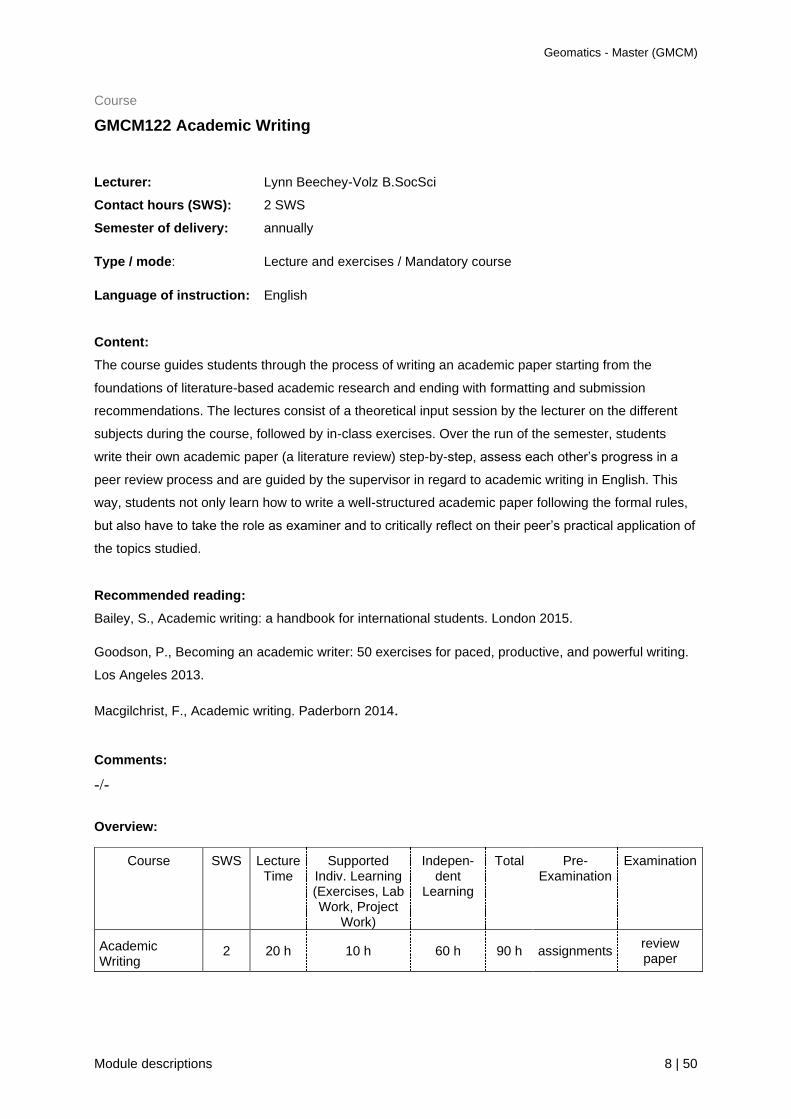
GMCM122 Academic Writing
Lecturer: Lynn Beechey-Volz B.SocSci
Contact hours (SWS): 2 SWS
Semester of delivery: annually
Type / mode: Lecture and exercises / Mandatory course
Language of instruction: English
Content:
The course guides students through the process of writing an academic paper starting from the
foundations of literature-based academic research and ending with formatting and submission
recommendations. The lectures consist of a theoretical input session by the lecturer on the different
subjects during the course, followed by in-class exercises. Over the run of the semester, students
write their own academic paper (a literature review) step-by-step, assess each other’s progress in a
peer review process and are guided by the supervisor in regard to academic writing in English. This
way, students not only learn how to write a well-structured academic paper following the formal rules,
but also have to take the role as examiner and to critically reflect on their peer’s practical application of
the topics studied.
Recommended reading:
Bailey, S., Academic writing: a handbook for international students. London 2015.
Goodson, P., Becoming an academic writer: 50 exercises for paced, productive, and powerful writing.
Los Angeles 2013.
Macgilchrist, F., Academic writing. Paderborn 2014.
Comments:
-/-
Overview:
Course SWS Lecture Time
Supported Indiv. Learning (Exercises, Lab Work, Project
Work)
Indepen-dent
Learning
Total Pre-Examination
Examination
Academic Writing
2 20 h 10 h 60 h 90 h assignments review paper

Geomatics - Master (GMCM)
Module descriptions 9 | 50
Module summary
GMCM130 BIM and AR/VR
Module coordinator: Prof. Dr. Heinz Saler, Prof. Dr. Detlef Günter-Diringer
Credits (ECTS): 6
Semester: 1
Pre-requisites with regard to content:
Solid knowledge in 3D visualization and CAD construction
Pre-requisites according to the examination regulations:
-
Competencies:
The students are able to use terrestrial laser scanner (TLS) for acquiring geometry data of
constructions and buildings, to process TLS data and to archive information for building models.
Students understand the benefit of BIM and how to integrate data into BIM.
In AR/VR competencies acquired cover theoretical knowledge and practical experience on the set up
of augmented reality (AR) and virtual reality (VR) applications using appropriate software
environments and their publishing on different output devices.
Assessment:
Marked project work
Usability:
Virtual reality projects are not limited to geospatial data, but used also in e.g. architecture, technical
engineering and technical documentation applications.

Geomatics - Master (GMCM)
Module descriptions 10 | 50
Course
GMCM131 Building Information Modelling Project
Lecturer: Prof. Dr. Heinz Saler
Contact hours (SWS): 2 SWS
Semester of delivery: Annually
Type / mode: Project work / mandatory course
Language of instruction: English
Content:
The students are enabled to capture building geometries to prepare the data for BIM based on TLS
data. After an introduction to BIM and the BIM data model, information acquisition is demonstrated
with the newest generation of surveying instruments and software. Here post-processing information
extraction methods are presented to the attendees. The acquired data is transferred into a BIM
structure. Teaching makes use of tutorials made available via ILIAS. Portions of lecture and project
work: 15% / 85%. In the lecture students are prepared for the practical project work by means of
presentations on the theoretical background of BIM, its setting within various disciplines, and
introductory practical exercises. The actual project work, which is performed in groups of 2 students,
includes the solving of a given task together with a documentation of the project work. Results are to
be presented regularly.
Recommended reading:
Borrmann, A., König, M., Koch, C. & Beetz, J. (2018). Building Information Modeling: Technology
Foundations and Industry Practice. Cham: Springer.
BMVI 2017. Umsetzung des Stufenplans Digitales Planen und Bauen. Erster Fortschrittsbericht
Building SMART, National building information – Standard, Part 1. 2007.
http://www.1stpricing.com/pdf/NBIMSv1_ConsolidatedBody_Mar07.pdf.
buildingSMART. What is openBIM? https://www.buildingsmart.org/about/openbim/openbim-definition/
buildingSMART. Standards, https://technical.buildingsmart.org/standards
Hausknecht, K. & T. Liebich, BIM-Kompendium. Fraunhofer IRB, Stuttgart 2016.
ISO (2018). ISO 16739:2018: Industry Foundation Classes (IFC) for data sharing in the construction
and facility management industries — Part 1: Data schema. International Organization for
Standardization. Geneva, Switzerland.
ISO (2016). ISO 10303-21:2016: Industrial automation systems and integration – Product data
representation and exchange — Part 21: Implementation methods: Clear text encoding of the
exchange structure. International Organization for Standardization. Geneva, Switzerland.
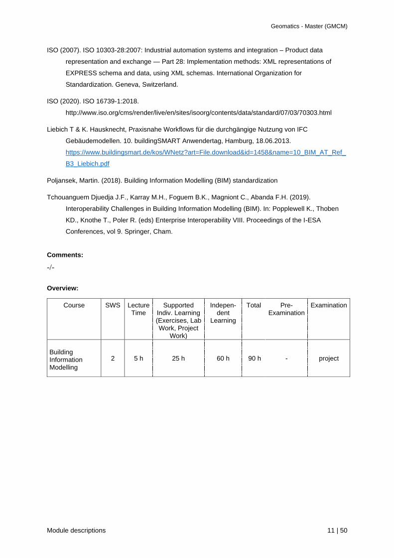
Geomatics - Master (GMCM)
Module descriptions 11 | 50
ISO (2007). ISO 10303-28:2007: Industrial automation systems and integration – Product data
representation and exchange — Part 28: Implementation methods: XML representations of
EXPRESS schema and data, using XML schemas. International Organization for
Standardization. Geneva, Switzerland.
ISO (2020). ISO 16739-1:2018.
http://www.iso.org/cms/render/live/en/sites/isoorg/contents/data/standard/07/03/70303.html
Liebich T & K. Hausknecht, Praxisnahe Workflows für die durchgängige Nutzung von IFC
Gebäudemodellen. 10. buildingSMART Anwendertag, Hamburg, 18.06.2013.
https://www.buildingsmart.de/kos/WNetz?art=File.download&id=1458&name=10_BIM_AT_Ref_
B3_Liebich.pdf
Poljansek, Martin. (2018). Building Information Modelling (BIM) standardization
Tchouanguem Djuedja J.F., Karray M.H., Foguem B.K., Magniont C., Abanda F.H. (2019).
Interoperability Challenges in Building Information Modelling (BIM). In: Popplewell K., Thoben
KD., Knothe T., Poler R. (eds) Enterprise Interoperability VIII. Proceedings of the I-ESA
Conferences, vol 9. Springer, Cham.
Comments:
-/-
Overview:
Course SWS Lecture Time
Supported Indiv. Learning (Exercises, Lab Work, Project
Work)
Indepen-dent
Learning
Total Pre-Examination
Examination
Building Information Modelling
2 5 h 25 h 60 h 90 h - project

Geomatics - Master (GMCM)
Module descriptions 12 | 50
Course
GMCM132 Virtual Reality
Lecturer: Prof. Dr. Detlef Günther-Diringer
Contact hours (SWS): 2 SWS
Semester of delivery: annually
Type / mode: Project / Mandatory Course
Language of instruction: English
Content:
Based on the students’ knowledge of setting up georeferenced 3D models, the programming of
interactive activities into the constructed 3D environment is taught for a further enhancement of 3D
models towards augmented and virtual reality applications (e.g. virtual sights, flight-overs and
movements in the 3D environment). The students learn how to make 3D visualisations run on different
output devices like head-mounted-displays, mobile devices, virtual walls, etc. Also here, the fields of
application can differ from indoor-applications to 3D city models or 3D landscape models.
Portions of lecture and project work: 30% / 70%. In the lecture students gain knowledge on the
theoretical background and the practical framework of AR and VR applications. The project
workincludes the setting-up of a AR/VR applications together with a documentation describing the
practical work. The results are tested by the other students, too.
Recommended reading:
Kent, B.R., 3D scientific visualization with Blender (IOP Concise Physics). Williston (VT) 2016.
Linowes, J., Unity virtual reality projects. Birmingham 2015.
Parisi, T., Programming 3D applications with HTML5 and WebGL: 3D animation and visualization for
Web pages. Sebastopol (CA) 2014.
Comments:
-/-
Overview:
Course SWS Lecture Time
Supported Indiv. Learning
(Exercises, Lab, Proj.Work)
Indepen-dent
Learning
Total Pre-Examination
Examination
Virtual Reality 2 9 h 21 h 60 h 90 h - Project

Geomatics - Master (GMCM)
Module descriptions 13 | 50
Module summary
GMCE140 Big Data
Module coordinator: Prof. Dr. Klaus Dürrschnabel, Prof. Dr. Reiner Jäger
Credits (ECTS): 6
Semester: 1
Pre-requisites with regard to content:
Solid knowledge in mathematics and computer science
Pre-requisites according to the examination regulations:
None
Competencies:
The amount of Big Data to be processed is too large, too complex, too fast-moving or too weakly
structured to be evaluated using manual and conventional methods of data processing. The students
have gained knowledge regarding the principles of handling Big Data and to solve special problems in
a realistic time and with economical use of computer memory. There are two alternative courses, Big
Data Analytics (Mathematical Modeling) or Big Data in Photogrammetry and Remote Sensing.
The students are enabled to find correct models and effective algorithms for special problems with Big
Data.
Assessment:
Written exam (90 min.)
Usability:
The use of Big Data is used in a lot of applications, e.g. databases, cloud computing, statistics,
economics and geographic data.

Geomatics - Master (GMCM)
Module descriptions 14 | 50
Course
GMCE141 Big Data Analytics
Lecturer: Prof. Dr. Klaus Dürrschnabel
Contact hours (SWS): 3 SWS
Semester of delivery: annually
Type / mode: Lecture and project / Elective course
Language of instruction: English or German
Content:
In this module basic mathematical models in the field of Big Data Analytics are presented, e.g.
methods of Graph Theory and Matrices (esp. Adjacency Matrices and Thin Matrices), Numerical
Linear Algebra (esp. Matrix Factorization, Conditioning of a problem), Statistics and Optimization
Theory (esp. Stochastic Mixed-Integer Programming). All Algorithms are implemented and tested by
the students in MATLAB. A self-developed program for a more complex task with the associated test
completes the course.
Recommended reading:
Bornemann, V., Numerische lineare Algebra. Springer Spektrum 2018
Briskorn, D., Operations Research. Springer Gabler 2020
Diestel, R., Graph Theory. Springer 2017
Klein Haneveld, W., van der Vlerk, M., Romeijnders, W., Stochastic Programming. Springer 2020
Comments:
-/-
Overview:
Course SWS Lecture Time
Supported Indiv. Learning (Exercises, Lab Work, Project
Work)
Indepen-dent
Learning
Total Pre-Examination
Examination
Big Data Analytics
3 10 h 35 h 135 h 180 h Laboratory
work
Written exam 90 min

Geomatics - Master (GMCM)
Module descriptions 15 | 50
Course
GMCE142 Big Data in Photogrammetry and Remote Sensing
Lecturer: Prof. Dr. Reiner Jäger
Contact hours (SWS): 3 SWS
Semester of delivery: annually
Type / mode: Lecture and project / Mandatory course
Language of instruction: English or German
Content:
The Big Data era situations in Photogrammetry and Remote Sensing come up in terms of the volume,
the variety, the velocity and the veracity, in which data sets and streams become available and challenge
current management and processing capabilities. While big data can be situated here in the disciplinary
area of traditional geospatial data handling theory and methods, the increasing volume and varying
format of collected geospatial Big Data itself leads to news new challenges in storing, managing, pro-
cessing, analyzing, visualizing and verifying the quality of data in Photogrammetry and Remote Sensing.
This has caused a paradigm shift to a data-driven research concerning all steps along the whole chain
of data acquisition and processing. The lecture accordingly starts with new spatial indexing and
algorithms to handle real-time, streaming Big Data and the support of topology for real-time analytics. It
is followed by Big Data method for quality assessment, data structuring and modeling, and data base
problems for Big Data streams. Then by chapters on methods for Big Data functional programming on
artificial intelligence (AI) and machine learning, Further chapters are on Big Data geospatial analytics,
visualization and visual analytics, data mining and knowledge discovery, up to fractals emerged from
Big Data. As concerns sensor data to be treated in the frame of the lecture and the project, as being
submitted to the above Big Data processing chain, are in Photogrammetry Big Data concerning classical
multispectral images, laser scanner point-clouds, time of flight (ToF) and recent plenoptic cameras. In
Remote Sensing for earth observation (EO) three types of Big Data occur and are regarded, namely
synthetic aperture radar (SAR), such as free available from European ESA Sentinel satellites, optical
imaging and atmospheric spectrometry data from satellites. Common topics of Photogrammetry and
Remote Sensing Big Data are on the fusion of SAR and optical images, the fusion of InSAR and optical
3D point clouds, and the fusion of polarimetric SAR, multi-/hyper-spectral image and lidar, e.g. for
classification tasks. In respect to the project the final chapters are open source software packages for
Big Data working along the above processing chains in Photogrammetry (e.g. Hadoop, Cassandra,
OpenGL, Meshroom, OpenDroneMap) and Remote Sensing (e.g. ESA Sentinel Toolboxes).
Recommended reading:
Lecture related
Acar, U. A., & Chen, Y. (2013). Streaming Big Data with Self-Adjusting Computation. Proceedings of
the 2013 Workshop on Data Driven Functional Programming -DDFP ’13, 15-18.
Geomatics - Master (GMCM)
Module descriptions 16 | 50
Luhrmann, T. (2018): Nahbereichsphotogrammetrie. 4. Auflage. Wichmann.
Ma, Y., Wu, H., Wang, L., Huang, B., Ranjan, R., Zomaya, A., & Jie, W. (2014). Remote Sensing Big
Data Computing: Challenges and Opportunities. Future Generation Computer Systems.
Lu, Y., Zhang, M., Witherspoon, S., Yesha, Y., Yesha, Y., & Rishe, N. (2013). sksOpen: Efficient In-
dexing, Querying, and Visualization of Geo-spatial Big Data. Proceedings of the 2013 12th International
Conference on Machine Learning and Applications (ICMLA), 2, 495-500.
Pettit, C., Stimson, R., Nino-Ruiz, M., Moradini, L., Widjaja, I., Delaney, P. Kvan, T. (2014). Supporting
Urban Informatics through a Big Data Analytics Online Workbench. NSF Workshop on Big Data and
Urban Informatics.
http://dgk.badw.de/fileadmin/docs/c-766.pdf
http://dgk.badw.de/fileadmin/docs/c-747.pdf
Project related
Bernasocchi, M., Çöltekin, A., & Gruber, S. (2012). An Open Source Geovisual Analytics Toolbox for
Multivariate Spatio-Temporal Data for Environmental Change Modeling. ISPRS Annals of the
Photogrammetry, Remote Sensing and Spatial Information Sciences, 1-2(2), 123-128.
https://gisgeography.com/open-source-remote-sensing-software-packages/
http://www.esa.int/esapub/tm/tm19/TM-19_ptA.pdf
http://www.esa.int/esapub/tm/tm19/TM-19_ptB.pdf
http://www.esa.int/esapub/tm/tm19/TM-19_ptC.pdf
Comments:
-/- Overview:
Course SWS Lecture Time
Supported Indiv. Learning (Exercises, Lab Work, Project
Work)
Indepen-dent
Learning
Total Pre-Examination
Examination
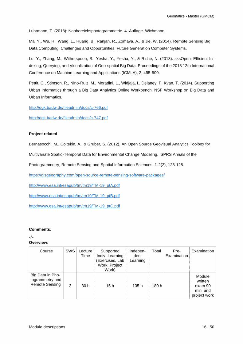
Big Data in Pho-togrammetry and Remote Sensing 3 30 h 15 h 135 h 180 h
Module written
exam 90 min and
project work

Geomatics - Master (GMCM)
Module descriptions 17 | 50
Module summary
GMCE150 Geovisual Analytics
Module coordinator: Prof. Dr. Gertrud Schaab
Credits (ECTS): 6
Semester: 1
Pre-requisites with regard to content:
Solid knowledge in thematic cartography, HTML5, JavaScript, and statistics.
Pre-requisites according to the examination regulations:
none
Competencies:
The students learn the distinct considerations when visualizing statistical data in a printed and thus
static map versus the display of multivariate data in a dynamic, interactive visualization tool. They are
highly aware of cartographically correct depictions as well as of good UI/UX design. Their extended
JavaScript programming knowledge lets them visualize data in versatile complex maps or develop
visualization tools, this from the very scratch.
Assessment:
Marked project work.
Usability:
It is of benefit to any work where flexible and appealing thematic maps are required. As map
compilation is achieved without the need of proprietary software, the module is useful for any later
work where spatial patterns and correlations needs to be visualized.

Geomatics - Master (GMCM)
Module descriptions 18 | 50
Course
GMCE151 Space-Time Visualization of Statistical Data
Lecturer: Prof. Dr. Gertrud Schaab
Contact hours (SWS): 3 SWS
Semester of delivery: annually
Type / mode: Project / Elective module
Language of instruction: English or german
Content:
For project work the students are asked to individually look for time-dependent multivariate statistical
data that can be used to reveal a geographical pattern and thus to tell a narrative of space and time.
By first analyzing the data, the students need to come up with a concept each for a static and a
dynamic interactive map depiction. The map for printout is limited in regard to space available and
teaches them to skillfully apply proven cartographic visualization methods, while the dynamic
visualization tool requires a well-thought graphical user interface around the legend. Here, the
students have to decide on where to place the emphasis on, either more towards cartographic
communication or more towards geographic visualization. For the static map, the participants are
asked to apply Illustrator or Inkscape to assure understanding of principles in thematic cartography. In
regard to the dynamic tool, the students should work with HTML5, JavaScript and the relevant libraries
(e.g. leaflet, D3).
In order to provide knowledge on visualizing time-dependent spatially referenced data, accompanying
lecturers cover the topics geographical visualization (GVIS), time in analogy to space on maps, state-
of-the-art capabilities in advanced thematic cartography, the dynamic cartographic environment,
dynamic variables, interactive vs. animation graphics, the time-space cube, and usability
considerations. This way, the students will gain the ability of presenting space and time dependent
processes through the analysis of time series data and their effective representation in high-quality
static and animated thematic maps.
Portions of lecturers and project work: 40% / 60%. The project work to be handed in encompasses
besides the static map and the dynamic interactive map also a textual description recapitulating the
lecture materials covered. The results are to be presented in front of class.
Recommended reading:
Aigner, W., S. Miksch, H. Schumann & C. Tominski, Visualization of time-oriented data. London,
Dordrecht 2011.
Andrienko, N. & G. Andrienko, Exploratory analysis of spatial and temporal data: A systematic
approach. Berlin, Heidelberg 2005.

Geomatics - Master (GMCM)
Module descriptions 19 | 50
Andrienko, G., A. Andrienko, P. Bak, D. Keim & S. Wrobel, Visual analytics of movement. Heidelberg,
New York 2013.
Dodge, M., M. McDerby & M. Turner (eds.), Geographic visualization: Concepts, tools and
applications. Chichester 2008.
Dykes, J., A.M. MacEachren & M.J. Kraak (eds.), Exploring geovisualization. Oxford 2005.
Kraak, M.-J., Mapping time. Illustrated by Minard’s map of Napoleon’s Russian campaign of 1812.
Redlands (CA), 2014.
Kraak, M.-J. & F. Ormeling, Cartography: Visualization of spatial data. Harlow 2010.
MacEachren, A.M., How maps work. Representation, visualization, and design. New York, London
1995.
Monmonier, M., Strategies for the visualization of geographic time-series data. In: Cartographica,
27(1), 30-45, 1990.
Tufte, E.R., Envisioning information. Cheshire (CT) 1990.
Comments:
-/-
Overview:
Course SWS Lecture Time
Supported Indiv. Learning (Exercises, Lab Work, Project
Work)
Indepen-dent
Learning
Total Pre-Examination
Examination
Space-Time Visualization of Statistical Data
3 18 h 27 h 135 h 180 h - Project

Geomatics - Master (GMCM)
Module descriptions 20 | 50
Module summary
GMCE160 Navigation
Module coordinator: Prof. Dr.-Ing. Reiner Jäger
Credits (ECTS): 6
Semester: 1
Pre-requisites with regard to content:
Knowledge on mathematics, physics, object-oriented programming
Pre-requisites according to the examination regulations:
- / -
Competencies:
By the module Navigation Technologies and Mobile GIS, the students will know the theoretical and
algorithmic background, the full spectrum of algorithms for out- und indoor-navigation and programming
of multisensor navigation, geo-referencing and Mobile GIS technologies and systems. By the module
Satellite Geodesy, the students know the theoretical background of reference systems for a global
georeferencing and positioning using GNSS space systems and other space technologies (VLBI,
Altimetry) in the context of modelling the dynamics of satellite orbits and a dynamic earth frame. Further
the theoretical background and algorithms for the methods of satellite based gravity field determination
are known. The students will be able to work in the full spectrum of navigation technologies and mobile
GIS. So they can work as consulting experts, in industrial and technological developments, design navi-
gation systems and mobile GIS, as well as in research institutions on other satellite geodes topics.
There are two alternative courses: Navigation Technologies and Mobile or Satellite Geodesy and
Spatial Reference Systems
Assessment:
Written examination (120 min.) and marked project work.
Usability:
Navigation supplies based on Markov-chains and a Bayes background the full spectrum for the deve-
lop¬ment of multisensor navigation, georeferencing and mobile GIS systems using GNSS, MEMS and
optical sensor data, state transition information and different navigation state estimation concepts.
Sa¬tellite Geodesy supplies spatial reference frames, earth dynamics, and GNSS positioning. Further,
sa¬telli¬te-based gravity field determination, satellite altimetry, VLBI and SAR/INSAR are teached in
order to complete the spectrum of satellite geodetic methods.

Geomatics - Master (GMCM)
Module descriptions 21 | 50
Course
GMCE161 Navigation Technologies and Mobile GIS
Lecturer: Prof. Dr.-Ing. Reiner Jäger
Contact hours (SWS): 3 SWS
Semester of delivery: annually
Type / mode: Lecture and project work / Elective Module
Language of instruction: English or German
Content:
Navigation parameters, navigation frames and transition between different frames
• Overview on out-and indoor navigation of air/land/sea vehicles system design.
• Markov-chain and Bayes background for the common use sensor data and state transition infor-
mation for navigation state estimation
• Kalman filter and particle filter based on Chapman-Kolmogorov equation solution
• GNSS, MEMS and optical sensor observations in a general multi-sensor multi-platform design
• SLAM algorithms
• Time synchronization algorithms
• GNSS, MEMS and optical sensor algorithms and state estimation concepts, equations and state
inequations for navigation, geo-referencing- and mobile GIS system design
• UAV out and indoor navigation and control
• Software design and developments on GNSS-positioning and internet-based data communication
components using smartphones
• Software design and developments for the integration of GNSS raw-data by opensource software
(RTKLIB, NTRIP), MEMS-sensors, maps and internet communication on smartphones
Recommended reading:
Literature:
Jäger, R. (2019): Multisensorische 3D-Mappingsysteme für BIM – SLAM basierte Navigation und
Steuerung, Systemrealisierung MSM und Profil künftiger Entwicklungen. Buchbeitrag zur Inter-
nationalen Geodätischen Woche 2019, Obergurgl, Österreich. Klaus Hanke / Thomas Weinold
(Eds.) ISBN 978-3-87907-659-8. Wichmann-Verlag. S. 286-293.
Runder Tisch GIS e.V. (2020): Leitfaden Mobile GIS – Von der GNSS-basierten Datenerfassung bis
zu Mobile Mapping, Version 4.0 (erschienen 10/2020), 7., vollständig aktualisierte und erweiterte
Auflage
Jäger, R. (2018): Multisensornavigation auf Bayes’scher Grundlage – Stand, Anwendungen und Ent-
wicklungen. In: A. Heck, K. Seitz, T. Grombein, M. Mayer, J.-M. Stövhase, H. Sumaya, M. Wam-
pach, M. Westerhaus, L. Dalheimer, P. Senger (ed.): (Schw)Ehre, wem (Schw)Ehre gebührt - Fes-
Geomatics - Master (GMCM)
Module descriptions 22 | 50
tschrift zur Verabschiedung von Prof. Dr.-Ing. Dr. h.c. Bernhard Heck. Schriftenreihe des Studien-
gangs Geodäsie und Geoinformatik, vol. 2018–1, Karlsruhe (KIT Scientific Publishing). S. 123-130.
Thrun, S., Burgard, W. und D. Fox (2006): Probabilistic Robotics. The MIT Press. Massachusetts,
USA.
Internet / Multimedia:
• www.navka.de
• http://developer.android.com/index.html
• http://rtklib.com
• https://www.gsa.europa.eu/gnss-applications/gnss-raw-measurements
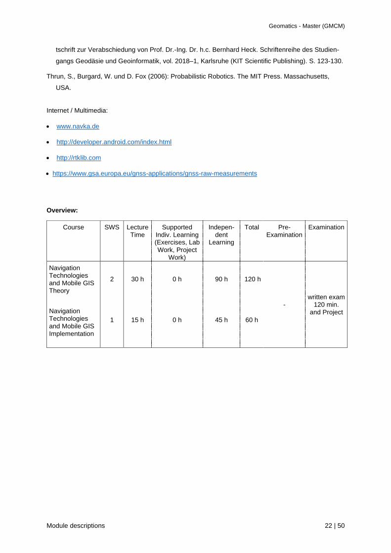
Overview:
Course SWS Lecture Time
Supported Indiv. Learning (Exercises, Lab Work, Project
Work)
Indepen-dent
Learning
Total Pre-Examination
Examination
Navigation Technologies and Mobile GIS Theory
Navigation Technologies and Mobile GIS Implementation
2
1
30 h
15 h
0 h
0 h
90 h
45 h
120 h
60 h
- written exam
120 min. and Project
Geomatics - Master (GMCM)
Module descriptions 23 | 50
Course
GMCE162 Satellite Geodesy and Spatial Reference Systems
Lecturer: Prof. Dr.-Ing. Reiner Jäger
Contact hours (SWS): 3 SWS
Semester of delivery: annually
Type / mode: Lecture / Elective Module
Language of instruction: English or German
Content:
• Spatial reference frames (Inertial system (ECIS/F), Earth fixed system (ECES/F) and transition).
Modelling of Earth dynamics (datum, datum-drift, plate movements). Regional classical and modern
reference frames related to frozen plates. Transition algorithms between spatial reference systems.
• GNSS satellite orbits equation and orbit representations
• Atmospheric models (ionosphere and troposphere) and delays in GNSS-positioning
• Satellite signals (Code, Phase, Doppler)
• Modelling of GNSS satellite signals in PPP and DGNSS positioning
• RTCM OSR, SSR and transformation messages data
• Commercial and Open Source GNSS processing software
• Classical and advanced ambiguity resolution and cycle-slip detection methods in static GNSS and
RTK positioning
• Computations with the open-source software RTKLIB and NTRIP
• Satellite based gravity field determination (gravity field and orbit pertubations, Lagrange perturbation
calculation, orbit perturbation and disturbance potential. Theory of Kaula and Müller. Observation
equations for gravity field determination, satellite-to-satellite-tracking, gradiometry. Gravity missions
on global monitoring, future gravity missions, data fusion for gravity field determination
• Earth tides modelling in satellite geodesy
• VLBI (principle, observation equations, parameter estimation)
• Satellite altimetry (Satellites, sea-surface topography definition and monitoring)
The seminar work comprises individual marked reports on present topics on spatial reference frames
and GNSS
Recommended reading:
Becker, M. und K. Hehl (2012): Geodäsie. WBG Edition. Darmstadt. ISBN: 978-3-534-23156-0
Kaula W.M. (1963) Determination of the Earth's gravitational field. Reviews of Geophysics Volume 1, Issue 4.
November 1963. Pages 507–551. The American Geophysical Union.
Satellite Altimetry Website (2018): https://www.aviso.altimetry.fr/en/techniques/altimetry.html
Journal of Geodesy (2018): https://link.springer.com/journal/190
Geomatics - Master (GMCM)
Module descriptions 24 | 50
Xu, G. (2016): GPS. Theory, Algorithms and Applications. Springer.
Xu, G. (2016): Sciences of Geodesy II. Springer.
Bauer, M. (2018). Vermessung und Ortung mit Satelliten. Globale Navigationssatellitensysteme (GNSS) und anders
satellitengestützte Navigationssysteme. 7., neu bearbeitete und erweitere Auflage.
Borre, K., Akos, D.M., Bertelsen, N., Rinder, P., Jensen, S.H. (2007): A software defined GPS and GALILEO
receiver. Springer.
RTKLIB-Website (2018): RTKLIB - An Open Source Program Package for GNSS Positioning. www.rtklib.org.
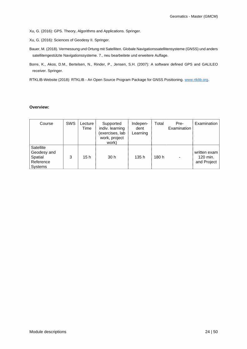
Overview:
Course SWS Lecture Time
Supported indiv. learning (exercises, lab work, project
work)
Indepen-dent
Learning
Total Pre-Examination
Examination
Satellite Geodesy and Spatial Reference Systems
3 15 h 30 h 135 h 180 h - written exam
120 min. and Project

Geomatics - Master (GMCM)
Module descriptions 25 | 50
Module summary
GMCM210 OpenSource GIS
Module coordinator: Prof. Dr. Heinz Saler
Credits (ECTS): 6
Semester: 2
Pre-requisites with regard to content:
Solid knowledge in the field of geographic information systems, software handling, and programming
Pre-requisites according to the examination regulations:
None
Competencies:
Students know how to develop software tools based on OGC standards and/or the knowledge of the
community. They are able to set-up a new WebGIS by combining various tools depending on the aims
and functionalities required.
Assessment:
Written examination (120 min)
Usability:
This module provides the basis for any software development based on standards and/or the
knowledge of the community. Knowing how to use and develop tools based on free OpenSource
technology is indispensable when low-cost approaches are required, as this is often the case in less
developed countries.

Geomatics - Master (GMCM)
Module descriptions 26 | 50
Course
GMCM211 Introduction to OpenSource GIS
Lecturer: Dr. Marco Lechner
Contact hours (SWS): 1
Semester of delivery: annually
Type / mode: Lecture / Mandatory course
Language of instruction: English
Content:
Students learn about the current range of software tools available in OpenSource GIS. Further, the
concepts of OpenSource software are taught. The theory of OGC standards like WMS, WFS is
presented, enabling the students to solve problems with the related methods. Linux and the
OpenSource WebGIS tools UMN-Mapserver, PostgreSQL/PostGIS, GeoServer, QGIS,
OpenLayers/GeoEXT and PHP are introduced.
Recommended reading:
Adams, T. & M. Jansen, OpenLayers, Webentwicklung mit dynamischen Karten und Geodaten.
München 2010.
Mitchell, T., Web mapping illustrated. Sebastopol (CA) 2005.
Mitchell, T., A. Christl & A. Emde, Web-Mapping mit Open Source-GIS-Tools. Köln 2008.
Comments:
-/-
Overview:
Course SWS Lecture Time
Supported Indiv. Learning (Exercises, Lab Work, Project
Work)
Indepen-dent
Learning
Total Pre-Examination
Examination
Introduction to OpenSource GIS
1 15 h 0 h 15 h 30 h assignments written exam
120 min

Geomatics - Master (GMCM)
Module descriptions 27 | 50
Course
GMCM212 Application of OpenSource GIS
Lecturer: Dr. Marco Lechner
Contact hours (SWS): 2 SWS
Semester of delivery: annually
Type / mode: Exercises / Mandatory course
Language of instruction: English
Content:
Students receive hands-on in OpenSource GIS programming for solving space-related questions and
for preparing the relating technical documentations. By applying various OpenSource WebGIS
software, they learn how to interact with the developer community. In the end, the students are familiar
with UMN-Mapserver, GeoServer, PostgreSQL/ PostGIS and OpenLayers/GeoEXT for developing and
using OpenSource WebGIS tools.
Recommended reading:
See course Introduction to OpenSource GIS
Comments:
-/-
Overview:
Course SWS Lecture Time
Supported Indiv. Learning (Exercises, Lab Work, Project
Work)
Indepen-dent
Learning
Total Pre-Examination
Examination
Application of OpenSource GIS
2 0 h 30 h 120 h 150 h assignments -

Geomatics - Master (GMCM)
Module descriptions 28 | 50
Module summary
GMCM220 Web Services & Geomonitoring
Module coordinator: Prof. Dr.-Ing. Reiner Jäger
Credits (ECTS): 6
Semester: 2
Pre-requisites with regard to content:
Knowledge of mathematics, physics, parameter estimation, statistics, object oriented programming.
Pre-requisites according to the examination regulations:
- / -
Competencies:
In the lecture Geomonitoring with Programming Application the students will get to know the sensor
equations (GNSS, SAR/INSAR and gravity satellites, terrestrial geodetic & optical sensors, and
physical sensors), the mathematical models and the algorithms, in order to be able to set up different
parametric approaches of an integrated geo-monitoring in 3D geometry and gravity space. The
programming part gives competencies on IT technologies for setting up different kinds of local and
global object geo-monitoring, and on the software implementation of different algorithms on time-
series analysis, the monitoring of change detections and visualization algorithms in object oriented
programming languages. As programming language Python will be used. The geo-monitoring system
GOCA, its installation on the Stuttgart television tower, and in the Laboratory on GNSS & Navigation
are giving competences on working with real data, local and Interned related communication and IT
technologies.
In the modules Web Services the students learn the setting-up and programming of a Web processing
service (WPS) following OGC standards and including own scripting parts and App Developments to
access, and for the analysis and control geomonitoring data and projects
Assessment:
Written examination (2 x 60 min.) and marked project work in each lecture part
Usability:
Web Services & Monitoring supplies the full spectrum of global and local geomonitoring. It covers the
space and terrestrial sensor equations, the mathematical models and algorithms for sensordata
fusion,and the IT and programming technologies for the implementation of different kind of geo-moni-
toring systems. The programming is done on Python based timer series analys, script language for
Web Services and Android Apps.

Geomatics - Master (GMCM)
Module descriptions 29 | 50
Course
GMCM221 Geomonitoring with Programming Applications
Lecturer: Prof. Dr.-Ing. Reiner Jäger
Contact hours (SWS): 2 SWS
Semester of delivery: annually
Type / mode: Lecture and project work / Mandatory Module
Language of instruction: English
Content:
General standards and profile of geo-monitoring, change detection and early warning in geodynamics,
natural objects, man-made structures, geotechnics. Geo-Monitoring, environmental-monitoring. Geo-
monitoring chain. Coordinate systems, global and local reference frames.
Satellite (GNSS, SAR/INSAR, Gravity), terrestrial geodetic, optical and physical geo-monitoring
sensors. Sensor-equations and -parametrization in geometry and gravity space. Mathematical models
and parameter estimation for sensor fusion in geo-monitoring. Classification of parametric deformation
models (observation and coordinate related approaches and network types (absolute, relative
deformation network). Special problems related to local, and ITRF embedded free and on-defect
deformation networks (global geodynamics modelling, datum, datum-drift, plate tectonics handling).
Statistical control of the reference frame.
Change detection (black-, grey- and white box) approaches. Selected change detection models
(basic deformation state vector, virtual sensors, surface and volume changes, system analysis, state
space and spectral domain, structural health monitoring) on the above sensors. Estimation concepts for
change detection (geometric deformation analysis, system analysis, Kalman filtering, spectral analysis,
prediction and early-warning. Types of geo-sensor networks and IT-Structures.
Project work combined with Geo-Monitoring and Programming: Software implementations along
the IT-structure, data processing, data interfaces of the geo-monitoring system GOCA. As installation
the Television Tower Stuttgart with internet-based data communication, and local installations in the
Laboratory GNSS & Navigation are used for programming of static and dynamic displacement
estimations. Further App-programming on visualization of state-space and spectral characteristics.
For time series analysis in geomonitoring, the programming language Python and programming
environment Jupiter (Pandas, NumPy and SciPy libraires) will be used in the lecture room. Additive and
multiplicative time series modeling and analysis and stationary and non-stationary are treated. The
methods and Python poramming for modeling, removing and forecsting of the non-stationary parts by
different trend models and FFT are treated. As stationary parts Random Walk, ARP, MA(q), ARMA(p,q)
and ARIMA (p,d1) modeling, estimation and forecasting of processing from real data are treaetd
theoretically and in programing applications.
Geomatics - Master (GMCM)
Module descriptions 30 | 50
Recommended reading:
Copernicus-Website (2018): Global Monitoring. http://www.copernicus.eu/
Kühne, Einstein, Krauter, Klapperich, Pöttler (2002): Proceedings International Conference on
Landslides Causes, Impacts and Countermeasures. Davos, Switzerland, June 17-21, ISBN 3-7739-
5969-9 Runge, GmbH, Cloppenburg. S. 261 – 275
Eichhorn, A. (2005): Ein Beitrag zur Identifikation von dynamischen Strukturmodellen mit Methoden der
adaptiven Kalman-Filterung. DGK-C Nr. 585. Deutsche Geodäische Kommisssion, München.
Plag, H.-P., Pearlman, M. (2009): Global Geodetic Observing System. Meeting the Requirements of a
Global Society on a Changing Planet in 2020. Springer
Silvia Nittel (2006): GeoSensor Networks: Second International Conference, GSN 2006, Boston, MA,
USA, October 1-3, 2006, Revised selected and invited Papers. Springer Edittion.
Wikipedia (2018): Structural Health Monitoring,
https://en.wikipedia.org/wiki/Structural_health_monitoring
Jäger, R. and F. Gonzalez (2005): GNSS/GPS/LPS based Online Control and Alarm System (GOCA) -
Mathematical Models and Technical Realisation of a System for Natural and Geotechnical Deforma-
tion Monitoring and Hazard Prevention. ISGDM IAG-Symposium 2005, April 2003, University of
Escuela Politécnica Superior de Jaén. Spain. (F. Sanso, A. J. Gil (Eds.): Geodetic Deformation
Monitoring: From Geophysical to Engineering Roles. IAG Series on Geodesy Symposia. Springer
Heidelberg and New York. ISBN 3-540-38595-9. 293 – 304.
Jäger, R., Kälber, S., Oswald, M. and M. Bertges (2006): GNSS/LPS/LS based Online Control and
Alarm System (GOCA) – Mathematical Models and Technical Realisation of a System for Natural and
Geotechnical Deformation Monitoring and Analysis. Proceedings of 3rd IAG Symposium on Geodesy
for Geotechnical and Structural Engineering and 12th FIG Symposium on Deformation Measurements
/ 22.-24. May 2006, Baden/Austria, CD-Rom. IAG and FIG, Vienna.
Jäger, R., Gorokhova, L. und E. Messmer (2017): Modell- und Sensorintegration zum integrierten 3D
Geomonitoring in moderner Datenkommunikationsstruktur mit Anwendung auf den Stuttgarter
Fernsehturm. Ingenieurvermessung 17: Beiträge zum 18. Internationalen Ingenieurvermessungskurs
Graz, 2017. Wichmann-Verlag. ISBN: 978-3-87907-630-7. S.23-251.
GOCA Web-Site (1998-2018): GNSS/LPS-based Online Control and Alarm System (GOCA).
www.goca.info
Kaiser, R. (2017): C++ mit Visual Studio 2017. Ein Fach- und Lehrbuch für Standard-C++. Springer.
Hagos, T. (2018): Learn Android Studio 3. Efficient Android App Development. Springer.
Marschallinger und Wanker (Hrsg.): Geomonitoring, FE-Modellierung, Sturzprozesse und Mas-
senbewegungen: Beiträge zur COG-Fachtagung. Salzburg 2008. Wichmann-Verlag.
Johansson R. (2015): Numerical Python. Springer.

Geomatics - Master (GMCM)
Module descriptions 31 | 50
Michael Markert et al. (2017): Das Python3.3-Tutorial auf Deutsch. Release 3.3.
https://media.readthedocs.org/pdf/py-tutorial-de/python-3.3/py-tutorial-de.pdf
Wes McKinney & PyData Development Team (2018): Pandas - Powerful Python Data Analysis Toolkit.
Release 0.22.0. https://pandas.pydata.org/pandas-docs/stable .
Comments:
-/-
Overview:
Course SWS Lecture Time
Supported Indiv. Learning (Exercises, Lab Work, Project
Work)
Indepen-dent
Learning
Total Pre-Examination
Examination
Geomonitoring with programming applications
2 20 h 10 h 60 h 90 h assignments written exam
120 min
Geomatics - Master (GMCM)
Module descriptions 32 | 50
Course
GMCM222 Web Services
Lecturer: N.N.
Contact hours (SWS): 2 SWS
Semester of delivery: annually
Type / mode: Lecture / Mandatory
Language of instruction: English
Content: The course starts with an introduction to the OGC specification for WPS as well as to
programming with Python. Further, the setting-up of a WPS is discussed and an example of a complex
process programmed by the students. Here, the students learn how to combine Esri’s ModelBuilder for
configuring and/or customizing scripts with own scripting in order to be most flexible. In addition, service
chaining is also covered including so-called ‘zip & ship’. Further Android based App Developments are
done, with application to the data of the project Structural Health Monitoring (SHM) of Fernsehturm
Stuttgart project.
Recommended reading: ./.
Comments:
-/-
Overview:
Course SWS Lecture Time
Supported Indiv. Learning (Exercises, Lab Work, Project
Work)
Indepen-dent
Learning
Total Pre-Examination
Examination
Web Services 2 20 h 10 h 60 h 90 h assignments written exam
120 min

Geomatics - Master (GMCM)
Module descriptions 33 | 50
Module summary
GMCM230 Satellite Image Analysis
Module coordinator: Prof. Dr. Gertrud Schaab
Credits (ECTS): 6
Semester: 2
Pre-requisites with regard to content:
Basic knowledge in Digital Image Processing; in existing acquisition sensor systems (multispectral and
RADAR) as well as in the geometry and physics background influencing data acquisition; practical
experience in DIP (including multi-band imagery and georeferencing) and in visual interpretation of
aerial photography.
Pre-requisites according to the examination regulations:
none
Competencies:
The students gain confidence in pre-processing, classification and analysis of multispectral-,
hyperspectral-and radar-satellite image data. Therefore they get the opportunity to learn about theory
and practical applications of pixel-based and object-based segmentation and classification. The
students should obtain the qualification to determine and apply a suitable processing chain, this
dependent on the available satellite image data and the concrete task.
Assessment:
Marked project work
Usability:
This module prepares for independent, scientific working during the Master thesis. Due to more and
more satellite imagery becoming available without costs, applications will be more wide-spread in the
future.
Geomatics - Master (GMCM)
Module descriptions 34 | 50
Course
GMCM231 Satellite Image Analysis
Lecturer: Prof. Dr. Gertrud Schaab
Contact hours (SWS): 3 SWS
Semester of delivery: annually
Type / mode: Lecture and Laboaratory Exercises / Mandatory course
Language of instruction: English
Content:
Algorithms for classification of multispectral and hyperspectral image data;Methods for RADAR-
data processing; Image transformations (IHS, PCA) and sensor fusion (pansharpening);
Atmospheric corrections; Fuzzy approaches in image analysis; Object-based segmentation and
classification.
Recommended reading:
Albertz, J., Einführung in die Fernerkundung. Grundlagen der Interpretation von Luft-und
Satellitenbildern: Eine Einführung in die Fernerkundung. Darmstadt 2007.
Hildebrandt, G., Fernerkundung und Luftbildmessung. für Forstwirtschaft, Vegetationskartierung und
Landschaftsökologie. Heidelberg 1996.
Jensen, J.R., Introductory digital image processing. A remote sensing perspective, Upper Saddle
River (New Jersey) 1995.
Lillesand, T.M. & R.W. Kiefer, Remote sensing and image interpretation. Cichester 2
Comments:
-/-
Overview:
Course SWS Lecture Time
Supported Indiv. Learning (Exercises, Lab Work, Project
Work)
Indepen-dent
Learning
Total Pre-Examination
Examination
Satellite Image Analysis
3 10 h 35 h 135 h 180 h Project

Geomatics - Master (GMCM)
Module descriptions 35 | 50
Module summary
GMCE240 Statistics for Big Data
Module coordinator: Prof. Dr. Peter Freckmann
Credits (ECTS): 6
Semester: 2
Pre-requisites with regard to content:
Solid knowledge in mathematics and fundamental statistical methods, experiences in working with
spatial data and GIS
Pre-requisites according to the examination regulations:
None
Competencies:
Students have the capacity for analyzing spatial distributions, patterns, processes, and relationships
on the basis of big data sets using explorative statistical methods. Students are able to incorporate
space (proximity, area, connectivity, and/or other spatial relationships) directly into their mathematical
framework. In general students get skills in answering questions about the spatial behavior of big data
in geo-sciences.
Assessment:
Marked project work
Usability:
In particular knowledge in complex statistical methods can be applied in the modules Geovisual
Analytics, Navigation, Geodesy and Satellite Image Analysis. In general this module provides the
basis for any analysis exploring big data sets. Knowing how to use complex statistical methods is
essential when making unknown spatial patterns und distributions understandable.

Geomatics - Master (GMCM)
Module descriptions 36 | 50
Course
GMCE241 Statistics for Big Data
Lecturer: Prof. Dr. Peter Freckmann
Contact hours (SWS): 3 SWS
Semester of delivery: annually
Type / mode: Lecture and project work / Elective module
Language of instruction: English or german
Content:
Students learn also how to identify characteristics of a spatial distribution and statistically significant
spatial clusters or spatial outliers, assess overall patterns of clustering or dispersion, group features
based on attribute similarities, identify an appropriate scale of analysis, and explore spatial
relationships. There for they learn to apply explorative statistical methods like factor and cluster
analysis, spatial auto correlation measurements and hot and cold spots analysis.
Recommended reading:
Armstrong, M.P., Xiao, N. & Bennett, D.A., 2003: Using Genetic Algorithms to Create Multicriteria
Class Intervals for Choropleth Maps. Annals of the Association of American Geographers, 93(3), 595-
623.
Bahrenberg, G., Giese, E. & Nipper, J.: Statistische Methoden in der Geographie. Band 2 -
Multivariate Statistik. Springer.
Bennett, L., D’Acosta, J. & Vale, F., 2010: Spatial Data Mining: A Deep Dive into Cluster Analysis.
https://blogs.esri.com/esri/arcgis/2010/07/13/spatial-statistics-resources/, letzter Zugriff 25.09.2017.
Burt, J. E. u. G. M. Barber, Elementary Statistics for Geographers, New York 1996
Chiles, J.-P. & P. Delfiner, Geostatistics: Modeling spatial uncertainty. 2nd ed., New York, 2012.
Cressie, N., Statistics for spatial data. Rev. ed., New York 1993.
Duque, J.C., Ramos, R. & Surinach, J., 2007: Supervised Regionalization Methods: A Survey.
Research Institute of Applied Economics 2006, Working Papers 2006/8, 1-31.

Geomatics - Master (GMCM)
Module descriptions 37 | 50
Getis, A. & Ord J.K., 1992: The Analysis of Spatial Association by Use of Distance Statistics.
Geographical Analysis 24(3), 189-206.
Getis, A. & Ord J.K., 1995: Local Spatial Autocorrelation Statistics: Distributional Issues and an
Application. Geographical Analysis 27(4), 286-306.
Goodchild, M.F., 1986: Spatial Autocorrelation. Catmog 47, Geo Books.
Sachs, L., Angewandte Statistik, Heidelberg 1999
Comments:
-/-
Overview:
Course SWS Lecture Time
Supported Indiv. Learning (Exercises, Lab Work, Project
Work)
Indepen-dent
Learning
Total Pre-Examination
Examination
Statistics for Big Data
3 15 h 30 h 135 h 180 h -
Written exam
90 min and project

Geomatics - Master (GMCM)
Module descriptions 38 | 50
Module summary
GMCE250 Mobile Apps & GIS
Module coordinator: Prof. Dr. Gertrud Schaab, Prof. Dr. Detlef Günther-Diringer
Credits (ECTS): 6
Semester: 2
Pre-requisites with regard to content:
Solid knowledge in geographical information systems (Web GIS), databases, and JavaScript
programming
Pre-requisites according to the examination regulations:
None
Competencies:
The students learn how to conceptualize native mobile map apps based on Qt / QML programming.
The students have gained experience in software development within a team.
Assessment:
Marked project work including an individual assessment of the project group members
Usability:
Any app development in the growing mobile app development field, this ideally independent of an
operating system and considering responsive design.

Geomatics - Master (GMCM)
Module descriptions 39 | 50
Course
GMCE251 Mobile Map Apps in Nature Conservation
Lecturer: Prof. Dr. Gertrud Schaab
Contact hours (SWS): 3 SWS
Semester of delivery: annually
Type / mode: Project / Elective module
Language of instruction: English
Content:
The project work covers the development of a mobile map app of use in nature conservation.
Applications are sought for supporting research or participatory activities in development cooperation.
After an introduction to participatory sensing and the particular app task, students in groups of four or
five need to make themselves familiar with similar mobile mapping applications via examples
described in the Internet or in scientific papers. This way students learn to conceptualize the app.
Besides, the students are prepared for their development task by introductory lectures on Qt / QML.
Programming hands-on are offered first via the configuration of ‘play apps’ based on out-of-the-box
templates in the cloud version of AppStudio for ArcGIS. Next the desktop version of AppStudio and
programming QML in the Integrated Development Environment (IDE) Qt Creator is introduced by
developing a ‘mock-up app’.
For the actual app development, students concentrate on app design (prototyping, GUI design),
database entry via forms, the use of map services, and the implementation of specific functionality
depending on the app task. As AppStudio for ArcGIS is supporting cross-platform app development,
responsive design matters. The students per group organize themselves for working as a team
following project management methods. For sharing and integrating the source code developed by
different members of the group, the students use a version control system. Regular meetings with the
lecturer provides opportunity to the students to discuss their progress, to ask questions and to ensure
their route to success. The students are thus able to perform software development within a team for
the growing mobile app development field.
Portions of lectures / programming hands-on and project work: 40% / 60%. The project work handed in
consists of the developed app and its source code as well as a written documentation of back-
ground/setting and the development process, which follows standards of scientific publications.
Additionally a presentation in front of class per group and an individual assessment is envisaged.
Recommended reading:
Brovelli, M.A., M. Minghini & G. Zamboni, Public Participation in GIS via Mobile Applications. ISPRS
Journal of Photogrammetry and Remote Sensing 114, 306-315, 2015.

Geomatics - Master (GMCM)
Module descriptions 40 | 50
Hennig, S. (ed.), Online-Karten im Fokus: Praxisorientierte Entwicklung und Umsetzung. Berlin, 2006.
McKinley, et al., Citizen Science Can Improve Conservation Science, Natural Resource Management,
and Environmental Protection. Biological Conservation 208, 15-28, 2017.
Mousa, H., S. Ben Mokhtar, O. Hasan, O. Younes, M. Hadhoud & L. Brunie, Trust Management and
Reputation Systems in Mobile Participatory Sensing Applications: A Survey. Computer Networks 90,
49-73, 2015.
Reichenbacher, T., Kartographie in der mobilen digitalen Welt. D. Beineke, O. Heunecke, T. Horst &
U.G.F. Kleim (eds.): Festschrift für Univ.-Prof. Dr.-Ing. Kurt Brunner anlässlich des Ausscheidens aus
dem aktiven Dienst. Schriftenreihe des Instituts für Geodäsie der Universität der Bundeswehr
München 87, 179-188, 2012.
Rice, R.M., Ensuring the Quality of Volunteered Geographic Information: A Social Approach. Karto-
graphische Nachrichten. Journal of Cartography and Geographic Information 3/2015, 123-130, 2015.
Rischpater, R., Application development with Qt Creator. Design and build dazzling cross-platform
applications using Qt and Qt Quick. Birmingham, Mumbai, 2014.
Salz, P. & J. Moranz, The Everything Guide to Mobile Apps. A Practical Guide to Affordable Mobile
App Development for Your Business. Avon (MA), 2013.
Sheth, A., Citizen Sensing, Social Signals, and Enriching Human Experience. IEEE Internet
Computing 13 (4), 80-85, 2009.
Comments:
-/-
Overview:
Course SWS Lecture Time
Supported Indiv. Learning (Exercises, Lab Work, Project
Work)
Indepen-dent
Learning
Total Pre-Examination
Examination
Mobil Map Apps in Nature Conservation
3 18 h 27 h 135 h 180 h - Project

Geomatics - Master (GMCM)
Module descriptions 41 | 50
Module summary
GMCE260 Geodesy
Module coordinator: Prof. Dr. Reiner Jäger
Credits (ECTS): 6
Semester: 1
Pre-requisites with regard to content:
Knowledge of mathematics, physics, software development, parameter estimation, satellite geodesy
Pre-requisites according to the examination regulations:
. / .
Competencies:
The students can choose between two options: “Intelligent Systems and Engineering Geodesy” or
“Physical and Integrated Geodesy”.
Course Intelligent systems and Engineering Geodesy: Attendees obtain knowledge necessary to
design the mathematical models, software- and hardware of intelligent systems, to realize and to
evaluate intelligent systems in engineering geodesy. Typical systems are autonomous in- and outdoor
vehicles (airborne, ground, water) and stationary or mobile multi-sensor robot systems, etc. The
students are able to apply suitable development evaluation methods on off-the-shelf systems in order
to provide digested information to decision-makers or make qualified, fact-based decision themselves.
Attendees are also skilled in rapid prototyping of intelligent systems, which requires comprehensive
knowledge on sensor physics, and the mathematical models, Bayes Estimation, algorithmic concepts,
software-development (e.g. based on Open Source) and operating systems (e.g. ROS for robotic
systems) of a sensor-fusion (GNSS, MEMS, Optics). SLAM and system-integration expertise. Tackling
product development paradigms students obtain also capabilities of active participation in industrial-
level product development.
Course Physical and Integrated Geodesy: The students have internalized the fundamentals of
mathematical and physical geodesy. Therefore, they are able to make themselves familiar with
complex problems of the mathematical models, estimation and prediction on different problems on
integrated geodesy and physical problems and to find solutions. They are acquainted with the main
methods of gravity field determination and of geoid computation, and they are able to apply them.
Assessment:
Written exam 90 Min/120 Min and marked project work
Geomatics - Master (GMCM)
Module descriptions 42 | 50
Usability:
The module is self-consistent in its contents both from theory and project work. In respect to other
modules of the Geomatics program it is dealing with algorithms and parameter estimation for multi-
sensor GNSS/MEMS/Optics robotic systems. As concerns other university programs it could be
integrated in study programs such as Sensor Systems Technology (Master) or Micro-Mechatronic
Systems (Master). Physical and integrated geodesy supplies the geometry and gravity field related
fundamental theories for fields like advanced parameter estimation concepts, satellite geodesy,
modern height systems and global as well as regional geodetic computations, estimation and
prediction concepts. The module gives theoretical background information for many areas of Geodesy
and Geoinformatics.

Geomatics - Master (GMCM)
Module descriptions 43 | 50
Course
GMCE261 Intelligent Systems in Engineering Geodesy
Lecturer: Prof. Dr. Reiner Jäger
Contact hours (SWS): 3 SWS
Semester of delivery: annually
Type / mode: Elective Module
Language of instruction: English or german
Content:
This course is integration/unification of several engineering subjects within the field of geometrics with
strong practical emphasis. It comprises, among others, recursive parameter estimation, machine
control, computer vision, machine learning and photogrammetry in order to provide students
comprehensive one-semester theory-supported-project walk-through and explain to build and
understand intelligent systems basics. The students obtain in strongly focused and in-depth theoretical
lectures necessary fundamentals on sensor fusion, computer vision, machine learning basics, robotic
control, etc. Based on that knowledge, attendees will build a sample robot using available robotic kit
and equip the systems with off-the-shelf sensors, SBC’s, etc. The systems must be realized to operate
in unknown environment and “behave intelligent”: they are able to observe and judge surroundings
and fulfill tasks autonomously. For this purpose, a training ground is provided where emulated or real
GNSS system provides a global positioning service. Localization of robotic system will be performed
by the system itself (redundancy, sensor fusion). The modular design of the robotic system allows
attendees to modify, extend or simplify the system and in order to grasp the complexity and extend of
general-purpose systems. The course attendees are also encouraged to modify and improve existing
algorithms, taught during the lectures or obtained from third party. The course ends with marked
presentation and benchmark between teams on predefined tasks.
The course consists of two parts: Theoretical primer and practical application. In the first Part following
themes are elaborated.
Theoretical Part (2 SWS):
The course starts with “Intelligent Systems and Challenges on Navigation State Estimation and
Control” and proceeds then with algorithmic fundamentals: Markov Chains and Bayes Representation
of Sensor Measurements and Controls, Navigation and Control of Systems in Markov Chain based
Bayes Presentation. Transition from Markov Chains to conditioned Densities and Bayes Formulations,
Integration of additional State Information via Chapman-Kolmogorov Equation, First Order Markov
Chain Assumption on the Navigation and Control of Systems, Integration of State Transition and
Control Equations and Examples, Final Bayes A-posterior-Density Relation.
Transition from Bayes Formulation to Classical and Extended Kalman Filtering by Maximum Posterior
Density Estimation, Transition from Bayes Formulation to Particle Filtering. Bayes-based SLAM
formulation: Multi-Sensor-Multiplatform Sensor System Design, Modelling of a Leverarm-Design for all

Geomatics - Master (GMCM)
Module descriptions 44 | 50
sensors. Sensor-observation equations (GNSS, MEMS, Optics) examples, State Transition and
Control Equations, Systems without control actions, controlled Systems.
Trajectory based planning of intelligent autonomous vehicles, obstacle detection, intelligence concepts
and algorithms for a dynamically modified course planning. Navigation and PID Control of UAS. This
includes flight physics and the derivation of UAS PID regulation at the example NAVKA Flight Control.
Projects Part (1 SWS):
The project part will of the course will gather students in small teams of four students, which will imple-
ment different kind of intelligent systems (mathematical models, algorithms, software and hardware-
design). These are practical exercises on GNSS-based and navigation positioning using Open Source
Software. Further the use of GNSS/MEMS/Camera/Laserscanner ground robots intelligent system for
environmental mapping or BIM based on SLAM (Simultaneous Localization and Mapping). The
attendants will work with the Volksbot RT3-2 as a remote controlled or autonomously driving intelligent
robotic and the implemented system MSM (ROS as operational system) provided by the Laboratory on
GNSS & Navigation.
Recommended reading:
Herzberg, J., Lingemann, K. und A. Nüchter (2012): Mobile Roboter: Springer Vieweg, Heidelberg.
Jäger, R. (2019): Multisensorische 3D-Mappingsysteme für BIM – SLAM basierte Navigation und Steue-rung, Systemrealisierung MSM und Profil künftiger Entwicklungen. Buchbeitrag zur Internationalen Geodätischen Woche 2019, Obergurgl, Österreich. Klaus Hanke / Thomas Weinold (Eds.) ISBN 978-3-87907-659-8. Wichmann-Verlag. S. 286-293.
Jäger, R. (2018): Multisensornavigation auf Bayes’scher Grundlage – Stand, Anwendungen und Ent-wicklungen. In: A. Heck, K. Seitz, T. Grombein, M. Mayer, J.-M. Stövhase, H. Sumaya, M. Wampach, M. Westerhaus, L. Dalheimer, P. Senger (ed.): (Schw)Ehre, wem (Schw)Ehre gebührt - Festschrift zur Verabschiedung von Prof. Dr.-Ing. Dr. h.c. Bernhard Heck. Schriftenreihe des Studiengangs Geodäsie und Geoinformatik, vol. 2018–1, Karlsruhe (KIT Scientific Publishing). S. 123-130.
Luhmann, T. (2014). Close Range Photogrammetry (2rd ed.). Wichmann Verlag.
NAVA-Webseite (2012-2021): www.navka.de.
ROS (2018): Robot Operation System (ROS). Web-Site: www.ros.org/-
Russell, S., & Norvig, P. (2009). Artificial Intelligence: A Modern Approach (3rd Edition). Prentice Hall.
Szeliski, R. (2010). Computer Vision: Algorithms and Applications (1st ed.). New York, NY, USA: Springer-Verlag New York, Inc.
Thrun, S., Burgard, W. und D. Fox (2006): Probabilistic Robots: The MIT Press. Cambridge, Massachusetts. London.
Zwiener, J. (2019): Robuste Zustandsschätzung zur Navigation und Regelung autonomer und bemann-ter Multikopter mit verteilten Sensoren. Darmstadt, Technische Universität, ISBN 978-3-935631-43-3. Dissertation.
Comments:
2 SWS on Theory and 2 SWS on Implementation Projects
Overview:

Geomatics - Master (GMCM)
Module descriptions 45 | 50
Course SWS Lecture Time
Supported Indiv. Learning (Exercises, Lab Work, Project
Work)
Indepen-dent
Learning
Total Pre-Examination
Examination
Intelligent Systems in Engineering Geodesy
2
(Theory) 20 h 10 h 90 h 120 h -
Written exam 90 min
1
(Projects) 5 h 10 h 45 h 60 h

Geomatics - Master (GMCM)
Module descriptions 46 | 50
Course
GMCE262 Physical and Integrated Geodesy
Lecturer: Prof. Dr. Tilman Müller, Prof. Dr. Reiner Jäger
Contact hours (SWS): 3 SWS
Semester of delivery: annually
Type / mode: Lecture / Elective course
Language of instruction: English or German
Content:
Physical Geodesy: Lectures cover gravitation and gravitational potential, gravity potential and level
surfaces, spherical harmonics, level ellipsoid and normal field, geodetic boundary value problems
(Stokes, Molodensky, …), temporal variations in the gravity field, absolute and relative gravimetry, geoid
determination with satellite methods, as well as regional and high accuracy geoid determination.
Integrated Geodesy is dealing with parametric and stochastic mathematical models, estimation and
prediction questions on geometrical and gravity field space problems in Geodesy, Bayesian theory is
used as a foundation to derive the basic estimation methods and their branches to integrate all
mathematical models down to interpolation and prediction (Kernel-based Methods, Kriging, Collocation).
The further treatment of mathematical models is concerned with classical 3D integrated geodetic
network adjustment and its extension to modern sensor types and parametrizations. roblems of datum
transformations, estimation of surface parameters and height reference systems are also covered.
Selected problems are on integrated conformal mapping and numerical integration to solve geodetic
major tasks. Exercises encompass diverse methods in the field of geoid computations and make use of
the DFHBF, WTRANS and COPAG software. Portions of lecture and project work: 70% / 30%. The joint
project with Physical Geodesy is related to theory evaluation followed by computations on gravity field
and quasi-geoid-computations. The integrated geodesy method maps a global geopotential model to
regional spherical cap harmonic models by integrating gravity measurement and fitting points. The
computation of a regional quasi-geoid model is done in terms of a geometric surface (continuous
polynomials) as carrier function, integrating fitting-points and deflections from the vertical.
Recommended reading:
Hofmann-Wellenhof, B., Physical geodesy. Wien 2006.
International Association of Geodesy (ed.). The geodesist‘s handbook. In: Journal of Geodesy, 90(10), 2016. https://iag.dgfi.tum.de/fileadmin/handbook/handbook_2016/Handbook_2016.pdf
Jäger, R., Geodätische Infrastrukturen für GNSS-Dienste (GIPS). In: K. Zippelt (ed.), Vernetzt und ausgeglichen. Festschrift zur Verabschiedung von Prof. Dr.-Ing. habil. Dr.-Ing. E.h. Günter Schmitt. Karlsruhe 2010.

Geomatics - Master (GMCM)
Module descriptions 47 | 50
Snyder, J.P., Map projections – A working manual. U. S. Geological Survey Professional Paper 1395, Washington DC 1987.
Torge, W., Geodesy. Berlin 2003.
Younis, G., Regional gravity field modeling with adjusted spherical cap harmonics in an integrated approach. PhD thesis TU Darmstadt, 2014.
Younis, G., R. Jäger & M. Becker, Transformation of global spherical harmonic models of the gravity field to a local adjusted spherical cap harmonic model. In: Arabian Journal of Geosciences, 6(2), 375-381, 2013.
http://dfhbf.de/
Comments:
-/-
Overview:
Course SWS Lecture Time
Supported Indiv. Learning (Exercises, Lab Work, Project
Work)
Indepen-dent
Learning
Total Pre-Examination
Examination
Physical Geodesy
1 15 h -/- 45 h 60 h - written exam
120 min Integrated
Geodesy 2 20 h 10 h 90 h 120 h -

Geomatics - Master (GMCM)
Module descriptions 48 | 50
Module summary
GMCM310 Seminar for Master Thesis
Module coordinator: Course director Geomatics Master
Credits (ECTS): 5
Semester: 3
Pre-requisites with regard to content:
Deepened knowledge within the range of the topic of the Master thesis
Pre-requisites according to the examination regulations:
Successful conclusion of all modules (max two modules can be completed after beginning of the
thesis)
Competencies:
The student is given a month time to familiarize him/herself with the topic by means of scientific
publications, to phrase objectives for the thesis and to plan the work. The result has to be delivered to
the referees as a report, i.e. the seminar work (about 3000 words, in English) and also includes the
elaboration of the task description. With this work the candidate demonstrates his/her knowledge of
scientific rules and standards. It ensures that the candidate is aware of what the Master thesis has to
cover and what the supervisors expect.
Assessment:
Marked seminar work
Usability:
Seminar work and task description provide the basis for elaborating the Master thesis.

Geomatics - Master (GMCM)
Module descriptions 49 | 50
Module summary
GMCM320 Master Thesis
Module coordinator: Prof. Dr. Gertrud Schaab, Course director Geomatics Master
Credits (ECTS): 22
Semester: 3
Pre-requisites with regard to content:
Deepened knowledge within the range of the topic of the Master thesis and knowledge of scientific
rules and standards
Pre-requisites according to the examination regulations:
Successful conclusion of the seminar work
Competencies:
With the Master thesis the student shows his/her ability to independently work on a scientific topic and
to finalize it within a limited time frame (5 months). Purpose of the thesis is to develop a research
topic, to convert it methodically, to analyze it critically and to evaluate the results. The work is to make
a contribution for knowledge extension to the selected scientific topic. It usually investigates a
research problem in a theoretical and in a practical part. The Master thesis has to be written in
English.
Assessment:
Marked Master thesis
Usability:
The Master thesis is based on the seminar work and profoundly deepens knowledge gained within
modules of the previous semesters.

Geomatics - Master (GMCM)
Module descriptions 50 | 50
Module summary
GMCM330 Colloquium for Master Thesis
Module coordinator: Course director Geomatics Master
Credits (ECTS): 3
Semester: 3
Pre-requisites with regard to content:
See Master thesis
Pre-requisites according to the examination regulations:
Handed-in Master thesis
Competencies:
In the colloquium the candidate demonstrates that he/she is able to present his/her thesis in a talk of
30 min and to sufficiently answer questions in the discussion afterwards.
Assessment:
Marked oral presentation
Usability:
The colloquium concludes the Master thesis phase.