mines and wines: industrial minerals, geology and wineries ... · pdf fileontario geological...
TRANSCRIPT

Ontario Geological SurveyOpen File Report 6029
Mines and Wines: IndustrialMinerals, Geology andWineries of the NiagaraRegion – Field TripGuidebook
2000

ONTARIO GEOLOGICAL SURVEY
Open File Report 6029
Mines and Wines: Industrial Minerals, Geology and Wineries of theNiagara Region – Field Trip Guidebook
by
K.G. Steele and S.J. Haynes
2000
Parts of this publication may be quoted if credit is given. It is recommended thatreference to this publication be made in the following form:
Steele, K.G. and Haynes, S.J. 2000. Mines and wines: industrial minerals, geology andwineries of the Niagara region – Field Trip Guidebook; Ontario Geological Survey,Open File Report 6029, 25p.
e Queen’s Printer for Ontario, 2000

iii
e Queen’s Printer for Ontario, 2000.
Open File Reports of the Ontario Geological Survey are available for viewing at the Mines Library in Sudbury, at theMines andMinerals InformationCentre in Toronto, and at the regionalMines andMinerals officewhose district includesthe area covered by the report (see below).
Copies can be purchased at Publication Sales and the office whose district includes the area covered by the report. Al-though a particular report may not be in stock at locations other than the Publication Sales office in Sudbury, they cangenerally be obtainedwithin 3working days.All telephone, fax, mail and e-mail orders should be directed to the Publica-tion Sales office in Sudbury. Use of VISA or MasterCard ensures the fastest possible service. Cheques or money ordersshould be made payable to the Minister of Finance.
Mines and Minerals Information Centre (MMIC) Tel: (416) 314-3800Macdonald Block, Room M2-17 1-800-665-4480(toll free inside Ontario)900 Bay St.Toronto, Ontario M7A 1C3
Mines Library Tel: (705) 670-5615933 Ramsey Lake Road, Level A3Sudbury, Ontario P3E 6B5
Publication Sales Tel: (705) 670-5691(local)933 Ramsey Lake Rd., Level A3 1-888-415-9845(toll-free)Sudbury, Ontario P3E 6B5 Fax: (705) 670-5770
E-mail: [email protected]
Regional Mines and Minerals Offices:
Kenora - Suite 104, 810 Robertson St., Kenora P9N 4J2
Kirkland Lake - 10 Government Rd. E., Kirkland Lake P2N 1A8
Red Lake - Box 324, Ontario Government Building, Red Lake P0V 2M0
Sault Ste. Marie - 70 Foster Dr., Ste. 200, Sault Ste. Marie P6A 6V8
Southern Ontario - P.O. Bag Service 43, Old Troy Rd., Tweed K0K 3J0
Sudbury - Level B3, 933 Ramsey Lake Rd., Sudbury P3E 6B5
Thunder Bay - Suite B002, 435 James St. S., Thunder Bay P7E 6S7
Timmins - Ontario Government Complex, P.O. Bag 3060, Hwy. 101 East, South Porcupine P0N 1H0
Toronto - MMIC, Macdonald Block, Room M2-17, 900 Bay St., Toronto M7A 1C3
This report has not received a technical edit. Discrepanciesmay occur for which the OntarioMinistry ofNorthernDevel-opment andMines does not assume any liability. Source references are included in the report andusers are urged to verifycritical information. Recommendations and statements of opinions expressed are those of the author or authors and arenot to be construed as statements of government policy.
If you wish to reproduce any of the text, tables or illustrations in this report, please write for permission to the TeamLeader, Publication Services, Ministry of Northern Development and Mines, 933 Ramsey Lake Road, Level B4,Sudbury, Ontario P3E 6B5.
Cette publication est disponible en anglais seulement.
Parts of this report may be quoted if credit is given. It is recommended that reference be made in the following form:
Steele, K.G. and Haynes, S.J. 2000. Mines and wines: industrial minerals, geology and wineries of the Niagararegion – Field Trip Guidebook; Ontario Geological Survey, Open File Report 6029, 25p.

v
TABLE OF CONTENTSINTRODUCTION ........................................................................................................................................................1FOCUS OF THE TRIP ...............................................................................................................................................1LOCATION AND ROUTE ..........................................................................................................................................1OVERVIEW OF THE GEOLOGY OF SOUTHERN ONTARIO ............................................................................2
Introduction ...............................................................................................................................................................2Tectonic Setting.........................................................................................................................................................2Cambrian Strata .........................................................................................................................................................5Ordovician Strata .......................................................................................................................................................5Silurian Strata ............................................................................................................................................................5Devonian Strata .........................................................................................................................................................6Geology of the Niagara Escarpment ..........................................................................................................................6Quaternary Geology...................................................................................................................................................7
THE INDUSTRIAL MINERALS INDUSTRY IN SOUTHERN ONTARIO ............................................................7Economic Geology ....................................................................................................................................................7Aggregate...................................................................................................................................................................9
Crushed Stone.....................................................................................................................................................9Sand & Gravel ...................................................................................................................................................10
Cement.....................................................................................................................................................................10Shale/Brick ..............................................................................................................................................................10Limestone and Dolostone Chemical, Metallurgical and Filler Products .................................................................11Dimension/Building Stone.......................................................................................................................................11Gypsum....................................................................................................................................................................12Salt...........................................................................................................................................................................12STOP 3-1 Canada Brick’s Burlington Quarry and Brick Plant ...............................................................................12STOP 3-2 Georgia-Pacific Canada Inc. Caledonia No.3 Mine and Wallboard Plant .............................................14
GEOLOGY AND PHYSIOGRAPHY OF THE NIAGARA PENINSULA.............................................................14STOP 4-1 Walker Industries Holdings Ltd. Vineland Quarries & Crushed Stone ................................................18
GEOLOGICAL FOUNDATION FOR TERROIRS OF THE NIAGARA PENINSULA ......................................18Terroirs and Appellations: a Summary....................................................................................................................18Niagara Peninsula Terroirs ......................................................................................................................................19STOP 5-1 Malivoire Wine Company .....................................................................................................................20STOP 5-2 Henry of Pelham Family Estate Winery ................................................................................................20
OVERVIEW OF THE GEOLOGY OF THE NIAGARA FALLS & GORGE........................................................21STOP 6-1 Great Gorge Adventure..........................................................................................................................21STOP 6-2 Niagara Falls..........................................................................................................................................22
ACKNOWLEDGEMENTS........................................................................................................................................22REFERENCES ..........................................................................................................................................................23APPENDIX 1..............................................................................................................................................................24

vii
TABLE OF FIGURES
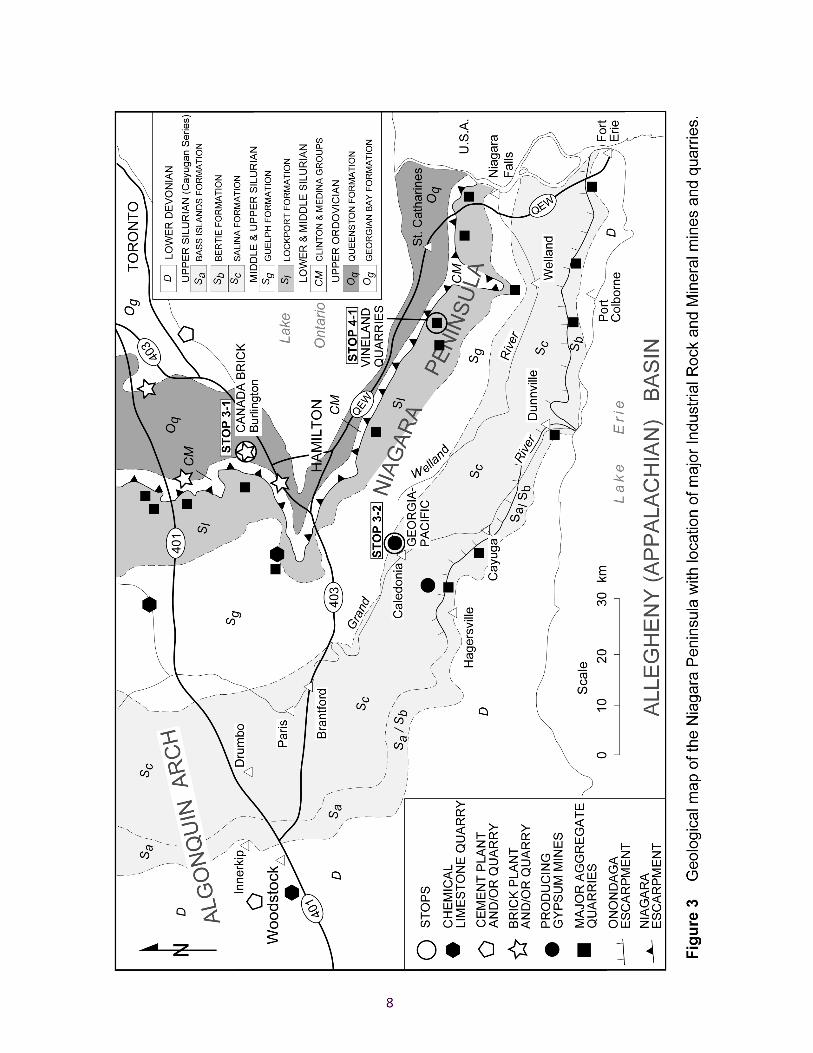
FIGURE 1 Geology of the Great Lakes …………….3FIGURE 2 Bedrock geology of southern Ontario …………….4FIGURE 3 Geological map of the Niagara Peninsula with location of major industrial rock
and mineral mines and quarries…………….8
FIGURE 4 Composite north-south section of the geology and physiography across theNiagara Escarpment
…………….15
FIGURE 5 Grape climatic zones in Niagara …………….15FIGURE 6 Relation of surface geology, generalized soil types and physiography to
vinifera vineyard terroirs and proposed sub-appellations of the northernNiagara Peninsula
…………….16

1
INTRODUCTION
This field trip was given on September 14, 2000 for staff of the Resident Geologist Program of theMinistry of Northern Development and Mines. Both authors have given versions of this trip to otheraudiences over the past few years. This guide is presented so those visiting Niagara area wineries have anoverview of the scenic and economic geology of the area, and a perspective on how geology is animportant element of the wine industry.
FOCUS OF THE TRIP
Geologists and other professionals within the minerals industry may not automatically associate the areaaround western Lake Ontario to the west and south of Toronto, including the Niagara Peninsula, as amajor mining camp. However, the area has major extraction operations for shale/brick,gypsum/wallboard and crushed stone aggregate. Mineral production for the area is estimated at $265M in1999.
Likewise, those imbibing Niagara vintages may not realize the direct influence of geology on the locationof wineries, types of grapes and quality of wines. The Niagara Peninsula is the dominant wine-producingregion in Canada. In 1999, retail sales of Niagara wines were approximately $270M.
The mining and wine industries of the Niagara region have a common element – the local geologyprovides a bountiful harvest for each. The geological element is woven throughout the field trip. Some ofsouthern Ontario’s major industrial mineral operations will be visited, with discussion on the geologicalresource, mining techniques, products, and site rehabilitation. The scenic wonders of Niagara Falls andthe Whirlpool expose spectacular geological sections. Winery visits provide the backdrop for an overviewon the geological foundation for terroirs of the Niagara Peninsula.
This trip is based on data contained and cited by source in Haynes (2000) and Steele (2000).
LOCATION AND ROUTE
For most of the day, the field trip route will be near the Niagara Escarpment, a prominent cuesta landformthat extends from central New York State in the east to Lake Huron in the west. In Ontario, the north-,then east-, facing cliff-face of this cuesta extends from Queenston, near Niagara Falls, for 725 kilometresto Tobermory on the Bruce Peninsula. The Escarpment has been produced by differential erosion ofharder and softer Paleozoic sedimentary rocks over the past 250 million years.
The first stop of the field trip is southwest of Toronto, where Canada Brick’s Burlington brick operationworks in the shadow of the Escarpment, quarrying red Queenston shale. We shall then cross south overthe Escarpment to Georgia Pacific’s gypsum mine at Caledonia to visit their wallboard plant.
Lunching “en autobus” we shall travel northeast to the Niagara Escarpment at Vineland to view thecrushed stone quarry operation of Walker Industries Holdings Ltd. From there, the route will be generallyeastward along the Escarpment, visiting geologic/scenic viewpoints and wineries along the way, to arriveat the Niagara River Gorge. Here, we shall descend by elevator to a boardwalk along the banks of thethundering Niagara River Rapids (Great Gorge Adventure). The trip will finish at Niagara Falls.
2
OVERVIEW OF THE GEOLOGY OF SOUTHERN ONTARIO
Introduction
The bedrock of southern Ontario consists of Paleozoic sedimentary rocks that stretch for nearly 600 km ina broad zone from Kingston to lakes Huron and Erie. The zone is bounded to the north by Precambrianrocks of the Canadian Shield. The sedimentary succession includes Cambrian, Ordovician, Silurian andDevonian strata.
The sediments that make up southern Ontario’s Paleozoic succession were deposited mainly in shallowmarine environments, at a time when the area was inundated by a series of inland seas centred about theAllegheny (Appalachian) and Michigan basins (Figs. 1 and 2). The sedimentary sequence includeslimestone, dolostone, shale and sandstone. The strata are essentially undeformed and nearly flat-lyingwith shallow regional southwesterly dips averaging 6 m/km. Units thicken to the southwest with themaximum thicknesses of Cambrian, Ordovician, Silurian and Devonian strata being 165, 920, 620 and390 m respectively. The regional southwesterly dip, coupled with over 250 million years of erosion thathas peneplaned the rocks, has resulted in successively younger rocks being exposed to the southwest. Theeroded surface is effectively flat, except where interrupted by north- and east-facing escarpments, formedin resistant carbonate rocks underlain by recessive-weathering shale. The Niagara Escarpment (Fig. 1)forms a prominent feature across southern Ontario. The Escarpment, composed of Late Ordovician andSilurian strata, separates the Silurian and Devonian rocks to the west from the Cambrian and Ordovicianrocks to the east (Fig. 2). Smaller escarpments, often partly buried beneath Quaternary sediments, occurboth south/west and north/east of the Niagara Escarpment (e.g., the Onondaga Escarpment; Figure 3).
Tectonic Setting
The major structural elements, which affected Paleozoic deposition across southern Ontario, are theAllegheny (Appalachian) and Michigan basins, and the Findlay and Algonquin arches (Fig. 1).
The Allegheny Basin, is an elongate foreland sedimentary basin, which parallels the AppalachianMountains, and is centered in the states of New York and Pennsylvania. The basin’s marginal edgeextends into Ontario along the Niagara Peninsula and beneath Lakes Erie and Ontario. As a result ofintermittent orogenic activity along the eastern margin of the basin throughout the Paleozoic, the depositswithin the basin are mostly clastic dominated.
The Algonquin Arch is a broad, northeast trending, basement ridge forming the spine of the southwesternOntario peninsula. A continuation of this feature south into the United States is the Findlay Arch, and thedepression separating the arches is called the Chatham Sag. Cambrian and Early Ordovician strata insouthern Ontario are truncated against the flanks of the Algonquin Arch, whereas, Middle Ordovicianstrata onlap and overlap the arch, indicating it was a positive feature in Paleozoic time. Once buried, thearch remained a positive feature and exerted influence on the deposition of Silurian strata of the NiagaraEscarpment and Devonian units of southwestern Ontario.
The Michigan Basin is a circular intracratonic sedimentary basin centered on the lower-peninsula ofMichigan and extending east to the Algonquin Arch. The basin was formed by the regional subsidence ofPrecambrian basement rocks. Carbonate and evaporite deposition was dominant within the basin.
3
4
5
The Paleozoic sequence is complicated by facies changes, as strata of the Allegheny Basin interfingerwith strata of the Michigan Basin in complex onlap-offlap patterns, over the Algonquin Arch.
In addition to the above major structural elements, clastic supply to the inland seas was important to thetypes and thickness of sediments deposited. Major clastic source areas were the Canadian Shield to thenorth and the highlands to the east, which were periodically uplifted, including the ancestral TaconicHighlands and the Appalachian Mountains.
Due to the regional dip of strata to the southwest, successively younger rocks are exposed from Kingstonto Windsor (Fig. 2). In the following sections, the Paleozoic sequence is presented from oldest toyoungest.
Cambrian Strata
The oldest Paleozoic strata in southern Ontario are Late Cambrian sandstone and dolostone. Except forsmall, isolated outcrops adjacent to Precambrian rock in the Kingston area, Cambrian rocks are known insubsurface onlapping the Algonquin Arch.
Ordovician Strata
Middle to Late Ordovician carbonates and shales underlie the area southwest from the Canadian Shield tothe Niagara Escarpment. The Simcoe Group is a succession of bioclastic carbonates, carbonatemudstones, and shales of the Gull River, Bobcaygeon, Verulum and Lindsay formations. The stratarepresent a relatively continuous deposition on a generally deepening shelf.
Overlying Ordovician strata are characterized by orogen-derived clastic rocks deposited in marine andnon-marine settings. The Blue Mountain Formation consists of grey, noncalcareous shale. The GeorgianBay Formation reflects a change to shaly and impure carbonates. The Queenston Formation is a thicksequence of red shale prominently exposed along the base of the Niagara Escarpment. It is a maroon,slightly calcareous to noncalcareous, shale with interbeds of grey-green shale. The formation ranges inthickness from 45 to 335 m.
Silurian Strata
Silurian sediments are exposed along the face of the Niagara Escarpment and in an outcrop belt extendingup to 70 km southwest of the Escarpment. The regional distribution and stratigraphy of Silurian strata aredifferent in areas influenced by the Allegheny Basin (Niagara Peninsula) and the Michigan Basin(Hamilton to Bruce Peninsula). The Cataract Group, at the base of the Silurian succession, consists of theWhirlpool, Manitoulin, Cabot Head and Grimsby formations. The Whirlpool is orthoquartzitic sandstone.The Cabot Head Formation, consists of shale with subordinate calcareous sandstone, limestone anddolostone interbeds. On the Niagara Peninsula, the maroon sandstones and shales of the GrimsbyFormation comformably overlie the dark shales and buff sandstones and carbonates of the Power GlenFormation (the Allegheny Basin equivalent of the Cabot Head Formation of the Michigan Basin).
In the Niagara Peninsula, the Clinton Group consists of, in ascending order, the Thorold, Neahga,Reynales, Irondequoit, Rochester and Decew formations. Most of these units pinch out or are truncated byunconformities to the west and north. Clinton Group units are a succession of quartzose sandstones,shales, argillaceous dolostones, dolomitic limestones, limestones and siltstones. The Lockport Formation
6
unconformably overlies the Clinton Group. The dolostone and dolomitic limestone rocks of the LockportFormation form the brow and main cliffs of the Niagara Escarpment along the Niagara Peninsula. Insouthern Ontario, outside of the Niagara Peninsula and Lake Erie areas, carbonate depositionpredominated during the time period of the Cataract and Clinton groups. North of Hamilton, the whiteweathering, thick-bedded dolostones of the Amabel Formation (approximately equivalent to the LockportFormation of the Niagara Peninsula) form the main cliffs of the Niagara Escarpment.
Across southern Ontario, the Guelph Formation overlies the Lockport/Amabel Formation. The GuelphFormation consists of reef and interreef deposits, characterized by tan, sugary, fossiliferous dolostone.After a probable unconformity, evaporites (halite, gypsum, anhydrite), evaporitic carbonates and shales ofthe Salina Formation were deposited. Dolostones of the Bertie and Bass Islands formations are theyoungest Silurian strata.
Devonian Strata
The Lower Devonian in southern Ontario was characterized by an extended period of erosion with adepositional interval of white silica sand of the Oriskany Formation. In Ontario, the Oriskany Formationis only preserved in outcrop near Cayuga, as most of this unit was eroded by subaerial processes later inthe early Devonian. In most areas, the Middle Devonian Bois Blanc Formation is the oldest Devonianstratum. The Bois Blanc Formation is cherty limestone overlying a basal glauconitic sandstone in theAllegheny Basin but dolostone in the Michigan Basin. Overlying strata are the Onondaga Formationlimestone in the Niagara Peninsula and the Detroit River Group elsewhere across southwestern Ontario.In ascending order, the Sylvania Formation sandstone, and Amherstburg and Lucas Formation limestoneand dolostones are included in the Detroit River Group. The Dundee Formation, the subcrop strata forbroad area between lakes Erie and Huron, is fossiliferous, micitric limestone.
The overlying Hamilton Group makes a sharp change from carbonate to clastic dominated strata. Itconsists of mudstones and shales with thin carbonate horizons. An unconformity separates the HamiltonGroup from the overlying Kettle Point Formation. The Kettle Point Formation is a siliciclastic, organic-rich shale. The Port Lambton Group disconformably overlies it. This group of clastic rocks consistsmainly of grey and black shales and sandstones. In southern Ontario, Port Lambton Group strata arerestricted to the subsurface in an area south of Sarnia.
Geology of the Niagara Escarpment
The Niagara Escarpment is a prominent geological and physiographic (a cuesta landform) feature thatextends in Ontario from Queenston west and then north to Tobermory. Although, as a geological featurethe Niagara Escarpment is continuous, it is not always present as a prominent topographic feature due toits mantling or burial by later deposits of glacial drift. The Niagara Escarpment is present in many formsthroughout its length, the most common of which are: rock scarp; mantled scarp; buried scarp; terracedscarp; multiple scarp; incised scarp; outlier; and stripped scarp. The Niagara Escarpment is an erosionescarpment, where hard and resistant dolostones of the Lockport or Amabel (north of Hamilton)formations dip gently to the southwest and are underlain by softer shales, sandstones and limestones ofthe Clinton and Cataract groups and by the soft shales of the Queenston and Georgian Bay formations.
The type section for the Niagara Escarpment is at Niagara Falls, where the escarpment is approximately90 m high. Here, a caprock of resistant Lockport dolostone is underlain by nearly 60 m of shales,limestones and sandstones of the Clinton and Cataract groups, with the base of the Escarpment being in

7
the upper 15 to 23 m of the Queenston shale. The maximum height of the escarpment is 270 m (south ofGeorgian Bay) where the escarpment extends as high stratigraphically as the lower part of the GuelphFormation dolostone, and as low stratigraphically as the base of the Georgian Bay Formation.
Quaternary Geology
All of southern Ontario has an extensive cover of Quaternary deposits. Drift cover can exceed 200 m, butis generally between 30 and 60 m. Major bedrock exposures occur only along and immediately west ofthe Niagara Escarpment, across the Bruce Peninsula and directly south of the Canadian Shield. Ontariohas been subjected to several glacial episodes during the past two million years. The last period of iceadvance was the Late Wisconsinan glaciation. Approximately 20,000 years ago, the ice margin began tomelt back from its maximum position south of the Great Lakes in a series of retreats and successively-smaller advances until about 12,000 years ago, when ice finally retreated from southern Ontario.
In southern Ontario, numerous till sheets were deposited during the successive advances and retreats ofthe ice sheets. The textures of these till sheets reflect the bedrock and overburden types erodedimmediately up-ice. The carbonate bedrock across much of southern Ontario resulted in broad areas ofsilt-rich till.
Ice flow was controlled by the broad topographic depressions of the Great Lake basins. Lobes of ice,extending beyond the main body of the ice sheet, developed in these basins and acted at timesindependently in response to local conditions. As the ice retreated, an ice lobe occupied the Lake Ontariobasin and another lobe occupied the Lake Huron-Georgian Bay basin. A series of proglacial lakes formedand disappeared with fluctuations in the ice margin during deglaciation. The numerous abandonedshoreline features, which ring the Great Lakes basins, record the complex sequences of ancestral lakelevels that occurred during deglaciation.
Considerable volumes of meltwater were generated by, and discharged from, the ice sheets. Largeamounts of glacial debris were transported by meltwater and deposited as stratified sediments under theglacier in conduits and cavities, along the ice margin, and beyond the ice margin in rivers and lakes.Southern Ontario has large areas of glaciofluvial and glaciolacustrine gravel, sand, silt and clay.
THE INDUSTRIAL MINERALS INDUSTRY IN SOUTHERN ONTARIO
Economic Geology
A conservative estimate of mining and quarrying of minerals, for 1999, in Ontario south of the CanadianShield is $1.5 billion of production, or approximately 30% of Ontario’s total mineral production. Thefollowing minerals and rocks were extracted– salt (rock and brine), gypsum (wallboard), shale (brick),limestone (cement, lime, aggregate), dolostone (dolime, aggregate, building stone), sandstone (buildingstone), sand and gravel (aggregate). All of the province’s salt, gypsum and cement production, almost allof the shale products and lime production, as well as a large percentage of its’ sand and gravel, and stoneproduction are from southern Ontario.
In southern Ontario, a total of 4 mines, 44 quarries and 3 brine well fields produce industrial minerals,non-aggregate stone and building stone (Fig. 3). In addition, approximately 60 crushed stone quarries andseveral hundred, sand and gravel pits extract aggregate material.
8
9
The following table lists geological formations with current production or future production potential.
Commodity Geological Formation
Aggregate Gull River, Bobcaygeon, Verulum, Lindsay, Manitoulin,St. Edmund, Lockport, Amabel, Guelph, Bertie, Bois Blanc,Onondaga, Amherstburg, Lucas, Dundee
Cement Verulum, Lindsay, Lucas, Amherstburg, DundeeBrick Georgian Bay, Queenston, ArkonaDolostone/marble/building stone Manitoulin, Amabel, Lockport, Guelph (Eramosa Member),
AmherstburgGypsum SalinaLime Lucas, Amherstburg, Lockport, AmabelDolime GuelphSilica SylvaniaSalt SalinaSandstone/building stone Whirlpool
Aggregate
Aggregate is a major mineral commodity produced in southern Ontario. In 1999, production in southernOntario is estimated at $500 million. The buoyant economy of southern Ontario is producing strongdemand for both crushed stone and sand and gravel aggregate products.
Crushed Stone
Strong demand resulted in approximately $240 million of production in 1999. Seven of the 20 largestquarries in Canada extract crushed stone for the southern Ontario market. Top quarries, are listed below.
Quarry Name & Operator National Ranking 1999 Production Geological Unit
Milton Quarry, Dufferin Aggregates 1 5.76 Mt Amabel Fm.Dundas Quarry, Lafarge Canada 5 3.5 Mt Guelph Fm.Acton Quarry, Blue Circle Aggregates 6 3.3 Mt Amabel Fm.
The main rock formations quarried for crushed stone aggregate are Gull River, Bobcaygeon, Lockport,Amabel, Guelph, Bois Blanc, Dundee, and Lucas. The major crushed stone source areas are along theNiagara Escarpment, particularly in the Milton area; east of Lake Simcoe; and in the Port Colborne area.Major crushed stone quarries on the Niagara Peninsula are listed below. The Thorold Quarry wasCanada’s 18th largest last year with production nearing one million tonnes. All production from the PortColborne Quarry is exported to the USA by Great Lakes shipping.
10
Quarry Name Operator Geological Unit
Thorold Quarry Walker Brothers Quarries Ltd. Lockport FormationQueenston Quarry Lafarge Canada Lockport FormationVineland Quarries Walker Industries Holdings Ltd. Lockport FormationLincoln Quarry Nelson Aggregate Lockport FormationPort Colborne Quarry Port Colborne Quarries Ltd. Bertie FormationRidgemont Quarry Ridgemount Quarries Ltd. Bertie FormationLaw Quarry Hard Rock Paving Bertie & Bois Blanc Formations
Sand & Gravel
Sand and gravel aggregate production in southern Ontario is estimated at $260 million for 1999. Nine ofthe 20 largest pits in Canada extract sand and gravel for the southern Ontario market. Top pits are listedbelow.
Plant Name & Operator National Ranking 1998 Production Geological Unit
Mosport Pit, TRT Aggregates 2 1.92 Mt Oak Ridges MoraineAberfoyle Pit, Blue Circle 5 1.40 Mt Puslinch outwashMosport Pit, Dufferin Aggregates 6 1.33 Mt Oak Ridges MoraineStouffville Pit, Lafarge Canada 7 1.21 Mt Oak Ridges MoraineCaledon Pit, James Dick Construction 9 1.15 Mt Caledon outwash
The major sand and gravel source areas include along the Oak Ridges Moraine northeast of Toronto, andwithin outwash deposits in Caledon and Puslinch townships and in the London, Cambridge and Brantfordareas. The only pit on the Niagara Peninsula is the Fonthill Pit of Blue Circle Aggregates. The pit issituated on the Fonthill Kame, a major topographic feature 18 km west of Niagara Falls.
Cement
The cement industry uses limestone resources from south central and southwestern Ontario. In southcentral Ontario, Ordovician age limestone is extracted from quarries along the north shore of LakeOntario. In southwest Ontario, cement quarries extract Devonian age limestone.
Five separate companies currently own and operate seven cement plants within southern Ontario.Production value in 1999 was $510 million. In 1998, total cement production in Ontario exceeded 8.2million tonnes. The largest operation was Blue Circle Cement’s Bowmanville Quarry and Plant with 2.6Mt of cement produced. Ontario production is sold across Canada and the United States, however, themajority of production is for the southern Ontario and United States Great Lakes markets.
Shale/Brick
The brick products industry in Ontario currently extracts resource materials from the QueenstonFormation shale. A significant amount of historical production came from Georgian Bay Formation shale.The Ordovician Queenston Formation occupies a narrow, wedge-shaped area located immediately east ofthe Niagara Escarpment and extends from Georgian Bay to the Toronto and Hamilton areas (Fig. 2).Much of the area underlain by the Queenston Formation is highly urbanized.

11
Currently, three companies extracted shale at six quarries in southern Ontario. The shale supplied fivebrick manufacturing operations. The brick industry had production valued at $129 million in 1999. Morethan 80 percent of these bricks were sold for residential construction, dominantly in southern Ontario. Theremainder was used in architectural, industrial and institutional construction. Two large operators,Canada Brick and Brampton Brick, have both quarrying and manufacturing facilities. Century Brick Ltd.operates a small quarry near Georgetown and brick plant in Hamilton.
In 1999, Canada Brick quarried Queenston shale at their Streetsville, Milton, Burlington and AldershotWest quarries located between Toronto and Hamilton. Canada Brick currently operates three large brickplants; one beside their Streetsville Quarry and two adjacent to their Burlington Quarry. In response tocontinuing strong demand for brick in the southern Ontario market, the company is currently building anew 150 million brick unit per year plant at the Aldershot West Quarry. Production is scheduled for fall2000. With this expansion, Canada Brick will have a production capacity of 480 million brick units peryear from their Ontario plants. The company currently holds a 70% share of the Ontario and Quebec brickmarket.
Brampton Brick Ltd. currently trucks Queenston shale from their Cheltenham Quarry a distance of 10 kmto their brick plant in northwest Brampton. In 1999, the Ontario housing boom prompted Brampton Brickto begin a $33 million plant expansion. When completed in 2000, production capacity will have increasedfrom 120 to 200 million brick units per year.
Limestone and Dolostone Chemical, Metallurgical and Filler Products
The chemical, metallurgical and filler limestone and dolostone products industry in Ontario uses calcium-rich limestone and calcium/magnesium-rich dolostone, almost exclusively from resources found insouthwest Ontario, as raw materials for manufacturing lime and associated products. The industrycurrently exploits or plans to develop limestone deposits within the Detroit River Group, Lucas andAmherstburg (Formosa Reef limestone) formations. High-purity dolostone deposits used by the industryoccur within the Guelph and Amabel formations.
Six operations extract limestone or dolostone for use in the lime, chemical, metallurgical and fillerproducts industries. The 1999 value of lime products from southern Ontario was $120 million. Thequicklime, dolime, hydrate lime, pulverized limestone and other processed lime products are utilized for awide range of metallurgical, industrial, environmental, chemical and construction applications.
Dimension/Building Stone
Some of the operators within the dimension, building and landscape stone industry in southern Ontarioextract materials for interior and exterior home construction, but all supply stone for landscape and/orengineering purposes. The geological units currently being utilized by the industry in ascendingstratigraphic order are Gull River Formation limestone, Whirlpool Formation sandstone, AmabelFormation dolostone, and Eramosa dolostone. These geological units meet the right combination offactors that makes them marketable, including suitable physical properties, good exposure and proximityto markets.
In 1999, approximately 25 quarries in the southern Ontario extracted material for dimension, building andlandscape stone uses. The largest concentration of stone producers is in the Wiarton area where 12
12
operations extracted Eramosa Member dolostone during 1999. Most quarries are seasonal operations thatoperate continuously from April through December, during which time they employ a workforce ofapproximately 500 workers.
Gypsum
Gypsum is widespread in the Silurian Salina Formation in south central Ontario along the southeasternflank of the Algonquin Arch. Gypsum is known in the subsurface from Woodstock east to Niagara Fallsand occurs in a number of thin, lenticular beds interbedded with dolomite and dolomitic shale.
Numerous small mines have been in production from the Salina Formation since as early as 1822. Theearly mines extracted gypsum from tunnels dug into the banks of the Grand River between Paris andCayuga.
The Salina Formation is divided into eight units. Gypsum is mined currently in Ontario at two locations:from the B Unit at Caledonia by Georgia-Pacific Canada Inc.; and from the E Unit at Hagersville by CGCInc. Both operations have on-site wallboard manufacturing facilities. Westroc Inc., operator of theDrumbo Mine from 1978 until its closure in 1995, continues to operate a wallboard facility inMississauga; using flue gas desulphurization gypsum supplied by Ontario Hydro and other sources.
Total gypsum production in 1999 was 1 143 000 tonnes with a production value of $15 million.
Salt
Salt deposits in Ontario occur within the Silurian Salina Formation in the Sarnia-Goderich areas at theeastern margin of the Michigan Basin, as well as in the Windsor and Chatham areas within the ChathamSag.
In 1999, three companies extracted salt in Ontario for a combined production value of $246 million. SiftoCanada Inc., located at Goderich, and The Canadian Salt Company Limited, located in south Windsor,operate both rock salt mines and brine well fields. General Chemical Canada Limited operates Ontario’slargest brine well field, south of Windsor near Amherstburg.
Almost all production from the Goderich and Windsor rock salt mines goes to road de-icing. Other usesinclude water softening, feed salt and use in the chloralkali industry. The salt from the brine operations isused as raw materials for the chemical and food industries.
STOP 3-1 Canada Brick’s Burlington Quarry and Brick Plant
At the Burlington site, Canada Brick operates a shale quarry and two adjacent brick manufacturing plants.Operations at the site started in 1959 as the former Diamond Clay Products Limited – Tansley Quarry andBrick Plant. In 1987, Canada Brick constructed a second brick plant. The original Burlington plant has acapacity of 75 million brick equivalents per year, and plant 2 produces 140 million bricks per year.Currently, 90% of production is used in new home construction, mostly in southern Ontario, and 10% issupplied for institutional, commercial and industrial structures.

13
Shale raw material is quarried on site and additional shale is trucked in from Canada Brick’s nearbyMilton and Aldershot Quarries. The two Burlington plants require 450,000 tonnes of shale annually.
At the Burlington Quarry, approximately 30 m of the Queenston Formation comprises a mixture of thin tovery thinly bedded red and green shale. The green beds are more carbonate rich. Rounded gypsumnodules are occasionally embedded in the red shale layers. The composition of Queenston shale is 55-65% clay minerals (largely illite and chlorite), 10-35% carbonates (mostly calcite) and minor quartz(Guillet, 1967). Impurities include 0.1% fluorine (within the illite crystal structure) and gypsum. Thegypsum can be neutralized by adding barium carbonate to stop surface scum on bricks. The firing colourof bricks is controlled by the shale’s carbonate and iron contents. Buff colours result from high calcitecontents (>25%), whereas reds result from high iron contents. The general composite chemistry ofQueenston shale from the Burlington Quarry is 45% SiO2, 11.9% Al2O3, 4.6% Fe2O3, 14.3% CaO, 2.6%MgO, and 3.0% K2O. This shale fires to a natural buff/brown colour.
The quarry is immediately adjacent to Bronte Creek: an environmentally sensitive area of significancewith a cold-water fishery. The creek is protected by erosion control and slope stability work. The annualquarry production is approximately 150,000 tonnes.
Queenston shale quickly softens through natural weathering, this improves plasticity and workability forthe brick making process. Slope weathering has been the predominant practice for past 20 years.Bulldozers, to expose material for weathering, rip an excavation slope of about 4:1 or flatter. Excavationis done by bulldozer, pushing the softened and ripped surface layer to the toe of the slope for stockpilingand trucking.
At Burlington Plant 2, a scraper blade automatically pushes the dumped shale into the crusher at the rateof 250 tons per hour. The grinding process reduces the crushed shale to a consistency not unlike beachsand. Water is added to increase the moisture content to approximately 12%. Shale is blended withappropriate amounts of barium carbonate, to control soluble salts, or colouring pigments, such aslimestone for buff colours or manganese dioxide for brown colours. The mix is then fed into a vacuumchamber, which extracts the air. The mixture is extruded into long columns, the length and height of thefinished brick. The extruder produces 35,000 brick per hour. If desired, surface texturing and surfacecolouring with sand or slurries takes place immediately after the column leaves the extrusion machine.Residential bricks are surface coated products as the marketplace is more tolerant of variations in shalecolour. In contrast, institutional, commercial and industrial bricks are uncoated or through the bodycolour.
The raw brick column is wire cut into individual bricks. The brick is loaded on computer controlled kilncars. Each car holds over 5000 brick. The cars travel to the dryer, which uses recycled heat from the kilns.In the dryers, which are heated to approximately 260 degrees Celsius, the moisture content of the productis reduced from approximately 12% to less than 1% over a period of 20 hours. The brick cars continueinto the natural gas fired tunnel kilns. Kiln temperature range from 200 degrees Celsius at entry to over1040 degrees Celsius in the firing zone. The kilns are major gas consumers; gas costs are approximately30% of overall production costs. The four kilns have a throughput time of 20 hours, with each kilnproducing 100,000 brick per day. The cars deliver the finished bricks to the automated packaging area.At this stage, samples are taken for quality control and a visual inspection is made of the product forcolour and quality.
14
STOP 3-2 Georgia-Pacific Canada Inc. Caledonia No.3 Mine andWallboard Plant
Georgia Pacific operates an integrated mine, mill and wallboard plant complex at Caledonia, 20 kmsouthwest of Hamilton. Georgia-Pacific bought the operations in 1996 from Domtar ConstructionMaterials. Caledonia No. 3 Mine began full production in 1992. Mines No. 1 and No. 2, on adjacent sites,had been in continuous production since 1905.
Gypsum is extracted from the B Unit Evaporite of the Salina Formation. In the mine area this unit is 20to 25 m below the ground surface, varies in thickness from 2.5 to 5 m, and is approximately 75% pure. Atwin ramp system and a small shaft access the mine. Gypsum ore is extracted on conveyor system via theramp. The company uses a continuous mining method, using two electric Paurat tunnelling machines. Themachines are used to develop the mining panels in a chevron pattern off the main conveyor lines throughthe central part of the ore body.
In 1999, 418 000 tonnes of gypsum was mined from the Caledonia No. 3 Mine. The mine is in the midstof capital improvements comprised of the sinking of a new ventilation shaft and the purchase of a thirdcontinuous mining machine, both to be operational in 2000. The additional continuous miner will increasemining capacity to 450 000 tonnes per year.
The basic process of manufacturing gypsum wallboard involves combining two raw materials, gypsumrock and paper for use as wallboard facing and backing. Crushing and grinding reduces rock gypsum intoa fine, chalk-like powder called land plaster. Heating the gypsum and removing the majority of the waterproduces calcined land plaster, called stucco. At the mixer, water and foam are added. The foam creates aslurry that will make the wallboard lighter in weight. The wallboard forming line starts by pouring theslurry onto a sheet of paper and covering it immediately with a top sheet. The slurry and paper sandwichthen passes through a series of forming plates. The sandwich travels as one continuous board down a 200m conveyor line. During this trip, the water and other ingredients added in the mixer rehydrate the stucco,causing it to harden. At the end of the line, knives cut the now hardened board into 8 or 9-foot lengths.The cut boards are then fed into the kiln in stacks. The kiln completes the drying process, leaving thegypsum board virtually moisture free. Stacks of finished board are bundled for transport to customers.
GEOLOGY AND PHYSIOGRAPHY OF THE NIAGARA PENINSULA
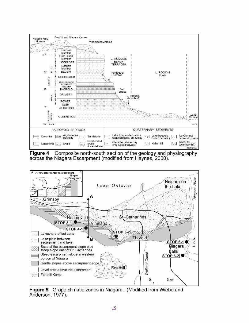
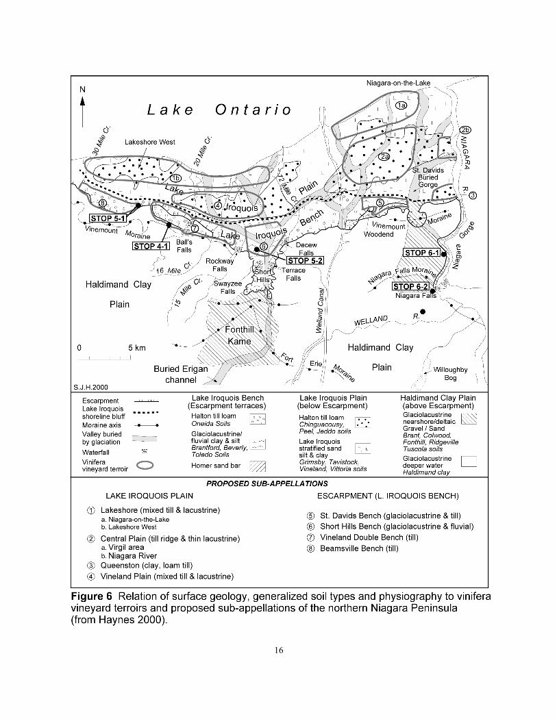
The relation of geology to physiography of the Niagara Peninsula is illustrated in Figures 4 (a compositecross section), 5 (physiography and climate zones) and 6 (plan of surface geology, general soil types,physiography and wine terroirs).
Throughout the Niagara Peninsula, the Niagara Escarpment forms a variety of landforms from the sheer cliffsabout 90 m in height of the Niagara Gorge, to the broad till-covered terraces of the Vineland Double Bench(Fig. 6): both of which will be examined on the trip. These landforms were determined by the glaciogenicerosion of the Lower and Middle Silurian strata, which comprises, from top to bottom: the highly-resistantcaprock of Lockport and Decew dolostones; the easily-eroded Rochester shale; the moderately-resistantpackage of Irondequoit dolostone, Reynales and Neagha limestones and shaly limestones, and Thorold andGrimsby sandstones; the easily-eroded Grimsby and Power Glen shales; the resistant Whirlpool sandstone(Fig. 4). The base of the Escarpment lies at the top of the highly-erosive Upper Ordovician Queenston shales(Figs. 4).
15
16
17
On the face of the Escarpment, two terraces (Bell and Irondequoit terraces, Fig. 4) are usually present (see:Haynes, 2000). At the base of the Niagara Escarpment, the Bell Terrace lies above a prominent north-facingbluff of gravels (Fig. 4) that can be traced around Lake Ontario, to Toronto. This bluff marks the shoreline ofthe Late Pleistocene - Early Holocene proglacial Lake Iroquois (the precursor to modern Lake Ontario) thatformed about 12,000 years ago as the continental ice-sheet retreated north of Toronto. Although narrow inthe east and west of the Niagara Peninsula, the Bell Terrace is often wide and reaches a maximum of about 3km between the Welland Canal and 15-Mile Creek (Fig. 6). The glaciolacustrine deposits on the Bell Terraceand below it on the Iroquois Plain (Fig. 6) vary from massive clay to silt to sand, with sands more commonnearer Lake Ontario.
The Irondequoit Terrace develops where the Rochester shale has been eroded southward above the scarp ofresistant Irondequoit limestone (Fig. 4). Usually the Irondequoit Terrace is very narrow but west of 16-MileCreek, the Escarpment is lower (about 62 m high) and this terrace is 1-2 km wide above a narrower BellTerrace (Vineland Double Bench, Fig. 6). Here, vineyards are located on the terraces in picturesque settingsreminiscent of those in northern Europe, and the major creeks (15-Mile, 16-Mile and 20-Mile Creeks, Fig. 6)cascade over a series of waterfalls that vary in height from a few metres to about 24 m. These waterfalls aredue to differential erosion of the three thick packages of shale (Rochester; Grimsby - Power Glen;Queenston) that underlie the two resistant sequences of: dolostones (Lockport-Decew), and; carbonates(Irondequoit – Reynales) overlying sandstones (Thorold - Grimsby). The two terraces of the VinelandDouble Bench have formed over: 1. an upper, thick, ledge of Irondequoit, and Reynales dolomitic andargillaceous limestones, and Thorold and Grimsby sandstones, and; 2. a lower, thin, ledge of Whirlpoolsandstone that coincides, at the base of the Escarpment, with the top of the shorebluff of proglacial LakeIroquois (Fig. 6). The width of each rock ledge is highly variable but the lower is usually wider, being up to 2km wide in this part of the Niagara Peninsula. Further west, toward Beamsville, the Irondequoit Terracerecedes back to the Escarpment scarp, while the Bell Terrace widens about I.5 to 2 km to form the BeamsvilleBench (Fig. 6). On both terraces, bedrock is overlain by a ramp of Halton till and other Quaternaryglacigenic sediments (Fig. 6). Due to limited exposure, these sediments are poorly understood, and in factmay not even be Halton till but a deposit from an earlier glacial advance. Although the till may be subglacialsediments, possibly formed by debris flow as a wedge of dead ice below the Escarpment (which provided aramp for the advancing ice sheet) melted out on ice retreat, it is likely that the two terraces formed by acombination of both ice carving by older glaciers and shore erosion by older lakes, prior to Lake Iroquois, ofthe Escarpment rock ledges.
The eastern end of the Vineland Double Bench is truncated by the Short Hills reentrant into the Escarpment(Fig. 5). This is a picturesque area, characterized by V-shaped valleys and round hills (short hills) formedduring the post-glacial incision by 12 Mile Creek (and its tributaries) of glacigenic sediments deposited in the,now partly–buried, ancient Short Hills Gorge. The sides of this 3 km wide reentrant are cut by several watercourses; the most significant being Beaverdams Creek, which has cut a gorge and waterfall (Decew Falls: thetype location of the Decew Formation). At Power Glen (type section of the Power Glen Formation), wherethe Niagara Escarpment meets the Short Hills reentrant, 12-Mile Creek has deeply incised the Lake Iroquoisbeach sediments built across the northern exit of the Short Hills Gorge.
To the south, the Short Hills are terminated by the Fonthill Kame (Figs.5 and 6). This is an irregular squarehill, which stands 67 m above the surrounding plain of Haldimand clay, characterised by a steep convex-upward northern slope (ice-contact side) and shallower concave-upward southern, eastern and western slopes.It is formed of stratified well-washed sands and gravels derived as the ice-contact delta to a melting glaciallobe that filled the long southward re-entrant of the Short Hills Gorge. It supplies all the sand and gravel usedin the Niagara Peninsula.
18
On the brow of the Escarpment are located many historic building/crushed stone quarries. Today, only afew are still operating due to land-use restrictions on the Niagara Escarpment as a UN BiospherePreserve. New quarries are located on or south of the Vineland Moraine: a water-lain till that sub-parallels the Escarpment throughout much of the Niagara Escarpment (Figs 4 and 6).
STOP 4-1 Walker Industries Holdings Ltd. Vineland Quarries &Crushed Stone
The quarry is situated near the brow of the Niagara Escarpment south of the village of Vineland. TheVineland Quarries property of over 300 ha encompasses three separate quarries. The original quarry, firstopened in 1958, is mined out. The office, processing plant and stockpiles are located within this quarry. Amajor portion of the quarry has been rehabilitated. Vineland Quarries recently completed the planting of a5 ha vineyard test plot with the assistance of the University of Guelph (see Appendix 1). Pending theoutcome of this test, it is hoped future rehabilitation will include more lands for the production of highquality grapes. The company maintains an ongoing progressive rehabilitation program and has receivednumerous awards.
Current production is from the Clinton and south quarries. A tunnel under Cherry Avenue connects theClinton Quarry to the west with the original quarry. A tunnel has been constructed from the originalquarry beneath Fly Road to access the newly developed south quarry. Current yearly production isapproximately 700,000 tonnes.
The Vineland Quarries expose 9 m of Middle Silurian rocks (OGS, 1989). The basal Rochester Formationconsists 0.3 m of shaly dolostone, which is overlain by the Decew Formation, 1.2 m of a dark grey, finecrystalline, massive and irregularly bedded dolostone. The Lockport Formation exposure is 7.4 m, of greyto light buff, medium to coarse crystalline, fossiliferous dolostone of the Gasport Member and lightbrown, buff weathering, subcrystalline, massive dolostone of the Goat Island Member.
Material is trucked to central location for primary crushing and processing. Vineland Quarries has thecapability to produce different grades of concrete, asphalt and crusher run stone, and variety of associatedproducts. Products are sold to markets across the Niagara Peninsula.
GEOLOGICAL FOUNDATION FOR TERROIRS OF THE NIAGARAPENINSULA
Terroirs and Appellations: a Summary
In France, an appellation refers to an individual viticulture district of a wine region that displays characteristicmeteorological (climatic), physiographic (landform), pedological (soil), geological (subsoil) and viticultural(grape-growing practice) features that constitute its terroir. However, that term is defined by a large numberof factors decreed by the refined Appellation laws of 1935 and each new application is evaluated by a team ofabout six scholars, including two geologists, under the auspices of the INAO (Institut National desAppellations d'Origine), and; the legal control is implicit as the term is short for Appellation d'OrigineContrôlée (A.O.C.). Furthermore, an appellation can be subdivided into sub-appellations, and even furtherdown to the specific vineyard, in terms of relative differences in its terroir (see: Haynes, 2000). OutsideFrance, the term, “appellation”, is used in a loose sense as a geographic area of vinifera vineyards. In
19
Ontario, such geographic areas are termed officially, Designated Viticultural Areas (DVAs), and areallocated in Ontario and British Columbia by an independent alliance, the Vintners Quality Alliance (VQA),who determine the regulations governing the right of vintners to use a DVA on their labels. In Ontario, thelargest DVA is Niagara Peninsula; the others are Lake Erie North Shore and Pelee Island (Fig. 1). VQAregulations governing the production and sale of wine have recently become separate Provincial laws inBritish Columbia and Ontario, but Federal legislation is needed for sale of Canadian wine in E.E.C. countriesas there are four distinct Provincial wine regions that contain separate viticulture districts: Ontario, BritishColumbia (Okanagan and Similkameen Valleys, Fraser Valley, Vancouver Island), Quebec (Montérégie andEstrie), and Nova Scotia; the partridgeberry wines of Newfoundland may constitute the fifth region. Thus, itis important that the separate provincial professional geoscientist associations, as well as the provincial andfederal, “mines ministries”, be represented on the VQA to give geological substance to determination ofCanadian appellations (DVAs) and sub-appellations.
The recognition of wine terroirs can be made at progressively smaller levels depending on the informationavailable. The largest is the macro-level of a wine region which is the scale of the Niagara PeninsulaDesignated Viticultural Area (DVA). The next is the meso-level of a French appellation which would be theequivalent of the division of the Niagara Peninsula into, at least three longitudinal segments: 1. the LakeIroquois Plain (between Lake Ontario and the base of the Niagara Escarpment), 2. the Niagara Escarpment(from the base of the Escarpment to the Vinemount Moraine), and 3. the Haldimand Clay Plain (south of theVinemount Moraine); the roughly circular area of the Fonthill Kame constitutes a fourth appellation. Othersmay consider these as sub-appellations of a Niagara Peninsula appellation; there being no rules on size, noron exact definitions. The next smaller is the mini-level of a sub-appellation, which have been defined byHaynes (2000) for the Lake Iroquois Plain and the Escarpment (Fig. 6). The absolute smallest level of aFrench terroir is the micro-level of a vineyard for a specific varietal wine: a climat. In all Canadian winedistricts it will be many years of work before we can begin to determine specific climats.
Niagara Peninsula Terroirs
Wiebe and Anderson (1977) divided the Niagara Peninsula DVA into seven climate zones based on thedifferent effect of air flow over the eastern Niagara Escarpment (narrow terraces) and western Escarpment(wide terraces), and an airborne thermal imagery study of infrared radiation along a north-south traverse ofthe northern Niagara Peninsula through Vineland (Fig. 5). Niagara's climate on and below the NiagaraEscarpment is dominated by the moderating effect of its position between the large water masses of LakesErie and Ontario. In winter, this contributes to warmer than normal temperatures such that distance north ofthe Escarpment is the determining climate factor in vineyard site selection in terms of: the likelihood of hardfrosts in April that cause severe bud damage. In the, “level area above the Escarpment”, and including theFonthill Kame (Fig. 5), the virtual absence of lake effects results in fewer frost-free days in spring and colderwinter temperatures below -20oC, that cause severe damage to the vines and restrict grape plantings to NorthAmerican labrusca varieties, which are hardier than European vinifera varieties. The longest frost-freeseason, and therefore the least cold injury danger to vines is the zone of, “Steep escarpment slope in westernportion of Niagara”, due to the escarpment-effect winds (see cross-section, Fig. 5). Moderate cold injurydanger is experienced in the, “Lakeshore effect” (which continues south along the Niagara River), and, “Baseof the escarpment slope (in the west) plus steep slope east of St. Catharines”, zones, and, at only slightlygreater risk, the zone of, “Gentle slopes above escarpment edge”. The flat, “Lake plain between escarpmentand lake”, zone is at greater frost risk than the other zones below the Escarpment because it is furthest fromboth the Escarpment and Lake Ontario.
In terms of physiography, drainage, bedrock, drift and soils, two distinctly different vinifera terroirs arepresent in the Niagara Peninsula (Fig 6): the Lake Iroquois Plain (the area between Lake Ontario and the

20
base of the Niagara Escarpment), and; the Escarpment (the terraces of the Lake Iroquois Bench, and alsolocally slopes above the Niagara Escarpment, north of the Vinemount Moraine). Topographically, the plainhas mainly gentle slopes, grading to both north and south, whereas the Escarpment terraces grade consistentlynorth, often with moderate to steep slopes. Soils in the Niagara Peninsula are derived mainly by directorganic and weathering breakdown of the underlying Late Pleistocene-Holocene glacial, lacustrine, fluvialand alluvial sediments. From 1:20 000 scale mapping, Kingston and Presant (1989) demonstrated that thesoils and their equivalent Pleistocene-Holocene subsoils exhibit a large number of types that exhibit rapidlateral changes. On the Lake Iroquois Bench: Oneida soils are above Halton clay till, and; Brantford,Beverley, Toledo (also, Cashel, Peel) soils are above glaciolacustrine silty clay, itself overlying Halton till.On the Lake Iroquois Plain: Chiguacousy, Peel and Jeddo soils overlie the ridges of Halton till clay, and;fertile Grimsby, Tavistock, Vineland and Vittoria soils overlie the stratified sands silts and clays of the LakeIroquois lakebed.
By combining the differences in the climate zones, landform physiography, and the soil types the LakeIroquois Plain can be subdivided into four (possibly six), and the Escarpment into four, separate terroirs orsub-appellations (Fig. 6). In general, these correspond with those recently proposed by winemaker J-L (Jean-Laurent) Groux, of Hillebrand Estate Winery, who has made an excellent study of the distinctive taste,bouquet, etc. of wines made by him in separate batches of wine under identical conditions (thus, removingthe, "winemaker", factor) from different vineyard terroirs throughout Niagara. His database, which has beenover 10 years in the making, has allowed him to distinguish nine different vinifera terroirs (sub-appellations).However, other sub-appellation terroirs are likely to emerge on further detailed study.
The characteristics of two different sub-appellation terroirs and their resultant wines will be examined atstops to two estate wineries.
STOP 5-1 Malivoire Wine Company
One of Niagara’s newest estate wineries, Martin Malivoire and his associates have achieved a remarkablefirst by constructing their winery into the Lake Iroquois bluff such that grapes go in at the vineyard levelat the top and emerge half-way down the slope as wine. According to winemaker Ann Sperling, thisgravity-feed system creates less stress on the wine and makes a better product as the juice and wine do notrequire pumping as in a conventional winery.
The vineyards are located at the eastern end of the Beamsville Bench (Fig. 6) on prime-quality well-drained Halton till on the gently-sloping terrace between the top of the Lake Iroquois shorebluff and thesteeply–sloping Escarpment. From here southwestward, the Escarpment is a prominent cliff past CaveSprings Conservation Area because the generally southwest-moving ice sheet gouged the Escarpmentalong a prominent SW-trending joint direction; with much of this eroded material being deposited as a tillramp at the western end of the Beamsville Bench. This cliff has enhanced the wind patterns off LakeOntario, in combination with the prevailing southwesterlies, such that this is also a warm climate locationand thus one of the best terroirs in the Niagara DVA..
STOP 5-2 Henry of Pelham Family Estate Winery
Run by the three Speck brothers and their late father since 1983 on the site of Henry Smith of Pelham’s(their ancestor and Empire Loyalist) original land grant after his father’s participation in theRevolutionary War of 1776. The vintage coaching inn (now the offices) has the original 1842 basement(now the tasting room) lined with red Grimsby sandstone from the outcrop 100 m to the south. Even
21
though it is probably the only estate winery in North America to have its own graveyard, it is singularlyunique in it coming complete with an uninterrupted line of Smiths and an interesting historicalperspective on the use of local stone for grave markers. Together with winemaker Ron Giesbrecht, theSpecks have made full use of their being the only Niagara estate winery on the Escarpment that is mostlyon very thick monotonous glaciolacustrine clay, rather than glacial till. This, so they would argue, makesthe grapes fight to achieve a better quality of juice for their international-award-winning wines.
They are the premier vineyard of the Short Hills Bench (Fig. 6), which in terms of soil (clay) and climate(mouth of the Short Hills re-entrant) are completely different from any other Escarpment or Lake IroquoisPlain terroir.
OVERVIEW OF THE GEOLOGY OF THE NIAGARA FALLS & GORGE
The most impressive view of the bedrock geology is the 50 or so metres exposed above the Niagara River atthe Falls and Gorge. However, from soundings of the river it is known that the plunge pool of the Falls hasexcavated about a further 50 m below the surface of the river. In the eastern Niagara Peninsula, the highestvertical exposure is where the Niagara River exits the Niagara Gorge at Queenston Heights (Figs. 4 and 6).Here the Escarpment forms an abrupt steeply-sloping feature, about 76 m (250 ft) in height, of south-dippingLower and Middle Silurian strata comprising, from top to bottom: the massive, cliff-forming, Lockport andDecew dolostones; Rochester shale; Irondequoit dolostone; Reynales and Neagha limestones and shalylimestones; Thorold and Grimsby sandstones; Grimsby and Power Glen shales; the Whirlpool sandstone,and; the top of the Upper Ordovician Queenston Shale, which extends along the Lower Niagara River toNiagara - on - the - Lake. The Silurian sequences were laid down over a time period of 20-25 million years,commencing 438 million years ago. At the base of the Escarpment, a terrace of gravels (Bell Terrace) formsa prominent north-facing bluff (see, cross-section, Fig. 4).
STOP 6-1 Great Gorge Adventure
The view from the Niagara Parkway looking into the Niagara Gorge encompasses the Silurian sequence fromthe Lockport dolostone caprock to the Gorge down to the Whirlpool sandstone (Fig. 4). We shall descend byelevator to a boardwalk along the Whirlpool Rapids which boast some of the world's largest standing waves,as well as the location of Ms Lane's rescue in the movie, "Superman". From here the geology can be viewedfrom the Lower Silurian units upward. On the opposite side of the river, a huge rockfall has covered thetracks of the late19th century electric tramway that followed the Gorge.
Downriver the Niagara River takes a 90o turn to the northeast at the Whirlpool. Originally, the Niagara Riverflowed through the buried St. David’s Gorge (Fig. 6) but during Late Wisconsinan glaciation it was filledwith glacial sediment. At the close of glaciation, the river cut back from the Escarpment along its presentpath to reach the old gorge about 5000 - 6000 BC (Tinkler et al., 1994); about the same time as the earliestrecords of grape cultivation for wine in the Middle East; where in the ancient Persian empire, it was officialgovernment policy that “government ministers used to take important decisions when drunk, in the belief thatthe divine influence of wine would guide them”, although, “such decisions were also reviewed by theministers when sober the following day!” (Buckley, 1994). The Whirlpool usually rotates anticlockwise, butin times of low water volume (much of the water is taken by hydro-electric stations on both Canadian andU.S.A. sides of the gorge) it flows clockwise.
22
STOP 6-2 Niagara Falls
There two main falls at Niagara Falls: the linear American Falls (wholly within the U.S.A.), which tumblesover the side of the Niagara Gorge, and the Canadian Falls (or Horseshoe Falls), which forms the head of theNiagara Gorge (Fig. 6). The falls have carved away much of the 90 m (310 feet) vertical height between theUpper Lockport Formation and the Queenston shale (Fig. 4). However, the lower half of this height is filledwith the water of the plunge pool of the lower Niagara River, below the falls: the falls themselves being about45 - 51 m (~150 feet) high. The only rocks normally exposed in the walls of the falls are the Lockport,Decew, Rochester and Irondequoit formations.
Although the hydro-electric stations on the American side of the Upper Gorge were destroyed by majorrockfalls, the one on the Canadian side is still working and can be seen from the Table Rock viewpoint. Acloser viewpoint is accessed from the base of the Scenic Tunnels Tour elevator.
Above the Falls, the Upper Niagara River takes an abrupt turn to the southeast. Examination of Figure 3indicates that the river preferentially followed the southwest and southeast joint sets in the bedrock as itcarved its way down and back from the edge of the Escarpment.
ACKNOWLEDGEMENTS
We are indebted to Mike Lozon, Department of Earth Sciences, Brock University for the computerartwork of the figures. The vineyard managers and wine makers of the Niagara region are heartilythanked for imparting their ideas and experiences over the years. We also thank Jennifer Stewart andPascale Sergerie, Ministry of Northern Development and Mines, for assisting with field trip arrangements.
23
REFERENCES
Buckley, R. (editor) 1994: The world of wine: The Grape and Civilization. Understanding Global Issues;European Schoolbooks Publishing, Cheltenham, UK.
Guillet, G.R. 1967: The Clay Products Industry of Ontario; Ontario Department of Mines, IndustrialMinerals Report 22, 206p.
Haynes, S.J. 2000: Geology and Wine 2. A geological foundation for terroirs and potential sub-appellations of Niagara Peninsula wines, Ontario, Canada; Geoscience Canada, Volume 27, Number 2,June 2000, p 67-87.
Kingston, M.S., and Presant, E.W., 1989, The soils of the Regional Municipality of Niagara: OntarioInstitute of Pedology, Report No. 60, Volumes 1 and 2, plus 7 maps scale 1:25,000.
Ontario Geological Survey 1989: Limestone Industries of Ontario, Volume III – Limestone Industries andResources of Central and Southwestern Ontario; Ontario Ministry of Natural Resources, LandManagement Branch, 175p.
Steele, K.G. 2000: Southern Ontario Regional Resident Geologist – Southwest Ontario District – 1999 inReport of Activities 1999, Resident Geologist Program, Southern Ontario; Ontario Geological Survey,Open File Report 6008, 79p.
Tinkler, K.J., Pengelly, J.W., Parkins, W.G. and Asselin, G. 1994: Postglacial recession of Niagara Fallsin Relation to the Great Lakes; Quaternary Research, Volume 42, p 20-29.
Wiebe, J., and Anderson, E.T., 1977: Site selection for grapes in the Niagara Peninsula; HorticulturalResearch Institute of Ontario, Vineland Station, Ontario, 1 page map.
In Vino Veritas
24
APPENDIX 1
Vineland Quarries Rehabilitation Project
September 12/13, 2000
C. Clark, B. Cornelius, Vineland QuarriesK.H. Fisher, University of Guelph
The trial was initiated to establish that perennial crops, such as grapevines, could be grown onrehabilitated quarry land if the appropriate measures were taken to ensure good soil structure. Financialpartners included Vineland Quarries and the Industrial Research Assistance Programme of the NationalResearch Council. Subcontractors and consultants for the project were Vineland Quarries, VailmontVineyards, Kasper Land Drainage, Braemar Acres, K.L. Bellamy Associates, Niagara College, theUniversity of Guelph and the former Quno/Donohue now Abitibi Consolidated Mills. The project startedin May 1 1999 and was completed July 31 2000.
This location had not been systematically rebuilt and after initial grading in the early 1980’s, was seededand used for pasture. The land was rolling at the north part of the parcel and then steeply sloping towardthe quarry floor. The initial work was to re-grade the slope to reasonable aspect to capitalize on the southface and allow for safe working conditions for conventional farm equipment working parallel to the slope.
The slope was graded to 12% and then ripped at 1.4 m centres to a depth of 0.8-1 m, both parallel andperpendicular to the slope. Because of the degree of soil movement required to regrade the slope, the newface was covered with about 0.5 m of topsoil from an undisturbed section of the quarry. The whole fieldwas then tiled parallel to the slope at 3.75 m. Three separate headers were cut perpendicular to the slopeand emptied into separate catch basins at the bottom of the field so that soil water could be monitored ifnecessary.
The field was then divided into 27 plots for three treatments with paper mill biosolids for therehabilitation of the soil structure. This material is basically cellulose with some ink residues and is theproduct from one paper mill which produces only newsprint. The product is very consistent and ismonitored very closely. Two rates and check plots with no biosolids are randomized throughout the field.This material was applied and then worked in and a cover crop of rye and radish sown. This spring, thecover crop was worked under and grapes planted. Eight varieties of wine grapes have been planted here,all red varieties and differing in their winter hardiness.
The soil quality has been monitored since the beginning of the trial and the cover crop has been analysedin November 1999 and June 2000. Vine growth, mineral nutrition and winter hardiness will be monitoredand further trials regarding the appropriate cover crops and fertilization programmes are planned. Weatherstations have also been installed to track the temperature differential on the slope and throughout thequarry.
Contact:K.H. FisherUniversity of Guelph, Ontario Agricultural College, Department of Plant Agriculture4890 Victoria Ave. North, P.O. Box 7000, Vineland Station, ON, L0R 2E0
25
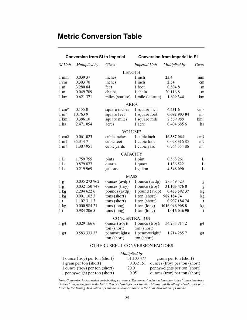
Metric Conversion Table
Conversion from SI to Imperial Conversion from Imperial to SI
SI Unit Multiplied by Gives Imperial Unit Multiplied by Gives
LENGTH1 mm 0.039 37 inches 1 inch 25.4 mm1 cm 0.393 70 inches 1 inch 2.54 cm1 m 3.280 84 feet 1 foot 0.304 8 m1 m 0.049 709 chains 1 chain 20.116 8 m1 km 0.621 371 miles (statute) 1 mile (statute) 1.609 344 km
AREA1 cm@ 0.155 0 square inches 1 square inch 6.451 6 cm@1 m@ 10.763 9 square feet 1 square foot 0.092 903 04 m@1 km@ 0.386 10 square miles 1 square mile 2.589 988 km@1 ha 2.471 054 acres 1 acre 0.404 685 6 ha
VOLUME1 cm# 0.061 023 cubic inches 1 cubic inch 16.387 064 cm#1 m# 35.314 7 cubic feet 1 cubic foot 0.028 316 85 m#1 m# 1.307 951 cubic yards 1 cubic yard 0.764 554 86 m#
CAPACITY1 L 1.759 755 pints 1 pint 0.568 261 L1 L 0.879 877 quarts 1 quart 1.136 522 L1 L 0.219 969 gallons 1 gallon 4.546 090 L
MASS1 g 0.035 273 962 ounces (avdp) 1 ounce (avdp) 28.349 523 g1 g 0.032 150 747 ounces (troy) 1 ounce (troy) 31.103 476 8 g1 kg 2.204 622 6 pounds (avdp) 1 pound (avdp) 0.453 592 37 kg1 kg 0.001 102 3 tons (short) 1 ton (short) 907.184 74 kg1 t 1.102 311 3 tons (short) 1 ton (short) 0.907 184 74 t1 kg 0.000 984 21 tons (long) 1 ton (long) 1016.046 908 8 kg1 t 0.984 206 5 tons (long) 1 ton (long) 1.016 046 90 t
CONCENTRATION1 g/t 0.029 166 6 ounce (troy)/ 1 ounce (troy)/ 34.285 714 2 g/t
ton (short) ton (short)1 g/t 0.583 333 33 pennyweights/ 1 pennyweight/ 1.714 285 7 g/t
ton (short) ton (short)
OTHER USEFUL CONVERSION FACTORS
Multiplied by1 ounce (troy) per ton (short) 31.103 477 grams per ton (short)1 gram per ton (short) 0.032 151 ounces (troy) per ton (short)1 ounce (troy) per ton (short) 20.0 pennyweights per ton (short)1 pennyweight per ton (short) 0.05 ounces (troy) per ton (short)
Note:Conversion factorswhich are in boldtype areexact. Theconversion factorshave been taken fromor havebeenderived from factors given in theMetric PracticeGuide for the CanadianMining andMetallurgical Industries, pub-lished by the Mining Association of Canada in co-operation with the Coal Association of Canada.


ISSN 0826--9580ISBN 0--7794--0401--7