microstar drifters: a friendly user’s guide lt ana lisa
TRANSCRIPT

MICROSTAR DRIFTERS: A friendly user’s guide LT Ana Lisa Wilson
OC 3570 March 16, 2007

2
I. Introduction and Background Ocean drifters are used to monitor the speed and direction of surface currents all
over the world. By releasing them into a water mass, the movement characteristics of that
mass can be determined and analyzed. The importance of these travel paths lies in global
circulation, which is necessary in determining overall transport. The measurements are also
useful in the design of dispersion models to track such events as oil spills, floating debris,
and larval migration.
Until recently, Naval Postgraduate School’s Oceanography Department (NPS) used
Brightwater drifters. These drifters are rather large in size (about 3-5 feet in height, and 6
inches in diameter), making them bulky in the amount of ship storage space that they take up.
Assembly requires multiple tools and a precise order to ensure that all of the parts fit together
and form a water tight seal. Experience shows that these drifters are rather inconvenient in
assembly and deployment. Due to the age of the drifters held at NPS and the progress of
technology, a replacement was needed. The Navy turned towards Pacific-Gyre and their
Microstar drifter. Currently NPS owns six such drifters, and they are set to become the
Naval Oceanographic Office’s primary research drifter.
The following user’s guide includes information on setting up and deploying the
Microstar Drifter, as well as analysis of some data collected from sea-trials of NPS drifters.
II. Set-up and Deployment/Recovery
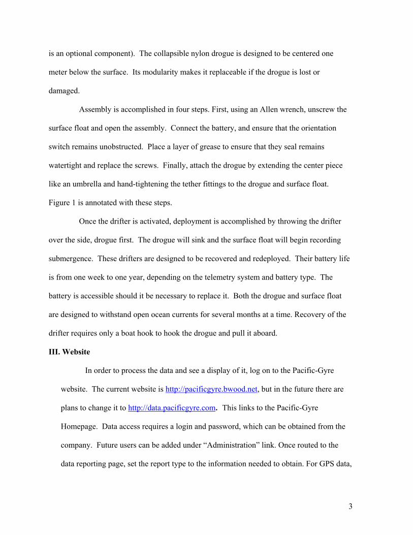
There are three components to the Microstar Drifter, a surface float, tether, and
drogue. The surface float contains the Global Positioning System (GPS) and battery. It is
made of ABS plastic, and contains the following sensors: Mobitex data packet telemetry,
GPS positioning, sea surface temperature, submergence, battery voltage, and salinity (which
3
is an optional component). The collapsible nylon drogue is designed to be centered one
meter below the surface. Its modularity makes it replaceable if the drogue is lost or
damaged.
Assembly is accomplished in four steps. First, using an Allen wrench, unscrew the
surface float and open the assembly. Connect the battery, and ensure that the orientation
switch remains unobstructed. Place a layer of grease to ensure that they seal remains
watertight and replace the screws. Finally, attach the drogue by extending the center piece
like an umbrella and hand-tightening the tether fittings to the drogue and surface float.
Figure 1 is annotated with these steps.
Once the drifter is activated, deployment is accomplished by throwing the drifter
over the side, drogue first. The drogue will sink and the surface float will begin recording
submergence. These drifters are designed to be recovered and redeployed. Their battery life
is from one week to one year, depending on the telemetry system and battery type. The
battery is accessible should it be necessary to replace it. Both the drogue and surface float
are designed to withstand open ocean currents for several months at a time. Recovery of the
drifter requires only a boat hook to hook the drogue and pull it aboard.
III. Website
In order to process the data and see a display of it, log on to the Pacific-Gyre
website. The current website is http://pacificgyre.bwood.net, but in the future there are
plans to change it to http://data.pacificgyre.com. This links to the Pacific-Gyre
Homepage. Data access requires a login and password, which can be obtained from the
company. Future users can be added under “Administration” link. Once routed to the
data reporting page, set the report type to the information needed to obtain. For GPS data,

4
choose Lat Lon Web or Lat Lon Text. (Note that if the pop-up blocker is enabled, none
of the web data will appear). Naval Postgraduate School should already be selected as
the organization. Next, select a project. This is either all, or NPS Global Microstars.
Then, select the devices that the data is being downloaded from by moving either single
drifters or all drifters from the left “Devices to Report” box to the right box. Devices are
deselected by moving them from the right box to the left. The device IDs are the same as
the number written on the individual drifters. There are currently no other sensors in the
NPS drifters, so it is unnecessary to select sensors to be included in the report. If saving
the data, check e-mail. The e-mail will be sent to the logged in user either one time, or at
the intervals selected. Name the report. Then, for later use, check the “Save Report
Definition” box. Click on “Submit” to see the data.
To plot the tracks of a drifter, click on “Data Mapping” from the menu. Once
on the data mapping page, choose a map type. “Microsoft Visual Earth” and “Google
Maps API” are the two choices. Again, select an organization and project if necessary.
The choice of “All” for project will work unless there is more than one project at a time.
The next step is selecting the device that should be plotted. Device selection is the same
as in the data reporting stage. Select a date and time range, name the map, and then save
for later use by selecting “Save map definition.”
Figure 4 shows the basic data report to include device name, time of device,
latitude, longitude, and GPS quality (which indicates the quality of the GPS fix, usually a
number between 1 and 3). GPS data will update every 10 minutes, providing high
spatial and temporal resolution. If other sensors are included, their data will be included

5
in the report. In addition to web format, data reports are in Microsoft Excel, XML
format, comma delimited, TIFF file, and Acrobat PDF.
III. Data Analysis
Data was collected from two cruises on the RV Point Sur, from January 23-January
30, 2007 (cruise 1) and on February 28, 2007 (cruise 2). Initially, on cruise 1, three drifters
named 902, 860, and 910 were opened on the deck of the ship to acquire the GPS signal and
ensure that the batteries were working before they were deployed. This step was taken to
ensure that the drifters could be recovered for future use. The three drifters were then
deployed in San Francisco Bay between 1509 and 1517 UTC. The third drifter deployed,
860, was deployed with Brightwater drifter 68, which had no GPS signal on it, and was only
used as a spotting mechanism. The drifters were recovered between 2053 and 2111 UTC. On
the same day, at 2232 UTC Microstar drifter 902 was redeployed and left in the bay
overnight, and then recovered on January 27th at 1721 UTC. The three drifters were
deployed again at 1815 UTC and recovered at 2343 UTC. Drifter 910 was deployed again at
0048 UTC and recovered at 1646 UTC on January 28th. On February 28th the three drifters
were deployed again from 1744 UTC until 2030 UTC. This time they were deployed with a
Brightwater Drifter equipped with positioning data.
The data from the first deployment of drifters on cruise 1 was analyzed and
compared to tidal data at the Golden Gate Bridge in San Francisco Bay. This was done using
vector analysis. By taking the distance between the latitude and longitude, squaring them,
and adding them together, distance traveled was determined. Speed of travel was determined
by dividing the distance traveled by the time between the two points. Direction of the drifter

6
was determined pictorially by placing arrows from one location to another. Current data
from San Francisco Bay (courtesy of the National Oceanic and Atmospheric Administration)
was compared to the speed vectors of the drifters. At 1841UTC the Max Ebb Current at
Alcatraz Island was 4.3 knots. The drifters were deployed at 1900 UTC. The average speed
of drifter was 1.57 knots, with a speed of 1.6 knots at Alcatraz Island at 2230 UTC.
According to San Francisco Tidal currents, at 2220 UTC there was a slack water period,
which corresponds with the slow moving drifters. (Figure 5)
The next analysis was on the reliability of the satellite data. This was done by
comparing the RV Point Sur’s positions to those of the drifters while they were on the boat
deck. The results of the GPS data comparison were very similar, validating the GPS on the
drifter. (Figure 6)
Using data from cruise 2, trajectory comparisons were made, first with the
Brightwater drifter and then with current trajectories from the Coastal Ocean Currents
Monitoring Program (COCMP). In both cases, the comparisons were favorable. The
trajectories of the Brightwater and Microstar drifters were very close, with the only notable
difference in the curvature of the Brightwater drifter. (Figure 7) The Brightwater trajectory
was less circular than that of the Microstar drifters. When compared to the OMA derived
current model from the COCMP site, the trajectories appear to be somewhat the same.
However, to make a more accurate comparison, higher resolution is needed.
Also using cruise 2 data, a comparison of how the four drifters behaved with time
was made. This comparison was made by plotting each of the drifters at 10 minute intervals,
then connecting the common timed markers with black lines. Figure 8 shows that as time
progressed the drifters moved at a constant speed. Throughout the beginning of the period

7
the drifters maintain a parallel course and remain equidistant. However, towards the end of
the period, as noted earlier, the trajectory of the Brightwater drifter changes slightly. This
suggests that while the drifters were deployed in the same water mass, there is the possibility
that the Brightwater moved into a different regime.
IV. Conclusions and Future Studies
The Microstar drifter proved to be uncomplicated in assembly, deployment, and
recovery. Accessing data from the Pacific-Gyre website is also uncomplicated and can be
done through several different methods, from actually viewing the data on the web to e-mails
at regular intervals. E-mails can be sent to cellular phones or other hand held devices giving
almost real-time updates that make drifter recovery possible. Analysis of the data shows that
in San Francisco Bay, the drifters were caught between the Ebb and Flood tides, in slack
water, and therefore moved more slowly than expected. The GPS data was accurate and can
be trusted for longer drifter deployments in the future. The third conclusion is that the
trajectory of the water mass off of Moss Landing flowed from south to north in a curved path
at a constant speed.
In the future, it would be beneficial to deploy the drifter for a longer period of
time. This would have a two-fold response. Trajectories could be explored for a longer time
and area currents could be more fully explored given a longer time stamp. The durability of
the drifter and actual battery length could also be confirmed if the drifter was deployed for a
longer period. Another suggestion is to deploy the Brightwater drifter (which uses radar
triangulation for locations) with a Microstar drifter, and compare how the two drifters move
in relationship to each other. Due to different drogues over time one would expect the two
drifters to have a significant difference in their trajectories.

8
V. Acknowledgements
Thank you to Dr. Collins and Dr. Guest who got me involved in this project.
Mike Cook helped me on the first testing day, and without him, the drifter would probably
still not be put back together. The crew of RV Point Sur played an integral part in launch and
recovery. Tarry Rago set me straight on some of the details, such as turning off my pop-up
blocker. Andy, the president of Pacific-gyre answered questions that I couldn’t find on their
website. Last but not least, thanks to my classmates who had to stand out in the cold with
and without me to ensure the drifters didn’t make it out of the bay.

9
VI. Figures
Step 2
Step 3
Step 4
Figure 1 Microstar Drifter Assembly

10
Figure 2 Pacific-Gyre Homepage
Figure 3 Data Mapping page for downloading drifter data

11
Latitude Longitude Report
Device Name Device Time GPS latitude longitude
0-227860 2007-02-28 18:00:00 3 36.795908 -121.865928
0-227910 2007-02-28 18:00:00 3 36.795436 -121.862514
0-227902 2007-02-28 18:30:00 3 36.797672 -121.871125
0-227910 2007-02-28 18:30:00 3 36.796944 -121.864589
0-227860 2007-02-28 19:00:00 3 36.799683 -121.868642
0-227902 2007-02-28 19:00:00 3 36.799783 -121.871786
0-227910 2007-02-28 19:00:00 3 36.798708 -121.865986
0-227902 2007-02-28 19:30:00 3 36.801953 -121.871667
0-227910 2007-02-28 19:30:00 3 36.800867 -121.866303
0-227860 2007-02-28 20:00:00 3 36.804078 -121.867367
0-227902 2007-02-28 20:00:00 3 36.804342 -121.870283
0-227910 2007-02-28 20:00:00 3 36.802989 -121.865372
0-227860 2007-02-28 20:30:00 3 36.806239 -121.864919
0-227902 2007-02-28 20:30:00 3 36.806503 -121.867503
0-227910 2007-02-28 20:30:00 3 36.805178 -121.863403
Figure 4 Sample Data report

12
Figure 5 Three buoys in San Francisco Bay on January 27th, 2007. The ending point is the upper left corner, near Alcatraz Island. Average speed of drifters is approximately 1.57 knots.

13
Figure 6 Comparison of Microstar Data with ship's track. This illustrates the reliability of the GPS data in Microstar telemetry package.

14
Figure 7 Initial comparison of Microstar vs. Brightwater drifter data, showing that trajectories of the four drifters are very similar at the beginning of the period.

15
Figure 8 Three Microstar drifters and Brightwater drifter graphed at 10 minute intervals. This plot shows the consistent speed and distance maintained between the drifters.

16
VII. References http://www.cencalcurrents.org/Plots/ This website was used to determine the predicted current trajectories off Moss Landing http://pacificgyre.bwood.net This is the Pacific-Gyre website. All specifications and data were retrieved from this website. http://wolfweb.unr.edu/homepage/edc/tides/2007/sfbe_fr07.html This is a site where currents in the San Francisco Bay are posted.