linwood vincent university of virginia charlottesville, va
TRANSCRIPT
PROF. ROBERT DOLAN' LINWOOD VINCENT
University o f Virginia Charlottesville, V a . 22903
Coastal Processes High-altitude aerial photographs aid in investigations.
T HE INCREASED availability of high-alti- tude aerial photographs provide an
excellent opportunity for the coastal in- vestigator to monitor changes in shoreline features at scales that were previously only occasionally used. If combined with the low-altitude photographs and ground sur- veillance, high-altitude imagery provides a valuable tool for engineering design and resource planning, as well as for studies of
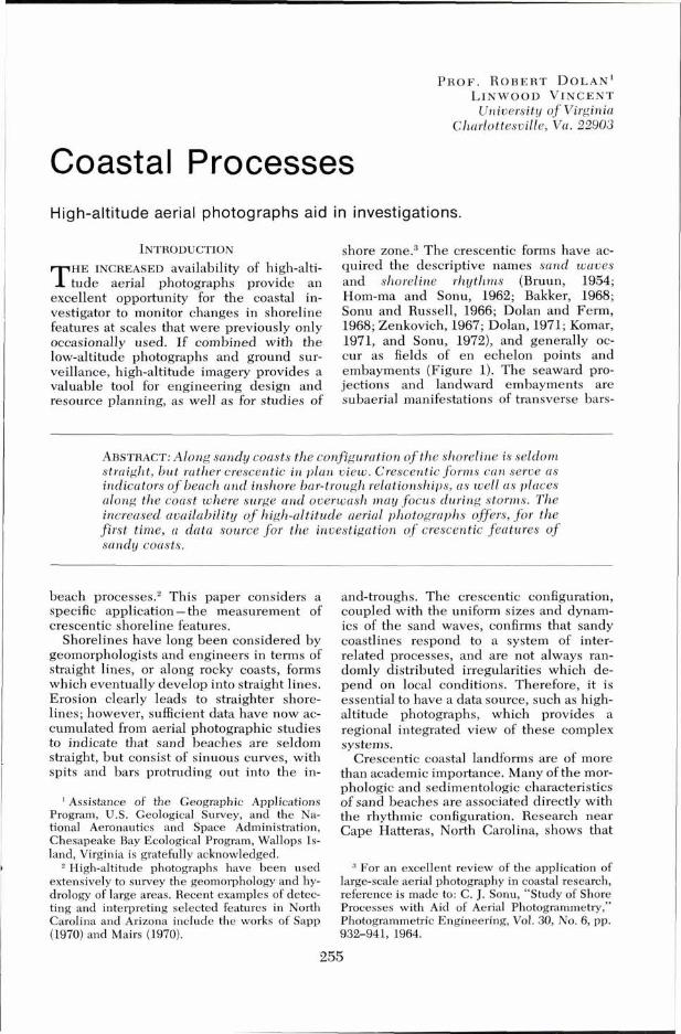
shore zone.3 The crescentic forms have ac- quired the descriptive names sand waves and shoreline rhythms (Bruun, 1954; Horn-ma and Sonu, 1962; Bakker, 1968; Sonu and Russell, 1966; Dolan and Ferm, 1968; Zenkovich, 1967; Dolan, 1971; Komar, 1971, and Sonu, 1972), and generally oc- cur as fields of en echelon points and embayments (Figure 1). The seaward pro- jections and landward embayments are subaerial manifestations of transverse bars-
ABSTRACT: Along sandy coasts the configuration of the shoreline is seldom straight, bu t rather crescentic i n plan v iew. Crescentic forms can serve as indicators o f beach and inshore bar-trough relationships, as well as places along the coast where surge and overwash may focus during storms. The increased availability o f high-altitude aerial photographs offers, for the first t ime, a data source for the investigation of crescentic features of sandy coasts.
beach processe~ .~ This paper considers a specific application -the measurement of crescentic shoreline features.
Shorelines have long been considered by geomorphologists and engineers in terms of straight lines, or along rocky coasts, forms which eventually develop into straight lines. Erosion clearly leads to straighter shore- lines; however, sufficient data have now ac- cumulated from aerial photographic studies to indicate that sand beaches are seldom straight, but consist of sinuous curves, with spits and bars protruding out into the in-
' Assistance of the Geographic Applications Program, U.S. Geological Survey, and the Na- tional Aeronautics and Space Administration, Chesapeake Bay Ecological Program, Wallops Is- land, Virginia is gratefully acknowledged.
High-altitude photographs have been used extensively to survey the geomorphology and hy- drology of large areas. Recent examples of detec- ting and interpreting selected features in North Carolina and Arizona include the works of Sapp (1970) and Mairs (1970).
and-troughs. The crescentic configuration, coupled with the uniform sizes and dynam- ics of the sand waves. confirms that sandv coastlines respond to a system of inter- related processes, and are not always ran- domly distributed irregularities which de- pend on local conditions. Therefore, it is essential to have a data source, such as high- altitude photographs, which provides a regional integrated view of these complex systems.
Crescentic coastal landforms are of more than academic importance. Many of the mor- phologic and sedimentologic characteristics of sand beaches are associated directly with the rhythmic configuration. Research near Cape Hatteras, North Carolina, shows that
For an excellent review of the application of large-scale aerial photography in coastal research, reference is made to: C. J. Sonu, "Study of Shore Processes with Aid of Aerial Photogrammetry," Photogrammetric Engineering, Vol. 30, No. 6, pp. 932-941, 1964.
measured offshore, and beach character- istics. - -
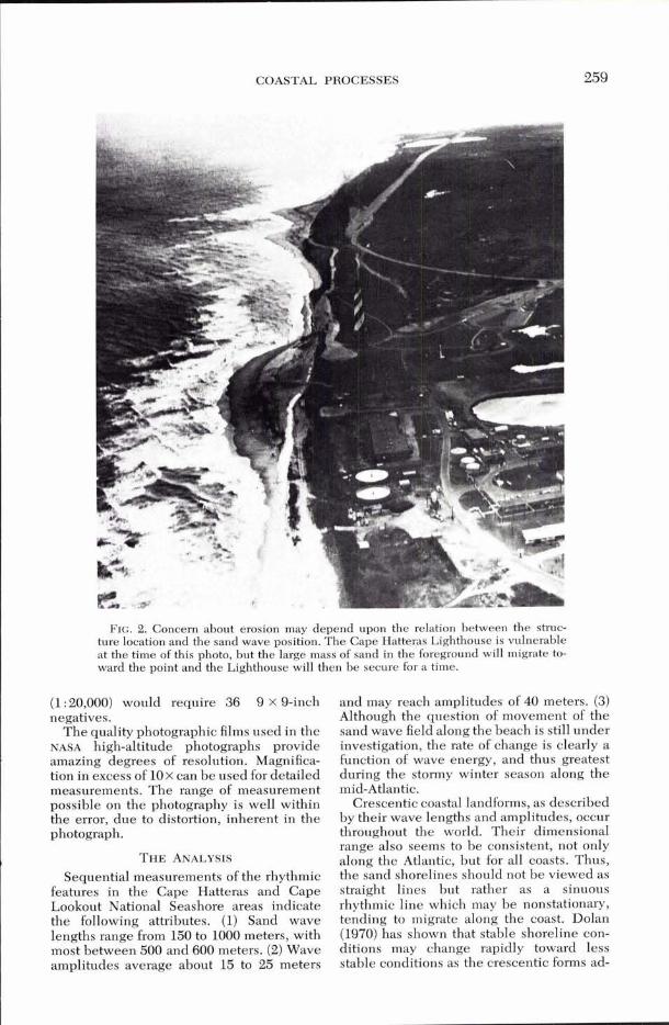
Submarine bars associated with the sand waves have deep-water channels immedi- ately offshore from embayments. Depres- sions in the bars allow higher waves to penetrate closer inshore, breaking on the beach face rather than on the bar. These channels and the offshore bar system can be seen on aerial photographs by comparing the shoaling of the incoming breakers with the sand wave field (Figure 2). Thus, the focus of destructive storm surge and overwash along barrier islands is related to the field posi- tion rather than by chance variation in the submarine bars or low places in the barrier dunes (Dolan, 1971).
THE PHOTOGRAPHS Several sets of high-altitude photographs
have been taken of the middle Atlantic coastal region. Five sets are now available of the C a ~ e Hatteras area since 1968. and most of the barrier islands of Virginia ind North Carolina are scheduled to be photographed by U-2 aircraft every 18 days under the NASA-USGS CARETS program. Commencing in 1972, space imagery of ERTS-I will pro- vide regular coverage of the mid-Atlantic coast.
Although the types of imagery available to secondary users depend on the agency and the objectives of the original NASA- and USGS-funded projects, color-infrared is avail- able from most of the NASA-USGS aircraft mis- s i o n ~ . ~ The high-altitude photographs are taken by reconnaissance aircraft, RB-57's and U-2's. Although the aircraft program is presently considered experimental, it is ex- pected to continue in a complementary role to the ERTS and Sky lab satellite platforms. The scales most frequently requested by in- vestigators are 1 : 60,000 and 1 : 120,000.
On photographs at a scale of 1 : 60,000, one inch represents slightly less than one mile, or approximately the scale of standard USGS quadrangle maps. At a scale of 1 : 120,000, one inch represents two miles, so the stan- dard 9 x 9-inch negative covers an area of
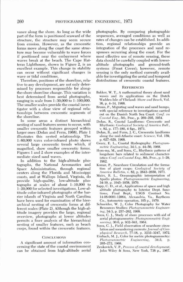
FIG. 1. Sand wave field near Cape Hatteras, 321 'quare (i8 by as 'Om- North Carolina. pared to 81 square miles for 1 : 60,000. The
same area with lower-altitude photographs
the width, slope, and even the sediment size Three recent Papers published in Phot~gram- metric Engineering discuss the use of color aerial of the beach all vary in relation to positions photography: ..Color for M e ~ c photog ram me^.. within individual crescentic forms. This re- (vol. 34, N ~ . 3, pp. 265-272, 1968); d6~oastal Hy-
lationship explains much of the hitherto un- drography" (Vol. 34, NO. 1, pp. 44-42, 1968); and explained variance that investigators have "Color Photography for Water Resources Studies" found in correlation between wave action, as (Vol. 34, No. 3, pp. 246-265, 1968).
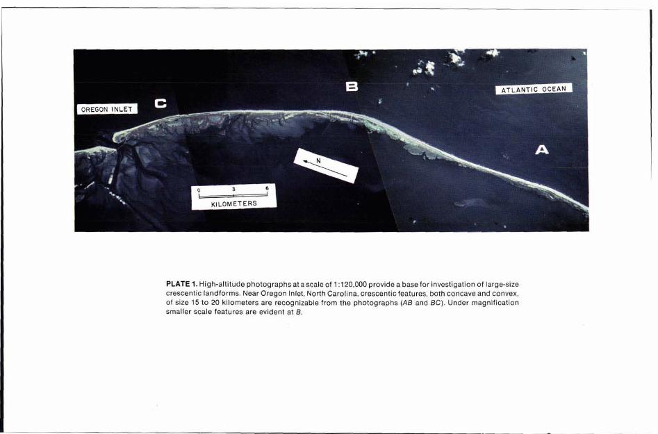
PLATE 1. High-altitude photographs at a scale of 1 :120,000 provide a base for investigation of large-size crescentic landforms. Near Oregon Inlet, North Carolina, crescentic features, both concave and convex, of size 15 to 20 kilometers are recognizable from the photographs (A8 and BC). Under magnification smaller scale features are evident at B.
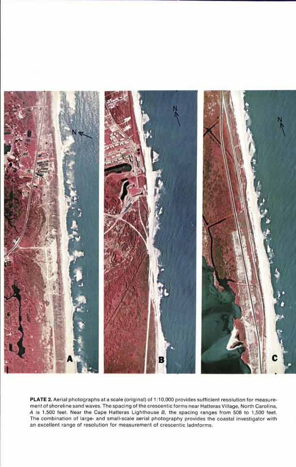
PLATE 2. Aerial photographs at a scale (original) of 1:10,000 provides sufficient resolution for measure- ment of shoreline sand waves. The spacing of the crescentic forms near Hatteras Village, North Carolina, A is 1,500 feet. Near the Cape Hatteras Lighthouse B, the spacing ranges from 508 to 1,500 feet. The combination of large- and small-scale aerial photography provides the coastal investigator with an excellent range of resolution for measurement of crescentic ladnforms.
COASTAL PROCESSES
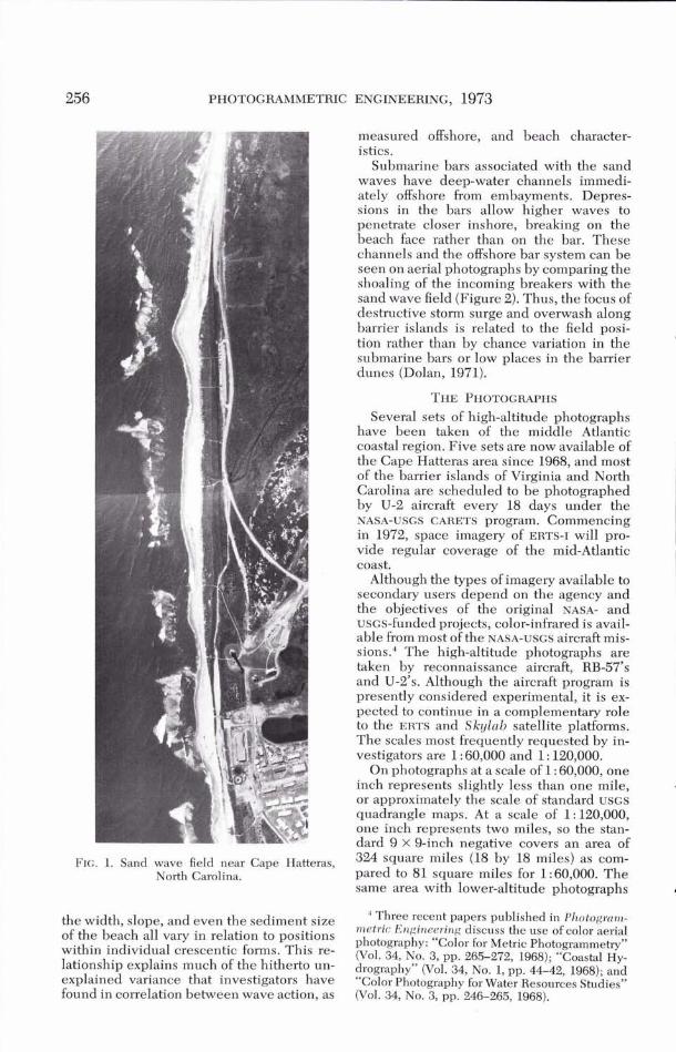
FIG. 2. Concern about erosion may depend upon the relation between the struc- ture location and the sand wave position. The Cape Hatteras Lighthouse is vulnerable at the time of this photo, but the large mass of sand in the foreground will migrate to- ward the point and the Lighthouse will then be secure for a time.
(1 : 20,000) would require 36 9 x 9-inch negatives.
The quality photographic films used in the NASA high-altitude photographs provide amazing degrees of resolution. Magnifica- tion in excess of 10 x can be used for detailed measurements. The range of measurement possible on the photography is well within the error, due to distortion, inherent in the photograph.
Sequential measurements of the rhythmic features in the Cape Hatteras and Cape Lookout National Seashore areas indicate the following attributes. (1) Sand wave lengths range from 150 to 1000 meters, with most between 500 and 600 meters. (2) Wave amplitudes average about 15 to 25 meters
and may reach amplitudes of 40 meters. (3) Although the question of movement of the sand wave field along the beach is still under investigation, the rate of change is clearly a function of wave energy, and thus greatest during the stormy winter season along the mid-Atlantic.
Crescentic coastal landforms, as described by their wave lengths and amplitudes, occur throughout the world. Their dimensional range also seems to be consistent, not only along the Atlantic, but for all coasts. Thus, the sand shorelines should not be viewed as straight lines but rather as a sinuous rhythmic line which may be nonstationav, tending to migrate along the coast. Dolan (1970) has shown that stable shoreline con- ditions may change rapidly toward less stable conditions as the crescentic forms ad-
vance along the shore. As long as the wide part of the form is positioned seaward of the structure, the structure may seem secure from erosion. However, as the crescentic forms move along the coast the same struc- ture may become vulnerable to wave forces if positioned near the embayment where waves break at the beach. The Cape Hat- teras Lighthouse, shown in Figure 2, is an excellent example. This change in stability can occur without significant changes in wave or tidal conditions.
Therefore, positions of the shoreline, rela- tive to any development, are not only deter- mined by processes responsible for along- the-shore shoreline change. This variation is best determined from aerial photographs, ranging in scale from 1 : 30,000 to 1 : 100,000. The smaller scales provide the coastal inves- tigator with a clear view of regional rela- tionships between crescentic segments of the shoreline.
In some areas a distinct hierarchical nesting of sand features seems to occur, with smaller crescentic features grouped within larger ones (Dolan and Ferm, 1968). Plate 1 illustrates this nested relationship. The 1 : 60,000 NASA color-infrared photo shows several large crescentic trends which, if magnified, show smaller crescentic forms. Figures 1 and 2 show examples of the inter- mediate sized sand waves.
In addition to the high-altitude pho- tographs, the National Aeronautics and Space Administration, through regional centers along the Florida and Mississippi coasts, and at Wallops Island, Virginia, do provide high-quality, low-altitude pho- tographs at scales of about 1:10,000 to 1 : 20,000 for selected investigations. Low-al- titude color-infrared photographs of the bar- rier islands of Virginia and North Carolina have been used for examination of the hier- archical nesting. of crescentic forms at dif- ferent scales (piate 2). Although the high-al- titude imagery provides the large, regional overview, photographs at lower altitudes permits a finer analysis of the hierarchical nesting of smaller features, such as beach cusps, found within the crescentic features.
photographs. By comparing photographic sequences, averaged conditions as well as rates of changes can be established. In addi- tion, regional relationships provide an integration of the processes and sand re- sponses occurring along the coast. For the most effective use of remote sensing, these data should be carefullv c o u ~ l e d with lower- altitude photographs' an2 ground-truth systems (Front Cover); however, remote sensing is the only method currently avail- able for investigating the aerial and temporal distributions of crescentic coastal features.
Bakker, W. T., A mathematical theory about sand waves and its applications on the Dutch Wadden Isle of Vlieland: Shore und Bench, Vol. 36, p. 4-14, 1968.
Bmun, P., Migrating sand waves and sand humps, with special reference to investigations carried out on the Danish North Sea Coast: Conf . on Coc~stal Eng., 5th, Proc., p. 269-295, 1954.
Dolan, R., Coastal Landforms: Crescentic and Rhythmic: Ceologiccll Society of America Bull., v. 82, p. 177-180,4 figs., 1971.
Dolan, R., and Ferm, J. C., Crescentic landforms along the mid-Atlantic coast: Science, Vol. 159, p. 627-629, 1968.
Geary, E. L., Coastal Hydrography: Photogrunt- metric Engineering, 34:1, p. 44-50, 1968.
Hom-ma, M., and Sonu, C., Rhythmic patterns of longshore bars related to sediment character- istics: Conf on Coustc~l Eng., Bth, Proc., p. 1-29, 1962.
Komar, P., Nearshore Circulation and the forma- tion of giant cusps: Geologicc~l Society o f Americu Bulletin, v. 82, p. 2643-2650, 1971.
Mairs, R. L., Oceanographic interpretation of Apollo photos: Plzotogrummetric Engineering, 34:10, p. 1045-1058, 1970.
Sapp, C. D., et al., Applications of space and high altitude photography to Interior Dept. func- tions; Final Rept., USGS Contract No. 14-08-0001-12064, Alexandria, Va., Raytheon Co., Autometric operation, 105 p., 1970.
Schneider, W. J., Color Photography for Water Resources Studies: Photogrumnletric Engineer- ing, 34:3, p. 257-262, 1968.
Sonu, C. J., Study of shore processes with aid of aerial photogrammetry: Photogrummetric Engi- neering, 30:6, p. 932-941, 1964.
Sonu, C. J., Field observation of nearshore circu- lation and meandering currents: lournal o f Geo- physical Research, 77318, p. 3232-3247," 1972.
CONCLUSIONS Umbach, M. J., Color for metric photogrammetry: Plzotogri~mnletric Engineering, 34:3, p.
A significant amount of information con- 265-272, 1968. cerning the state of the coastal environment Zenkovich, V. P., Process of coustcll development, can be obtained from high-altitude aerial John Wiley & Sons, New York, 738 p., 1967.