lesson 6 - ncesd
TRANSCRIPT

River of Power – North Central ESD 2013 rev. Lesson 6 - Page 1
Disciplinary Core Ideas Science 4-ESS2-2: Analyze and interpret data from maps to describe patterns of Earth’s features.
4-ESS3-1: Obtain and combine information to describe that energy and fuels are derived from natural resources and uses affect environment. 4-ESS3-2: Generate and compare multiple solutions to reduce the impacts of natural Earth processes on humans.
Social Studies Economics 2.2.1 Understands the basic elements of Washington State’s economic system, including businesses, industry, natural resources, and labor.
Examines how irrigating the semi-desert climate of Eastern Washington has impacted the economies of Indian tribes and other residents of Washington State.
Economics 2.4.1 Understands how geography, natural resources, climate, and available labor contribute to the sustainability of the economy of regions of Washington State.
Explains how dams impact the economic well-being of regions of Washington State
Scientific & Engineering Practices Obtaining, evaluating, and communicating information
Crosscutting Concepts Patterns
Lesson 6
Why Dams?
Overview In Lessons 4 and 5 students experienced three investigations
identifying the different human and non-human stakeholders of
the Columbia River Watershed. As they discussed the life cycle of
the salmon and viewed the DVD Journey of the King, they were
made aware of how the dams on the Columbia River and its
tributaries have had a dramatic effect on the salmon and steelhead
runs of the Pacific Northwest. The impact that the dams have had
on the once bountiful fish runs and as a result, on the Native
American tribes whose culture, and livelihood depend on the
salmon might lead students to ask the question, “Why do we need
dams?” Lesson 6 addresses this question by examining the
reasons that the 400+ dams have been constructed on the
Columbia River and its tributaries. Through reading selections,
examination of maps and classroom discussion students examine
the tremendous benefits that the dams bring to the desert region
of Eastern Washington, Oregon, and Western Idaho.
Their understanding of the Columbia River and the stakeholders
who depend on the river is deepened through the initial reading
selection in the student book Voyage to the Pacific.
Students use the What We Know About Dams
brainstorming chart from Lesson 1 to review and discuss
their current understanding of dams.
Students label a map of the state of Washington identifying
the major rivers, mountains, lakes, towns, and dams of the
Columbia River Basin.
Students read to learn about the dams of the Columbia
River and their importance to the stakeholders of the
Columbia River watershed.
Student Learning Targets Using a map of Washington State, I can identify and label the
major rivers, lakes, cities, and dams of the Columbia River Basin.
I will learn more about the dams of the Columbia River through
class discussions, and reading selections.

River of Power – North Central ESD 2013 rev. Lesson 6 - Page 2
I can communicate the affect dams can have on the lives of
those living in the Columbia River Basin.
Teacher Background Information
See the Teacher Background Information from Lesson 1
entitled The Columbia River by Bill Lang, Professor of History
Portland State University, Director, Center for Columbia
River History, http://www.ccrh.org/
The sections entitled “Description,” and “Uses of the
Columbia” provide detailed information related to the topics
discussed in Lessons 4, 5, and 10.
Information taken from the document - What Makes
The Columbia River Basin Unique And How We Benefit
By the Foundation for Water and Energy Education (FWEE)
In short, the Columbia River Basin is an essential reason for
the Northwest being a dynamic and highly prosperous region
within the nation and the world. Hydropower, flood control,
irrigation, navigation and recreation are specific benefits that
the uniqueness of the Basin and its river system provide.
Hydropower
Up to 80% of the electricity in the Northwest is produced by
hydropower. Historically, hydropower has been one of the
most inexpensive and most efficient sources of electricity in
the region. In the Northwest, for example, electricity from
hydropower typically costs $10 per megawatt hour to produce.
This compares to $60, $45 and $25 per megawatt hour to
produce electricity, respectively, at nuclear, coal and natural
gas plants. To determine these price comparisons, planners
calculate what it costs to build, maintain and operate these
differing generation facilities.
This source of inexpensive electricity was a major attraction
for energy intensive industries such as aluminum, food
processing, and the production of plutonium for national
defense. Other industries, such as aerospace, were attracted to this area because they wanted
proximity to a resource, in this case aluminum, being manufactured in the Northwest. In
addition, the mining industry was a major beneficiary because inexpensive electricity greatly
reduced the costs of extracting various metals.
Academic Vocabulary
Irrigation: The watering of land
by artificial means to foster plant growth.
Industry: A distinct group of
productive or profit-making enterprises.
Recreation: Something people do
to relax or have fun; activities done for enjoyment.
Hydroelectric Power: Electricity
that is generated by falling water in a dam. Flowing water pushes a turbine, which turns a shaft and magnets inside a generator to produce electricity.
Columbia River: The largest river in Washington and the 4th largest river in the United States. It is 1243 miles long. Dam: A barrier built across a waterway such as a river to control the level, flow of water. Flood Control: The act of
controlling river flow with dams, dikes, artificial channels, etc., to minimize the occurrence of floods.
Run off: Water from rain or snow
that flows over the surface of the ground into streams.

River of Power – North Central ESD 2013 rev. Lesson 6 - Page 3
Individuals benefited as well. For instance, hydropower was the first source of electricity for
many rural areas. Further, the cost of owning and maintaining a more comfortable home was
less. Specifically, inexpensive electricity meant installing electric heaters, dryers, stoves and
other appliances was in easy reach of the many, not the few.
Today, natural resource and manufacturing industries are becoming less vital to the Northwest's
economy. Indeed, one forecast shows that the non-manufacturing share of total regional
employment could grow to nearly 89 percent by the year 2015. As a result, the Northwest's
traditional dependence on inexpensive electricity to fuel the economy has declined somewhat.
On the other hand, the Northwest's population is continuing to boom. From 1980 to 2010,
population is expected to increase from eight to almost twelve million people. Each of these
individuals is a consumer of electricity. To continue to receive the individual benefits of
inexpensive electricity, maintaining hydropower as a resource is as important as ever.
And while the dollar cost of hydropower is highlighted here, the environmental costs and benefits
of this renewable resource are very important as well.
Flood Control
Historically, the two priorities for coordinated management of the Columbia River system have
been electric generation and flood control. Other priorities, such as irrigation, navigation and
recreation, are largely carried out within the context of meeting these needs. Most recently,
impacts on salmon have resulted in the National Marine Fisheries Services stating that
anadromous fish recovery should receive priority over all river uses except flood control.
Understanding the importance of flood control is similar to understanding the importance of
insurance. Until you lose something, you do not appreciate how important it is. In 1948, the
importance of flood control became a priority after Vanport, Oregon was destroyed by a flood. The
Army Corps of Engineers responded by developing a multiple-use reservoir storage plan for the
Columbia River Basin.
A treaty with Canada and the evolution of sophisticated planning and interagency cooperation
have resulted in up to 39.7 million acre-feet of storage space being available for flood control.
That is enough water to cover the Northwest four inches deep in water. For the Columbia River
Basin, the need for reservoir space to help reduce the risk of flooding is most important during
two seasons of the year: in winter, when there are rain-induced floods, and in the spring and
early summer, when there are floods from snowmelt and rain.
By manipulating the amount of water in reservoirs throughout the Basin, system operators are
able to create a balance between releasing water to produce hydropower when it is most needed,
and reducing the potential for flooding. Looking at average river flows at The Dalles Dam over
the course of the year is one way to see the difference between unrestricted water flow and the
use of reservoirs to make this flow more constant. Further, reservoir storage is also assisted by a
system of levees, flood walls, bank protection, and various types of land use regulation.

River of Power – North Central ESD 2013 rev. Lesson 6 - Page 4
Source: Northwest Power Planning Council. Fourth Northwest Power Plan,
Portland OR, March 13, 1996, p.4-5
Forty-eight years of developing this coordinated approach came together as never
before in February, 1996. Heavy rains and melting snowpack due to mild
temperatures created the worst flooding in over 30 years in the Northwest.
Government agencies and non-federal hydro operators worked together to reduce
flood damage by an estimated 3.2 billion dollars. Because the Northwest had a
flood control plan in place, the evening news did not show downtown Portland six
feet deep in water. Some of the details of how the flood of 1996 was contained are
remarkable. Although nobody expected these types of floods to occur for another
several years, floods at the end of 1996 reminded everyone that the importance of
flood control is always present.
Navigation
Every year, the Columbia and Snake Rivers carry 17 million tons of cargo to and
from the Pacific Ocean along a 465-mile waterway. This is another example of
technology and coordinated planning leading to the Columbia Basin being put to
multiple use. Specifically, a series of eight locks facilitates the passage of ships
from the ocean to as far inland as Lewiston, Idaho. These locks are part of the
same projects and reservoirs that produce hydropower and help control flooding.
From the ocean to Portland, Oregon and Vancouver, Washington dredging
assures that a 40-foot-deep open river channel remains open year-long for ocean-
going vessels. This 106-mile segment then connects with a 359-mile segment that
extends to Lewiston, Idaho. Within this second segment, a 14-foot-deep channel
for barges and other craft is kept open. To maintain this channel depth,
maximum and minimum reservoir elevations are set. These elevations are
determined within the context of meeting needs for electrical generation, flood
control, and the release of water to help fish passage.
Academic Vocabulary Irrigation: The watering of
land by artificial means to foster plant growth.
Industry: A distinct group of
productive or profit-making enterprises.
Recreation: Something
people do to relax or have fun; activities done for enjoyment.
Hydroelectric Power: Electricity that is generated by falling water in a dam. Flowing water pushes a turbine, which turns a shaft and magnets inside a generator to produce electricity.
Columbia River: The largest river in Washington and the 4th largest river in the United States. It is 1243 miles long. Dam: A barrier built across a waterway such as a river to control the level, flow of water. Flood Control: The act of
controlling river flow with dams, dikes, artificial channels, etc., to minimize the occurrence of floods.
Run off : Water from rain or
snow that flows over the surface of the ground into streams.

River of Power – North Central ESD 2013 rev. Lesson 6 - Page 5
Irrigation
Another benefit that stems directly from the unique nature of
the Columbia Basin is irrigation. In fact, six percent of the
Columbia River Basin's yearly runoff is diverted to irrigate
about 7.8 million acres of land. Much of the water that is
diverted eventually finds its way back into the river system.
Farmers in arid parts of eastern Washington, northeastern
Oregon, and southern Idaho depend on irrigation to support
crops such as wheat, corn, potatoes, peas, alfalfa, apples, and
grapes.
The Columbia Basin Project, for instance, turned the high
desert area of central Washington into another bread basket for
America. The centerpiece is the Grand Coulee Dam, which was
built primarily as an irrigation project by the Bureau of
Reclamation. Water stored behind Grand Coulee Dam in Lake
Roosevelt is pumped into Banks Lake. This lake was formed by
damming both ends of Grand Coulee, which is one of the
geological formations that dates back to ice age floods. The
water then flows through a system of tunnels and canals to
irrigate croplands. The project irrigates over 500,000 acres and
has the potential to be expanded to irrigate over 1.1 million
acres. The Grand Coulee Dam is also used as a hydroelectric
project and has the capacity to generate more electricity than
any other hydroelectric project in North America.
The Bureau of Reclamation, local irrigation districts and water
companies are examples of authorities that regulate how much
water is diverted from the river system to support irrigation.
Although scheduled locally, the cumulative effect of utilizing
water from the river system to support large and small
irrigation projects can be quite significant. As a result, those
responsible for coordinated management of the river system
estimate the effect of such diversions when determining
reservoir levels. through accurate estimates, reservoir levels
can be properly maintained to meet flood control, hydroelectric
generation and irrigation needs.
One should also note that some areas and stretches of river are
much more affected by irrigation than others. The effects on the
Snake River are more pronounced than on the main stem of the
Columbia. For instance, the Minidoka Project along the Snake
uses water from six storage and two diversion dams. Thousands
of miles of distribution canals then provide irrigation service to
more than 1.1 million acres of farmland.
Disciplinary Core Ideas
Science 4-ESS2-2: Analyze and interpret data from maps to describe patterns of Earth’s features.
4-ESS3-1: Obtain and combine information to describe that energy and fuels are derived from natural resources and uses affect environment. 4-ESS-2: Generate and compare multiple solutions to reduce the impacts of natural Earth processes on humans.
Social Studies Economics 2.2.1 Understands the basic elements of Washington State’s economic system, including businesses, industry, natural resources, and labor.
Examines how irrigating the semi-desert climate of Eastern Washington has impacted the economies of Indian tribes and other residents of Washington State.
Economics 2.4.1 Understands how geography, natural resources, climate, and available labor contribute to the sustainability of the economy of regions of Washington State.
Explains how dams impact the economic well-being of regions of Washington State
Scientific & Engineering
Practices
Obtaining, evaluating, and
communicating information
Crosscutting Concepts Patterns

River of Power – North Central ESD 2013 rev. Lesson 6 - Page 6
For these reasons, the issue of "water rights" has been a source of contention for quite some time.
In Idaho, for instance, the state constitution grants "the right to divert and appropriate the
unappropriated waters of any natural stream to beneficial uses." In other words, if you got there
first you can keep diverting water for the "beneficial" purpose of irrigation. While contentious at
a local and state level, the situation is made even more complex by recognizing that the
Northwest as a whole is also affected. For example, because irrigation can cause less water to be
available for reservoirs, flexibility in releasing water to support fish passage can be lost.
Recreation
Recreation is the last major benefit that will be discussed. This
benefit is also somewhat different from the others. When
hydroelectric and reservoir storage projects were proposed, more
recreation was not the driving force behind their creation. rather,
opportunities for new and additional recreation came with
development of a project. Such opportunities were used to meet
local and regional needs as well as address impacts caused by
construction. Each year, for instance, about 450,000 thousand
people pass through the Grand Coulee Dam Visitor Center.
Examples of recreation opportunities that stem from project
development include fishing, swimming, waterskiing, picnicking,
camping, hiking, rafting, boating and sightseeing. Often,
developing these opportunities were part of receiving a license to
develop and operate a project. Now that some of these projects
are being relicensed, which generally occurs after a project has
been in existence for 30 years, maintenance and further
development of many recreation sites is being reviewed.
The number and diversity of recreational opportunities
associated with hydroelectric projects is indeed remarkable. Each
year, hundreds of thousands of individuals take extended
vacations, weekend and day trips to access these opportunities.
Looking at a directory of recreational sites associated with non-
Federal hydroelectric projects tells the story better than words.
Note – The information in the Teacher Background information
is intended to provide information that can be shared during
class discussion related to the role that dams play in the
Columbia River Basin.
Academic Vocabulary
Irrigation: The watering of land by
artificial means to foster plant growth.
Industry: A distinct group of productive
or profit-making enterprises.
Recreation: Something people do to
relax or have fun; activities done for enjoyment.
Hydroelectric Power: Electricity that
is generated by falling water in a dam. Flowing water pushes a turbine, which turns a shaft and magnets inside a generator to produce electricity.
Columbia River: The largest river in Washington and the 4th largest river in the United States. It is 1243 miles long. Dam: A barrier built across a waterway such as a river to control the level, flow of water. Flood Control: The act of controlling
river flow with dams, dikes, artificial channels, etc., to minimize the occurrence of floods.
Run off : Water from rain or snow that
flows over the surface of the ground into streams.

River of Power – North Central ESD 2013 rev. Lesson 6 - Page 7
Materials For each student
1 science notebook
1 Washington map with Columbia Basin landmarks
For every two students
1 Voyage to the Pacific student reader
For the class
The What We Know about Dams chart from Lesson 1
Glue sticks to paste the Washington/Columbia Basin map into students’ science notebooks
Preparation
1. Post the What We Know about Dams chart from Lesson 1 in a visible location.
2. Review the Teacher Background information in preparation to lead a discussion
related to the benefits the dams on the Columbia River and its tributaries provide.
3. Copy the Washington map with Columbia Basin landmarks numbered for each
student.
4. Prepare to display the Washington/Columbia Basin map using a document camera and
projector or computer; or by creating an overhead transparency and using an overhead
projector.
5. Prepare a page in a model notebook, copy “Student Map Key,” or use it by following
the numbering and numbering for students to identify the landmarks on the
Washington/Columbia Basin map.
Procedure 1. Review with students that in Lesson 4 the class examined how dams have had a dramatic
effect on the native salmon and steelhead runs, as well as to greatly affect the lifeway of the
Native American peoples of the Columbia Basin. Tell students that in today’s lesson the class
will be answering the question, “Why dams?”
2. Introduce the student learning targets for Lesson 1 and check for understanding.
3. Display the What We Know about Dams chart from Lesson 1. Give students a chance to read
over the information that was recorded on the first day of the River of Power unit. Draw a
solid “line of learning” under the last recorded response. Ask students if there is any new
information that they would like to add to the chart.
4. Let students know that an important part of the class discussion related to dams will be to
identify where they are located. Hand out the Washington/Columbia Basin student maps.
River of Power – North Central ESD 2013 rev. Lesson 6 - Page 8
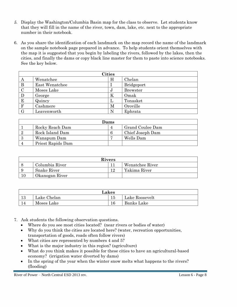
5. Display the Washington/Columbia Basin map for the class to observe. Let students know
that they will fill in the name of the river, town, dam, lake, etc. next to the appropriate
number in their notebook.
6. As you share the identification of each landmark on the map record the name of the landmark
on the sample notebook page prepared in advance. To help students orient themselves with
the map it is suggested that you begin by labeling the rivers, followed by the lakes, then the
cities, and finally the dams or copy black line master for them to paste into science notebooks.
See the key below.
Cities
A Wenatchee H Chelan
B East Wenatchee I Bridgeport
C Moses Lake J Brewster
D George K Omak
E Quincy L Tonasket
F Cashmere M Oroville
G Leavenworth N Ephrata
Dams
1 Rocky Reach Dam 4 Grand Coulee Dam
2 Rock Island Dam 6 Chief Joseph Dam
3 Wanapum Dam 7 Wells Dam
4 Priest Rapids Dam
Rivers
8 Columbia River 11 Wenatchee River
9 Snake River 12 Yakima River
10 Okanogan River
Lakes
13 Lake Chelan 15 Lake Roosevelt
14 Moses Lake 16 Banks Lake
7. Ask students the following observation questions.
Where do you see most cities located? (near rivers or bodies of water)
Why do you think the cities are located here? (water, recreation opportunities,
transportation of goods, roads often follow rivers)
What cities are represented by numbers 4 and 5?
What is the major industry in this region? (agriculture)
What do you think makes it possible for these cities to have an agricultural-based
economy? (irrigation water diverted by dams)
In the spring of the year when the winter snow melts what happens to the rivers?
(flooding)

River of Power – North Central ESD 2013 rev. Lesson 6 - Page 9
What do you think allows the cities to be located near the rivers safely? (dams control
flooding)
Note – During the discussion share pertinent information from the Teacher Background
information provided.
8. Draw students’ attention to the chart What We Know about Dams, circle the following key
benefits that dams provide to the Columbia River Basin while students record them in the
science notebook. If they have not been listed on the chart add them from the class
discussion.
Dams Provide
Flood control
Renewable energy (Electricity)
Irrigation water
Transportation of goods
Recreation opportunities
Final Activities 1. Revisit student learning targets for Lesson 1 and use the formative map assessment to check
for student understanding.
2. Read Voyage to the Pacific pages 7-11 A Lake on the Roof of the World, and Back Toward
Civilization.

River of Power – North Central ESD 2013 rev. Lesson 6 - Page 10
Lesson 6 “Why Dams” Student Map Key
Name:________________________________________________________ Date____________
Cities
A H
B I
C J
D K
E L
F M
G N
Dams
1 5
2 6
3 7
4
Rivers
8 11
9 12
10
Lakes
13 15
14 16

River of Power – North Central ESD 2013 rev. Lesson 6 - Page 11
Lesson 6
Map KEY
Cities
A Wenatchee H Chelan
B East Wenatchee I Bridgeport
C Moses Lake J Brewster
D George K Omak
E Quincy L Tonasket
F Cashmere M Oroville
G Leavenworth N Ephrata
Dams
1 Rocky Reach Dam 5 Grand Coulee Dam
2 Rock Island Dam 6 Chief Joseph Dam
3 Wanapum Dam 7 Wells Dam
4 Priest Rapids Dam
Rivers
8 Columbia River 11 Wenatchee River
9 Snake River 12 Yakima River
10 Okanogan River
Lakes
14 Lake Chelan 16 Lake Roosevelt
15 Moses Lake 17 Banks Lake

River of Power – North Central ESD 2013 rev. Lesson 6 - Page 12