land use planning compre
TRANSCRIPT
7/31/2019 Land Use Planning Compre
http://slidepdf.com/reader/full/land-use-planning-compre 1/32
I. LAND USE PLANNING
1. land use planning concepts
2 what is land use planning
3. what is a land use plan
4. objectives of land use planning
5. two division of land use planning
6. land use categories and color coding
7. formulation of the general land use plan
8. environmentally critical areas
II. LAND USE PATTERNS
a. basic urban form conceptual frameworks
7/31/2019 Land Use Planning Compre
http://slidepdf.com/reader/full/land-use-planning-compre 2/32
b. different shapes in land use patterns
III. URBAN LAND USE MODELS
a. what’s a model?
b. concentric-zone model
c. sector model
d. multiple nuclei model
e. urban realms model
Land Use Planning Concepts
Land
Land is viewed as a shared natural resource, much like air and water found therein, tobe conserved and cared for with due regard for its effect on society as a whole and
for the conditions in which it will be passed on to future generations.
Land is also viewed as a property - a private commodity which can be owned, used,
bought or sold for personal comfort and profit.
Land is a finite resource but population continues to grow year after year requiring
more land for housing and other urban uses, agricultural areas for food production
and more forest for timber production and watershed protection. Therefore, the need
to allocate land judiciously and discriminately
What is Land Use Planning? It is the systematic approach / process for
identifying, classifying and locating urban land, which is achieved by analyzing
the socio-economic needs of the population in consideration of the physical
and natural attributes of a city / municipality
Technical aspect- involves determining what activities(agricultural,
construction) a given piece of land can support without causing damage to the
land itself in order it can be used across many generations without
jeopardizing.
Political aspect – is concerned with the commitment of decision makers and
politicians to ensure that there is strict compliance with the plan and its
implementation tools.
What is a LAND USE PLAN ??? An essential component of the
comprehensive development plan, it designates the future use or
reuse of the land and the structure built upon the land within a given
jurisdiction’s planning area and the policies and reasoning used in
7/31/2019 Land Use Planning Compre
http://slidepdf.com/reader/full/land-use-planning-compre 3/32
arriving at the decisions in the plan. It projects public and private
land uses in accordance with the planned spatial organization of
economic and social activities and the traffic of goods and people
Objectives of Land Use Planning
1. To promote the efficient utilization, acquisition and disposition of
land as a limited resources;
a) Make sure there is enough for our future generations to use and
enjoy while addressing the needs of the present times
2. To influence, direct and harmonize decisions and activities of the
public and the private sectors affecting the use, management and
disposition of lands;
3. Reconcile land use conflicts between and among individuals and government
agencies relating to present needs and anticipated demands for land;
4. Promote desirable and efficient patterns of land uses and prevent premature
and wasteful development and minimize the cost of public facilities, services
and infrastructure;
5. Protect and preserve valuable agri-cultural areas consistent with the need
to promote industrialization;
6. Maintain ecological balance thru Control of development in critical areas such
as flood plains and watershed areas
7. Integrate programs and projects on land resources development among
land development agencies;
8. Conserve areas of ecological, aesthetic and historical values and maintain and
protect natural open areas and areas of significant views;
9. Promote and implement a shelter plan
• Thru Identification of sites suitable for housing; and
10.Promote an efficient circulation system
Overview of the Process
It utilizes the planning methodology which includes: data gathering, problem
identification and situational analysis; goals / objectives formulation;
generation of alternative spatial strategies; evaluation and selection of
preferred strategy; formulation of the plan; adoption, review and approval; and
implementation and monitoring
7/31/2019 Land Use Planning Compre
http://slidepdf.com/reader/full/land-use-planning-compre 4/32
Two Division of Land Use Planning
General Land Use Planning – deals primarily with the non-urban large scale
uses such as: croplands, forests, pasture lands, mining/quarrying areas and
swamplands, with areas occupied by structures treated collectively as “built –
up” areas”
Urban Land Use Planning – concerned with the location, intensity and amount
of land development required for the various space-using functions such as
residential, commercial, industrial, institutional, recreation and other activities
found in the urban areas.
Land Use
General Land use:
Four Major Categories:
○ Built-up
○ Agriculture
○ Forest
○ Special use
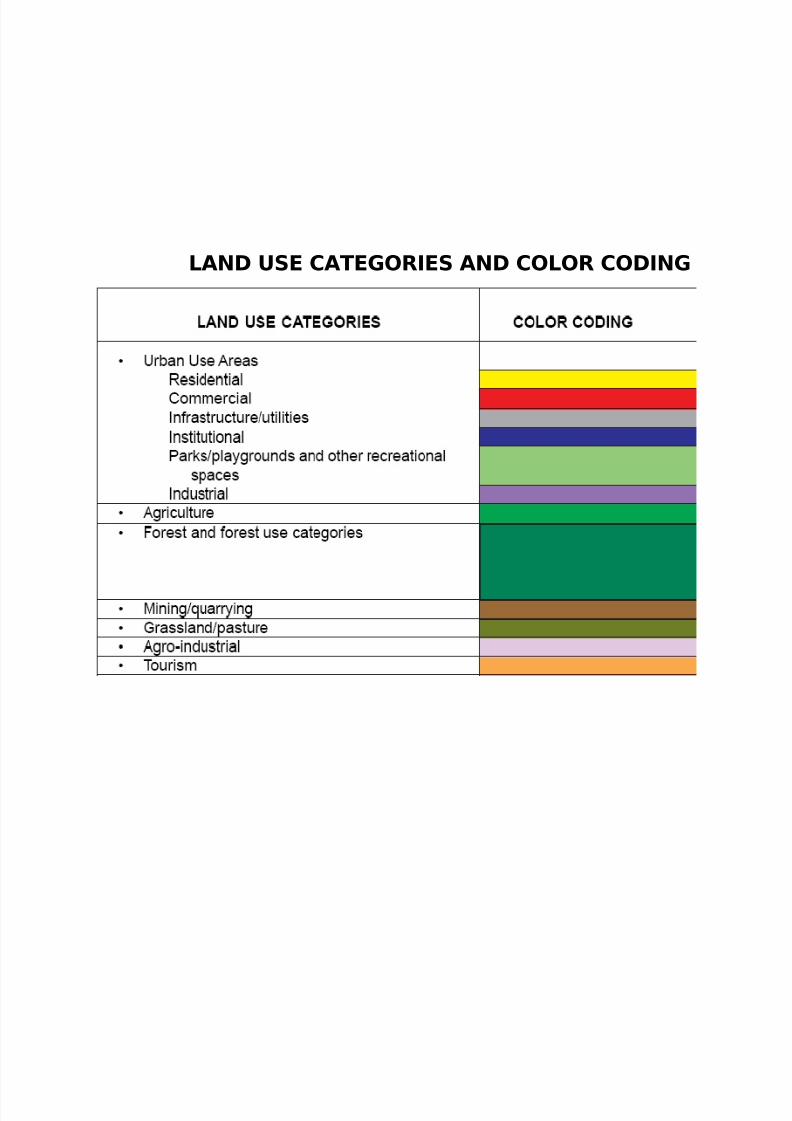
Urban Land Use
Residential
Commercial
Industrial
Institutional
Parks/playgrounds
Infrastructure/utilities
Etc.
7/31/2019 Land Use Planning Compre
http://slidepdf.com/reader/full/land-use-planning-compre 5/32
LAND USE CATEGORIES AND COLOR CODING
7/31/2019 Land Use Planning Compre
http://slidepdf.com/reader/full/land-use-planning-compre 6/32
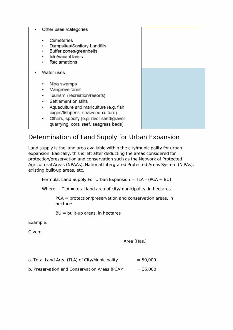
Determination of Land Supply for Urban Expansion
Land supply is the land area available within the city/municipality for urban
expansion. Basically, this is left after deducting the areas considered for
protection/preservation and conservation such as the Network of Protected
Agricultural Areas (NPAAs), National Intergrated Protected Areas System (NIPAs),
existing built-up areas, etc.
Formula: Land Supply For Urban Expansion = TLA – (PCA + BU)
Where: TLA = total land area of city/municipality, in hectares
PCA = protection/preservation and conservation areas, in
hectares
BU = built-up areas, in hectares
Example:
Given:
Area (Has.)
a. Total Land Area (TLA) of City/Municipality = 50,000
b. Preservation and Conservation Areas (PCA)* = 35,000
7/31/2019 Land Use Planning Compre
http://slidepdf.com/reader/full/land-use-planning-compre 7/32
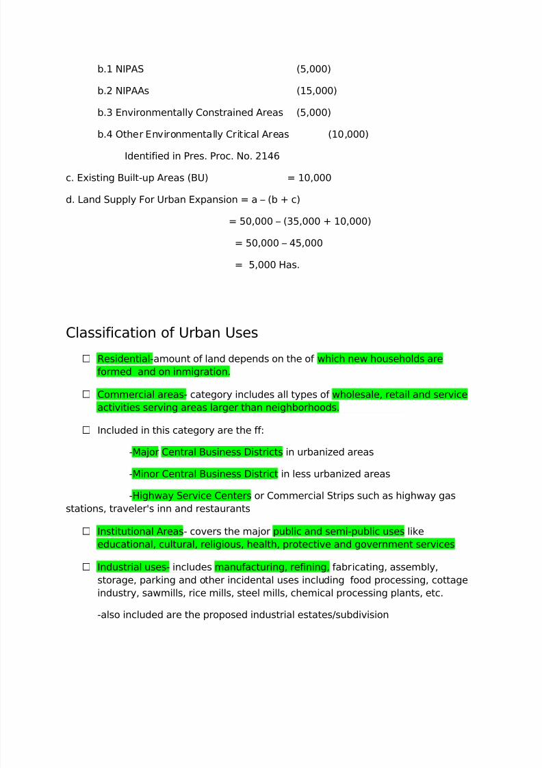
b.1 NIPAS (5,000)
b.2 NIPAAs (15,000)
b.3 Environmentally Constrained Areas (5,000)
b.4 Other Environmentally Critical Areas (10,000)
Identified in Pres. Proc. No. 2146
c. Existing Built-up Areas (BU) = 10,000
d. Land Supply For Urban Expansion = a – (b + c)
= 50,000 – (35,000 + 10,000)
= 50,000 – 45,000
= 5,000 Has.
Classification of Urban Uses
Residential-amount of land depends on the of which new households are
formed and on inmigration.
Commercial areas- category includes all types of wholesale, retail and service
activities serving areas larger than neighborhoods.
Included in this category are the ff:
-Major Central Business Districts in urbanized areas
-Minor Central Business District in less urbanized areas
-Highway Service Centers or Commercial Strips such as highway gas
stations, traveler's inn and restaurants
Institutional Areas- covers the major public and semi-public uses like
educational, cultural, religious, health, protective and government services
Industrial uses- includes manufacturing, refining, fabricating, assembly,
storage, parking and other incidental uses including food processing, cottage
industry, sawmills, rice mills, steel mills, chemical processing plants, etc.
-also included are the proposed industrial estates/subdivision
7/31/2019 Land Use Planning Compre
http://slidepdf.com/reader/full/land-use-planning-compre 8/32
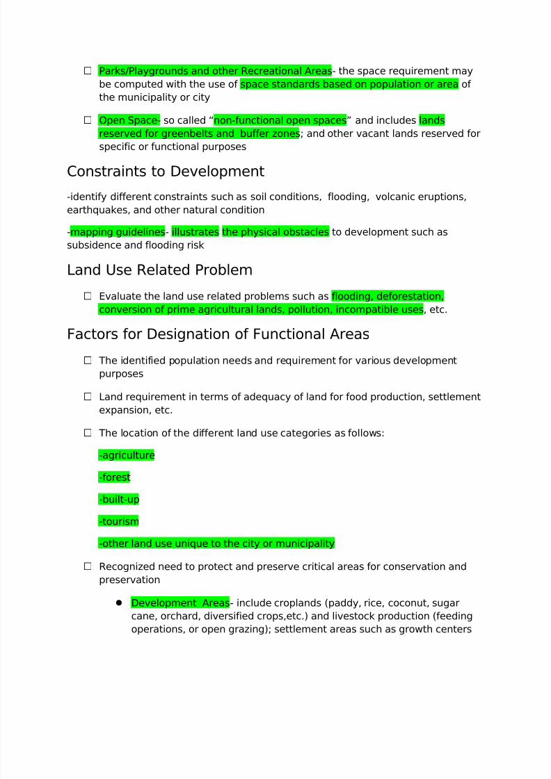
Parks/Playgrounds and other Recreational Areas- the space requirement may
be computed with the use of space standards based on population or area of
the municipality or city
Open Space- so called “non-functional open spaces” and includes lands
reserved for greenbelts and buffer zones; and other vacant lands reserved forspecific or functional purposes
Constraints to Development
-identify different constraints such as soil conditions, flooding, volcanic eruptions,
earthquakes, and other natural condition
-mapping guidelines- illustrates the physical obstacles to development such as
subsidence and flooding risk
Land Use Related Problem Evaluate the land use related problems such as flooding, deforestation,
conversion of prime agricultural lands, pollution, incompatible uses, etc.
Factors for Designation of Functional Areas
The identified population needs and requirement for various development
purposes
Land requirement in terms of adequacy of land for food production, settlement
expansion, etc.
The location of the different land use categories as follows:
-agriculture
-forest
-built-up
-tourism
-other land use unique to the city or municipality
Recognized need to protect and preserve critical areas for conservation and
preservation
Development Areas- include croplands (paddy, rice, coconut, sugar
cane, orchard, diversified crops,etc.) and livestock production (feeding
operations, or open grazing); settlement areas such as growth centers
7/31/2019 Land Use Planning Compre
http://slidepdf.com/reader/full/land-use-planning-compre 9/32
and ethnic reserves; military reservation and other urban uses which
required relatively large areas like industrial estates and utilities
Conservation and Preservation Areas
-maintain the desired ecological balance and area characteristic
-to protect the integrity of sensitive/critical ecosystem
-to preserve their natural or unique characteristic;
Formulation of the General Land Use Plan
Land Capability Classification
- indicates the suitability of areas for cultivation according to soil conservation
management requirements. Factors considered in the identification of land capability
classes are soil erosion potential/flooding and soil condition limitations.
Soil condition includes its characteristics such as droughtiness, fertility,
stoniness, salinity, alkalinity, acidity, depth, presence of toxic substance, etc.
The degree of limitations ranges from no or slight limitations, moderate,
serious to severe, to very serious or very severe.
The different land capability classes are as follows:
Class A – very good land; can be cultivated safely, requiring only simple but good
farm management practices.
Class B – good land; can be cultivated safely, require easily applicable conservation
practices.
Class C – moderately good land, must be cultivated with caution; requires careful
management and complex conservation practices.
Class D – fairly good land; must be cultivated with extra caution; requires careful
management and complex conservation practices for safe cultivation. Most suitable
for pasture or forest.
Class L – level to nearly level; too stony or very wet for cultivation; limited to pasture
or forest with careful soil management.
Class M – steep land; very severely eroded; shallow; not for cultivation; limited to
pasture or forest with careful management.
7/31/2019 Land Use Planning Compre
http://slidepdf.com/reader/full/land-use-planning-compre 10/32
Class X – level land; wet most of the time and cannot be economically drained;
suited for fishpond or recreation.
Class Y – very hilly and mountainous, barren and rugged; should be reserved for
recreation and wildlife or for reforestation.
Soil Suitability
A soil suitability study shall be conducted to determine the appropriateness of
agricultural lands for specific crops. At present, the Bureau of Soils and Water
Management has prepared Crop Development and Soil conservation Planning Guide
Maps for various crops.
Environmentally Critical Areas
Weather and Water Related Hazards
- tropical cyclone winds
- tropical cyclone rains
- storm surge
- drought
Earthquake Induced Hazards
- ground shaking
- ground rupture
- liquefaction and lateral spreading
- landslides
- tsunami
Volcanic Hazards
- lava flow
- airfall
- pyroclastic flows
- lahar
- edifice failure
7/31/2019 Land Use Planning Compre
http://slidepdf.com/reader/full/land-use-planning-compre 11/32
Erosion
- soil erosion
- river bank erosion
- coastal wave erosion
Environmentally Critical Areas
other Environmentally Critical Areas covered by the Presidential Proclamation
No. 2146
- areas set aside as aesthetic potential tourist spots;
- areas of unique historic, archeological or scientific interest;
- areas which are traditionally occupied by cultural minority communities ortribes;
- areas classified as prime agricultural lands;
- recharge areas of aquifers;
- water bodies characterized by one or any combination of the following
conditions;
-tapped for domestic purposes
-within the controlled and/or protected areas declared by appropriateauthorities
- support wild life and fishery activities
- coral reef characterized by one or any combination of the ff. conditions:
- with 50% and above live coraline cover
- spawning and nursery grounds for fish
- act as natural breakwater of coastline
LAND USE PATTERNS
Land Use Pattern
Basic Urban Form Conceptual Frameworks
Trend Extension
7/31/2019 Land Use Planning Compre
http://slidepdf.com/reader/full/land-use-planning-compre 12/32
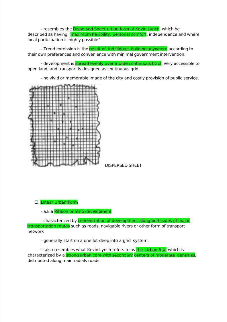
- resembles the Dispersed Sheet urban form of Kevin Lynch, which he
described as having “maximum flexibility, personal comfort, independence and where
local participation is highly possible”
- Trend extension is the result of individuals building anywhere according to
their own preferences and convenience with minimal government intervention.
- development is spread evenly over a wide continuous tract, very accessible to
open land, and transport is designed as continuous grid.
- no vivid or memorable image of the city and costly provision of public service.
DISPERSED SHEET
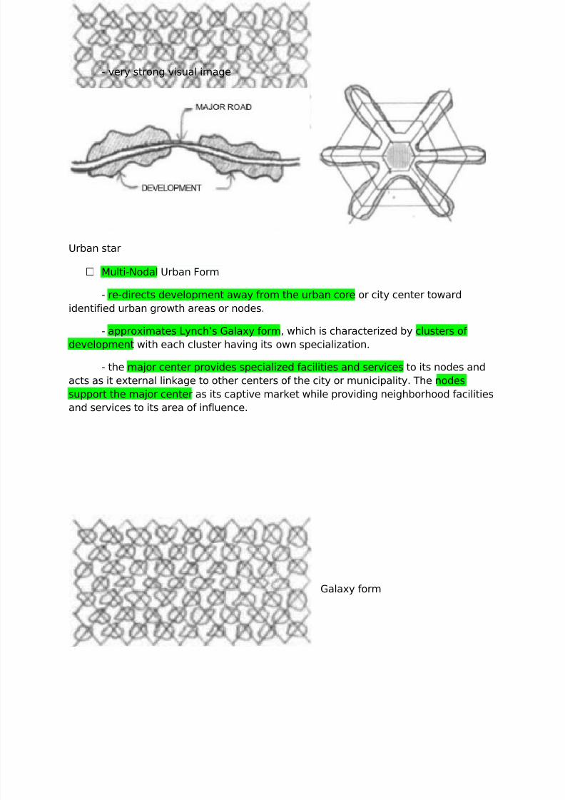
Linear Urban Form
- a.k.a Ribbon or Strip development
- characterized by concentration of development along both sides of major
transportation routes such as roads, navigable rivers or other form of transportnetwork
- generally start on a one-lot-deep into a grid system.
- also resembles what Kevin Lynch refers to as the Urban Star which is
characterized by a strong urban core with secondary centers of moderate densities,
distributed along main radials roads.
7/31/2019 Land Use Planning Compre
http://slidepdf.com/reader/full/land-use-planning-compre 13/32
- very strong visual image
Urban star
Multi-Nodal Urban Form
- re-directs development away from the urban core or city center toward
identified urban growth areas or nodes.
- approximates Lynch’s Galaxy form, which is characterized by clusters of
development with each cluster having its own specialization.
- the major center provides specialized facilities and services to its nodes and
acts as it external linkage to other centers of the city or municipality. The nodes
support the major center as its captive market while providing neighborhood facilities
and services to its area of influence.
Galaxy form
7/31/2019 Land Use Planning Compre
http://slidepdf.com/reader/full/land-use-planning-compre 14/32
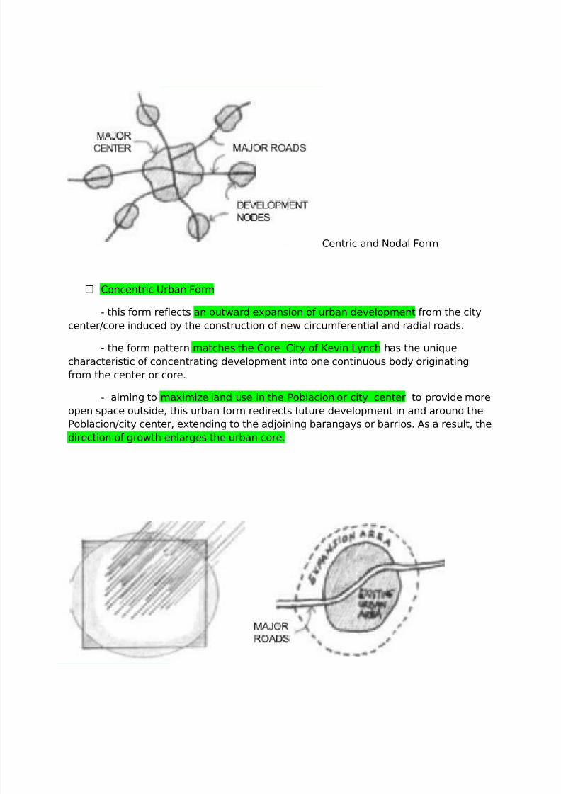
Centric and Nodal Form
Concentric Urban Form
- this form reflects an outward expansion of urban development from the city
center/core induced by the construction of new circumferential and radial roads.
- the form pattern matches the Core City of Kevin Lynch has the unique
characteristic of concentrating development into one continuous body originating
from the center or core.
- aiming to maximize land use in the Poblacion or city center to provide more
open space outside, this urban form redirects future development in and around the
Poblacion/city center, extending to the adjoining barangays or barrios. As a result, the
direction of growth enlarges the urban core.
7/31/2019 Land Use Planning Compre
http://slidepdf.com/reader/full/land-use-planning-compre 15/32
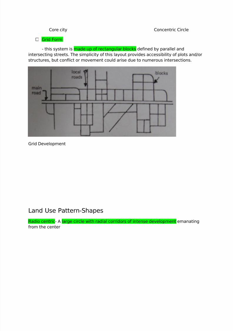
Core city Concentric Circle
Grid Form
- this system is made up of rectangular blocks defined by parallel and
intersecting streets. The simplicity of this layout provides accessibility of plots and/or
structures, but conflict or movement could arise due to numerous intersections.
Grid Development
Land Use Pattern-Shapes
Radio centric- A large circle with radial corridors of intense development emanating
from the center
7/31/2019 Land Use Planning Compre
http://slidepdf.com/reader/full/land-use-planning-compre 16/32
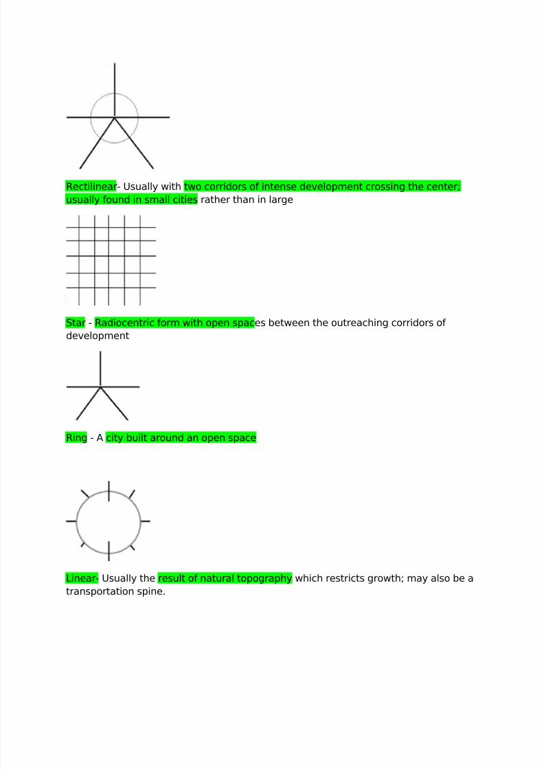
Rectilinear- Usually with two corridors of intense development crossing the center;
usually found in small cities rather than in large
Star - Radiocentric form with open spaces between the outreaching corridors of
development
Ring - A city built around an open space
Linear- Usually the result of natural topography which restricts growth; may also be a
transportation spine.
7/31/2019 Land Use Planning Compre
http://slidepdf.com/reader/full/land-use-planning-compre 17/32
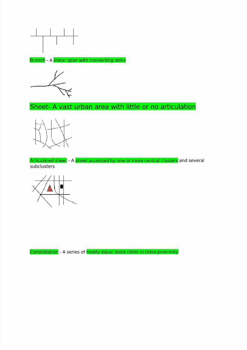
Branch - A linear span with connecting arms
Sheet- A vast urban area with little or no articulation
Articulated sheet - A sheet accented by one or more central clusters and several
subclusters
Constellation - A series of nearly equal sized cities in close proximity
7/31/2019 Land Use Planning Compre
http://slidepdf.com/reader/full/land-use-planning-compre 18/32
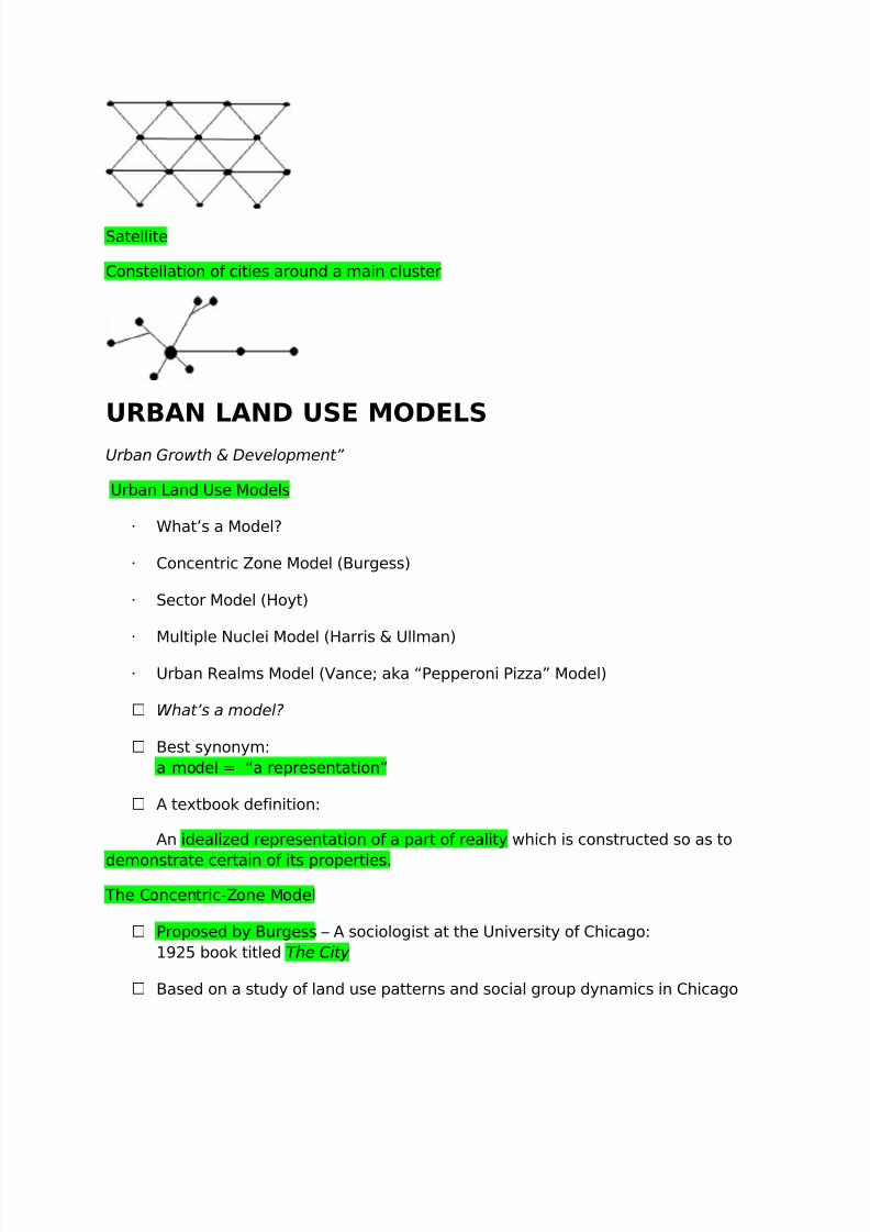
Satellite
Constellation of cities around a main cluster
URBAN LAND USE MODELS
Urban Growth & Development”
Urban Land Use Models
What’s a Model?
Concentric Zone Model (Burgess)
Sector Model (Hoyt)
Multiple Nuclei Model (Harris & Ullman)
Urban Realms Model (Vance; aka “Pepperoni Pizza” Model)
What’s a model?
Best synonym:
a model = “a representation”
A textbook definition:
An idealized representation of a part of reality which is constructed so as to
demonstrate certain of its properties.
The Concentric-Zone Model
Proposed by Burgess – A sociologist at the University of Chicago:
1925 book titled The City
Based on a study of land use patterns and social group dynamics in Chicago
7/31/2019 Land Use Planning Compre
http://slidepdf.com/reader/full/land-use-planning-compre 19/32
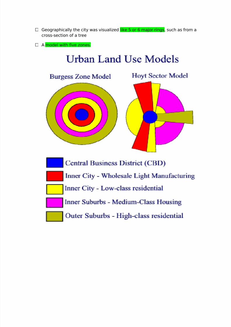
Geographically the city was visualized like 5 or 6 major rings, such as from a
cross-section of a tree
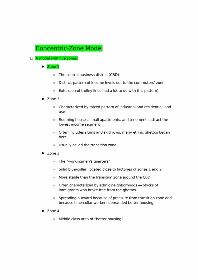
A model with five zones.
7/31/2019 Land Use Planning Compre
http://slidepdf.com/reader/full/land-use-planning-compre 20/32
Concentric-Zone Model A model with five zones.
Zone 1
○ The central business district (CBD)
○ Distinct pattern of income levels out to the commuters’ zone
○ Extension of trolley lines had a lot to do with this pattern)
Zone 2
○ Characterized by mixed pattern of industrial and residential land
use
○ Rooming houses, small apartments, and tenements attract the
lowest income segment
○ Often includes slums and skid rows, many ethnic ghettos began
here
○ Usually called the transition zone
Zone 3
○ The “workingmen’s quarters”
○ Solid blue-collar, located close to factories of zones 1 and 2
○ More stable than the transition zone around the CBD
○ Often characterized by ethnic neighborhoods — blocks of
immigrants who broke free from the ghettos
○ Spreading outward because of pressure from transition zone and
because blue-collar workers demanded better housing
Zone 4
○ Middle class area of “better housing”
7/31/2019 Land Use Planning Compre
http://slidepdf.com/reader/full/land-use-planning-compre 21/32
○ Established city dwellers, many of whom moved outward with the
first streetcar network
○ Commute to work in the CBD
Zone 5
○ Consists of higher-income families clustered together in older
suburbs
○ Located either on the farthest extension of the trolley or
commuter railroad lines
○ Spacious lots and large houses
○ From here the rich pressed outward to avoid congestion and
social heterogeneity caused by expansion of zone 4
Theory represented the American city in a new stage of development
Before the 1870s, cities such as New York had mixed neighborhoods
where merchants’ stores and sweatshop factories were intermingled
with mansions and hovels
Rich and poor, immigrant and native-born, rubbed shoulders in the same
neighborhoods
In Chicago, Burgess’s home town, the great fire of 1871 leveled the core
The result of rebuilding was a more explicit social patterning
Chicago became a segregated city with a concentric pattern
This was the city Burgess used for his model
The actual map of the residential area does not exactly match his
simplified concentric zones
7/31/2019 Land Use Planning Compre
http://slidepdf.com/reader/full/land-use-planning-compre 22/32
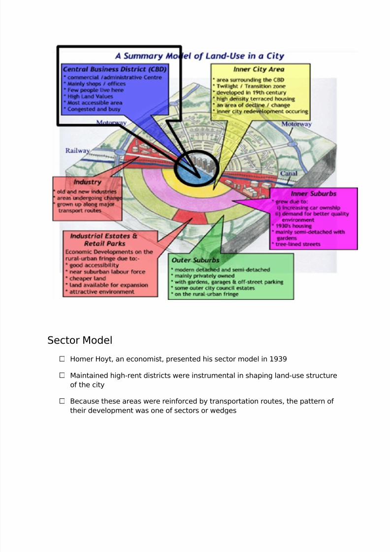
Sector Model
Homer Hoyt, an economist, presented his sector model in 1939
Maintained high-rent districts were instrumental in shaping land-use structure
of the city
Because these areas were reinforced by transportation routes, the pattern of
their development was one of sectors or wedges
7/31/2019 Land Use Planning Compre
http://slidepdf.com/reader/full/land-use-planning-compre 23/32
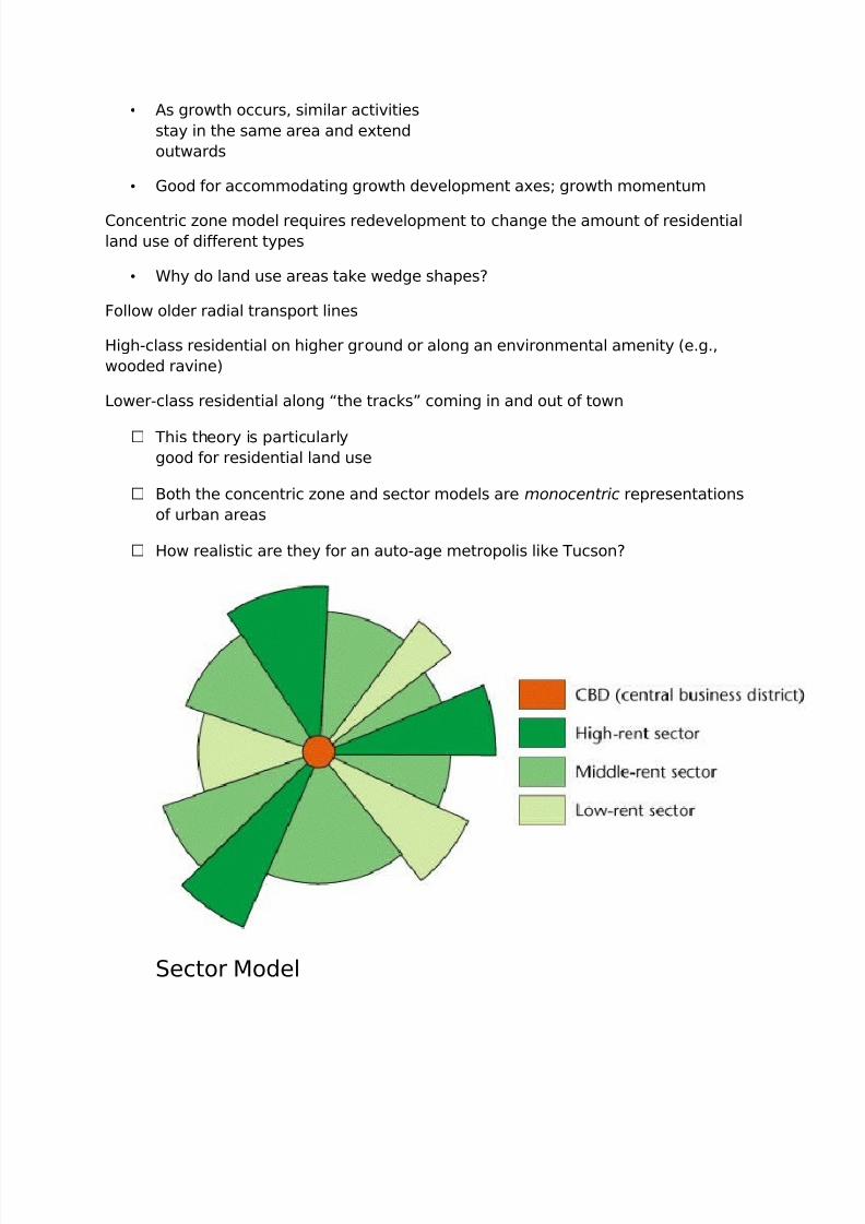
• As growth occurs, similar activities
stay in the same area and extend
outwards
• Good for accommodating growth development axes; growth momentum
Concentric zone model requires redevelopment to change the amount of residential
land use of different types
• Why do land use areas take wedge shapes?
Follow older radial transport lines
High-class residential on higher ground or along an environmental amenity (e.g.,
wooded ravine)
Lower-class residential along “the tracks” coming in and out of town
This theory is particularly
good for residential land use
Both the concentric zone and sector models are monocentric representations
of urban areas
How realistic are they for an auto-age metropolis like Tucson?
Sector Model
7/31/2019 Land Use Planning Compre
http://slidepdf.com/reader/full/land-use-planning-compre 24/32
Hoyt suggested high-rent sector would expand according to four factors
Moves from its point of origin near the CBD, along established routes of
travel, toward another nucleus of high-rent buildings
Will progress toward high ground or along waterfronts, when these areas
are not used for industry
Will move along the route of fastest transportation
Will move toward open space
As high-rent sectors develop, areas between them are filled in
Middle-rent areas move directly next to them, drawing on their prestige
Low-rent areas fill remaining areas
Moving away from major routes of travel, rents go from high to low
There are distinct patterns in today’s cities that echo Hoyt’s model
He had the advantage of writing later than Burgess — in the age of the
automobile
Today, major transportation arteries are generally freeways
Surrounding areas are often low-rent districts
Contrary to Hoyt’s theory
Freeways were imposed on existing urban pattern
Often built through low-rent areas where land was cheaper and political
opposition was less
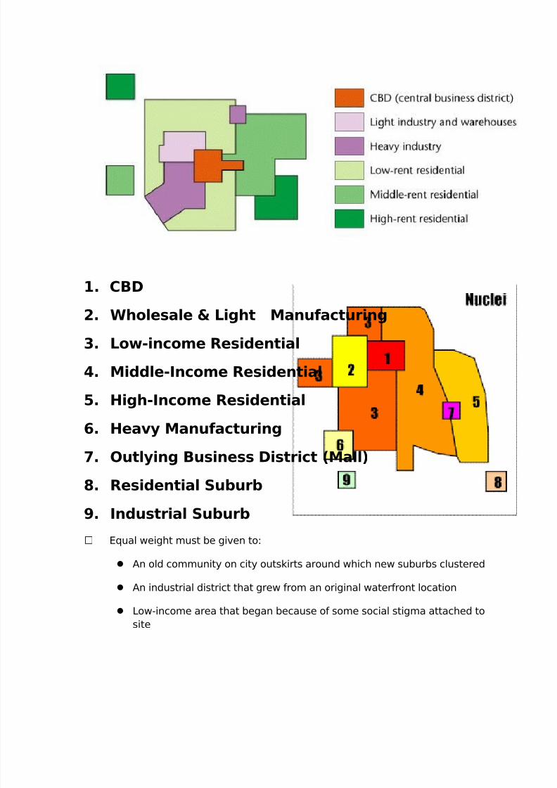
Multiple Nuclei Model
Developed by two geographers: Chauncey Harris & Edward Ullman in 1945
based on Seattle, Washington
Maintained a city developed with equal intensity around various points
The CBD was not the sole generator of change
Basic concept: cities don’t grow up around a single core but have several
nodes
7/31/2019 Land Use Planning Compre
http://slidepdf.com/reader/full/land-use-planning-compre 25/32
1. CBD
2. Wholesale & Light Manufacturing
3. Low-income Residential
4. Middle-Income Residential
5. High-Income Residential
6. Heavy Manufacturing
7. Outlying Business District (Mall)
8. Residential Suburb
9. Industrial Suburb
Equal weight must be given to:
An old community on city outskirts around which new suburbs clustered
An industrial district that grew from an original waterfront location
Low-income area that began because of some social stigma attached to
site
7/31/2019 Land Use Planning Compre
http://slidepdf.com/reader/full/land-use-planning-compre 26/32
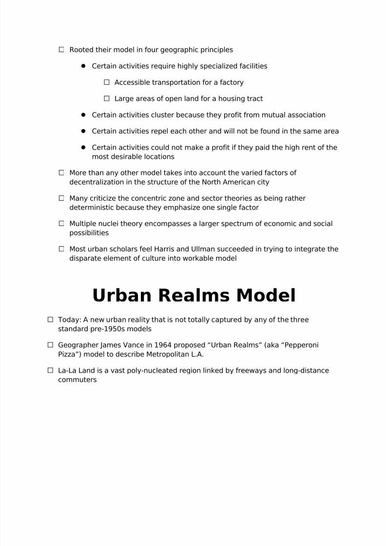
Rooted their model in four geographic principles
Certain activities require highly specialized facilities
Accessible transportation for a factory
Large areas of open land for a housing tract
Certain activities cluster because they profit from mutual association
Certain activities repel each other and will not be found in the same area
Certain activities could not make a profit if they paid the high rent of the
most desirable locations
More than any other model takes into account the varied factors of
decentralization in the structure of the North American city
Many criticize the concentric zone and sector theories as being rather
deterministic because they emphasize one single factor
Multiple nuclei theory encompasses a larger spectrum of economic and social
possibilities
Most urban scholars feel Harris and Ullman succeeded in trying to integrate the
disparate element of culture into workable model
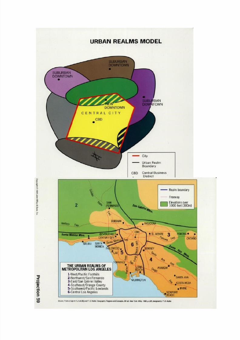
Urban Realms Model Today: A new urban reality that is not totally captured by any of the three
standard pre-1950s models
Geographer James Vance in 1964 proposed “Urban Realms” (aka “Pepperoni
Pizza”) model to describe Metropolitan L.A.
La-La Land is a vast poly-nucleated region linked by freeways and long-distance
commuters
7/31/2019 Land Use Planning Compre
http://slidepdf.com/reader/full/land-use-planning-compre 27/32

7/31/2019 Land Use Planning Compre
http://slidepdf.com/reader/full/land-use-planning-compre 28/32
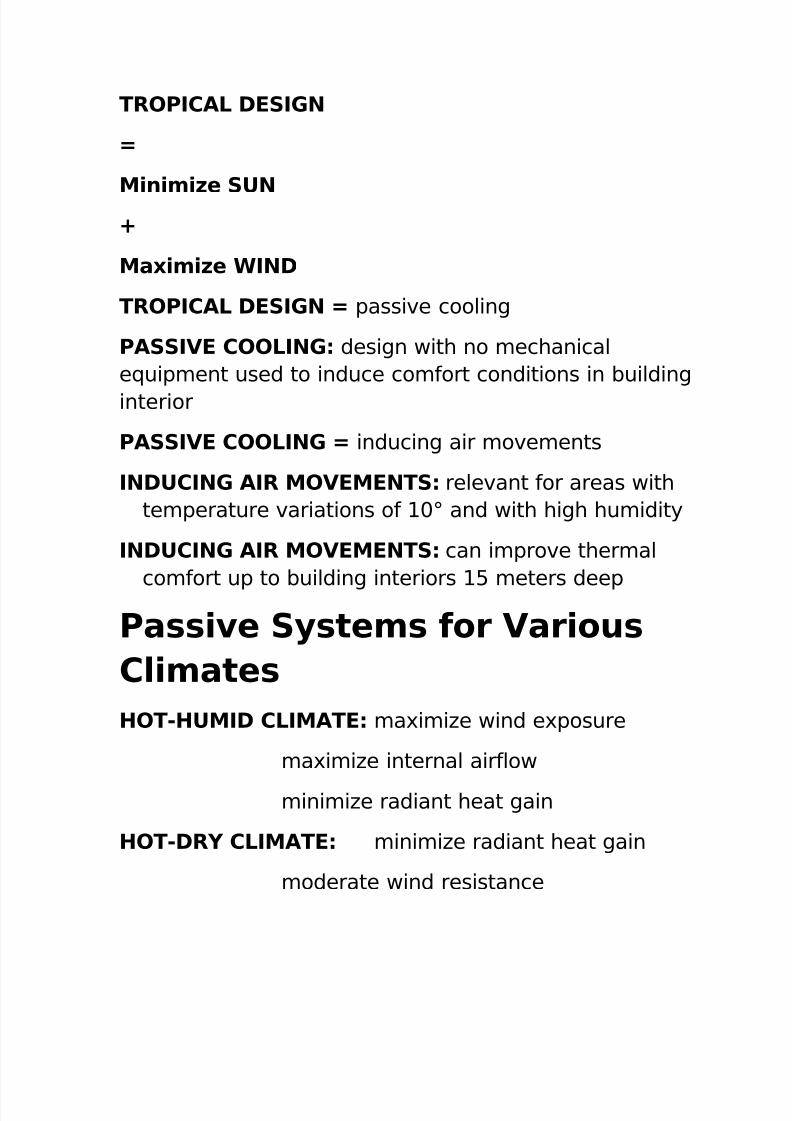
Additional notes TROPICAL DESIGN
7/31/2019 Land Use Planning Compre
http://slidepdf.com/reader/full/land-use-planning-compre 29/32
TROPICAL DESIGN
=
Minimize SUN+
Maximize WIND
TROPICAL DESIGN = passive cooling
PASSIVE COOLING: design with no mechanical
equipment used to induce comfort conditions in building
interior
PASSIVE COOLING = inducing air movements
INDUCING AIR MOVEMENTS: relevant for areas with
temperature variations of 10° and with high humidity
INDUCING AIR MOVEMENTS: can improve thermal
comfort up to building interiors 15 meters deep
Passive Systems for Various
Climates
HOT-HUMID CLIMATE: maximize wind exposure
maximize internal airflow
minimize radiant heat gain
HOT-DRY CLIMATE: minimize radiant heat gain
moderate wind resistance
7/31/2019 Land Use Planning Compre
http://slidepdf.com/reader/full/land-use-planning-compre 30/32
moderate internal airflow
COOL CLIMATE: maximize thermal retention
maximize radiant heat gainminimize wind resistance
TEMPERATE CLIMATE: moderate thermal
retention
moderate radiant heat gain
slight wind exposure (for humidity
control)
moderate internal airflow
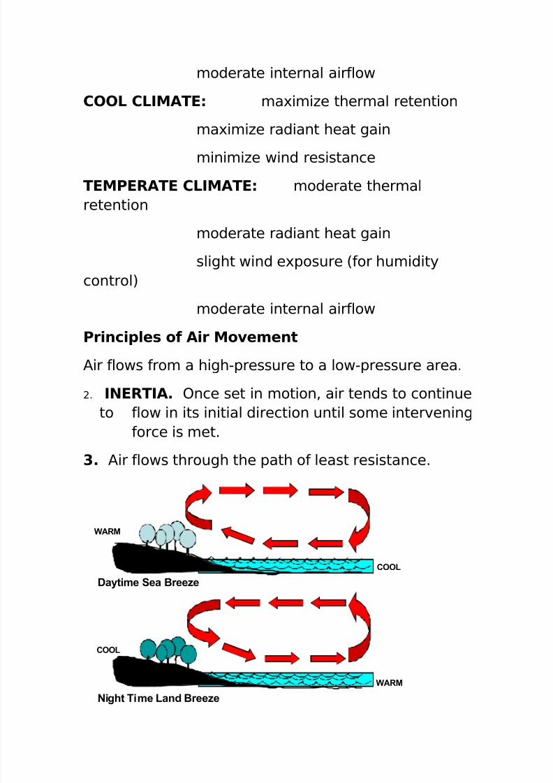
Principles of Air Movement
Air flows from a high-pressure to a low-pressure area.
2. INERTIA. Once set in motion, air tends to continue
to flow in its initial direction until some interveningforce is met.
3. Air flows through the path of least resistance.
Daytime Sea Breeze
Night Time Land Breeze
WARM
COOL
COOL
WARM
7/31/2019 Land Use Planning Compre
http://slidepdf.com/reader/full/land-use-planning-compre 31/32
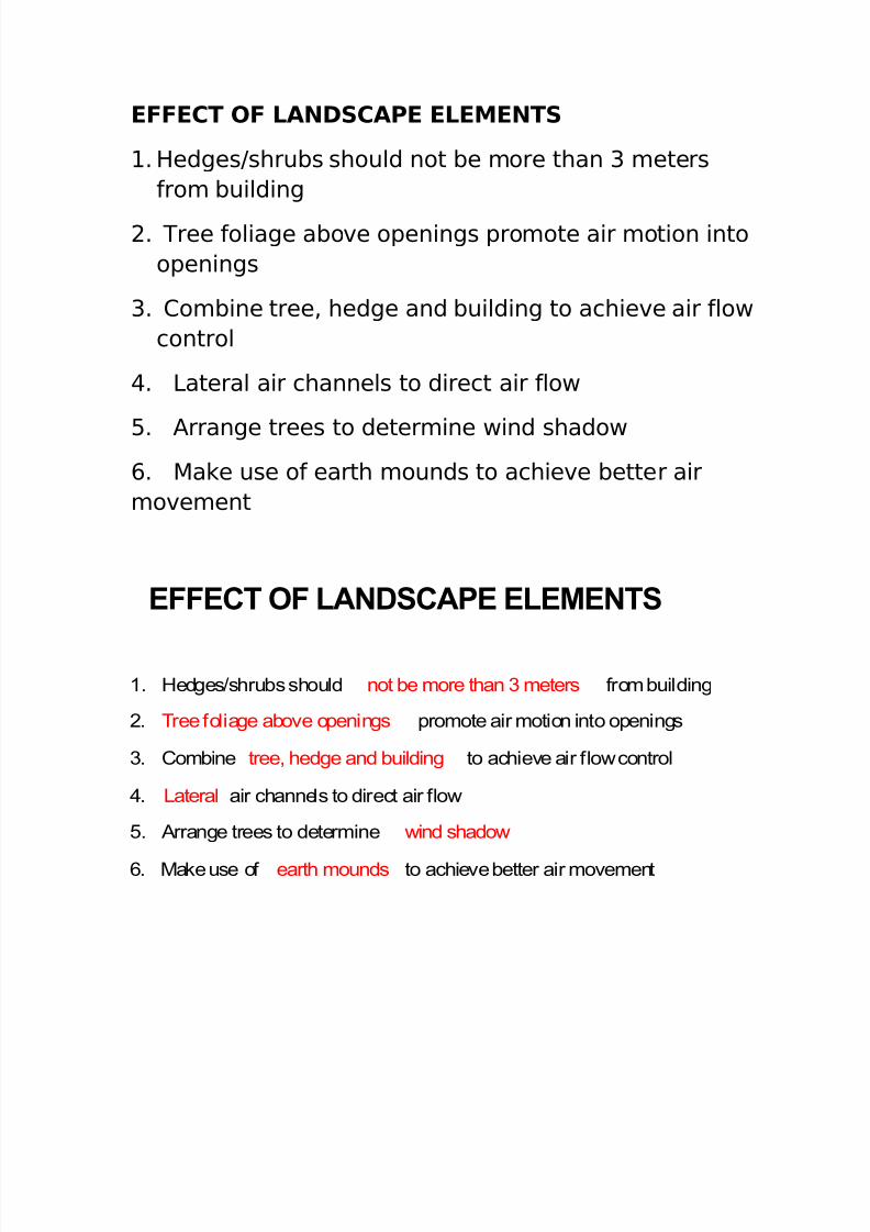
EFFECT OF LANDSCAPE ELEMENTS
1. Hedges/shrubs should not be more than 3 meters from building
2. Tree foliage above openings promote air motion into openings
3. Combine tree, hedge and building to achieve air flow control
4. Lateral air channels to direct air flow
5. Arrange trees to determine wind shadow
6. Make use of earth mounds to achieve better air movement
EFFECT OF LANDSCAPE ELEMENTS
1. Hedges/shrubs should not be more than 3 meters
from building
2. Tree foliage above openings promote air motion into
openings
3. Combine tree, hedge and building to achieve air flow
control
4. Lateral air channels to direct air flow
5. Arrange trees to determine wind shadow
6. Make use of earth mounds to achieve better air
movement

7/31/2019 Land Use Planning Compre
http://slidepdf.com/reader/full/land-use-planning-compre 32/32
THANK YOU