la cuna de aztlan sacred site protection circle
DESCRIPTION
This booklet details the Sacred Sites and Cultural Resources threatened by large corporate solar development in the California DesertsTRANSCRIPT
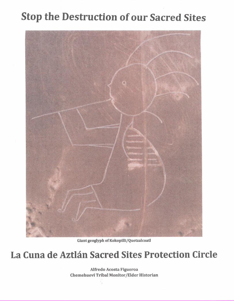
Stop the Destruction of our Sacred Sites
Giant geoglyph of KokopillijQuetzalcoatl
La Cuna de Aztlan Sacred Sites Protection CircleAlfredo Acosta Figueroa
Chemehuevi Tribal Monitor jElder Historian
Table of Contents
Indigenous Sacred Sites/Kokopelli Cover Illustration
GPS Coordinates of the Sacred Geoglyphs
Cicimitl Geoglyph
Glyph of Cicimitl from the Magliabecchi Codex
Map of the Colorado River indicating Cicimitl Geoglyph location
Foot Print & Four Zero Geoglyphs
Aerial picture of EI Tosco & Granite Peak
El Tosco Geoglyph
Temple Geoglyph
Maze Geoglyph
Letter "Fa Geoglyph & Ancient Trail
East/West Trail & 3-mounts
Aerial picture of geoglyphs & North/South Geoglyph
Fish Geoglyph
Quetzalpetlatl's Mountain Image
Quetzalcoatl & McCoy Well
La Cuna de Aztlan Protection Circle & BLM
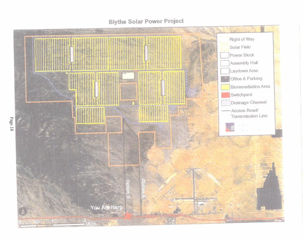
Map of proposed Blythe Solar Power Project
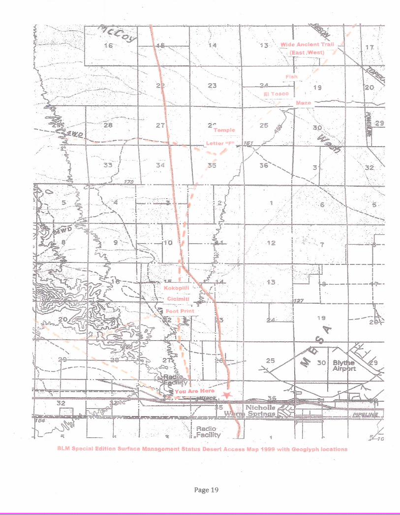
Map of Geoglyph locations
Francis J & Patricia H. Johnston Map
Sacred Sites Protection Circle Mission Statement
Memorandum of Understanding
Chemehuevi Tribe: Resolution Statement
Declaration Letter
BLM Email
Page 1
Page 2
Page 3
Page 4
Page 5
Page 6
Page 7
Page 8
Page 9
Page 10
Page 11
Page 12
Page 13
Page 14
Page 15
Page 16
Page 17
Page 18
Page 19
Page 20
Page 21
Page 22
Page 23
Page 24
Page 25
Kokopelli and Indigenous Sacred Sites Threatened by Mega Solar Power Plants inthe California Desert
The enclosures herein submitted by La Cuna de Aztlan Sacred Sites Protection Circle, include pictures of
local native/indigenous sacred sites threatened by the proposed mega solar power plants. These Native
American sacred sites and cultural resources will be destroyed by the construction of these solar power
plants. Other enclosures are of maps, an MOD and correspondence pertaining to the mega-solar power
plants. The Blythe Solar Power Project/Chevron, Genesis Solar Energy and Palen Solar Power
Project/Chevron are part of the fast track large solar projects to be built on BLM land with a deadline of
December, 2010, to qualify for Obama stimulus monies. Though the Bureau of Land Management claims
that it will ensure the protection of cultural resources, the fast-track renewable energy solar plants
scheduled to be built on the 1-10 corridor in Eastern Riverside County, are already in the implementation
stages despite the fact that their cultural resources surveys have yet to be completed. When members of
the Sacred Sites Protection Circle met with the California Energy Commission to inform them of their
concerns, their presentation was shelved. The members made it clear that they were not against renewableenergy, but were protesting the destruction of these specific sites and cultural resources.
A giant geoglyph of the Kokopelli, (see front cover), the indigenous hunchback icon with a flute, lies
within the right of way acreage ofthe proposed Blythe Solar Project eight miles east of Blythe, California.
BLM officials have visited the site of the Kokopelli, yet they continue to sign off on the paperwork in
pursuit of the implementation ofthe proposed solar power plants. This document was sent out in search of
assistance in protecting the Kokopelli and over 25 other indigenous sacred sites that are exposed to
destruction by off road vehicles and now, mega-solar power plants.
For the past 55 years, we have been studying "The Aztec Place of Origin," Aztlan/Chicomozstoc/HueHue- Tlapallan, here in the surrounding Palo Verde/Parker Valleys. A brief history of the area followsbelow just to give you an idea of where these sacred sites are located and what they mean to the creation
stories ofthe local tribes and Aztec history. The Lower Colorado River Basin Valleys have been home to
the nucleus of many different indigenous linguistic families which at one time or another came to the area
where they stayed for sometime and then went on their journey to the four directions. Their migration is
symbolized by "Nahui-ollin," in Nahuatl. Some of the nations settled permanently in the area.
According to Chief Gary Harrison, the Athapaskans left the Colorado River and went north to Alaska
before the last Ice Age. Many nations left the area, beginning with the Olmeca, who went south,
thousands of years ago. The Chichimeca followed soon after, and then the Tolteca and Yaqui in the
sthcentury, followed by the Azteca/Mexica in the 1ihcentury. The Lower Colorado River Valleys have
been a major crossroad for indigenous nations within the western hemisphere, with some of the nationsgoing full circle. These nations traveled/migrated to the four directions and later returned to the ColoradoRiver Valleys. (Krober, 1976)
The major interests of this study are the three main linguistic families that claim to have originated on
theColorado River. They are the Uto-Aztecan Family (Nahua) which include the Pima, Tohono O'odam,
Yaqui, Hopi, Chemehuevi, Paiute, Cahuilla, Azteca/Mexica, Tarahumara, Cora, Huichol,
Page 1
Tlaxcalteca,Tarasco and Chichimeca. The Hokan Family (Yuman) includes the Mojave, Quechan,
Kamias, YavapaiHualapai, Cocopah, Ha1chidoma, Havasupai, Pai Pai, Chumash, Porno, Shasta, Seris (in
Sonora) and the Maya Chontal (in Yucatan and Guerrero). The Athapaskan Family includes the Apache,
Navajo, Janos, Athapaskan, in Alaska and Canada.
There are five native reservations in the Lower Colorado River Valleys from north to south, including
Fort Mojave, near Needles, California, Chemehuevi, Colorado River Indian Tribes, (CRIT), Quechan and
Cocopah, south of Yuma, Arizona. Ofthose five, the Mojave and Chemehuevi are the most prominent
nations in the Palo VerdelParker Valleys.
The area that surrounds Blythe, California (withinl00-mile radius) is the center of the Aztec/Mexica
creation story called "Omeyocan." This is illustrated by the Mexica Codices and artifacts (such as the
Aztec Sun Stone Calendar) that cross-reference with the surrounding mountain images, geoglyphs,
petro glyphs, pictographs, equinoxes and solstices. The Omeyocan is geographically outlined in the form
of a diamond. It begins in the north with a peak in the Whipple Mountains (North of Parker, Arizona) and
with Dome Rock Peak in the Dome Rock Mountains (East of Blythe, Ca) and the eastern boundary is
represented by the Bouse Fisherman Geoglyph (TlaIoc) and the west boundary is the Big Maria Peak in
the Big Maria Mountains west above the Blythe Giant Intaglios. The entire length of the Omeyocan
Diamond is approximately 50-miles long and 32-miles wide. The Blythe Giant Intaglios represent the
center ofthe Mexica Creation Story and are shown in the Aztec Sun Stone Calendar which symbolizes the
first Sun of the giants (Tezcatlipoca).
In 1865, the original boundaries of CRIT were formed and the Chemehuevi and Mojave elders wanted toinclude most of the area that comprised the Omeyocan Diamond. The government did not accept their
proposal and reduced CRIT's acreage to its current boundaries. They have since regained part of theirland. All these tribes have at one time or another utilized the sacred sites and trails that follow the Coco
Maricopa East/West Trail and the North/South Quechan Trail that cross at the Blythe Mesa, where the
Blythe Energy Plant is located.
Sacred Sites Protection Circle is in opposition to the proposed Blythe, Genesis and Palen Solar Power
project sites. Ironically, we have an MOD (see enclosure) with the BLM to protect the other sacred sites
located along the Lower Colorado River Valleys including the Blythe Giant Intaglios, and worked jointly
with the Chemehuevi Indian Tribe, Natural Resource Conservation Service, Southern Low Desert
Resource Conservation and Development Council and the National Park Service. We are adamant that
there will not be a mitigation process with Mother Earth. We will protect all of these sacred sites,including the Kokopilli giant geoglyph and the sacred trails that connect them to the Blythe Giant
Intaglios.
Respectfully submitted by:
Alfredo A. Figueroa,ElderlHistorianiChemehuevi Tribal Monitor
Patricia Pinon, President, La Cuna de Aztlan Sacred Sites Protection Circle
Maria Lopez, Secretary, La Cuna de Aztlan Sacred Sites Protection Circle
Page I-a
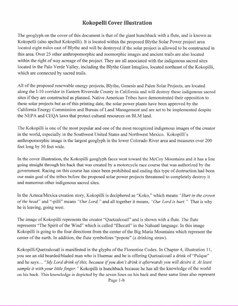
Kokopelli Cover illustration
The geoglyph on the cover of this document is that of the giant hunchback with a flute, and is known as
Kokopelli (also spelled Kokopilli). It is located within the proposed Blythe Solar Power project area
located eight miles east of Blythe and will be destroyed if the solar project is allowed to be constructed in
this area. Over 25 other anthropomorphic and zoomorphic images and ancient trails are also located
within the right of way acreage of the project. They are all associated with the indigenous sacred sites
located in the Palo Verde Valley, including the Blythe Giant Intaglios, located northeast of the Kokopilli,
which are connected by sacred trails.
All of the proposed renewable energy projects, Blythe, Genesis and Palen Solar Projects, are located
along the 1-10 corridor in Eastern Riverside County in California and will destroy these indigenous sacred
sites if they are constructed as planned. Native American Tribes have demonstrated their opposition to
these solar projects but as of this printing date, the solar power plants have been approved by the
California Energy Commission and Bureau of Land Management and are set to be implemented despite
the NEP A and CEQA laws that protect cultural resources on BLM land.
The Kokopilli is one of the most popular and one of the most recognized indigenous images of the creator
in the world, especially in the Southwest United States and Northwest Mexico. Kokopilli's
anthropomorphic image is the largest geoglyph in the lower Colorado River area and measures over 200
feet long by 50 feet wide.
In the cover illustration, the Kokopilli geoglyph faces west toward the McCoy Mountains and it has a line
going straight through his back that was created by a motorcycle race course that was authorized by the
government. Racing on this course has since been prohibited and ending this type of destruction had been
our main goal of the tribes before the proposed solar power projects threatened to completely destroy it
and numerous other indigenous sacred sites.
In the AztecaiMexica creation story, Kokopilli is deciphered as "Koko," which means "Hurt in the crown
of the head" and "-pilli" means "Our Lord, " and all together it means, "Our Lord is hurt." That is why
he is leaving, going west.
The image of Kokopilli represents the creator "Quetzalcoatl" and is shown with a flute. The flute
represents "The Spirit of the Wind" which is called "Ehecatl" in the Nahuatl language. In this image
Kokopilli is going to the four directions from the center of the Big Maria Mountains which represent the
center of the earth. In addition, the flute symbolizes "popote" (a drinking straw).
Kokopilli/Quetzalcoatl is manifested in the glyphs of the Florentine Codex. In Chapter 4, illustration 11,
you see an old bearded/bladed man who is Huemac and he is offering Quetzalcoatl a drink of "Pulque"
and he says ... "My Lord drink of this, because if you don 't drink it afterwards you will desire it. At least
sample it with your little finger. " Kokopilli is hunchback because he has all the knowledge of the world
on his back. This knowledge is depicted by the seven lines on his back and these same lines also representPage I-b

the harmonious balance (equilibrium) of the world. His image is seen on hundreds of petro glyphs along
the migration routes in the four directions out of the Colorado River area as depicted on the Nahua Codex.
In the Codex, the hunchback is called "Teomama-Huehuetlatolli" meaning "The Bundle Carriers of
Knowledge. " Kokopilli's five feathers on his head represent the communication from the center of the
earth to the cosmos. His upper body is of a bee and the lower portion is that of a human.
Kokopilli/Quetzalcoatl geoglyph is facing west and is departing with the sunset during the fall equinox at
the end ofthe 3rd Sun as shown in the Aztec Stone Calendar. In the creation story, when Quetzalcoatlleft
he promised to come back during the end of the 4th Sun which is also the beginning of the 5th Sun.
Quetzalcoatl came at the beginning of the 5th Sun but in the form of a blonde bearded Christopher
Columbus in 1492 and later in the form of Heman Cortes in 1519. Thus, the native people of the
Continent of Anahuac suffered the greatest devastation that the world has ever seen upon the arrival of
Europeans.
Page 1-c
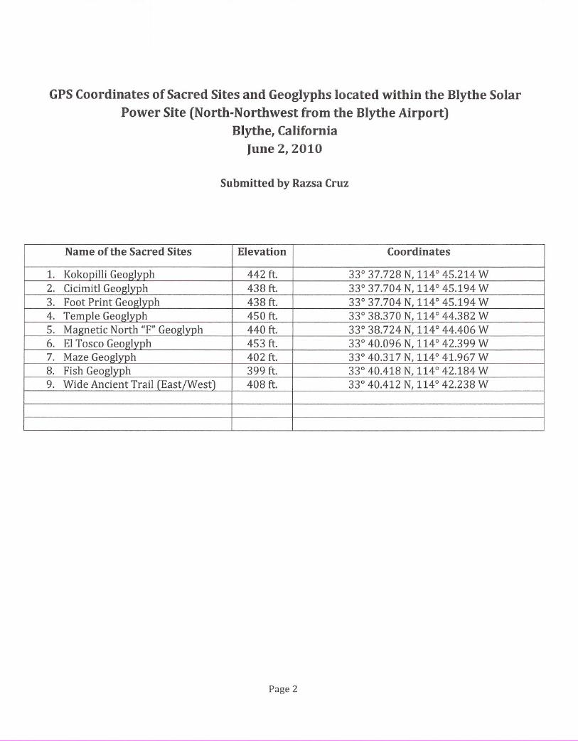
GPSCoordinates of Sacred Sites and Geoglyphs located within the Blythe SolarPower Site (North-Northwest from the Blythe Airport)
Blythe, CaliforniaJune 2, 2010
Submitted by Razsa Cruz
1.2.
3.4.5.6.7.8.9.
Name of the Sacred Sites Elevation
442 ft.438 ft.438 ft.450 ft.
440 ft.453 ft.402 ft.
399 ft.
408 ft.
Page 2
Coordinates
33037.728 N, 114045.214 W33037.704 N, 114045.194 W33037.704 N, 114045.194 W33038.370 N, 114044.382 W33038.724 N, 114044.406 W33040.096 N, 114042.399 W33040.317 N, 114041.967 W33040.418 N, 114042.184 W33040.412 N, 1140 42.238 W
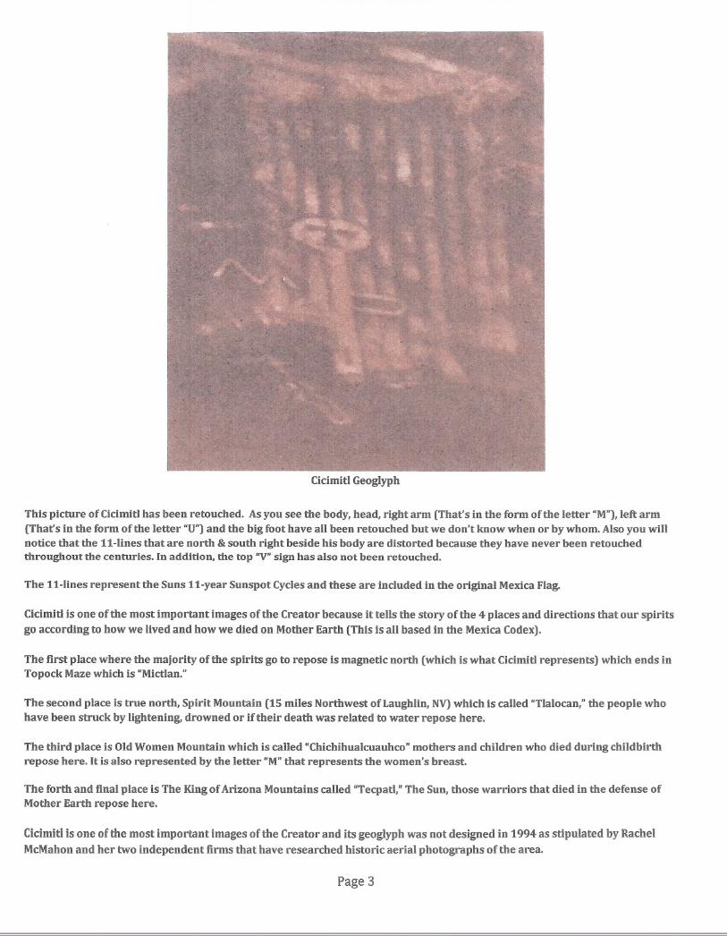
Cicimitl Geoglyph
This picture ofCicimitl has been retouched. As you see the body, head, right arm (That's in the form of the letter "M"),left arm(That's in the form of the letter "U")and the big foot have all been retouched but we don't know when or by whom. Also you willnotice that the tt-Iines that are north & south right beside his body are distorted because they have never been retouchedthroughout the centuries. In addition, the top "V"sign has also not been retouched.
The tt-Iines represent the Suns tt-year Sunspot Cycles and these are included in the original Mexica Flag.
CicimitI is one of the most important images of the Creator because it tells the story of the 4 places and directions that our spiritsgo according to how we lived and how we died on Mother Earth (This is all based in the Mexica Codex).
The first place where the majority of the spirits go to repose is magnetic north (which is what Cicimitl represents) which ends inTopock Maze which is "Mictlan."
The second place is true north, Spirit Mountain (t5 miles Northwest of Laughlin, NY)which is called "Tlalocan," the people whohave been struck by lightening, drowned or if their death was related to water repose here.
The third place is Old Women Mountain which is called "Chichihualcuauhco" mothers and children who died during childbirthrepose here. It is also represented by the letter "M"that represents the women's breast.
The forth and final place is The Kingof Arizona Mountains called "Tecpatl," The Sun, those warriors that died in the defense ofMother Earth repose here.
Cicimitl is one of the most important images of the Creator and its geoglyph was not designed in 1994 as stipulated by RachelMcMahon and her two independent firms that have researched historic aerial photographs ofthe area.
Page 3

(:)+
This image is from the Magliabecchi Codex that is in the Nazional Centrale library in
Florence, Italy. Cicimitl was painted like a skeleton, full of hearts and hands around the
neck and head. Around the hearts there are 11 flags referred to by the Mexica as "Pantli."
They are also represented in the original Mexican flag before the European invasionduring the battle of Cuitlahuac and Cuauhtemoc in 1521.
This is the Codex glyph of the Cicimitl geoglyph that is next to the Kokopilli geoglyph site.
Page 4
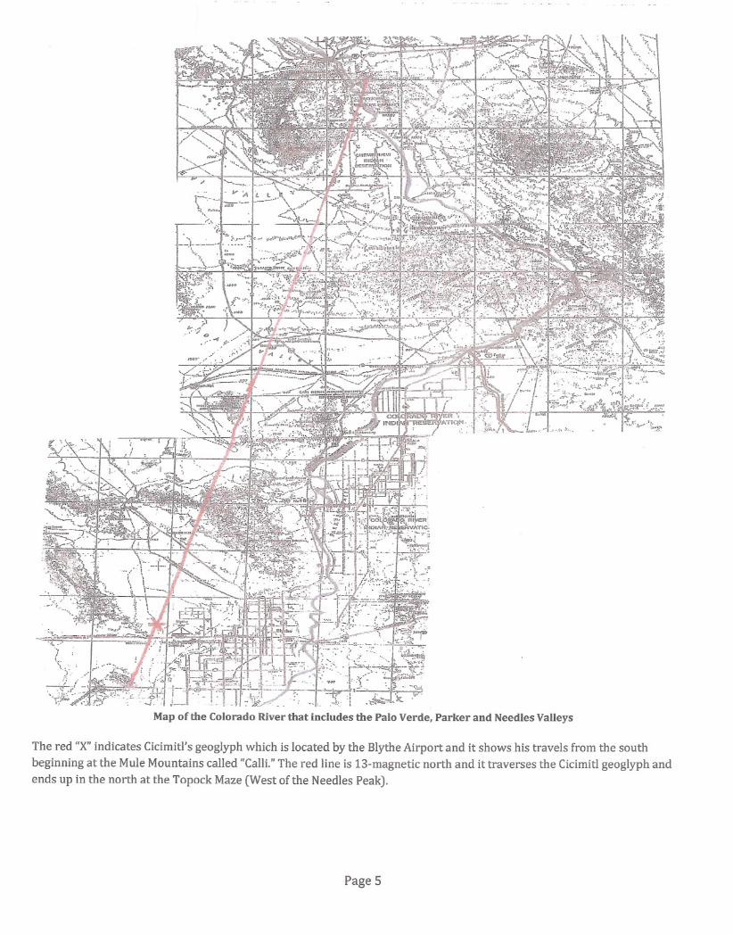
· :"\1' '....__ \ :...••.-l"'... ~.\:~._-_... ---- .~
The red "X"indicates Cicimitl's geoglyph which is located by the Blythe Airport and it shows his travels from the south
beginning at the Mule Mountains caUed "CaUL"The red line is 13-magnetic north and it traverses the Cicimitl geoglyph andends up in the north at the Topock Maze (West of the Needles Peak).
Page 5
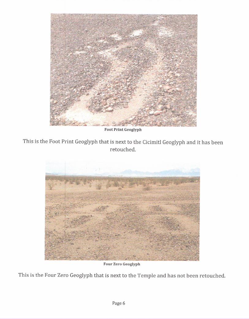
This is the Foot Print Geoglyph that is next to the Cicimitl Geoglyph and it has beenretouched.
Four Zero Geoglyph
This is the Four Zero Geoglyph that is next to the Temple and has not been retouched.
Page 6
Aerial image af EITasca geaglyph
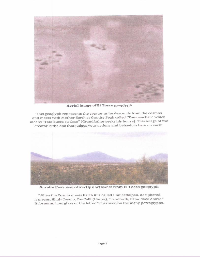
This geoglyph represents the creator as he descends froIn the cosmosand meets vvith Mother Earth at Granite Peak called "Tamoanchan" ""hich
means "Tata busca su Casa" (Grandfather seeks his house). This image of thecreator is the one that judges your actions and behaviors here on earth.
Granite Peak seen directly narth-west fram EITasca geaglyph
"When the Cosmo meets Earth it is called Ilhuicatlalpan, decipheredit means, Ilhui=Cosmo, Ca=Calli (House), TIal=Earth, Pan=Place Above."It forms an hourglass or the letter "X"as seen on the many petroglyphs.
Page 7
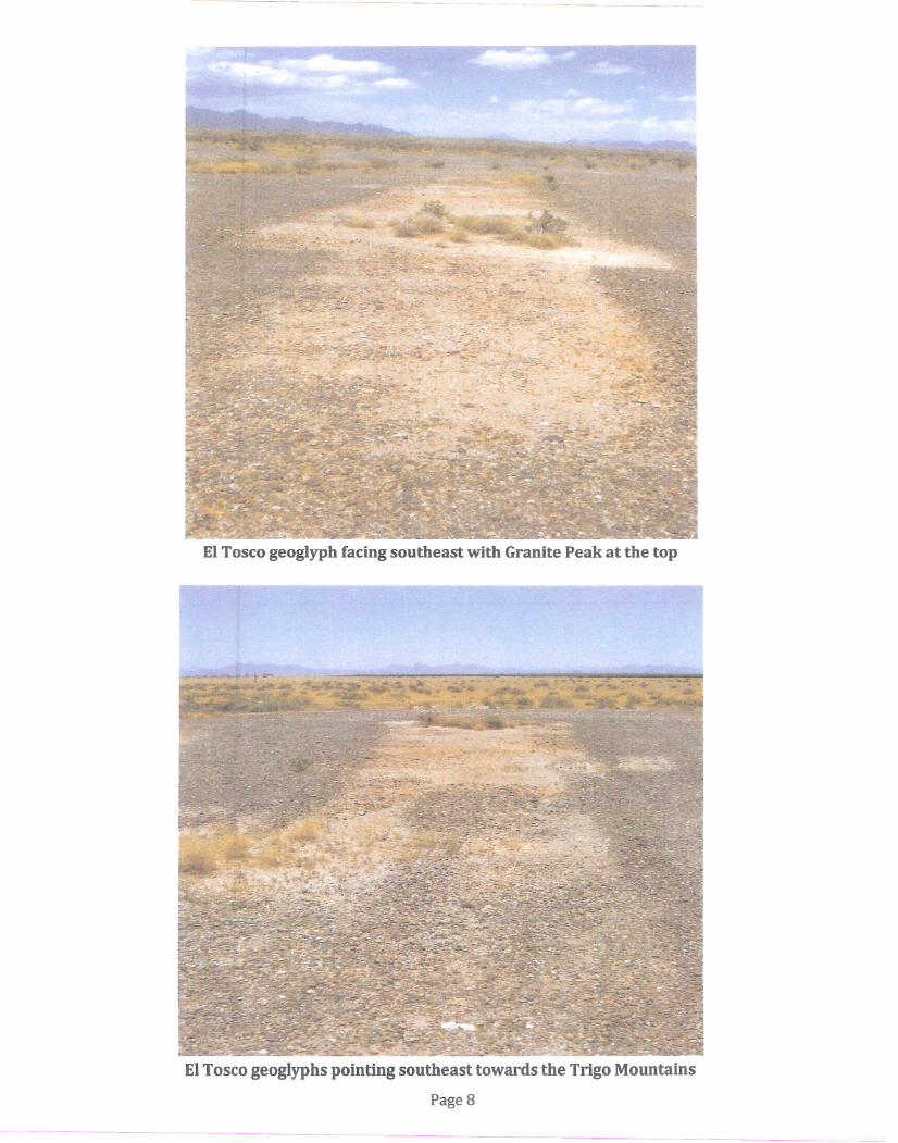
EITosco geoglyph facing southeast with Granite Peak at the top
EITosco geoglyphs pointing southeast towards the Trigo Mountains
Page 8
Temple Geoglyph: Coordinates
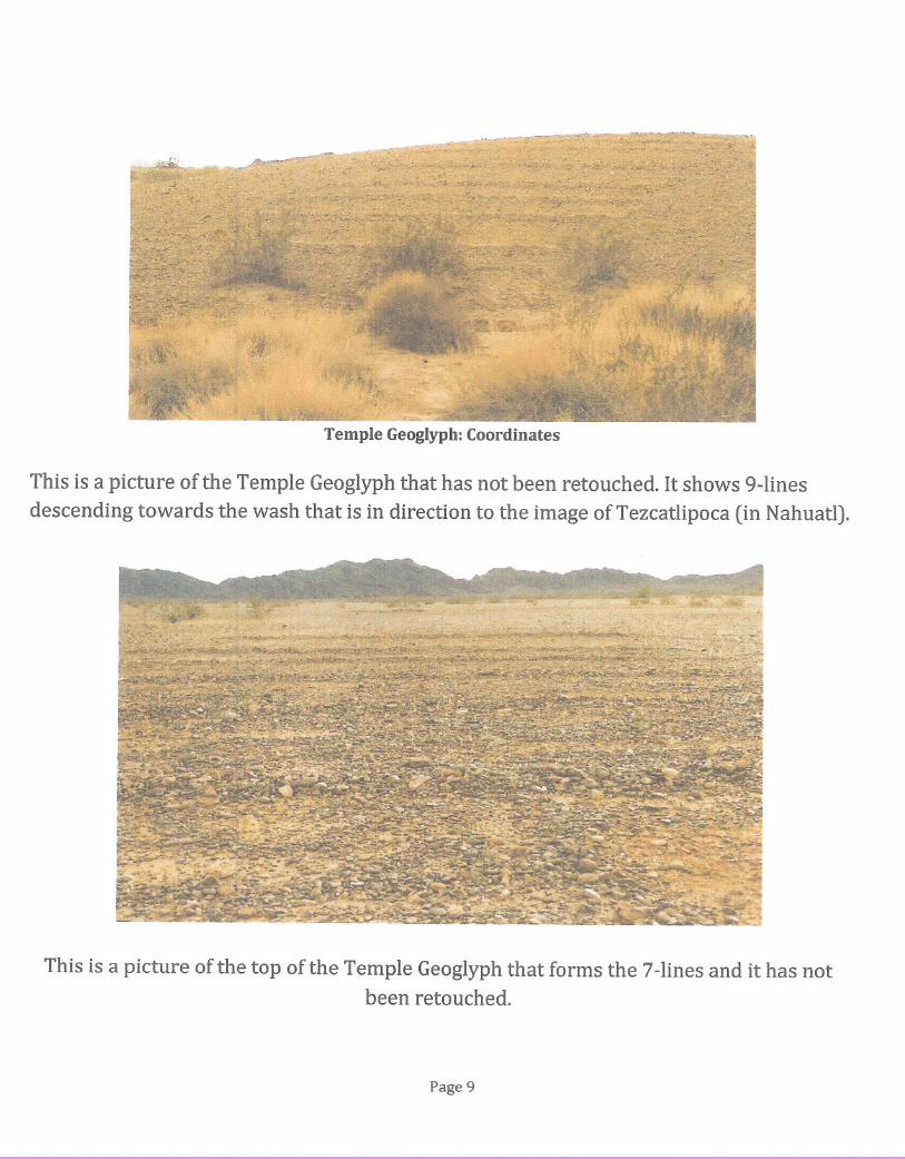
This is a picture of the Temple Geoglyph that has not been retouched. It shows 9-lines
descending towards the wash that is in direction to the image of Tezcatlipoca (in Nahuatl).
This is a picture of the top of the Temple Geoglyph that forms the 7-lines and it has notbeen retouched.
Page 9
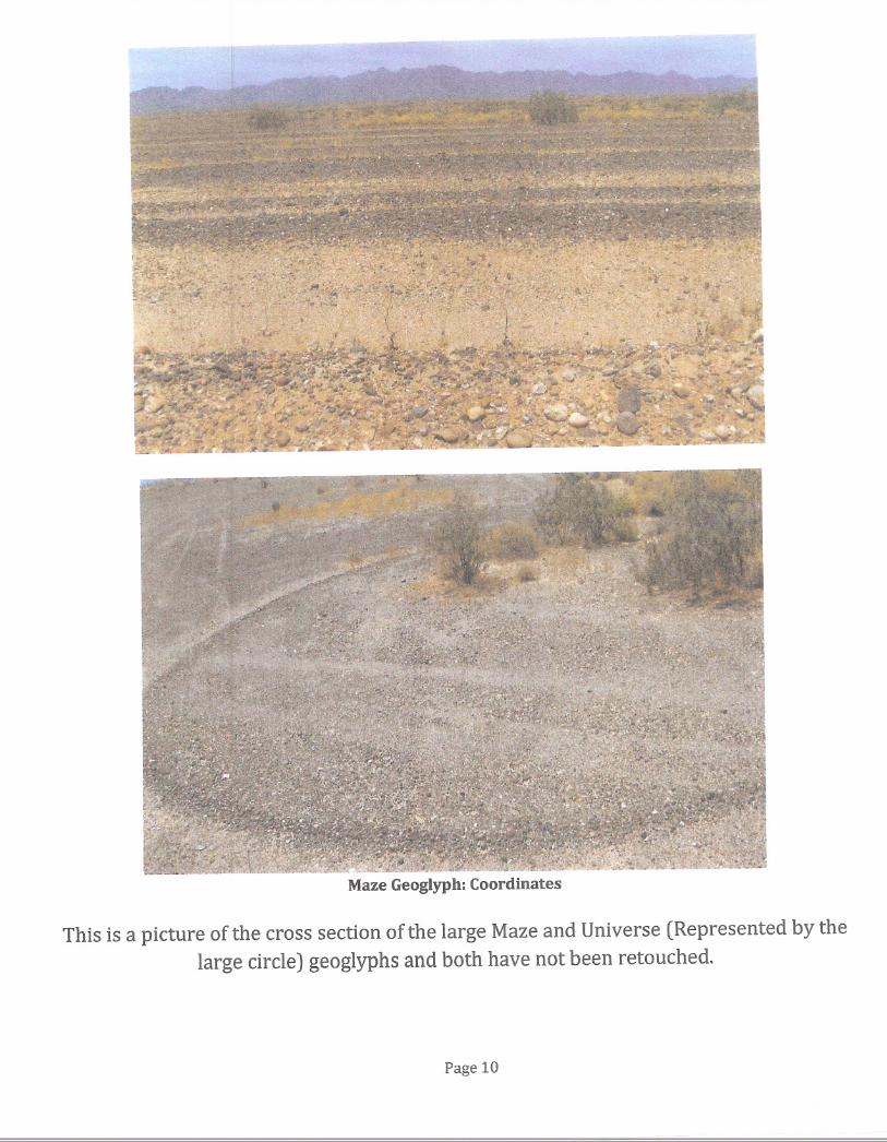
Maze Geoglyph: Coordinates
This is a picture of the cross section of the large Maze and Universe (Represented by thelarge circle) geoglyphs and both have not been retouched.
Page 10
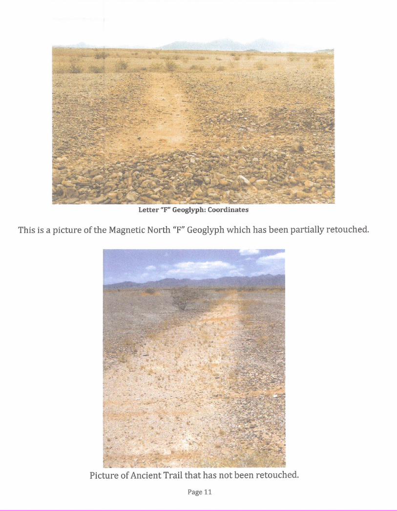
Letter ifF" Geoglyph: Coordinates
This is a picture of the Magnetic North ttF" Geoglyph which has been partially retouched.
Picture of Ancient Trail that has not been retouched.
Page 11
..g
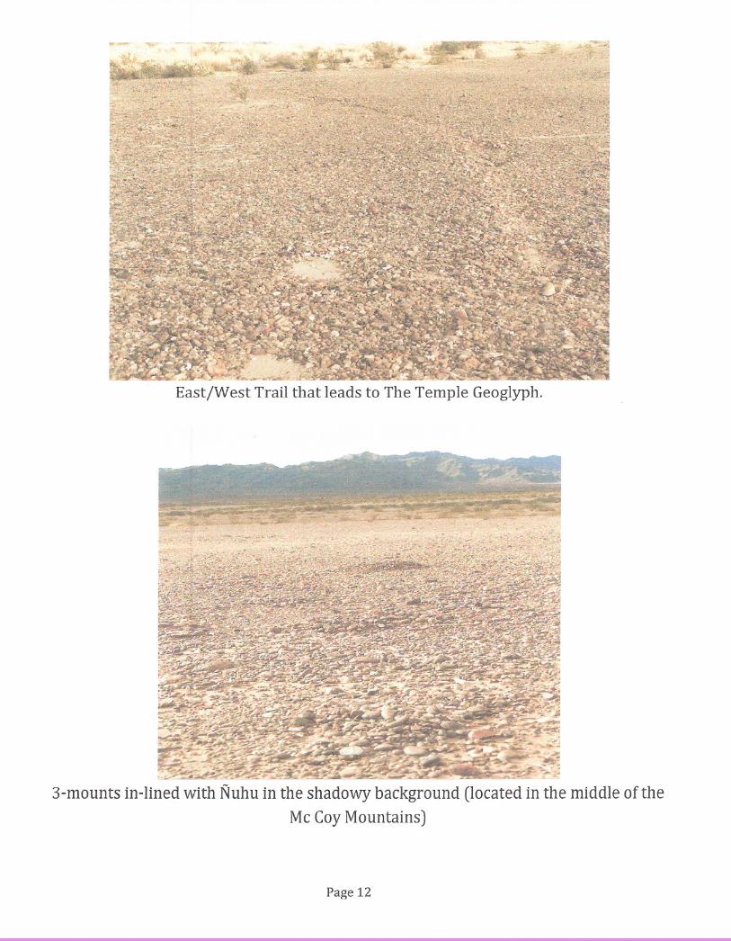
East/West Trail that leads to The Temple Geoglyph.
3-mounts in-lined with Nuhu in the shadowy background (located in the middle of the
Mc Coy Mountains)
Page 12
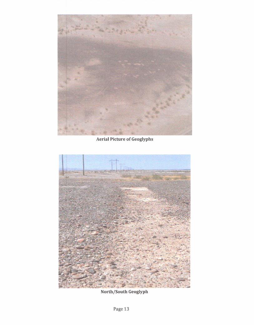
Aerial Picture of Geoglyphs
North/South Geoglyph
Page 13
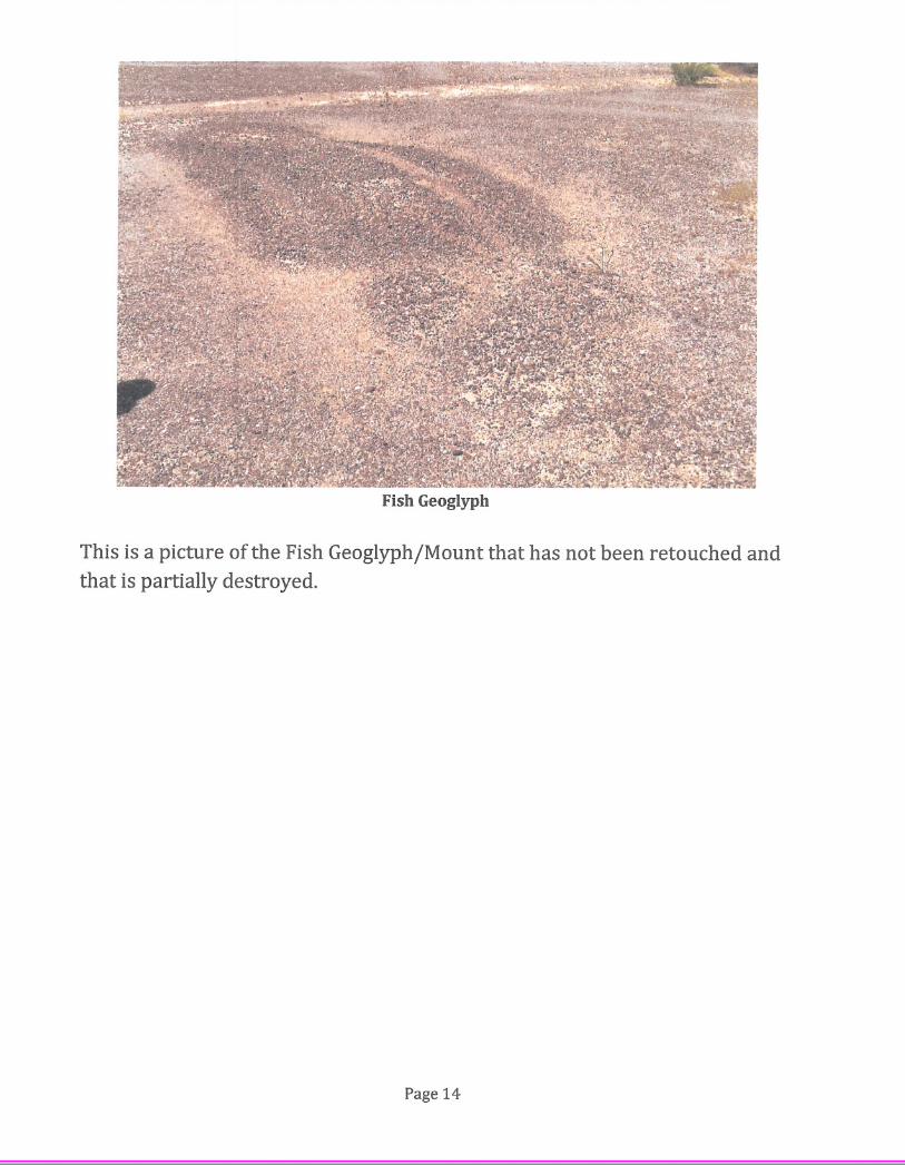
Fish Geoglyph
This is a picture of the Fish GeoglyphjMount that has not been retouched andthat is partially destroyed.
Page 14
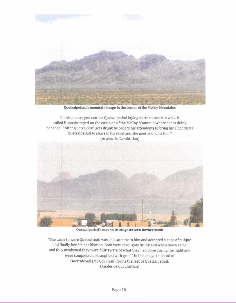
Quetzalpetlatl's mountain image in the center of the McCoy Mountains
In this picture you can see Quetzalpetlatllaying north to south in what iscalled Nonoalcatepetl on the east side of the McCoy Mountain where she is doing
penance ..."After Quetzalcoatl gets drunk he orders his attendents to bring his elder sisterQuetzalpetlatl to share in his revel and she goes and joins him."
(Anales de Cuauhtitlan)
f
jQuetzalpetlatl's mountain image as seen further south
"She came to were Quetzalcoatl was and sat next to him and accepted 4 cups of pulqueand finally her 5th, her libation. Both were throughly drunk and when dawn came
and they awakened they were fully aware of what they had done during the night and
were completed distraughted with grief." In this image the head ofQuetzalcoatl (Mc Coy Peak) forms the feet of Quetzalpetlatl.
(Anales de Cuauhtitlan)
Page 15
,~ .
'S.:····;':;.~~:',~~~r:i~~r~'~·
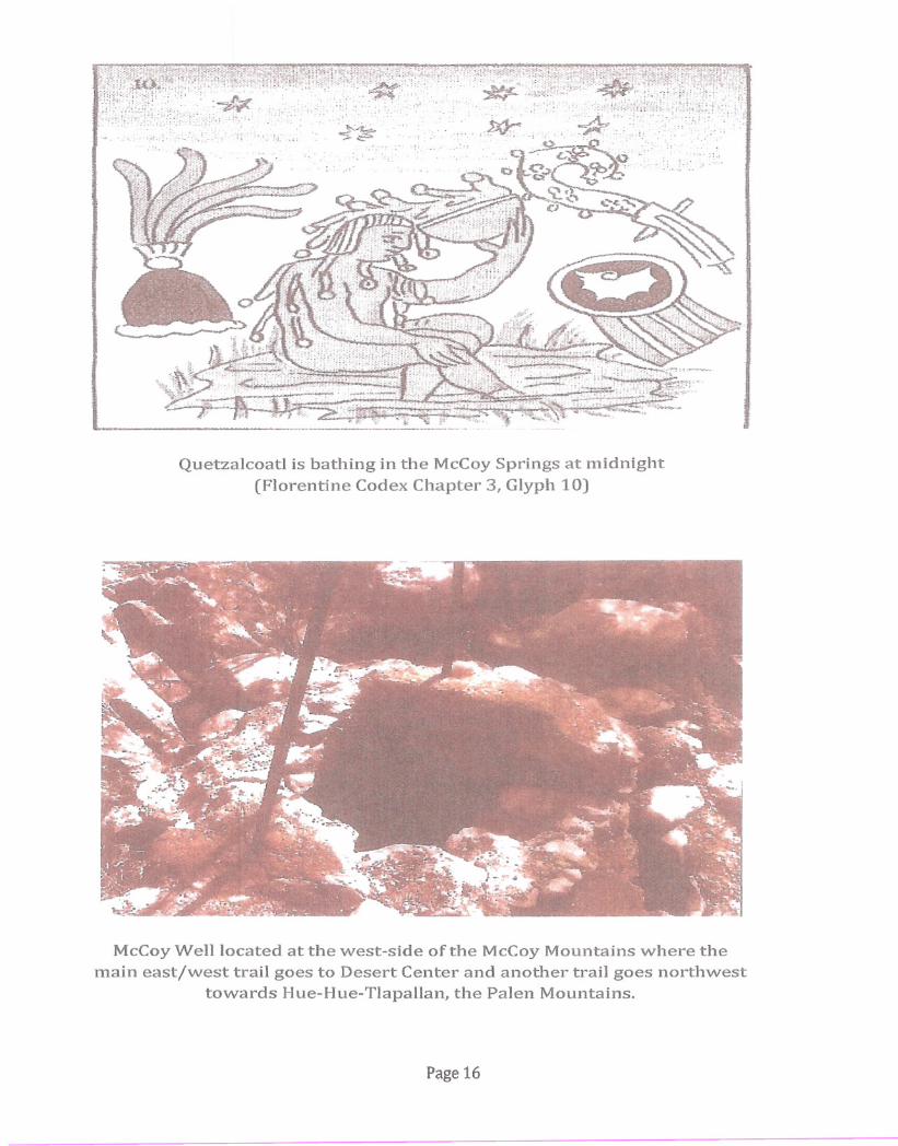
Quetzalcoatl is bathing in the McCoySprings at midnight(Florentine Codex Chapter 3, Glyph 10)
McCoyWell located at the west-side of the McCoyMountains where themain east/west trail goes to Desert Center and another trail goes northwest
towards Hue-Hue-Tlapallan, the Palen Mountains.
Page 16
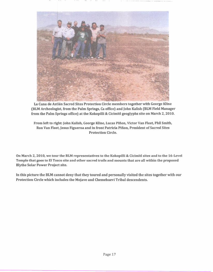
La Cuna de Aztlan Sacred Sites Protection Circle members together with George Kline
(BLM Archeologist, from the Palm Springs, Ca office) and John Kalish (BLM Field Managerfrom the Palm Springs office) at the Kokopilli & Cicimitl geoglyphs site on March 2,2010.
From left to right: John Kalish, George Kline, Lucas Pinon, Victor Van Fleet, Phil Smith,Ron Van Fleet, Jesus Figueroa and in front Patricia Pinon, President of Sacred Sites
Protection Circle.
On March 2, 2010, we tour the BLM representatives to the Kokopilli & Cicimitl sites and to the 16-LevelTemple that goes to EI Tosco site and other sacred trails and mounts that are all within the proposedBlythe Solar Power Project site.
In this picture the BLM cannot deny that they toured and personally visited the sites together with our
Protection Circle which includes the Mojave and Chemehuevi Tribal descendents.
Page 17
~£l.l
()Q(l)•.....00
B~ytheSo~arPowe rojec'~
Right of Way
Solar Field
DPower Block
DAssembly HallDLaydown Area
-.-.. Office at ParkingDBioremediation Area
l_':I\ Switchyard
~-:JDrainage Channel
-Access Road/Transmission Line
~-
'·7
....."'-
t1 •••.•}'{k-.•...\ -I -""'='"
" ,\,',' ,
32
~~~...~ ..- ~-~···f--.......•........ -28
II
27\
.;~~'.
23
2'"Tdmple
tier
-1-- ,. . . '.;.. , " .' , ,
"'t' :'f""'"
, '. , .." " ,' ,-
, ,... ' ...' .. ,:..;..;,. --
, tI, '-I",~r_
III---+'"f-II
19----.---1t1, '
~ 1---2;'
peeial Edition Surface Management Status Desert _~ccessMap 1999 with Geoglyph locations
Page 19
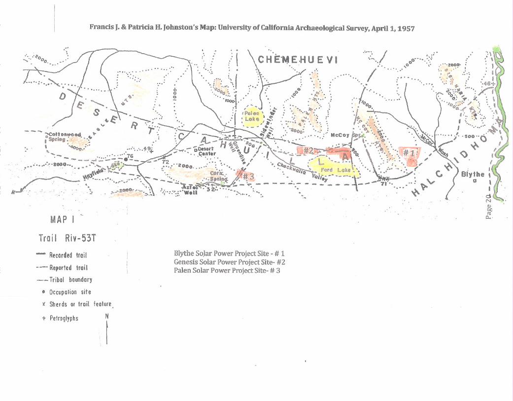
MAP I
Francis J. & Patricia H. Johnston's Map: University of California Archaeological Survey, April 1, 1957
···.··~o : '\' ~." / ,\....•.. °0 :' .• ' • '.. \..... - .;::: C H E'N E HUE V I .: o'-"'~:'/ :'\\~.•. ' •.•• 0°' ••
.•.......... ' : •••.. " " .···zoo~· . J
:::" ; f .. ': ." I" ~ ' ). :'.:: '. :.....~ • '......•.. ::'"•.. ,: .. I.o, •••••.••.••• ' •••••••• ,•. ' ,..' ... ' ...
. .. "'~ ..•... '" '.' •....• '.• ',: . '·46+
• : g ". °00;,:, • ()o : :'•• L'" : ~'« :•••• /i••. 0 ". '" 1 . O· 1:.' •• ' •. 'r "0 - .' f"""¥- . _ ., '.' O' ..•• ' •
~. rooo: • 0 ~"" ••••• ' • '. '" •••.•• • ,.•••••••• I. • '" •• .'. 0.. or. ~ • \••• ' , ••••••• '4o ••• , •• °0 .. , ... ;. '" ..
•... • ,',"4.. 0, ••••••••• : .' o. 00..•.. ,..= ',1
S e· .,... :1 IPolew , .; : '. "'-",~",: 'h '. 0..(' ~'; '.~ •...•• 'Lo""" (" .: •.•.•.••.• g: ,of!••••• \.' '" ...••• I::'i '.• :::----- ••••• I •••• -•••~ "'" '•••• (f> •••• • ; ••••••••.
__ ..•.• 'T 'Po •• : ••••• ' - •.••••• : ••.••. ~ to'·· :.' , •••• '•• '~ottonllf<)od " I,.: .. :' .~~ '. 2000: ' •. :: •. 0,4" .•.• I ...•...._""-I SpriDg: ...• ~ : A--:':~~ .,.~ ",:" MCCOYr~" ".\' •. ' ..I}'" ..•..••. ' .. " ~-,•. , "40 :.' : ~ - H ~~ ·(10••••-. '. '•• ' '" ,. '.0'. ,-"t'c I !:l00 0 '
.' "" 1:>0.' ••••• •• ••• ~91. ·.~--::.~Qrt ~-C:-IJO""" --- .• ;;. •••... \ .•.. ~). •••.• --"'" '<' '_ •••••. ,.~' w •.•.•••••• \ •• ~ r.. _ 76 ,-*,,'" Cent.r ., , . I - ..•.' D#"~ -~- ..•.'.". (;# l' I.. I
_ •••••• 4> I ..,:. ••••. 4, A v••• ' •• 'T•••. <:)__ -...: __ -._ . " .•.. ,. _ ~-.... '.. ,"','" .
• • •' ••••• - - - _ - _ - T . '. Of:, •• - " '. '. ' •• " " «." •••. ,1000_ ••• _ .••••• J3.~.; 2."200 .": '. ~I ' •• " •• L . L --..-.' .:.... "~ ' \.'... ,' • ...'l.~••.•,'"" ••••• 0..•. ·•• ".' '''',"" •. , .', •• :'. " ~ I... '. \~u. ~ ......•. '.••.•• "L•• "'11( tr: ~ ,," : ••• '
~.. ' .. 'i<J - __ .... CGrA: .• ~ • II Q - Ford Lok ••• ", •••.• ( . I. ' ..••• _.••••• _ .•_•.•. -_ .••• "S,dn:" ~.#3· '. 1I0ii------'-i' ." . C, Blythe,. , ,'.' • 1. \.~ •.••. ~. --.. --. .:.: "'••••• ~ • ': • -I to •. ~ ~_ ~.,... ,,_-e-------.-- 71'· "-- g
A' .... , .... ' .... : .' .'. ~ :. ":'zt.c···32,·.···. -' .. - - - - - ' ..... to.... -- \.... '.; ' ..: ..'" : :.',:' Well • •.••.. '._.' .••. \<~ r I.e·, '" ••• , ••••.. :. --: •. '.•. " .. dNQ)bllr<:l
0....
Trail Riv-53T
- Recorded trail
u-_ Reported trail
.-.- Tribal boundary
• Occupation site
)( Sherds or trait feature
Blythe Solar Power Project Site - # 1Genesis Solar Power Project Site- #2Palen Solar Power Project Site- # 3
t PetroglyphsN
I
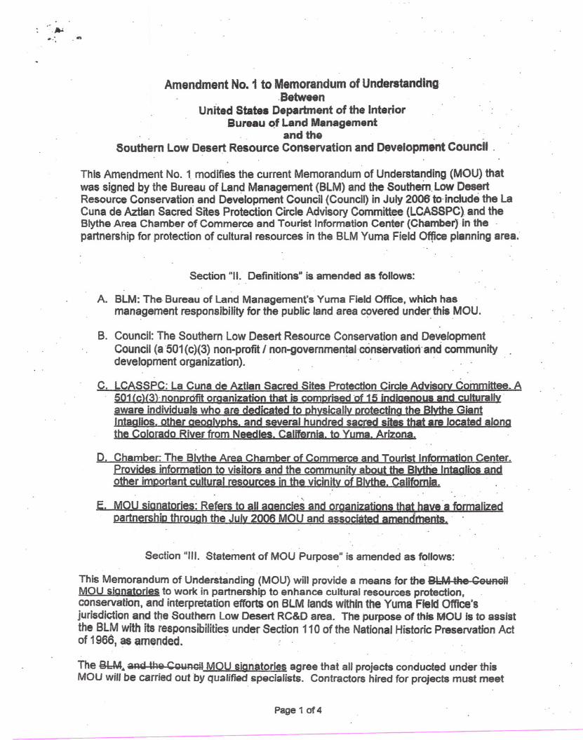
Amendment No.1 to Memorandum of Understanding.Between
United States Department of the InteriorBureau Qf Land Management
. and the __Southern Low Desert Resource Conservation and Development Council .
This Amendment No. t modifies the current Memorandum of Understanding (MOU) thatwas signed by the Bureau of land Management (BlM) and the Southern. Low DesertResource Conservation and Development Council (Council) in July 2006 to· include the LaCuna de Aztlan Sacred Sites Protection Circle Advisory Committee (LCASSPC) and theBlythe Area Chamber of Commerce and Tourist Information Center (Chamber) In thepartnership for protection of cultural res.ources in the BlM Yuma Field Office planning area.·
Section "II. Definitions" is amended as follows:
A. BLM: The Bureau of land Management's Yuma Field Office, which hasmanagement responsibility for the public land area covered under this MOU.
B. Council: The Southern Low Desert Resource Conservation and DevelopmentCouncil (a 501(c)(3) non-profit I non-governmentaloonservatiortand communitydevelopment organization) ..
C. LCASSPC: La Cuna de Aztlan Sacred Sites Protection Circle Advisory Committee. A501 {c){3lnonDrofit organization that is comDtised·of 15 indiQenous and culturally·aware individuals who are dedicated to Dhysically orotectinQ the Blvthe GiantIntaglios. other aeoglYDhs. and several hundred sacred sites that are located alonathe Colorado River from Needles. Califernla. to Yuma. Arizona.
D. Chamber. The Blvthe Area Chamber of Commerce and Tourist Information Center.Provides information to visitors and the community about the Blvthe Intaatios andother imDortant cultural resources in the vicinitv of Blythe. California.
E. MOU sianatories: Refers to all aaencies and organizations that have·a formalizedpartnership throuah the Julv 2006 MOU and associated amendments ..
Section "III. Statement of MOU Purpose" is amended as follows:
This Memorandum of Understanding (MOU) will provide a means for the BlM theCololnoilMOU sianatories to work in partnership to enhance cultural resources protection,conservation, and interpretation efforts on BLM lands within the Yuma Field Office'sjurisdiction and the Southern low Desert RC&D area. The purpose of this MOU is to assistthe BlM with its responsibilities under Section 110 of the National Historic Preservation Actof 1966, as amended ..
The QbM.•.aRg U1Q Ccnmcil MOU signatories agree that all projects conducted under thisMOU will be carried out by qualified specialists. Contractors hired for projects must meet
Page 1 cf4
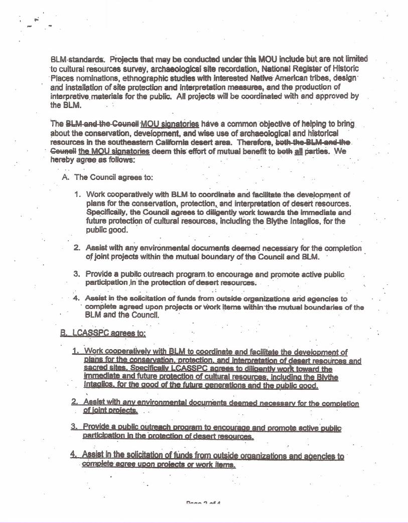
BLM·standa~ds'. Projects that may be conducted under this MOU include bUt,are not limited'to cultural resources survey, archaeological site recordation, National Register of Historic'Places nominations, ethnographic studies with ,interested Native, American tribes, design'and installf;ltfon of site protection and Interpretation measures, and the production ofinterpretive, materials for the public. All projects will be coordinated with and approved bythe BLM. ' : ..
The eLM aAd the CounGiI'MOU ~ignatori~have a common objective of helping to bring,about the conservation. develOpment, and wise use of archaeological and historical 'resourceS in the southeastern CaUfomia desert area. Thereibre, ~91k the 8&.M sRi ~e '
. CeYAGiI the MOU signatories deem this' effort of mutual benefit to SetA .dpartIeS. Wehereby agree as followS: '
A. The Council agrees to:
1. Work cooperatively with BLM to coordinate and facilitate ,the deve~pment ofplans for the conservation, protection" and interpretation of desert resources.S~ific8l1y, the Council agrees to diligently work towards thefmmediate andfuture protection of cultural resources, inCluding the Blythe Intaglios. for thepublic good. " ,
2. Assist with any environmental documenf$ deemed necessary 10r the completionof joint projects within the mutual boundary of the 'Council and alMa '
3. Provide a public outreach program,toencourage and promOte active pUblicparticipation In'the protection of desert resources~ ' ' ,
.., ,
4. 'Ass~t in the solicitation of funds from,outslde-organizations arid agencies to, complete agreed upon proj$cts or Work items within'the mutual boundaries of the
BLM and the Council.
B. LCAS$PC aorees to~'. ,
1. Work cooDeratively with BlM to coordinate and facilitate the develoDment ofDlans for the conseNation~ 'protection. and intemreta1jon of desert resources andsacred sit•• SoecificaUv LCASSPC aqreas to dirlOentlv work toward the .immediate and future orotectIon of cultural resources .•includina the BlvtheIntaGlios. for the good of the future generations arid the D~bUc Good.
2. Assist with any environmental documents deemed necessarY for the comDletionof joint Droieets. " '
3. Provide a Dublic outreach omaram ~o encourBge and Dromote, active'DubllcDsrtfcication in the "DrotectiOn of desertresource5_
, ,
4. AssilUn the sol~Jrom ouliiJe of9anizationsandagenc. to ',cOmDIete,'aaree uoon oroiecta 9f' work items.

-..
C. The Chamber aarees to:
1. Work cooperativelv with BlM to coordinate and facilitate the development ofplans for the conservation. Qrotection. and interpretation of desert resources.Soeciflcally. the Chamber aorees to diligently work toward the immediate andfuture protection of cultural resources. includina the Blvthe '"taolios. for thepublic aood.
2. Provide a public outreach program to encouraae and cromote active publicoarticloation in the orotection of desert resources.
3. Assist in the solicitation of funds from outside oroanizations and a~encies tocomplete agreed upon proiects or work items.
~ BlM agrees to:
1. Work cooperatively with the COl:lnoilon projects of mutual benefit to RI U ~nrf th~rnllnnil the MOU siqnatories ..
2. Provide technical and planning assistance for projects of mutual benefit to theIilLU flnd tho Cnllnr.il MOU signatories.
3. Initiate any environmental assessment documents deemed necessary for thecompletion of any agreed upon joint projects \!Jithin tha mutual hnunderioG of thA81 M and tha C~lJnnil.
4. Assist with the preparation of statements of work and hiring of contractors tocomplete the agreed upon projects.
5. Cooperate and assist (when appropriate) with seeking funds to complete agreedupon joint projects.
Section "IV. Terms of the MOU" is amended as follows:
A. The fol/owing individuals are designated as the liaison between-'the RI A4 ~nd thA
Cnllnr.il MOU signatories.
1. Bureau of land ManagementYuma Field Office
Rebecca Heiok James T. Shoaff. Field Manager2555 E Gila Ridge RoadYuma, AZ 85365PH: (928) 317-3200FX: 928-311-3250
2. Southern Low Desert Resource Conservation & Development CouncilThomas Burgin, President53990 Enterprise Way, 68
page 3 of4
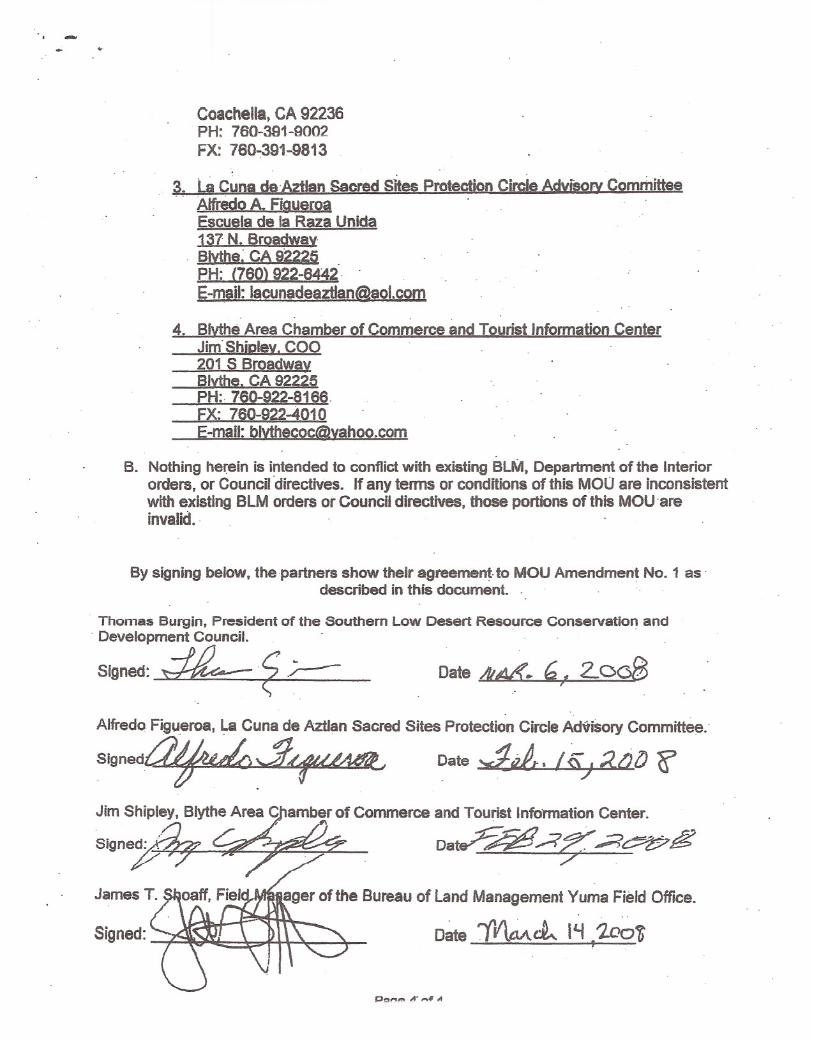
Date /It~. ~ ~ 2..008r
-
Coachella, CA 92236PH: 760-391-9002FX: 760-391:...9813
3. LaCuna de 'Antan Sacred Sites Protection Circle Advisory CommitteeAlfredo A. FigueroaEscuels de la Raza Unida137 N. Broadwav8lvthe~ CA 92225PH: (760) 922-6442 -E-mail: [email protected]
4. Blythe Area Chamber of Commerce and Tourist Information CenterJim'ShiDlev. COO201 S BroadwayJ;3lvthe. CA 92225PH: 760-922-8166.FX: 760-922...4010E-mail: [email protected]
B. Nothing he~ein is intended to conflict with existing BLM, Department of the Interiororders, or Council 'directives. If any terms or conditions of this MOU are inconsistentwith existing BlM orders or Council directives, those portions of this MOUareinvalid.
By signing below, the partners show their agreement-to MOU Amendment No.1 asdescribed in this document. .
Thomas BIJrgin, President of the Southern Low Desert Resource Conservation and- Development Council.
Signed: ~ ,<; .;.----
Alfredo Figueroa, La Cuna de AztIan Sacred Sites Protection Circle Advisory Committee.-
Si9ned~ ,_.g.. ..(~ Date ~t7t. I~J ;{.()lJ cr"
Jim Shipley. Blythe Area C)1amberof Commerce and Tourist Info'rmation Center .. .•.. ~'
Dat?~AJ3; ,;;?~g
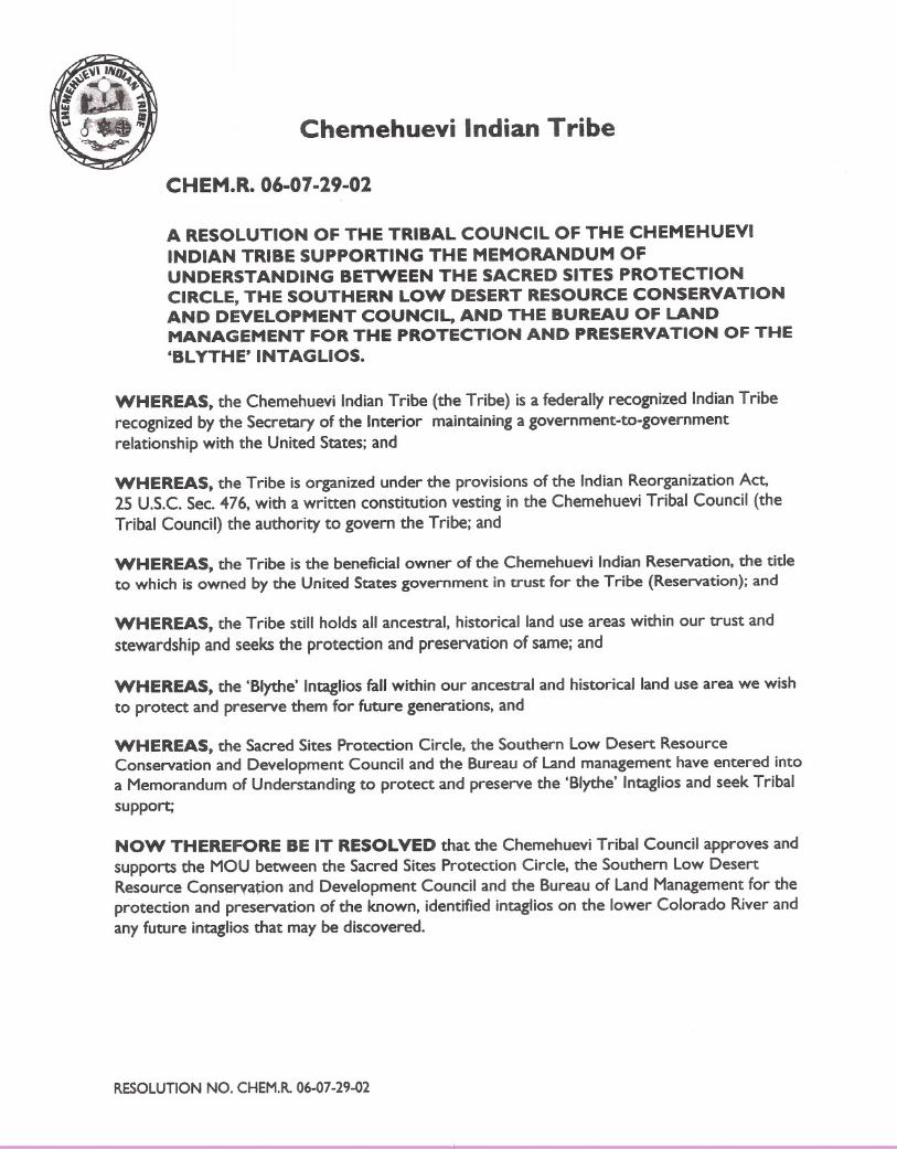
Chemehuevi Indian Tribe
CHEM.R.06-07-29-02
A RESOLUTION OF THE TRIBAL COUNCIL OF THE CHEMEHUEVIINDIAN TRIBE SUPPORTING THE MEMORANDUM OFUNDERSTANDING BETWEEN THE SACRED SITES PROTECTIONCIRCLE, THE SOUTHERN lOW DESERT RESOURCE CONSERVATIONAND DEVELOPMENT COUNCIL, AND THE BUREAU OF LANDMANAGEMENT FOR THE PROTECTION AND PRESERVATION OF THE'BLYTHE' INTAGLIOS.
WHEREAS, the Chemehuevi Indian Tribe (the Tribe) is a federally recognized Indian Triberecognized by the Secretary of the Interior maintaining a government-to-governmentrelationship with the United States; and
WHEREAS, the Tribe is organized under the provisions of the Indian Reorganization Act.25 U.S.c. Sec. 476, with a written constitution vesting in the Chemehuevi Tribal Council (the
Tribal Council) the authority to govern the Tribe; and
WHEREAS, the Tribe is the beneficial owner of the Chemehuevi Indian Reservation, the tideto which is owned by the United States government in trust for the Tribe (Reservation); and
WHEREAS, the Tribe still holds all ancestral, historical land use areas within our trust and
stewardship and seeks the protection and preservation of same; and
WHEREAS, the 'Blythe' Intaglios fall within our ancestral and historical land use area we wishto protect and preserve them for future generations, and
WHEREAS, the Sacred Sites Protection Circle, the Southern Low Desert ResourceConservation and Development Council and the Bureau of Land management have entered intoa Memorandum of Understanding to protect and preserve the 'Blythe' Intaglios and seek Tribalsupport;
NOW THEREFORE BE IT RESOLVED that the Chemehuevi Tribal Council approves and
supports the MOU between the Sacred Sites Protection Circle, the Southern Low DesertResource CQns~rvation and Development Council and the Bureau of land Management for theprotection and preservation of the known, identified intaglios on the lower Colorado River andany future intaglios that may be discovered.
RESOLUTION NO. CHEM.R. 06-07-29-02
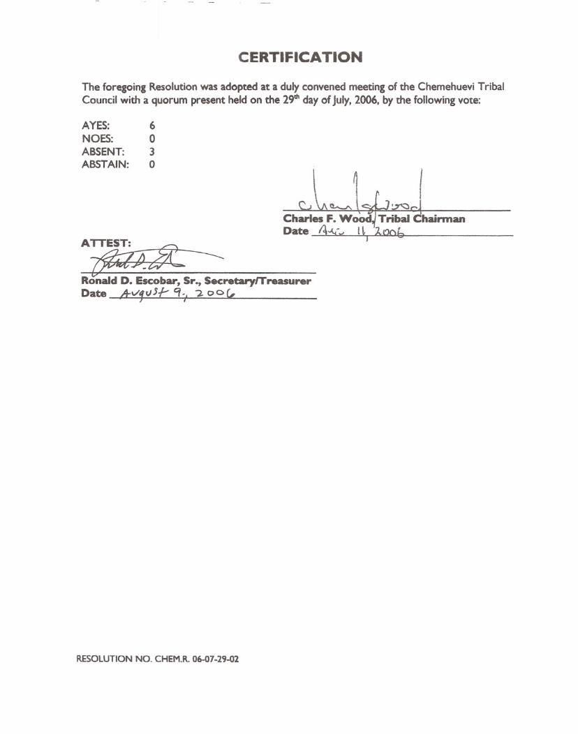
CERTIFICATION
The foregoing Resolution was adopted at a duly convened meeting of the Chemehuevi TribalCouncil with a quorum present held on the 29th day of July, 2006, by the following vote:
AYES: 6NOES: 0ABSENT: 3ABSTAIN: 0
ATTEST: ~~~ ---
Ronald D. Escobar, Sr., SecretarylTreasurerDate ,A-v'tpJJI- q" -:2. 0 0 (,
RESOLUTION NO. CHEM.R. 06-07-29-02

The following is the Declaration of:Alfredo Acosta Figueroa
424 North Carlton Ave.
Blythe, Ca 92225Phone: (760) 922-6422E-mail: [email protected]
Submitted To:
California Energy CommissionHearing Room B1516 Ninth Street
Sacramento, ea 95814
I Alfredo Acosta Figueroa, a native of the Colorado River, born in Blythe, California,Elder/Historian and a Chemehuevi Tribal Sacred Site Monitor hereby declare:
That I for the past 55 years have been studying "The Aztec Place of Origin,"AztlcinlChicomozstoclHue-Hue- Tlapallan, here in the surrounding Palo VerdeIParker Valleys.The author of the book "Ancient Footprints of the Colorado River," published in May 2002.
That in 1975 we organized opposition against the Sun Desert Nuclear Power Plantproposed to be built at the base of the Sacred Mule Mountains ("Calli" in Nahuatl & "HamocAvi" in Mojave) stopping the project in 1979.
That in 1992 we organized the Colorado River Anti-Ward Valley CoordinatingCommittee and after 8-years stopped the proposed Ward Valley Nuclear Toxic Dump located inbetween the Sacred Turtle and Avi-Kawme (Spirit Mountain located 15 miles west of Laughlin,Nevada) Mountains.
That in 2000 we organized La Cuna de AztlAn Sacred Sites Protection Circle under theauspices of La Escuela de la Raza Unida, said circle is comprised of 15 individuals dedicated tophysically protecting the Sacred Sites and that on February 15,2008 were given a Memorandumof Understanding together with the Southern Low Desert Resource Conservation &Development Council to partnership for protection of cultural resources, that included the BlytheGiant Intaglios, other geoglyphs and several hundred Sacred Sites that are located along theColorado River from Needles, Ca down to Yuma, Az.
I hereby state:
That we oppose the certification by the California Energy Commission and the issuing ofpublic land by the Bureau of Land Management to the following proposed solar power projects:
1) Genesis Solar Energy Project: 09-AFC-82) Solar Millennium Blythe Project: 09-AFC-6
3) Solar Millennium Palen Project: 09-AFC-7
2364-060a I
Our investigations concerning the above projects are located in Eastern Riverside County along the 1-10corridor that is the most Sacred area of the North American Continent It is the area where the Aztec Calendar is
geographically outlined and located. The area entails from the Kofa Mountains in Arizona, west to the human headimage (CopiIl-Quettalli) on the crest of the San Jacinto Mountains above the city of Palm Springs, Ca.
The proposed Blythe Solar Power Project is overlaid on more than 25 large geoglyphs that we have found
throughout the area. They include the world known image of Kokopilli, Cicimitl (The Great Spirit that takes humanspirlts to their final resting place in the Topock Maze, "Mictlan"). Included in the area is the image of Tosco, over 5large windrow mazes, a 9-level pyramid and over 25 Sacred images (that we have not yet deciphered).
The main EastjWest & North/South trails all lead to and from the Blythe Giant Intaglios. One trail leads to
Kokopilli and Cicimitl which traverses west through the south end of the McCoy Mountains to the McCoy Springs.
Here the image of Quetzalcoatl takes a bath then goes to the Palen Mountains "Hue-Hue- TlapallanD (ReddishEarth), were he is lead to the underworld by Xolotl (The Dog), as shown in the petro glyphs at the Palen MountainMural Wash.
The trail comes down from the Palen Mountain Wash and meets with another trail from the McCoy Springs
area that is in the Genesis project. The trail then runs west along the plains of the Palen Mountains then crossedsouthwest towards the Chuckawalla Mountains were it meets the main trail coming west from the Mule Mountains
towards Desert Center, Ca.These two trails meet at the proposed Palen Mountain Project and the southwest trailleads towards Corn Springs (Tula) located in "the center of the Chuckwalla Mountains.
On February 2009, we took 2 archeologists, Jeffery Adams and Joe that had contacts with the BLMto
document all the geoglyphs along the Colorado River which included the Sacred Sites of Kokopilli and Cicimitl.
On March 2, 2010 we took John Kalish, Bureau of Land Management Field Manager and George Kline,archeologist of the Palm Springs. California office to the Blythe Power Project area and took them on an onsite tourwhich included 5 large geoglyphs and the images of Kokopilli and Cidcmitl. Unfortunately. we have not yetreceived a report of the investigations.
Please feel free to contact me with any questions regarding the Sacredness of the areas.
Sincerely,
tJJ(yv-ck ~.:1~Alfredo Acosta Figueroa
Alfredo A.Figueroa424 N. Carlton Ave
Blythe, Ca92225
Our Mission:
Phone: (760) 922-6422E-mail: [email protected]
The mission of La Cuna de Aztlan Sacred Sites Protection Circle is to protect, preserve, share indigenous history
that that has been denied to us for more than 500 years. Our mission is to educate the general population of the
sacredness of the Blythe Giant Intaglios as well as hundreds of other geogIyphs, petroglyphs, pictographs and othersacred sites that are remnants of the ancient footprints left here by the thousands of years of migrations from thesurrounding lower Colorado River Valley.
The Sacredness of the Intaglios:
These Intaglios are extremely important not only to our indigenous culture but to all civilizations of the world. It is
estimated that they are over 10,000 years old and they can be crossed referenced with the AztecjMexica Codex's.
The Intaglios represent the giant inhabitants that dwelled on this earth during the First Sun "Tezcatlipoca" in theLegend of the Five Suns, of the Aztec Sun Stone Calendar. According to the Codex's, the giants were told not to fall
down because if they did they would never get up (As illustrated in the Vatican A Codex).
The Intaglios are geogIyphs that are designed on dark-surfaced mesas along the Colorado River which stones arecovered with desert varnish. The designs are made when the stones are removed and the "Caliche" (Light-coloredLimestone) is exposed, outlining the various images that leave an impression (As seen from above) similar to chalkdesigns on a blackboard.
According to retired BLMArcheologist of the Yuma, Arizona office, Barna Johnson, there are over 275 known
Intaglios designs which are anthropomorphs (human-like), zoomorphs (animal-like), geometric and linear shaped,(Which begin in the Needles, California area in the north, down to Yuma, Arizona in the south). Boma also stated
that the concentration of geoglyphs in the area of the Colorado River is the greatest in North America.
Memorandum of Understanding by the Bureau of Land Manaiement:
The Sacred Sites Protection Circle is comprised of 13'lndigenous and culturally aware individuals, includinganthropologists and archeologists whom are dedicated to protecting these Sacred Sites.
In 2008, La Cuna de Aztlan Sacred Sites Protection Circle along with the R.C.N.D(Southern Low Desert ResourceConservation District Council of the U.S.Dept. of Ag) received an MOUby the B.L.Mto preserve the Blythe GiantIntaglios and other Sacred Sites. In addition we have a partnership with the Chemehuevi Tribe.
Page 21
MOU States: "fA Cuna de Aztlan Sacred Sites Protection CircleAdvisory Committee. A SOl © (3l nonprofit
organization that is comprised of 15 indigenous and culturally aware individuals who are dedicated to physically
protecti11Bthe Blythe Giant Intaglios, other geoglyphs and several hundreds sacred sites that are located along the
Colorado River from Needles, California to Yuma, Arizona."
OUf Future Goals:
As the Sacred Sites Protection Circle, we envision the Intaglio sites to one day become a State or National Park and
eventually a World Heritage Site. In addition, we plan to educate the general public of the Sacredness of the sites.
As well as raise public awareness through presentations, media campaigns (such as in-house videos) andeducational publications and build community support
In the future we also plan to construct a visitor center in Blythe, California that will house artifacts, books, films
and educational material that is related to the hundreds of images that we are protecting. We will also be havingguided tours that will take the general public to the sites in order to view and learn about them. However, this willnot be possible until we fence and protect these sacred sites off.
Sponsor of the La Cuna de Aztlan Sacred Sites Protection Circle:
Escuela de la Raza Unida is a non-profit organization, incorporated in 1972, (Federal ID # 95-2778840), a BilingualIndigenous Alternative school which includes Early Childhood and Day-Care Centers, and KERU-88.5 FM,an
educational bilingual radio station located Oll the premises of 137 North Broadway, Blythe, Ca 92225.
La Cuna de AztIan Sacred Sites Committee Members
Alfredo Acosta Figueroa
Michelle Leivas Kristmann
Jorge Hernandez
Mateo Hanks Levias
Phillip Gonzales Smith
Gilbert Lopez Levias
Patricia Figueroa
Catherine Ohrin-Greipp
Jim Guerra
Robert Gonzales
Ron Van Fleet Sr.
Dr. Greg Nall
Barna Johnson
La Cuna de Aztlan Sacred Sites Protection Circle
Patricia Pifion. President
(760) 219-2834
Alfredo Acosta Figueroa. ElderjHistorian/Chemehuevi Tribal Monitor(760) 922-6422
Dear Bureau of Land Management,
We the members of La Cuna de Aztlan Sacred Sites Protection Circle are againstthe proposed Genesis Solar Energy Power Project site. The proposed GenesisSolar Energy site is located approximately 4-5 miles from Interstate-10 and liesnorth of Ford Dry Lake at the base of the south end of the Palen Mountains.
On December 9,2009 the Palo Verde Times invited the general public to an onsitevisit to the proposed site. However, the onsite visit and hearing turned out to be abig farce. Before I went to City Hall I was undecided if I should take my hikingshoes because the Palo Verde Times newspaper article said "That we weregoing to visit the site. II But when we were in line to board the bus, I noticed thatthe ladies of the company had high heels shoes. This is when I knew somethingwas up, and sure enough when the bus stopped at the Ford Dry Lake off-ramp wedidn't even get off. Instead we were told by the tour guides to look north towardsthe base of the Palen Mountains at the proposed site. They also said that theyhad placed some large balloons above the site as markers and offered usbinoculars to see the balloons from the bus, however no one was able to seethem. My brother and I were indeed misconstrued and where very perturbedbecause we thought that we were going to visit the site.
The Palen Mountains are very sacred to the Uto-Aztecan and in nahuatl they arecalled "Hue-Hue-Talpallan" which means Hue (Ancient), Hue (Ancient), Talpallan(Reddish Earth) altogether this means "The Ancient, Ancient Reddish Earth"where the Creator Quetzalcoatl descends at sun down.
When you see the section in the center of the Palen Mountains you can see that ithas a large image of a wrinkled reddish face looking towards the west. At thebase of the Palen Mountains there is a large arroyo that has a large rectangular20x40 foot wall that is facing west and among the petroglyphs is the image ofthe creator shown as a stick figure descending together with Xolotl ''the dog." Thisis the place where the creator goes to the underworld.
The trail that leads to and from the petroglyphs of the Palen Arroyo meets with thetrail that comes from the petroglyphs of the McCoy Springs (from the east) andthey meet directly on the site. This is why I was so interested in going to the site inthe first place.
The junction of the two trails, lead to Desert Center and 4.7 miles west of DesertCenter is where the 13 monuments are located. They represent "13 Acatl" whichis the top section of the Aztec Sun Stone Calendar.
Confirming our traditional knowledge of the area are the following knownarcheologist reports: In Bern Schwenn article "In the Foots of the Ancients"
Friday, December 18, 2009 America Online: LaCunaDeAztlan
Page 25

re:tgc..) Ul ..)
Colorado River.
Companies such as NextEra Energy have no respect or concern for Mother-Earthand our Native Traditions.
I am attaching Johnston's and McCarthy's map of the trail systems from theColorado River that clearly shows the trails passing in between the north end ofFord Dry Lake and the south end of the base of the Palen Mountains.
S~t:'lperely, . ~ a-~A~ta FigueroaLa Cuna de Aztlan Sacred Sites Protection Circle424 North Carlton Ave.
Blythe, Ca 92225(760) 922-6422
Friday, December 18,2009 America Online: LaCunaDeAztlan