hume battery energy storage system project
TRANSCRIPT

Hume Battery Energy Storage System Project
Response to Submissions Report
IA215400_RTS | Final
9 October 2020
Meridian Energy Australia
Response to Submissions Report Meridian Energy Australia
Response to Submissions Report
IA215400_RTS 1
Hume Battery Energy Storage System Project
Project No: IA213400
Document Title: Response to Submissions Report
Document No.: IA215400_RTS
Revision: Final
Date: 9 October 2020
Client Name: Meridian Energy Australia
Client No:
Project Manager: Thomas Muddle
Author: Thomas Muddle and Ada Zeng
File Name: IA213400_Hume BESS EIS Submissions Report_Final_09102020
Jacobs Australia Pty Limited Level 7, 177 Pacific Highway North Sydney NSW 2060 Australia PO Box 632 North Sydney NSW 2059 Australia T +61 2 9928 2100 F +61 2 9928 2444 www.jacobs.com
© Copyright 2019 Jacobs Australia Pty Limited. The concepts and information contained in this document are the property of Jacobs. Use or copying of this document in whole or in part without the written permission of Jacobs constitutes an infringement of copyright.
Limitation: This document has been prepared on behalf of, and for the exclusive use of Jacobs’ client, and is subject to, and issued in accordance with, the provisions of the contract between Jacobs and the client. Jacobs accepts no liability or responsibility whatsoever for, or in respect of, any use of, or reliance upon, this document by any third party.
Document history and status
Revision Date Description Author Checked Reviewed Approved
Draft 16/09/2020 Draft for input Ada Zeng Thomas
Muddle
Thomas
Muddle
Thomas
Muddle
Final 09/10/2020 Final for issue Ada Zeng Thomas
Muddle
Thomas
Muddle
Thomas
Muddle
Response to Submissions Report
IA215400_RTS 2
Contents Contents ................................................................................................................................................................................. 2
1. Introduction ............................................................................................................................................................ 4
1.1 Background .......................................................................................................................................................................... 4
1.2 Purpose of this report ....................................................................................................................................................... 4
2. Overview of Project ................................................................................................................................................ 5
2.1 Project summary ................................................................................................................................................................ 5
2.2 Project benefits ................................................................................................................................................................... 5
2.3 Design refinements ........................................................................................................................................................... 5
2.3.1 Compound layout changes ............................................................................................................................................. 5
2.3.2 Expansion of the proposed sediment basin capacity and footprint ................................................................. 6
2.3.3 Realignment of electricity cabling infrastructure ................................................................................................... 6
2.3.4 Provision of detail of components within the switchyard .................................................................................... 6
2.4 Implications of design changes ..................................................................................................................................... 6
3. Engagement during and after EIS exhibition .................................................................................................. 8
3.1 Consultation Prior to exhibition .................................................................................................................................... 8
3.2 Consultation during EIS exhibition .............................................................................................................................. 8
3.3 Consultation since EIS exhibition ................................................................................................................................. 9
4. Summary of submissions on the EIS .............................................................................................................. 10
5. Response to submissions on the EIS .............................................................................................................. 12
5.1 Agency submissions and response ............................................................................................................................ 12
5.1.1 DPIE Biodiversity and Conservation Division (BCD) ............................................................................................. 12
5.1.2 NSW Environment Protection Authority (EPA) ...................................................................................................... 13
5.1.3 NSW Rural Fire Service (RFS) ....................................................................................................................................... 13
5.1.4 Transport for NSW (TfNSW) ......................................................................................................................................... 15
5.1.5 TransGrid ............................................................................................................................................................................ 15
5.1.6 WaterNSW ........................................................................................................................................................................... 15
5.1.7 Heritage NSW .................................................................................................................................................................... 17
5.1.8 Fire and Rescue NSW (FRNSW) ................................................................................................................................... 17
5.1.9 Murray-Darling Basin Authority (MDBA) ................................................................................................................. 18
5.1.10 DPI Fisheries ...................................................................................................................................................................... 18
5.1.11 Crown Lands ...................................................................................................................................................................... 18
5.1.12 Regional NSW Mining, Exploration and Geoscience (MEG) .............................................................................. 18
5.1.13 Albury City Council .......................................................................................................................................................... 18
5.1.14 DPI Agriculture .................................................................................................................................................................. 18
5.2 Organisation submissions and response ................................................................................................................. 18
5.2.1 Friends of the Lake Hume Gliders (FLHG) ............................................................................................................... 18
5.2.2 Thurgoona Community Action Group (TCAG) ....................................................................................................... 19
5.2.3 Trout Farm Properties Pty Ltd (TFP) ......................................................................................................................... 19
Response to Submissions Report
IA215400_RTS 3
5.2.3.1 EIS consultation ................................................................................................................................................................ 19
5.2.3.2 Property characterisation .............................................................................................................................................. 19
5.2.3.3 Impacts to water supply ................................................................................................................................................. 20
5.2.3.4 Prior switchyard fire and fire risks .............................................................................................................................. 20
5.3 Community submissions and response .................................................................................................................... 20
5.3.1.1 Submitter SE-9248836 ................................................................................................................................................. 20
5.3.1.2 Submitter SE-9235628 ................................................................................................................................................. 22
5.3.1.3 Submitter ID SE-9250417 ............................................................................................................................................ 24
5.4 Responses to issues regarding Squirrel Gliders and biodiversity .................................................................... 27
5.4.1 Barbed wire ........................................................................................................................................................................ 27
5.4.2 Noise impacts .................................................................................................................................................................... 28
5.4.3 Habitat impacts ................................................................................................................................................................ 28
5.5 Comments on safety ....................................................................................................................................................... 28
5.6 Comment on options consideration .......................................................................................................................... 29
5.6.1 Site selection for the Project ........................................................................................................................................ 29
5.6.2 Comments on options considerations process ...................................................................................................... 29
6. Updated Project Description ............................................................................................................................ 32
7. Management and monitoring measures ....................................................................................................... 41
Appendix A. Revised design plans
Appendix B. Revised BDAR
Appendix C. Final ACHAR
Response to Submissions Report
IA215400_RTS 4
1. Introduction
1.1 Background
Meridian Energy Australia Pty Ltd (Meridian) proposes to develop the Hume Battery Energy Storage Project (BESS) in Lake Hume Village near Albury, NSW. Meridian has been investigating the feasibility of a BESS to store hydropower electricity which can then release this energy to the grid when needed. The BESS can support the Hume Dam Hydropower Station by charging during low electricity demand periods and dispatch electricity when demand is high. Meridian has carried out consultation with stakeholders and the community and has reviewed submissions to the Environmental Impact Statement (EIS). A full description of the Hume BESS Project was provided in Chapter 2 of the Environmental Impact Statement and is reproduced with minor amendments made in response to submissions and design refinements in Chapter 6 of this document. For the purpose of the remainder of this document the Project is used to refer to all works the subject of the development application as described in Chapter 6 with the BESS used to describe the main component of the Project.
The Project is classified as State significant development (SSD) under the State Environmental Planning Policy (State and Regional Development) 2011 and requires development consent under Part 4 Division 4.7 of the Environmental Planning and Assessment Act 1979 (EP&A Act). An EIS was prepared by Jacobs to support the development application and carry out environmental assessment for the Project. The EIS was submitted to the Department of Planning, Industry and Environment (DPIE) and placed on public exhibition from 13 August 2020 to 10 September 2020. During the exhibition period, the general public, organisations and government agencies were invited to make submissions.
DPIE received five submissions on the project, including two from special interest groups and three from the general public. Advice was also received from 14 government agencies including Albury City Council. All submissions received by the Department during the exhibition of the proposal are available on the Department’s website at https://www.planningportal.nsw.gov.au/major-projects/project/33566. To progress the application, Meridian is now required to prepare and submit a report detailing responses to matters and recommendations raised in all submissions.
This Response to Submissions (RTS) report addresses the requirement to consider and respond to all submissions received. The RTS report also describes changes to the Project to address submissions and updated mitigation and management measures which would be implemented to minimise potential negative impacts of the Project. Where supporting technical assessments have been updated post exhibition in response to consultation and recommendations these are also identified and attached.
1.2 Purpose of this report
The purpose of the RTS report is to:
Consider and respond to matters raised in the submissions received by DPIE
Describe any changes to the Project, including a revised set of proposed mitigation measures.
The structure of this RTS Report is as follows:
Chapter 2 – overview of the proposed Project
Chapter 3 – summary of consultation carried out during and after EIS exhibition
Chapter 4 – summary of submissions received
Chapter 5 – responses to submissions received
Chapter 6 – changes to the proposed Project
Chapter 7 – update mitigation measures.
Response to Submissions Report
IA215400_RTS 5
2. Overview of Project
2.1 Project summary
Meridian is proposing the development of the Hume BESS, to be connected to the existing switchyard currently servicing the Hume Power Station (HPS). The HPS is connected to both the AusNet (66kV) and TransGrid (132kV) networks, and there is currently capacity for additional supply to be connected. The proposed installation of a 20 Megawatt (MW) /40 Megawatt-hour (MWh) BESS would be located within WaterNSW landholding that currently houses the existing HPS and aims to respond to the needs of the National Electricity Market (NEM) and unlock new revenue streams, while supporting local and regional socio-economic growth.
The Project would include the following key components:
Installation, commissioning, and operation of a 20MW/40MWh BESS
Construction and operational access track from existing internal WaterNSW access road
Ancillary upgrades to the existing switchyard to connect the BESS to the National Energy Market
Underground 11 kV electricity cabling infrastructure from the existing switchyard to the BESS
Construction of fencing around the perimeter of the BESS compound.
2.2 Project benefits
The Project aims to showcase the relevance and opportunities offered by the solution of BESS coupling with an existing hydropower generation asset that has its dispatchability restricted by water release regulations. Under the expected operation mode, by charging the battery during low electricity demand periods with hydropower output, the BESS can provide a range of services based on market signalling. As a result, the economic benefits of the electricity generated by the HPS can be maximised. The Project is the first of its kind in Australia and is an important proof-of-concept for providing valuable new solutions for dispatchable electricity generation. The newly adopted technology solution would bring the HPS into the 21st century and can be replicated at other run-of-river hydropower stations in Australia, effectively future proofing these older hydropower stations for generations to come.
2.3 Design refinements
As discussed above, there are several design refinements proposed for the Project in response to submissions received, including:
Compound layout changes
Expansion of the proposed sediment basin capacity and footprint
Realignment of electricity cabling infrastructure
Provision of detail of components within the switchyard.
Revisions have also been made to mitigation and monitoring measures in response to submissions as detailed in Chapter 7.
2.3.1 Compound layout changes
The following changes have been made to the BESS compound layout:
Provision of space for a wall for noise / visual screening purposes along north of compound
Replacement of the benched arrangement to a flat arrangement at a level of approximately reduced level (RL) 194 metres Australian Height Datum (AHD) in the east sloping to RL 193 in the west on which structures would be installed
Response to Submissions Report
IA215400_RTS 6
Increase in number of battery cubes from 80 to 96
Reorientation of BESS rows from east-west to north-south
Relocation of transformers and inverters to the centre of the compound away from Trout Farm Road
Avoidance of clearing of more existing vegetation between the compound and Trout Farm Road through re-alignment of security fence
Avoidance of encroachment into TransGrid easement to the east
Re-alignment of the access into the compound from the north to the centre of the western end
Expansion of the compound to the south.
Efforts to avoid the use of barbed wire remain under development and Meridian would not use barb wire if conditioned to that effect and not in contravention of any applicable electrical installation standards. A monitoring program is proposed and would be refined in consultation with stakeholders if barbed wire use is required.
Revised Project designs and layouts are provided in Appendix A. A revised Project Description incorporating these changes is provided in Chapter 6.
2.3.2 Expansion of the proposed sediment basin capacity and footprint
In response to WaterNSW comments on run-off water quality and quantity, the designs have been modified to make provision for a larger, 250 cubic metre, sediment basin. As proposed in the EIS, this basin would be converted to a bioretention type basin post construction with final design to achieve pre-development flow characteristics.
2.3.3 Realignment of electricity cabling infrastructure
The proposed electricity cabling infrastructure is now proposed to run along the north of the WaterNSW access road for approximately 40 metres before crossing. This will facilitate the avoidance of retaining wall and culvert of heritage significance and reduce disruption of access to the main WaterNSW laydown area and compound.
2.3.4 Provision of detail of components within the switchyard
The design now illustrates works within the existing switchyard which includes the continuation of cable trenching to the proposed switchroom and from the switchroom to the step-up transformers. The location of the proposed switchroom is also illustrated (Refer to Appendix A).
2.4 Implications of design changes
As described in Chapter 18 of the EIS, the assessment of the project within the EIS was based on consideration of reasonable worse case environmental impacts to allow flexibility in design and construction methodology and the ongoing design of Project components would adopt the performance outcomes for the Project as identified in the EIS. The implications of the above refinements in response to submissions is identified and addressed as follows:
Biodiversity - Minor changes to disturbance footprint have been captured in the updated Biodiversity Development Assessment Report and biodiversity offset credit calculations (refer to Appendix B). The estimated clearing is approximately 4398 square metres (Reduced from 4421 square metres) consisting of the following Plant Community Types (PCTs):
White Box grassy woodland in the upper slopes sub-region of the NSW South Western Slopes Bioregion (PCT 266) –4,209 square metres (reduced from 4225)
Response to Submissions Report
IA215400_RTS 7
River Red Gum herbaceous-grassy very tall open forest wetland on inner floodplains in the lower slopes sub-region of the NSW South Western Slopes Bioregion and the eastern Riverina Bioregion (PCT 5) –116 square metres (increased from 105 square metres)
Planted native trees and shrubs –73 square metres (reduced from 91 square metres).
The revised biodiversity credit requirements for the Project are calculated as follows:
White Box grassy woodland in the upper slopes sub-region of the NSW South Western Slopes Bioregion (PCT 266) – Poor: 1 credit (no change)
River Red Gum herbaceous-grassy very tall open forest wetland on inner floodplains in the lower slopes sub-region of the NSW South Western Slopes Bioregion and the eastern Riverina Bioregion (PCT 5) – Poor: 1 credit (no change)
Squirrel Glider (Petaurus norfolcensis) – 1 credit (increased from 0 despite no changes in level of impact).
The use of barb wire would be avoided if conditioned to that effect and not in contravention of any applicable electrical installation standards and a monitoring program is proposed where this is not possible (Refer to appendix B).
Aboriginal heritage – The minor changes to the disturbance footprint remain within the area surveyed. The identified potential archaeological deposit remains impacted by the Project and test excavation program is proposed. No comments on the Aboriginal Cultural Heritage Assessment Report (ACHAR) were received from Registered Aboriginal Parties (RAPs) and the ACHAR has now been finalised (Refer to Appendix C)
Non-Aboriginal heritage – The minor design changes do not introduce an increased risk to non-Aboriginal heritage items on the site and the commitments made in the EIS are retained.
Land – The minor design refinements are not predicted to increase land-use conflicts beyond that described in the EIS. The inclusion of the provision for a noise / visual screening to the North of the BESS would further reduce risks of land-use conflict.
Visual amenity – The design refinements while introducing a slight increase in the Project envelope are in keeping with the Project described and assessed in the Visual Impact Assessment. The provision for screening to the north of the site would limit the potential for views from this direction but represents additional component that may be visible from other viewpoints. The treatment of any screening would be negotiated with stakeholders such that visual impacts are minimised.
Noise and vibration – The design refinements do not change the predicted noise impacts as impacts were modelled using noise generating activities occurring on the boundary of the BESS compound. The provision for screening to the north of the compound would further reduce risks of noise impacts to the nearest receivers.
Traffic and transport – The number of BESS cubes proposed would potentially require an additional six deliveries. This would not affect the functioning of the road network.
Surface water and hydrology – The design refinements make for provision for a larger sediment basin. The erosion and sediment control details provided in the updated design remain provisional and a Surface Water Management Plan incorporating an Erosion and Sediment Control Plan would be prepared and implemented prior to the commencement of construction.
Hazards and Risks – The design refinements do not affect the findings of the hazards and risks assessment provided. Further consultation is ongoing with Rural Fire Services in relation to planning for bushfire protection.
Socio-economic assessment -The design refinements do not affect the likely socio-economic impacts of the Project.
Waste - The design refinements do not affect the likely waste impacts of the Project.
Response to Submissions Report
IA215400_RTS 8
3. Engagement during and after EIS exhibition
3.1 Consultation Prior to exhibition
Consultation undertaken during the early Project planning phases, Project Scoping Report and EIS preparation are summarised in Chapter 5 of the EIS. Meridian has continued to engage with the community and key stakeholders since the EIS exhibition, involving teleconference, email and phone correspondence. Community information sessions that were intended were not able to be undertaken due to Covid 19 risks.
3.2 Consultation during EIS exhibition
The EIS for the Hume Hydro and Battery Power project went on public exhibition on 13 August 2020 and closed on 10 September 2020. Consultation included advising nearby landowners, who had requested to be informed, that the EIS was on exhibition by phone and email.
Copies of the EIS were available at the following locations during the exhibition period:
The EIS is available online through the DPIE Major Projects website at https://www.planningportal.nsw.gov.au/major-projects/project/33566
Albury Council offices
DPIE contacted adjoining residents and public authorities directly to notify of the EIS submission and exhibition period.
The Meridian project website was updated with the EIS exhibition details and links to the Department Planning, Industry and Environment (DPIE) website for the project EIS. An EIS FAQ was posted on the website to summarise key information regarding the EIS for interested community members. The project 1800 number and email continued to be available for community enquiries.
On 13 August, residents of 32 Trout Farm Road, Lake Hume were contacted by phone to advise the EIS was now on exhibition. An email was sent following the phone call with the links to the EIS on the DPIE website. There was further correspondence via email following review of the EIS and information was provided to the property owners on 21 August regarding other batteries in Australia as well as their proximity to housing and any accidents. A meeting was arranged with residents of 32 Trout Farm Road, Lake Hume on Thursday 27 August which was held via teleconference and attended by the property owners and their solicitor and Meridian Energy. At the meeting a number of concerns were raised and information was provided from Meridian Energy regarding the proposed battery.
On 27 August, Meridian Energy spoke with owner of 64 Trout Farm Road, Lake Hume by phone regarding the EIS and proximity of the proposed battery to the property. Following the conversation an email was sent with more information on the project to the property owners as well as sent by mail. A late submission was received from Trout Farm Properties Pty Ltd (the owner of 64 Trout Farm Road) due to technical issues and has been addressed in Section 5.2.
Meridian Energy contacted key stakeholders including Albury City Council and the Local and Federal Members of Parliament ahead of the EIS going on public exhibition.
Aboriginal community representatives
During the EIS public exhibition, the draft Aboriginal Cultural Heritage Assessment Report (ACHAR) remained under review by the Registered Aboriginal Parties (RAPs) for comment in accordance with Section 60 of the National Parks and Wildlife Regulation 2019. Consultation followed steps outlined in the Aboriginal cultural heritage consultation requirements for proponents (OEH, 2010). No comments were received from RAPs relating to ACHAR. The ACHAR has as such been finalised to document this outcome and is provided in Appendix C.

Response to Submissions Report
IA215400_RTS 9
3.3 Consultation since EIS exhibition
Meridian consulted with Rural Fire Service (RFS) on 25 September to discuss their expectations around navigable defendable space which would conflict with commitments to reserve the Glider corridor along Trout Farm Road. RFS confirmed that their recommendations were provided for consideration only and that alternative measures may be acceptable so long as the objective to provide for the defence of the facility was met. A detailed response outlining alternatives proposed is provided below. This response was endorsed as consistent with the intent of the RFS recommendations provided via email from RFS on 8 October 2020 with further consultation to be undertaken in developing the fire management plan.
No further consultation with agencies has been undertaken on the basis that recommended conditions are able to be accepted and align with the commitments made in the EIS.
Response to Submissions Report
IA215400_RTS 10
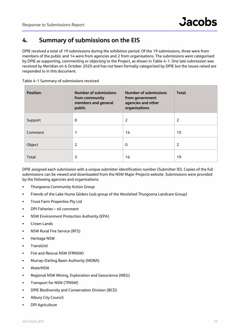
4. Summary of submissions on the EIS
DPIE received a total of 19 submissions during the exhibition period. Of the 19 submissions, three were from members of the public and 14 were from agencies and 2 from organisations. The submissions were categorised by DPIE as supporting, commenting or objecting to the Project, as shown in Table 4-1. One late submission was received by Meridian on 6 October 2020 and has not been formally categorised by DPIE but the issues raised are responded to in this document.
Table 4-1 Summary of submissions received
Position Number of submissions from community members and general public
Number of submissions from government agencies and other organisations
Total
Support 0 2 2
Comment 1 14 15
Object 2 0 2
Total 3 16 19
DPIE assigned each submission with a unique submitter identification number (Submitter ID). Copies of the full submissions can be viewed and downloaded from the NSW Major Projects website. Submissions were provided by the following agencies and organisations:
Thurgoona Community Action Group
Friends of the Lake Hume Gliders (sub group of the Woolshed Thurgoona Landcare Group)
Trout Farm Properties Pty Ltd
DPI Fisheries – nil comment
NSW Environment Protection Authority (EPA)
Crown Lands
NSW Rural Fire Service (RFS)
Heritage NSW
TransGrid
Fire and Rescue NSW (FRNSW)
Murray-Darling Basin Authority (MDBA)
WaterNSW
Regional NSW Mining, Exploration and Geoscience (MEG)
Transport for NSW (TfNSW)
DPIE Biodiversity and Conservation Division (BCD)
Albury City Council
DPI Agriculture

Response to Submissions Report
IA215400_RTS 11
The issues raised in the submissions can be categorised into the following topics:
Biodiversity
Water
Land use conflicts and options consideration
Hazard and risks
Roads, traffic and access
Heritage
Noise and vibration
Socio-economic and wellbeing
Consultation.

Response to Submissions Report
IA215400_RTS 12
5. Response to submissions on the EIS
This chapter provides an overview of the Meridian responses to the submissions received.
5.1 Agency submissions and response
5.1.1 DPIE Biodiversity and Conservation Division (BCD)
BCD raised issues primarily related to the adequacy of the BDAR in addressing the requirements of the Biodiversity Assessment Method and also recommended additional mitigation measures.
Key issues raised by DPIE BCD and the responses by Meridian are provided in Table 5-1. The revised BDAR is provided in Appendix B. The BDAR has also been revised to address the minor layout changes described in Chapter 6.
Table 5-1 Key issues raised and responses to submission by DPIE BCD
Recommended actions Responses
Unmapped vegetation – recommended actions:
Provide more information about vegetation in the development footprint that has not been included in a vegetation zone. Explain how the boundary of Zone 2 was determined
Revise maps (Fig 2-1 and 4-1) to show BAM vegetation integrity plot location labelled with the plot identifier and vegetation zones numbered to correspond with BAM-C
Zone 2 was mapped based on the distribution and extent of any native groundcover species. This is described in Section 4 of the BDAR. A drafting error was made whereby data for Plot 2 was mistakenly copied into the Plot 4 column in Appendix B. As Plot 2 is from the native grasslands, this introduced the 5% Themeda triandra into the Plot 4 column. The BDAR has been revised (refer to Appendix B) and Plot 4 now shows 100% exotic groundcover, which is representative of the unmapped areas within the footprint.
Figures have been revised as requested (i.e. plot labels and veg zone labels added). 5 plots were completed, which are shown in Appendix B of the revised BDAR.
Exclusion of species from BAM – recommended actions:
Provide more detail to support exclusion of species credit flora that were not surveyed in the correct months. At a minimum, the BDAR should relate the vegetation assessment to habitat requirements for each threatened plant species.
Provide evidence that the field survey included adequate assessment of habitat elements or microhabitats for species excluded due to lack of habitat in Tables 5-1 and 5-3.
Update BAM-C to include Sloane’s froglet at Step 5
The BDAR has been updated as follows:
A table has been included in Section 5.3.1 of the revised BDAR which lists all the threatened plant species that were surveyed outside of the correct season. A description of habitat requirements is compared to the habitats within the footprint to provide justification for exclusion of these species.
More detail has been provided in the methods section regarding survey for fauna habitat features of species listed in Tables 5-1 and 5-3.
BAM-C updated to include Sloane’s froglet at Step 5
Revised mitigation measures – recommended actions:
Meridian accepts the revised mitigation measures B01 and B03 and have updated the BDAR accordingly. The Project construction and operation would avoid unnecessary clearing of
Response to Submissions Report
IA215400_RTS 13
Measures B01 and B03 be revised to ensure existing paved and cleared areas are used for vehicle movements and materials storage.
Prepare and implement a protocol for regular monitoring and fauna rescue (including contact details for local wildlife carers) if wire fencing is included in the final design.
vegetated areas for non-permanent infrastructure.
Meridian is addressing standard safety requirements regarding why barbed wires on fencing cannot be avoided in the final design. All precautions would be undertaken to prevent barbed wire disruption biodiversity including the Squirrel Glider population.
A draft monitoring protocol has been developed and is shown in Section 10 of the BDAR.
5.1.2 NSW Environment Protection Authority (EPA)
The EPA provided recommendations on conditions of approval that reflect the commitments made in the EIS. The EPA also identified that the Switchyard is a scheduled premises and if approved, a variation to the licence may be required to cover the works as Ancillary Works within the existing Environmental Protection Licence.
The recommendations and information provided by the EPA are acknowledged and accepted.
5.1.3 NSW Rural Fire Service (RFS)
RFS provided recommendations on conditions of approval as follows:
That a draft Fire Management Plan must be prepared and sent to RFS district office for comment
All land within BESS site and access roads must be managed as an asset protection zone
Asset protection zone must include a 10 m trafficable defendable space around all assets, around BESS site and around all areas of unmanaged vegetation to be retained within the site
All proposed access within the site must be designed and constructed pursuant to Appendix 3 of ‘Planning for Bush Fire Protection 2019’.
A minimum 20,000-litre water supply (tank) fitted with a 65mm Storz fitting must be located adjoining the internal access road within the required asset protection zone.
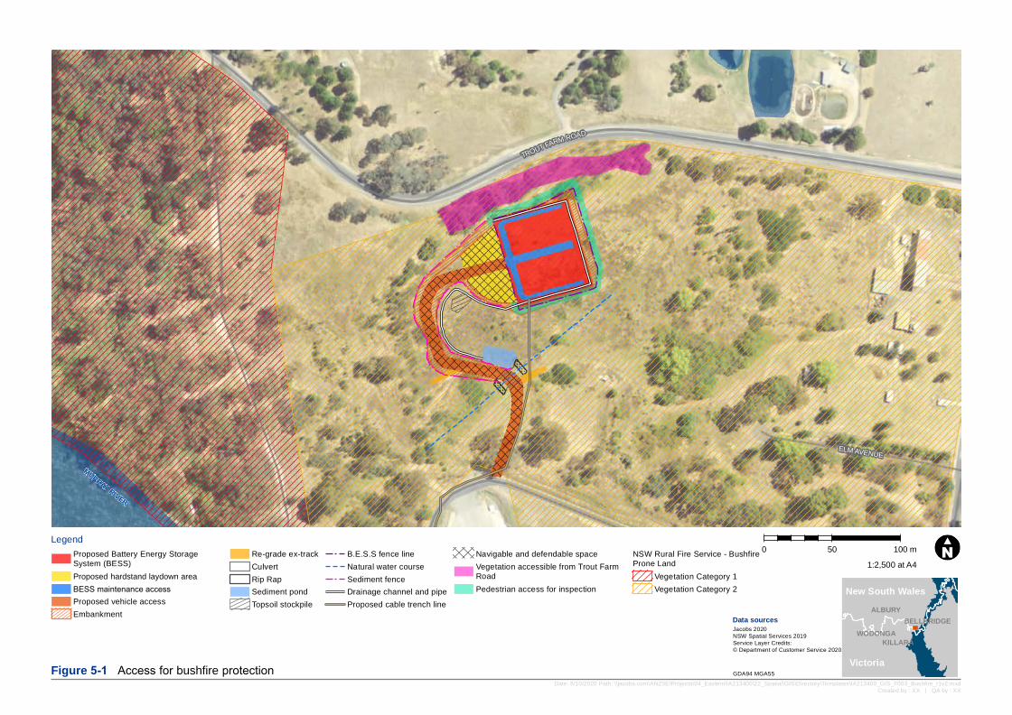
As described above, the provision of a trafficable defendable space is not proposed as it conflicts with the requirement and commitment to minimise impacts to vegetation important to listed threatened species. Alternative measures are available to meet the objective of providing for the defence of the infrastructure from bushfires. The following alternative options for defence of the site are proposed:
10 metre trafficable defendable space to the west of the BESS addressing identified key bushfire risk emanating from the neighbouring travelling stock reserve
1 metre wide pedestrian access to south and north of the BESS for inspection purposes due to steep terrain
Defendable space available within the existing TransGrid easement to the east of the BESS compound with emergency access to be explored.
Vegetation to the north of the BESS, between the BESS and Trout Farm Road, is accessible from Trout Farm Road or within the BESS compound with emergency access for RFS to be arranged.
A map illustrating the above is provided below.
MURRAY RIVER
TROUT FARM ROAD
ELM AVENUE
Legend0 50 100 m
Date: 8/10/2020 Path: \\jacobs.com\ANZ\IE\Projects\04_Eastern\IA213400\22_Spatial\GIS\Directory\Templates\IA213400_GIS_F003_Bushfire_r1v2.mxdCreated by : XX | QA by : XX
Data sourcesJacobs 2020NSW Spatial Services 2019Service Layer Credits:© Department of Customer Service 2020
Figure 5-1 Access for bushfire protection GDA94 MGA55
WODONGA
ALBURY
KILLARA
BELLBRIDGE
1:2,500 at A4
New South Wales
Victoria
Proposed Battery Energy Storage System (BESS)Proposed hardstand laydown areaBESS maintenance accessProposed vehicle accessEmbankment
Re-grade ex-trackCulvertRip RapSediment pondTopsoil stockpile
B.E.S.S fence lineNatural water courseSediment fenceDrainage channel and pipeProposed cable trench line
Navigable and defendable spaceVegetation accessible from Trout FarmRoadPedestrian access for inspection
NSW Rural Fire Service - BushfireProne Land
Vegetation Category 1Vegetation Category 2
Response to Submissions Report
IA215400_RTS 15
These options have been provided to RFS for comment with agreed measures to be included in the fire management plan to be prepared in consultation with RFS as a condition of approval.
All other recommendations of RFS are acknowledged and accepted by Meridian and will be accommodated in the detailed design.
5.1.4 Transport for NSW (TfNSW)
TfNSW provided recommendations on conditions of approval requiring the preparation of a Construction Traffic Management Plan and that appropriate licences for haulage need to be obtained as required. TfNSW also noted that access upgrades from local roads would need to be agreed with Council.
The TfNSW recommendations are acknowledged and accepted by Meridian. No access upgrades are proposed.
5.1.5 TransGrid
TransGrid provided a submission identifying the following:
Boundary of the BESS as illustrated in the EIS encroaches on TransGrid easement and that the design must be revised to avoid encroachment
The design information provided does not illustrate the entire length of the proposed underground cable from the BESS to TransGrid’s substation and needs to be updated
The Customer is required to address clause 5.3.9 of the National Electricity Rules separately to the EP&A Act approvals process.
The Project design has been refined to address TransGrid observations and requirements. Meridian will continue to consult with TransGrid separately to address the requirements of the National Electricity Rules and secure necessary connection via the TransGrid substation.
5.1.6 WaterNSW
WaterNSW provided recommendations in its submission with specific requested conditions in Table 5-2.
Table 5-2 Key issues raised and responses to submission by WaterNSW
Requested conditions Responses
Hydrology and stormwater management
Post-development stormwater flows must not exceed pre-development flows, for both water quality and quantity.
A Soil and Water Management Plan (SWMP) must be developed and approved by WaterNSW before commencement of establishment or construction works. The SWMP must include controls for all aspects of the project, including the proposed access road, stockpile site, batters, and trenching to the switchyard, as well as the battery site.
Erosion and sediment controls must be installed before works commence, and be retained and maintained until groundcover is re-established and the surface stabilised.
Stockpiles must be stabilised with runoff directed to an appropriately sized sediment basin established before construction works commence.
Meridian accepts the recommendations submitted by WaterNSW which reflect the commitments made in the EIS and discussed with WaterNSW prior to finalising the EIS.
Response to Submissions Report
IA215400_RTS 16
Appropriate and adequate dust suppression measures must be undertaken to prevent dust blowing from the project site.
Upon completion of construction, the proposed sediment basin must be converted to a bioretention basin with an agreed maintenance plan in place.
The access track must be upgraded according to DECCW’s Unsealed Roads Manual (Blue Book Vol 2C) – and Unsealed Roads Best Practice Guide (ARRB, 2020) – Note overlap with RFS
Soil and water contamination
The BESS compound must be bunded to ensure chemical or fuel leaks or spills are fully contained.
Chemicals, fuels and lubricants must be securely stored in approved containers and clear of the identified drainage line.
A spill kit must be immediately available to all site workers where refuelling of equipment is undertaken.
Refuelling must occur at the designated workshop area or compound area.
All equipment, vehicles and machinery must be cleaned before entering the project site, including tyres, boots and blades/buckets.
All staff and contractors must use the existing facilities or otherwise provide a porta-loo to be removed at the conclusion of construction.
Any waste generated must be removed from the site and disposed of at a facility licenced to accept such waste.
All incidents, including spills, accidents and unexpected finds must be immediately reported on WaterNSW’s Incident Notification Number 1800 061 069 (24 hour service).
While the entire BESS compound is not proposed to be bunded, each item within it that contains hazardous substances would have its own bunding to ensure leaks or spills are fully contained.
All other recommendation would be adopted and implemented through the soil and water management plan.
Traffic management
The proponent must consult with WaterNSW to develop an internal traffic management plan to the satisfaction of WaterNSW.
Recommendation reflects the commitment made in the EIS and is accepted.
Heritage, vibration and construction
The proponent shall implement all practical measures to prevent damage to WaterNSW assets that may result from construction or operation of the project.
The proponent shall repair, or pay all reasonable costs associated with repairing any damaged WaterNSW assets in a timely manner and to the satisfaction of WaterNSW.
Trenching and laying of cabling is to occur in a manner to avoid all culverts with identified heritage value.
If any Aboriginal or European cultural heritage site or artefact (as defined by the National Parks and Wildlife Act 1974 or Heritage Act 1977) is identified during the Approved Activity and does not already have an
The revised cable design avoids heritage listed culverts (Refer to revised plans in Chapter 6). All recommendations align with commitments made in the EIS which are re-confirmed in the revised mitigation measures section of this report (Refer to Section 7.
Response to Submissions Report
IA215400_RTS 17
appropriate heritage plan that is being implemented, the Applicant’s employees, contractors and/or contractors must Stop Work immediately at the location and ensure no further harm to the object. The Consent Holder must immediately report the find to Water NSW via the Incident Notification Number 1800 061 069, and report to the regulator in accordance with legislation. The approved activity must not commence in the vicinity of the find until any required approvals have been granted by the regulator. In the event that skeletal remains are encountered, the area must be secured to prevent unauthorised access and the Consent Holder must immediately contact NSW Police and Water NSW.
Prior to finalising the Construction Environmental Management Plan (CEMP), the Applicant must consult with WaterNSW. The plan must include detailed procedures for managing the environmental impacts of construction.
Biodiversity
Direct impact to any hollow bearing trees must be avoided.
The proposed access track must be located and constructed to minimise impacts on the native vegetation and changes to the drainage and movement of fauna to the wetland.
Existing Squirrel Glider nesting boxes that are directly impacted by the project must be relocated to appropriate locations, and measures undertaken to minimise disturbance or damage to others.
All recommendations are acknowledged and accepted. Revised commitments are provided in Section 7.
5.1.7 Heritage NSW
Heritage NSW does not oppose to the Project and supports the recommendations of the Statement of Heritage Impact (SOHI).
Heritage NSW recommendations have been acknowledged and accepted. Meridian has committed to mitigation and management measures that aim to protect the identified heritage items in the vicinity of the Project, and implement protocols for protective fencing, heritage induction and unexpected finds. Heritage management would form a component of the Construction Environmental Management Plan.
5.1.8 Fire and Rescue NSW (FRNSW)
FRNSW does not oppose to the Project and has reaffirmed previous recommendations provided in April 2020 prior to the SEARs being issued. FRNSW emphasised the need for first responders to have access to information about hazard control and emergency incident management in the event of a fire or hazardous material incident.
FRNSW recommended for a comprehensive emergency response plan (ERP) to be developed for the Project site, as well as the preparation of a Fire Safety Study (FSS) to be submitted for review and determination by FRNSW.
Meridian acknowledged and accept FRNSW recommendations.
An emergency response plan would be prepared for the Project in consultation with all relevant stakeholders and provided to the Local Emergency Management Committee, as provided in Chapter 15 of the EIS.
Response to Submissions Report
IA215400_RTS 18
5.1.9 Murray-Darling Basin Authority (MDBA)
The MDBA supports the Project and has concluded the proposed development is unlikely to have negative impacts on the River Murray. MDBA has provided comments as conditions of consent that specify the Project will continue to involve MDBA under the management of WaterNSW and that the Project’s energy storage capacity will depend on operations and discharge from Hume Dam. MDBA also provides that the alignment of the connection between the BESS to the existing switchyard will need to consider the WaterNSW site and that water quality risks should be mitigated throughout the construction and operational phases of the Project.
Meridian acknowledges and accepts the recommendations of MDBA which are consistent with the commitments made in the EIS.
5.1.10 DPI Fisheries
No comment was provided by DPI Fisheries.
5.1.11 Crown Lands
Crown Lands provided the following comments in their submission:
Although the proposal does not impact on Crown land directly, it is adjacent to two Crown Reserves. If the proposal is expected to encroach or impact on either of the adjacent Crown Reserves in any way; notification to, and authorisation of, the proposed activity, should be sought from Crown Lands, Local Land Services (for Travelling Stock Reserve 68940), as well as Albury Local Aboriginal Land Council (in respect of ALC 5608 or ALC 11797), prior to the commencement of any works – preferably in the planning stage.
Meridian confirms that the Project does not encroach on the two Crown Reserves. Indirect impacts are described in the EIS and would be managed as detailed in Chapter 7.
5.1.12 Regional NSW Mining, Exploration and Geoscience (MEG)
MEG has no resource sterilisation concerns to raise regarding the proposal.
5.1.13 Albury City Council
Albury City Council raised no concerns and provided Council’s full support to the application commending Meridian Energy’s innovation and commitment to renewable energy throughout regional NSW.
Meridian welcomes the support of Albury City Council.
5.1.14 DPI Agriculture
DPI Agriculture has reviewed the proposal as it is to be located on Rural Zoned land (RU2). As land use conflict and land management issues have been considered, there are no further comments.
5.2 Organisation submissions and response
5.2.1 Friends of the Lake Hume Gliders (FLHG)
The FLHG raised the following in their submission:
Recommends a Lake Hume Glider Management Plan to be prepared and implemented
Remove the barbed wire on the renewed fencing that crosses the northern and eastern corridor
Noise and vibration impact on glider day time sleep cycle in the Trout Farm Road Crown Land area.
Response to Submissions Report
IA215400_RTS 19
Meridian acknowledges the recommendations. Refer to Section 5.4 for additional consideration of glider impacts and mitigation measures.
5.2.2 Thurgoona Community Action Group (TCAG)
The TCAG raised the following issues in their submission:
Recommends a Squirrel Glide Management plan be prepared by Meridian
Supports the FLHG submission about barbed wire fencing.
Meridian acknowledges the recommendations. Refer to Section 5.4 for additional consideration of glider impacts and mitigation measures.
5.2.3 Trout Farm Properties Pty Ltd (TFP)
TFP raised the following issues in their submission:
That the Project was submitted and exhibited without notification
That the EIS does not refer to the use of the site as a Trout Farm and incorrectly categorises the property as an industrial receiver when it includes two residential dwellings
Concern that the Project could affect water supply via pipes from Hume Weir
That the EIS did not consider fire risk despite a switchyard fire occurring in 2012.
5.2.3.1 EIS consultation
Meridian would like to assure TFP that the approach taken to consultation was intended to be open an honest and in no way intended to exclude any stakeholder. Meridian attempted to undertake reasonable efforts to consult with all potentially affected land-owners as described in Section 3 and are disappointed that the breakdown in communication occured.
In the absence of ability to undertake door knocking due to Covid risks, and of relevance to the submission, Jacobs commissioned Australia Post to deliver a project flyer to 64 Trout Farm Road, Lake Hume Village 3691 on 24 June 2020. The Flyer requested the owner make contact via a 1800 number or email. It is noted that TFP state their address as 64 Trout Farm Road, Wodonga, VIC 3690 which may have led to the loss of correspondence.
Since realising the breakdown of communication, Meridian has supplied all requested information to TFP and welcome the opportunity to formally respond to the concerns raised.
5.2.3.2 Property characterisation
Meridian would like to assure TFP that the characterisation of the property was not deliberately wrong or misleading. The reference to the waste water treatment facility does not relate to 64 Trout Farm Road. The site was categorised as an industrial receiver for noise impact assessment purposes only based on interpretation of the predominant use of the site from aerial imagery. If more appropriately classified as residential the implications for land use conflict can be interpreted as similar to that of the nearest neighbour at 34 Trout Farm road.
In particular exceedance of noise management level for construction at this receiver would be 10.8 dB during civil works and 4.8 dB during mechanical / structural works in the absence of mitigation measures. A 10.8 dB(A) exceedance during standard hours is considered to be ‘moderately intrusive’, and the CNVG recommends additional mitigation measures. These measures, as well as the standard noise controls for the Project were presented in the EIS and are reproduced in Section 7. Operational noise impacts would be well below criteria at the receptor.
Response to Submissions Report
IA215400_RTS 20
5.2.3.3 Impacts to water supply
The Project would not affect water supply to TFP. The operation of Hume Weir would not be impacted by the Project and no works in the vicinity of supply pipes identified in the submission are proposed.
5.2.3.4 Prior switchyard fire and fire risks
The EIS considered fire risks to and from the BESS in Section 15.4 and commits to the preparation of an emergency response plan for the Project.
The switchyard fire noted in the submission occurred in 2012 prior to Meridian taking over the power station in 2018. Meridian maintains an incident response procedure for the Hume Power Station. In the event of an incident, the site’s Chief Warden would activate the Emergency Siren and Emergency Response Plan (as required). The response plan may include notifying authorities such as Fire and Rescue NSW or SES Albury.
Refer to Section 5.5 for additional consideration of safety.
5.3 Community submissions and response
The issues have been extracted and collated from community submissions which either objected to the Project or raised comments. Where similar issues have been raised in different submissions, a single response has been provided. Issues that have been considered to be outside the scope of the EIS assessment are identified as such.
Key issues raised in the submissions by the community are as follows:
Biodiversity impacts of the Project focused on impacts to squirrel gliders from the two organisations and the public
Suitability of the Project location and adequacy of options assessment with reference to the following issues:
- Noise and vibration impact of the Project
- Hazard and safety
- Land use and property impacts
- Mitigation measure changes.
Submissions by members of the public have been each given a submitter identification number (Submitter ID) by DPIE and their comments have been provided as follows:
5.3.1.1 Submitter SE-9248836
Issue Response
Concerned about Squirrel Glider being indirectly impacted not only by fencing and infrastructure but also by noise and disturbance during the construction period, and ultimately any parts of the development that inhibit movement along corridors and the overall resilience of the local population.
Efforts to avoid impacts to Squirrel Glider habitat are detailed in the revised BDAR. The revised design preserves more vegetation to the north of the BESS along trout farm road. Comments on fencing and noise are provided below.
Strongly supportive of the removal or barb wire measure and the use of visual signals such as plastic and metal flags.
Meridian and their technology provide continue to explore the ability to avoid the use of barbed wire. Refer to Section 5.4 for detailed discussion.
Recommended refinement of the commitment that “Construction crews would be made aware that any native fauna species encountered must be allowed to
The recommendation is accepted and would be adopted and documented and implemented in the Construction Environmental Management Plan.

Response to Submissions Report
IA215400_RTS 21
Issue Response
leave site without being harassed and a local wildlife rescue organisation must be called for assistance where necessary” through the addition of the following “These contacts should be determined before construction and their contact details readily accessible by the crews during construction”.
Recommended refinement of the commitment that “Planting of native trees and shrubs through identified movement corridors would be undertaken with the agreement of Water NSW” through the addition of the following “the species selection should be native tree and shrubs that encourage a more resilient glider population (e.g. planting wattles as a source of gum, width of plantings so that gliders are not overly exposed to predation)”.
The recommendation is accepted and any planting negotiated with WaterNSW or neighbours would be limited to natives and consider glider needs.
Concerned that at times the during the construction phase highly disruptive noise and vibration levels may impact significantly on the glider’s day sleep cycle, and importantly, their ability raise and care for their young and recommends the following mitigation measure “The commencement of construction should be timed so that when high noise levels need to occur (if things go to plan) it occurs outside the glider breeding season”.
According to the NSW Scientific Committee (2008) Squirrel Glider Petaurus norfolcensis: Review of Current Information in NSW females can breed at one year old, and bear one or two (rarely three) young between April and November, with a peak in winter or spring; a second litter may be raised in a year.
As identified in the EIS, the Project is aiming to commence construction in early 2021 subject to obtaining approval and satisfying pre-construction commitments identified then peak construction may occur during May and June. It is also noted that the construction schedule is not fixed and as such it may not be possible to avoid the breeding season.
It should also be noted that the noise impacts presented in the EIS are conservative estimates based on plant and equipment operating continuously and concurrently and without mitigation. The most noise intensive works would be likely to occur during a three week period during site levelling.
The EIS commits to the implementation of reasonable and feasible measures to minimise construction noise impacts. While the guidelines and commitment are focussed on human receptors, their implementation would consider squirrel gliders. Key controls such as temporary screening around the site and noise plant would be established between works areas and the identified squirrel glider corridor.
Response to Submissions Report
IA215400_RTS 22
5.3.1.2 Submitter SE-9235628
Issue Response
Identified as nearest neighbour and whilst supportive of renewable energy has concerns with the design and location of the proposed development and objection to the application.
Objection is on the basis of impacts on well-being and enjoyment of property known as “Lanark” which is situated at 32 Trout Farm Rd, Lake Hume Village based on safety, noise visual and property value grounds.
Noted – refer to comments on specific concerns below.
Supportive of renewable energy and apart from the proposed location for the development otherwise have no objection to the proposal.
Meridian appreciates the support for renewable energy, has taken steps to address concerns regarding the proposed location and is committed to and confident that the Project will not significantly affect neighbours.
Strong preference for moving the Project to the initially proposed “southern location” as this would reduce safety, noise, visual and property value impacts.
Refer to Section 5.6 for additional detail on why other locations have been ruled out and selection of the northern location.
Raises concerns regarding information set-out in EIS regarding:
New technology
Unstaffed nature of the development
Lithium ion characteristics
Thermal runaway
Fires from BESS
BESS in fires
Gas leaks
Safety protocols and planning.
Refer to Section 5.5 for additional comments on safety. Meridian is confident that the Project will not represent a safety risk to its staff, offsite receptors or emergency services. A detailed emergency response plan would be prepared and implemented for the Project.
Raised concerns regarding impact on enjoyment and wellbeing due to the following:
Noise
Visual
Impacts to potential future dwelling closer to Project.
Noise
As described above it should also be noted that the noise impacts presented in the EIS are conservative estimates based on plant and equipment operating continuously and concurrently and without mitigation. The most noise intensive works would be likely to occur during a three-week period during site levelling.
The EIS commits to the implementation of reasonable and feasible measures to minimise construction noise impacts. Their implementation is anticipated to reduce construction noise impacts by between 5 and 10 DB at the receiver.
During operation, predicted noise levels would be approximately 35dBA at the property boundary as presented in Section 6.4 of the EIS.
Visual
The visual impact assessment in the EIS presented a viewshed analysis that indicates some areas of the
Response to Submissions Report
IA215400_RTS 23
Issue Response
property may have views of the Project. The viewshed analysis does not consider screening provided by vegetation along trout farm road. The Project does not involve the clearing of this vegetative screening and Meridian has committed to the establishment of additional vegetation screening in consultation with Water NSW as the land owner and neighbours.
Potential Future Dwelling
Meridian notes the location of the potential future dwelling. While closer to the Project, the location identified would not be unreasonably affected by operational noise as it is modelled as being below the lowest allowable operational criterion of 35 dB(A) as presented in Section 6.4 of the EIS.
The location of the potential future dwelling may be within the viewshed of the Project. As described above, the viewshed does not consider screening provided by vegetation along trout farm road and Meridian has committed to the establishment of additional screening in consultation with Water NSW as the land owner and neighbours.
Raised concerns with level of detail regarding location options selection including comparison of southern and northern options presented in the Scoping Report against a comprehensive list of criteria.
It is noted that the southern location was originally preferred by Meridian based on similar criteria considered in submission. However, the southern option was ruled-out due to constructability issues. Refer to Section 5.6 for additional detail on why other locations have been ruled out and selection of the northern location.
Refers to correspondence stating that Meridian would consider any alternate site we would be happier with and referring to a submission by other indicating where these preferred locations would be.
This is a misinterpretation of the offer by Meridian which was an offer to consider options and ideas as to how the impacts of the northern site could be reduced including through screening. We apologise for the lack of clarity in the email correspondence. Consideration has been given to the alternative locations identified. Refer to Section 5.6 for additional detail on why other locations have been ruled out and selection of the northern location.
Raised concerns with consultation undertaken leading to lack of clarity around Project description.
Meridian undertook reasonable efforts to consult with all potentially affected land-owners as described in Section 3. It is unfortunate that the information evening originally proposed in the Scoping Report was not possible due to Covid risks. Meridian did however attempt to make contact with all landowners but note that where owners are not residing on the property, this relies on information to be forwarded. In the absence of an information night, Meridian made additional attempts to contact all stakeholders that had requested follow-up and people who had not responded.
Response to Submissions Report
IA215400_RTS 24
Issue Response
A revised Project description is provided in Chapter 6. There is no intention to expand the Project. Should an expansion be considered in the future it would be subject to either a modification application if considered by the determining authority to be substantially the same development or a new development application. In either case, consultation with stakeholders including neighbours would be required.
If the department elects to approve the development request that Meridian level the ground as per the plans in the EIS so that the battery is 50 cm below the level of the existing road, protection from potential accidents by having earth bank walls installed and trees suitable to blend in with the natural landscape.
Revised design plans are provided in Section 6 with changes described in Section 2.3. Establishment of earth bunds is not currently proposed as battery safety features are considered sufficient to mitigate any off-site safety risks and additional earthworks would increase biodiversity impacts. Vegetative screening would be retained, and additional screening considered as described above.
5.3.1.3 Submitter ID SE-9250417
Issue Response
Identified as joint owner of nearest neighbouring property and whilst supportive of renewable energy has concerns with the design and location of the proposed development and objection to the application.
Noted – refer to comments on specific concerns below.
Supports the plan for a BESS to be located at the Hume Hydro Station. I have no major concerns if this involved:
Good site selection and design accounting for its local surroundings
BESS construction and operation management that takes into account local landholders and residents, not impacting adversely on any particular individual(s) or environmental issue.
Meridian appreciates the support for renewable energy, has taken steps to address concerns regarding the proposed location and is committed to and confident that the Project will not significantly affect neighbours through the implementation of revised mitigation measures proposed.
Supports “southern location” as presented in Scoping Report as addressing the above points but not Northern location as considers it does not meet SEARs criteria or account for local surroundings or impacts to individuals or environmental issues.
It is noted that the southern location was originally preferred by Meridian due to proximity to Switchyard and environmental ground. However, the southern option was ruled-out due to constructability issues. The southern location is similarly affected by an identified squirrel glider corridor. Refer to Section 5.6 for additional detail on why other locations have been ruled out and selection of the northern location.
Response to Submissions Report
IA215400_RTS 25
Issue Response
Identifies that selection of northern location maximises noise impacts and as such cannot be considered to implement reasonable and feasible avoidance of:
Noise impacts
Safety risks
Property values
Impacts to gliders.
Detailed description of concerns is provided int the submission.
Noise
As described above it should also be noted that the noise impacts presented in the EIS are conservative estimates based on plant and equipment operating continuously and concurrently and without mitigation. The most noise intensive works would be likely to occur during construction in a three-week period where the site was being levelled.
The EIS commits to the implementation of reasonable and feasible measures to minimise construction noise impacts with reference to applicable guidelines. Their implementation is anticipated to reduce construction noise impacts by between 5 and 10 DB at the receiver.
During operation, predicted noise levels would be approximately 35dBA at the property boundary as presented in Section 6.4 of the EIS.
Safety
Refer to Section 5.5 for additional comments on safety. Meridian is confident that the Project will not represent a safety risk to its staff, offsite receptors or emergency services. A detailed emergency response plan would be prepared and implemented for the Project.
Property values
The EIS considered amenity and land use conflict issues in accordance with the SEARs. While short term noise impacts are acknowledged, these would be mitigated to the extent reasonable and feasible. Post construction, the mitigation measures proposed would prevent amenity impacts (visual, noise, safety).
Squirrel Gliders
It is acknowledged that the Project is adjacent to vegetation previously identified as important to the local glider population and this has been considered in the Biodiversity Development Assessment Report. It is further noted that the Southern Location is also mapped as a glider corridor. Refer to Section 5.4 for further comment on response to glider impacts.
Raised concerns with level of detail regarding location options selection including comparison of southern and northern options presented in the Scoping Report against a comprehensive list of criteria.
It is noted that the southern location was originally preferred by Meridian based on similar criteria considered in submission. However, the southern option was ruled-out due to constructability issues. Refer to Section 5.6 for additional detail on why other locations have been ruled out and selection of the northern location.
Suggests that no contact was made with land owners north of the Trout Farm road during the Scoping
Meridian undertook considerable efforts to consult with all potentially affected land-owners as described in Section 3. It is unfortunate that the

Response to Submissions Report
IA215400_RTS 26
Issue Response
Report, or EIS, despite several on ground investigations occurring.
information evening originally proposed in the Scoping Report was not possible due to Covid risks. Meridian did however attempt to make contact with all landowners but note that where owners are not residing on the property, this relies on information to be forwarded. In the absence of an information night, Meridian made additional attempts to contact all stakeholders that had requested follow-up and people who had not responded.
Concern that EIS has not taken into account the actual use of land closest to the proposed site.
Consideration of land use conflicts was documented in Chapter 10 of the EIS. While identifying the properties to the north of Trout Farm Rd as Rural Landscape as per its existing land use zoning, the existing residential dwelling was acknowledged and impacts to this dwelling assessed in accordance with the SEARs.
Identified the following design changes to reduce risks and impacts:
Adjust the BESS siting, and lower the BESS base level, to ensure Pod’s rooflines, on the side facing the Trout Farm Road are below excavation levels (by approx. 0.25 to 0.5 m )
Construct bun walls, or solid concrete barriers, around the BESS Pad base area. Essential for the side facing the Trout Farm Rd to have solid protection for sound, fire and possible explosion, to a height of approx. 0.25 to 0.5 m above the top of the height of all BESS pods
Fencing type and location to be glider friendly, monitoring of gliders to confirm population numbers
Sympathetic natural screening to ensure BESS is largely not visible from the Trout Farm Road or adjacent properties,
An independent Authority to oversee sound monitoring (eg EPA).
Revised design plans are provided in Section 6 with changes described in Section 2.1.
Establishment of earth bunds is not currently proposed as battery safety features are considered sufficient to prevent any off-site safety risks and additional earthworks would increase biodiversity impacts.
Refer to Section 5.4 for further consideration of glider impacts.
Noise monitoring (construction and operation) would be undertaken to confirm predictions made in the EIS and recommend any additional reasonable and feasible measures to achieve the noise performance outcomes.
Vegetative screening would be retained, and additional screening considered as described above.
The Submission also provided comment on the adequacy of the EIS. Appendix B of the EIS identifies how SEARs were addressed. Table 5.3 clarifies some of the statements made in the submission through reference to the EIS and additional information where otherwise not addressed above.
Table 5.3: Clarifications on adequacy of EIS
Submission Clarification
Detailed constraints map Detailed constraints mapping was provided in the EIS in Figure 4.1 and 4.2. The existing environmental constraints was presented and described throughout impact assessment chapters 6 to 17.
Response to Submissions Report
IA215400_RTS 27
Submission Clarification
Justification of the development focussing on site selection.
Refer to Section 5.6 for further discussion on the options consideration undertaken that led to the selection of the Northern location.
It is acknowledged that the southern location was the originally preferred site but was subsequently excluded due to constructability issues as described in the EIS. The southern location is similarly affected by an identified squirrel glider corridor.
While land use and land zoning may not be the same thing, land use zoning as defined in local planning instruments is for the purpose of specifying acceptable uses of land through objectives and identification of permissible and prohibited uses or developments. Consideration of objectives of the land use zone has been provided in Section 3.4.6 of the EIS and the Project is considered compatible with the objectives of the RU2 zone. As described above, the operational impacts of the Project are not considered to unreasonably impact on the rural lifestyle existing use of the land or a potential future dwelling.
Heritage It is noted that the assessment and mitigation measures for Aboriginal heritage and identified Potential Aboriginal Deposit have been reviewed and accepted by the Registered Aboriginal Parties for the Project.
Visual Revised design is provided in Chapter 6. The design refinements do not change the scale of the Project that was considered in the visual impact assessment. Meridian has committed to provision of screening in agreement with WaterNSW and any affected residents.
Socio-economic Short term construction impacts are predicted, however post construction amenity impacts including noise, visual and safety are identified as not impacting properties north of Trout Farm Road. Mitigation and monitoring measures are committed to that would ensure this outcome is achieved.
5.4 Responses to issues regarding Squirrel Gliders and biodiversity
Community, organisations and government agency submissions have all raised matters regarding the Project impact on Squirrel Gliders and biodiversity in the Project location and surrounding areas. Issues raised were:
Strong preference to avoid the use of barbed wire and need for a monitoring plan if barbed wire cannot be avoided
Day time noise impacts affecting breeding and sleep due to nocturnal nature
Recommendations regarding planting and avoidance of hollow bearing trees and relocation of nest boxes if disturbed.
5.4.1 Barbed wire
The inclusion of barbed wire security fencing is a response to standard safety and security requirements. Meridian is continuing to investigate the ability to avoid use of barbed wire and will do so if conditioned to that effect and not in contravention of any applicable electrical installation standards. A commitment has been added to the adoption of a monitoring program if unable to be avoided.
Response to Submissions Report
IA215400_RTS 28
5.4.2 Noise impacts
According to the NSW Scientific Committee (2008) Squirrel Glider Petaurus norfolcensis: Review of Current Information in NSW females can breed at one year old, and bear one or two (rarely three) young between April and November, with a peak in winter or spring; a second litter may be raised in a year.
As identified in the EIS, the Project is aiming to commence construction in early 2021 subject to obtaining approval and satisfying pre-construction commitments identified that peak construction may occur during May and June. It is noted that the construction schedule is not fixed and as such it may not be possible to avoid the breeding season.
It should also be noted that the noise impacts presented in the EIS are conservative estimates based on plant and equipment operating continuously and concurrently and without mitigation. The most noise intensive works would be likely to occur during construction in a three-week period where the site would be levelled.
The EIS commits to the implementation of reasonable and feasible measures to minimise construction noise impacts. While the guidelines and commitment are focussed on human receptors, their implementation would consider squirrel gliders. Key controls such as temporary screening around the site and noise plant would be established between works areas and the identified squirrel glider corridor.
Impacts to Squirrel Gliders has been considered in the BDAR and would be offset in accordance with the Biodiversity Assessment Method. Meridian has considered the issues and will seek to minimise any potential negative impacts of the Project on fauna movement corridors and habitats, including that of the Squirrel Glider population.
5.4.3 Habitat impacts
The one habitat tree identified adjacent to the new access track would be avoided and all impacted nest boxes would be relocated.
Any planting negotiated with WaterNSW or neighbours would be limited to natives and consider Squirrel Glider needs and preferences.
5.5 Comments on safety
Two submissions from the public requested further details around the safety of the BESS technology and noted historic incidents overseas. Fire and Rescue NSW also recommend a condition of approval for the preparation of an emergency response plan. The following provides further discussion of the safety features of the technology under consideration.
It is noted that the system under consideration complies with all current safety standards for batteries which have been developed and refined to historic industry incidents and are applied and accepted by various authorities in the US for systems being installed in built-up areas.
Additional information provided by the system supplier is as follows:
Safety is Fluence’s top priority. Our product development teams regularly review emerging codes and standards, industry best practices, potential safety issues, new customer requests, and lessons learned from the field. These items are reviewed and prioritized for inclusion in Fluence’s ongoing product development roadmap. The design and review process involves both internal Fluence domain experts as well as external safety and engineering professionals.
This 20 MW/40 MWh Gridstack system will operate with multiple layers of redundancy and autonomous layers of control, and performs comprehensive hazard monitoring, detection, and response.
Response to Submissions Report
IA215400_RTS 29
Specifically, it includes the following safety features:
Fluence and OEM software and firmware: The Fluence OS continuously monitors for possible anomalies in the system and alerts operators to them. Potential problems are isolated and flagged for immediate attention, including alerts to Fluence’s 24/7 monitoring staff. Certain patterns, such as deviations in cell voltage or temperature, trigger an immediate emergency stop, which electrically isolates the batteries.
Cube enclosure: The Fluence Cube is a modular, factory-assembled cube-shaped enclosure that is configurable with the latest energy storage technology and safety equipment. The Cube is designed for external access and cannot be entered. In the event of a fire, the Cube will electrically isolate itself and is designed to limit propagation to any adjacent Cubes. If a safety incident occurs, a fire strobe and alarm will be triggered to alert people that the sensors in the Cube detect an abnormal condition, and signage on the enclosure will alert first responders not to open the Cube.
Incipient gas detection: The system includes gas detection technology designed to provide an alert to off-gassing events that may indicate abnormal system behavior, including battery gassing prior to thermal runaway. Upon detection of incipient battery off-gases, the gas detection system will trigger an emergency shutdown.
Fire suppression: The primary role of the fire suppression system is extinguishment of a non-battery fire before it spreads to battery cells. Upon detection of multiple smoke detection signals, the system will be stopped (if not already done) and fire suppression will be deployed.
Deflagration panels: The Cubes use batteries which have demonstrated non-propagation of single cell thermal runaway in UL 9540A testing. In the very unlikely event of propagating thermal runaway that causes batteries to release combustible gases, deflagration panels are built into every Cube to direct the force of any pressure up and away from humans. The pressure release serves to minimize structural and mechanical damage, and more important, to minimize the safety risk to operators or first responders. Each Cube contains deflagration panels compliant with NFPA 68.
First responder guidance: Fluence provides first responder guidance and offers training for incorporation into project owners’ site emergency action plans. First responder guidance is tailored to site specifics and includes descriptions of hazards as well as details on equipment and layouts of the site. Guidance documentation also includes a recommended sequence of operations for a potential event. This guidance includes that the system was not designed to be entered by people and all emergency plans should include removing people from the immediate vicinity of the system. It is important to keep people out of harm’s way during the period following a potential event, which could take a considerable amount of time. We encourage owners to discuss these action plans in detail with their local first responder community.
5.6 Comment on options consideration
5.6.1 Site selection for the Project
Site selection and the decision to use the northern site for the BESS Project location has been raised as an issue by two submitters who are members of the community. Specifically, the submitters identified alternative locations for the Project and questioned why the southern site option identified in the Project Scoping Report has not been chosen as the final Project location. Submitters recommended the southern site to be used due to a perceived reduction in noise, heritage, biodiversity, and socio-economic impacts.
The submissions indicate that more evidence of why the northern site was selected should be provided and recommend re-consideration of the “Southern Option” put forward in the Scoping Report but not pursued as well as two further areas to the east in WaterNSW land.
5.6.2 Comments on options considerations process
Project options consideration generally progresses from high level to more detailed consideration as Project viability and design becomes more certain. The selection of a preferred option involves consideration of:
Land use and permissibility
Response to Submissions Report
IA215400_RTS 30
Land tenure and encumbrances
Constructability and cost
Environmental and social impacts.
In an ideal world the preferred option would be readily identified as the least cost, least impact option. However, the option may need to be excluded based on one consideration only despite being preferred for all others.
In progressing to the selection of the preferred option, Meridian has given consideration to the entire WaterNSW land-holding at Hume Dam.
Meridian’s consideration of options began in early 2019 when the Project opportunity was identified. The first site considered was off Elm Avenue which was of interest due to it being on flat terrain, access and signs of prior disturbance. This option was ruled out due to its current land zoning of RU5 prohibiting energy generation works and this not being overcome by State Environmental Planning Policy (Infrastructure) 2007.
On identifying the permissibility issue, site selection sought to identify land in proximity to the substation on which the Project would be permissible. The “Southern Option” was identified as the closest suitable location and heritage and biodiversity investigations commenced on this site while Meridian progressed the design / procurement and consultation process with the land owner. At this stage Meridian had relied on typical TransGrid and Ausnet easements for their understanding of existing encumbrances. On obtaining subdivision plans, and in consultation with TransGrid it became apparent that larger than typical easements were in place and that TransGrid had not provided access to construct the Project within their registered easement. This limited land available within the Southern Option and all land east of the TransGrid easement to the south of the WaterNSW access road that had previously been under consideration.
In March, Meridian invited the preferred technology provider to attend site to consider constructability issues associate with the preferred locations. During this site visit it was identified that the Southern Option had a number of risks and limitations in addition to the transmission easement. As mentioned in the EIS this included “sub-terranean infrastructure”. While design and construction details of this infrastructure have not been made available to Jacobs, it is understood to be a septic sewer system for the WaterNSW site and adjoining properties. The technology provider also identified an abnormal flat area associated with the septic sewer system formed from fill placed to construct a flat platform. Uncertainty regarding the origin, specification and placement methods of this fill along with existing infrastructure represents a project risk that led to the identification and focus of the Northern Option as potentially less constrained from a constructability perspective and warranting further consideration.
As outlined in the EIS, and acknowledging respondents’ concerns, the Northern Option is not without constraints. In comparing the Northern and Southern option it was identified at the time that the Northern Option would represent potential for increased Aboriginal heritage, Noise and Visual impacts requiring management. Non-Aboriginal heritage risks were considered reduced due to further separation from heritage listed features associated with the Dam and WaterNSW works area and location of construction camps. These issues were investigated in the EIS based on the preferred “Northern Location” and on the basis that the impacts are considered manageable, no further identification or consideration of alternative sites was undertaken.
The respondents indicate that Meridian offered to consider any alternative option proposed. This is a misinterpretation of the offer to consider options and ideas as to how the impacts of the preferred site could be reduced including screening. Nevertheless, consideration of the two alternate options provided by respondents is as follows:
Option 1i: Not permissible as zoned RU5.
Option 1ii: Partially within RU5 zone and largely within TransGrid easement.
Response to Submissions Report
IA215400_RTS 31
From an environmental and social perspective, Option 1 is also closer to more receivers (Hume Village) than the preferred northern option, within the curtilage of the Hume Dam works compound heritage listing, would be more visible from publicly accessible areas and in similar proximity to identified Squirrel Glider movement corridors.
Option 2i: Affected by a drainage line which would make it unsuitable from a constructability perspective
Option 2ii: Affected by steep terrain that would make it unsuitable from a constructability perspective.
Response to Submissions Report
IA215400_RTS 32
6. Updated Project Description
This Chapter provides a full description of the Project including activities associated with construction and operation of each Project component based on current available design information.
6.1 Project summary
The purpose of the Project is to help address the limited dispatchability of hydro power while enabling the HPS and the connected electricity grid to be more responsive to fluctuations in demand. This would generally be achieved through the construction and operation of a 20 MW / 40 MWh battery energy storage system on WaterNSW land in proximity to the existing HPS and connected to the National Energy Market via minor alterations to the existing HPS switchyard.
A summary of Project aspects for assessment is provided in Table 6-1 based on worst case consequences likely to result from overlapping project components. Further details of each Project element are provided in subsequent sections.
Table 6-1: Project summary
Project Element Summary of the Project
Site Description
Local Government Area Albury
Project location Lake Hume Village
Formal Identifier Lot 2 Deposited Plan 1165089 (BESS and network connection) and Lot 1, 2, 3 and 4 DP1135602 (switchyard connection).
Zoning RU2 Rural zoning
Permanent footprint Approximate60 metres by 80 metres BESS compound fully fenced off and secured via a locked entrance gate.
Approximate eight-metre-wide access track with additional batters and drainage infrastructure from WaterNSW access road to BESS compound.
Switchroom with building footprint of five by four metres located within the existing transformer bay replacing an existing shed.
Access Access off Murray Street via existing WaterNSW access road and upgraded and new access track to BESS compound.
Specifications
Capacity Approximately 20MW of generation capacity with two-hour discharge duration.
BESS compound components
96 battery stacks with approximate dimensions of 2.5 metres in height and a footprint of 2.6 by 2.2 metres each arranged in groups of five and housing lithium-ion type battery cells, associated control systems and HVAC units
Eight Power Inverters
Four 6MVA 630V to 11kV Step-up Transformers
Two auxiliary transformers
Relay room building of approximate dimensions of 2.7 metres with a building footprint of five by three metres
Two 10,000 litre fire water tanks
Internal access tracks
Response to Submissions Report
IA215400_RTS 33
Project Element Summary of the Project
2.4 metre, chain wire security fencing and locked gate or alternative safety and security arrangements where available
Provision for noise / visual screening in the form of a noise wall if required.
Grid connection Underground 11 kV electricity cabling infrastructure from the step-up transformers within the existing switchyard to the BESS.
Switch room building with approximate dimensions of 3.2 metres in height and footprint of five by four metres within existing transformer bay replacing redundant shed.
Minor works to existing cable pit to connect cable to existing transformers connected to the existing TransGrid and Ausgrid networks.
Construction
Construction activities The following construction activities are proposed:
Installation and maintenance of environmental controls
Upgraded construction access track from existing WaterNSW internal access road to BESS location
Cut and fill to form BESS pad and construction laydown area
Trenching and installation of cable from BESS to Switchyard
Structural works to support BESS facilities
Delivery, installation and electrical fit-out of BESS
Testing and commissioning activities
Minor works to connect BESS to existing switchyard
Removal of construction equipment and rehabilitation of construction areas.
Cut and fill Cut and fill is expected to be balanced. Based on the proposed layout it is estimated around 10,000 m3 of material will be cut and filled to create a generally level pad and construction laydown area and access track.
Project construction footprint (maximum disturbance footprint assessed)
Including the BESS permanent impact area, a construction footprint in the order of 100 by 140 metre is required as illustrated in Figure 6-1. Construction disturbance would be rehabilitated once construction activity is complete.
Underground cable would require trenching with approximately 1.2 metres in depth and 0.6 metres in width and involve a temporary construction area four metres wide for 50 metres from BESS compound to access track, collocated with new access track to WaterNSW access road and the 1.2 metre works area adjacent to WaterNSW access road for 240 metres to the Switchyard.
Construction Workforce Up to 40 Full Time Equivalent (FTE) (at peak) to be preferentially sourced locally where appropriate skill sets are available and otherwise accommodated within existing temporary accommodation.
Construction Hours Standard construction hours (Monday-Friday 0700-1600, Saturday 0800-1300 and no Sunday or public holiday work)
Construction schedule Nine Month Construction Period and subject to obtaining and complying with planning and secondary approvals seeking to commence in early 2021 with peak construction period four months after commencement and targeting May to June 2021.
Daily traffic volumes Up to 48 light vehicles movements and 8 heavy vehicles movements per day on average. (Movements refers to one direction, so each delivery equates to two movements).
Response to Submissions Report
IA215400_RTS 34
Project Element Summary of the Project
Vehicle movements for associated activities are as follows:
Civil works – 24 light vehicle and eight heavy vehicle movements per day over month 1-5
Mechanical / Structural – 24 light vehicle and eight heavy vehicle movements per day over month 3-4
Electrical - 24 light vehicle and four heavy vehicle movements per day over month 5-6
Testing and Commissioning - 20 light vehicle and no heavy vehicle movements per day over month 7-8.
Plant and Equipment The following plant and equipment will be required for construction:
Civil - Grader, two diggers, Bobcat, loader and drilling rig over an approximate eight week period
Mechanical / Structural – 150-tonne crane over a one week period and five-tonne forklift and 12 tonne Franna crane over a 20 week period
Electrical – utes and vans and 12-tonne Franna crane over a 20 week period
Testing and commissioning – utes, vans and 5 tonne forklift over a 20 week period.
Materials and components
The following materials and components will be required and delivered as follows:
Five tonnes of steel in one delivery
100 m3 of concrete in 20 deliveries
5000 metres of cables delivered in five to ten drums
32 deliveries of batteries cores in 40 foot containers
15 containers of other equipment
Four 6MVA 630V to 11kV step-up transformers and two auxiliary transformers in five deliveries
Eight power inverters in four 40-foot containers
One, Three by three metre control room
Two other deliveries of miscellaneous equipment.
Construction water supply
Up to 60,000 litres of water is expected to be required predominantly for compaction and dust suppression activities. Water would be sourced from standpipes and carted to site with a tanker under agreement with water supply authority.
Two 10,000 litre fire water tanks would also be filled during construction.
Operations
Operational life expectancy
The Project has a target life of 20 years with components anticipated to be replaced or upgraded as required and life may be extended if feasible at the time.
Operational workforce The Project would be an unstaffed facility managed remotely by Meridian.
Annual maintenance would be undertaken by up to two people over a one-week period each year.
Daily Operation Traffic Movements
Periodic Maintenance only involving one vehicle attending site over a one-week period every six to 12 months.
Typical operating scenario
The BESS is expected to operate on a 24 hour per day 7 day per week basis typically as follows:
Two hours discharge on batteries per day
Response to Submissions Report
IA215400_RTS 35
Project Element Summary of the Project
Three hours charging on batteries per day
24x7 operation while on the DC interconnector and not running through the batteries.
Facility Noise Emission Level
79 dBA at 1 metre from project fence.
Fire suppression system Battery stacks to be fitted with an automatic, internal, fire detection and suppression systems adhering to Australian standard AS214-2018 and using substances not classified as dangerous or otherwise hazardous.
Two, 10,000 litre tanks would be located adjacent to the main entry of the BESS compound for use in bush firefighting.
Operational water supply
No water is required for the operation of the Project.
The fire water tank would be filled by tanker and toped up on an as needed basis.
6.2 Project Layout
The Project layout is illustrated in Figure 6-1 and includes four main works areas being:
BESS compound
Access track and drainage features
Underground 11 kV electricity cabling infrastructure from the existing switchyard to the BESS
Switchyard connection works.
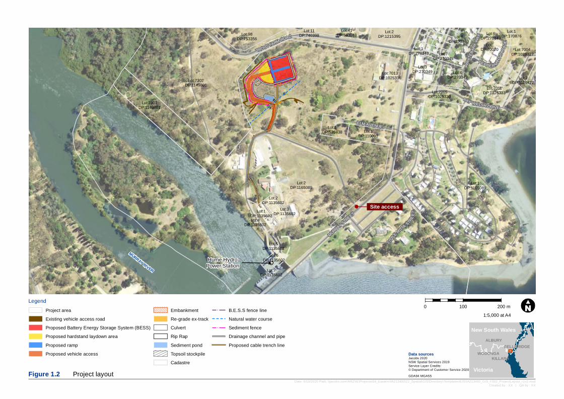
Hume HydroPower Station
MURRAY RIVER
WHITE
BARK
WAY
L ITTLE
MITTASTR
EET
MURRAY STREET
RAY WELSH DRIVE
ELM AVENUE
PEPPE R MINTPA
RADE
TROUT FARM ROAD
Site access
Lot:11DP:740398
Lot:1DP:110091
Lot:1DP:270349 Lot:7004
DP:1025327
Lot:7005DP:1025330
Lot:4DP:270349
Lot:DP:70020
Lot:1DP:528438
Lot:6DP:270349
Lot:7013DP:1025336
Lot:3DP:270349
Lot:1DP:170876
Lot:41DP:591183
Lot:7011DP:1025333
Lot:98DP:753356
Lot:6DP:1135602
Lot:5DP:1135602
Lot:4DP:1135602
Lot:3DP:1135602Lot:1
DP:1135602
Lot:2DP:1135602
Lot:7DP:1135602
Lot:7303DP:1149801
Lot:7302DP:1149801
Lot:1DP:1165089
Lot:3DP:1119422
Lot:2DP:1165089
Lot:7DP:270349
Lot:9DP:270349
Lot:2DP:1215395
Legend0 100 200 m
Date: 8/10/2020 Path: \\jacobs.com\ANZ\IE\Projects\04_Eastern\IA213400\22_Spatial\GIS\Directory\Templates\EIS\IA213400_GIS_F002_ProjectLayout_r1v2.mxdCreated by : XX | QA by : XX
Data sourcesJacobs 2020NSW Spatial Services 2019Service Layer Credits:© Department of Customer Service 2020Figure 1.2 Project layout GDA94 MGA55
WODONGA
ALBURY
KILLARA
BELLBRIDGE
1:5,000 at A4
New South Wales
Victoria
Project areaExisting vehicle access roadProposed Battery Energy Storage System (BESS)Proposed hardstand laydown areaProposed rampProposed vehicle access
EmbankmentRe-grade ex-trackCulvertRip RapSediment pondTopsoil stockpileCadastre
B.E.S.S fence lineNatural water courseSediment fenceDrainage channel and pipeProposed cable trench line
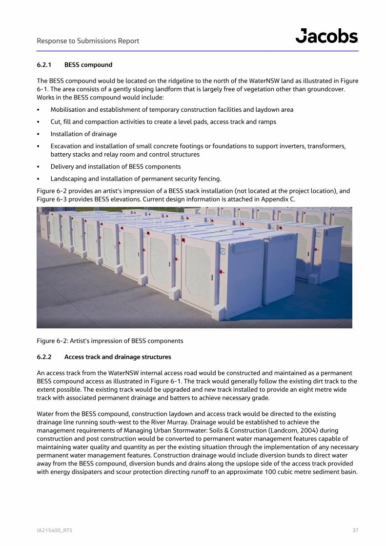
Response to Submissions Report
IA215400_RTS 37
6.2.1 BESS compound
The BESS compound would be located on the ridgeline to the north of the WaterNSW land as illustrated in Figure 6-1. The area consists of a gently sloping landform that is largely free of vegetation other than groundcover. Works in the BESS compound would include:
Mobilisation and establishment of temporary construction facilities and laydown area
Cut, fill and compaction activities to create a level pads, access track and ramps
Installation of drainage
Excavation and installation of small concrete footings or foundations to support inverters, transformers, battery stacks and relay room and control structures
Delivery and installation of BESS components
Landscaping and installation of permanent security fencing.
Figure 6-2 provides an artist’s impression of a BESS stack installation (not located at the project location), and Figure 6-3 provides BESS elevations. Current design information is attached in Appendix C.
Figure 6-2: Artist’s impression of BESS components
6.2.2 Access track and drainage structures
An access track from the WaterNSW internal access road would be constructed and maintained as a permanent BESS compound access as illustrated in Figure 6-1. The track would generally follow the existing dirt track to the extent possible. The existing track would be upgraded and new track installed to provide an eight metre wide track with associated permanent drainage and batters to achieve necessary grade.
Water from the BESS compound, construction laydown and access track would be directed to the existing drainage line running south-west to the River Murray. Drainage would be established to achieve the management requirements of Managing Urban Stormwater: Soils & Construction (Landcom, 2004) during construction and post construction would be converted to permanent water management features capable of maintaining water quality and quantity as per the existing situation through the implementation of any necessary permanent water management features. Construction drainage would include diversion bunds to direct water away from the BESS compound, diversion bunds and drains along the upslope side of the access track provided with energy dissipaters and scour protection directing runoff to an approximate 100 cubic metre sediment basin.
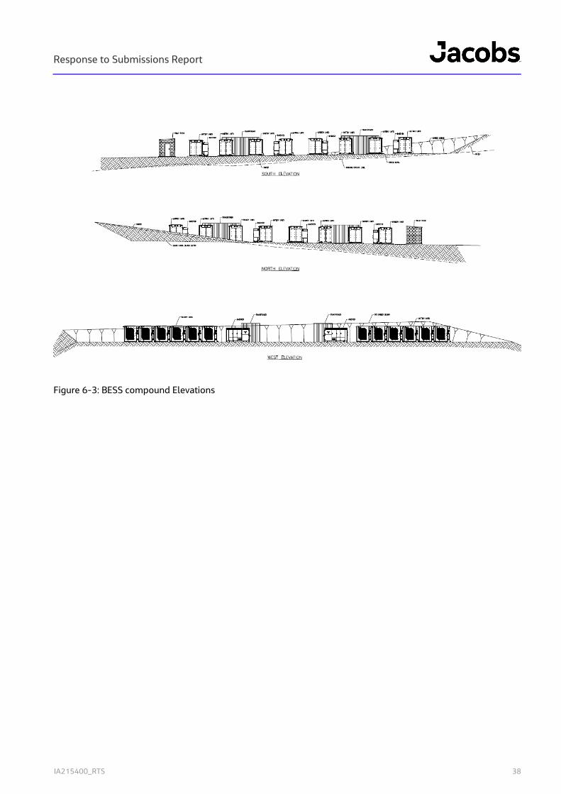
Response to Submissions Report
IA215400_RTS 38
Figure 6-3: BESS compound Elevations

Response to Submissions Report
IA215400_RTS 39
Following completion of construction, all disturbance areas not housing permanent infrastructure would be rehabilitated with native vegetation, drainage features would be retained and maintained to prevent erosion and the sediment basin converted to a bioretention basin or similar sized to achieve pre-development flow characteristics.
6.2.3 Network Connection
Hume Hydro-Electric Power Station (HPS) is located on the border of Victoria and New South Wales and connects to both AusNet Services' 66 kV network and TransGrid's 132 kV network. HPS contains two 29 MW hydroelectric generators first commissioned in 1957. Each generator has a dedicated 40 MW high-voltage step-up transformer that converts 11 kV inputs to 66 kV and 132 kV outputs into the Ausnet and TransGrid networks. 11 MW of spare capacity exists within each step-up transformer due to the transformer being oversize for the existing HPS generators. The project proposes connection to both the Ausnet and TransGrid networks using this identified spare capacity within the step-up transformers.
New infrastructure required to connect the BESS to the HPS and step-up transformers would involve:
Underground 11 kV electricity cabling infrastructure from the step-up transformers within the existing switchyard to the BESS
Switch room building with approximate dimensions of 3.2 metres in height and footprint of five by four metres within existing transformer bay replacing redundant shed.
Minor works are also required to existing cable pit to connect cable to existing step-up transformers connected to the existing TransGrid and Ausnet networks.
6.2.3.1 Cable works
Approximate 400 metres of trenching would be required for the installation of the underground 11 kV cabling from the BESS to the switchyard. The trench would be approximate 1.2 metres deep and 0.6 metres wide for direct burial of cables. The alignment of the cable infrastructure is generally indicated in Figure 6-1 noting the road crossing may vary to accommodate heritage impact avoidance, and access disruption
Cables would be laid on 50 millimetres of thermal bedding and consist of two 11 kV cables each with trefoil arrangement spaced 0.3 metres from each other. Cables would be covered by 75 millimetres of thermal bedding over which a PVC cover would be lain. Above the PVC layer, the trench would be backfilled using excavated material from the trench, provided with a flagging layer at approximately 0.3 metres deep, compacted and revegetated to match pre-existing conditions.
The trench would be excavated using a backhoe and backfilled with excavated material immediately after completion of cable installation. The trench alignment would be rehabilitated to achieve existing conditions.
One crossing of the WaterNSW access road is required and this would be located to avoid disruption to WaterNSW access, avoid existing culverts where heritage values have been identified and be undertaken within one day or otherwise provided with road cover to facilitate access. Cable installation would be as per the above with the exception that backfill would include a 40 millimetre wearing course, 80 millimetre Binder course and 150 millimetre base course above the marker tape.
Response to Submissions Report
IA215400_RTS 40
6.2.3.2 Switchyard works
Due to the existing capacity within the step-up transformers which form the point of connection of the Project to Minor works at the Switchyard are required to facilitate connection to the existing network as follows:
Continuation of cable works through the switchyard compound to a new switch room
Installation of a brick switch room accommodating switchgear within the existing Transformer bay. To facilitate this, an existing, redundant shed would be removed. The switch room would house standard electrical equipment to facilitate the connection of the BESS to the existing network
Continuation of cable from switch room to the existing cable pit
Minor works to the existing cable pit at the step-up transformer to connect wiring.
6.3 Construction duration and timing
Construction of the Project is expected to proceed as follows:
Installation and maintenance of environmental controls
Upgraded construction access track from existing WaterNSW internal access road to BESS location
Cut and fill to form BESS pad and construction laydown area
Trenching and installation of cable from BESS to Switchyard
Structural works to support BESS facilities
Delivery, installation and electrical fit-out of BESS
Testing and commissioning activities
Minor works to connect BESS to existing switchyard
Removal of construction equipment and rehabilitation of construction areas.
The construction project is anticipated to take nine months consisting and include a five-month civil works component and overlapping two month mechanical and structural component followed by two months of electrical works and three months of testing and commissioning.
All works would be limited to standard construction hours of:
Monday-Friday 0700-1600,
Saturday 0800-1300
No works on Sunday or public holidays
6.4 Upgrades or Decommission
Over the life of the project, various components may require or benefit from upgrade or replacement. This is most likely to involve the replacement of battery cores within the BESS stacks but may also involve the repair or replacement of other infrastructure. If required, works intensity would not exceed, and is likely to be significantly lower than construction works described above. Should additional generation capacity also be attainable from improved technology without increasing disturbance footprint or exceeding assessed performance outcomes this may also be undertaken.
Following the end of economic life, all above ground, built infrastructure associated with the Project would be removed and the site footprint graded and rehabilitated to a safe, sustainable and non-polluting landform. Generally, this would include returning the site to as near to pre-development condition as practicable, such as removing buildings and infrastructure and rehabilitating the site using native species.
Response to Submissions Report
IA215400_RTS 41
7. Management and monitoring measures This Chapter addresses the SEARs requirement that the EIS include a consolidated summary of all the proposed environmental management and monitoring measures, identifying all the commitments in the EIS.
7.1 Project environmental commitments
7.1.1 Ongoing design strategy
While the Project design has been substantially progressed, final detailed design is yet to be completed. The EIS is based on a current design status which may be amended through the detailed design process. Construction methods may also vary subject to design refinements and the selection of the construction contractor.
The assessment of the project within the EIS is based on consideration of reasonable worse case environmental impacts to allow flexibility in design and construction methodology. The ongoing design of Project components would adopt the performance outcomes for the Project as identified in the EIS.
As part of the engagement of a technology provider and construction contractor, a risk assessment would be completed on the battery solution selected and construction methods to be implemented and an environmental management plan prepared that incorporates the Project commitments and conditions of approval. Further consultation with relevant agencies would be undertaken and necessary approvals of final designs and methods sought.
Meridian will comply with any pre-construction compliance obligations prior to the commencement of the Project. The risk assessments, final design plans and management plans would be used to confirm that no greater impact than that assessed in this EIS would eventuate. Where additional impacts are identified, any necessary modifications would be sought.
7.1.2 Environmental management plan
An environmental management plan would be developed for the Project and updated as it progresses through construction, operations and finally decommissioning. The environmental management plan would provide principles and plans of implementation related to environmental performance objectives of the Project aimed at achieving and demonstrating compliance with the commitments of the EIS and approval conditions and minimising environmental impact.
The environmental management plan, and conditions of approval would be implemented through contractual arrangements such that resources necessary to achieve compliance and to minimise impacts will be provided. The Environmental Management Plan would be reviewed and updated in response to design changes, compliance reporting, independent audit findings and prior to progressing into each stage of the development.
Response to Submissions Report
IA215400_RTS 42
7.1.3 Summary of proposed monitoring
Table 7-1 provides a summary of monitoring committed to in the EIS or otherwise proposed.
Table 7-1: Summary of proposed monitoring
Environmental matter
Monitoring Frequency
General Weekly inspections of all active works areas would be undertaken to confirm:
Clearing and ground disturbance is limited to approved impact footprint
Exclusion zone marking is in place to protect heritage items in proximity to works
Erosion controls are in place and retain capacity to manage run-off events in accordance with guidelines
Storage and handling arrangements for oils, grease and fuel for construction plant are appropriately bunded and managed to prevent spills and that no evidence of spills exists
Spill kits are fully stocked and appropriate for the works being undertaken
Waste is appropriately segregated and being collected at a frequency to maintain site in a neat and tidy manner
Stockpiled materials are appropriately managed to prevent wind-blown dust or erosion.
Should weekly observations identify areas of concern, the frequency of inspection would be increased.
Weekly during construction
Biodiversity Any trenches left over night will be inspected each morning such that trapped fauna can be released
Perimeter fencing will be inspected observed for signs of trapped or injured squirrel glider.
A fence monitoring protocol would be developed in consultation with relevant stakeholders and implemented in the event that the use of barbed wire associated with the Project cannot be avoided.
As needed
Heritage Ground excavations will be observed for signs of items of heritage value and works stopped and chance finds reported immediately.
ongoing
Noise Construction noise monitoring to confirm predicted noise levels are not exceeded and to confirm need and effectiveness of noise mitigation measures.
Operational noise monitoring to confirm predicted noise levels would not exceed NML at any off site receiver location.
On commencement of Civil works.
On commencement of operations.
Waste Records of all waste sent off-site will be retained on site. As needed
Water Post rainfall inspections to confirm sediment control functioning and need for active management of water levels or quality in sediment basin prior to discharge.
Prior to and during any discharge events.

Response to Submissions Report
IA215400_RTS 43
Real-time water quality sampling of any discharge to confirm general compliance with guideline levels of suspended sediments (turbidity), pH or visible signs of oils and grease.
Auditing Independent audits of construction, operation and closure. In accordance with Independent Audit Post Approval Requirements unless not required by conditions of approval.
7.1.4 Consolidated summary of mitigation measures
A summary of the proposed environmental mitigation measures is provided in Table 7-2. These measures have been adapted from, and reflect the intent of, the recommended measures of the specialist assessments provided in Appendix D to I whilst adopting the overarching environmental management approach for the Project by Meridian.
Table 7-2: Proposed mitigation measures
Reference Environmental management measures Timing
Biodiversity
B01 The limits of the work zone, areas for parking and turning of vehicles and plant equipment would be accurately and clearly marked out prior to commencement of works. These areas would be located so that vegetation disturbance is minimised as much as possible and the drip-line of trees avoided.
Pre-construction
B02 Exclusion zones would be established around high-quality vegetation in the west of the Project site. Periodic monitoring would be undertaken to ensure all controls are in place and no inadvertent impacts are occurring.
Pre-construction
B03 Materials, plant, equipment, work vehicles and stockpiles would be placed to avoid damage to surrounding vegetation and will be outside tree drip-lines.
Pre-construction
B04 If any damage occurs to vegetation outside of the nominated work area, the appropriate environmental representative will be notified so that appropriate remediation strategies can be developed.
Construction
B05 Erosion and sediment measures would be implemented in accordance with the principles and requirements in Managing Urban Stormwater – Soils and Construction, Volume 1 (Landcom 2004) and Volume 2D (NSW Department of Environment, Climate Change and Water 2008c), commonly referred to as the ‘Blue Book’.
Pre-construction
B06 Construction personnel are to be informed of the environmentally sensitive aspects of the site, including plans for impacted and adjoining areas showing vegetation communities; important flora and fauna habitat areas; and locations where threatened species, populations or ecological communities have been recorded.
All stages
B07 A pre-clearing inspection would be undertaken 48 hours prior to any native vegetation clearing by a suitable qualified ecologist and the Contractor’s Environmental Manager (or delegate). The pre-clearing inspection would include, as a minimum:
Identification of hollow bearing trees or other habitat features
Identification of any threatened flora and fauna
A check on the physical demarcation of the limit of clearing
Construction
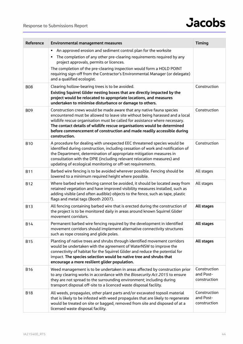
Response to Submissions Report
IA215400_RTS 44
Reference Environmental management measures Timing
An approved erosion and sediment control plan for the worksite
The completion of any other pre-clearing requirements required by any project approvals, permits or licences.
The completion of the pre-clearing inspection would form a HOLD POINT requiring sign-off from the Contractor’s Environmental Manager (or delegate) and a qualified ecologist.
B08 Clearing hollow-bearing trees is to be avoided. Existing Squirrel Glider nesting boxes that are directly impacted by the project would be relocated to appropriate locations, and measures undertaken to minimise disturbance or damage to others.
Construction
B09 Construction crews would be made aware that any native fauna species encountered must be allowed to leave site without being harassed and a local wildlife rescue organisation must be called for assistance where necessary. The contact details of wildlife rescue organisations would be determined before commencement of construction and made readily accessible during construction.
Construction
B10 A procedure for dealing with unexpected EEC threatened species would be identified during construction, including cessation of work and notification of the Department, determination of appropriate mitigation measures in consultation with the DPIE (including relevant relocation measures) and updating of ecological monitoring or off-set requirements.
Construction
B11 Barbed wire fencing is to be avoided wherever possible. Fencing should be lowered to a minimum required height where possible.
All stages
B12 Where barbed wire fencing cannot be avoided, it should be located away from retained vegetation and have improved visibility measures installed, such as adding visible (and often audible) objects to the fence, such as tape, plastic flags and metal tags (Booth 2007).
All stages
B13 All fencing containing barbed wire that is erected during the construction of the project is to be monitored daily in areas around known Squirrel Glider movement corridors.
All stages
B14 Permanent barbed wire fencing required by the development in identified movement corridors should implement alternative connectivity structures such as rope crossing and glide poles.
All stages
B15 Planting of native trees and shrubs through identified movement corridors would be undertaken with the agreement of WaterNSW to improve the connectivity of habitat for the Squirrel Glider and reduce the potential for impact. The species selection would be native tree and shrubs that encourage a more resilient glider population.
All stages
B16 Weed management is to be undertaken in areas affected by construction prior to any clearing works in accordance with the Biosecurity Act 2015 to ensure they are not spread to the surrounding environment; including during transport disposal off-site to a licenced waste disposal facility.
Construction and Post-construction
B18 All weeds, propagules, other plant parts and/or excavated topsoil material that is likely to be infested with weed propagules that are likely to regenerate would be treated on site or bagged, removed from site and disposed of at a licensed waste disposal facility.
Construction and Post-construction
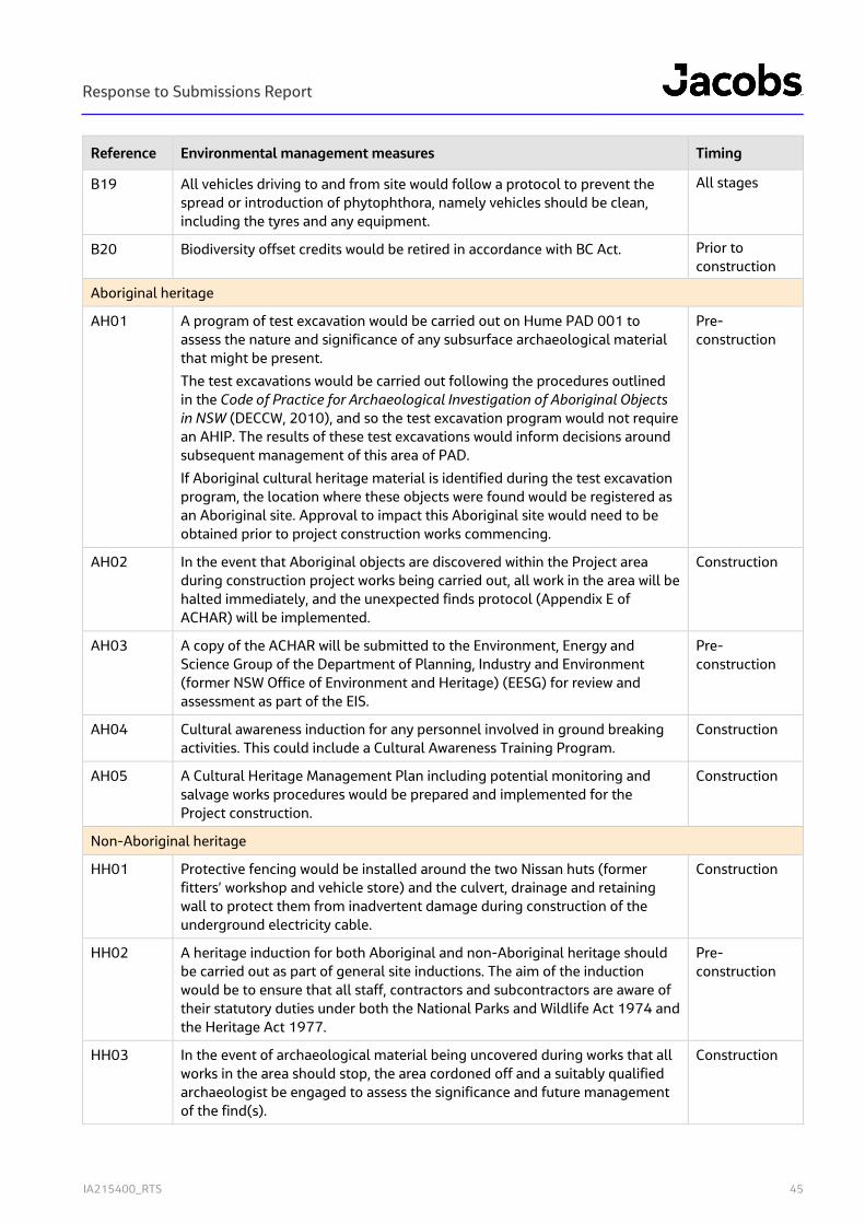
Response to Submissions Report
IA215400_RTS 45
Reference Environmental management measures Timing
B19 All vehicles driving to and from site would follow a protocol to prevent the spread or introduction of phytophthora, namely vehicles should be clean, including the tyres and any equipment.
All stages
B20 Biodiversity offset credits would be retired in accordance with BC Act. Prior to construction
Aboriginal heritage
AH01 A program of test excavation would be carried out on Hume PAD 001 to assess the nature and significance of any subsurface archaeological material that might be present.
The test excavations would be carried out following the procedures outlined in the Code of Practice for Archaeological Investigation of Aboriginal Objects in NSW (DECCW, 2010), and so the test excavation program would not require an AHIP. The results of these test excavations would inform decisions around subsequent management of this area of PAD.
If Aboriginal cultural heritage material is identified during the test excavation program, the location where these objects were found would be registered as an Aboriginal site. Approval to impact this Aboriginal site would need to be obtained prior to project construction works commencing.
Pre-construction
AH02 In the event that Aboriginal objects are discovered within the Project area during construction project works being carried out, all work in the area will be halted immediately, and the unexpected finds protocol (Appendix E of ACHAR) will be implemented.
Construction
AH03 A copy of the ACHAR will be submitted to the Environment, Energy and Science Group of the Department of Planning, Industry and Environment (former NSW Office of Environment and Heritage) (EESG) for review and assessment as part of the EIS.
Pre-construction
AH04 Cultural awareness induction for any personnel involved in ground breaking activities. This could include a Cultural Awareness Training Program.
Construction
AH05 A Cultural Heritage Management Plan including potential monitoring and salvage works procedures would be prepared and implemented for the Project construction.
Construction
Non-Aboriginal heritage
HH01 Protective fencing would be installed around the two Nissan huts (former fitters’ workshop and vehicle store) and the culvert, drainage and retaining wall to protect them from inadvertent damage during construction of the underground electricity cable.
Construction
HH02 A heritage induction for both Aboriginal and non-Aboriginal heritage should be carried out as part of general site inductions. The aim of the induction would be to ensure that all staff, contractors and subcontractors are aware of their statutory duties under both the National Parks and Wildlife Act 1974 and the Heritage Act 1977.
Pre-construction
HH03 In the event of archaeological material being uncovered during works that all works in the area should stop, the area cordoned off and a suitably qualified archaeologist be engaged to assess the significance and future management of the find(s).
Construction
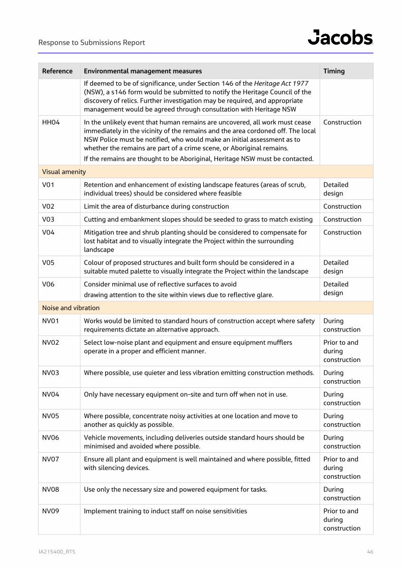
Response to Submissions Report
IA215400_RTS 46
Reference Environmental management measures Timing
If deemed to be of significance, under Section 146 of the Heritage Act 1977 (NSW), a s146 form would be submitted to notify the Heritage Council of the discovery of relics. Further investigation may be required, and appropriate management would be agreed through consultation with Heritage NSW
HH04 In the unlikely event that human remains are uncovered, all work must cease immediately in the vicinity of the remains and the area cordoned off. The local NSW Police must be notified, who would make an initial assessment as to whether the remains are part of a crime scene, or Aboriginal remains.
If the remains are thought to be Aboriginal, Heritage NSW must be contacted.
Construction
Visual amenity
V01 Retention and enhancement of existing landscape features (areas of scrub, individual trees) should be considered where feasible
Detailed design
V02 Limit the area of disturbance during construction Construction
V03 Cutting and embankment slopes should be seeded to grass to match existing Construction
V04 Mitigation tree and shrub planting should be considered to compensate for lost habitat and to visually integrate the Project within the surrounding landscape
Construction
V05 Colour of proposed structures and built form should be considered in a suitable muted palette to visually integrate the Project within the landscape
Detailed design
V06 Consider minimal use of reflective surfaces to avoid
drawing attention to the site within views due to reflective glare.
Detailed design
Noise and vibration
NV01 Works would be limited to standard hours of construction accept where safety requirements dictate an alternative approach.
During construction
NV02 Select low-noise plant and equipment and ensure equipment mufflers operate in a proper and efficient manner.
Prior to and during construction
NV03 Where possible, use quieter and less vibration emitting construction methods. During construction
NV04 Only have necessary equipment on-site and turn off when not in use. During construction
NV05 Where possible, concentrate noisy activities at one location and move to another as quickly as possible.
During construction
NV06 Vehicle movements, including deliveries outside standard hours should be minimised and avoided where possible.
During construction
NV07 Ensure all plant and equipment is well maintained and where possible, fitted with silencing devices.
Prior to and during construction
NV08 Use only the necessary size and powered equipment for tasks. During construction
NV09 Implement training to induct staff on noise sensitivities Prior to and during construction
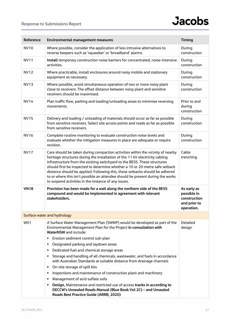
Response to Submissions Report
IA215400_RTS 47
Reference Environmental management measures Timing
NV10 Where possible, consider the application of less intrusive alternatives to reverse beepers such as ‘squawker’ or ‘broadband’ alarms.
During construction
NV11 Install temporary construction noise barriers for concentrated, noise-intensive activities.
During construction
NV12 Where practicable, install enclosures around noisy mobile and stationary equipment as necessary.
During construction
NV13 Where possible, avoid simultaneous operation of two or more noisy plant close to receivers. The offset distance between noisy plant and sensitive receivers should be maximised.
During construction
NV14 Plan traffic flow, parking and loading/unloading areas to minimise reversing movements.
Prior to and during construction
NV15 Delivery and loading / unloading of materials should occur as far as possible from sensitive receivers. Select site access points and roads as far as possible from sensitive receivers.
During construction
NV16 Complete routine monitoring to evaluate construction noise levels and evaluate whether the mitigation measures in place are adequate or require revision.
During construction
NV17 Care should be taken during compaction activities within the vicinity of nearby heritage structures during the installation of the 11 kV electricity cabling infrastructure from the existing switchyard to the BESS. These structures should first be inspected to determine whether a 10 or 20 metre safe setback distance should be applied. Following this, these setbacks should be adhered to or where this isn’t possible an attendee should be present during the works to suspend activities in the instance of any issues.
Cable trenching
VN18 Provision has been made for a wall along the northern side of the BESS compound and would be implemented in agreement with relevant stakeholders.
As early as possible in construction and prior to operation.
Surface water and hydrology
W01 A Surface Water Management Plan (SWMP) would be developed as part of the Environmental Management Plan for the Project in consultation with WaterNSW and include:
Erosion sediment control sub-plan
Designated parking and laydown areas
Dedicated fuel and chemical storage areas
Storage and handling of all chemicals, wastewater, and fuels in accordance with Australian Standards at suitable distance from drainage channels
On-site storage of spill kits
Inspections and maintenance of construction plant and machinery
Management of acid sulfate soils
Design, Maintenance and restricted use of access tracks in according to DECCW’s Unsealed Roads Manual (Blue Book Vol 2C) – and Unsealed Roads Best Practice Guide (ARRB, 2020)
Detailed design
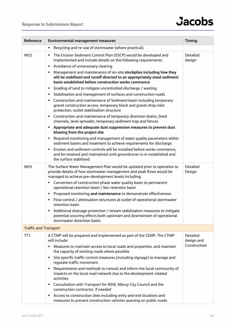
Response to Submissions Report
IA215400_RTS 48
Reference Environmental management measures Timing
Recycling and re-use of stormwater (where practical).
W02 The Erosion Sediment Control Plan (ESCP) would be developed and implemented and include details on the following requirements:
Avoidance of unnecessary clearing
Management and maintenance of on-site stockpiles including how they will be stabilised and runoff directed to an appropriately sized sediment basin established before construction works commence
Grading of land to mitigate uncontrolled discharge / wasting
Stabilisation and management of surfaces and construction roads
Construction and maintenance of Sediment basin including temporary gravel construction access, temporary block and gravel drop inlet protection, outlet stabilisation structure
Construction and maintenance of temporary diversion drains, lined channels, level spreader, temporary sediment trap and fences
Appropriate and adequate dust suppression measures to prevent dust blowing from the project site
Required monitoring and management of water quality parameters within sediment basins and treatment to achieve requirements for discharge.
Erosion and sediment controls will be installed before works commence, and be retained and maintained until groundcover is re-established and the surface stabilised.
Detailed design
W03 The Surface Water Management Plan would be updated prior to operation to provide details of how stormwater management and peak flows would be managed to achieve pre-development levels including:
Conversion of construction phase water quality basin to permanent operational retention basin / bio-retention basin
Proposed monitoring and maintenance to demonstrate effectiveness
Flow control / attenuation structures at outlet of operational stormwater retention basin
Additional drainage protection / stream stabilisation measures to mitigate potential scouring effects both upstream and downstream of operational stormwater detention basin.
Detailed Design
Traffic and Transport
TT1 A CTMP will be prepared and implemented as part of the CEMP. The CTMP will include:
Measures to maintain access to local roads and properties, and maintain the capacity of existing roads where possible
Site specific traffic control measures (including signage) to manage and regulate traffic movement
Requirements and methods to consult and inform the local community of impacts on the local road network due to the development-related activities
Consultation with Transport for NSW, Albury City Council and the construction contractor, if needed
Access to construction sites including entry and exit locations and measures to prevent construction vehicles queuing on public roads
Detailed design and Construction
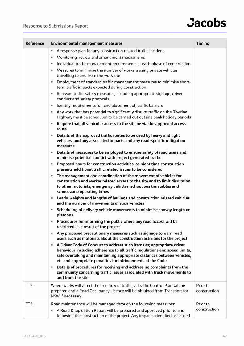
Response to Submissions Report
IA215400_RTS 49
Reference Environmental management measures Timing
A response plan for any construction related traffic incident
Monitoring, review and amendment mechanisms
Individual traffic management requirements at each phase of construction
Measures to minimise the number of workers using private vehicles travelling to and from the work site
Employment of standard traffic management measures to minimise short-term traffic impacts expected during construction
Relevant traffic safety measures, including appropriate signage, driver conduct and safety protocols
Identify requirements for, and placement of, traffic barriers
Any work that has potential to significantly disrupt traffic on the Riverina Highway must be scheduled to be carried out outside peak holiday periods
Require that all vehicular access to the site be via the approved access route
Details of the approved traffic routes to be used by heavy and light vehicles, and any associated impacts and any road-specific mitigation measures
Details of measures to be employed to ensure safety of road users and minimise potential conflict with project generated traffic
Proposed hours for construction activities, as night time construction presents additional traffic related issues to be considered
The management and coordination of the movement of vehicles for construction and worker related access to the site and to limit disruption to other motorists, emergency vehicles, school bus timetables and school zone operating times
Loads, weights and lengths of haulage and construction related vehicles and the number of movements of such vehicles
Scheduling of delivery vehicle movements to minimise convoy length or platoons
Procedures for informing the public where any road access will be restricted as a result of the project
Any proposed precautionary measures such as signage to warn road users such as motorists about the construction activities for the project
A Driver Code of Conduct to address such items as; appropriate driver behaviour including adherence to all traffic regulations and speed limits, safe overtaking and maintaining appropriate distances between vehicles, etc and appropriate penalties for infringements of the Code
Details of procedures for receiving and addressing complaints from the community concerning traffic issues associated with truck movements to and from the site.
TT2 Where works will affect the free flow of traffic, a Traffic Control Plan will be prepared and a Road Occupancy Licence will be obtained from Transport for NSW if necessary.
Prior to construction
TT3 Road maintenance will be managed through the following measures:
A Road Dilapidation Report will be prepared and approved prior to and following the construction of the project. Any impacts identified as caused
Prior to construction
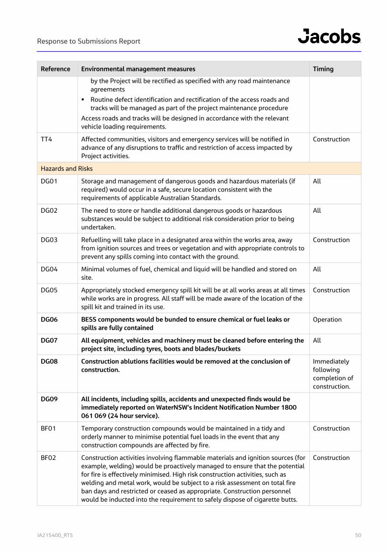
Response to Submissions Report
IA215400_RTS 50
Reference Environmental management measures Timing
by the Project will be rectified as specified with any road maintenance agreements
Routine defect identification and rectification of the access roads and tracks will be managed as part of the project maintenance procedure
Access roads and tracks will be designed in accordance with the relevant vehicle loading requirements.
TT4 Affected communities, visitors and emergency services will be notified in advance of any disruptions to traffic and restriction of access impacted by Project activities.
Construction
Hazards and Risks
DG01 Storage and management of dangerous goods and hazardous materials (if required) would occur in a safe, secure location consistent with the requirements of applicable Australian Standards.
All
DG02 The need to store or handle additional dangerous goods or hazardous substances would be subject to additional risk consideration prior to being undertaken.
All
DG03 Refuelling will take place in a designated area within the works area, away from ignition sources and trees or vegetation and with appropriate controls to prevent any spills coming into contact with the ground.
Construction
DG04 Minimal volumes of fuel, chemical and liquid will be handled and stored on site.
All
DG05 Appropriately stocked emergency spill kit will be at all works areas at all times while works are in progress. All staff will be made aware of the location of the spill kit and trained in its use.
Construction
DG06 BESS components would be bunded to ensure chemical or fuel leaks or spills are fully contained
Operation
DG07 All equipment, vehicles and machinery must be cleaned before entering the project site, including tyres, boots and blades/buckets
All
DG08 Construction ablutions facilities would be removed at the conclusion of construction.
Immediately following completion of construction.
DG09 All incidents, including spills, accidents and unexpected finds would be immediately reported on WaterNSW’s Incident Notification Number 1800 061 069 (24 hour service).
BF01 Temporary construction compounds would be maintained in a tidy and orderly manner to minimise potential fuel loads in the event that any construction compounds are affected by fire.
Construction
BF02 Construction activities involving flammable materials and ignition sources (for example, welding) would be proactively managed to ensure that the potential for fire is effectively minimised. High risk construction activities, such as welding and metal work, would be subject to a risk assessment on total fire ban days and restricted or ceased as appropriate. Construction personnel would be inducted into the requirement to safely dispose of cigarette butts.
Construction
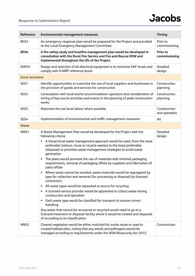
Response to Submissions Report
IA215400_RTS 51
Reference Environmental management measures Timing
BF03 An emergency response plan would be prepared for the Project and provided to the Local Emergency Management Committee.
Prior to commissioning
BF04 A fire safety study and bushfire management plan would be developed in consultation with the Rural Fire Service and Fire and Rescue NSW and implemented throughout the life of the Project.
Prior to commissioning
EMF01 Design and selection of all electrical equipment is to minimise EMF levels and comply with ICNIRP reference levels
Detailed design
Socio-economic
SE01 Identify opportunities to maximise the use of local suppliers and businesses in the provision of goods and services for construction.
Construction planning
SE02 Consultation with local tourist accommodation operators and consideration of timing of key tourist activities and events in the planning of peak construction works.
Construction planning
SE03 Maximise the use local labour where possible. Construction and operation
SE04 Implementation of environmental and traffic management measures All
Waste
WR01 A Waste Management Plan would be developed for the Project with the following criteria:
A hierarchical waste management approach would be used, from the most preferable (reduce, reuse or recycle wastes) to the lease preferable (disposal) to prioritise waste management strategies to avoid waste generation
The plans would promote the use of materials with minimal packaging requirements, removal of packaging offsite by suppliers and fabrication of parts offsite
Where waste cannot be avoided, waste materials would be segregated by type for collection and removal (for processing or disposal) by licensed contractors
All waste types would be separated at source for recycling
A licensed service provider would be appointed to collect waste during construction and operation
Each waste type would be classified for transport to ensure correct handling.
Any waste that cannot be recovered or recycled would need to go to a licensed treatment or disposal facility where it would be treated and disposed of according to its classification.
Detailed design
WR02 Cleared vegetation would be either mulched for onsite reuse or used to created habitat piles, noting that any weeds and pathogens would be managed according to requirements under the NSW Biosecurity Act 2015.
Construction

Response to Submissions Report
IA215400_RTS
Appendix A. Revised design plans

Response to Submissions Report
IA215400_RTS
Appendix B. Revised BDAR

Response to Submissions Report
IA215400_RTS
Appendix C. Final ACHAR