greenpoint-williamsburg waterfront rezoning
DESCRIPTION
Case Study on the rezoning of the Greenpoint-Williamsburg waterfront in Brooklyn, New York and the (possible) redevelopmentsTRANSCRIPT
case-study: greenpoint-WilliamsBurg WaterFront redevelopmenttransForming tHe Working-WaterFront to prime real estate
Miguel Van Steenbrugge 2MIRA 2011-2012
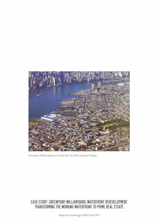
Greenpoint-Williamsburg aerial, September 20, 2004, Greenpoint Blogger
2
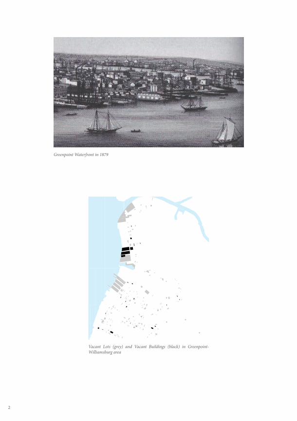
Vacant Lots (grey) and Vacant Buildings (black) in Greenpoint-Williamsburg area
Greenpoint Waterfront in 1879
3
introduction
The Greenpoint-Williamsburg waterfronts have always been dynamic zones of commerce and farming until the mid 19th Century. Due to population change and economical growth, manufacturing, industry and maritime activities found their way onto the East River shorelines and replaced nearly all farmlands by 1900. This gave rise to a thriving shipbuilding and manufacturing center in New York City and contributed in the identity of mixed-use communities along the waterfront that housed mostly working class groups1. But as in other parts of the New York City area (for instance Red Hook2), waterfront communities have become a victim of changing economic patterns, global competition and displacement of activities. Small-scale uses such as light manufacturing, transportation, warehousing and utilities, which were thriving in Greenpoint-Williamsburg as well as other areas, experienced accelerated displacement since the 1990s because of gentrification phenomena3. Between 1991 and 2002, manufacturing employment alone dropped by 72% in Williamsburg and by 60% in Greenpoint and the number of industrial jobs declined with almost 40%. Large manufacturing firms are no longer present in the area. The employment in manufacturing for New York City as a whole has fallen by nearly 80% in comparison with 19474. The overall result of these changes on the working-waterfront is a dominant presence of vacant lots and under used industrial resources.
To address these problems and other issues concerning the entire neighborhood, the Greenpoint-Williamsburg Waterfront and Land Use Plan was legislated and approved in May of 2005. It represented an extensive effort by the City to increase housing opportunities and revive the waterfronts as an economic asset inspired by the 1992 Comprehensive Waterfront Plan5. The Plan was guided by proposals in 197a Community Plans already adopted in January of 2002 and comprising of the following main themes: waterfront access, housing, local commercial development and rezoning. This was complemented by several objectives the Plan set out to accomplish in order to reflect changing conditions and prepare the communities for the future. It would provide in the City’s need for affordable housing and other developments, relying on vacant and under used land. It would build on the strong character of the existing neighborhood. It would protect zones of important industrial activity and employment. And finally, it would establish a blueprint for a publicly accessible waterfront6.
In order to accomplish the aforementioned goals, both the waterfront and inland area of Greenpoint-Williamsburg needed to be rezoned. This would allow for new developments in the future but also supports occurring trends in the neighborhood (e.g. illegally transforming vacant floors of industrial buildings into lofts). The rezoning was guided by several development principles that originate from community goals (as mentioned above) balanced by challenges of waterfront development.
1. Greenpoint-Williamsburg Waterfront Open Space Masterplan, 2005, p52. Vision 2020, March 2011, p171: Between 2000 and 2008 the number of industrial firms in the Sunset Park SMIA dropped by almost 14% while non-industrial firms increased by nearly 40%. It has some of the largest vacant sites of all SMIAs.3. Community Development Studio, Rutgers University, Spring 2007, p164. 2002 New York State Department of Labor data analysed by the Department of City Planning, http://www.nyc.gov/html/dcp/html/greenpointwill/greenplan3.shtml, Accessed October 26 20115. Community Development Studio, Rutgers University, Spring 2007, p46. Planning Framework Background, http://www.nyc.gov/html/dcp/html/greenpointwill/greenplan1.shtml, Accessed October 26, 2011
4
MMMMOOOO
RRRRGGGG
AAAA
PAIDGE AV
MXMXMXMXMXMXMXMXMXMXMXMXMXMXMXM1-2/R6M1-2/R6M1-2/R6M1-2/R6M1-2/R6M1-2/R6M1-2/R6M1-2/R6M1-2/R6M1-2/R6M1-2/R6M1-2/R6M1-2/R6M1-2/R6M1-2/R6M1-2/R6M1-2/R6M1-2/R6M1-2/R6M1-2/R6M1-2/R6M1-2/R6M1-2/R6M1-2/R6M1-2/R6M1-2/R6M1-2/R6M1-2/R6M1-2/R6M1-2/R6M1-2/R6M1-2/R6M1-2/R6M1-2/R6M1-2/R6M1-2/R6M1-2/R6M1-2/R6M1-2/R6M1-2/R6M1-2/R6M1-2/R6M1-2/R6M1-2/R6M1-2/R6M1-2/R6M1-2/R6M1-2/R6M1-2/R6M1-2/R6M1-2/R6M1-2/R6M1-2/R6M1-2/R6M1-2/R6M1-2/R6M1-2/R6M1-2/R6M1-2/R6M1-2/R6M1-2/R6M1-2/R6M1-2/R6M1-2/R6M1-2/R6M1-2/R6M1-2/R6M1-2/R6M1-2/R6M1-2/R6M1-2/R6M1-2/R6M1-2/R6M1-2/R6M1-2/R6M1-2/R6M1-2/R6M1-2/R6M1-2/R6M1-2/R6M1-2/R6M1-2/R6M1-2/R6M1-2/R6M1-2/R6M1-2/R6M1-2/R6M1-2/R6M1-2/R6M1-2/R6M1-2/R6M1-2/R6M1-2/R6M1-2/R6M1-2/R6M1-2/R6M1-2/R6M1-2/R6M1-2/R6M1-2/R6M1-2/R6M1-2/R6M1-2/R6M1-2/R6M1-2/R6M1-2/R6M1-2/R6M1-2/R6M1-2/R6M1-2/R6M1-2/R6M1-2/R6M1-2/R6M1-2/R6M1-2/R6M1-2/R6M1-2/R6M1-2/R6M1-2/R6M1-2/R6M1-2/R6M1-2/R6M1-2/R6M1-2/R6M1-2/R6M1-2/R6M1-2/R6M1-2/R6M1-2/R6M1-2/R6M1-2/R6M1-2/R6M1-2/R6M1-2/R6M1-2/R6M1-2/R6M1-2/R6M1-2/R6M1-2/R6M1-2/R6M1-2/R6M1-2/R6M1-2/R6M1-2/R6M1-2/R6M1-2/R6M1-2/R6M1-2/R6M1-2/R6M1-2/R6M1-2/R6M1-2/R6M1-2/R6M1-2/R6M1-2/R6M1-2/R6M1-2/R6M1-2/R6M1-2/R6M1-2/R6M1-2/R6M1-2/R6M1-2/R6M1-2/R6M1-2/R6M1-2/R6M1-2/R6M1-2/R6M1-2/R6M1-2/R6M1-2/R6M1-2/R6M1-2/R6M1-2/R6M1-2/R6M1-2/R6M1-2/R6M1-2/R6M1-2/R6M1-2/R6M1-2/R6M1-2/R6M1-2/R6M1-2/R6M1-2/R6M1-2/R6M1-2/R6M1-2/R6M1-2/R6M1-2/R6M1-2/R6M1-2/R6M1-2/R6M1-2/R6M1-2/R6M1-2/R6M1-2/R6M1-2/R6M1-2/R6M1-2/R6M1-2/R6M1-2/R6M1-2/R6M1-2/R6M1-2/R6M1-2/R6M1-2/R6M1-2/R6M1-2/R6M1-2/R6M1-2/R6M1-2/R6M1-2/R6M1-2/R6M1-2/R6M1-2/R6M1-2/R6M1-2/R6M1-2/R6M1-2/R6M1-2/R6M1-2/R6M1-2/R6M1-2/R6M1-2/R6M1-2/R6M1-2/R6M1-2/R6M1-2/R6M1-2/R6M1-2/R6M1-2/R6M1-2/R6M1-2/R6M1-2/R6M1-2/R6M1-2/R6M1-2/R6M1-2/R6M1-2/R6M1-2/R6M1-2/R6M1-2/R6M1-2/R6M1-2/R6M1-2/R6M1-2/R6M1-2/R6M1-2/R6M1-2/R6M1-2/R6M1-2/R6M1-2/R6M1-2/R6M1-2/R6M1-2/R6M1-2/R6M1-2/R6M1-2/R6M1-2/R6M1-2/R6M1-2/R6M1-2/R6M1-2/R6M1-2/R6M1-2/R6M1-2/R6M1-2/R6M1-2/R6M1-2/R6M1-2/R6M1-2/R6M1-2/R6M1-2/R6M1-2/R6M1-2/R6M1-2/R6M1-2/R6M1-2/R6M1-2/R6M1-2/R6M1-2/R6M1-2/R6M1-2/R6M1-2/R6M1-2/R6M1-2/R6M1-2/R6M1-2/R6M1-2/R6M1-2/R6M1-2/R6M1-2/R6M1-2/R6M1-2/R6M1-2/R6M1-2/R6M1-2/R6M1-2/R6M1-2/R6M1-2/R6M1-2/R6M1-2/R6M1-2/R6M1-2/R6M1-2/R6M1-2/R6M1-2/R6M1-2/R6M1-2/R6M1-2/R6M1-2/R6M1-2/R6M1-2/R6M1-2/R6M1-2/R6M1-2/R6M1-2/R6M1-2/R6M1-2/R6M1-2/R6M1-2/R6M1-2/R6M1-2/R6M1-2/R6M1-2/R6M1-2/R6M1-2/R6M1-2/R6M1-2/R6M1-2/R6M1-2/R6M1-2/R6M1-2/R6M1-2/R6M1-2/R6M1-2/R6M1-2/R6M1-2/R6M1-2/R6M1-2/R6M1-2/R6M1-2/R6M1-2/R6M1-2/R6M1-2/R6M1-2/R6M1-2/R6M1-2/R6M1-2/R6M1-2/R6M1-2/R6M1-2/R6M1-2/R6M1-2/R6M1-2/R6M1-2/R6M1-2/R6M1-2/R6M1-2/R6M1-2/R6M1-2/R6M1-2/R6M1-2/R6M1-2/R6M1-2/R6M1-2/R6M1-2/R6M1-2/R6M1-2/R6M1-2/R6M1-2/R6M1-2/R6M1-2/R6M1-2/R6M1-2/R6M1-2/R6M1-2/R6M1-2/R6M1-2/R6M1-2/R6M1-2/R6M1-2/R6M1-2/R6M1-2/R6M1-2/R6M1-2/R6M1-2/R6M1-2/R6M1-2/R6M1-2/R6M1-2/R6M1-2/R6M1-2/R6M1-2/R6M1-2/R6M1-2/R6M1-2/R6M1-2/R6M1-2/R6M1-2/R6M1-2/R6M1-2/R6M1-2/R6M1-2/R6M1-2/R6M1-2/R6M1-2/R6M1-2/R6M1-2/R6M1-2/R6M1-2/R6M1-2/R6M1-2/R6M1-2/R6M1-2/R6M1-2/R6M1-2/R6M1-2/R6M1-2/R6M1-2/R6M1-2/R6M1-2/R6M1-2/R6M1-2/R6M1-2/R6M1-2/R6M1-2/R6M1-2/R6M1-2/R6M1-2/R6M1-2/R6M1-2/R6M1-2/R6M1-2/R6M1-2/R6M1-2/R6M1-2/R6M1-2/R6M1-2/R6M1-2/R6M1-2/R6M1-2/R6M1-2/R6M1-2/R6M1-2/R6M1-2/R6M1-2/R6M1-2/R6M1-2/R6M1-2/R6M1-2/R6M1-2/R6M1-2/R6M1-2/R6M1-2/R6M1-2/R6M1-2/R6M1-2/R6M1-2/R6M1-2/R6M1-2/R6M1-2/R6M1-2/R6M1-2/R6M1-2/R6M1-2/R6M1-2/R6M1-2/R6M1-2/R6M1-2/R6M1-2/R6M1-2/R6M1-2/R6M1-2/R6M1-2/R6M1-2/R6M1-2/R6M1-2/R6M1-2/R6M1-2/R6M1-2/R6M1-2/R6M1-2/R6M1-2/R6M1-2/R6M1-2/R6M1-2/R6M1-2/R6M1-2/R6M1-2/R6M1-2/R6M1-2/R6M1-2/R6M1-2/R6M1-2/R6M1-2/R6M1-2/R6M1-2/R6M1-2/R6M1-2/R6M1-2/R6M1-2/R6M1-2/R6M1-2/R6M1-2/R6M1-2/R6M1-2/R6M1-2/R6M1-2/R6M1-2/R6M1-2/R6M1-2/R6M1-2/R6M1-2/R6M1-2/R6M1-2/R6M1-2/R6M1-2/R6M1-2/R6M1-2/R6M1-2/R6M1-2/R6M1-2/R6M1-2/R6M1-2/R6M1-2/R6M1-2/R6M1-2/R6M1-2/R6M1-2/R6M1-2/R6M1-2/R6M1-2/R6M1-2/R6M1-2/R6M1-2/R6M1-2/R6M1-2/R6M1-2/R6M1-2/R6M1-2/R6M1-2/R6M1-2/R6M1-2/R6M1-2/R6M1-2/R6M1-2/R6M1-2/R6M1-2/R6M1-2/R6M1-2/R6M1-2/R6M1-2/R6M1-2/R6M1-2/R6M1-2/R6M1-2/R6M1-2/R6M1-2/R6M1-2/R6M1-2/R6M1-2/R6M1-2/R6M1-2/R6M1-2/R6M1-2/R6M1-2/R6M1-2/R6M1-2/R6M1-2/R6M1-2/R6M1-2/R6M1-2/R6M1-2/R6M1-2/R6M1-2/R6M1-2/R6M1-2/R6M1-2/R6M1-2/R6M1-2/R6M1-2/R6M1-2/R6M1-2/R6M1-2/R6M1-2/R6M1-2/R6M1-2/R6M1-2/R6M1-2/R6M1-2/R6M1-2/R6M1-2/R6M1-2/R6M1-2/R6M1-2/R6M1-2/R6M1-2/R6M1-2/R6M1-2/R6M1-2/R6M1-2/R6M1-2/R6M1-2/R6M1-2/R6M1-2/R6M1-2/R6M1-2/R6M1-2/R6M1-2/R6M1-2/R6M1-2/R6M1-2/R6M1-2/R6M1-2/R6M1-2/R6M1-2/R6M1-2/R6M1-2/R6M1-2/R6M1-2/R6M1-2/R6M1-2/R6M1-2/R6M1-2/R6M1-2/R6M1-2/R6M1-2/R6M1-2/R6M1-2/R6M1-2/R6M1-2/R6M1-2/R6M1-2/R6M1-2/R6M1-2/R6M1-2/R6M1-2/R6M1-2/R6M1-2/R6M1-2/R6M1-2/R6M1-2/R6M1-2/R6M1-2/R6M1-2/R6M1-2/R6M1-2/R6M1-2/R6M1-2/R6M1-2/R6M1-2/R6M1-2/R6M1-2/R6M1-2/R6M1-2/R6M1-2/R6M1-2/R6M1-2/R6M1-2/R6M1-2/R6M1-2/R6M1-2/R6M1-2/R6M1-2/R6M1-2/R6M1-2/R6M1-2/R6M1-2/R6M1-2/R6M1-2/R6M1-2/R6M1-2/R6M1-2/R6M1-2/R6M1-2/R6M1-2/R6M1-2/R6M1-2/R6M1-2/R6M1-2/R6M1-2/R6M1-2/R6M1-2/R6M1-2/R6M1-2/R6M1-2/R6M1-2/R6M1-2/R6M1-2/R6M1-2/R6M1-2/R6M1-2/R6M1-2/R6M1-2/R6M1-2/R6M1-2/R6M1-2/R6M1-2/R6M1-2/R6M1-2/R6M1-2/R6M1-2/R6M1-2/R6M1-2/R6M1-2/R6M1-2/R6M1-2/R6M1-2/R6M1-2/R6M1-2/R6M1-2/R6M1-2/R6M1-2/R6M1-2/R6M1-2/R6M1-2/R6M1-2/R6M1-2/R6M1-2/R6M1-2/R6M1-2/R6M1-2/R6M1-2/R6M1-2/R6M1-2/R6M1-2/R6M1-2/R6M1-2/R6M1-2/R6M1-2/R6M1-2/R6M1-2/R6M1-2/R6M1-2/R6M1-2/R6M1-2/R6M1-2/R6M1-2/R6M1-2/R6M1-2/R6M1-2/R6M1-2/R6M1-2/R6M1-2/R6M1-2/R6M1-2/R6M1-2/R6M1-2/R6M1-2/R6M1-2/R6M1-2/R6M1-2/R6M1-2/R6M1-2/R6M1-2/R6M1-2/R6M1-2/R6M1-2/R6M1-2/R6M1-2/R6M1-2/R6M1-2/R6M1-2/R6M1-2/R6M1-2/R6M1-2/R6M1-2/R6M1-2/R6M1-2/R6M1-2/R6M1-2/R6M1-2/R6M1-2/R6M1-2/R6M1-2/R6M1-2/R6M1-2/R6M1-2/R6M1-2/R6M1-2/R6M1-2/R6M1-2/R6M1-2/R6M1-2/R6M1-2/R6M1-2/R6M1-2/R6M1-2/R6M1-2/R6M1-2/R6M1-2/R6M1-2/R6M1-2/R6M1-2/R6M1-2/R6M1-2/R6M1-2/R6M1-2/R6M1-2/R6M1-2/R6M1-2/R6M1-2/R6M1-2/R6M1-2/R6M1-2/R6M1-2/R6M1-2/R6M1-2/R6M1-2/R6M1-2/R6M1-2/R6M1-2/R6M1-2/R6M1-2/R6M1-2/R6M1-2/R6M1-2/R6M1-2/R6M1-2/R6M1-2/R6M1-2/R6M1-2/R6M1-2/R6M1-2/R6M1-2/R6M1-2/R6M1-2/R6M1-2/R6M1-2/R6M1-2/R6M1-2/R6M1-2/R6M1-2/R6M1-2/R6M1-2/R6M1-2/R6M1-2/R6M1-2/R6M1-2/R6M1-2/R6M1-2/R6M1-2/R6M1-2/R6M1-2/R6M1-2/R6M1-2/R6M1-2/R6M1-2/R6M1-2/R6M1-2/R6M1-2/R6M1-2/R6M1-2/R6M1-2/R6M1-2/R6M1-2/R6M1-2/R6M1-2/R6M1-2/R6M1-2/R6M1-2/R6M1-2/R6M1-2/R6M1-2/R6M1-2/R6M1-2/R6M1-2/R6M1-2/R6M1-2/R6M1-2/R6M1-2/R6M1-2/R6M1-2/R6M1-2/R6M1-2/R6M1-2/R6M1-2/R6M1-2/R6M1-2/R6M1-2/R6M1-2/R6M1-2/R6M1-2/R6M1-2/R6M1-2/R6M1-2/R6M1-2/R6M1-2/R6M1-2/R6M1-2/R6M1-2/R6M1-2/R6M1-2/R6M1-2/R6M1-2/R6M1-2/R6M1-2/R6M1-2/R6M1-2/R6M1-2/R6M1-2/R6M1-2/R6M1-2/R6M1-2/R6M1-2/R6M1-2/R6M1-2/R6M1-2/R6M1-2/R6M1-2/R6M1-2/R6M1-2/R6M1-2/R6M1-2/R6M1-2/R6M1-2/R6M1-2/R6M1-2/R6M1-2/R6M1-2/R6M1-2/R6M1-2/R6M1-2/R6M1-2/R6M1-2/R6M1-2/R6M1-2/R6M1-2/R6M1-2/R6M1-2/R6M1-2/R6M1-2/R6M1-2/R6M1-2/R6M1-2/R6M1-2/R6M1-2/R6M1-2/R6M1-2/R6M1-2/R6M1-2/R6M1-2/R6M1-2/R6M1-2/R6M1-2/R6M1-2/R6M1-2/R6M1-2/R6M1-2/R6M1-2/R6M1-2/R6M1-2/R6M1-2/R6M1-2/R6M1-2/R6M1-2/R6M1-2/R6M1-2/R6M1-2/R6M1-2/R6M1-2/R6M1-2/R6M1-2/R6M1-2/R6M1-2/R6M1-2/R6M1-2/R6M1-2/R6M1-2/R6M1-2/R6M1-2/R6M1-2/R6M1-2/R6M1-2/R6M1-2/R6M1-2/R6M1-2/R6M1-2/R6M1-2/R6M1-2/R6M1-2/R6M1-2/R6M1-2/R6M1-2/R6M1-2/R6M1-2/R6M1-2/R6M1-2/R6M1-2/R6M1-2/R6M1-2/R6M1-2/R6M1-2/R6M1-2/R6M1-2/R6M1-2/R6M1-2/R6M1-2/R6M1-2/R6M1-2/R6M1-2/R6M1-2/R6M1-2/R6M1-2/R6M1-2/R6M1-2/R6M1-2/R6M1-2/R6M1-2/R6M1-2/R6M1-2/R6M1-2/R6M1-2/R6M1-2/R6M1-2/R6M1-2/R6M1-2/R6M1-2/R6M1-2/R6M1-2/R6M1-2/R6M1-2/R6M1-2/R6M1-2/R6M1-2/R6M1-2/R6M1-2/R6M1-2/R6M1-2/R6M1-2/R6M1-2/R6M1-2/R6M1-2/R6M1-2/R6M1-2/R6M1-2/R6M1-2/R6M1-2/R6M1-2/R6M1-2/R6M1-2/R6M1-2/R6M1-2/R6M1-2/R6M1-2/R6M1-2/R6M1-2/R6M1-2/R6M1-2/R6M1-2/R6M1-2/R6M1-2/R6M1-2/R6M1-2/R6M1-2/R6M1-2/R6M1-2/R6M1-2/R6M1-2/R6M1-2/R6M1-2/R6M1-2/R6M1-2/R6M1-2/R6M1-2/R6M1-2/R6M1-2/R6M1-2/R6M1-2/R6M1-2/R6M1-2/R6M1-2/R6M1-2/R6M1-2/R6M1-2/R6M1-2/R6M1-2/R6M1-2/R6M1-2/R6M1-2/R6M1-2/R6M1-2/R6M1-2/R6M1-2/R6M1-2/R6M1-2/R6M1-2/R6M1-2/R6M1-2/R6M1-2/R6M1-2/R6M1-2/R6M1-2/R6M1-2/R6M1-2/R6M1-2/R6M1-2/R6M1-2/R6M1-2/R6M1-2/R6M1-2/R6M1-2/R6M1-2/R6M1-2/R6M1-2/R6M1-2/R6M1-2/R6M1-2/R6M1-2/R6M1-2/R6M1-2/R6M1-2/R6M1-2/R6M1-2/R6M1-2/R6M1-2/R6M1-2/R6M1-2/R6M1-2/R6M1-2/R6M1-2/R6M1-2/R6M1-2/R6M1-2/R6M1-2/R6M1-2/R6M1-2/R6M1-2/R6M1-2/R6M1-2/R6M1-2/R6M1-2/R6M1-2/R6M1-2/R6M1-2/R6M1-2/R6M1-2/R6M1-2/R6M1-2/R6M1-2/R6M1-2/R6M1-2/R6M1-2/R6M1-2/R6M1-2/R6M1-2/R6M1-2/R6M1-2/R6M1-2/R6M1-2/R6M1-2/R6M1-2/R6M1-2/R6M1-2/R6M1-2/R6M1-2/R6M1-2/R6M1-2/R6M1-2/R6M1-2/R6M1-2/R6M1-2/R6M1-2/R6M1-2/R6M1-2/R6M1-2/R6M1-2/R6M1-2/R6M1-2/R6M1-2/R6M1-2/R6M1-2/R6M1-2/R6M1-2/R6M1-2/R6M1-2/R6M1-2/R6M1-2/R6M1-2/R6M1-2/R6M1-2/R6M1-2/R6M1-2/R6M1-2/R6M1-2/R6M1-2/R6M1-2/R6M1-2/R6M1-2/R6M1-2/R6M1-2/R6M1-2/R6M1-2/R6M1-2/R6M1-2/R6M1-2/R6M1-2/R6M1-2/R6M1-2/R6M1-2/R6M1-2/R6M1-2/R6M1-2/R6M1-2/R6M1-2/R6M1-2/R6M1-2/R6M1-2/R6M1-2/R6M1-2/R6M1-2/R6M1-2/R6M1-2/R6M1-2/R6M1-2/R6M1-2/R6M1-2/R6M1-2/R6M1-2/R6M1-2/R6M1-2/R6M1-2/R6M1-2/R6M1-2/R6M1-2/R6M1-2/R6M1-2/R6M1-2/R6M1-2/R6M1-2/R6M1-2/R6M1-2/R6M1-2/R6M1-2/R6M1-2/R6M1-2/R6M1-2/R6M1-2/R6M1-2/R6M1-2/R6M1-2/R6M1-2/R6M1-2/R6M1-2/R6M1-2/R6M1-2/R6M1-2/R6M1-2/R6M1-2/R6M1-2/R6M1-2/R6M1-2/R6M1-2/R6M1-2/R6M1-2/R6M1-2/R6M1-2/R6M1-2/R6M1-2/R6M1-2/R6M1-2/R6M1-2/R6M1-2/R6M1-2/R6M1-2/R6M1-2/R6M1-2/R6M1-2/R6M1-2/R6M1-2/R6M1-2/R6M1-2/R6M1-2/R6M1-2/R6M1-2/R6M1-2/R6M1-2/R6M1-2/R6M1-2/R6M1-2/R6M1-2/R6M1-2/R6M1-2/R6M1-2/R6M1-2/R6M1-2/R6M1-2/R6M1-2/R6M1-2/R6M1-2/R6M1-2/R6M1-2/R6M1-2/R6M1-2/R6M1-2/R6M1-2/R6M1-2/R6M1-2/R6M1-2/R6M1-2/R6M1-2/R6M1-2/R6M1-2/R6M1-2/R6M1-2/R6M1-2/R6M1-2/R6M1-2/R6M1-2/R6M1-2/R6M1-2/R6M1-2/R6M1-2/R6M1-2/R6M1-2/R6M1-2/R6M1-2/R6M1-2/R6M1-2/R6M1-2/R6M1-2/R6M1-2/R6M1-2/R6M1-2/R6M1-2/R6M1-2/R6M1-2/R6M1-2/R6M1-2/R6M1-2/R6M1-2/R6M1-2/R6M1-2/R6M1-2/R6M1-2/R6M1-2/R6M1-2/R6M1-2/R6M1-2/R6M1-2/R6M1-2/R6M1-2/R6M1-2/R6M1-2/R6M1-2/R6M1-2/R6M1-2/R6M1-2/R6M1-2/R6M1-2/R6M1-2/R6M1-2/R6M1-2/R6M1-2/R6M1-2/R6M1-2/R6M1-2/R6M1-2/R6M1-2/R6M1-2/R6M1-2/R6M1-2/R6M1-2/R6M1-2/R6M1-2/R6M1-2/R6M1-2/R6M1-2/R6M1-2/R6M1-2/R6M1-2/R6M1-2/R6M1-2/R6M1-2/R6M1-2/R6M1-2/R6M1-2/R6M1-2/R6M1-2/R6M1-2/R6M1-2/R6M1-2/R6M1-2/R6M1-2/R6M1-2/R6M1-2/R6M1-2/R6M1-2/R6M1-2/R6M1-2/R6M1-2/R6M1-2/R6M1-2/R6M1-2/R6M1-2/R6M1-2/R6M1-2/R6M1-2/R6M1-2/R6M1-2/R6M1-2/R6M1-2/R6M1-2/R6M1-2/R6M1-2/R6M1-2/R6M1-2/R6M1-2/R6M1-2/R6M1-2/R6M1-2/R6M1-2/R6M1-2/R6M1-2/R6M1-2/R6M1-2/R6M1-2/R6M1-2/R6M1-2/R6M1-2/R6M1-2/R6M1-2/R6M1-2/R6M1-2/R6M1-2/R6M1-2/R6M1-2/R6M1-2/R6M1-2/R6M1-2/R6M1-2/R6M1-2/R6M1-2/R6M1-2/R6M1-2/R6M1-2/R6M1-2/R6M1-2/R6M1-2/R6M1-2/R6M1-2/R6M1-2/R6M1-2/R6M1-2/R6M1-2/R6M1-2/R6M1-2/R6M1-2/R6M1-2/R6M1-2/R6M1-2/R6M1-2/R6M1-2/R6M1-2/R6M1-2/R6M1-2/R6M1-2/R6M1-2/R6M1-2/R6M1-2/R6M1-2/R6M1-2/R6M1-2/R6M1-2/R6M1-2/R6M1-2/R6M1-2/R6M1-2/R6M1-2/R6M1-2/R6M1-2/R6M1-2/R6M1-2/R6M1-2/R6M1-2/R6M1-2/R6M1-2/R6M1-2/R6M1-2/R6M1-2/R6M1-2/R6M1-2/R6M1-2/R6M1-2/R6M1-2/R6M1-2/R6M1-2/R6M1-2/R6M1-2/R6M1-2/R6M1-2/R6M1-2/R6M1-2/R6M1-2/R6M1-2/R6M1-2/R6M1-2/R6M1-2/R6M1-2/R6M1-2/R6M1-2/R6M1-2/R6M1-2/R6M1-2/R6M1-2/R6M1-2/R6M1-2/R6M1-2/R6M1-2/R6M1-2/R6M1-2/R6M1-2/R6M1-2/R6M1-2/R6M1-2/R6M1-2/R6M1-2/R6M1-2/R6M1-2/R6M1-2/R6M1-2/R6M1-2/R6M1-2/R6M1-2/R6M1-2/R6M1-2/R6M1-2/R6M1-2/R6
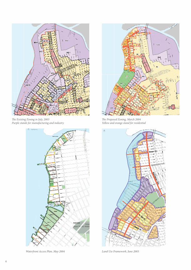
Th e Proposed Zoning, March 2004Yellow and orange stand for residential
K ING
S
M3-1M3-1M3-1M3-1M3-1M3-1M3-1M3-1M3-1M3-1M3-1M3-1M3-1M3-1M3-1M3-1M3-1M3-1M3-1M3-1M3-1M3-1M3-1M3-1M3-1M3-1M3-1M3-1M3-1M3-1M3-1M3-1M3-1M3-1M3-1M3-1M3-1M3-1M3-1M3-1M3-1M3-1M3-1M3-1M3-1M3-1M3-1M3-1M3-1M3-1M3-1M3-1M3-1M3-1M3-1M3-1M3-1M3-1M3-1M3-1M3-1M3-1M3-1M3-1M3-1M3-1M3-1M3-1M3-1M3-1M3-1M3-1M3-1M3-1M3-1M3-1M3-1M3-1M3-1M3-1M3-1M3-1M3-1M3-1M3-1M3-1M3-1M3-1M3-1M3-1M3-1M3-1M3-1M3-1M3-1M3-1M3-1M3-1M3-1M3-1M3-1M3-1M3-1M3-1M3-1M3-1M3-1M3-1M3-1M3-1M3-1M3-1M3-1M3-1M3-1M3-1M3-1M3-1M3-1M3-1M3-1M3-1M3-1M3-1M3-1M3-1M3-1M3-1M3-1M3-1M3-1M3-1M3-1M3-1M3-1M3-1M3-1M3-1M3-1M3-1M3-1M3-1M3-1M3-1M3-1M3-1M3-1M3-1M3-1M3-1M3-1M3-1M3-1M3-1M3-1M3-1M3-1M3-1M3-1M3-1M3-1M3-1M3-1M3-1M3-1M3-1M3-1M3-1M3-1M3-1M3-1M3-1M3-1M3-1M3-1M3-1M3-1M3-1M3-1M3-1M3-1M3-1M3-1M3-1M3-1M3-1M3-1M3-1M3-1M3-1M3-1M3-1M3-1M3-1M3-1M3-1M3-1M3-1M3-1M3-1M3-1M3-1M3-1M3-1M3-1M3-1M3-1M3-1M3-1M3-1M3-1M3-1M3-1M3-1M3-1M3-1M3-1M3-1M3-1M3-1M3-1M3-1M3-1M3-1M3-1M3-1M3-1M3-1M3-1M3-1M3-1M3-1M3-1M3-1M3-1M3-1M3-1M3-1M3-1M3-1M3-1M3-1M3-1M3-1M3-1M3-1M3-1M3-1M3-1M3-1M3-1M3-1M3-1M3-1M3-1M3-1M3-1M3-1M3-1M3-1M3-1M3-1M3-1M3-1M3-1M3-1M3-1M3-1M3-1M3-1M3-1M3-1M3-1M3-1M3-1M3-1M3-1M3-1M3-1M3-1M3-1M3-1M3-1M3-1M3-1M3-1M3-1M3-1M3-1M3-1M3-1M3-1M3-1M3-1M3-1M3-1M3-1M3-1M3-1M3-1M3-1M3-1M3-1M3-1M3-1M3-1M3-1M3-1M3-1M3-1M3-1M3-1M3-1M3-1M3-1M3-1M3-1M3-1M3-1M3-1M3-1M3-1M3-1M3-1M3-1M3-1M3-1M3-1M3-1M3-1M3-1M3-1M3-1M3-1M3-1M3-1M3-1M3-1M3-1M3-1M3-1M3-1M3-1M3-1M3-1M3-1M3-1M3-1M3-1M3-1M3-1M3-1M3-1M3-1M3-1M3-1M3-1M3-1M3-1M3-1M3-1M3-1M3-1M3-1M3-1M3-1M3-1M3-1M3-1M3-1M3-1M3-1M3-1M3-1M3-1M3-1M3-1M3-1M3-1M3-1M3-1M3-1M3-1M3-1M3-1M3-1M3-1M3-1M3-1M3-1M3-1M3-1M3-1M3-1M3-1M3-1M3-1M3-1M3-1M3-1M3-1M3-1M3-1M3-1M3-1M3-1M3-1M3-1M3-1M3-1M3-1M3-1M3-1M3-1M3-1M3-1M3-1M3-1M3-1M3-1M3-1M3-1M3-1M3-1M3-1M3-1M3-1M3-1M3-1M3-1M3-1M3-1M3-1M3-1M3-1M3-1M3-1M3-1M3-1M3-1M3-1M3-1M3-1M3-1M3-1M3-1M3-1M3-1M3-1M3-1M3-1M3-1M3-1M3-1M3-1M3-1M3-1M3-1M3-1M3-1M3-1M3-1M3-1M3-1M3-1M3-1M3-1M3-1M3-1M3-1M3-1M3-1M3-1M3-1M3-1M3-1M3-1M3-1M3-1M3-1M3-1M3-1M3-1M3-1M3-1M3-1M3-1M3-1M3-1M3-1M3-1M3-1M3-1M3-1M3-1M3-1M3-1M3-1M3-1M3-1M3-1M3-1M3-1M3-1M3-1M3-1M3-1M3-1M3-1M3-1M3-1M3-1M3-1M3-1M3-1M3-1M3-1M3-1M3-1M3-1M3-1M3-1M3-1M3-1M3-1M3-1M3-1M3-1M3-1M3-1M3-1M3-1M3-1M3-1M3-1M3-1M3-1M3-1M3-1M3-1M3-1M3-1M3-1M3-1M3-1M3-1M3-1M3-1M3-1M3-1M3-1M3-1M3-1M3-1M3-1M3-1M3-1M3-1M3-1M3-1M3-1M3-1M3-1M3-1M3-1M3-1M3-1M3-1M3-1M3-1M3-1M3-1M3-1M3-1M3-1M3-1M3-1M3-1M3-1M3-1M3-1M3-1M3-1M3-1M3-1M3-1M3-1M3-1M3-1M3-1M3-1M3-1M3-1M3-1M3-1M3-1M3-1M3-1M3-1M3-1M3-1M3-1M3-1M3-1M3-1M3-1M3-1M3-1M3-1M3-1M3-1M3-1M3-1M3-1M3-1M3-1M3-1M3-1M3-1M3-1M3-1M3-1M3-1M3-1M3-1M3-1M3-1M3-1M3-1M3-1M3-1M3-1M3-1M3-1M3-1M3-1M3-1M3-1M3-1M3-1M3-1M3-1M3-1M3-1M3-1M3-1M3-1M3-1M3-1M3-1M3-1M3-1M3-1M3-1M3-1M3-1M3-1M3-1M3-1M3-1M3-1M3-1M3-1M3-1M3-1M3-1M3-1M3-1M3-1M3-1M3-1M3-1M3-1M3-1M3-1M3-1M3-1M3-1M3-1M3-1M3-1M3-1M3-1M3-1M3-1M3-1M3-1M3-1M3-1M3-1M3-1M3-1M3-1M3-1M3-1M3-1M3-1M3-1M3-1M3-1M3-1M3-1M3-1M3-1M3-1M3-1M3-1M3-1M3-1M3-1M3-1M3-1M3-1M3-1M3-1M3-1M3-1M3-1M3-1M3-1M3-1M3-1M3-1M3-1M3-1M3-1M3-1M3-1M3-1M3-1M3-1M3-1M3-1M3-1M3-1M3-1M3-1M3-1M3-1M3-1M3-1M3-1M3-1M3-1M3-1M3-1M3-1M3-1M3-1M3-1M3-1M3-1M3-1M3-1M3-1M3-1M3-1M3-1M3-1M3-1M3-1M3-1M3-1M3-1M3-1M3-1M3-1M3-1M3-1M3-1M3-1M3-1M3-1M3-1M3-1M3-1M3-1M3-1M3-1M3-1M3-1M3-1M3-1M3-1M3-1M3-1M3-1M3-1M3-1M3-1M3-1M3-1M3-1M3-1M3-1M3-1M3-1M3-1M3-1M3-1M3-1M3-1M3-1M3-1M3-1M3-1M3-1M3-1M3-1M3-1M3-1M3-1M3-1M3-1M3-1M3-1M3-1M3-1M3-1M3-1M3-1M3-1M3-1M3-1M3-1M3-1M3-1M3-1M3-1M3-1M3-1M3-1M3-1M3-1M3-1M3-1M3-1M3-1M3-1M3-1M3-1M3-1M3-1M3-1M3-1M3-1M3-1M3-1M3-1M3-1M3-1M3-1M3-1M3-1M3-1M3-1M3-1M3-1M3-1M3-1M3-1M3-1M3-1M3-1M3-1M3-1M3-1M3-1M3-1M3-1M3-1M3-1M3-1M3-1M3-1M3-1M3-1M3-1M3-1M3-1M3-1M3-1M3-1M3-1M3-1M3-1M3-1M3-1M3-1M3-1M3-1M3-1M3-1M3-1M3-1M3-1M3-1M3-1M3-1M3-1M3-1M3-1M3-1M3-1M3-1M3-1M3-1M3-1M3-1M3-1M3-1M3-1M3-1M3-1M3-1M3-1M3-1M3-1M3-1M3-1M3-1M3-1M3-1M3-1M3-1M3-1M3-1M3-1M3-1M3-1M3-1M3-1M3-1M3-1M3-1M3-1M3-1M3-1M3-1M3-1M3-1M3-1M3-1M3-1M3-1M3-1M3-1M3-1M3-1M3-1M3-1M3-1M3-1M3-1M3-1M3-1M3-1M3-1M3-1M3-1M3-1M3-1M3-1M3-1M3-1M3-1M3-1M3-1M3-1M3-1M3-1M3-1M3-1M3-1M3-1M3-1M3-1M3-1M3-1M3-1M3-1M3-1M3-1M3-1M3-1M3-1M3-1M3-1M3-1M3-1M3-1M3-1M3-1M3-1M3-1M3-1M3-1M3-1M3-1M3-1M3-1M3-1M3-1M3-1M3-1M3-1M3-1M3-1M3-1M3-1M3-1M3-1M3-1M3-1M3-1M3-1M3-1M3-1M3-1M3-1M3-1M3-1M3-1M3-1M3-1M3-1M3-1M3-1M3-1M3-1M3-1M3-1M3-1M3-1M3-1M3-1M3-1M3-1M3-1M3-1M3-1M3-1M3-1M3-1M3-1M3-1M3-1M3-1M3-1M3-1M3-1M3-1M3-1M3-1M3-1M3-1M3-1M3-1M3-1M3-1M3-1M3-1M3-1M3-1M3-1M3-1M3-1M3-1M3-1M3-1M3-1M3-1M3-1M3-1M3-1M3-1M3-1M3-1M3-1M3-1M3-1M3-1M3-1M3-1M3-1M3-1M3-1M3-1M3-1M3-1M3-1M3-1M3-1M3-1M3-1M3-1M3-1M3-1M3-1M3-1M3-1M3-1M3-1M3-1M3-1M3-1M3-1M3-1M3-1M3-1M3-1M3-1M3-1M3-1M3-1M3-1M3-1M3-1M3-1M3-1M3-1M3-1M3-1M3-1M3-1M3-1M3-1M3-1M3-1M3-1M3-1M3-1M3-1M3-1M3-1M3-1M3-1M3-1M3-1M3-1M3-1M3-1M3-1M3-1M3-1M3-1M3-1M3-1M3-1M3-1M3-1M3-1M3-1M3-1M3-1M3-1M3-1M3-1M3-1M3-1M3-1M3-1M3-1M3-1M3-1M3-1M3-1M3-1M3-1M3-1M3-1M3-1M3-1M3-1M3-1M3-1M3-1M3-1M3-1M3-1M3-1M3-1M3-1M3-1M3-1M3-1M3-1M3-1M3-1M3-1M3-1M3-1M3-1M3-1M3-1M3-1M3-1M3-1M3-1M3-1M3-1M3-1M3-1M3-1M3-1M3-1M3-1M3-1M3-1M3-1M3-1M3-1M3-1M3-1M3-1M3-1M3-1M3-1M3-1M3-1M3-1M3-1M3-1M3-1M3-1M3-1M3-1M3-1M3-1M3-1M3-1M3-1M3-1M3-1M3-1M3-1M3-1M3-1M3-1M3-1M3-1M3-1M3-1M3-1M3-1M3-1M3-1M3-1M3-1M3-1M3-1M3-1M3-1M3-1M3-1M3-1M3-1M3-1M3-1M3-1M3-1M3-1M3-1M3-1M3-1M3-1M3-1M3-1M3-1M3-1M3-1M3-1M3-1M3-1M3-1M3-1M3-1M3-1M3-1M3-1M3-1M3-1M3-1M3-1M3-1M3-1M3-1M3-1M3-1M3-1M3-1M3-1M3-1M3-1M3-1M3-1M3-1M3-1M3-1M3-1M3-1M3-1M3-1M3-1M3-1M3-1M3-1M3-1M3-1M3-1M3-1M3-1M3-1M3-1M3-1M3-1M3-1M3-1M3-1M3-1M3-1M3-1M3-1M3-1M3-1M3-1M3-1M3-1M3-1M3-1M3-1M3-1M3-1M3-1M3-1M3-1M3-1M3-1M3-1M3-1M3-1M3-1M3-1M3-1M3-1M3-1M3-1M3-1M3-1M3-1M3-1M3-1M3-1M3-1M3-1M3-1M3-1M3-1M3-1M3-1M3-1M3-1M3-1M3-1M3-1M3-1M3-1M3-1M3-1M3-1M3-1M3-1M3-1M3-1M3-1M3-1M3-1M3-1M3-1M3-1M3-1M3-1M3-1M3-1M3-1M3-1M3-1M3-1M3-1M3-1M3-1M3-1M3-1M3-1M3-1M3-1M3-1M3-1M3-1M3-1M3-1M3-1M3-1M3-1M3-1M3-1M3-1M3-1M3-1M3-1M3-1M3-1M3-1M3-1M3-1M3-1M3-1M3-1M3-1M3-1M3-1M3-1M3-1M3-1M3-1M3-1M3-1M3-1M3-1M3-1M3-1M3-1M3-1M3-1M3-1M3-1M3-1M3-1M3-1M3-1M3-1M3-1M3-1M3-1M3-1M3-1M3-1M3-1M3-1M3-1M3-1M3-1M3-1M3-1M3-1M3-1M3-1M3-1M3-1M3-1M3-1M3-1M3-1M3-1M3-1M3-1M3-1M3-1M3-1M3-1M3-1M3-1M3-1M3-1M3-1M3-1M3-1M3-1M3-1M3-1M3-1M3-1M3-1M3-1M3-1M3-1M3-1M3-1M3-1M3-1M3-1M3-1M3-1M3-1M3-1M3-1M3-1M3-1M3-1M3-1M3-1M3-1M3-1M3-1M3-1M3-1M3-1M3-1M3-1M3-1M3-1M3-1M3-1M3-1M3-1M3-1M3-1M3-1M3-1M3-1M3-1M3-1M3-1M3-1M3-1M3-1M3-1M3-1M3-1M3-1M3-1M3-1M3-1M3-1M3-1M3-1M3-1M3-1M3-1M3-1M3-1M3-1M3-1M3-1M3-1M3-1M3-1M3-1M3-1M3-1M3-1M3-1M3-1M3-1M3-1M3-1M3-1M3-1M3-1M3-1M3-1M3-1M3-1M3-1M3-1M3-1M3-1M3-1M3-1M3-1M3-1M3-1M3-1M3-1M3-1M3-1M3-1M3-1M3-1M3-1M3-1M3-1M3-1M3-1M3-1M3-1M3-1M3-1M3-1M3-1M3-1M3-1M3-1M3-1M3-1M3-1M3-1M3-1M3-1M3-1M3-1M3-1M3-1M3-1M3-1M3-1M3-1M3-1M3-1M3-1M3-1M3-1M3-1M3-1M3-1M3-1M3-1M3-1M3-1M3-1M3-1M3-1M3-1M3-1M3-1M3-1M3-1M3-1M3-1M3-1M3-1M3-1M3-1M3-1M3-1M3-1M3-1M3-1M3-1M3-1M3-1M3-1M3-1M3-1M3-1M3-1M3-1M3-1M3-1M3-1M3-1M3-1M3-1M3-1M3-1M3-1M3-1M3-1M3-1M3-1M3-1M3-1M3-1M3-1M3-1M3-1M3-1M3-1M3-1M3-1M3-1M3-1M3-1M3-1M3-1M3-1M3-1M3-1M3-1M3-1M3-1M3-1M3-1M3-1M3-1M3-1M3-1M3-1M3-1M3-1M3-1M3-1M3-1M3-1M3-1M3-1M3-1M3-1M3-1M3-1M3-1M3-1M3-1M3-1M3-1M3-1M3-1M3-1M3-1M3-1M3-1M3-1M3-1M3-1M3-1M3-1M3-1M3-1M3-1M3-1M3-1M3-1M3-1M3-1M3-1M3-1M3-1M3-1M3-1M3-1M3-1M3-1M3-1M3-1M3-1M3-1M3-1M3-1M3-1M3-1M3-1M3-1M3-1M3-1M3-1M3-1M3-1M3-1M3-1M3-1M3-1M3-1M3-1M3-1M3-1M3-1M3-1M3-1M3-1M3-1M3-1M3-1M3-1M3-1M3-1M3-1M3-1M3-1M3-1M3-1M3-1M3-1M3-1M3-1M3-1M3-1M3-1M3-1M3-1M3-1M3-1M3-1M3-1M3-1M3-1M3-1M3-1M3-1M3-1M3-1M3-1M3-1M3-1M3-1M3-1M3-1M3-1M3-1M3-1M3-1M3-1M3-1M3-1M3-1M3-1M3-1M3-1M3-1M3-1M3-1M3-1M3-1M3-1M3-1M3-1M3-1M3-1M3-1M3-1M3-1M3-1M3-1M3-1M3-1M3-1M3-1M3-1M3-1M3-1M3-1M3-1M3-1M3-1M3-1M3-1M3-1M3-1M3-1M3-1M3-1M3-1M3-1M3-1M3-1M3-1M3-1M3-1M3-1M3-1M3-1M3-1M3-1M3-1M3-1M3-1M3-1M3-1M3-1M3-1M3-1M3-1M3-1M3-1M3-1M3-1M3-1M3-1M3-1M3-1M3-1M3-1M3-1M3-1M3-1M3-1M3-1M3-1M3-1M3-1M3-1M3-1M3-1M3-1M3-1M3-1M3-1M3-1M3-1M3-1M3-1M3-1M3-1M3-1M3-1M3-1M3-1M3-1M3-1M3-1M3-1M3-1M3-1M3-1M3-1M3-1M3-1M3-1M3-1M3-1M3-1M3-1M3-1M3-1M3-1M3-1M3-1M3-1M3-1M3-1M3-1M3-1M3-1M3-1M3-1M3-1M3-1M3-1M3-1M3-1M3-1M3-1M3-1M3-1M3-1M3-1M3-1M3-1M3-1M3-1M3-1M3-1M3-1M3-1M3-1M3-1M3-1M3-1M3-1M3-1M3-1M3-1M3-1M3-1M3-1M3-1M3-1M3-1M3-1M3-1M3-1M3-1M3-1M3-1M3-1M3-1M3-1M3-1M3-1M3-1M3-1M3-1M3-1M3-1M3-1M3-1M3-1M3-1M3-1M3-1M3-1M3-1M3-1M3-1M3-1M3-1M3-1M3-1M3-1M3-1M3-1M3-1M3-1M3-1M3-1M3-1M3-1M3-1M3-1M3-1M3-1M3-1M3-1M3-1M3-1M3-1M3-1M3-1M3-1M3-1M3-1M3-1M3-1M3-1M3-1M3-1M3-1M3-1M3-1M3-1M3-1M3-1M3-1M3-1M3-1M3-1M3-1M3-1M3-1M3-1M3-1M3-1M3-1M3-1M3-1M3-1M3-1M3-1M3-1M3-1M3-1M3-1M3-1M3-1M3-1M3-1M3-1M3-1M3-1M3-1M3-1M3-1M3-1M3-1M3-1M3-1M3-1M3-1M3-1M3-1M3-1M3-1M3-1M3-1M3-1M3-1M3-1M3-1M3-1M3-1M3-1
Th e Existing Zoning in July, 2003Purple stands for manufacturing and industry
Waterfront Access Plan, May 2004
DIA
Land Use Framework, June 2003
5
Before the Plan was adopted, the zoning of the Greenpoint-Williamsburg Waterfront refl ected the historical land uses that once dominated the area. As seen on the map to the left , the entire waterfront was zoned for heavy industrial uses and manufacturing represented by the darkest purple. Adjoining this working waterfront was a zone of lighter industry that formed a buff er between the waterfront industry and a traditional residential core following Manhattan Avenue7. In general, (new) residential uses were prohibited in areas zoned for manufacturing but in the 1970s two areas were recognized for their mixed-use character: the Northside and Franklin Street Mixed-Use districts, seen on the map as letters N and FR.
When we look at the new zoning map proposed by the Plan, especially the waterfront, we can see how the neighborhood is being transformed. Almost the entire three kilometer stretch of waterfront has been rezoned for high density residential uses, represented by R6 & R8 areas shown on the map to the left . Surrounding the Bushwick Inlet, we fi nd a large new park of about 113.300m2 (the green area on the map). Th e waterfront to the North East at Newtown Creek has remained industrial as it is part of the larger Newtown Creek Industrial Business Zone or IBZ (it is also defi ned as a Signifi cant Maritime and Industrial Area or SMIA) and is therefore “protected” against other uses8.
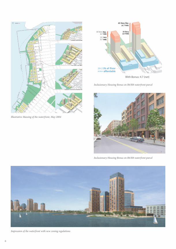
Th e rezoning map complies with a preceding Waterfront Access Plan that set out to create a large amount of new green public space (about 200.000 m2), a 2.5km continuous walkway on the shoreline and publicly accessible piers prior to development of the area9. Th ese interventions are in accordance with the goals and visions for New York City’s waterfront that result from extensive studies performed by the Mayor’s offi ce, more specifi cally the 1992 Comprehensive Waterfront Plan and the more recent Vision202010. Because the majority of waterfront sites are privately owned, providing waterfront access could only be achieved by allowing development that also is fi nancially feasible i.e. commercial or residential use. Th e New York City Zoning Resolution has a set of regulations called “Public Access Requirements” that forces public access on commercial or residential developments at waterfront parcels11. With these rules the Department of City Planning is able to allow for new uses on privately owned (vacant) waterfront lots (e.g. market rate housing) while at the same time connecting the waterfront with the adjacent communities. Th is results in waterfront parks that are privately paid for but publicly accessible. In a similar manner, the need for new aff ordable housing would as well be met. Th rough inclusionary housing requirements, developers are obliged to include a certain percentage of aff ordable housing units. Th is is a measure that couples market rate development with income restricted housing. On the other hand, developers are allowed to built higher and with bigger FAR12 values, to compensate for the loss in buildable area that is open space and for the loss in profi ts.
Th e possible consequence of these rezoning measures is a waterfront that over time will transform in a high density residential strip with green space surrounding it. Or as formulated by the DCP in their waterfront development principles: Locate taller buildings near the water’s edge and create a varied and compelling skyline13.Th e amount of space zoned for industrial uses has therefore been decreased drastically in favor of residential uses. Industry and manufacturing are being pushed out towards concentrated business areas such as Newtown Creek. To “honor” the mixed use character of the neighborhood (and the two disctricts created in the 70s) MX districts are expanded inland of Greenpoint-Williamsburg albeit with more commercial uses instead of the original light manufacturing. In this manner, commercialization of corridors is being promoted in accordance with a land use framework that was developed prior to the Plan (as seen in the image on the left , the orange zones)14.
7. Planning Framework Overview, http://www.nyc.gov/html/dcp/html/greenpointwill/greenplan2.shtml, Accessed October 26, 20118. the 2005 New York City Industrial Policy outlined the IBZs; they result from the SMIAs defi ned in the 1992 Comprehensive Waterfront Plan 9. Th e Greenpoint-Williamsburg Waterfront Access Plan, http://www.nyc.gov/html/dcp/html/greenpointwill/greenwateraccess2.shtml, Accessed October 26, 201110. Vision2020 was presented in May 201111. Waterfront Zoning Requirements, http://www.nyc.gov/html/dcp/html/greenpointwill/greenwateraccessplan.shtml, Accessed February 4, 201212. FAR stands for “fl oor area ratio” 13. Waterfront Development Principles, http://www.nyc.gov/html/dcp/html/greenpointwill/greenwaterdevelop1.shtml, Accessed February 4, 201214. Community Development Studio, Rutgers University, Spring 2007, p4
cHanging tHe WaterFront: reZoning
6
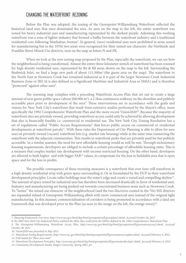
Illustrative Massing of the waterfront, May 2004
Impression of the waterfront with new zoning regulations
20-25% of floor 20-25% of floor area affordablearea affordable
30 Story Max.30 Story Max.(4.7 FAR)(4.7 FAR)
23 Story23 Story(3.7 FAR)(3.7 FAR)
40 Story Max.(4.7 FAR)
33 Story(3.7 FAR)
With Bonus: 4.7 (net)
Inclusionary Housing Bonus on R6/R8 waterfront parcel
Inclusionary Housing Bonus on R6/R8 waterfront parcel
7
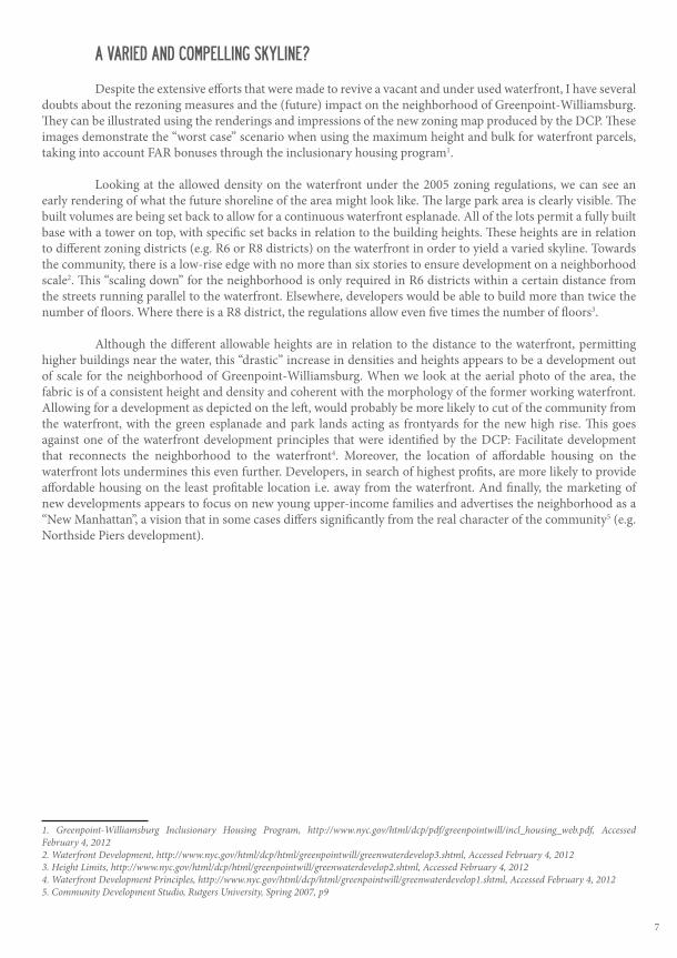
Despite the extensive efforts that were made to revive a vacant and under used waterfront, I have several doubts about the rezoning measures and the (future) impact on the neighborhood of Greenpoint-Williamsburg. They can be illustrated using the renderings and impressions of the new zoning map produced by the DCP. These images demonstrate the “worst case” scenario when using the maximum height and bulk for waterfront parcels, taking into account FAR bonuses through the inclusionary housing program1.
Looking at the allowed density on the waterfront under the 2005 zoning regulations, we can see an early rendering of what the future shoreline of the area might look like. The large park area is clearly visible. The built volumes are being set back to allow for a continuous waterfront esplanade. All of the lots permit a fully built base with a tower on top, with specific set backs in relation to the building heights. These heights are in relation to different zoning districts (e.g. R6 or R8 districts) on the waterfront in order to yield a varied skyline. Towards the community, there is a low-rise edge with no more than six stories to ensure development on a neighborhood scale2. This “scaling down” for the neighborhood is only required in R6 districts within a certain distance from the streets running parallel to the waterfront. Elsewhere, developers would be able to build more than twice the number of floors. Where there is a R8 district, the regulations allow even five times the number of floors3.
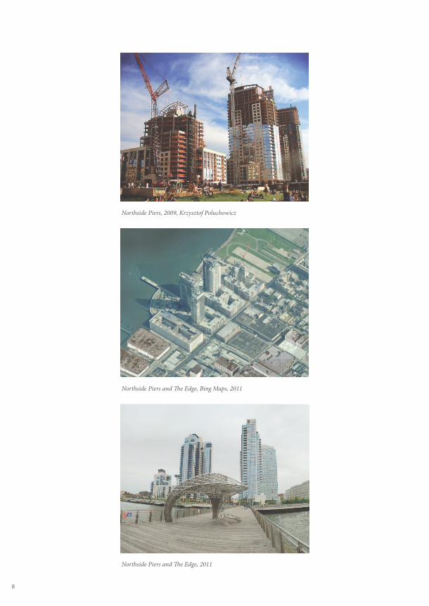
Although the different allowable heights are in relation to the distance to the waterfront, permitting higher buildings near the water, this “drastic” increase in densities and heights appears to be a development out of scale for the neighborhood of Greenpoint-Williamsburg. When we look at the aerial photo of the area, the fabric is of a consistent height and density and coherent with the morphology of the former working waterfront. Allowing for a development as depicted on the left, would probably be more likely to cut of the community from the waterfront, with the green esplanade and park lands acting as frontyards for the new high rise. This goes against one of the waterfront development principles that were identified by the DCP: Facilitate development that reconnects the neighborhood to the waterfront4. Moreover, the location of affordable housing on the waterfront lots undermines this even further. Developers, in search of highest profits, are more likely to provide affordable housing on the least profitable location i.e. away from the waterfront. And finally, the marketing of new developments appears to focus on new young upper-income families and advertises the neighborhood as a “New Manhattan”, a vision that in some cases differs significantly from the real character of the community5 (e.g. Northside Piers development).
1. Greenpoint-Williamsburg Inclusionary Housing Program, http://www.nyc.gov/html/dcp/pdf/greenpointwill/incl_housing_web.pdf, Accessed February 4, 20122. Waterfront Development, http://www.nyc.gov/html/dcp/html/greenpointwill/greenwaterdevelop3.shtml, Accessed February 4, 20123. Height Limits, http://www.nyc.gov/html/dcp/html/greenpointwill/greenwaterdevelop2.shtml, Accessed February 4, 20124. Waterfront Development Principles, http://www.nyc.gov/html/dcp/html/greenpointwill/greenwaterdevelop1.shtml, Accessed February 4, 20125. Community Development Studio, Rutgers University, Spring 2007, p9
a varied and compelling skyline?
8
Northside Piers, 2009, Krzysztof Poluchowicz
Northside Piers and Th e Edge, 2011
Northside Piers and Th e Edge, Bing Maps, 2011
9
closing statement
The rezoning of Greenpoint-Williamsburg has effectively accelerated the residential development in the area and especially on the formerly industrial waterfront. Vision 2020 reports of a transformation resulting in the building of 2700 new housing units since the rezoning of 2005 with another 2900 units in development15. It provides for mid-rise and high-rise developments on the waterfront which will give incredible views on Manhattan. Project marketing often uses this to promote certain developments. One could say that the zoning change and the impressions made are just a theoretical representation of what “could be”. But in fact, development has been in progress for quite a while. An exemplary project is Northside Piers, located near the Bushwick Inlet. It provides over 900 market rate housing units in three towers, benefitting from the FAR bonus through the inclusionary housing program. This results in approximately 113 affordable housing units on site and another 76 units off-site. Upon completion, this project almost perfectly corresponds to the theoretical bulk and height allowed on this waterfront parcel. Or formulated differently: Thirty stories of shimmering glass that redefine the Williamsburg waterfront16. Another project called the Edge is located next to the Northside Piers development. It includes high-rise and mid-rise buildings and some retail spaces with a total of 892 luxurious residential units17. This development as well takes benefit from the total allowed bulk and height to provide the greatest number of market rate appartments and condominiums.
Michael Marella stated on The Architects Newspaper that Greenpoint-Williamsburg is a clear example of rezoning that gives residential development the waterfront and moves manufacturing to the interior opposed to integrating both with access to the water18. In a way, this is consistent with a trend of converting the shoreline from a working waterfront to high end real estate, that has been occurring for the last few decades19. Even before the rezoning of 2005, property owners saw the opportunity to increase income by getting rid of industrial firms in favor of higher rents, especially in mixed-use districts. A report by the Pratt Center in 2001 even stated that “the primary reason that manufacturing uses have declined in mixed-use districts is that an influx of non-manufacturing uses has caused property values to rise, prompting owners of manufacturing buildings to replace manufacturers with other uses that can generate higher revenues.” Since the approval of the first Comprehensive Waterfront Plan in 1992 and waterfront zoning in 1993, it appears that it is easier to rezone industrial waterfront for impressive high-rises in neighborhoods20. Although these developments are also a means of providing neighborhoods with much needed housing stock, more importantly affordable housing, these facilities aren’t always (partly) reserved for neighborhood residents21.
15. Vision 2020, March 2011, Greenpoint-Williamsburg Transformation, p1316. New York’s New Perspective, http://www.northsidepiers.com/index.shtml, Accessed February 4, 201217. Community Development Studio, Rutgers University, Spring 2007, p918. On The Waterfront, The Architect’s Newspaper, September 26 2011, Accessed October 24, 2011: Michael Marella worked on Vision 202019. Tom Angotti, On The Waterfront plan: Real Estate Dreams and Future Conflicts, January 2011, Accessed October 24, 201120. Tom Angotti, On The Waterfront plan: Real Estate Dreams and Future Conflicts, January 2011, Accessed October 24, 201121. Community Development Studio, Rutgers University, Spring 2007, p9

10
11
New York Harbor Background, Planning, Waterfront & Vision 2020
Vision 2020, March 20111992 Comprehensive Waterfront Plan
http://www.nyc.gov/html/dcp/html/cwp/index.shtml;http://www.nyc.gov/html/waves/html/home/home.shtml;http://www.nyc.gov/html/waves/html/gallery/gallery.shtml;http://www.nyc.gov/html/dcp/html/rezonings/rezonings.shtml;http://www.dec.ny.gov/lands/317.html;http://www.nyc.gov/html/dcp/html/wrp/wrp.shtml;http://www.panynj.gov/about/coastal-eco-systems.html;http://www.gothamgazette.com/article/landuse/20110124/12/3457http://www.nytimes.com/2010/11/07/realestate/07cov.html?_r=1&scp=5&sq=project%20waterfront&st=csehttp://en.wikipedia.org/wiki/New_York_Harbor; last modified on 14 October 2011 at 09:00;http://en.wikipedia.org/wiki/Port_of_New_York_and_New_Jersey; 4 October 2011 at 14:08;http://www.nytimes.com/2007/06/14/arts/design/14wate.html;http://www.preservationnation.org/travel-and-sites/sites/northeast-region/brooklyns-industrial-waterfront.html;http://www.archpaper.com/news/articles.asp?id=5650http://saveindustrialbrooklyn.org/http://www.guardian.co.uk/world/2011/may/01/new-york-harbour-city-againhttp://www.washingtonpost.com/wp-dyn/content/article/2011/03/13/AR2011031303804.html
Greenpoint-Williamsburg
Greenpoint-Williamsburg Waterfront and Land Use PlanGreenpoint-Williamsburg Waterfront Access Plan
http://www.nyc.gov/html/dcp/html/greenpointwill/greenoverview.shtmlhttp://nymag.com/realestate/articles/neighborhoods/williamsburg.htmhttp://www.nyc.gov/html/dcp/pdf/greenpointwill/gw_fuca_sum.pdfhttp://www.nyc.gov/html/dcp/pdf/greenpointwill/waterfront_access_plan_map.pdfhttp://www.nyc.gov/html/dcp/pdf/greenpointwill/landuse_0903.pdfhttp://www.nyc.gov/html/dcp/pdf/greenpointwill/existing_zoning.pdfhttp://www.nyc.gov/html/dcp/pdf/greenpointwill/propzone.pdfhttp://www.nyc.gov/html/dcp/pdf/greenpointwill/wap.pdfhttp://www.nyc.gov/html/dcp/pdf/greenpointwill/framework.pdfhttp://www.nycgovparks.org/sub_your_park/greenpoint_williamsburg_waterfront/greenpoint-williamsburg.htmlhttp://www.nycgovparks.org/sub_your_park/greenpoint_williamsburg_waterfront/images/greenpoint_williamsburg_waterfront_masterplan.pdfhttp://policy.rutgers.edu/academics/projects/studios/Williamsburg07r.pdfhttp://northbrooklyn.org/econdev.phphttp://www.cb1brooklyn.org/PDF/CB1-RTF%20ULURP%20POSITION%20STATEMENT%20AND%20RECOMMENDATIONS.pdfhttp://www.nyc.gov/html/dcp/html/greenpointwill/greenplan3.shtmlhttp://www.nyc.gov/html/dcp/html/greenpointwill/greenwaterdevelop1.shtmlhttp://www.nyc.gov/html/dcp/html/greenpointwill/greenwaterdevelop2.shtmlhttp://www.nyc.gov/html/dcp/html/greenpointwill/greenwaterdevelop3.shtmlhttp://www.nyc.gov/html/dcp/pdf/greenpointwill/gw_feis_ch_03.pdfhttp://www.nyc.gov/html/dcp/pdf/wrp/newtowncreek.pdfhttp://www.nyc.gov/html/dcp/html/pub/wf.shtmlhttp://www.nyc.gov/html/dcp/pdf/pub/cwp.pdfhttp://online.wsj.com/article/SB10001424052702303823104576391681273001042.html?mod=wsj_share_twitterhttp://www.nyc.gov/html/lpc/downloads/pdf/reports/austinnichols.pdfhttp://www.gothamgazette.com/unpreserved/6.shtmlhttp://www.gothamgazette.com/article/waterfront/20060511/18/1848http://gothamist.com/2006/05/03/greenpoint_term.phphttp://www.northsidepiers.com/index.shtmlhttp://www.williamsburgedge.com/http://www.panoramio.com/photo/52851141
Access times are added to footnotes
sources: