geologic lake guide along lake powell, glen...
TRANSCRIPT
Geologic Road, Trail, and Lake Guides to Utah's Parks and Monuments 2000 Utah Geological Association Publication 29 P.B. Anderson and D.A. Sprinkel, editors
INTRODUCTION The walls are steadily increasing in altitude, the curves are gentle, and often the river sweeps by an arc of vertical wall, smooth and unbroken, and then by a curve that is variegated by royal arches, mossy alcoves, deep, beautiful glens, and painted grottoes. —Major John Wesley Powell, July 31, 1869
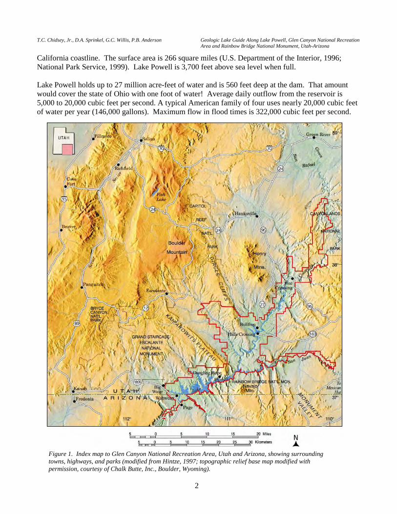
Major John Wesley Powell wrote these words to describe an area near the mouth of the San Juan River, Utah during his first expedition into the canyons of the Colorado River. Powell was particularly impressed with the many "beautiful glens" along this stretch of the Colorado River, and thus named the area Glen Canyon. The purpose of his 1869 expedition was purely scientific—to document the geology, geography, and natural history of the region, and ultimately determine if it could be settled with limited supplies of water. Though his expedition was "scientific," Powell was well aware that he was competing with other government surveys for funds, and that adventures such as his river trips drew much public interest and support. One hundred and three years later, Congress established Glen Canyon National Recreation Area on October 27, 1972. It is located principally in southeastern Utah, with a small portion within northernmost Arizona (figure 1). The recreation area protects lands primarily adjacent to the large reservoir created by the construction of Glen Canyon Dam on the Colorado River, Lake Powell, named after the famous explorer and geologist. The 710-foot-high Glen Canyon Dam, located near Page, Arizona (figure 2), was authorized by Congress in 1956 to provide water storage in the upper Colorado River basin, and construction began that same year. Lake Powell stores water from the Colorado River and several major tributaries, including the Green, Yampa, White, Dolores, Dirty Devil, and San Juan Rivers. The gates of the Glen Canyon Dam were closed on March 13, 1963. However, the lake did not reach full capacity until June 22, 1980, and again in 1983 and 1984. Lake Powell is now the second largest reservoir in the United States (Lake Mead in Nevada and Arizona is the largest). The lake is 186 miles long, and with 96 major side canyons, it has more than 1,960 miles of shoreline—more than twice the length of the
GEOLOGIC LAKE GUIDE ALONG LAKE POWELL, GLEN CANYON NATIONAL RECREATION AREA AND RAINBOW BRIDGE NATIONAL MONUMENT, UTAH-ARIZONA Thomas C. Chidsey, Jr., Utah Geological Survey, Salt Lake City, Utah Douglas A. Sprinkel, Utah Geological Survey, Salt Lake City, Utah Grant C. Willis, Utah Geological Survey, Salt Lake City, Utah
Paul B. Anderson, Consulting Geologist, Salt Lake City, Utah
1
T.C. Chidsey, Jr., D.A. Sprinkel, G.C. Willis, P.B. Anderson Geologic Lake Guide Along Lake Powell, Glen Canyon National Recreation Area and Rainbow Bridge National Monument, Utah-Arizona
2
California coastline. The surface area is 266 square miles (U.S. Department of the Interior, 1996; National Park Service, 1999). Lake Powell is 3,700 feet above sea level when full. Lake Powell holds up to 27 million acre-feet of water and is 560 feet deep at the dam. That amount would cover the state of Ohio with one foot of water! Average daily outflow from the reservoir is 5,000 to 20,000 cubic feet per second. A typical American family of four uses nearly 20,000 cubic feet of water per year (146,000 gallons). Maximum flow in flood times is 322,000 cubic feet per second.
Figure 1. Index map to Glen Canyon National Recreation Area, Utah and Arizona, showing surrounding towns, highways, and parks (modified from Hintze, 1997; topographic relief base map modified with permission, courtesy of Chalk Butte, Inc., Boulder, Wyoming).
P.B. Anderson and D.A. Sprinkel, editors 2000 Utah Geological Association Publication 29
3
Eighty-five percent of the water from Lake Powell goes to agricultural production and the rest for urban use in California, Arizona, and Nevada. The hot arid climate causes an average annual evaporation of 2.6 percent of the lake's volume. Siltation in the lake averages 37,000 acre-feet per year, brought in principally from the San Juan and Colorado Rivers (National Park Service, 1994a; U.S. Department of the Interior, 1996). That is the equivalent of 6 million dump trucks of silt each year! Even at that rate, it would take 730 years to fill the lake up with silt.
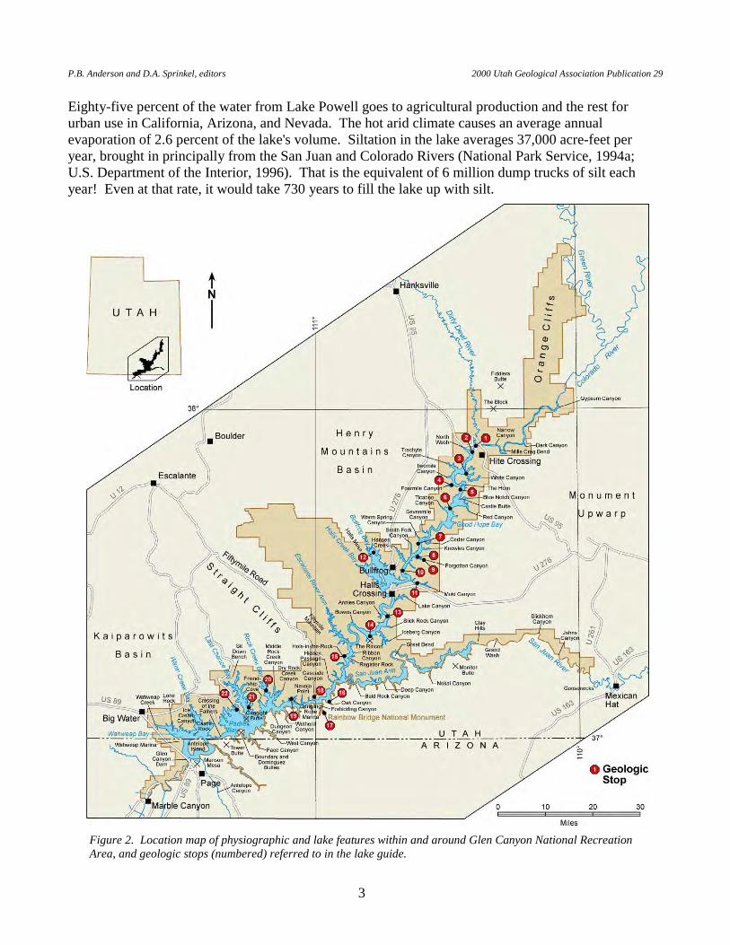
Figure 2. Location map of physiographic and lake features within and around Glen Canyon National Recreation Area, and geologic stops (numbered) referred to in the lake guide.
T.C. Chidsey, Jr., D.A. Sprinkel, G.C. Willis, P.B. Anderson Geologic Lake Guide Along Lake Powell, Glen Canyon National Recreation Area and Rainbow Bridge National Monument, Utah-Arizona
4
Lake Powell comprises only 13 percent of Glen Canyon National Recreation Area. However, it provides access to some of the best examples of the spectacular and unique geology the Colorado Plateau region has to offer. The canyons in the recreation area formed within the past 5 million years, and possibly only within the past 1 million years, by vigorous downcutting of the Colorado River and its tributaries, exposing more than 8,000 feet of bedrock that span a period of about 300 million years (figures 3 and 4). Rock descriptions, thickness, color, and other attributes of the exposed formations in the recreation area are summarized in table 1. A series of generalized geologic maps shows the distribution of rock units in the vicinity of the recreation area (figures 4 through 8). In general, floating down the lake from Hite Crossing toward Glen Canyon Dam, one will observe that the rocks at lake level get younger, except where the lake crosses the axes of several folds. These folds are typically subtle and sometimes difficult to see away from the lake; however, the lake surface makes a great horizontal datum to view the folds. The oldest rocks exposed in Glen Canyon National Recreation Area are limestone and mudstone beds of the Pennsylvanian Hermosa Group, which crop out along the Colorado and San Juan Rivers in the northern and eastern part of the recreation area (figures 5 and 7). The youngest exposed rocks are sandstone and mudstone beds of the Upper Cretaceous Straight Cliffs Formation, which crop out in the southwestern part of the recreation area north of Wahweap (figure 8). Among the most impressive sights along Lake Powell are the sheer sandstone cliffs formed by the Lower Jurassic Glen Canyon Group (Wingate, Kayenta, and Navajo Formations) and the Middle Jurassic Entrada and Romana Sandstones. Throughout Glen Canyon National Recreation Area are several different unconsolidated or surficial deposits, which thinly cover bedrock units. These deposits consist of sand, gravel, and boulders deposited by wind, water, and gravity. They form the sandy beaches along Lake Powell and the broad sandy benches adjacent to the lake. They also form the alluvium in creek beds and chaotic piles of sandstone boulders left when slabs of rock fell from the steep canyon walls. All record the geologic history of the area for the past 1 million years. Some of the more interesting surficial deposits are the older gravel beds of the Colorado and San Juan Rivers, which have varied and distinctive cobbles and pebbles. Although these deposits are near present lake level, they are still 500 to 700 feet above the lake bottom (the modern riverbed prior to the lake). The recreation area contains many unique and well-exposed geologic features such as large mud cracks and paleosols in the Moenkopi and Chinle Formations; oasis and wadi deposits, ironstone concretions, and strangely contorted bedding in the Navajo Sandstone; and massive, irregular deformational structures and giant weathering pits of an enigmatic origin in the Entrada Sandstone. Active surficial processes continue to shape the recreation area, including extensive mass-wasting complexes involving the Chinle Formation and Wingate Sandstone, and cloudburst-generated debris flows in slot canyons. Rainbow Bridge in Rainbow Bridge National Monument (figure 1) (reached via Lake Powell), a unique geologic feature itself, is one of the largest natural bridges in the world with a height of 290 feet above its floor and a span of 275 feet. This publication guides visitors to the classic Colorado Plateau region geology and the unique features along Lake Powell from Hite Crossing to the Glen Canyon Dam (figure 2). It provides an overview of the geology of Glen Canyon National Recreational Area and Rainbow Bridge National Monument. The shores of the lake are referred to as the "right shore" and the "left shore" as one follows this lake guide southwest from Hite Crossing. This guide contains general descriptions of the geology as seen from marker buoys in the lake and provides detailed explanations of many of the geologic features at
P.B. Anderson and D.A. Sprinkel, editors 2000 Utah Geological Association Publication 29
5
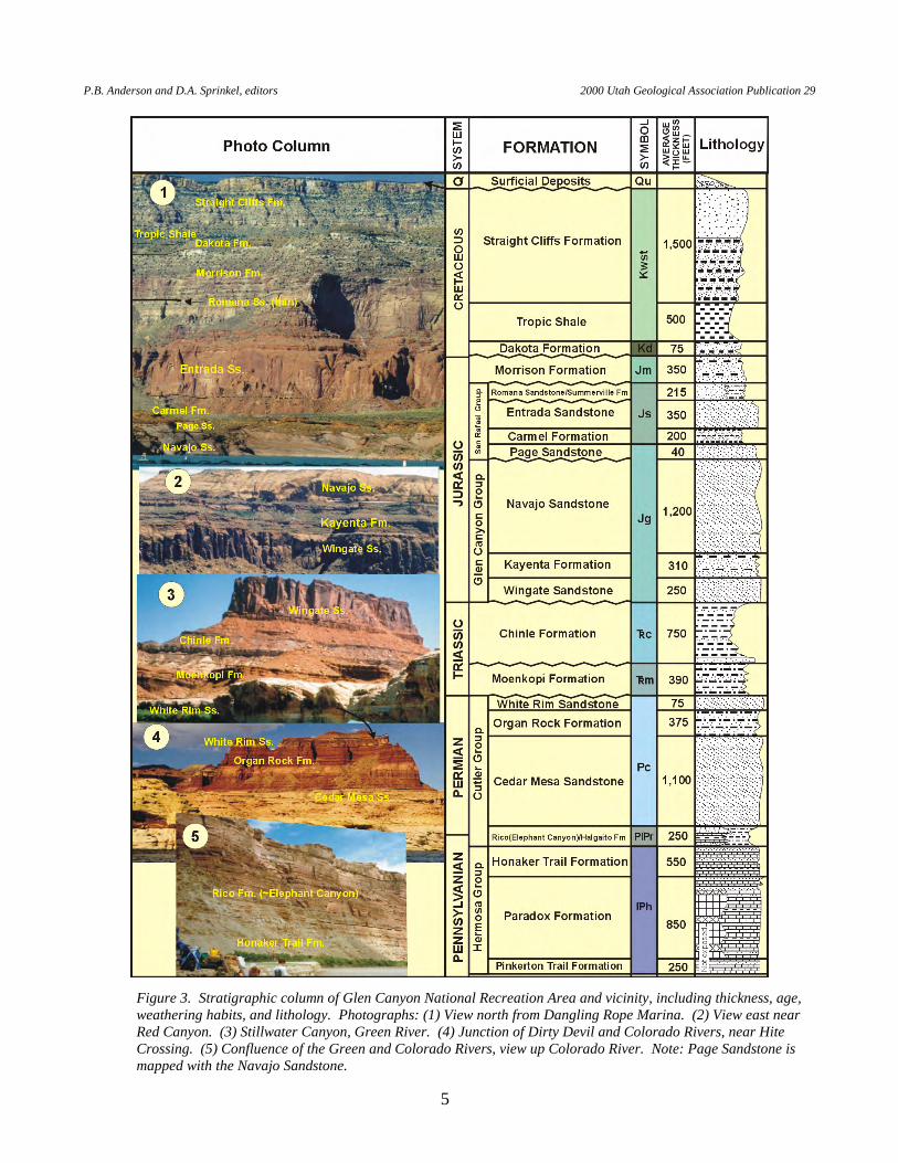
Figure 3. Stratigraphic column of Glen Canyon National Recreation Area and vicinity, including thickness, age, weathering habits, and lithology. Photographs: (1) View north from Dangling Rope Marina. (2) View east near Red Canyon. (3) Stillwater Canyon, Green River. (4) Junction of Dirty Devil and Colorado Rivers, near Hite Crossing. (5) Confluence of the Green and Colorado Rivers, view up Colorado River. Note: Page Sandstone is mapped with the Navajo Sandstone.
T.C. Chidsey, Jr., D.A. Sprinkel, G.C. Willis, P.B. Anderson Geologic Lake Guide Along Lake Powell, Glen Canyon National Recreation Area and Rainbow Bridge National Monument, Utah-Arizona
6
Tabl
e 1.
Stra
tigra
phic
uni
ts in
Gle
n C
anyo
n N
atio
nal R
ecre
atio
n A
rea,
Uta
h an
d A
rizon
a.
P.B. Anderson and D.A. Sprinkel, editors 2000 Utah Geological Association Publication 29
7
* A
bbre
viat
ions
for p
aper
s des
crib
ing
the
geol
ogy
of su
rrou
ndin
g pa
rks i
n U
tah
Geo
logi
cal A
ssoc
iatio
n Pu
blic
atio
n 28
, Geo
logy
of U
tah’
s Par
ks a
nd M
onum
ents
: A
rche
s NP
- Ar (
Doe
lling
, 200
0), C
anyo
nlan
ds N
P - C
Y (B
aars
, 200
0), C
apito
l Ree
f NP
- CR
(Mor
ris a
nd o
ther
s, 20
00),
Dea
d H
orse
Poi
nt S
P - D
(Doe
lling
and
ot
hers
, 200
0), G
oose
neck
s SP
- G (S
teve
nson
, 200
0), G
rand
Sta
ircas
e-Es
cala
nte
NM
- G
S (D
oelli
ng a
nd o
ther
s, 20
00),
Rain
bow
Brid
ge N
M -
R (C
hids
ey a
nd
othe
rs, 2
000)
, Org
an R
ock
Form
atio
n st
udy
(Sta
nesc
o an
d ot
hers
, 200
0) -
St, E
ast K
aiba
b m
onoc
line
stud
y (T
inda
ll, 2
000)
- T.
GC
NR
A =
Gle
n C
anyo
n N
atio
nal
Rec
reat
ion
Are
a, ss
= sa
ndst
one,
sh =
shal
e.
Tabl
e 1
cont
inue
d.
T.C. Chidsey, Jr., D.A. Sprinkel, G.C. Willis, P.B. Anderson Geologic Lake Guide Along Lake Powell, Glen Canyon National Recreation Area and Rainbow Bridge National Monument, Utah-Arizona
8
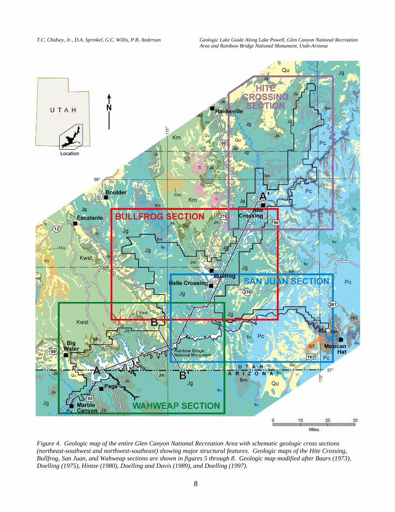
Figure 4. Geologic map of the entire Glen Canyon National Recreation Area with schematic geologic cross sections (northeast-southwest and northwest-southeast) showing major structural features. Geologic maps of the Hite Crossing, Bullfrog, San Juan, and Wahweap sections are shown in figures 5 through 8. Geologic map modified after Baars (1973), Doelling (1975), Hintze (1980), Doelling and Davis (1989), and Doelling (1997).
P.B. Anderson and D.A. Sprinkel, editors 2000 Utah Geological Association Publication 29
9
Figure 4 (continued). Geologic map of the entire Glen Canyon National Recreation Area with schematic geologic cross sections (northeast-southwest and northwest-southeast) showing major structural features. Geologic maps of the Hite Crossing, Bullfrog, San Juan, and Wahweap sections are shown in figures 5 through 8. Geologic map modified after Baars (1973), Doelling (1975), Hintze (1980), Doelling and Davis (1989), and Doelling (1997).
T.C. Chidsey, Jr., D.A. Sprinkel, G.C. Willis, P.B. Anderson Geologic Lake Guide Along Lake Powell, Glen Canyon National Recreation Area and Rainbow Bridge National Monument, Utah-Arizona
10
Figure 5. Geologic map of Hite Crossing section of Glen Canyon National Recreation Area and geologic stops referred to in the lake guide. Buoys are indicated by numbered blue circles. See figure 4 for explanation.
P.B. Anderson and D.A. Sprinkel, editors 2000 Utah Geological Association Publication 29
11
Figu
re 6
. G
eolo
gic
map
of B
ullfr
og se
ctio
n of
Gle
n Ca
nyon
Nat
iona
l Rec
reat
ion
Area
and
geo
logi
c sto
ps re
ferr
ed to
in th
e la
ke g
uide
. Bu
oys a
re in
dica
ted
by n
umbe
red
blue
circ
les.
See
figu
re 4
for e
xpla
natio
n.
T.C. Chidsey, Jr., D.A. Sprinkel, G.C. Willis, P.B. Anderson Geologic Lake Guide Along Lake Powell, Glen Canyon National Recreation Area and Rainbow Bridge National Monument, Utah-Arizona
12
Figu
re 7
. G
eolo
gic
map
of S
an J
uan
sect
ion
of G
len
Cany
on N
atio
nal R
ecre
atio
n Ar
ea a
nd g
eolo
gic
stops
refe
rred
to in
the
lake
gui
de.
Buoy
s are
indi
cate
d by
nu
mbe
red
blue
circ
les.
See
figu
re 4
for e
xpla
natio
n.
P.B. Anderson and D.A. Sprinkel, editors 2000 Utah Geological Association Publication 29
13
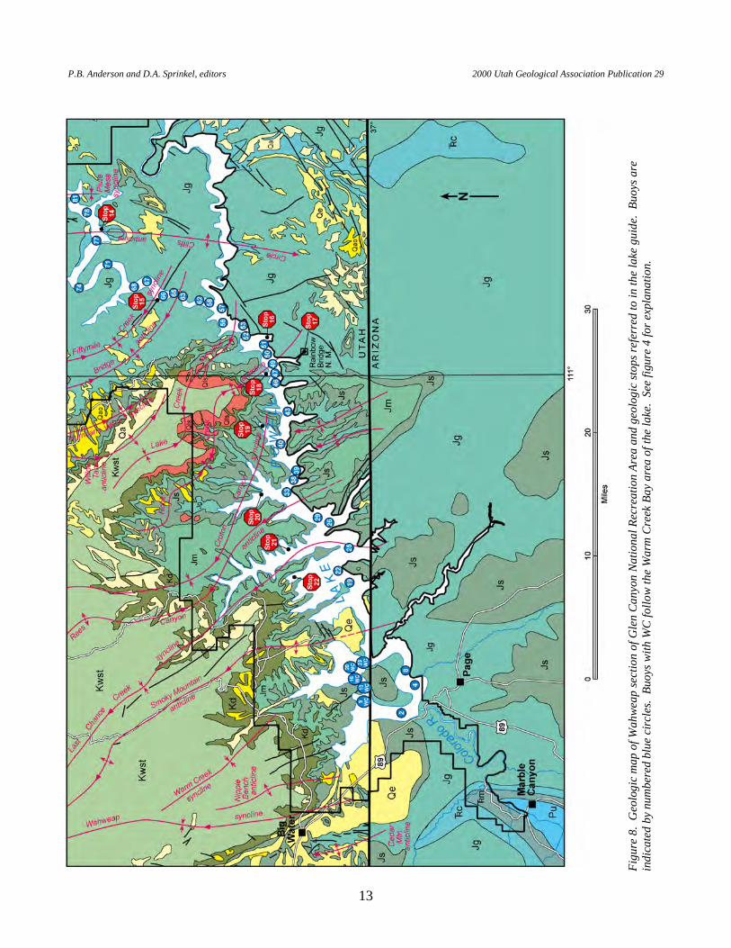
Figu
re 8
. G
eolo
gic
map
of W
ahwe
ap se
ctio
n of
Gle
n Ca
nyon
Nat
iona
l Rec
reat
ion
Area
and
geo
logi
c sto
ps re
ferr
ed to
in th
e la
ke g
uide
. Bu
oys a
re
indi
cate
d by
num
bere
d bl
ue c
ircle
s. B
uoys
with
WC
follo
w th
e W
arm
Cre
ek B
ay a
rea
of th
e la
ke.
See
figur
e 4
for e
xpla
natio
n.
T.C. Chidsey, Jr., D.A. Sprinkel, G.C. Willis, P.B. Anderson Geologic Lake Guide Along Lake Powell, Glen Canyon National Recreation Area and Rainbow Bridge National Monument, Utah-Arizona
14
selected stops along the lake, bays, and side canyons. Many geologic features are common to large parts of the recreation area and can be observed at numerous locations along the lake. These common features are usually described in detail at the first place they occur along the lake or where the best examples are found, and are only underlined elsewhere in this lake guide. The underlined features are listed in the index at the end of this guide. The index provides a way to find these descriptions even if you are not following this lake guide from start to finish. For example, if you begin your trip from Wahweap Marina, the geologic description of a stop or an area near a buoy may mention the presence of "oasis deposits" or "Navajo berries" or other interesting geologic features, but no details are provided on what they are, how they formed, and so forth. That the feature is underlined indicates that a detailed description is somewhere within this lake guide. The index directs you to that part of this guide containing the detailed description of the same geologic feature you are observing. Buoys on Lake Powell have a tendency to move and sometimes are missing. Thus, the location of any one buoy may not be exactly where we describe it in the guide, but it should be relatively close. However, all stops include the Global Positioning System (GPS) location in latitude and longitude. The full lake guide covers a distance of a little over 200 miles and will generally take a minimum of three days depending upon the speed and fuel capacity of your boat, and weather conditions. If camping and swimming are part of your plans, this trip can take several days longer. Gasoline, water, food, and ice are only available at Hite Crossing, Bullfrog, Halls Crossing, Dangling Rope, and Wahweap Marinas. Parts of Lake Powell are remote and the surrounding country rugged; visitors should make sure their boat is properly equipped and that they have proper training and experience. We recommend that the travelers leave from the Bullfrog Marina and cruise up lake to Hite Crossing before beginning to follow the lake guide. If you are not camping, the distance back to Bullfrog can be covered in one long day using boats that travel 30 to 35 miles per hour; it may take multiple days in slower boats such as houseboats. You may then travel the entire distance from Bullfrog to Wahweap in one long day, filling up your boat with gas at Dangling Rope Marina (if you don’t, be prepared to get stranded!). We recommend that you follow the lake guide directly to Wahweap, leaving the geologic stops for the return trip to Bullfrog. If you take any of the optional side trips, plan on an extra day or two. The geologic stops described in the lake guide are accessible by most large and small boats and pontoon houseboats. Please note that it is illegal to remove petrified wood, fossils, rocks, Indian artifacts, and so forth from Glen Canyon National Recreation Area and Rainbow Bridge National Monument. BUOY NUMBER DESCRIPTION
START FOLLOWING THE LAKE GUIDE AT HITE BRIDGE (figures 2
and 5) . STOP NO. 1 (FLOATING): PERMIAN AND TRIASSIC OUTCROPS.
HITE (BICENTENNIAL) BRIDGE (latitude 37°53'6.9"N., longitude 110°28'57.1"W.). Some of the oldest, easily accessed rocks in Glen Canyon National Recreational Area are exposed along Lake Powell near Hite Crossing. The rocks viewed from the Hite Crossing area consist of the Permian Cedar Mesa Sandstone up through the Lower Jurassic Navajo Sandstone (see photographs 2 through 4 in figure 3). Hite Bridge, also referred to as Bicentennial Bridge, is a 726-foot steel-arch bridge constructed in 1966 to serve traffic over Utah
P.B. Anderson and D.A. Sprinkel, editors 2000 Utah Geological Association Publication 29
15
Highway 95, the Bicentennial Highway. The Hite Bridge abutments are anchored in the Cedar Mesa Formation. Cross-beds in "frozen" sand dunes of the Cedar Mesa indicate the paleowinds were from the north. The Organ Rock Formation, deposited in a fluvial (river) to eolian environment, lies above the Cedar Mesa Sandstone. It is a reddish-brown sandstone, siltstone, and mudstone that Utah Highway 95 crosses. The Organ Rock Formation forms the steep red cliffs at or above the water line around the Hite Crossing area. Above the Organ Rock, the mottled white ledge that forms the top of the cliff is the eolian White Rim Sandstone with cross-beds indicating paleowinds were from the northwest. The Rico, Cedar Mesa, Organ Rock, and White Rim are all formations of the Permian Cutler Group.
The Triassic Moenkopi Formation forms the brownish-red slope that lies above
the White Rim Sandstone. The overlying prominent bench consists of the Shinarump Member of the Triassic Chinle Formation. The remainder of the Chinle is a slope former. The first cliff on the western horizon is the Wingate Sandstone, which forms the base of the Lower Jurassic Glen Canyon Group. The Lower Jurassic Glen Canyon Group consists of the basal Wingate Sandstone (eolian), the middle Kayenta Formation (fluvial/flood plain), and the upper Navajo Sandstone (eolian). Both the Wingate and Navajo Sandstones are resistant and generally form cliffs, whereas the middle Kayenta Formation is less resistant and forms slopes and ledges. The light-brown, rounded hills are the Navajo Sandstone on the skyline.
And now we wheel into another canyon ...this new canyon is very narrow and
very straight with walls vertical below and terraced above. We name this Narrow Canyon. —Major John Wesley Powell, July 28, 1869
OPTIONAL SIDE TRIP: PENNSYLVANIAN-PERMIAN RICO
FORMATION. PROCEED EAST UP THE LAKE ABOUT 3 MILES FROM HITE BRIDGE AND ENTER NARROW CANYON. The Permian Cedar Mesa Formation forms the steep cliffs of Narrow Canyon (see Rigby and others, 1971, for a lake and river guide from the Hite Bridge through Canyonlands National Park). The Cedar Mesa is yellowish light-gray sandstone that is highly cross-bedded with large-scale trough and planar cross-beds. Numerous holes or tafoni are also characteristic of the Cedar Mesa sandstone in this area, which was deposited as wind-blown coastal sand dunes (eolian). Directly before Mille Crag Bend, beds of Rico Formation crop out at lake level. The Rico Formation is reddish-brown marine sandstone and mudstone.
AFTER THE STOP HEAD DOWN THE LAKE TOWARD HITE
CROSSING MARINA.
T.C. Chidsey, Jr., D.A. Sprinkel, G.C. Willis, P.B. Anderson Geologic Lake Guide Along Lake Powell, Glen Canyon National Recreation Area and Rainbow Bridge National Monument, Utah-Arizona
16
...we discover the mouth of a stream which enters from the right. The water is exceedingly muddy and has an unpleasant odor. One of the men in the boat following ... asks whether it is a trout stream. Dun replies, much disgusted, that it is "a dirty devil," and by this name the river is to be hereafter.
—Major John Wesley Powell, July 28, 1869 CONFLUENCE OF DIRTY DEVIL RIVER AND THE COLORADO RIVER.
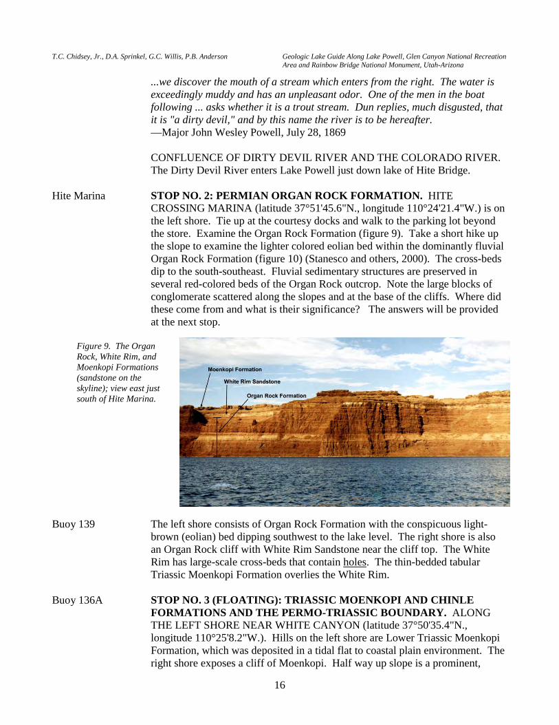
The Dirty Devil River enters Lake Powell just down lake of Hite Bridge. Hite Marina STOP NO. 2: PERMIAN ORGAN ROCK FORMATION. HITE
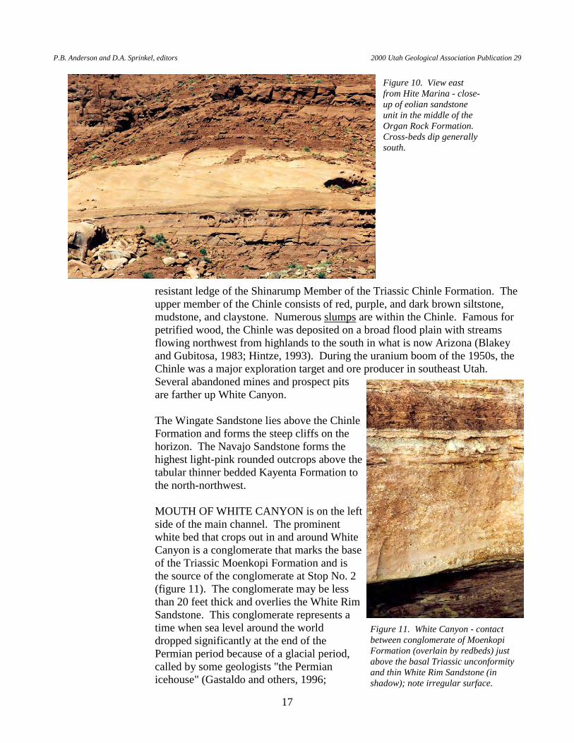
CROSSING MARINA (latitude 37°51'45.6"N., longitude 110°24'21.4"W.) is on the left shore. Tie up at the courtesy docks and walk to the parking lot beyond the store. Examine the Organ Rock Formation (figure 9). Take a short hike up the slope to examine the lighter colored eolian bed within the dominantly fluvial Organ Rock Formation (figure 10) (Stanesco and others, 2000). The cross-beds dip to the south-southeast. Fluvial sedimentary structures are preserved in several red-colored beds of the Organ Rock outcrop. Note the large blocks of conglomerate scattered along the slopes and at the base of the cliffs. Where did these come from and what is their significance? The answers will be provided at the next stop.
Buoy 139 The left shore consists of Organ Rock Formation with the conspicuous light-brown (eolian) bed dipping southwest to the lake level. The right shore is also an Organ Rock cliff with White Rim Sandstone near the cliff top. The White Rim has large-scale cross-beds that contain holes. The thin-bedded tabular Triassic Moenkopi Formation overlies the White Rim.
Buoy 136A STOP NO. 3 (FLOATING): TRIASSIC MOENKOPI AND CHINLE
FORMATIONS AND THE PERMO-TRIASSIC BOUNDARY. ALONG THE LEFT SHORE NEAR WHITE CANYON (latitude 37°50'35.4"N., longitude 110°25'8.2"W.). Hills on the left shore are Lower Triassic Moenkopi Formation, which was deposited in a tidal flat to coastal plain environment. The right shore exposes a cliff of Moenkopi. Half way up slope is a prominent,
Figure 9. The Organ Rock, White Rim, and Moenkopi Formations (sandstone on the skyline); view east just south of Hite Marina.
P.B. Anderson and D.A. Sprinkel, editors 2000 Utah Geological Association Publication 29
17
resistant ledge of the Shinarump Member of the Triassic Chinle Formation. The upper member of the Chinle consists of red, purple, and dark brown siltstone, mudstone, and claystone. Numerous slumps are within the Chinle. Famous for petrified wood, the Chinle was deposited on a broad flood plain with streams flowing northwest from highlands to the south in what is now Arizona (Blakey and Gubitosa, 1983; Hintze, 1993). During the uranium boom of the 1950s, the Chinle was a major exploration target and ore producer in southeast Utah. Several abandoned mines and prospect pits are farther up White Canyon.
The Wingate Sandstone lies above the Chinle
Formation and forms the steep cliffs on the horizon. The Navajo Sandstone forms the highest light-pink rounded outcrops above the tabular thinner bedded Kayenta Formation to the north-northwest.
MOUTH OF WHITE CANYON is on the left
side of the main channel. The prominent white bed that crops out in and around White Canyon is a conglomerate that marks the base of the Triassic Moenkopi Formation and is the source of the conglomerate at Stop No. 2 (figure 11). The conglomerate may be less than 20 feet thick and overlies the White Rim Sandstone. This conglomerate represents a time when sea level around the world dropped significantly at the end of the Permian period because of a glacial period, called by some geologists "the Permian icehouse" (Gastaldo and others, 1996;
Figure 10. View east from Hite Marina - close-up of eolian sandstone unit in the middle of the Organ Rock Formation. Cross-beds dip generally south.
Figure 11. White Canyon - contact between conglomerate of Moenkopi Formation (overlain by redbeds) just above the basal Triassic unconformity and thin White Rim Sandstone (in shadow); note irregular surface.

T.C. Chidsey, Jr., D.A. Sprinkel, G.C. Willis, P.B. Anderson Geologic Lake Guide Along Lake Powell, Glen Canyon National Recreation Area and Rainbow Bridge National Monument, Utah-Arizona
18
Crowell, 1999). Down cutting into the Permian rocks and deposition of local conglomerates are found in many places in Utah and the world. This boundary is referred to as the TR-1 unconformity and represents an erosional time gap of 5 to 12 million years (Pipiringos and O’Sullivan, 1978; Doelling and others, 2000).
The whole country is a region of naked rock of many colors, with cliffs and
buttes about us and towering mountains in the distance. —Major John Wesley Powell, July 28, 1869
Buoy 135 MOUTH OF TRACHYTE CANYON is on the right side of the main channel.
The Triassic Chinle (upper Chinle) Formation is at lake level with numerous slump features. The overlying Jurassic Wingate Sandstone forms a steep massive cliff. The thin ledgey sandstone overlying the Wingate is the Kayenta Formation. The Navajo Sandstone forms the light-brown rounded sandstone cliffs.
Mount Hillers—one of the peaks that form the Henry Mountains—is in view to
the west (figure 12). The Henry Mountains are located near the northern end of Lake Powell (figure 1) and consist of five dome-shaped mountains; from north to south they are Mount Ellen (elevation 11,522 feet), Mount Pennell (elevation 11,371 feet), Mount Hillers (elevation 10,723 feet), Mount Holmes (elevation 7,930 feet), and Mount Ellsworth (elevation 8,235 feet). The southern four mountains are 6 to 8 miles in diameter at the base; Mount Ellen is about 12 miles in diameter. Each mountain consists of a stock (a discordant igneous intrusion) surrounded by laccoliths (Hunt, 1980). The Henry Mountains are the type locality for laccoliths as first described by Gilbert (1877). A laccolith is a dome- or mushroom-shaped structure formed when igneous intrusions were injected along bedding planes (concordant) and bowed up layers of overlying sedimentary rocks. In the Henry Mountains, these laccoliths are intruded into the Jurassic Morrison Formation and Cretaceous units (Hunt, 1980). The igneous rocks are granodioritic (diorite porphyry) in composition (Doelling,
Figure 12. Chinle Formation through Kayenta Formation with part of Mount Hillers (10,723 feet) showing; view west from Buoy 135 near the entrance of Trachyte Canyon.
P.B. Anderson and D.A. Sprinkel, editors 2000 Utah Geological Association Publication 29
19
1975) and were intruded 31.2 to 23.3 million years ago (Ma) during the late Oligocene (Nelson and others, 1992). All of the Henry Mountains except Mount Ellsworth have numerous folds and domes formed by superimposed underlying laccoliths and other intrusive bodies (Hunt, 1980). Triassic through Cretaceous strata crop out on the flanks of these mountains. Along the western side of the northern part of Lake Powell, Permian and Triassic formations dip gently west into a subtle syncline that lies east of, and trends parallel to, Mounts Ellsworth and Holmes (Doelling, 1975).
Buoy 132A The left shore consists of the Chinle Formation overlain by the massive cliffs of
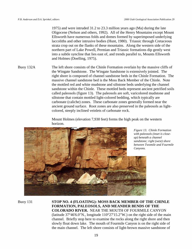
the Wingate Sandstone. The Wingate Sandstone is extensively jointed. The right shore is composed of channel sandstone beds in the Chinle Formation. The massive channel sandstone bed is the Moss Back Member of the Chinle. Note the mottled red and white mudstone and siltstone beds underlying the channel sandstone within the Chinle. These mottled beds represent ancient petrified soils called paleosols (figure 13). The paleosols are soft, varicolored mudstone and siltstone that contain mottled light-colored bedding, which typically are carbonate (caliche) zones. These carbonate zones generally formed near the ancient ground surface. Root zones are also preserved in the paleosols as light-colored, steeply inclined veinlets of carbonate rock.
Mount Holmes (elevation 7,930 feet) forms the high peak on the western
horizon.
Buoy 131 STOP NO. 4 (FLOATING): MOSS BACK MEMBER OF THE CHINLE FORMATION, PALEOSOLS, AND MEANDER BENDS OF THE COLORADO RIVER. NEAR THE MOUTH OF FOURMILE CANYON (latitude 37°46'6.0"N., longitude 110°27'15.2"W.) on the right side of the main channel. Briefly stop here to examine the rocks along the right shore and then slowly float down lake. The mouth of Fourmile Canyon is on the right side of the main channel. The left shore consists of light-brown massive sandstone of
Figure 13. Chinle Formation with paleosols (inset is close-up) beneath a channel sandstone; right (west) shore between Twomile and Fourmile Canyons.
T.C. Chidsey, Jr., D.A. Sprinkel, G.C. Willis, P.B. Anderson Geologic Lake Guide Along Lake Powell, Glen Canyon National Recreation Area and Rainbow Bridge National Monument, Utah-Arizona
20
the Moss Back Member of the Chinle Formation. Overlying the Moss Back is the upper slope-forming varicolored Chinle. The overlying Wingate Sandstone forms steep sheer cliffs. The right shore is mostly Chinle, Wingate, and thin tabular beds of Kayenta Formation capped by light-pink-brown rounded beds of the massive-weathering Navajo Sandstone. The Navajo has little jointing. Joints in the Wingate trend N.10°W. Mount Ellsworth (elevation 8,235 feet) is seen westward from the mouth of Fourmile Canyon.
The big curve in the lake between Buoys 136 and 129 is an old meander bend of
the Colorado River. In early Cenozoic time, the Colorado Plateau was uplifted along with a much broader area that included the Basin and Range Province to the west and southwest, with limited uplift probably continuing through the remaining Cenozoic (Hunt, 1956; Lucchitta, 1979; Graf and others, 1987; Fleming, 1994; Huntoon and others, 2000). This regional uplift changed the landscape from one of deposition to one of massive erosion. Several thousand feet of sedimentary rocks have been removed by the erosive processes of running water and mass wasting. Most of this material has been carried to the sea by the Colorado River system. At one time, the ancestral Colorado River and its tributaries flowed through meandering channels in wide valleys where the channels crossed easily eroded rocks. As the Colorado Plateau continued to rise and downcutting of the Grand Canyon accelerated about 5 million years ago (Lucchitta, 1989), the rejuvenated Colorado River drainage system was able to rapidly carve through strata. By then, the river channels were established and they became superimposed and entrenched, cutting into resistant rocks such as the Navajo Sandstone. The results of this downcutting are the countless tributary canyons and entrenched meanders in Glen Canyon, such as the one here.
The left shore is the Moss Back Member of the Chinle Formation. On the right
(west) shore, shale, mudstone, and siltstone are beds of the Chinle Formation. The Moss Back thickens and thins and has an irregular base. A close look at Chinle beds below the Moss Back sandstone reveals paleosol deposits. The paleosols are mottled gray and red. The gray rocks are calcrete deposits and root structures. The Moss Back Member caps The Horn; one can see the variable thickness from a few feet to as much as 20 feet through this area. The Moss Back river-channel sandstone strikes northwest-southeast and was likely deposited in a northwest-flowing steam (Blakey and Gubitosa, 1983; Hintze, 1993).
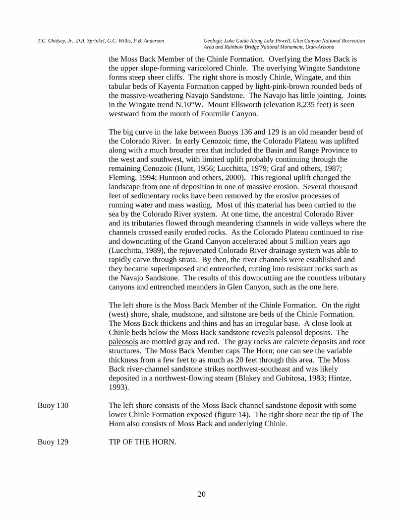
Buoy 130 The left shore consists of the Moss Back channel sandstone deposit with some
lower Chinle Formation exposed (figure 14). The right shore near the tip of The Horn also consists of Moss Back and underlying Chinle.
Buoy 129 TIP OF THE HORN.
P.B. Anderson and D.A. Sprinkel, editors 2000 Utah Geological Association Publication 29
21
Near Buoy 127 STOP NO. 5 (FLOATING): DEFORMATION IN THE CHINLE FORMATION. SOUTH OF THE HORN ALONG THE RIGHT SHORE (latitude 37°45'54.4"N., longitude 110°26'42.4"W.). The Chinle Formation is cut by a surface that is likely a rupture surface of a landslide. Note the blocks of the Wingate Sandstone that are pulling away from the cliff along the joints. Numerous open joints can be seen.
Buoy 126 CASTLE BUTTE AND ENTRANCE TO BLUE NOTCH AND RED
CANYONS (to the left of the main channel). The Chinle Formation outcrops along the left shore. The Moss Back Member of the Chinle forms the bench. The Jurassic Wingate Sandstone forms the sheer, steep cliffs. The right shore has Moenkopi Formation with Chinle and Wingate forming the ridgeline. The Shinarump Member of the Chinle, where it is present, overlies the reddish-brown Moenkopi Formation. Purple to grayish siltstones and shales under the Shinarump sandstone bed are generally included with the Shinarump Member. Where the Shinarump is absent, the varicolored lower part of the Chinle is in direct contact with the Moenkopi.
Castle Butte consists of the slope-forming varicolored Chinle Formation overlain
by the cliff-forming Wingate Sandstone, which give the butte the castle-like appearance.
SIDE TRIP INTO RED CANYON (figure 2). PROCEED EAST into Red
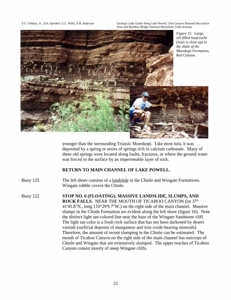
Canyon on the left side of the main channel. Red Canyon is cut in Moenkopi Formation, which consists of reddish-brown (sometimes described as chocolate colored) interbedded siltstone and sandstone with some mudstone. A variety of sedimentary features are preserved in the Moenkopi in Red Canyon. These include ripple marks, cross-bedding, and spectacular mudcracks (figure 15); all indicating that the sediments that eventually lithified were deposited in a tidal mud flat environment. Paleosols are also preserved in the Moenkopi, mostly near the top of the formation. A greenish mudstone layer is locally at the top of the Moenkopi immediate below the Shinarump. Near the end of Red Canyon (by boat), a large tufa deposit crops out. The tufa is probably Pleistocene, much
Figure 14. The Moss Back Member channel deposit thinning in the down-lake direction with some lower Chinle Formation; on the left shore near The Horn.
T.C. Chidsey, Jr., D.A. Sprinkel, G.C. Willis, P.B. Anderson Geologic Lake Guide Along Lake Powell, Glen Canyon National Recreation Area and Rainbow Bridge National Monument, Utah-Arizona
22
younger than the surrounding Triassic Moenkopi. Like most tufa, it was
deposited by a spring or series of springs rich in calcium carbonate. Many of these old springs were located along faults, fractures, or where the ground water was forced to the surface by an impermeable layer of rock.
RETURN TO MAIN CHANNEL OF LAKE POWELL. Buoy 125 The left shore consists of a landslide in the Chinle and Wingate Formations.
Wingate rubble covers the Chinle. Buoy 122 STOP NO. 6 (FLOATING): MASSIVE LANDSLIDE, SLUMPS, AND
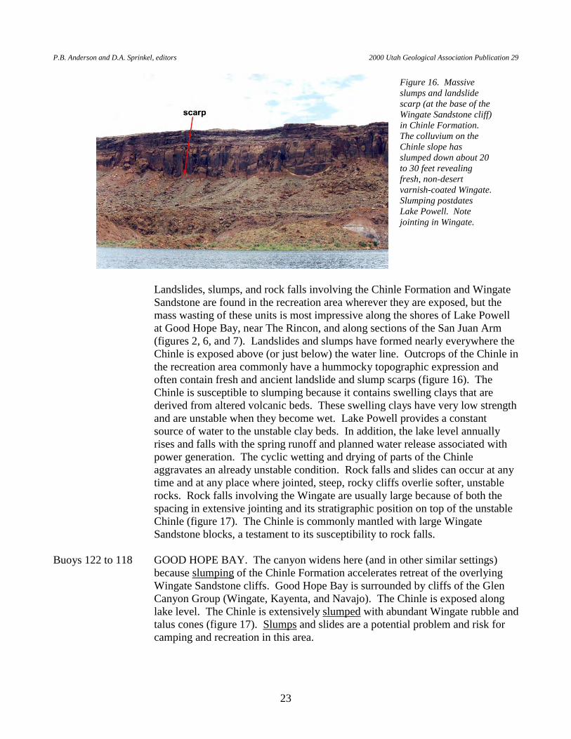
ROCK FALLS. NEAR THE MOUTH OF TICABOO CANYON (lat 37°41'45.8"N., long 110°29'9.7"W.) on the right side of the main channel. Massive slumps in the Chinle Formation are evident along the left shore (figure 16). Note the distinct light tan-colored line near the base of the Wingate Sandstone cliff. The light tan color is a fresh rock surface that has not been darkened by desert varnish (surficial deposits of manganese and iron oxide-bearing minerals). Therefore, the amount of recent slumping in the Chinle can be estimated. The mouth of Ticaboo Canyon on the right side of the main channel has outcrops of Chinle and Wingate that are extensively slumped. The upper reaches of Ticaboo Canyon consist mostly of steep Wingate cliffs.
Figure 15. Large, silt-filled mudcracks (inset is close-up) in the shale of the Moenkopi Formation, Red Canyon.
P.B. Anderson and D.A. Sprinkel, editors 2000 Utah Geological Association Publication 29
23
Landslides, slumps, and rock falls involving the Chinle Formation and Wingate Sandstone are found in the recreation area wherever they are exposed, but the mass wasting of these units is most impressive along the shores of Lake Powell at Good Hope Bay, near The Rincon, and along sections of the San Juan Arm (figures 2, 6, and 7). Landslides and slumps have formed nearly everywhere the Chinle is exposed above (or just below) the water line. Outcrops of the Chinle in the recreation area commonly have a hummocky topographic expression and often contain fresh and ancient landslide and slump scarps (figure 16). The Chinle is susceptible to slumping because it contains swelling clays that are derived from altered volcanic beds. These swelling clays have very low strength and are unstable when they become wet. Lake Powell provides a constant source of water to the unstable clay beds. In addition, the lake level annually rises and falls with the spring runoff and planned water release associated with power generation. The cyclic wetting and drying of parts of the Chinle aggravates an already unstable condition. Rock falls and slides can occur at any time and at any place where jointed, steep, rocky cliffs overlie softer, unstable rocks. Rock falls involving the Wingate are usually large because of both the spacing in extensive jointing and its stratigraphic position on top of the unstable Chinle (figure 17). The Chinle is commonly mantled with large Wingate Sandstone blocks, a testament to its susceptibility to rock falls.
Buoys 122 to 118 GOOD HOPE BAY. The canyon widens here (and in other similar settings)
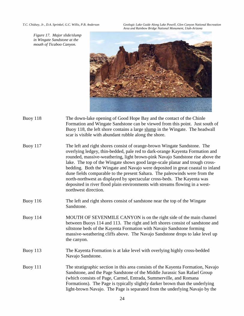
because slumping of the Chinle Formation accelerates retreat of the overlying Wingate Sandstone cliffs. Good Hope Bay is surrounded by cliffs of the Glen Canyon Group (Wingate, Kayenta, and Navajo). The Chinle is exposed along lake level. The Chinle is extensively slumped with abundant Wingate rubble and talus cones (figure 17). Slumps and slides are a potential problem and risk for camping and recreation in this area.
Figure 16. Massive slumps and landslide scarp (at the base of the Wingate Sandstone cliff) in Chinle Formation. The colluvium on the Chinle slope has slumped down about 20 to 30 feet revealing fresh, non-desert varnish-coated Wingate. Slumping postdates Lake Powell. Note jointing in Wingate.
T.C. Chidsey, Jr., D.A. Sprinkel, G.C. Willis, P.B. Anderson Geologic Lake Guide Along Lake Powell, Glen Canyon National Recreation Area and Rainbow Bridge National Monument, Utah-Arizona
24
Buoy 118 The down-lake opening of Good Hope Bay and the contact of the Chinle Formation and Wingate Sandstone can be viewed from this point. Just south of Buoy 118, the left shore contains a large slump in the Wingate. The headwall scar is visible with abundant rubble along the shore.
Buoy 117 The left and right shores consist of orange-brown Wingate Sandstone. The
overlying ledgey, thin-bedded, pale red to dark-orange Kayenta Formation and rounded, massive-weathering, light brown-pink Navajo Sandstone rise above the lake. The top of the Wingate shows good large-scale planar and trough cross-bedding. Both the Wingate and Navajo were deposited in great coastal to inland dune fields comparable to the present Sahara. The paleowinds were from the north-northwest as displayed by spectacular cross-beds. The Kayenta was deposited in river flood plain environments with streams flowing in a west-northwest direction.
Buoy 116 The left and right shores consist of sandstone near the top of the Wingate
Sandstone. Buoy 114 MOUTH OF SEVENMILE CANYON is on the right side of the main channel
between Buoys 114 and 113. The right and left shores consist of sandstone and siltstone beds of the Kayenta Formation with Navajo Sandstone forming massive-weathering cliffs above. The Navajo Sandstone drops to lake level up the canyon.
Buoy 113 The Kayenta Formation is at lake level with overlying highly cross-bedded
Navajo Sandstone. Buoy 111 The stratigraphic section in this area consists of the Kayenta Formation, Navajo
Sandstone, and the Page Sandstone of the Middle Jurassic San Rafael Group (which consists of Page, Carmel, Entrada, Summerville, and Romana Formations). The Page is typically slightly darker brown than the underlying light-brown Navajo. The Page is separated from the underlying Navajo by the
Figure 17. Major slide/slump in Wingate Sandstone at the mouth of Ticaboo Canyon.
P.B. Anderson and D.A. Sprinkel, editors 2000 Utah Geological Association Publication 29
25
J-2 unconformity (Pipiringos and O’Sullivan, 1978), a surface that represents a period of about 14 million years in which erosion prevented deposition and/or preservation of rocks.
Buoy 110 MOUTH OF CEDAR CANYON is on the left side of the main channel. Navajo
Sandstone dips down to lake level between Buoy 111 and Buoy 110. Up the canyon, the Kayenta Formation is at lake level.
MOUTH OF WARM SPRINGS CANYON is on the right side of the main
channel. The Navajo Sandstone forms steep walls all along the canyon. A large overhanging alcove is at the end of Warm Springs Canyon.
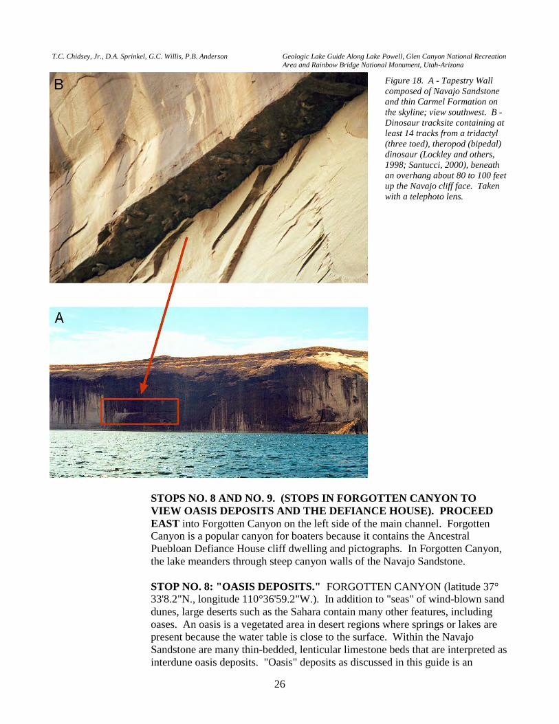
Buoys 110 to 109 STOP NO. 7 (FLOATING): DINOSAUR TRACKS. TAPESTRY WALL
(latitude 37°36'0.4"N., longitude 110°36'20.5"W.). Tapestry Wall is a 300-foot sheer wall of Navajo Sandstone along the right shore of the main channel (figure 18A). It gets its name from the reddish-brown discoloration that forms streaks down the steep, light-brown Navajo face. The streaks are caused by rainwater that flows down from the overlying reddish-brown Carmel Formation and across the Navajo face of the wall. Another fascinating aspect of Tapestry Wall is a small overhang about 80 to 100 feet above the lake. The overhang contains preserved tracks from a tridactyl (three-toed) theropod (two-footed [bipedal]) dinosaur (figure 18B); the tracks are most likely of the ichnogenus Eubrontes, characterized by 20-foot-long carnivores (Lockley and others, 1998; Santucci, 2000).
Buoy 107A Eolian Navajo and overlying Page Sandstones crop out along the left and right
shores; the Navajo is at lake level and the Page is the darker brown sandstone on the skyline, about 20 feet thick. The thickness of the Page varies along the lake; in places it is absent. A good example of large-scale cross-bedding in the Navajo is exposed on the right shore.
Near Buoy 107 MOUTH OF KNOWLES CANYON is on the left side of the main channel. The
Navajo Sandstone crops out at lake level at the mouth of the canyon, but the underlying Kayenta Formation crops out at lake level not far up canyon.
Buoys 107 to 106 SMITH FORK AND FORGOTTEN CANYONS. The mouth of Smith Fork
Canyon is on the right side of the main channel. The Navajo Sandstone is at lake level up the canyon and the Page Sandstone and Carmel Formation overlie the Navajo above the lake. Abundant soft-sediment deformation features are preserved in the Navajo in Smith Fork Canyon.
...we discover the ruins of an old building...Its walls are of stone, laid in mortar
with much regularity. Great quantities of flint chips are found on the rocks near by, and many arrowheads, some perfect, others broken; and fragments of pottery are strewn about in great profusion. —Major John Wesley Powell, July 29, 1869
T.C. Chidsey, Jr., D.A. Sprinkel, G.C. Willis, P.B. Anderson Geologic Lake Guide Along Lake Powell, Glen Canyon National Recreation Area and Rainbow Bridge National Monument, Utah-Arizona
26
STOPS NO. 8 AND NO. 9. (STOPS IN FORGOTTEN CANYON TO VIEW OASIS DEPOSITS AND THE DEFIANCE HOUSE). PROCEED EAST into Forgotten Canyon on the left side of the main channel. Forgotten Canyon is a popular canyon for boaters because it contains the Ancestral Puebloan Defiance House cliff dwelling and pictographs. In Forgotten Canyon, the lake meanders through steep canyon walls of the Navajo Sandstone.
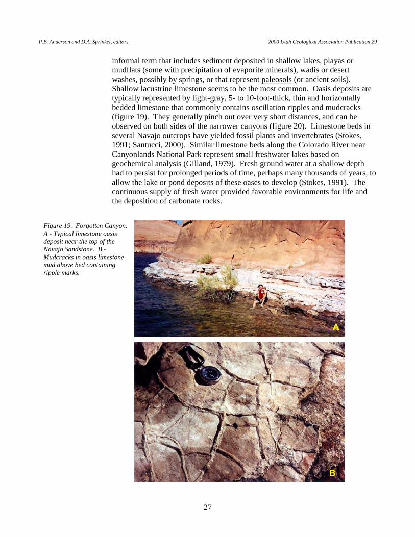
STOP NO. 8: "OASIS DEPOSITS." FORGOTTEN CANYON (latitude 37°
33'8.2"N., longitude 110°36'59.2"W.). In addition to "seas" of wind-blown sand dunes, large deserts such as the Sahara contain many other features, including oases. An oasis is a vegetated area in desert regions where springs or lakes are present because the water table is close to the surface. Within the Navajo Sandstone are many thin-bedded, lenticular limestone beds that are interpreted as interdune oasis deposits. "Oasis" deposits as discussed in this guide is an
Figure 18. A - Tapestry Wall composed of Navajo Sandstone and thin Carmel Formation on the skyline; view southwest. B - Dinosaur tracksite containing at least 14 tracks from a tridactyl (three toed), theropod (bipedal) dinosaur (Lockley and others, 1998; Santucci, 2000), beneath an overhang about 80 to 100 feet up the Navajo cliff face. Taken with a telephoto lens.
P.B. Anderson and D.A. Sprinkel, editors 2000 Utah Geological Association Publication 29
27
informal term that includes sediment deposited in shallow lakes, playas or mudflats (some with precipitation of evaporite minerals), wadis or desert washes, possibly by springs, or that represent paleosols (or ancient soils). Shallow lacustrine limestone seems to be the most common. Oasis deposits are typically represented by light-gray, 5- to 10-foot-thick, thin and horizontally bedded limestone that commonly contains oscillation ripples and mudcracks (figure 19). They generally pinch out over very short distances, and can be observed on both sides of the narrower canyons (figure 20). Limestone beds in several Navajo outcrops have yielded fossil plants and invertebrates (Stokes, 1991; Santucci, 2000). Similar limestone beds along the Colorado River near Canyonlands National Park represent small freshwater lakes based on geochemical analysis (Gilland, 1979). Fresh ground water at a shallow depth had to persist for prolonged periods of time, perhaps many thousands of years, to allow the lake or pond deposits of these oases to develop (Stokes, 1991). The continuous supply of fresh water provided favorable environments for life and the deposition of carbonate rocks.
Figure 19. Forgotten Canyon. A - Typical limestone oasis deposit near the top of the Navajo Sandstone. B - Mudcracks in oasis limestone mud above bed containing ripple marks.
T.C. Chidsey, Jr., D.A. Sprinkel, G.C. Willis, P.B. Anderson Geologic Lake Guide Along Lake Powell, Glen Canyon National Recreation Area and Rainbow Bridge National Monument, Utah-Arizona
28
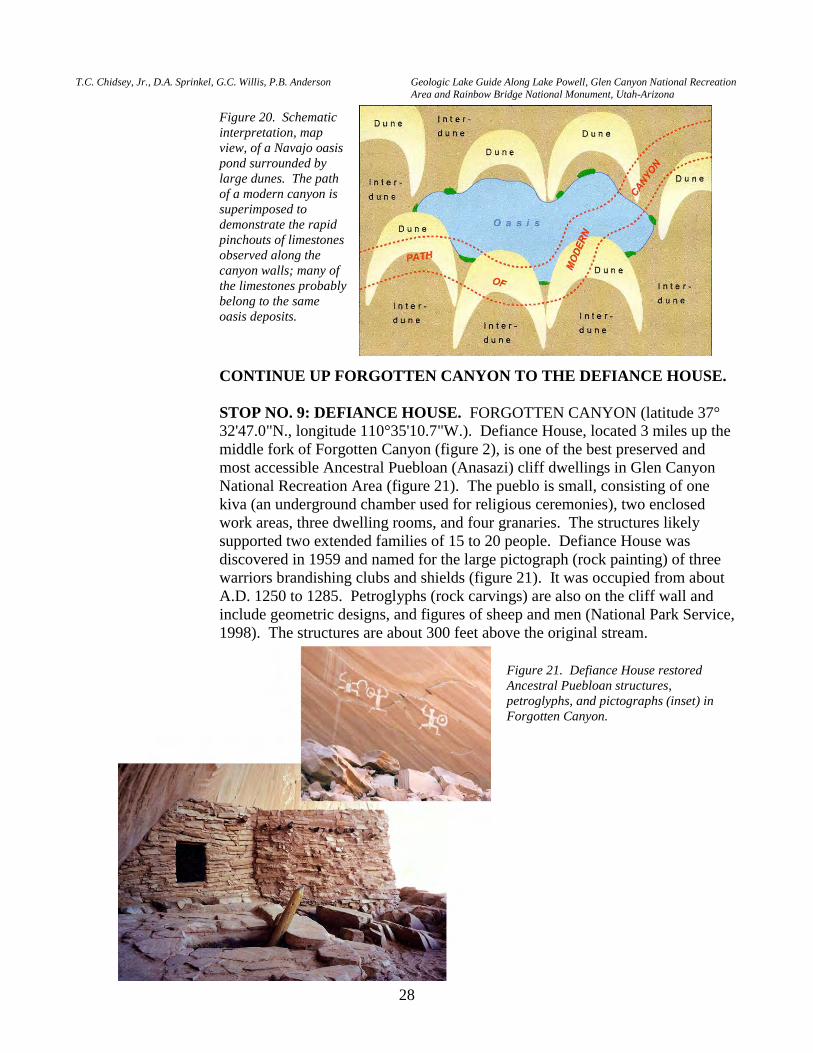
CONTINUE UP FORGOTTEN CANYON TO THE DEFIANCE HOUSE. STOP NO. 9: DEFIANCE HOUSE. FORGOTTEN CANYON (latitude 37°
32'47.0"N., longitude 110°35'10.7"W.). Defiance House, located 3 miles up the middle fork of Forgotten Canyon (figure 2), is one of the best preserved and most accessible Ancestral Puebloan (Anasazi) cliff dwellings in Glen Canyon National Recreation Area (figure 21). The pueblo is small, consisting of one kiva (an underground chamber used for religious ceremonies), two enclosed work areas, three dwelling rooms, and four granaries. The structures likely supported two extended families of 15 to 20 people. Defiance House was discovered in 1959 and named for the large pictograph (rock painting) of three warriors brandishing clubs and shields (figure 21). It was occupied from about A.D. 1250 to 1285. Petroglyphs (rock carvings) are also on the cliff wall and include geometric designs, and figures of sheep and men (National Park Service, 1998). The structures are about 300 feet above the original stream.
Figure 20. Schematic interpretation, map view, of a Navajo oasis pond surrounded by large dunes. The path of a modern canyon is superimposed to demonstrate the rapid pinchouts of limestones observed along the canyon walls; many of the limestones probably belong to the same oasis deposits.
Figure 21. Defiance House restored Ancestral Puebloan structures, petroglyphs, and pictographs (inset) in Forgotten Canyon.
P.B. Anderson and D.A. Sprinkel, editors 2000 Utah Geological Association Publication 29
29
RETURN TO MAIN CHANNEL OF LAKE POWELL. Buoy 104 MOUTH OF HANSEN CREEK CANYON is on the right side of the main
channel. Both the left and right shores consist of Navajo Sandstone. The Page Sandstone is the darker brown sandstone bed overlying the Navajo. The Carmel Formation is the reddish tabular beds on the skyline.
Buoy 103 STOP NO. 10: IRONSTONE DEPOSITS IN THE NAVAJO SANDSTONE.
(latitude 37°31'7.8"N., longitude 110°39'32.5"W.). The left and right shores expose Navajo Sandstone with the overlying Page Sandstone and Carmel Formation above lakeshore. A view of the Entrada Sandstone is seen above the right shore. An old river terrace deposit can be seen above the lake on the left shore.
River gravels are abundant on many surfaces all along the Colorado River. We
have pointed them out in just a few places. It is well worth the time to stop and take a closer look. Note the wide variety of clasts, and the excellent sorting and rounding. These represent just the most resistant fraction of the wide variety of rocks exposed in the Colorado River basin upstream. Some were derived from local exposures in Utah, while many, particularly the metamorphic clasts, could only have been transported from easternmost Utah or western Colorado. Some of these clasts may have been transported hundreds of miles. It is interesting to compare the well-sorted river cobbles, which were rounded by tens to hundreds of miles of transportation down the river, to the angular and subangular clasts, which were derived locally and could only have been transported a short distance.
Though some of these deposits are now near lake level, remember that the lake is
up to 700 feet deep. Some gravels are as much as 1,400 feet above the pre-lake river level (Hunt, 1969). The time of deposition can be inferred using incision rates (see Buoy 50, STOP NO. 16), which indicate that gravels near the present lake level may have been deposited less than 300,000 years ago, and the highest may have been deposited 500,000 to over a million years ago.
PROCEED TOWARD THE LEFT SHORE. The Navajo Sandstone contains
numerous dark-brown zones of ironstone sheets and concretions. These features are harder than the sandstone. The ironstone sheets are thin and are often found along Navajo cross-beds (figure 22A). The concretions, called "Navajo berries" or "Moki marbles," weather out of the Navajo (figure 22B) and consist of a well-cemented limonite shell around a friable (loosely cemented) sandstone core (Doelling, 1968, 1975). Most are nearly spherical and range from pea size up to 4 inches in diameter. Navajo berries and ironstone sheets form in the subsurface, probably after the sand is lithified to sandstone. They are composed mostly of quartz sand bound by the dense mineraloid goethite (FeO.OH), with some formation of hematite (Fe2O3). The process is uncertain, but they form as minute amounts of iron are precipitated from ground water. Ground water moving through the sandstone typically has about 0.1 to 0.2 parts per million dissolved
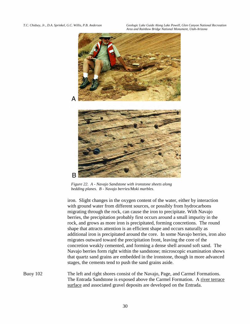
T.C. Chidsey, Jr., D.A. Sprinkel, G.C. Willis, P.B. Anderson Geologic Lake Guide Along Lake Powell, Glen Canyon National Recreation Area and Rainbow Bridge National Monument, Utah-Arizona
30
iron. Slight changes in the oxygen content of the water, either by interaction
with ground water from different sources, or possibly from hydrocarbons migrating through the rock, can cause the iron to precipitate. With Navajo berries, the precipitation probably first occurs around a small impurity in the rock, and grows as more iron is precipitated, forming concretions. The round shape that attracts attention is an efficient shape and occurs naturally as additional iron is precipitated around the core. In some Navajo berries, iron also
migrates outward toward the precipitation front, leaving the core of the concretion weakly cemented, and forming a dense shell around soft sand. The Navajo berries form right within the sandstone; microscopic examination shows that quartz sand grains are embedded in the ironstone, though in more advanced stages, the cements tend to push the sand grains aside.
Buoy 102 The left and right shores consist of the Navajo, Page, and Carmel Formations.
The Entrada Sandstone is exposed above the Carmel Formation. A river terrace surface and associated gravel deposits are developed on the Entrada.
Figure 22. A - Navajo Sandstone with ironstone sheets along bedding planes. B - Navajo berries/Moki marbles.
P.B. Anderson and D.A. Sprinkel, editors 2000 Utah Geological Association Publication 29
31
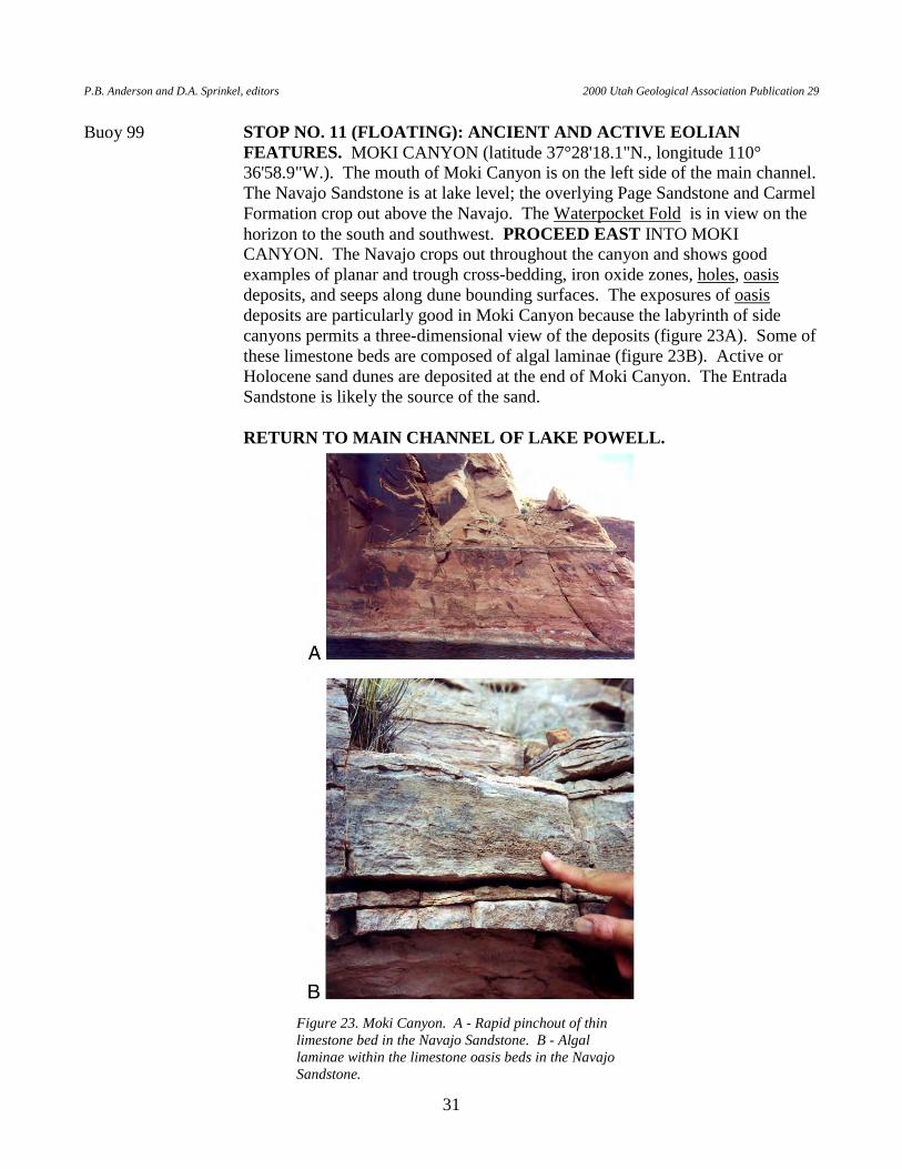
Buoy 99 STOP NO. 11 (FLOATING): ANCIENT AND ACTIVE EOLIAN FEATURES. MOKI CANYON (latitude 37°28'18.1"N., longitude 110°36'58.9"W.). The mouth of Moki Canyon is on the left side of the main channel. The Navajo Sandstone is at lake level; the overlying Page Sandstone and Carmel Formation crop out above the Navajo. The Waterpocket Fold is in view on the horizon to the south and southwest. PROCEED EAST INTO MOKI CANYON. The Navajo crops out throughout the canyon and shows good examples of planar and trough cross-bedding, iron oxide zones, holes, oasis deposits, and seeps along dune bounding surfaces. The exposures of oasis deposits are particularly good in Moki Canyon because the labyrinth of side canyons permits a three-dimensional view of the deposits (figure 23A). Some of these limestone beds are composed of algal laminae (figure 23B). Active or Holocene sand dunes are deposited at the end of Moki Canyon. The Entrada Sandstone is likely the source of the sand.
RETURN TO MAIN CHANNEL OF LAKE POWELL.
Figure 23. Moki Canyon. A - Rapid pinchout of thin limestone bed in the Navajo Sandstone. B - Algal laminae within the limestone oasis beds in the Navajo Sandstone.
T.C. Chidsey, Jr., D.A. Sprinkel, G.C. Willis, P.B. Anderson Geologic Lake Guide Along Lake Powell, Glen Canyon National Recreation Area and Rainbow Bridge National Monument, Utah-Arizona
32
Buoy 97 The Navajo Sandstone through the Carmel Formation is exposed on the right shore. The Page Sandstone is close to lake level. The left shore has Navajo through Entrada Sandstone. The contact between the Carmel and overlying Entrada is placed at the base of the massive-weathering, orange sandstone. Alcoves are developed at and above the contact in the Entrada. An old river terrace is developed on the Entrada Sandstone. Gravel deposits are preserved on the surface.
Buoy 95A The Carmel Formation is the reddish-brown, slope-forming unit exposed at lake
level. The Carmel represents an environment of intermittent shallow-marine flooding. The reddish-orange, massive-weathering, rounded sandstone is the overlying Entrada Sandstone which represents a return to eolian conditions.
Buoy 95 BULLFROG BAY is the large bay on the right side of the main channel. The
Entrada Sandstone is exposed at lake level surrounding Bullfrog Bay. The two monoliths that guard the entrance to Bullfrog Bay are composed of Entrada Sandstone. The monoliths are called The Haystacks. The Entrada is capped by gravel deposits representing a river terrace surface.
LEAVE THE MAIN CHANNEL AND PROCEED INTO BULLFROG
BAY. STOP NO. 12 (FLOATING): WATERPOCKET FOLD, AND MIDDLE
AND UPPER JURASSIC ROCKS. BOAT NORTHWEST TO NEAR THE END OF BULLFROG BAY. The Entrada Sandstone crops out at lake level at the head of Bullfrog Bay. To the north, the overlying Summerville Formation and Salt Wash Member of the Upper Jurassic Morrison Formation crop out. The Summerville forms vertical red cliffs with Salt Wash capping the cliffs. The Salt Wash consists of white and red ledgey sandstone. Also to the north are the Henry Mountains. Mount Hillers (left) and Mount Ellsworth (right) are two of the five named peaks in the Henry Mountains.
A peninsula of Entrada Sandstone capped with old river terrace gravel deposits
separates Halls Creek and Bullfrog Bay. The gravel deposits are probably Pleistocene in age.
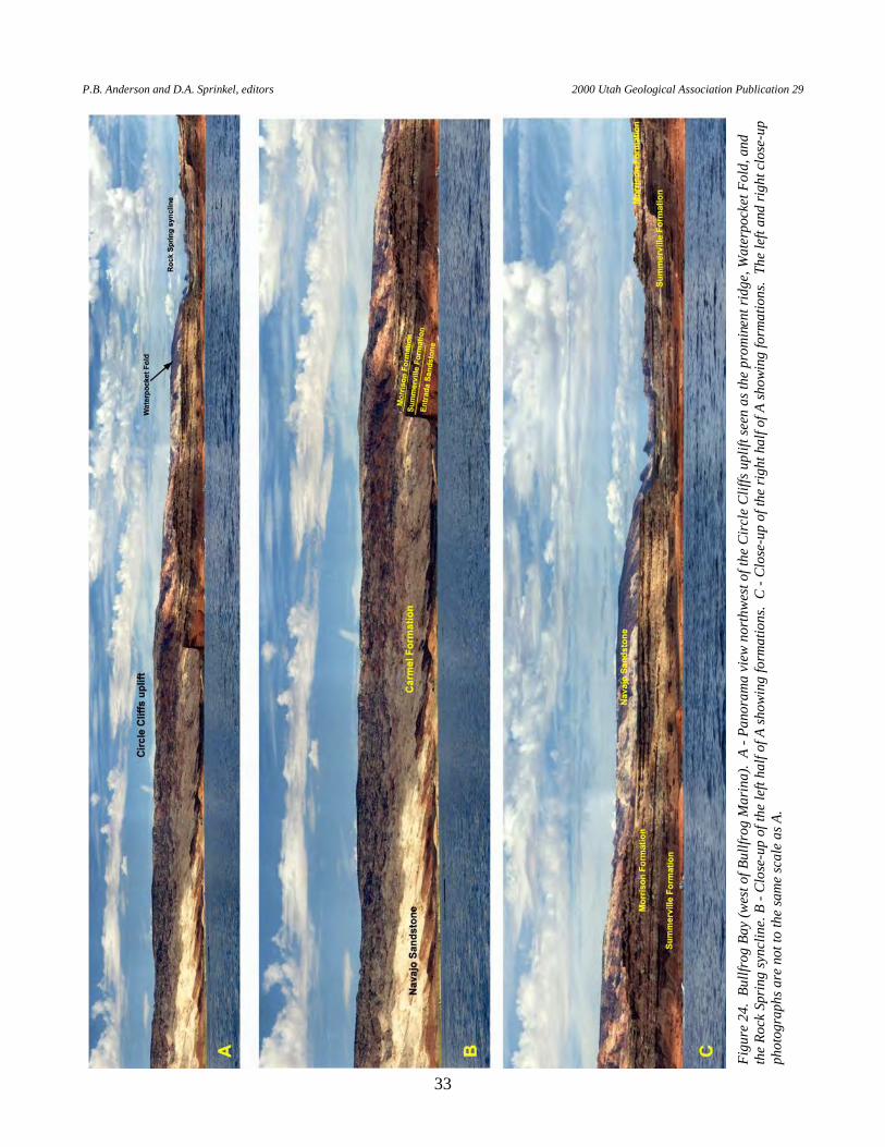
The Waterpocket Fold and a small syncline in Upper Jurassic rocks are
prominently displayed on the north side of the lake (figure 24). The Lower Jurassic Navajo Sandstone forms the round outcrops of light gray and pink sandstone on the ridge above the shoreline. The Middle Jurassic Carmel Formation forms the dark reddish lowlands (flatirons) near lake level to the west, and the light-orange, Middle Jurassic Entrada Sandstone is at lake level to the east. The Middle Jurassic Summerville Formation forms the vertical red cliffs with Salt Wash Member of the Morrison Formation (mottled red and white sandstone beds) that crops out at the head of the bay. The Navajo most clearly defines the Waterpocket Fold, a monocline that represents the east flank of the Circle Cliffs uplift. The Circle Cliffs uplift folded these rocks during the
P.B. Anderson and D.A. Sprinkel, editors 2000 Utah Geological Association Publication 29
33
Figu
re 2
4. B
ullfr
og B
ay (w
est o
f Bul
lfrog
Mar
ina)
. A
- Pan
oram
a vi
ew n
orth
wes
t of t
he C
ircl
e C
liffs
upl
ift se
en a
s the
pro
min
ent r
idge
, Wat
erpo
cket
Fol
d, a
nd
the
Rock
Spr
ing
sync
line.
B -
Clos
e-up
of t
he le
ft ha
lf of
A sh
owin
g fo
rmat
ions
. C
- Clo
se-u
p of
the
right
hal
f of A
show
ing
form
atio
ns.
The
left
and
right
clo
se-u
p ph
otog
raph
s are
not
to th
e sa
me
scal
e as
A.
T.C. Chidsey, Jr., D.A. Sprinkel, G.C. Willis, P.B. Anderson Geologic Lake Guide Along Lake Powell, Glen Canyon National Recreation Area and Rainbow Bridge National Monument, Utah-Arizona
34
Laramide orogeny (mountain building event) about 70 to 40 million years ago. To the right of the Waterpocket Fold, the fold axis of the Rock Spring syncline is preserved in the Middle and Upper Jurassic rocks.
STRUCTURAL DEFORMATION IN GLEN CANYON NATIONAL
RECREATION AREA FOLDED ROCKS: If asked for a general description of the rocks of Glen
Canyon, most people would state that they are "flat" or "level." However, in reality, all of the rocks are warped by three broad anticlinal folds that cover several tens of miles, intervening synclines, and several smaller superimposed folds. Indeed, these subtle folds are one of the defining characteristics of the rocks of Glen Canyon National Recreation Area (only locally do beds dip more than about 3 degrees). The horizontal lake surface provides an ideal datum for recognizing the subtle slope of the beds. As you travel up and down the lake, you will notice the gentle inclination of the strata makes them appear to rise or fall relative to the lake surface. These folds are generally attributed to three main deformational events: (1) the Laramide orogeny, (2) intrusion of the Navajo Mountain laccolith, and (3) uplift of the Colorado Plateau. A fourth event, Mesozoic subsidence and arching, produced shallow basins that are more difficult to recognize. The intrusion of the Navajo Mountain laccolith during the Oligocene produced a broad domal uplift that is described in more detail at Buoy 50 (STOP NO. 16).
JURASSIC BASINS: During most of the Mesozoic and Cenozoic, North
America was on a collision course with the Farallon Plate, the subducting floor of an earlier Pacific Ocean. This deformation was first expressed in Glen Canyon National Recreation Area during the Jurassic as broad sag folds called "back-bulge basins" (DeCelles, 1994; Willis, 1999). The Carmel, Entrada, Romana, and Morrison Formations are particularly striking examples of sediments deposited in these broad basins. Later, during the Late Jurassic and Early Cretaceous, a counterfold - a broad arch - formed in this area; previously deposited formations are beveled off by erosion across this arch. These planed-off beds are best seen near the west end of Wahweap Bay (Buoy 7WC). Finally, the Dakota, Tropic, and Straight Cliffs Formations, seen at Fiftymile Mountain, were deposited in a later "foredeep basin" that developed in response to compressional mountain building to the west. These Mesozoic folds are so broad and shallow that they can only be detected by noting changing thicknesses of formations and subtle erosion surfaces across southern Utah.
SEVIER AND LARAMIDE OROGENIES: In the Early Cretaceous, mountain-
building compression of the Sevier orogeny was directly affecting western Utah in the form of large thrust faults that stacked up great sheets of rock. Glen Canyon National Recreation Area was east of this thrust deformation. However, by the Late Cretaceous and early Tertiary, the deformation of the Laramide orogeny extended farther eastward where it exerted a different effect on Glen Canyon National Recreation Area. Instead of thrust faults, it produced
P.B. Anderson and D.A. Sprinkel, editors 2000 Utah Geological Association Publication 29
35
deep-seated reverse faults in the brittle Precambrian basement rock. These faults were bounded by broad domal uplifts and basins. Over the basement faults, the relatively flexible sedimentary rocks formed large drapes called monoclinal folds. Broad uplifts and basins tens of miles wide formed between the monoclines. The Circle Cliffs uplift (bounded by the Waterpocket Fold), Monument uplift (bounded by the Comb Ridge monocline east of Glen Canyon National Recreation Area), and Echo Cliffs monocline (mostly in Arizona), and the intervening Henry and Kaiparowits basins, are the major folds in Glen Canyon National Recreation Area (figure 4). Smaller secondary folds formed over the larger folds. Several of these large and small folds are quite striking in Glen Canyon National Recreation Area, and are pointed out in the lake guide.
UPLIFT: The Laramide compression also produced another effect - most of the
western U.S., including Glen Canyon National Recreation Area, rose in elevation. How this was caused is uncertain and complex, but some recent workers believe that as the hot, young, Farallon ocean plate slid beneath the continental plate (underplating), the crust was forced to rise in compensation (Burchfiel and others, 1992). Most of the uplift occurred in the early Tertiary, but erosion of uplifted rock caused additional buoyant "rebound" throughout the remainder of the Tertiary, accentuating the uplift. Today, rocks deposited below sea level in the Late Cretaceous are found at elevations of over 8,000 feet at the top of Fiftymile Mountain. If these rocks are projected over the Circle Cliffs and Monument uplifts, they would stand at more than 12,000 feet in elevation. By middle Tertiary time, this part of the Colorado Plateau stood as a broad high plain.
PROCEED TO HALLS CREEK BAY by either navigating around the end of
the peninsula or cutting across a small, shallow strait that connects the two bays. However, PROCEED THROUGH THE STRAIT WITH CAUTION because it can be too shallow for some boats to navigate during periods of low water. Similar views of the geology seen in Bullfrog Bay can be seen in Halls Creek Bay, but at a slightly different perspective.
PROCEED BACK TO THE MAIN CHANNEL AND CONTINUE DOWN
THE LAKE. Buoy 92 The left and right shores consist of Navajo Sandstone. The Carmel Formation
forms the overlying thin-bedded reddish sandstone and siltstone that caps this view of Iron Top Mesa.
The smooth, naked rock stretches out on either side of the river for many miles,
but curiously carved mounds and cones are scattered everywhere and deep holes are worn out. Many of these pockets are filled with water. —Major John Wesley Powell, July 29, 1869
T.C. Chidsey, Jr., D.A. Sprinkel, G.C. Willis, P.B. Anderson Geologic Lake Guide Along Lake Powell, Glen Canyon National Recreation Area and Rainbow Bridge National Monument, Utah-Arizona
36
Buoy 90 A good view of the Waterpocket Fold is to the north. Navajo Sandstone is at lake level with Carmel Formation capping cliffs. Small holes, commonly referred to as "stonepecker holes" or tafoni, have been weathered out of the Navajo (also observed in the Cedar Mesa, White Rim, Wingate, Page, and Entrada Sandstones) along cross-beds and bedset boundaries in many areas. Sometime in the past a geologist jokingly stated that the holes were created by "stonepecker" birds, and the name stuck. They are most likely caused by differential erosion in areas where ground water has weakened the cement at small variations or imperfections in the rock. Once started, the voids protect accumulated water from evaporation, thus promoting further growth of the opening.
Buoy 89 MOUTH OF LAKE CANYON is just down the lake of Buoy 89 on the left side
of the main channel. The Navajo Sandstone is at lake level with Carmel Formation coming close to lake level near the head of the canyon; the Page Sandstone is absent in this area. Cross-beds, soft-sediment deformation, and ironstone concretions are abundantly preserved in the Navajo in Lake Canyon.
Buoy 87A The left shore is Navajo Sandstone with Carmel Formation capping the cliff.
The right shore is Navajo. Buoy 86 Navajo Sandstone is at lake level (left and right shore) with Carmel Formation
capping the cliff. Numerous hanging gardens within the Navajo are visible between Buoy 87 and Buoy 86.
Buoy 84 MOUTH OF ANNIES CANYON is between Buoy 84 and Buoy 83 on the right
side of the main channel. Navajo Sandstone crops out on the left and right shores. Annies Canyon consists of steep narrow walls of Navajo. Trough cross-bedding, convolute bedding from soft-sediment deformation or slumping on the slopes of ancient dunes, and horizontal bedding of an oasis deposit are preserved in the Navajo near the end of the south fork of Annies Canyon. In addition, fracture sets that strike N. 80° W. are common. A small-displacement fault is mapped in Annies Canyon (Doelling and Davis, 1989). The fault also strikes about N. 80° W. This fault can be viewed in a small cove on the left side of the main channel at about Buoy 83.
Buoy 83 STOP NO. 13 (FLOATING): FAULTED OASIS DEPOSITS AND ALICE
J. ARCH. (latitude 37°22'13.8"N., longitude 110°43'2.2"W.). The main channel follows the axis of the Piute Mesa syncline (Doelling and Davis, 1989). Navajo Sandstone is at lake level with Carmel Formation capping the cliff on the right side of the main channel. A small cove on the left side of the main channel contains a good example of an oasis deposit in the Navajo.
PROCEED INTO THE SMALL COVE to view oasis deposits and a small-
displacement fault (figure 25). The oasis deposit is the thin, flat-lying, gray limestone beds within the Navajo. Surrounding sandstone beds display pronounced trough cross-bedding which indicates the paleowinds were from the
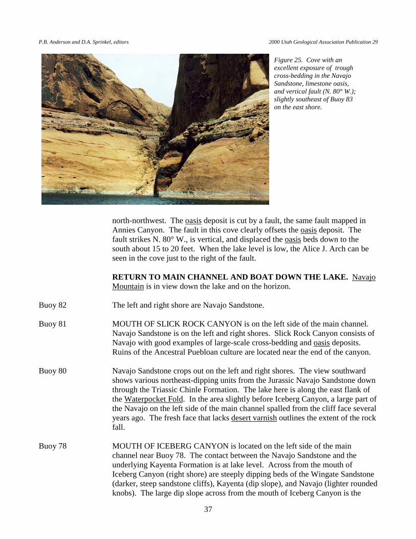
P.B. Anderson and D.A. Sprinkel, editors 2000 Utah Geological Association Publication 29
37
north-northwest. The oasis deposit is cut by a fault, the same fault mapped in Annies Canyon. The fault in this cove clearly offsets the oasis deposit. The fault strikes N. 80° W., is vertical, and displaced the oasis beds down to the south about 15 to 20 feet. When the lake level is low, the Alice J. Arch can be seen in the cove just to the right of the fault.
RETURN TO MAIN CHANNEL AND BOAT DOWN THE LAKE. Navajo
Mountain is in view down the lake and on the horizon. Buoy 82 The left and right shore are Navajo Sandstone. Buoy 81 MOUTH OF SLICK ROCK CANYON is on the left side of the main channel.
Navajo Sandstone is on the left and right shores. Slick Rock Canyon consists of Navajo with good examples of large-scale cross-bedding and oasis deposits. Ruins of the Ancestral Puebloan culture are located near the end of the canyon.
Buoy 80 Navajo Sandstone crops out on the left and right shores. The view southward
shows various northeast-dipping units from the Jurassic Navajo Sandstone down through the Triassic Chinle Formation. The lake here is along the east flank of the Waterpocket Fold. In the area slightly before Iceberg Canyon, a large part of the Navajo on the left side of the main channel spalled from the cliff face several years ago. The fresh face that lacks desert varnish outlines the extent of the rock fall.
Buoy 78 MOUTH OF ICEBERG CANYON is located on the left side of the main
channel near Buoy 78. The contact between the Navajo Sandstone and the underlying Kayenta Formation is at lake level. Across from the mouth of Iceberg Canyon (right shore) are steeply dipping beds of the Wingate Sandstone (darker, steep sandstone cliffs), Kayenta (dip slope), and Navajo (lighter rounded knobs). The large dip slope across from the mouth of Iceberg Canyon is the
Figure 25. Cove with an excellent exposure of trough cross-bedding in the Navajo Sandstone, limestone oasis, and vertical fault (N. 80° W.); slightly southeast of Buoy 83 on the east shore.
T.C. Chidsey, Jr., D.A. Sprinkel, G.C. Willis, P.B. Anderson Geologic Lake Guide Along Lake Powell, Glen Canyon National Recreation Area and Rainbow Bridge National Monument, Utah-Arizona
38
Kayenta. In Iceberg Canyon, the Navajo contains large-scale cross-bedding, an oasis deposit, hanging gardens, and abundant holes (tafoni). In addition, large east-west fractures are common. The Rincon is visible to the south down the lake.
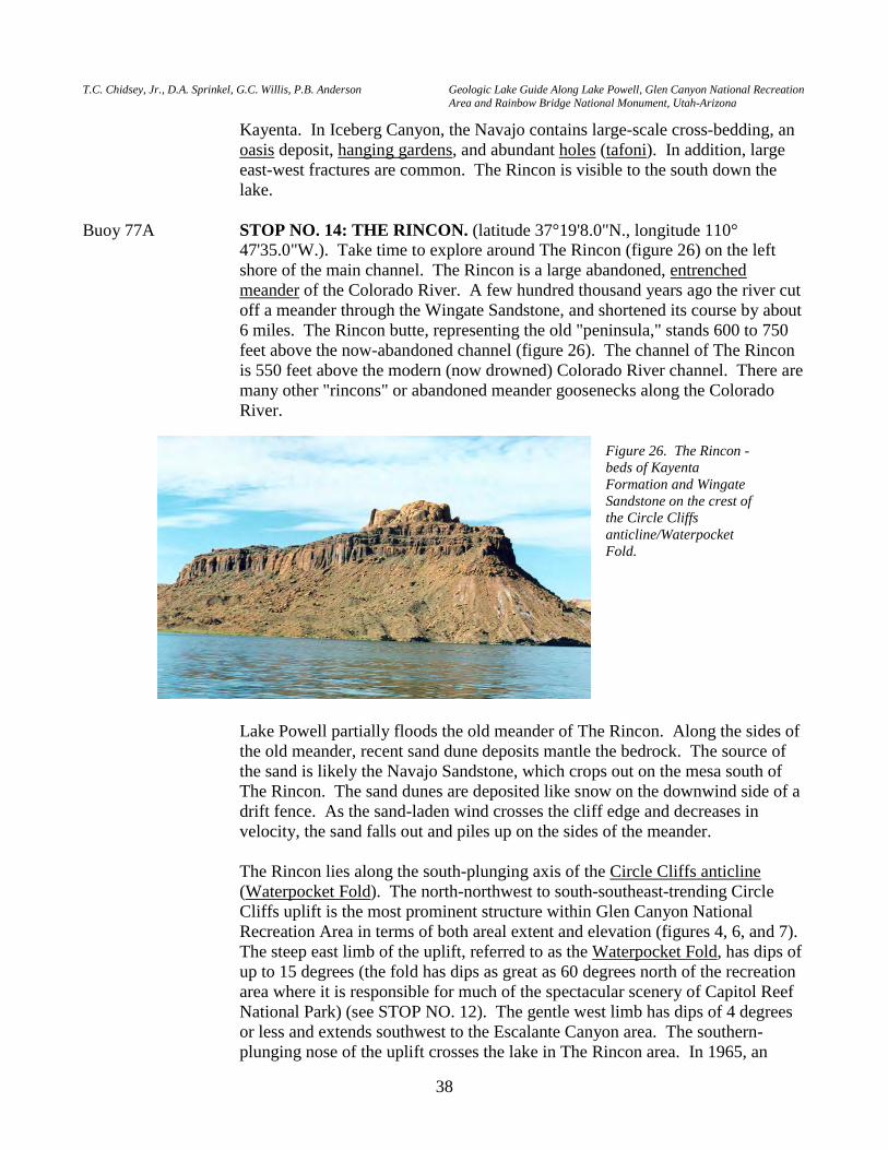
Buoy 77A STOP NO. 14: THE RINCON. (latitude 37°19'8.0"N., longitude 110°
47'35.0"W.). Take time to explore around The Rincon (figure 26) on the left shore of the main channel. The Rincon is a large abandoned, entrenched meander of the Colorado River. A few hundred thousand years ago the river cut off a meander through the Wingate Sandstone, and shortened its course by about 6 miles. The Rincon butte, representing the old "peninsula," stands 600 to 750 feet above the now-abandoned channel (figure 26). The channel of The Rincon is 550 feet above the modern (now drowned) Colorado River channel. There are many other "rincons" or abandoned meander goosenecks along the Colorado River.
Lake Powell partially floods the old meander of The Rincon. Along the sides of the old meander, recent sand dune deposits mantle the bedrock. The source of the sand is likely the Navajo Sandstone, which crops out on the mesa south of The Rincon. The sand dunes are deposited like snow on the downwind side of a drift fence. As the sand-laden wind crosses the cliff edge and decreases in velocity, the sand falls out and piles up on the sides of the meander.
The Rincon lies along the south-plunging axis of the Circle Cliffs anticline
(Waterpocket Fold). The north-northwest to south-southeast-trending Circle Cliffs uplift is the most prominent structure within Glen Canyon National Recreation Area in terms of both areal extent and elevation (figures 4, 6, and 7). The steep east limb of the uplift, referred to as the Waterpocket Fold, has dips of up to 15 degrees (the fold has dips as great as 60 degrees north of the recreation area where it is responsible for much of the spectacular scenery of Capitol Reef National Park) (see STOP NO. 12). The gentle west limb has dips of 4 degrees or less and extends southwest to the Escalante Canyon area. The southern-plunging nose of the uplift crosses the lake in The Rincon area. In 1965, an
Figure 26. The Rincon - beds of Kayenta Formation and Wingate Sandstone on the crest of the Circle Cliffs anticline/Waterpocket Fold.
P.B. Anderson and D.A. Sprinkel, editors 2000 Utah Geological Association Publication 29
39
exploratory oil well, the Kissinger No. 1 Rincon Dome (SE1/4SW1/4 section 3, T. 40 S., R. 10 E., Salt Lake Base Line and Meridian) was drilled on the right shore just below the steep cliffs across from The Rincon. The drill rig was brought to the area by a barge from Halls Crossing. The well was drilled to a total depth of 4,466 feet, bottoming in the Mississippian Redwall Limestone (Riggs, 1978). Tests (drillstem test) were run on several formations and 26 barrels of oil were recovered from the Shinarump Member of the Chinle Formation at a depth of 410 feet before the well was abandoned.
The oldest formation exposed in The Rincon is the Triassic Chinle Formation.
The Chinle is the varicolored, slope-forming unit that emerges above water. Near the east arm of The Rincon, the Chinle consists of mudstone, conglomerate, paleosols, and calcrete. The Chinle locally contains petrified wood and dinosaur remains. A small island of Chinle is near the east arm of The Rincon. The island also contains large jumbled blocks of Wingate Sandstone that give the island a rubble look. We call it "Rubble Island." Take the time to hike along Rubble Island and the nearby shore to inspect the various rock types of the Chinle Formation. PLEASE REMEMBER TO LEAVE ANY PETRIFIED WOOD OR DINOSAUR REMAINS YOU MAY HAPPEN TO FIND. IT IS A FEDERAL OFFENSE TO REMOVE GEOLOGIC RESOURCES FROM THE RECREATION AREA.
The Chinle Formation is an unstable unit because of clay beds derived from
altered volcanic ash. Numerous slumps and slides and fresh headwall scarps characterize The Rincon area like most places where the Chinle is exposed. The Chinle has a hummocky topographic expression and is mantled by large joint blocks of sandstone that fell from the overlying Wingate Sandstone cliffs. Canyons are typically wide in areas where the Chinle crops out because of the persistent movement of this unit. As the Chinle slumps and slides, the overlying Wingate becomes unstable, which causes large blocks of sandstone to calve off from the cliff face along the joints. Here, the joints in the Wingate generally parallel the lake. Rock falls of the Wingate are a constant hazard and people should not camp on the Chinle below Wingate cliffs.
Buoy 77 Wingate Sandstone blocks are resting on the Chinle Formation. This is similar
to Rubble Island. See the description at Buoy 77A. ...the orange sandstone ..., yielding to gravity, as the softer shales below work
out into the river, breaks into angular surfaces, often having a columnar appearance. —Major John Wesley Powell, July 30, 1869
Buoy 75A Chinle Formation is on left and right shores with highly jointed Wingate
Sandstone above. Note the slumps in the Chinle. Buoy 75 Note the contact between the Chinle Formation and Wingate Sandstone. The
Wingate approaches the lake level as the beds of the Chinle and Wingate dip west across the west flank of the Circle Cliffs anticline.
T.C. Chidsey, Jr., D.A. Sprinkel, G.C. Willis, P.B. Anderson Geologic Lake Guide Along Lake Powell, Glen Canyon National Recreation Area and Rainbow Bridge National Monument, Utah-Arizona
40
Buoys 75 to 74A BENNETT’S SEEP is a now submerged, naturally occurring oil seep located near the mouth of Long Canyon on the right side of the main channel (Gregory and Moore, 1931; Ritzma, 1973). The seep originates from the Shinarump Member of the Chinle Formation and is noted on the 1955 U.S. Geological Survey topographic map of The Rincon quadrangle (1:62,500) as "oil seep bar" (Riggs, 1978).
Buoy 74A MOUTH OF BOWNS CANYON is on the right side of the main channel. The
top of the Wingate Sandstone, which is massive-weathering, is above the lake level. The more ledgy dark sandstone is the Kayenta Formation, and the steep, massive-weathering, rounded light brown cliffs are Navajo Sandstone.
Between Buoy 74 and the mouth of Escalante Canyon, the rocks dip generally
southwest such that the Navajo Sandstone is at lake level at the mouth of Escalante Canyon; however, in this interval, the lake crosses the axes of a few small folds that bring the Wingate Sandstone above the water line for short distances. Kayenta Formation is on the left and right shores with overlying Navajo forming steep cliffs. Hanging valleys are common, especially on the left shore. These geomorphic features formed when the rate of downcutting by streams in tributary canyons could not keep up with the rate of downcutting in the main channel by the Colorado River and were left "hanging."
Buoy 72 Kayenta Formation crops out along the left and right shores. Buoy 71 The contact of the Wingate Sandstone and Kayenta Formation is exposed at
Buoy 71. South of Buoy 71 is the axis of a subsidiary fold off the west flank of the Waterpocket Fold. The Wingate is in the core of the fold at lake level. The Kayenta Formation and overlying Navajo Sandstone crop out high above the lake.
Buoy 69A The Wingate Sandstone crops out at lake level; however, it disappears beneath
the lake not far south of this buoy. One could almost imagine that the walls have been carved with a purpose, to
represent giant architectural forms. In the deep recesses of the walls we find springs, with mosses and ferns on the moistened sandstone. —Major John Wesley Powell, July 30, 1869
Buoy 69 ESCALANTE CANYON. The mouth of Escalante Canyon is on the right side
of the main channel. The Escalante River was the last major stream in the contiguous United States to be mapped and named. Powell’s expedition completely missed the river. However, in 1872 some of Powell’s companions led by Almon H. Thompson explored the region. They decided to name the stream the "Escalante River" in honor of Father Escalante, the Spanish priest who co-lead an expedition through much of Utah in 1776, though he never saw the river that now bears his name (National Park Service and Bureau of Land Management, 1995) (see CROSSING OF THE FATHERS at Buoy 15). Most of
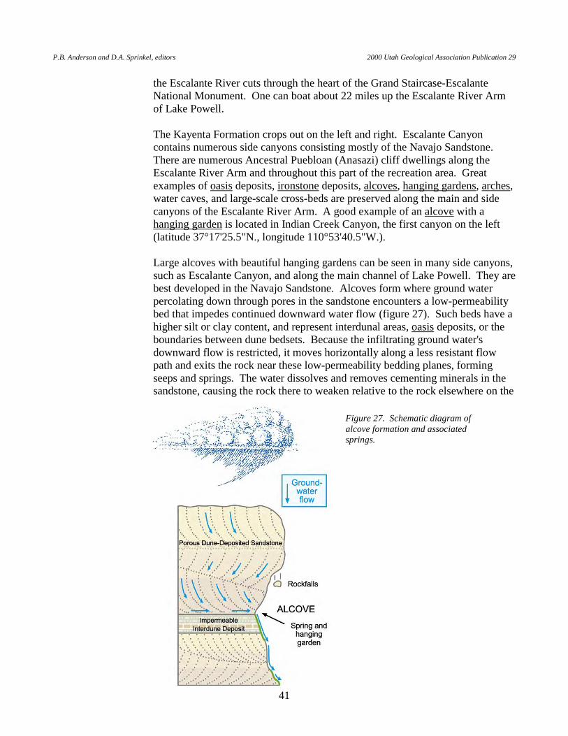
P.B. Anderson and D.A. Sprinkel, editors 2000 Utah Geological Association Publication 29
41
the Escalante River cuts through the heart of the Grand Staircase-Escalante National Monument. One can boat about 22 miles up the Escalante River Arm of Lake Powell.
The Kayenta Formation crops out on the left and right. Escalante Canyon
contains numerous side canyons consisting mostly of the Navajo Sandstone. There are numerous Ancestral Puebloan (Anasazi) cliff dwellings along the Escalante River Arm and throughout this part of the recreation area. Great examples of oasis deposits, ironstone deposits, alcoves, hanging gardens, arches, water caves, and large-scale cross-beds are preserved along the main and side canyons of the Escalante River Arm. A good example of an alcove with a hanging garden is located in Indian Creek Canyon, the first canyon on the left (latitude 37°17'25.5"N., longitude 110°53'40.5"W.).
Large alcoves with beautiful hanging gardens can be seen in many side canyons,
such as Escalante Canyon, and along the main channel of Lake Powell. They are best developed in the Navajo Sandstone. Alcoves form where ground water percolating down through pores in the sandstone encounters a low-permeability bed that impedes continued downward water flow (figure 27). Such beds have a higher silt or clay content, and represent interdunal areas, oasis deposits, or the boundaries between dune bedsets. Because the infiltrating ground water's downward flow is restricted, it moves horizontally along a less resistant flow path and exits the rock near these low-permeability bedding planes, forming seeps and springs. The water dissolves and removes cementing minerals in the sandstone, causing the rock there to weaken relative to the rock elsewhere on the
Figure 27. Schematic diagram of alcove formation and associated springs.
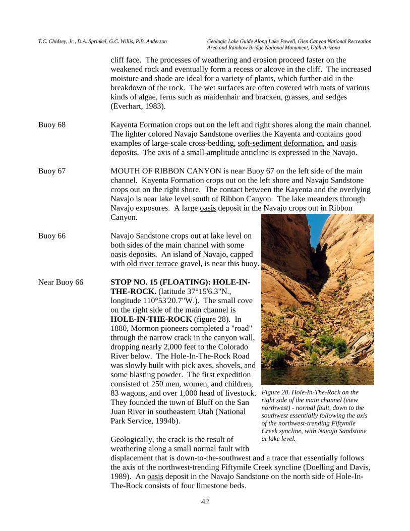
T.C. Chidsey, Jr., D.A. Sprinkel, G.C. Willis, P.B. Anderson Geologic Lake Guide Along Lake Powell, Glen Canyon National Recreation Area and Rainbow Bridge National Monument, Utah-Arizona
42
cliff face. The processes of weathering and erosion proceed faster on the weakened rock and eventually form a recess or alcove in the cliff. The increased moisture and shade are ideal for a variety of plants, which further aid in the breakdown of the rock. The wet surfaces are often covered with mats of various kinds of algae, ferns such as maidenhair and bracken, grasses, and sedges (Everhart, 1983).
Buoy 68 Kayenta Formation crops out on the left and right shores along the main channel.
The lighter colored Navajo Sandstone overlies the Kayenta and contains good examples of large-scale cross-bedding, soft-sediment deformation, and oasis deposits. The axis of a small-amplitude anticline is expressed in the Navajo.
Buoy 67 MOUTH OF RIBBON CANYON is near Buoy 67 on the left side of the main
channel. Kayenta Formation crops out on the left shore and Navajo Sandstone crops out on the right shore. The contact between the Kayenta and the overlying Navajo is near lake level south of Ribbon Canyon. The lake meanders through Navajo exposures. A large oasis deposit in the Navajo crops out in Ribbon Canyon.
Buoy 66 Navajo Sandstone crops out at lake level on
both sides of the main channel with some oasis deposits. An island of Navajo, capped with old river terrace gravel, is near this buoy.
Near Buoy 66 STOP NO. 15 (FLOATING): HOLE-IN-
THE-ROCK. (latitude 37°15'6.3"N., longitude 110°53'20.7"W.). The small cove on the right side of the main channel is HOLE-IN-THE-ROCK (figure 28). In 1880, Mormon pioneers completed a "road" through the narrow crack in the canyon wall, dropping nearly 2,000 feet to the Colorado River below. The Hole-In-The-Rock Road was slowly built with pick axes, shovels, and some blasting powder. The first expedition consisted of 250 men, women, and children, 83 wagons, and over 1,000 head of livestock. They founded the town of Bluff on the San Juan River in southeastern Utah (National Park Service, 1994b).
Geologically, the crack is the result of
weathering along a small normal fault with displacement that is down-to-the-southwest and a trace that essentially follows the axis of the northwest-trending Fiftymile Creek syncline (Doelling and Davis, 1989). An oasis deposit in the Navajo Sandstone on the north side of Hole-In-The-Rock consists of four limestone beds.
Figure 28. Hole-In-The-Rock on the right side of the main channel (view northwest) - normal fault, down to the southwest essentially following the axis of the northwest-trending Fiftymile Creek syncline, with Navajo Sandstone at lake level.
P.B. Anderson and D.A. Sprinkel, editors 2000 Utah Geological Association Publication 29
43
REGISTER ROCK lies across the channel on the left shore, consisting also of faulted Navajo Sandstone. After crossing the Colorado River, the pioneers carved their names into the sandstone of Register Rock while resting their wagon teams. This record is now submerged below the lake (Reay, 1980).
Buoy 65 The contact between the Kayenta Formation and Navajo Sandstone is exposed
on the right shore near lake level. The Navajo crops out at lake level along the left shore.
Buoy 63 Strata are inclined upward in a southerly direction toward the axis of Bridge
anticline, a small-amplitude anticline, exposing the Wingate Sandstone at lake level. The contact between the Wingate Sandstone and the overlying Kayenta Formation is near the buoy. The Glen Canyon Group (Wingate, Kayenta, and Navajo Formations) is exposed on both sides of the main channel.
Buoy 62 Kayenta Formation is at lake level on both sides of the main channel. Buoy 59 The contact of the Kayenta Formation and Navajo Sandstone is along the left
shore. The Navajo is on the right shore. Buoy 58 The Navajo Sandstone, capped by Colorado River gravel, is exposed near lake
level. A knob of Navajo above the confluence of the main channel and the San Juan Arm contains oasis deposits. The river gravel deposited on the Navajo consists of pebble- to boulder-size clasts. The clasts include igneous and metamorphic rocks, limestone, and rare petrified wood. Igneous and metamorphic rocks comprise a high percentage of clasts. The Colorado River gravel deposited above the San Juan Arm of Lake Powell seems better sorted than the river gravel deposited below the San Juan Arm.
Buoy 57 CONFLUENCE OF THE MAIN CHANNEL OF LAKE POWELL
(COLORADO RIVER) AND THE SAN JUAN ARM OF LAKE POWELL (SAN JUAN RIVER). The main channel widens through this stretch with several small islands of Navajo Sandstone capped by river gravel. The San Juan Arm enters the main channel on the left. A side trip up the San Juan Arm is worthwhile, but not covered in this guide. If you go upstream along the San Juan Arm, the lake meanders down-section through the Jurassic Glen Canyon Group (Navajo, Kayenta, Wingate Formations), the Triassic Chinle and Moenkopi Formations, and the Permian Cutler Group before merging with the San Juan River. Geologic features that are preserved in the San Juan Arm include large-scale cross-beds in the Navajo Sandstone, large rock slides in the Wingate Sandstone, massive landslides and slumps in the Chinle Formation, alcoves, hanging gardens, abandoned meanders, and arches.
Structurally, between Bald Rock Canyon and Deep Canyon, the western part of
the San Juan Arm crosses the south-plunging axis of the Circle Cliffs anticline (figures 2 and 7). The eastern part of the San Juan Arm and of the recreation area in general form the western flank of the Laramide-age Monument uplift.
T.C. Chidsey, Jr., D.A. Sprinkel, G.C. Willis, P.B. Anderson Geologic Lake Guide Along Lake Powell, Glen Canyon National Recreation Area and Rainbow Bridge National Monument, Utah-Arizona
44
The Monument uplift is a large, broad, north-trending, asymmetrical monocline that exposes Upper Paleozoic rocks over much of southeastern Utah and northeastern Arizona. Numerous secondary folds wrinkle the uplift along the eastern San Juan Arm of Lake Powell and the canyon of the San Juan River (figure 7) (Baars, 1973; Stevenson, 2000). The flanks of these structures have gentle dips and are tens of miles in length, generally oriented in a north-south direction.
CAUTION: MOST BOATERS DO NOT GO MUCH FARTHER UP THE
SAN JUAN ARM THAN NESKAHI WASH, A DISTANCE OF 22 MILES, BECAUSE THERE ARE NO MARINAS FOR REFUELING AND WATER QUALITY IS POOR AT TIMES DUE TO BACTERIAL CONTAMINATION.
Near Buoy 56 MOUTH OF HIDDEN PASSAGE CANYON is on the right side of the main
channel. The Navajo Sandstone crops out at lake level with views of the Morrison Formation high on the skyline. There are excellent hanging gardens in this canyon. In addition, the Navajo contains limestone oasis deposits and conjugate fracture sets near the mouth of the canyon. There is a large fin at the mouth of the canyon that appears to have once been an arch or bridge, but has now collapsed. Note the contorted beds in the Navajo.
Buoys 53 and 52 The Navajo Sandstone crops out at lake level. An excellent view of Fiftymile
Mountain is on the right side of the main channel. From lake level to Fiftymile Mountain, the Jurassic Navajo Sandstone, Carmel Formation, Entrada Sandstone, Romana Sandstone, Morrison Formation, Cretaceous Dakota Sandstone, Tropic Shale, and Straight Cliffs Formation are exposed, about 5,600 feet of rock that represent about 100 million years of time (figure 3).
Gentle north- to northwest-trending anticlines and synclines, secondary folds of
the Laramide-age Kaiparowits structural basin (figures 4, 6, and 8), extend into the southern part of the recreation area and are easily recognized against the horizontal lake surface, which serves as a perfect datum. The axis of the Lake Canyon syncline trends east-west through this area (Doelling and Davis, 1989). Most folds developed over deep faults in Precambrian basement rocks. Jurassic strata are the oldest rocks exposed on the crests of the anticlines. Dips on the flanks of the structures are up to 7 degrees, and the folds plunge to the north (Doelling and Davis, 1989). These folds are tens of miles in length and have been targets for petroleum exploration. No production has been achieved in this area, but it has been achieved about 50 miles to the northwest at Upper Valley oil field (located about 10 miles southwest of the town of Escalante), which produces oil from Permian and Triassic carbonate rocks. A few minor normal faults developed parallel to the axes of some of the folds. These faults are typically high angle, with down-to-the-west displacement of less than 100 feet.
Buoy 51 Navajo Sandstone is at lake level. About 10 to 15 feet above the right shore, the
Navajo is mantled with older river gravel deposits. These gravel deposits consist of several igneous rock types, gneiss, sandstone, conglomerate, and occasional
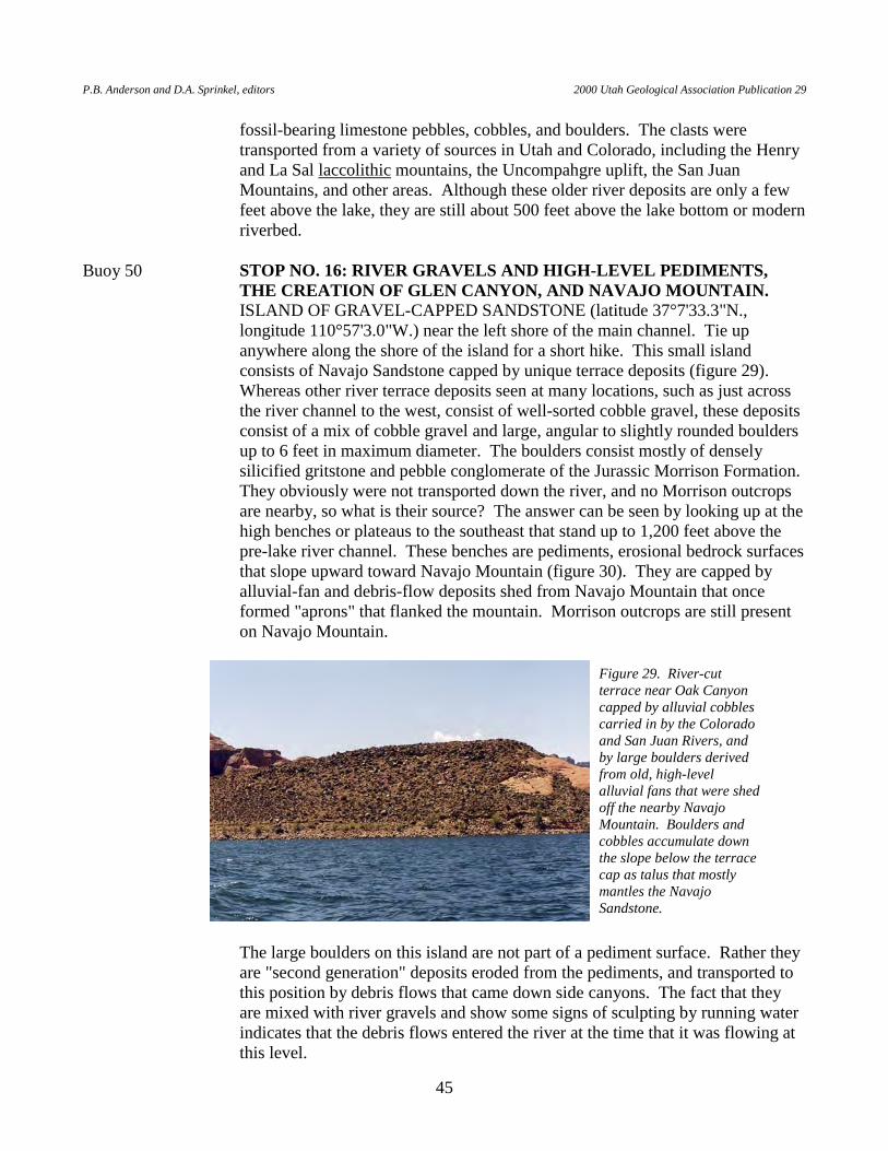
P.B. Anderson and D.A. Sprinkel, editors 2000 Utah Geological Association Publication 29
45
fossil-bearing limestone pebbles, cobbles, and boulders. The clasts were transported from a variety of sources in Utah and Colorado, including the Henry and La Sal laccolithic mountains, the Uncompahgre uplift, the San Juan Mountains, and other areas. Although these older river deposits are only a few feet above the lake, they are still about 500 feet above the lake bottom or modern riverbed.
Buoy 50 STOP NO. 16: RIVER GRAVELS AND HIGH-LEVEL PEDIMENTS,
THE CREATION OF GLEN CANYON, AND NAVAJO MOUNTAIN. ISLAND OF GRAVEL-CAPPED SANDSTONE (latitude 37°7'33.3"N., longitude 110°57'3.0"W.) near the left shore of the main channel. Tie up anywhere along the shore of the island for a short hike. This small island consists of Navajo Sandstone capped by unique terrace deposits (figure 29). Whereas other river terrace deposits seen at many locations, such as just across the river channel to the west, consist of well-sorted cobble gravel, these deposits consist of a mix of cobble gravel and large, angular to slightly rounded boulders up to 6 feet in maximum diameter. The boulders consist mostly of densely silicified gritstone and pebble conglomerate of the Jurassic Morrison Formation. They obviously were not transported down the river, and no Morrison outcrops are nearby, so what is their source? The answer can be seen by looking up at the high benches or plateaus to the southeast that stand up to 1,200 feet above the pre-lake river channel. These benches are pediments, erosional bedrock surfaces that slope upward toward Navajo Mountain (figure 30). They are capped by alluvial-fan and debris-flow deposits shed from Navajo Mountain that once formed "aprons" that flanked the mountain. Morrison outcrops are still present on Navajo Mountain.
The large boulders on this island are not part of a pediment surface. Rather they are "second generation" deposits eroded from the pediments, and transported to this position by debris flows that came down side canyons. The fact that they are mixed with river gravels and show some signs of sculpting by running water indicates that the debris flows entered the river at the time that it was flowing at this level.
Figure 29. River-cut terrace near Oak Canyon capped by alluvial cobbles carried in by the Colorado and San Juan Rivers, and by large boulders derived from old, high-level alluvial fans that were shed off the nearby Navajo Mountain. Boulders and cobbles accumulate down the slope below the terrace cap as talus that mostly mantles the Navajo Sandstone.
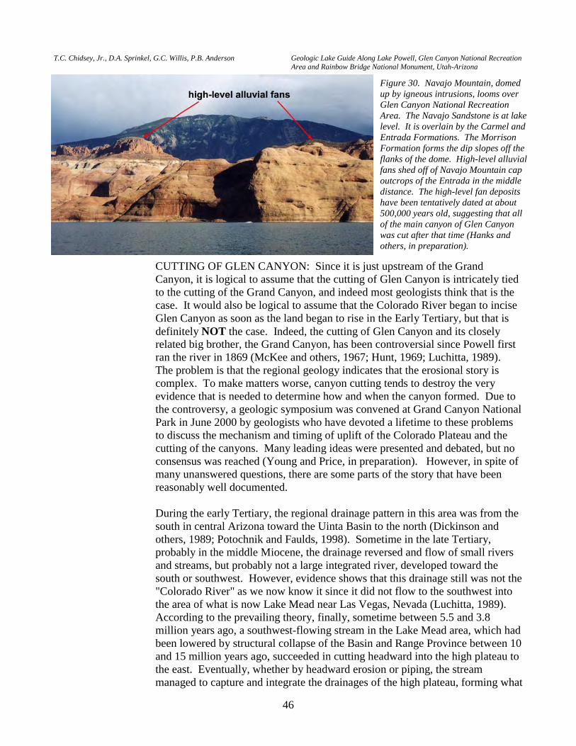
T.C. Chidsey, Jr., D.A. Sprinkel, G.C. Willis, P.B. Anderson Geologic Lake Guide Along Lake Powell, Glen Canyon National Recreation Area and Rainbow Bridge National Monument, Utah-Arizona
46
CUTTING OF GLEN CANYON: Since it is just upstream of the Grand Canyon, it is logical to assume that the cutting of Glen Canyon is intricately tied to the cutting of the Grand Canyon, and indeed most geologists think that is the case. It would also be logical to assume that the Colorado River began to incise Glen Canyon as soon as the land began to rise in the Early Tertiary, but that is definitely NOT the case. Indeed, the cutting of Glen Canyon and its closely related big brother, the Grand Canyon, has been controversial since Powell first ran the river in 1869 (McKee and others, 1967; Hunt, 1969; Luchitta, 1989). The problem is that the regional geology indicates that the erosional story is complex. To make matters worse, canyon cutting tends to destroy the very evidence that is needed to determine how and when the canyon formed. Due to the controversy, a geologic symposium was convened at Grand Canyon National Park in June 2000 by geologists who have devoted a lifetime to these problems to discuss the mechanism and timing of uplift of the Colorado Plateau and the cutting of the canyons. Many leading ideas were presented and debated, but no consensus was reached (Young and Price, in preparation). However, in spite of many unanswered questions, there are some parts of the story that have been reasonably well documented.
During the early Tertiary, the regional drainage pattern in this area was from the
south in central Arizona toward the Uinta Basin to the north (Dickinson and others, 1989; Potochnik and Faulds, 1998). Sometime in the late Tertiary, probably in the middle Miocene, the drainage reversed and flow of small rivers and streams, but probably not a large integrated river, developed toward the south or southwest. However, evidence shows that this drainage still was not the "Colorado River" as we now know it since it did not flow to the southwest into the area of what is now Lake Mead near Las Vegas, Nevada (Luchitta, 1989). According to the prevailing theory, finally, sometime between 5.5 and 3.8 million years ago, a southwest-flowing stream in the Lake Mead area, which had been lowered by structural collapse of the Basin and Range Province between 10 and 15 million years ago, succeeded in cutting headward into the high plateau to the east. Eventually, whether by headward erosion or piping, the stream managed to capture and integrate the drainages of the high plateau, forming what
Figure 30. Navajo Mountain, domed up by igneous intrusions, looms over Glen Canyon National Recreation Area. The Navajo Sandstone is at lake level. It is overlain by the Carmel and Entrada Formations. The Morrison Formation forms the dip slopes off the flanks of the dome. High-level alluvial fans shed off of Navajo Mountain cap outcrops of the Entrada in the middle distance. The high-level fan deposits have been tentatively dated at about 500,000 years old, suggesting that all of the main canyon of Glen Canyon was cut after that time (Hanks and others, in preparation).
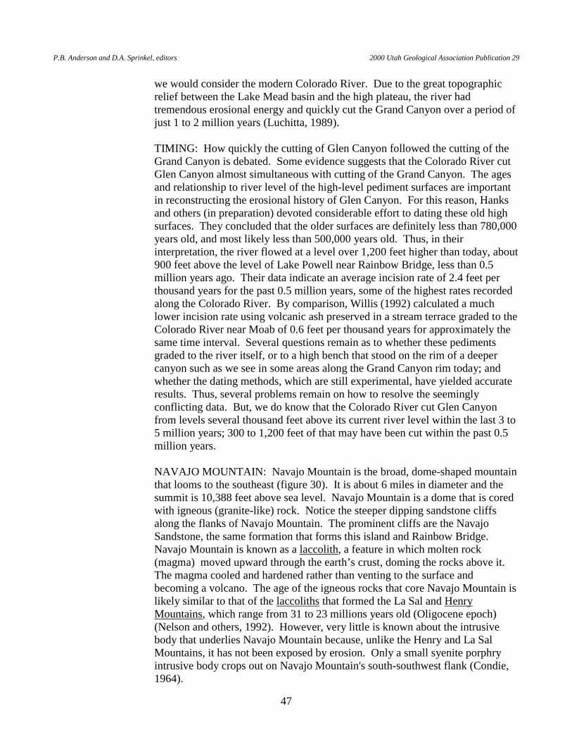
P.B. Anderson and D.A. Sprinkel, editors 2000 Utah Geological Association Publication 29
47
we would consider the modern Colorado River. Due to the great topographic relief between the Lake Mead basin and the high plateau, the river had tremendous erosional energy and quickly cut the Grand Canyon over a period of just 1 to 2 million years (Luchitta, 1989).
TIMING: How quickly the cutting of Glen Canyon followed the cutting of the
Grand Canyon is debated. Some evidence suggests that the Colorado River cut Glen Canyon almost simultaneous with cutting of the Grand Canyon. The ages and relationship to river level of the high-level pediment surfaces are important in reconstructing the erosional history of Glen Canyon. For this reason, Hanks and others (in preparation) devoted considerable effort to dating these old high surfaces. They concluded that the older surfaces are definitely less than 780,000 years old, and most likely less than 500,000 years old. Thus, in their interpretation, the river flowed at a level over 1,200 feet higher than today, about 900 feet above the level of Lake Powell near Rainbow Bridge, less than 0.5 million years ago. Their data indicate an average incision rate of 2.4 feet per thousand years for the past 0.5 million years, some of the highest rates recorded along the Colorado River. By comparison, Willis (1992) calculated a much lower incision rate using volcanic ash preserved in a stream terrace graded to the Colorado River near Moab of 0.6 feet per thousand years for approximately the same time interval. Several questions remain as to whether these pediments graded to the river itself, or to a high bench that stood on the rim of a deeper canyon such as we see in some areas along the Grand Canyon rim today; and whether the dating methods, which are still experimental, have yielded accurate results. Thus, several problems remain on how to resolve the seemingly conflicting data. But, we do know that the Colorado River cut Glen Canyon from levels several thousand feet above its current river level within the last 3 to 5 million years; 300 to 1,200 feet of that may have been cut within the past 0.5 million years.
NAVAJO MOUNTAIN: Navajo Mountain is the broad, dome-shaped mountain
that looms to the southeast (figure 30). It is about 6 miles in diameter and the summit is 10,388 feet above sea level. Navajo Mountain is a dome that is cored with igneous (granite-like) rock. Notice the steeper dipping sandstone cliffs along the flanks of Navajo Mountain. The prominent cliffs are the Navajo Sandstone, the same formation that forms this island and Rainbow Bridge. Navajo Mountain is known as a laccolith, a feature in which molten rock (magma) moved upward through the earth’s crust, doming the rocks above it. The magma cooled and hardened rather than venting to the surface and becoming a volcano. The age of the igneous rocks that core Navajo Mountain is likely similar to that of the laccoliths that formed the La Sal and Henry Mountains, which range from 31 to 23 millions years old (Oligocene epoch) (Nelson and others, 1992). However, very little is known about the intrusive body that underlies Navajo Mountain because, unlike the Henry and La Sal Mountains, it has not been exposed by erosion. Only a small syenite porphry intrusive body crops out on Navajo Mountain's south-southwest flank (Condie, 1964).
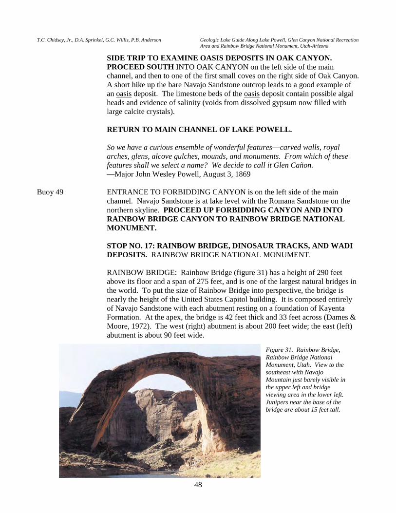
T.C. Chidsey, Jr., D.A. Sprinkel, G.C. Willis, P.B. Anderson Geologic Lake Guide Along Lake Powell, Glen Canyon National Recreation Area and Rainbow Bridge National Monument, Utah-Arizona
48
SIDE TRIP TO EXAMINE OASIS DEPOSITS IN OAK CANYON. PROCEED SOUTH INTO OAK CANYON on the left side of the main channel, and then to one of the first small coves on the right side of Oak Canyon. A short hike up the bare Navajo Sandstone outcrop leads to a good example of an oasis deposit. The limestone beds of the oasis deposit contain possible algal heads and evidence of salinity (voids from dissolved gypsum now filled with large calcite crystals).
RETURN TO MAIN CHANNEL OF LAKE POWELL. So we have a curious ensemble of wonderful features—carved walls, royal
arches, glens, alcove gulches, mounds, and monuments. From which of these features shall we select a name? We decide to call it Glen Cañon.
—Major John Wesley Powell, August 3, 1869 Buoy 49 ENTRANCE TO FORBIDDING CANYON is on the left side of the main
channel. Navajo Sandstone is at lake level with the Romana Sandstone on the northern skyline. PROCEED UP FORBIDDING CANYON AND INTO RAINBOW BRIDGE CANYON TO RAINBOW BRIDGE NATIONAL MONUMENT.
STOP NO. 17: RAINBOW BRIDGE, DINOSAUR TRACKS, AND WADI
DEPOSITS. RAINBOW BRIDGE NATIONAL MONUMENT. RAINBOW BRIDGE: Rainbow Bridge (figure 31) has a height of 290 feet
above its floor and a span of 275 feet, and is one of the largest natural bridges in the world. To put the size of Rainbow Bridge into perspective, the bridge is nearly the height of the United States Capitol building. It is composed entirely of Navajo Sandstone with each abutment resting on a foundation of Kayenta Formation. At the apex, the bridge is 42 feet thick and 33 feet across (Dames & Moore, 1972). The west (right) abutment is about 200 feet wide; the east (left) abutment is about 90 feet wide.
Figure 31. Rainbow Bridge, Rainbow Bridge National Monument, Utah. View to the southeast with Navajo Mountain just barely visible in the upper left and bridge viewing area in the lower left. Junipers near the base of the bridge are about 15 feet tall.
P.B. Anderson and D.A. Sprinkel, editors 2000 Utah Geological Association Publication 29
49
A natural bridge is formed primarily by the erosive process of running water and spans a ravine or valley, as opposed to a natural arch, which is formed by weathering and rock falls along joints and fractures and does not span a ravine or valley. Rainbow Bridge formed as a result of a favorable combination of regional uplift, structure, running water, and lithology (Chidsey and others, 2000).
In the early-late Cenozoic, the ancestral Colorado River and its tributaries
flowed through meandering channels in wide valleys where the channels crossed easily eroded rocks, or in the case of Bridge Creek, alluvial fan deposits on the flank of Navajo Mountain. Differentiation of the Colorado Plateau and the Basin and Range took place 10 to 15 million years ago, followed by cutting of the Grand Canyon in the last 5 million years. Due to continued regional downcutting of the Colorado River, Bridge Creek and other river channels became superimposed and entrenched, eroding the resistant rocks such as the Navajo Sandstone. Small side canyons such as Forbidding and Rainbow Bridge Canyons are probably the result of old superimposed channels, influenced by joints and other heterogeneities in the rocks.
Rainbow Bridge itself is due to events of the past 1 to 2 million years. Several
meanders in the evolving canyon were separated by very short land distances (figure 32A). At these locations, erosion into the canyon walls by Bridge Creek occurred at cutbanks on both sides of the rock wall by the meandering or migrating stream, creating narrow necks and setting the stage for bridge formation (figure 32B). Stream flow in Bridge Creek at the level of the lower gravel terraces likely increased during the wetter conditions of the Pleistocene, increasing the rate of erosion.
Development of Rainbow Bridge was assisted by weak partings or bedding
layers in the lower Navajo, rock falls off of the meander neck along the near-vertical joints (ideally located on the north and south faces), inclined joints, and exfoliation. Finally, several thousand years ago, the narrow wall beneath the incipient bridge was penetrated and Rainbow Bridge was born (figure 32C). Based on tenuous dating of pediment-mantle deposits that cap the high mesas near here (Hanks and others, in preparation; see discussion at STOP NO. 16), we estimate the top of the arch was exposed about 125,000 years ago, and the opening was first cut about 30,000 years ago (Chidsey and others, 2000). (The window first opened approximately halfway up the current opening.) Because several questions remain on the validity and interpretation of the data used to calculate these dates, they should be considered rough estimates only. Actual numbers could be considerably less or more. Other bridges may have existed at other meanders upstream from Rainbow Bridge but have since collapsed. Later, Bridge Creek cut into the much softer Kayenta Formation, quickly increasing the depth of incision (figures 32C). This significantly increased the vertical height of the bridge opening. It probably also served to confine Bridge Creek in a narrow, straighter channel, protecting the bridge footings from continued lateral migration of the stream.
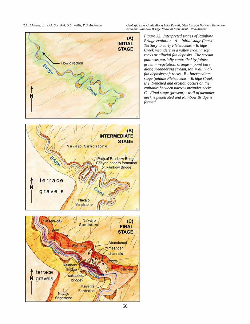
T.C. Chidsey, Jr., D.A. Sprinkel, G.C. Willis, P.B. Anderson Geologic Lake Guide Along Lake Powell, Glen Canyon National Recreation Area and Rainbow Bridge National Monument, Utah-Arizona
50
Figure 32. Interpreted stages of Rainbow Bridge evolution. A - Initial stage (latest Tertiary to early Pleistocene) - Bridge Creek meanders in a valley eroding soft rocks or alluvial fan deposits. The stream path was partially controlled by joints; green = vegetation, orange = point bars along meandering stream, tan = alluvial-fan deposits/soft rocks. B - Intermediate stage (middle Pleistocene) - Bridge Creek is entrenched and erosion occurs on the cutbanks between narrow meander necks. C - Final stage (present) - wall of meander neck is penetrated and Rainbow Bridge is formed.
P.B. Anderson and D.A. Sprinkel, editors 2000 Utah Geological Association Publication 29
51
The natural processes affecting Rainbow Bridge today also affect sandstone cliff
faces and arches throughout this arid region of Utah. Rock falls that develop along tension-formed joints and by exfoliation are common occurrences over geologic time. These processes are assisted during winter months when freezing moisture forces apart fractures, joints, and the spaces between sand grains in the rock.
Chemical weathering and wind abrasion have minor impacts on the bridge. In
addition, studies have shown the effects of Lake Powell under the bridge and increased levels of sulphur dioxide emitted from the Navajo Power Generating Plant to the southwest in Arizona will not significantly alter the integrity of Rainbow Bridge (Dames & Moore, 1972). For the bridge to collapse, over one-half of the foundation rock on each leg would have to be removed. Under existing conditions, Rainbow Bridge will continue to stand for many thousands of years to come.
DINOSAUR TRACKS, WADI DEPOSITS, AND OTHER INTERESTING
FEATURES AT RAINBOW BRIDGE: There are other interesting geologic features to observe in Rainbow Bridge National Monument besides the bridge. Classic examples of conjugate joint sets can be viewed along the trail between the courtesy dock and the bridge viewing area. A tridactyl (three-toed), theropod (bipedal) dinosaur track in the Kayenta Formation is well displayed at the bridge viewing area. An ancient wadi deposit can be observed in the Navajo Sandstone from the courtesy dock and is represented by several dark, iron-stained channel-form features present on the south side of the canyon (figure 33A). A wadi is a usually dry stream bed or channel a in desert region. A few large blocks of a wadi deposit fell to the terrace bench near the bridge viewing area. One is in the bridge viewing area and is easily observed. Another larger block can be seen about 15 feet back from the trail (please don’t walk over to it; due to the fragile vegetation visitors are required to stay on the trail). The larger block fell from a channel bed about 2.5 to 3 feet thick about 50 feet up the cliff. The base and top are abrupt and slightly irregular. The deposit is a "pudding stone" consisting of tan to reddish-orange, rounded sandstone fragments or clasts, and gray to dark-gray, subangular to subrounded dolomitic limestone clasts (figure 33B). Clasts vary from pea to small boulder size. The matrix is medium- to coarse-grained sandstone cemented with iron-bearing quartz and minor calcite. The fallen block is horizontally stratified and has some small-scale cross-beds. It contains rip-up clasts of lime muds; some imbricated rip-up clasts are inclined in the downstream direction. Additional wadi deposits are located in other parts of Rainbow Bridge Canyon and Forbidding Canyon, and possibly belonged to the same ancient wadi system (figure 33C).
RETURN TO THE MAIN CHANNEL OF LAKE POWELL.
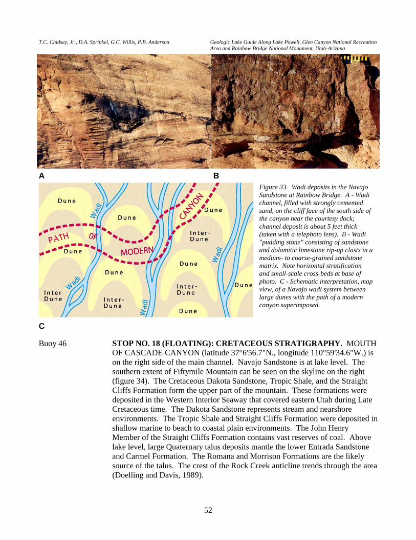
T.C. Chidsey, Jr., D.A. Sprinkel, G.C. Willis, P.B. Anderson Geologic Lake Guide Along Lake Powell, Glen Canyon National Recreation Area and Rainbow Bridge National Monument, Utah-Arizona
52
Buoy 46 STOP NO. 18 (FLOATING): CRETACEOUS STRATIGRAPHY. MOUTH
OF CASCADE CANYON (latitude 37°6'56.7"N., longitude 110°59'34.6"W.) is on the right side of the main channel. Navajo Sandstone is at lake level. The southern extent of Fiftymile Mountain can be seen on the skyline on the right (figure 34). The Cretaceous Dakota Sandstone, Tropic Shale, and the Straight Cliffs Formation form the upper part of the mountain. These formations were deposited in the Western Interior Seaway that covered eastern Utah during Late Cretaceous time. The Dakota Sandstone represents stream and nearshore environments. The Tropic Shale and Straight Cliffs Formation were deposited in shallow marine to beach to coastal plain environments. The John Henry Member of the Straight Cliffs Formation contains vast reserves of coal. Above lake level, large Quaternary talus deposits mantle the lower Entrada Sandstone and Carmel Formation. The Romana and Morrison Formations are the likely source of the talus. The crest of the Rock Creek anticline trends through the area (Doelling and Davis, 1989).
Figure 33. Wadi deposits in the Navajo Sandstone at Rainbow Bridge. A - Wadi channel, filled with strongly cemented sand, on the cliff face of the south side of the canyon near the courtesy dock; channel deposit is about 5 feet thick (taken with a telephoto lens). B - Wadi "pudding stone" consisting of sandstone and dolomitic limestone rip-up clasts in a medium- to coarse-grained sandstone matrix. Note horizontal stratification and small-scale cross-beds at base of photo. C - Schematic interpretation, map view, of a Navajo wadi system between large dunes with the path of a modern canyon superimposed.
A B
C
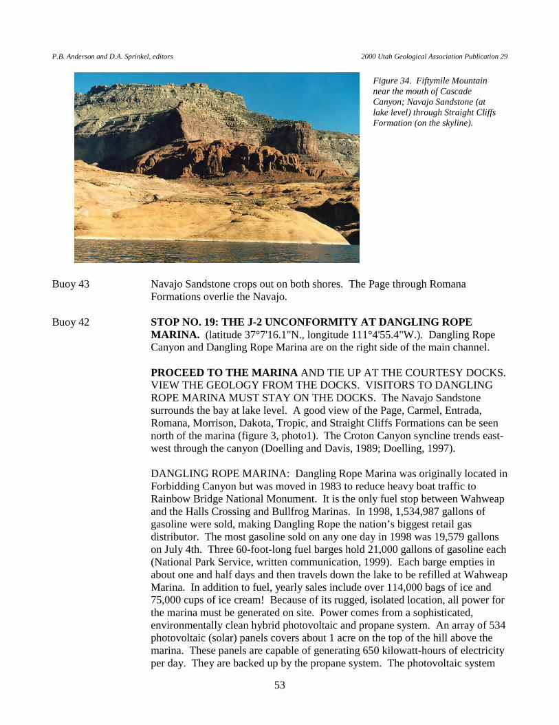
P.B. Anderson and D.A. Sprinkel, editors 2000 Utah Geological Association Publication 29
53
Buoy 43 Navajo Sandstone crops out on both shores. The Page through Romana Formations overlie the Navajo.
Buoy 42 STOP NO. 19: THE J-2 UNCONFORMITY AT DANGLING ROPE
MARINA. (latitude 37°7'16.1"N., longitude 111°4'55.4"W.). Dangling Rope Canyon and Dangling Rope Marina are on the right side of the main channel.
PROCEED TO THE MARINA AND TIE UP AT THE COURTESY DOCKS.
VIEW THE GEOLOGY FROM THE DOCKS. VISITORS TO DANGLING ROPE MARINA MUST STAY ON THE DOCKS. The Navajo Sandstone surrounds the bay at lake level. A good view of the Page, Carmel, Entrada, Romana, Morrison, Dakota, Tropic, and Straight Cliffs Formations can be seen north of the marina (figure 3, photo1). The Croton Canyon syncline trends east-west through the canyon (Doelling and Davis, 1989; Doelling, 1997).
DANGLING ROPE MARINA: Dangling Rope Marina was originally located in
Forbidding Canyon but was moved in 1983 to reduce heavy boat traffic to Rainbow Bridge National Monument. It is the only fuel stop between Wahweap and the Halls Crossing and Bullfrog Marinas. In 1998, 1,534,987 gallons of gasoline were sold, making Dangling Rope the nation’s biggest retail gas distributor. The most gasoline sold on any one day in 1998 was 19,579 gallons on July 4th. Three 60-foot-long fuel barges hold 21,000 gallons of gasoline each (National Park Service, written communication, 1999). Each barge empties in about one and half days and then travels down the lake to be refilled at Wahweap Marina. In addition to fuel, yearly sales include over 114,000 bags of ice and 75,000 cups of ice cream! Because of its rugged, isolated location, all power for the marina must be generated on site. Power comes from a sophisticated, environmentally clean hybrid photovoltaic and propane system. An array of 534 photovoltaic (solar) panels covers about 1 acre on the top of the hill above the marina. These panels are capable of generating 650 kilowatt-hours of electricity per day. They are backed up by the propane system. The photovoltaic system
Figure 34. Fiftymile Mountain near the mouth of Cascade Canyon; Navajo Sandstone (at lake level) through Straight Cliffs Formation (on the skyline).
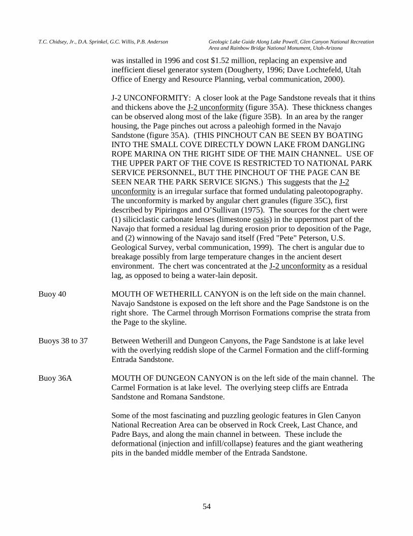
T.C. Chidsey, Jr., D.A. Sprinkel, G.C. Willis, P.B. Anderson Geologic Lake Guide Along Lake Powell, Glen Canyon National Recreation Area and Rainbow Bridge National Monument, Utah-Arizona
54
was installed in 1996 and cost $1.52 million, replacing an expensive and inefficient diesel generator system (Dougherty, 1996; Dave Lochtefeld, Utah Office of Energy and Resource Planning, verbal communication, 2000).
J-2 UNCONFORMITY: A closer look at the Page Sandstone reveals that it thins
and thickens above the J-2 unconformity (figure 35A). These thickness changes can be observed along most of the lake (figure 35B). In an area by the ranger housing, the Page pinches out across a paleohigh formed in the Navajo Sandstone (figure 35A). (THIS PINCHOUT CAN BE SEEN BY BOATING INTO THE SMALL COVE DIRECTLY DOWN LAKE FROM DANGLING ROPE MARINA ON THE RIGHT SIDE OF THE MAIN CHANNEL. USE OF THE UPPER PART OF THE COVE IS RESTRICTED TO NATIONAL PARK SERVICE PERSONNEL, BUT THE PINCHOUT OF THE PAGE CAN BE SEEN NEAR THE PARK SERVICE SIGNS.) This suggests that the J-2 unconformity is an irregular surface that formed undulating paleotopography. The unconformity is marked by angular chert granules (figure 35C), first described by Pipiringos and O’Sullivan (1975). The sources for the chert were (1) siliciclastic carbonate lenses (limestone oasis) in the uppermost part of the Navajo that formed a residual lag during erosion prior to deposition of the Page, and (2) winnowing of the Navajo sand itself (Fred "Pete" Peterson, U.S. Geological Survey, verbal communication, 1999). The chert is angular due to breakage possibly from large temperature changes in the ancient desert environment. The chert was concentrated at the J-2 unconformity as a residual lag, as opposed to being a water-lain deposit.
Buoy 40 MOUTH OF WETHERILL CANYON is on the left side on the main channel.
Navajo Sandstone is exposed on the left shore and the Page Sandstone is on the right shore. The Carmel through Morrison Formations comprise the strata from the Page to the skyline.
Buoys 38 to 37 Between Wetherill and Dungeon Canyons, the Page Sandstone is at lake level
with the overlying reddish slope of the Carmel Formation and the cliff-forming Entrada Sandstone.
Buoy 36A MOUTH OF DUNGEON CANYON is on the left side of the main channel. The
Carmel Formation is at lake level. The overlying steep cliffs are Entrada Sandstone and Romana Sandstone.
Some of the most fascinating and puzzling geologic features in Glen Canyon
National Recreation Area can be observed in Rock Creek, Last Chance, and Padre Bays, and along the main channel in between. These include the deformational (injection and infill/collapse) features and the giant weathering pits in the banded middle member of the Entrada Sandstone.
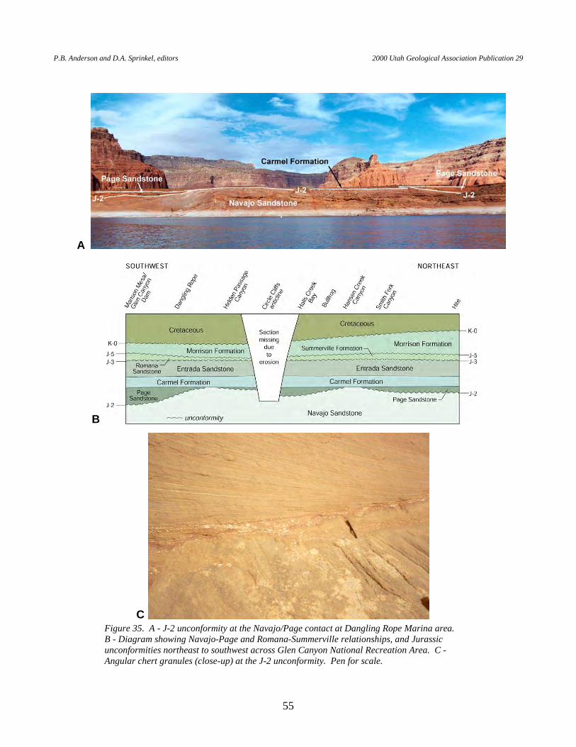
P.B. Anderson and D.A. Sprinkel, editors 2000 Utah Geological Association Publication 29
55
Figure 35. A - J-2 unconformity at the Navajo/Page contact at Dangling Rope Marina area. B - Diagram showing Navajo-Page and Romana-Summerville relationships, and Jurassic unconformities northeast to southwest across Glen Canyon National Recreation Area. C - Angular chert granules (close-up) at the J-2 unconformity. Pen for scale.
A
B
C
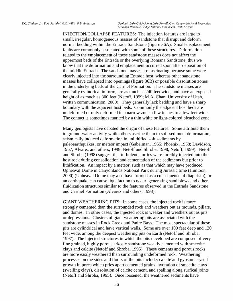
T.C. Chidsey, Jr., D.A. Sprinkel, G.C. Willis, P.B. Anderson Geologic Lake Guide Along Lake Powell, Glen Canyon National Recreation Area and Rainbow Bridge National Monument, Utah-Arizona
56
INJECTION/COLLAPSE FEATURES: The injection features are large to small, irregular, homogeneous masses of sandstone that disrupt and deform normal bedding within the Entrada Sandstone (figure 36A). Small-displacement faults are commonly associated with some of these structures. Deformation related to the emplacement of these sandstone masses does not affect the uppermost beds of the Entrada or the overlying Romana Sandstone, thus we know that the deformation and emplacement occurred soon after deposition of the middle Entrada. The sandstone masses are fascinating because some were clearly injected into the surrounding Entrada host, whereas other sandstone masses have collapsed into openings (figure 36B) or possible dissolution zones in the underlying beds of the Carmel Formation. The sandstone masses are generally cylindrical in form, are as much as 240 feet wide, and have an exposed height of as much as 300 feet (Netoff, 1999; M.A. Chan, University of Utah, written communication, 2000). They generally lack bedding and have a sharp boundary with the adjacent host beds. Commonly the adjacent host beds are undeformed or only deformed in a narrow zone a few inches to a few feet wide. The contact is sometimes marked by a thin white or light-colored bleached zone.
Many geologists have debated the origin of these features. Some attribute them
to ground-water activity while others ascribe them to soft-sediment deformation, seismically induced deformation in unlithified soft sediments by paleoearthquakes, or meteor impact (Gabelman, 1955; Phoenix, 1958; Davidson, 1967; Alvarez and others, 1998; Netoff and Shroba, 1998; Netoff, 1999). Netoff and Shroba (1998) suggest that turbulent slurries were forcibly injected into the host rock during consolidation and cementation of the sediments but prior to lithification. An impact by a meteor, such as that which may have produced Upheaval Dome in Canyonlands National Park during Jurassic time (Huntoon, 2000) (Upheaval Dome may also have formed as a consequence of diapirism), or an earthquake can cause liquefaction to occur, generating sand blows and other fluidization structures similar to the features observed in the Entrada Sandstone and Carmel Formation (Alvarez and others, 1998).
GIANT WEATHERING PITS: In some cases, the injected rock is more
strongly cemented than the surrounded rock and weathers out as mounds, pillars, and domes. In other cases, the injected rock is weaker and weathers out as pits or depressions. Clusters of giant weathering pits are associated with the sandstone masses in Rock Creek and Padre Bays. The most spectacular of these pits are cylindrical and have vertical walls. Some are over 100 feet deep and 120 feet wide, among the deepest weathering pits on Earth (Netoff and Shroba, 1997). The injected structures in which the pits developed are composed of very fine grained, highly porous arkosic sandstone weakly cemented with smectite clays and calcite (Netoff and Shroba, 1995). These cements and porous rocks are more easily weathered than surrounding undeformed rock. Weathering processes on the sides and floors of the pits include: calcite and gypsum crystal growth in pores which pries apart cemented grains, hydration of smectite clays (swelling clays), dissolution of calcite cement, and spalling along surfical joints (Netoff and Shroba, 1995). Once loosened, the weathered sediments have
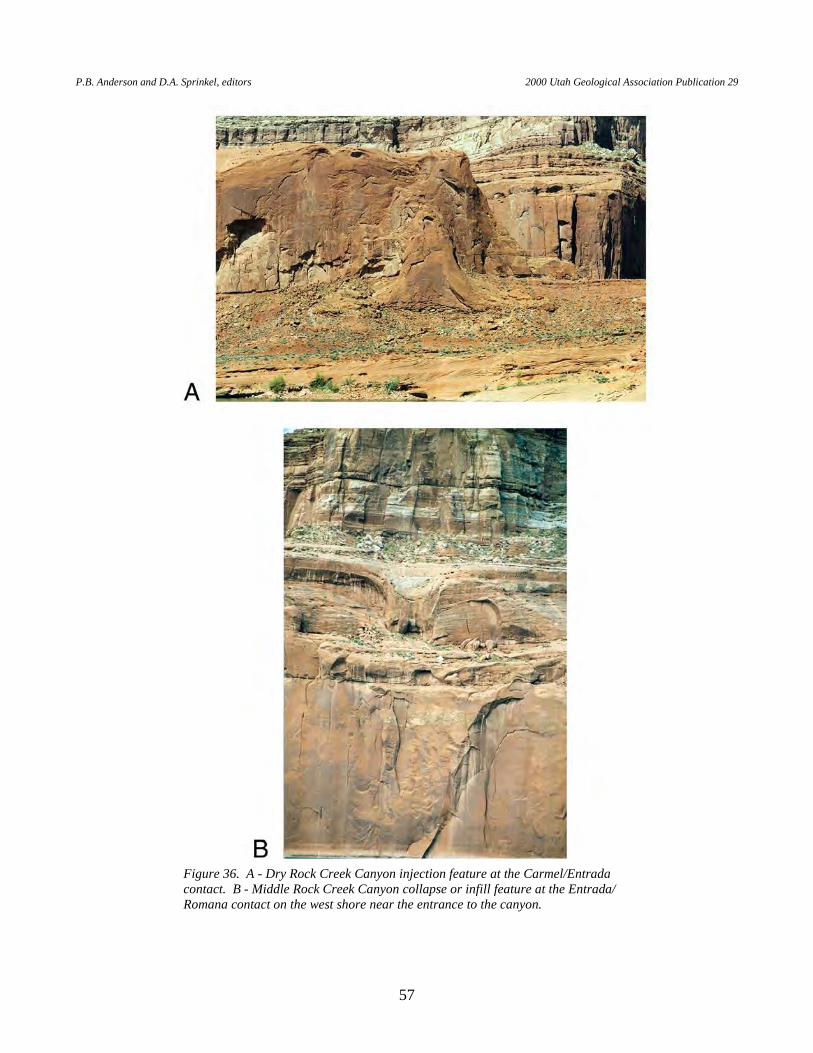
P.B. Anderson and D.A. Sprinkel, editors 2000 Utah Geological Association Publication 29
57
Figure 36. A - Dry Rock Creek Canyon injection feature at the Carmel/Entrada contact. B - Middle Rock Creek Canyon collapse or infill feature at the Entrada/Romana contact on the west shore near the entrance to the canyon.
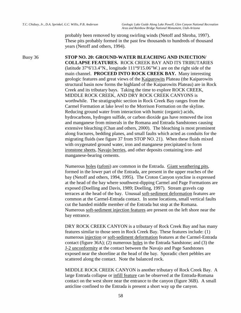
T.C. Chidsey, Jr., D.A. Sprinkel, G.C. Willis, P.B. Anderson Geologic Lake Guide Along Lake Powell, Glen Canyon National Recreation Area and Rainbow Bridge National Monument, Utah-Arizona
58
probably been removed by strong swirling winds (Netoff and Shroba, 1997). These pits probably formed in the past few thousands to hundreds of thousand years (Netoff and others, 1994).
Buoy 36 STOP NO. 20: GROUND-WATER BLEACHING AND INJECTION/
COLLAPSE FEATURES. ROCK CREEK BAY AND ITS TRIBUTARIES (latitude 37°6'13.4"N., longitude 111°9'15.06"W.) are on the right side of the main channel. PROCEED INTO ROCK CREEK BAY. Many interesting geologic features and great views of the Kaiparowits Plateau (the Kaiparowits structural basin now forms the highland of the Kaiparowits Plateau) are in Rock Creek and its tributary bays. Taking the time to explore ROCK CREEK, MIDDLE ROCK CREEK, AND DRY ROCK CREEK CANYONS is worthwhile. The stratigraphic section in Rock Creek Bay ranges from the Carmel Formation at lake level to the Morrison Formation on the skyline. Reducing ground water from interaction with humic (organic) acids, hydrocarbons, hydrogen sulfide, or carbon dioxide gas have removed the iron and manganese from minerals in the Romana and Entrada Sandstones causing extensive bleaching (Chan and others, 2000). The bleaching is most prominent along fractures, bedding planes, and small faults which acted as conduits for the migrating fluids (see figure 37 from STOP NO. 21). When these fluids mixed with oxygenated ground water, iron and manganese precipitated to form ironstone sheets, Navajo berries, and other deposits containing iron- and manganese-bearing cements.
Numerous holes (tafoni) are common in the Entrada. Giant weathering pits,
formed in the lower part of the Entrada, are present in the upper reaches of the bay (Netoff and others, 1994, 1995). The Croton Canyon syncline is expressed at the head of the bay where southwest-dipping Carmel and Page Formations are exposed (Doelling and Davis, 1989; Doelling, 1997). Stream gravels cap terraces at the head of the bay. Unusual soft-sediment deformation features are common at the Carmel-Entrada contact. In some locations, small vertical faults cut the banded middle member of the Entrada but stop at the Romana. Numerous soft-sediment injection features are present on the left shore near the bay entrance.
DRY ROCK CREEK CANYON is a tributary of Rock Creek Bay and has many
features similar to those seen in Rock Creek Bay. These features include: (1) numerous injection or soft-sediment deformation features at the Carmel-Entrada contact (figure 36A); (2) numerous holes in the Entrada Sandstone; and (3) the
J-2 unconformity at the contact between the Navajo and Page Sandstones exposed near the shoreline at the head of the bay. Sporadic chert pebbles are scattered along the contact. Note the balanced rock.
MIDDLE ROCK CREEK CANYON is another tributary of Rock Creek Bay. A
large Entrada collapse or infill feature can be observed at the Entrada-Romana contact on the west shore near the entrance to the canyon (figure 36B). A small anticline confined to the Entrada is present a short way up the canyon.
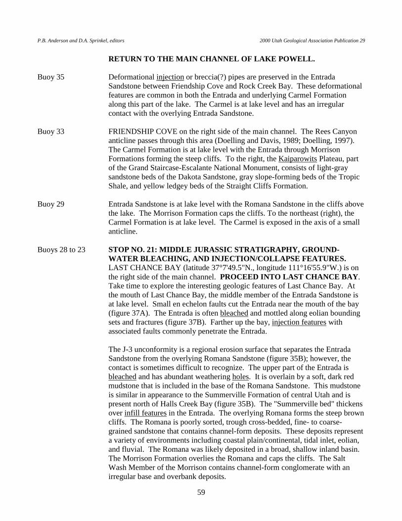
P.B. Anderson and D.A. Sprinkel, editors 2000 Utah Geological Association Publication 29
59
RETURN TO THE MAIN CHANNEL OF LAKE POWELL. Buoy 35 Deformational injection or breccia(?) pipes are preserved in the Entrada
Sandstone between Friendship Cove and Rock Creek Bay. These deformational features are common in both the Entrada and underlying Carmel Formation along this part of the lake. The Carmel is at lake level and has an irregular contact with the overlying Entrada Sandstone.
Buoy 33 FRIENDSHIP COVE on the right side of the main channel. The Rees Canyon
anticline passes through this area (Doelling and Davis, 1989; Doelling, 1997). The Carmel Formation is at lake level with the Entrada through Morrison Formations forming the steep cliffs. To the right, the Kaiparowits Plateau, part of the Grand Staircase-Escalante National Monument, consists of light-gray sandstone beds of the Dakota Sandstone, gray slope-forming beds of the Tropic Shale, and yellow ledgey beds of the Straight Cliffs Formation.
Buoy 29 Entrada Sandstone is at lake level with the Romana Sandstone in the cliffs above
the lake. The Morrison Formation caps the cliffs. To the northeast (right), the Carmel Formation is at lake level. The Carmel is exposed in the axis of a small anticline.
Buoys 28 to 23 STOP NO. 21: MIDDLE JURASSIC STRATIGRAPHY, GROUND-
WATER BLEACHING, AND INJECTION/COLLAPSE FEATURES. LAST CHANCE BAY (latitude 37°7'49.5"N., longitude 111°16'55.9"W.) is on the right side of the main channel. PROCEED INTO LAST CHANCE BAY. Take time to explore the interesting geologic features of Last Chance Bay. At the mouth of Last Chance Bay, the middle member of the Entrada Sandstone is at lake level. Small en echelon faults cut the Entrada near the mouth of the bay (figure 37A). The Entrada is often bleached and mottled along eolian bounding sets and fractures (figure 37B). Farther up the bay, injection features with associated faults commonly penetrate the Entrada.
The J-3 unconformity is a regional erosion surface that separates the Entrada
Sandstone from the overlying Romana Sandstone (figure 35B); however, the contact is sometimes difficult to recognize. The upper part of the Entrada is bleached and has abundant weathering holes. It is overlain by a soft, dark red mudstone that is included in the base of the Romana Sandstone. This mudstone is similar in appearance to the Summerville Formation of central Utah and is present north of Halls Creek Bay (figure 35B). The "Summerville bed" thickens over infill features in the Entrada. The overlying Romana forms the steep brown cliffs. The Romana is poorly sorted, trough cross-bedded, fine- to coarse-grained sandstone that contains channel-form deposits. These deposits represent a variety of environments including coastal plain/continental, tidal inlet, eolian, and fluvial. The Romana was likely deposited in a broad, shallow inland basin. The Morrison Formation overlies the Romana and caps the cliffs. The Salt Wash Member of the Morrison contains channel-form conglomerate with an irregular base and overbank deposits.
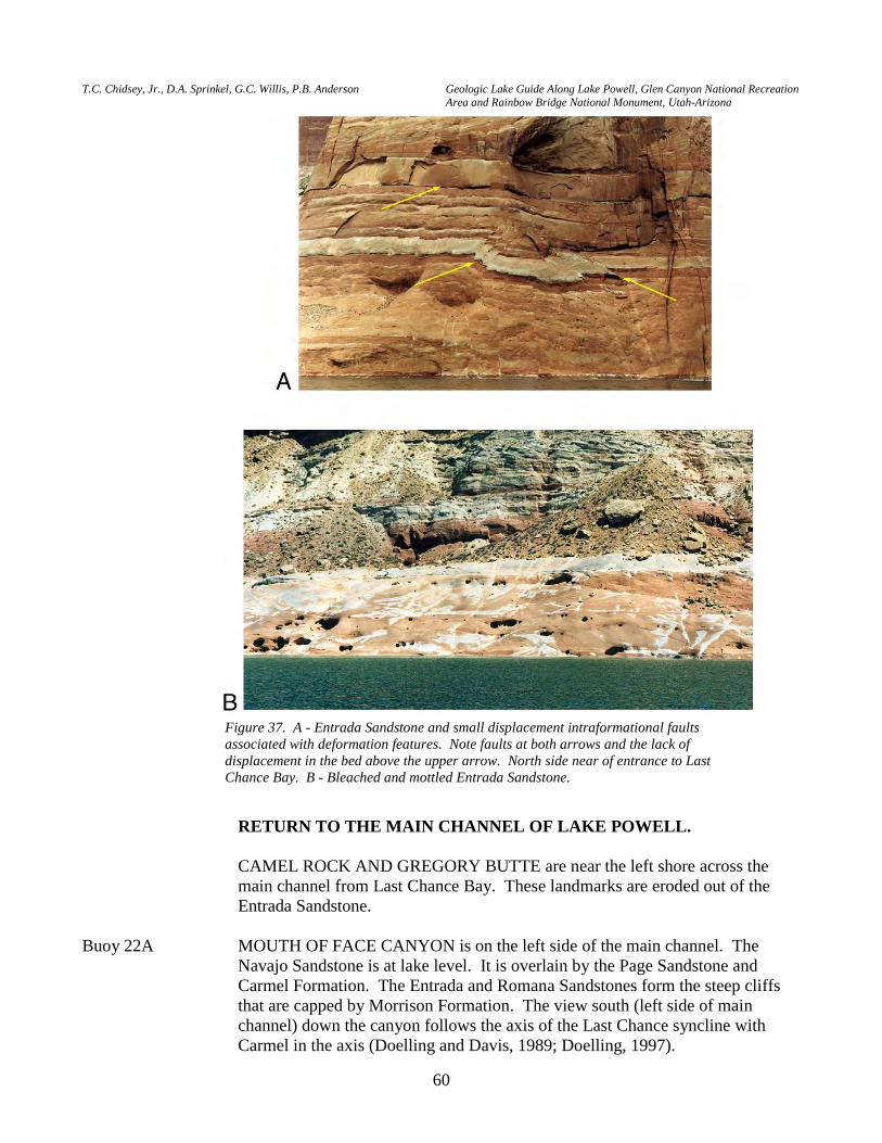
T.C. Chidsey, Jr., D.A. Sprinkel, G.C. Willis, P.B. Anderson Geologic Lake Guide Along Lake Powell, Glen Canyon National Recreation Area and Rainbow Bridge National Monument, Utah-Arizona
60
RETURN TO THE MAIN CHANNEL OF LAKE POWELL. CAMEL ROCK AND GREGORY BUTTE are near the left shore across the
main channel from Last Chance Bay. These landmarks are eroded out of the Entrada Sandstone.
Buoy 22A MOUTH OF FACE CANYON is on the left side of the main channel. The
Navajo Sandstone is at lake level. It is overlain by the Page Sandstone and Carmel Formation. The Entrada and Romana Sandstones form the steep cliffs that are capped by Morrison Formation. The view south (left side of main channel) down the canyon follows the axis of the Last Chance syncline with Carmel in the axis (Doelling and Davis, 1989; Doelling, 1997).
Figure 37. A - Entrada Sandstone and small displacement intraformational faults associated with deformation features. Note faults at both arrows and the lack of displacement in the bed above the upper arrow. North side near of entrance to Last Chance Bay. B - Bleached and mottled Entrada Sandstone.
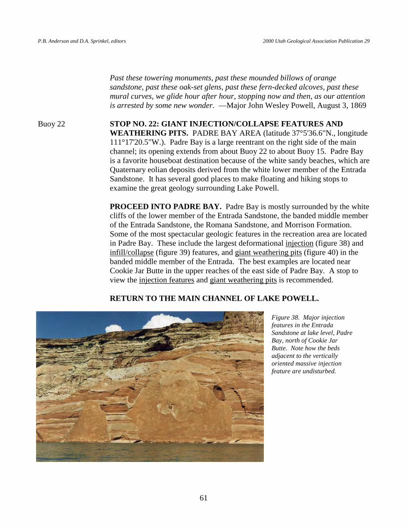
P.B. Anderson and D.A. Sprinkel, editors 2000 Utah Geological Association Publication 29
61
Past these towering monuments, past these mounded billows of orange
sandstone, past these oak-set glens, past these fern-decked alcoves, past these mural curves, we glide hour after hour, stopping now and then, as our attention is arrested by some new wonder. —Major John Wesley Powell, August 3, 1869
Buoy 22 STOP NO. 22: GIANT INJECTION/COLLAPSE FEATURES AND
WEATHERING PITS. PADRE BAY AREA (latitude 37°5'36.6"N., longitude 111°17'20.5"W.). Padre Bay is a large reentrant on the right side of the main channel; its opening extends from about Buoy 22 to about Buoy 15. Padre Bay is a favorite houseboat destination because of the white sandy beaches, which are Quaternary eolian deposits derived from the white lower member of the Entrada Sandstone. It has several good places to make floating and hiking stops to examine the great geology surrounding Lake Powell.
PROCEED INTO PADRE BAY. Padre Bay is mostly surrounded by the white
cliffs of the lower member of the Entrada Sandstone, the banded middle member of the Entrada Sandstone, the Romana Sandstone, and Morrison Formation. Some of the most spectacular geologic features in the recreation area are located in Padre Bay. These include the largest deformational injection (figure 38) and infill/collapse (figure 39) features, and giant weathering pits (figure 40) in the banded middle member of the Entrada. The best examples are located near Cookie Jar Butte in the upper reaches of the east side of Padre Bay. A stop to view the injection features and giant weathering pits is recommended.
RETURN TO THE MAIN CHANNEL OF LAKE POWELL.
Figure 38. Major injection features in the Entrada Sandstone at lake level, Padre Bay, north of Cookie Jar Butte. Note how the beds adjacent to the vertically oriented massive injection feature are undisturbed.
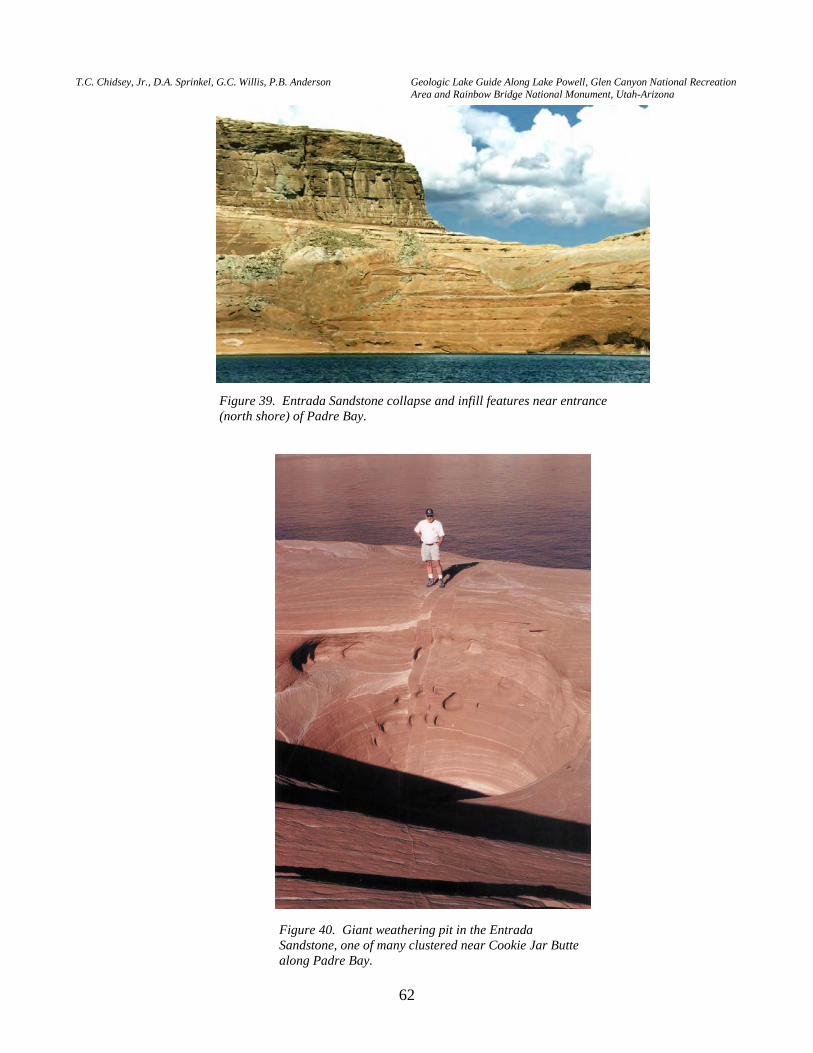
T.C. Chidsey, Jr., D.A. Sprinkel, G.C. Willis, P.B. Anderson Geologic Lake Guide Along Lake Powell, Glen Canyon National Recreation Area and Rainbow Bridge National Monument, Utah-Arizona
62
Figure 39. Entrada Sandstone collapse and infill features near entrance (north shore) of Padre Bay.
Figure 40. Giant weathering pit in the Entrada Sandstone, one of many clustered near Cookie Jar Butte along Padre Bay.
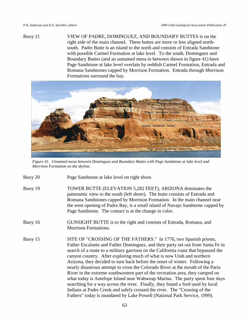
P.B. Anderson and D.A. Sprinkel, editors 2000 Utah Geological Association Publication 29
63
Buoy 21 VIEW OF PADRE, DOMINGUEZ, AND BOUNDARY BUTTES is on the right side of the main channel. These buttes are more or less aligned north-south. Padre Butte is an island to the north and consists of Entrada Sandstone with possible Carmel Formation at lake level. To the south, Dominguez and Boundary Buttes (and an unnamed mesa in between shown in figure 41) have Page Sandstone at lake level overlain by reddish Carmel Formation, Entrada and Romana Sandstones capped by Morrison Formation. Entrada through Morrison Formations surround the bay.
Buoy 20 Page Sandstone at lake level on right shore. Buoy 19 TOWER BUTTE (ELEVATION 5,282 FEET), ARIZONA dominates the
panoramic view to the south (left shore). The butte consists of Entrada and Romana Sandstones capped by Morrison Formation. In the main channel near the west opening of Padre Bay, is a small island of Navajo Sandstone capped by Page Sandstone. The contact is at the change in color.
Buoy 16 GUNSIGHT BUTTE is to the right and consists of Entrada, Romana, and
Morrison Formations. Buoy 15 SITE OF "CROSSING OF THE FATHERS." In 1776, two Spanish priests,
Father Escalante and Father Dominguez, and their party set out from Santa Fe in search of a route to a military garrison on the California coast that bypassed the canyon country. After exploring much of what is now Utah and northern Arizona, they decided to turn back before the onset of winter. Following a nearly disastrous attempt to cross the Colorado River at the mouth of the Paria River in the extreme southwestern part of the recreation area, they camped on what today is Antelope Island near Wahweap Marina. The party spent four days searching for a way across the river. Finally, they found a ford used by local Indians at Padre Creek and safely crossed the river. The "Crossing of the Fathers" today is inundated by Lake Powell (National Park Service, 1999).
Figure 41. Unnamed mesa between Dominguez and Boundary Buttes with Page Sandstone at lake level and Morrison Formation on the skyline.
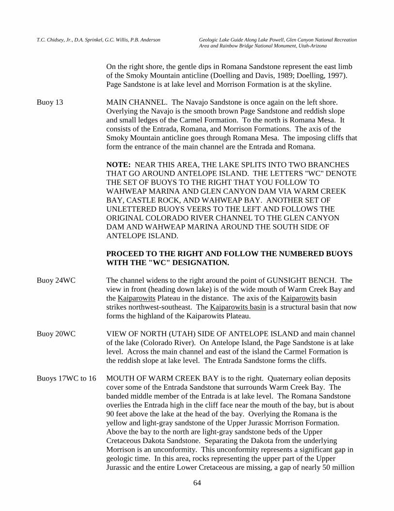
T.C. Chidsey, Jr., D.A. Sprinkel, G.C. Willis, P.B. Anderson Geologic Lake Guide Along Lake Powell, Glen Canyon National Recreation Area and Rainbow Bridge National Monument, Utah-Arizona
64
On the right shore, the gentle dips in Romana Sandstone represent the east limb
of the Smoky Mountain anticline (Doelling and Davis, 1989; Doelling, 1997). Page Sandstone is at lake level and Morrison Formation is at the skyline.
Buoy 13 MAIN CHANNEL. The Navajo Sandstone is once again on the left shore.
Overlying the Navajo is the smooth brown Page Sandstone and reddish slope and small ledges of the Carmel Formation. To the north is Romana Mesa. It consists of the Entrada, Romana, and Morrison Formations. The axis of the Smoky Mountain anticline goes through Romana Mesa. The imposing cliffs that form the entrance of the main channel are the Entrada and Romana.
NOTE: NEAR THIS AREA, THE LAKE SPLITS INTO TWO BRANCHES
THAT GO AROUND ANTELOPE ISLAND. THE LETTERS "WC" DENOTE THE SET OF BUOYS TO THE RIGHT THAT YOU FOLLOW TO WAHWEAP MARINA AND GLEN CANYON DAM VIA WARM CREEK BAY, CASTLE ROCK, AND WAHWEAP BAY. ANOTHER SET OF UNLETTERED BUOYS VEERS TO THE LEFT AND FOLLOWS THE ORIGINAL COLORADO RIVER CHANNEL TO THE GLEN CANYON DAM AND WAHWEAP MARINA AROUND THE SOUTH SIDE OF ANTELOPE ISLAND.
PROCEED TO THE RIGHT AND FOLLOW THE NUMBERED BUOYS
WITH THE "WC" DESIGNATION. Buoy 24WC The channel widens to the right around the point of GUNSIGHT BENCH. The
view in front (heading down lake) is of the wide mouth of Warm Creek Bay and the Kaiparowits Plateau in the distance. The axis of the Kaiparowits basin strikes northwest-southeast. The Kaiparowits basin is a structural basin that now forms the highland of the Kaiparowits Plateau.
Buoy 20WC VIEW OF NORTH (UTAH) SIDE OF ANTELOPE ISLAND and main channel
of the lake (Colorado River). On Antelope Island, the Page Sandstone is at lake level. Across the main channel and east of the island the Carmel Formation is the reddish slope at lake level. The Entrada Sandstone forms the cliffs.
Buoys 17WC to 16 MOUTH OF WARM CREEK BAY is to the right. Quaternary eolian deposits
cover some of the Entrada Sandstone that surrounds Warm Creek Bay. The banded middle member of the Entrada is at lake level. The Romana Sandstone overlies the Entrada high in the cliff face near the mouth of the bay, but is about 90 feet above the lake at the head of the bay. Overlying the Romana is the yellow and light-gray sandstone of the Upper Jurassic Morrison Formation. Above the bay to the north are light-gray sandstone beds of the Upper Cretaceous Dakota Sandstone. Separating the Dakota from the underlying Morrison is an unconformity. This unconformity represents a significant gap in geologic time. In this area, rocks representing the upper part of the Upper Jurassic and the entire Lower Cretaceous are missing, a gap of nearly 50 million
P.B. Anderson and D.A. Sprinkel, editors 2000 Utah Geological Association Publication 29
65
years. Westward the gap increases because the Dakota rests on the Entrada near the town of Big Water, Utah.
In the distance to the north, the gray beds of the Tropic Shale and the yellow-tan
sandstone beds of the overlying Straight Cliffs Formation are in view. The John Henry Member of the Straight Cliffs contains significant quantities of coal. In this area, natural underground fires have burned much of the coal. These fires begin where the coal is exposed to oxygen in the atmosphere and spontaneous combustion takes place. The red discoloration in the distant slopes is caused by baking and oxidation of the shales from the heat produced by the coal fires.
Buoy 15WC to 13 PROCEED THROUGH THE STRAIT THAT SEPARATES CASTLE
ROCK ON THE RIGHT (NORTH) AND ANTELOPE ISLAND ON THE LEFT (SOUTH). The rocks exposed are the same as described at Buoy 9WC.
Buoy 9WC APPROACHING CASTLE ROCK on the right side of the main channel. Castle
Rock consists of the Entrada Sandstone with some underlying Carmel Formation exposed along the south side of the island at lake level. A normal fault cuts through Castle Rock. The fault is nearly vertical and shows down-to-the-northeast displacement of about 3 to 5 feet.
The right shore of Lake Powell consists of the Entrada Sandstone overlain by the
Romana Sandstone and Morrison Formation. The left shore is the northern shore of Antelope Island and consists of Navajo Sandstone through Carmel Formation. Bedding dips to the southwest off of the flank of the Smokey Mountain anticline in this area. The Navajo consists of pinkish-brown sandstone with large-scale cross-beds and contorted beds that form rounded knobs and cliffs. In places, wedge-like limestone and dolomite beds are preserved near the top of the formation, representing oasis or lake deposits that formed between the dunes. The Navajo also contains "Moki marbles" or "Navajo berries," small ironstone concretions that weather out as balls. The Carmel Formation is a red unit that consists of sandstone, siltstone, and some mudstone. It generally forms slopes and thin ledges.
A prominent brown sandstone bed about 300 feet thick separates the Navajo
Sandstone from the overlying Carmel Formation. This is the Page Sandstone. It also has large-scale cross-beds and contains zones of ironstone concretions. The Page rests on a prominent planar surface, which represents the J-2 unconformity. In many places the J-2 surface contains mud cracks and concentrations of light-gray chert pebbles. In addition, dinosaur tracks and trackways are preserved on the surface.
Buoy 7WC WAHWEAP BAY. The middle member of the Entrada Sandstone surrounds
Wahweap Bay at lake level. Along and above the west shore are Quaternary eolian (sand dune) deposits, which make nice beaches, like at LONE ROCK BEACH. The east shore consists of cliffs of the middle Entrada and Romana Sandstone, capped by Upper Jurassic Morrison Formation.
T.C. Chidsey, Jr., D.A. Sprinkel, G.C. Willis, P.B. Anderson Geologic Lake Guide Along Lake Powell, Glen Canyon National Recreation Area and Rainbow Bridge National Monument, Utah-Arizona
66
In the southern Utah area, the Entrada Sandstone consists of three informal
members: lower white cross-bedded sandstone, middle red and white-banded sandstone, and upper white cliff-forming sandstone. The entire upper member has been removed by erosion represented by the J-3 unconformity in Glen Canyon National Recreation Area. Locally, a thin red bed generally marks the base of the overlying Romana Sandstone. The Romana consists of light-brown to light-gray sandstone, and the overlying Morrison Formation consists of light gray sandstone. LONE ROCK, in the western end of the bay, is composed of Entrada and Romana. The contact between those formations is placed at the prominent line that separates the smooth cliff from the bumpy cliff.
The Romana Sandstone and the Morrison Formation pinch out within about 1
mile of each other near the west end of Wahweap Bay in a rare double unconformity. The west end of Wahweap Bay offers a view to the north of the approximate pinchout of the Romana Sandstone (the Morrison pinchout can be seen from Highway 89 a few miles west of the bay), the Entrada Sandstone at lake level, the subtle Nipple Bench anticline of the Kaiparowits basin (Doelling and Davis, 1989; Doelling, 1997), and the Cretaceous Straight Cliffs Formation in the distance. To the east of the pinchouts, the Cretaceous Dakota Formation rests on top of the Romana. The Entrada cross-beds dip south, contain holes at dune contacts, and are covered with black-colored lichens in places on the south shore.
The middle part of Wahweap Bay—north shore—contains Quaternary eolian
deposits at lake level with Entrada, Romana, Morrison, and Dakota Formations on the skyline. The Morrison thickens towards Warm Creek Bay; Wahweap Windows Arch in Entrada Sandstone is located on the east side of Ice Cream Canyon, on the north shore of the bay.
Wahweap Marina WAHWEAP MARINA is built on Page Sandstone covered by Quaternary eolian
(sand dune) and river gravel deposits. Wahweap to dam The Page Sandstone is the large-scale cross-bedded sandstone exposed along the
right shore. Around the Glen Canyon Dam and Page, Arizona, the Page Sandstone is about 300 feet thick. The type section is located on Manson Mesa, the large flat area east of the dam. Manson Mesa served as a storage area for equipment and supplies during the building of the dam. The sandstone hills that rise above the mesa consist of Page Sandstone. The town of Page is built on the Page Sandstone as well.
Glen Canyon Dam was constructed between 1957 and 1964, and cost
$187,000,000. It took 4,901,000 cubic yards or 400,000 buckets (each holding 24 tons) of concrete to build the dam. This concrete-arch type dam has a thickness of 300 feet at the lowest point of the foundation and a thickness of 25 feet at the crest. The crest length (arc at the axis of the dam) is 1,560 feet. The canyon wall along each abutment of the dam is composed of the Navajo
P.B. Anderson and D.A. Sprinkel, editors 2000 Utah Geological Association Publication 29
67
Sandstone. At a height of 710 feet, Glen Canyon Dam is only 16 feet shorter than Hoover Dam, the nation’s tallest. The power plant at Glen Canyon Dam produces 5 billion kilowatt-hours of hydroelectric power annually, enough to supply the needs of 400,000 households. Water seeps through fractures and joints in the Navajo into tunnels within the dam at rate of about 2,600 gallons per minute. This water is diverted and discharged into the river below the dam. During the initial filling of the Lake Powell, 8.5 million acre-feet of water was lost into the surrounding sandstone aquifers. When the lake level is low, some of this water is discharged back into the reservoir (Bureau of Reclamation, 1999).
Antelope Island RETURN TO WAHWEAP MARINA FROM GLEN CANYON DAM BY
LOOPING AROUND THE EAST SIDE OF ANTELOPE ISLAND. Plan at least two hours for powerboats to travel around the east side of the island and return to Wahweap Marina. This route follows the original Colorado River channel and the buoys are numbered 1 through 13 (without letters).
Antelope Island, mainly in Arizona, consists of Navajo Sandstone, Page
Sandstone, and Carmel Formation covered in places by Quaternary eolian deposits. Take time to hike on the island to see great examples soft-sediment deformation in the Navajo and mudcracks and Moki marbles in the Page.
Buoy 1 Navajo Sandstone crops out at lake level with the Page Sandstone overlying the
Navajo. The south shore of Antelope Island contains some of the best examples of soft-sediment deformation or contorted bedding in the Navajo. The contorted bedding is the result of slumping on the slopes of ancient sand dunes before the sediments were lithified, possibly during earthquakes. Many of the tortuous and twisted beds have weathered in relief, forming eerie-looking outcrops (figure 42).
Figure 42. Spectacular contorted bedding in Navajo Sandstone; south side of Antelope Island, Arizona.
T.C. Chidsey, Jr., D.A. Sprinkel, G.C. Willis, P.B. Anderson Geologic Lake Guide Along Lake Powell, Glen Canyon National Recreation Area and Rainbow Bridge National Monument, Utah-Arizona
68
Buoy 4 The contact between the Navajo Sandstone and the overlying Page Sandstone is at lake level. The Carmel Formation is the reddish slope-forming unit that crops out above the Page. ANTELOPE CANYON is on the opposite side of the main channel from Antelope Island. Antelope Canyon is a popular canyon to hike because in places hikers are treated to winding, steep, narrow passages. In these areas, abrasive running water from flash floods has nearly smoothed the narrow canyon walls, displaying well-developed, large-scale cross-beds; when the light penetrates the narrow, highly cross-bedded sandstone walls, the canyon has a surreal appearance. While this sublime canyon can be inspirational, it can also turn deadly when flash floods or debris flows pour through the canyon during the summer monsoon season. In 1997, eleven hikers were killed in Antelope Canyon by a debris flow generated by a summer thunderstorm several miles away.
Buoy 8 TOWER BUTTE (5,282 FEET) is to the east with NAVAJO MOUNTAIN
(10,388 FEET) in the distance. The Page Sandstone is at lake level on the Antelope Island side of the channel. The Carmel Formation is a few feet above the shore. Good examples of old Colorado River gravel deposits are along the shore across the channel from Antelope Island (figure 43). Clasts in the gravel deposits are composed of rounded plutonic igneous, quartzite, and volcanic cobbles and boulders that were transported from as far away as central Colorado. Well-developed caliche deposits cement some of the cobbles and boulders.
Buoy 12 The Navajo Sandstone crops out at lake level with the overlying Page Sandstone
and Carmel Formation exposed on the bench. The cliffs to the north are composed of Entrada and Romana Sandstones.
Figure 43. River gravels consisting of volcanic, quartzite, basalt, chert, metamorphic, and other types of clasts; south of Antelope Island.
P.B. Anderson and D.A. Sprinkel, editors 2000 Utah Geological Association Publication 29
69
Buoy 13 END OF THE ANTELOPE ISLAND LOOP. PROCEED FORWARD AND TO THE LEFT TO RETURN TO WAHWEAP MARINA. TO THE RIGHT WILL LEAD THE BOATER UP THE MAIN CHANNEL OF LAKE POWELL AND TO DANGLING ROPE MARINA, RAINBOW BRIDGE NATIONAL MONUMENT, AND BULLFROG, HALLS CROSSING, AND HITE MARINAS.
END OF LAKE GUIDE
ACKNOWLEDGMENTS
We thank Bruce Heise, Tim Connors, and Joe Gregson of the National Park Service, Geological Resources Division, and Norm Henderson and Dave Gustafson of Glen Canyon National Recreation Area, National Park Service for providing enthusiastic support, funding, access, and transportation to Glen Canyon National Recreation Area and Rainbow Bridge National Monument. The Utah Geological Survey (UGS) covered most field expenses and provided transportation to Glen Canyon National Recreation Area. We thank Stephen M. Richard, Arizona Geological Survey, for providing GIS files used to construct the Arizona section of the geologic map. Jim Parker and Vicky Clarke (UGS) turned many of our rough drawings and photographs into fine illustrations; Cheryl Gustin (UGS) formatted the manuscript for publication. We thank Dave Tabet and Mike Hylland of the UGS for their careful reviews and constructive criticisms of the manuscript.
REFERENCES Alvarez, W., Staley, E., O'Connor, D., and Chan, M.A., 1998, Synsedimentary deformation in the
Jurassic of southeastern Utah - a case of impact shaking?: Geology, v. 26, p. 579-582. Baars, D.L., editor, 1973, Geology of the canyons of the San Juan River — a river runner's guide: Four
Corners Geological Society, Seventh Field Conference, p. 1-7. —2000, Geology of Canyonlands National Park, Utah, in Sprinkel, D.A., Chidsey, T.C., Jr., and
Anderson, P.B., editors, Geology of Utah's Parks and Monuments: Utah Geological Association Publication 28, p. 61-83.
Blakey, R.C., and Gubitosa, R., 1983, Late Triassic paleogeography and depositional history of the
Chinle Formation, southern Utah and northern Arizona, in Reynolds, M.W., and Dolly, E.D., editors, Symposium on Mesozoic paleogeography of west-central United States: Rocky Mountain Section of Society of Economic Geologists and Paleontologists, Denver, Colorado, p. 57-76.
Burchfiel, B.C., Lipman, P.W., and Zoback, M.L., editors, 1992, The Cordilleran orogen -
conterminous U.S.: Geological Society of America, Decade of North American Geology, 734 p. Bureau of Reclamation, 1999, Glen Canyon Dam: Bureau of Reclamation brochure, U.S. Department
of the Interior, non-paginated.
T.C. Chidsey, Jr., D.A. Sprinkel, G.C. Willis, P.B. Anderson Geologic Lake Guide Along Lake Powell, Glen Canyon National Recreation Area and Rainbow Bridge National Monument, Utah-Arizona
70
Chan, M.A., Parry, W.T., Bowman, J.R., 2000, Diagenetic hematite and manganese oxides and fault-related fluid flow in Jurassic sandstones, southeastern Utah: American Association of Petroleum Geologists Bulletin, v. 84, no. 9, p. 1281-1310.
Chidsey, T.C., Jr., Willis, G.C., Sprinkel, D.A., and Anderson, P.B., 2000, Geology of Rainbow Bridge
National Monument, Utah, in Sprinkel, D.A., Chidsey, T.C., Jr., and Anderson, P.B., editors, Geology of Utah's Parks and Monuments: Utah Geological Association Publication 28, p. 251-262.
Condie, K.C., 1964, Crystallization PO2 of syenite porphyry from Navajo Mountain, southern Utah:
Geological Society of America Bulletin, v. 75, no. 4, p. 359-362. Crowell, J.C., 1999, Pre-Mesozoic ice ages - their bearing on understanding the climate system:
Geological Society of America Memoir 192, 112 p. Dames & Moore, 1972, Geological and structural evaluation of Rainbow Bridge, Rainbow Bridge
National Monument, Utah: Unpublished consultant’s report for the Upper Colorado River Commission, 39 p., 4 appendices.
Davidson, E.S., 1967, Geology of the Circle Cliffs area, Garfield and Kane Counties, Utah: U.S.
Geological Survey Bulletin 1229, 140 p. DeCelles, P.G.,1994, Late Cretaceous-Paleocene synorogenic sedimentation and kinematic history of
the Sevier thrust belt, northeast Utah and southwest Wyoming: Geological Society of America Bulletin, v. 106, no. 1, p. 32-56.
Dickinson, W.R., Fiorello, A.R., Hall, D.L., Monreal, R., Potochnik, A.R., and Swift, P.N., 1989,
Cretaceous strata of southern Arizona, in Jenney, J.P., and Reynolds, S.J., editors, Geologic evolution of Arizona: Tucson, Arizona Geological Society Digest 17, p. 447-461.
Doelling, H.H., 1968, Southern Utah oddities lure rock hounds: Utah Geological Survey Quarterly
Review, v. 2, no. 3, p. 7. —1975, Geology and mineral resources of Garfield County, Utah: Utah Geological and Mineral
Survey Bulletin 107, 175 p., map, scale 1:250,000. —1997, Interim geologic map of the Smoky Mountain 30' X 60' quadrangle, Kane and San Juan
Counties, Utah and Coconino County, Arizona: Utah Geological Survey Open-File Report 359, 2 plates, scale 1:100,000.
—2000, Geology of Arches National Park, Grand County, Utah, in Sprinkel, D.A., Chidsey, T.C., Jr.,
and Anderson, P.B., editors, Geology of Utah's Parks and Monuments: Utah Geological Association Publication 28, p. 11-36.
P.B. Anderson and D.A. Sprinkel, editors 2000 Utah Geological Association Publication 29
71
Doelling, H.H., Blackett, R.E., Hamblin, A.H., Powell, J.D., and Pollock, G.L., 2000, Geology of Grand Staircase-Escalante National Monument, Utah, in Sprinkel, D.A., Chidsey, T.C., Jr., and Anderson, P.B., editors, Geology of Utah's Parks and Monuments: Utah Geological Association Publication 28, p. 189-231.
Doelling, H.H., Chidsey, T.C., Jr., and Benson, B.J., 2000, Geology of Dead Horse Point State Park,
Grand and San Juan Counties, Utah, in Sprinkel, D.A., Chidsey, T.C., Jr., and Anderson, P.B., editors, Geology of Utah's Parks and Monuments: Utah Geological Association Publication 28, p. 391-409.
Doelling, H.H, and Davis, F.D., 1989, Geology of Kane County, Utah: Utah Geological and Mineral
Survey Bulletin 124, 192 p., 10 plates, scale 1:100,000. Dougherty, R., 1996, Hybrid photovoltaic-propane system powers remote national park: Energy User
News, v. 52, p. 16 and 52. Everhart, R.E., 1983, Glen Canyon-Lake Powell — the story behind the scenery: Las Vegas, KC
Publications, Inc., p. 10-11. Fleming, R.F., 1994, Cretaceous pollen in Pliocene rocks — implications for Pliocene climate in the
southwestern United States: Geology, v. 22, p. 787-790. Gabelman, J.W., 1955, Cylindrical structures in Permian (?) siltstone, Eagle County, Colorado: Journal
of Geology, v. 63, p. 214-227. Gastaldo, R.A., DiMichele, W.A., and Pfefferkorn, H.W., 1996, Out of the icehouse into the
greenhouse - a late Paleozoic analog for modern global vegetational change: Geological Society of America GSA Today, v. 6, no. 10, p. 1-7.
Gilbert, G.K., 1877, Report on the geology of the Henry Mountains: U.S. Geographical and Geological
Survey, Rocky Mountain Region, 160 p. Gilland, J.K., 1979, Paleoenvironment of a carbonate lens in the lower Navajo Sandstone near Moab,
Utah: Utah Geological and Mineral Survey, Utah Geology, v. 6, no. 1, p. 29-38. Graf, W.L., Hereford R., Laity, J., and Young, R.A., 1987, Colorado Plateau, in Graf, W.L., editor,
Geomorphic systems of North America: Geological Society of America Centennial Special Volume 2, p. 259-302.
Gregory, H.E., and Moore, R.C., 1931, The Kaiparowits region: U.S. Geological Survey Professional
Paper 164, 161 p. Hanks, T.C., Lucchitta, I., Davis, S.W., Davis, M.E., Finkel, R.C., Lefton, S.A., Garvin, C.D., in
preparation, The Colorado River and the age of Glen Canyon, in Young, R.A., and Price, G., editors, The Colorado River, origin, and evolution (tentative title): Grand Canyon Natural History Association.
T.C. Chidsey, Jr., D.A. Sprinkel, G.C. Willis, P.B. Anderson Geologic Lake Guide Along Lake Powell, Glen Canyon National Recreation Area and Rainbow Bridge National Monument, Utah-Arizona
72
Hintze, L.F., 1980, Geologic map of Utah: Utah Geological and Mineral Survey, scale 1:500,000. —1993, Geologic history of Utah: Brigham Young University Geology Studies Special Publication 7,
202 p. —1997, Geologic highway map of Utah: Brigham Young University Geology Studies Special
Publication 3, scale 1:1,000,000. Hunt, C.B., 1956, Cenozoic geology of the Colorado Plateau: U.S. Geological Survey Professional
Paper 279, 99 p. —1969, Geologic history of the Colorado River: U.S. Geological Survey Professional Paper 669-C, p.
59-130. —1980, Structural and igneous geology of the Henry Mountains, Utah, in Picard, M.D., editor, Henry
Mountain symposium: Utah Geological Association Publication 8, p. 25-106. Huntoon, J.E., and Chan, M.A., 1987, Marine origin of paleotopographic relief on eolian White Rim
Sandstone (Permian), Elaterite basin, Utah: American Association of Petroleum Geologists Bulletin, v. 71, no. 9, p. 1035-1045.
Huntoon, J.E., Stanesco, J.D., Dubiel, R.F., and Dougan, J., 2000, Geology of Natural Bridges National
Monument, Utah, in Sprinkel, D.A., Chidsey, T.C., Jr., and Anderson, P.B., editors, Geology of Utah's Parks and Monuments: Utah Geological Association Publication 28, p. 233-249.
Huntoon, P.W., 2000, Upheaval Dome, Canyonlands, Utah - strain indicators that reveal an impact
origin, in Sprinkel, D.A., Chidsey, T.C., Jr., and Anderson, P.B., editors, Geology of Utah's Parks and Monuments: Utah Geological Association Publication 28, p. 619-628.
Lockley, M.G., Hunt, A.P, Meyer, C., Rainforth, E.C., and Schultz, J.J., 1998, A survey of fossil
footprint sites at Glen Canyon National Recreation Area (western USA) - a case study in documentation of trace fossil resources at a national preserve: Ichnos, v. 5, p. 177-211.
Lucchitta, Ivo, 1979, Late Cenozoic uplift of the southwestern Colorado Plateau and adjacent Colorado
River region: Tectonophysics, v. 61, p. 63-95. —1989, History of the Grand Canyon and of the Colorado River in Arizona, in Jenney, J.P., and
Reynolds, S.J., Geologic evolution of Arizona: Arizona Geological Society Digest 17, p. 701-715.
McKee, E.D., Wilson, R.F., Breed, W.J., and Breed, C.S., editors, 1967, Evolution of the Colorado
River in Arizona: Museum of Northern Arizona Bulletin 44, 67 p. Morris, T.H., Manning, V.W., and Ritter, S.M., 2000, Geology of Capitol Reef National Park, Utah, in
Sprinkel, D.A., Chidsey, T.C., Jr., and Anderson, P.B., editors, Geology of Utah's Parks and Monuments: Utah Geological Association Publication 28, p. 85-105.
P.B. Anderson and D.A. Sprinkel, editors 2000 Utah Geological Association Publication 29
73
National Park Service, 1994a, Glen Canyon—where does the water go?: Glen Canyon National Recreation Area, National Park Service brochure, U.S. Department of the Interior, 2 p.
—1994b, Hole-In-The-Rock: Glen Canyon National Recreation Area, National Park Service brochure,
U.S. Department of the Interior, 2 p. —1998, Defiance House: Glen Canyon National Recreation Area, National Park Service brochure,
U.S. Department of the Interior, 2 p. —1999, Glen Canyon—official map and guide: Glen Canyon National Recreation Area, National Park
Service, U.S. Department of the Interior, 2 p. National Park Service and Bureau of Land Management, 1995, Floating the Escalante River: Glen
Canyon National Recreation Area, National Park Service, and Bureau of Land Management brochure, U.S. Department of the Interior, 11 p.
Nelson, S.T., Heizler, M.T., and Davidson, J.P., 1992, New 40Ar/39Ar ages of intrusive rocks from the
Henry and La Sal Mountains: Utah Geological Survey Miscellaneous Publication MP-92-2, 24 p.
Netoff, D.I., 1999, Seismogenically-induced fluidization of Jurassic erg sands in a wet eolian-sabkha
environment, south-central Utah [abs.]: Geological Society of America Program with Abstracts, v. 31, no. 7, p. A-160.
Netoff, D.I., Cooper, B.J., and Shroba, R.R., 1994, Origin and development of the giant sandstone
weathering pits near Cookie Jar Butte, southeastern Utah [abs.]: Geological Society of America Abstracts with Programs, v. 26, no. 6, p. 56.
—1995, Giant sandstone weathering pits near Cookie Jar Butte, southeastern Utah, in van Riper, C.,
editor, Proceedings of the second biennial conference on research in Colorado Plateau national parks: National Park Service, Department of the Interior, Transactions and Proceedings Series NPS/NRNAU/NRTP-95/11, p. 25-53.
Netoff, D.I., and Shroba, R.R., 1995, Physical weathering processes and probable deflation in the
development of giant sandstone weathering pits in southeastern Utah [abs.]: Geological Society of America Abstracts with Programs, v. 27, no. 3, p. 76.
—1997, Evidence of deflational removal of sandy sediment from giant weathering pits in southeastern
Utah [abs.]: Geological Society of America Abstracts with Programs, v. 29, no. 6, p. 255. —1998, The nature and origin of clastic pipes in the Jurassic Entrada Sandstone in and near Glen
Canyon National Recreation Area, Utah - preliminary observations [abs.]: Geological Society of America, Rocky Mountain Section Meeting Program with Abstracts, v. 30, no. 6, p. 33.
Phoenix, D.A., 1958, Sandstone cylinders as possible guides to paleomovement of ground water: New
Mexico Geological Society Ninth Field Conference, p. 194-196.
T.C. Chidsey, Jr., D.A. Sprinkel, G.C. Willis, P.B. Anderson Geologic Lake Guide Along Lake Powell, Glen Canyon National Recreation Area and Rainbow Bridge National Monument, Utah-Arizona
74
Pipiringos, G.N., and O’Sullivan, R.B., 1975, Chert pebble unconformity at the top of the Navajo Sandstone in southeastern Utah, in Fassett, J.E., and Wengred, S.A., editors, Canyonlands country: Four Corners Geological Society Guidebook, Eighth Field Conference, p. 149-156.
—1978, Principal unconformities in Triassic and Jurassic rocks, Western Interior United States—a
preliminary survey: U.S. Geological Survey Professional Paper 1035-A, 29 p. Potochnik, A.R., and Faulds, J.E., 1998, A tale of two rivers - Tertiary structural inversion and drainage
reversal across the southern boundary of the Colorado Plateau, in Duebendorfer, E.M., editor, Geologic excursions in northern and central Arizona: Field Trip Guidebook for Geological Society of America Rocky Mountain Section Meeting.
Powell, J.W., 1895, Canyons of the Colorado: New York, Argosy - Antiquarian, Ltd., 400 p. Reay, L., 1980, Through the Hole-In-The-Rock to San Juan: Provo, Utah, Meadow Lane Publications,
34 p. Rigby, J.K., Hamblin, W.K., Matheny, R., and Welsh, S.L., 1971, Guidebook to the Colorado River,
part 3 - Moab to Hite, Utah through Canyonlands National Park: Brigham Young University Geology Studies, v. 18, pt. 2, 91 p.
Riggs, E.A., 1978, Bennett’s oil field, in Fassett, J.E., editor, Oil and gas fields of the Four Corners
area: Four Corners Geological Society, v. 2, p. 594-595. Ritzma, H.R., 1973, Oil-impregnated rock deposits of Utah: Utah Geological and Mineralogical
Survey, Map 33. Santucci, V.L., 2000, A survey of the paleontological resources from the national parks and
monuments in Utah, in Sprinkel, D.A., Chidsey, T.C., Jr., and Anderson, P.B., editors, Geology of Utah's Parks and Monuments: Utah Geological Association Publication 28, p. 535-556.
Stanesco, J.D., Dubiel, R.F., and Huntoon, J.E., 2000, Depositional environments and paleotectonics of
the Organ Rock Formation of the Permian Cutler Group, southeastern Utah, in Sprinkel, D.A., Chidsey, T.C., Jr., and Anderson, P.B., editors, Geology of Utah's Parks and Monuments: Utah Geological Association Publication 28, p. 591-605.
Stevenson, G.M., 2000, Geology of Goosenecks State Park, San Juan County, Utah, in Sprinkel, D.A.,
Chidsey, T.C., Jr., and Anderson, P.B., editors, Geology of Utah's Parks and Monuments: Utah Geological Association Publication 28, p. 433-447.
Stokes, W.L., 1991, Petrified mini-forests of the Navajo Sandstone, east-central Utah: Utah Geological
Survey, Survey Notes, v. 25, no. 1, p. 14-19. Tindall, S.E., 2000, The Cockscomb segment of the East Kaibab monocline - taking the structural
plunge, in Sprinkel, D.A., Chidsey, T.C., Jr., and Anderson, P.B., editors, Geology of Utah's Parks and Monuments: Utah Geological Association Publication 28, p. 629-643.
P.B. Anderson and D.A. Sprinkel, editors 2000 Utah Geological Association Publication 29
75
U.S. Department of the Interior, 1996, Glen Canyon Dam—facts & figures: Bureau of Reclamation and National Park Service brochure, U.S. Department of the Interior, 2 p.
Willis, G.C., 1992, Lava Creek "B" volcanic ash in pediment mantle deposits, Colorado Plateau, east
central Utah—implications for Colorado River downcutting and pedogenic carbonate accumulation rates [abs.]: Geological Society of America Program with Abstracts, v. 24, no. 6., p. 68.
—1999, The Utah thrust system - an overview, in Spangler, L.D., and Allen, C.J., editors, Geology of
northern Utah and vicinity: Utah Geological Association Publication 27, p. 1-9. Young, R.A., and Price, G., editors, in preparation, The Colorado River, origin, and evolution (tentative
title): Grand Canyon Natural History Association.
T.C. Chidsey, Jr., D.A. Sprinkel, G.C. Willis, P.B. Anderson Geologic Lake Guide Along Lake Powell, Glen Canyon National Recreation Area and Rainbow Bridge National Monument, Utah-Arizona
76
INDEX
Subject Detailed Description/Location Alcoves/Hanging Gardens Buoy 69 Bleaching Stop No. 20 Desert Varnish Stop No. 6 Entrada Injection/Collapse or Infill Features Buoy 36A Entrenched Meanders Buoy 131 Giant Weathering Pits Buoy 36A Henry Mountains/Laccoliths Buoy 135 Holes (Tafoni) Buoy 90 Ironstone Sheet Deposits Stop No. 10 J-2 Unconformity Buoy 111, Stop 19 Kaiparowits Basin/Anticlines and Synclines Buoys 53 & 52, Stop 12 Laramide Orogeny Stop No. 12 Moki Marbles/Navajo Berries Stop No. 10 Natural Bridges/Arches Stop No. 17 Navajo Mountain Stop No. 16 Oasis Deposits Stop No. 8 Old River Terrace Deposits/Gravels Buoy 103, Stop No. 16 Paleosols Buoy 132A Slumps and Landslides Stop No. 6 Soft-Sediment Deformation Buoy 1 Waterpocket Fold/Circle Cliffs Anticline Stop No. 12