field trip guides vol. ii - csic et al(20… · field trip guides vol. ii editors: desir, g.;...
TRANSCRIPT

SIXTH INTERNATIONAL CONFERENCE ON GEOMORPHOLOGY
Zaragoza, September 7-11, 2005-09-22
Field Trip Guides Vol. II
Editors: Desir, G.; Gutiérrez, F.; Gutiérrez, M.

CONTENTS: GALICIA REGION: LANDFORMS AND MORPHOLOGICAL EVOLUTION OF GRANITIC AREAS. J. R. Vidal-Romaní; A. Martelli, D. Fernández-Mosquera, E. de Uña and J. Yepes ..............................................................5
DIVERSE GEOMORPHIC PROCESSES IN THE SOUTH EASTERN PYRENEES. Francesc Gallart, J. Carles Balasch, Albert Casas, Jordi Corominas, Pilar Llorens, Jérôme Latron, José Moya and David Regüés..........................................................................................................................................................................37 TRAVERTINES AND VOLCANIC LANDFORMS IN THE EASTERN PYRENEES MARGIN Lluís Pallí, David Brusi, David Soler, Carles Roqué, Rogelio Linares and Albert Cebrià .....................................................67 LANDFORMS AND GEOMORPHOLOGICAL PROCESSES IN THE DUERO BASIN. PLEISTOCENE GEOARCHEOLOGY OF AMBRONA AND ATAPUERCA SITES. Alfredo Pérez-González (Coord.); Alfonso Benito Calvo, Manuel Bernat Rebollal, Ángel Martín-Serrano, E. Molina, Francisco Nozal, Juan Antonio Rodríguez, Manuel Santonja, Juan Luis Arsuaga, José María Bermúdez de Castro and Eudall Carbonell .............................................................................................................................................................115 THE GUADARRAMA MOUNTAINS (SPANISH CENTRAL SYSTEM): GEOMORPHOLOGY, LANDSCAPE AND ENVIRONMENTAL PROBLEMS Javier de Pedraza; José F. Martín-Duque; Rosa M. Carrasco; Miguel A. Sanz, Andy Godfrey.............................................169 LANDSCAPES AND DESERTIFICATION IN SOUTH-EAST SPAIN. OVERVIEW AND FIELD SITES F. López-Bermúdez, C. Boix-Fayos, A. Solé-Benet, J. Albaladejo, G. G .Barberá, G. del Barrio, V. Castillo, J. García, R. Lázaro, M. D. Martínez-Mena, W. Mosch, J. A. Navarro-Cano, J. Puigdefabregas, M. Sanjuan ........................213 CENTRAL ANDALUSIA: KARST, PALEOCLIMATE AND NEOSEISMOTECTONICS J. J. Durán, B. Andreo, F. Carrasco, J. López-Martínez .........................................................................................................255
FIELD TRIP TO SIERRA NEVADA MASSIF GLACIAL GEOMORPHOLOGY AND PRESENT COLD PROCESSES Antonio Gómez Ortiz, Lothar Schulte, Ferran Salvador Franch, David Palacios Estremera, Carlos Sanz de Galdeano, José J. Sanjosé Blasco, Luis M. Tanarro García and Alan Atkinson ......................................................................................309 GEOMORPHOLOGY OF THE SOUTH-ATLANTIC SPANISH COAST F.J. Gracia-Prieto (Coord.); F. Borja, A. Rodríguez-Ramírez; C. Alonso, G. Anfuso, J. Benavente, C. Borja , L. Cáceres, C.J. Dabrio , L. Del Río, F. Díaz del Olmo, L. Domínguez, J.L. Goy, J. Lario , J.A. Martínez, N. Mercier, J. Rodríguez-Vidal, E. Roquero, J.C. Rubio, P.G. Silva and C. Zazo .......................................................................................357 MALLORCA ISLAND: GEOMORPHOLOGICAL EVOLUTION AND NEOTECTONICS. P. G. Silva, J. L. Goy, C. Zazo, J. Giménez J. Fornós, A.Cabero, T. Bardají, R. Mateos, F. M. González Hernández, Hillaire-Marcel, Cl. and Bassam, G........................................................................................................................................433 VOLCANIC LANDSCAPE AND GEOMORPHOLOGICAL EVOLUTION OF TENERIFE ISLANDS Constantino Criado and Raphael Paris ..................................................................................................................................473 THE ISLAND AND ITS TERRITORY: VOLCANISM IN LANZAROTE Alex Hansen Machin and Francisco Perez Torrado .............................................................................................................505
PORTUGAL: COASTAL DYNAMICS Ana Ramos Pereira, Jorge Trindade and Mário Neves .........................................................................................................537

LANDSCAPES AND DESERTIFICATION IN SOUTH-EAST SPAIN. OVERVIEW AND FIELD SITES
F. López-Bermúdez, C. Boix-Fayos, A. Solé-Benet, J. Albaladejo, G. G .Barberá, G. del Barrio, V. Castillo, J. García, R. Lázaro, M. D. Martínez-Mena,
W. Mosch, J. A. Navarro-Cano, J. Puigdefabregas, M. Sanjuan
213

214

SIXTH INTERNATIONAL CONFERENCE ON GEOMORPHOLOGY
LANDSCAPES AND DESERTIFICATION IN SOUTH-EAST SPAIN. OVERVIEW AND FIELD SITES
F. López-Bermúdez1, C. Boix-Fayos
2, A. Solé-Benet
3, J. Albaladejo
2, G. G .Barberá
2, G. del
Barrio3, V. Castillo
2, J .Garcia
1 , R. Lázaro
3, M. D. Martínez-Mena
2, W. Mosch
2, J. A. Navarro-
Cano2, J. Puigdefabregas
3, M. Sanjuan
3
(1)Department of Physical Geography. University of Murcia. Campus Universitario de La Merced. 30001 Murcia, Spain.
Phone:+34 968 363132. http://www.um.es (2)Soil and Water Conservation Department.CEBAS, CSIC, Campus Universitario de Espinardo, PO Box 164, 30100
Murcia, Spain. Phone: +34 968366349. http:// www.cebas.csic.es (3)Desertification and GeoEcology Group, Estación Experimental de Zonas Aridas,CSIC, c/General Segura,1, 04001
Almería, Spain. Phone: +34 950 281 045. http://www.eeza.csic.es
1. Introduction to the area. South-East Spain, the driest part of Europe, is a geomorphological and bioclimatic region
container by the 350 mm isohyet (Fig.1). The climate is semi-arid and arid in
Some areas. The mean annual temperatures range between 17 to 20ºC and the annual potential
evapotranspiration varies from 800 to 1150 mm. The hydrological deficit is very marked and
affects the character of the vegetation structure. Sclerophyllous vegetation has a marcked role by
being the best adaptor to the low rainfall and summer drought. The vegetation communities which
colonize the soils are patchy, their physiognomy corresponds to an open matorral with xerophytic
herbaceous annual and perennials, leaving large open spaces of bare ground.
Figure 1. Location of the Sout-East Spain
South-East Spain lies within the domain of the Betic ranges. This is the biggest and most complex
mountain system created by the Alpine orogeny, extending from Cadiz in the west to Alicante in
the east, more than 500 km. The rocks of the territory range from Palaeozoic to Quaternary. The
oldest are metamorphic and above these in the sequence are clays and limestones, dolomites,
conglomerates, sandstones and gypsiferous marls. In the Pliocene and Quaternary sequences,
215
Landscape and desertification Southeast Spain
2
which are widespread, sands, loams, colluvium, alluvium and basal conglomerates occur. There
are also volcanic outcrops of Pliocene and early Quaternary ages.
20 km
Cárcavo catchment
El Picarcho catchments
to Almería
to Granada
Archena
Molina de Segura
MURCIA
Alcantarilla
Mula
Cieza
Murcia province
Albacete province
Stop 3
Stop 2
Stop 1
Figure 2. Location of Cárcavo and El Picarcho catchments and stops of the fieldtrip.
Soil erosion and desertification are the most important processes of landscapes degradation in the
South-east because of its agricultural and environmental implications. Environmental changes
have involved natural processes and human action. Natural events have been dominating the
process until about 6000 BP, and man´s influence has been increasing towards the present. The
main stages in the early development of agriculture left their marks on the landscape. The
relevance of historical events in the present processes in the landscape increases with the
proximity to the present. Nowadays, the South-East Spain, is a mosaic of geomorphologic,
bioclimatic and anthropic landscapes of transition between North Africa and the rest of Europe,
and they are threatened by desertification. The situation in the environmental context is
216

F. López Bermúdez et al.
3
characterized by high soil erosion, surface and groundwater overexploitation, soil salinization and
natural habitat destruction along with a massive increase of irrigation agriculture in the valley and
the dry land.
The main scenerys show in this field trip are: (i) The Cárcavo and El Picarcho catchments in the
Murcia region and (ii) The Rambla Honda in Almeria province.
2. The Cárcavo and Picarcho catchments. The Cárcavo and El Picarcho catchments are located in the North of the Murcia region. The Soil
and Water Conservation Department of the CEBAS (Centro de Edafología y Biología Aplicada
del Segura, CSIC) in cooperation with the Department of Geography of the University of Murcia
have undertaken research on different hydrological, geomorphological and ecological aspects of
the catchments. The fieldtrip will consist of three stops (Figure 2): two within the Cárcavo
catchment with the objective of getting a general impression of the geomorphological impact of
check-dams on ephemeral rivers; and a third stop in the study area of El Picarcho as an example
of hydro-geomorphological functioning in typical Mediterranean semiarid landscapes on
limestones.
Stop 1. Overview of Cárcavo catchment The Cárcavo catchment (38º13’ N; 1º31’ W) is formed by a marly depression with an inciding
drainage network giving as a result a partly badland landscape with an active gully and rill system.
The catchment is developed on Tortonian marls and Plio-Quaternary deposits (IGME, 1974,
1982), and it is surrounded by mountain ridges of medium height, SW-NE direction: Almorchón
(784) and La Higuera (486) to the North, Sierra del Oro (926) to the East and Cerro Salinas (527)
to the West. They belong to the Internal and External Subetic units (IGME, 1974, 1982). It has a
drainage area of about 2713 ha, draining South-North direction as a subsidiary to the Segura river.
Drainage density (8.1) and first-order channel frequency (67.1) are high, with a total of 260 km of
channels (López-Bermúdez, 1973) (Figure 3).
The centre of the catchment is formed by Miocene marls and marls with gypsum of the Keuper.
The surrounding relief is formed by limestone ridges (locally dolomite), with gypsum outcrops in
the lower parts. Extended pediment surfaces of carbonated colluvium (Quaternary deposits)
connect the surrounding relief with the depression. The pediment surfaces are dissected by
ephemeral channels and gullies, and at a large extend used for agriculture (olive, almond,
wineyards, 16 % of the total watershed), or have been subject to reforestation with pines (Pinushalepensis). Most other slopes are covered with semi natural pines or recent pine reforestation. In
1988 a large dam for flood control was constructed at the end of the rambla, just before its
confluence to the river Segura. Dominant soils are Regosols and Calcisols in the depressions and
Calcisols and Litosols in the steep and higher areas.
(i) Climate The Region of Murcia is located in the southeastern Spain. This area is in the rain shadow of the
Betic mountains, therefore, it is one of the driest areas of Europe. Climate is predominantly
Mediterranean semiarid. In the southwestern of the region average precipitation is hardly 180
mm, although in the top of the mountains it is about 500-600 mm. More of the region, however, is
under the isohyet of 300 mm.
217

Landscape and desertification Southeast Spain
4
Cárcavo rambla
Sierra
del L
loro
Almor
chón
Figure 3. Drainage pattern of rambla del Cárcavo (Source: López-Bermúdez, 1973).
Cárcavo catchment is located in a central position in the region and aridity is not so severe,
nevertheless ecosystems have to cope with an important hydric stress. Average yearly rainfall is
just under 300 mm, and average temperature is 16.5ºCº. Interannual droughts, typical of
Mediterranean climate, are severe. In July and most of August there is no virtually rain, but not
infrequently more than 5 months with virtually no rain occurs. Maximum rainfall is bimodal with
peaks in April and October. Autumn rains can be especially intense, producing severe episodes of
soil erosion. Intensities over 125 mm day-1
are usual. Potential evapotranspiration, measured by
Thornthwaite method is close to 900 mm, although empirical measurement with Piché
evaporimeter are over 1700 mm. Coldest month is January, with average temperature of 9.5ºCº
and hottest July and August close to 26ºCº. Frost is relatively uncommon and rarely severe.
(ii) Land use There are two main different land uses on Cárcavo catchment: forest land and field agriculture.
The first land use is dominated by reforestation with Pinus halepensis 20-35 year old. They were
executed on strips and terraces. Moreover, there is a mature Pinus halepensis forest on North
slope of the main range mountain which surrounds the basin.
Agricultural uses has gone through different periods in Cárcavo zone during last century. Thus,
we can point three different stages in recent history: the first half of XX century was characterized
by an extension of traditional dry crops and livestock in the catchment. From 1950s to 1980s
agriculture suffered a strong abandonment due to general socioeconomic factors of the marginal
areas in Spain. Strong migration from the country to the city had to place, as the same time as
government reforestation projects tried to recover abandoned land. In the last years, however,
irrigated crops are substituting rainfed croplands.
218

F. López Bermúdez et al.
5
Nowadays, croplands occupy some plains on marls, wide stream beds and terraces. Dominant
crops are olive trees and almond trees. Although, cereal fields, vineyard and fruit trees are also
present. Moreover, abandoned lands on marly wide stream beds are even frequent.
Livestock is actually a marginal agricultural activity, existing only two small mixed sheep and
goat flocks which use the marginal agriculture fields and borders on the basin. Close to the outlet,
the catchment presents a reservoir which was built in the eighties to flood control.
(iii) Vegetation Slope vegetation is mainly composed by Stipa tenacissima communities and dwarf-shrubs with
Rosmarinus officinalis, Cistus clusii, Thymus membranaceus on mid and low areas. Stipa tenacissima tussock harvest was one of the main economic activities in this region of southeastern
Spain, so these type of communities has been favoured during centuries. Slope vegetation is in
upper areas of Rhamno lycioidis-Quercetum cocciferae shrublands with Juniperus oxycedrus and
Pistacia lentiscus, which are considered the potential vegetation in this mesomediterranean
semiarid area. These shrublands are usually mixed with old woodlands of Pinus halepensis.
Moreover, scrub species typical of gypsum includes several endemic plants such as Ononis tridentata, Salsola genistoides, Teucrium carolipaui, Helianthemum squamatum, Senecio auriculaor Thymus zygis subsp. gracilis, etc. are common, being frequently dominant vegetation on bare
gypsum-slopes.
Vegetation on channels and gullies is characterized by alternating between bare ground on eroded
sections and patches of riparian, saltmarsh or halo-nitrophilous semiarid vegetation. Riparian
galleries and thickets on gullies and concave hillslopes of upper areas are characterized by Nerium oleander, Rhamnus lycioides and Pistacia lentiscus tall shrubs, with some scrub species such as
Anthylllis cytisoides, Rosmarinus officinallis, Cistus sp. pl., etc.; Brachypodium retusum perennial
grass forms high-cover meadows not only below the Pinus halepensis canopy, but also beneath
scrub canopy.
Tamarix canariensis thickets and riparian galleries on temporary inundated soils are common,
principally on silty beds up-waters of chekdams in marly ephemeral streams. Downstream of
chekdams temporary ponds are frequently dominated by Juncus and Scirpus tall rushes, with
reedbeds of Phragmites australis and Limonium delicatulum on margins.
Nevertheless, most usual vegetation on marly ephemeral streams and gully bottoms is
characterized by patches of low-cover meadows, scrubs and grasses communities, with
Moricandia arvensis, Polypogon mospeliensis, Bromus sp., Diplotaxis harra subsp. lagascana,
Pipthaterum miliaceum, Plantago albicans, Dorycnium pentaphyllum, Salsola genistoides,
Brachypodium retusum, etc., alternating with scarce individuals of Nerium oleander and Tamarix canariensis.
Moreover, salt steppes associations rich in perennial, rossete-forming Limonium sp. and saltmarsh
fringe formations of Lygeum spartum are frequents. Finally, gypsiferous rocky gullies are
dominated by Nerium oleander riparian galleries with Phragmites australis, Saccharum ravennaeon beds and gypsum scrubs with Ononis tridentata, Salsola genistoides, Thymus membranaceus,
etc., on banks.
219
Landscape and desertification Southeast Spain
6
Stop 2. Geomorphological impact of check-dams for soil erosion control The Spanish Forest Administration started in the 70’s a Forest Hydrological Restoration Project in
the Cárcavo catchment (as in many other catchments of Spain) in order to reduce soil erosion and
to combat desertification. These projects consist of the construction of check-dams in the
ephemeral channels (ramblas) and reforestation of degraded hillslopes. The dams are usually
constructed in low order catchments in the upper part of the drainage network. The small dams (in
general less than 5 m high) are supposed to stabilise the channels and reduce erosion. The
evaluation of the geomorphological consequences of these projects and their effectiveness have
been recently started in the Murcia region (Castillo et al., submitted).
Within the Cárcavo catchment 38 dams were found and surveyed (approximately half of them
constructed in 1970 and half in 1980) (Figure 4).
Figure 4. Location of check-dams within the Cárcavo basin (in black the dams where bankfull discharge measurements
were carried out) (Source: Castillo et al., submitted).
Thirty of them are completely filled up with sediments. Two dams were destroyed and only six
dams have not been completely filled in with sediments yet. In general, the dams built in
barrancos in the upper part of the catchment or in small tributary streams store less sediments
than the dams in the rambla due to their smaller dimensions, a steeper longitudinal gradient and
the V-form of the cross section of the channels. Castillo et al. (2002) showed that, in the Cárcavo
basin, the probability that a check dam filled up increased as the drainage area increases and the
agricultural land in the catchment decreases. The apparently contradictory relationship between
sedimentation upstream the dam and extent of agricultural land probably merely reflects that
agricultural land is located in flatter areas of the catchment. Furthermore, the frequent ploughing
of these areas breaks up the soil crust, increasing infiltration and reducing direct runoff and
220

F. López Bermúdez et al.
7
erosion. Soil conservation measures (small terraces and earth embankments, and stone walls)
adopted in the study area may also bring about a reduction of soil losses in agricultural area in
contrasting to more degraded slopes.
Table 1. Depth, width and width/depth ratio of the bankfull discharge measurements (Source: Castillo et al., submitted).
Check dam 1 Check dam 4 Check dam 7
distance
from the
dam
depth
(m)
width
(m)
width /
depth
ratio
distance
from the
dam
depth
(m)
width
(m)
width/
depth
ratio
distance
from the
dam
depth
(m)
width
(m)
width/
depth
ratio
Upstream 200m 1,1 14,0 12,7 200m 1,4 14,6 10,8 200m 0,6 22,4 35,6
100m 1,4 14,4 10,7 100m 1,1 18,3 16,7 100m 0,9 29,9 34,0
50m 1,1 17,7 15,7 50m 1,1 21,4 18,8 50m 0,9 26,6 30,9
Dowsntream 50m 0,8 10,4 13,0 50m 1,2 8,1 6,9 50m 1,3 14,4 11,3
100m 1,1 9,5 8,6 100m 1,1 11,4 10,9 100m 1,5 13,9 9,4
150m 1,0 10,5 10,2 150m 1,1 13,5 11,8 150m 1,3 15,3 11,6
200m 1,3 12,8 10,2 200m 1,0 13,1 12,8 200m 1,1 12,1 11,3
Check dam 8 Check dam 33
distance from
the dam
depth
(m)
width
(m)
width /depth
ratio
distance from the
dam
depth
(m)
width
(m)
width/ depth
ratio
Upstream 200m 0,9 15,5 17,6 200m 0,9 3,2 3,4
100m 1,0 16,6 17,1 100m 0,9 5,5 6,5
50m 0,8 19,9 25,4 50m 0,9 6,8 7,6
Dowsntream 50m 1,0 15,9 16,0 50m 1,1 9,1 8,7
100m 1,1 15,1 13,6 100m 1,1 4,0 3,6
150m 1,3 17,8 14,2 150m 1,0 6,7 6,6
200m 1,6 10,7 6,9 200m 0,8 3,3 4,2
From the geomorphological field survey becomes clear that processes and forms in the upstream
reach of check dams are very different from those in the downstream reach. The map in Figure 5
shows the typical geomorphology of the channel bed in the reach between two check dams. In the
upstream reach of the check dams sedimentation takes place. Due to a decrease in the longitudinal
gradient fine sediments are predominant in the sedimentation area upstream of the dams, and due
to higher water contents vegetation develops very well. In general the morphological pattern
upstream shows that often more than one inner channel exists and that these channels are little
profound. The measurements of the bank-full channel width and depth show that stream upwards
channels have little depth (Table 1). This is also indicated by the alluvial bars, which are less high
compared to the bars downstream. The decrease in channel capacity upstream, is due to channel
bed aggradation and may lead to lateral erosion or overflows during rainstorm events.
Downstream of the dams only one single channel exists, in which bedrock is exposed very
frequently. In general channels have a lower width/depth ratio. Fine sediments and vegetation are
only present on the flood plains or bars. The presence of bedrock and decrease in width/depth
ratio indicate the erosion downstream of the dam. This erosion occurs due the high erosive power
221
Landscape and desertification Southeast Spain
8
of water without sediment, which has been trapped by the dam and by the erosive power of the
water falling from the top of the dam. The erosion downstream seems to continue downstream
until the sedimentation of next sediment wedge of the next dam. At the foot of dam number 7 a
pool has developed, due to local erosion, which traps fine sediment. A lobe of deposition occurs
downstream of dam number 8 due to channel meandering. Most cross sections indicated the
incision of the channel downstream (DS) compared to the upstream (US) sections.
Figure 5. Geomorphological map of the stream channel in the reach between check-dams 7 and 8. The height of the bars
with respect to the channel is indicated (Source: Castillo et al., submitted).
222

F. López Bermúdez et al.
9
Stop 3. El Picarcho catchments El Picarcho study area is located in a complex glacis system developed on the Quaternary in this
region of Murcia. The glacis of the Cieza area were formed within a semi-closed catchment with a
bad drainage system, thus two level of glacis are conserved (Figure 6). Its formation is related to
climatic changes during the Quaternary that affected to the Spanish Mediterranean. Processes of
sheetflood and sheetwash displaced the material laterally and flattened the surfaces. The erosion
of the surrounding mountains and the supply of detritic material are the consequence of a climate
that favoured the glacis formation (López-Bermúdez, 1973).
Sierra de Ascoy
SierraLarga
El Picarcho
Cabezo del Asno
Sierradel Puerto
Sierra del Molino
Sierra de la Pila
Segura river
Semiclosed Plio-Quaternary catchment
Upper glacis
Lower glacis
GLACIS SYSTEM OF THE CIEZA AREA
El Picarcho study area
Sierra del Lloro
Figure 6. Morphological map of region around El Picarcho study area (Glacis of Cieza depression) (Source: López-
Bermúdez, 1973).
The study catchments are located on the northern limits of the catchment described above, just on
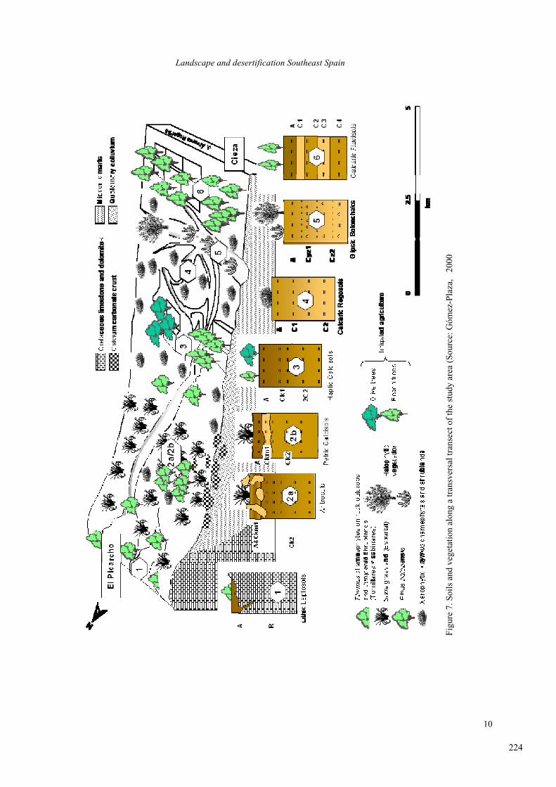
the southern slope of El Picarcho mountain range (1º29’ W, 38º 23’N). The soils are developed on
Cretacic limestone, they are classified as Petric Calcisols (FAO-ISRIC-ISSS, 1998) characterized
by a A-Ckm1-Ckm2 profile, with the petrocalcic horizon at 40-70 cm (Gómez-Plaza, 2000)
(Figure 7).
The area has a mean annual rainfall of 298 mm and an annual average temperature of 16.5 Cº This
area was partially affected by a wildfire in July 1994. Vegetation is agrassland dominated by Stipa tenacissima L. in one part of the study area and open woodland with Pinus halepensis in another
part of the study area.
223
Landscape and desertification Southeast Spain
10
Fig
ure
7. S
oil
s an
d v
eget
atio
n a
lon
g a
tra
nsv
ersa
l tr
anse
ct
of
the
stu
dy
are
a (
So
urc
e: G
óm
ez-P
laza
, 2
00
0
224
F. López Bermúdez et al.
11
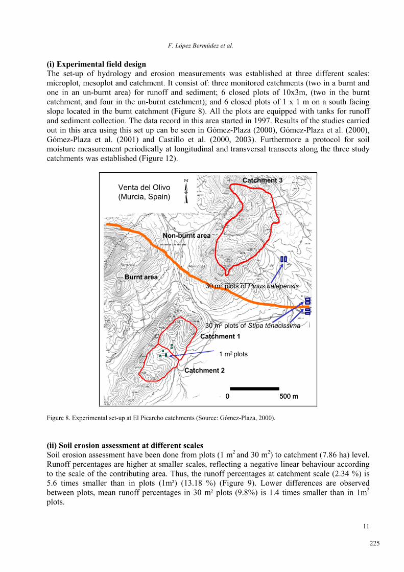
(i) Experimental field design The set-up of hydrology and erosion measurements was established at three different scales:
microplot, mesoplot and catchment. It consist of: three monitored catchments (two in a burnt and
one in an un-burnt area) for runoff and sediment; 6 closed plots of 10x3m, (two in the burnt
catchment, and four in the un-burnt catchment); and 6 closed plots of 1 x 1 m on a south facing
slope located in the burnt catchment (Figure 8). All the plots are equipped with tanks for runoff
and sediment collection. The data record in this area started in 1997. Results of the studies carried
out in this area using this set up can be seen in Gómez-Plaza (2000), Gómez-Plaza et al. (2000),
Gómez-Plaza et al. (2001) and Castillo et al. (2000, 2003). Furthermore a protocol for soil
moisture measurement periodically at longitudinal and transversal transects along the three study
catchments was established (Figure 12).
Burnt area
Non-burnt area
Catchment 1
Catchment 2
Catchment 3
30 m2 plots of Stipa tenacissima
1 m2 plots
Venta del Olivo (Murcia, Spain)
0 500 m
30 m2 plots of Pinus halepensisBurnt area
Non-burnt area
Catchment 1
Catchment 2
Catchment 3
30 m2 plots of Stipa tenacissima
1 m2 plots
Venta del Olivo (Murcia, Spain)
0 500 m0 500 m
30 m2 plots of Pinus halepensis
Figure 8. Experimental set-up at El Picarcho catchments (Source: Gómez-Plaza, 2000).
(ii) Soil erosion assessment at different scales Soil erosion assessment have been done from plots (1 m
2and 30 m
2) to catchment (7.86 ha) level.
Runoff percentages are higher at smaller scales, reflecting a negative linear behaviour according
to the scale of the contributing area. Thus, the runoff percentages at catchment scale (2.34 %) is
5.6 times smaller than in plots (1m²) (13.18 %) (Figure 9). Lower differences are observed
between plots, mean runoff percentages in 30 m² plots (9.8%) is 1.4 times smaller than in 1m2
plots.
225
Landscape and desertification Southeast Spain
12
The differences in runoff percentages found between plots are related, basically, to soil moisture
antecedent conditions. When the soil is dry the response is variable and in most of the cases it is
similar between the plots. However when the soil is moist, the runoff coefficient is always higher
in 1 m² plots than in the 30 m² plots. This is due to a more homogeneous soil moisture pattern at
smaller surfaces facilitating a continuity of the flow. This illustrates the important role of
antecedent soil moisture conditions in the hydrological response at larger scales.
Sca
le r
atio
0
1
2
3
4
5
6
Runoff percentage
Sediment concentration
Soil loss
catchment/30 m2
catchment/1m2
30 m2/1 m2
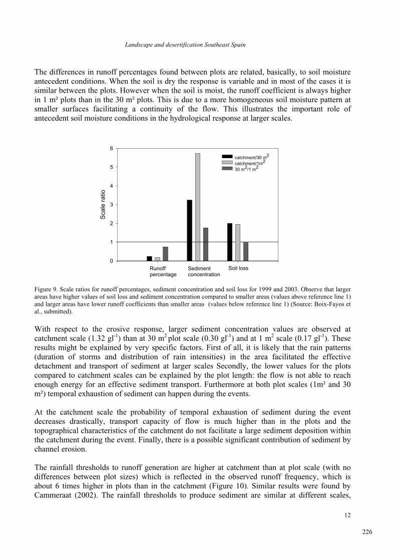
Figure 9. Scale ratios for runoff percentages, sediment concentration and soil loss for 1999 and 2003. Observe that larger
areas have higher values of soil loss and sediment concentration compared to smaller areas (values above reference line 1)
and larger areas have lower runoff coefficients than smaller areas (values below reference line 1) (Source: Boix-Fayos et
al., submitted).
With respect to the erosive response, larger sediment concentration values are observed at
catchment scale (1.32 gl-1
) than at 30 m2plot scale (0.30 gl
-1) and at 1 m
2 scale (0.17 gl
-1). These
results might be explained by very specific factors. First of all, it is likely that the rain patterns
(duration of storms and distribution of rain intensities) in the area facilitated the effective
detachment and transport of sediment at larger scales Secondly, the lower values for the plots
compared to catchment scales can be explained by the plot length: the flow is not able to reach
enough energy for an effective sediment transport. Furthermore at both plot scales (1m² and 30
m²) temporal exhaustion of sediment can happen during the events.
At the catchment scale the probability of temporal exhaustion of sediment during the event
decreases drastically, transport capacity of flow is much higher than in the plots and the
topographical characteristics of the catchment do not facilitate a large sediment deposition within
the catchment during the event. Finally, there is a possible significant contribution of sediment by
channel erosion.
The rainfall thresholds to runoff generation are higher at catchment than at plot scale (with no
differences between plot sizes) which is reflected in the observed runoff frequency, which is
about 6 times higher in plots than in the catchment (Figure 10). Similar results were found by
Cammeraat (2002). The rainfall thresholds to produce sediment are similar at different scales,
226

F. López Bermúdez et al.
13
being slightly lower at 30 m² than at the 1m² plot and in the catchment. The observed sediment
frequency (once the runoff is generated) increases with the increase of the drainage area which is
related to the limited flow transport capacity at short distances and reflected especially in the
sediment concentrations.
A
Runoff generation
Frequency
0 10 20 30 40 50
Rai
nfal
l thr
esho
ld (
mm
)
0
2
4
6
8
10
12
14
16
0
2
4
6
8
10
12
14
16
I 30
thre
shol
d (m
m h
-1)
Soil loss
Frequency
10 20 30 40 50 60 70 80
Rai
nfal
l thr
esho
ld (
mm
)
0
2
4
6
8
10
12
14
16
0
2
4
6
8
10
12
14
16
I 30
thre
shol
d (m
m h
-1)B
1 m2 plots
30 m2 plots catchment
Figure 10. Threshold of rainfall depth and rainfall intensity to generate runoff (Grey filling: rainfall intensity threshold;
black filling: rainfall depth threshold) (Source: Boix-Fayos et al., submitted).
Small plots (1m 2) have the problem of the low energy of flow for soil detachment and transport
generated over short distances, and the partial and limited representation of the high spatial
variability of surface components in semiarid ecosystems. This spatial variability of surface
properties is partially responsible for the intermittent flow generation and the runoff/run-on
mosaic pattern at the slopes which is reflected in a specific hydrological and erosion response of
the catchments. Beside that, at smaller scales the erosion processes might not be fully represented.
(iii) Hydrological response of catchments and the role of antecedent soil moisture Only three events since the establishment of the monitoring program caused runoff at the outlet of
the three catchments (Table 2, Figure 11). In the event of 30/9/97 and 18/6/99 the non-burnt
catchment produced less total runoff (1.5% and 1.7 % of runoff coefficient respectively) than the
burnt catchments (9 and 8.9% of runoff coefficient for catchments 1 and 2 respectively in the
event 30/9/97 and higher values in the event of 22/1/99) despite of the fact that the non-burnt
227
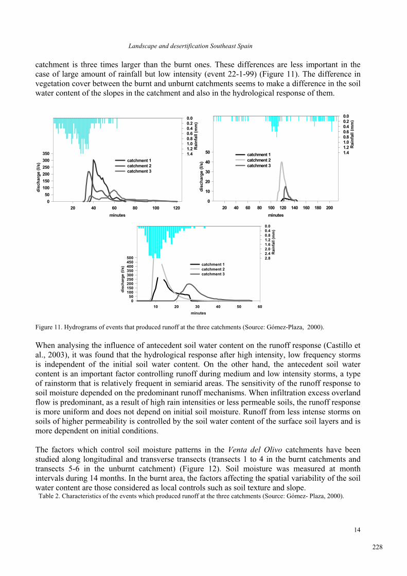
Landscape and desertification Southeast Spain
14
catchment is three times larger than the burnt ones. These differences are less important in the
case of large amount of rainfall but low intensity (event 22-1-99) (Figure 11). The difference in
vegetation cover between the burnt and unburnt catchments seems to make a difference in the soil
water content of the slopes in the catchment and also in the hydrological response of them.
minutes
20 40 60 80 100 120
dis
char
ge
(l/s
)
0
50
100
150
200
250
300
350
catchment 1catchment 2catchment 3
Rai
nfa
ll (m
m)
1.41.21.00.80.60.40.20.0
minutes
20 40 60 80 100 120 140 160 180 200
dis
char
ge
(l/s
)0
10
20
30
40
50 catchment 1catchment 2catchment 3
Rai
nfa
ll (m
m)
1.41.21.00.80.60.40.20.0
minutes
10 20 30 40 50 60
dis
char
ge
(l/s
)
050
100150200250300350400450500
catchment 1catchment 2catchment 3
Rai
nfa
ll (m
m)
2.82.42.01.61.20.80.40.0
Figure 11. Hydrograms of events that produced runoff at the three catchments (Source: Gómez-Plaza, 2000).
When analysing the influence of antecedent soil water content on the runoff response (Castillo et
al., 2003), it was found that the hydrological response after high intensity, low frequency storms
is independent of the initial soil water content. On the other hand, the antecedent soil water
content is an important factor controlling runoff during medium and low intensity storms, a type
of rainstorm that is relatively frequent in semiarid areas. The sensitivity of the runoff response to
soil moisture depended on the predominant runoff mechanisms. When infiltration excess overland
flow is predominant, as a result of high rain intensities or less permeable soils, the runoff response
is more uniform and does not depend on initial soil moisture. Runoff from less intense storms on
soils of higher permeability is controlled by the soil water content of the surface soil layers and is
more dependent on initial conditions.
The factors which control soil moisture patterns in the Venta del Olivo catchments have been
studied along longitudinal and transverse transects (transects 1 to 4 in the burnt catchments and
transects 5-6 in the unburnt catchment) (Figure 12). Soil moisture was measured at month
intervals during 14 months. In the burnt area, the factors affecting the spatial variability of the soil
water content are those considered as local controls such as soil texture and slope. Table 2. Characteristics of the events which produced runoff at the three catchments (Source: Gómez- Plaza, 2000).
228

F. López Bermúdez et al.
15
Characteristics of the rainfall Characteristics of the hydrogram
Catchment 1 Date P Im Imax I30max I5max I10max HI
(%) Ti
(min) Tp
(min) Tb
(min) Qp(l/s)
UE(mm)
CE(%)
30/9/97 28 25.6 84 42.4 76.8 61.2 10 36 40 34 302.9 23.8 8.9
22/1/99 19.6 5.1 48 16.8 40.8 34.8 7.3 118 125 26 2.53 11.6 0.18
18/6/99 31.8 57.8 240 63.2 144 175.2 5 9 20 >500 12 >4.2
Catchment 2 Date P Im Imax I30max I5max I10max HI
(%) Ti
(min) Tp
(min) Tb
(min) Qp(l/s)
UE(mm)
CE(%)
30/9/97 28 25.6 84 42.4 76.8 61.2 12 30 35 44 218.9 18.8 8.9
22/1/99 19.6 5.1 48 16.8 40.8 34.8 8.8 110 118 40 40 7.8 2.14
18/6/99 31.8 57.8 240 63.2 144 175.2 6 8 35 >500 8 >5.1
Catchment 3 Date P Im Imax I30max I5max I10max HI
(%) Ti
(min) Tp
(min) Tb
(min) Qp(l/s)
UE(mm)
CE(%)
30/9/97 28 25.6 84 42.4 76.8 61.2 15 34 60 84 81.6 21.2 1.50
22/1/99 19.6 5.1 48 16.8 40.8 34.8 9.0 122 126 17 14.7 13.0 0.13
18/6/99 31.8 57.8 240 63.2 144 175.2 7 20 26 35 194.3 29.2 1.7
HI = Inicial soil moisture; Ti = Inicial time of the hydrogram; Tp = Time to peak of the hydrogram; Tb= Duration of the
hydrogram; Qp =Peak discharge; UE=Runoff threshold; CE= Runoff coefficient
Figure 12. Location of the topographic transects for the study of the soil moisture and its control factors (burnt
catchments above, unburnt catchment below) (Source: Gómez-Plaza et al., 2001).
Transect 1Transect
Transect 3Transect 4
Transect 5Transect 6
229
Landscape and desertification Southeast Spain
16
These factors are able to explain a significant part of the spatial distribution of soil moisture in
this zone independently of the soil moisture state. In the unburnt area, the factors affecting soil
moisture were those related with the presence of absence of vegetation in semiarid environments.
The upslope contributing area, aspect, soil profile curvature and soil depth best explained the
spatial variability of the soil moisture content in the vegetated zone. The actual influence of these
factors showed marked seasonal variations due to changes in the physiological activity of the
vegetal cover (Gómez-Plaza et al., 2001).
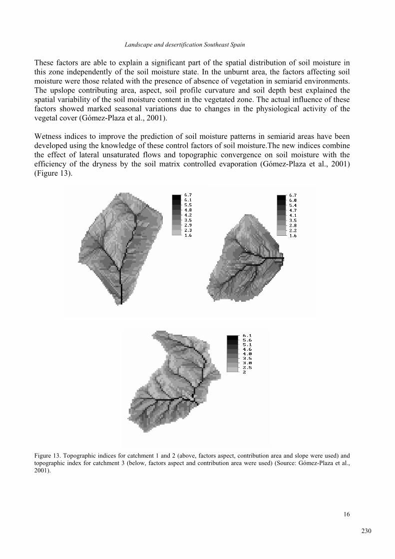
Wetness indices to improve the prediction of soil moisture patterns in semiarid areas have been
developed using the knowledge of these control factors of soil moisture.The new indices combine
the effect of lateral unsaturated flows and topographic convergence on soil moisture with the
efficiency of the dryness by the soil matrix controlled evaporation (Gómez-Plaza et al., 2001)
(Figure 13).
Figure 13. Topographic indices for catchment 1 and 2 (above, factors aspect, contribution area and slope were used) and
topographic index for catchment 3 (below, factors aspect and contribution area were used) (Source: Gómez-Plaza et al.,
2001).
230

F. López Bermúdez et al.
17
Acknowledgements The research carried out at these areas was part of several projects:"Seguimiento y Evaluación de los efectos sobre el
Medio Natural de la Sequía y los Procesos Erosivos. 2: Seguimiento de las actuaciones de lucha contra la desertificación”,
funded by the Comunidad Autónoma de la Región de Murcia e INTERREG IIC Programme; “Respuesta Hidrológica y
Geomorfológica de los Sistemas Fluvio-Torrenciales afectados por proyectos de Restauración Hidrológico-Forestal en
cuencas semiáridas del Sureste Peninsular” funded by Fundación Instituto Euromediterráneo de Hidrotecnia; contract
RESEL (Contribución Española al Desarrollo del Convenio Mundial para Prevenir la Desertificación: I.- Red de Cuencas
y Parcelas Experimentales de seguimiento y Evaluación de la Erosión y Desertificación) supported by the Spanish
Ministries of Environment and of Science and Technology (CICYT); PROHISEM “Procesos hidrológicos en áreas semi-
naturales mediterráneas” (REN01-2268-CO2-01/HID) supported by the National Plan I+D+I 2001-2004; and
RECONDES “Conditions for restoration and mitigation in desertified areas using vegetation (GOCE-CT-2003-505361)
funded by the European Community.
References.
Boix-Fayos, C., Martínez-Mena, M., Albaladejo,
J., Arnau-Rosalén, E., Calvo-Cases, A.,
Castillo, V. (submitted): Understanding the
sources of variation introduced by erosion
plots to measure interrill erosion in the field:
a review of the method with some examples
of Southeast Spain. Progress in Physical Geography.
Cammeraat, L.H. 2002: A review of two strongly
contrasting geomorphological systems
within the context of scale. Earth Surface Processes and Landforms 27, 1201-1222.
Castillo V, Barberá GG, Mosch W, Navarro-
Cano JA, Conesa C, López-Bermúdez F.
2002: Seguimiento y Evaluación de los
trabajos de restauración hidrológico-forestal.
In: López Bermúdez (Ed.) Seguimiento y
evaluación de los efectos sobre el medio
natural de la sequía y los procesos erosivos
en la Región de Murcia. Consejería de
Agricultura, Agua y Medio Ambiente de la
región de Murcia. Murcia. pp. 166-233.
Castillo,V., Gómez-Plaza, A., Martínez-Mena,
M. 2003: The role of antecedent soil water
content in the runoff response of semiarid
catchments: a simulation approach. Journalof Hydrology 284, 114-130.
Castillo, V., Mosch, W.M., Conesa García, C.,
Barberá, G.G., Navarro Cano, J.A., López-
Bermúdez, F. (submitted): Effectiveness and
geomorphological impact of check-dams for
soil erosion control in semiarid
Mediterranean catchments, SE Spain.
Catena.
Gómez-Plaza, A. 2000: Variabilidad espacio
temporal del contenido de humedad del
suelo en una zona mediterránea semiárida.
Efectos de las condiciones antecedentes en
la respuesta hidrológica. Ph.D. Thesis,
Universidad Politécnica de Madrid, Madrid,
Spain (unpublished work).
Gómez-Plaza,A., Alvarez Rogel,J., Albaladejo, J.
and Castillo, V. M. 2000: Spatial patterns
and temporal stability of soil moisture across
a range of scales in a semiarid environment.
Hydrological Processes 14, 1261-1277.
Gómez-Plaza,A., Martínez-Mena, M. Albaladejo,
V.M., Castillo, V.M. 2001: Factors
regulating spatial distribution of soil water
content in small semiarid catchments.
Journal of Hydrology 253, 211-226.
IGME (1974): Mapa Geológico de España.
Calasparra (890, 20-35), 1:50000.
IGME (1982): Mapa Geológico de España. Cieza
(891, 26-35), 1:50000.
López Bermúdez, F., 1973: La Vega Alta del Segura. Clima, hidrología y geomorfología.Departamento de Geografía. Universidad de
Murcia, Murcia, 287 pp.
López-Bermúdez F, Romero Díaz M.A. 1992:
Génesis y consecuencias erosivas de las
lluvias de alta intensidad en la región
mediterránea. Cuadernos de Investigación Geográfica. 18-19, pp. 7-28.
231
Landscape and desertification Southeast Spain
18
General characteristics of the province of Almeria 1. Historical context Almería, a city with a population of about 150,000, which is the capital of the province of the
same name, was called Portus Magnus by the Romans, and Al-Mariyya (mirror of the sea) by the
Arabs. It has an average of 320 days of sun per year. On the hill to the west of the town is the
Moorish fortress, the Alcazaba. Controlled by the Arabs from the 8th century until 1489, the city
was destroyed by an earthquake in 1522. In modern times, Almería and its province were one of
the poorest areas of Spain, until the development in the last 35 years of industrialized agriculture
based on forced cultivation under plastic. This permited a 30% increase in the population between
1960 and 1986, but was also the cause of abandoning large extensions of lands.
The Almeria province has characteristics unique in Western Europe due to the combination of
three factors: its semi-arid climate, recent tectonic activity and ancient human ocupation. This has
caused the landscape as a whole to be fragile with scant capacity for recovery from perturbations.
The main tension periods in the recent historical evolution of human settlement in the Almería
region are:
16 & 17 centuries: land use changes after the christian colonization
- Extension of cereal crops/large sheep stocks
- Transformation of woodlands into wineyards
- Pluvial fluctuation of the Modern Age
1850 - 1920: Expansion of mining activity (lead and iron)
- Destruction of woodlands for firewood
- Expansion of Stipa harvesting and exportation
1970 onwards: Greenhouse agriculture
- Uncoupling and marginalization of the hinterland
- Over explotation of water resources
- Salinization of soils and aquifers
2. Geographical context Almería is located between the last foothills of the Gádor Mountains and the Alborán Sea, in the
center of the Gulf of Almería. Around Almería there are several mountain ranges.
The Betic Mountains are generally aligned E to W, and are separated by sedimentary basins.
Around Almería from N to S is found an axis formed by the Baza and Filabres ranges (2168 m
asl), the Nevada range (extreme east end, 2640 in the province of Almería), and the series of
(from W to E) Gador, Alhamilla and Cabrera ranges (2244, 1397 and 961 m asl, respectively). To
the SE, already on the coast and forming the eastern flank of the bay of Almería, extends the
Miocene andesitic-dacitic volcanic formation of Cabo de Gata (493 m asl).
Among the mountain ranges named above, there are various valleys and depressions: between Los
Filabres and Nevada, the Nacimiento River valley, which will later enter the Andarax River, the
mouth of which is just east of the city of Almería; between Nevada y Gádor, the Andarax valley
and, between Los Filabres y Alhamilla, the valley of Tabernas-Sorbas, the western half of which
is drained by the Tabernas rambla (rambla is a river without water on surface generally, except if
it rains strongly; most rives of Almería are really ramblas), also an affluent of the Andarax and
into which the Rambla Honda empties its occasional waters, while the eastern half is drained
232
F. López Bermúdez et al.
19
toward the east coast by the Aguas River. Between the Alhamilla and Cabrera Mountains and the
Cape Gata formation, extends the sedimentary basin of Almería-Carboneras, drained by
overflows of little importance.
The three valleys mentioned and the Almería-Carboneras basin flow together into a central
depression of lesser altitude situated between the city of Almería and the Filabres Mountains. To
the west of that depression are the confines of the Gador and Nevada mountands and to the east
the Alhamilla Mountains. Approximately at the extreme northeast is the Rambla Honda
(MEDALUS field site) and, in its center, the "Desert of Tabernas", an area of badlands set in one
of the most arid points of Europe.
3. Geological context The extreme east of the Betic ranges is formed by two geological complexes, one lower, the
Nevado-Filabride, and the other upper, Alpujarride. The first forms Nevada and Los Filabres
Mountains and the axis of the mountain system. This is made up of two lithological units, the
lower, made up of micaceous schists and quartzites and the upper, by marbles, gneisses and
micaceous schists.
The second, which appears in the Gador, Alhamilla and Cabrera Mountains, has slipped over the
former and has suffered a lesser degree of metamorphism. It is formed by a stratigraphic sequence
from the Paleozoic to the Triassic, which contains micaceous schists, phyllites and carbonated
rocks, in that order.
The tectonics of the tension instilled during the Miocene produced the rising of the Nevado-
Filabride complex and the movement over it of the Alpujarride, creating a topography of
emerging mountains, separated by sedimentary basins, where powerful sequences of Neogenic
sediments accumulated. The sedimentary surroundings, clearly marine since Tortonian , with
predominance of marls, became more superficial during the Messinian, where calcoarenites,
limestone, reefs and evaporites abound.
Starting with the Pliocene, a tectonic compression and epeirogenic lift are initiated which provoke
the emergence of the entire region. The marine deposits are limited to the present coasts, with
coastlines retreating toward the south, from the Sorbas basin. The most notable can be observed in
the area of Almería, as a consequence of the late rising of the Alhamilla Mountains. The
sedimentary basins are fractured and suffer relative lifting and sinking. The maximum relative
lifting may be seen in the Sorbas basin, where strong differences in level are created between
Vera to the east and Tabernas to the West.
The development of the tectonic activity has conditioned the development of the drainage
network and this, in turn, of the landscape throughout the Quaternary period (Harvey, 1987).
While the mountain systems lifted show a predominance of disection, with very scanty
accumulations of Quaternary sediments along the main valleys, the neogenic basins present
outstanding differences between the forms of disection and aggradation.
The forms of disection are related to the incision of the drainage network and are especially
significant on steep gradients that originate to the east and west of the Sorbas basin, which, as we
have seen, experiences a relative lift compared to its surroundings. Thus, the Aguas River on the
East, falls 160 m in 11 km., carves 160 m into the Messinian marls and captures the ancient
Aguas-Feos system which originally drained the Sorbas basin to the south, by the Carboneras
233

Landscape and desertification Southeast Spain
20
basin. In the west, the Tabernas rambla falls 260 m in 16 km and produces disecctional reliefs 200
m into Tortonian marl sediments, giving rise to one of the largest areas of badlands in Spain, the
Desert of Tabernas.
The most extensive forms of aggradation in the region are the glacis or pediments and the alluvial
fans. The first are especially frequent on the edges of the Vera and Almería basins and in many
cases present lower Quaternary gravel crusts. In the Almería basin those coming from the Sierra
Alhamilla are outstanding. Various surfaces from the lower Quaternary end in marine deposits,
also Quaternary. The unit has been disturbed by the Almería falt system, disected by gullies
proceding from the Sierra Alhamilla. These last, are found within the pediments and have formed
younger alluvial fans in their interior.
The largest alluvial fans are found at the contacts between Los Filabres and Alhamilla Mountains
with the extreme east of the Tabernas basin on one side and, between the Alhamilla-Cabrera
Mountains, with the central part of the Almería-Carboneras basin, on the other. Both areas are far
from the rising incision induced by tectonic activity. The greater part of the fans undergo
degradation from the formation of gullies at the headwaters and distal aggradation, so that the
materials that comprise them are relocated within the sedimentary body itself.
4. Climate For Neumann (1961) "This is the poorest region in rainfall in all of Europe. The vegetation and
landscape have a markedly African stamp." Likewise, Geiger (1973) considers the Iberian
Southeast to be the most arid region of Europe except for the area north of the Caspian Sea.
The minimum peninsular precipitations are concentrated along a coastal belt that extends from
Villajoyosa (Alicante) to Adra (Almería), with a maximum width of some 70 km. The zone
around Aguilas (Murcia) and the Lower Almanzora, Cape Gata to Almería and Rioja to Tabernas
are the most arid, often under 200 mm per year. The Iberian Southeast is a very mountainous
country and the Betic ranges (Betic sensu stricto, Subbetic and Prebetic), due to the dominant
atomospheric circulation, act as a screen for precipitation coming from the Atlantic, so that this
strip coastal remains to the leeward side. At the same time these mountains receive sufficient
contributions of water to maintain arboreal vegetation, which may even become relatively
abundant: In all of them 400 mm/year are attained, sometimes 500 and in the Nevada Mountains,
more than 700 mm. This, combined with the decrease in temperatures due to altitude in the
highlands, makes the region contrast with the relatively sharp environmental gradients and
outstanding wealth of ecological niches.
Above all, under conditions of cold drop, the fronts proceding from the Mediterranean
occasionally bring heavy, destructive rainfall. But these torrential rains are not very freequent, and
do not occur every year. Precipitation is basically orographic. Interannual variability is also
probably the highest in Europe, around 30% for the region as a whole and over 40% in some of
the most arid zones. The intensity of the rainfall is very variable in time as well as space:
According to Capel (1986), in Rioja, near the Tabernas badlands, about 219 mm per year fall,
over 40 days of precipitation, which gives an average preciptation per day of 5.4 mm, the lowest
in the province; on the other hand, in Zurgena, on the Lower Almanzora, for an annual average of
251 mm, there are only 15 days of rainfall, with an average of 16.7 mm, more than three times
greater. This concentration of precipitation in Zurgena is outstanding; apart from the minimum
234
F. López Bermúdez et al.
21
number of days of precipitation per year, it also has other records, such as the maximum rainfall
in 24 hours: 600 mm, on October 19, 1973.
The climate of the region, although within the Mediterranean type, is really intermediate between
that of the Mediterranean area and deserts. According to Geiger (op. cit.) there is no other region
in the world with such climatic conditions: a) long period of precipitation (from September to
May or June) during which only 200 to 300 mm fall. All the regions of the Earth that can be
compared for their total annual precipitation and temperature patterns present strong
concentration of precipitation in winter. b) Very numerous days with weak precipitation, under 5
mm. Torrential rains, although they exist, are not as frequent as in other regions.
In winter, precipitation is usually snow over 1400 -1700 m altitude, depending on the distance
form the sea and orientation; in spring and especially in autumn, snows are only frequent on the
peaks, at 2000 m altitude or more. In the area of our excursion, the order of the seasons, from
greater to lesser precipitation is: Autumn, Winter, Spring and Summer. It is often the case that in
July there is no precipitation at all, which may also happen in August.
In winter, the coast of the Iberian Southeast has the maximum insolation and temperatures in
Europe. The daily range of temperatures is characteristic, approximately double that of the
northern coast of Spain. Absolute maximums of 32° have been recorded in January and 50°C in
July. But normally the maximums during the hot months are similar to a wide sector of the east
and the south coast of the Peninsula and lower than those in the interior of Andalucía, southern
Submeseta and southern Extremadura: What is characteristic is the great number of hours with
temperatures near maximum and that the minimums are usually among the highest in the
Peninsula, in summer as well as in winter. On the coast there are practically no frosts. But the
temperatures decrease rapidly toward the interior and in winter minimums of from -10° and -15°
in mountain villages (for example, at 1200 m altitude and around 60 km from the sea) may be
found. On the coast and generally up to 500 m altitude, average temperatures are between 17 and
20°. The 18, 17, 16 and even 15°C annual average isotherms run a course more or less parallel to
the coast and surround the more coastal mountain ranges; the 12, 11 and 10° isotherms are found
almost exclusively in the greater mountain ranges. In high mountains, due to strong insolation and
summer heat, the annual average does not usually go below 10°C.
Except in summer, near the coast, the humidity in the air is often high at night, and dew is
frequent. The potential evaporation is 4 or 5 times greater than the annual precipitation. In the
majority of years there are 7 to 10 dry months (from 8 to 11 in the driest areas cited above). The
average annual insolation is around or above 3000 hours of sun throughout the area.
5. Vegetation The climactic arboreal vegetation in the Iberian Southeast is wood of evergreen oak with Quercus rotundifolia ("encina") as the dominant species. There is also wide concensus that this vegetation
finds its natural limit precisely in the area which concerns us, because of the aridity. These are
woods of slight height, typically with 4 layers (tree, shrub, grass and moss), dense in the most
favorable biotypes but, in general rather open and progressively more so as the bioclimatic limits
of its area are reached. These limits, microclimates apart, are usually near the isoline of 350 mm
average annual precipitation. Therefore the evergreen oak forests are found in the Southeast above
600-900 m altitude, since precipitation is orographic; in fact, they delimit the semiarid climate
rather closely. Quercus rotundifolia forest was dominant, giving rise to different vegetative series
235

Landscape and desertification Southeast Spain
22
with differences in the floristic composition according to altitude (due to temperatures), the
precipitations, the location and the substrate, but the dynamics and the phases of degradation of
the various series are structurally similar.
The wood of pines would also be important in places with less soil, strongly dominated by Pinus halepensis in the warmer and coastal areas, up to 1500 m altitude, and by Pinus nigra in some
mountain ranges, generally above this altitude. The other tree communities (other Quercus,
Populus, etc.) are reduced to small areas and often in framentary form, for, above all, climatic
reasons, and because as is so common in the Spanish Mediterranean environment, the strongest
concentration of crops is near watercourses, and therefore in many areas, river groves and gallery-
type woods are practically non-existent or reduced to small residual fragments.
Traditionally, the wood of the evergreen oak has been much used by man, mainly for charcoal,
and also in mining. On the other hand, in many places, areas are farmed at the expense of woods,
(and, in many cases, have later been abandoned). Certainly, 36 years ago, when ICONA (Instituto
Nacional para Conservación de la Naturaleza) began the massive reforestation of the Almería
Mountains, trees had practically disappeared from them. At present, tree-life consists of pines
planted by ICONA, using from lower to upper and mainly, P. halepensis, P. pinaster, P. nigra y P. sylvestris. And the evergreen oaks are reduced to more or less small localized spots; even to
single trees or scattered groups. Although there are places where natural recovery is evident, such
as in the Umbría de la Virgen, in the María Mountains, where the evergreen oaks are beginning to
grow massively from seed under the pines. In recent years an important effort is being made to
repopulate with autoctonous leaf species.
Below 600 or 900 m altitude the potential vegetation would be a more or less dense, high
brushwood dominated by Rhamnus lycioides, Olea europaea var. sylvestrys, Quercus coccifera, Ephedra fragilis, Asparagus albus, Pistacia lentiscus, Salsola webbi, etc. and, more toward the
coast by Chamaerops humilis, Maithenus senegalensis, Withania frutescens, Ziziphus lotus, Periploca laevigata, etc. But at this lower level, the most often used by man for thousands of
years, the majority of original vegetation disappeared a long time ago, in some places to the point
where it is difficult to identify and, today is substituted by crops, grazing lands, human
settlements and areas - rather extensive - with serial vegetation in more or less advanced stages of
Succession depending on the accessibility and length of time abandoned. In these areas of wild
vegetation, in general, progressive succession has suffered continuous detentions and backward
movements due to the transit of man and changes in use, normally too fast.
Therefore, apart from reforestation, the natural vegetation is brushwood, very much degraded
because of the fragility of these ecosystems. High brushwood are infrequent and cover small areas,
often with difficult access and/or microclimates, where small spots with remnants of the climax
are found, structure which appears when the first noble shrubs begin to become established,
usually Rhamnus lycioides, Olea europaea or Ephedra fragilis, or else Chamaerops humilis or Ziziphus lotus on the coast; in this case it is usually very open with well-spaced shrubs and the
majority of cover due to smaller serial scrub. In some places some higher shrubs may be observed
with little or no presence of climacic species, for example, Rosmarinus officinalis, and various
species of Genista, Cistus ladanifer, Ulex parviflorus. They are usually dense and, like almost all
the shrubs of a certain stature, survive because of their interest to cynegetics. The dominant
structures in the present wild vegetation, at a level below the evergreen oaks, are:
236

F. López Bermúdez et al.
23
- Tomillar (thyme). It is a dark brushwood. Typically in two layers, the upper of
chamaephytes, the lower of therophytes (Sometimes there are three layers, with two tall fruticeous
chamaephytes or nanophanerophytes and dwarf chamaephytes and it can have a lowest layer of
lichens and/or moss), and cover of between 20 and 50%. It is floristically rich and variable and
with numerous endemisms. It forms numerous communities, depending on the substrate and the
climate and microclimate as well as, on a lesser scale, the geographic location, due to the
influence of the corollogy of the main species. Some of the most frequent and typical species are
Anthyllis cytisoides y A. terniflora, Helianthemum almeriense, Thymus hyemalis, etc; in more arid
places, Salsola genistoides, S. papillosa, Anabasis articulata, Euzomodendron bourgaeanum, Launaea lanifera, Limonium insigne, etc., and in the most eutrophic, Artemisia barrelieri, A. herba-alba, Peganum harmala, Zygophyllum fabago, etc. Among the terphytes Stipa capensis, Plantago ovata, P. amplexicaulis, Bromus rubens, Koelpinia linearis, etc., are outstanding.
"Tomillar" occupies the more degraded, arid and most unstable places and, in the most
nitrophyllic, act as colonizers, after a pioneering therophyte phase, or even simultaneously. They
are visible throughout the excursion, but the vegetation at the second stop is the most typical of
this type.
- Espartal (alfa grass). It occupies large areas the perennial pasture land of graminiform
cespitose hemicryptophytes of averge height, dominated by Stipa tenacissima, in which is also
very frequent Dactylis hispanica. It usually has a rather herbaceous layer of therophytes, as well
as geophytes and some chamaephytes. In general, the size of "espartal" and often also its coverage
is greater than "tomillar". They are much more homogeneous, less diversified than the "tomillar"
and their floristic wealth is also less. Mixed "espartal" - "tomillar" formations are not rare.
Formation of sparto grass represents a more advanced step than formation of thymes in
progressive Succession. Typically they occupy the more stable watersheds which have been in
disuse for some time and are visited less often; on the other hand Stipa tenacissima is not so
demanding with regard to soil; consequently, sparto grass formation is usually spread equally over
the high parts of waterheds and in the steeper and rockier areas. Although, as Stipa tenacissimahas been rather intensively developed in the region until recent times for its fiber and its
dispersion has been favored by man, part of its present distribution is due to human intervention.
This formation may be seen mainly at the first stop and its surroundings.
- Retamar (open brushwood). Formation strongly dominated by Retama s phaerocarpa, with three layers: the upper (2-3 m) made up of more less well-spaced plants of
this shurb; the lower, herbaceous, is spacially and temporally very variable as density as floristic
composition are concerned, and is made up mainly of a great variety of therophytes (1-3 dm)
(Brachypodium distachyon, Leysera leyseroides, Ifloga spicata, Linaria nigricans...); between the
two, a layer of very sparse chamaephytes (about 4 or 5 dm high) made up of a few species in
general more or less nitrophyllic pioneers, since these brooms formation are occasionally
cultivated and almost permanently used for grazing by animals. This formation, although not as
extensive as the above, becomes established in flat or slightly sloping places with deep alluvial or
colluvium substrates, in general rather wide valley floors and in particular, is well represented in
the valley between Los Filabres and Alhamilla mountains. The last 10 or 15 km before arriving at
the first stop will be entirely through brooms formation, which is also the vegetation in the lowest
part of the Rambla Honda.
The region's serial vegetation is floristically rich and with abundant endemisms, since they are in
a broad ecotone between the European Mediterranean and arid African worlds and because of the
237

Landscape and desertification Southeast Spain
24
great number of microhabitats that produce an intersection of climates together with the
accidented topography and the lithological wealth.
Alcaraz (1991) gives the following analysis of Murcia-Almería flora:
Mediterranean sensu stricto 46.90 %
Mediterranean and Eurosiberian 11.70 %
Iberian endemism 9.63 %
Subcosmopolitan 8.30 %
Iberoafricanism 4.88 %
Murcian-Almeriense endemism 4.18 %
Mediterranean and Irano-Turanian 3.78 %
Adventitious 3.54 %
Circumboreal 2.20 %
Mediterranean and Macaronesic 2.08 %
Mediterranean and Atlantic 1.59 %
Mediterranean and Saharo-Sindian 1.22 %
The following are endemisms of the Almería Sector of the Murcia-Almería corollogical province:
Androcymbium europaeum Antirrhinum charidemi Coris hispanica Dianthus charidemi Erucastrum pseudosinapis Euphorbia mazarronensis Euzomodendron bourgeanum Helianthemum alypoides Helianthemum x mariano-salvatoris Herniaria fontanesii subsp. almeriana Limonium album Limonium carthaginense Limonium coincy Limonium insigne Limonium estevei Linaria benitoi Linaria nigricans Moricandia foetida
Narcisus tortifolius Phlomis purpurea subsp. almeriensis Salsola papillosa Sideritis foetens subsp. rivasgodayii Sideritis ibanyezi Sideritis osteoxylla Sideritis pusilla subsp. pusilla Sideritis pusilla Teucrium carthaginense Teucrium charidemi Teucrium eriocephalum subsp. almeriense Teucrium intricatum Teucrium lanigerum Teucrium polycephalum subsp. hicronymi Teucrium turredanum Ulex canescens Verbascum charidemi
6. The Rambla Honda field site (37.1297°N, 2.3713°W) (i) Aims General:
To provide information about the evolution of the semi-arid Mediterranean landscape and its
sensitivity to climate once the activity of man has been interrupted.
Specific:
1. To find out relationships between land use, soil, vegetation attributes and organic matter
balances along a catena representative of semi-arid environment.
238
F. López Bermúdez et al.
25
2. To provide field information about the response of the catena elements, in terms of runoff,
sediment outputs, leaf area and net primary productivity to rainfall events, and to seasonal and
interannual climate variations.
3. To describe the physiological strategies of the main building species and the micro-
environmental variations created by their patchy distribution. To use this information for
improving the existing water balance models.
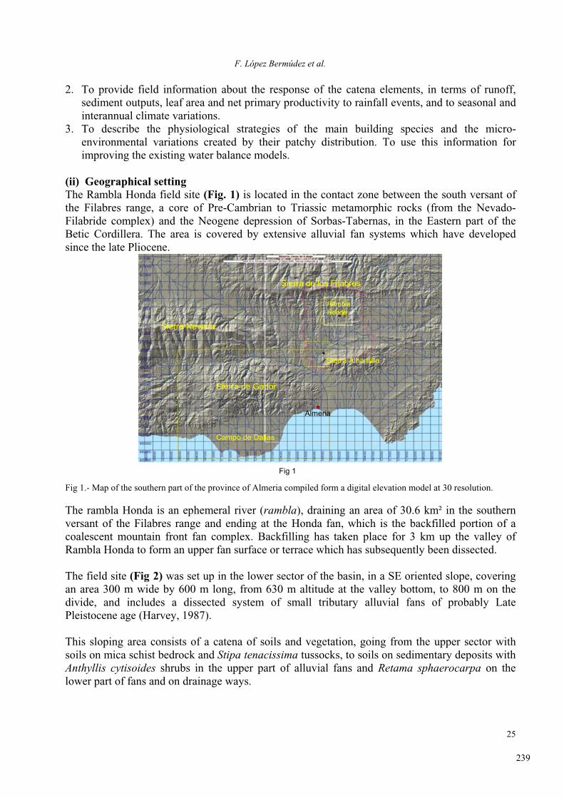
(ii) Geographical settingThe Rambla Honda field site (Fig. 1) is located in the contact zone between the south versant of
the Filabres range, a core of Pre-Cambrian to Triassic metamorphic rocks (from the Nevado-
Filabride complex) and the Neogene depression of Sorbas-Tabernas, in the Eastern part of the
Betic Cordillera. The area is covered by extensive alluvial fan systems which have developed
since the late Pliocene.
Sierra de los Filabres
Sierra Nevada
Sierra de Gador
Sierra Alhamilla
Campo de Dalias
Almeria
Fig 1
RamblaHonda
Fig 1.- Map of the southern part of the province of Almeria compiled form a digital elevation model at 30 resolution.
The rambla Honda is an ephemeral river (rambla), draining an area of 30.6 km² in the southern
versant of the Filabres range and ending at the Honda fan, which is the backfilled portion of a
coalescent mountain front fan complex. Backfilling has taken place for 3 km up the valley of
Rambla Honda to form an upper fan surface or terrace which has subsequently been dissected.
The field site (Fig 2) was set up in the lower sector of the basin, in a SE oriented slope, covering
an area 300 m wide by 600 m long, from 630 m altitude at the valley bottom, to 800 m on the
divide, and includes a dissected system of small tributary alluvial fans of probably Late
Pleistocene age (Harvey, 1987).
This sloping area consists of a catena of soils and vegetation, going from the upper sector with
soils on mica schist bedrock and Stipa tenacissima tussocks, to soils on sedimentary deposits with
Anthyllis cytisoides shrubs in the upper part of alluvial fans and Retama sphaerocarpa on the
lower part of fans and on drainage ways.
239

Landscape and desertification Southeast Spain
26
Fig 2.- Rambla Honda field site (map compiled from DEM at 1 m resolution), showing runoff-erosion plots, runoff gauges
in the catchment and meteorological station.
(iii) Settlement and land use The lower sector of the Rambla Honda basin, where the Field Site is located, has a surface of 5.28
km². Until the sixties, three farms were exploiting the area, with a total of 9 families. The total
number of sheep and goats owned by the farmers was around 600. The mean grazing pressure
may be estimated around 1.13 sheep/ha. The alpha grass was harvested for cellulose and the rest
of the area was cultivated for grain. Alpha grass and livestock accounted for more than 90% of the
cash in the traditional economy. Three types of fields may be identified: terraced plots in the
slopes, fields without specific structures on the alluvial fans and fields enclosed with stonewalls
along drainage ways which were irrigated by flooding. In the former two, the main crop was
barley and in the later wheat and maize were often grown. Additional crops provided further
diversification of the income: olive trees along drainage ways, fig trees, Opuntia for pig feeding
and growing coccids for making stain. The non-cultivated floor of the rambla was covered with
bushes of Retama sphaerocarpa which were cut for firewood.
This traditional agricultural system has been abandoned some 40 years ago. In the slopes, the
growth of Stipa tenacissima is hindered by its own litter because it is not harvested anymore; the
terraces and upper sectors of alluvial fans are invaded by dense populations of Anthyllis cytisoides; the lower sectors of alluvial fans, which were abandoned later (about 15 years ago),
are covered with scattered populations of Retama sphaerocarpa which sprout from roots
remaining in the field after ploughing.
In summary, the area is a piece of the hinterland which runs a subsistence agriculture rather well
adjusted to regional climate conditions but with limited population carrying capacity. It played a
role of source and refuge for population. Over-population, if any, was often channeled to escape
activities so frequent in the Mediterranean: harvesting of Chenopodiaceae for sodium carbonate
240

F. López Bermúdez et al.
27
elaboration, harvesting of alpha for cellulose, mining (lead and iron), grape cultivation, migration
and recently, greenhouse agriculture.
Although the agricultural land has been abandoned, the area is still grazed by sheep flocks and, in
rainy winters, plots on alluvial fans and riverbeds may be cultivated.
(iv) Geology and hydrogeology The lithology of the area is formed by a monotonous and considerably thick series of micaschists
from the Devonian-Carboniferous. This rock is a highly convoluted and fractured, dark grey,
fine grained, slaty mica schist with graphite and garnets, crossed by abundant quartz veins,
alternating with thin phyllite layers.
Neotecthonics has affected the primitively fractured series with new fractures and folds of very
large radius. From Tortonian to Early Plistocene a distension phase has been followed by a
compressive phase which is still active.
The weathering degree of the bedrock is related to the layering pattern and to the proportions of
garnets and quartz. When the latter is high, spurs or shoulders are formed by differential erosion
and colluvial debris are accumulated upslope behind them.
In the middle to low part of hillslopes, the slope colluvia gradate to an alluvial fan formation
which connects with the large Rambla Honda fan system. The tributary fans are dominantly made
by imbricated gravels and lensed and cross-bedded sand supported gravels, indicating a debris
flow regime, probably under wetter climates from Late Pleistocene. The depositional sequence
shows no major break in sedimentation and little or no cementation. Morphologically they show
longitudinal concave profiles and convex tranversal ones. Fan distribution within the main valley
is essentially controlled by neotectonics.
Alluvial fan bodies are in general moderately preserved as they have been affected by dissection
and erosion from the present drainage network. Fan apices have mostly been eroded and at
present we can only see main bodies and fan feet.
Four bore holes were drilled along an altitudinal transect, from the root of the alluvial fan to the
rambla floor, to investigate the sedimentary characteristics of alluvia and colluvia and to monitor
the phreatic level. The bore holes reached the underlying mica schist basal rock. The thickness of
the sediment (18, 8, 16, 28 m) and hence the altitude above sea level of the basal rock (627, 632,
609, 597 m) show the existence of a rather pronounced paleo-relief antecedent to the deposition of
sediment. The sedimentary columns contain alternating beds of coarse and fine material. Gravels
and sands, with a planar geometry, prevail in the upper section whereas reddish-brown loams with
small sandy intercalations predominate in the lower section, while the intermediate section shows
transitional characteristics.
In the bore hole 4, a permeability test (constant head, Lefranc type) was performed in dry
conditions. The estimates of permeability range from 8.61 x 10-³ cm/s for the total column to 1.9
x 10-² cm/s for the gravel beds. Owing to the inaccuracies of this test, these figures should be
treated with caution, but they suggest a moderate total permeability which almost doubles in the
coarser layers.
241

Landscape and desertification Southeast Spain
28
(v) ClimateThe climate is semi-arid with long and hot summers. A strong seasonal and inter-annual
variability in rainfall has been measured (Fig.3). On average, 75 % of annual rainfall is recorded
during autumn and winter. Geographical interpolations among nearby weather stations with long
series provide estimations of 300 mm annual rainfall (Lázaro and Rey, 1991), though only 268
mm have been measured in the period 1989-2004 (Fig 3). Maximum rainfall intensities during
that period are: 211 mm h-1
in 44 seconds, I5’ = 91,2 mm h-1
, I30’ = 32.5 mm h-1
, I24h = 98 mm.
From the analysis of a long series of precipitation data from the nearby Tabernas station, the
estimated return periods for events of more than 50, 70 and 100 mm day-1
is over 5, 11 and 30
years respectively (Lazaro et al., 2001).
0
100
200
300
400
500
600
89-9
0
90-9
1
91-9
2
92-9
3
93-9
4
94-9
5
95-9
6
96-9
7
97-9
8
98-9
9
99-0
0
00-0
1
01-0
2
02-0
3
03-0
4
P (
mm
)
summer
spring
winter
autumn
Fig 3.- Seasonal rainfall in Rambla Honda from 1989 to 2004.
Rainfall events in the area are produced by rain-bearing fronts coming in from the west from the
Atlantic Ocean, mainly in the cold season. This geographic location makes the regional climate in
the SE Iberian Peninsula markedly semi-arid due both to the rainfall shadow effect of the main
Betic ranges and its proximity to northern Africa (Geiger, 1973). After summer and during
autumn, rainfall is associated with fronts coming from the Mediterranean Sea, which sometimes
results in storms and torrential rainfall. Precipitation in the Almeria region is influenced both by
the December North Atlantic Oscillation and by the October Southern Oscillation (Rodriguez-
Puebla et al., 1998).
Temperatures show mild annual averages (T = 16ºC) with warm summers (33°C - 19°C) and mild
winters (15°C – 4°C), due to a high insolation and mild winds. Air humidity values are relatively
extreme on a daily basis (differences over 30%), this patterns remaining constant during the
whole year, though monthly averages remain quite constant (49% in summer, 68% in winter).
Dominant winds mostly come from NE and SW, following the alignment of the Rambla Honda
valley, but for only 1% of the year, is the speed greater than 5 m/s. Global solar radiation reaches
maxima of 1000 W/m² in summer and around 500 W/m² in winter, indicating that the minimum
atmospheric extinction is around 21% and 27% respectively (for extraterrestrial radiation of 1273
W/m² in summer and 689 W/m² in winter, at this latitude).
242

F. López Bermúdez et al.
29
(vi) Vegetation The natural vegetation includes bushes and thorny shrubs of the series Rhamno lycioidi-Querceto cocciferae sigmetum betic facies with Ephedra fragilis, but the remnants of this matorral
(Rhamnus lycioides, Pistacia lentiscus, etc) are restricted to very small patches not suitable for
agriculture or livestock. A large part of the area is covered with a steppe extended by man, which
is dominated by alpha, Stipa tenacissima L. grass with variable proportions of Anthyllis cytisoidesL.
The vegetation in the instrumented field site is arranged in a catena going from the upper hillslope
sector with Stipa tenacissima L., to the sedimentary deposits with Anthyllis cytisoides L., which
are shrubs in the upper parts of the alluvial fans, and Retama sphareocarpa (L.) Boiss on the lower
part of the fans and on drainage channels.
(vii) Soils The soils from Rambla Honda are essentially colluvial and alluvial in origin. Those on the slopes
have developed directly from micashists and quite shallow slope deposits. Steepness of slope and
variability in hardness of bedrock influence soil thickness: where slates with abundant quartz
veins dominate, soils are usually shallow (< 15 cm); where phyllite strata dominate, soils are
thicker (< 60 cm). Those on alluvial fans have developed from bedded colluvia which have
originated from the erosion and sedimentation of material from the slopes above them.
The soils of the whole area show little development of pedogenic horizons and may be arranged
in three main groups: a) soils of the rambla terrace, classified as Eutric Fluvisols, exhibit a clear
stratification and an irregular distribution of organic matter down the profile; b) soils of the lower
part of alluvial fans, classified as Eutric Regosols, and b) soils on the upper part of alluvial fans
and hillslopes, classified as Eutric Leptosols, are texturally somewhat finer (Puigdefábregas et al.,
1996a).
All soils are mostly channery loamy sands and channery fine sandy loams (with low proportions
of silt + clay). Coarse fragments (larger than 2 mm in diameter) within the soil mass range from
15% in the lower part of the alluvial fan to 70% in the higher part of the catena, with 2-8 mm
fragments being the most abundant size. The dominant stone type, either quartz or micaschist, is
quite variable and depends on proximity to large quartz outcrops (veins of variable thickness,
from a few millimetres to more than 1m). The soils on the alluvial fans contain relatively less clay
and less coarse fragments than the slope soils.
A large part of Rambla Honda soils is covered by a filtration pavement formed by a surface cover
of rock fragments underlayered by a sieving crust up to a few centimetres thick (Fig 4). A sievingcrusts may be either the lower part of a filtration pavement, or simply be taken as a synonymous
for that last term, and is made up of a layer of loose sandy grains overlaying a layer of much finer
particles. Valentin (1991) describes the most advanced form of a sieving crust, with three well-
sorted layers: an uppermost layer composed of coarse grains, a middle layer formed by fine,
densely packed grains with vesicular pores and a lower layer with a high content of fine particles
with a considerably reduced porosity.
243
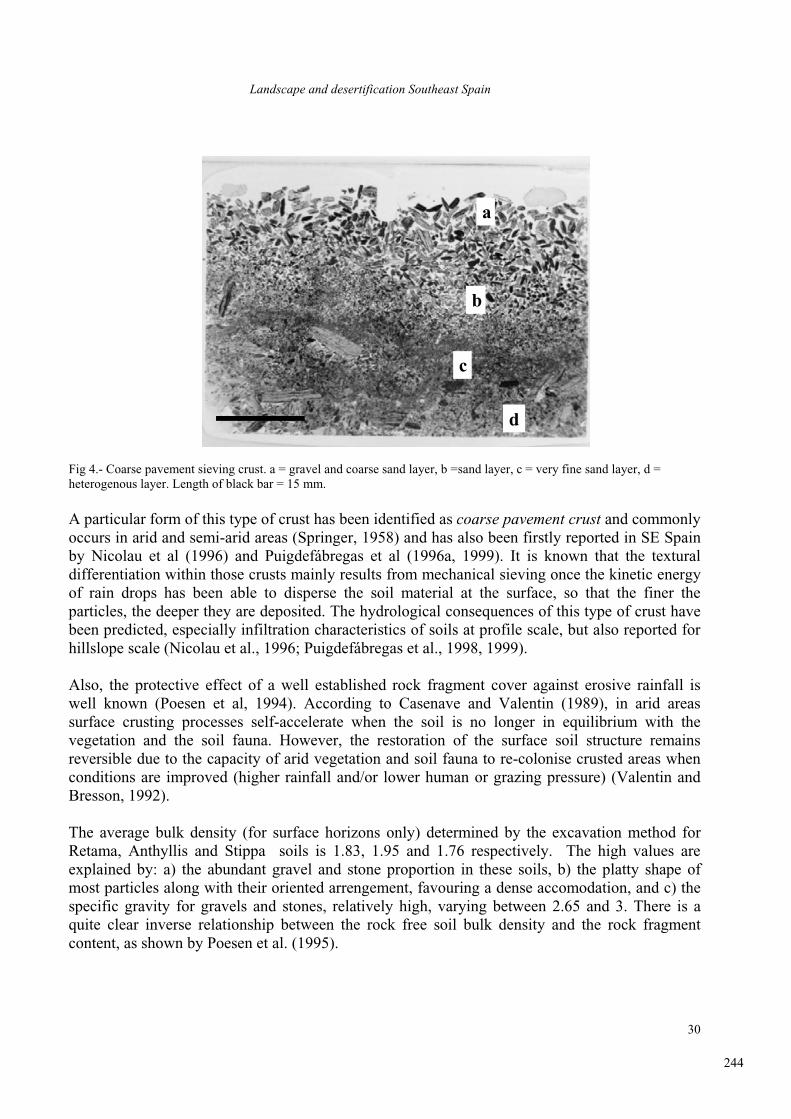
Landscape and desertification Southeast Spain
30
a
b
c
d
a
b
c
d
Fig 4.- Coarse pavement sieving crust. a = gravel and coarse sand layer, b =sand layer, c = very fine sand layer, d =
heterogenous layer. Length of black bar = 15 mm.
A particular form of this type of crust has been identified as coarse pavement crust and commonly
occurs in arid and semi-arid areas (Springer, 1958) and has also been firstly reported in SE Spain
by Nicolau et al (1996) and Puigdefábregas et al (1996a, 1999). It is known that the textural
differentiation within those crusts mainly results from mechanical sieving once the kinetic energy
of rain drops has been able to disperse the soil material at the surface, so that the finer the
particles, the deeper they are deposited. The hydrological consequences of this type of crust have
been predicted, especially infiltration characteristics of soils at profile scale, but also reported for
hillslope scale (Nicolau et al., 1996; Puigdefábregas et al., 1998, 1999).
Also, the protective effect of a well established rock fragment cover against erosive rainfall is
well known (Poesen et al, 1994). According to Casenave and Valentin (1989), in arid areas
surface crusting processes self-accelerate when the soil is no longer in equilibrium with the
vegetation and the soil fauna. However, the restoration of the surface soil structure remains
reversible due to the capacity of arid vegetation and soil fauna to re-colonise crusted areas when
conditions are improved (higher rainfall and/or lower human or grazing pressure) (Valentin and
Bresson, 1992).
The average bulk density (for surface horizons only) determined by the excavation method for
Retama, Anthyllis and Stippa soils is 1.83, 1.95 and 1.76 respectively. The high values are
explained by: a) the abundant gravel and stone proportion in these soils, b) the platty shape of
most particles along with their oriented arrengement, favouring a dense accomodation, and c) the
specific gravity for gravels and stones, relatively high, varying between 2.65 and 3. There is a
quite clear inverse relationship between the rock free soil bulk density and the rock fragment
content, as shown by Poesen et al. (1995).
244

F. López Bermúdez et al.
31
In general, in spite of sandiness, the water released from 0.01MPa to 1.5 MPa, is relatively high,
between 20% and 30% of soil volume in surface horizons in the soils from the rambla terrace and
alluvial fans, under Retama and Anthyllis respectivelly, and between 30% and 50% in upslope
soils, under Stipa.
Infiltration, which was determined by simulating rainfall at 50 mm/h, is high in the lower part of
the alluvial fan, in Retama areas (24 to 41 mm/h), intermediate in the upper part of the alluvial fan,
in Anthyllis areas (9 to 25 mm/h), and quite low in higher slopes, in Stipa areas (3.7 to 6.4 mm/h)
(Nicolau et al., 1996).
Saturated hydraulic conductivity (K) determined per horizons ranges from low to very high. This
larger dispersion in the results is a consequence of local heterogeneity due to sorting and layering
along the slopes. The highest values appear in retama soils, averaging from 1 to 2 m/day, and the
lowest in the apex of the alluvial fan (Area 5), from less than 0.1 to 0.4 m/day. Under stippa soils,
K ranges from 0.3 to 1 m/day (Puigdefábregas et al., 1996a).
Common chemical attributes (Puigdefábregas et al., 1996) are:
1) pH from slightly acid (6.5) to moderately alkaline (8);
2) electrical conductivity is very low, from 0.003 S/m to 0.022 S/m;
3) cation exchange capacity is also very low, less than 10 cmol/kg, as a consequence of the low
relative content of both clay and organic matter.
The organic matter content of surface horizons in all soils is quite variable being largely
dependent on the vegetation type and cover: areas with Retama, in the Rambla terrace and lower
part of the alluvail fan, have the lowest O.M. content (1.4% to 4.7%) while areas with Stipa, on
the slopes, have the highest (from 2% to 6.5%), having the areas with Anthyllis, in the upper part
of alluvial fans, intermediate values (Puigdefábregas et al., 1996).
Water repellency has been measured by the water drop penetretation time test. Extreme repellency
is associated to rabbit latrines, high repellency being restricted to the whashed-in layers of sieving
crusts, which cover most of the surface of alluvial fans (Contreras et al., 2003).
0
50
100
150
200
11 12 13 14 15 16 17 18 19Twin plot number
Cum
ula
tive
runoff
(m
m)
A (dense plant cover)
B (sparse plant cover)
Accumulated rainfall = 2100 mm
Fig 5.- Accumulated runoff (from Sept 91 to Aug 2000) along the catena, from lower (nº 11) to upper hillslope (nº 19). A
and B are twin runoff-erosion plots as shown in Fig 2.
245
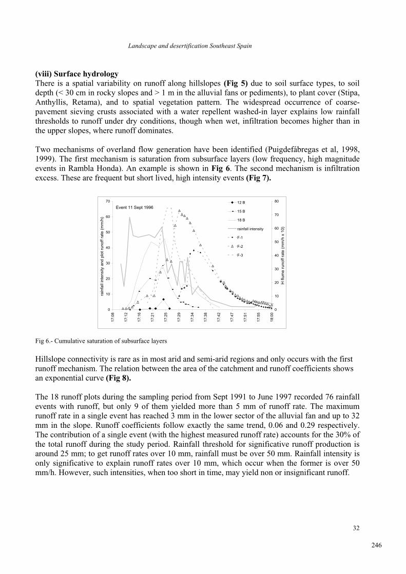
Landscape and desertification Southeast Spain
32
(viii) Surface hydrology There is a spatial variability on runoff along hillslopes (Fig 5) due to soil surface types, to soil
depth (< 30 cm in rocky slopes and > 1 m in the alluvial fans or pediments), to plant cover (Stipa,
Anthyllis, Retama), and to spatial vegetation pattern. The widespread occurrence of coarse-
pavement sieving crusts associated with a water repellent washed-in layer explains low rainfall
thresholds to runoff under dry conditions, though when wet, infiltration becomes higher than in
the upper slopes, where runoff dominates.
Two mechanisms of overland flow generation have been identified (Puigdefábregas et al, 1998,
1999). The first mechanism is saturation from subsurface layers (low frequency, high magnitude
events in Rambla Honda). An example is shown in Fig 6. The second mechanism is infiltration
excess. These are frequent but short lived, high intensity events (Fig 7).
Event 11 Sept 1996
0
10
20
30
40
50
60
70
17:0
8
17:1
2
17:1
6
17:2
1
17:2
5
17:2
9
17:3
4
17:3
8
17:4
2
17:4
7
17:5
1
17:5
5
18:0
0
rain
fall
inte
nsity
and
plo
t run
off r
ate
(mm
/h)
0
10
20
30
40
50
60
70
80
H fl
ume
runo
ff ra
te (
mm
/h x
10)
12 B
15 B
18 B
rainfall intensity
F-1
F-2
F-3
Fig 6.- Cumulative saturation of subsurface layers
Hillslope connectivity is rare as in most arid and semi-arid regions and only occurs with the first
runoff mechanism. The relation between the area of the catchment and runoff coefficients shows
an exponential curve (Fig 8).
The 18 runoff plots during the sampling period from Sept 1991 to June 1997 recorded 76 rainfall
events with runoff, but only 9 of them yielded more than 5 mm of runoff rate. The maximum
runoff rate in a single event has reached 3 mm in the lower sector of the alluvial fan and up to 32
mm in the slope. Runoff coefficients follow exactly the same trend, 0.06 and 0.29 respectively.
The contribution of a single event (with the highest measured runoff rate) accounts for the 30% of
the total runoff during the study period. Rainfall threshold for significative runoff production is
around 25 mm; to get runoff rates over 10 mm, rainfall must be over 50 mm. Rainfall intensity is
only significative to explain runoff rates over 10 mm, which occur when the former is over 50
mm/h. However, such intensities, when too short in time, may yield non or insignificant runoff.
246

F. López Bermúdez et al.
33
Event 28-02-1995
0
5
10
15
20
25
30
35
40
12:0
0
13:1
2
14:2
4
15:3
6
16:4
8
18:0
0
19:1
2
20:2
4
21:3
6
22:4
8
0:00
cum
ulat
ive
runo
ff (m
m),
vol
(
%)
0
5
10
15
20
25
30
35
40
cum
ulat
ive
rain
fall
(mm
)
soil moisture 5 cm
soil moisture 15 cm
cumulative runoff (plot)
cumulative rainfall
Fig 7.- Runoff by infiltration excess (Horton)
(ix) Sediment production Erosion rates have been very low during the study period, up to 9 g m
-1 year
-1 in erosion plots and
< 0.01 g m-2
year-1
in a 5 ha catchment, with averages ranging from 14 g m-2
in the slopes and 2 g
m-2
in the lower part of the alluvial fan. A maximum of 46 g m-2
in a single event (in a slope plot)
has been recorded, accounting for up to the 55% of the total sediment production during a 6 year
study period.
y = 69.199x-0.2832
R2 = 0.9821
0
20
40
60
80
100
0 10000 20000 30000 40000 50000area (m2)
max
runo
ff co
effic
ient
(%)
Rambla Honda A
Fig 8: Relationships between catchment size and runoff coefficients.
The explanation for these low rates is, apart from the low rainfall in the area, the armouring effect
of the coarse pavement sieving crust which covers most of the alluvial fans and also part of the
hillslopes.
The research on erosion at patch scale has particularly focused on the role of vegetation as a
source of spatial heterogeneity that affects short-range distribution of water and sediments.
Results from Rambla Honda, based on field observations, experiments and simulation models
(Sánchez & Puigdefábregas, 1994), show that a range of positive feedback mechanisms, like the
247

Landscape and desertification Southeast Spain
34
trapping of water and sediments by vegetated patches and the mutual facilitation between herbs
and bushes, leads to nucleation or to the increase of spatial heterogeneity, by concentrating
resources of the soil beneath plant clumps at the expense of neighbouring bare ground
(Puigdefábregas et al, 1999). Concerning sediments at the small catchment scale, channels are the
main redistribution structures, as well as the main sources when they cut into alluvial fans
(Puigdefábregas et al., 1999).
(x) Actual evapotranspiration A model was developed that predicted evaporation based on combined information on the
physiology of overstorey and substrate, micrometeorological conditions and spatial distribution of
plants (Domingo et al., 1999). Predicted evapotranspiration was verified at stand level for Retamasphaerocarpa shrubs, and model parameters were tested to determine their importance in
controlling evaporation. Model predictions were compared with evapotranspiration, measured by
a Bowen Ratio Energy Balance system (BREB), and transpiration, measured by sap flow of the
stems of the bushes. Modifications made to the original two source clumped model in the tested
model significantly improved agreement between predicted surface evapotranspiration rates and
rates measured by the Bowen Ratio method. The modifications made to the model were improved
parameterisation of soil surface conductance, a more detailed description of the radiation balance,
and improved parameterisation of the soil aerodynamic conductance terms. Improvements in the
soil surface conductance estimates made the most significant change to model predictions
A sensitivity analysis indicated that relatively large variations of leaf area index or albedo caused
little variation in evapotranspiration during the period measured, whereas variations in soil water
content caused large changes in predicted evapotranspiration. Transpiration rates of shrubs
(measured and modelled) indicated an independence from surface soil moisture (0±25 cm)
supporting the view that Retama sphaerocarpa had access to reserves of water deep in the soil
which enabled it to survive and grow vigorously in this type of semiarid environment. Thus, it
was concluded that land use changes which affect redistribution of water resources (overland and
subsurface flow) may threaten the stability survival of Retama sphaerocarpa stands.
This validated evapotranspiration model applied to an area of about 2 ha in the lower sector of the
catena in Rambla Honda showed that actual evapotranspiration (ETact) largely exceeds (about 100
mm per year) precipitation (P) at annual scales. The estimated deficit may be compensated by: a)
infiltration of local rainfall during extreme events, b) runoff from the surrounding hillslopes or c)
infiltration of channel flow during flash floods originating from the upper part of the catchment.
Data from long term monitoring show that possibilities a) and b) can not explain the water deficit
but do show that deep storage of water during floods in the main channel can be as much as 60
mm to 150 mm per event, and may have been 160 mm year-1
to 400 mm year-1
during a period of
four years (1994-1997) (Domingo et al, 2001).
(xi) Instrumentation layout The study site is located in a hillslope oriented to the East and grazing was excluded from the
whole study area from September 1st 1991 onwards through arrangements with the owners. The
main instrumentation of the site (Vidal et al., 1996) consists in the following:
- Nine measurement areas (MA), established in September 1991, 3 in each of the three
vegetation types, along the catena; each MA is provided with two (2 x 10 m) runoff plots (higher
and lower plant cover). Three MA, one per vegetation type, is provided with runoff, soil moisture,
soil temperature and soil electrical conductivity recording systems.
248

F. López Bermúdez et al.
35
- Ten 2 x 8 m runoff plots, established in 1990, on sedimentary formations with abandoned
fields.
- Three gauging stations (H type flumes) have been installed along a small catchment (5 ha) in
order to obtain information about the relative importance of the erosional and deposition slope
sectors as sources or sinks for runoff and sediments.
- A weather station at the base of the hillslope, with an additional rainfall recorder near the
divide, and pairs of raingauges in each MA.
- Specific micrometeorological settings are run in a Retama plot, in the valley bottom, where
most of ecophysiological measurements are concentrated.
(xii) Available dataMeteorological data
- rainfall and rainfall intensity (Sept. 1989- present)
- air temperature (Sept. 1989 - present)
- air humidity (Sept. 1989 - present)
- wind speed (Sept. 1989 - present)
- wind direction (Sept. 1989 - present)
- total solar radiation (Sept. 1989 - present)
- net solar radiation (Sept.- 1989 - present)
Topography and derived maps, and aerial photographies- B/W aerial photographies of the area at 1:3500 (1992), 1:12000 (1991),1:30000 (1956)
and color, 1:10000 and 1:6600 (NERC flight 1996)
- topographical map 1:500 (digitally supported) of the study area (from aerial photograph
1992)
- hillslope transect with teodolith.
- digital elevation model (DEM) built with ANUDEM 4.4, resolution 1 m;
- maps of terrain attributes (slope angle, slope aspect, plan curvature, profile curvature,
local drain direction, specific catchment size, wetness index and slope lenght factor)
derived from DEM.
- geodetic network of 70 point covering the whole site.
Geology - Geological map.
- Geomorphological map.
-Lithological characterization of selected samples: a) total and clay fraction
mineralogy of representative outcrops; b) particle size distribution.
- Hydrogeology: 4 bore holes along a transect from the edge to the axis of the
valley, with samples every 20 cm (water level monitoring from 1990 onwards).
- Geotechnical properties of selected samples: Atterberg limits.
- Geochronological data from both radiocarbon and palynological studies of Holocene
sediments.
Hydrology- runoff and sediment yield from 3 “flume H” gauging devices in nested catchments
(4.6ha, 4 ha, 0.09 ha) equipped with automatic samplers (Jan 1994 - present)
- rainfall chemistry (pH, EC and bulk deposition) (Sept 1991 - present)
- runoff and sediment yield from 18 rainfall simulations at 55 mm/h over 0.24 m² plots.
249

Landscape and desertification Southeast Spain
36
- soil moisture along the hillslope in the 9 measurement areas, under bare soil and under
perennial plants (1990-1994)
- continuous soil moisture and temperature at 5, 15 and 50 cm depth, under bare soil and
under perennial plants, both in the upper part of the hillslope and in the alluvial fan (14
probes in total). (Jun 1994 - present)
- rainfall partitioning by canopies of Retama, Anthyllis and Stipa- development of evapotranspiration models for some Rambla Honda plant communities
- below-ground water distribution and water use in relation to Retama roots.
- spatial redistribution pattern of water and nutrients.
Soils - morphological descriptions (over 20 soil profiles along the main hillslope).
- rock fragment cover from runoff plots.
- surface roughness of runoff plots.
- micromorphology of most profiles, with emphasis in surface and subsurface horizons in
bare patches and under perennial plants.
- physical properties (particle size distribution, bulk density, water retention curves,
infiltrability, hydraulic conductivity).
- chemical properties (organic matter content, pH, EC, total carbonates, exchange
capacity and exchangeable cations, total N).
- soil classification (Soil Taxonomy and FAO systems).
- soil surface behaviour and evolution since agricultural abandonment.
- surface roughness under different soil surface conditions.
Vegetation - fenology, by field observations (1992 - 1997).
- herbs biomass, by collection traps (1992 - 1997)
- perennial aerial biomass, by allometric estimates (1992 and 1997)
- coarse root biomass, by allometric estimates (1992)
- fine root biomass, by volumetric soil samples (Aug. 1991 & May 1992)
- net primary production and LAI from twigs sampling (1992 - 1997)
- litter, by collection traps (1991- 1997)
- herbs cover, by collection traps (1991 - 1993)
- perennial cover from aerial photos (1992 and 1997)
- cellulolytic activity, by cotton strip assay (1992 - 1994)
- individuals demography from marked individuals (1993 - 1996)
- branches demography from marked branches (1993 - 1996)
- twigs demography from marked twigs (1993 - 1997)
- fungus and Anthyllis roots symbiosis (1994 - 1998)
- grazing effects on winter annuals and Anthyllis shrubs.
- constraints to seedling establishment.
- annual-perennials interactions.
- patch dynamics.
- demography and survival rates of seedlings of Retama and Anthyllis.
- genetic variation in annual grasses.
250
F. López Bermúdez et al.
37
Plant ecophysiology - relative water content, from leaves/shoot bulked (1992)
- water potential, by pressure chamber (1992)
- stomatal conductance, by infra-red gas analyser (1992)
- net photosynthesis by infra-red gas analyser (1992)
- fluorescence, by fluorometer (1992)
- functional differences between lateral and deep roots of Retama
Invertebrate ecology - invertebrate abundance
- ant’s nest density
- effects of ants on plant communities
- effects of ants on soil properties
- earthworm abundance
- ant predation - water interaction on seed establishment
- and foraging ecology
(xiii) Data acquisition system It is a new low-speed digital radio network (LAN) field facility, consisting of several remote
microprocessor stations (based on Motorola MC68HC05/11 microcomputer families) and a
central unit connected to a PC , which allows real time, overall control, monitoring, maintenance,
calibration and logging functions.
With this system, all data generated by the meteorological station and the 4 flume-H gauging
stations are sent in real time to the EEZA headquaters in Almeria, where they are stored in the
hard disk of a PC.
(xiv)Drawbacks and sustainability of long term monitoring Several problems occurred during the experiments on the runoff plots: a) Bounded runoff plots
stop sediment fluxes from upslope and therefore might suffer from sediment exhaustion after
several years of no runoff. b) Soil moisture surplus near a collector troughs enhances the growth
of annual plants, thus triggering a feedback mechanism of progressive sediment trapping and
enhanced plant growth. c) An important part of runoff collected from runoff plots comes from a
few decimetres upslope of the collector trough. d) The changes in spatial structure of vegetation
within runoff plots during the monitoring period may influence the magnitude of the measured
variables. e) Several types of external changes (galleries and/or latrines of rabbits or other
vertebrates, feeding grounds or rooting areas of wild boars, and nests, etc.) may cause an
important non-homogeneity on numerical series of the monitored variables, fact especially acute
in bounded runoff plots. f) Periodical calibration of tipping buckets and levelling flow divisors are
highly recommended to avoid a progressive drift of the measured variables. All these problems,
because of the small scale of the experiments, make difficult the upscaling of results (Solé-Benet
et al., 2003).
Detected problems in small instrumented catchments: a) It is not easy to select the right gauging
device for ephemeral channels, nor its right dimension. A combination of large devices (large
range, reduced precision) with small ones (short range, higher precision) seems to be the most
adequate approach. b) In semi-arid areas, where runoff events normally occur with low frequency,
(1 year-1
) it may take a long time to collect a good series of data where to test homogeneity.
251

Landscape and desertification Southeast Spain
38
Data obtained in micro-catchments from arid and semi-arid regions should be used with caution
when trying to extrapolate data to either larger or different areas: because of the occurrence of
spatial heterogeneity (in soil depth, vegetation type and cover and rooting depth), in such areas
along the high temporal variability in rainfall and other meteorological data with very important
hydrological consequences, extrapolations might only apply on very similar environmental
conditions (Solé-Benet et al., 2003).
In dry environments, looking at fine time scales is essential to obtain information of processes,
especially those from extreme events, such as rainfall, which are the main drivers of landscape
change.
Moreover, as permanent research facilities, they afford the paradox that funding is mainly through
specific research projects, the time scale of which is usually not compatible with the longer term
evolution of the geomorphic processes. The approach is by developing and monitoring low cost
indicators, including remote sensing data.
252

F. López Bermúdex et al.
39
(xv) Scientific papers and reports about the area
Alcaraz, F., Sanchez-Gomez,F., de la Torre, A.
1991. Biogeografia de la provincial
Murciano-Almeriense hasta el nivel de
subsector. Rivasgodaya, 6: 77-100.
Capel Molina, J.J. (1986) El clima de la
provincia de Almería. 2ª Ed. Publicaciones
Caja Ahorros Almería. Almería. Spain.
Casenave A, Valentin C. Les états de surface de
la zone sahelienne. Influence sur l'infiltration.
ORSTOM, editor. 1-230. 1989. Paris,
ORSTOM. Collection Didactiques.
Geiger, F. (1973) El SE español y los problemas
de la aridez. Rev. Geogr., 7 (1-2): 166-209.
Barcelona.
Contreras,S., Solé-Benet,A. 2003.
Hidrofobicidad en suelos mediterráneos
semiáridos: implicaciones hidrológicas para
una pequeña cuenca experimental en el SE
ibérico. Cuaternario y Geomorfología, 17:
29-45.
Domingo, F., L. Villagarcía, A. J. Brenner & J.
Puigdefábregas. 1999. Evapotranspiration
model for semi-arid shrub-lands tested
against data from SE Spain. Agriculturaland Forest Meteorology, 95: 67–84.
Domingo, F., L. Villagarcía, M. M. Boer, L.
Alados-Arboledas & J. Puigdefábregas.
2001. Evaluating the long-term water
balance of arid zone stream bed vegetation
using evapotranspiration modelling and
hillslope runoff measurements. Journal of Hydrology, 243: 17–30.
Harvey, A.M.- 1987- Patterns of Quaternary
aggradational and dissectional landform in
the Almeria region, southeast Spain: a dry-
region, tectonically active landscape. Dieerde 118: 193 - 215.
Kosmas, C., N. Danalatos, L. H. Cammeraat, M.
Chabart, J. Diamantopoulos, R. Farand, L.
Gutiérrez, A. Jacob, H. Marqués, J. Martínez-
Fernández, A. Mizara, N. Moustakas, J. M.
Nicolau, C. Oliveros, G. Pinna, R. Puddu, J.
Puigdefábregas, M. Roxo, A. Simao, G.
Stamou, N. Tomasi, D. Usai & A. Vacca.
1997. The effect of land use on runoff and
soil erosion rates under Mediterranean
conditions. Catena, 29: 45–59.
Lázaro, R. & J. M. Rey. 1991. Sobre el clima de
la provincia de Almería (SE ibérico): primer
ensayo de cartografía automática de medias
anuales de temperatura y precipitación. Suelo y Planta 1: 61–68.
Lázaro, R., F.S. Rodrigo, L. Gutiérrez, F.
Domingo y J. Puigdefábregas. 2001. Analysis
of a Thirty Year Rainfall Record (1967-1997)
from Semi-Arid SE Spain for implications on
vegetation. Journal of Arid Environments,
48: 373 - 395
Neumann, H. (1961) El clima des sudeste de
España. Estudios Geográficos, 21: 171-209.
Nicolau, J. M., A. Solé-Benet, J. Puigdefábregas
& L. Gutiérrez. 1996. Effects of soil and
vegetation on runoff along a catena in semi-
arid Spain. Geomorphology, 14: 297–309.
Poesen J, Torri D, Bunte K. 1994. Effects of rock
fragments on soil erosion by water at
different spatial scales: a review. Catena,23:141-166.
Poesen J, Van Wesemael B. 1995. Effects of rock
fragments on the structural collapse of tilled
topsoils during rain. In: Derbyshire E,
Dijkstra T, Smalley IJ, editors. Genesis and properties of collapsible soils. Dordrecht:
Kluwer Academic Publisher, pp 333-343.
253
Landscape and desertification Southeast Spain
40
Puigdefábregas J., J. M. Alonso, L. Delgado, F.
Domingo, M. Cueto, L. Gutiérrez, R. Lázaro,
J. M. Nicolau, G. Sánchez, A. Solé, S. Vidal,
C. Aguilera, A. Brenner, S. Clark & L. Incoll.
1996. The Rambla Honda field site:
interactions of soil and vegetation along a
catena in semi-arid southeast Spain. En J.
Brandt yJ. B. Thornes (eds) Mediterranean Desertification and Land Use, pp 137–168.
John Wiley & Sons, Ltd.
Puigdefábregas, J., G. del Barrio, M. Boer, L.
Gutierrez & A. Solé. 1998. Differential
responses of hillslope elements to rainfall
events in a semi-arid area. Geomorphology,
14: 297-309.
Puigdefábregas,J., Solé,A., Gutiérrez,L.,
DelBarrio,G., Boer,M. 1999. Scales and
processes of water and sediment
redistribution in drylands: results from the
Rambla Honda field site in SE Spain. Earth Science Reviews, 48:39-70.
Rodriguez-Puebla, C., Encinas, A.H., Nieto, S.,
Garmendia, J. 1998. Spatial and temporal
patterns of annual precipitation variability
over the Iberian peninsula. Int. J. Climatol., 18: 299-316.
Sánchez, G. & J. Puigdefábregas. 1994.
Interactions of plant growth and sediment
movement on slopes in a semi-arid
environment. Geomorphology, 9: 243–260
Sole-Benet,A., Pini,R., Raffaelli,M. 2002.
Hydrological consequences of soil surface
type and condition in colluvial mica-schist
soils after agricultural abandonment. In
J.L.Rubio, R.P.C.Morgan, S.Asins, V.Andreu
(eds.) Man and soil at the third millenium (3rd Int. Congress of the European Society for Soil Conservation), vol I, pp. 523-533,
Geoforma Ediciones, Logroño, Spain.
Solé-Benet,A., Cantón,Y., Domingo,F.,
DelBarrio,G., Lázaro,R., Domene,M.A.,
Vidal,S., Puigdefábregas,J. 2003. Long term
hydrological monitoring of two micro-
catchments in semi-arid SE Spain. In Holko, L.
& Miklanek, P. (Eds.) Interdisciplinary approaches in small catchment hydrology: Monitoring and research. IHP-VI Technical
Documents in Hydrology No. 67, UNESCO,
Paris, pp 183-188.
Springer,M.E. 1958. Desert pavement and
vesicular layer of some soils of the desert of
the Lahontan Basin, Nevada. S.S.S.A.Proc.,22:63-66.
Valentin, C., Bresson, L.M. 1992. Morphology,
genesis and classification of surface crusts in
loamy and sandy soils. Geoderma, 55:225-
245.
Valentin, C. 1991. Surface crusting in two
alluvial soils of northen Niger. Geoderma1991; 48:201-222.
Vidal, S., M. A. Domené, F. Domingo, A. Solé
& J. Puigdefábregas. 1996. Desarrollo y
calibración de un nuevo sensor de humedad
del suelo. Instituto Tecnológico Geominero
de España Eds. En IV Simposio sobre el Agua en Andalucía. Vol. 1: 101–109.
Vidal, S., A. Solé-Benet, R. Lázaro, A. Durán &
J. Puigdefábregas. 1996. Estaciones
Automáticas de aforo y muestreo de caudales,
de bajo costo y mantenimiento, para zonas
remotas. Instituto Tecnológico Geominero de
España Eds. IV Simposio sobre el Agua en Andalucía. Vol. 1: 193–203.
254