ecological studies, vol. 160 - safety messagesafetymessage.com/images/books/enpdf/fire/fire and...
TRANSCRIPT


Ecological Studies, Vol. 160Analysis and Synthesis
Edited by
I.T. Baldwin, Jena, GermanyM.M. Caldwell, Logan, USAG. Heldmaier, Marburg, GermanyO.L. Lange, Würzburg, GermanyH.A. Mooney, Stanford, USAE.-D. Schulze, Jena, GermanyU. Sommer, Kiel, Germany

Ecological Studies
Volumes published since 1992 are listed at the end of this book.
SpringerNew YorkBerlinHeidelbergHong KongLondonMilanParisTokyo

Thomas T. Veblen William L. BakerGloria Montenegro Thomas W. SwetnamEditors
Fire and Climatic Change in TemperateEcosystems of theWestern Americas
With 122 Illustrations
1 3
Thomas T. Veblen William L. BakerDepartment of Geography Department of Geography and RecreationUniversity of Colorado University of WyomingBoulder, CO 80309-0260 Laramie, WY 82071USA [email protected] [email protected]
Gloria Montenegro Thomas W. SwetnamDepartamento de Ciencias Vegetales Laboratory of Tree-Ring ResearchFacultad de Agronomía e University of Arizona
Ingeniería Forestal Tucson, AZ 85721Pontificia Universidad Católica de Chile USACasilla 306 [email protected], [email protected]
Cover illustration: Photographs courtesy of Laboratory of Tree-Ring Research, University ofArizona, and Thomas T. Veblen.
Library of Congress Cataloging-in-Publication DataFire and climatic change in temperate ecosystems of the western Americas
p. cm.—(Ecological studies; v. 160)Includes bibliographical references (p.).ISBN 0-387-95455-4 (alk. paper)
1. Fire ecology—West (U.S.) 2. Climatic changes—West (U.S.) 3. Fire ecology—South America. 4. Climatic changes—South America. I. Veblen, Thomas T., 1947–II. Series. QH104.5.W4 F57 2002577.2—dc21 2002017655
ISSN 0070-8356ISBN 0-387-95455-4 Printed on acid-free paper.
© 2003 Springer-Verlag New York, Inc.All rights reserved. This work may not be translated or copied in whole or in part without the writtenpermission of the publisher (Springer-Verlag New York, Inc., 175 Fifth Avenue, New York, NY 10010,USA), except for brief excerpts in connection with reviews or scholarly analysis. Use in connectionwith any form of information storage and retrieval, electronic adaptation, computer software, or bysimilar or dissimilar methodology now known or hereafter developed is forbidden.The use in this publication of trade names, trademarks, service marks, and similar terms, even if theyare not identified as such, is not to be taken as an expression of opinion as to whether or not they aresubject to proprietary rights.
Printed in the United States of America.
9 8 7 6 5 4 3 2 1 SPIN 10868329
www.springer-ny.com
Springer-Verlag New York Berlin HeidelbergA member of BertelsmannSpringer Science+Business Media GmbH

Preface
In the context of global change, there is an increasing urgency for a comprehen-sive understanding of how climatic variation influences fire regimes across abroad range of spatial and temporal scales. The chapters in this book examinehow the spatial and temporal variation of fire occurrence varies in particularecosystems and broad regions, particularly in relation to climate but also whereappropriate in relation to land use. The book also considers the ecological con-sequences of these variations in fire regimes.
Geographically, we focus on the temperate ecosystems of western North andSouth America. These regions are broadly similar in climate and vegetation physi-ognomy but differ in the timing and intensity of human land use. They alsostrongly contrast in the phylogenetic origins of the biota, which creates the oppor-tunity to test the generality of some climate and fire hypotheses for floras withquite distinct evolutionary histories. Broad similarities in present-day climate andvegetation of these two regions provide the potential for comparative studies ofthe effects of climate variation and human activities on fire regimes and of theresponses of these ecosystems to altered fire regimes.
This volume had its beginnings at two workshops held in Silver Falls, Oregon,in 1996 and in Bariloche, Argentina, in 1997 that were sponsored by the Inter-American Institute and the National Science Foundation. Within the context offire and global change research, the goals of these workshops were to (1) assesscurrent knowledge of potential influences of global change on fire regimes, (2) define a research agenda on the potential effects of global change on fire
v
regimes, (3) evaluate methodologies for analyzing the influences of climate andland-use changes on fire regimes, and (4) form a network of researchers andresearch institutions interested in developing an interdisciplinary research agendathat focuses on interhemispheric comparisons of fire regime and global change.The current volume summarizes much of the work achieved at those workshopsas well as much research that was conducted subsequently.
Much of the discussion at the 1996 and 1997 workshops was centered on fourbroad questions: (1) What is the relationship of fire to climate variation across arange of biomes and at a range of temporal scales from seasonal to centennial?(2) How are climate-induced changes in fire regimes linked to broad-scale atmos-pheric circulation patterns and mechanisms? (3) How have fire regimes beenaltered by land-use practices by humans including both Native Americans andEuro-American practices? (4) What is the role of landscape heterogeneity in influ-encing how fire regimes respond to climate variation and human impacts? Thesefour broad questions are strongly reflected in the different chapters of this book.
The book is divided into four sections: (1) methods and models, (2) NorthAmerican case studies, (3) South American case studies, and (4) practical impli-cations. The initial chapter by Whitlock and Anderson critically evaluates the theoretical and empirical basis for charcoal analysis as a methodology for reconstructing fire history from sedimentary records from lakes and wetlands.This first chapter also presents detailed Holocene fire histories for several studyareas in Oregon and in the Sierra Nevada of California. This focus on sedimen-tary methods is complemented by the discussion of methods of extracting cli-matic signals from tree-ring-based fire histories in the chapter by Swetnam andBaisan. Several other chapters also apply tree-ring methods to reconstruct firehistory.
Modeling perspectives on fire and climate are also considered in Section 1.Simulation approaches are often the only means available to study the interac-tion of wildland fire, vegetation, fuels, and climate in a spatial domain over longtime periods. Keane and Finney use a conceptual simulation model called FESM(fire effects simulation model) as the context for a summary of the importantecosystem processes that need be explicitly simulated to adequately model fireinteractions with ecosystems at a landscape scale. Miller uses the simulationmodel FACET (or FM), developed in the Sierra Nevada of California, to modelcomplex influences of climate on fire and forest dynamics. Simulation resultssuggest that indirect effects of climatic change on the fire regime can be as significant as the direct effects of climatic change.
The chapters in Section 2 illustrate the richness of the literature and knowl-edge of fire regimes in western North America. The chapter by Flannigan, Stocks,and Weber on Canadian forests, in particular, western boreal forests, examinescurrent knowledge of fire–climate interactions derived from existing fire–weather/climate analyses, fire history reconstructions, and paleo studies. It appliessuch knowledge with general circulation models to present possible scenarios ofthe impact of anticipated climate change on the fire regime and Canadian forests.Growing evidence supports a rapid increase in temperature and increased rates
vi Preface

of burning, particularly at higher latitudes. In reviewing fire and climate in theforests of the U.S. Rocky Mountains, Baker stresses the need for greater under-standing of how climate, fuels, the landscape, and land-use practices separatelyand jointly shape fire regimes, thus substantially complicating the task of identi-fying a climatic signal in historical fire data. For the Rocky Mountains, he con-trasts a view that emphasizes how broad-scale patterns of climate and fuelscontrol fire regimes, with a contingent view in which local spatial constraints and historical legacies may limit general trends. Models that represent the broad-scale view tend to stress a rapidly responding, climatically controlled fire regimeaffecting a passive and independent vegetation in a featureless landscape. In contrast, the contingent view suggests that fire regimes are inherently spatial, areconstrained by the physical landscape, and are shaped by climate and vegetationas well as by historical legacies.
In their chapter on the Southwest and the Sierra Nevada, Swetnam and Baisanreview time series of fire occurrence derived from extensive networks of tree-ring records. The synchrony of fire across large regions is an effective strategyof separating broad-scale climatic influences from local nonclimatic influencesand contingencies of individual sites. An important finding is that annual resolution fire-scar networks can provide an independent indicator of chang-ing temporal patterns of globally important climatic processes, such as the El Niño–Southern Oscillation. ENSO is also shown to be a major driver of fireby Heyerdahl and Alvarado in their tree-ring-based fire history in the pine-oakforests of the Sierra Madre Occidental in north-central Mexico. Changes in landuse, rather than climate, however, probably caused the near cessation of firerecorded asynchronously at sites after 1900 to 1950. In their review of past,current, and future fires in California shrublands, Keeley and Fotheringham focuson the issue of human impacts on fire regimes and on vegetation patterns. Theycritically examine competing models of how fuel cycles and humans constrainfire occurrence in chaparral vegetation.
The chapters in Section 3 on South America illustrate the rapid increase inresearch on fire regimes in Chile and Argentina since about 1990. For northernPatagonia, Veblen et al. examine the roles of humans in altering fire regimes, andthe interaction between landscape patterns and fire behavior. They stress the profound and long-lasting impacts on the landscape of short periods of excep-tionally high rates of forest and shrubland burning associated with human activ-ities and severe droughts. Land-use changes, such as grazing by livestock andtwentieth-century fire exclusion, have had many of the same ecological effectsas in xeric conifer woodlands of western North America. Also for northern Pata-gonia, Kitzberger and Veblen analyze changes in fire occurrence derived fromboth tree-ring and documentary records in relation to climatic variation. ENSOis a major driver of the year-to-year variation in fire regimes and also has adetectable influence at longer time scales. They stress the differential responsesof fire regimes to interannual climatic variability along the steep vegetation gradient from Andean rain forests to the Patagonian steppe. For the rain forests of southern Chile, Lara et al. document the importance of past fires to the
Preface vii

dynamics of these wet forests over periods of many centuries. In this region ofintensive deforestation, intentionally set fires during the twentieth century haveplayed a major role in shaping the landscape. Similarly, for relatively xeric forestsof Austrocedrus in central Chile, Aravena et al. use tree-ring evidence to docu-ment the importance of fire, mainly of anthropogenic origin, in stand dynamics.Also for central Chile but at lower elevations, Montenegro et al. review the effectsof humans on fire in the region of Mediterranean-type shrublands. They stressthe effects of fire on community dynamics, taking into account the relative unim-portance of natural fires in the history of this vegetation. For southern Patagonia,Huber and Markgraf use sedimentary records to reconstruct Holocene fire historyin the ecotone between Patagonian steppe and Nothofagus forests. Peat macro-fossil and macroscopic charcoal data suggest that on multimillennial time scales,increased aridity has favored fire occurrence in this region.
In the final chapter, Morgan, Defossé, and Rodríguez focus on the practical,management implications of the fire and climate change research that is reportedin the preceding chapters. They describe the strong parallels, as well as impor-tant differences, in the vegetation, climate, and history of land use between thetemperate zones of North and South America. They consider the varied goals,strategies, and contexts of fire management, and stress the complexity of inter-actions among fire, climate, and land use.
Thomas T. VeblenWilliam L. Baker
Gloria MontenegroThomas W. Swetnam
viii Preface

Acknowledgments
ix
The editors are grateful to all the contributing authors for their sustained effortin assembling this book and for their patience in seeing to completion this lengthyproject.
We wish to thank the many anonymous reviewers who generously helpedassure the rigor and accuracy of the individual chapters. In general, each chapterwas reviewed by at least two experts in the subject matter of the chapter. We areparticularly appreciative of the dedicated editorial assistance provided byRosanna Ginocchio of the Pontificia Universidad Católica de Chile.
We gratefully acknowledge funding from the Inter-American Institute and theNational Science Foundation, which supported the initial workshops from whichthis volume originated.
Thomas T. VeblenWilliam L. Baker
Gloria MontenegroThomas W. Swetnam

This page intentionally left blank

Contents
Preface vAcknowledgments ixContributors xv
Section 1. Methods and Models
1. Fire History Reconstructions Based on Sediment Records from Lakes and Wetlands 3Cathy Whitlock and R. Scott Anderson
2. The Simulation of Landscape Fire, Climate, and Ecosystem Dynamics 32Robert E. Keane and Mark A. Finney
3. Simulation of Effects of Climatic Change on Fire Regimes 69Carol Miller
Section 2. North America
4. Fire Regimes and Climatic Change in Canadian Forests 97Mike Flannigan, Brian Stocks, and Mike Weber
xi

5. Fires and Climate in Forested Landscapes of the U.S. Rocky Mountains 120William L. Baker
6. Tree-Ring Reconstructions of Fire and Climate History in the Sierra Nevada and Southwestern United States 158Thomas W. Swetnam and Christopher H. Baisan
7. Influence of Climate and Land Use on Historical Surface Fires in Pine-Oak Forests, Sierra Madre Occidental, Mexico 196Emily K. Heyerdahl and Ernesto Alvarado
8. Impact of Past, Present, and Future Fire Regimes on North American Mediterranean Shrublands 218Jon E. Keeley and C.J. Fotheringham
Section 3. South America
9. Fire History and Vegetation Changes in Northern Patagonia, Argentina 265Thomas T. Veblen, Thomas Kitzberger, Estela Raffaele, and Diane C. Lorenz
10. Influences of Climate on Fire in Northern Patagonia, Argentina 296Thomas Kitzberger and Thomas T. Veblen
11. Fire Regimes and Forest Dynamics in the Lake Region of South-Central Chile 322Antonio Lara, Alexia Wolodarsky-Franke, Juan Carlos Aravena, Marco Cortés, Shawn Fraver, and Fernando Silla
12. Fire History in Central Chile: Tree-Ring Evidence and Modern Records 343Juan Carlos Aravena, Carlos LeQuesne, Héctor Jiménez, Antonio Lara, and Juan J. Armesto
13. Holocene Fire Frequency and Climate Change at Rio Rubens Bog, Southern Patagonia 357Ulli M. Huber and Vera Markgraf
xii Contents

14. Regeneration Potential of Chilean Matorral After Fire: An Updated View 381Gloria Montenegro, Miguel Gómez, Francisca Díaz, and Rosanna Ginocchio
Section 4. Practical Implications
15. Management Implications of Fire and Climate Changes in the Western Americas 413Penelope Morgan, Guillermo E. Defossé, and Norberto F. Rodríguez
Index 441
Contents xiii

This page intentionally left blank

Contributors
Ernesto Alvarado Forestry Sciences Laboratory, Universityof Washington, Seattle, WA 98105, USA
R. Scott Anderson Center for Environmental Sciences andEducation, Northern Arizona University,Flagstaff, AZ 86011, USA
Juan Carlos Aravena Departamento de Biología, Facultad de Ciencias, Universidad de Chile,Correo 653, Santiago, [email protected]
Juan J. Armesto Departamento de Biología, Facultad deCiencias, Universidad de Chile, Correo653, Santiago, Chile
Christopher H. Baisan Laboratory of Tree-Ring Research,University of Arizona, Tucson, AZ85721, USA
William L. Baker Department of Geography andRecreation, University of Wyoming,Laramie, WY 82071, [email protected]
xv

xvi Contributors
Marco Cortés Departamento de Ciencias Forestales,Universidad Catolica de Temuco, Casilla151, Temuco, Chile
Guillermo E. Defossé Consejo Nacional de InvestigacionesCientificas y Tecnicas, 9200 Esquel,Chubut, Argentina
Francisca Díaz Departamento de Ciencias Vegetales,Facultad de Agronomía e IngenieríaForestal, Pontificia Universidad Católicade Chile, Casilla 306, Campus SanJoaquin, Santiago, Chile
Mark A. Finney USDA Forest Service, Rocky MountainResearch Station, Fire SciencesLaboratory, Missoula, MT 59807, USA
Mike Flannigan Canadian Forest Service, Edmonton T6H 3S5, [email protected]
C.J. Fotheringham Department of Organismic Biology,Ecology and Evolution, University ofCalifornia, Los Angeles, CA 09995,USA
Shawn Fraver Department of Forest EcosystemScience, University of Maine, Orono,ME 04469-5755, USA
Rosanna Ginocchio Departamento de Ecología, Facultad deCiencias Biologicas, PontificiaUniversidad Católica de Chile, Alameda 340, Santiago, Chile
Miguel Gómez Departamento de Ciencias Vegetales,Facultad de Agronomía e IngenieríaForestal, Pontificia Universidad Católicade Chile, Campus San Joaquin, Casilla306, Santiago, Chile
Emily K. Heyerdahl USDA Forest Service, Rocky MountainResearch Station, Fire SciencesLaboratory, Missoula, MT 59807, [email protected]

Contributors xvii
Ulli M. Huber Geobotanical Institute, Unversity ofBern, CH-3013 Bern, [email protected]
Héctor Jiménez Departamento de Biología, Facultad deCiencias, Universidad de Chile, Correo653, Santiago, Chile
Robert E. Keane USDA Forest Service, Rocky MountainResearch Station, Fire SciencesLaboratory, Missoula, MT 59807, [email protected]
Jon E. Keeley Western Ecological Research Center,Sequoia National Parks, Three Rivers,CA 93271-9651, [email protected]
Thomas Kitzberger Laboratorio El Ecotono, UniversidadNacional del Comahue, E.P.Universidad, 8400 Bariloche, [email protected]
Antonio Lara Instituto de Silvicultura, Universidad deAustral, Casilla 567, Valdivia, [email protected]
Carlos LeQuesne Instituto de Silvicultura, Universidad deAustral, Casilla 567, Valdivia, Chile
Diane C. Lorenz Geological Society of America, Boulder,CO 80301-9140, USA
Vera Markgraf Institute of Arctic and Alpine Research,University of Colorado, Boulder, CO80309-0450, USA
Carol Miller USDA Forest Service, Rocky MountainResearch Station, Aldo LeopoldWilderness Research Institute, Missoula,MT 59807, USA. [email protected]
Gloria Montenegro Departamento de Ciencias Vegetales,Facultad de Agronomía e IngenieríaForestal, Pontificia Universidad Católicade Chile, Campus San Joaquin, Casilla306, Santiago, Chile. [email protected]

Penelope Morgan College of Natural Resources, Universityof Idaho, Moscow, ID 83844-1133,USA. [email protected]
Estela Raffaele Laboratorio El Ecotono, UniversidadNacional del Comahue, E.P.Universidad, 8400 Bariloche, Argentina
Norberto F. Rodríguez Consejo Nacional de InvestigacionesCientificas y Tecnicas, 9200 Esquel,Chubut, Argentina
Fernando Silla Departamento de Ecología, Universidadde Salamanca, Salamanca, Spain
Brian Stocks Canadian Forest Service, Sault Ste.Marie, Ontario P6A 2E5, Canada
Thomas W. Swetnam Laboratory of Tree-Ring Research,University of Arizona, Tucson, AZ85721, USA. [email protected]
Thomas T. Veblen Department of Geography, University ofColorado, Boulder, CO 80309-0260,USA. [email protected]
Mike Weber Canadian Forest Service, Edmonton T6H 3S5, Canada
Cathy Whitlock Department of Geography, University ofOregon, Eugene, OR 97403, [email protected]
Alexia Wolodarsky-Franke Instituto de Silvicultura, Universidad deAustral, Casilla 567, Valdivia, Chile
xviii Contributors

1. Methods and Models

This page intentionally left blank

1. Fire History Reconstructions Based on Sediment Records from Lakes and Wetlands
Cathy Whitlock and R. Scott Anderson
Fire-history reconstructions that extend beyond the age of living trees and sub-fossil wood are based on an analysis of particulate charcoal and other fire proxiespreserved in the sediments of lakes and wetlands. The goal of such research is todocument the long-term fire history with enough temporal and spatial resolutionto complement and extend reconstructions provided by dendrochronological andhistorical records. Long-term records also provide an opportunity to examine howfire regimes were affected by periods of major climate change and vegetationreorganization in the past. Such insights are critical for understanding the legacyof past fires in present ecosystems, as well as the role of fire with projectedclimate changes as a result of increased greenhouse gases in the future (e.g., Overpeck, Rind, and Jones 1990; Price and Rind 1994; Bartlein, Whitlock, andShafer 1997). In the last decade several advances have been made in the analy-sis of lake and wetland sediment records for fire history reconstructions. Theseadvances reflect a growing interest within the paleoecological community to con-sider fire as an ecosystem process operating on long and short time scales, as wellas an increasing need on the part of resource managers to understand prehistoricfire regimes. In this chapter we review the theoretical and empirical basis forcharcoal analysis, including assumptions about the charcoal source area and theprocesses that transport and deposit charcoal into lakes and wetlands. We discussissues of site selection, chronology, and data analysis. In an effort to standardizeprocedures and establish greater confidence in inter-site comparisons, we suggesta research protocol for long-term fire history studies in the western Americas
3

based on our own work and the recommendations of a charcoal workshop heldin Eugene, Oregon, in June 1996 that was sponsored by the Inter-American Insti-tute and National Science Foundation. Finally, we present examples of three firehistory reconstructions in the western United States using this protocol.
Fire reconstructions based on lake and wetland records are derived from (1) the analysis of particulate charcoal (both macroscopic and microscopic in size),which provides direct evidence of burning, (2) pollen evidence of fluctuations invegetation that can be tied to disturbance, and (3) lithologic evidence of water-shed adjustments caused by fire, such as erosion or the formation of fire-alteredminerals. The first of these, charcoal analysis, is based on the accumulation ofcharcoal particles in sediments during and following a fire event. Stratigraphiclevels with abundant charcoal (so-called charcoal peaks in the core) are inferredto result from past fire activity. The use of pollen analysis to detect periods ofburning is based on the assumption that the pollen of disturbance-adapted speciesincreases immediately following a fire, while that of fire-sensitive speciesdecreases. For example, a grass-dominated assemblage in a period otherwisecharacterized by forest taxa might indicate a fire event. Lithologic analyses sup-plement charcoal data by detecting changes in the input of allochthonous sedi-ment and alteration of soil minerals due to heating. The registration of fire-relatedlithologic changes varies among sites, but where present, the information helpsconstrain the fire location.
Our experience in conducting fire history studies comes from regions withnatural lakes and wetlands. Lake sites are used for most stratigraphic fire historystudies, and our understanding of charcoal deposition and burial (i.e., charcoaltaphonomy) comes from such sites. Fire history studies from wetlands avoid someof the problems of sediment reworking found in lakes and offer a more local firesignal. Thus wetlands provide complementary information and an important alter-native in regions where lakes are absent.
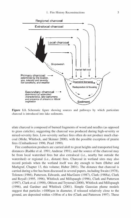
Charcoal Taphonomy
The rate at which charcoal accumulates in a lake or wetland depends on the char-acteristics of the fire (e.g., how much charcoal is produced) and the processesthat transport and deliver charcoal to the lake (e.g., how far the charcoal is carriedaloft; how much charcoal is introduced by streams and surface runoff in the yearsfollowing a fire) (Fig. 1.1). Primary charcoal refers to the material introducedduring or shortly after a fire event. Secondary charcoal is introduced to the sed-imentary record during non-fire years, as a result of surface runoff and redeposi-tion. Fire size, intensity, and severity all affect charcoal production and transport,and if these were the only processes at work, all sedimentary charcoal would beprimary and thus a direct measure of biomass burning. However, studies haveshown that the record reflects both primary and secondary sources, and estimat-ing fire size, severity, or intensity has been possible only in the most generalterms. In the forested regions of the western United States, for example, partic-
4 C. Whitlock and R.S. Anderson
ulate charcoal is composed of burned fragments of wood and needles (as opposedto grass cuticles), suggesting the charcoal was produced during high-severity ormixed-severity fires. Low-severity surface fires often do not produce much char-coal (Mohr, Whitlock, and Skinner 2000), with the possible exception of prairiefires (Umbanhower 1996; Pearl 1999).
Fire combustion products are carried aloft to great heights and transported longdistances (Radtke et al. 1991; Andreae 1991), and the source of the charcoal maybe from local watershed fires but also extralocal (i.e., nearby but outside thewatershed) or regional (i.e., distant) fires. Charcoal in wetland sites may alsorecord periods when the wetland itself was dry enough to burn (Huber and Markgraf, Chapter 13, this volume; Huber 2001). The distance that charcoal iscarried during a fire has been discussed in several papers, including Swain (1978),Tolonen (1986), Patterson, Edwards, and MacGuire (1987), Clark (1988a), Clarkand Royall (1995, 1996), Whitlock and Millspaugh (1996), Clark and Patterson(1997), Clark et al. (1998), Ohlson and Tryterud (2000), Whitlock and Millspaugh(1996), and Gardner and Whitlock (2001). Simple Gaussian plume modelssuggest that particles >1000mm in diameter, if released relatively close to theground, are deposited within <100m of a fire (Clark and Patterson 1997). These
1. Fire History Reconstructions 5
Figure 1.1. Schematic figure showing sources and pathways by which particulate charcoal is introduced into lake sediments.

models predict that particles <10mm in size travel well beyond 100m, and verysmall particles can be transported long distances.
Empirical studies are consistent with model projections by showing a decreasein charcoal particle size and abundance away from the source. A study of char-coal accumulation following the 1988 fires in Yellowstone National Park indi-cates that charcoal particles >125mm diameter were abundant in sites <7km fromthe fire (Whitlock and Millspaugh 1996); beyond that distance the accumulationof such particles declined sharply. In a study of 35 lakes following a 1996 fire inthe Cascade Range, levels of >125mm size charcoal were also highest in siteswithin the burned perimeter (Gardner and Whitlock 2001). Unburned sites located100ms beyond the burned area had significantly less charcoal, and nearby sitesupwind of the fire had the lowest charcoal amounts of all. Clark et al. (1998) col-lected charcoal in a series of traps during a prescribed fire in Siberia in 1993. Thedistribution of particle sizes was the same for traps in the burned area as it wasfor those located 80m beyond the burn. Again, charcoal abundance dropped offsharply at the edge of the fire. All of these results, as well as those of Clark andHussey (1996) and Ohlson and Tryterud (2000), suggest that large charcoal par-ticles provide a record of local fire activity. To reconstruct fire history at multi-ple spatial scales would require an analysis of several particle size ranges.
Studies of charcoal accumulation following modern fires also indicate that thedeposition of charcoal in lakes can take place several years after the actual event.Whitlock and Millspaugh (1996) observed that lakes in both burned and unburnedwatersheds in Yellowstone received charcoal during the 1988 fires, but theamounts continued to increase significantly for five years in burned watersheds.Anderson et al. (1986) described accrual of charcoal into a lake in Maine forseveral decades following a 1910 fire. The secondary charcoal, in both cases,could have been introduced from wind erosion of standing burned snags, espe-cially in winter, as well as from dead trees that eventually fell into the lake.Surface runoff may also have deposited charcoal in the lake during the first fewyears following a fire, but after that slopes become stabilized by vegetation.Another source, noted in the Yellowstone study, was the accumulation of parti-cles that landed on the lake during the fire and were blown to the shore anddeposited in the littoral zone. In the years after the fire, this material was refo-cused to deep water.
Bradbury (1996) documented the movement of the littoral charcoal in ElkLake, a large lake in north-central Minnesota. By associating the charcoal peaksin the deep-water core with the seasonal flux of diatoms, he showed that shallow-water charcoal was mobilized in the lake during spring circulation. In both theYellowstone and Elk Lake studies, the focusing of charcoal to deep wateroccurred within a few years of the fire event. Focusing of littoral charcoal is alsoblamed for variation in charcoal accumulation rates in sediment cores in differ-ent parts of a lake (Edwards and Whittington 2000). The cautionary note is thatcharcoal peaks are composed of particles deposited during and after the fire. Forthis reason it would be difficult to infer levels of charcoal production or biomassburning in the past based on charcoal abundance in lakes.
6 C. Whitlock and R.S. Anderson

Larsen and MacDonald (1993) and Larsen et al. (1998) considered the char-acteristics of lakes best suited for paleoecological studies. Deep lakes were prefer-able because the sediments are less mixed by biological activity and less impactedby wind-driven currents. Lakes with steep-sided basins are less suitable becauseof the likelihood of subaqueous slumping. Studies in Yellowstone offer somesupport for these recommendations. Charcoal abundance in surface sedimentswas compared along a transect from shallow to deep water in eight lakes forseveral years after the 1988 Yellowstone fires (Whitlock and Millspaugh 1996).Charcoal accumulation was slowest and the year-to-year variation was less in thedeep-water sediments of lakes with >10m water depth. In contrast, shallow-watersites showed significant interannual variation in charcoal abundance.
To examine the patterns of charcoal accumulation in lakes in more detail, atransect of 42 short cores from shallow to deep water was collected from DuckLake, Yellowstone National Park, in 1993 (Fig. 1.2). The small watershed was
1. Fire History Reconstructions 7
Figure 1.2. Charcoal abundance profile in a series of short cores from Duck Lake at Yellowstone National Park in 1993. Cores were collected from shallow to deep water asindicated by squares. The graphs show the charcoal abundance at 2-cm intervals to a core depth of 10cm (each interval of the x-axis represents the top of a 2-cm sample, i.e.,0 = 0–2cm, 2 = 2–4cm). The y-axis shows number of charcoal particles >125mm/gm dryweight. Adjacent cores with similar profiles are indicated by the series of black and whitesquares. The high abundance of charcoal in the uppermost samples is attributed to the1988 fire. A high level of charcoal at depths >4cm in some cores is attributed to a fire in1889 or rapid deposition since the 1988 fires.

60% burned by the 1988 fires. In each core the charcoal accumulation was cal-culated for 2-cm-long intervals to a depth of 10cm. The profiles indicate thatcharcoal from the 1988 fire was unevenly distributed across the lake. Shallow-water cores contained the most charcoal. The source is probably primary mater-ial that was blown to shore before sinking and secondary charcoal that wasintroduced by surface runoff and tree blowdown. Little charcoal was present incores taken from the steepest slopes of the lake, perhaps because of slope insta-bility. The amount of charcoal in the upper sediments of the deep-water coreswas highly variable. Some cores contained a distinct charcoal peak, whereasothers had very little charcoal. Two explanations may account for the pattern.First, charcoal might not have been deposited uniformly across the lake bottomduring the 1988 fire, and postfire focusing of charcoal may have accentuated core-to-core variability. (Some cores also showed a peak in charcoal in the lower 4cmthat may represent a fire in 1889; however, no independent dating of the coreswas undertaken.) Second, the charcoal variability might have been related to vari-ations in sedimentation rates and bioturbation since 1988. Parts of the basin withhigher sedimentation rates could have “buried” the charcoal peak. Again, withoutan independent chronology there is no way to choose between these explanations.
Both the Yellowstone and Elk Lake studies suggest that a charcoal peak rep-resents accumulation occurring over a few years, and at any particular site, char-coal transport and deposition are affected by fire and fuel characteristics, weatherconditions during and following the fire, surface runoff, and stream input.Although these processes lead to spatial variability in the abundance of charcoalacross the lake bottom, charcoal samples from any single coring location yieldsimilar results. In Yellowstone, for example, charcoal values of 30 surface corestaken from the same location fell within 10% of the mean charcoal value at thatlocation. Thus analytical errors associated with field sampling and laboratorypreparation are relatively small (Whitlock and Millspaugh 1996).
Fire-history information is also obtained from wetland deposits and soils, par-ticularly in Europe (e.g., Iversen 1941; Tolonen 1985; O’Sullivan 1991; Odgaard1992; Kuhry 1994; Carcaillet and Thinon 1996; Bradshaw, Tolonen, and Tolonen1997; Pitkänen, Turunen, and Tolonen 1999; Innes and Simmons 2000). Wetlandstudies have also been undertaken in South America (e.g., Huber and Markgraf,Chapter 13, this volume; Heusser 1994; Markgraf and Anderson 1994; Huber2001) and North America (e.g., Mehringer, Arno, and Petersen 1977; Terasmaeand Weeks 1979; Wein et al. 1987; Anderson and Smith 1994, 1997; Brunner Jass1999). Assumptions about charcoal accumulation in wetland sites are not welltested by models or empirical studies, but it seems clear that such sites avoid theproblems of sediment focusing and mixing that complicate the interpretation oflake-sediment records. Close agreement has been found between the tree-ringrecord of known fires and the age of charred particles in bogs (Tolonen 1985;Bradshaw, Tolonen, and Tolonen 1997; Brunner Jass 1999).
In wetland sites, charcoal is introduced not only from upland fires, but also isproduced in situ when the wetland surface burns (Huber and Markgraf, Chapter13, this volume). Water levels likely determine the depth of in situ wetland
8 C. Whitlock and R.S. Anderson

burning, and so the thickness of the charred layer is an indication of effectivemoisture at the time of the fire. Wetland surfaces are uneven, and the lateral extentand thickness of a charcoal layer depend on spatial variations in flammability.Huber and Markgraf (Chapter 13, this volume) combined a fire history based oncharcoal data with a drought record based on wetland-plant macrofossils toexamine climate variability at the forest-steppe ecotone in southern Patagonia.They noted that charcoal layers were associated with sedge remains, indicatingbog fires during dry periods, whereas little charcoal was found in sediments withabundant moss fragments, indicating wetter conditions. In Denmark, Odgaard(1992) combined charcoal and pollen analysis to reconstruct a local fire historyof heathland fires. Charcoal peaks were associated with periods of Calluna pollen,implying an expansion of the bog as a result of anthropogenic burning of thewatershed and forest clearance.
Methodological Issues
Site Selection and Field Methods
There is no point in carrying out historical studies of fire from lake sediments if the sediment quality and coring sites do not fulfill the criteria for finely resolved pollen analysis.
—Tolonen (1986)
In selecting a site for charcoal studies, several issues need to be addressed: Whattype of fires (surface, crown, or a combination) characterizes the present fireregime? How does topography influence fire patterns and the introduction of char-coal to the lake? How do lake or wetland characteristics influence charcoal accu-mulation and deposition? What is the desired spatial and temporal resolution ofthe fire history reconstruction—local or regional and annual, decadal, centennial,or millennial? The answers to these questions affect the choice of a site and themethods used.
Assuming that charcoal transport and deposition are not unlike that of pollen,regional records of fire can be obtained by looking at charcoal records from a large lake (sensu Jacobson and Bradshaw 1981) or by looking at small charcoalparticles that might be transported long distances (Patterson, Edwards, andMacGuire 1987). In either case, the fire history integrates information from a largearea. In general, small lakes (<10ha) are selected when a local fire history is ofinterest. Whitlock and Millspaugh (1996) suggest that deep lakes (>10m waterdepth) in steep catchments provide better charcoal records than lakes in low-gradient watersheds, since such sites increase the input of fire-related material(Meyer, Wells, and Tull 1995) and sediment focusing. Sites with a fringing marginof littoral vegetation may be less desirable because aquatic vegetation can entrapcharcoal and mitigate charcoal reaching deep water. On the other hand, littoralvegetation may filter out local inputs, making such sites suitable for studies of
1. Fire History Reconstructions 9

regional fire history (Terasmae and Weeks 1979). Sites with significant streamactivity are avoided because of the likelihood that secondary charcoal will beintroduced from distal parts of the watershed long after the fire event. Lakes withlarge watersheds (e.g., >10¥ the size of the lake) are sometimes chosen on theassumption that they amplify the limnological signal of watershed disturbancethrough the greater input of allochthonous material (Rhodes and Davis 1995; Birks 1997). On the other hand, inputs from a large watershed limit the spatialspecificity of the local fire reconstruction.
Local fire history information can also be obtained from charcoal preserved inwetlands. The best sites are small; have forest margins, rapid sedimentation rates,and little through-flow; and remain moist throughout the year. Such sites havethe potential to incorporate charcoal particles from upland fires into the sedimentsas discrete layers. Anderson and Smith (1997) have shown that multiple coresfrom a single site are needed to capture all fire events because burned layers inwetlands are discontinuous. Suitable wetland areas with thick sediment accumu-lations are common in the narrow glaciated valleys of the western Cordillera (seephoto in Anderson and Smith 1997). Reconstructions of in situ fire events thatburn the wetlands themselves target sites that dry seasonally and thus have agreater potential to burn during the fire season (Huber and Markgraf, Chapter 13,this volume).
Site selection of lakes and wetlands should also accord with the availability ofindependent information on fire history against which to calibrate the charcoaldata. This information includes documentary records of historic fires and den-drochronological data within and near the watershed. Analysis of the uppermostsediments of a core should reveal charcoal peaks that match known fire events,especially fires that were severe or near the lake or wetland margin. Sites withsedimentary records that do not register known fires, for whatever reason, willprobably not provide a reliable record of older events, and it is best to find another,more sensitive site.
Magnetic measurements of lake sediments can complement the informationobtained from charcoal analysis (Rummery et al. 1979; Thompson and Oldfield1986; Gedye et al. 2000). The usefulness of such data depends on fire location,fire type and intensity, and soils and substrate type. Millspaugh and Whitlock(1995) examined magnetic susceptibility to detect periods of fire-related erosionor the formation of paramagnetic minerals due to soil heating. Lakes that recordedthe highest sediment magnetism were located in steep-sided watersheds, wherethe potential for postfire erosion was greatest. Low-gradient watersheds, in com-parison, showed no signal. Gedye et al. (2000) correlated the magnetic stratigra-phy with pollen and charcoal evidence of fire in a Swiss lake. Long et al. (1998)found that magnetic susceptibility increased dramatically in the late Holocene,but that peaks of magnetic susceptibility did not match the charcoal peaks in mostcases. Fire-induced erosion has also been inferred from increases in the contentof aluminum, vanadium, and inorganic sediments immediately overlying char-coal peaks (Cwynar 1978) and from an increase in varve thickness (Larsen andMacDonald 1998a).
10 C. Whitlock and R.S. Anderson

Most researchers collect cores for charcoal analysis from the deepest water orthe center of the lake basin, or from the thickest section or center of the wetland,as is standard practice for pollen analysis. Whitlock and Millspaugh (1996)provide justification for this decision based on their studies of charcoal abundancein shallow- and deep-water sediments in Yellowstone (described above). Theyalso found that more charcoal was deposited on the downwind shore of a lakethan on the upwind shore. Thus it is likely that shallow-water areas under- oroverrepresent charcoal compared to the center of the basin.
In most studies, a “long” core is obtained with a piston corer, vibracorer orpercussion corer, and the cores are transported to the lab for further analysis. Inaddition a “short” core or a frozen core of the uppermost meter is collected formodern calibration purposes, including determining the size fraction most usefulfor identifying local fires in the long core. The short core is extruded in the fieldin 1-cm intervals and stored in plastic bags; frozen cores are sampled in the lab-oratory, also at a fine interval (Clark 1988b).
Fire History Reconstructions Based on Charcoal Accumulation Rates
Laboratory Methods
One issue in fire history studies has been the lack of a standardized methodology(see also Whitlock and Larsen, in press). Several methods have been proposedfor generating charcoal time series and quantifying the results (Table 1.1).Methods concerned with general fire activity have been focused on pollen slideor microscopic charcoal with size fractions generally <150mm. In this approachthe number or area of charcoal particles is determined along a series of traverses,and the data are expressed as a percentage of the pollen sum, as a ratio of thepollen count, or as charcoal accumulation rates (e.g., Swain 1973, 1978; Cwynar1987; Smith and Anderson 1992; Bradshaw, Tolonen, and Tolonen 1997). Theadvantage is that microscopic charcoal is tallied on pollen slides and no furtherpreparation is required. A concern, however, is that charcoal particles are brokenduring pollen preparation, thus creating artificially high abundances of micro-scopic charcoal. R. L. Clark (1982) modified the pollen slide method by deter-mining charcoal area with a point count method. This faster method mayunderestimate charcoal when values are low (Patterson, Edwards, and MacGuire1987). A technique that uses chemical digestion and loss on ignition has also been used to calculate charcoal abundance by weight (Winkler 1985), but someanalysts have found the results unreliable (MacDonald et al. 1991). Laird andCampbell (2000) modified the Winker approach by using a total carbon analyzerrather than loss on ignition, and the results correlated fairly well with fires in theupper watershed but not those located at the lake margin.
The sampling interval in microscopic charcoal studies generally matches thatof pollen analysis. Samples are taken centimeters apart in a core, which can rep-resent a spacing of several centuries. Microscopic particles are generally consid-ered to be evidence of regional or extralocal fires, but the exact source area isusually vague—somewhere in the area, but not necessarily within the watershed.
1. Fire History Reconstructions 11

12
Table 1.1. Comparison of methods of charcoal analysis
Advantages (Adv) andMethod Procedure (P) and quantification (Q) Objective disadvantages (Dis) References
Macroscopic P—Contiguous 1-cm core intervals are gently washed To reconstruct Adv—Easy, can be used for Millspaugh andsieving through analytical sieves (mesh sizes >0.125 mm). history of local nonlaminated lake sediments, Whitlock 1995;
Sieved samples put in gridded petri dish (see Box). and extralocal preserves macrofossils for Long et al. 1998.Q—Macroscopic charcoal (>125m) counted under fires on decadal AMS-dating.
stereomicroscope. Recorded as charcoal per volume. to millennial Dis—Time-consumingtime scales.
Thin-section P—Varved or nonlaminated sediments dehydrated with To reconstruct Adv—Provides record with Clark 1988b;acetone, impregnated with epoxy, cured, then thin- history of local annual or subdecadal Anderson andsectioned. and extralocal resolution. Smith 1997.
Q—A grid moved on traverses across each varve. fires on annual Dis—Expensive, varvedNumber and area of macroscopic charcoal (>50 m) to millennial sediments are rare.are recorded. time scales.
Chemical P—Digest sediment in nitric acid, then weigh sample. To determine Adv—Don’t have to worry Winkler 1985;Extraction Ignite sample at 500°C, then weigh again or use total the importance about visual misidentification Laird and
carbon analyzer to calculate carbon content. of fire on of charcoal. Campbell 2000.Q—To calculate % charcoal: subtract weight after nitric millennial Dis—Poor temporal resolution;
digestion from weight after ignition, multiply by 100, time scales. record may be influenced by then divide by weight of sample or total carbon watershed processes.
Image analysis P—Uses a video camera, mounted on a microscope, to To quantify Adv—Use of scanner is less time- MacDonald etscan preparation for charcoal particles. charcoal area consuming than visual counting. al. 1991; Horn,
Q—Scanner recognizes charcoal based on optical for different Dis—Scanner misidentifies other Horn, and Byrnedensity. Number, area, and size-class distributions size ranges. types of dark particles. Scanner 1992; Earle,of charcoal recorded. Verification of each particle is doesn’t focus on all particles. Brubaker, andrequired. Anderson 1996.
Pollen slide P—Standard pollen preparation methods. To determine Adv—Charcoal is counted on Swain 1973;Q—A grid (in microscope eyepiece) is moved on the importance pollen slides without additional Cwynar 1978;
traverses across pollen slide. Number and area of of fire in a preparation. Clark 1982;charcoal particles recorded. Expressed as % of pollen region on Dis—Spatial and temporal Patterson,sum or ratio of total pollen count. centennial or resolution of charcoal Edwards, and
Q—A grid is moved step by step across a pollen slide millennial record is poor; difficult to MacGuire 1987.and only charcoal particles that intersect a grid line time scales. identify breakage; influx are counted. Area of charcoal particles is estimated. problems with exotic.
Fire frequency per se cannot be calculated, because the source area is diffuse andthe records are discontinuous. Nonetheless, the data are useful in that they dis-close broad periods of burning in the past, and often the paleoclimatic inferencesare consistent with those based on the pollen record, probably because the sourceareas of pollen and microscopic charcoal are similar in size. A common conclu-sion from studies that look at pollen and microscopic charcoal, for example, isthat lots of fires occurred during periods when disturbance-adapted species weremore prevalent; thus both charcoal and pollen suggest a drier climate and/or moreclimate variability.
Recent efforts have focused on extracting the local fire signal from charcoaldata by examining macroscopic charcoal particles, generally defined as particles>60 to 100mm in diameter (Clark 1988b; Millspaugh and Whitlock 1995). Themost convincing demonstration that large particles indeed provide a record oflocal fires comes from comparing the charcoal from varved (annually laminated)lake sediments with known watershed fires (e.g., Clark 1990). In such sites, char-coal peaks can be dated to a particular year, and the accumulation of charcoalparticles or charcoal area can be calculated for a particular fire.
Macroscopic charcoal is quantified from petrographic thin-sections or in sievedsediment fractions. Both methods of analysis yield comparable fire reconstruc-tions, as long as contiguous samples are examined and the records are calibratedagainst known fires in an explicit way. Thin-section analysis is desirable forvarved-sediment records, because it is possible to tally charcoal particles on anannual time scale. Anderson and Smith (1997) also used the thin-section methodon wet meadow sites in the Sierra Nevada, California, which enabled them totally charcoal particles at 1-mm intervals.
The sieving approach has yielded promising results in cases where contiguous,usually 1-cm-thick, core segments have been analyzed (see Box 1.1). Charcoalpeaks in nonlaminated sediment records, dated by 210Pb age determinations, havebeen shown to match fairly closely with the timing of known fire events withinthe watershed (Millspaugh and Whitlock 1995; Long et al. 1979; Mohr, Whitlock, and Skinner 2000). Methods of enumeration include simple counts ofparticles of different size (Millspaugh and Whitlock 1995; Mehringer, Arno, andPetersen 1977) and area measures (Horn, Horn, and Byrne 1992; Earle, Brubaker,and Anderson 1996; Clark 1990) (Table 1.1). Hallett and Walker (2000) com-pared macroscopic charcoal counts and charcoal area measurements in the samecore and concluded that the approaches produced similar results.
In most lakes of the western United States, a single centimeter represents about5 to 20 years, depending on the sedimentation rate. Where fires are infrequent,this sampling interval is short enough to discriminate particular fire events, butin regions of frequent burning, a single sample may represent one or more firesoccurring several years apart. For that reason, the term “fire event” or “fireepisode”, rather than “fire,” is more appropriate for the information provided bymost charcoal studies. In our experience, subsampling lake-sediment cores atintervals of <1cm (e.g., at 0.5cm intervals) did not improve the temporal resolu-tion because bioturbation blurred the charcoal signal at a finer scale. However,
1. Fire History Reconstructions 13
14 C. Whitlock and R.S. Anderson
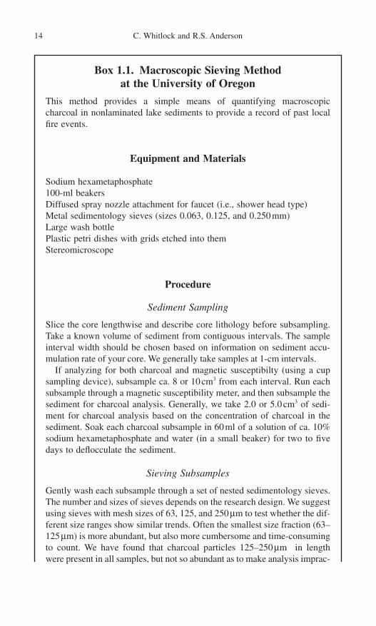
Box 1.1. Macroscopic Sieving Method at the University of Oregon
This method provides a simple means of quantifying macroscopic charcoal in nonlaminated lake sediments to provide a record of past localfire events.
Equipment and Materials
Sodium hexametaphosphate100-ml beakers Diffused spray nozzle attachment for faucet (i.e., shower head type)Metal sedimentology sieves (sizes 0.063, 0.125, and 0.250mm)Large wash bottlePlastic petri dishes with grids etched into themStereomicroscope
Procedure
Sediment Sampling
Slice the core lengthwise and describe core lithology before subsampling.Take a known volume of sediment from contiguous intervals. The sampleinterval width should be chosen based on information on sediment accu-mulation rate of your core. We generally take samples at 1-cm intervals.
If analyzing for both charcoal and magnetic susceptibilty (using a cupsampling device), subsample ca. 8 or 10cm3 from each interval. Run eachsubsample through a magnetic susceptibility meter, and then subsample thesediment for charcoal analysis. Generally, we take 2.0 or 5.0cm3 of sedi-ment for charcoal analysis based on the concentration of charcoal in thesediment. Soak each charcoal subsample in 60ml of a solution of ca. 10%sodium hexametaphosphate and water (in a small beaker) for two to fivedays to deflocculate the sediment.
Sieving Subsamples
Gently wash each subsample through a set of nested sedimentology sieves.The number and sizes of sieves depends on the research design. We suggestusing sieves with mesh sizes of 63, 125, and 250 mm to test whether the dif-ferent size ranges show similar trends. Often the smallest size fraction (63–125mm) is more abundant, but also more cumbersome and time-consumingto count. We have found that charcoal particles 125–250 mm in length were present in all samples, but not so abundant as to make analysis imprac-
tical. Particles >250mm were present in low numbers in most samples. After this initial test, we chose to sieve for particles in the 125–250 mm, and >250mm size ranges.
Using a spray nozzle attached to a faucet, gently spray the surface of thetop sieve for 1.5 to 2 minutes so that the entire subsample is washed throughthe sieves. Separate the sieves, and then gently wash the sediment to oneside of each sieve. Turn the sieve so that its surface is perpendi-cular to the counter top and the sediment is at the bottom (closest to thecounter). Using a large wash bottle, direct a stream of water at the charcoaland remaining particles and wash them into a gridded plastic petri dish. Itis best to use as little water as possible so that the charcoal and other particles do not float around as you try to count them.
Counting Charcoal Particles
Under a stereomicroscope at 50–100¥ magnification, count all charcoal particles. The gridded rows helps you keep track of your counting. Collect large pieces of charcoal (>500mm) while you are counting for AMS radio-carbon dating. Save samples in plastic bags in case the charcoal needs tobe recounted at a later date.
Data Analysis
This procedure gives number of charcoal particles (in a particular sizerange) for a volume of sediment. To calculate the charcoal concentrationfor each sample, divide the number of charcoal particles by the volume toget charcoal particles in cm-3. Enter the charcoal concentration data andage-depth data (derived from radiocarbon dates) into a computer programsuch as TILIA (Grimm, ND). Calculate an age-depth curve, charcoal accu-mulation rates (pieces cm-2 yr-1), and sediment-deposition time for eachsample. Transfer information to CHAPS for decomposition approach(available from Department of Geography, University of Oregon).
Anderson and Smith (1997) used finer sampling in wetland sites where biotur-bation is less of a problem. In the sieving method, the core is sampled at contin-uous 1-cm intervals and every sample is analyzed.
Sample volume is measured carefully, and it can be adjusted depending on theabundance of particulate charcoal. Between 2 and 5cm3 per sample is used inlake-sediment studies, as little as 0.5 to 1.0cm3 of sediment is used in wetlandand lakes with abundant charcoal. Each sample is soaked in a deflocculant for afew days and then gently washed through a series of nested sieves (with meshsizes of 250, 125, and 63mm). Initially the amount of charcoal in the differentsize fractions is tallied or measured for several samples to ensure that the threefractions show similar trends. In the western United States, we have found that
1. Fire History Reconstructions 15

the smallest, 63–125 mm size fraction contains abundant charcoal in nearly everysample and is tedious and difficult to count accurately. The >250mm fraction isnot present in many samples, suggesting that the largest particle sizes may notbe deposited evenly across the lake. Most of our studies use the 125–250 mm frac-tion or the >125mm fraction as the most practical size range for analysis. In thisrange, a fire event is typically represented by >50 particles cm-3 and a nonfireevent by substantially fewer particles. The resulting data set is converted to char-coal concentrations (number of charcoal particles cm-3) and then to charcoal accu-mulation rates (CHAR = number of charcoal particles cm-2 yr-1) by dividing bythe deposition time (yr cm-1).
Chronological Issues
Adequate chronological control is necessary for any high-resolution time series,and sediments that have annual laminations (varves) offer an opportunity for firehistory reconstructions on annual time scales. In nonlaminated sediments, thechronology for the fire reconstruction is based on 210Pb dating of sediments thatspan the last 200 years and AMS 14C dating of charcoal and terrestrial macrofossilsfrom the remainder of the core. Radiocarbon years are converted to calendar yearsusing the calibration program of Stuiver et al. (1998) in order to calculate charcoalaccumulation rates in calendar years. In developing an age model, it is desirable touse as smooth a regression curve as possible to calculate the deposition time of par-ticular lithologic units. Sharp discontinuities in deposition time that are artificiallyimposed by using linear interpolation between dates will influence the charcoalaccumulation rates.
Variations in sedimentation rate often make it difficult to sample a core atequally spaced time intervals. This is especially true for wet meadow records(Anderson and Smith 1997). For practical purposes and to facilitate comparisonwith other records, we convert our observations to regularly spaced time inter-vals. Because direct interpolation of CHAR to a constant time interval may notconserve the quantity of charcoal within the intervals, concentration values arefirst interpolated to pseudo-annual intervals, and those values are integrated overdecadal or longer time intervals. The unit of aggregation is generally equal to theshortest deposition time; for example, Mohr, Whitlock, and Skinner (2000) aggre-gated samples at 12-year intervals and Long et al. (1998) and Millspaugh, Whitlock, and Bartlein (2000) used an aggregation of 10 years. This approachpreserves the features of the raw charcoal accumulation rates but allows the datato be analyzed at evenly spaced time intervals (Fig. 1.3).
Decomposition Approach for Analyzing Charcoal Accumulation Rates. Thepurpose of the data-analytical phase is to separate the charcoal component relatedto the fire event from that related to variations in fuel biomass and depositionalprocesses. Clark and Royall (1996) and Long et al. (1998) suggest that this separation can be accomplished statistically by decomposing the charcoal time series into separate series. Time series of the charcoal accumulation rate (CHAR)display a low-frequency or slowly varying component, called the background
16 C. Whitlock and R.S. Anderson

component, and a higher-frequency or rapidly varying component, called thepeaks component. This type of decomposition approach also assumes that therelationship between these two components stays constant throughout the record.The background component or general trend in the data arises from any of severalsources, which are poorly understood and difficult to separate. A general time-varying level of background CHAR may be the result of changes in fuel accumulation and its influence on charcoal production. For example, Millspaugh,Whitlock, and Bartlein (2000) argue that the increase in background CHAR inYellowstone lakes about 11,000 years ago occurred as a result of changes in fuelduring the transition from open meadow to forest vegetation. Background CHAR has also been attributed to secondary charcoal, namely material stored inthe watershed and littoral zone that is delivered to the lake over a long period oftime. In this case, the charcoal is not directly related to a fire event. An increasein charcoal in late-Holocene sediments at Little Lake in the Coast Range wasattributed to more mass movements occurring with the onset of a wetter climate(Long et al. 1998). This hypothesis was supported by the high magnetic suscep-
1. Fire History Reconstructions 17
Figure 1.3. Charcoal data from Cygnet Lake at Yellowstone National Park showing thetransformation of the data from charcoal concentrations (A) to charcoal accumulation rates(CHAR) at evenly spaced time intervals. CHAR are plotted on both normal (B) and logarithmic (C) scales (after Millspaugh, Whitlock, and Bartlein 2000).
tibility of late-Holocene sediments. A third contributor of background charcoalmay be from extralocal or regional fires. This possibility, proposed by Clark andRoyall (1996), needs further testing by comparing the background charcoalstratigraphy with that of a microscopic charcoal record. Of the three sources ofbackground charcoal, both variations in charcoal production and secondary charcoal delivery are affected by changes in vegetation, climate, and fire weather,as well as by changes in hydrology, fluvial geomorphology, and lake conditions.The regional fire component also may have varied as the vegetation and climatechanged.
The peaks component is evident when the charcoal record is compared withhistorical and dendrochronological records of fires (Clark 1990; Millspaugh andWhitlock 1995). The peak represents the contribution of charcoal from a fireevent. As discussed above, this component has its source area within the water-shed and sometimes from adjacent upwind basins. In addition to a particular fireevent, it also represents “noise” from analytical error (Whitlock and Millspaugh1996) and natural random variations in CHAR. In practice, the largest variationsin the peaks component are attributed to fire events, and the minor “noise” com-ponent is disregarded.
Peaks of significance are identified by assigning a threshold value, such thatCHAR higher than that value is assumed to represent a fire event. Depending onthe deposition time, an event may comprise one or more fires occurring duringthe time span represented by the peak. In sites with fast deposition times, a peakis generally less than 20 years (1 or 2cm thick) (Long et al. 1998; Millspaugh,Whitlock, and Bartlein 2000), whereas in sites with slow sedimentation, a com-parable size peak may span several decades (Anderson and Smith 1997; Mohr,Whitlock, and Skinner 2000; Hallett and Walker 2000). To detect individual fires,it is necessary to have a sedimentary record that can be sampled at a shorter inter-val than the time between fires (Whitlock and Larsen, in press).
The decomposition approach has also been applied to magnetic susceptibilitydata. Background levels of magnetic minerals provide information on pedologicand geomorphic processes that operate within the basin over the long term. Peaks in magnetic susceptibility measurements indicate individual geomorphicevents, such as landslides, similar to the CHAR peaks. In Yellowstone, peaks inmagnetic susceptibility corresponded well with charcoal peaks, suggesting thatthey were fire-related erosion events (Millspaugh and Whitlock 1995). In otherstudies in Yellowstone, the Coast Range, the Sierra Nevada, and the KlamathMountains, no direct relation between CHAR peaks and magnetic susceptibilitypeaks was noted, even when the possibility of a time lag was considered(Millspaugh 1997; Long et al. 1998; Brunelle 1997; Mohr, Whitlock, and Skinner2000).
Charcoal data, like other paleoenvironmental records in lake sediments, areapproximately lognormally distributed, in that most of the charcoal is depositedclose to the site and the abundance declines exponentially away from the sourcearea (Clark 1988a; Clark et al. 1998). Consequently, CHAR and magnetic sus-ceptibility data are usually log transformed before analysis (Fig. 1.3). A locally
18 C. Whitlock and R.S. Anderson

weighted (moving) average is used to define the background component. It is cal-culated by moving a “window” along the CHAR series, and at each point deter-mining a weighted average of CHAR values for the points contained in thewindow. The weight assigned to each point is based on the distance of the pointfrom the center of the window so that points near the edge of the window haveless influence than those near the center. This method of locally weighted aver-aging is related to the “lowess” approach for smoothing scatter diagrams (Cleveland 1979), and weights are determined using a tri-cube or approximatelybell-shaped function. The width of the window affects the smoothness of thebackground component. If too wide, a window does not capture long-term variations in the data; if too narrow, a window produces a background trend thatmimics the high-frequency or peaks component. In sites with fast sedimentationrates relative to the fire frequency, window widths of 500 to 1000 years have beenused to convey the general trends in the data (e.g., Long et al. 1998). However,in sites with very slow sedimentation rates, a shorter window width is preferredbecause each interval of high CHAR spans several decades and is considered significant (Mohr, Whitlock, and Skinner 2000). In these cases, a broader back-grounds width would tend to smooth the data and not identify potentially signif-icant peaks.
The CHAR threshold value is set or calibrated based on the timing of knownfires evident in dendrochronological or historical records. The calibration deter-mines what specific values of the peaks components correspond with a fire event.The threshold value is defined in terms of a threshold ratio, that is, a ratio ofCHAR at a particular time relative to background. For example, a ratio of 1.00would identify all peaks greater than background as a fire event. In the case oflake records, the peak begins at the oldest interval at which the CHAR thresholdvalue is exceeded, and it is registered until CHAR drops below that value. Theassumption is that the oldest date marks the fire event and the younger part ofthe peak is reworked or secondary charcoal. In wetland records the peak is markedat the youngest interval with CHAR greater or equal to the threshold value, onthe ground that the fire burns the surface and penetrates some depth into thewetland sediment (Huber and Markgraf, Chapter 13, this volume).
Clark and Royall (1996) used a Fourier series filter (Press et al. 1986), basedon the variance spectrum of the CHAR series, to describe the background com-ponent. The peaks component was defined as the positive deviations of the CHARseries from background. This approach assumes that the background series iscomposed of many sinusoidal components, and can be adjusted by the choice ofthe width of the “spectral window” used in constructing a variance spectrumeither through smoothing the periodogram or transforming an autocovariancefunction. Clark and Royall (1996) do not explicitly define a CHAR threshold foridentifying fire events but by plotting the positive residual from the backgroundcomponent, such a threshold is implicitly defined. The low values of the noisecomponent are not separated from the horizontal axis of their plots of the peakscomponents. Because the variance spectrum and resulting filter are defined usingthe entire record, as opposed to locally as in our approach, their strategy assumes
1. Fire History Reconstructions 19

that the CHAR background does not change through time. The CHAR data atLittle Lake (Fig. 1.4), for example, suggest that the variance spectrum did indeedvary over time in response to changing climate and vegetation. We favor anapproach where the background component may adapt to changes in the vari-ability of the CHAR data.
Window width and threshold-ratio parameters are selected by (1) examiningthe CHAR from the short core relative to the record of recent fires near the site,and (2) by testing a variety of values of the two parameters to decompose thelong record. The results of the decomposition are compared with information onpresent-day fire regimes in the region. This iterative approach provides an oppor-tunity to examine the robustness of the method and the sensitivity of the out-comes to the choice of parameter values (Fig. 1.4). We display the fire events asa locally weighted mean frequency of peaks (number of peaks/1000 years). Thispeak-frequency series was obtained by smoothing a binary series of peaks (1,peaks; 0, no peaks) using a locally weighted average with a 2000-year windowwidth.
A software package (Charcoal Analysis Programs, or CHAPS, developed byP.J. Bartlein) is available from the University of Oregon to facilitate decompo-sition of the charcoal records. The program converts charcoal concentration data into concentration at pseudo-annual intervals and then into charcoal con-centration and CHAR at decadal intervals. The program also allows considera-tion of different background and threshold values to produce a plot of peakfrequency.
20 C. Whitlock and R.S. Anderson
Figure 1.4. Comparison at Little Lake of different window widths to define backgroundcharcoal (left) and different threshold-ratio levels to identify significant peaks that represent fire events (right). In Long et al. (1998), a window width of 600 years and athreshold-ratio value of 1.12 was used to reconstruct the fire history.

Examples of High-Resolution Charcoal Studies
Charcoal and pollen data from Little Lake in the Oregon Coast Range (Long etal. 1998), charcoal records from Bluff and Crater lakes in the Klamath Mountains of northern California (Mohr, Whitlock, and Skinner 2000), and acharcoal study of wet meadows in the Sierra Nevada (Anderson and Smith 1997)illustrate the type of insights that can be gained from high-resolution fire historystudies. In each case macroscopic charcoal was analyzed in contiguous intervals.
At Little Lake, an 11.33-m-long core was taken that spanned the last 9000calyears. The chronology for this core was based on four AMS 14C dates on char-coal particles, one conventional bulk-sediment 14C date, and the age of theMazama volcanic ash, which was identified in the core. A third-order polynomialwas used to fit a smooth age-to-depth model. At the coring location, a 45-cm-long short core was also retrieved and dated by 210Pb method. The cores weresliced into 1-cm-thick intervals, and from each sample, sediment was taken formagnetic susceptibility and charcoal analyses. The pollen stratigraphy hadalready been described in a previous study (Worona and Whitlock 1995). Char-coal samples (2.5cm3 volume) were washed through sieves of 63-, 125-, and 250-mm mesh diameters, and the particles were counted under a stereomicroscope andcompared. As a result, only the two larger size fractions were examined, becausethey contained abundant charcoal but not so much that counting was impractical.Data were converted to concentration data and then to CHAR at decadal inter-vals, using CHAPS software.
Very little information was available on the modern fire history of the LittleLake watershed, because much of the area was logged and reforested in the twen-tieth century. The choice of parameters to assign for window-width and threshold-ratio values came from an understanding of the recent fire regime, aswell as an inspection of the CHAR data. Long et al. (1998) identified eight largeCHAR peaks in the last 1500 years, which seemed to represent fire events (Fig.1.4). The temporal spacing of the peaks was consistent with the mean return inter-val of fires in the Coast Range at present based on dendrochronological studies.Different combinations of window-width and threshold-ratio values were con-sidered in an effort to find parameters that would identify the eight peaks as fireevents. A background window of 600 years and a threshold value of 1.12 werechosen, because they identified all eight peaks and no additional ones. Thesevalues also produced fire return intervals of <600 years in the rest of the record,which seemed reasonable given the return intervals of large fires in the wettestand driest parts of the Pacific Northwest rain forest suggested by dendrochrono-logical data (Agee 1993).
Applying the peak and threshold parameters to the entire record produced afire event frequency that showed variations throughout the Holocene. The back-ground component at Little Lake was low for the first 5000 years, and thenincreased abruptly at 4000calyrBP (before present). The increase corresponds toa change in deposition time and implies an increase in secondary charcoal duringnon-fire years in the late Holocene. It was ascribed to more woody fuel biomass
1. Fire History Reconstructions 21
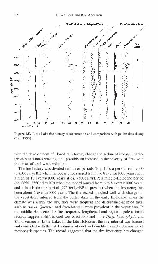
with the development of closed rain forest, changes in sediment storage charac-teristics and mass wasting, and possibly an increase in the severity of fires withthe onset of cool wet conditions.
The fire history was divided into three periods (Fig. 1.5): a period from 9000to 8500calyrBP, when fire occurrence ranged from 5 to 8 events/1000 years, witha high of 10 events/1000 years at ca. 7500calyrBP; a middle-Holocene period(ca. 6850–2750calyrBP) when the record ranged from 6 to 8 events/1000 years,and a late-Holocene period (2750calyrBP to present) when the frequency hasbeen about 5 events/1000 years. The fire record matched well with changes inthe vegetation, inferred from the pollen data. In the early Holocene, when theclimate was warm and dry, fires were frequent and disturbance-adapted taxa, such as Alnus, Quercus, and Pseudotsuga, were prevalent in the vegetation. Inthe middle Holocene, the fire frequency lengthened and regional paleoclimaterecords suggest a shift to cool wet conditions and more Tsuga heterophylla andThuja plicata at Little Lake. In the late Holocene, the fire interval was longestand coincided with the establishment of cool wet conditions and a dominance of mesophytic species. The record suggested that the fire frequency has changed
22 C. Whitlock and R.S. Anderson
Figure 1.5. Little Lake fire history reconstruction and comparison with pollen data (Longet al. 1998).

continuously with climate change and that the present fire regime has been inexistence for only the last 1000 to 2000 years.
The second example combined pollen and high-resolution charcoal data fromtwo lakes, Bluff and Crater, in the Klamath Mountains of northern California(Mohr, Whitlock, and Skinner 2000). In these mixed conifer forests the historicfire return interval is very short, on the order of decades (Skinner and Chang1996). The same methodological approach was used as at Little Lake, but theKlamath lakes were located on serpentine substrates and had very slow sedi-mentation rates. Each 1-cm sample spanned 24 to 180 years at Bluff Lake, and12 to 120 years at Crater Lake, which was longer than the average fire returninterval based on tree-ring data. The charcoal record was decomposed using abackground window width of 120 years and a threshold-ratio value of 1.00, basedon a comparison with dendrochronological and documentary evidence of recentfires and their registration of specific charcoal peaks in a 210Pb-dated short core.Because of the slow deposition time, the goal was to select a value that wouldcorrectly identify multiple decadal intervals with significant burning. Charcoalpeaks represented one or more fires occurring over a time span of 12 to 180 years,and, as a result, the data were not directly comparable to the dendrochronologi-cal record.
The pollen and charcoal record considered together provided information onthe postglacial vegetation and fire regimes near the lakes. The vegetation and fire history indicated more xerophytic vegetation and more frequent fire eventsduring the early Holocene than at present. The early Holocene is widely documented as a period of intense summer drought in the Pacific Northwest basedon several lines of evidence (Thompson et al. 1993). As the climate became coolerand wetter in the late Holocene, mesophytic taxa, such as Tsuga heterophylla,became more important and fire event frequencies decreased. The modern forestwas established in the last 2000 years; fire event frequencies were high at ca. 1000calyrBP and have declined since then. Both watersheds experienced highest fire frequencies during dry periods. Fire events were frequent at 8300calyrBP,4000calyrBP, and during the so-called Medieval Warm Period, ca. 1000calyrBP (Stine 1994) (Fig. 1.6). The synchroneity of the fire history at the sites implieda response to regional changes in climate on submillennial time scales.
The third example considered high-resolution charcoal records in several wet meadow cores in the Sierra Nevada of California (Anderson and Smith 1997). The meadows varied in elevation from 1786 to 2206m. The goal of thestudy was to examine the broad-scale fire patterns within the montane forestduring the last 10,000 years by comparing the charcoal record from several sites.Using the thin-section charcoal method (Clark 1988b), charcoal particles were identified and tallied in contiguous 1-mm-depth intervals for each core. A chronology was developed by assigning ages based on a suite of AMS and conventional radiocarbon dates. The data were aggregated into 25-year periods,because sedimentation rates within the wet meadows were assumed to be vari-able (Anderson and Smith 1994). More recently Anderson and Smith (1998)
1. Fire History Reconstructions 23

refined the chronology with additional AMS dates and converted the time scaleto calendar years.
Although charcoal is recovered in variable amounts throughout the profile(note logarithmic scale), distinct charcoal peaks were recorded at each of the sites,and are inferred to be local fire events (Fig. 1.7). Lesser amounts of charcoalcould be attributed to regional as well as local fires. Over the last 1000cal years,three sites showed a prominent peak between 550 and 400calyrBP. Three sitesalso registered a charcoal peak between 790 and 665calyrBP, while two dis-played charcoal peaks between 985 and 935calyrBP. Higher concentrations ofcharcoal indicating increased fire activity occurred over the last ca. 1200 years,at ca. 2200, 2700, and 3000calyrBP, between ca. 3700 and 5200calyrBP, at ca.7250calyrBP and between ca. 9300 and 9700calyrBP. In between these inter-vals were periods of considerably lower charcoal deposition (Anderson and Smith1997, 1998).
Like the Coast Range and Klamath studies, the Sierran records suggest thatclimate changes were responsible for the long-term variations in fire occurrence.Warmer drier conditions in the early Holocene led to open forests with more pineand montane chaparral shrubs than today (Anderson 1990). With increased effec-tive precipitation in the late Holocene, forests became more closed and fires wereless frequent (Anderson 1990; Anderson and Smith 1994).
24 C. Whitlock and R.S. Anderson
Figure 1.6. Comparison of two KlamathLake records for the last 8500 years, showingsynchronous periods of high and low fireoccurrence (Mohr, Whitlock, and Skinner2000; reprinted with permission from TheHolocene, © Arnold Publishers).

Conclusion
As more charcoal records become available in the Americas, their value in paleoclimate reconstructions and in assessing the proximal causes of vegetationchange will increase. Studies to date suggest that variations in fire frequency offera more sensitive proxy of millennial-scale climate variations than do pollen data.The development of high-resolution charcoal records in both hemispheres offersan opportunity to examine climate variations and teleconnections associated with
1. Fire History Reconstructions 25
Figure 1.7. Charcoal area (mm2) in 25-year increments for four montane meadows in theSierra Nevada of California (modified from Anderson and Smith 1997). Dots show loca-tion of radiocarbon dates, which have been calibrated as calendar years.

ENSO and changes in the seasonal cycle of insolation. To realize the potential ofcharcoal studies as a paleoclimate proxy, however, requires that the paleoeco-logical community standardize both the techniques and interpretation of suchdata. Too many charcoal studies are based on imprecise or unsubstantiatedassumptions and analytical approaches.
Modern studies of charcoal transport and deposition are rare. Two have been undertaken in the western United Sates, and none are available from South America. Data on modern processes are needed to calibrate charcoal data and refine the interpretation of the stratigraphic record. Similarly, modelingefforts that focus on the relation between fire and charcoal production and transport are needed to verify the assumptions developed from empirical studies.
The language used to describe past fire regimes from charcoal data has beenimprecise, and often does not convey information that is useful to fire ecologists.For example, the term “fire frequency” has been used in the paleoecological lit-erature to describe everything from changes in abundance of microscopic char-coal in discontinuous records to peaks in high-resolution records of macroscopiccharcoal. These two data sets do not describe the same phenomenon. Likewise,the term “regional fires” is seldom defined in a paper, and it is not clear whetherit refers to distant fires, large widespread fires, or a more general attribute of afire regime. The lack of standardization in terminology has limited our abilityboth to compare charcoal records and to link charcoal-based fire reconstructionswith those provided by dendrochronological data. It is important that the char-coal and the dendrochronological communities work together to understand anddescribe fire regimes on multiple spatial and temporal scales. Charcoal analysiscan contribute in significant ways toward assessing the representativeness of den-drochronological records on longer time scales, and tree-ring records can assistin refining the interpretation of charcoal data.
Several methods are now available for charcoal analysis, and while the choicemay seem bewildering, we offer some recommendations:
1. Charcoal studies should routinely examine macroscopic charcoal in orderto get a local fire reconstruction. The source area of macroscopic charcoal is muchbetter known than that of microscopic charcoal, and fire location is an essentialpart of any fire reconstruction.
2. Contiguous sampling at a fine sampling interval is critical to calculate fireevent frequency; discontinuous sampling misses charcoal peaks and often back-ground trends are interpreted as fire events.
3. An adequate chronology is essential, as is some method of calibration to identify a significant threshold level. Thus, charcoal studies require varved-sediment records or calibrated AMS 14C-dated and 210Pb-dated records.
4. Macroscopic charcoal data are quantified in different ways, most commonlyas particle counts or area measurements. Charcoal accumulation rates are calculated based on sediment weight or volume. These different methods seem
26 C. Whitlock and R.S. Anderson

to give generally similar trends through time. More important is the decision toundertake high-resolution sampling by analyzing contiguous samples.
5. The time series consists of at least two components, a slowly varying back-ground component, superimposed upon which is a peaks component. The infor-mation contained in these two components is different and should be interpretedseparately. Periods with abundant charcoal may not necessarily represent timesof more fires; they could be periods of high background charcoal as a result of ashift in fire severity or the introduction of secondary charcoal.
6. Each macroscopic charcoal record is a local reconstruction; to infer landscape, regional, or larger-scale patterns requires a network of sites, all doneto a similar high standard, or calibration of the microscopic charcoal component.
7. In addition to charcoal data, other fire proxies are worth considering, especially as they can supplement the fire interpretations. Closely sampled pollenrecords have been used as a proxy of fire (Sugita et al. 1997; MacDonald et al.1991; Larsen and MacDonald 1998b). The sensitivity of pollen records to a particular fire event should to be carefully tested in each locality. Similarly, litho-logic analyses, in particular, magnetic susceptibility measurements, have provedto be a useful indicator of fire-related erosion in some regions, but the successvaries among sites.
Acknowledgments. The research that motivated this chapter was supported bygrants from the National Science Foundation (SBR9616951, EAR9906100,ATM0117160 to CW), USDA Forest Service (USFS PSW-95-0022CA, USFSPNW-98-5122-1CA to CW), U.S. Geological Survey Global Change Program(1434-WR-97-AG-00013 to RSA), and the National Park Service Global ChangeProgram (CA 8000-7-0001, CA 8013-8-0002 to RSA).
References
Agee, J.K. 1993. Fire Ecology of Pacific Northwest Forests. Washington, DC: Island Press.Anderson, R.S. 1990. Holocene forest development and paleoclimates within the central
Sierra Nevada, Cal. J. Ecol. 78:470–489.Anderson, R.S., Davis, R.B., Miller, N.G., and Stuckenrath, R. 1986. History of late- and
post-glacial vegetation and disturbance around Upper South Branch Pond, northernMaine. Can. J. Bot. 64:1977–1986.
Anderson, R.S., and Smith, S.J. 1994. Paleoclimatic interpretations of meadow sedimentand pollen stratigraphies from California. Geology 22:723–726.
Anderson, R.S., and Smith, S.J. 1997. The sedimentary record of fire in montane meadows,Sierra Nevada, California, USA: A preliminary assessment. In Sediment Records ofBiomass Burning and Global Change, eds. J.S. Clark, H. Cachier, J.G. Goldammer,and B. Stocks, pp. 313–328. NATO ASI Series 1: Global Environmental Change, vol.51. Berlin: Springer.
Andreae, M.O. 1991. Biomass burning: its history, use, and distribution and its impact onenvironmental quality and global climate. In Global Biomass Burning: Atmospheric,Climatic, and Biospheric Implications, ed. J.S. Levin, pp. 3–21. Cambridge: MIT Press.
Bartlein, P.J., Whitlock, C., and Shafer, S.L. 1997. Future climate in Yellowstone NationalPark region and its potential impact on vegetation. Conservation Biol. 11:782–792.
1. Fire History Reconstructions 27
Birks, H.J.B. 1997. Reconstructing environmental impacts of fire from the Holocene sed-imentary record. In Sediment Records of Biomass Burning and Global Change, eds.J.S. Clark, H. Cachier, J.G. Goldammer, and B. Stocks, pp. 295–312. NATO ASI Series1: Global Environmental Change, vol. 51. Berlin: Springer-Verlag.
Bradbury, J.P. 1996. Charcoal deposition and redeposition in Elk Lake, Minnesota, USA.Holocene 6:339–344.
Bradshaw, R.H.W., Tolonen, K., and Tolonen, M. 1997. Holocene records of fire from the boreal and temperate zones of Europe. In Sediment Records of Biomass Burningand Global Change, eds. J.S. Clark, H. Cachier, J.G. Goldammer, and B. Stocks, pp. 347–366. NATO ASI Series 1: Global Environmental Change, vol. 51. Berlin:Springer-Verlag.
Brunelle, A. 1997. A post-glacial record of fire and vegetation from Siesta Lake, YosemiteNational Park, California. M.S. thesis. Northern Arizona University, Flagstaff. 107p.
Brunner Jass, R.M. 1999. Fire occurrence and paleoecology at Alamo Bog and Chihuahueños Bog, Jemez Mountains, New Mexico. M.S. thesis. Northern ArizonaUniversity, Flagstaff. 140p.
Carcaillet, C., and Thinon, M. 1996. Pedoanthracological contribution to the study of the evolution of the upper treeline in the Maurienne Valley (North French Alps):Methodology and preliminary data. Rev. Palaeobot. Palynol. 91:399–416.
Clark, J.S. 1988a. Particle motion and the theory of stratigraphic charcoal analysis: Sourcearea, transport, deposition, and sampling. Quat. Res. 30:67–80.
Clark, J.S. 1988b. Stratigraphic charcoal analysis on petrographic thin sections: Applica-tions to fire history in northwestern Minnesota. Quat. Res. 30:81–91.
Clark, J.S. 1990. Fire and climate change during the last 750 years in northwestern Minnesota. Ecol. Monogr. 60:135–159.
Clark, J.S., and Hussey, T.C. 1996. Estimating the mass flux of charcoal from sedimen-tary records: Effects of particle size, morphology, and orientation. Holocene6:129–145.
Clark, J.S., and Patterson, W.A. III. 1997. Background and local charcoal in sediments:Scales of fire evidence in the paleorecord. In Sediment Records of Biomass Burningand Global Change, eds. J.S. Clark, H. Cachier, J.G. Goldammer, and B. Stocks, pp. 27–48. NATO ASI Series 1: Global Environmental Change, vol. 51. Berlin: Springer.
Clark, J.S., and Royall, P.D. 1995. Particle size evidence for source areas of charcoal accumulation in late Holocene sediments of eastern North American lakes. Quat. Res. 43:80–89.
Clark, J.S., and Royall, P.D. 1996. Local and regional sediment charcoal evidence for fireregimes in presettlement northeastern North America. J. Ecol. 84:365–382.
Clark, J.S., Lynch, J., Stocks, B., and Goldammer, J. 1998. Relationships between charcoal particles in air and sediments in west-central Siberia. Holocene 8:19–29.
Clark, R.L. 1982. Point count estimation of charcoal in pollen preparations and thin sections of sediment. Pollen Spores 24:523–535.
Cleveland, W.S. 1979. Robust locally weighted regression and smoothing scatterplots. J.Am. Stat. Assoc. 74:829–836.
Cwynar, L.C. 1978. Recent history of fire and vegetation from annually laminated sediment of Greenleaf Lake, Algonquin Park, Ontario. Can. J. Bot. 56:10–12.
Cwynar, L.C. 1987. Fire and the forest history of the north Cascade Range. Ecology68:791–802.
Earle, C.J., Brubaker, L.B., and Anderson, P.M. 1996. Charcoal in north central Alaskanlake sediments: Relationships to fire and late-Quaternary vegetation history. Rev.Palaeobot. Palynol. 92:83–95.
Edwards, K.J., and Whittington, G. 2000. Multiple charcoal profiles in a Scottish lake:Taphonomy, fire ecology, and human impact and interference. Palaeogeogr. Palaeo-clim. Palaeoecol. 164:67–86.
28 C. Whitlock and R.S. Anderson

1. Fire History Reconstructions 29
Gardner, J., and Whitlock, C. 2001. Charcoal accumulation following a recent fire in theCascade Range, northwestern USA, and its relevance for fire-history studies. Holocene11:541–549.
Gedye, S.J., Jones, R.T., Tinner, W., Ammann, B., and Oldfield, F. 2000. The use of mineralmagnetism in the reconstruction of fire history: A case study from Lago di Origlio,Swiss Alps. Palaeogeogr. Palaeoclim. Palaeoecol. 164:101–110.
Grimm, E.C., ND. Tilia Software Package. Illinois State Museum, Springfield, IL.Hallett, D.J., and Walker, R.C. 2000. Paleoecology and its application to fire and
vegetation management in Kootenay National Park, British Columbia. J. Paleolim.24:401–414.
Heusser, C.J. 1994. Paleoindians and fire during the late Quaternary in southern SouthAmerica. Rev. Chilena Hist. Nat. 67:435–443.
Horn, S.P., Horn, R.D., and Byrne, R. 1992. An automated charcoal scanner for paleoe-cological studies. Palynology 16:7–12.
Huber, U. 2001. Holocene variations among fire, climate, and vegetation in southern Patagonia. Ph.D. dissertation. University of Colorado, Boulder.
Innes, J.B., and Simmons, I.G. 2000. Mid-Holocene charcoal stratigraphy, fire history, andpalaeoecology at North Gill, North York Moors, UK. Palaeogeogr. Palaeoclim.Palaeoecol. 164:151–165.
Iversen, J. 1941. Land occupation in Denmark’s Stone Age. Danmarks Geologiske Forenhandlungen II 66:1–126.
Jacobson, G.L. Jr., and Bradshaw, R.H.W. 1981. The selection of sites for paleovegeta-tional studies. Quat. Res. 16:80–96.
Laird, K.D., and Campbell, I.D. 2000. High resolution palaeofire signals from ChristinaLake, Alberta: A comparison of charcoal signals extracted by two different methods.Palaeogeogr. Palaeoclim. Palaeoecol. 164:111–123.
Larsen, C.P.S., and MacDonald, G.M. 1993. Lake morphology, sediment mixing and the selection of sites for fine resolution palaeoecological studies. Quat. Sci. Rev.12:781–792.
Larsen, C.P.S., and MacDonald, G.M. 1998a. An 840-year record of fire and vegetationin a boreal white spruce forest. Ecology 79:106–118.
Larsen, C.P.S., and MacDonald, G.M. 1998b. Fire and vegetation dynamics in a jack pineand black spruce forest reconstructed using fossil pollen and charcoal. J. Ecol.86:815–828.
Larsen, C.P.S., Peinitz, R., Smol, J.P., Moser, K.A., Cumming, B.F., Blais, J.M., MacDonald, G.M., and Hall, R.I. 1998. Relations between lake morphometry and thepresence of laminated lake sediments: A reexamination of Larsen and MacDonald(1993). Quat. Sci. Rev. 17:711–717.
Long, C.J., Whitlock, C., Bartlein, P.J., and Millspaugh, S.H. 1998. A 9000-year fire historyfrom the Oregon Coast Range, based on a high-resolution charcoal study. Can. J. For.Res. 28:774–787.
MacDonald, G.M., Larsen, C.P.S., Szeicz, J.M., and Moser, K.A. 1991. The reconstruc-tion of boreal forest fire history from lake sediments: a comparison of charcoal, pollen,sedimentological, and geochemical indices. Quat. Sci. Rev. 10:53–72.
Markgraf, V., and Anderson, L. 1994. Fire history of Patagonia: Climate versus humancause. Rev. Instituto Geologico, Sao Paulo 15:35–47.
Mehringer, P.J., Arno, S.F., and Petersen, K.L. 1977. Postglacial history of Lost Trail PassBog, Bitterroot Mountains, Montana. Arct. Alp. Res. 9:345–368.
Meyer, G.A., Wells, S.G., and Tull, A.J.T. 1995. Fire and alluvial chronology in Yellowstone National Park: Climatic and intrinsic controls on Holocene geomorphicprocesses. Geol. Soc. Am. Bull. 107:1211–1230.
Millspaugh, S.H. 1997. Late-glacial and Holocene variations in fire frequency in theCentral Plateau and Yellowstone-Lamar Provinces of Yellowstone National Park. Ph.D.dissertation. University of Oregon, Eugene.
Millspaugh, S.H., and Whitlock, C. 1995. A 750-year fire history based on lake sedimentrecords in central Yellowstone National Park, USA. Holocene 5:283–292.
Millspaugh, S.H., Whitlock, C., and Bartlein, P.J. 2000. Variations in fire frequency andclimate over the last 17,000 years in central Yellowstone National Park. Geology28:211–214.
Mohr, J.A., Whitlock, C., and Skinner, C.J. 2000. Postglacial vegetation and fire history,eastern Klamath Mountains, California. Holocene 10:587–601.
Odgaard, B.V. 1992. The fire history of Danish heathland areas as reflected by pollen andcharred particles in lake sediments. Holocene 2:218–226.
Ohlson, M.C., and Tryterud, E. 2000. Interpretation of the charcoal record in forest soils:forest fires and their production and deposition of macroscopic charcoal. Holocene10:519–525.
O’Sullivan, A. 1991. Historical and contemporary effects of fire on the native woodlandvegetation of Killarney, S.W. Ireland. Ph.D. dissertation. Trinity College, Dublin.
Overpeck, J.T., Rind, D., and Goldberg, R. 1990. Climate-induced changes in forest disturbance and vegetation. Nature 343:51–53.
Patterson, W.A. III, Edwards, K.J., and MacGuire, D.J. 1987. Microscopic charcoal as afossil indicator of fire. Quat. Sci. Rev. 6:3–23.
Pearl, C.A. 1999. Holocene environmental history of the Willamette Valley, Oregon:Insights from an 11,000-year record from Beaver Lake. M.S. thesis. EnvironmentalStudies Program. University of Oregon, Eugene.
Pitkänen, A. Turunen, J., and Tolonen, K. 1999. The role of fire in the carbon dynamicsof a mire, eastern Finland. Holocene 9:453–462.
Press, W.H., Flannery, B.P., Teukolsky, S.A., and Vetterling, W.T. 1986. NumericalRecipes. Cambridge: Cambridge University Press.
Price, C., and Rind, D. 1994. The impact of a 2 ¥ CO2 climate on lightning caused fires.J. Clim. 7:1484–1494.
Radtke, L.F., Hegg, D.A., Hobbs, P.V., Nance, J.D., Lyons, J.H., Laursen, K.K., Weiss,R.E., Riggan, P.J., and Ward, D.E. 1991. Particulate and trace gas emissions from largebiomass fires in North America. In Global Biomass Burning: Atmospheric, Climatic,and Biospheric Implications, ed. J.S. Levin, pp. 209–224. Cambridge: MIT Press.
Rhodes, T.E., and Davis, R.B. 1995. Effects of late Holocene forest disturbance and vegetation change on acidic Mud Pond, Maine, USA. Ecology 76:734–746.
Rummery, T.A., Bloemendal, J., Dearing, J., Oldfield, F., and Thompson, R. 1979. Thepersistence of fire-induced magnetic oxides in soils and lake sediments. Ann. Geophys.35:103–107.
Skinner, C.N., and Chang, C. 1996. Fire regimes, past and present. In Sierra NevadaEcosystem Project: Final Report to Congress, Vol. II, Assessments and Scientific Basisfor Management Options. University of California at Davis, Centers for Water andWildland Resources 1041–1069.
Smith, S.J., and Anderson, R.S. 1992. Late Wisconsin paleoecologic record from SwampLake, Yosemite National Park, California. Quat. Res. 38:91–102.
Stine, S. 1994. Extreme and persistent drought in California and Patagonia during mediaeval time. Nature 369:546–549.
Stuiver, M., Reimer, P.J., Bard, E., Beck, J.W., Burr, G.S., Hughen, K.A., Kromer, B.,McCormac, F.G., van der Plicht, J., and Spurk, M. 1998. INTCAL 98 Radiocarbon agecalibration 24,000–0cal BP. Radiocarbon 40:1041–1083.
Sugita, S., MacDonald, G.M., and Larsen, C.P.S. 1997. Reconstruction of fire disturbanceand forest succession from fossil pollen in lake sediments: Potential and limitations.In Sediment Records of Biomass Burning and Global Change, eds. J.S. Clark, H.Cachier, J.G. Goldammer, and B. Stocks, pp. 387–412. NATO ASI Series 1: GlobalEnvironmental Change, vol. 51. Berlin: Springer.
Swain, A.M. 1973. A history of fire and vegetation in northeastern Minnesota as recordedin lake sediments. Quat. Res. 3:383–396.
30 C. Whitlock and R.S. Anderson

Swain, A.M. 1978. Environmental changes during the past 2000yr in north-central Wisconsin: Analysis of pollen, charcoal and seeds from varved lake sediments. Quat.Res. 10:55–68.
Terasmae, J., and Weeks, N.C. 1979. Natural fires as an index of paleoclimate. Can. FieldNat. 93:116–125.
Thompson, R., and Oldfield, F. 1986. Environmental Magnetism. London: Allen andUnwin.
Thompson, R.S., Whitlock, C., Bartlein, P.J., Harrison, S.P., and Spaulding, W.G. 1993.Climatic changes in western United States since 18,000yr BP. In Global Climates sincethe Last Glacial Maximum, eds. H.E. Wright Jr., J.E. Kutzbach, T. Webb III, W.F. Ruddiman, and F.A. Street-Perrot, pp. 468–513. Minneapolis: University of MinnesotaPress.
Tolonen, K. 1986. Charred particle analysis. In Handbook of Holocene Palaeoecology andPalaeohydrology, ed. B.E. Berglund, pp. 485–496. New York: Wiley.
Tolonen, M. 1985. Paleoecological record of local fire history from a peat deposit in SWFinland. Ann. Bot. Fenn. 15:177–209.
Umbanhowar, C.E., Jr. 1996. Recent fire history of the northern Great Plains. Am. Midl.Nat. 135:115–121.
Wein, R.W., Burzynski, M.P., Screenivasa, B.A., and Tolonen, K. 1987. Bog profile evidence of fire and vegetation dynamics since 3000 years BP in the Acadian Forest.Can. J. Bot. 65:1180–1186.
Whitlock, C., and Larsen, C.P.S., in press. Charcoal as a fire proxy. In Tracking Environ-mental Change Using Lake Sediments: Terrestrial, Algal, and Siliceous Indicators, eds.J.P. Smol, H.J.B. Birks, and W.M. Last, vol. 3. Dordrecht: Kluwer Academic.
Whitlock, C., and Millspaugh, S. 1996. Testing assumptions of fire history studies: Anexamination of modern charcoal accumulation in Yellowstone National Park. Holocene6:7–15.
Winkler, M.G. 1985. Charcoal analysis for paleoenvironmental interpretation: a chemicalassay. Quat. Res. 23:313–326.
Worona, M.A., and Whitlock, C. 1995. Late-Quaternary vegetation and climate historynear Little Lake, Central Coast Range, Oregon. Geol. Soc. Am. Bull. 107:867–876.
1. Fire History Reconstructions 31

2. The Simulation of Landscape Fire, Climate, and Ecosystem Dynamics1
Robert E. Keane and Mark A. Finney
Wildland fire is a critical disturbance process in many ecosystems worldwide, yetit is difficult to study fire and its relationship to climate across large landscapesover long time periods (Crutzen and Goldammer 1993). Most field studies eval-uate the effects of fire at the stand level, and usually after only one fire event.Field investigation of the cumulative effects of many fires across an entire land-scape would require exorbitant amounts of time and money not available to manyfire scientists. Simulation modeling, however, provides an alternative tool toinvestigate and understand how landscapes respond to changes in fire brought on by climate change across large spatial and temporal domains. Simulationapproaches allow the integration of diverse scientific information into a compre-hensive framework to explore more complex problems, such as the effects ofclimate change on fire dynamics. An advantage of simulation modeling is that itenables us to determine the relative importance of one factor in regulating ecosys-tem behavior by holding other factors constant.
There are many types of simulation models, and they are usually categorizedinto four groups (Table 2.1). Empirical models are primarily built on statisticalrelationships derived from actual data. Deterministic models use generalized
32
1 The use of trade or firm names in this paper is for reader information and does not implyendorsement by the U.S. Department of Agriculture of any product or service. This paperwas written and prepared by U.S. Government employees on official time, and thereforeis in the public domain and not subject to copyright.

functions to represent the relationships that drive simulation dynamics. Stochas-tic models use probability distributions to represent primary ecosystem processes.And last, mechanistic models use fundamental biological and physical relation-ships to simulate the underlying processes or causal mechanisms that dictatesystem behavior (Gay 1989). While all of these model approaches have theirvarious advantages and disadvantages (Table 2.1), the best simulation models areoften combinations of all four types.
This chapter presents a general review of spatially explicit fire and fire effectssimulation modeling, but uses a conceptual fire simulation system called FESM(fire effects simulation model) as the context for this review. The primary focusof this conceptual framework is to investigate the interaction of fire and climatewith ecosystem dynamics at landscape scales as it relates to management issuesor research goals. This conceptual framework or general model is presented onlyto organize and integrate the discussion of the important processes needed to sim-ulate fire and its immediate and long-term effects on ecosystems and landscapes(Fig. 2.1). The lack of computer resources, limited research findings, complexinterrelationships, and incomplete scientific expertise prohibit the inclusion of all processes into FESM as yet, so not all processes shown in Figure 2.1 will bediscussed.
Terminology used in this chapter must be clearly defined to avoid confusion.Fire behavior is defined as the quantification of the physical properties of a fire.Descriptors of fire behavior include spread rate (ms-1), fire line intensity (kWm-1), and flame length (m) (Anderson 1969; Rothermel 1972; Albini 1976a).Fire effects are the direct and indirect consequences of a fire on ecosystem com-ponents. These effects may or may not be correlated to fire behavior. Direct orfirst-order fire effects include fuel consumption, tree mortality, and smoke gen-eration. Indirect or second-order fire effects include plant succession, soil erosion,and landscape pattern. A model component is the abstract representation of a sim-ulated process or characteristic used for descriptive purposes, whereas a moduleis the quantification and representation of that process into a computer algorithm.Model compartments are the state variables that represent characteristics of an
2. Simulation of Dynamics 33
Table 2.1. Contrasting aspects of the four simulation approaches discussed in this chapter
Attribute Empirical Deterministic Stochastic Mechanistic
Complexity Low Low Moderate HighParameter requirements Low Moderate Moderate HighAccuracy High Variable Low LowExploratory uses Low Moderate Moderate HighManagement application High High Low LowPortability to other Low Moderate Moderate High
situationsExpandability Low Moderate Moderate HighComputer requirements Low Moderate Moderate HighPreparation time Low Low Moderate High

ecosystem, such as leaf carbon or soil nitrogen (Swartzman 1979). Processes arethe dynamic exchange of energy across the landscape, such as photosynthesis andrespiration (Forman and Godron 1986). Mechanisms refer to the factors, such as temperature and radiation, that influence the flow of energy across model components.
The Fire Effects Simulation Model (FESM) Overview
It is necessary to specify the critical assumptions, goals, and objectives of FESMdesign. FESM is a not a prognostic model. It is, instead, primarily used to explorethe interactions of fire, climate, and ecosystems on a landscape. FESM is mech-anistic in design because exploratory models require explicit representations ofthe causal mechanisms that affect fire and landscapes (Bossel 1991). However,empirical, deterministic, and stochastic methods can substituted when underly-ing physical processes are unknown, inherently complex, or not required. FESMshould be spatially explicit to address the effect of fire severity on the pattern,composition, and structure of landscapes (Forman and Godron 1986; Goodchild,Parks, and Steyaert 1993). Further, since FESM has a landscape focus, ecosys-tem processes must be integrated at appropriate time and space scales (Ball and Gimblett 1992). FESM must also have outputs that are applicable to both research
34 R.E. Keane and M.A. Finney
Figure 2.1. Critical processes needed to simulate fire and landscape interactions in theFESM construction.

and land management (Korzukhin, Ter-Mikaelian, and Wagner 1996). Last,FESM’s design must maintain its flexibility so that empirical modules can bereplaced with complex mechanistically driven modules as new research becomesavailable.
Four hierarchically nested organizational levels corresponding to an appropri-ate spatial scale are useful for FESM design (Simard 1996) (Fig. 2.2). The land-scape is defined by spatial extent and is usually at least 5 to 10 times the size ofthe largest fire (Knight 1987) or target area (Keane et al. 2002), or 50 to 100 timesthe average fire size (Baker 1992a). Hydrologic boundaries (i.e., watersheds) areoften used to define landscapes because most hydrological processes are com-pletely represented within a watershed, and a watershed usually contains a fairrepresentation of the ecosystems and topography that compose the surroundingareas (Forman and Godron 1986). The landscape is then divided into biophysi-cal settings (Fig. 2.2), which define areas of similar soils, topography, land form,and hydrology that do not change throughout a simulation. Habitat types or poten-tial vegetation types can be used to define biophysical settings in lieu of explic-itly mapped weather, soils, and topography characteristics (Keane, Morgan, andRunning 1996; Pfister et al. 1977). Each biophysical setting is then divided intostands that are best described as successional communities. Stand boundaries aredynamic because they are created by fire and other disturbances. Within the standare the organisms that represent the successional community. This chapter willlimit the discussion of organisms to plants and predominantly trees.
2. Simulation of Dynamics 35
Figure 2.2. Organizational scales explicit in FESM model structure. Each organizationalscale references a spatial scale of appropriate resolution.

Landscape and Biophysical Setting Processes
There are essentially five major processes that should be included in landscape-scale architecture of FESM: climate, fire, insects and disease, seed dispersal, andhydrology (Fig. 2.3). Landscape is the only state variable shown in Figure 2.3,and it represents the collective characteristics of a spatial setting such as pattern,biomass, water, and nitrogen. Simulation of the landscape processes in Figure 2.3are reviewed next. Insects and diseases are beyond the scope of this chapter,although they are important disturbance processes on the landscape and their sim-ulation should be included in FESM. Especially important is the interrelationshipof insects and disease with climate and fire regimes. A thorough discussion ofhuman impacts, such as forestry practices, human settlement, grazing, and firesuppression, on fire dynamics is also beyond the scope of this chapter.
Climate and Weather
Climate plays a critical role across all ecosystems and scales, and its simulationis critical to understand fire and succession dynamics. It is represented as weatherat a daily time step at the biophysical setting and stand spatial scales. Climateand weather are important at the coarse scale for ecosystem processes such asspecies distributions, hydrologic cycles, and fire regimes; at the midscale for plantgrowth, decomposition, and fire patterns, and at the fine scales for plant regen-eration, mortality, and fire spread. Conversely, the effect of fire on landscapestructure and composition can influence regional climate and weather (Segal etal. 1988; Pielke and Avissar 1990).
36 R.E. Keane and M.A. Finney
Figure 2.3. Diagram of FESM processes at the scale of the landscape and biophysicalsetting. Circles indicate processes while squares indicate states. Flows of energy aredepicted by the arrows.

A minimum of seven daily measurements would be needed to quantify weatherfor all FESM components: maximum and minimum temperature, humidity, precipitation, wind direction and speed, and solar radiation. Most fire modelsrequire weather estimates at still smaller time steps, usually hourly but at leastdaily (Rothermel et al. 1986). But Finney (1998) uses a cosine function to derivehourly values from these daily estimates to compute fire behavior. Vegetation succession models usually need weather data at daily (Friend, Schugart, andRunning 1993; Keane, Morgan, and Running 1996), weekly, monthly (Kercherand Axelrod 1984; Pastor and Post 1985), or yearly (Reed and Clark 1979;Mohren, Van Gerwen, and Spitters 1984; Bossel and Shafer 1988) time steps,depending on the detail of the simulation approach. Species dispersal models mayuse significantly longer time steps for simulation, often monthly or yearly. Each landscape process requires different lengths and temporal resolution of weatherrecords.
In general, three methods can be used to simulate weather for input to FESMcomponents across all organizational scales. The most complicated method usesa top-down approach where simulated climate from global circulation models(GCMs) are obtained for very coarse scale grids, usually 1 to 5 degrees in size.These grids can then be used as boundary conditions for modeling the mesoscaleclimate in gridded mechanistic models such as RegCM2 (Giorgi et al. 1993a;Luce, Kluzek, and Bingham 1995), MM4 (Hsie 1987), or RAMS (Pielke et al.1992). Mesoscale models can compute the seven weather variables (listed above)on smaller grids of about 10 to 50km square at time steps compatible with somefire simulations (Pinty et al. 1992). These gridded weather estimates can then beused to compute site-specific weather for biophysical settings through variousextrapolation and interpolation techniques (Luce, Kluzek, and Bingham 1995) orfiner-scale mechanistic modeling (Running, Nemani, and Hungerford 1987).Dickinson et al. (1989) took this approach in simulating the regional climate fromglobal climate models. This multiple-scale approach requires an inordinateamount of computer resources and expertise, but it does provide a consistentscaling of weather information across a landscape (Blyth, Dolman, and Noihan1994).
A second method employs a bottom-up approach where empirical weatherdata, measured at weather stations scattered across the landscape, are extrapo-lated to biophysical settings by empirical and process-based relationships. Many modelers have used MTCLIM (Running, Nemani, and Hungerford 1987;Hungerford et al. 1989) to extrapolate daily weather measurements taken at abase station to various sites on the landscape for ecosystem modeling (White1996; Keane, Morgan, and Running 1996). Thornton, Running, and White (1997)improved MTCLIM algorithms and implemented them in a spatial domain to generate maps of daily weather for input to coarse-scale biogeochemical models(Running and Coughlan 1988; Thornton, Running, and White 1997). Everham,Wooster, and Hall (1991) built the TOPOCLIM model to simulate landscapeclimate at hourly time steps from empirical and mechanistic relationships.Bottom-up methods usually produce short weather records because the base
2. Simulation of Dynamics 37

station record is limited. Although there are many scaling problems, such ascomplex topography, with this extrapolation method, it remains perhaps the mostwidely used and accurate of all methods.
The last method involves simulating weather streams from historical weatherstation data or simulated GCM inputs using stochastic or empirical methods.Pastor and Post (1985, 1986) simulated monthly weather variations by way of anormal distribution with stochastic parameters quantified by actual weather data.Synthetic weather records were stochastically simulated from monthly weathersummaries by Strandman, Vaisanen, and Kellomaki (1993) for input to climatechange models in boreal ecosystems. A problem with creating daily stochasticweather streams is that daily observations are autocorrelated in time, space, andacross the seven measurements. Failure to account for this correlation usuallyproduces unrealistic weather patterns, such as high temperatures occurring onrainy days. These errors are then magnified because fire and ecosystem dynam-ics models will translate effects of odd weather trends onto the state variables.Lall and Sharma (1996) and Rajagopalan et al. (1997) used nonparametric resam-pling and time series to create statistically driven weather streams from histori-cal data. Next-day weather is computed by matching the recent weather patternto historical sequences. Desanker and Reed (1991) stochastically generate auto-correlated weather streams for ecological models using Markov chains and mul-tivariate techniques. An advantage to this stochastic method is that it produces aseemingly endless weather record that is invaluable for century and millennialsimulations.
Fire
The simulation of fire across the multiple scales implemented in FESM willrequire at least two landscape-scale modules. First, a fire ignition module isneeded to start a fire on the landscape, and then a fire growth module is neededto spread that fire across the landscape. These two modules must be linked inspace and time to the landscape and climate components for realistic simulations.This is an extremely difficult task. A mechanistic fire ignition module will requiredaily or hourly weather data from century-long records across an entire landscapedefined at a resolution fine enough to distinguish lightning strikes on fuel beds.A detailed mechanistic fire growth model also requires hourly weather data andhigh-resolution spatial data layers that define fuel characteristics, topography, andvegetation. Obviously a compromise must be made between model resolution and algorithmic realism given the state of available research and current com-puter technology.
Integrated mechanistic fire models require many specialized parameters to cal-culate fire ignition, behavior, and growth. First, a detailed expression of the fuelbed is essential to fire modeling (Anderson 1982; Burgan and Rothermel 1984).Fuels must be described by type (live or dead), size (diameter of fuel particle),loading (kgm-2), depth (m), heat content (Jkg-1), surface area-to-volume ratio (m2 m-3), mineral content (%), and moisture (%) (Brown 1970, 1981; Anderson
38 R.E. Keane and M.A. Finney
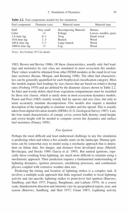
1982; Brown and Bevins 1986). Of these characteristics, usually only fuel load-ings and moistures by size class are simulated in most ecosystem fire models.Their values would be obtained from other FESM modules at the stand level (seelater sections) (Keane, Morgan, and Running 1996). The other fuel characteris-tics can be generally quantified for each biophysical classification category. Mostfire models require fuel loadings by size classes that are based on relative dryingrates (Fosberg 1970) and are defined by the diameter classes shown in Table 2.2.So litter and woody debris shed from vegetation compartments must be stratifiedby these size classes, which is rarely done in most ecosystem dynamics models.Pastor and Post (1985) stratify woody fuel by species and size class, but only tomore accurately simulate decomposition. Fire models also require a detaileddescription of the topography to simulate weather and fire spread. This is usuallytaken from digital elevation models (DEMs) (U.S. Geological Survey 1987). Last,the four stand characteristics of canopy cover, crown bulk density, stand height,and crown height will be needed to compute crown fire dynamics and surfacefuel moistures (Finney 1995).
Fire Ignition
Perhaps the most difficult and least understood challenge in any fire simulationis predicting when and where a fire actually starts on the landscape. Human igni-tions can be somewhat easy to model using a stochastic approach that is depen-dent on Julian date, fire danger, and distance from developed areas (Martell,Bevilacqua, and Stocks 1989; Garcia et al. 1995). But natural ignitions, espe-cially those resulting from lightning, are much more difficult to simulate using amechanistic approach. Their prediction requires a fundamental understanding oflightning dynamics, ignition processes, smoldering processes, and combustionphysics coupled with extensive weather data sets.
Predicting the timing and location of lightning strikes is a complex task. Itinvolves a multiple-scale approach that links regional weather to local lightningactivity and site-specific lightning strikes to point-level fuel ignition (Barrows,Sandberg, and Hart 1977; Fuquay, Baughman, and Latham 1979). At a coarsescale, thunderstorm direction and intensity vary by geographical region, year, andseason (Barrows, Sandberg, and Hart 1977; Uman 1987). Lightning activity
2. Simulation of Dynamics 39
Table 2.2. Fuel components needed for fire simulation
Fuel component Diameter (cm) Material name Material type
Duff Very small Decomposing Material HumusLitter <1 Foliage Leaves, needles, grass1-h time lag 0–1 Twig Small wood10-h time lag 1–3 Branch Wood100-h time lag 3–7 Large branch Wood1000-h time lag >7 Log Wood
Notes: See Fosberg 1972 for details.

within a single storm, such as the number of cloud-to-cloud and cloud-to-groundstrikes, also changes during the life of the storm as it passes over a region (Uman1987). Some lightning dynamics can be simulated by mesoscale climate models(Pielke et al. 1992), but the majority of factors that affect lightning activity arestill unknown. Land form, aspect, elevation, and slope position are major land-scape characteristics that can influence lightning strikes (Fowler and Asleson1984). And, at an organism level, Knight (1987) mentions that dead trees may bemore susceptible to lightning ignition but that live trees may be struck more oftenby lightning. Lightning strike locations and strike characteristics for cloud-to-ground lightning strikes are available across the United States using directional-finding and time-of-arrival technologies (Graham, Holle, and Lopez 1997). Thesedata can be used for model building, but the geo-referenced inaccuracies (0.4–4km) and limited sampling periods may prevent their use at fine scales.
The ignition of the fuel bed by the predicted lightning strike must also beexplicitly simulated in FESM (Hartford 1990). Electric energy from the lightningdischarge must be translated to heat of ignition for a given fuel bed, and thiscomplex process depends on average peak current, period of continuing current,charge, and fuel-bed characteristics (Latham 1983). Only a portion of lightningstrikes have the characteristics needed to start a fire (Fuquay et al. 1972; Lathamand Schlieter 1989). Positive charges start most fires because they have higherpeak currents and longer periods of continuing current (Fuquay 1980; Lathamand Schlieter 1989; Flannigan and Wotton 1991). Fuels must have high surfaceareas, low moistures, and sufficient fuel loading to sustain active burning andprovide the heat needed to start a wildfire (Fowler and Asleson 1984). Fuel mois-ture is greatly dependent on whether the lightning storm produced any rain.Latham and Schlieter (1989) describe stochastic approaches to simulating igni-tion on various fuel beds where arc duration, fuel moisture, and fuel-bed depthwere major factors in ignition success.
Initiation of smoldering and flaming combustion processes from lightning igni-tions will need to be simulated next in FESM (Hungerford, Frandsen, and Ryan 1995). Smoldering rates and heat of combustion depend on the bulk density,moisture content, and inorganic concentrations of the fuels (Latham and Schlieter 1989; Flannigan and Wotton 1991; Frandsen 1991a,b). The transitionof smoldering combustion sufficient to flaming combustion sufficient to start anactive wildland fire is also difficult to simulate because the fire could smolder forweeks and even months before fuel and weather conditions are conducive for theinitiation of a flaming surface fire. Excessive computer resources would berequired to simulate smoldering combustion processes at the requisite fine scalegiven the complexity of the models used to simulate this phenomenon (Frandsen1991a; Hungerford, Frandsen, and Ryan 1995). Clearly, since the smolderingcombustion is a fine-scale process acting on very small pieces of ground (1–5m2)(Frandsen 1991a), a detailed resolution of the input data layers describing fuels and moistures would be prohibitive for development and simulation efficiency.
40 R.E. Keane and M.A. Finney

The entire complex ignition process is often modeled using stochasticapproaches where the probability of a fire start is approximated from fire historyor stand structure data (see Johnson 1992; Johnson and Gutsell 1994; Boychuket al. 1997). Weibull functions and their derivatives are used to generate proba-bilities of fire occurrence for only stand-replacement fires (Van Wagner 1978;Johnson and Van Wagner 1985; Baker 1989a, 1993; Baker, Egbert, and Frazier1991). Reed (1994) used likelihood functions to estimate annual probability ofstand-replacement fire and Baker, Egbert, and Frazier (1991) used probabilitiesin the DISPATCH model to simulate the interaction of climate change on fireregime and landscape dynamics. Li et al. (1996) investigated the sensitivity offour fire probability functions and their parameters on fire rotation periods. Unfor-tunately, it is difficult to parameterize these functions because fire history and treeage data are unavailable, inadequate, or inappropriate for many stands (Fox 1989;Baker 1989a; Finney 1995; Boychuk et al. 1997). Moreover frequent, nonlethalfire regimes (i.e., not stand replacement) are often described from fire-scar evi-dence that does not accurately represent fire size (Marsden 1983; Fox 1989; Baker1989a; Finney 1995).
Perhaps the most efficient way to simulate fire starts is by a melding ofapproaches where mechanistic variables, dynamically linked to other FESM compartments, are used to drive stochastic functions. But it is problematic to simulate fire ignition stochastically, and then subsequent fire behavior mechanis-tically, to produce results that compare well to fires observed on the landscape(McKenzie, Peterson, and Alvarado 1996; Keane and Long 1997). Incompatibil-ities across module linkages may result when weather and spatial databases are inconsistent in time and space scales across the simulation of both processes.For example, the fire ignition module could start fires in wet periods if ignitionprobability functions do not include daily or monthly weather (Keane et al. 1997; Keane and Long 1997). This inconsistency is common in many spatiallyexplicit fire succession models, and more research is needed to pioneer compre-hensive and complementary techniques to link ignition with behavior.
Fire Growth Simulation
There are many fire behavior simulation models available for research and man-agement applications, but only a few are compatible with the mechanistic FESMdesign strategy. Fire growth models can be grouped by mechanistic and non-mechanistic approaches in a spatial or nonspatial implementation. Mechanistic,nonspatial models developed by Albini (1976a), Rothermel (1972, 1991),McArthur (1967), and Noble, Bary, and Gill (1980) are used extensively in landand fire management programs around the world. Computer programs contain-ing these models, such as BEHAVE (Andrews 1986), are the backbone of manyfire management programs. Nonspatial models with empirical approaches includethe Australian model developed by MacArther (1967) and quantified by Noble,Bary, and Gill (1980). Although these models are not as robust and sometimes
2. Simulation of Dynamics 41

have only local applications, they are useful because they require minimal datafor input and generate somewhat accurate predictions.
Spatially explicit fire behavior models have recently become important in land-scape ecology and fire management simulations (Andrews 1990). Accurate predictions of fire sizes and fire spread speeds and directions are critical toresearching and managing both prescribed fire and wildfire. These models arereviewed and categorized by Gardner, Romme, and Turner (1999) and somewhatby McCarthy and Gill (1997). We did not find any purely empirical spatial firemodels, but there are many mechanistic fire models that use a variety of sto-chastic, fractal, and geometric techniques to spread fire across landscapes.
The most common approach to mechanistic spatial fire modeling is to simu-late fire growth as a discrete process of cell-to-cell ignitions across a regularlyspaced landscape grid (i.e., cellular models). Kourtz and O’Reagan (1971) cal-culated fire arrival time for distances between the eight neighboring cells in a gridto compute which cell the fire spreads to first. Some cellular techniques use tem-plates of varying shapes and sizes to circumscribe fire perimeters (Green 1983),while others use stochastic percolation procedures (Von Niessen and Blumen1988; Beer and Enting 1990; Gardner et al. 1996), biased percolation (Ohtsukiand Keyes 1986), or fractal algorithms (Clarke, Brass, and Riggan 1994) to sim-ulate the uncertainty in fire spread across a landscape. Fire behavior in nonuni-form fuels was spatially simulated using hexagon-shaped pixels and mechanisticfire spread equations by Frandsen and Andrews (1979). Vasconcelos and Guertin(1992) linked a cellular fire spread model to a Geographic Information System(GIS) for fire management applications. Karafyllidis and Thanailakis (1997)incorporate weather and topography in their forest fire cell automata model.Turner et al. (1994) use a cellular model to investigate the effects of fire on landscape pattern in Yellowstone National Park. Cellular models can produceunrealistic fire shapes when environmental conditions and landscapes becomecomplex and heterogeneous because they do not respond well to subtle changesin diurnal wind speed, topography, wind direction, and fuel moisture (French1992).
Vector or wave approaches to fire growth modeling treat the fire front as a con-tinually expanding polygon using discrete timesteps (Anderson et al. 1982). Firepolygon boundaries are defined by a series of vertices (x, y coordinates) deter-mined from a computation of the spread rate and direction for the time interval(Richards 1995; Finney 1998). Huygens’s principle, which states that growthalong boundaries can be modeled as a progression of elliptical wavelets, was usedby Sanderlin and Sunderson (1975) and Finney (1998) to spatially grow fires.Richards (1990, 1995) analytically derived a differential equation to propagatefire from various points using elliptical and other fire shapes. Many others havealso developed procedures for computing fire perimeter positions based onHuygens’s principle (Anderson et al. 1982; Catchpole, Alexander, and Gill 1982;Dorrer 1993; Knight and Coleman 1993; Wallace 1993).
Many spatial fire models used in ecosystem simulations do not explicitly sim-ulate fire behavior, but rather infer subsequent fire effects from vegetation and
42 R.E. Keane and M.A. Finney

fuel characteristics inside a simulated burn perimeter. The EMBYR model(Gardner et al. 1996) spreads fire across the landscape using a stochastic cellautomata approach where probabilities are related to vegetation and fuel attrib-utes. Burn severity is calculated as a linear combination of fuel type, fuel mois-ture, wind speed, and cell burn rate. McCarthy and Gill (1997) use probabilitydistributions to compute fire ignition and size, and then used a cell automatamodel to spread this fire across the landscape. Green (1989) simulated landscapefires by drawing the number of fires from a Poisson distribution and the area burntfrom a geometric distribution. These types of cell automata models may be moreappropriate for midscale to coarse time and space scale applications (McKenzie,Peterson, and Alvarado 1996; Keane and Long 1997). Other landscape modelsconfine the spread process to mapped polygon boundaries and select the polygonto burn using probability distributions. Roberts and Betz (1999) simulated land-scape fire dynamics using fuzzy systems theory at the stand level. The SIMP-PLLE (Chew 1997) and CRBSUM (Keane et al. 1996) models simulate fire byselecting stands to be burned based on fire interval probabilities, and then mod-eling fire effects based on cover type and biophysical setting.
Specific properties and linkages are required to mechanistically simulate fireeffects on the landscape in FESM. Most important, the model must simulate firebehavior from attributes computed in other FESM components. For example,combustion processes are simulated from weather derived in the climate moduleand downed organic biomass (i.e., fuels) derived in the ecosystem dynamicsmodule to compute fire behavior characteristics. Next, FESM must have a spa-tially explicit fire spread simulation to incorporate large-scale influences (e.g.,topography) on fine-scale fire behavior so that realistic fire patterns are generatedacross the landscape. The model must also have the capability of simulating thetransition from surface to crown fire (Van Wagner 1977) and crown fire spread(Van Wagner 1977; Rothermel 1991). This is important for the computation ofsmoke, crown fuel consumption, and postfire tree mortality. Ember spotting, orthe ignition of additional fires downwind, must also be included in this fire modelbecause many fire patterns are a result of complex spot fires rather than the directspread of the main fire (Albini 1979). Next, the model might have the ability touse weather and vegetation characteristics computed from other FESM compo-nents (e.g., shading, wind damping) to dynamically compute fuel moistures athourly time steps (Rothermel et al. 1986).
Seed Abundance and Dispersal
Seed crop abundance and subsequent seed dispersal are needed to simulate themigration of plant species across a landscape. The amount and distribution ofplant propagules across landscapes play important roles in postfire successionaldynamics and subsequent landscape composition and structure. Seed crop abundance has rarely been mechanistically modeled because it is dependent onmany cross-scale factors including species, plant health, long-term weather trends(drought), short-term weather disturbances (winds, hail storms, early frosts), and
2. Simulation of Dynamics 43

animal predation (Eis and Craigdallie 1983; Shearer 1985). The frequency andintensity of seed crops is usually simulated by species at the landscape level using stochastic approaches where probabilities of seed crop classes (e.g., good,fair, and poor) are taken from field studies (Kercher and Axelrod 1984; Keane, Arno, and Brown 1989). Mechanistic approaches may be possible as eco-physiological research efforts quantify the relationships between plant carbonallocation to reproductive organs and growing environment (Landsberg andGower 1997).
Seed dispersal depends on many biotic and abiotic factors including propag-ule release height, topography (e.g., slope, elevation), wind speed and direction,tree density, and seed morphology (Johnson et al. 1981; Van der Pijl 1982; Greeneand Johnson 1996). In addition there are many vectors besides wind that disperseseeds across a landscape, including birds, rodents, water, and large mammals (Vander Pijl 1982). Many plant species regenerate primarily from organs that survivethe fire and these will be discussed in later sections.
Seed dispersal models have been developed for diverse spatial applications andmost simulate only tree species. Clark et al. (1998) developed a set of generaldispersal probability density functions (i.e., kernels) using the gamma functionto study long-distance seed dispersal of many forest species. Malanson and Armstrong (1996) modeled seed dispersal as a negative algebraic decay awayfrom source pixels using a Monte Carlo approach implemented in the JABOWA-II tree growth model (Botkin 1993; Malanson 1996). Keane, Morgan, andRunning (1996) used a hybrid approach where empirical dispersal equations for wind-dispersed species (McCaughey, Schmidt, and Shearer 1985) and bird-dispersed species (Tomback, Hoffman, and Sund 1990) generate probabilities of tree seed landing on any given landscape pixel. Animal and wind dispersalvectors are included in the McClanahan (1986) simulation of seedflow across vegetation islands. Andersen (1991) uses a more complex, physicalapproach to simulate seed shadows of plants whose seeds are dispersed by thewind. In a highly mechanistic approach, Greene and Johnson (1989) simulatedthe effect of flight morphology on seed dispersal for wind-dispersed plant species,and then improved the model to include microclimate effects (Greene andJohnson 1996).
A mechanistic simulation of seed dispersal may need to be simplified in themultiple-scale approach of FESM to increase computer efficiency. For example,dispersal could be simulated at the stand level instead of the organism level byusing average species height, wind direction and speed, elevation, and slope.These factors may then be integrated into a spatially explicit stochastic simula-tion of dispersal across the landscape (Keane, Morgan, and Running 1996a).Mladenoff et al. (1996) used forest age class structure rather that individual treesto simulate seed dispersal across large landscapes in the LANDIS model. Propag-ule dispersal from non-tree species may also need to be simplified for computa-tional efficiency because of the vast number of plant species and dispersal vectorson the landscape (Van der Pijl 1982).
44 R.E. Keane and M.A. Finney

Hydrologic Processes
The routing of water as it flows across the landscape is a critical link to the under-standing of stand-level water cycling, which can determine unique compositionsand processes for specific areas in the landscape. Many hydrologic models havebeen developed using varied approaches for diverse purposes. Band et al. (1991)partitioned the landscape into “hillslopes” to more effectively simulate overlandand subsurface water flow in the TOPMODEL. Beven and Kirkby (1979) constructed a basin hydrology model using a physical approach stratified by contributing landscape areas. Boumans and Sklar (1990) simulate hydrologicdrainage and its effect on forest succession in a Louisiana wetland. Narasimhan(1995) reviews hydrogeologic process-based models and approaches. The selec-tion of which hydrologic routing model to include in FESM would ultimatelydepend on modeling objectives. A simple and less comprehensive hydrologicrouting module might be suitable if only upland stand dynamics are important.If riparian stand dynamics or fire’s effect on streamflow is of concern, then adetailed representation of hydrologic processes should be included. However,detailed, physically based hydrology models have many parameters that requireintensive quantification and calibration, and model outputs can have a high levelof predictive uncertainty (Binley et al. 1991).
Stand and Organism Processes
FESM must contain specific model components and compartments at the standand organism simulation level to achieve the stated objective of exploring fire’srole in landscape dynamics (Fig. 2.4). Vegetation, fuels, and soils must be definedby an appropriate set of compartments that allow the application of model resultsto management issues and research problems (Fig. 2.4). The level of stratifica-tion of stand components again depends on simulation objective and desiredoutputs. A workhorse FESM module, called the ecosystem dynamics module, iswhere all stand and organism processes are simulated. Plant growth, regenera-tion, and mortality are simulated from climate drivers using mechanisticapproaches linked to landscape-level simulation results (Landsberg and Gower1997). The cycling of organic matter and nutrients is explicitly modeled from theprocesses of plant litterfall, atmospheric deposition, and decomposition (Waringand Schlesinger 1985). The effects of fire on abiotic and biotic components ofthe stand are also included in this module design.
Simulation Compartments
At least six types of organic material (detailed in Table 2.2) are needed to ade-quately represent forest floor dynamics at the stand level (Fig. 2.4) for linkage tofire behavior and ecosystem dynamics calculations. Woody material fallen fromthe canopy must be placed into four carbon pools depending on size of fallen
2. Simulation of Dynamics 45
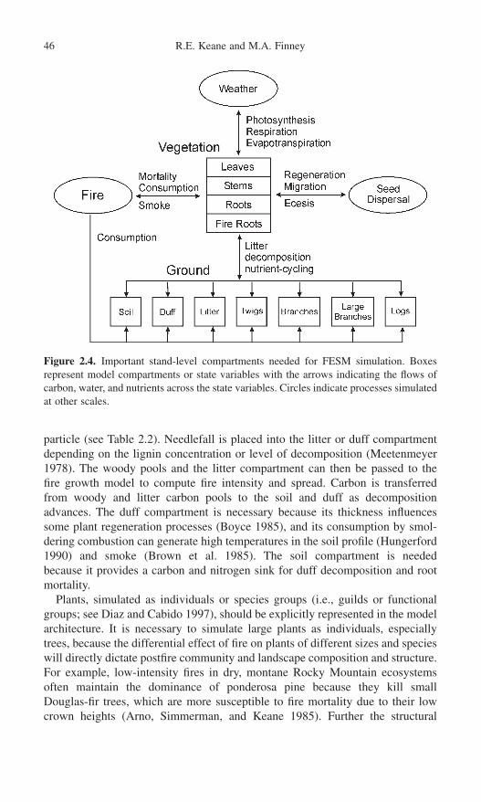
particle (see Table 2.2). Needlefall is placed into the litter or duff compartmentdepending on the lignin concentration or level of decomposition (Meetenmeyer1978). The woody pools and the litter compartment can then be passed to the fire growth model to compute fire intensity and spread. Carbon is transferred from woody and litter carbon pools to the soil and duff as decompositionadvances. The duff compartment is necessary because its thickness influencessome plant regeneration processes (Boyce 1985), and its consumption by smol-dering combustion can generate high temperatures in the soil profile (Hungerford1990) and smoke (Brown et al. 1985). The soil compartment is needed because it provides a carbon and nitrogen sink for duff decomposition and rootmortality.
Plants, simulated as individuals or species groups (i.e., guilds or functionalgroups; see Diaz and Cabido 1997), should be explicitly represented in the modelarchitecture. It is necessary to simulate large plants as individuals, especiallytrees, because the differential effect of fire on plants of different sizes and specieswill directly dictate postfire community and landscape composition and structure.For example, low-intensity fires in dry, montane Rocky Mountain ecosystemsoften maintain the dominance of ponderosa pine because they kill small Douglas-fir trees, which are more susceptible to fire mortality due to their lowcrown heights (Arno, Simmerman, and Keane 1985). Further the structural
46 R.E. Keane and M.A. Finney
Figure 2.4. Important stand-level compartments needed for FESM simulation. Boxes represent model compartments or state variables with the arrows indicating the flows ofcarbon, water, and nutrients across the state variables. Circles indicate processes simulatedat other scales.

characteristics of individual trees describe the vertical structure of the stand, soit is important to accurately simulate sunlight and rainfall attenuation through thecanopy and to model surface-to-crown fire transitions (Van Wagner 1977; Finney1998). It is probably not necessary, nor practical, to spatially locate each treeacross the simulated landscape or stand due to computer limitations and inade-quate research in mechanistic spatial plant interactions at fine scales.
Since there can be tens of thousands of individual plants within a stand, theremust be some simplification of plant representation in model structure to moreefficiently manage computer resources. Many models simulate only individualtrees and then represent other vascular plants by species or by groups of species(Shugart and West 1977; Keane, Morgan, and Running 1996). Moreover manymodels only simulate a small portion or vignette of a stand to increase simula-tion time, but this vignette must be large enough to adequately represent allecosystem processes and small enough to ensure efficient use of computerresources (Dale and Hemstrom 1984; Botkin 1993). FESM design should prob-ably limit individual plant simulation to only trees and represent the remainingplants by species, guilds, life-forms, or functional groups.
All plants or plant guilds should be represented by leaf, stem, coarse root, andfine root carbon and nitrogen compartments, such as in mechanistic stand-levelecosystem process models of FOREST-BGC (Running and Coughlan 1988;Running and Gower 1991) and CENTURY (Parton et al. 1987; Parton, Stewart,and Cole 1988) (Fig. 2.4). This way an efficient simulation can be obtained offire’s effects on many ecosystem processes, including photosynthesis, respiration,transpiration, and carbon allocation (Dixon et al. 1990; Bossel 1991; Mohren,Bartelink, and Lansen 1994). Ecophysiological single-tree models, such as Fire-BGC (Keane, Ryan, and Running 1996), TREE-BGC (Korol et al. 1991; Korol,Running, and Milner 1995) and HYBRID (Friend, Schugart, and Running 1993),require separate leaf, stem, coarse root, and fine root carbon and nitrogen com-partments for each tree. In addition plants must be described by the structuralcharacteristics that dictate fire, light, and water dynamics, such as height, age,diameter, and live crown height. Structural characteristics are also needed becausethey are used to initialize state variables, to compute intermediate variables fromallometric equations, and to summarize simulation results in a form useful tomanagement. For instance, the FARSITE model uses stand height, average livecrown base height, crown bulk density (derived from leaf area), and crownclosure to compute the transition and spread of crown fires. FESM design mustinclude these compartments for a comprehensive biogeochemical landscape sim-ulation so that the full range of fire and landscape interactions can be exploredacross various ecosystems and scales.
Ecosystem Dynamics Modeling
Ecosystem models can be classified into combinations of four categories: (1)stand level or plant level, (2) stand based or plant based, (3) mechanistic and non-mechanistic, and (4) spatial and nonspatial. A stand-level model simulates all
2. Simulation of Dynamics 47

ecosystem processes across a homogeneous piece of ground, whereas a plant-level model simulates the dynamics of only one plant. Plant-level models are difficult to scale up to stand level because of their inherent complexity and detail.As a result they are primarily used to investigate carbon and nutrient cycling pat-terns on plant growth (Bassow, Ford, and Kiester 1990; Host and Isebrands 1994;Zhang et al. 1994). ECOPHYS is a mechanistic whole-tree growth model forjuvenile poplar that includes morphological, phenological, and physiologicalinteractions in the simulation (Rauscher et al. 1990; Host and Isebrands 1994).Plant-level models are probably not appropriate for FESM. Stand-based modelssimulate stand characteristics as one entity instead of a collection of individualplants. For example, growth and yield models used in forestry simulate changesin stand basal area over time (Mohren, Bartelink, and Lansen 1994). Plant-basedmodels simulate interactions between and within individual plants and their envi-ronment across a stand to investigate ecosystem dynamics. Mechanistic modelsattempt to simulate basic biogeochemical processes from fundamental physicalrelationships and relate them to ecosystem dynamics. Ecosystem models thatdirectly simulate spatial interactions are called spatial models (Busing 1991). Asummary of these models is provided in Hunsaker et al. (1993) and Baker(1989b). We believe that only stand-level, and stand- and plant-based mechanis-tic models are appropriate for inclusion into FESM.
Stand-based, stand-level, mechanistic ecosystem models are commonly usedto explore the role of changing environment on ecosystem productivity. Grass-land ecosystem models are reviewed by Hanson, Parton, and Innis (1985), whilemodels of forest ecosystems are discussed by Dixon et al. (1990), Dale andRauscher (1994), and Ågren et al. (1991). The “big-leaf ” models such as Forest-BGC (Running and Coughlan 1988; Running and Gower 1991), Biome-BGC(Hunt et al. 1996), CENTURY (Parton et al. 1987; Parton, Stewart, and Cole1988), and BIOMASS (McMurtrie et al. 1992) simulate fluxes of carbon, nitro-gen, and water across stand-level stem, leaf, and root compartments to describeecosystem productivity (Ågren et al. 1991). The lumped-parameter PnET modelof Aber and Federer (1992) computes production from photosynthesisis, respira-tion, and evapotranspiration in temperate and boreal forests. Rastetter et al. (1991)built a highly aggregated biogeochemical model to investigate effects of CO2 andother environmental factors on plant and soil carbon and nitrogen.
Unfortunately, these standlevel models are rarely directly applicable to land-scape fire simulations because they fail to recognize those components that influ-ence fire occurrence, behavior, and effects. For example, fuel loadings by sizeclass categories (Table 2.2) are rarely simulated in these models, and none ofthese models explicitly represents the vegetation characteristics needed tocompute fire effects. The IMAGE 2.0 model developed by Goldewijk et al. (1994)does stratify organic matter pools by woody size classes but does not simulatefire and its effects on these compartments. Most stand-based models have beenimplemented in a spatial domain because they do not have the tremendousnumber of computations required by individual plant-based models. White (1996)integrated the Biome-BGC model into a spatial implementation and linked it to
48 R.E. Keane and M.A. Finney
the hydrology model TOPMODEL (Band et al. 1991) and other landscapemodules to study landscape carbon and water dynamics.
Many tree-based, stand-level, nonspatial mechanistic models are currentlyavailable for implementation into FESM (Dale, Doyle, and Shugart 1985), butonly a few have all compartments and processes critical for FESM construction.The gap-phase models, originating with JABOWA (Botkin, Janak, and Wallis1972) and FORET (Shugart and West 1977), are a special class of mechanisticmodels because they abstractly simulate the effect of environmental processes ontree regeneration, growth, and mortality using growth response functions (seereviews by Botkin and Schenk 1996; Dale and Rausher 1994; Dale, Doyle, andShugart 1985; Shugart and West 1980; Urban and Shugart 1992). Pacala,Canham, and Silander (1993) modified the JABOWA-FORET model to simulatespatial interactions between individual trees in a stand-level simulation. Somegap-phase models have the compartments and characteristics needed to simulatefire and fire effects, but very few include an explicit simulation of fire. Forexample, Dale, Hemstrom, and Franklin (1986) simulated fire as a probability oftree mortality on a simulation plot without regard to fuel loading, fire intensity,or topography. Examples of gap-phase fire models include BRIND (Shugart andNoble 1981), SILVA (Kercher and Axelrod 1984), FIRESUM (Keane, Arno, andBrown 1989), and ZELIG (Miller and Urban 1999a), where fire modules wereadded to compute fire effects at the stand level. A few gap-phase models havebeen implemented in landscape applications (Shugart and Seagle 1985; Urban etal. 1991; Mladenoff and Baker 1999).
The investigative power of gap-phase models was greatly improved when thegrowth modules were refined using more mechanistic approaches (Reed 1980;Huston, DeAngelis, and Post 1988; Dixon et al. 1990; Levine et al. 1993; Mohren,Bartelink, and Lansen 1994). For example, Friend, Shugart, and Running (1993)created the HYBRID model by merging the gap-phase model ZELIG (Burton and Urban 1990; Urban et al. 1991) with the stand-based mechanistic modelFOREST-BGC (Running and Coughlan 1988). Leemans and Prentice (1989)based the growth algorithm in FORSKA on photosynthesis calculations to simulate forest succession in a Swedish broad-leaved forest for seven species(Leemans 1992). Kimmins (1993) included nutrient dynamics, photosyntheticfunctions, and carbon allocation in the hybrid model FORCYTE-11, which com-bines the historical bioassay modeling approach with tree-level process-basedsimulation. Battaglia and Sands (1998) and Sharp (1986) provide a review offactors, scale, and objectives of the application of several process-based forestproductivity models.
Few individual tree gap models contain the compartments needed for multi-scale FESM simulations for two reasons. First, they rarely include a comprehen-sive simulation of non-tree plant species; the exceptions being FORSKA, whichsimulates species in the understory layer of broadleaf European forests (Leemansand Prentice 1989) and the Kellomäki and Vaissane (1991) model that simulatesthe understory in boreal ecosystems. Most simulate the undergrowth as life-formsor species guilds independent of tree-level processes (Kercher and Axelrod 1984;
2. Simulation of Dynamics 49

Keane, Arno, and Brown 1989). Second, gap-phase models seldom simulate theforest floor dynamics in compartments directly useful for fire modeling. Forexample, Kercher and Axelrod (1984) use only litter to carry the fire in theirSILVA model so there is no treatment of woody fuel dynamics. Miller and Urban (1999a,b) used downed, dead woody and herbaceous fuels to define a fuel bed.
Regeneration is the most difficult process to simulate in most plant-basedmodels (Pukkala 1987; Blake and Hoogenboom 1988). Once a seed has landedon the ground, it is subject to many environmental factors that may prevent ordelay its germination and ultimate development to a tree, including soil moisture,temperatures, seed bed condition, nutrient status, and competition from other treeseedlings. Because of the inherent complexity in plant regeneration processes,many models establish trees as saplings and ignore germination and seedlingdynamics (Blake and Hoogenboom 1988; Groot 1988; Botkin 1993). However,it is important that the effects of fire on regeneration processes be included in thissimplification. Keane, Arno, and Brown (1989) linked duff reduction by fire to regeneration success using empirical relationships from Boyce (1985). Fire-caused seedling mortality is important to understory dynamics (Kercher andAxelrod 1984). The postfire flush of nutrients to the soil from combustionprocesses can enhance seedling survival and germination for several years afterthe fire and must be accounted for in FESM model design (Grier 1975).
Fire Effects
Most fire effects would be computed at the stand and organism scale in FESMdesign but would translate upward in scale to affect landscape composition andstructure. It is impossible to simulate the full extent of fire’s influence on allecosystem components because of the complexity of fire processes and the lackof long-term field studies that take a comprehensive approach to the fire effectsresearch. Most research efforts study only one aspect of fire’s aftermath, such asfuel consumption, and do not link that effect to changes in ecosystem processesacross spatial and temporal scales. Currently there are five major fire effects thatshould be included, at a minimum, in FESM design—fuel consumption, plantmortality, soil heat pulse, smoke, and nutrient cycling. Other second-order fireeffects, such as soil erosion, are important but can be added to FESM as neededand will not be discussed here.
Fuel consumption is important because it affects carbon and nitrogen cycling,soil heat pulse, and smoke generation. Downed woody and litter consumptioncan be empirically calculated using consumption equations from the FOFEM(Reinhardt, Keane, and Brown 1997) or CONSUME (Ottmar et al. 1990) fireeffects models. Fuel consumption regression models exist for many areas of theUnited States, but these equations are often limited in scope and application (e.g.,Norum 1974; Sanberg 1980; Brown et al. 1985; Reinhardt, Keane, and Brown1997). An alternative is to use the mechanistic BURNOUT model (Albini et al.1995; Albini and Reinhardt 1995) to directly simulate fuel consumption from
50 R.E. Keane and M.A. Finney

active and smoldering combustion, but the required extensive inputs of fuel load-ings, moistures, and fuel characteristics may prohibit its use until computer tech-nology and research findings are sufficiently advanced.
A stochastic approach is usually employed for the computation of fire-causedtree mortality because of the complex interactions involved when a fire kills atree. First, fire can kill the tree’s cambium across all or some of the circumfer-ence of the stem, resulting in a wide array of mortality responses across a widevariety of tree species (Ryan, Peterson, and Reinhardt 1987; Ryan and Reinhardt1988). Next, heat generated from smoldering combustion can kill fine and coarseroots in the soil. And last and more common, fire can scorch all or part of thecrown to kill the tree outright or over the next few years (Van Wagner 1973; Peterson 1985). It is usually a combination of these factors that contributes to theeventual demise of a tree over short to long time periods. Ryan and Reinhardt(1988) developed a robust set of stochastic equations to predict fire-caused treemortality after one year for seven Rocky Mountain conifers. Variables in theseequations act as surrogates for fire mortality vectors discussed above, and theyinclude bark thickness (cambium insulation), percentage of crown scorched (lossof photosynthetic tissue), and species (fire resistance).
Evaluation of fire-caused mortality for non-tree plants is more difficult becausemany species in fire-dominated ecosystems have developed diverse and special-ized strategies to survive fires (Flinn and Wein 1977; Noble and Slatyer 1977;Grime 1979; Canham and Marks 1985). Shrubs often regenerate from rhizomesor root sprouts beneath the soil surface that are protected from fire. Grasses cansprout from deep-rooted rhizomes and corms, while forbs can regenerate frombulbs, corms, or caudices (Fischer and Bradley 1987; Stickney 1990). Someplants germinate from light seeds that are dispersed great distances to burn areas,while other plants germinate from seeds that have survived the fire either in thecanopy or in the soil (Stickney 1990). Still other species rely on birds to disperseseeds into recent burns (Tomback 1982; Tomback, Hoffman, and Sund 1990).FESM design should account for the diverse regenerative strategies that directlyinfluence successional dynamics, especially if management issues such as speciesbiodiversity and migration are important simulation objectives.
A simplified, computationally efficient method is needed to simulate under-growth fire successional dynamics. Cattelino et al. (1979) simulated successionafter fire using a vital attributes approach pioneered by Noble and Slatyer (1977).The FATE model also uses the vital attributes approach to simulate successionaldynamics of Australian forest and woodland communities (Moore and Noble1990). Roberts (1996) expanded the vital attributes concept into a more compre-hensive spatial fire succession model for Bryce National Park. Both Keane (1987)and Moeur (1985) used a regression techniques and vital attributes to predict post-fire species coverage. The Fire Effects Information System (Fischer et al. 1996)is a valuable source of input parameters and species descriptions needed in thesimulation of plant species dynamics. None of these models allow the directlinkage of climate, water, and light on understory plant survival and subsequentgrowth. Additional research is needed to link understory dynamics with the
2. Simulation of Dynamics 51
tree and climate compartments to comprehensively and mechanistically studypostfire succession.
The smoldering combustion of large woody fuel and duff after the flaming frontof the fire has passed causes a pulse of heat to move through the soil profile(Campbell et al. 1995). This heat pulse can kill plant roots, soil organisms, plantreproductive parts, and it can also alter important soil properties such as fertilityand texture (Flinn and Wein 1977; Levitt 1980) (Fig. 2.5). The duration and inten-sity of this heat pulse depends on many properties of the duff and soil such asdepth, inorganic content, moisture, texture, and temperature (Hungerford 1990).The heat pulse phenomenon can be simulated by a variety of mechanistic soilheat transfer models (see the review by Albini et al. 1996). Campbell et al. (1995)used a soil heat and moisture transport model to simulate soil temperatures atvarious soil depths under differing soil moisture conditions. Hungerford (1990)presents a conceptual model containing the major components needed to mech-anistically simulate soil heat pulse and its effect on plant tissue mortality. TheAston and Gill (1976), Philip and deVries (1957), and deVries (1958) models ofsoil heat and moisture transport were used as a basis for many other modelingefforts (Schroeder 1974; Jury 1973; Peter 1992). Unfortunately, very little isknown of the transfer of heat from the soil to living plant parts and the translation of that heat to plant mortality or reduction in vigor (Flinn and Wein1977).
Smoke production is becoming an increasingly important issue in fire researchand management, and its inclusion in a simulation of wildland fire is essential forthree reasons. First, smoke emissions from wildland fires are important green-house gases, and any comprehensive investigation of the effect of global climate
52 R.E. Keane and M.A. Finney
Figure 2.5. Critical temperatures for changes in important soil characteristics caused bythe heat pulse from fire.

change on ecosystem and carbon dynamics must include smoke inputs to theatmosphere (Ward 1990). Second, current smoke emission regulations oftenrestrict prescribed burning on many public lands because of the adverse effectson human health. It makes no sense to simulate detailed fire management sce-narios if the smoke generated by simulated fires would prevent their implemen-tation. Last, important minerals and nutrients are lost from the ecosystem in thesmoke plume. Nitrogen is volatilized during the combustion process and trans-ported away from the fire in smoke, as are other elements such as phosphorous,magnesium, and potassium (Ward 1990). It may be important to account for this loss in the nutrient cycle, especially where they are limited. Nutrient lossesare often computed from the proportion of the fuel consumed and the fuel type(Little and Ohmann 1988; Keane, Morgan, and Running 1996). Kutiel and Shaviv(1992) found postfire nutrient dynamics dictated successional trajectory andunderstory dynamics. These conclusions demonstrate that the direct linkage offire-caused changes in nutrient pools to ecosystem dynamics is essential for long-term successional simulations.
Smoke is directly related to the amount of fuel consumed and the rate or effi-ciency of combustion (Ward 1990). Smoke is easily computed by multiplying anemission factor by the amount of woody biomass consumed based on combus-tion efficiency (Reinhardt, Keane, and Brown 1997). Emission factors are avail-able for many forest species and woody fuel size classes (Ward, Peterson, andHao 1993). Especially important in smoke management issues is the dispersal ofsmoke over large land areas, which requires the rate of smoke production over time. This can be computed in FESM by linking the Albini et al. (1996)BURNOUT model with any of the current smoke dispersion models (see Breyfogle and Ferguson 1996) such as CALPUFF (Scire et al. 1995), VALBOX(Sestak, Marlatt, and Riebau 1989), PLUMP (Latham 1994), and SASEM (Sestakand Riebau 1988). This linkage would require comprehensive representation ofwind speed and direction at different atmospheric heights over several days fromthe climate module.
FESM Implementation
The acute complexity and detail involved in a strict mechanistic FESM designwould ultimately prevent its development because of previously mentionedreasons. However, it is possible to create a spatially explicit landscape fire modelusing parts or simplifications of the FESM structure presented here. Empiricaland stochastic modules can be substituted for some mechanistic components untiladequate research and computer technology become available. We have severalrecommendations for the successful construction of such a model. First, it isimperative that the simulation objectives be clearly defined prior to constructionso that appropriate modules can be designed and included in FESM structure(Korzukhin, Ter-Mikaelian, and Wagner 1996). The “shotgun” approach of sim-ulating every ecosystem process may allow investigation of many aspects of
2. Simulation of Dynamics 53

ecosystem dynamics, but ultimately it will lead to large, unwieldy computer pro-grams that require abundant computer resources and are only moderately useful.Second, it is more efficient if the model is constructed from a set of linked com-puter programs that can be easily added or removed from the simulation likebuilding blocks or tinker toys (Bevins and Andrews 1994; Bevins, Andrews andKeane 1995). Comprehensive simulation of ecosystem processes and their inter-actions is an extremely complex task and the development of detailed mechanis-tic models to simulate these processes is often best left to the appropriatediscipline. It may be more practical if simulation modules are simply taken frompreviously tested models and modified for inclusion in linked fire simulations.Last, there must be comprehensive verification and testing of intermediate andfinal simulation results to assess model behavior, sensitivity, accuracy, and pre-cision (Rastetter 1996). This requires extensive field data sets to validate internalalgorithms and parameters so that simulation computations can be interpreted inthe right context (Turner, Costanza, and Sklar 1989).
Simulation platforms can be useful tools for linking many simulation programswith databases, GIS, and other software to form a comprehensive computer appli-cation. Many complex simulation efforts use this integrated approach to link pro-grams into one application. The Loki system (Bevins and Andrews 1994) allowedKeane et al. (1996, 1997) to link the FARSITE fire behavior model with the seed dispersal model SEEDER, the Fire-BGC ecosystem process model, theFIRESTART model, and the GRASS GIS system (USA CERL 1990) to simulatethe role of fire on Glacier National Park ecosystems. Ford, Running, and Nemani.(1994) developed a modular system to link mechanistic ecosystem processmodels across several scales. An object-oriented, event-driven simulation systemwas developed by Bolte, Fisher, and Ernst (1993) to investigate the complexitiesof biological systems. Lauenroth et al. (1993) coupled four models to investigateinteractions between vegetation structure and ecosystem processes along envi-ronmental gradients.
Models of Landscape Change
Landscape change models investigate the role of disturbance, primarily fire, onlandscape dynamics, and several existing models provide examples of how FESMcomponents can be developed using different approaches integrated into a com-prehensive application. Baker (1989a) examines several models of landscapechange and groups them into whole, distributional, and spatial landscape modelsdepending on the level of data aggregation. Details of some landscape models arepresented in Mladenoff and Baker (1999). We only review landscape modelswhere spatial interactions are directly simulated in model design.
The LANDIS model was used to evaluate fire, wind throw, and harvest dis-turbance regimes on landscape pattern and structure (Mladenoff et al. 1996). Fireis indirectly simulated at the standlevel by quantifying fire effects based on ageclass structure, and succession is simulated as a competitive process driven by
54 R.E. Keane and M.A. Finney

species life history parameters. Roberts (1996) used life history parameters orvital attributes (Noble and Slatyer 1977) to drive succession in his polygon-basedmodel LANDSIM, which also simulates fire effects at the polygon level withouta fire spread model (Roberts and Betz 1999). The DISPATCH model of Baker(1992b, 1993) and Baker, Egbert, and Frazier (1991) stochastically simulates fireoccurrence and spread based on the dynamically simulated weather, fuel load-ings, and topographic setting, and then simulates subsequent forest succession asa change in cover type and stand age. The SIMPPLLE model (Chew 1997) usesa multiple-pathway approach to simulate succession on landscape polygons. Ituses a stochastic approach to determine when a polygon will burn. Miller (1994)implemented a spatial application of fire in the Zelig model to assess the inter-action of fire, climate, and pattern in Sierra Nevada forests (Miller and Urban1999a, 199b). Ratz (1995) used a single-pathway succession model linked to acellular automata fire spread model to simulate long-term fire patterns in borealforests. Keane and Long (1997) used a multiple-pathway succession model tosimulate coarse-scale fire succession, where fire is simulated as an independentstochastic process that can burn across polygon boundaries.
A major problem with many landscape fire models is the forcing of fire spreadalong polygon boundaries when actual fire growth depends on many factors other than vegetation. Weather, topography, wind, and landform all influence firepattern. As a result fire spread must be modeled independent of vegetation layerdelineations and allowed to transect and divide polygons to achieve realistic simulations. Another limitation of current landscape fire simulation efforts is theirinability to recognize the range of severities within and across stands. Daily fluc-tuations in wind and humidity can cause fine-scale differences in fire effectswithin a stand. Tree mortality, fuel consumption, and smoke can vary a great dealwithin a stand boundary because of changes in fire weather. Future models wouldneed to incorporate fine-scale fire severity patterns into the spatial design.
Conclusion
A comprehensive, mechanistic simulation of wildland fire and ecosystem dynam-ics across a landscape may not be possible because of computer limitations, inadequate research, inconsistent data, and extensive parameterization. Thereforeempirical and stochastic approaches must be substituted for many mechanisticmodules until research and technology improve. Unfortunately, nonmechanisticapproaches limit the scope and applicability of spatial ecosystem process models.Ecosystem dynamics models need to be refined so that appropriate compartmentsthat model fire spread and effects are explicitly represented in their structure.Landscape disturbance models need to simulate fire growth unconstrained by vegetation polygon delineations. Most important, these models must be designedin the context of the simulation objective to ensure that appropriate simulationmodules are included.
2. Simulation of Dynamics 55
References
Aber, J.D., and Federer, C.A. 1992. A generalized, lumped-parameter model of photo-synthesis, evapotranspiration, and net primary production in temperate and borealforest ecosystems. Oecologia 92:463–474.
Ågren, G.I., and Axelsson, B. 1980. PT-A tree growth model. Ecol. Bull. (Stockholm) 32:525–536.
Ågren, G.I., McMurtrie, R.E., Parton, W.J., Pastor, J., and Shugart, H.H. 1991. State-of-the-art of models of production-decomposition linkages in conifer and grasslandecosystems. Ecol. Appl. 1(2):118–138.
Albini, F.A. 1976a. Computer-Based Models of Wildland Fire Behavior: A User’s Manual.Ogden, UT: USDA Forest Service, Intermountain Forest and Range ExperimentStation. 68p.
Albini, F.A., and Reinhardt, E.D. 1995. Modeling ignition and burning rate of large woodynatural fuels. Int. J. Wildl. Fire 5(2):81–91.
Albini, F.A., Brown, J.K., Reinhardt, E.D., and Ottmar, R.D. 1995. Calibration of a largefuel burnout model. Int. J. Wildl. Fire 5(3):173–192.
Albini, F.A., Amin, M.R., Hungerford, R.D., Frandsen, W.H., and Ryan, K.C. 1996.Models for fire-driven heat and moisture transport in soils. USDA Forest Service Gen.Tech. Rep. INT-GTR-335. 16p.
Andersen, M. 1991. Mechanistic models for the seed shadows of wind-dispersed plants.The Am. Naturalist 137(4):476–497.
Anderson, D.G., Catchpole, E.A., DeMestre, N.J., and Parkes, T. 1982. Modeling thespread of grass fires. J. Austral. Math. Soc. (ser. B.) 23:451–466.
Anderson, H.E. 1969. Heat transfer and fire spread. Res. Pap. INT-69. Ogden, UT: USDA,Forest Service, Intermountain Forest and Range Experiment Station. 20p.
Anderson, H.E. 1982. Aids to determining fuel models for estimating fire behavior. Gen.Tech. Rep. INT-122. Ogden, UT: USDA Forest Service, Intermountain Forestry andRange Experimental Station. 22p.
Andrews, P.L. 1986. BEHAVE: Fire behavior prediction and fuel modeling system—BURN subsystem. USDA Forest Service Gen. Tech. Rep. INT-194. 130p.
Andrews, P.L. 1990. Application of fire growth simulation models in fire management. InProceedings of the 10th Conference on Fire and Forest Meteorology, pp. 317–321.April 17–21, Ottawa, Canada. Society of American Foresters, Washington, DC.
Arno, S.F., Simmerman, D.G., and Keane, R.E. 1985. Forest succession on four habitattypes in western Montana. Gen. Tech. Rep. INT-177. Ogden, UT: USDA ForestService, Intermountain Forest and Range Experiment Station. 74p.
Aston, A.R., and Gill, A.M. 1976. Coupled soil moisture, heat, and water vapor transfersunder simulated fire conditions. Austral. J. Soil Res. 14:55–66.
Baker, W.L. 1989a. Effect of scale and spatial heterogeneity on fire-interval distributions.Can. J. For. Res. 19:700–706.
Baker, W. L. 1989b. A review of models of landscape change. Landscape Ecol. 2(2):111–133.
Baker, W.L. 1992a. Effects of settlement and fire suppression on landscape structure.Ecology 73:1879–1887.
Baker, W.L. 1992b. The landscape ecology of large disturbances in the design and man-agement of nature reserves. Landscape Ecol. 7(3):181–194.
Baker, W.L. 1993. Spatially heterogeneous multi-scale response of landscapes to fire sup-pression. Oikos 66:66–71.
Baker, W.L., Egbert, S.L., and Frazier, G.F. 1991. A spatial model for studying the effectsof climatic change on the structure of landscapes subject to large disturbances. Ecol.Model. 56:109–125.
Ball, G.L., and Gimblett, R. 1992. Spatial dynamic emergent hierarchies simulation andassessment system. Ecol. Model. 62:107–121.
56 R.E. Keane and M.A. Finney

Band, L.E., Peterson, D.L., Running, S.W., Coughlan, J., Lanners, R., Dungan, J., andNemani, R. 1991. Forest ecosystem processes at the watershed scale: basis for dis-tributed simulation. Ecol. Model. 56:171–196.
Barrows, J.S., Sandberg, D.V., and Hart, J.D. 1977. Lightning fires in Northern RockyMountain forests. USDA Forest Service Final Report for Contract Grant 16-440-CA.On file, USDA Forest Service, Intermountain Fire Sciences Laboratory, P.O. Box 8089,Missoula, MT. 221p.
Bassow, S.L., Ford, E.D., and Kiester, A.R. 1990. A critique of carbon-based tree growthmodels. In Process Modeling of Forest Ggrowth Responses to Environmental Stress,eds. R.K. Dixon, R.S. Meldahl, G.A. Ruark, and W.G. Warren, pp. 50–57. Portland,OR: Timber Press.
Battaglia, M., and Sands, P.J. 1998. Process-based forest productivity models and theirapplication in forest management. For. Ecol. Manag. 102:13–32.
Beer, T., and Enting, I.G. 1990. Fire spread and percolation modelling. Mathl. Comput.Model. 13(11):77–96.
Beven, K.J., and Kirkby, M.J. 1979. A physically based, variable contributing area modelof basin hydrology. Hydrol. Sci. Bull. 24(1):43–69.
Bevins, C.D., and Andrews, P.L. 1994. The Loki software architecture for fire and ecosys-tem modeling: A tinker toy approach. In 12th Conference on Fire and Forest Meteo-rology, pp. 252–260, October 26–28, Jekyll Island, GA. Society of American Foresters,Washington, DC.
Bevins, C.D., Andrews, P.L., and Keane, R.E. 1995. Forest succession modelling usingthe Loki software architecture. Lesnictvi-Forestry 41(4):158–162.
Binley, A.M., Beven, K.J., Calver, A., and Watts, L.G. 1991. Changing responses in hydrol-ogy: Assessing the uncertainty in physically based model predictions. Water ResourcesRes. 27(6):1253–1261.
Blake, J.I., and Hoogenboom, G. 1988. A dynamic simulation of loblolly pine (Pinustaeda) seedling establishment based upon carbon and water balances. Can. J. For. Res.18:833–850.
Blyth, E.M., Dolman, A.J., and Noilhan, J. 1994. The effect of forest on mesoscale rainfall: An example from HAPEX-MOBILHY. J. Appl. Meteorol. 33(4):445–454.
Bolte, J.P., Fisher, J.A., and Ernst, D.H. 1993. An object-oriented, message-based envi-ronment for integrating continuous, event-driven and knowledge-based simulation. In Proceedings of Conference on Application of Advanced Information Technologies:Effective Management of Natural Resources, pp. 290–308, June 18–19, Spokane, WA.American Society of Agricultural Engineers.
Bossel, H. 1991. Modeling forest dynamics: Moving from description to explanation.Forest Ecol. Manag. 42:129–142.
Bossel, H., and Schäfer, H. 1988. Eco-physiological dynamic simulation model of treegrowth, carbon, and nitrogen dynamics. In Forest Simulation Systems: Proceedings of the IUFRO Conference, eds. L.C. Wensel, G.S. Biging. November 2–5, 420p. Berkeley, CA: University of California, Division of Agriculture and Natural Resources.pp. 121–122.
Botkin, Daniel B. 1993. Forest Dynamics: An Ecological Model. New York: Oxford University Press.
Botkin, D.B., and Schenk, H.J. 1996. Review and analysis of JABOWA and related forestmodels and their use in climate change studies. NCASI Tech. Bull. 717. 62p.
Botkin, D.B., Janak, J.F., and Wallis, J.R. 1972. Some ecological consequences of a com-puter model of forest growth. J. Ecol. 60:849–872.
Boumans, R.M.J., and Sklar, F.H. 1990. A polygon-based spatial (PBS) model for simu-lating landscape change. Landscape Ecol. 4(2/3):83–97.
Boyce, R.B. 1985. Conifer germination and seedling establishment on burned andunburned seedbeds. MS thesis. University of Idaho, Moscow.
2. Simulation of Dynamics 57

Boychuk, D., Perera, A.H., Ter-Mikaelian, M.T., Martell, D.L., and Li, C. 1997. Model-ling the effect of spatial scale and correlated fire disturbances on forest age distribu-tion. Ecol. Model. 95:143–162
Breyfogle, S., and Ferguson, S.A. 1996. User assessment of smoke-dispersion models forwildland biomass burning. USDA Forest Service Gen. Tech. Rep. PNW-GTR-379. 30p.
Brown, J.K. 1970. Ratios of surface area to volume for common fire fuels. For. Sci. 16:101–105.
Brown, J.K. 1981. Bulk densities of nonuniform surface fuels and their application to firemodeling. For. Sci. 27:667–683.
Brown, J.K., and Bevins, C.D. 1986. Surface fuel loadings and predicted fire behavior forvegetation types in the Northern Rocky Mountains. Res. Note INT-358. Ogden, UT:USDA Forest Service, Intermountain Forest and Range Experiment Station. 9p.
Brown, J.K., Marsden, M.A., Ryan, K.C., and Reinhardt. E.D. 1985. Predicting duff andwoody fuel consumed by prescribed fire in the Northern Rocky Mountains. Res. Pap.INT-337. Ogden, UT: USDA Forest Service, Intermountain Forest and Range Experi-ment Station. 23p.
Burgan, R.E., and Rothermel, R.C. 1984. BEHAVE: Fire behavior prediction and fuel mod-eling system—FUEL subsystem. USDA Forest Service Gen. Tech. Rep. INT-167. 126p.
Burton, P.J., and Urban, D.L. 1990. An overview of ZELIG, a family of individual-basedgap models simulating forest succession. In Symposia Proceedings Vegetation Man-agement: An Integrated Approach, E. Hamilton, (compiler), November, 14–16, pp.92–96, Victoria, BC. Forestry Canada Pacific Forestry Centre FRDA Rep. 109.
Busing, R.T. 1991. A spatial model of forest dynamics. Veg. Sci. 92:167–179.Campbell, G.S., Jungbauer, J.D., Bristow, K.L., and Hungerford, R.D. 1995. Soil temper-
ature and water content beneath a surface fire. Soil Sci. 159(6):363–374.Canham, C.D., and Marks, P.L. 1985. The response of woody plants to disturbance: pat-
terns of establishment and growth. In The Ecology of Natural Disturbance and PatchDynamics, pp. 197–216. S.T.A. Piclult and P.S. White, San Diego, CA: Academic Press
Catchpole, E.A., Alexander, M.E., and Gill, A.M. 1982. Elliptical fire perimeter and areaintensity distributions. Can. J. For. Res. 22:968–972.
Cattelino, P.J., Noble, I.R., Slatyer, R.O., and Kessell, S.R. 1979. Predicting multiple path-ways of plant succession. Environ. Manag. 3:41–50.
Chew, J.D. 1997. Simulating landscape patterns and processes at landscape scales. In Proceedings of the 11th Annual Symposium on Geographic Information Systems, pp.287–291. Vancouver, B.C. GIS World Publications, Fort Collins, CO.
Cipollini, M.L., Wallace-Senft, D.A., and Whigham, D.F. 1994. A model of patch dynam-ics, seed dispersal, and sex ratio in the dioecious shrub Lindera benzoin (Lauraceae).J. Ecol. 82:621–633.
Clark, J.S., Fastie, C., Hurtt, G., Jackson, S.T., Johnson, C., King, G., Lewis, M., Lynch,J., Pacala, S., Prentice, C., Schupp, E.W., Webb, T., and Wyckoff, P. 1998. Reid’sParadox of rapid plant migration. Biosci. 48:13–18.
Clarke, K.C., Brass, J.A., and Riggan, P.J. 1994. A cellular automaton model of wildfirepropagation and extinction. Photogramm. Eng. Rem. Sens. 60(11):1355–1367.
Crutzen, P.J., and Goldammer, J.G. 1993. Fire in the Environment: The Ecological, Atmospheric and Climatic Importance of Vegetation Fires. New York: Wiley.
Dale, V.H., Doyle, T.W., and Shugart, H.H. 1985. A comparison of tree growth models.Ecol. Model. 29:145–169.
Dale, V.H., and Hemstrom, M. 1984. CLIMACS: A computer model of forest stand development for western Oregon and Washington. USDA Forest Service Res. Pap.PNW-327. Portland, OR: USDA Forest Service, Pacific Northwest Forest and RangeExperiment Station. 60p.
Dale, V.H., Hemstrom, M., and Franklin, J. 1986. Modeling the long-term effects of disturbances on forest succession, Olympic Peninsula, Washington. Can. J. For. Res.16:56–67.
58 R.E. Keane and M.A. Finney

Dale, V.H., and Rauscher, H.M. 1994. Assessing impacts of climate change on forests:The state of biological modeling. Clim. Change 28:65–90.
Desanker, P.V., and Reed, D.D. 1991. A stochastic model for simulating daily growingseason weather variables for input into ecological models. In: M.A. Buford (compiler).Proceedings of the 1991 Symposium on Systems Analysis in Forest Resources, pp. 1–11,March 3–6, Charleston, SC. USDA Forest Service Gen. Tech. Rep. SE-74.
DeVries, D.A. 1958. Simultaneous transfer of heat and moisture in porous media. Trans.Am. Geophys. Union 39:909–916.
Diaz, S., and Cabido, M. 1997. Plant functional types and ecosystem function in relationto global change. J. Veg. Sci. 8:121–133.
Dickinson, R.E., Erroco, R.M., Giorgi, F., and Bates, G.T. 1989. A regional climate modelfor the western United States. Clim. Change 15:383–422.
Dixon, R.K., Meldahl, R.S., Ruark, G.A., and Warren, W.G., eds. 1990. Process Modelling of Forest Growth Responses to Environmental Stress. Portland, OR: TimberPress.
Dyer, J.M. 1995. Assessment of climatic warming using a model of forest species migration. Ecol. Model. 79:199–219.
Eis, S., and Craigdallie, D. 1983. Reproduction of conifers: A handbook for cone cropassessment, pp. 12–27. Canadian Forest Service Tech. Rep. 31.
Everham, E.M., Wooster, K.B., and Hall, C.A.S. Forest landscape climate modeling. In:M.A. Buford (compiler). Proceedings of the 1991 Symposium on Systems Analysis inForest Resources, March 3–6, pp. 11–16, Charleston, SC. USDA Forest Service Gen.Techn. Rep. SE-74.
Fall, J., and Fall, A. 1996. SELES: A spatially explicit landscape event simulator. In Proceedings of the NCGIA Conference on GIS and Environmental Modeling, January12, pp. 1–12, Santa Fe, NM.
Finney, M.A. 1995. The missing tail and other considerations for the use of fire historymodels. Int. J. Wildl. Fire 5(4):197–202.
Finney, M.A. 1998. FARSITE: Fire area simulator—Model development and evaluation.USDA Forest Service Gen. Tech. Rep. RMRS-GTR-4. 47p.
Fischer, W.C., and Bradley, A.F. 1987. Fire ecology of western Montana forest habitat types. Gen. Tech. Rep. INT-223. Intermountain Research Station. USDA Forest Service.95p.
Fischer, W.C., Miller, M., Johnston, C.M., Smith, J.K., Simmerman, D.G., and Brown,J.K. 1996. Fire effects information system: User’s guide. USDA Forest Service Gen.Tech. Rep. INT-GTR-327. 131p.
Flannigan, M.D., and Wotton, B.M. 1991. Lightning-ignited forest fires in northwesternOntario. Can. J. For. Res. 21:277–287.
Flinn, M.A., and Wein, R.W. 1977. Depth of underground plant organs and theoretical survival during fire. Can. J. Bot. 55:2550–2554.
Ford, R., Running, S.W., and Nemani, R. 1994. A modular system for scalable ecologicalmodeling. IEEE Comp. Sci. Eng. 10:32–44.
Forman, R.T.T., and Godron, M. 1986. Landscape Ecology. New York: Wiley.Fosberg, M.A. 1970. Drying rates of heartwood below fiber saturation. For. Sci. 16:57–63.Fowler, P.M., and Asleson, D.O. 1984. The location of lightning-caused wildland fires,
Northern Idaho. Phys. Geogr. 5(3):240–253.Fox, J.F. 1989. Bias in estimating forest disturbance rates and tree lifetimes. Ecology 70(5):
1267–1272.Frandsen, W.H., and Andrews, P.L. 1979. Fire behavior in nonuniform fuels. Res. Pap.
INT-232. Ogden, UT: USDA Forest Service, Intermountain Forest and Range Experiment Station. 34p.
Frandsen, W.H. 1991a. Heat evolved from smoldering peat. Int. J. Wild. Fire 1:197–204.Frandsen, W.H. 1991b. Burning rate of smoldering peat. Northwest Sci. 65(4):166–
172.
2. Simulation of Dynamics 59

French, I.A. 1992. Visualization techniques for the computer simulation of bushfires intwo dimensions. M.S. thesis. University of New South Wales, Australian Defence ForceAcademy. 140p.
Friend, A.D., Shugart, H.H., and Running, S.W. 1993. A physiology-based gap model offorest dynamics. Ecology. 74(3):792–797.
Fuquay, D.M. 1980. Lightning that ignites forest fires. In Proceedings, Sixth Conferenceon Fire and Meteorology, pp. 109–112. April 22–24, Seattle, WA. Society of American Foresters, Washington, DC.
Fuquay, D.M., Baughman, R.G., and Latham, D.J. 1979. A model for predicting lightning-fire ignition in wildland fuels. USDA Forest Service Res. Pap. INT-217. 21p.
Fuquay, D.M., Taylor, A.R., Hawe, R.G., and Schmid, C.W. 1972. Lightning dischargesthat caused forest fires. J. Geophy. Res. 77:2156–2158.
Garcia, C.V., Woodard, P.M., Tinus, S.J., Adamowicz, W.L., and Lee, B.S. 1995. A logitmodel for predicting the daily occurrence of human caused forest fires. Int. J. Wild.Fire 5(2):101–111.
Gardner, R.H., Hargrove, W.W., Turner, M.G., and Romme, W.H. 1996. Climate change,disturbances and landscape dynamics. pp. 149–172. In Global Change and TerrestrialEcosystems, ed. B.H. Walker and W.L. Steffen. Cambridge: Cambridge UniversityPress.
Gardner, R.H., Romme, W.H., and Turner, M.G. 1999. Predicting forest fire effects at land-scape scales. In Spatial Modeling of Forest Landscape Change: Approaches and Applications, eds. D.J. Mladenoff and W.L. Baker, pp. 163–185. Cambridge: Cam-bridge University Press.
Gay, C.A. 1989. Modeling tree level processes. In Proceedings of the Second US–USSRSymposium Air Pollution Effects on Vegetation Including Forest Ecosystems, eds. I.Nobel and D. Reginald, pp. 143–155. Broomall, PA, September 1989.
Giorgi, F., Marinucci, M.R., Bates, G.T., and Canio, G.D. 1993a. Development of a secondgeneration regional climate model (RegCM2). I. Boundary-layer and radiative trans-fer processes. Mon. Wea. Rev. 121:2794–2813.
Giorgi, F., Marinucci, M.R., Bates, G.T., and Canio, G.D. 1993b. Development of a secondgeneration regional climate model (RegCM2). II. Convective processes and assimila-tion of lateral boundary conditions. Mon. Wea. Rev. 121:2813–2832.
Goldewijk, K.K., van Minnen, J.G., Kreileman, G.J., Vloedbeld, M., and Leemans, R.1994. Simulating the carbon flux between the terrestrial environment and the atmos-phere. Water Air Soil Pollut. 76:199–230.
Goodchild, M.F., Parks, B.O., and Steyaert, L.T. 1993. Environmental Modeling with GIS.New York: Oxford University Press.
Graham, B.L., Holle, R.L., and Lopez, R.E. 1997. Lightning detection and data use in theUnited States. Fire Manag. Notes 57(2):4–9.
Green, D.G. 1983. Shapes of simulated fires in discrete fuels. Ecol. Model. 20:21–32.Green, D.G. 1989. Simulated effects of fire, dispersal and spatial pattern on competition
within forest mosaics. Vegetatio 82:139–153.Greene, D.F., and Johnson, E.A. 1989. A model of wind dispersal of winged or plumed
seeds. Ecol. 70:339–347.Greene, D.F., and Johnson, E.A. 1996. Wind dispersal of seeds from a forest into a clear-
ing. Ecol. 77(2):595–609.Grier, C.C. 1975. Wildfire effects on nutrients distribution and leaching in a coniferous
ecosystem. Can. J. For. Res. 5:599–607.Grime, J.P. 1979. Plant Strategies and Vegetation Processes. New York: Wiley.Groot, A. 1988. Methods for estimating seedbed receptivity and for predicting seedling
stocking and density in broadcast seeding. Can. J. For. Res. 18:1541–1549.Hanson, J.D., Parton, W.J., and Innis, G.S. 1985. Plant growth and production of
grassland ecosystems: a comparison of modelling approaches. Ecol. Model. 29:131–144.
60 R.E. Keane and M.A. Finney

Hartford, R.A. 1990. Smoldering combustion limits in peat as influenced by moisture,mineral content, and organic bulk density. In Proceedings of the 10th Conference onFire and Forest Meteorology, eds. D.C. MacIver, H. Auld, R. Whitewood, pp. 282–286.April 17–21, Ottawa, Ontario. Forestry Canada, Petawawa National Forestry Institute,Chalk River, Ontario.
Host, G.E., and Isebrands, J.G. 1994. An interregional validation of ECOPHYS, a growthprocess model of juvenile poplar clones. Tree Physiol. 14:933–945.
Hsie, E.Y. 1987. MM4 (Penn State/NCAR) mesoscale model version 4 documentation.NCAR Tech. Note, NCAR/TN294 + STR, National Center for Atmospheric Research,P.O. Box 3000, Boulder, CO 80307. 215p.
Hungerford, R.D. 1990. Modeling the downward heat pulse from fire in soils and in planttissue. In Proceedings of the 10th Conference on Fire and Forest Meterology, eds. D.C.MacIver, H. Auld, R. Whitewood, pp. 148–151. April 17–21, Ottawa, Ontario. ForestryCanada, Petawawa National Forestry Institute, Chalk River, Ontario.
Hungerford, R.D., Frandsen, W.H., and Ryan, K.C. 1995. Ignition and burning character-istics of organic soils. In Fire in Wetlands: A Management Perspective. Proceedingsof the Tall Timbers Fire Ecology Conference No. 19, eds. S.I. Cerulean and R.T.Engstrom, pp. 78–91. Tallahasee, FL. Tall Timbers Research Station.
Hungerford, R.D., Nemani, R.R., Running, S.W., and Coughlan, J.C. 1989. MTCLIM: Amountain microclimate simulation model. Research Paper INT-414. Ogden, UT: USDAForest Service, Intermountain Research Station. 52p.
Hunsaker, C.T., Nisbet, R.A., Lam, D.C., Brower, J.A., Baker, W.L., Turner, M.G., andBotkin, D.B. 1993. Spatial models of ecological systems and processes: The role ofGIS. In Environmental Modeling with GIS, eds. M.F. Goodchild, B.O. Parks, L.T.Steyaert, pp. 248–264. New York: Oxford University Press.
Hunt, E.R., Piper, S.C., Nemani, R., Keeling, C.D., Otto, R.D., and Running, S.W. 1996.Global net carbon exchange and intra-annual atmospheric CO2 concentrations predictedby an ecosystem process model and three-dimensional atmospheric transport model.Global Biogeochem. Cycles 10(3):431–456.
Huston, M., DeAngelis, D., and Post, W. 1988. New computer models unify ecologicaltheory. BioScience 38(10):682–691.
Johnson, E.A. 1992. Fire and Vegetation Dynamics: Studies from the North AmericanBoreal Forest. New York: Cambridge University Press.
Johnson, E.A., and Gutsell, S.L. 1994. Fire frequency models, methods, and interpreta-tions. Adv. Ecol. Res. 25:239–285.
Johnson, E.A., and Van Wagner, C.E. 1985. The theory and use of two fire history models.Can. J. For. Res. 15:214–220.
Johnson, W.C., Sharpe, D.M., DeAngelis, D.L., Fields, D.E., and Olson, R.J. 1981. Modeling seed dispersal and forest island dynamics. In Forest Island Dynamics in Man-Dominated Landscapes, eds. R.L. Burgess and D.M. Sharpe, pp. 215–239. NewYork: Springer.
Jury, W.A. 1973. Simultaneous transport of heat and moisture through a medium sand. Ph.D. dissertation. Physics Department, University of Wisconsin, Madison. 19p.
Karafyllidis, I., and Thanailakis, A. 1997. A model for predicting forest fire spreading usingcellular automata. Ecol. Model. 99:87–97.
Keane, R.E. 1987. Forest succession in western Montana—A computer model designedfor resource management. Res. Note INT-376. USDA Forest Service, IntermountainResearch Station. 8p.
Keane, R.E., Arno, S.F., and Brown, J.K. 1989. FIRESUM—An ecological process modelfor fire succession in Western conifer forests. Gen. Tech. Rep. INT-266. Ogden, UT:USDA Forest Service, Intermountain Research Station. 76p.
Keane, R.E., Arno, S.F., and Brown, J.K. 1990. Simulating cumulative fire effects in ponderosa pine/Douglas-fir forests. Ecology 71(1):189–203.
2. Simulation of Dynamics 61

Keane, R.E., Morgan, P., and Running, S.W. 1996. Fire-BGC—A mechanistic ecologicalprocess model for simulating fire succession on coniferous forest landscapes of theNorthern Rocky Mountains. USDA Forest Service Res. Pap. INT-484. 122p.
Keane, R.E., Long, D.G., Menakis, J.P., Hann, W.J., and Bevins, C. 1996. Simulatingcoarse scale vegetation dynamics with the Columbia River Basin succession modelCRBSUM. USDA Forest Service Gen. Tech. Rep. INT-GTR-340. 50p.
Keane, R.E., Hardy, C.C., Ryan, K.C., and Finney, M.A. 1997. Simulating effects of fireon gaseous emissions from future landscape of Glacier National Park, Montana, USA.World Resources Rev. 9(2):177–205.
Keane, R.E., and Long, D.G. 1997. A comparison of coarse scale fire effects simulationstrategies. Northwest Sci. 72(2):76–90.
Keane, R.E., Rarsons, R., and Hessburg, P. 2002. Estimating historical range and varia-tion of landscape path dynamics: Limitations of the simulation approach. Ecol. Model.(In press).
Kellomäki, S., and Väisänen, H. 1991. Application of a gap model for the simulation offorest ground vegetation in boreal conditions. For. Ecol. Manag. 42:35–47.
Kercher, J.R., and Axelrod, M.C. 1984. A process model of fire ecology and successionin a mixed-conifer forest. Ecology 65(6):1725–1742.
Kessell, S.R., Good, R.B., and Hopkins, A.J.M. 1984. Implementation of two new resourcemanagement information systems in Australia. Environ. Manag. 8:251–270.
Kimmins, J.P. 1993. Scientific foundations for the simulation of ecosystem function andmanagement in FORCYTE-11. Inf. Rep. NOR-X-328. Edmonton, Alberta: ForestryCanada, Northwest Region, Northern Forestry Centre. 88p.
Knight, D.H. 1987. Parasites, lightning and the vegetation mosaic in wilderness andscapes.In Landscape Heterogeneity and Disturbance, ed. M.G. Turner, pp. 59–83. New York:Springer-Verlag.
Knight, I., and Coleman, J. 1993. A fire perimeter expansion algorithm based on Huygens’wavelet propagation. Int. J. Wild. Fire 3(2):73–84.
Korol, R.L., Running, S.W., Milner, K.S., and Hunt, E.R. 1991. Testing a mechanisticcarbon balance model against observed tree growth. Can. J. For. Res. 21:1098–1105.
Korol, R.L., Running, S.W., and Milner, K.S. 1995. Incorporating intertree competitioninto an ecosystem model. Can. J. For. Res. 25:413–424.
Korzukhin, M.D., Ter-Mikaelian, M.T., and Wagner, R.G. 1996. Process versus empiricalmodels: which approach for forest ecosystem management? Can. J. For. Res. 26:879–887.
Kourtz, P., and O’Reagan, W.G. 1971. A model for a small forest fire to simulate burnedand burning areas for use in a detection model. For. Sci. 17(2):163–169.
Kutiel, P., and Shaviv, A. 1992. Effects of soil type, plant composition and leaching onsoil nutrients following a simulated forest fire. For. Ecol. Manag. 53:329–343.
Lall, U., and Sharma, A. 1996. A nearest neighbor bootstrap for time series resampling.Water Resources Res. 32(3): 679–693.
Landsberg, J.J., and Gower, S.T. 1997. Applications of Physiological Ecology to ForestManagement. San Diego, CA: Academic Press.
Latham, D. 1983. LLAFFS-A lightning-locating and fire-forecasting system. USDA ForestService Res. Pap. INT-315. 44p.
Latham, D., Burgan, R., Chase, C., and Bradshaw, L. 1997. Using lightning location inthe Wildland Fire Assessment System. USDA Forest Service Gen. Tech. Rep. INT-GTR-349. 5p.
Latham, D.J., and Schlieter, J.A. 1989. Ignition probabilities of wildland fuels based onsimulated lightning discharges. USDA Forest Service Res. Pap. INT-411. 16p.
Latham, D. 1994. PLUMP: A plume predictor and cloud model for fire managers. USDAForest Service INT-GTR-314. 15p.
62 R.E. Keane and M.A. Finney

Lauenroth, W.K., Urban, D.L., Coffin, D.P., Parton, W.J., Shugart, H.H., Kirchner, T.B.,and Smith, T.M. 1993. Modeling vegetation structure-ecosystem process interactionsacross sites and ecosystems. Ecol. Model. 67:49–80.
Leemans, R. 1992. Simulation and future projection of succession in a Swedish broad-leaved forest. For. Ecol. Manag. 48:305–319.
Leemans, R., and Prentice, I. 1989. FORSKA, a general forest succession model. Gen.Rep. 89/2, Institute of Ecological Botany, Uppsala, Sweden. 45p.
Levitt, J. 1980. Responses of Plants to Environmental Stresses: Chilling, Freezing, andHigh Temperature Stresses, vol. 1. New York: Academic Press.
Levine, E.R., Ranson, K.J., Smith, J.A., Williams, D.L., Knox, R.G., Shugart, H.H., Urban,D.L., and Lawrence, W.T. 1993. Forest ecosystem dynamics; linking forest succession,soil process and radiation models. Ecol. Model. 75:199–219.
Li, C., Ter-Mikaelian, M., and Perera, A. 1996. Temporal fire disturbance patterns on aforest landscape. Ecol. Model. 99(2, 3):137–150.
Little, S.N., and Ohmann, J.L. 1988. Estimating nitrogen lost from the forest floor duringprescribed fires in Douglas-fir/western hemlock clearcuts. For. Sci. 34(1):152–164.
Luce, C.H., Kluzek, E., and Bingham, G.E. 1995. Development of a high resolution cli-matic data set for the Northern Rockies. In Interior West Global Change Workshop,ed. R. Tinus, pp. 106–111. USDA Forest Service Gen. Tech. Rep. RM-GTR-262.
Malanson, G.P. 1996. Effects of dispersal and mortality on diversity in a forest standmodel. Ecol. Model. 87:103–110.
Malanson, G.P., and Armstrong, M.P. 1996. Dispersal probability and forest diversity in afragmented landscape. Ecol. Model. 87:91–102.
Marsden, M.A. 1983. Modeling the effect of wildfire frequency on forest structure andsuccession in the Northern Rocky Mountains. J. Environ. Manag. 16(1):45–62.
Martell, D.L., Bevilacqua, E., and Stocks, B.J. 1989. Modelling seasonal variation in dailypeople-caused forest fire occurrence. Can. J. For. Res. 19:1555–1563.
McArthur, A.G. 1967. Fire behavior in eucalypt forests. Commonwealth of AustraliaForestry and Timber Bureau Leaflet No. 107. 80p.
McCarthy, M.A., and Gill, A.M. 1997. Fire modeling and biodiversity. In Natural andAltered Landscapes: Disturbance Ecology of Ecosystems, pp. 79–88. Amsterham: Elsevier.
McCaughey, W.W., Schmidt, W.C., and Shearer, R.C. 1985. Seed dispersal characteristicsof conifers of the Inland Mountain West. In Proceedings of Symposium on Conifer Seedin Inland Mountain West, ed. R.C. Shearer (compiler), pp. 50–61. April 5–6, Missoula,MT.
McClanahan, T.R. 1986. Seed dispersal from vegetation islands. Ecol. Model. 32:301–309.McKenzie, D., Peterson, D.L., and Alvarado, E. 1996. Extrapolation problems in model-
ing fire effects at large spatial scales: A review. Int. J. Wild. Fire 6(4):165–176.McMurtrie, R.E., Leuning, R., Thompson, W.A., and Wheeler, A.M. 1992. A model of
canopy photosynthesis and water use incorporating a mechanistic formulation of leafCO2 exchange. For. Ecol. Manag. 52:261–278.
Meetenmeyer, V. 1978. Macroclimate and lignin control of decomposition rates. Ecology59:465–472.
Miller, C. 1994. A model of the interactions among climate, fire, and forest pattern in theSierra Nevada. MS thesis. Department of Forest Sciences, Colorado State University,Fort Collins. 77p.
Miller, C., and Urban, D.L. 1999a. A model of surface fire, climate and forest pattern inthe Sierra Nevada, California. Ecol. Model. 114:113–135.
Miller, C., and Urban, D.L. 1999b. Interactions between forest heterogeneity and surfacefire regimes in the southern Sierra Nevada. Can. J. For. Res. 29:202–212.
Mladenoff, D.J., and Baker, W.L. 1999. Spatial Modeling of Forest Landscape Change.Cambridge: Cambridge University Press.
2. Simulation of Dynamics 63

Mladenoff, D.J., Host, G.E., Boeder, J., and Crow, T.R. 1996. LANDIS: A spatial modelof forest landscape disturbance, succession and management. In GIS and Environ-mental Modeling, pp. 175–181. NCGIA, Santa Barbara, CA.
Moeur, M. 1985. COVER: A user’s guide to the CANOPY and SHRUBS extension of the Stand Prognosis Model. USDA Forest Service Gen. Tech. Rep. INT-190. 49p.
Mohren, G.M.J., Van Gerwen, C.P., and Spitters, C.J.T. 1984. Simulation of primary production in even-aged stands of Douglas-fir. For. Ecol. Manag. 9:27–49.
Mohren, G.M.J., Bartelink, H.H., and Lansen, J.J., eds. 1994. Contrasts between biologi-cally based process models and management-oriented growth and yield models. Specialissue—For. Ecol. Manag. 69(1–3):1–350.
Moore, A.D., and Noble, I.R. 1990. An individual model of vegetation stand dynamics. J. Environ. Manag. 31:61–81.
Narasimhan, T.N. 1995. Models and modeling of hydrogeologic processes. Soil Sci. Soc.Am. J. 59:300–306.
Noble, I.R., Bary, G.A.V., and Gill, A.M. 1980. McArthur’s fire danger meters expressedas equations. Austral. J. Ecol. 5:201–203.
Noble, I.R., and Slatyer, R.O. 1977. Postfire succession of plants in Mediterranean ecosys-tems. In Proceedings of Symposium on the Environmental Consequences of Fire andFuel Management in Mediterranean Ecosystems, eds. H.A. Mooney and C.E. Lowrad,pp. 27–36. USDA Forest Service Gen. Tech. Rep. WO-3.
Ohtsuki, T., and Keyes, T. 1986. Biased percolation: Forest fires with wind. J. Phys.Advanus Math. Gen. 19:L281–L287.
Ottmar, R.D., Burns, M.F., Hall, J.N., and Hanson, A.D. 1993. CONSUME users guide.USDA Forest Service Gen. Tech. Rep. PNW-GTR-304. 118p.
Pacala, S.W., Canham, C.D., and Silander, J.A. 1993. Forest models defined by field measurements: I. The design of a northeastern forest simulator. Can. J. For. Res. 23:1980–1988.
Parton, W.J., Schimel, D.S., Cole, C.V., and Ojima, D. 1987. Analysis of factors control-ling soil organic levels of grasslands in the Great Plains. Soil Sc. Soc. Am. J. 51:1173–1179.
Parton, W.J., Stewart, J.W.B., and Cole, C.V. 1988. Dynamics of C, N, P, and S in grass-land soils: A model. Biogeochemistry 5:109–131.
Pastor, J., and Post, W.M. 1985. Development of a linked forest productivity-soil processmodel. Environmental Sciences Division Publication No. 2455. Oak Ridge, TN: MartinMarietta Energy Systems, Inc. for the U.S. Department of Energy, Environmental Sciences Division. 162p.
Pastor, J., and Post, W.M. 1986. Influence of climate, soil moisture, and succession onforest carbon and nitrogen cycles. Biogeochemistry 2:3–27.
Peter, S.J. 1992. Heat transfer in soils beneath a surface fire. Ph.D. dissertation. Development of Chemical Engineering, University of New Brunswick, Fredericton.479p.
Peterson, D.L. 1985. Crown scorch volume and scorch height: Estimates of post-fire treecondition. Can. J. For. For. Res. 15:596–598.
Pfister, R.D., Kovalchik, B.L., Arno, S.F., and Presby, R.C. 1977. Forest habitat types ofMontana. Gen. Tech. Rep. INT-34. Ogden, UT: USDA Forest Service, IntermountainForest and Range Experiment Station. 174p.
Philip, J.R., and DeVries, D.A. 1957. Moisture movement in porous materials under tem-perature gradients. Trans. Am. Geophys. Union 38:222–232.
Pielke, R.A., and Avissar, R.A. 1990. Influence of landscape structure on local and regionalclimate. Landscape Ecol. 4:133–155.
Pielke, R.A., Cotton, W.R., Walko, R.L., Tremback, C.J., Nicholls, M.E., Moran, M.D.,Wesley, D.A., Lee, T.J., and Copland, J.H. 1992. A comprehensive meteorological modeling system—RAMS. Meteorol. Atmos. Phys. 49:69–91.
64 R.E. Keane and M.A. Finney

Pinty, J.P., Mascart, P., Bechtold, P., and Rosset, R. 1992. An application of the vegetation-atmosphere coupling concept to the HAPEX-MOBILHY experiment.Agricult. For. Meteorol. 61:253–279.
Pukkala, T. 1987. Simulation model for natural regeneration of Pinus sylvestris, Piceaabies, Bedtula pendula and Betula pubescens. Silva Fennica 21(1):37–53.
Rajagopalan, B., Lall, U., Tarboton, D.G., and Bowles, D.S. 1997. Multivariate non-parametric resampling scheme for generation of daily weather variables. Stochast.Hydrol. Hydraul. 11(1):65–95.
Rastetter, E.B., Ryan, M.G., Shaver, G.R., Melillo, J.M., Wadelhoffer, K.J., Hobbie, J.E.,and Aber, J.D. 1991. A general biogeochemical model describing the responses of theC and N cycles in terrestrial ecosystems to changes in CO2, climate, and N deposition.Tree Physiol. 9:101–126.
Rastetter, E. B. 1996. Validating models of ecosystem response to global change. Bio-science 46(3):190–197.
Ratz, A. 1995. Long-term spatial patterns created by fire: A model oriented towards borealforests. Int. J. Wildland Fire 5(1):25–34.
Reed, K.L. 1980. An ecological approach to modeling growth of forest trees. For. Sci. 26:33–50.
Reed, K.L., and Clark, S.G. 1979. SUCcession SIMulator: A coniferous forest simulator.Model documentation. Bulletin No. 11. Seattle: University of Washington, ConiferousBiome Ecosystem Analysis. 96p.
Reed, W.J. 1994. Estimating the historic probability of stand-replacement fire using age-class distribution of undisturbed forest. For. Sci. 40(1):104–119.
Reinhardt, E.D., Keane, R.E., and Brownm, J.K. 1997. First order fire effects model:FOFEM 4.0, user’s guide. USDA Forest Service Gen. Tech. Rep. INT-GTR-344. 65p.
Richards, G.D. 1990. An elliptical growth model of forest fire fronts and its numericalsolution. Int. J. Numer. Meth. Eng. 30:1163–1179.
Richards, G.D. 1995. A general mathematical framework for modeling two-dimensionalwildland fire spread. Int. J. Wildl. Fire 5(2):63–72.
Roberts, D.W. 1996. Landscape vegetation modeling with vital attributes and fuzzy ststemstheory. Ecol. Model. 90:175–184.
Roberts, D.W., and Betz, D.W. 1999. Simulating landscape vegetation dynamics of BryceCanyon National Park with the vital attributes/fuzzy systems model VAFS.LANDSIM.In Spatial Modeling of Forest Landscape Change: Approaches and Applications, eds.D.J. Mladenoff and W.L. Baker, pp. 99–123. Cambridge: Cam bridge University Press.
Rothermel, R.C. 1972. A mathematical model for predicting fire spread in wildland fuels.Res. Pap. INT-115. Ogden, UT: USDA Forest Service, Intermountain Forest and RangeExperiment Station. 40p.
Rothermel, R.C. 1991. Predicting behavior and size of crown fires in the Northern RockyMountains. USDA Forest Service Res. Pap. INT-438. 46p.
Rothermel, R.C., Wilson, R.A., Morris, G.A., and Sackett, S.S. 1986. Modeling moisturecontent of fine dead wildland fuels: Input to the BEHAVE fire prediction system. USDAForest Service Res. Pap. INT-359. 61p.
Running, S.W., and Coughlan, J.C. 1988. A general model of forest ecosystem processesfor regional applications. I. Hydrologic balance, canopy gas exchange and primary pro-duction processes. Ecol. Model. 42:125–154.
Running, S.W., and Gower, S.T. 1991. FOREST-BGC, a general model of forest ecosys-tem processes for regional applications. II. Dynamic carbon allocation and nitrogenbudgets. Tree Physiol. 9:147–160.
Running, S.W., Nemani, R.R., and Hungerford, R.D. 1987. Extrapolation of synoptic mete-orological data in mountainous terrain and its use for simulating forest evapotranspi-ration and photosynthesis. Can. J. For. Res. 17:472–483.
Ryan, K.C., Peterson, D.L., and Reinhardt, E.D. 1987. Modeling long-term fire-causedmortality of Douglas-fir. For. Sci. 34(1):190–199.
2. Simulation of Dynamics 65

Ryan, K.C., and Reinhardt, E.D. 1988. Predicting postfire mortality of seven westernconifers. Can. J. For. Res. 18:1291–1297.
Sandberg, D.V. 1980. Duff reduction by prescribed underburning in Douglas-fir. USDAForest Service Res. Pap. PNW-272. 18p.
Sanderlin, J.C., and Sunderson, J.M. 1975. A simulation for wildland fire managementplanning support (FIREMAN). In Volume II. Prototype Models for FIREMAN (PartII): Campaign Fire Evaluation. Mission Research Corp. Contract No. 231–343, Spec.222. 249p.
Schroeder, C.N. 1974. The development of an optimized computer simulation model forheat and moisture transfer in soils. Ph.D. dissertation. Texas A&M University, CollegeStation. 318p.
Scire, J., Strimaitis, D.G., Yamartino, R.J., and Xiamong, Z. 1995. A user’s guide forCALPUFF dispersion model. Document 1321–2. Concord, MA: Sigma Research/EarthTech. 315p.
Segal, M., Avissar, R., McCumber, M.C., and Pielke, R.A. 1988. Evaluation of vegetationeffects on the generation and modification of mesoscale circulation. J. Atmos. Sci. 45:2268–2292.
Sestak, M.L., Marlatt, W.E., and Riebau, A.R. 1989. VALBOX: Ventilated valley boxmodel. Unpublished report on file with Michael Sestak, USDI Bureau of Land Man-agement and Colorado State University, Environmental Science and TechnologyCenter, 2401 Research Blvd., Suite 205, Fort Collins, CO 80526.
Sestak, M.L., and Riebau, A.R. 1988. SASEM: Simple approach smoke estimation model. Tech. Note 382. USDI Bureau of Land Management, Fort Collins, CO 80526.31p.
Sharpe, P.J.H., Walker, J., Penridge, L.K., Wu, H., and Rykiel, E.J. 1986. Spatial consid-erations in physiological models of tree growth. Tree Physiol. 2:403–421.
Shugart, H.H., and Noble, I.R. 1981. A computer model of succession and fire responseof the high-altitude Eucalyptus forest of the Brindabella Range, Australian Capital Territory. Austral. J. Ecol. 6:149–164.
Shugart, H.H., and Seagle, S.W. 1985. Modeling forest landscapes and the role of distur-bance in ecosystems and communities. In The Ecology of Natural Disturbance andPatch Dynamics, eds. S.T.H. Pickett and P.S. White, pp. 353–368. San Diego, CA: Academic Press.
Shugart, H.H., and West, D.C. 1980. Forest succession models. Bioscience 30(5):308–313.Shugart, H.H., and West, D.C. 1977. Development of an Appalachian deciduous forest
succession model and its application to assessment of the impact of the chestnut blight.J. Environ. Manag. 5:161–179.
Sievänen, R., and Burk. T.E., 1993. Adjusting a process-based growth model for varyingsite conditions through parameter estimation. Can. J. For. Res. 23:1837–1851.
Sievänen, R., Hari, P., Orava, P.J., and Pelkonen, P. 1988. A model for the effect of pho-tosynthate allocation and soil nitrogen on plant growth. Ecol. Model. 41:55–65.
Simard, A.J. 1996. Fire severity, changing scales, and how things hang together. Int. J.Wildl. Fire 1(1):23–34.
Sirois, L., Bonan, G.B., and Shugart, H.H. 1994. Development of a simulation model ofthe forest-tundra transition zone of northeastern Canada. Can. J. For. Res. 24:697–706.
Stickney, P.F. 1990. Early development of vegetation following holocaustic fire in North-ern Rocky Mountain Forests. Northwest Sci. 64(5):243–249.
Strandman, H., Vaisanen, H., and Kellomaki, S. 1993. A procedure for generating syn-thetic weather records in conjunction of climatic scenario for modelling of ecologicalimpacts of changing climate in boreal conditions. Ecol. Model. 70:195–220.
Swartzman, G.L. 1979. Simulation modeling of material and energy flow through anecosystem: methods and documentation. Ecol. Model. 7:55–81.
66 R.E. Keane and M.A. Finney

Thornton, P.E., Running, S.W., and White, M.A. 1997. Generating surfaces of daily mete-orological variables over large regions of complex terrain. J. Hydrol. 190:214–251.
Tomback, D.F. 1982. Dispersal of whitebark pine seeds by Clark’s nutcracker: A mutual-ism hypothesis. J. Animal Ecol. 51:451–467.
Tomback, D.F., Hoffman, L.A., and Sund, S.K. 1990. Coevolution of whitebark pine andnutcrackers: Implications for forest regeneration. In Proceedings of the Symposium:Whitebark Pine Ecosystems: Ecology and Management of a High Mountain Resource,pp. 118–130. March 29–31. Bozeman, MT. USDA Forest Service Gen. Tech. Rep. INT-270.
Turner, M.G., Costanza, R., and Sklar, F.H. 1989. Methods to evaluate the performanceof spatial simulation models. Ecol. Model. 48:1–18.
Turner, M.G., Hargrove, W.W., Gardner, R.H., and Romme, W.H. 1994. Effects of fire on landscape heterogeneity in Yellowstone National Park, Wyoming. J. Veg. Sci. 5:731–742.
Uman, M.A. 1987. The Lightning Discharge. Orlando, FL. Academic Press.Urban, D.L., Bonan, G.B., Smith, T.M., and Shugart, H.H. 1991. Spatial applications of
GAP models. For. Ecol. Manag. 42:95–110.Urban, D.L., and Miller, C. 1996. Modeling Sierran forests: Capabilities and pro-
spectus for gap models. In Final Report to Congress, Status of the Sierra NevadaVolume III, Assessments, Commissioned Reports, and Background Information. University of California, Davis, CA, Centers for Water and Wildland Resources. pp.733–744.
Urban, D.L., and Shugart, H.H. 1992. Individual-based models of forest succession. InPlant Succession Theory and Prediction, eds. D.C. Glenn-Lewin, R.K. Peet, T.T.Veblen, pp. 249–292. London: Chapman and Hall.
USA CERL. 1990. GRASS 4.0 Reference Manual. United States Army Corps of Engineers, Construction Engineering Research Laboratory, Champaign, IL. 208p.
U.S. Geological Survey. 1987. Digital Elevation Models Data User’s Guide. U.S. Department of the Interior. 38p.
Van der Pijl, L. 1982. Principles of Dispersal in Higher Plants. Berlin: Springer-Verlag.
Van Wagner, C.E. 1973. Height of crown scorch in forest fires. Can. J. For. Res. 3:373–378.
Van Wagner, C.E. 1977. Conditions for the start and spread of crownfire. Can. J. For. Res.3:373–378.
Van Wagner, C.E. 1978. Age-class distribution and the forest fire cycle. Can. J. For. Res.8:220–227.
Vasconcelos, M.J., and Guertin, D.P. 1992. FIREMAP—Simulation of fire growth with ageographic information system. Int. J. Wildl. Fire 2:87–98.
Von Niessen, W., and Blumen, A. 1988. Dynamic simulation of forest fires. Can. J. For.Res. 18:805–812.
Wallace, G. 1993. A numerical fire simulation model. Int. J. Wildl. Fire 3(2):111–116.Wang, Y.P., and Jarvis, P.G. 1990. Description and validation of an array model-
MAESTRO. Agric. For. Meteorol. 51:257–280.Ward, D.E. 1990. Factors influencing the emissions of gases and particulate matter from
biomass burning. In Fire in the Tropical Biota, ed. J.G. Goldammer, pp. 418–436.Berlin: Springer.
Ward, D.E., Peterson, J., and Hao, W.M. 1993. An inventory of particulate matter and airtoxic emissions from prescribed fires in the USA for 1989. In Proceedings of the Airand Waste Management Association 1993 Annual Meeting and Exhibition. Denver, CO,June 14–18, pp. 1–19.
Waring, R.H., and Schlesinger, W.H. 1985. Forest Ecosystems Concepts and Management.San Diego, CA: Academic Press.
2. Simulation of Dynamics 67

Wiens, J.A. 1989. Spatial scaling in ecology. Funct. Ecol. 3:385–397.White, J.D. 1996. Spatial, and temporal scale effects on assessment of a regional ecosys-
tem model: Modeling climate change in Glacier National Park, USA. Ph.D. disserta-tion. University of Montana, Missoula. 191p.
Zhang, Y., Reed, D.D., Cattelino, P.J., Gale, M.R., Jones, E.A., Liechty, H.O., and Mroz,G.D. 1994. A process-based growth model for young red pine. For. Ecol. Manag. 69:21–40.
68 R.E. Keane and M.A. Finney

3. Simulation of Effects of Climatic Change on Fire Regimes
Carol Miller
Increasing concentrations of greenhouse gases in the atmosphere will likely beaccompanied by substantial warming of the earth’s surface (1.5–4.5°C), alteredprecipitation patterns, and an increase in climate variability (Houghton et al.2001). The impact of such climatic change on vegetation and fire activity is ofgreat economic, social, and ecological interest across the globe. Plant specieshave evolved under a range of environmental conditions that have occurred inthe past, including the timing and severity of fires, and some species may not be able to persist in a new climatic regime if the changes in environmental con-ditions exceed pre-adapted tolerances. Changes in plant species distributionsbrought on by global warming could seriously affect biotic diversity and eco-system function (Peters and Lovejoy 1992).
Of particular concern are changes in climate that result in an increase in thesize, severity, or frequency of wildfires because the social and economic conse-quences of such changes are likely to compound existing management challenges(Arno and Brown 1991). For example, in western North America the accumula-tion of hazardous fuels due to decades of fire exclusion already poses seriousthreats to human life and property (Hardy et al. 1999; U.S. General AccountingOffice 1999), and climate-mediated changes in the fire regime could serve toexacerbate the situation (Riggan et al. 1994). Changes in the size, severity, or frequency of fires could also have important ecological consequences such aschanges in vegetation structure, species composition and native plant diversity(Christensen 1988; Brown 2000).
69

Fire Regimes and Climate
A fire regime is a generalized description of the role fire plays in an ecosystem(Agee 1993). A generic set of descriptors of disturbance regimes (White andPickett 1985) have been applied specifically to fire regimes and include descrip-tors such as frequency, spatial extent, rotation period, intensity, severity, and seasonality. The specific combinations of measures that are used to describe fireregimes vary greatly in the literature. Fire regimes have been classified accord-ing to fire frequency and intensity (Heinselman 1973), potential vegetation types(Davis, Clayton, and Fischer 1980), and the effect of fire on dominant vegetation(Agee 1990). In this chapter only two aspects of the fire regime are discussed:frequency and spatial extent. Furthermore the discussion is limited to surfacefires, which spread by flaming combustion through fuels at or near the surface(Pyne, Andrews, and Laven 1996); crown fires, which burn through the crownsof trees, are not considered here.
Climate influences the environment under which fires burn across a wide rangeof temporal scales. Temperature, relative humidity, and precipitation influencehow a wildland fire burns on a time scale of hours to days by influencing themoisture content of the live and dead vegetation (i.e., fuel) and the amount ofheat transfer required for combustion of those fuels (Pyne, Andrews, and Laven1996). On a time scale of weeks to months, climatic variables combine to influ-ence drought and the duration of the fire season (Pyne, Andrews, and Laven1996). A short fire season provides fewer opportunities for fires to occur thandoes a long fire season, thereby influencing the fire frequency at a site. On longertime scales of years to decades, climate can influence fire regimes by governingplant distributions, growth rates, and the type and amount of fuel that result(Christensen 1993).
Describing the variability of climate and its influence on fire regimes is criti-cal for establishing reference conditions as targets for management (Landres,Morgan, and Swanson 1999; Swetnam, Allen, and Betancourt 1999) and paleo-ecological studies can provide useful insights into the interconnections betweenclimate and fire regimes. Very long term records of the relationship between fireand climate have been inferred from the charcoal content in lake sediments andfrom proxy data such as pollen (Whitlock and Anderson, Chapter 1, this volume).The impacts of global climate cycles on regional fire regimes have been demon-strated using networks of tree-ring studies (Swetnam and Baisan, Chapter 6, thisvolume; Heyerdahl and Alvarado, Chapter 7, this volume). Tree-ring studies canalso provide information on the influence of interannual and seasonal variationson fire regimes (Swetnam and Baisan, Chapter 6, this volume). Our understand-ing of how fire and climate interact to affect vegetation patterns in many differ-ent ecosystems has been improved through the use of paleoecological data. Suchdata provide us with valuable insights about the interactions between climate andfire, but because the data correspond to a particular time period (and associatedclimate) from the past, our ability to use these data to infer the impacts fromfuture climatic change may be limited (Millar and Woolfenden 1999). Further-
70 C. Miller

more temperature and precipitation may vary independently from one another,perhaps even in different directions, and a future climate may not have an analogfrom the past with which to compare.
Interactions with Vegetation
The interaction of vegetation, climate, and fire adds to the challenge of usingpaleoecological data for understanding the effect of climatic change on fireregimes. Past changes in vegetation composition have been inferred from pollenand macrofossil records, and changes in some aspects of fire regimes can beinferred from charcoal in lake sediments and fire-scarred trees (Betancourt, VanDevender, and Martin 1990; Clark 1990). The relative timing of changes are oftendifficult to discern in paleoecological records (e.g., Clark, Royall, and Chumbley1996), in part because vegetation response can significantly lag changes in envi-ronmental conditions (Davis and Botkin 1985). A change in climate might invokea change in vegetation type and subsequent changes in associated fuels, therebyaltering patterns of fire occurrence and fire spread. Alternatively, a change in theclimate might directly affect fire frequency or severity, subsequently altering thevegetation. If future climatic change results in an altered fire regime, will thatnew fire regime precede or follow a change in vegetation? To understand howclimatic change might influence fire regimes, we need to also understand the com-plexities of vegetation response (Clark 1993).
The vegetation that occurs on any site is a collection of individual plants, each responding to its environment on an individual basis. Different plant specieshave minimum and/or maximum tolerances for environmental factors such astemperature, soil moisture, light, and nutrients; multiple species may be com-peting for resources within these tolerances. When climatic change causes anenvironmental factor, such as temperature or soil moisture, to exceed the tolerance limit of a species, that species can become locally extinct. Furthermorea change in environmental conditions can cause a shift in the competitive balanceamong species and result in the increase of some species over others (Urban,Harmon, and Halpern 1993). The ability of a plant species to take advantage of new environmental conditions over the long term depends on its opportunitiesfor reproduction on the site. Because disturbances often create new establish-ment sites for plants (e.g., by leaving bare soil and/or an opening in a forestcanopy), the rate at which vegetation responds to climatic change might be accel-erated by increased fire occurrence (Overpeck, Rind, and Goldberg 1990). There-fore vegetation response to climatic change will depend on the species present,the site conditions, and the creation of establishment sites by disturbances.
How can we explore these complex interactions and interrelationships andanticipate ecosystem response to future climatic change? Simulation modeling isa viable option for expanding our understanding of the site-specific and species-specific responses to climatic change and the important interactions between fireand vegetation.
3. Climatic Change and Fire Regimes 71

Models for Understanding
At continental and global scales, dynamic global vegetation models have beenused to predict the changes in the distribution of general vegetation types thatwould occur in a new climate (Prentice et al. 1992; Nielsen 1995; Haxeltine, Prentice, and Cresswell 1996). These models simulate vegetation in terms of life-form (e.g., evergreen vs. deciduous trees, shrubs, and C3 versus C4 grasses) andcannot simulate changes in species composition that might result from climaticchange. At landscape scales (104–106 ha), dynamic landscape simulation modelshave been used to explore the effects of fire on vegetation pattern (Gardner et al.1999), and several of these models have been used to simulate the implicationsof climatic change over time periods of centuries to millennia (Baker, Egbert, and Frazier 1991; Keane, Ryan, and Running 1996; He and Mladenoff 1999; Hargrove et al. 2000). Most models are not designed to explore how climaticchange might alter fire regimes, but instead make explicit assumptions about howclimatic change will affect fire frequency, and in some cases, fire size (e.g., Baker,Egbert, and Frazier 1991). However, because of the feedback of vegetation onfire regimes, it can be difficult to determine what effect a particular climaticchange scenario might have on fire regimes. For the purpose of investigatingfuture vegetation response to climatic change, a model needs to simulate a realistic disturbance regime (Overpeck, Rind, and Goldberg 1990); for fire, this means simulating a fire regime coupled to both climate and vegetationdynamics.
This chapter discusses insights on climate-fire interactions provided by a modelthat was developed for the Sierra Nevada in California to study the complex link-ages among climate, fire, and forest dynamics. The Sierra Nevada is a particu-larly appropriate region for studying the implications of climatic change on fireregimes for two major reasons. First, there is a strong connection between climateand fire regimes in the Sierra Nevada. Climate and fire histories reconstructedfrom multimillenial tree-ring chronologies have established that fire regimes aredirectly related to climatic factors in the Sierra Nevada (Swetnam 1993; Caprioand Swetnam 1995). In addition, data from vegetation inventory plots in SequoiaNational Park, as well as results from simulation models, reveal that the soil waterbalance strongly governs tree species distributions (Stephenson 1988; Urban et al. 2000), which in turn dictate the type and amount of fuel that accumulate(Miller and Urban 1999b). Second, the fire management issues and climaticchange concerns are typical of much of western North America. Fire exclusionduring the twentieth century has resulted in an abundance of dead surface fuels,an increase in forest stand densities, and a shift in species composition towardshade-tolerant tree species (Vankat and Major 1978; Parsons and DeBenedetti1979; van Wagtendonk 1985). Although the importance of restoring the naturalrole of fire to these forests is widely acknowledged (Kilgore 1973; Graber 1985;Parsons et al. 1986; Biswell 1989; Husari and McKelvey 1996), there is sub-stantial disagreement about how to accomplish this restoration (e.g., Bonnicksenand Stone 1982; Stephenson 1999). Global climatic change could amplify these
72 C. Miller

management challenges by contributing to changes in species distributions, lossof biotic diversity, increased frequency or severity of wildfires, and increased treemortality (Stephenson and Parsons 1993).
The model discussed here simulates surface fire regimes from climate and veg-etation. Because the predominant fire regimes in the Sierra Nevada are surfacefire regimes (McKelvey et al. 1996; Skinner and Chang 1996), this model wasnot designed to simulate crown fire behavior. In the model, temperature and pre-cipitation directly influence fuel moisture, and indirectly influence fuel loads andfuel type via their influence on forest productivity and tree species distribution.The model can be used to examine how some aspects of fire regimes vary acrossclimatic gradients, such as those that occur with elevation, as well as to investi-gate feedbacks that may accompany transient (short-lived) responses to climaticchange. The purpose of this model is not to predict fine-scale patterns in vegeta-tion for fire regimes, nor is it to predict what will happen under a particular cli-matic change scenario. Unlike the modeling approach introduced by Keane andFinney (Chapter 2, this volume), this model does not simulate detailed fire behav-ior and is not expected to be able to reproduce actual fire perimeters. Instead, thevalue of this model is in its ability to generate some aspects of fire regimes thatare realistic and influenced by climate and forest properties.
Model Description
Gap Models
The model described here is an extension of the forest gap model ZELIG (Smithand Urban 1988; Urban et al. 1991). All forest gap models simulate the estab-lishment, growth, and death of individual trees on a tree-sized plot about the sizeof a typical canopy gap that would be created by the death of an overstory tree.This tree-sized plot is considered to be homogeneous and representative of anentire forest stand. Tree growth is usually specified as a maximum potential whichis then reduced to reflect suboptimal environmental conditions (e.g., low light,low temperature, or drought). A key characteristic of gap models is that they sim-ulate system feedbacks: not only are trees affected by their environment, but eachtree exerts an influence on its environment (e.g., through shading and water use).Different species are often ranked by their tolerances to environmental condi-tions, and these rank tolerances are used to simulate species replacement duringsuccession. For example, as trees grow and increase leaf area, less light reachesthe forest floor, ultimately allowing only shade-tolerant species to establish.
A spatially explicit variant of ZELIG arrays the individual treesized plots in a rectangular grid and these plots interact with one another via shading (i.e., tall trees on one plot may shade out smaller trees on neighboring plots). This raster configuration relaxes the assumption of a homogeneous forest stand and allows for the investigation of causes and consequences of spatialpattern within a stand (Smith and Urban 1988; Urban et al. 1991). The model
3. Climatic Change and Fire Regimes 73

version discussed here is FM 97.5 (FACET Model version 97.5). The functionalunit is the slope-facet (Daly, Neilson, and Phillips 1994), which is defined in themodel as a grid of cells with homogeneous slope and aspect, and with one edgeof the grid located at a specified elevation (Fig. 3.1). Elevation, slope, and aspectare used in FM’s weather model to adjust incoming solar radiation (Nikolov and Zeller 1992), and to adjust estimates of monthly temperature and precipita-tion according to lapse rates (Running, Nemani, and Hungerford 1987). For theSierran version of FM, the lapse rates were derived from seven meteorologicalstations in Sequoia National Park (Urban et al. 2000). In the experiments dis-cussed in this chapter, a 9-ha forest stand is represented by 15 ¥ 15m cells arrayedin a 20 ¥ 20 cell grid. FM is a spatial model at the stand scale but not at the land-scape scale because only one slope-facet is run at a time. It does not simulate firespread across a landscape of multiple slope-facets. To apply the 9-ha slope-facet
74 C. Miller
Figure 3.1. FM simulates a grid of 15 ¥ 15m forest plots as a landscape “facet” that hasan assigned elevation, slope, and aspect. In the simulation experiments the landscape is20 ¥ 20 cells (300 ¥ 300m = 9ha).

to the larger landscape scale, a simple sampling approach was used—each simulation was assigned a unique combination of elevation, slope, and aspect—effectively distributing the model grid over topographic gradients (Urban et al.2000). Therefore the landscape-scale patterns presented in this chapter are theresult of a simple aggregation of stand-scale results.
Climate, Vegetation, and Fire
Monthly temperature and precipitation affect tree growth in two main ways inFM. First, species have a temperature tolerance whereby cold temperatures con-strain tree growth. This sorts out species abundance along temperature gradientsthat exist with latitude or elevation (Urban et al. 2000). Second, soil moisture issensitive to both temperature and precipitation (Urban et al. 2000) and is indexedas the number of drought-days per year. Species tolerances to drought governeach tree’s growth response to soil moisture. Nine tree species were simulatedhere: Quercus kelloggii (black oak), Calocedrus decurrens (incense cedar), Pinusponderosa (ponderosa pine), Pinus jeffreyii (Jeffrey pine), Pinus lambertiana(sugar pine), Abies concolor (white fir), Abies magnifica (red fir), Pinus contorta(lodgepole pine), and Pinus monticola (western white pine).
In FM, forest dynamics are coupled to the fire regime because trees producesurface fuels (Fig. 3.2). Each year in FM, a portion of each tree’s foliage and
3. Climatic Change and Fire Regimes 75
Figure 3.2. Schematic of major feedback relationships modeled in FM.

branch biomass is shed according to tree size and species. In addition, when an individual tree dies, its bole, bark, branch, and foliage biomass is added to thefuel load. Thus fuels respond to temporal changes in forest structure and com-position that occur during successional development of the forest and to differ-ences in forest structure and composition that exist across topographic gradients.Fuels are partitioned into separate fuel classes that accumulate and decay inde-pendently. The fuel classes that represent “dead and down” fuels are litter, finewood (<7.5cm diameter, in three size classes corresponding to 1-, 10-, and 100-hour time lag fuels), and coarse wood (>7.5cm diameter, or 1000-hour fuels).These fuel classes are kept as separate compartments in the model, making FMcompatible with mechanistic surface fire behavior equations and models (Keaneand Finney, Chapter 2, this volume). In addition to these dead fuel classes, FMsimulates a duff layer representing the compact, partially decomposed layer oflitter. Although the duff layer is not considered important in prediction of firebehavior, it is stored in the model’s fuel array for convenience. Additionally itfunctions as the surface soil layer in FM’s soil moisture model (described below)and can limit tree seedling establishment.
Because fine herbaceous fuels can be an important factor in Sierra Nevada fireregimes, particularly at lower elevations where oak-pine woodlands can occur,FM includes a grass component in its fuel bed. Grass production is simulated asa function of precipitation, temperature, shade from overstory trees, and the depthof the duff layer (Miller and Urban 1999a). As FM does not currently simulatecrown fire behavior, no other living fuels (e.g., live tree foliage or branches) havebeen included in the simulation of fire behavior.
Climate directly affects the fire regime in FM by influencing fuel moisture (Fig.3.2). Fuel moisture is estimated from FM’s soil moisture model (Urban et al.2000), whereby the uppermost soil layer of a multilayer soil profile comprisesthe duff layer (the partially decomposed portion of foliage litter). The moisturecontent of this layer is used to derive fuel moisture (Cohen and Deeming 1985)for the different fuel classes for each grid cell. Surface evaporation reduces themoisture content of the duff layer as a function of temperature and incoming solarradiation, and therefore this effect varies with elevation and topographic position.Elevation and topographic position also affect rainfall and snowmelt, both ofwhich affect the moisture content of the duff layer. In this way FM simulates fuelmoistures that vary across topographic gradients and that vary with monthly tem-perature and precipitation. Fuel moisture in the model does not vary at time scalesshorter than one month and therefore reflects seasonal drought conditions asopposed to diurnal or weekly fluctuations in weather conditions.
The types of fuels comprising the fuel bed may influence flammability as muchas the gross amount of fuel mass that exists. The loosely packed litter of long-needled ponderosa pine forests will burn more readily than a tightly packed short-needled fir forest floor, and a fuel bed with a large grass component may burnmore readily than a fuel bed comprised only of forest fuels. To capture these dif-ferences, FM simulates bulk density of the fuel bed for each grid cell as a func-tion of species composition and grass content. Fuel-bed bulk density is directly
76 C. Miller

related to the fuel-bed depth used for mechanistic simulation of fire behavior. InFM simulations, fuel-bed bulk density tends to increase with elevation as speciescomposition shifts from pine to fir and as grass production declines (Miller andUrban 1999a).
Although FM does not simulate detailed fire spread behavior, it does simulatefire frequency, area burned, and fire intensity. Fire ignition events are possibleevery year, but for fire to occur, low fuel moisture and suitable fuels must exist(Fig. 3.2). Each year, the fireline intensity (i.e., the amount of energy releasedalong a linear fire front) for each of the grid cells is computed from the accu-mulated fuels and fuel moisture conditions following equations for surface firebehavior (Rothermel 1972; Albini 1976). Cells are considered to be burnable ifthe fireline intensity is at least 45kWm-1 (roughly equivalent to a scorch heightof 0.5m); fire effects are not simulated for grid cells with intensities less thanthis. A simple algorithm is used to address the contagious nature of fire. Fires ini-tiate from a randomly located ignition point on the grid and spread to any adjoin-ing cells that are burnable. Thus fires are restricted to a contagious cluster ofburnable cells, and on average, fires tend to burn the largest cluster of burnablecells. Although this method does not simulate detailed fire spread patterns as afunction of fine-scale weather data, it is a simple way to approximate the extentof burning using coarser-scale monthly weather information.
The fireline intensity estimated from the fire behavior model equations is usedto estimate fire effects for each cell that burns (Fig. 3.2). Fuels are reduced as afunction of pre-fire fuel load (Brown et al. 1985), scorch height is calculated as a function of mean daytime temperature and fireline intensity (Van Wagner1973) and fire mortality is computed as a function of crown damage (Ryan andReinhardt 1988; Stephens 1995; Mutch and Parsons 1998). FM calculates onlythose fire effects that have a significant feedback to forest condition, and there-fore, a feedback to the fire regime.
Model Validation
The climatic variables that drive forest processes and the fire regime in FM varyat large landscape scales and the model is not expected to be able to reproduceforest pattern or fire history at finer scales. Rather, landscape-scale patterns simulated by the model must be compared to similarly scaled data. For example,simulated tree species distributions were verified using plot-level data from 280quadrats widely distributed throughout the west slope of Sequoia National Park(Stephenson 1988; Graber, Haultain, and Fessenden 1993). The model reproducesthe gradient pattern in species composition that occurs with elevation and repro-duces overall patterns of species abundance across a wide range of site condi-tions (Urban et al. 2000). Elevation gradient patterns in fuel loads observed inindependent field data are also reproduced by the model (Miller and Urban1999b).
Paleoecological fire history data are often summarized and used to parameter-ize the inputs for model simulations. However, because FM generates fire fre-
3. Climatic Change and Fire Regimes 77

quency and fire size as output, paleoecological data from the Sierra Nevada wereused for model validation instead of model parameterization. Two sets of appro-priately scaled fire history data were used to this end. First, fire-scar data froman elevation transect on the western slope of Sequoia National Park provideempirical evidence for decreasing average fire frequencies with increasing elevation (Caprio and Swetnam 1995). Because the soil moisture simulated by FM—and thus fuel moisture—varies with elevation, FM also generates decreas-ing fire frequencies (i.e., increasing intervals between fires) with elevation (Millerand Urban 1999b). The second set of fire history data comprises very long fire-scar chronologies from giant sequoia groves in Sequoia and Yosemite NationalParks, which provide evidence that larger (more widely spreading) fires occurredduring periods of less frequent fire in the past (Swetnam 1993). Model simula-tions also produce this result due to the greater amounts of fuel that may accu-mulate when fires are less frequent (Miller and Urban 1999b). Both sets of resultsprovided some confidence that the model generates fire regimes that are realisticand sensitive to forest condition and climate, but a more rigorous comparison of model results with data could not be done for several reasons. First, data on monthly temperature and precipitation are not available for the time period represented by the fire scar record (AD 1700–1900). Model simulations usedmean monthly temperature and precipitation derived from data from the latterhalf of the twentieth century, which may be quite different from the historicalperiod. Second, ignition rates for the historical time period are completelyunknown. In the absence of such information, a uniform ignition rate (once per year) across the elevation gradient was assumed in the simulations. Third,neither the area burned in FM nor the area inferred from the fire scar represent actual fire extent, and they cannot be directly compared. The measure derivedfrom the fire-scar data is the percent of sampled trees scarred and can be inter-preted only as a coarse index of area burned. In FM the simulated area burneddepends partly on the burnability threshold of 45kWm-1, which is a somewhatarbitrary number.
Fire Regimes and Climate
Simulation results from FM illustrate the direct and indirect influences of climateon fire frequency and area burned. Two sets of model results are discussed here.The first represents a steady-state examination of the connectivity of the fuel bed(Miller and Urban 2000). The second set of results is from specific hypotheticalclimatic change scenarios (Miller and Urban 1999c).
Fuel-Bed Connectivity
The spread of fire is a contagious process, and therefore the area that burns duringa fire is very sensitive to the connectivity of fuels across a landscape. Under-
78 C. Miller

standing how climate affects this connectivity can lead to a better understandingof how climatic change might affect future trends of area burned. This is partic-ularly relevant in forests in western North America because decades of fire exclu-sion may have already increased fuel-bed connectivity, consequently increasingthe likelihood of extremely large fires.
FM’s explicit spatial design is useful for examining connectivity and its rolein the fire regime. For the purposes here, an area is defined as connected if firewill burn through it under a given set of conditions. One way to index connec-tivity is with the correlation length, which is a measure of the average within-cluster distances for a map (Stauffer 1985). As applied here, it is the averagedistance that fire can spread in a randomly selected direction without encounter-ing an unburnable cell. Burnability is a function of the same variables that predictfireline intensity, such as fuel moisture, fuel loads (or fuel mass), and fuel-bedbulk density.
Each of these variables (fuel moisture, fuel loads, and fuel-bed bulk density)can vary greatly from grid cell to grid cell in FM, making the direct and indirecteffects of climate on connectivity difficult to discern. Fortunately, the relativeinfluence of fuel moisture, fuel loads, and fuel-bed bulk density on connectivityof the fuel bed can be isolated by postprocessing output from FM and re-computing which grid cells are burnable when one or more of these variables areheld constant across the grid. For example, a single map of fuels was post-processed to generate the three maps shown in Figure 3.3. In each case, fuel mois-ture was held constant at a different value (1, 5, and 10%) when calculatingburnability. The average connectivity of burnable area was computed for each ofthese moisture levels and for simulations run at elevations ranging from 1000 to3000m (Fig. 3.4a). When fuel moisture is moderate, the pattern of fuels dictatesthe burnability and connectedness of the map, but under extremely dry conditions(e.g., fuel moisture = 1%), most of the map is burnable, and consequently con-nectivity is very high. Indeed, events such as the Yellowstone fires in 1988demonstrate that fire pays no heed to the existing vegetation mosaic or to topo-graphic features when wind and moisture conditions are extreme (Turner andRomme 1994).
Results from this model also illustrate how the connectivity of a fuel bed canbe quite sensitive to other less-studied properties of the fuel bed. The bulk densityof the fuel bed, for example, greatly affects the connectivity of the fuel bed. Thepresence of grass in the fuel bed at elevations below 1500m contributes to a low fuel-bed bulk density, resulting in relatively high connectivity (Fig. 3.4). Theincrease in forest productivity and accompanying fuel mass that occurs above2500m (Fig. 3.4c) should serve to increase connectivity along this gradient. Butas species composition shifts from grass and long-needled pine at low elevationsto short-needled fir at higher elevations, fuel-bed bulk density increases (Fig.3.4b), thereby countering the effect of increased fuel mass on the connectivity ofthe fuel bed. The zone of low connectivity simulated between 1550 and 1850melevation (Fig. 3.4a) is the result of low grass production and low litter produc-
3. Climatic Change and Fire Regimes 79

tion from forest trees simulated by the model at these elevations. The connectiv-ity of the fuel bed varies with elevation in complex ways because fuel moisture,fuel mass, and fuel-bed bulk density all vary independently across the environ-mental gradient.
In the past many fires burned across all elevations in the Sierra Nevada (Caprioand Swetnam 1995), perhaps linking disparate vegetation types along the eleva-tion gradient. The fire regime and vegetation pattern in one elevation zone couldinfluence the fire regime and vegetation pattern in other zones. Although FM doesnot explicitly link forest stands from one site to another across the elevation gra-dient, the suggestion that connectivity varies with elevation may have importantimplications for fires that spread throughout the landscape. For example, if thereis an elevation zone of low connectivity, such as that simulated between 1550and 1850m (Fig. 3.4a), this zone could act as a natural fire break for fires burningupslope from sites below, except, of course, during conditions of extremely dryweather. If climatic change results in extended and more severe droughts, largerfires might occur due to low fuel moisture.
80 C. Miller
Figure 3.3. Maps of burnable area for three levels of fuel moisture. The fraction of themap that is burnable, p, and the correlation length, CL, are given.

3. Climatic Change and Fire Regimes 81
Figure 3.4. Elevational gradients in connectivity, fuel-bed bulk density and fuel loads. (a) Connectivity measured by correlation length. Isolines represent different levels of fuelmoisture; fuel-bed bulk density was allowed to vary within the stand and with elevation.(b) Mean fuel-bed bulk density simulated during fire years. (c) Mean fuel loads for litterand grass fuels simulated during fire years.
Climatic Change Experiments
FM was used to investigate the impacts that climatic change might have on SierraNevada forests and fire regimes. Several simulation experiments were conductedto investigate the sensitivity of the fire regime and forest vegetation to departuresfrom baseline (i.e., current) mean temperature and precipitation. These experi-

ments do not represent predictions of a future climate, but rather are designed todevelop an understanding of how the complex linkages among forest pattern, fire,and climate might interact to elicit responses in forest structure, species compo-sition, and fire regimes. A warm-dry case (+2°C and -20% precipitation), a cool-wet case (-2°C and +20% precipitation), and two 2 ¥ CO2 predictions oftemperature and precipitation from general circulation models (GCMs) were sim-ulated. The 2 ¥ CO2 predictions for the Sierra Nevada region were generated bythe Oregon State University (OSU) and the United Kingdom MeteorologicalOffice (UKMO) GCMs. These represent the most conservative and most extremeGCM predictions, respectively, that were available for the Sierra Nevada region(UCAR 1997). Both GCMs predict warmer temperatures, but they differ some-what in their prediction of precipitation relative to baseline climate (Fig. 3.5).The simulations were run from bare ground for 800 years. The first 200 yearswere run without fire to allow successional dynamics to stabilize. Climatechanges were applied gradually with the temperature and precipitation changesoccurring linearly over 100 years from simulations years 501–600.
To illustrate the effect of altered temperature and precipitation on the climaticenvironment, the weather model in FM was used to simulate 31 sites rangingfrom 500 to 3000m elevation. Growing degree-days per year (a temperatureindex) is plotted against drought-days per year (a drought index) for the five sim-ulation experiments (Fig. 3.6). The set of curves in Figure 6 describe the gradi-
82 C. Miller
Figure 3.5. Mean monthly temperaturesand precipitation predicted by the OSU and UKMO GCMs compared to baselineclimate. Data are for the nominal averageelevation in the GCM grid cells correspond-ing to Sequoia National Park (ca. 2400m).

ents that result under the different experiments with the lower left corner of thegraph representing cool and wet conditions (and higher elevations), and the upperright corner representing warm and dry environments (and lower elevations). Thesymbol on each curve represents a site at 2600m elevation. A comparison of therelative position of these points illustrates the different climatic environmentsexperienced by trees in each simulation experiment.
Climatic change affects simulated forest structure and composition across the elevation gradient. Generally speaking, tree species migrate either upslope ordownslope, following the environmental conditions under which they bestcompete with other species. When climatic change results in a net increase inavailable water (i.e., a decrease in drought-days), water-limited sites experiencean increase in woody biomass. This is the case in the cool-wet experiment at1800, 2200, and 2600m elevation (Fig. 3.7). At sites that are limited by the lengthof the growing season (e.g., 3000m elevation), the response to a warmer and drierclimate is also an increase in woody biomass, such as in warm-dry and OSUexperiments (Fig. 3.7). When the new climate exceeds the temperature or droughttolerances of all tree species, the forest is converted to grassland or other non-forest type, a result seen in the warm-dry and the two GCM experiments at 1800m (Table 3.1). The climatic change experiments simulated here alter conditionsseverely enough to produce dramatic shifts in species composition as well as con-version to nonforest conditions at certain sites.
The mean fire interval (average time between fires) for the 9-ha model grid(Fig. 3.8a) and the mean area burned by each fire (Fig. 3.8b) were computed for each of the climatic change experiments and averaged over 10 replicate
3. Climatic Change and Fire Regimes 83
Figure 3.6. The climatic environment simulated by FM’s weather model for baseline con-ditions and three of the climate scenarios. The uppermost right-hand point on each curveis a site at 500m and the lowest left-hand point is a site at 3000m. Pointers indicate thesame site at 2600-m elevation under the different climate scenarios.

simulations. Warmer and drier climates tend to generate more frequent fires thancooler and wetter climates, and in general, the average area burned by each fireis inversely related to fire frequency. An important point, however, is that moreprecipitation does not necessarily mean “wetter” with respect to the annual waterbalance. For example, the UKMO GCM predicts higher precipitation than base-line climate, but the warmer temperatures in the UKMO experiment create a
84 C. Miller
Figure 3.7. Total woody biomass simulated at four elevations for the four climatic changescenarios and baseline conditions. Values were averaged over 10 replicate simulations.The climate transient from baseline conditions occurred from simulation year 501–600.
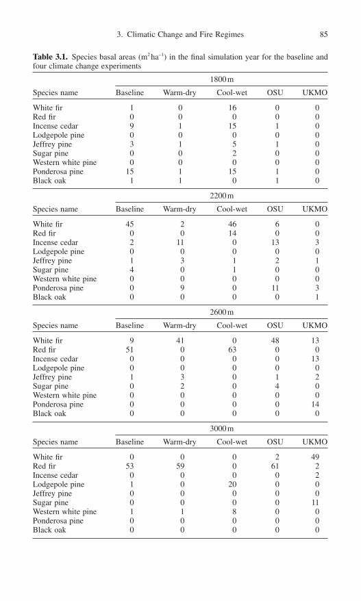
3. Climatic Change and Fire Regimes 85
Table 3.1. Species basal areas (m2 ha-1) in the final simulation year for the baseline andfour climate change experiments
1800m
Species name Baseline Warm-dry Cool-wet OSU UKMO
White fir 1 0 16 0 0Red fir 0 0 0 0 0Incense cedar 9 1 15 1 0Lodgepole pine 0 0 0 0 0Jeffrey pine 3 1 5 1 0Sugar pine 0 0 2 0 0Western white pine 0 0 0 0 0Ponderosa pine 15 1 15 1 0Black oak 1 1 0 1 0
2200m
Species name Baseline Warm-dry Cool-wet OSU UKMO
White fir 45 2 46 6 0Red fir 0 0 14 0 0Incense cedar 2 11 0 13 3Lodgepole pine 0 0 0 0 0Jeffrey pine 1 3 1 2 1Sugar pine 4 0 1 0 0Western white pine 0 0 0 0 0Ponderosa pine 0 9 0 11 3Black oak 0 0 0 0 1
2600m
Species name Baseline Warm-dry Cool-wet OSU UKMO
White fir 9 41 0 48 13Red fir 51 0 63 0 0Incense cedar 0 0 0 0 13Lodgepole pine 0 0 0 0 0Jeffrey pine 1 3 0 1 2Sugar pine 0 2 0 4 0Western white pine 0 0 0 0 0Ponderosa pine 0 0 0 0 14Black oak 0 0 0 0 0
3000m
Species name Baseline Warm-dry Cool-wet OSU UKMO
White fir 0 0 0 2 49Red fir 53 59 0 61 2Incense cedar 0 0 0 0 2Lodgepole pine 1 0 20 0 0Jeffrey pine 0 0 0 0 0Sugar pine 0 0 0 0 11Western white pine 1 1 8 0 0Ponderosa pine 0 0 0 0 0Black oak 0 0 0 0 0

water demand that exceeds the increase in precipitation. As a result conditions inthe UKMO simulation experiment are actually droughtier (i.e., more drought-days per year) than current baseline climate (Fig. 3.6) and the mean fire intervaldecreases at all sites in this experiment. The most significant differences in firefrequency occurred at the highest elevation sites.
More intriguing, perhaps, are the strong indirect effects of climate on the fireregime. Climatic change can influence the spatial extent of fires indirectly becausealtered forest structure and composition affect both the amount and type of fuel
86 C. Miller
Figure 3.8. Summary of two aspects of the fire regime for four climatic change scen-arios and baseline conditions. (a) Average mean fire interval during simulation years501–800 and (b) average percent of the total area burned per fire during simulation years501–800. Values were averaged over 10 replicate simulations and error bars are ±1 stan-dard deviation. The average mean fire interval for the cool-wet scenario at 3000m is notshown but was 202 years.
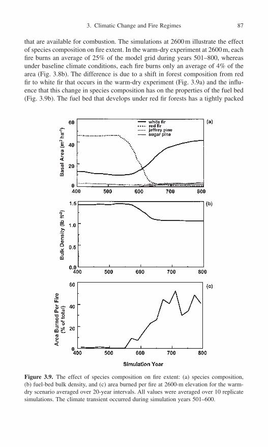
that are available for combustion. The simulations at 2600m illustrate the effectof species composition on fire extent. In the warm-dry experiment at 2600m, eachfire burns an average of 25% of the model grid during years 501–800, whereasunder baseline climate conditions, each fire burns only an average of 4% of thearea (Fig. 3.8b). The difference is due to a shift in forest composition from redfir to white fir that occurs in the warm-dry experiment (Fig. 3.9a) and the influ-ence that this change in species composition has on the properties of the fuel bed(Fig. 3.9b). The fuel bed that develops under red fir forests has a tightly packed
3. Climatic Change and Fire Regimes 87
Figure 3.9. The effect of species composition on fire extent: (a) species composition, (b) fuel-bed bulk density, and (c) area burned per fire at 2600-m elevation for the warm-dry scenario averaged over 20-year intervals. All values were averaged over 10 replicatesimulations. The climate transient occurred during simulation years 501–600.

litter component that does not burn readily. The fuel bed produced under a whitefir forest, however, is less compact (van Wagtendonk, Benedict, and Sydoriak1998), more burnable, and results in more area burned (Fig. 3.9c).
Limitations
The experiments simulated here are intended to demonstrate the sensitivity ofthese forests to climatic change and are not intended to make predictions of forestresponse to a particular climatic change scenario. Rather than looking at themodel results for a single experiment or scenario, it is more instructive to comparethe range of responses that may be possible. Climate predictions from GCMscarry substantial uncertainties, especially with respect to precipitation patterns,and it is noteworthy to point out that the GCM predictions used here predictincreases in precipitation for the Sierra Nevada. If these predictions are wrongand precipitation instead decreases in the Sierra, we might expect even greaterimpacts on forest structure and composition and the fire regime.
The global climate may be responding to increasing greenhouse gas concen-trations at a much faster rate than the climatic changes observed in the earth’spaleoecological record (Houghton et al. 2001). The future sustainability of forestsand ecosystems depends on whether plant migrations can keep pace with thisrapid change (Davis 1990; Solomon and Kirilenko 1997). Unfortunately, we still do not understand many of the mechanisms responsible for plant migration(Pitelka 1997). FM, like most forest gap models, assumes that all species can dis-perse to all sites. Therefore it is possible that the model overpredicts the rate thatforests can respond to climatic change (Loehle and LeBlanc 1996).
On the other hand, FM may actually underestimate the rate of forest responseto climatic change because it tends to underestimate the severity of fires. Forexample, the model does not simulate crown fire behavior or the contribution oflive fuels other than grass to fire behavior. Live foliage and branches from treesand shrubs in the subcanopy can serve as fuel ladders and promote crown fires,thereby increasing tree mortality. Higher mortality rates would (1) open up theforest canopy more than is currently simulated by the model, (2) provide moreestablishment opportunities for species better suited to the new climate, and (3) increase the rate of forest response to the simulated climatic change (Over-peck, Rind, and Goldberg 1990). FM also does not simulate extreme weather andwind conditions, and as a result probably underestimates the overall extent offires and severity of fire effects.
Fire is not the only disturbance that interacts with vegetation and climate. Forexample, the frequency and severity of insect and disease outbreaks may increasein the Sierra Nevada under altered climatic conditions (Ferrell 1996). The asso-ciated tree mortality would provide increased dead fuels, potentially increasingfire frequency and area burned. Furthermore fire-damaged trees may be more sus-ceptible to bark beetle attack (Ryan and Amman 1996), especially during droughts(Ferrell 1996), potentially resulting in a positive feedback cycle between drought,fire, and insect outbreaks.
88 C. Miller
Results from the simulations discussed here demonstrate the fire regime’s sen-sitivity to fuel-bed bulk density which is a function of species composition andgrass content in FM. However, other physical environmental factors, such as thedepth and duration of snow pack, could affect fuel-bed bulk density. Furthermorefuel-bed bulk density is probably not the only fuel property that varies with elevation in the Sierra Nevada. For example, surface-area-to-volume ratios forwoody fuels vary among species (van Wagtendonk, Benedict, and Sydoriak1996), but these differences were not simulated here. Elevation gradients in other fuel properties could either enhance or offset the influence of fuel-bed bulkdensity on connectivity of burnable area that was demonstrated here.
Beyond the Sierra Nevada
Although this version of FM was developed for the Sierra Nevada, the model can be used to investigate climate-fire-forest relationships in other forests wheresurface fires dominate the fire regime. To apply the model to other forests,however, substantial data for parameterization are needed. This version uses lifehistory information and tree-size allometric data from a variety of sources, includ-ing unpublished data sets, for the nine tree species simulated here (see Miller and Urban 1999b for a detailed list of parameters and data sources); similar information would be required to include other tree species. FM also requiresconsiderable information about fuels. Data from several field studies of fuel accu-mulation rates, fuel input rates, and species-specific fuel characteristics were usedto parameterize the model (e.g., Parsons 1978; van Wagtendonk, Benedict, andSydoriak 1996, 1998; J. van Wagtendonk, USGS Yosemite Field Station, unpub-lished data). The success in applying FM to other forests may depend on the avail-ability of these data.
Although the details of simulation results will differ if FM is applied to otherforests, some general results are expected to hold. Because the model uses fueldynamics to link forest dynamics with fire, fuels act as an intermediary for cli-matic change effects on the fire regime. This result is likely to be borne out inother forests as well. The simulation experiments highlight the influence of fuel-bed characteristics (e.g., fuel-bed bulk density) on the fire regime, but other vari-ables may be important in other forests. Other aspects of fuel dynamics, such asfuel input rates or decay rates, or other fuel-bed characteristics (e.g., particle sizerelationships, heat content of fuels) may be critical variables in other forests. Athorough understanding of fuel dynamics is needed to predict climatic changeeffects on fire regimes.
Conclusion
The response of ecosystems and fire regimes to global climatic change willdepend on a host of site-specific factors and a complex set of interactions amongclimate, fire, and vegetation. If our society is to anticipate the potential conse-
3. Climatic Change and Fire Regimes 89

quences of climatic change, we must improve our understanding of the complexinteractions between climate and fire regimes. To study the impacts of climaticchange on fire regimes, the effects of climatic change on vegetation must besimultaneously studied because vegetation affects fire regimes through its influ-ence on the fuels that accumulate. Although paleoecological data have been usedto reconstruct linkages among past changes in fire regimes, climate, and vegeta-tion, the use of these retrospective data for projecting future consequences islimited because the climate of the future may not be analogous to any climate inthe past. Simulation models may help us understand how fire-dependent ecosys-tems might respond to climatic change, particularly if the models simulate fireregimes that are driven by both climate and vegetation dynamics.
The simulation model FM was used to investigate how climatic change mightimpact surface fire regimes and forests in the Sierra Nevada. Simulated changesin temperature and precipitation affected forest biomass, forest species com-position, fire frequency, and area burned. These effects were site specific andvaried in direction and magnitude depending on the elevation of the simulatedsite. Total forest biomass and species composition changed in response to thechange in site conditions relative to the tolerances of tree species simulated inthe model. In some cases changes in temperature and precipitation affected thefuel moisture simulated by the model, thus directly affecting fire frequency andarea burned. In other cases the fire regime was affected by changes in the amountand type of fuel that resulted from changes in forest structure or composition.These results suggest that the fire regime may be impacted most by climaticchange where species composition shifts significantly and alters the flammabil-ity of the fuel bed.
Results from the simulation experiments suggest future directions for researchon fire and climatic change. Vegetation response to climatic change will occur atthe species level with individual species responding to environmental conditionsas their life history adaptations allow, and it’s possible that even subtle changesin the composition of species could dramatically influence the flammability ofthe fuel bed, thereby altering the fire regime. Therefore climatic change researchwould benefit from the use of models that simulate species-specific responses toclimatic factors and that simulate fire regimes that respond to climate and vege-tation processes. Fuels are at the heart of climate-fire-vegetation interactions, andwe need to improve our understanding of fuel dynamics and the properties of fuelbeds that influence flammability. Additional field studies of the biological andphysical factors that govern fuel dynamics and fuel-bed characteristics will beessential for increasing our understanding of potential climatic change effects onfire regimes.
References
Agee, J.K. 1990. The historical role of fire in Pacific Northwest forests. In Natural andPrescribed Fire in Pacific Northwest Forests, eds. J.D. Walstad, S.R. Radosevich, andD.B. Sandberg, pp. 25–38. Corvallis, OR: Oregon State University Press.
90 C. Miller

Agee, J.K. 1993. Fire Ecology of Pacific Northwest Forests. Washington, DC: Island Press.Albini, F.A. 1976. Estimating wildfire behavior and effects. USDA Forest Service Gen.
Tech. Rep. INT-30.Arno, S.F., and Brown, J.K. 1991. Overcoming the paradox in managing wildland fire.
Western Wildlands (Spring):40–46.Baker, W.L., Egbert, S.L., and Frazier, G.F. 1991. A spatial model for studying the effects
of climatic change on the structure of landscapes subject to large disturbances. Ecol.Model. 56:109–125.
Betancourt, J.L., Van Devender, T.R., and Martin, P.S., eds. 1990. Packrat Middens: TheLast 40,000 Years of Biotic Change. Tucson: University of Arizona Press.
Biswell, H.H. 1989. Prescribed burning in California wildlands vegetation management.Berkeley: University of California Press.
Bonnicksen, T.M., and Stone, E.C. 1982. Managing vegetation within U.S. national parks:A policy analysis. Environ. Manag. 6:101–102, 109–122.
Brown, J.K. 2000. Ecological principles, shifting fire regimes and management consider-ations. In Wildland Fire in Ecosystems: Effects of Fire on Flora, eds. J.K. Brown andJ. Smith, pp. 185–203. USDA Forest Service Gen. Tech. Rep. RMRS-42-vol. 2.
Brown, J.K., Marsden, M.A., Ryan, K.C., and Reinhardt, E.D. 1985. Predicting duff andwoody fuel consumed by prescribed fire in the northern Rocky Mountains. USDAForest Service Res. Pap. INT-337.
Caprio, A.C., and Swetnam, T.W. 1995. Historic fire regimes along an elevational gradi-ent on the west slope of the Sierra Nevada, California. In Proceedings of Symposiumon Fire in Wilderness and Park Management, tech. coords. J.K. Brown, R.W. Mutch,C.W. Spoon, and R.W. Wakimoto, pp. 173–179. Missoula, MT, March 30–April 1,1993.
Christensen, N.L. 1988. Succession and natural disturbance: paradigms, problems, andpreservation of natural ecosystems. In Ecosystem Management for Parks and Wilder-ness, eds. J.K. Agee and D.R. Johnson, pp. 62–86. Seattle: University of WashingtonPress.
Christensen, N.L. 1993. Fire regimes and ecosystem dynamics. In Fire in the Environ-ment, eds. P.J. Crutzen and J.G. Goldammer, pp. 233–244. New York: Wiley.
Clark, J.S. 1990. Twentieth-century climate change, fire suppression, and forest production and decomposition in northwestern Minnesota. Can. J. For. Res. 20:219–232.
Clark, J.S. 1993. Paleoecological perspectives on modeling broad-scale responses to globalchange. In Biotic Interactions and Global Change, ed. P.M. Kareiva, J.G. Kingsolver,and R.B. Huey, pp. 315–332. Sinauer Associates, Sunderland, MA.
Clark, J.S., Royall, P.D., and Chumbley, C. 1996. The role of fire during climate changein an eastern deciduous forest at Devil’s Bathtub, New York. Ecology 77:2148–2166.
Cohen, J.D., and Deeming, J.E. 1985. The national fire-danger rating system: basic equa-tions. USDA Forest Service Gen. Tech. Rep. PSW-82.
Daly, C., Neilson, R.P., and Phillips, D.L. 1994. A digital topographic model for distrib-uting precipitation over mountainous terrain. J. Appl. Meteorol. 33:140–158.
Davis, M.B. 1990. Climatic change and the survival of forest species. In The Earth inTransition: Patterns and Processes of Biotic Impoverishment, ed. G.M. Woodwell, pp.99–111. Cambridge: Cambridge University Press.
Davis, M.B., and Botkin, D.B. 1985. Sensitivity of cool-temperate forests and their fossilpollen record to rapid temperature change. Quat. Res. 23:327–340.
Davis, K.M., Clayton, B.D., and Fischer, W.C. 1980. Fire ecology of Lolo National Foresthabitat types. USDA Forest Service Gen. Tech. Rep. INT-79.
Ferrell, G.T. 1996. The influence of insect pests and pathogens on Sierra forests. In SierraNevada Ecosystem Project: Final Report to Congress, Vol. II: Assessments and Scien-tific Basis for Management Options, pp. 1177–1192. Davis: University of California,Centers for Water and Wildland Resources.
3. Climatic Change and Fire Regimes 91

Gardner, R.H., Romme, W.H., and Turner, M.G. 1999. Predicting forest fire effects at landscape scales. In Spatial Modeling of Forest Landscape Change—Approaches and Applications, eds. D.J. Mladenoff and W.L. Baker, pp. 163–185. Cambridge: Cambridge University Press.
Graber, D.M. 1985. Coevolution of National Park Service fire policy and the role ofnational parks. In Proceedings of Symposium and Workshop on Wilderness Fire, tech.coords., J.E. Lotan, B.M. Kilgore, W.C. Fischer, and R.W. Mutch, pp. 345–349. USDAForest Service Gen. Tech. Rep. INT-182.
Graber, D.M., Haultain, S., and Fessenden, J.E. 1993. Conducting a biological survey: acase study from Sequoia and Kings Canyon National Parks. In Proceedings of FourthConference on Research in California’s National Parks, eds. S.D. Veirs Jr., T.J.Stohlgren, and C. Schonewald-Cox, pp. 17–35. Transactions and Proceedings Series 9,U.S. Department of the Interior, National Park Service.
Hardy, C.C., Bunnell, D.L., Menakis, J.P., Schmidt, K.M., Long, D.G., Simmerman, D.G.,and Johnston, C.M. 1999. Coarse-scale Spatial Data for Wildland Fire and Fuel Man-agement. World Wide Web site: www.fs.fed.us/fire/fuelman
Hargrove, W.W., Gardner, R.H., Turner, M.G., Romme, W.H., and Despain, D.G. 2000.Simulating fire patterns in heterogeneous landscapes. Ecol. Model. 135:243–263.
Haxeltine, A., Prentice, I.C., and Cresswell, I.D. 1996. A coupled carbon and water fluxmodel to predict vegetation structure. J. Vegetation Sci. 7:651–666.
He, H.S., and Mladenoff, D.J. 1999. Spatially explicit and stochastic simulation of forest-landscape fire disturbance and succession. Ecol. 80:81–99.
Heinselman, M.L. 1973. Fire in the virgin forests of the Boundary Waters Canoe Area,Minnesota. Quat. Res. 3:329–382.
Houghton, J.T., Ding, Y., Griggs, D.J., Noguer, M., van der Linden, P.J., and Xiasou, D.,eds. 2001. Climate Change 2001: The Scientific Basis. Cambridge: Cambridge University Press.
Husari, S.J., and McKelvey, K.S. 1996. Fire-management policies and programs. In SierraNevada Ecosystem Project: Final Report to Congress, Vol. II, Assessments and Scien-tific Basis for Management Options, pp. 1101–1117. Davis: University of California,Centers for Water and Wildland Resources.
Keane, R.E., Ryan, K.C., and Running, S.W. 1996. Simulating effects of fire on northernRocky Mountain landscapes with the ecological process model FIRE-BGC. TreePhysiol. 16:319–331.
Kilgore, B.M. 1973. The ecological role of fire in Sierran conifer forests: Its applicationto national park management. J. Quat. Res. 3:496–513.
Landres, P.B., Morgan, P., and Swanson, F.J. 1999. Overview of the use of natural vari-ability concepts in managing ecological systems. Ecol. Appl. 9:1179–1188.
Loehle, C., and LeBlanc, D. 1996. Model-based assessments of climate change effects onforests: a critical review. Ecol. Model. 90:1–31.
McKelvey, K.S., Skinner, C.N., Chang, C., Erman, D.C., Husari, S.J., Parsons, D.J., van Wagtendonk, J.W., and Weatherspoon, C.P. 1996. An overview of fire in the Sierra Nevada. In Sierra Nevada Ecosystem Project: Final Report to Congress, Vol. II:Assessments and Scientific Basis for Management Options, pp. 1033–1040. Davis: University of California, Centers for Water and Wildland Resources.
Millar, C.I., and Woolfenden, W.B. 1999. The role of climate change in interpreting his-torical variability. Ecol. Appl. 9:1207–1216.
Miller, C., and Urban, D.L. 1999a. Forest heterogeneity and surface fire regimes. Can. J.For. Res. 29:202–212.
Miller, C., and Urban, D.L. 1999b. A model of surface fire, climate and forest pattern inSierra Nevada, California. Ecol. Model. 114:113–135.
Miller, C., and Urban, D.L. 1999c. Forest pattern, fire, and climatic change in the SierraNevada. Ecosystems 2:76–87.
92 C. Miller

Miller, C., and Urban, D.L. 2000. Connectivity of forest fuels and surface fire regimes.Landscape Ecol. 15:145–154.
Mutch, L.S., and Parsons, D.J. 1998. Mixed conifer forest mortality and establishmentbefore and after prescribed fire in Sequoia National Park, California. For. Sci. 44:341–355.
Nielsen, R.P. 1995. A model for predicting continental-scale vegetation distribution andwater balance. Ecol. Appl. 5:362–385.
Nikolov, N.T., and Zeller, K.F. 1992. A solar radiation algorithm for ecosystem dynamicmodels. Ecol. Model. 61:149–168.
Overpeck, J.T., Rind, D., and Goldberg, R. 1990. Climate-induced changes in forests dis-turbance and vegetation. Nature 343:51–53.
Parsons, D.J. 1978. Fire and fuel accumulation in a giant sequoia forest. J. For. 76:104–105.
Parsons, D.J., and DeBenedetti, S.H. 1979. Impact of fire suppression on a mixed-coniferforest. For. Ecol. Manag. 2:21–33.
Parsons, D.J., and van Wagtendonk, J.W. 1996. Fire research and management in the SierraNevada National Parks. In Science and Ecosystem Management in the National Parks,eds. W.L. Halvorson and G.E. Davis, pp. 25–48. Tucson: University of Arizona Press.
Parsons, D.J., Graber, D.M., Agee, J.K., and van Wagtendonk, J.W. 1986. Natural fire man-agement in national parks. Environ. Manag. 10:21–24.
Peters, R.L., and Lovejoy, T.E., eds. 1992. Global Warming and Biological Diversity. NewHaven: Yale University Press.
Pitelka, L.F. 1997. Plant migration and climate change. Am. Scientist 85:464–473.Prentice, I.C., Cramer, W., Harrison, S.P., Leemans, R., Monserud, R.A., and Solomon,
A.M. 1992. A global biome model based on plant physiology and dominance, soil prop-erties and climate. J. Biogeogr. 19:117–134.
Pyne, S.J., Andrews, P.A., and Laven, R.D. 1996. Introduction to Wildland Fire. New York:Wiley.
Riggan, P.J., Franklin, S.E., Brass, J.A., and Brooks, F.E. 1994. Perspectives on fire man-agement in Mediterranean ecosystems of southern California. In The Role of Fire inMediterranean-Type Ecosystems, eds. J.M. Moreno and W.C. Oechel, pp. 140–162.New York: Springer-Verlag.
Rothermel, R.C. 1972. A mathematical model for predicting fire spread in wildland fuels.USDA Forest Service Res. Pap. INT-115.
Running, S.W., Nemani, R., and Hungerford, R.D. 1987. Extrapolation of meteorologicaldata in mountain terrain, and its use for simulating forest evapotranspiration and pho-tosynthesis. Can. J. For. Res. 17:472–483.
Ryan, K.C., and Amman, G.D. 1994. Bark beetle activity and delayed tree mortality in theGreater Yellowstone Area following the 1988 fires. In The Ecological Implications ofFire in Greater Yellowstone: Proceedings of the Second Biennial Conference on theGreater Yellowstone Ecosystem, ed. J. Greenlee, pp. 151–158. Fairfield, WA: Interna-tional Association of Wildland Fire.
Ryan, K.C., and Reinhardt, E.D. 1988. Predicting postfire mortality of seven westernconifers. Can. J. For. Res. 18:1291–1297.
Skinner, C.N., and Chang, C. 1996. Fire regimes, past and present. In Sierra NevadaEcosystem Project: Final Report to Congress, Vol. II: Assessments and Scientific Basisfor Management Options, pp. 1041–1069. Davis: University of California, Centers forWater and Wildland Resources.
Smith, T.M., and Urban, D.L. 1988. Scale and resolution of forest structural pattern. Vegetatio 74:143–150.
Solomon, A.M., and Kirilenko, A.P. 1997. Climate change and terrestrial biomass: Whatif trees do not migrate? Global Ecol. Biogeogr. Letts. 6:139–148.
Stauffer, D. 1985. An Introduction to Percolation Theory. London: Taylor and Francis.
3. Climatic Change and Fire Regimes 93

Stephens, S.L. 1995. Effects of prescribed and simulated fire and forest history of giantsequoia (Sequoiadendron giganteum [Lindley] Buccholz.)-mixed conifer ecosys-tems of the Sierra Nevada, California. Ph.D. dissertation. University of California,Berkeley.
Stephenson, N.L. 1988. Climatic control of vegetation distribution: the role of the waterbalance with examples from North America and Sequoia National Park, California.Ph.D. dissertation. Cornell University, Ithaca.
Stephenson, N.L. 1999. Reference conditions for giant sequoia forest restoration: struc-ture, process, and precision. Ecol. Appl. 9:1253–1265.
Stephenson, N.L., and Parsons, D.J. 1993. A research program for predicting the effectsof climatic change on the Sierra Nevada. In Proceedings of the Fourth Conference on Research in California’s National Parks, eds. S.D. Veirs Jr., T.J. Stohlgren, and C. Schonewald-Cox, pp. 93–109. U.S. Department of the Interior National Park ServiceTransactions and Proceedings Series 9.
Swetnam, T.W. 1993. Fire history and climate change in giant sequoia groves. Science262:885–889.
Swetnam, T.W., Allen, C.D., and Betancourt, J.L. 1999. Applied historical ecology: Usingthe past to manage for the future. Ecol. Appl. 9:1189–1206.
Turner, M.G., and Romme, W.H. 1994. Landscape dynamics in crown fire ecosystems.Landscape Ecol. 9:59–77.
United States General Accounting Office. 1999. Western National Forests: A CohesiveStrategy Is Needed to Address Catastrophic Wildfire Threats. General AccountingOffice Report GAO/RCED-99–65.
University Corporation for Atmospheric Research (UCAR). 1997. World Wide Web site:www.cgd.ucar.edu/vemap/scenario.html
Urban, D.L., Bonan, G.B., Smith, T.M., and Shugart, H.H. 1991. Spatial applications ofgap models. For. Ecol. Manag. 42:95–110.
Urban, D.L., Harmon, M.E., and Halpern, C.B. 1993. Potential response of Pacific north-western forests to climatic change, effects of stand age and initial composition. Clim.Change 23:247–266.
Urban, D.L., Miller, C., Halpin, P.N., and Stephenson, N.L. 2000. Forest gradient responsein Sierran landscapes: the physical template. Landscape Ecol. 15:603–620.
Vankat, J.L., and Major, J. 1978. Vegetation changes in Sequoia National Park, California. J. Biogeogr. 5:377–402.
Van Wagner, C.E. 1973. Height of crown scorch in forest fires. Can. J. For. Res. 3:373–378.
van Wagtendonk, J.W. 1985. The role of fire in the Yosemite wilderness. In Proceedingsof the National Wilderness Research Conference, Fort Collins, CO, July 23–26, pp.2–9.
van Wagtendonk, J.W., Benedict, J.M., and Sydoriak, W.M. 1996. Physical properties ofwoody fuel particles of Sierra Nevada conifers. Int. J. Wildland Fire 6:117–123.
van Wagtendonk, J.W., Benedict, J.M., and Sydoriak, W.M. 1998. Fuel bed characteris-tics of Sierra Nevada conifers. Western J. Appl. For. 13:73–84.
White, P.S., and Pickett, S.T.A. 1985. Natural disturbance and patch dynamics, an intro-duction. In The Ecology of Natural Disturbances and Patch Dynamics, eds. S.T.A.Pickett and P.S. White, pp. 3–13. New York: Academic Press.
94 C. Miller

2. North America

This page intentionally left blank

4. Fire Regimes and Climatic Change in Canadian Forests
Mike Flannigan, Brian Stocks, and Mike Weber
Forest fire is the dominant disturbance regime in circumboreal forests, burningan average of 5 to 10 million ha annually (Stocks 1991; Weber and Stocks 1998),almost exclusively in Canada, Alaska, and Russia. Forest fire is the primaryprocess organizing the physical and biological attributes of the boreal biome overmost of its range, shaping landscape diversity and influencing energy flows andbiogeochemical cycles, particularly the global carbon cycle. Settlement andexploitation of the boreal zone has been accomplished in conjunction with thedevelopment of sophisticated fire management systems designed to suppressunwanted fires that threaten public and industrial interests while permittingnatural forest cycling through fire where possible.
Fire and climate/weather are intimately linked (Johnson 1992; Swetnam 1993),which means the fire regime will respond rapidly to changes in climate. For thepurposes of this chapter we define the fire regime as having six components; frequency, size, intensity, seasonality, type, and severity (cf. Flannigan 1993;Malanson 1987; Merrill and Alexander 1987). The ecological importance of someof these components of a fire regime has been put into perspective by Malanson(1987) and Whelan (1995). Fire frequency affects ecosystems by interrupting orterminating individual life cycles. If fires recur more or less regularly, selectionpressure will favor those organisms that better take advantage of the recurrenceat a given interval. Fire size determines landscape patchiness and determines thedistance seed will have to travel for regeneration. Fire intensity is equivalent tothe amount of energy released per unit length of fireline. Intensity, within the
97
confines of a single burn, can vary greatly depending on the fuel type and loading,topography, meteorological influences, and characteristics of the previous distur-bance, among other factors. Season of the year at which fire occurs is one of thedeterminants of the successional trajectories on which ecosystems embark afterfire. Time of year may affect fire intensity through differences in surface andcrown fuel moisture contents. Seasonal phenological state of the plants burnedwill determine the characteristics of the vegetative or seed reproductive responseand have a pronounced effect on the structure of postfire ecosystems and land-scapes. Fire type refers to crown, surface, and ground fires, which are largely controlled by fire intensity and fuel characteristics (structure, load, and moisture).Fire type, like intensity, can vary across the area of the burn, giving rise to amosaic of postfire plant communities that might be initiated by crowning, surfacefires, intermittent crowning, or a combination thereof. Fire severity is a descrip-tion of the depth of burn into the surface soil organic layers and therefore anotherimportant controlling factor of postfire ecosystem structure and function throughdirect impacts on underground plant root and reproductive tissues, soil seed bank, and forest floor microbial populations. These component parts of a fireregime with their intricate linkage to Canadian forest ecosystem structure andfunction are, in turn, highly dependent on climate (Kirschbaum and Fishlin 1996).
Since 1980 there has been an annual average of over 10,000 fires with an areaburned close to 3 million ha in Canada. Approximately 3% of the fires are largerthan 200ha, but these fires are responsible for 97% of the area burned (Weberand Stocks 1998). In the boreal forest the dominant fire type is stand-replacingcrown fires. Typical fire cycles range from 30 to 500 years for most of the borealforest (Flannigan et al. 1998). Species regenerate vegetatively or through seroti-nous cones within the area burned, or they can regenerate from seeds from adja-cent unburned stands. Fire is a critical aspect in the regeneration of many forestsas it removes competition, allows sunlight to reach the forest floor, and preparesthe seed bed by removing organic matter. Figure 4.1 shows the forest regions ofCanada along with the location of large fires (≥200ha) during the 1980 to 1989period (Stocks et al. 1998).
Discussion in this chapter is restricted to changes in climate and vegetationduring the last 10,000 years. Ten thousand years ago northern latitudes were stillgreatly influenced by the continental ice sheet. The climate warmed to a pointwhere it was warmer than the present day for the period 7000 to 3000 years beforepresent (Intergovernmental Panel on Climate Change [IPCC] 2001). A generalcooling trend has been experienced in the last 3000 years with relatively shortperiods of warming, such as the recent warming since the end of the Little IceAge (ca. AD 1850).
There is consensus that human activities are responsible for recent changes in the climate (IPCC 2001). Specifically, increases in radiatively active gases such as carbon dioxide, methane, and the chlorofluorocarbons in the atmo-sphere are causing a significant warming of the earth’s surface. Significantincreases in temperature are anticipated in this century and beyond, with general
98 M. Flannigan, B. Stocks, and M. Weber

circulation models (GCMs) projecting a mean global temperature increase of 1.4–5.8°C by AD 2100, an increase greater than any observed in the last 10,000 years.
Weather and climate are crucial to the occurrence and growth of forest fires.Lightning is the key ignition agent for naturally caused forest fires. Lightning isthe result of an electrical discharge from a thunderstorm, which itself is a resultof the appropriate meteorological conditions, namely atmospheric instability,moisture, and a lifting agent. The weather prior to ignition is important in deter-mining the fuel moisture, which in turn will determine if ignition will occur andif the fire will grow. These weather conditions that influence fuel moisture includetemperature, precipitation, wind speed, and atmospheric moisture (vapor pressuredeficient). Fire growth is a function of a number of variables, but if fuels areavailable and dry, then wind speed is the key factor.
When studying the role of the weather or climate on the area burned by forestfires several meteorological parameters are important. Temperature, precipitation,wind, atmospheric moisture, upper atmospheric features, teleconnections, verti-cal structure of the atmosphere, drought indexes, and components of fire weatherindex systems have all been used to elucidate the relationships between theweather/climate and area burned by forest fire (Flannigan and Wotton 2001).Mean and maximum temperature are frequently used in studies. Precipitationmeasures include, amount, frequency, and duration. Wind speed and direction are
4. Canadian Forests 99
Figure 4.1. Ecoclimatic regions of Canada with the 1980 to 1989 fires comprising >200ha.

often used, as well as the dew point, relative humidity, or other measures of themoisture in the atmosphere near the earth’s surface. Features such as upper-levelridges and the stability of the atmosphere have been addressed in some studiesrelating fire to climate and weather (Flannigan and Harrington 1988; Skinner etal. 1999). Often the term blocking ridges has been associated with fire outbreaks.These are persistent ridges in the upper atmosphere (usually at the 500-mb levelwhich is approximately 5600m above sea level) that last a week or longer. Theseridges tend to block or divert precipitation-bearing systems to the north or southof the ridge; thus dry and warm weather at the surface is typically associated withthese upper ridges.
Drought indexes such as the Palmer Drought Index and components of fireweather index systems like the Canadian Forest Fire Weather Index (FWI) Sys-tem (Van Wagner 1987) have been employed in investigations between fire andweather. Fire danger rating systems integrate daily weather information into qual-itative outputs that describe the relative fire danger across an area. Fire dangersystems are typically designed to suit fuel types in a specific region (Deeming,Burgan, and Cohen 1977; Van Wagner 1987; Stocks et al. 1989). These systemsvary greatly around the world in terms of input and output complexity but, ingeneral, use daily air temperatures, relative humidities, wind speeds, and precip-itation amount (and perhaps rate) to calculate a series of cumulative fuel mois-ture indicators. The fuel moisture indicators are then used as relative dangerindexes or are combined to give a more general index of fire potential. In somesystems differences in fuel type and topographical effects are also taken intoaccount, though these inputs are more typically used for site-specific fire behav-ior prediction. With regard to the relative importance of vegetation and weatheron fire behavior, research has shown that weather is the most important factor byfar (Bessie and Johnson 1995; Hely et al. 2001).
There are numerous other factors such as ignition agents, topography, vegeta-tion, landscape fragmentation, and fire management activities that could influ-ence the fire activity in a region. The agent of ignition can be lightning, or ignitioncan be human caused by a wide variety of activities. In some cases fire can be acultural practice such as burning fields or conversion of forest to agriculture usingslash and burn practices (Pyne 1997). Topography, slope, and orientation can sig-nificantly influence fire behavior (Van Wagner 1977). Vegetation can also play animportant role as aspects of fuel amount, continuity, moisture, arrangement, andstructure are key determinants in fire occurrence and spread. The fragmentationof the landscape through natural features such as lakes or via human activitiesincluding roads, agriculture, and settlements can influence the area burned (Weirand Johnson 1998; Weir, Johnson, and Miyanishi 2000). The influence of firemanagement on area burned is a function of the effectiveness of the fire crewsand the suppression policy in place.
The objective of this chapter is to estimate how climate change will influencethe fire regime across Canada in the twenty-first century and, in turn, how thischange in fire regime will impact Canadian forests. We will begin by reviewingconnections between climate and fire that have been elucidated by paleo studies,
100 M. Flannigan, B. Stocks, and M. Weber

fire-history studies, and fire-weather studies. Those studies that encompass warmperiods in the past might be analogues to future warming. Predictions of theclimate derived from GCMs will be used to estimate the fire weather in thiscentury. The implications of climate change on Canadian forests will be discussedwith regard to changes in the fire regime.
Fire-Climate Interactions
This section will address fire-climate interactions during the Holocene (ca. 10,800years ago to the present) which represents the present interglacial period. There areseveral methods to determine the long-term fire regime data (Tolonen 1983).These approaches include fire scars, time-since-fire maps, charcoal in peat, andlaminated lake sediments. Short-term fire-weather studies will also be discussed inthis section along with an overview of modeling efforts of fire activity in the future.
Fire Scars and Time-Since-Fire Maps
Trees that survive fires often scar, which allows a reconstruction of the fire historyat that location. Multiple scarring is possible, and for longer-lived tree speciessuch as sequoia and bristlecone pine, a long fire history (1000s of years) may beavailable (Swetnam 1993). Additionally fire scars on snags can be used to extendthe fire history even further by using a master chronology. However, for much ofthe North American boreal forest, fire scars allow a reconstruction of fire activ-ity for only the last 100 to 300 years, as this method is limited by the longevityof the trees. This same limitation is in effect for the time-since-fire map method.A time-since-fire map depicts regions of vegetation that are delineated by the lastyear in which they burned. Time-since-fire maps were introduced by Heinselman(1973). Using likelihood inference historical fire frequency can be obtained fromthese maps (Reed et al. 1998).
Payette et al. (1989) studied fire at the treeline in northern Quebec, and foundthat fire was related to vegetation and climate. In shrub tundra, fires are small andinfrequent. In the open forest, fire is more frequent and sizes are larger, whereasin the closed forest, fire activity was the greatest. They conclude that the gradi-ent of fire regimes is partly the result of climate and vegetation type. Sirois andPayette (1991) found that recent fires in the forest tundra have contributed todeforestation with the burned areas reverting to tundra. This is in agreement withresults from Payette and Gagnon (1985), who found that increased fire activitywas the immediate cause of a tree-line recession in northern Quebec startingaround 3000 years ago. The southward retreat of vegetation is consistent with theoverall cooling of the climate during the last few thousand years. Fire can be anagent of change that hastens the rate of vegetation change associated with achange in climate.
Bergeron (1991) found that fire frequency in western Quebec has decreasedsince the end of the Little Ice Age (ca. AD 1850) despite warmer temperatures.
4. Canadian Forests 101

Bergeron and Archambault (1993) attribute the decrease in fires to reduceddrought frequency which might be the result of the region being under the influ-ence of a warmer and moister tropical air mass during the fire season. Foster(1983) found that years of high fire activity in southeastern Labrador were asso-ciated with low summer precipitation.
Johnson, Fryer, and Heathcott (1990) used fire scars and time-since-fire mapsto examine the fire regimes of Glacier National Park in British Columbia. Theydiscovered a decrease in the fire frequency after AD 1760, which they associatewith moister conditions. Johnson and Larsen (1991) found that the fire cycle wasabout 50 years, prior to AD 1730, before increasing to 90 years for the 1730 to1980 period for the Kananaskis Watershed in the southern Canadian Rockies.They attribute this change in fire cycle to a change in climate as determined bydendroclimatological studies. These studies suggest warm and dry conditionsprior to 1730 becoming cooler and moister conditions thereafter.
Flannigan et al. (1998) surveyed the recent fire history studies in Canada andnorthern Europe. They found that fire frequency has decreased at almost everysite in the last 150 years despite a warming since the end of the Little Ice Age.Some of these sites are influenced by human activities, including landscape frag-mentation and fire suppression, which have a direct effect on fire frequency.Payette (1992) also displays a table of recent fire-history studies for several borealforest areas in North America. These studies demonstrate the need for cautionwhen extrapolating results from an individual study to infer a trend over a regionor continent.
Charcoal Studies
The analysis of charcoal is often done by using slides prepared for pollen analy-sis. The charcoal is counted with the aid of a microscope or the charcoal abun-dance is determined by a chemical assay method (Winkler 1985). Charcoal isoften described as macrofossil or microfossil. The microfossil charcoal or finefraction charcoal reflects regional fire activity, whereas macroscopic charcoalreflects fire activity near the site of collection. Clark (1988) employed a techniquethat requires thin-sectioned lake sediments from varved (annually laminated)lakes. Although this method gives an improved temporal resolution because ofthe annual varves, it is limited in that varved lakes are not available in all regions.Charcoal beds in peat (Khury 1994) and charcoal abundance from lake sediments(Clark 1988; Winkler 1985) have also been used to reconstruct fire history. Fireactivity in Quebec has been reconstructed using charcoal preserved in sand dunes(Filion et al. 1991). MacDonald et al. (1991) provides an excellent discussion oncharcoal analysis.
Studies of charcoal beds in peat deposits in central Canada suggest a peak infire frequency around 3500 to 4000 years before present (BP) (Bryson, Irving,and Larsen 1965; Nichols 1967). Nichols (1967) suggests that this increased fireactivity may be related to a cooling from 6000 to 1500 years BP which broughtcentral Canada under the influence of the cold and dry Arctic air mass. However,
102 M. Flannigan, B. Stocks, and M. Weber

additional cooling since 3500 to 4000 years BP has not corresponded to increasedfire activity. Khury (1994) studied charcoal beds in Canadian peatlands in Alberta,Saskatchewan, and Manitoba. He found that fire was more frequent by a factorof two to one during a mid-Holocene warm period prior to 5000 years BP. Vance,Emerson, and Habgood (1983), using charcoal from pollen slides obtained from sites in central Alberta, found charcoal influx was greater during the mid-Holocene warm period as opposed to after about 4000 years ago. Hu, Brubaker,and Anderson (1993) found that charcoal abundance was low at Wien Lake incentral Alaska during the mid-Holocene warm period but that charcoal increasedduring the cooling after the mid-Holocene.
Future areas of research might use a regional approach to look at whether thereis spatial synchrony in the fire-climate record. Ideally one technique would be tofind and core a number of varved lakes across a large region and reconstruct thefire regime and the vegetation present. Finally warmer periods of the past suchas the mid Holocene warm period can be used as analogues for future warming.Flannigan et al. (2001) use charcoal data from sites across Canada in combina-tion with a specially modified GCMs that was run for 6000 years ago to suggestthat previous warm periods may be analogues of future warming. In that studythere was good agreement between the charcoal data and model data, which tendsto validate the results, as these two data sources can be treated as independent.
Fire-Weather Studies
Day to day weather can dramatically influence fire behavior and area burned. Thishas lead to many studies over various spatial and temporal scales that try to relatethe weather to fire. There have been numerous case studies that address theweather associated with an individual fire or an outbreak of fires. Schaefer (1957)addressed the relationship with the upper-level jet stream on forest fires. Turner(1970) studied the effect of hours of sunshine on fire season severity. The synoptic weather types associated with critical fire weather were studied bySchroeder et al. (1964). Other studies (Flannigan and Harrington 1987; Hirschand Flannigan 1990; Quintilio, Fahnestock, and Dube 1977; Stocks and Walker1973; Stocks 1975) have documented the weather prior to and during major fireruns. These studies have shown that fire spread rapidly when the fuels were dryand the weather conditions were warm to hot, dry, and windy. These studies bythemselves have limited application because of the narrow scope in terms of tem-poral and spatial scales used. However, these studies are of value in identifyingthe most likely meteorological predictors related to fire activity that can be usedin studies with a larger time and space domain.
Harrington, Flannigan, and Van Wagner (1983) related the monthly provincialarea burned in Canada to components of the Canadian Fire Weather Index (FWI)System for 1953 to 1980. Results showed that the monthly means and extrememaximum values of the Duff Moisture Code (DMC) and the daily severity rating(DSR) were the best predictors of area burned. In western Canada, with the excep-tion of the Yukon and Northwest Territories, explained variance averaged 33%.
4. Canadian Forests 103

In the territories and eastern Canada the explained variance averaged 12%. Usingthe same data set, Flannigan and Harrington (1988) studied the relation betweenmeteorological variables and monthly area burned by wildfire from May toAugust 1953–80 for nine provincial sized regions in Canada. They found that badfire months were independent of rainfall amount but significantly dependent onrainfall frequency, temperature, and relative humidity. Results were similar tothose obtained by Harrington, Flannigan, and Van Wagner (1983), except themeteorological variables did better in the Territories and eastern Canada than didthe FWI System. The most important predictors were long sequences of days withless than 1.5mm of precipitation and long sequences of days with relative humid-ity below 60%. These long sequences were assumed to be associated with block-ing highs in the upper atmosphere.
Newark (1975) discovered that 500-mb longwave ridging was related to forestfire occurrence in northwestern Ontario during the summer of 1974. Nimchuk(1983) related two episodes of catastrophic burning during the Alberta 1981 fireseason to the breakdown of the upper ridge over Alberta. These episodes, whichlasted eight days, accounted for about 1 million ha burned. The breakdown ofthese upper ridges is often accompanied by increased lightning activity as upperdisturbances (shortwaves) move along the west side of the ridge. Additionally, asthe ridge breaks down, strong and gusty surface winds are common. Brotak andReifsnyder (1977) also studied the upper air conditions associated with 52 majorwildland fires (area burned 5000 acres or more) in the eastern United States from1963 to 1973. They found that the vast majority of the fires were associated withthe eastern portion of a small but intense shortwave trough at 500mb. Despitethe difference in geographical location, the Brotak and Reifsnyder study and thework by Nimchuk may both be discussing the same situation, though the empha-sis changes from trough to ridge breakdown from the former to the latter. Coldfronts are often associated with the breakdown of the ridge or the passing of ashortwave trough, which are also important in terms of major wildland fires(Brotak and Reifsnyder 1977). In addition to strong, and at times gusty, surfacewinds associated with these upper features, it is also important to note that a windshift from southwest to northwest occurs with the passage of the shortwave troughaloft and the cold front at the surface. This is important in that the flank of a firewith a southwest wind will become the head of the fire with a northwest wind.
Flannigan and Harrington (1988) found that the 700-mb-height anomaly forthe forested regions of their provincial areas was the predictor that was selectedthe most when relating meteorological variables to monthly provincial areaburned in Canada 1953–1980. Johnson and Wowchuk (1993) found that midtro-pospheric positive anomalies (blocking ridges) were related to large-fire years inthe southern Canadian Rocky Mountains, whereas as negative anomalies wererelated to small-fire years. They observed that these blocking ridges associatedwith the large-fire years were teleconnected, both spatially and temporally cor-related with respect to 500-mb heights, to upper-level troughs in the North Pacificand eastern North America which is the positive mode of the Pacific NorthAmerica (PNA) pattern. The PNA teleconnection is really a triple connection
104 M. Flannigan, B. Stocks, and M. Weber

among an anticyclonic circulation over the North Pacific, a cyclonic circulationover western Canada, and a second anticyclonic circulation over the southeast-ern United States (Horel and Wallace 1981). Skinner et al. (1999) found that 500-mb-height anomalies were well correlated with seasonal area burned over variouslarge regions of Canada. They also found a structure similar to the PNA patternfor the extreme fire seasons in western and west-central Canada Current researchsuggests that blocking frequency is related to the wave number (the number oflongwaves in the westerlies—typically 3–5) with blocking ridges being more fre-quent with higher wave numbers (Weeks et al. 1997). Also research has suggestedthat the persistence of blocking ridges in the upper atmosphere will increase in a2 ¥ CO2 climate (Lupo, Oglesby, and Mokhov 1997). This could have significantimpact on fire activity as these upper ridges are associated with dry and warmconditions at the surface that are conducive to forest fires.
Dry and unstable air enhances the growth of forest fires. Unstable air is a layerof air that is characterized by a vertical temperature gradient such that when airparcels are displaced upward, they will accelerate upward and away from theiroriginal altitude. Haines (1988) developed a lower-atmosphere severity index(LASI) for wildland fires to account for temperature stability and the amount ofmoisture in the lower-atmosphere. He determined that only 6% of all fire seasondays fell into the high-index class for the western United States. However, 45%of days with large and/or erratic wildfire occurred during those high-index classdays. Potter (1996) examined atmospheric properties associated with large wild-fires (over 400ha) in the United States from 1971 to 1984. He compared thelower-atmosphere moisture, temperature, wind, and lapse rate for the 339 largefires in the data set with climatology using the same 14-year period. The resultsshow that the fire day surface air temperature and moisture differ from climatol-ogy at the 0.001 significance level. There was no difference in wind shear betweenfire days and climatology days. Results from wind speed and lapse rate wereinconclusive. To date, research like that conducted by Haines (1988) and Potter(1996) on the vertical structure of the lower atmosphere has not been applied inCanada.
Models of the Future Climate
There are many General Circulation Models that enable researchers to simulatethe future climate. Although there are a number of shortcomings associated withthe GCMs, they provide the best means available to estimate the impact ofchanges in the future climate on the fire regime. Most models are in agreementin predicting the greatest warming at high latitudes and over land. In Canada,winter temperatures are expected to increase by 6–10°C, while summer temper-atures increase by 4–6°C for a doubling of carbon dioxide in the middle of thiscentury. The confidence is lower for estimates of precipitation, but many modelssuggest an increased moisture deficit, particularly in the center of continentsduring the summer. Recent transient GCMs, which include ocean-atmospherecoupling and aerosols, support these findings (Flato et al. 2000). In addition to
4. Canadian Forests 105
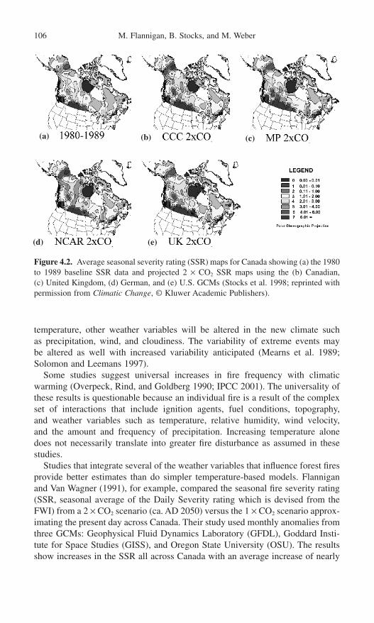
temperature, other weather variables will be altered in the new climate such as precipitation, wind, and cloudiness. The variability of extreme events may be altered as well with increased variability anticipated (Mearns et al. 1989;Solomon and Leemans 1997).
Some studies suggest universal increases in fire frequency with climaticwarming (Overpeck, Rind, and Goldberg 1990; IPCC 2001). The universality ofthese results is questionable because an individual fire is a result of the complexset of interactions that include ignition agents, fuel conditions, topography, and weather variables such as temperature, relative humidity, wind velocity, and the amount and frequency of precipitation. Increasing temperature alone does not necessarily translate into greater fire disturbance as assumed in thesestudies.
Studies that integrate several of the weather variables that influence forest firesprovide better estimates than do simpler temperature-based models. Flanniganand Van Wagner (1991), for example, compared the seasonal fire severity rating(SSR, seasonal average of the Daily Severity rating which is devised from theFWI) from a 2 ¥ CO2 scenario (ca. AD 2050) versus the 1 ¥ CO2 scenario approx-imating the present day across Canada. Their study used monthly anomalies fromthree GCMs: Geophysical Fluid Dynamics Laboratory (GFDL), Goddard Insti-tute for Space Studies (GISS), and Oregon State University (OSU). The resultsshow increases in the SSR all across Canada with an average increase of nearly
106 M. Flannigan, B. Stocks, and M. Weber
(a) (b) (c)
(d) (e)
Figure 4.2. Average seasonal severity rating (SSR) maps for Canada showing (a) the 1980to 1989 baseline SSR data and projected 2 ¥ CO2 SSR maps using the (b) Canadian, (c) United Kingdom, (d) German, and (e) U.S. GCMs (Stocks et al. 1998; reprinted withpermission from Climatic Change, © Kluwer Academic Publishers).
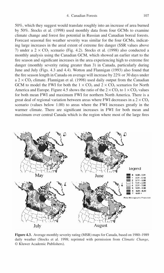
50%, which they suggest would translate roughly into an increase of area burnedby 50%. Stocks et al. (1998) used monthly data from four GCMs to examineclimate change and forest fire potential in Russian and Canadian boreal forests.Forecast seasonal fire weather severity was similar for the four GCMs, indicat-ing large increases in the areal extent of extreme fire danger (SSR values above7) under a 2 ¥ CO2 scenario (Fig. 4.2). Stocks et al. (1998) also conducted amonthly analysis using the Canadian GCM, which showed an earlier start to thefire season and significant increases in the area experiencing high to extreme firedanger (monthly severity rating greater than 3) in Canada, particularly duringJune and July (Figs. 4.3 and 4.4). Wotton and Flannigan (1993) also found thatthe fire season length in Canada on average will increase by 22% or 30 days undera 2 ¥ CO2 climate. Flannigan et al. (1998) used daily output from the CanadianGCM to model the FWI for both the 1 ¥ CO2 and 2 ¥ CO2 scenarios for NorthAmerica and Europe. Figure 4.5 shows the ratio of the 2 ¥ CO2 to 1 ¥ CO2 valuesfor both mean FWI and maximum FWI for northern North America. There is agreat deal of regional variation between areas where FWI decreases in a 2 ¥ CO2
scenario (values below 1.00) to areas where the FWI increases greatly in thewarmer climate. There are significant increases in FWI for both mean andmaximum over central Canada which is the region where most of the large fires
4. Canadian Forests 107
Figure 4.3. Average monthly severity rating (MSR) maps for Canada, based on 1980–1989daily weather (Stocks et al. 1998; reprinted with permission from Climatic Change, © Kluwer Academic Publishers).

have occurred recently (Fig. 4.1). However, much of eastern Canada and north-western Canada has ratios below 1.00, indicating that the FWI will decreasedespite the warmer temperatures associated with a 2 ¥ CO2 climate. Noteworthyis the area of decreased FWI over western and northwestern sections of Canadawhere historically large portions of the landscape have been burned. However,due to the coarse spatial resolution of the GCM (~400km) confidence in theresults over complex, mountainous terrain is low. In such areas a RegionalClimate Model (RCM) should be used (Caya and Laprise 1999) where the finerspatial resolution (ca. 40km) can resolve mountain ranges. Significant increasesin the FWI are evident over parts of central North America. The ratio of extrememaximum values of the FWI show a similar pattern, with higher ratios overcentral continental areas and lower values over portions of eastern Canada. Onthe other hand, there are increases in the maximum FWI over portions of westernCanada. Consequences of climate change on fire disturbance must be viewed ina spatially dependent context.
Flannigan et al. (1998) suggest the reason for the decreased FWI despite theincreasing temperature is due primarily to changes in the precipitation regime,and in particular to increases in precipitation frequency. These models results(Fig. 4.5) are in good agreement with recent fire-history studies, which cover
108 M. Flannigan, B. Stocks, and M. Weber
Figure 4.4. Average monthly severity rating (MSR) maps for Canada under a 2 ¥ CO2
climate using the Canadian GCM (Stocks et al. 1998; reprinted with permission from Climatic Change, © Kluwer Academic Publishers).

4. Canadian Forests 109
(a)
(b)
Figure 4.5. Mean (a) and maximum (b) FWI ratios (2 ¥ CO2/1 ¥ CO2) for North America(Flannigan et al. 1998; reprinted with permission from Journal of Vegetation Science, © Opulus Press).
roughly the last 200 years (Flannigan et al. 1998; Larsen 1996). Many of thesestudies show decreasing fire activity despite the warming since the end of theLittle Ice Age (ca. AD 1850). These modeled results are also consistent with themodeled fire weather and charcoal record anomalies for a warm period duringthe mid-Holocence about 6000 years BP which was about 1°C warmer thanpresent for Canada (Flannigan et al. 2001).
What will the fire regime be like for this century? Most studies in Canadasuggest an overall increase in fire weather severity, although some areas ofdecreased fire weather severity are possible. Combine this with increasing fireseason length and the increased cloud-to-ground lightning with a correspondingincrease in ignitions (Price and Rind 1994), and greater fire activity is likely.
Climate Change: Impact on Canadian Forests
The forests of Canada will respond to changes in the climate over time. However,the almost instantaneous response of the fire regime to changes in the climate hasthe potential to overshadow importance of direct effects of global warming onspecies distribution, migration, substitution, and extinction. Thus fire is a cata-lyst for vegetation change.

In addition to climate’s influence on the fire regime, other factors such as vegetation characteristics and human activities, fire management policies, andlandscape fragmentation may greatly influence the fire regime in this century.Vegetation type, amount, and structure influence fire regime characteristics; thusany changes in vegetation due to changes in climate or fire regime have a feed-back effect on the fire regime. Human activities such as fire management poli-cies and effectiveness will continue to change. Other human activities such asconversion of forest lands to agriculture or urban areas along with the fragmen-tation of the landscape will influence the fire regime. These are confoundingeffects that may dampen or amplify the impact of a changing climate on the fireregime.
Fire may be more important than the direct effects of climate change for speciesdistribution, migration, substitution, and extinction (Weber and Flannigan 1997).Fire can hasten the modification of the vegetation landscape into an new equi-librium with the climate if species are able to migrate fast enough. This wouldbe true where the fire activity is expected to increase in this century. For example,increased fire frequency at the grassland–aspen parkland–boreal forest transitionin western Canada (Fig. 4.1) may hasten the conversion of boreal forest to aspenparkland and aspen parkland to grassland. In those areas of Canada that experi-ence a reduced fire frequency, in contrast, the transition of vegetation types maybe retarded. For example, as the climate warms, the southern boreal forest ineastern Canada may be replaced by more southern species from the mixed woodregion (Great Lakes–St. Lawrence Forest). This poleward migration of southernspecies would be enhanced by the presence of disturbed areas such as burns. Inthe absence of fire, existing shade-tolerant species such as balsam fir (Abies balsamea (L.) Mill.) and black spruce (Picea mariana (Mill.) B.S.P.) would dominate the landscape and would be hard to displace, retarding the polewardmigration of southern species. Of course, increases in other disturbance regimessuch as pests, diseases, and blowdown could offset decreases in area burned.Changes in climate and disturbance regimes may lead to assemblages of speciesthat have never been encountered before (Martin 1993).
Vegetation models using GCM input have projected a large poleward shift invegetation (Solomon and Leemans 1989; Rizzo and Wilken 1992; Smith andShugart 1993a; IPCC 1998). However, most of these models have not incorpo-rated forest fires.
Carbon and Nitrogen Cycling and Budgets
Changes in climate and the fire regime will impact on carbon and nitrogen cyclingand budgets. Disturbances such as fire could be a critical factor in determining ifCanadian forests are a carbon sink or source on a year-to-year basis.
Recent estimates are that 714 petagrams (Pg) of carbon (1Pg = 1015 grams or1 billion tonnes) are stored in the boreal forest region (Apps et al. 1993), and thisrepresents about 37% of the total amount of carbon in the global terrestrial bios-phere (Smith et al. 1993). The potential effects of climate change on levels of
110 M. Flannigan, B. Stocks, and M. Weber

carbon storage in boreal forests has been estimated using changes in temperatureand precipitation projected by GCMs to estimate changes in terrestrial biomes(Smith and Shugart 1993a, 1993b; Solomon et al. 1993). Fire has been shown tohave a major effect on boreal carbon storage (Kasischke, Christensen, and Stocks1995), but has been largely ignored in these models and even in the internationalBoreal Ecosystem–Atmosphere Study (BOREAS) conducted in Canada in 1994and 1995 (BOREAS Special Issue 1998). With pervasive influence of fire acrossthe boreal zone, and the strong likelihood of increased fire activity/severity undera warming climate, an improved understanding of the influence of fire on carboncycling is essential.
Kasischke, Christensen, and Stocks (1995) described six ways that fire affectscarbon storage in boreal forests: by directly releasing carbon to the atmospherethrough combustion, through the conversion of plant material to charcoal, bystrongly influencing the pattern of secondary succession on fire-disturbed land-scapes, by altering the thermal regime of the forest floor and enhancing decom-position in these layers, by increasing the amount of soil nutrients available forplant growth, and by directly influencing the age-class distribution of foreststands. Amiro et al. (2001) found that direct emissions of carbon from forest firesin Canada from 1959 to 1999 averaged 27Tg a year, which represents about 20% of the current carbon dioxide emissions from the Canadian energy sector.Kasischke, Christensen, and Stocks (1995) conducted a sensitivity analysis of therelationship between fire and carbon storage in the living-biomass and ground-layer compartments of boreal forests. They found that an increase in the occur-rence and severity of fires under a warming climate would cause a net loss ofcarbon, as rapid loss of forest floor carbon would outpace carbon sequestrationthrough plant regrowth. They concluded that because large amounts of carbonare stored in the ground layer of boreal forests, and fire significantly influencescarbon storage in this area, any climate-induced changes in fire regimes will havemajor impacts.
The Carbon Budget Model of the Canadian Forest Sector (CFS-CBM) is adynamic simulation model that accounts for carbon pools and fluxes in Canadianforest ecosystems and forest products (Kurz et al. 1992). The CBM-CFS has beenused to analyze carbon flows both retrospectively (Kurz and Apps 1996) and toproject future carbon budgets of Canadian boreal forests (Kurz and Apps 1995).In both cases the carbon sink/source strength of Canadian forests was determinedto be significantly influenced by disturbance regimes, particularly fire and insects.Climate variation over the past two decades appears to have increased fire fre-quency, leading to a net carbon release from Canadian boreal forests. Periods ofhigh fire activity were found to result in reduced carbon accumulation in biomasscarbon pools, and a corresponding increase in soil carbon pools. The increase indead organic matter associated with disturbance results in higher carbon loss fromdecomposition in the years following periods of high disturbance. The CBM-CFSresults support the conclusion that fire activity is the major influence on thecarbon budget of Canadian boreal forests. Apps et al. (2000) state that increasedfire protection can perhaps delay, but not prevent, eventual carbon release from
4. Canadian Forests 111
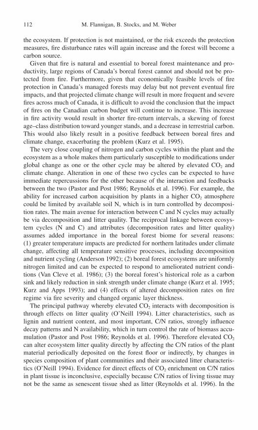
the ecosystem. If protection is not maintained, or the risk exceeds the protectionmeasures, fire disturbance rates will again increase and the forest will become acarbon source.
Given that fire is natural and essential to boreal forest maintenance and pro-ductivity, large regions of Canada’s boreal forest cannot and should not be pro-tected from fire. Furthermore, given that economically feasible levels of fireprotection in Canada’s managed forests may delay but not prevent eventual fireimpacts, and that projected climate change will result in more frequent and severefires across much of Canada, it is difficult to avoid the conclusion that the impactof fires on the Canadian carbon budget will continue to increase. This increasein fire activity would result in shorter fire-return intervals, a skewing of forestage–class distribution toward younger stands, and a decrease in terrestrial carbon.This would also likely result in a positive feedback between boreal fires andclimate change, exacerbating the problem (Kurz et al. 1995).
The very close coupling of nitrogen and carbon cycles within the plant and theecosystem as a whole makes them particularly susceptible to modifications underglobal change as one or the other cycle may be altered by elevated CO2 andclimate change. Alteration in one of these two cycles can be expected to haveimmediate repercussions for the other because of the interaction and feedbacksbetween the two (Pastor and Post 1986; Reynolds et al. 1996). For example, theability for increased carbon acquisition by plants in a higher CO2 atmospherecould be limited by available soil N, which is in turn controlled by decomposi-tion rates. The main avenue for interaction between C and N cycles may actuallybe via decomposition and litter quality. The reciprocal linkage between ecosys-tem cycles (N and C) and attributes (decomposition rates and litter quality)assumes added importance in the boreal forest biome for several reasons: (1) greater temperature impacts are predicted for northern latitudes under climatechange, affecting all temperature sensitive processes, including decompositionand nutrient cycling (Anderson 1992); (2) boreal forest ecosystems are uniformlynitrogen limited and can be expected to respond to ameliorated nutrient condi-tions (Van Cleve et al. 1986); (3) the boreal forest’s historical role as a carbonsink and likely reduction in sink strength under climate change (Kurz et al. 1995;Kurz and Apps 1993); and (4) effects of altered decomposition rates on fireregime via fire severity and changed organic layer thickness.
The principal pathway whereby elevated CO2 interacts with decomposition isthrough effects on litter quality (O’Neill 1994). Litter characteristics, such aslignin and nutrient content, and most important, C/N ratios, strongly influencedecay patterns and N availability, which in turn control the rate of biomass accu-mulation (Pastor and Post 1986; Reynolds et al. 1996). Therefore elevated CO2
can alter ecosystem litter quality directly by affecting the C/N ratios of the plantmaterial periodically deposited on the forest floor or indirectly, by changes inspecies composition of plant communities and their associated litter characteris-tics (O’Neill 1994). Evidence for direct effects of CO2 enrichment on C/N ratiosin plant tissue is inconclusive, especially because C/N ratios of living tissue maynot be the same as senescent tissue shed as litter (Reynolds et al. 1996). In the
112 M. Flannigan, B. Stocks, and M. Weber

case of a CO2-caused shift in plant community species composition, changes inlitter quality are expected because the type of carbon compounds in litter, andhence C/N ratios, are species specific (Pastor and Post 1986). C/N ratios controlN availability; that is to say, the narrower the litter C/N ratios, the more rapid arethe microbial decomposition rates, which in turn increase nitrogen availabilityfor plant uptake and biomass production (Reynolds et al. 1996; Ryan 1991). Anytime forest floor decomposition rates are altered due to soil warming, increaseddepth of active layer over permafrost, improved soil drainage, or accelerated sub-strate microbial activity, direct impacts on the fire regime are probable via fireseverity (depth of burn). Improved soil drainage as a result of soil warming atnorthern latitudes is an important consideration for any climate change scenario(e.g., Anderson 1992; Bonan 1989; Dang and Lieffers 1989; Lashof 1989)because of the implications for organic layer drying and hence fire severity.
Combining increased fire severity in a changing climate with increased fire fre-quency, could accelerate carbon mineralization rates in arctic and subarctic soilsunderlying most of the boreal forests of North America (Anderson 1991). Thesefaster carbon mineralization rates under warmer and drier conditions are due tolow stabilization of soil organic matter and enhanced microbial responses to smallchanges in soil moisture and temperature (Anderson 1991). Accelerated C min-eralization eventually feeds back to atmospheric CO2 loading, possible biomassproduction impacts, litterfall quality, and quantity and decomposition rates. As apoint of departure, for further information on the implications of such a scenariofor global carbon cycling, mobilization of carbon stores from boreal forests, thecarbon source/sink controversy, and feedback to global climate change, the readeris referred to Anderson (1992), Apps, Price, and Wisniewski (1995), Kasischke,Christensen, and Stocks (1995), Kurz et al. (1995), Oechel et al. (1993), andThomas and Rowntree (1992).
Most of the atmospheric change-generated impacts are actually environmentalstresses and may therefore predispose individuals and ecosystems to secondarystressors, such as insect and disease attack and drought (cf. Jones et al. 1993).Should this dynamic result in increased above-ground mortality and standbreakup, the fire regime may be affected immediately and in the short termbecause of to increased surface fuel loading and, hence, increased fire intensity(Stocks 1987).
Conclusion
Recently the climate has been warming over most of Canada (Gullett and Skinner1992), and the warming is expected to continue throughout the twenty-firstcentury (IPCC 2001). This warming and changes in other meteorological variables will alter the fire regime. Significant increases in fire weather indexesare anticipated over central sections of Canada where much of the current fireactivity occurs. We believe that this increase in fire weather indexes will trans-late into significant increases in area burned in this century. Changes in the fire
4. Canadian Forests 113
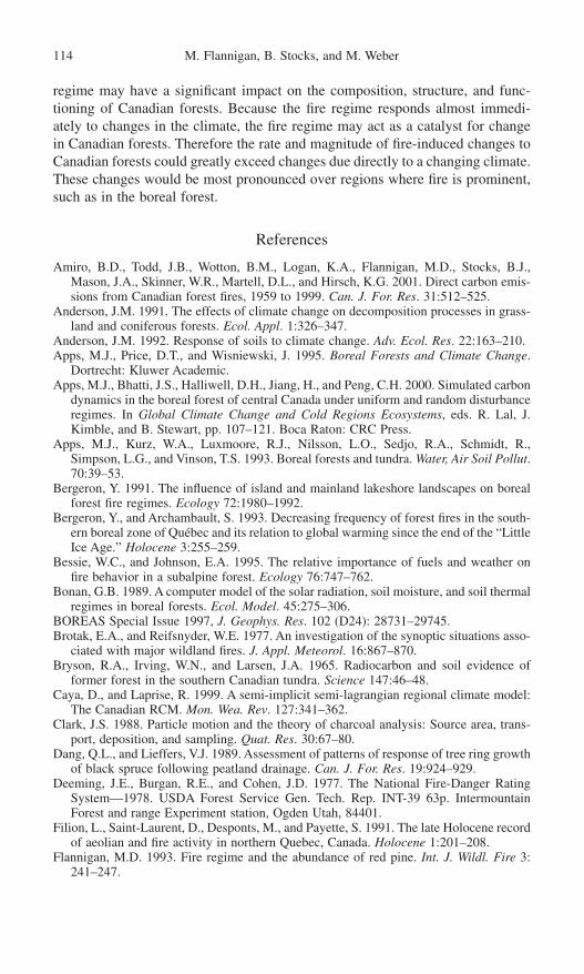
regime may have a significant impact on the composition, structure, and func-tioning of Canadian forests. Because the fire regime responds almost immedi-ately to changes in the climate, the fire regime may act as a catalyst for changein Canadian forests. Therefore the rate and magnitude of fire-induced changes toCanadian forests could greatly exceed changes due directly to a changing climate.These changes would be most pronounced over regions where fire is prominent,such as in the boreal forest.
References
Amiro, B.D., Todd, J.B., Wotton, B.M., Logan, K.A., Flannigan, M.D., Stocks, B.J.,Mason, J.A., Skinner, W.R., Martell, D.L., and Hirsch, K.G. 2001. Direct carbon emis-sions from Canadian forest fires, 1959 to 1999. Can. J. For. Res. 31:512–525.
Anderson, J.M. 1991. The effects of climate change on decomposition processes in grass-land and coniferous forests. Ecol. Appl. 1:326–347.
Anderson, J.M. 1992. Response of soils to climate change. Adv. Ecol. Res. 22:163–210.Apps, M.J., Price, D.T., and Wisniewski, J. 1995. Boreal Forests and Climate Change.
Dortrecht: Kluwer Academic.Apps, M.J., Bhatti, J.S., Halliwell, D.H., Jiang, H., and Peng, C.H. 2000. Simulated carbon
dynamics in the boreal forest of central Canada under uniform and random disturbanceregimes. In Global Climate Change and Cold Regions Ecosystems, eds. R. Lal, J.Kimble, and B. Stewart, pp. 107–121. Boca Raton: CRC Press.
Apps, M.J., Kurz, W.A., Luxmoore, R.J., Nilsson, L.O., Sedjo, R.A., Schmidt, R.,Simpson, L.G., and Vinson, T.S. 1993. Boreal forests and tundra. Water, Air Soil Pollut.70:39–53.
Bergeron, Y. 1991. The influence of island and mainland lakeshore landscapes on borealforest fire regimes. Ecology 72:1980–1992.
Bergeron, Y., and Archambault, S. 1993. Decreasing frequency of forest fires in the south-ern boreal zone of Québec and its relation to global warming since the end of the “LittleIce Age.” Holocene 3:255–259.
Bessie, W.C., and Johnson, E.A. 1995. The relative importance of fuels and weather onfire behavior in a subalpine forest. Ecology 76:747–762.
Bonan, G.B. 1989. A computer model of the solar radiation, soil moisture, and soil thermalregimes in boreal forests. Ecol. Model. 45:275–306.
BOREAS Special Issue 1997, J. Geophys. Res. 102 (D24): 28731–29745.Brotak, E.A., and Reifsnyder, W.E. 1977. An investigation of the synoptic situations asso-
ciated with major wildland fires. J. Appl. Meteorol. 16:867–870.Bryson, R.A., Irving, W.N., and Larsen, J.A. 1965. Radiocarbon and soil evidence of
former forest in the southern Canadian tundra. Science 147:46–48.Caya, D., and Laprise, R. 1999. A semi-implicit semi-lagrangian regional climate model:
The Canadian RCM. Mon. Wea. Rev. 127:341–362.Clark, J.S. 1988. Particle motion and the theory of charcoal analysis: Source area, trans-
port, deposition, and sampling. Quat. Res. 30:67–80.Dang, Q.L., and Lieffers, V.J. 1989. Assessment of patterns of response of tree ring growth
of black spruce following peatland drainage. Can. J. For. Res. 19:924–929.Deeming, J.E., Burgan, R.E., and Cohen, J.D. 1977. The National Fire-Danger Rating
System—1978. USDA Forest Service Gen. Tech. Rep. INT-39 63p. IntermountainForest and range Experiment station, Ogden Utah, 84401.
Filion, L., Saint-Laurent, D., Desponts, M., and Payette, S. 1991. The late Holocene recordof aeolian and fire activity in northern Quebec, Canada. Holocene 1:201–208.
Flannigan, M.D. 1993. Fire regime and the abundance of red pine. Int. J. Wildl. Fire 3:241–247.
114 M. Flannigan, B. Stocks, and M. Weber

Flannigan, M.D., and Harrington, J.B. 1987. Synoptic conditions during the Porter Lakeburning experiment. Climatol. Bull. 21:19–40.
Flannigan, M.D., and Harrington, J.B. 1988. A study of the relation of meteorological vari-ables to monthly provincial area burned by wildfire in Canada 1953–80. J. Appl. Mete-orol. 27:441–452.
Flannigan, M.D., and Van Wagner, C.E. 1991. Climate Change and wildfire in Canada.Can. J. For. Res. 21:66–72.
Flannigan, M.D., and Wotton, B.M. 2001. Connections—Climate/weather and areaburned. In Forest Fires: Behavior and Ecological Effects, eds. E.A. Johnson, and K.Miyanishi, pp. 335–357. San Diego, CA: Academic Press.
Flannigan, M.D., Bergeron, Y., Engelmark, O., and Wotton, B.M. 1998. Future wildfire incircumboreal forests in relation to global warming J. Veg. Sci. 9:469–476.
Flannigan, M.D., Campbell, I., Wotton, B.M., Carcaillet, C., Richard, P., and Bergeron, Y.2001. Future fire in Canada’s boreal forest: Paleoecology results, and GCM/RCM simulations. Can. J. For. Res. 31:854–864.
Flato, G.M., Boer, G.J., Lee, W.G., McFarlane, N.A., Ramsden, D., Reader, M.C., andWeaver, A.J. 2000. The Canadian Centre for Climate Modelling and Analysis GlobalCoupled Model and its Climate. Clim. Dyn. 16:451–467.
Foster, D.R. 1983. The history and pattern of fire in the boreal forest of southeasternLabrador. Can. J. Bot. 61:2459–2471.
Gullett, D.W., and Skinner, W.R. 1992. The state of Canada’s climate: Temperature changein Canada 1895–1991. A state of the Environment Report No. 92-2, Environ. Canada,Ottawa. Ontario.
Haines, D.A. 1988. A lower atmosphere severity index for wildland fires. Nat. Wea. Digest13:23–27.
Harrington, J.B., Flannigan, M.D., and Van Wagner, C.E. 1983. A study of the relation ofcomponents of the Fire Weather Index System to monthly provincial area burned by wildfire in Canada 1953–80. Can. For. Serv., Petawawa Natl. For. Inst., Inf. Rep.PI-X-25.
Heinselman, M.L. 1973. Fire in the virgin forests of the Boundary Waters Canoe Area,Minnesota. Quat. Res. 3:329–382.
Hely, C., Flannigan, M.D., Bergeron, Y., and McRae, D. 2001. Role of vegetation andweather on fire behavior in the Canadian Mixedwood boreal forest using two firebehavior prediction systems. Can. J. For. Res. 31:430–441.
Hirsch, K.G., and Flannigan, M.D. 1990. Meteorological and fire behavior characteristicsof the 1989 fire season in Manitoba, Canada. International Conference on Forest FireResearch, Coimbra, Portugal. pp. B.06-1–B.06-16.
Horel, J.D., and Wallace, J.M. (1981). Planetary-scale atmospheric phenomena associatedwith the southern oscillation. Mon. Wea. Rev. 109:813–829.
Hu, F.S., Brubaker, L.B., and Anderson, P.M. 1993. A 12,000 year record of vegetationchange and soil development from Wien Lake, central Alaska. Can. J. Bot. 71:1133–1142.
Intergovernmental Panel on Climate Change (IPCC). 2001. Climate Change 2001:Impacts, Adaptation, and Vulnerability, eds. J.J. McCarthy, O.F. Canziani, N.A. Leary,D.J. Dokken, and K.S. White. Cambridge: Cambridge University Press.
Intergovernmental Panel on Climate Change (IPCC). 1998. The Regional Impacts of Cli-mate Change: An Assessment of Vulnerability. Cambridge: Cambrige University Press.
Johnson, E.A. 1992. Fire and Vegetation Dynamics: Studies from the North AmericanBoreal Forest. Cambridge: Cambridge University Press.
Johnson, E.A., and Larsen, C.P.S. 1991. Climatically induced change in fire frequency inthe southern Canadian Rockies. Ecol. 72:194–201.
Johnson, E.A., and Wowchuk, D.R. 1993. Wildfires in the southern Canadian RockyMountians and their relationship to mid-tropospheric anomalies. Can. J. For. Res. 23:1213–1222.
4. Canadian Forests 115

Johnson, E.A., Fryer, G.I., and Heathcott, M.J. 1990. The influence of man and climateon frequency of fire in the interior wet belt forest, British Columbia. J. Ecol. 78:403–412.
Jones, E.A., Reed, D.D., Mroz, G.D., Liechty, H.O., and Cattelino, P.J. 1993. Climatestress as a precursor to forest decline: Paper birch in northern Michigan, 1985–1990.Can. J. For. Res. 23:229–233.
Kasischke, E.S., Christensen, N.L., and Stocks, B.J. 1995. Fire, global warming, and thecarbon balance of the boreal forests. Ecol. Appl. 5:437–451.
Khury, P. 1994. The role of fire in the development of Sphagnum-dominated peatlands inwestern boreal Canada. J. Ecol. 82:899–910.
Kirschbaum, M.U.F., and Fishlin, A. 1996. Climate change impacts on forests. In ClimateChange 1995. Contributions of Working Group II to the Second Assessment Report ofthe Intergovernmental Panel of Climate Change, eds. R. Watson, M.C. Zinyowera, andR.H. Moss, pp. 93–129. Cambridge: Cambridge University Press.
Kurz, W.A., and Apps, M.J. 1993. Contribution of northern forests to the global C cycle:Canada as a case study. Water Air Soil Pollut. 70:163–176.
Kurz, W.A., and Apps, M.J. 1995. An analysis of future carbon budgets of Canadian borealforests. Water Air Soil Pollut 82:321–331.
Kurz, W.A., and Apps, M.J. 1996. Retrospective assessment of carbon flows in Canadianboreal forests. In Forest Ecosystems, Forest Management, and the Global CarbonCycle, eds. M.J. Apps and D.T. Price, pp. 173–182. Berlin: Springer-Verlag.
Kurz, W.A., Apps, M.J., Stocks, B.J., and Volney, J.A. 1995. Global climate change: Disturbance regimes and biospheric feedbacks of temperate and boreal forests. In Biotic Feedbacks in the Global Climatic System. Will the Warming feed the Warming?eds. G.M. Woodwell and F.T. Mackenzie. pp. 119–133. New York: Oxford UniversityPress.
Kurz, W.A., Apps, M.J., Webb, T.M., and McNamee, P.J. 1992. The carbon budget of theCanadian forest sector: phase 1. For. Can., North. For. Cent. Inf. Rep. NOR-X-326,Edmonton, AB.
Larsen, C.P.S. 1996. Fire and climate dynamics in the boreal forest of northern Alberta,Canada from AD 1850 to 1989. Holocene 6:449–456.
Lashof, D.A. 1989. The dynamic greenhouse: Feedback processes that may influencefuture concentrations of atmospheric trace gases and climate change. Clim. Change14:213–242.
Lupo, A.R., Oglesby, R.J., and Mokhov I.I. 1997. Climatological features of blocking anticyclones: A study of Northern Hemisphere CCM1 model blocking events inpresent-day and couble CO2 concentration atmosphere. Clim. Dyn. 13:181–195.
MacDonald, G.M., Larsen, C.P.S., Szeicz, J.M., and Moser, K.A. 1991. The reconstruc-tion of boreal forest fire history from lake sediments: A comparison of charcoal, pollen,sedimentological, and geochemical indices. Quat. Sci. Rev. 10:53–71.
Malanson, G.P. 1987. Diversity, stability, and resilience: effects of fire regime. In The roleof Fire in Ecological Systems. ed. L. Trabaud, pp. 49–63. The Hague: SPB AcademicPublishing.
Martin, P. 1993. Vegetation responses and feedbacks to climate: A review of models andprocesses. Clim. Dyn. 8:201–210.
Mearns, L.O., Schneider, S.H., Thompson, S.L., and McDaniel, L.R. 1989. Climate variability statistics from General Circulation Models as applied to climate changeanalysis. In Natural Areas Facing Climate Change, ed. G.P. Malanson, pp. 51–73. TheHague: SPB Academic Publishing.
Merrill, D.F., and Alexander, M.E. 1987. Glossary of Forest Fire Management Terms, 4th ed. National Research Council of Canada, Canadian Committee on Forest FireManagement. NRCC No. 26516.
Newark, M.J. 1975. The relationship between forest fire occurrence and 500mb ridging.Atmos. 13:26–33.
116 M. Flannigan, B. Stocks, and M. Weber
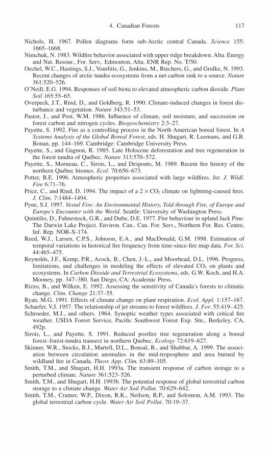
Nichols, H. 1967. Pollen diagrams form sub-Arctic central Canada. Science 155:1665–1668.
Nimchuk, N. 1983. Wildfire behavior associated with upper ridge breakdown. Alta. Energyand Nat. Resour., For. Serv,. Edmonton, Alta. ENR Rep. No. T/50.
Oechel, W.C., Hastings, S.J., Vourlitis, G., Jenkins, M., Riechers, G., and Grulke, N. 1993.Recent changes of arctic tundra ecosystems from a net carbon sink to a source. Nature361:520–526.
O’Neill, E.G. 1994. Responses of soil biota to elevated atmospheric carbon dioxide. PlantSoil 165:55–65.
Overpeck, J.T., Rind, D., and Goldberg, R. 1990. Climate-induced changes in forest dis-turbance and vegetation. Nature 343:51–53.
Pastor, J., and Post, W.M. 1986. Influence of climate, soil moisture, and succession onforest carbon and nitrogen cycles. Biogeochemistry 2:3–27.
Payette, S. 1992. Fire as a controlling process in the North American boreal forest. In ASystems Analysis of the Global Boreal Forest, eds. H. Shugart, R. Leemans, and G.B.Bonan, pp. 144–169. Cambridge: Cambridge University Press.
Payette, S., and Gagnon, R. 1985. Late Holocene deforestation and tree regeneration inthe forest tundra of Québec. Nature 313:570–572.
Payette, S., Morneau, C., Sirois, L., and Desponts, M. 1989. Recent fire history of thenorthern Québec biomes. Ecol. 70:656–673.
Potter, B.E. 1996. Atmospheric properties associated with large wildfires. Int. J. Wildl.Fire 6:71–76.
Price, C., and Rind, D. 1994. The impact of a 2 ¥ CO2 climate on lightning-caused fires.J. Clim. 7:1484–1494.
Pyne, S.J. 1997. Vestal Fire: An Environmental History, Told through Fire, of Europe andEurope’s Encounter with the World. Seattle: University of Washington Press.
Quintilio, D., Fahnestock, G.R., and Dube, D.E. 1977. Fire behaviour in upland Jack Pine:The Darwin Lake Project. Environ. Can.. Can. For. Serv., Northern For. Res. Centre,Inf. Rep. NOR-X-174.
Reed, W.J., Larsen, C.P.S., Johnson, E.A., and MacDonald, G.M. 1998. Estimation of temporal variations in historical fire frequency from time-since-fire map data. For. Sci.44:465–475.
Reynolds, J.F., Kemp, P.R., Acock, B., Chen, J.-L., and Moorhead, D.L. 1996. Progress,limitations, and challenges in modeling the effects of elevated CO2 on plants andecosystems. In Carbon Dioxide and Terrestrial Ecosystems, eds. G.W. Koch, and H.A.Mooney, pp. 347–380. San Diego, CA: Academic Press.
Rizzo, B., and Wilken, E. 1992. Assessing the sensitivity of Canada’s forests to climaticchange. Clim. Change 21:37–55.
Ryan, M.G. 1991. Effects of climate change on plant respiration. Ecol. Appl. 1:157–167.Schaefer, V.J. 1957. The relationship of jet streams to forest wildfires. J. For. 55:419–425.Schroeder, M.J., and others. 1964. Synoptic weather types associated with critical fire
weather. USDA Forest Service, Pacific Southwest Forest Exp. Stn., Berkeley, CA,492p.
Sirois, L., and Payette, S. 1991. Reduced postfire tree regeneration along a borealforest–forest-tundra transect in northern Quebec. Ecology 72:619–627.
Skinner, W.R., Stocks, B.J., Martell, D.L., Bonsal, B., and Shabbar, A. 1999. The associ-ation between circulation anomalies in the mid-troposphere and area burned by wildland fire in Canada. Theor. App. Clim. 63:89–105.
Smith, T.M., and Shugart, H.H. 1993a. The transient response of carbon storage to a perturbed climate. Nature 361:523–526.
Smith, T.M., and Shugart, H.H. 1993b. The potential response of global terrestrial carbonstorage to a climate change. Water Air Soil Pollut. 70:629–642.
Smith, T.M., Cramer, W.P., Dixon, R.K., Neilson, R.P., and Solomon, A.M. 1993. Theglobal terrestrial carbon cycle. Water Air Soil Pollut. 70:19–37.
4. Canadian Forests 117

Solomon, A.M., and Leemans, R. 1989. Forest dieback inevitable if climate changes. Int.Inst. Appl. Syst. Anal., Luxemburg, Austria. IIASA Options.
Solomon, A.M., and Leemans, R. 1997.Boreal forest carbon stocks and wood supply: Past,present and future responses to changing climate, agriculture and species availability.Agric. For. Met. 84:137–151.
Solomon, A.M., Prentice, I.C., Leemans, R., and Cramer, W.P. 1993. The interaction ofclimate and land use in future terrestrial carbon storage and release. Water Air SoilPollut. 70:595–614.
Stocks, B.J. 1975. The 1974 wildfire situation in northwestern Ontario. Can. For. Serv.,Great Lakes Forest Res. Centre, Inf. Rep. O-X-232.
Stocks, B.J. 1987. Fire potential in the spruce-budworm damaged forests of Ontario. For.Chron. 63:8–14.
Stocks, B.J. 1991. The extent and impact of forest fires in northern circumpolar countries.In Global Biomass Burning: Atmospheric, Climatic, and Biospheric Implications, ed.J.S. Levine, pp. 197–202. Cambridge: MIT Press.
Stocks, B.J., and Walker, J.D. 1973. Climatic conditions before and during four signifi-cant forest fire situations in Ontario. Can. For. Serv., Great Lakes Forest Res. Centre,Inf. Rep. O-X-187.
Stocks, B.J., Lee, B.S., and Martell, D.L. 1996. Some potential carbon budget implica-tions of fire management in the boreal forest. In Forest Ecosystems, Forest Manage-ment and Global Carbon Cycle, eds. M.J. Apps, and D.T. Price, pp. 89–96. NATO ASISeries Vol. I 40. Berlin: Springer.
Stocks, B.J., Fosberg, M.A., Lynham, T.J., Mearns, L., Wotton, B.M., Yang, Q., Jin, J.-Z.,Lawrence, K., Hartley, G.R., Mason, J.A., and McKenney, D.W. 1998. Climate changeand forest fire potential in Russian and Canadian boreal forests. Clim. Change 38:1–13.
Stocks, B.J., Lawson, B.D., Alexander, M.E., Van Wagner, C.E., McAlpine, R.S., Lynham,T.J., and Dubé, D.E. 1989. The Canadian Forest Fire Danger Rating System: anOverview. For. Chron. 65:450–457.
Swetnam, T.W. 1993. Fire history and climate change in giant sequoia groves. Science262:885–889.
Thomas, G., and Rowntree, P.R. 1992. The boreal forests and climate. Q.J.R. Meteorol.Soc. 118:469–497.
Tolonen, K. 1983. The post-glacial fire record. In The Role of Fire in Northern Circum-polar Ecosystems, eds. W.R. Wein, and D.A. MacLean, pp. 21–44. New York: Wiley.
Turner, J.A. 1970. Hours of sunshine and fire season severity over the Vancouver ForestDistrict. For. Chron. 46:106–111.
Vance, R.E., Emerson, D., and Habgood, T. 1983. A mid-Holocene record of vegetativechange in central Alberta. Can. J. Earth Sci. 20:364–376.
Van Cleve, K., Chapin, F.S., III., Flanagan, P.W., Viereck, L.A., and Dyrness, C.T. 1986.Forest Ecosystems in the Alaskan Taiga. Ecological Studies 57. New York: Springer.
Van Wagner, C.E. 1977. Effect of slope on fire spread. Can. For. Serv., Bi-Mon. Res. Notes33:7–8.
Van Wagner, C.E. 1987. The development and structure of the Canadian Forest Fireweather index system. Canadian Forest Service, Forest Tech. Rep. 35, Ottawa, Ontario.
Weber, M.G., and Flannigan, M.D. 1997. Canadian boreal forest ecosystem structure andfunction in a changing climate: impact on fire regimes. Environ. Rev. 5:145–166.
Weber, M.G., and Stocks, B.J. 1998. Forest fires and sustainability in the boreal forests ofCanada. Ambio 27:545–550.
Weeks, E.R., Tian, Y., Urbach, J.S., Ide, K., Swinney, H.L., and Ghil, M. 1997. Transi-tions between blocked and zonal flows in a rotating annulus with topography. Science278:1598–1601.
Weir, J.M.H., and Johnson, E.A. 1998. Effects of escaped settlement fires and logging onforest composition in the mixedwood boreal forest. Can. J. For. Res. 28:459–467.
118 M. Flannigan, B. Stocks, and M. Weber

Weir, J.M.H., Johnson, E.A., and Miyanishi, K. 2000. Fire frequency and the spatial agemosaic of the mixed-wood boreal in western Canada. Ecol. Appl. 10:1162–1177.
Whelan, R.J. 1995. The Ecology of Fire. Cambridge: Cambridge University Press.Winkler, M.G. 1985. Charcoal analysis for paleoenvironmental interpretation: a chemical
assay. Quat. Res. 23:313–326.Wotton, B.M., and Flannigan, M.D. 1993. Length of the fire season in a changing climate.
For. Chron. 69:187–192.
4. Canadian Forests 119

5. Fires and Climate in Forested Landscapes of the U.S. Rocky Mountains
William L. Baker
Scattered reports indicate that the number of fires or area burned has increasedrecently in parts of the northern temperate zone, but is climatic change responsi-ble? Annual number of fires and area burned have generally increased since about1950 in Canada and Sweden (Stocks 1991), the Rocky Mountains (Qu and Omi1994; Fig. 5.1a) and the western United States (Arno 1996; Fig. 5.1b). However,trends in fire statistics may in part reflect increasing ability to monitor fires (Ryan1976; Qu and Omi 1994). Moreover, in Canada and in Yellowstone National Park,trends are dominated by a few exceptional fire years in the 1980s (Stocks 1991;Balling, Meyer, and Wells 1992a). Also suppression of fires decades ago mayhave increased fuel loads, leading to the larger fires seen now (Covington andMoore 1994). Finally the landscape may shape potential responses to climaticchange, leading to disequilibrium between climate and fires (Baker 1995). Identifying a climatic signal in historical fire data may thus require more under-standing of how climate, fuels, the landscape, and land-use practices separatelyand jointly shape fire regimes.
To organize a discussion of the present state of understanding in the Rocky Mountains, I contrast a view that emphasizes how broad-scale patterns ofclimate and fuels control fire regimes, with a contingent view in which localspatial constraints and historical legacies may limit general trends. While theseperspectives on what is important underlie models, empirical studies, and theo-ries, they are seldom explicit. Models that represent the broad-scale view, forexample, suggest that fires may hasten the response of vegetation to climatic
120

change by removing vegetation that may otherwise persist after climate is nolonger favorable (Overpeck, Rind, and Goldberg 1990). This view is of a rapidlyresponding, climatically controlled fire regime affecting a passive and indepen-dent vegetation in a featureless landscape. The contingent view suggests that fire regimes are inherently spatial, are constrained by the physical landscape, andare shaped by climate and vegetation as well as by historical legacies. Fireregimes thus typically require decades to centuries to adjust to new climates(Baker 1995).
In this chapter I review the broad-scale and contingent views in the context ofthe U.S. Rocky Mountains. These mountains extend from northern Montana to the Sangre de Cristo Mountains of New Mexico and the San Francisco Peaksof Arizona (Peet 1988). The Rockies can be divided into the northern Rocky
5. U.S. Rocky Mountains 121
Figure 5.1. Trends in the occurrence of fires in (a) the Rocky Mountains (Qu and Omi1994), and (b) the western United States (Arno 1996; reproduced with permission fromthe USDA Forest Service).

Mountains in Montana, the central Rocky Mountains from southern Montana intocentral Wyoming, and the southern Rocky Mountains from southern Wyomingto northern New Mexico and Arizona.
The Broad-Scale View
Relative Roles of Climate and Fuels
The prevailing climate affects the probability of weather conducive to fire initi-ation and spread and affects fuel buildup and fuel moisture (Fig. 5.2). Fires areprimarily ignited by lightning and humans, with lightning ignitions more proba-ble during certain weather episodes, particularly thunderstorms (Price and Rind1994a). Ignitions often do not spread significantly unless followed by weatherthat promotes spread, such as droughts and strong winds. However, the moisturecontent and abundance of fuel can also significantly constrain or promote firespread.
The relative importance of fire weather and fuels in shaping fire regimes varies geographically (Table 5.1). In a generally warm, dry climate (e.g., BajaCalifornia) where fuel moisture is often low enough to carry a fire, and weatheris often conducive to ignition and spread of fire, the primary limitation on firesmay be the time required for fuel to build to levels sufficient to carry a fire(Minnich et al. 1993). In contrast, in the colder, more humid climate of westernCanada, where suitable fire weather is rare, fuel buildup may be of little impor-tance, and the fire regime is more strongly controlled by fire-initiation and spreadweather (Bessie and Johnson 1995). Variation in the relative importance of
122 W.L. Baker
Figure 5.2. Major influences of climate on the occurrence of fires.

weather and fuels affects the potential response of the fire regime to changes inclimate. Thus it is important to consider how climate, weather, and fuels mayindividually affect fires before their joint effects can be understood.
Climatic Setting of the Rocky Mountains
Air Mass Boundaries, Droughts, and Teleconnections
The central and southern Rocky Mountains are separated by a comparatively low-lying shrub steppe landscape between the Wind River Mountains and MedicineBow Mountains in Wyoming. This is the location of a significant winter bound-ary between predominantly east–west airflow from the Pacific to the north andpredominantly southerly flow, associated with an anticyclone over southernNevada, to the south (Mitchell 1976; Adams and Comrie 1997). This boundaryperiodically breaks down, allowing Pacific cyclones to enter the southernRockies. During summer, a monsoon boundary runs southwest to northeast acrossnorthwestern Colorado not far from the winter boundary (Mitchell 1976; Adamsand Comrie 1997). To the north the Rockies are under predominantly westerlyflow from the Pacific, which in summer results in prevailing warm, dry condi-tions. However, the northern Rockies are also an area of summer cyclogenesis(Changnon 1985). To the south, the southern Rockies are dominated in summerby the North American monsoon, which brings warm, moist tropical air from thegulfs of California and Mexico (Adams and Comrie 1997), and regular afternoonthunderstorms and lightning (Carleton 1985).
Low winter snowpacks, which may contribute to summer fire occurrence (e.g.,Balling et al. 1992b), link to sea surface temperatures in the tropics and NorthPacific. The El Niño phenomenon, associated with anomalous warming of easternPacific sea surface waters, may affect U.S. winter weather through extratropicalteleconnections at periods concentrated in the four-year frequency band (Diaz andMarkgraf 1992; Stahle et al. 1998). At the southern end of the southern Rockies(e.g., southern Colorado), winter precipitation and snowpack are enhanced duringEl Niños and lowered during La Niñas (Ropelewski and Halpert 1986; D’Arrigoand Jacoby 1991; Cayan 1996; Stahle et al. 1998; Kunkel and Angel 1999).Further north in the southern and central Rockies, El Niños and La Niñas mayhave less effect (Ropelewski and Halpert 1986; Woodhouse 1993). However, both
5. U.S. Rocky Mountains 123
Table 5.1. Two ends of a continuum between fuel control of the fire regime and fire-weather control of the fire regime
Minnich et al. (1993) Bessie and Johnson (1995)
Baja California chaparral and mixed Western Canadian subalpine forestsconifer
Fire regime predominantly fuel driven Fire regime predominantly weather drivenClimatic change primarily affects fuel Climatic change primarily affects fire
buildup; increased ignitions and fire weather; increased fuel buildup of weather irrelevant minor importance

El Niño and La Niña increase snowfall in Wyoming (Smith and O’Brien 2001).In the western part of the northern Rockies, El Niño leads to average snowfalldecreases of about 20%, and La Niña leads to similar increases in snowfall(Kunkel and Angel 1999; Smith and O’Brien 2001). Thus the effects of ElNiño/La Niña vary along the Rockies, apparently with the greatest, but opposite,effects at the southern and northern ends. Another factor affecting low wintersnowpacks is a strong Pacific North America (PNA) pattern, which consists of adeep Aleutian low and a blocking ridge over the northwestern United States andwestern Canada. This leads to low winter snowpack in the central and northernRockies and often enhanced snowpack in the southern Rockies, as occurred fromabout 1977 to 1989 (Changnon, McKee, and Doesken 1993; Cayan 1996). Since1989 the relationship between El Niño and the PNA pattern has broken down,probably because the North Atlantic Oscillation (NAO) and Pacific DecadalOscillation (PDO) became locked in phase (Watanabe and Nitta 1999).
The PDO is an index of decadal variability in the climate of the Pacific Ocean(Mantua et al. 1997), with a period of about 23 years, but varying from 17 to 28years (Biondi, Gershunov, and Cayan 2001). The PDO affects the strength of ElNiño and La Niña, as well as the El Niño related PNA pattern. When the PDOis generally in a cold or low phase (e.g., 1947–1977) the effect of El Niño onU.S. climate is weakened, while the effect of La Niña is enhanced (Gershunovand Barnett 1998). The 1952 to 1956 central U.S. drought is an example (Barlow,Nigam, and Berbery 2001). Conversely, when the PDO is in a warm or high phase(e.g., 1977–1989) the effect of El Niño on U.S. climate is enhanced and the effectof La Niña is weakened. In addition to its effect on El Niño and La Niña, thePDO itself is associated with drought in the mid-Atlantic states and the extremeNorthwest (Cole and Cook 1998), and also with dry summers in the central andnorthern Rockies and wet summers in the southern part of the southern Rockies(Barlow, Nigam, and Berbery 2001).
Summer droughts have less clear teleconnections with El Niño or La Niña inthe central and southern Rockies, but they may also be linked to the winter PNApattern. The 1988 drought that led to extensive fires in and near YellowstoneNational Park in the northern central Rockies was associated with a tele-connection from the eastern Pacific following an El Niño early in 1988. But thisteleconnection was unlike the typical winter PNA pattern, and it was probablyonly reinforced by, rather than caused by, La Niña (Trenberth, Branstator, and Arkin 1988; Palmer and Brankovic 1989). Major droughts in the western UnitedStates have often had a teleconnection to the North Pacific (Namias 1982). The1997–98 drought, however, was broadly linked to exceptionally warm global seasurface temperatures, and not just El Niño or Pacific temperatures (Kumar et al.2001).
The North American monsoon is influenced by the PNA pattern, El Niño/LaNiña, and the PDO. A weak North American monsoon and dry conditions in thesouthern Rockies are associated with southward displacement of the summer subtropical ridge. Both tend to occur after a zonal or weak PNA pattern in winter,
124 W.L. Baker

with no ridge over the western United States (Carleton, Carpenter, and Weser1990; Higgins, Mo, and Yao 1998). A strong winter PNA pattern may lead to awet monsoon the following summer, as the subtropical ridge is displaced north,allowing moist tropical air to flow into the southwest (Carleton, Carpenter, and Weser 1990; Higgins, Mo, and Yao 1998). El Niño (La Niña) is associ-ated with late (early) onset of the monsoon (Higgins and Shi 2001). Monsoon intensity appears to be more controlled by intraseasonal effects, particularly thetropical Madden-Julian oscillation, and local influences, such as spring snowcover (Anderson, Roads, and Chen 2000; Higgins and Shi 2001). A high or warmPDO may also enhance monsoon strength (Barlow, Nigam, and Berbery 2001).
Droughts that promote fires in the Rocky Mountains also have statistical link-ages to solar and lunar phenomena and, potentially, both oceans. A 22-year cycleof drought in the western United States correlates with the Hale sunspot cycleover long time periods (Mitchell, Stockton, and Meko 1979). Other strongsunspot-weather correlations have been found (van Loon and Labitzke 1988). Thesunspot-weather relationship is weaker since 1895 (Diaz 1983), and may even bemore strongly correlated with an 18.6-year lunar nodal-tide effect (Currie 1984).Tree rings reveal bi-decadal (20–23 year) and 7.8-year frequencies of drought inthe western United States from 1700 to 1978 (Cook, Meko, and Stockton 1997).These authors found that both the Hale sunspot cycle and lunar tidal cycle are significantly correlated with drought, although an internally driven ocean-atmosphere oscillation in the North Pacific (e.g., PDO) is also a possible explana-tion (see also Woodhouse and Overpeck 1998). In the plains adjoining the RockyMountains, there is similar evidence of the Hale sunspot cycle in historical airtemperatures (Chang and Smith 2001), but also a possible influence of the NorthAtlantic Oscillation on the bi-decadal drought cycle (Hu, Woodruff, and Mudrick1998; Woodhouse and Overpeck 1998). Thus the bi-decadal drought cycleappears significant in the Rocky Mountain region, but there remain severalhypotheses about the source of the cycle.
Influences of solar variation on fires have seldom been analyzed, since a com-pelling physical link with climate is lacking, but mechanisms have recently beenproposed. These include cosmic ray influences on clouds (Wagner et al. 2001)and absorption of ultraviolet radiation by stratospheric ozone (Shindell et al.1999). These explanations require further resolution, as do possible effects onfires. In the northwestern United States, including Idaho and Montana, the numberof lightning fires correlates with sunspot numbers over the period from 1915 to1939 (Bumstead 1943). In bristlecone pine forests in the southern Rockies, manystand origins, likely caused by fire, coincided with the Maunder sunspot minimum(Baker 1992).
Teleconnections with the tropics and the Pacific Ocean appear to influenceRocky Mountain climate, and there is now clear evidence of influence on RockyMountain fires. Many fire years in subalpine forests in the Rocky Mountainsappear to have been regional in extent, suggesting a strong regional synoptic cli-
5. U.S. Rocky Mountains 125

matic control (Veblen 2000; Kipfmueller and Baker 2000). An early study foundthat above- and below-average fire years bear no relation to El Niño events in the Rocky Mountains (Simard, Haines, and Main 1985). However, the “RockyMountains” in this study include some Great Plains and southwestern states,clouding relationships in the mountains. In the first study, to clearly demonstratean effect on fires in the Rockies, wet episodes associated with El Niño one tothree years prior to drought were found to enhance fuel buildup that increasesfires during La Niña-related drought in the Colorado Front Range (Veblen et al.2000). This pattern of large fires occurring after a sequence of strong El Niño andLa Niña years was also found to occur synchronously in the southwestern UnitedStates and Argentina (Kitzberger, Swetnam, and Veblen, in press). Decadal andcentennial trends in fire occurrence are also approximately synchronous in theColorado Front Range and Argentina (Veblen and Kitzberger, in press), and areprobably related to variations in the strength of El Niño and La Niña.
Fire regimes also change in response to longer-term climatic trends. On themillennial time scale, fire frequency in Yellowstone National Park during the last17,000 years increased as July insolation increased under the influence of varia-tions in the earth’s tilt and the timing of the perihelion (Millspaugh, Whitlock,and Bartlein 2000). The onset of warmer and drier conditions about 2600 yearsBP may have increased fire frequency in subalpine forests in central Colorado(Fall 1997).
Climate research continues to alter our understanding of Rocky Mountainclimate, and some potential effects on fires have yet to be studied. For example,the effect of the PDO on U.S. climate has been elucidated (Mantua et al. 1997),but PDO effects on fires are unstudied. Fire research may always be awaitingfurther clarification of sources of variability in climate. This is particularly so inthe Rocky Mountains, a complex meeting place for multiple climatic influences.
Lightning and Ignitions
Climatic episodes that lead to dry conditions are insufficient for fires, since igni-tion also is required, and lightning may be limiting. Lightning density is com-paratively low in the Rockies, especially in the northern Rockies. The density ofcloud-to-ground lightning averages 0.5 to 1.0 flashes km-2 yr-1 in the central andnorthern Rockies to 1 to 3 flashes km-2 yr-1 in the southern Rockies, compared to 9 to 13 flashes km-2 yr-1 in parts of the midwest and southeast (Orville 1994;Orville and Silver 1997; Orville and Huffines 2001). In the southern Rockies,highest lightning densities are in July and August from noon to midnight, peakingin late afternoon, with much less in June and September, and very little in othermonths (López and Holle 1986).
Lightning-strike density gradually decreases by 50% from southwestern Colorado to southern Wyoming, while strike density remains about a third of thatin southwestern Colorado across the central Rockies in Wyoming (Reap 1986).This north–south gradient is strongly related to thunderstorm density associatedwith moist tropical air from the North American monsoon (Reap 1986; Watson
126 W.L. Baker

et al. 1994). However, in the northern Rockies a much larger percentage of thun-derstorms is associated with summer cold fronts than with local convection andmoist tropical air (Colson 1957). Lightning density in the western United Statesa little more than doubles from 1000 to 3000m in elevation (Reap 1986), but pre-cipitation also increases.
Lightning-strike density is often well correlated with thunderstorms and rain-fall (e.g., Tapia, Smith, and Dixon 1998), but storms that start fires have less rainand more cloud-to-ground lightning. A study of 14,754 reports of thunderstormsfrom 270 or more fire lookouts stationed on high mountains in the northernRockies over a five-year period linked lightning, rain, and ignitions (Gisborne1931). Lightning storms that cover larger areas lead to more fires per unit area.The average lightning storm that does (does not) start a fire has about 9 (15)minutes of rain before the lightning starts and about 31 (44) minutes after thelightning ends. Six percent to 10% of thunderstorms have lightning with no rain.Gisborne found that these dry storms ignite fires no better than wet storms, butRorig and Ferguson (1999) link dry lightning with increased fire starts in thenorthern Rockies. Storms that start fires have a high percentage of cloud-to-ground (as opposed to cloud-cloud) lightning and long-continuing current strokes(Fuquay et al. 1967a, b; Latham and Schlieter 1989). One thunderstorm ignited335 fires in the northern Rockies in a day (Barrows 1951a).
Lags are common between ignition and fire detection or spread. Gisborne(1931) found that about 8% of fires were not detected until more than 48 hoursafter the storm that led to ignition. After ignition a fire may smolder for weeksbefore spreading; the Ouzel fire in 1978 in Rocky Mountain National Park, forexample, ignited August 9 but did not begin its major spread until dry conditionsand strong winds began on September 1 (Butts 1985). In subalpine forests, manysmall fires are started that burn only a few trees before going out (Kipfmuellerand Baker 2000).
The Fire Season
The fire season in the Rockies is typically from April to October, but the seasondecreases in length with elevation. In the southern Rockies the fire season tendstoward bimodality, with peaks in May to June and in September to October anda low period from about mid-July to the end of August (Cohen 1976; Ryan 1976;Floyd, Romme, and Hanna 2000). The number of fires and average fire size aretypically highest in June (Ryan 1976; Floyd, Romme, and Hanna 2000). The lowperiod after June reflects the wet period associated with the peak of the NorthAmerican monsoon. In the northern Rockies, where the monsoon has less effect,the number of fires is more unimodally distributed with a peak in July (Fig. 5.3;Barrows 1951a). Larsen (1925) suggests, based on an analysis of over 13,000fires, that the fire season in northern Idaho and Montana is bounded by the timemean air temperature is above about 10°C and monthly precipitation is <50mm.This results in a fire season of about 150 days in the lowest forested zone andabout 76 days in subalpine forests.
5. U.S. Rocky Mountains 127

Fire-Spread Weather
Even if there is a climatic episode favorable to ignition, an ignited fire cannotspread unless weather conditions are also favorable. In the Rockies the majorweather factors that promote fire spread, once a fire is ignited, are high tempera-tures and low precipitation or drought, which leads to low fuel moisture, low re-lative humidity, and strong winds (Table 5.2). These factors are reflected infire-weather indexes commonly used in the region (Table 5.2). Antecedent con-ditions are also important. Low precipitation during the preceding winter andspring often leads to more and larger fires during the fire season (Kipfmueller and Swetnam 2000). Where there are live fine fuels (e.g., grasses, conifer needles), high precipitation one to four years previously may provide abun-dant fuels that lead to increased fires during dry years (Veblen et al. 1996, 2000;Kipfmueller and Swetnam 2000). Drought intensity, measured by the Palmerindexes, is strongly correlated with fire occurrence, large fires, and area burned.High temperatures and drought lead to low fuel moisture. The most significant firespread rates during the 1988 fires were associated with 1000-hour time lag fuelmoistures <13% (Renkin and Despain 1992), but the area burned was correlatedwith 100-hour time lag fuel moisture (Turner et al. 1994). When the moisturecontent of fine fuels reaches as low as 4–7%, very large fires and rapid rates ofspread have occurred (Jemison 1932; Thomas 1991). Strong winds spread fires inthis region, but strong winds alone are insufficient unless the relative humidity islow (Beighley and Bishop 1990). The spread of plume-dominated, rather thanwind-driven, fires is promoted by atmospheric instability, reflected in steep, upper-air lapse rates and air temperature–dew point differences >6°C (Haines 1988;Werth and Ochoa 1990).
Two major synoptic climatic patterns leading to strong winds, and two synop-tic patterns leading to hot, dry conditions, contribute to the occurrence of large
128 W.L. Baker
Figure 5.3. The mean number of days in each month when lightning fires have occurredin the northern Rocky Mountains (data from Barrows 1951a from 1931 to 1945 on nationalforests).

Table 5.2. Reported weather effects on the occurrence of fires, large fires, and the amount of area burned in the U.S. Rocky Mountains
Large AreaFires fires burned Where Author(s)
TemperatureMonthly mean temp. r = 0.79 r = 0.49 r = 0.57 Black Hills, SD & WY McCutchan & Main 1989Temp. > 38°C ¥ Rocky Mts. Brown & Davis 1939Temp. > 37°C ¥ Northern ID Jemison 1932Temp. above avg. in July ¥ Front Range, CO Veblen et al. 1996, 2000Temp. above avg. in summer ¥ Southern CO Baker 1992Temp. above avg. in summer ¥ Yellowstone, WY Balling et al. 1992aMax. temp. in summer r = 0.58 Yellowstone, WY Balling et al. 1992bHigh temperatures ¥ MT & SD Potter 1996
PrecipitationNo precip. for 8 or more days ¥ Rocky Mts. Brown & Davis 1939Precip. below avg. preceding winter/spring ¥ Yellowstone, WY Balling et al. 1992aPrecip. below avg. preceding spring ¥ ¥ Front Range, CO Veblen et al. 1996, 2000Precip. below avg. in summer ¥ Yellowstone, WY Balling et al. 1992aPrecip. below avg. in summer ¥ Yellowstone, WY Renkin & Despain 1992Precip. below avg. in summer ¥ West-central ID Steele et al. 1986Precip. total in summer r = -0.52 Yellowstone, WY Balling et al. 1992bPrecip. days in summer r = -0.41 Yellowstone, WY Balling et al. 1992bPrecip. below avg. for year ¥ ¥ Front Range, CO Veblen et al. 1996, 2000Precip. above avg. 1–3 years before ¥ ¥ Front Range, CO Veblen et al. 1996, 2000Dry periods ¥ Priest Range, ID Marshall 1927Precip. substantially below average ¥ Northern Rockies Barrett et al. 1997
Fuel MoistureFuel moisture 0–7% ¥ Rocky Mts. Brown & Davis 1939Fuel moisture (duff & branch wood) < 10% ¥ Northern Rockies Weidman 1923Fuel moisture (duff & branch wood) < 10% ¥ Northern ID Gisborne 1927Fuel moisture (duff & branch wood) 4–5% ¥ Northern ID Jemison 1932100-hr time lag fuel moisture r = 0.52 Yellowstone, WY Turner et al. 19941000-hr time lag fuel moisture r = 0.36 Yellowstone, WY Turner et al. 19941000-hr time lag fuel moisture < 13% ¥ Yellowstone, WY Renkin & Despain 19921000-hr time lag fuel moisture ¥ ID & MT Burgan et al. 1996
129
Continued

DroughtSevere droughts ¥ Glacier NP, MT Barrett et al. 1991Droughts ¥ Northern Rockies Barrett et al. 1997Palmer Hydrological Index r = -0.86 r = -0.65 Black Hills, SD & WY McCutchan & Main 1989Palmer Drought Index r = -0.84 r = -0.66 Black Hills, SD & WY McCutchan & Main 1989Palmer Drought Index ¥ Western MT Goens 1990Palmer Drought Index ¥ State of Colorado Cohen 1976Palmer Drought Severity Index r = -0.60 Yellowstone, WY Balling et al. 1992bPalmer Drought Severity Index ¥ Western MT Kipfmueller & Swetnam 2000
Relative Humidity (RH)RH < 20% needed before strong winds caneffectively spread a fire ¥ Boise, ID Beighley & Bishop 1990RH about 10% ¥ Northern ID Jemison 1932
WindWind > 40km/hr ¥ Rocky Mts. Brown & Davis 1939Winds very strong ¥ Ouzel Fire, CO Butts 1985Wind gusts > 80km/hr ¥ Pingree Park, CO Colo. St. Univ. 1995Winds very strong ¥ Western MT Goens 1990Strong afternoon winds ¥ Northern ID Gisborne 1927Strong winds above the fire ¥ Boise, ID Small 1957Foehn winds ¥ Rocky Mts. Heilman et al. 1994Foehn winds ¥ Western MT Goens 1990
Atmospheric InstabilitySteep upper air lapse rates producing unstable air ¥ Western U.S. Haines 1988Air temperature-dew point differences > 6°C ¥ Western U.S. Haines 1988
Fire Weather IndexesFosberg Fire Weather Index (wind, moisture) r = 0.66 Black Hills, SD & WY McCutchan & Main 1989Burning Index (rel. humid., temp.) r = 0.64 Black Hills, SD & WY McCutchan & Main 1989
Note: Large fires are defined using a variety of criteria. Negative reports (e.g., no effect of Palmer Drought Severity Index) are not included. The first column lists the vari-able used by the author; succeeding columns indicate which fire parameter(s) was found to be related. State abbreviations are: CO = Colorado, ID = Idaho, MT = Montana,SD = South Dakota, WY = Wyoming.
Table 5.2. Continued
Large AreaFires fires burned Where Author(s)
130
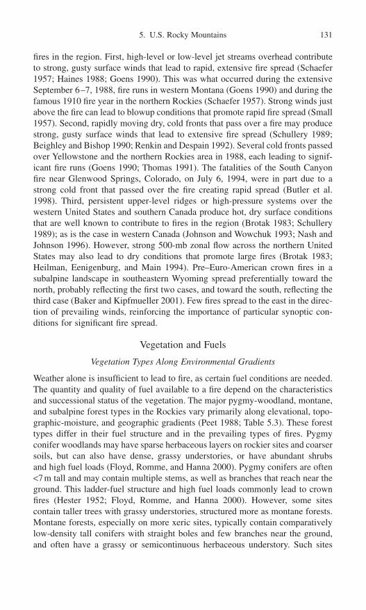
fires in the region. First, high-level or low-level jet streams overhead contributeto strong, gusty surface winds that lead to rapid, extensive fire spread (Schaefer1957; Haines 1988; Goens 1990). This was what occurred during the extensiveSeptember 6–7, 1988, fire runs in western Montana (Goens 1990) and during thefamous 1910 fire year in the northern Rockies (Schaefer 1957). Strong winds justabove the fire can lead to blowup conditions that promote rapid fire spread (Small1957). Second, rapidly moving dry, cold fronts that pass over a fire may producestrong, gusty surface winds that lead to extensive fire spread (Schullery 1989;Beighley and Bishop 1990; Renkin and Despain 1992). Several cold fronts passedover Yellowstone and the northern Rockies area in 1988, each leading to signif-icant fire runs (Goens 1990; Thomas 1991). The fatalities of the South Canyonfire near Glenwood Springs, Colorado, on July 6, 1994, were in part due to astrong cold front that passed over the fire creating rapid spread (Butler et al.1998). Third, persistent upper-level ridges or high-pressure systems over thewestern United States and southern Canada produce hot, dry surface conditionsthat are well known to contribute to fires in the region (Brotak 1983; Schullery1989); as is the case in western Canada (Johnson and Wowchuk 1993; Nash andJohnson 1996). However, strong 500-mb zonal flow across the northern UnitedStates may also lead to dry conditions that promote large fires (Brotak 1983;Heilman, Eenigenburg, and Main 1994). Pre–Euro-American crown fires in asubalpine landscape in southeastern Wyoming spread preferentially toward thenorth, probably reflecting the first two cases, and toward the south, reflecting thethird case (Baker and Kipfmueller 2001). Few fires spread to the east in the direc-tion of prevailing winds, reinforcing the importance of particular synoptic con-ditions for significant fire spread.
Vegetation and Fuels
Vegetation Types Along Environmental Gradients
Weather alone is insufficient to lead to fire, as certain fuel conditions are needed.The quantity and quality of fuel available to a fire depend on the characteristicsand successional status of the vegetation. The major pygmy-woodland, montane,and subalpine forest types in the Rockies vary primarily along elevational, topo-graphic-moisture, and geographic gradients (Peet 1988; Table 5.3). These foresttypes differ in their fuel structure and in the prevailing types of fires. Pygmyconifer woodlands may have sparse herbaceous layers on rockier sites and coarsersoils, but can also have dense, grassy understories, or have abundant shrubs and high fuel loads (Floyd, Romme, and Hanna 2000). Pygmy conifers are often<7m tall and may contain multiple stems, as well as branches that reach near theground. This ladder-fuel structure and high fuel loads commonly lead to crownfires (Hester 1952; Floyd, Romme, and Hanna 2000). However, some sitescontain taller trees with grassy understories, structured more as montane forests.Montane forests, especially on more xeric sites, typically contain comparativelylow-density tall conifers with straight boles and few branches near the ground,and often have a grassy or semicontinuous herbaceous understory. Such sites
5. U.S. Rocky Mountains 131

typically support low-intensity surface fires and periodic crown fires (Weaver1974; Ryan 1976; Ehle 2001). More mesic sites and mixed conifer forests areoften denser, may contain abundant shrubs, and thus have more ladder fuels.While surface fires may occur, there is a higher probability of crown fire than indrier montane forests (Veblen 2000; Veblen, Kitzberger, and Donnegan 2000).Lodgepole pine forests often are dense, and have sparse, low-growing under-stories, although taller-shrub understories also occur. Very dense stands self-thinafter a few decades, leading to high dead-fuel loads beneath dense canopies(Alexander 1979). Lodgepole pine forests are prone to crown fires, but surfacefires can occur (Franklin and Laven 1991). Spruce fir forests often contain abun-dant ladder fuels, such as young trees, tall shrubs, and the low branches of thedominant conifers. These forests are also prone to crown fires.
The varying fuel structures of forests lead to strong differences in susceptibil-ity to fire, even among adjoining forest types, illustrating that the structure ofvegetation and fuels is important to the fire regime. Forests, relative to grasslands
132 W.L. Baker
Table 5.3. Major forest types and their dominant tree species in the Rocky Mountains
Forest zone Major forest type Dominant species Common name
Subalpine Spruce fir forest Picea engelmannii Engelmann spruceforest Abies lasiocarpa Subalpine fir
Xeric pine forest Pinus aristata Bristlecone pinePinus flexilis Limber pinePinus albicaulis Whitebark pine
Lodgepole pine Pinus contorta Lodgepole pineforest
Quaking aspen Populus tremuloides Quaking aspenforest
Montane Douglas fir forest Pseudotsuga menziesii Douglas firforest Ponderosa pine Pinus ponderosa Ponderosa pine
forestMixed conifer Pseudotsuga menziesii Douglas fir
forest Pinus ponderosa Ponderosa pinePinyon juniper Abies concolor White fir
Pygmy woodland Pinus edulis Twoneedle pinyonwoodland Juniperus scopulorum Rocky Mt. juniper
Juniperus monosperma Oneseed juniperJuniperus osteosperma Utah juniper
Riparian Cottonwood Populus deltoides ssp.forest forest monilifera Plains cottonwood
Populus deltoides ssp.wislizeni Rio Grande
cottonwoodPopulus angustifolia Narrowleaf
cottonwoodBlue spruce Picea pungens Blue spruce
forest
Note: Nomenclature is from the U.S. Department of Agriculture’s online PLANTS database(http://plants.usda.gov/plants/ ).
or shrublands, are strongly favored locations for fire starts throughout the RockyMountains (Barrows 1951b, 1978). Old-growth forests in landscapes with lodge-pole pine are preferential locations for ignitions (Renkin and Despain 1992), butintermediate-aged trees appear more susceptible in northern Idaho (Fowler andAsleson 1984). Forest types, such as ponderosa pine and Douglas-fir forests, thatmay occur within a few hundred meters of each other have quite different igni-tion rates (Table 5.4), an index that measures the ability of a forest type to sustainfires. Higher ignition ratios also suggest that it is more difficult to start a fire inDouglas-fir forests than in ponderosa pine forests (Table 5.4). The most impor-tant factor in ignition is fuel moisture in ponderosa pine and Engelmann spruceforests, but duff depth in lodgepole pine and Douglas-fir forests (Latham andSchlieter 1989). Mean fire sizes in the southern Rocky Mountains are highest inpinyon juniper woodlands and lodgepole pine forests and lowest in Douglas-fir,ponderosa pine, and aspen forests (Table 5.4).
Fuel Buildup with Succession
There is surprisingly little consistent difference in fuel loads among the majorcover types and environments, at least in the northern Rocky Mountains. Brownand See (1981) analyzed hundreds of fuel plots, and found no trends with slope,elevation, or aspect. Brown and Bevins (1986) compared hundreds of samples offuel loads from all the major forest types (Table 5.3) in the northern Rockies, andfound insignificant variation in mean loads for each fuel component among mostcover types. Fuel loads were quite varied within a cover type, presumably reflect-ing trends with succession and effects of disturbance.
Fuel trends appear complex and are not always consistent as succession pro-ceeds in Rocky Mountain forests. In subalpine forests of the northern Rockies
5. U.S. Rocky Mountains 133
Table 5.4. Ignition rates and mean fire sizes for major forest types in Colorado, ignitionrates in the northern Rocky Mountains, and ignition ratios in southwestern Idaho
Ignition rateMean
fire size (ha) Ignition ratioColoradoa Northern Rockiesb Coloradoa Idahoc
Sagebrush-grass 3.6 — 2.22 144Pinyon-juniper — — 4.01 —Ponderosa pine 81.9 310.7 1.00 24Douglas-fir 25.5 24.0 0.53 42Aspen 1.9 9.0 1.43 —Lodgepole pine 8.3 13.5 3.97 —Spruce-fir 4.1 13.2 2.42 —
Source:a Fechner and Barrows 1976.b Bevins and Barney 1980.c Meisner et al. 1994.Note: The ignition rate is the number of fires per 400,000ha (million acres) of that forest type peryear. The ignition ratio is the number of lightning strikes per fire start.

the fine fuels (litter, grass and forbs, and small branchwood), which are impor-tant in sustaining ignitions and in subsequent fire spread, are low during the firstdecade of postfire succession, as these fuels are typically consumed by the fire(Kessell et al. 1978). These fuels gradually increase for 150 to 200 years after afire in the central Rockies, then slowly decline with age, but quantities of finefuels in these forests are generally relatively small (Romme 1982). Small, deadfuels not consumed by the fire fall to the forest floor and are high immediatelyafter the fire, but decline within the first few decades (Kessell et al. 1978) to asmuch as a century (Romme 1982), as do the live fuels (shrubs, grass). Clagg(1975), however, found more complex trends in medium-sized fuels with timesince fire in the southern Rockies. Shrub fuels may decline in other major covertypes as succession proceeds (Habeck 1976), but may also increase (Brown andSee 1981). After the first few decades, most small fuels show relatively minortrends or no trend with stand age.
The largest fuel component generally increases through time (Kessell et al.1978; Romme 1982), although Brown and See (1981) report no consistent trendwith stand age, except that very old stands have high loads. Large, sound fuelsare relatively unimportant to future fires, since they are typically not consumed,but large, rotten fuels are important to fire intensity, and do accumulate over time(Clagg 1975). Overall, Romme (1982) observed a decline in total dead woodyfuels important to future fires through about the first century, then a gradualbuildup to about 450 years after a fire. Brown and See (1981), however, questionwhether there are any consistent trends in fuel components with stand age in anyRocky Mountain forest.
The duff layer is important in maintaining smoldering fires during cold, wetweather and in ignition in lodgepole pine and Douglas-fir forests (Latham andSchlieter 1989). In the Rockies, duff often accumulates gradually in a nearlylinear way from the time of the fire (Clagg 1975; Habeck 1976; Romme 1982).However, Clagg (1975) and Alexander (1979) found a trend toward a peak induff/litter depth at about 125 to 200 years after a fire in lodgepole pine forests.
Interaction of Climate and Fuels
Coincidence of Fuel Buildup and Fire Weather
An intermediate view of the relative roles of climate and fuels is that fires (par-ticularly large fires) are encouraged when fuel buildup is accompanied by suit-able fire weather. Insufficient fuel buildup, in this view, may limit the size of fireseven if suitable fire weather occurs. Romme and Despain (1989) emphasize thatduring the 250 years prior to the 1988 fires, fires in Yellowstone National Parkwere small because the landscape was dominated by young forests.
While fuel buildup may be important in limiting fire in some areas, this limita-tion can be overcome by extreme fire weather, as Bessie and Johnson (1995)suggest. When fuel moisture is very low (<10% in duff and branch wood), fires may spread with little response to fuel-load variations (Gisborne 1927).Jemison (1932) noted that when fuel moisture reaches as low as 4% or 5%, then
134 W.L. Baker

strong winds and high temperatures can lead to exceptional rates of fire spread(>600hahr-1) that are insensitive to fuel loads. During the Yellowstone fires of1988, age-class boundaries that stopped past fires were ineffective, and fuel varia-tions were apparently insignificant in shaping fire spread (Turner and Romme1994). The mechanism behind exceptional fire spread, independent of fuel loads,is that low fuel moisture makes more of the fuel load flammable and increases fireintensity.
There are thus two present conceptual models for the interaction of weatherand fuels. In the “fuel-weighted interactive model,” based on Romme andDespain (1989), fire weather varies, but this variation does not control fire occur-rence until fuel buildup is sufficient to lead to a combined high probability of fire.Importance is weighted toward fuel, and fire weather may just control the timingof the fire. In the “weather-weighted interactive model,” based on Jemison (1932)and Bessie and Johnson (1995), fuel buildup does increase fire probability, butfire weather is often sufficiently extreme to override the importance of fuels. Thismodel is supported by a weak tendency for area burned to increase as time-since-fire increases (Baker and Kipfmueller 2001).
Elevational Gradient of Interactions
An elevational gradient of interactions of climate and fuels can be hypothesized(Fig. 5.4a), based on trends reviewed earlier. Droughts decline with elevation,while lightning increases. Fine fuels reach a peak and ladder fuels reach a lowpoint in montane forests. Other variables that change are length of the fire seasonand relative fuel moisture (Fowler and Asleson 1984).
These trends lead to different potential limitations to fire occurrence in the threezones, but all three zones are hypothesized to have fire-weather control or weather-weighted interactive control, rather than fuel control of the fire regime (Table 5.1).In pygmy conifer woodlands at low elevation, drought and ladder fuels arecommon, the fire season is long, and fuel moisture is relatively low. Fire may bemost limited by insufficient lightning and the continuous fine fuels necessary toignition and spread. This zone is thus hypothesized to have a fire weather con-trolled fire regime, in which ignition-promoting weather, rather than drought, isthe primary control. In montane forests at middle elevations, droughts and light-ning are common and fine fuels are abundant; fire may be most limited by the needfor a combination of droughts and abundant fine fuels (Veblen, Kitzberger, andDonnegan 2000). Thus this may again be a fire weather controlled regime, but theweather control is by wet conditions promoting fine fuels followed by dry condi-tions leading to low fuel moisture. This regime may also be the most fuels-weatherinteractive fire regime, with weighting toward weather. In subalpine forests light-ning and ladder fuels are common, but fine fuels are less common and droughts areuncommon, so fire occurrence is most strongly limited by the occurrence ofdroughts that dry out dead and live fine fuels sufficiently to carry a fire. Subalpineforests in the Rockies appear most likely to fit the model of a more fire weathercontrolled fire regime, with drought the primary weather control.
5. U.S. Rocky Mountains 135
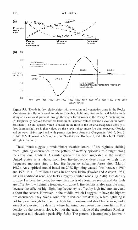
These trends suggest a predominant weather control of fire regimes, shiftingfrom lightning occurrence, to the pattern of wet/dry episodes, to drought alongthe elevational gradient. A similar gradient has been suggested in the westernUnited States as a whole, from low fire-frequency desert sites to high fire-frequency montane sites to low fire-frequency subalpine forest sites (Martin1982). An empirical model based on 2088 lightning-caused fires between 1960and 1971 in a 1.3 million ha area in northern Idaho (Fowler and Asleson 1984)adds an additional zone, and lacks a pygmy conifer zone (Fig. 5.4b). Fire densityin zone 1 is near the mean, because the effects of a long fire season and dry fuelsare offset by low lightning frequency. In zone 4, fire density is also near the meanbecause the effect of high lightning frequency is offset by high fuel moisture anda short fire season. However, in the middle, which I suggest to have the highestfire occurrence, they have a zone 2 with reduced fire density, where lightning isnot frequent enough to offset the high fuel moisture and short fire season, and azone 3 of elevated fire density where lightning does overcome these limits. Firedensity on the western slope, but not the eastern slope of the northern Rockies,suggests a mid-elevation peak (Fig. 5.5a). The pattern is incompletely known in
136 W.L. Baker
3.0
2.0
1.0
1.0
2.0
3.0
0
150 450 750300 600 1050 1350 1650 1850900 1200 1500 1800 2100 2250
Log of x2 values for
ABOVE NORMAL EXPECTED FIRE FREQUENCYIdaho Panhandle
LOG OF X2
VALUES
ZONE 1 ZONE 2
ZONE 3 ZONE 4
Log of x2 values for
BELOW NORMAL / EXPECTED FIRE FREQUENCYIdaho Panhandle
ELEVATION (m)
(a)
(b)
Figure 5.4. Trends in fire relationships with elevation and vegetation zone in the RockyMountains: (a) Hypothesized trends in droughts, lightning, fine fuels, and ladder fuelsalong an elevational gradient through the major forest zones in the Rocky Mountains; and(b) Empirically derived theoretical trend in chi-squared values version elevation in north-ern Idaho. The chi-squared value is based on the ratio of the observed/expected density offires (number/ha), so higher values on the y-axis reflect more fire than expected (Fowlerand Asleson 1984; reprinted with permission from Physical Geography, Vol. 5, No. 3, p. 243, © V.H. Winston & Son, Inc., 360 South Ocean Boulevard, Palm Beach, FL 33480;all rights reserved).

the southern Rockies (Fig. 5.5b). Research is needed to test these ideas over abroader area.
The Contingent View
Spatial Variation, Constraints, and Dependencies
Spatial Variation in Topographic Constraints on Fire Regimes
Topography and the location of mountains control air masses that affect relativehumidity and other important components of fire weather. In Colorado low
5. U.S. Rocky Mountains 137
Figure 5.5. Elevational trends in mean annual fires per 400,000ha on the eastern andwestern slopes of the Rocky Mountains: (a) lightning fires in the northern Rocky Mountains. Data are from Barrows (1951a). Elevation zones are in 1000 ft increments in the original data; (b) total fires in Colorado (data from Ryan (1976)).

relative humidity is most frequent in a broad zone at the center of the state, fromthe western border east to near Denver, with an outlier along the far northernfoothills of the Front Range (Cohen 1976). Days characterized by dry unstableair that promotes extreme fire behavior are much more frequent in the central andsouthern Rockies than the northern Rockies (Werth and Werth 1998).
In mountains the wind field that affects rates and directions of fire spread isthe result of synoptic-scale forcing, modified at that scale by mountain locationand orientation (Barry 1992). In Colorado frequent strong winds peak in thewestern San Juan Mountains and on the eastern slope of the northern ColoradoFront Range (Cohen 1976). In central Idaho the wind blows parallel to ridges,increasing the drying effect, while in parts of Idaho and Montana the wind blowsperpendicular to ridgelines, which then successively slow the wind and decreasefire spread (Larsen and Delavan 1922). Strong downslope winds, resulting from synoptic and topographic effects, occur frequently in the lee of the Rockies,especially in the northern Colorado Front Range (Cohen 1976), and are accentu-ated where mountains are perpendicular to prevailing westerly winds (Goens1990). Downslope winds are concentrated between November and March butmay also occur during the beginning and end of the fire season (Cohen 1976;Barry 1992).
On a finer topographic scale, ridges and valleys may channel and acceleratesynoptic-scale winds, with more exposed locations dominated by these winds,while more protected locations may develop local thermally induced winds(Sturman 1987). Terrain-forced convergence led to strong winds and large fireruns in several parts of the 1988 fires in western Montana (Goens 1990). Noc-tural downslope winds are most strongly developed on calm, clear nights whena surface temperature inversion and a low-level jet may develop. The low-leveljet may lead to rapid spread rates on ridges in the early morning, even thoughadjoining valleys are calm due to the inversion, as in the 1967 Sundance fire inIdaho (Baughman 1981). The variable arrangement of hillslopes and incomingsolar radiation leads to dynamic thermally induced winds (Sturman 1987). Duringthe early part of the day, asymmetrical heating of slopes may induce a cross-valley flow and an upslope flow, while later in the afternoon the overlying flowmay scour into valley bottoms through down-mixing (Sturman 1987). Rough,broken mountain terrain increases the mixing depth at night as well, and maybring strong winds aloft to the surface, as was the case during the 1988 fires inwestern Montana (Goens 1990).
Fire Breaks as Spatial Constraints
Fire breaks are physical and vegetational features that can stop a fire, lower itsintensity, or shift its direction (Fig. 5.6). In extreme conditions fire may crossapparent barriers with ease, and fires can always spot, via airborne embers, acrossdistances of several kilometers (e.g., Jemison 1932). Physical fire breaks (e.g.,rock outcrops, lakes) do not change in their resistance to fire spread as weatherchanges, but vegetational fire breaks (e.g., snow avalanche tracks) may be
138 W.L. Baker

effective only under less extreme conditions (e.g., Turner and Romme 1994).Even minor increases in fuel moisture can be a fire break under mild conditions(Clark 1990).
Fire breaks affect the susceptibility of the landscape to fires and, ultimately,the fire regime. First, fire breaks decrease fire sizes relative to fire sizes in similarfuels without breaks. Second, fire frequency at a point, with fire breaks in thevicinity, is decreased relative to fire frequency if the fire breaks were not nearby.This occurs because spread from adjoining areas, which contributes to fire fre-quency at a point, is diminished by nearby fire breaks. The fire rotation was 65%longer 6km or more, as opposed to less than 3km, from water breaks in a borealforest in Canada (Larsen 1997), so this effect can be very significant. On a finerscale, patches of rock and bare soil in pinyon juniper woodlands lead to about400-year fire rotations, while nearby shrublands, with more continuous fine fuelshave fire rotations of nearly 100 years (Floyd, Romme, and Hanna 2000). Third,if fire breaks are absent, then large fires can spread, leading to synchrony andspatial homogeneity in fuel buildup, which may promote synchronous suscepti-bility to future fires and lead to large future fires (Baisan and Swetnam 1990). Iffire breaks are present, the landscape is more likely to have asynchrony and spatialheterogeneity in fuel buildup and potential future fires. Landscapes with firebreaks are thus likely to be more continuously susceptible, than are landscapeswithout fire breaks, to “recording” lesser magnitude climate-related fire events,since some part of landscapes with fire breaks is likely to retain susceptible fuelloads.
5. U.S. Rocky Mountains 139
Figure 5.6. Potential fire breaks identified in the literature: (a) ridgelines, (b) avalanchetracks, (c) riparian areas and wetlands, (d) rock outcrops, talus slopes, and mass move-ment paths, (e) forest age class boundaries, (f ) aspen stands.

Elevational Gradient in Constraints
Topographic effects and fire breaks (Fig. 5.6) likely vary along elevational gra-dients, although there has been no systematic study of elevational trends. Lowerelevations, especially in valleys, are subject to temperature inversions and asso-ciated calm winds, but upslope and downslope thermal winds can become strong.Lower elevations probably typically have the highest density of some physicalfuel breaks (i.e., rock outcrops, canyons, large rivers) but not others (lakes, ridge-lines, mass movements). The highest forest elevations, in the subalpine zone upto treeline, have more exposed ridges subject to strong, synoptic-scale winds,low-level jets, and downslope winds, but are less affected by thermal winds andinversions. These high elevations have a high density of certain kinds of vegeta-tional and physical fuel breaks (i.e., wetlands, snow avalanche paths, aspenstands, age-class boundaries, lakes, mass movements, ridgelines). In the south-ern Rocky Mountains a relatively flat peneplain at mid-elevations has a lowdensity of physical fuel breaks, and perhaps has the highest fuel continuity in themountains. These patterns of spatial constraint are only hypothetical, and addi-tional research is warranted.
Fire as a Spatially Dependent Process
Fire is inherently a spatial spread process, which leads to spatial autocorrelationin fire regimes (Chou et al. 1990), although spotting that offsets autocorrelationalso occurs, particularly in stand-replacing fire regimes. Spatial autocorrela-tion occurs when the probability of fire at a point is dependent on the probabil-ity of fire at adjoining points. For a forest stand with a certain structure, fuel load,and climatic setting, the long-term fire frequency or other parameters of the fireregime in the stand may differ depending on the types of nearby ecosystem, proximity to favored ignition points (e.g., ridgelines), terrain setting, nearby fuelloads, and so on. The distance over which spatial autocorrelation occurs is relatedto the size of the fires and the physical processes that affect fire probability (e.g.,wind). The scale of significant spatial autocorrelation in the fire regime is alsothe scale over which spatial constraints (e.g., fuel breaks, topographic effects)have a significant effect. One study in southeastern Wyoming found significantspatial autocorrelation in mean fire intervals in a lodgepole pine forest over dis-tances exceeding 2km (Baker and Kipfmueller 2001), but additional research isneeded.
Historical Legacies
Legacy of Past Climate and Natural Disturbance
The Little Ice Age (LIA) in the southern Rockies and the U.S. southwest, fromabout AD 1400 to 1850 was, on average, cold and dry relative to the present, butfluctuations occurred (Bradley and Jones 1992; Petersen 1994; Grissino-Mayer1995), so the name is perhaps a misnomer. Droughts occurred in the late 1500s
140 W.L. Baker
in the southern Rockies and Great Plains (D’Arrigo and Jacoby 1991; Woodhouse2001), wet episodes in the early 1600s, and droughts around 1820 and 1860(Woodhouse and Overpeck 1998; Cook et al. 1999), while the 1830s are identi-fied as the wettest episode since the 1600s (Grissino-Mayer 1995). After the LIAa strong increase in pinyon pollen in southwestern Colorado suggests wettersummers from a stronger North American monsoon (Petersen 1988, 1994). His-torical climatic data and tree-ring analysis for the Rockies reveal warming, butcontinuing significant fluctuations in climate since the end of the LIA (Stocktonand Meko 1975; Cook, Meko, and Stockton 1997; Woodhouse 2001; Woodhouseand Brown 2001).
The older live trees in a forest may have originated in an earlier, and quite dif-ferent environmental period, such as the LIA, leaving a legacy of forest structurethat shapes present fire occurrence. Clark (1990) suggested that the present disturbance regime may not explain forest structure established earlier, but theconverse is also a possibility. The structure (e.g., density, volume) of trees presentin older forests may reflect a long sequence of climatic conditions and distur-bances conceivably no longer present in the landscape. The composition of theforest may also reflect a previous climate, as several centuries may be requiredfor forest composition to adjust to climate change (Campbell and McAndrews1993).
Stand characteristics at the time of a stand-replacing burn may leave an impor-tant legacy affecting subsequent fuel loads, more important in some respects thanthe characteristics of the postfire stand. The attributes (e.g., density) of trees killedby a fire, compared to attributes of trees that survived or became established afterthe fire, are better predictors of loads of small fuels and amounts of downed rottenmaterial in postfire Pinus contorta stands in Colorado (Alexander 1979). This isnot true for litter, which is more related to postfire live-tree volume. In the north-ern Rockies there is also little relationship between fuel loads and stand age, inpart because of the significant legacy from the pre-burn stand (Brown and See1981).
The absence of a consistent trend in fuel loads during succession is also attrib-uted in part to periodic, unpredictable disturbances and other varying sources ofleaf, needle, branch, and stem input to the fuels complex (Brown and See 1981).A variety of events and influences, such as windstorms, ice storms, droughts,disease, parasites, and a host of disturbances can cause canopy trees or under-story plants to contribute material to the fuel load. Insect and parasite effects onfuel loads, for example, can be quite complex, as these agents can open thecanopy, leading to increased solar radiation and possibly faster fuel decomposi-tion, as well as increased fuel contribution from the canopy (Knight 1987).
Legacy of Human Land Uses
Several human land uses influence fire regimes while they are occurring, but mayalso leave a legacy that affects future fires. Livestock grazing can reduce fine
5. U.S. Rocky Mountains 141

fuels in forests, reducing the probability of ignition and spread (e.g., Hatton1920). However, excessive livestock grazing continued for years may also favordevelopment of ladder fuels that increase the probability of crown fires in Douglasfir forests in the northern Rockies (Zimmerman and Neuenschwander 1984).Similar effects are suggested for ponderosa pine forests throughout the south-western United States (Covington and Moore 1994). In the southern RockyMountains where the fire regime in montane forests is sensitive to fine-fuel abun-dance linked to the El Niño–Southern Oscillation (Veblen et al. 2000), livestockgrazing, where excessive, could decrease fine fuels, reducing the sensitivity ofthe fire regime in these forests to the El Niño–Southern Oscillation. However,livestock grazing has been decreasing in the wildland–urban interface in someareas. A variety of other land uses, such as timber harvesting (Weatherspoon andSkinner 1995) and associated forest fragmentation (Goldammer and Price 1998),can alter the structure and composition of fuels, leaving a legacy that affects thepotential response of the fire regime to climatic change.
Fire as a Temporally Dependent Process
Fire regimes do not adjust immediately to climatic change, since fire as a spatialprocess requires decades to centuries to fully burn through a landscape. If climatechanges abruptly, it may require up to two fire rotations of the new fire regimefor all the trees in a landscape to receive a fire from the new regime, in parterasing present fuel loads and forest structures that then can adjust to the newregime (Baker 1995). However, fires do not consume all the fuels.
The legacy is not fully over in two rotations, but persists until past trees killedby the new fire regime fully decompose, since large dead wood affects fire inten-sity. The new regime may shorten (lengthen) the rotation, leading to a lower(higher) mean age and tree size for forest stands across the landscape (Baker1995). However, as the existing older (younger) and larger (smaller) trees arekilled by fire, these large (small) stems atypical of the new fire regime will con-tinue to affect the new regime until stems killed by the fire decompose. Downedlogs in subalpine forests in the Rockies may require >150 years to fully decom-pose (Brown et al. 1998).
Thus the maximum time that existing stand structure may influence future fires,even if climate changes immediately, is on average about two rotations of thenew fire regime (decades to centuries) to burn away existing structure, and anadditional century and a half (in subalpine forests) to decompose the trees killedby the new fire regime. Baker (1995) argued that the time required for fire regimesto adjust to climatic change may often exceed the time that climate is stable,leading to perpetual temporal disequilibrium between climate, fire regimes, fuelloads, and forest structure. New climates that arise quickly may interact fordecades to centuries with past fuel loads and forest structures before the new fireregime is fully adjusted. If climate changes gradually in a directional way, thenthe fire regime will be perpetually adjusting to the new climate, held back by anongoing legacy of fuel loads and forest structures.
142 W.L. Baker

Potential Response to Climatic Change
Projected Climate Changes
General circulation models (GCMs) predict increased temperature and precipita-tion in the Rocky Mountains under a doubled CO2 climate, summarized byHoughton et al. (1996) as follows: These models do not include topographic detailimportant in the region, but do include aerosol effects that damp projected tem-perature increases. Predictions are for about 1.5–3.5°C warming in winter,0.0–0.5°C warming in summer, 0.0–0.25mm/day more precipitation in winter,and 0.1–0.6mm/day more precipitation in summer in central North America byabout AD 2050. A net increase in soil moisture, averaging about 1cm in bothwinter and summer in the central North America region, is also predicted,although a net decrease may occur in the southern Rockies. Snowpack maydecrease by 25% to 100% (McCabe and Wolock 1999). Variability in climateassociated with El Niño–Southern Oscillation may continue and be enhancedsomewhat. GCMs do not presently simulate changes in winds very well, or some local-scale processes (e.g., topographically controlled convection and thunderstorm formation) important to fire weather in the Rocky Mountain region.More spatially precise regional-nested GCMs, which do better with localprocesses, have predictions congruent with the summary above but also predicta larger increase in summer precipitation (Giorgi et al. 1998; Leung and Ghan 1999).
Potential Fire Regime Changes
The Broad-Scale View
Projected climate changes may influence vegetation and fuels, ignitions, and firespread weather (Fosberg, Stocks, and Lynham 1996). In the central and northernRockies, not considering the effects of fire, projected warmer and wetter wintersand drier summers alone may allow expansion of ranges of ponderosa pine,western larch, western red cedar, and Gambel oak and lead to significant con-tractions in whitebark pine and Engelmann spruce (Bartlein, Whitlock, and Shafer1997). While simple upward or northward migration is not projected, somemontane species (e.g., Douglas fir) may migrate upward and replace subalpinespecies (e.g., whitebark pine). With the addition of fire into the model, an increasein lodgepole pine and other fire-adapted species may occur (Keane, Arno, andBrown 1990; Bartlein, Whitlock, and Shafer 1997). If some tree species find theirpresent ranges no longer suitable, then increased leaf senescence, stress-relatedmortality, and other effects may increase dead fuels (Ryan 1991). Fine dead fuelsimportant to ignition and spread may respond most rapidly to projected climatechanges, but it is difficult to predict the net outcome for fuel loads resulting fromchanges in fuel inputs, decomposition rates, and nutrient shifts (e.g.,carbon–nitrogen ratios) (Ryan 1991). Widespread mortality of canopy trees, ashas occurred during past droughts (e.g., Allen and Breshears 1998), would
5. U.S. Rocky Mountains 143

lead to significant increases in fire intensity. Replacement of present canopy dominants (Bartlein, Whitlock, and Shafer 1997) would have complex effects onfuels.
Lightning and the length of the fire season are expected to increase, but withuncertain consequences. Increased use of wildlands by people is also likely toincrease ignitions (Ryan 1991). About a 5% to 6% increase in lightning per 1°Cof global warming is the general projection (Price and Rind 1994b). However, inparts of the Rockies the fire regime may already have sufficient lightning, andadditional lightning could have little effect if accompanied by increased precip-itation and soil moisture, as projected, that keep fuels wetter. If the fire seasonincreases in the Rockies, several effects might occur. More fires might burn beforebud set, for example, increasing tree crown damage and mortality (Ryan 1991).
There are two GCM-based projections of effects on fire in the Rockies. In thefirst projection (Price and Rind 1994a), an empirical model linked to a GCM isused to predict the number of fires per month from water balance and number oflightning days. An increase from 476 to 619 (30%) lightning fires per month inMay, June, and July is projected for a doubled-CO2 climate. In the second pro-jection (Flannigan et al. 1998), fire weather is based on mean and extreme valuesof the Fire Weather Index (FWI), which integrates temperature, humidity, pre-cipitation, and wind speed to predict the intensity of spreading fire. In the morehumid western part of the northern Rockies, the FWI is projected, for a doubled-CO2 climate, to be on average 1–2 times present values. On the drier easternslopes of the northern and central Rockies and throughout Colorado, the averageFWI may be 2–5 times present values. An area centered on eastern Montana andWyoming would have >5 times present values, the greatest increase projected forNorth America (Flannigan et al. 1998, Flannigan et al., Chapter 4, this volume,Fig. 5b). Extreme values of FWI are generally expected to be >1.5 times presentvalues for most of the central and northern Rockies (Flannigan et al. 1998, Flannigan et al., Chapter 4, this volume, Fig. 5b). The Flannigan et al. projec-tions suggest that the Rockies might be among the regions in North America mostvulnerable to increases in severe fire weather.
These projections are incomplete for the Rockies, and they do not always agreewith observed trends. Price and Rind (1994a) use empirical models derived forthe Southwest to project Rocky Mountain changes. Flannigan et al. (1998)include only part of the Rockies, and the fire-weather index they use explainsonly about 44% of burned area in the Black Hills of South Dakota and Wyoming(McCutchan and Main 1989), so other factors must be important. Burned areahas increased in the Rockies at a higher rate than these projections would suggest(Fig. 1a), so other factors must be having an influence. Annual burned area inYellowstone National Park increased from 1890 to 1990, as did the PalmerDrought Severity Index, which has increased primarily due to declining winterprecipitation (Balling, Meyer, and Wells 1992b). Winter precipitation in theRockies, however, is projected by many GCMs to increase (Houghton et al. 1996;Bartlein, Whitlock, and Shafer 1997), although snowpack may decrease (McCabeand Wolock 1999). And yet more fires are being projected, which is inconsistent
144 W.L. Baker

with the observed trend of burned area in Yellowstone. Further empirical andmodeling work is clearly warranted.
The Contingent View
If the projections reviewed above were to occur, then what role might the land-scape and historical legacies play in shaping the outcome? First, under the Flannigan et al. (1998) projections, the greatest effects may be in eastern Montanaand Wyoming, while under the Price and Rind (1994a) projections the greatesteffects may be near the Southwest, perhaps in southern Colorado. Flannigan etal. unfortunately do not include this area in their study. Second, both projectionssuggest an increase in fires under a doubled-CO2 climate, but the Flannigan et al.projections suggest an increase in extreme fire weather that typically contributesmost to area burned. Increases in the frequency of extreme fire weather willdecrease the ability of fire breaks (Fig. 5.6) to halt or shift fire spread, so firesmay spread farther.
Third, there is a significant legacy, from a century of human land uses, thatmay tend to diminish future fires. Human-set fires in the settlement era (Veblenand Lorenz 1991), combined with timber harvesting, have decreased the amountof old-growth forest and forest age generally, and decreased large dead wood inRocky Mountain forests (Kaufman, Moir, and Bassett 1992). Old-growth forestis important to ignition and large dead wood to fire intensity. Large trees presentin pre–Euro-American old-growth forests, but that succumbed to logging or earlyfires, have either become wood products or reached the late stages of decompo-sition on the forest floor (Brown et al. 1998), and are unlikely to affect futurefires. Fine fuels have been reduced in many stands by excessive livestock grazing(Savage and Swetnam 1990), decreasing ignition potential in a way that mayoffset increased lightning (Price and Rind 1994a).
However, these effects are offset by a number of other trends. Fire exclusion andtimber harvesting in some areas have allowed the buildup of fuels that maypromote more severe fires (Covington and Moore 1994). Also in some areas deadfuels have built up from insect and disease outbreaks that appear to have beenexacerbated by human land uses and fire exclusion (e.g., Hadley 1994). Sites withladder fuels or abundant dead fuels may be epicenters from which future fires,burning under extreme weather conditions (Flannigan et al. 1998), can becomesignificant crown fires that spread across the landscape. Air temperatures haveincreased in fragmented forests adjacent to roads and timber harvests, leading toincreased drying of fuels inside forest interiors (Vaillancourt 1995; Goldammerand Price 1998). Increased access to and use of forests by people has also increasedignitions (Barrows, Sandberg, and Hart 1976). Thus the present landscape is gen-erally younger, more homogeneous, and often contains less fine fuels and largedead fuels than at the time of Euro-American settlement, but also probably hasdrier fuels, is more likely to be ignited, and is possibly more prone to severe fires.
If increased fire is the result of future climatic change as the projectionssuggest, then the landscape will undergo adjustment lasting decades. Fire sizes
5. U.S. Rocky Mountains 145

will likely increase, since vegetational fire breaks will be less effective, and anincrease in the number of fires is also predicted (Price and Rind 1994a). Increasedfire size will likely decrease the fire rotation, decreasing the time needed for thelandscape to adjust (Baker 1995). Present fire rotations in the Rockies are in the60- to 300-year range generally (Baker 1995), so, at a minimum, several decadeswill likely be needed for the landscape to burn over under the new fire regime.Several more decades will be needed for remnant fuels to decompose. Of course,climatic change may occur gradually, in which case continued adjustment islikely.
Elevational Gradient in Potential Response
At the lowest elevations in the pygmy conifer zone and in the drier lower montanezone of the northern Rockies, fires might increase because of increased lightning(Price and Rind 1994a) in this lightning-limited zone. However, fine fuels havebeen depleted in some areas by excessive livestock grazing, and increased tem-peratures will lead to higher moisture stress that may not favor grasses and forbsneeded for ignition and spread. Fires, if they do occur, may have higher intensitythan pre–Euro-American fires in this zone, not because of unnatural fuel buildup(Floyd, Romme, and Hanna 2000) but because of more extreme fire weather. Thiszone already has the highest mean fire size (Table 5.4), but fire sizes mightincrease further. However, this zone has many physical fire breaks (e.g., canyons,large rivers) that may limit increases in fire spread.
In the montane zone, as in the pygmy conifer zone, fine fuels have often beendepleted by livestock grazing, and grasses and forbs may not be favored byincreases in moisture stress, so these factors may decrease the probability offuture fires. However, dry fuels that are present will have an increased lightning-ignition source, and the buildup of larger fuels and ladder fuels, as a result of fireexclusion, may lead in some cases to more intense fires. Physical fire breaks maylimit surface-fire spread, but higher-intensity crown fires may not be deterred.Surface fires will not lead to rapid adjustment of fuel loads to the new climaticregime, since canopy trees can survive and continue to affect understory fuelloads. Crown fires, if they become more common, will encourage more rapidadjustment of fuel loads, by killing overstory trees. Dead stems will still need todecompose before fuel loads will fully adjust to the new fire regime.
In the subalpine zone, lightning appears less limiting, and an increase wouldhave little effect. However, fine fuels have not been widely depleted by livestockgrazing. Fire suppression has likely had less effect, and fuels are not generally lim-iting in this zone. The lower part of this zone and the upper part of the montanehave relatively continuous fuels, particularly in lodgepole-pine forests. Fire hazardin this zone has also been increased by forest fragmentation, and the wider avail-ability of dry fuels in clear-cut openings. In this part of the subalpine zone, thehigher frequency of extreme fire weather predicted by Flannigan et al. (1998)would likely lead to much larger fires and comparatively rapid adjustment to cli-matic change. In the higher subalpine zone, in contrast, there are many fire breaks
146 W.L. Baker

that could impede the spread of fires, although extreme fire weather may overcomevegetational fire breaks. Because of the fire breaks, many individual fires will beneeded before the whole zone is affected, so adjustment to climatic change willlikely be longest in this area, where fire rotations are already a century or more.
Problems in Detecting Changes in Fire Regimes
Fire intervals and associated statistics (e.g., mean fire interval) are frequently usedto identify change in fire regimes, but suffer from autocorrelation, lags, uncer-tainties, and ambiguities that make sampling difficult, and the value of these statistics uncertain (Baker and Ehle 2001). Different authors tend to use differ-ent intervals (e.g., scar-to-present) and different sampling/compositing areas,which makes comparison difficult. Purposeful sampling, while sometimesunavoidable, leads to biased estimates of fire intervals. A significant potentialresponse to climatic change is increasing crown fires, but analysis of crown firesin montane forests has not been adequate, resulting in an insufficient baseline forunderstanding changes in fire regimes (Shinneman and Baker 1997; Baker andEhle 2001). Since fire is a spatially autocorrelated process, samples may be auto-correlated, which can lead to biased estimates of fire regime parameters (e.g.,mean fire interval). Samples taken over time to identify changes in fire regimesoften suffer from insufficient statistical power, if not an absence of statisticalanalysis (Baker and Ehle 2001). Since fire is a spatial-spread process, fire inter-vals may represent more than one climatic regime. The fire regime requires aperiod of adjustment following a climatic change, and during this time the land-scape is in transition, with newly burned areas adjusted to the new regime andunburned areas unadjusted (Baker 1993). If the climate changes again beforeadjustment, then a disequilibrium between climate and fire intervals may be main-tained (Baker 1995). Many of these problems can be overcome by appropriatesampling, standardization of procedures and measures, and explicit treatment ofpotential errors (Baker and Ehle 2001).
Land-use changes that potentially affect fire regimes have often occurredduring times when climate also changed, so potential causative agents are tem-porally confounded. Spatial comparisons of areas affected by a particular landuse with reference areas free of the land use can potentially isolate a land-use orclimatic effect (Grissino-Mayer 1995). Reference areas have included kipukasfree of severe livestock grazing (Touchan, Swetnam, and Grissino-Mayer 1995),islands lacking intentional fire suppression (Bergeron and Archambault 1993),and national parks or other protected areas (Floyd, Romme, and Hanna 2000).Temporally confounded causes can also be potentially separated, where spatialcontrol is not possible, by modeling the separate contributions of each process tothe observed pattern of change. This has been used to isolate potentially com-peting causes of historical climatic change by quantifying the radiative forcingof each source of temperature change (Houghton et al. 1996). Clark (1988) sim-ilarly modeled the separate contributions to fires since AD 1240 from fuelbuildup, the 22-year drought cycle, and the breakup of early successional stands.
5. U.S. Rocky Mountains 147

Retrospective modeling of observed historical changes in fire regime parameters,such as area burned (Fig. 5.1), with climate and land-use drivers may allow thecontributions of recent climatic and land-use changes in the Rockies to be iso-lated. This is an essential step in predicting future changes.
Summary and Conclusions
The broad-scale view links climate, fuels, and elevation. Winter snowpack in theRockies is linked via teleconnections to the Pacific, while summer drought is alsolinked to the North Pacific, the El Niño–Southern Oscillation, and bi-decadalsolar and lunar drought cycles. Lightning decreases from south to north, butincreases with elevation, and is most limiting to fires at low elevations and in thenorth. Low fuel moisture and deep duff are most important to ignition of finefuels. Fires are typically ignited during thunderstorms, and they can smolder forweeks before spreading significantly, so weather after ignition is important.Strong winds and extensive fire spread are associated with jet streams andsummer cold fronts, and drought is associated with persistent high pressure orzonal flow across the northern states. Fuel loads often do not vary in a consistentway among forest types or with succession, but are influenced by the pre-burnstand and postfire disturbances, as well as time since fire.
The contingent view suggests that these general patterns and trends are shapedby spatial effects and historical legacies in the present landscape. Spatial effectsinclude (1) geographic and topographic effects on humidity, wind, and otherclimate variables important to fires, (2) variation in the density and effect of phys-ical (e.g., rivers) and vegetational (e.g., snow avalanche paths) fire breaks, and(3) spatial dependency in the fire regime related to fire sizes and the scale of topographic effects on weather affecting fires. Historical legacies include foreststructures and fuel loads resulting from (1) past climates or the forest precedingthe fire, (2) past human land uses, and (3) the slow adjustment of fire regimes toclimatic changes.
GCM predictions for a doubled-CO2 climate are for warming in all seasons,but concentrated in winter, accompanied by increased precipitation, with slightlymore increase in summer. Significant compositional changes predicted in someforests may shift entire fire regimes, but more commonly an increase in extremefire weather will lead to more and larger fires, although predictions are prelimi-nary for the Rockies. If the fires do increase, it will require several decades at aminimum for the legacy of present forest structure and fuel loads to be erased.Topographically complex landscapes with many fire breaks will require longerperiods to adjust.
Present methods of analyzing fire regimes suffer from problems that mayhamper detection of climatically induced changes, but some problems can beovercome. Ongoing human land uses are confounded with climatic effects,requiring spatial comparisons or modeling to disentangle the contributions ofeach potential cause.
148 W.L. Baker

Acknowledgments. I appreciate the opportunity to visit South America, withsupport from Thomas T. Veblen and the Inter-American Institute, as this visit pro-vided the impetus for this chapter. This chapter is based on work supported bythe Cooperative State Research, Education and Extension Service, U.S. Depart-ment of Agriculture, Agreement No. 95-37106-2357, and the National ParkService, Global Change Program, Cooperative Agreement No. CA 1268-1-9009.
References
Adams, D.K., and Comrie, A.C. 1997. The North American monsoon. Bull. Am. Meteo-rol. Soc. 78:2197–2213.
Alexander, M.E. 1979. Fuels description in lodgepole pine stands of the Colorado FrontRange. M.S. thesis. Colorado State University, Fort Collins.
Allen, C.D., and Breshears, D.D. 1998. Drought-induced shift of a forest-woodlandecotone: Rapid landscape response to climate variation. Proc. Nat. Acad. Sci. 95:14839–14842.
Anderson, B.T., Roads, J.O., and Chen, S.-C. 2000. Large-scale forcing of summertimemonsoon surges over the Gulf of California and the southwestern United States. J.Geophys. Res. 105:24455–24467.
Arno, S.F. 1996. The seminal importance of fire in ecosystem management-impetus forthis publication. In The Use of Fire in Forest Restoration: A General Session at theAnnual Meeting of the Society for Ecological Restoration, eds. C.C. Hardy and S.F. Arno, pp. 3–5, September 14–16, 1995 Seattle, WA. Ogden, UT: USDA ForestService Gen. Tech. Rep. INT-GTR-341, Intermountain Research Station.
Baisan, C.H., and Swetnam, T.W. 1990. Fire history on a desert mountain range: RinconMountain Wilderness, Arizona, U.S.A. Can. J. For. Res. 20:1559–1569.
Baker, W.L. 1992. Structure, disturbance, and change in the bristlecone pine forests ofColorado, U.S.A. Arct. Alp. Res. 24:17–26.
Baker, W.L. 1993. Spatially heterogenous multi-scale response of landscapes to fire sup-pression. Oikos 66:66–71.
Baker, W.L. 1995. Longterm response of disturbance landscapes to human interventionand global change. Landscape Ecol. 10:143–159.
Baker, W.L., and Ehle, D. 2001. Uncertainty in surface-fire history: the case of ponderosapine forests in the western United States. Can. J. For. Res. 31:1205–1226.
Baker, W.L., and Kipfmueller, K.F. 2001. Spatial ecology of pre–Euro-American fires ina southern Rocky Mountain subalpine forest landscape. Prof. Geogr. 53:248–262.
Baker, W.L., and Weisberg, P.J. 1995. Landscape analysis of the forest-tundra ecotone inRocky Mountain National Park, Colorado. Prof. Geogr. 47:361–375.
Balling, R.C. Jr., Meyer, G.A., and Wells, S.G. 1992a. Climate change in YellowstoneNational Park: Is the drought-related risk of wildfires increasing? Clim. Change 22:35–45.
Balling, R.C. Jr., Meyer, G.A., and Wells, S.G. 1992b. Relation of surface climate andarea burned in Yellowstone National Park. Agric. For. Meteorol. 60:285–293.
Barlow, M., Nigam, S., and Berbery, E.H. 2001. ENSO, Pacific decadal variability, andU.S. summertime precipitation, drought, and stream flow. J. Clim. 14:2105–2128.
Barrett, S.W., Arno, S.F., and Key, C.H. 1991. Fire regimes of western larch-lodgepolepine forests in Glacier National Park, Montana. Can. J. For. Res. 21:1711–1720.
Barrett, S.W., Arno, S.F., and Menakis, J.P. 1997. Fire episodes in the inland northwest(1540–1940) based on fire history data. Ogden, UT: USDA Forest Service Gen. Tech.Rep. INT-GTR-370, Intermountain Research Station.
Barrows, J.S. 1951a. Lightning fires in the northern Rocky Mountains. USDA For. Ser.Fire Contr. Notes 12:24–28.
5. U.S. Rocky Mountains 149

Barrows, J.S. 1951b. Fire behavior in northern Rocky Mountain forests. Missoula, MT:USDA Forest Service Station Pap. 29, Northern Rocky Mountains Forest and RangeExperimental Station.
Barrows, J.S. 1978. Lightning fires in southwestern forests. Report to the USDA ForestService, Intermountain Forest and Range Experimental Station, Northern Forest Fire Lab. by Department of Forest and Wood Science, Colorado State University, FortCollins.
Barrows, J.S., Sandberg, D.V., and Hart, J.D. 1976. Lightning fires in northern RockyMountain forests. Report to the USDA Forest Service, Intermountain Forest and RangeExperiment Station, Northern Forest Fire Laboratory by Department of Forest andWood Science, Colorado State University, Fort Collins.
Barry, R.G. 1992. Mountain Weather and Climate, 2nd ed. London: Routledge.Bartlein, P.J., Whitlock, C., and Shafer, S.L. 1997. Future climate in the Yellowstone
National Park region and its potential impact on vegetation. Cons. Biol. 11:782–792.Baughman, R.G. 1981. Why windspeeds increase on high mountain slopes at night. Ogden,
UT: USDA Forest Service Res. Pap. INT-276, Intermountain Forest and Range Exper-iment Station, 6p.
Beighley, M., and Bishop, J. 1990. Fire behavior in high-elevation timber. Fire Manag.Notes 51:23–28.
Bergeron, Y., and Archambault, S. 1993. Decreasing frequency of forest fires in the south-ern boreal zone of Quebec and its relation to global warming since the end of the “LittleIce Age.” Holocene 3:255–259.
Bessie, W.C., and Johnson, E.A. 1995. The relative importance of fuels and weather onfire behavior in subalpine forests. Ecology 76:747–762.
Bevins, C.D., and Barney, R.J. 1980. Lightning fire densities and their management impli-cations on northern region National Forests. Proc. Conf. Fire For. Meteorol. 6:127–131.
Biondi, F., Gershunov, A., and Cayan, D.R. 2001. North Pacific decadal climate variabil-ity since 1661. J. Clim. 14:5–10.
Bradley, R.S., and Jones, P., eds. 1992. Climate Since A.D. 1500. London: Routledge.Brotak, E.A. 1983. Weather conditions associated with major wildland fires in the western
United States. Proc. Conf. Fire For. Meteorol. 7:7–8.Brown, A.A., and Davis, W.S. 1939. A fire danger meter for the Rocky Mountain region.
J. For. 37:552–558.Brown, J.K., and Bevins, C.D. 1986. Surface fuel loadings and predicted fire behavior for
vegetation types in the northern Rocky Mountains. Ogden, UT: USDA Forest ServiceRes. Note INT-358, Intermountain Research Station.
Brown, J.K., and See, T.E. 1981. Downed dead woody fuel and biomass in the northernRocky Mountains. Ogden, UT: USDA Forest Service Gen. Tech. Rep. INT-117, Inter-mountain Forest and Range Experiment Station.
Brown, P.M., Sheppard, W.D., Mata, S.A., and McClain, D.L. 1998. Longevity of wind-thrown logs in a subalpine forest of central Colorado. Can. J. For. Res. 28:932–936.
Bumstead, A.P. 1943. Sunspots and lightning fires. J. For. 41:69–70.Burgan, R.E., Hartford, R.A., and Eidenshink, J.C. 1996. Using NDVI to assess departure
from average greenness and its relation to fire business. Ogden, UT: USDA ForestService Gen. Tech. Rep. INT-GTR-333, Intermountain Research Station.
Butler, B.W., Bartlette, R.A., Bradshaw, L.S., Cohen, J.D., Andrews, P.L., Putnam, T., andMangan, R.J. 1998. Fire behavior associated with the 1994 South Canyon fire on StormKing Mountain, Colorado. Fort Collins: USDA Forest Service Res. Pap. RMRS-RP-9,Rocky Mountains Research Station.
Butts, D.B. 1985. Case study: The Ouzel fire, Rocky Mountain National Park. In Pro-ceedings of Symposium and Workshop on Wilderness Fire, eds. J.E. Lotan, B.M. Kilgore, W.C. Fischer, and R.W. Mutch, pp. 248–251. Ogden, UT: USDA ForestService Gen. Tech. Rep. INT-182, Intermountain Forest and Range Experiment Station.
150 W.L. Baker

Campbell, I.D., and McAndrews, J.H. 1993. Forest disequilibrium caused by rapid LittleIce Age cooling. Nature 366:336–338.
Carleton, A.M. 1985. Synoptic and satellite aspects of the southwestern U.S. summer“monsoon”. J. Climatol. 5:389–402.
Carleton, A.M., Carpenter, D.A., and Weser, P.J. 1990. Mechanisms of interannual vari-ability of the southwest United States summer rainfall maximum. J. Clim. 3:999–1015.
Cayan, D.R. 1996. Interannual climate variability and snowpack in the western UnitedStates. J. Clim. 9:928–948.
Chang, F.-C., and Smith, E.A. 2001. Hydrological and dynamical characteristics of sum-mertime droughts over U.S. Great Plains. J. Clim. 14:2296–2316.
Changnon, D., McKee, T.B., and Doesken, N.J. 1993. Annual snowpack patterns acrossthe Rockies: long-term trends and associated 500-mb synoptic patterns. Mon. Wea. Rev.121:633–647.
Changnon, S.A. Jr. 1985. Secular variations in thunder-day frequencies in the twentiethcentury. J. Geophys. Res. 90:6181–6194.
Chou, Y.-H., Minnich, R.A., Salazar, L.A., Power, J.D., and Dezzani, R.J. 1990. Spatialautocorrelation of wildfire distribution in the Idyllwild quadrangle, San Jacinto Moun-tain, California. Photogramm. Eng. Rem. Sens. 56:1507–1513.
Clagg, H.B. 1975. Fire ecology in high-elevation forests in Colorado. MS thesis. ColoradoState University, Fort Collins.
Clark, J.S. 1988. Effect of climate change on fire regimes in northwestern Minnesota.Nature 334:233–235.
Clark, J.S. 1990. Fire and climate change during the last 750yr in northwestern Minnesota.Ecol. Monogr. 60:135–159.
Cohen, J.D. 1976. Analysis of Colorado mountain fire weather. M.S. Thesis. ColoradoState University, Fort Collins.
Cole, J.E., and Cook, E.R. 1998. The changing relationship between ENSO variability and moisture balance in the continental United States. Geophys. Res. Lett. 25:4529–4532.
Colorado State University. 1995. The Hourglass fire at Pingree Park July 1, 1994. Nature,People, and Wildfire: A Delicate Balance. Information brochure. Colorado State Uni-versity, Fort Collins, Pingree Park Campus.
Colson, D. 1957. Thunderstorm analysis in the northern Rocky Mountains. Ogden, UT:USDA Forest Service Res. Pap. No. 49, Intermountain Forest and Range ExperimentStation.
Cook, E.R., Meko, D.M., Stahle, D.W., and Cleaveland, M.K. 1999. Drought reconstruc-tions for the continental United States. J. Clim. 12:1145–1162.
Cook, E.R., Meko, D.M., and Stockton, C.W. 1997. A new assessment of possible solarand lunar forcing of the bidecadal drought rhythm in the western United States. J. Clim.10:1343–1356.
Covington, W.W., and Moore, M.M. 1994. Southwestern ponderosa pine forest structure:changes since Euro-American settlement. J. For. 92(1):39–47.
Currie, R.G. 1984. Evidence for 18.6-year lunar nodal drought in western North Americaduring the past millennium. J. Geophys. Res. 89:1295–1308.
D’Arrigo, R., and Jacoby, G.C. 1991. A 1000-year record of winter precipitation fromnorthwestern New Mexico, USA: a reconstruction from tree-rings and its relation toEl Niño and the Southern Oscillation. Holocene 1:95–101.
Diaz, H.F. 1983. Some aspects of major dry and wet periods in the contiguous UnitedStates, 1895–1981. J. Clim. Appl. Meteorol. 22:3–16.
Diaz, H.F., and Markgraf, V. 1992. El Niño: Historical and Paleoclimatic Aspects of theSouthern Oscillation. Cambridge: Cambridge University Press.
Ehle, D.S. 2001. Spatial and temporal patterns of disturbance and ponderosa pine foreststructure in Rocky Mountain National Park. M.A. thesis. University of Wyoming,Laramie.
5. U.S. Rocky Mountains 151

Fall, P.L. 1997. Fire history and composition of the subalpine forest of western Coloradoduring the Holocene. J. Biogeogr. 24:309–325.
Fechner, G.H., and Barrows, J.S. 1976. Aspen stands as wildfire fuel breaks. EisenhowerConsortium Bulletin 4, Fort Collins, CO: Department of Forestry and Wood ScienceCollege of Forestry and Natural Resources, Colorado State University.
Flannigan, M.D., Bergeron, Y., Engelmark, O., and Wotton, B.M. 1998. Future wildfire incircumboreal forests in relation to global warming. J. Veg. Sci. 9:469–476.
Floyd, M.L., Romme, W.H., and Hanna, D.D. 2000. Fire history and vegetation pattern inMesa Verde National Park, Colorado, USA. Ecol. Appl. 10:1666–1680.
Fosberg, M.A., Stocks, B.J., and Lynham, T.J. 1996. Risk analysis in strategic planning:fire and climate change in the boreal forest. In Fire in Ecosystems of Boreal Eurasia,eds. J.G. Goldammer and V.V. Furyaev, pp. 495–504. Dordrecht: Kluwer Academic.
Fowler, P.M., and Asleson, D.O. 1984. The location of lightning-caused wildland fires,northern Idaho. Phys. Geogr. 5:240–252.
Franklin, T.L., and Laven, R.D. 1991. Fire influences on central Rocky Mountain lodge-pole pine stand structure and composition. Proc. Tall Timbers Fire Ecol. Conf. 17:183–196.
Fuquay, D.M., Baughman, R.G., Taylor, A.R., and Hawe, R.G. 1967a. Characteristics ofseven lightning discharges that caused forest fires. J. Geophys. Res. 72:6371–6373.
Fuquay, D.M., Baughman, R.G., Taylor, A.R., and Hawe, R.G. 1967b. Documentation oflightning discharges and resultant forest fires. Ogden, UT: USDA Forest Service Res.Note INT-68, Intermountain Forest and Range Experiment Station.
Gershunov, A., and Barnett, T.P. 1998. Interdecadal modulation of ENSO teleconnections.Bull. Am. Meteorol. Soc. 79:2715–2725.
Giorgi, F., L. Mearns, O., Shields, C., and McDaniel, L. 1998. Regional nested model sim-ulations of present day and 2 ¥ CO2 climate over the central Plains of the U.S. Clim.Change 40:457–493.
Gisborne, H.T. 1927. Meteorological factors in the Quartz Creek forest fire. Mon. Wea.Rev. 55:56–60.
Gisborne, H.T. 1931. A five-year record of lightning storms and forest fires. Mon. Wea.Rev. 59:139–150.
Goens, D.W. 1990. Meteorological factors contributing to the Canyon Creek fire blowupSeptember 6 and 7, 1988. In Proceedings of the 5th Conference on Mountain Meteo-rology, pp. 180–186, June 25–29, Boulder, CO. Boston: American MeteorologicalSociety.
Goldammer, J.G., and Price, C. 1998. Potential impacts of climate change on fire regimesin the Tropics based on MAGICC and a GISS GCM-derived lightning model. Clim.Change 39:273–296.
Grissino-Mayer, H.D. 1995. Tree-ring reconstructions of climate and fire history at ElMalpais National Monument, New Mexico. Ph.D. dissertation. University of Arizona,Tucson.
Habeck, J.R. 1976. Forests, fuels and fire in the Selway-Bitterroot Wilderness, Idaho. Proc.Tall Timbers Fire Ecol. Conf. 14:305–353.
Hadley, K.S. 1994. The role of disturbance, topography, and forest structure in the devel-opment of a montane forest landscape. Bull. Torr. Bot. Club 121:47–61.
Haines, D.A. 1988. A lower atmosphere severity index for wildland fires. Nat. Wea. Digest13:23–27.
Hatton, J.H. 1920. Livestock grazing as a factor in fire protection on the national forests.USDA Circular 134. Washington, DC: U.S. Government Printing Office.
Heilman, W.E., Eenigenburg, J.E., and Main, W.A. 1994. Upper-air synoptic patterns asso-ciated with regional fire-weather episodes. Proc. Conf. Fire Forest Meteorol.12:355–362.
Hester, D.A. 1952. The pinon-juniper fuel type can really burn. USDA For. Ser. Fire Contr.Notes 13:26–29.
152 W.L. Baker

Higgins, R.W., Mo, K.C., and Yao, Y. 1998. Interannual variability of the U.S. summerprecipitation regime with emphasis on the southwestern monsoon. J. Clim. 11:2582–2606.
Higgins, R.W., and Shi, W. 2001. Intercomparison of the principal modes of interannualand intraseasonal variability of the North American monsoon system. J. Clim. 14:403–417.
Houghton, J.T., Meira Filho, L.G., Callander, B.A., Harris, N., Kattenberg, A., andMaskell, K., eds. 1996. Climate Change 1995: The Science of Climate Change. Cambridge: Cambridge University Press.
Hu, Q., Woodruff, C.M., and Mudrick, S.E. 1998. Interdecadal variations of annual pre-cipitation in the central United States. Bull. Am. Meteorol. Soc. 79:221–229.
Jemison, G.M. 1932. Meteorological conditions affecting the Freeman Lake (Idaho) fire.Mon. Wea. Rev. 60:1–2.
Johnson, E.A., and Wowchuk, D.R. 1993. Wildfires in the southern Canadian RockyMountains and their relationship to mid-tropospheric anomalies. Can. J. For. Res.23:1213–1222.
Kauffman, M.R., Moir, W.H., and Bassett, R.L., eds. 1992. Old-Growth Forests in theSouthwest and Rocky Mountain Regions: Proceedings of a Workshop, March 9–13,Portal, AZ. Fort Collins, CO: USDA Forest Service Gen. Tech. Rep. RM-213, RockyMountains Forest and Range Experiment Station.
Keane, R.E., Arno, S.F., and Brown, J.K. 1990. Simulating cumulative fire effects in pon-derosa pine/Douglas-fir forests. Ecol. 71:189–203.
Kessell, S.R., Potter, M.W., Bevins, C.D., Bradshaw, L., and Jeske, B.W. 1978. Analysisand application of forest fuels data. Environ. Manag. 2:347–363.
Kipfmueller, K.F., and Baker, W.L. 2000. A fire history of a subalpine forest in south-eastern Wyoming, USA. J. Biogeogr. 27:71–85.
Kipfmueller, K.F., and Swetnam, T.W. 2000. Fire-climate interactions in the Selway-Bitterroot Wilderness area. In Wilderness Science in a Time of Change Conference. Vol. 5: Wilderness Ecosystems, Threats, and Management, eds. D.N. Cole, S.F. McCool, W.T. Borrie, and J. O’Laughlin, pp. 270–275. Fort Collins, CO:USDA Forest Service Proceedings RMRS-P-15-VOL-5, Rocky Mountains Research Station.
Kitzberger, T., Swetnam, T.W., and Veblen, T.T. 2001. Inter-hemispheric synchrony offorest fires and the El Niño–Southern Oscillation. Global Ecol. Biogeogr. 10:315–326.
Knight, D.H. 1987. Parasites, lightning, and the vegetation mosaic in wilderness land-scapes. In Landscape Heterogeneity and Disturbance, ed. M.G. Turner, pp. 59–83. NewYork: Springer-Verlag.
Kumar, A., Wang, W., Hoerling, M.P., Leetmaa, A., and Ji, M. 2001. The sustained NorthAmerican warming of 1997 and 1998. J. Clim. 14:345–353.
Kunkel, K.E., and Angel, J.R. 1999. Relationship of ENSO to snowfall and related cycloneactivity in the contiguous United States. J. Geophys. Res. 104:19425–19434.
Larsen, C.P.S. 1997. Spatial and temporal variations in boreal forest fire frequency innorthern Alberta. J. Biogeogr. 24:663–673.
Larsen, J.A. 1925. The forest-fire season at different elevations in Idaho. Mon. Wea. Rev.53:60–63.
Larsen, J.A., and Delavan, C.C. 1922. Climate and forest fires in Montana and northernIdaho, 1909–1919. Mon. Wea. Rev. 50:55–68.
Latham, D.J., and Schlieter, J.A. 1989. Ignition probabilities of wildland fuels based onsimulated lightning discharges. Ogden, UT: USDA Forest Service Res. Pap. INT-411,Intermountain Research Station.
Leung, L.R., and Ghan, S.J. 1999. Pacific Northwest climate sensitivity simulated by aregional climate model driven by a GCM. Part II: 2 ¥ CO2 simulations. J. Clim. 12:2031–2053.
5. U.S. Rocky Mountains 153

López, R.E., and Holle, R.L. 1986. Diurnal and spatial variability of lightning activity innortheastern Colorado and central Florida during the summer. Mon. Wea. Rev. 114:1288–1312.
Malanson, G.P., and Butler, D.R. 1984. Avalanche paths as fuel breaks: implications forfire management. J. Environ. Manag. 19:229–238.
Mantua, N.J., Hare, S.R., Zhang, Y., Wallace, J.M., and Francis, R.C. 1997. A Pacific inter-decadal climate oscillation with impacts on salmon production. Bull. Am. Meteorol.Soc. 78:1069–1079.
Marshall, R. 1927. Influence of precipitation cycles on forestry. J. For. 25:415–429.Martin, R.E. 1982. Fire history and its role in succession. In Forest Succession and Stand
Development in the Northwest, ed. J.E. Means, pp. 92–99. Forest Science Laboratory,Oregon State University, Corvallis.
McCabe, G.J., and Wolock, D.M. 1999. General-circulation-model simulations of future snowpack in the western United States. J. Am. Water Res. Assoc. 35:1473–1484.
McCutchan, M.H., and Main, W.A. 1989. The relationship between mean monthly firepotential indices and monthly fire severity. Proc. Conf. Fire Forest Meteorol. 10:430–435.
Meisner, B.N., Chase, R.A., McCutchan, M.H., Mees, R., Benoit, J.W., Ly, B., Albright, D., Strauss, D., and Ferryman, T. 1994. A lightning fire ignition assessmentmodel. Proc. Conf. Fire Forest Meteorol. 12:172–178.
Millspaugh, S.H., Whitlock, C., and Bartlein, P.J. 2000. Variations in fire frequency andclimate over the past 17,000yr in central Yellowstone National Park. Geology 28:211–214.
Minnich, R.A., Vizcaino, E.R., Sosa-Ramirez, J., and Chou, Y.-H. 1993. Lightning detec-tion rates and wildland fire in the mountains of northern Baja California, Mexico.Atmósfera 6:235–253.
Mitchell, J.M. Jr., Stockton, C.W., and Meko, D.M. 1979. Evidence of a 22-year rhythmof drought in the western United States related to the Hale solar cycle since the 17thcentury. In Solar-Terrestrial Influences on Weather and Climate, eds. B.M. McCormacand T.A. Seliga, pp. 125–143. Dordrecht: Reidel.
Mitchell, V.L. 1976. The regionalization of climate in the western United States. J. Appl.Meteorol. 15:920–927.
Namias, J. 1982. Anatomy of Great Plains protracted heat waves (especially the 1980 U.S.summer drought). Mon. Wea. Rev. 110:824–838.
Nash, C.H., and Johnson, E.A. 1996. Synoptic climatology of lightning-caused forest firesin subalpine and boreal forests. Can. J. For. Res. 26:1859–1874.
Orville, R.E. 1994. Cloud-to-ground lightning flash characteristics in the contiguousUnited States: 1989–1991. J. Geophys. Res. 99:10833–10841.
Orville, R.E., and Huffines, G.R. 2001. Cloud-to-ground lightning in the United States:NLDN results in the first decade, 1989–98. Mon. Wea. Rev. 129:1179–1193.
Orville, R.E., and Silver, A.C. 1997. Lightning ground flash density in the contiguousUnited States: 1992–95. Mon. Wea. Rev. 125:631–638.
Overpeck, J.T., Rind, D., and Goldberg, R. 1990. Climate-induced changes in forest dis-turbance and vegetation. Nature 343:51–53.
Palmer, T.N., and Brankoviac., C. 1989. The 1988 US drought linked to anomalous seasurface temperature. Nature 338:54–57.
Peet, R.K. 1988. Forests of the Rocky Mountains. In North American Terrestrial Vegeta-tion, eds. M.G. Barbour and W.D. Billings, pp. 63–101. Cambridge: Cambridge University Press.
Petersen, K.L. 1988. Climate and the Dolores River Anasazi. Anthropol. Papers No. 113.Salt Lake City: University of Utah Press.
Petersen, K.L. 1994. A warm and wet Little Climatic Optimum and a cold and dry LittleIce Age in the southern Rocky Mountains, U.S.A. Clim. Change 26:243–269.
154 W.L. Baker

Potter, B.E. 1996. Atmospheric properties associated with large wildfires. Intern. J. Wildl.Fire 6:71–76.
Price, C., and Rind, D. 1994a. The impact of a 2 ¥ CO2 climate on lightning-caused fires.J. Clim. 7:1484–1494.
Price, C., and Rind, D. 1994b. Possible implications of global climate change on globallightning distributions and frequencies. J. Geophys. Res. 99:10823–10831.
Qu, J., and Omi, P.N. 1994. Potential impacts of global climate changes on wildfire activ-ity in the USA. Proc. Conf. Fire Forest Meteorol. 12:85–92.
Reap, R.M. 1986. Evaluation of cloud-to-ground lightning data from the Western UnitedStates for the 1983–1984 summer seasons. J. Clim. Appl. Meteorol. 25:785–799.
Renkin, R.A., and Despain, D.G. 1992. Fuel moisture, forest type, and lightning-causedfire in Yellowstone National Park. Can. J. For. Res. 22:37–45.
Romme, W.H. 1982. Fire and landscape diversity in subalpine forests of YellowstoneNational Park. Ecol. Monogr. 52:199–221.
Romme, W.H., and Despain, D.G. 1989. The long history of fire in the greater Yellowstone ecosystem. Western Wildl. 15(2):10–17.
Ropelewski, C.F., and Halpert, M.S. 1986. North American precipitation and temperaturepatterns associated with the El Niño/Southern Oscillation. Mon. Wea. Rev. 114:2352–2362.
Rorig, M.L., and Ferguson, S.A. 1999. Characteristics of lightning and wildland fire igni-tion in the Pacific Northwest. J. Appl. Meteorol. 38:1565–1575.
Ryan, K.C. 1976. Forest fire hazard and risk in Colorado. M.S. thesis. Colorado State University, Fort Collins.
Ryan, K.C. 1991. Vegetation and wildland fire: Implications of global climate change.Environ. Intern. 17:169–178.
Savage, M., and Swetnam, T.W. 1990. Early 19th-century fire decline following sheep pas-turing in a Navajo ponderosa pine forest. Ecology 71:2374–2378.
Schaefer, V.J. 1957. The relationship of jet streams to forest wildfires. J. For. 55:419–425.Schullery, P. 1989. The fires and fire policy. BioScience 39:686–694.Shindell, D., Rind, D., Balachandran, N., Lean, J., and Lonergan, P. 1999. Solar cycle vari-
ability, ozone, and climate. Science 284:305–308.Shinneman, D.J., and Baker, W.L. 1997. Nonequilibrium dynamics between catastrophic
disturbances and old-growth forests in ponderosa pine landscapes of the Black Hills.Cons. Biol. 11:1276–1288.
Simard, A.J., Haines, D.A., and Main, W.A. 1985. Relations between El Nino/SouthernOscillation anomalies and wildland fire activity in the United States. Agric. For. Mete-orol. 36:93–104.
Small, R.T. 1957. Relationship of weather factors to rate of spread of the Robie Creek fire.Mon. Wea. Rev. 85:1–8.
Smith, S.R., and O’Brien, J.J. 2001. Regional snowfall distributions associated withENSO: Implications for seasonal forecasting. Bull. Am. Meteorol. Soc. 82:1179–1191.
Stahle, D.W., D’Arrigo, R.D., Krusic, P.J., Cleaveland, M.K., Cook, E.R., Allan, R.J., Cole, J.E., Dunbar, R.B., Therrell, M.D., Gay, D.A., Moore, M.D., Stokes, M.A., Burns,B.T., Villanueva-Diaz, J., and Thompson, L.G. 1998. Experimental dendroclimaticreconstruction of the southern oscillation. Bull. Am. Meteorol. Soc. 79:2137–2152.
Steele, R., Arno, S.F., and Geier-Hayes, K. 1986. Wildfire patterns change in centralIdaho’s ponderosa pine-Douglas-fir forest. W. J. Appl. For. 1:16–18.
Stocks, B.J. 1991. The extent and impact of forest fires in northern circumpolar countries.In Global Biomass Burning: Atmospheric, Climatic, and Biospheric Implications, ed.J.S. Levine, pp. 199–202. Cambridge, Massachusetts: MIT Press.
Stockton, C.W., and Meko, D.M. 1975. A long-term history of drought occurrence inwestern United States as inferred from tree rings. Weatherwise (Dec):244–249.
Sturman, A.P. 1987. Thermal influences on airflow in mountainous terrain. Progr. Phys.Geogr. 11:183–206.
5. U.S. Rocky Mountains 155

Tapia, A., Smith, J.A., and Dixon, M. 1998. Estimation of convective rainfall from light-ning observations. J. Appl. Meteorol. 37:1497–1509.
Thomas, D.A. 1991. The Old Faithful fire run of September 7, 1988. Proc. Conf. FireForest Meteorol. 11:272–280.
Touchan, R., Swetnam, T.W., and Grissino-Mayer, H.D. 1995. Effects of livestock grazingon pre-settlement fire regimes in New Mexico. In Proceedings: Symposium on Fire inWilderness and Park Management, eds. J.K. Brown, R.W. Mutch, C.W. Spoon, andR.H. Wakimoto, pp. 268–272. Ogden, UT: USDA Forest Service Gen. Tech. Rep. INT-GTR-320, Intermountain Research Station.
Trenberth, K.E., Branstator, G.W., and Arkin, P.A. 1988. Origins of the 1988 North American drought. Science 242:1640–1645.
Turner, M.G., Hargrove, W., Gardner, R.H., and Romme, W.H. 1994. Effects of fire onlandscape heterogeneity in Yellowstone National Park, Wyoming. J. Veg. Sci. 5:731–742.
Turner, M.G., and Romme, W.H. 1994. Landscape dynamics in crown fire ecosystems.Landscape Ecol. 9:59–77.
Vaillancourt, D.A. 1995. Structural and microclimatic edge effects associated withclearcutting in a Rocky Mountain forest. M.S. thesis. University of Wyoming, Laramie.
van Loon, H., and Labitzke, K. 1988. Association between the 11-year solar cycle, theQBO, and the atmosphere. Part II: Surface and 700mb in the northern hemisphere inwinter. J. Clim. 1:905–920.
Veblen, T.T. 2000. Disturbance patterns in southern Rocky Mountain forests. In ForestFragmentation in the Southern Rocky Mountains, eds. R.L. Knight, F.W. Smith, S.W. Buskirk, W.H. Romme, and W.L. Baker, pp. 31–54. Boulder: University Press ofColorado.
Veblen, T.T., Hadley, K.S., Nel, E.M., Kitzberger, T., Reid, M., and Villalba, R. 1994. Dis-turbance regime and disturbance interactions in a Rocky Mountain subalpine forest. J.Ecol. 82:125–135.
Veblen, T.T., and Kitzberger, T. (In press). Inter-hemispheric comparison of fire history:The Colorado Front Range, U.S.A. and the northern Patagonian Andes, Argentina.Plant Ecol.
Veblen, T.T., Kitzberger, T., and Donnegan, J. 1996. Fire ecology in the wildland/urbaninterface of Boulder County. Res. Rep. to City of Boulder Open Space by the Depart-ment of Geography, University of Colorado, Boulder.
Veblen, T.T., Kitzberger, T., and Donnegan, J. 2000. Climatic and human influences onfire regimes in ponderosa pine forests in the Colorado Front Range. Ecol. Appl.10:1178–1195.
Veblen, T.T., and Lorenz, D.C. 1991. The Colorado Front Range: A Century of Ecologi-cal Change. Salt Lake City: University of Utah Press.
Wagner, G., Livingstone, M., Masarik, J., Muscheler, R., and Beer, J. 2001. Some resultsrelevant to the discussion of a possible link between cosmic rays and the earth’s climate.J. Geophys. Res. 106:3381–3387.
Watanabe, M., and Nitta, T. 1999. Decadal changes in the atmospheric circulation andassociated surface climate variations in the northern hemisphere winter. J. Clim.12:494–510.
Watson, A.I., Holle, R.L., and López, R.E. 1994. Cloud-to-ground lightning and upper-airpatterns during bursts and breaks in the southwest monsoon. Mon. Wea. Rev.122:1726–1739.
Weatherspoon, C.P., and Skinner, C.N. 1995. An assessment of factors associated withdamage to tree crowns from the 1987 wildfires in northern California. For. Sci.41:430–451.
Weaver, H. 1974. Effects of fire on temperate forests: Western United States. In Fire and Ecosystems, eds. T.T. Kozlowski and C.E. Ahlgren, pp. 279–319. New York: Academic Press.
156 W.L. Baker

Weidman, R.H. 1923. Relation of weather forecasts to the prediction of dangerous forestfire conditions. Mon. Wea. Rev. 52:563–564.
Werth, P., and Ochoa, R. 1990. The Haines index and Idaho wildfire growth. Fire Manag.Notes 51:9–13.
Werth, J., and Werth, P. 1998. Haines index climatology for the western United States.Fire Manag. Notes 58:8–17.
Woodhouse, C.A. 1993. Tree-growth response to ENSO events in the central ColoradoFront Range. Phys. Geogr. 14:417–435.
Woodhouse, C.A. 2001. A tree-ring reconstruction of streamflow for the Colorado FrontRange. J. Am. Water Res. Assoc. 37(3):1–9.
Woodhouse, C.A., and Brown, P.M. 2001. Tree-ring evidence for Great Plains drought.Tree-Ring Res. 57:89–103.
Woodhouse, C.A. and Overpeck, J.T. 1998. 2000 years of drought variability in the centralUnited States. Bull. Am. Meteorol. Soc. 79:2693–2714.
Zimmerman, C.T., and Neuenschwander, L.F. 1984. Livestock grazing influences on com-munity structure, fire intensity, and fire frequency within the Douglas-fir/ninebarkhabitat type. J. Range Manag. 37:104–110.
5. U.S. Rocky Mountains 157

6. Tree-Ring Reconstructions of Fire and Climate History in the Sierra Nevada and
Southwestern United States
Thomas W. Swetnam and Christopher H. Baisan
Most of the fire history research conducted in the past century has focused oncase studies and local-scale assessments of pattern and process, with an empha-sis on describing typical fire frequencies in forest stands and watersheds. Domi-nant research themes have included the characterization and analyses of firefrequencies across ranges of topographic settings and habitats. In general, these“histories” have been more about describing time-averaged processes, than elucidating the events, narratives, and contingencies of “history.” Now that manycrossdated fire chronologies have been developed from tree-ring analyses of fire-scarred trees, it is possible to assemble regional to global-scale networks of fireoccurrence time series. These networks and time series can be used in quantita-tive, historical analyses that identify and separate broad-scale climate-driven patterns of fire occurrence from local, nonclimatic features of individual sites.The seasonal to annual resolution of tree rings facilitates historical fire climatol-ogy because the high temporal resolution of these data allows us to connect mul-tiple events in space and time. The importance of climatic influence is reflectedin the degree of synchrony in specific fire events and decadal to centennial trendsamong widely distributed sites (Swetnam and Betancourt 1990, 1998; Swetnam1993; Veblen et al. 1999; Veblen, Kitzberger, and Donnegan 2000; Grissino-Mayer and Swetnam 1997, 2000; Heyerdahl, Brubaker, and Agee 2001, in press;Kitzberger and Veblen 1998; Kitzberger, Veblen, and Villalba 1997; Kitzberger,Swetnam, and Veblen 2001; Brown, Kaufmann, and Shepperd 1999; Brown etal. 2001; Allen 2002).
158

Synchrony of events across space is a fundamental principle of dendro-chronology and is the basis of tree-ring dating and the identification of broad-scaleenvironmental patterns in tree rings (Douglass 1941; Fritts and Swetnam 1989).Patterns of wide and narrow rings, for example, are highly correlated among precipitation-sensitive trees growing in arid and semi-arid regions. Significant correlations (p < 0.05) of standardized ring-width series extend up to 1100kmbetween trees and sites in the western United States (Cropper and Fritts 1982;Meko et al. 1993). The reason for these positive correlations is that broad-scaledrought and wet years have acted to synchronize the relative changes in tree-ringgrowth of moisture-limited conifers over large geographic areas (LaMarche andFritts 1971; Fritts 1976, 1991). Local weather and nonclimatic variations result inunique variations in tree growth at individual sites. However, by combiningnumerous ring-width chronologies from broad areas, the site-specific variationsare averaged out, while the common climatic signals are concentrated in meanvalue functions, or amplitude series from principal components analysis (Fritts1976). It is from these composite, regional tree-ring networks that climatic historyis most effectively reconstructed (e.g., Fritts 1976, 1991; Meko et al. 1993; Cooket al. 1999).
The short- and long-term climatic fluctuations that have importantly affectedtree growth at local to global scales have also affected fire regimes. The commonlink of climatic influence on tree-ring growth and forest fuels (quantity and mois-ture content) provides the basis for fire-climate research in dendrochronology. In this chapter we illustrate our key findings regarding climatic controls of pastfire regimes in the southwestern United States and Sierra Nevada of California.Following a description of tree-ring sampling strategies and methods of firechronology development, we illustrate with a set of examples how fire-scar net-works can be used to identity fire-climate associations across a broad range ofspatial scales. Of particular importance is the finding that annual resolution fire-scar networks can provide an independent indicator of changing temporal pat-terns of globally important climatic processes, such as of the El Niño–SouthernOscillation.
Fire-Scar Chronologies
Fire-scar chronologies were reconstructed in forest stands throughout Arizona andNew Mexico, and on the west slope of the Sierra Nevada (hereafter, these regionsare referred to as the “Southwest” and the “Sierras,” respectively). Many of thesechronologies were developed through cooperative studies with land managementagencies in national forest and national park wilderness and protected areas. Presence of living or dead fire-scarred trees was obviously necessary for recon-structing fire-scar based fire history, but sample areas included a broad range ofabundance of fire-scarred trees. Concerns over impacts and aesthetics, and limitedaccess sometimes required opportunistic sampling near roads or trails. Studyareas and stands to be sampled were often located in areas where prescribed fire
6. Sierra Nevada and Southwestern United States 159
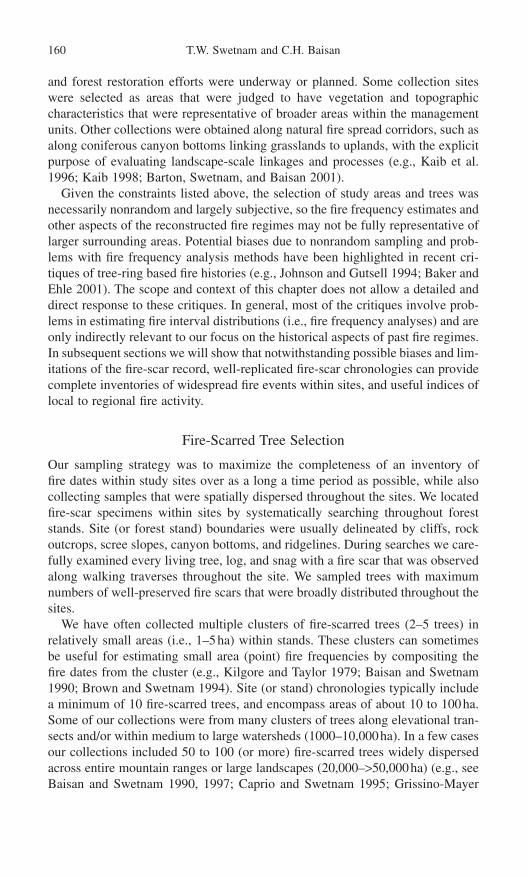
and forest restoration efforts were underway or planned. Some collection siteswere selected as areas that were judged to have vegetation and topographic characteristics that were representative of broader areas within the managementunits. Other collections were obtained along natural fire spread corridors, such asalong coniferous canyon bottoms linking grasslands to uplands, with the explicitpurpose of evaluating landscape-scale linkages and processes (e.g., Kaib et al.1996; Kaib 1998; Barton, Swetnam, and Baisan 2001).
Given the constraints listed above, the selection of study areas and trees wasnecessarily nonrandom and largely subjective, so the fire frequency estimates andother aspects of the reconstructed fire regimes may not be fully representative oflarger surrounding areas. Potential biases due to nonrandom sampling and prob-lems with fire frequency analysis methods have been highlighted in recent cri-tiques of tree-ring based fire histories (e.g., Johnson and Gutsell 1994; Baker andEhle 2001). The scope and context of this chapter does not allow a detailed anddirect response to these critiques. In general, most of the critiques involve prob-lems in estimating fire interval distributions (i.e., fire frequency analyses) and areonly indirectly relevant to our focus on the historical aspects of past fire regimes.In subsequent sections we will show that notwithstanding possible biases and lim-itations of the fire-scar record, well-replicated fire-scar chronologies can providecomplete inventories of widespread fire events within sites, and useful indices oflocal to regional fire activity.
Fire-Scarred Tree Selection
Our sampling strategy was to maximize the completeness of an inventory of fire dates within study sites over as a long a time period as possible, while also collecting samples that were spatially dispersed throughout the sites. We locatedfire-scar specimens within sites by systematically searching throughout foreststands. Site (or forest stand) boundaries were usually delineated by cliffs, rockoutcrops, scree slopes, canyon bottoms, and ridgelines. During searches we care-fully examined every living tree, log, and snag with a fire scar that was observedalong walking traverses throughout the site. We sampled trees with maximumnumbers of well-preserved fire scars that were broadly distributed throughout thesites.
We have often collected multiple clusters of fire-scarred trees (2–5 trees) inrelatively small areas (i.e., 1–5ha) within stands. These clusters can sometimesbe useful for estimating small area (point) fire frequencies by compositing thefire dates from the cluster (e.g., Kilgore and Taylor 1979; Baisan and Swetnam1990; Brown and Swetnam 1994). Site (or stand) chronologies typically includea minimum of 10 fire-scarred trees, and encompass areas of about 10 to 100ha.Some of our collections were from many clusters of trees along elevational tran-sects and/or within medium to large watersheds (1000–10,000ha). In a few casesour collections included 50 to 100 (or more) fire-scarred trees widely dispersedacross entire mountain ranges or large landscapes (20,000–>50,000ha) (e.g., seeBaisan and Swetnam 1990, 1997; Caprio and Swetnam 1995; Grissino-Mayer
160 T.W. Swetnam and C.H. Baisan

and Swetnam 1997). More details about our collections and study sites, includ-ing summaries of fire interval statistics, can be found in Swetnam and Baisan(1996), Swetnam, Baisan, and Kaib (2001), and the many fire history papers inthe Reference section.
Composite Chronologies, Filtering, and Sample Size Effects
Fire chronologies were composited (sensu Dieterich 1980, 1983) at differentspatial scales to evaluate fire regime changes (e.g., Baisan and Swetnam 1990;Grissino-Mayer and Swetnam 1997; Brown and Sieg 1996, 1999; Brown, Kaufmann, and Shepperd 1999; Brown et al. 2001) (Fig. 6.1). One of the ways wehave assessed fire regime variations is by “filtering” methods, whereby minimumnumbers or percentages of trees scarred are used to sort and describe fire event andinterval data (e.g., Swetnam and Baisan 1996; Swetnam, Baisan, and Kaib 2001).These filters helped identify fires that were probably more or less extensive withinsites in a relative sense. Filtering also helped identify fire frequency estimates thatwere less affected by sample size (described below). Fire-scar data compilation,sorting, statistical analyses, and graphical presentation were greatly facilitated by Henri Grissino-Mayer’s development of the FHX2 software (Grissino-Mayer 1995, 1999, 2001, and see http://web.utk.edu/~grissino/fhx2.htm). Usingthe FHX2 program, different minimum numbers and/or percentages of treesscarred per fire can be defined and used as a coarse filter for computing fire interval statistics for fires of different relative spatial extent within or betweenstands.
In using filtering approaches, our aim was to reasonably identify and classifyfire events that were probably more or less widespread, while recognizing thatfire-scar data analyzed in this manner provide relative (versus absolute) estimatesof fire frequency and extent. In assessments of the degree and pattern of syn-chrony of fire events within sites, we commonly used filters of a minimum of two trees scarred per fire, and/or 10% and 25% of trees recording fires per year.Although particular fire event filters (e.g., 10% or 25%) may be arbitrary, such apriori selection of threshold quantities for testing, classifying, and sorting data isa widely accepted statistical practice (e.g., the use of specific confidence inter-vals, or percentile thresholds in statistical description and hypothesis testing). Useof a priori filtering thresholds also facilitates comparisons among sites becausefiltered fire frequencies are less affected by sample size (see below).
One of the concerns in fire history sampling is the effect of study area size,and number of fire-scarred trees sampled, on fire frequency estimates (Arno and Peterson 1983; Swetnam and Baisan 1996; Baker and Ehle 2001). As studyareas increase in size the chances of encompassing additional past fire perime-ters increases. Likewise, as more fire-scarred trees are sampled and included incomposites, there is an increased chance of detecting additional fires that burnedin previously unsampled areas, or only in small areas. The effects of changingsample size and the completeness of the inventory of fire dates within sites orstudy areas can be assessed in a manner that is similar to the use of species–area
6. Sierra Nevada and Southwestern United States 161

162 T.W. Swetnam and C.H. Baisan
Figure 6.1. Different spatial scales of analyses in fire histories are illustrated in this hierarchical set of maps. The fire year 1748 was the most synchronous fire year in thesouthwestern fire-scar network, and is shown schematically as an example of cross-scalesynchrony. Synchrony of fire dates between trees and nearby stands can be reasonablyinferred to indicate fires that spread between sample points, although unburned areasbetween points, and separate fire ignitions are acknowledged possibilities. Synchrony of fire dates among stands, watersheds, and mountain ranges separated by great dis-tances or barriers to fire spread is most probably caused by climatic entrainment of fireoccurrence.

curves by botanists for assessing the completeness of inventories of plant speciesdiversity (e.g., Colwell and Coddington 1994; Rosenzweig 1995).
We address here the issue of completeness of our fire-scar chronologiesbecause this is relevant to our interpretations that we were able to detect wide-spread fires within and between sites, and that these relatively extensive fireevents were associated with climatic variations. In our example, fire frequencies(fires/century) at different sample sizes were re-computed for a fixed time periodand study site using randomly selected sub-sets of the sampled trees (Fig. 6.2).Re-sampling (bootstrap) methods were used to estimate the confidence intervalsof the mean fire intervals recomputed at different sample sizes (Mooney andDuval 1993).
As expected, a general pattern that we commonly observed in these assess-ments was that fire frequencies tended to increase as more trees were added tothe collection. However, when we applied the least restrictive filter of fire dates—namely the inclusion of only those fire dates recorded by two or more trees—thefire frequency estimates were typically asymptotic as a function of sample size(Fig. 6.2). This result suggests that single-tree fire-scar dates were probably representing relatively localized, small fires that occurred around those singletrees. As sample size increased more of these small fires were detected, and sofire frequency continuously increased.
Presumably, with additional samples from an area of fixed size the fire fre-quency should eventually stabilize. If the area was large enough, as more sampleswere collected fire frequency would eventually reach the maximum possible frequency of one fire a year (i.e., all years with fire-scar dates). However, at thespatial scale of most of our sample areas (10–1000ha), surface fires recorded bytwo or more fire-scarred trees probably represented relatively widespread firesthat exposed many trees to re-scarring. Hence, when only these fire events wereincluded, the fire frequencies tended to stabilize after a certain number of treeswere sampled. In application of this kind of assessment to many of our fire-scar chronologies, we have found that in sites of less than approximately 100ha,10 to 15 trees were usually sufficient to reach fire frequency asymptotes usingthe 2-tree minimum filter. In large sample areas (1000–10000+ha) asymptotes were usually not achieved with the 2-tree minimum filter but often were achievedwith more restrictive filters (e.g., 25% or more trees scarred per fire, unpublisheddata).
The main interpretation from these analyses was that most of our fire-scarchronologies were complete, or nearly complete, inventories of relatively wide-spread fires that occurred within the sampled areas. Frequencies of fires of anysize, occurring anywhere within the study sites, however, were probably under-estimated because many small fires were probably not picked up by fire-scarsample sets of these sizes.
An important point to bear in mind is that mean fire intervals (i.e., the inverseof fire frequency) estimated from composite fire-scar chronologies should not beinterpreted to indicate that every square meter burned within the study area, onaverage, at those intervals. Even in the case of mean fire intervals computed using
6. Sierra Nevada and Southwestern United States 163
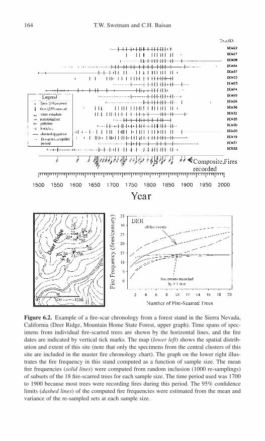
164 T.W. Swetnam and C.H. Baisan
Figure 6.2. Example of a fire-scar chronology from a forest stand in the Sierra Nevada,California (Deer Ridge, Mountain Home State Forest, upper graph). Time spans of spec-imens from individual fire-scarred trees are shown by the horizontal lines, and the firedates are indicated by vertical tick marks. The map (lower left) shows the spatial distrib-ution and extent of this site (note that only the specimens from the central clusters of thissite are included in the master fire chronology chart). The graph on the lower right illus-trates the fire frequency in this stand computed as a function of sample size. The meanfire frequencies (solid lines) were computed from random inclusion (1000 re-samplings)of subsets of the 18 fire-scarred trees for each sample size. The time period used was 1700to 1900 because most trees were recording fires during this period. The 95% confidencelimits (dashed lines) of the computed fire frequencies were estimated from the mean andvariance of the re-sampled sets at each sample size.
the more restrictive filters (e.g., 10% or 25%), and thereby inferring that thesewere intervals between relatively widespread fires, this does not imply that noareas were unburned within the sampled areas during those fire events.
In general, it is our view that fire historians have tended to overemphasize fire frequency analyses (i.e., description and testing of different fire interval dis-tributions) as the primary goal of fire history research. Statistical descriptions andtests of fire interval distributions are inherently limited in objectivity, resolution,and reliability. One reason for this is that selection of an appropriate study areaextent or time period to analyze, which very importantly affect interval distribu-tions, will always be subjective or arbitrary at some level (Millar and Woolfenden1999). Improved sampling methods can only go so far in estimating or cor-recting for biases and peculiarities in the paleorecord, which by its nature is fragmentary and preserved by only partially understood biological and physicalprocesses (Swetnam, Allen, and Betancourt 1999).
Rather than focusing so exclusively on statistical analysis of fire interval dis-tributions, we think that historical approaches are likely to be equally or more reliable and informative about the drivers of past fire patterns and processes, suchas humans and climatic variations. Powerful explanations and understanding canbe derived from the discovery of specific historical events, trends, contingencies,and patterns. These historical processes are often obscured in time-averaged sum-maries, statistically fitted models, and estimates of central tendency. Reasonableand convincing explanations often derive from relatively straightforward graph-ical assessments of the temporal-spatial patterns of event synchrony. Such patternsare often evident in fire-scar chronology composites, especially when comparedwith independent historical records of climate and land-use history. Statisticaldetection and testing of visually evident historical changes and linkages are also possible using methods such as contingency, correlation, and superposedepoch analyses. These kinds of graphical and statistical analyses emphasize theunique, historical nature of fire regimes, rather than just the time and space aver-aged view emphasized in fire frequency (fire interval) analyses.
Examples of Mountain Range-Scale Fire Chronologies and Historical Interpretations
Master fire chronologies from two mountain ranges in the southwestern UnitedStates illustrate the value of examining historical patterns, rather than just the timeand space-averaged aspects of fire regimes (Figs. 6.3 and 6.4). The two moun-tain ranges are the Mogollon Mountains in the Gila Wilderness, New Mexico, and the Santa Catalina Mountains near Tucson, Arizona. Stands were sampledalong elevational transects in both mountain ranges. The tree rings and fire scars in these samples were dated and composited using techniques described in detailelsewhere (Dieterich 1980; Dieterich and Swetnam 1984; Swetnam and Dieterich1985; Baisan and Swetnam 1990; Swetnam and Baisan 1996; Abolt 1997;Swetnam, Baisan, and Kaib 2001).
6. Sierra Nevada and Southwestern United States 165

Figure 6.3. Master fire chronology from an elevational transect in the Santa CatalinaMountains (near Tucson, AZ) extending from mixed conifer forest near the summit ofMount Lemmon down to pine-oak forests at Bear Canyon. The transect spans elevationsof approximately 2000 to 3000m over a linear distance of about 20km. Groups of fire-scarred trees sampled in sites (stands) are indicated by brackets and site names on theright. Note the high degree of synchrony of a subset of the fire dates across the elevationalgradient; this is compelling evidence that widespread fires occurred during those syn-chronous fire years.
166

6. Sierra Nevada and Southwestern United States 167
Composite stand and transect chronologies show several common patterns in fire histories of pine and mixed-conifer forests in the Southwest and Sierras.One of the most obvious patterns is a striking change in fire frequency in the latenineteenth or early twentieth centuries (Figs. 6.3 and 6.4). This reduction in fireoccurrence coincides in almost all cases to within a few years of the first docu-mented introduction of large numbers of domestic livestock (sheep, goats, cattle,or horses). The great ranching boom of the late nineteenth century, for example,
Figure 6.4. Master fire chronology from an elevational transect in the Mogollon Moun-tains (Gila Wilderness, NM) extending from spruce fir forest near the summit of Mogol-lon Baldy and down to ponderosa pine forests on Langstroth Mesa (see map at bottom).The transect spans elevations of approximately 2300 to 3080m over a linear distance ofabout 15km. Groups of fire-scarred trees sampled in sites (stands) are indicated by brack-ets and site names on the right. Note the apparent change in fire frequency and synchronyca. 1800, and also in Figure 6.3.

led to sheep or cattle introduction to some mountain areas as early as the 1870s,and was delayed in other more remote mountain ranges until after around 1900.The timing of the decline of frequent fires as recorded by the fire scars closelyreflects these historic land use differences (see Swetnam, Baisan, and Kaib 2001for specific examples). In general, the livestock introduction and coincidentreduction in fire occurrence preceded by a decade or more the advent of orga-nized and systematic fire suppression by government agencies. In most placeslimited fire fighting by a few government agents began about 1905 to 1910. Orga-nized fire fighting was probably not very effective in many areas until increasednumbers of fire fighters, lookout towers, and equipment (e.g., aircraft) becameavailable after the 1930s or 1940s (Pyne 1982; Swetnam, Baisan, and Kaib 2001;Rollins, Swetnam, and Morgan 2001).
In the southwest, frequent fires were typically interrupted between about 1870 and 1900. Figures 3 and 4 show examples of disrupted fire regimes around1900; see Swetnam, Baisan, and Kaib (2001) for examples of variable fire regime disruption dates from the 1870s to 1900s in southern Arizona and NewMexico. Exceptions were places where earlier introduction of livestock (espe-cially sheep) by Hispanic or Navajo herders occurred (i.e., early nineteenth, eighteenth, or seventeenth centuries, depending on location), as documented withindependent archival records (Savage and Swetnam 1990; Touchan, Allen, andSwetnam 1996; Baisan and Swetnam 1997). Other exceptions were uninterruptedfire regimes in locations where intensive livestock grazing did not occur becauseof topographic barriers, such as impassable lava flows (Grissino-Mayer andSwetnam 1997).
Fire regimes were not disrupted until the midtwentieth century (i.e., 1940s and 1950s) in the remote, rugged mountains of northern Mexico where perma-nent water or roads needed for intensive livestock and human uses were lacking.These late disruptions coincide with the “ejido reforms” of the 1940s, after whichthere was an increase in numbers of roads, water tank development, livestockgrazing, and logging in some areas (Fulé and Covington 1997, 1999; Fulé, Covington, and Moore 1997; Kaib 1998; Swetnam, Baisan, and Kaib 2001; Heyerdahl and Alvarado, Chapter 7, this volume). These exceptions essentiallyprove the rule: intensive livestock grazing and associated human land uses werethe initial causes of fire regime disruption in most areas of the greater Southwest.Continued absence of widespread, frequent surface fire in the mid to late twentieth century (at least on the U.S. side of the border) was probably due to a combination of livestock grazing and organized, increasingly effective fire suppression efforts by government agencies.
Climate change is an unlikely explanation for the late nineteenth- to early twentieth-century fire regime disruptions. This is because (1) the disruptions weretypically asynchronous between mountain ranges that shared similar regionalclimate patterns, (2) droughts and wet periods during this era (i.e., 1870s–1910s)do not consistently coincide with the disruptions, whereas the dates of livestockintroductions generally do coincide, (3) portions of some remote mountains inSonora, Mexico, that were not heavily grazed continued to burn throughout the
168 T.W. Swetnam and C.H. Baisan

twentieth century, despite having very similar climate as nearby mountain rangeson the U.S. side where grazing occurred and frequent fire regimes were disrupted(Swetnam, Baisan, and Kaib 2001).
The frequent surface fire regimes of mid-elevation forests (2000 to 3000m) inthe Sierras were typically disrupted earlier than in most southwestern sites. Thelast widespread fire in our sites on the west slope of the Sierras occurred betweenabout 1850 and 1870 (Fig. 6.2, and see Caprio and Swetnam 1995). This cor-responds with movement of large sheep herds into the Sierras during and fol-lowing a severe drought in the early 1860s, which forced sheepherders in theCentral Valley to seek forage in the high mountain meadows (Vankat 1977). Thisintensive grazing led to denudation of large tracts of formerly grassy areas in thehigh Sierras by the 1870s, as decried by John Muir; he called these sheep herds“hooved locusts” (Muir 1911).
Native Americans and High-Frequency Fire Regimes
The decline of frequent fire regimes in the Southwest and elsewhere has sometimes been attributed to the forced removal of Native Americans from theselandscapes during the nineteenth century and earlier (Pyne 1982, 1985). Drawingprimarily from written historical documents, and interviews of Native Americansduring the twentieth century, some cultural and environmental historians arguethat human manipulation of vegetation with fire was ubiquitous for many millennia before the arrival of Europeans (e.g., Dobyns 1978; Pyne 1982, 1985;Denevan 1992; Anderson 1996). A general conclusion is that humans were thedominant and overriding influence on fire regimes. “Natural” (nonhuman) factors,such as climate and lightning variability, are also acknowledged as importantdrivers of past fire regimes but are typically considered to be of secondary impor-tance, or as merely complementary to the human drivers.
Although the written histories that the cultural historians depend on is ex-tensive, alternative views on the universality of human dominance of past fireregimes, particularly for the western United States, have been presented (e.g.,Vale 1998; Vale 2002). One of the chief points made in recent papers is that light-ning was a more frequent and dominant cause of fires in western U.S. landscapesthan was appreciated by almost all nineteenth- and early twentieth-centuryobservers (e.g., Allen 2002; Baker 2002). It is only in the past couple of decadesthat with the new lightning detection technologies, comprehensive maps havebecome available showing millions of lightning strikes per year over regions the size of individual western states (e.g., Gosz et al. 1995). In a recent study ofdetected lightning fires during the twentieth century, we have found rates of igni-tion in southern Arizona mountains as high as two fires per km2/y (unpublisheddata). A lack of knowledge of the very high rates of fire ignitions by lightning in some western forests, combined with anti-Indian biases in the nineteenth cen-tury and earlier, probably led to erroneous attribution of some fires to NativeAmericans, while under estimates of the importance of lightning as causes offorest fires (Allen 2002; Baker 2002).
6. Sierra Nevada and Southwestern United States 169

Based on our research in the Southwest and Sierras, we conclude that NativeAmerican control of past fire regimes was very time and place specific, and cannotbe broadly generalized as ubiquitous or dominant in all places and times. Fireregimes in large portions of these regions would probably have had similar char-acteristics (fire frequency, seasonality, extent, etc.) if people had never enteredthe Americas. It is clear, however, that people profoundly affected fire regimesin particular places and times. For example, in a study of more than 200 fire-related quotations in Spanish, Mexican, and American archival documents (rele-vant to the Southwest) extending back to the seventeenth century, Kaib (1998)found that more than 70% were in the context of warfare with the Apache peopleof southern Arizona and New Mexico. Intentional burning of large areas was very rare, except during times of warfare. The use of fire against enemies was acommon practice used by all sides—Apache, Spaniard, Mexican, and Americansoldiers. Combatants burned particular places (campsites, livestock watering andgrazing areas, etc.) during conflicts, but intentional burning of broader areas wasonly rarely mentioned in the documentary sources. The general picture was oneof great temporal and spatial variability and specificity in the firing of landscapesduring warfare.
This emphasis on the time and place specific influence of Native Americanson past regimes in the Southwest is supported by tree-ring studies. For example,a tree-ring study of eighteenth- and nineteenth-century fire history in severalmountain ranges of southern Arizona and northern Mexico revealed that fire fre-quency generally tracked the occurrences of peacetime and wartime (Kaib et al.1996; Kaib 1998). Based on place name references in archival documents, it wasevident that some of the sampled stands were located near historic campsites ortravel routes. Highest fire frequencies occurred during periods of maximal con-flict among all sides, while reduced fire frequencies occurred when truces withApaches were in effect. Other fire-scar studies in the Chiricahua Mountains ofArizona (Seklecki et al. 1996) and the Organ Mountains of New Mexico (Morino1996) also found evidence of changing fire frequencies and seasonal timing thatwere speculated to be related to presence or absence of Apaches. Again, thesestudy sites were located in specific areas where independent documentary sourcesindicate historical usage by Apaches.
In a detailed case study in the Sacramento Mountains, Kaye and Swetnam(1999) used independent documentary records and tree-ring dates of “culturallymodified trees” to pinpoint the presence of Apaches in both time and place. Inthis study the culturally modified trees were “peeled” ponderosa pines that theApaches had used as a food source by peeling the bark and cambium layer froma section of the lower bole (Swetnam 1984). The soft cambium provided carbo-hydrate and other nutrients (Martorano 1981) and was probably used primarilyas an emergency food source (Swetnam 1984). Tree-ring dates from the peelings,and documented dates of skirmishes between Apaches and soldiers within andnear the study area, were used to assess frequency and season of fires duringknown occupation periods versus other times. We also assessed regional climaticassociations with fire dates and fire frequency trends.
170 T.W. Swetnam and C.H. Baisan

We found that Apaches may have increased fire frequencies during someperiods, and altered the seasonal timing of a few fires. Overall, however, theresults were equivocal. Even in this unique case study, where detailed indepen-dent sources of temporal and spatial evidence were available to assess possibleNative American influence on past fire regimes, it was not possible to stronglyconclude that they significantly altered the character of fire regimes from whatwould have prevailed with lightning alone as an ignition source.
A broader-scale study of fire histories within the Sacramento Mountains,including the chronologies used by Kaye and Swetnam (1999), confirmed thatclimatic variations (drought/wet years) were dominant controls of past fire regimevariations at the landscape scale (Brown et al. 2001). Again, the most significantand demonstrable effect of humans on past fire regimes was the disruption of fre-quent, widespread surface fires in the late nineteenth and early twentieth centurieswhen large numbers of livestock were introduced, and organized fire suppressionbegan.
Twentieth-Century Verification of Fire Events
A common observation in fire chronologies from the Southwest and Sierras are a few scattered fire-scar dates in the twentieth century (Figs. 6.3, 6.4, and 6.5). There is usually a good correspondence of these dates with known twentieth-century fires in these areas. For example, almost all fires greater than10 acres (4ha) documented in fire atlases maintained by the U.S. Forest Service for the portion of our elevation transect in Gila Wilderness (Rollins,Swetnam, and Morgan 2001) were confirmed by the fire-scar dates from theseareas (Fig. 6.4). In fact the particular trees that recorded fires corresponded well with the mapped perimeters of these fires. For example, a 1953 wildfire is know to have burned only within the area in the uppermost site, whereas a 1978 “prescribed natural fire” burned only with the areas of the lowermost site (Fig. 6.4) (Abolt 1997). The widespread 1904 fire in this chronology wasreferred to in both old Forest Service records and the local newspaper, with very specific place names that locates this fire within our study sites (Abolt 1997).
In the Santa Catalina Mountains of Arizona the last widespread fire in 1900along our sampled transect was described and photographed by government surveyors who fought this low-intensity surface fire (Swetnam, Baisan, and Kaib2001). This fire was clearly recorded as an extensive fire-scar event along the 20-km transect (Fig. 6.3). The 1985 fire was also documented in this network of site chronologies as occurring only within the Rose Canyon site (Fig. 6.3).Verification of dozens of other fire-scar dates, through references in documentsor mapped fire perimeters in fire atlases, provides a high degree of confidence toour interpretation that fire-scar collections were generally complete and accuraterecorders of past fires (for additional examples, see Dieterich and Swetnam 1984;Swetnam and Dieterich 1985; Baisan and Swetnam 1990; Caprio and Swetnam1995; Swetnam, Baisan, and Kaib 2001).
6. Sierra Nevada and Southwestern United States 171

172 T.W. Swetnam and C.H. Baisan
Figure 6.5. Composite time series of fire events in the Sierra Nevada (upper graph) andSouthwest (lower graph) from regional networks of fire-scar chronologies. Number of sites recording fire each year are shown (AD 1600–1995). The number of fire-scarred treesincluded in the data sets during each year (sample depth) are also shown. The map insertof the Sierras shows locations of the five giant sequoia groves (letter codes). Small irreg-ular dots show approximate range of sequoia groves. The 49 sites from the Sierras includedin the composite are from four elevational transects adjacent to the Mariposa Grove (MP),the Big Stump Grove (BS), Giant Forest (GF), and Mountain Home State Forest (MHF).The map insert of the Southwest shows 26 mountain ranges (as dots) where the 63 sitesincluded in the composite are located. The irregular outline on this map is the approxi-mate range of ponderosa pine in Arizona and New Mexico.
Synchrony Within Stands, Watersheds, and Mountain Ranges
An outstanding feature of many fire-scar chronologies in the Southwest andSierras is a high degree of synchrony of fire-scar dates among trees across a broadrange of spatial scales, from stands to regions. The high degree of synchrony of

some fires over linear distances of more than 10km and elevation gradients of1000 to 2000m (Figs. 6.3 and 6.4) leads to a simple and logical interpretation:relatively large areas burned within these study areas during these synchronousyears.
It is likely that some of these synchronous events represent separately ignitedfires that did not coalesce into contiguous burned areas. It is also very likely that some unburned areas existed between sampled trees and sites along thesetransects and within the surrounding areas. Despite these considerations our basicinterpretation is still reasonable, that relatively greater areas probably burnedduring the highly synchronous years than during less synchronous years (i.e., fireyears recorded by a single tree or a few trees; Figs. 6.2, 6.3, and 6.4). It is alsovery likely that many pre-1900 fires burned over very large areas because light-ning ignitions occur as early as April in some years in the Southwest, and firesare known to have burned for weeks to months. Nineteenth-century newspapers,for example, reported that wildfires burned for long periods of time and achievedenormous sizes; some fires exceeded 500,000ha (Bahre 1985).
The synchrony of multiple tree and site fire events is often statistically signif-icant ( p < 0.05) across a range of spatial scales. For example, contingency analy-sis of the fire dates common to 3, 4, or 5 sampled giant sequoia groves over thepast 1300 years showed that the odds of obtaining this observed degree of syn-chrony of events by chance was less than 1 in 1000 (Swetnam 1993). In general,we have interpreted significant synchrony of fire dates among trees within standsto be indicative of widespread fire at this scale. Synchrony among widely scat-tered sites—especially where effective fire barriers or distance separate the sites(as in the giant sequoia example)—is indicative of regional climatic influence onfire occurrence (e.g., Swetnam and Betancourt 1990, 1992, 1998; Grissino-Mayerand Swetnam 2000; Swetnam and Baisan 1996; Kaib et al. 1996).
Fire Drought Patterns in the Southwest and Sierras
Regional Composites and Synchronous Fire Years
The regional networks of fire-scar chronolgies we have assembled are from 63sites in 26 mountain ranges in the Southwest, and 49 sites from four elevationaltransects on the west slope of the Sierras. Our Sierran collections include fivegiant sequoia fire-scar chronologies, which will be described separately. Theinfluence of interannual climatic variation is evident as years when many sites(and trees) have recorded fires during particular years, and as years when no, orfew sites (and trees) have recorded fire events (Fig. 6.5). The interpretation ofclimate as the primary driver of this synchrony is reasonable because there is noother known factor that operates at these spatial and temporal scales that couldresult in such a high degree of year-to-year synchrony. Also, as will be demon-strated below, these synchronous dates are statistically associated with indepen-dent records of interannual wet and dry conditions.
6. Sierra Nevada and Southwestern United States 173

The synchrony is visually obvious (Figs. 6.3, 6.4, and 6.5), but it is reasonableto ask: Is the degree of observed synchrony statistically significant? Specifically,if this number of independent, random time series were combined could theobserved synchrony among the series have occurred purely by chance? The sta-tistical strength of the observed synchrony is illustrated by a contingency calcu-lation. Fire frequency within 63 individual sites in the Southwest averaged aboutone fire per 7.5 years from 1700 to 1900. Using this average fire frequency andsimple binomial joint probability calculations, strictly by chance we would expectabout one coincidence of the same fire date in 21 of the 63 sites (one-third) inabout a 35,000-year period. Yet 15 different years met or exceeded this criterionin the 201-year period (Fig. 6.5). The probability of 41 of 63 sites recording the same fire date by chance, as in 1748, is vanishingly small. These probabilitycalculations oversimplify the contingency of fire events among multiple sitesbecause the fire interval distributions and probabilities are not necessarily bino-mial; they are different from site to site, and they change through time. Never-theless, these probability estimates indicate that it is highly likely that our generalconclusion is robust: the degree of synchrony observed is much greater than onewould expect to occur by chance.
The relative, year-to-year strength of the synchrony is difficult to assess directlybecause the regional time series contains trends that are in part due to the sam-ple depth (number of fire-scarred trees that were alive and recording fire-scar dates each year). Some of these trends, however, are probably related to climaticvariability. An example of a decade-scale variation in regional fire occurrence and climate will be described in the next section, but first we focus on the extreme year-to-year (interannual) variations and their associations with climatevariability.
The years of highest synchrony are labeled in Fig. 5 and were identified asyears that exceeded the 95th percentile of smallest or largest values in a rankingof the fire years based on the number of sites recording fires per year in 20-yearmoving periods. By using a moving period for the percentile rankings we adjustedfor the changing sampling depth. The year-by-year values of the 95th percentilethreshold were variable (i.e., the values produced a somewhat jagged curve, notshown) because the moving period included or excluded the particularly large or small values as it was shifted along the time series. The result was that some“extreme” years exceeding the 95th percentile were included or excluded in asomewhat arbitrary fashion. Therefore we used the 95th percentile curves (upperand lower) as a general guide for selecting the years to include or exclude in theanalyses. Overall, this approach led to the inclusion or exclusion of only a fewadditional years (either large or small), and in a separate analyses we found thatthe basic results were not changed relative to use of only years strictly definedby the moving period.
Although the ranking in moving periods provided some adjustment for samplesize, we decided it was best to exclude the pre-1700 and post-1860 periods of theSierra regional chronology, and the post-1880 period of the Southwest regionalchronology. The sample depth in the earliest period (before ca. 1700) in the
174 T.W. Swetnam and C.H. Baisan
Sierras drops below approximately 100 trees and 10 sites, and therefore it isdoubtful that we are accurately identifying all regional extremes with this reducedsample size, especially small fire years. Some regional large fire events wereevident in the 1600s (Fig. 6.5, upper graph) and these were included in the analy-ses. The many apparent low fire activity years during the 1600s, however, wereprobably due to the small sample size, and so the extreme small events in thiscentury were not included in the analysis. In general, as more sites and trees enter the data sets in later years, the number of zero value years decline, and the regional small years tend to become more apparent (Fig. 6.5). The Southwestnetwork included more than 200 trees and 20 sites back to 1600, so regional largeand small events were included in the analysis back through the 1600s.
The post-livestock-grazing eras were evident in both regional chronologies as declines in numbers of sites recording fires in the late 1800s. Several largeevent years (e.g., 1871, 1898, and 1970 in the Sierras, and 1891 and 1899 in theSouthwest) and many small event years appear after the onset of intensive grazingin the two regions. We chose to exclude these post-livestock-grazing periods inthe fire-climate analysis because of the known change in fuels in these periodsrelative to the preceding periods, and the obvious change in the nature of the fire-scar record at these times (e.g., Figs. 6.2, 6.3, 6.4, and 6.5; see also dis-cussion and literature cited in previous sections). Interestingly the 1970 largeevent in the Sierras is traceable to extensive prescribed burning along one of thefour elevation transects—in Sequoia National Park. These fires were set by theNational Park Service in an ambitious prescribed burning effort during this par-ticular year (unpublished Sequoia and Kings Canyon national parks fire historydatabase).
The decline in sample depth through the twentieth century was due to our selec-tive sampling of primarily dead fire-scarred trees (i.e., stumps, snags, and logs)to maximize chronology length and minimize impacts on living trees. The outerring dates of these dead specimens were often in the early or midtwentieth century(e.g., Figs. 6.2, 6.3, and 6.4). Although this decline in sample depth probablyaffected our ability to detect some fires during the late twentieth century, we doubtthat this effect was very pronounced. Support for this interpretation is the factthat the twentieth-century fire-scar records were commonly confirmed by theindependent documentary record (e.g., 1970 example, and other examples men-tioned previously). Also in most sites, where it was permissible and possible, wealso sampled a few living trees with fire scars for the purpose of obtaining thefull record of twentieth-century fire dates. Most of the time, these living fire-scarred trees had frequent fire scars extending up to the disruption period nearthe turn of the century, then no fire scars, or only one or two fire scars recordedduring the twentieth century (e.g., Figs. 6.2, 6.3, and 6.4).
Interannual Fire Associations with Dry/Wet Patterns
We used superposed epoch analyses (SEA) to evaluate the interannual relationsbetween extreme fire years (large and small) as identified in the two regional fire
6. Sierra Nevada and Southwestern United States 175

chronologies (Fig. 6.5). This method involved computing the average (or de-parture from average) climate condition during, before and after the extremeyears. Monte Carlo techniques were used to estimate the confidence intervals of the observed averages (or departures) (Mooney and Duvall 1993). A similartechnique was first used in studies of the potential effect of volcanic eruptions on global climate patterns, and was adapted by Baisan and Swetnam (1990),Swetnam and Betancourt (1992), Swetnam (1993), and Grissino-Mayer (1995)for use in fire history studies.
The FHX2 software includes a subroutine written by Richard Holmes to carryout the SEA computations (Grissino-Mayer 2001). The program requires the inputof a list of key dates and a continuous time series of an environmental variable,such as a precipitation or drought index. In the present case, for the key years weused the extreme large and small fire years in the regional chronologies (yearslabeled in Fig. 6.5). The environmental time series we used were two recentlydeveloped tree-ring reconstructions of summer (June–August) Palmer DroughtSeverity Index (PDSI) from the Southwest and the Sierras (Meko et al. 1993;Cook et al. 1999). These PDSI reconstructions are based on large networks ofdrought-sensitive tree-ring-width chronologies, and they were derived via cali-bration and validation using linear regression techniques. Details of the calibra-tion and validation statistics of these reconstructions are described on the world-wide web (at http://www.ngdc.noaa.gov/paleo/pdsi.html; see also Meko et al.1993 and Cook et al. 1994, 1999). The reconstructed values were summer (June–August) PDSI, but in general also reflect persistent moisture conditions duringthe preceding month (i.e., May) because the PDSI algorithm includes laggingwater balance effects of preceding periods.
The SEA results (Fig. 6.6) were similar to patterns observed in the other SEAstudies of fire associations with interannual precipitation or drought variables(e.g., Veblen et al. 1999; Veblen, Kitzberger, and Donnegan 2000; Donnegan,Veblen, and Sibold 2001). In particular, large fire years (on average) tended to be significantly dry (p < 0.001, Fig. 6.6, upper and lower left graphs). Small fireyears tended to be significantly wet in the Southwest (p < 0.05). The associationof fire and drought was not surprising, but more interesting results were the find-ings of lagging relationships in fire–PDSI comparisons. For example, summerPDSI in the year before small fire years was consistently low (dry) in both the Southwest and Sierras ( p < 0.001, Fig. 6.6, upper and lower right graphs).Summer conditions in years preceding large fire years tended to be wet, but thiswas consistent and statistically significant only in the Southwest regional com-posite. We interpret the importance of lagging patterns in the Southwest to be due to a high importance of fine fuel accumulation during wet years in these relatively dry sites. The widespread fires within and among sites throughout theregion were largely a function of the accumulation of a continuous fuel layer ofgrass and tree needles. A series of one to three years of wet conditions was oftenimportant for the development of a continuous fuel layer that carried the spread-ing surface fires. Understory fuel accumulation and dynamics were also impor-tant because the frequently occurring fires consumed these fine fuel layers. Insemi-arid conditions, it probably required one to several years of relatively wet
176 T.W. Swetnam and C.H. Baisan

6. Sierra Nevada and Southwestern United States 177
conditions (and lack of fire) to rebuild continuous surface fuels. The importanceof dry years preceding the smallest regional fire years was probably due, in part,to the occurrence of extensive fires during these preceding dry years, thus limit-ing the ignition and spread of fires during the next year. Dry preceding years alsolimited fuel production necessary for fire ignition and spread in the subsequentyear, especially if the subsequent year was wet (i.e., in the Southwest compari-son, Fig. 6.6 upper right).
The different fire–PDSI lagging patterns in the Southwest and Sierras wereprobably due to the different mixtures of tree species and understory conditionsin the two regions. In other studies we have sorted study sites into those with sig-nificant ponderosa pine or Jeffrey pine components, versus somewhat higher elevation, mixed conifer sites where these pine species were relatively minorcomponents or were absent (Swetnam and Baisan 1996; Caprio and Swetnam1995; Swetnam and Betancourt 1998). We found that the lagged wet conditionspreceding large fire years were restricted to the pine-dominant sites. Mixed con-ifer sites tended to show no significant previous years wet patterns, but drier condi-
Figure 6.6. Results of superposed epoch analysis (SEA) comparing summer PalmerDrought Severity Indexes (PDSI) during relatively large (extensive) and small (less extensive) fire years in the Southwest (top row) and Sierras (bottom row). (See text for explanation of how “extensive” and “less extensive” were defined and time periodsanalyzed.) Horizontal dotted, dashed, and solid lines are 99.9, 99.0, and 95.0 confidenceintervals, respectively, computed using a resampling procedure (Swetnam and Betancourt1992).

tions occurred during large fire years than in the ponderosa pine sites. As justdescribed, we think this difference was due to the high importance of understoryfuel amounts in the relatively xeric, pine-dominated forests. In contrast, low fuelmoisture was probably more important for successful fire ignition and spread inthe relatively mesic, and productive mixed conifer forests (i.e., fuels were gen-erally not limiting). Hence the lack of significantly wet years preceding regionallarge fire years in the Sierras could be because most of these sites were in rela-tively productive mixed conifer stands, whereas the majority of the southwesternsites were in dry ponderosa pine stands.
This interpretation is supported by similar SEA results in Oregon and Washington (Heyerdahl, Brubaker, and Agee, in press) where precipitation isgreater and mixed conifer forests are more productive than in the southwesternpine-dominant stands. Also the relatively dry pine forests sampled in Colorado(Veblen, Kitzberger, and Donnegan 2000; Donnegan, Veblen, and Sibold 2001),Mexico (Heyerdahl and Alvarado, Chapter 7, this volume), and Austrocedruschilensis woodlands in Argentina (Kitzberger, Veblen, and Villalba 1997;Kitzberger and Veblen 1998; Veblen et al. 1999) had similar wet years precedinglarge fire years.
El Niño–Southern Oscillation and Fire Relationships
The importance of wet/dry sequences to synchronized fire activity in someregions is at least partly explainable by El Niño–Southern Oscillation (ENSO)teleconnections to regional rainfall patterns. ENSO events are known to affectseasonal rainfall amounts through changes in atmospheric circulation (e.g., posi-tion, strength, and sinuosity of the jet stream) and frequency of tropical and sub-tropical storms (Aceituno 1988; Andrade and Sellers 1988; Nicholls 1992; Diazand Markgraf 2000; Harrington, Cerveny, and Balling 1992). Weak to moderatecorrelations have been identified between modern fire occurrence and fire-scarrecords and various indexes of the Southern Oscillation in the Southwest, Colorado Front Range, Oregon, Washington, Mexico, and in Patagonia (Swetnamand Betancourt 1990, 1992; Kitzberger, Veblen, and Villalba 1997; Kitzbergerand Veblen 1998; Fulé and Covington 1999; Veblen, Kitzberger, and Donnegan2000; Donnegan, Veblen, and Sibold 2001; Heyerdahl, Brubaker, and Agee, inpress; Heyerdahl and Alvarado, Chapter 7, this volume).
A key finding of these studies was that synchronized, regional fire eventstended to occur during dry years that were often associated with La Niña events(in the Southwest, Colorado, and Patagonia). These dry, regional fire years tendedto follow one to several wet years that were often associated with El Niño events.Wet/dry patterns and regionally synchronized fire events were not entirely consistent within regions or through time, but were sufficiently strong as to bedetectable in both twentieth-century and paleo-fire and climate comparisons (Fig.6.7). Moreover, as expected, reverse correlations were noted in the Pacific Northwest, where El Niños tended to produce drier conditions and increased fireactivity (Morgan et al. 2001; Heyerdahl, Brubaker, and Agee, in press). As
178 T.W. Swetnam and C.H. Baisan

6. Sierra Nevada and Southwestern United States 179
remarkable as these regional fire-climate relationships were, an even more inter-esting pattern recently emerged at the global scale. We discovered that fire occur-rence time series from the Southwest and Patagonia shared similar interannual todecadal scale variations (discussed below) (Kitzberger, Swetnam, and Veblen2001). Given that ENSO climate teleconnections are similar in the two regions,perhaps it should not be surprising that ENSO might act as a pacemaker, syn-chronizing fire activity at interhemispheric (i.e., global) scales.
Decadal-Scale Changes in Fire Frequency and Climate
In addition to interannual fire-climate variations and correlations we have alsodetected decadal-scale fire-climate patterns. One of the most interesting decadal-scale changes occurred in the Southwest from about 1780 to 1840. (Other exam-ples of decadal-scale fire-climate changes will be described in the next sectionon giant sequoia fire history.) In recent years the evidence for this change in the
Figure 6.7. Time series of the percentage of trees scarred per year in a network of 15 sitesin Arizona and New Mexico compared with the estimated Darwin-Tahiti Southern Oscil-lation Index (upper graph). The Spearman rank correlation from 1866 to 1905 is 0.46, p= 0.002 (Swetnam and Betancourt 1990). In the lower graph the annual area burned in allfederal, state, and private lands in the Arizona and New Mexico (1905–1994) is comparedwith El Niño and La Niña events.

Southwest and other regions, and its association with global-scale climate pat-terns, has continued to build (Swetnam and Betancourt 1998; Grissino-Mayer andSwetnam 2000; Kitzberger, Swetnam, and Veblen 2001; Heyerdahl, Brubaker,and Agee, in press). At present, there are five lines of evidence pointing to a majorclimate-driven fire regime change in the late eighteenth and early nineteenth centuries: (1) unusually long intervals between fires during this period, (2) a shiftfrom higher to lower fire frequency (and a related shift from less synchronous to more synchronous fire events), (3) a shift in seasonality of fires, (4) a strikingdecrease in the interannual correlation of fire events and climate indexes, and (5) the existence of a similar secular change in northern Patagonia, Argentina.
The first indication of a late eighteenth to early nineteenth century fire regimeshift that we noticed was an unusually long interval between surface fires in theGila Wilderness, New Mexico (Swetnam and Dieterich 1985). Since then, wehave identified unusually long fire-free intervals around this time in many other(but not all) chronologies in the Southwest (Fig. 6.8). In some areas a long inter-val begins as early as the 1780s, and in others the interval does not begin untilthe early 1800s (e.g., Figs. 6.4 and 6.8). In some sites a few small fires (i.e.,recorded by one or a few trees) occurred during the long interval, but there wasa notable lack of widespread (highly synchronous) fires (Figs. 6.4, 6.8, and notealso the slight dip in the number of sites recording fire in the Southwest duringthe early 1800s in Fig. 6.5).
The second indication of an important fire regime shift was a decrease in firefrequency after ca. 1800, and a notable increase in synchrony of fire events be-tween trees (Figs. 6.3 and 6.4). This kind of change in frequency and synchronywas also noted in our giant sequoia studies during another time period (i.e., achange around AD 1300). Such frequency/synchrony (extent) shifts may reflectthe natural feedbacks between fire frequency, fuel amounts, types, and spatialarrangements (Swetnam 1993). During relatively high frequency periods, fuelsbecome more of a limiting factor to fire ignition and spread because the lagsbetween fire events are too short for fuel continuity (amounts and spatial con-nectedness) to build to the point where fires will spread extensively throughstands. This feedback between fires and fuels leads to spatially heterogeneousfuel layers and fire extent patterns. During relatively low fire frequency periods,fuels are less limiting because the longer lags enable fuel continuity to increase.When fires do occur, they tend to spread through the relatively abundant, spa-tially continuous fuels. Recent dynamic simulation models, incorporating climateand fuels components, generally support these interpretations with direct com-parisons between simulated spatial and temporal patterns of fire frequency andextent and actual fire history data (Miller and Urban 1999, 2000).
A third line of evidence pointing to fire-regime and climate changes at the turnof eighteenth to nineteenth centuries is an apparent shift in seasonality of fire in a set of fire-scar chronologies from west central New Mexico (Grissino-Mayer and Swetnam 2000). Allen (1989) noted a similar seasonality change in a fire-scardata set from the Jemez Mountains in northern New Mexico. By examining theintraannual position of fire scars, we were able to infer the relative timing of past
180 T.W. Swetnam and C.H. Baisan
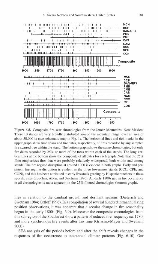
6. Sierra Nevada and Southwestern United States 181
fires in relation to the cambial growth and dormant seasons (Dieterich andSwetnam 1984; Ortloff 1996). In a compilation of several hundred intraannual ringposition observations, it was apparent that a secular change in fire seasonalitybegan in the early 1800s (Fig. 6.9). Moreover the composite chronologies fromthis subregion of the Southwest show a pattern of reduced fire frequency ca. 1780,and more synchronous fire events after this time (Grissino-Mayer and Swetnam2000).
SEA analysis of the periods before and after the shift reveals changes in theresponses of fire occurrence to interannual climate patterns (Fig. 6.10). Our
Figure 6.8. Composite fire-scar chronologies from the Jemez Mountains, New Mexico.These 10 stands are very broadly distributed around the mountain range, over an area ofabout 50,000ha (see schematic map in Fig. 1). The horizontal lines and tick marks in theupper graph show time spans and fire dates, respectively, of fires recorded by any sampledfire-scarred tree within the stand. The bottom graph shows the same chronologies, but onlyfire dates recorded by 25% or more of the trees within each of the stands. The long ver-tical lines at the bottom show the composite of all dates for each graph. Note that the 25%filter emphasizes fires that were probably relatively widespread, both within and amongstands. The fire regime disruption at around 1900 is evident in both graphs. Early and per-sistent fire regime disruption is evident in the three lowermost stands (CCC, CPE, andCON), and this has been attributed to early livestock grazing by Hispanic ranchers in thesespecific sites (Touchan, Allen, and Swetnam 1996). An early 1800s gap in fire occurrencein all chronologies is most apparent in the 25% filtered chronologies (bottom graph).

182 T.W. Swetnam and C.H. Baisan
general conclusions from these analyses were that fire seasonality changes wereprobably related to a shift in seasonality of rainfall patterns (Grissino-Mayer andSwetnam 2000). In particular, the shift from a late-season dominant fire regimeprior to 1800 to more early season fires after 1800 (Fig. 6.9) could have been a
Figure 6.9. The relative position of fire scars within tree rings at El Malpais, New Mexico,changed through time, with a decreasing percentage of middle to late season scars (prob-ably July–September) after ca. 1800 (from Grissino-Mayer and Swetnam 2000; reprintedwith permission from The Holocene, © Arnold Publishers).
Figure 6.10. Superposed epoch analysis of the fire events before (left) and after (right)ca. 1800 at El Malpais, NM, suggests a change in the lagging relations between fires andclimate in the two periods (from Grissino-Mayer and Swetnam 2000; reprinted with per-mission from The Holocene, © Arnold Publishers). Asterisks indicate significant values atthe 95% confidence level.

consequence of fewer El Niño events after circa 1800 than before. El Niño eventstend to result in relatively wet winters and early springs (Andrade and Sellers1988), and a reduction in summer monsoonal rainfall (Harrington, Cerveny, and Balling 1992; Gutzler and Preston 1997). Hence, with more frequent El Niño events before circa 1800, the peak dry conditions and fire season in theSouthwest would have often been relatively late, that is, from July to September.Higher fire frequencies in the pre-1800 period than in the post-1800 period could also have been partly related to more frequent El Niños, which would leadto increased fuel production in the relatively dry Southwest forests.
The SEA (Fig. 6.10) suggests that moist conditions in prior years were gen-erally important both before and after 1800 (but this pattern was not statisticallysignificant before 1800). Drought conditions were strongly associated with extensive fire events before but not after 1800. This pattern may have devel-oped because the post-1800 period had an increasing frequency of dry, latesprings/early summers (and increasing numbers of fire events occurring duringthis season, e.g., Fig. 6.9). In a climatic situation when dry springs were the norm,drier than average conditions (relative to the whole period) could not have beenvery important for fire ignitions and extensive fire spread.
The fourth line of evidence for a change in fire-climate relations ca. 1780 to1840 was a large drop in correlation between regional drought indexes and fireoccurrence over the entire Southwest during this period (Fig. 6.11). For this analy-sis, first differences were computed (see equation in the caption to Fig. 6.11) forboth the regional drought and fire-scar series, so only the year-to-year variationswere retained in the series and all long-term variations (e.g., decadal to cen-tennial) were removed. Remarkably high interannual correlations were evidentin the periods preceding and following ca. 1780 to 1840, with Pearson r-valuesexceeding 0.8 during the 1730s to 1780s and 1840s. Again, the importance ofextreme switching between relatively wet and dry years (e.g., see especially the mid-1700s in Fig. 6.11) appears to be a key to regional fire and climate synchrony. Decreased climate and fire variance and correlation during the 1780s to 1840s period points to a weakening of the interannual switching of wet to dryconditions.
The fifth line of evidence offers a plausible climatic explanation for the decadal-scale change. A very similar reduction in fire occurrence during ca. 1780to 1840 occurred in Patagonia, Argentina (Kitzberger, Swetnam, and Veblen2001). Cross-spectral analyses of the Southwest and Patagonia regional fire timeseries showed moderate coherence in the 2- to 10-year portion of the spectrum,with clear changes in coherence during the 1780 to 1840 period. We also noted that this period had the lowest frequency of El Niño and La Niña events in the pasttwo to three hundred years, as determined from a broad range of paleoclimaticreconstructions (ice cores, tree-rings, coral layers, and archival documents)(Kitzberger, Swetnam, and Veblen 2001). The early 1800s (i.e., ca. 1810s–1830s)was notable as a pronounced cold period throughout the Northern Hemisphere(Mann, Bradley, and Hughes 1998), and some extremely cold years occurredduring these decades that were probably related to major volcanic eruptions (e.g.,the cold year of 1816 which followed the eruption of Tambora in 1815). Finally,
6. Sierra Nevada and Southwestern United States 183

184 T.W. Swetnam and C.H. Baisan
Heyerdahl’s study in the Pacific Northwest shows a very similar decline in fire frequency during the early 1800s (Heyerdahl, Brubaker, and Agee, in press).Although the precise climatic mechanisms for reduced fire activity in such broadlyscattered regions as the Pacific Northwest, the Southwest, and Patagonia areunclear, the evidence would suggest that wet/dry oscillations associated withENSO, and/or anomalous global-scale cold conditions were probably involved.
Giant Sequoia Fire History and Climate
Giant sequoias are remarkable recorders of past surface fires. By sampling dozensof fire-scarred sequoia stumps, logs, and snags in five sequoia groves on thewestern slope of the Sierras, we reconstructed a network of fire histories that spanthe past 2000 to 3000 years (Stephenson, Parsons, and Swetnam 1989; Swetnam
Figure 6.11. A composite time series of fire events in the Southwest (number of sitesrecording fires each year) is compared with a composite of Palmer Drought severity gridpoint reconstructions for June to August (from Cook et al. 1999) (upper graph). The inter-annual variations in the two time series are emphasized in this comparison by transform-ing (filtering) them by computing the first differences (i.e., first difference = value (year t)- value (year t - 1)). Note that PDSI values were multiplied by -1 so that dry years (neg-ative values) would be positive and correspond with large fire years (positive values). Thelower graph shows a 20-year running correlation (plotted on the eleventh year of the period)between the two time series (from Swetnam and Baisan 1996; and Swetnam and Betan-court 1998, reprinted from Journal of Climate, © American Meteorological Society).

6. Sierra Nevada and Southwestern United States 185
et al. 1991, 1992; Swetnam 1993). The composite record of fire dates from fivegroves shows that fire regimes varied across a range of temporal scales, frominterannual to decadal, to centennial (Fig. 6.12).
The fire history work in giant sequoia groves provides an example of extremesampling constraints and difficulties that fire historians face in reconstructing longand well-replicated fire-scar chronologies. Fire-scar cavities are common onancient sequoias, but there are aesthetic, ethical, and regulatory constraints inobtaining cross-sectional samples from these magnificent living trees. These con-straints required that we obtain our specimens entirely from dead trees. The sam-pling involved very arduous cutting with large chain saws (1–2-m length bars).
Figure 6.12. Fire occurrence in 5 sequoia groves since 1 BC. The upper graph shows cen-tennial fire frequencies (number of fires/century) computed in each of the 5 groves, plottedon the first year of the century. The middle graph shows moving-period fire frequenciesamong all groves (sum of all years with fires in any of the 5 groves) for 50- and 20-yearperiods, plotted on the 25th and 10th years, respectively. The lower graph shows syn-chronous fire years in 3, 4, or 5 groves for each year (reprinted with permission fromSwetnam, T.W. 1993, Fire history and climate change in giant sequoia groves, Science262:885–889, Copyright 1993 American Association for the Advancement of Science).
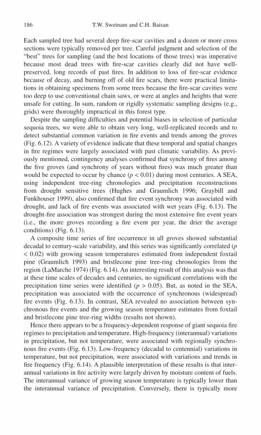
Each sampled tree had several deep fire-scar cavities and a dozen or more crosssections were typically removed per tree. Careful judgment and selection of the“best” trees for sampling (and the best locations of those trees) was imperativebecause most dead trees with fire-scar cavities clearly did not have well-preserved, long records of past fires. In addition to loss of fire-scar evidencebecause of decay, and burning off of old fire scars, there were practical limita-tions in obtaining specimens from some trees because the fire-scar cavities weretoo deep to use conventional chain saws, or were at angles and heights that wereunsafe for cutting. In sum, random or rigidly systematic sampling designs (e.g.,grids) were thoroughly impractical in this forest type.
Despite the sampling difficulties and potential biases in selection of particularsequoia trees, we were able to obtain very long, well-replicated records and todetect substantial common variation in fire events and trends among the groves(Fig. 6.12). A variety of evidence indicate that these temporal and spatial changesin fire regimes were largely associated with past climatic variability. As previ-ously mentioned, contingency analyses confirmed that synchrony of fires amongthe five groves (and synchrony of years without fires) was much greater thanwould be expected to occur by chance (p < 0.01) during most centuries. A SEA,using independent tree-ring chronologies and precipitation reconstructions from drought sensitive trees (Hughes and Graumlich 1996; Graybill andFunkhouser 1999), also confirmed that fire event synchrony was associated withdrought, and lack of fire events was associated with wet years (Fig. 6.13). Thedrought-fire association was strongest during the most extensive fire event years(i.e., the more groves recording a fire event per year, the drier the average conditions) (Fig. 6.13).
A composite time series of fire occurrence in all groves showed substantialdecadal to century-scale variability, and this series was significantly correlated (p< 0.02) with growing season temperatures estimated from independent foxtailpine (Graumlich 1993) and bristlecone pine tree-ring chronologies from theregion (LaMarche 1974) (Fig. 6.14). An interesting result of this analysis was thatat these time scales of decades and centuries, no significant correlations with theprecipitation time series were identified (p > 0.05). But, as noted in the SEA, precipitation was associated with the occurrence of synchronous (widespread) fire events (Fig. 6.13). In contrast, SEA revealed no association between syn-chronous fire events and the growing season temperature estimates from foxtailand bristlecone pine tree-ring widths (results not shown).
Hence there appears to be a frequency-dependent response of giant sequoia fireregimes to precipitation and temperature. High-frequency (interannual) variationsin precipitation, but not temperature, were associated with regionally synchro-nous fire events (Fig. 6.13). Low-frequency (decadal to centennial) variations intemperature, but not precipitation, were associated with variations and trends infire frequency (Fig. 6.14). A plausible interpretation of these results is that inter-annual variations in fire activity were largely driven by moisture content of fuels.The interannual variance of growing season temperature is typically lower thanthe interannual variance of precipitation. Conversely, there is typically more
186 T.W. Swetnam and C.H. Baisan
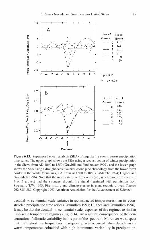
6. Sierra Nevada and Southwestern United States 187
decadal- to centennial-scale variance in reconstructed temperatures than in recon-structed precipitation time series (Graumlich 1993; Hughes and Graumlich 1996).It may be that the decadal- to centennial-scale responses of fire regimes to similartime-scale temperature regimes (Fig. 6.14) are a natural consequence of the con-centration of climatic variability in this part of the spectrum. Moreover we suspectthat the highest fire frequencies in sequoia groves occurred when decadal-scalewarm temperatures coincided with high interannual variability in precipitation.
Figure 6.13. Superposed epoch analysis (SEA) of sequoia fire events versus precipitationtime series. The upper graph shows the SEA using a reconstruction of winter precipitationin the Sierra from AD 1060 to 1850 (Graybill and Funkhouser 1999), and the lower graphshows the SEA using a drought-sensitive bristlecone pine chronology from the lower forestborder in the White Mountains, CA, from AD 500 to 1850 (LaMarche 1974; Hughes andGraumlich 1996). Note that the more extensive fire events (i.e., synchronous fire events in4 or 5 groves) had the strongest drought-fire signal (reprinted with permission fromSwetnam, T.W. 1993, Fire history and climate change in giant sequoia groves, Science262:885–889, Copyright 1993 American Association for the Advancement of Science).

188 T.W. Swetnam and C.H. Baisan
These conditions would be conducive to production of copious fuels during warmand wet years, and abundant fire ignitions and extensive fire spread during thewarm and dry years.
Examples of such situations may have occurred during some decades of theso-called Medieval Warm Period, which appears to have been strongly expressedin the Sierra Nevada region from ca. AD 900 to 1300 (LaMarche 1974;
Figure 6.14. Decadal and centennial variations in estimated temperatures and fire occur-rence in the Sierras are compared. The fire occurrence time series was computed from a weighted sum of fire events in the five sequoia groves in 20-year nonoverlapping periods(i.e., each year had a value of 0 to 5 depending on number of groves recording fire). Thetemperature series were 20-year, nonoverlapping means, and both the temperature and fire occurrence series were slightly smoothed with a cubic spline (for graphical purposes,but not for the statistical analyses). The upper graph shows a comparison of fire activitywith reconstructed summer temperature from foxtail pine in the Sierras (Graumlich 1993),and the lower graph shows a comparison with a temperature responsive, upper tree-line bristlecone pine chronology from the White Mountains, CA (LaMarche 1974). ThePearson correlation between the foxtail reconstructed temperature and fire series was r = 0.41, p = 0.006, and the correlation between bristlecone ring-width chronology andfire series was 0.30, p = 0.012 (unsmoothed values used in correlation analysis; reprintedwith permission from Swetnam, T.W. 1993, Fire history and climate change in giantsequoia groves, Science 262:885–889, Copyright 1993 American Association for theAdvancement of Science).
Graumlich 1993; Stine 1994). The highest fire frequencies in the past 2000 yearsoccurred during this period (Fig. 6.14). This period, and the subsequent Little Ice Age (ca. AD 1400–1840, Grove 1988) have often been overextrapolated byvarious researchers, with unwarranted assumptions that these were monolithicperiods of temporally consistent climate in virtually all regions of the NorthernHemisphere (see a critique of these assumptions regarding the Medieval WarmPeriod by Hughes and Diaz 1994). We agree that there is a high degree of regionalvariability in climate, and a lack of strong evidence for anything like a MedievalWarm Period or Little Ice Age in many parts of the world. Nevertheless, theclimate history of the Sierras apparently coincided with the approximate timingand climatic conditions usually ascribed to these two periods (warm and cold,respectively).
In addition to the tree-ring width evidence (LaMarche 1974; Graumlich 1993)and lake level evidence (Stine 1994), now fire history may be added as anotherline of independent evidence in support of the occurrence of a generally warmperiod ca. 900 to 1300 and a subsequent cool period in the Sierra Nevada (regard-less of whether they are given the appellation “Medieval Warm Period” or “LittleIce Age”). As noted above, fire frequencies were highest during the late MiddleAges (especially ca. 1100–1300) and decreased fire frequencies occurred after1300s, especially during the major cold episodes of the mid 1400s and late 1600s.Although fire can only be considered an indirect proxy for past climatic varia-tions, it is arguably not any less directly related to climate than, for example, lakelevels.
Conclusion
Regional synchrony of ecological process is the hallmark of climatic influenceand is an emergent property evident in fire occurrence time series aggregated overregions to continents (e.g., Swetnam and Betancourt 1998; Kitzberger, Swetnam,and Veblen 2001). Although fire history is often a function of site-specific envi-ronmental and cultural variables, it is clear that with network approaches, involv-ing massive replication of high-resolution fire-scar time series across multiplepoints in space, it is possible to reconstruct very useful proxies of ecologicallyeffective climatic change. The synchrony of fire regime variations in differentregions can be compared and contrasted to elucidate historical climatic and cul-tural events and variations.
Disentangling climatic and human effects on past fire regimes is very chal-lenging but not impossible. Multiple case studies and comparisons across net-works of fire history sites is a key to identifying and distinguishing the effects ofhumans and climate on past forest fire regimes. More comparisons are needed of fire-scar chronologies with independent reconstructions and records of bothclimate and human history (e.g., from documentary sources or culturally modi-fied trees). So far we have identified a few cases in the Southwest where NativeAmerican effects on fire frequency and seasonality before 1900 may be discern-
6. Sierra Nevada and Southwestern United States 189
190 T.W. Swetnam and C.H. Baisan
able. The most striking and clearly identified effect of humans on nineteenth- andearly twentieth-century fire regimes in the Southwest and Sierras was the dis-ruption of fire regimes by the introduction of intensive livestock grazing.
Interesting time periods showing coherent and significant fire and climatechanges, such as the early 1800s and transition from Medieval Warm Period to Little Ice Age (1300–1400), offer unique opportunities for fire historians and paleoclimatologists to target specific regions and mechanisms for testing. For example, as we learn more about regionally consistent and specific terrestrialteleconnections to ocean-atmosphere patterns (El Niño–Southern Oscillation,Pacific Decadal–Oscillation, North Atlantic Oscillation, etc.), we could target key “sensitive” regions for new fire history collections and reconstructions. Wehave learned that climatic teleconnections in some regions are opposite inresponse relative to other regions. The Pacific Northwest, and northern U.S.Rockies, for example, tend to have opposite drought and fire responses to ENSOrelative to the Southwest. The changing and variable nature of these inverse patterns should be thoroughly assessed using combinations of twentieth-centuryclimate and fire occurrence data (fire atlases) and tree-ring based fire histories(Morgan et al. 2001). Direct comparisons between existing fire atlases and broad-scale networks of fire histories will be one way to do this, but development ofmore extensive networks is needed, especially in regions where relatively fewcrossdated fire-scar chronologies have been developed, such as in southwestCanada and the Pacific Northwest, northern Rockies, Great Basin, and northernMexico.
References
Abolt, R.A.P. 1997. Fire histories of upper elevation forests in the Gila Wilderness, NewMexico via fire scar and stand age structure analyses. M.S. thesis, School of Renew-able Natural Resources, University of Arizona, Tucson. 120p.
Aceituno, P. 1988. On the functioning of the Southern Oscillation in the South Americansector. Part 1. Surface climate. Mon. Wea. Rev. 116:505–524.
Allen, C.D. 1989. Changes in the landscape of the Jemez Mountains, New Mexico. Ph.D.dissertation. University of California, Berkeley.
Allen, C.D. 2002. Lots of lightning and plenty of people: An ecological history of fire inthe upland Southwest. In Fire, Native Peoples, and the Natural Landscape, ed. T.R.Vale, pp. 173–194. Covelo, CA: Island Press.
Anderson, M.K. 1996. Tending the wilderness. Restor. Manag. Notes 14(2):154–166.Andrade, E.R. Jr., and Sellers, W.D. 1988. El Niño and its effect on precipitation in Arizona
and western New Mexico. J. Clim. 8:403–410.Arno, S.F., and Petersen, T.D. 1983. Variation in estimates of fire intervals: A closer look
at fire history on the Bitterroot National Forest. USDA Forest Service Res. Pap. INT-301.
Bahre, C.J. 1985. Wildfire in southeastern Arizona between 1859 and 1890. Desert Plants7(4):190–194.
Baisan, C.H., and Swetnam, T.W. 1990. Fire history on a desert mountain range: RinconMountain Wilderness, Arizona, U.S.A. Can. J. For. Res. 20:1559–1569.
Baisan, C.H., and Swetnam, T.W. 1997. Interactions of fire regime and land-use history in the central Rio Grande Valley. USDA Forest Service Res. Pap. RM-RP-330.20p.
Baker, W.L. 2002. Indians and fire in the U.S. Rocky Mountains: the wilderness hypo-thesis renewed. In Fire, Native Peoples, and the Natural Landscape, ed. T.R. Vale. pp.41–76. Covelo, CA: Island Press.
Baker, W.L., and Ehle, D. 2001. Uncertainty in surface-fire history: the case of ponderosapine forests in the western United States. Can. J. For. Res. 31(7):1205–1226.
Barton, A.M., Swetnam, T.W., and Baisan, C.H. 2001. Arizona pine (Pinus arizonica)stand dynamics: Local and regional factors in a fire-prone madrean gallery forest ofSoutheast, Arizona, USA. Landscape Ecol. 16(4):351–369.
Brown, P.M., and Sieg, C.H. 1996. Fire history in interior ponderosa pine communities ofthe Black Hills, South Dakota, USA. Int. J. Wildl. Fire 6(3):97–105.
Brown, P.M., and Sieg, C.H. 1999. Historical variability in fire at the ponderosa pine–Northern Great Plains prairie ecotone, southeastern Black Hills, South Dakota. Eco-science 6(4):539–547.
Brown, P.M., and Swetnam, T.W. 1994. A crossdated fire history in a coast redwood forestnear Redwood National Park, California. Can. J. For. Res. 24:21–31.
Brown P.M., Kaufmann, M.R., and Shepperd W.D. 1999. Long-term, landscape patternsof past fire events in a montane ponderosa pine forest of central Colorado. LandscapeEcol. 14(6):513–532.
Brown, P.M., Kaye M.W., Huckaby, L.S., and Baisan, C.H. 2001. Fire history along envi-ronmental gradients in the Sacramento Mountains, New Mexico: Influences of localand regional processes. Ecoscience 8(1):115–126.
Caprio, A.C., and Swetnam, T.W. 1995. Historic fire regimes along an elevational gradi-ent on the west slope of the Sierra Nevada, California. In Proceedings of Symposiumon Fire in Wilderness and Park Management, tech. coords. J.K. Brown, R.W. Mutch,C.W. Spoon, and R.H. Wakimoto, pp. 173–199. USDA Forest Service Gen. Tech. Rep.INT-GTR-320.
Colwell, R.K., and Coddington, J.A. 1994. Estimating terrestrial biodiversity throughextrapolation. Philos. Trans. Roy. Soc. London, (ser. B) Biolog. Sci. 345(1311):101–118.
Cook, E.R., Meko, D.M., Stahle, D.W., and Cleaveland, M.K. 1994. Tree-ring recon-structions of past drought across the coterminous United States: Tests of a regres-sion method and calibration/verification results. In Tree-Rings, Environment, and Humanity, eds. J.S. Dean, D.M. Meko, and T.W. Swetnam, pp. 155–169. Tucson, AZ:Radiocarbon.
Cook, E.R., Meko, D.M., Stahle, D.W., and Cleaveland, M.K. 1999. Drought reconstruc-tions for the continental United States. J. Clim. 12(4):1145–1162.
Cropper, J.P., and Fritts, H.C. 1982. Density of tree-ring grids in western North America.Tree-Ring Bull. 42:3–10.
Denevan, W.M. 1992. The pristine myth—The landscape of the Americas in 1492. Ann.Assoc. Am. Geogr. 82(3):369–385.
Diaz, H.F., and Markgraf, V. 2000. El Niño and the Southern Oscillation: Multiscale Variability and Global and Regional Impacts. Cambridge: Cambridge University Press.
Dieterich, J.H. 1980. The composite fire interval—A tool for more accurate interpretationsof fire history. In Proceedings of the Fire History Workshop, tech. coords. M.A. Stokes,and J.H. Dieterich, pp. 8–14, October 20–24, Tucson, AZ. USDA Forest Service Gen.Tech. Rep. RM-81.
Dieterich, J.H. 1983. Fire history of southwestern mixed conifer: A case study. For. Ecol.Manag. 6:13–31.
Dieterich, J.H., and Swetnam, T.W. 1984. Dendrochronology of a fire-scarred ponderosapine. For. Sci. 30(1):238–247.
Dobyns, H.F. 1978. From fire to flood: Historic human destruction of Sonoran desert river-ine oases. Ballena Press Anthropological Papers No. 20. Soccoro, NM.
Donnegan, J.A., Veblen, T.T., and Sibold, J.S. 2001. Climatic and human influences on fire history in Pike National Forest, central Colorado. Can. J. For. Res. 31(9):1526–1539.
6. Sierra Nevada and Southwestern United States 191

Douglass, A.E. 1941. Crossdating in dendrochronology. J. For. 39(10):825–831.Frittts, H.C. 1976. Tree Rings and Climate. London: Academic Press.Fritts, H.C. 1991. Reconstructing Large-Scale Climatic Patterns from Tree-Ring Data.
Tucson: University of Arizona Press.Fritts, H.C., and Swetnam, T.W. 1989. Dendroecology: A tool for evaluating variations in
past and present forest environments. Adv. Ecol. Res. 19:111–189.Fulé, P.Z., and Covington, W.W. 1997. Changing fire regimes in Mexican pine forests:
Ecological and management implications. J. For. 94(10):33–38.Fulé, P.Z., and Covington, W.W. 1999. Fire regime changes in La Michilia Biosphere
Reserve, Durango, Mexico. Conserv. Biol. 13(3):640–652.Fulé, P.Z., Covington, W.W., and Moore, M.M. 1997. Determining reference conditions
for ecosystem management of southwestern ponderosa pine. Ecol. Appl. 7(3):895–908.Graumlich, L.J. 1993. A 1000-year record of temperature and precipitation in the Sierra
Nevada. Quat. Res. 39:249–255.Graybill, D.A., and Funkhouser, G.S. 1999. Dendroclimatic reconstructions during the past
millennium in the Southern Sierra Nevada and Owens Valley, California. In Proceed-ings of Southern California Climate Symposium on Trends and Extremes of the Past2,000 Years, eds. M.R. Rose and P.E. Wigand, pp. 239–269, October 25, 1991. NaturalHistory Museum of Los Angeles County, Tech. Rep., Number 11.
Grissino-Mayer, H.D. 1995. Tree-ring reconstructions of climate and fire history at El Malpais National Monument, New Mexico. Ph.D. dissertation, Department of Geosciences, University of Arizona, Tucson. 407p.
Grissino-Mayer, H.D. 1999. Modeling fire interval data from the American Southwest withthe Weibull distribution. Int. J. Wildl. Fire 9(1):37–50.
Grissino-Mayer, H.D. 2001. FHX2—Software for analyzing temporal and spatial patternsin fire regimes from tree rings. Tree-Ring Res. 57(1):113–122.
Grissino-Mayer, H.D., and Swetnam, T.W. 1997. Multi-century history of wildfire in theponderosa pine forests of El Malpais National Monument. New Mexico Bur. MinesMineral Resources Bull. 156:163–171.
Grissino-Mayer, H.D., and Swetnam, T.W. 2000. Century-scale climate forcing of fireregimes in the American Southwest. Holocene 10(2):213–220.
Grove, J.M. 1988. The Little Ice Age. London: Methuen.Gutzler, D.S., and Preston, J.W. 1997. Evidence for a relationship between spring snow
cover in North America and summer rainfall in New Mexico. Geophys. Res. Lett.24(17):2207–2210.
Harrington, J.A. Jr., Cerveny, R.S., and Balling, R.C. Jr. 1992. Impact of the SouthernOscillation on the North American Southwest monsoon. Phys. Geogr. 13:318–330.
Heyerdahl, E.K., Brubaker, L.B., and Agee, J.K. 2001. Spatial controls of historical fireregimes: A multiscale example from the interior west, USA. Ecology 82(3):660–678.
Heyerdahl, E.K., Brubaker, L.B., and Agee, J.K. (In press). Annual and decadal influenceof climate on fire regimes (1687–1994) of the Blue Mountains, USA. Holocene.
Hughes, M.K., and Diaz, H.R. 1994. Was there a Medieval Warm Period, and if so, whereand when? Clim. Change 26:109–142.
Hughes, M.K., and Graumlich, L.J. 1996. Multimillennial dendroclimatic records from thewestern United States. In Climatic Variations and Forcing Mechanisms of the last 2000Years, eds. R.S. Bradley, P.D. Jones, and J. Jouzel, pp. 109–124. NATO AdvancedStudies Workshop Series. New York: Springer-Verlag.
Johnson, E.A., and Gutsell, S.L. 1994. Fire frequency models, methods and interpreta-tions. Adv. Ecol. Res. 25:239–287.
Kaib, M. 1998. Fire history in riparian canyon pine-oak forests and the intervening desertgrasslands of the Southwest borderlands: A dendroecological, historical, and culturalinquiry. M.S. thesis, University of Arizona, Tucson. 234p.
Kaib, M., Baisan, C.H., Grissino-Mayer, H.D., and Swetnam, T.W. 1996. Fire history inthe gallery pine-oak forests and adjacent grasslands of the Chiricahua Mountains of
192 T.W. Swetnam and C.H. Baisan

Arizona. In Effects of Fire on Madrean Province Ecosystems: A Symposium Proceed-ings, tech. coord. P.F. Ffolliott, L.F. DeBano, M.B. Maker Jr., G.J. Gottfried, G. Solis-Garza, C.B. Edminster, D.G. Neary, L.S. Allen, and R.H. Hamre, pp. 253–264.USDA Forest Service Gen. Tech. Rep. RM-GTR-289.
Kaye, M.W., and Swetnam, T.W. 1999. An assessment of fire, climate, and Apache historyin the Sacramento Mountains, New Mexico, USA. Phys. Geogr. 20(4):305–330.
Kilgore, B.M., and Taylor, D. 1979. Fire history of a sequoia-mixed conifer forest. Ecology60(1):129–142.
Kitzberger, T., and Veblen, T.T. 1998. Influences of humans and ENSO on fire history ofAustrocedrus chilensis woodlands in northern Patagonia, Argentina. Ecoscience 4(4):508–520.
Kitzberger, T., Veblen, T.T., and Villalba, R. 1997. Climatic influences on fire regimesalong a rain forest to xeric woodland gradient in northern Patagonia, Argentina. J. Biogeogr. 24(1):35–47.
Kitzberger, T., Swetnam, T.W., and Veblen, T.T. 2001. Inter-hemispheric synchrony offorest fires and the El Nino-Southern Oscillation. Global Ecol. Biogeogr. 10(3):315–326.
LaMarche, V.C. Jr. 1974. Paleoclimatic inferences from long tree-ring records. Science183:1043–1048.
LaMarche, V.C. Jr., and Fritts, H.C. 1971. Anomaly patterns of climate over the westernUnited States, 1700–1930, derived from principal components analysis of tree-ringdata. Mon. Wea. Rev. 99(2):138–142.
Mann, M.E., Bradley, R.S., and Hughes, M.K. 1998. Global-scale temperature patternsand climate forcing over the past six centuries. Nature 392:779–787.
Martorano, M.A. 1981. Scarred Ponderosa Pine Trees Reflecting Cultural Utilization ofBark. M.S. thesis, Department of Anthropology, Colorado State University, FortCollins. 127p.
Meko, D., Cook, E.R., Stahle, D.W., Stockton, C.W., and Hughes, M.K. 1993. Spatial patterns of tree-growth anomalies in the United States and Southeastern Canada. J.Clim. 6(9):1773–1786.
Miller, C., and Urban, D.L. 1999. A model of surface fire, climate and forest pattern inthe Sierra Nevada, California. Ecol. Model. 114(2–3):113–135.
Miller, C., and Urban, D.L. 2000. Connectivity of forest fuels and surface fire regimes.Landscape Ecol. 15(2):145–154.
Millar, C.I., and Woolfenden, W.B. 1999. The role of climate change in interpreting historical variability. Ecol. Appl. 9(4):1207–1216.
Mooney, C.Z., and Duvall, R.D. 1993. Bootstrapping: A non-parametric approach to statistical inference. Sage University Paper Series on Quantitative Applications in theSocial Sciences 07-095, Newbury Park, CA. 73p.
Morgan, P., Hardy, C., Swetnam, T.W., Rollins, M.G., and Long, D.G. 2001. Mapping fireregimes across time and space: Understanding coarse and fine-scale patterns. Int. J.Wildl. Fire 10(3–4):329–342.
Morino, K.A. 1996. Reconstruction and interpretation of historical patterns of fire occurrence in the Organ Mountains, New Mexico. M.S. thesis. University of Arizona,Tucson. 144p.
Muir, J. 1911. My First Summer in the Sierra. Boston: Houghton Mifflin.Nicholls, N. 1992. Historical El Niño/Southern Oscillation variability in the Australasian
region. In El Niño: Historical and Paleoclimatic Aspects of the Southern Oscillation,eds. H.F. Diaz and V. Markgraf, pp. 151–173. Cambridge: Cambridge University Press.
Ortloff, W. 1996. Wood anatomical evidence of fire seasonality. In Tree-Rings, Environ-ment, and Humanity, eds. J.S. Dean, D.M. Meko, and T.W. Swetnam, pp. 89–93.Tucson, AZ: Radiocarbon.
Pyne, S.J. 1982. Fire in America: A Cultural History of Wildland and Rural Fire. Princeton: Princeton University Press.
6. Sierra Nevada and Southwestern United States 193

Pyne, S.J. 1985. Vestal fires and virgin lands: a historical perspective on fire and wilder-ness. In Proceedings of Symposium and Workshop on Wilderness Fire, tech. coord. J.E. Lotan, B.M. Kilgore, W.C. Fischer, and R.W. Mutch, pp. 254–262. November15–18, 1983, Missoula, MT. USDA Forest Service Gen. Tech. Rep. INT-182.
Rollins, M., Swetnam, T.W., and Morgan, P. 2001. Evaluating a century of fire patterns in two Rocky Mountain wilderness areas using digital fire atlases. Can. J. For. Res.31(12):2107–2123.
Rosenzweig, M.L. 1995. Species diversity in space and time. Cambridge: Cambridge University Press.
Savage, M., and Swetnam, T.W. 1990. Early and persistent fire decline in a Navajo ponderosa pine forest. Ecol. 70(6):2374–2378.
Seklecki, M.T., Grissino-Mayer, H.D., and Swetnam, T.W. 1996. Fire history and the pos-sible role of Apache-set fires in the Chiricahua Mountains of southeastern Arizona. InEffects of Fire on Madrean Province Ecosystems: A Symposium Proceedings, tech.coord. P.F. Ffolliott, L.F. DeBano, M.B. Maker Jr., G.J. Gottfried, G. Solis-Garza, C.B.Edminster, D.G. Neary, L.S. Allen, and R.H. Hamre, pp. 238–246. USDA ForestService General Tech. Rep. RM-GTR-289.
Stephenson, N.L., Parsons, D.J., and Swetnam, T.W. 1989. Restoring natural fire to thesequoia-mixed conifer forest: should intense fire play a role? Proceedings 17th TallTimbers Fire Ecology Conference. High Intensity Fire in Wildlands: ManagementChallenges and Options, pp. 321–337, May 18–21, Tallahassee, FL.
Stine, S. 1994. Extreme and persistent droughts in California and Patagonia during mediaeval times. Nature 369:546–549.
Swetnam, T.W. 1984. Peeled ponderosa pine trees: A record of inner bark utilization byNative Americans. J. Ethnobiol. 4(2):177–190.
Swetnam, T.W. 1993. Fire history and climate change in giant sequoia groves. Science262:885–889.
Swetnam, T.W., and Baisan, C.H. 1996. Fire effects in southwestern forests. Proceedingsof the Second La Mesa Fire Symposium, March 29–31, 1994, Los Alamos, NM. USDAForest Service Gen. Tech. Rep. RM-GTR-286.
Swetnam, T.W., and Betancourt, J.L. 1990. Fire-southern oscillation relations in the south-western United States. Science 249:1017–1020.
Swetnam, T.W., and Betancourt, J.L. 1992. Temporal patterns of El Nino/Southern Oscillation—Wildfire patterns in the southwestern United States. In El Nino: Histori-cal and Paleoclimatic Aspects of the Southern Oscillation, eds. H.F. Diaz and V.M.Markgraf, pp. 259–270. Cambridge: Cambridge University Press.
Swetnam, T.W., and Betancourt, J.L. 1998. Mesoscale disturbance and ecological responseto decadal climatic variability in the American Southwest. J. Clim. 11(12):3128–3147.
Swetnam, T.W., and Dieterich, J.H. 1985. Fire history of ponderosa pine forests in the GilaWilderness, New Mexico. In Proceedings-Symposium and Workshop on WildernessFire, tech. coords. J.E. Lotan, B.M. Kilgore, W.C. Fischer, and R.W. Mutch, pp.390–397. November 15–18, 1983, Missoula, MT. USDA Forest Service Gen. Tech.Rep. INT-182.
Swetnam, T.W., Allen, C.D., and Betancourt, J.L. 1999. Applied historical ecology: Usingthe past to manage for the future. Ecol Appl. 9(4):1189–1206.
Swetnam, T.W., Baisan, C.H., Caprio, A.C., Touchan, R., and Brown, P.M. 1992. Tree-ring reconstruction of giant sequoia fire regimes. Report on Cooperative Agreement DOI 8018-1-0002 to National Park Service. University of Arizona. 90p.
Swetnam, T.W., Baisan, C.H., and Kaib, J.M. 2001. Forest fire histories in the sky islandsof La Frontera. In Changing Plant Life of La Frontera: Observations on Vegetation inthe United States/Mexico Borderlands, eds. G.L. Webster and C.J. Bahre, pp. 95–119.Albuquerque: University of New Mexico Press.
194 T.W. Swetnam and C.H. Baisan

Swetnam, T.W., Touchan, R., Baisan, C.H., Caprio, A.C., and Brown, P.M. 1991. Giantsequoia fire history in Mariposa Grove, Yosemite National Park. In Proceedings of theYosemite Centennial Symposium, pp. 249–255. El Portal, CA: Yosemite Association.
Touchan, R., Allen, C.D., and Swetnam, T.W. 1996. Fire history and climatic patterns inponderosa pine and mixed-conifer forests of the Jemez Mountains, northern NewMexico. In Fire Effects in Southwestern Forests: Proceedings of the Second La MesaFire Symposium, ed. C.D. Allen, pp. 33–46. USDA Forest Service Gen. Tech. Rep.RM-GTR-286.
Vale, T.R. 1998. The myth of the humanized landscape: An example from YosemiteNational Park. Natural Areas J. 18(3):231–236.
Vale, T.R., editor. 2002. Fire, Native Peoples, and the Natural Landscape. Covelo, CA:Island Press.
Vankat, J.L. 1977. Fire and man in Sequoia National Park. Ann. Assoc. Am. Geogr. 67(1):17–27.
Veblen, T.T., Kitzberger, T., and Donnegan, J. 2000. Climatic and human influences onfire regimes in ponderosa pine forests in the Colorado Front Range. Ecol. Appl. 10(4):1178–1195.
Veblen, T.T., Kitzberger, T., Villalba, R., and Donnegan, J. 1999. Fire history in northernPatagonia: The roles of humans and climatic variation. Ecol. Monogr. 69(1):47–67.
6. Sierra Nevada and Southwestern United States 195

7. Influence of Climate and Land Use on Historical Surface Fires in Pine-Oak Forests,
Sierra Madre Occidental, Mexico
Emily K. Heyerdahl and Ernesto Alvarado
The rugged mountains of the Sierra Madre Occidental, in north-central Mexico,support a mosaic of diverse ecosystems. Of these, the high-elevation, temperatepine-oak forests are ecologically significant for their extensiveness and biodiver-sity. They cover nearly half the land area in the states of Durango and Chihuahua(42%), and comprise a similar percentage of the temperate coniferous forest inMexico as a whole (45%; World Forest Institute 1994; SARH 1994). These forestsare globally significant centers of vascular plant diversity, and of endemism inboth plant and animal species (Bye 1993; Manuel-Toledo and Jesús-Ordóñez1993). For example, they have the highest number of pine and oak species in theworld (Rzedowski 1991) and contain many of Mexico’s Pinus, Quercus, andArbutus species (33%, 30%, and 66%, respectively; Bye 1995). Surface fires werehistorically frequent in these forests, and variations in their frequency may havecontributed to the maintenance of this biodiversity (Dieterich 1983; Fulé andCovington 1997, 1999; Park 2001). However, we know little about the drivers ofvariation in historical fire regimes.
Forest fires are controlled by processes acting across a broad range of spatialscales (Tande 1979; Payette et al. 1989; Swetnam and Baisan 1996; Taylor andSkinner 1998; Heyerdahl, Brubaker, and Agee 2001). At coarse spatial scales,annual extremes in regional climate can synchronize the occurrence of fires acrossbroad areas (Swetnam and Betancourt 1998; Swetnam and Baisan, Chapter 6, thisvolume). For example, fires were widespread during years of regionally low precipitation at sites in North and South America (Veblen et al. 1999; Veblen,
196

Kitzberger, and Donnegan 2000; Kitzberger, Swetnam, and Veblen 2001; Heyerdahl, Brubaker, and Agee in press; Swetnam and Baisan, Chapter 6, thisvolume). Climate varies at annual scales in Mexico, partly in response to the ElNiño–Southern Oscillation (ENSO), which significantly affects precipitation inthe Sierra Madre Occidental (Ropelewski and Halpert 1986, 1987, 1989; Kiladisand Diaz 1989; Cavazos and Hastenrath 1990; Stahle et al. 1998, 1999). Wewould expect such temporal variations in climate to synchronize the occurrencefire across this region by affecting the amount and moisture content of the finefuels that carry surface fires. Assessing the annual relationship between climateand fire requires long accurate records. Unfortunately, detailed archival recordsof fire occurrence and climate are rare for much of the Sierra Madre Occidental.However, multicentury records of both can be reconstructed from annually datedtree-ring series for the region (Fulé and Covington 1997, 1999; Stahle et al. 1998,1999).
Climate is not the only factor that drives variation in fire regimes through time. In the western United States, for example, fire regimes were dramaticallyaffected by late nineteenth- and early twentieth-century changes in land use, suchas grazing, road building, and timber harvesting (e.g., Leopold 1937; Savage andSwetnam 1990; Baisan and Swetnam 1997; Fulé and Covington 1997, 1999; Kaib1998; Veblen et al. 1999; Veblen, Kitzberger, and Donnegan 2000; Heyerdahl,Brubaker, and Agee, in press). These land-use activities also intensified in theSierra Madre Occidental in the mid-1900s with changes in the ejido system ofland tenure in Mexico and may have affected fire regimes there.
Our objective was to infer the role of annual variation in regional climate andchanges in land use in driving the occurrence of widely synchronous surface firesin pine-oak forests of the Sierra Madre Occidental of Mexico. Specifically, wereconstructed a multicentury history of fire from tree rings and fire scars at eightsites in the states of Durango and Chihuahua. We compared this history to exist-ing tree-ring reconstructions of precipitation and ENSO activity (Stahle et al.1998, 1999) and to archival records of land use.
Study Area
Sampling Sites
We relied on the knowledge of local foresters and researchers to judgmentallylocate eight largely unlogged sites (2–6ha each) containing relatively old, fire-scarred trees. The sites are distributed over nearly 700km on the dry east side of the crest of the Sierra Madre Occidental in north-central Mexico (Fig. 7.1). All the sites are high in elevation (2440–2950m, Table 7.1), but vary in slope(16–65%), aspect (3–343°) and topographic position (hill slopes: SSP, AJT, FCT,CHI, LBA; mesas: CAR, MLC; rocky ridge: ALF). The shallow, coarse-texturedvolcanic soils at most of our sites are typical of the region in general (Challenger1998; Ferrusquía Villafranca 1998).
7. Sierra Madre Occidental, Mexico 197

Forest composition at these sites, typical of this portion of the Sierra MadreOccidental (Bye 1995), was dominated by four pine species (Pinus durangensisMart., P. teocote Schl. & Cham., P. ayacahuite Ehren., or P. engelmannii Carr.),but other species also occurred (P. arizonica Engelm., P. herrerai Mart., P.lumholtzii Robins. & Fern. and Pseudotsuga menziesii Mirb. Franco). Severalspecies of Quercus were common at all sites, and a few species of Arbutus andJuniperus occurred at some southern sites. The understory was dominated bygrasses and herbs.
198 E.K. Heyerdahl and E. Alvarado
Figure 7.1. Mexico and the states of Durango and Chihuahua, showing the location ofthe eight sites at which we reconstructed fire history.
Table 7.1. Location and topographic position of the sampling sites
AreaSite Nearby Elevation Aspect Slope sampled
Site name code Ownership town (m) (degrees) (%) (ha)
Salsipuedes SSP El Largo Madera 2620 314 47 2Alto del Jiguital AJT El Tecuan Tamazula 2440 18 34 3Falda de la FCT Santa Ana Tamazula 2660 212 26 4
CañadaEl Carpintero CAR La Victoria– San Miguel 2790 295 18 4
MiravallesMesa de los MLC La Victoria– San Miguel 2830 179 16 3
Ladrónes MiravallesLas Chivas CHI La Victoria El Salto 2950 224 42 6Arroyo de las ALF La Campana El Salto 2800 3 65 5
FloresLas Bayas LBA UJED Research La Flor 2900 343 38 3
Forest
Note: Sites are ordered from north to south (top to bottom). All sites but LBA are owned by the ejidos indicated.UJED is the Universidad Juárez del Estado de Durango. All sites except SSP are in Durango.

Instrumental Climate
The Sierra Madre Occidental has a monsoonal climate with warm, wet summers,a long dry period in the spring and a shorter one in the fall (Fig. 7.2; MosiñoAlemán and García 1974). Most annual precipitation (70–80%) falls during thesummer (June–September) as a result of the monsoon that develops over south-ern Mexico in May and spreads north along the Sierra Madre Occidental to reachArizona and New Mexico by July (Mosiño Alemán and García 1974; Hales 1974;Douglas et al. 1993). Annual precipitation, derived from low-elevation stationsfor the states of Durango and Chihuahua, averages 40 and 56cm, respectively(1945–1993; Douglas and Englehart 1995). While the seasonal distribution ofprecipitation at our high-elevation sampling sites is probably similar to thesestatewide averages, total precipitation is likely higher. For example, El Salto (ele-vation ca.2500m), near the southern end of our sampling area, annually receives92cm of rain (1940–1993; Fig. 7.2). Winter precipitation can fall as snow at highelevations in the Sierra Madre Occidental, but persistent snow packs are rare(Mosiño Alemán and García 1974; Challenger 1998). Precipitation in the SierraMadre Occidental varies through time, partly in response to global processes likeENSO. Winters are wetter than average during El Niño years and drier thanaverage during La Niña years (Ropelewski and Halpert 1986, 1987, 1989; Kiladisand Diaz 1989; Cavazos and Hastenrath 1990). Temperatures are generally mildin this region, with an annual maximum in June (e.g., 16°C at El Salto, Fig. 7.2;Mosiño Alemán and García 1974).
Most modern fires in our study area burn in the spring (January–May, SEMARNAP 2000) as temperatures warm and fine fuels dry, but before mon-soon rains increase fine-fuel moisture and encourage new growth of grasses andherbs. Lightning is most common from April to October and has been inferred
7. Sierra Madre Occidental, Mexico 199
Figure 7.2. Climate of El Salto, Durango (1940–1993; elevation ca.2500m). Totalmonthly precipitation is shown as bars, average monthly minimum, mean, and maximumtemperatures are shown as lines.
as an ignition source for fire elsewhere in the Sierra Madre Occidental (Turmanand Edgar 1982; Fulé and Covington 1999).
Historical Climate from Tree Rings
Precipitation has been reconstructed from tree rings for Durango (1386–1995;Stahle et al. 1999). These reconstructions explain 56% of the variance in theinstrumental record of winter precipitation (previous November–March) and 53% of that in early summer (May–June, 1942–1983). For each of these seasons,modern precipitation varies similarly in Durango and Chihuahua (r = 0.57 and0.59, for winter and early summer, respectively, p < 0.01, 1945–1994; Douglasand Englehart 1995). Consequently the reconstruction for Durango probably captures variation in precipitation at our sites in both states.
Variation in the strength and phase of ENSO is captured by an index of theSouthern Oscillation, computed as the normalized difference in monthly surfacepressure between Tahiti and Darwin, Australia, two measurement stations nearthe oscillating centers of high and low pressure (Enfield 1992; Allan, Lindesay,and Parker 1996). Years of low (high) values of the Southern Oscillation Index(SOI) are typically El Niño (La Niña) years (Deser and Wallace 1987). WinterSOI (December–February) has been reconstructed from tree rings and explains53% of the variance in instrumental SOI (1706–1977, Cook 1985; Allan, Lindesay, and Parker 1996; Stahle et al. 1998).
Methods
Fire Regimes
Over an area of 2 to 6ha per site, we used a chain saw to remove scarred sec-tions from 19 to 32 of those trees that we judged to have the greatest number ofvisible, well-preserved scars (Arno and Sneck 1977). More than half of these trees(56%) were alive when sampled. We sanded the scarred sections until the cellstructure was visible with a binocular microscope and assigned calendar years totree rings using a combination of visual crossdating of ring widths and crosscor-relation of measured ring-width series (Holmes 1983). The crossdating was con-firmed by another dendrochronologist for nearly half the dated sections (47%).We excluded 13% of the sampled trees from further analyses because they couldnot be crossdated.
We used fire scars as evidence of surface fires and identified them as discon-tinuities between cells, within a ring or along a ring boundary, where the cambiumhad been killed but not mechanically damaged, followed by overlapping, curledrings (Dieterich and Swetnam 1984). Additionally we obtained a small amountof supporting evidence of surface fires (5% of fire-scar dates) from abrupt changesin the width of annual rings (e.g., Landsberg et al. 1984; Sutherland, Covington,and Andariese 1991). However, because factors other than surface fires can cause
200 E.K. Heyerdahl and E. Alvarado
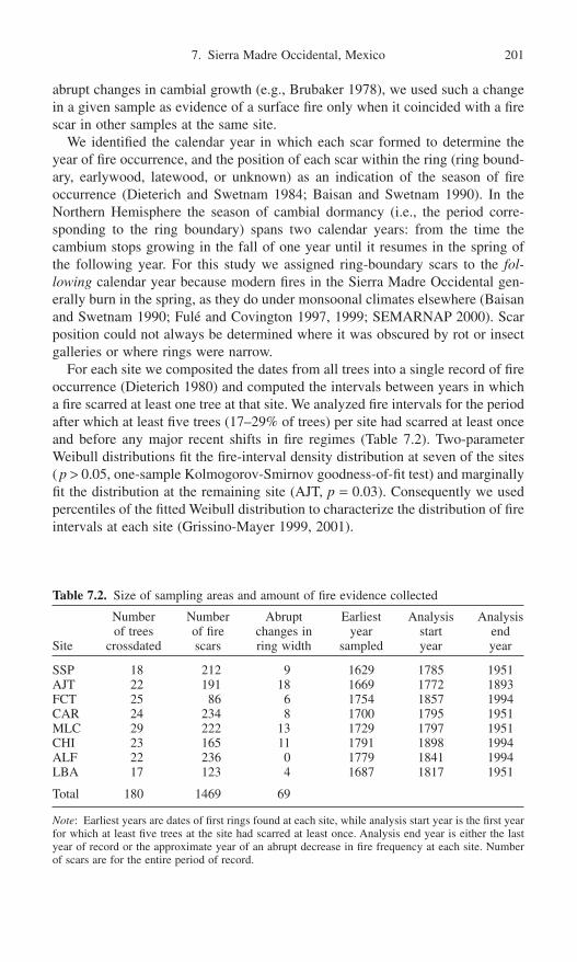
abrupt changes in cambial growth (e.g., Brubaker 1978), we used such a changein a given sample as evidence of a surface fire only when it coincided with a firescar in other samples at the same site.
We identified the calendar year in which each scar formed to determine theyear of fire occurrence, and the position of each scar within the ring (ring bound-ary, earlywood, latewood, or unknown) as an indication of the season of fireoccurrence (Dieterich and Swetnam 1984; Baisan and Swetnam 1990). In theNorthern Hemisphere the season of cambial dormancy (i.e., the period corre-sponding to the ring boundary) spans two calendar years: from the time thecambium stops growing in the fall of one year until it resumes in the spring ofthe following year. For this study we assigned ring-boundary scars to the fol-lowing calendar year because modern fires in the Sierra Madre Occidental gen-erally burn in the spring, as they do under monsoonal climates elsewhere (Baisanand Swetnam 1990; Fulé and Covington 1997, 1999; SEMARNAP 2000). Scarposition could not always be determined where it was obscured by rot or insectgalleries or where rings were narrow.
For each site we composited the dates from all trees into a single record of fireoccurrence (Dieterich 1980) and computed the intervals between years in whicha fire scarred at least one tree at that site. We analyzed fire intervals for the periodafter which at least five trees (17–29% of trees) per site had scarred at least onceand before any major recent shifts in fire regimes (Table 7.2). Two-parameterWeibull distributions fit the fire-interval density distribution at seven of the sites( p > 0.05, one-sample Kolmogorov-Smirnov goodness-of-fit test) and marginallyfit the distribution at the remaining site (AJT, p = 0.03). Consequently we usedpercentiles of the fitted Weibull distribution to characterize the distribution of fireintervals at each site (Grissino-Mayer 1999, 2001).
7. Sierra Madre Occidental, Mexico 201
Table 7.2. Size of sampling areas and amount of fire evidence collected
Number Number Abrupt Earliest Analysis Analysisof trees of fire changes in year start end
Site crossdated scars ring width sampled year year
SSP 18 212 9 1629 1785 1951AJT 22 191 18 1669 1772 1893FCT 25 86 6 1754 1857 1994CAR 24 234 8 1700 1795 1951MLC 29 222 13 1729 1797 1951CHI 23 165 11 1791 1898 1994ALF 22 236 0 1779 1841 1994LBA 17 123 4 1687 1817 1951
Total 180 1469 69
Note: Earliest years are dates of first rings found at each site, while analysis start year is the first yearfor which at least five trees at the site had scarred at least once. Analysis end year is either the lastyear of record or the approximate year of an abrupt decrease in fire frequency at each site. Numberof scars are for the entire period of record.

Drivers of Temporal Variation in Historical Fire Regimes
To identify climate drivers of fire at annual scales, we determined whether variation in regional climate was associated with variation in the occurrence ofwidespread surface fires in our study area. Specifically, we assessed whetherclimate during widespread- and non-fire years was significantly different fromclimate during the preceding and following years (±5 years), using superposedepoch analysis (SEA; Baisan and Swetnam 1990; Swetnam and Betancourt 1992; Grissino-Mayer 1995). We used this analysis to test for departures inclimate during two sets of years at our eight sites: widespread fire years, namelythose with at least 50% of sites recording a fire (~1 standard deviation above the mean; 31 years); and non-fire years, namely those with no sites recording fire(68 years). For both sets of years, we computed departures in three cli-mate parameters: winter precipitation (previous November–March; Stahle et al.1999), early summer precipitation (May–June; Stahle et al. 1999), and winter SOI (December–February; Stahle et al. 1998). We identified significant depar-tures as those with p < 0.05, determined by bootstrapping (1000 trials; Swetnamand Betancourt 1992; Mooney and Duvall 1993; Grissino-Mayer 1995). We con-ducted this analysis from 1772 to 1977, the period after which at least five treesper site had scarred at least once (17–29% of trees per site; Table 7.2) to the endof the record of reconstructed SOI (1977). However, the tree-ring record startedafter 1772 for some sites, so we computed the percentage of sites burning during a given year as a percentage of those sites that had a record for that year.Finally, we repeated these SEA analyses but included existing fire history reconstructions from an additional four sites in Durango (Fulé and Covington1997).
To identify nonclimatic drivers of surface fire, we determined whether changesin land use were synchronous with variation in surface fire occurrence in ourstudy area. We used regional trends in land use to make inferences about theeffects of land use on the history of fire at our sites because we lack site-specificland-use histories. Specifically, we used a national record of the amount of landredistributed via the ejido system (Sanderson 1984), as an indication of likely settlement in the forests of the Sierra Madre Occidental. We compared this timeseries to that of percentage of sites recording fire per year. To emphasize decadalvariation, we smoothed the time series of fire occurrence using a cubic spline thatretained 50% of the variance present in the original series at periods of 20 years(Diggle 1990).
Results
Fire Regimes
We removed fire-scarred sections from 206 trees, most of which were Pinusdurangensis (40%), P. teocote (14%), P. ayacahuite (10%), P. engelmannii(6%) or unknown species (26%; Table 7.2). The remaining samples came from
202 E.K. Heyerdahl and E. Alvarado

7. Sierra Madre Occidental, Mexico 203
Figure 7.3. Fire charts. Each horizontal line shows the fires recorded by a single treethrough time. Recorder years generally follow the first scar on each tree. Nonrecorder years precede the formation of the first scar on each tree but also occur when tree rings areconsumed by subsequent fires or rot. Inner and outer dates are the dates of the earliest or latest rings sampled for trees where pith or bark were not sampled.
(a)
P. arizonica (1%), P. herrerai (1%), P. lumholtzii (1%) or Pseudotsuga menziesii(1%). We were able to crossdate 180 of these trees, yielding 1469 fire scars, and 69 abrupt changes in ring width (Fig. 7.3; Dieterich 1980; Grissino-Mayer2001).
We were able to assign an intra-ring position to most scars (73% of 1341 scarsduring the analysis periods; Table 7.2). The distribution of scars by intra-ringposition was similar among sites. Of the scars to which we could assign an intra-

ring position, most were created by fires burning when the cambium was dormant(63% ring-boundary scars; Fig. 7.4). Most of the rest of the scars were createdduring the growing season (35% earlywood scars), and of these, most wereformed early in that season (51% in the first third of the earlywood, 35% in themiddle third). Only a few scars were created by fires burning late in the cambialgrowing season (2% latewood scars).
The distribution of intervals was similar for the composite surface fires fromour sample of trees at most sites, although intervals were slightly longer and morevariable, at FCT and LBA than at the other sites (sampled areas 2–6ha; Fig. 7.5).Weibull median intervals were 3 to 6 years, minimum intervals 1 to 2 years andmaximum intervals 9 to 20 years. Most fires (76–100% per site), were recorded
204 E.K. Heyerdahl and E. Alvarado
(b)
Figure 7.3. Continued

7. Sierra Madre Occidental, Mexico 205
Figure 7.4. Distribution among sites of intra-ring position of fire scars, as a percentageof scars per site for which position could be determined (974 scars or 56–83% per site).Ring-boundary scars were formed by fires that burned between growing seasons, whenthe cambium was dormant, whereas earlywood and latewood scars were formed by firesthat burned during the growing season. The boxes enclose the 25th to 75th percentiles ofthe distribution. The whiskers enclose the 10th to 90th percentiles and the horizontal lineacross each box indicates the 50th percentile. Circles mark all values lying outside the10th to 90th percentiles.
Figure 7.5. Composite fire intervals by site, with the number of intervals in parentheses.The box-and-whisker sets are as defined for Figure 7.4, but mark the percentiles of Weibulldistributions fit to the composite fire intervals at each site, for the analysis periods indi-cated in Table 7.2. Trees were sampled over 2 to 6ha per site (Table 7.1).
by more than one tree, with an average of 5 trees recording a fire per site (range:1–23).
At some sites surface fire regimes changed abruptly in the late nineteenth to midtwentieth century, with sites near one another generally experiencing syn-

chronous changes. Specifically, fires nearly ceased after the late 1800s at AJT andafter about 1950 at SSP, CAR, MLC, and LBA (Fig. 7.3). In contrast, surfacefires remained frequent until the time of sampling at CHI and ALF. The abruptcessation of fire at some sites is not likely an artifact of sampling dead trees, andhence low twentieth-century sample size, because an average of 14 trees (range:7–20) had a record extending into the late twentieth century at each site. Firesmay have been frequent at FCT before about 1950, as they were at nearby AJT.However, the record at FCT is less than 150 years for most trees, which is tooshort to determine if the fire regime changed at this site around 100 years ago,as it did at AJT.
Drivers of Temporal Variation in Historical Fire Regimes
Annual variation in climate was a strong driver of surface fires in the Sierra MadreOccidental. Not surprisingly, fires were widespread in years with significantly drywinters and early summers, but did not burn during significantly wet years (Fig.7.6a, b). Consistent with these results, fires were widespread during years of significantly high SOI (Fig. 7.6c), which tend to be La Niña years and have drywinters. In contrast, variation in SOI was not significantly associated with non-fire years.
Climate in preceding years was also an important driver of surface fires in ourstudy area. Specifically, fires were widespread following several years with wet
206 E.K. Heyerdahl and E. Alvarado
Figure 7.6. Annual association of fire and climate. Average departure from climate duringwidespread fire years (31 years, >50% of sites recording fire) and non-fire years (68 years,no sites recording fire), and for years immediately before and after these years. Solid dotsmark departures that fall outside the 95% confidence interval, determined by bootstrap-ping. The horizontal lines indicate average precipitation or SOI for the analysis period(1772–1977).

winters and early summers (although not significantly wet), while fires did notburn following 1 to 2 significantly dry years (Fig. 7.6a, b). Consistent with theseresults, fires were widespread following a year with significantly low SOI (Fig.7.6c), which tend to be El Niño years and have wet winters. This association is reversed for non-fire years, which followed a year of significantly high SOI(La Niña years).
Surface fires over a broader area were similarly driven by climate. When werepeated the SEA analyses including four additional existing fire history recon-structions from Durango (Fulé and Covington 1997), we found nearly identicalpatterns of significant climate departures for both widespread and non-fire years.
In addition to varying at annual time scales, the occurrence of widespread firesvaried at decadal time scales, sometimes due to variation in the synchrony of firesamong sites but sometimes to a lack of fire (Fig. 7.7). Compared to the periodfrom the late 1700s to about 1930, fires were somewhat less synchronous amongsites for brief periods around 1810 and 1910. However, the decrease in synchronyaround 1810 could be due to low sample size because few of the sampled treeshave a record before this time. The occurrence of widespread fires declinedsharply beginning around 1930, due to an abrupt cessation of fires at some sites(Fig. 7.3). This abrupt decline was synchronous with the beginning of extensivedistribution of ejido lands in Mexico.
7. Sierra Madre Occidental, Mexico 207
area of ejido land grantedpercentage of sites with fire
Figure 7.7. Decadal variation in the occurrence of synchronous fires, compared tochanges in land tenure in Mexico. The percentage of sites recording fire per year was determined from the combined composite records of fire occurrence for the analysisperiods identified for each site in Table 7.2, smoothed using cubic splines with a 50% frequency cutoff at 20 years. Land tenure is the amount of land distributed to ejidos(Sanderson 1984).

Discussion
Fire Regimes
Based on our sample of trees, composite surface fire intervals were remarkablysimilar across the study area, despite topographic variation among the sites (Fig.7.5, Table 7.1). Topographically driven variation in solar insolation was an impor-tant driver of spatial variation in historical surface fire regimes farther north (e.g.,Taylor and Skinner 1998; Heyerdahl, Brubaker, and Agee 2001). However, dif-ferences in solar energy input to steep slopes of different aspect are not as greatin Mexico as they are at higher latitudes (Holland and Steyn 1975) and so maynot drive differences in fire frequency as they do farther north. Furthermore the frequency of fire at these sites may not be driven only by the topographiccharacteristics of the sampled area but may also depend on the frequency of firein surrounding areas because our sites are not surrounded by fire breaks (Agee,Finney, and de Gouvenain 1990; Bergeron 1991; Heyerdahl, Brubaker, and Agee 2001). We do not have a clear explanation for the long and variable inter-vals that we found at FCT and LBA, relative to the other sites. The record at FCT may entirely postdate a change in fire intervals because this site is near AJT.Fires at AJT nearly ceased in the late 1800s and major changes in fire regimesare generally synchronous among sites that are near one another. However, wecompare fire intervals among our sites cautiously because these sites were notselected to capture spatial variation in fire frequency. Rather, we selected sitesand trees that we expected to yield relatively long records of surface fires in orderto explore the role of climate in driving widespread fires. Consequently we maynot have captured the full range of variability in fire frequency across the land-scape (Baker and Ehle 2001; Lertzman, Fall, and Dorner 1998). Furthermore thefire intervals we report may be affected by the small differences in area overwhich they were composited (2–6ha; Table 7.1; Arno and Petersen 1983; Bakerand Ehle 2001).
The intervals we report probably include fires of different sizes, although wedid not reconstruct this parameter of fire regimes. The number of scarred treesper fire at our sites yields little information about the size of those fires becausewe sampled trees over relatively small areas (2–6ha). Most fires were recordedby at least several trees at a site (average of 73% of fire years per site recordedby ≥3 trees). However, even fires recorded by a single tree may be extensivebecause our sites are not surrounded by fire breaks so that fires may have spreadinto them from surrounding areas.
Most of the fires we reconstructed probably burned in the spring, before theonset of the monsoon rains that wet litter fuel and encourage new growth of grassesand herbs. This is consistent with the seasonality of most modern fires in the SierraMadre Occidental which burn during the dry spring when lightning is mostcommon (Mosiño Alemán and García 1974; Hales 1974; Turman and Edgar 1982;Douglas et al. 1993; SEMARNAP 2000), and with written reports of spring burn-ing by indigenous people (Sheridan and Naylor 1978; Graham 1994). Most fire
208 E.K. Heyerdahl and E. Alvarado

years with ring-boundary scars on some trees also had scars in the first third of the earlywood on other trees (62%), consistent our assumption that most firesburned early in the year, when some of the trees had begun growing. Likewise, nofire years had ring-boundary scars on some trees and latewood scars on others, suggesting that few fires burned late in the year. However, some fall or winter firesmay have burned in our study area because some fire years (24%) had only ring-boundary scars. Consequently we cannot determine whether these fires burnedduring the fall, after growth ceased, or during the following spring, before growthbegan again. Although lightning is not as common in the fall and winter as in the summer, humans could have ignited fires in these forests during the brief falldry season.
Historically surface fires in our study area, and at sites elsewhere in Durango(Fulé and Covington 1997, 1999) probably burned earlier in the year than sur-faces fires in the Mexico/U.S. borderlands. Most historical fires in our study areaburned during the season of cambial dormancy whereas in the borderlands, theyburned during the cambial growing season (Swetnam, Baisan, and Kaib 2001).Based on the few existing studies of cambial phenology, fires in the borderlandsburned during the warm spring dry period (April–June) consistent with the sea-sonality of lightning and modern fires in that region (Baisan and Swetnam 1990;Swetnam, Baisan, and Kaib 2001). We know of no studies of cambial phenologyin the pine-oak forests of the Sierra Madre Occidental, but the early spring sea-sonality we inferred from fire scars for this region is also consistent with the sea-sonality of modern precipitation, lightning, and fires. However, these differencesin the intra-ring position of fire scars could result from differences in cambialphenology between the two regions, rather than from a difference in the seasonof burning.
Climate Was a Strong Driver of Surface Fire Regimes
Current year’s climate synchronized the occurrence of widespread surface firesamong our sites in the Sierra Madre Occidental, probably by affecting fuel mois-ture and perhaps by affecting fuel amount (Fig. 7.6). In this region, where wintersare relatively dry and cold, fires burn primarily in the spring, before the flush oflive surface fuels and the onset of monsoon rains in early summer which wetsurface fuels and inhibit fire ignition and spread. Winter precipitation probablyaffects fire by influencing soil moisture and hence the growth of live surface fuels.Consequently, after dry winters, the spring flush of grasses and herbs may bedelayed, lengthening the fire season and increasing the likelihood of widespreadfires in this region. The opposite may occur after wet winters, when high soilmoisture leads to an early spring flush and a relatively short fire season. Winterprecipitation probably does not affect the moisture content of fine fuels duringthe subsequent fire season because any increased moisture will evaporate quicklywith warm, dry weather. However, the onset of monsoon rain in early summercan affect fine fuel moisture at the beginning of the fire season. During yearswhen the onset of the monsoon rains was delayed (i.e., years with low early
7. Sierra Madre Occidental, Mexico 209

summer precipitation), fine fuels remained dry. As a result the fire season wasrelatively long and the probability of synchronous fires was greater than duringyears when the monsoon rains began early. These relationships are consistent withthe effect of precipitation on fire regimes in monsoonal climates elsewhere(Swetnam and Baisan, Chapter 6, this volume).
The current year associations we found between surface fire and ENSO aregenerally consistent with those we found between fire and precipitation, becausethese two measures of climate are strongly associated in the study area. In theSierra Madre Occidental, dry La Niña winters may have resulted in a delay inthe spring flush of grasses and herbs and hence a relatively long fire season,increasing the probability of widespread fires, as described above. HistoricalENSO activity also affected the length of the fire season elsewhere in NorthAmerica (Heyerdahl, Brubaker, and Agee, in press). We would expect wet ElNiño winters to have the opposite effect, suppressing widespread fire activity, asthey do in the American Southwest (Swetnam and Betancourt 1990). However,El Niño years were not significantly associated with non-fire years, perhapsbecause the effect of ENSO on weather, and hence fire, varies from one event tothe next (Enfield 1992; Allen 2000; Kitzberger, Swetnam, and Veblen 2001).Specifically, in the Sierra Madre Occidental, ENSO activity sometimes affectswinter temperature as well as winter precipitation. For example, the El Niñowinters of 1982–1983 and 1997–1998 were very cold as well as wet in northernMexico (SEMARNAP 2000). Consequently heavy snow broke tree limbs andtops, increasing fuel loads so that extensive areas burned when these fuels driedin the spring (Alvarado 1984). We do not know how common these cold El Niñowinters were historically, because there are no reconstructions of winter tem-perature for this region. However, the occurrence of some cold El Niño winterswould explain why fire activity is not strongly suppressed during El Niño yearswhen viewed over several centuries in our study area.
Prior year’s climate also strongly synchronized the occurrence of widespreadsurface fires among our sites in the Sierra Madre Occidental, probably by affect-ing fuel amount, rather then fuel moisture. The growth of grasses and herbs wasprobably enhanced during wet years, increasing the amount of fine-fuel availableto carry surface fires in subsequent dry years. This enhanced growth may alsohave increased fuel continuity so that fires spread more effectively, similar to theeffect of wet years on fine-fuel production inferred for dry pine forests elsewhere(Swetnam and Baisan 1996; Baisan and Swetnam 1997; Swetnam and Betancourt1998; Veblen, Kitzberger, and Donnegan 2000). In contrast, these fine live fuelswere probably reduced during prior dry years. Specifically, dry winters may havedelayed or inhibited the spring flush of grasses and herbs, especially given thepoor moisture retention of the coarse soils at our sites. Fires during dry prior yearsprobably also consumed these fuels, further limiting the amount of fine fuel avail-able to carry fire in subsequent years (Swetnam and Betancourt 1998).
The prior year associations we found between surface fire and ENSO are gen-erally consistent with those we found between fire and precipitation. At our sites,fires were widespread in years following wet El Niño years but did not burn in
210 E.K. Heyerdahl and E. Alvarado

years following dry La Niña years, consistent with the effect of precipitation onthe growth and consumption of fine live fuels, discussed above. ENSO varieswith a period of two to five years (Enfield 1992; Stahle 1998), so the associationwe found between widespread fire and prior year’s ENSO activity is probablynot an artifact of the intrinsic scale of variation in ENSO. Last, fires were wide-spread during La Niña years and following prior El Niño years. This switchingfrom one atmospheric state to another is characteristic of the ENSO system(Kiladis and Diaz 1989), and it drives widely synchronous fires elsewhere inNorth and South America (Swetnam and Betancourt 1998; Kitzberger, Swetnam,and Veblen 2001).
Land-Use Change Caused Recent Cessation of Surface Fires
The recent abrupt cessation of surface fires at some of our sites likely resultedfrom a complex mix of local changes in land use rather than from regional variation in climate, since fires did not cease synchronously at all sites (Fig. 7.3).Fire at individual sites can be dramatically impacted by grazing, fire use or sup-pression, timber harvesting, and the construction of roads and railways (e.g.,Leopold 1937; Dieterich 1983; Savage and Swetnam 1990; Baisan and Swetnam1997; Fulé and Covington 1997, 1999; Kaib 1998; Veblen et al. 1999; Veblen,Kitzberger, and Donnegan 2000; Heyerdahl, Brubaker, and Agee, in press).However, local variation in the intensity of these activities can impact fire regimesdifferently among sites, particularly for small, widely dispersed sites such as thosewe sampled. We lack local land-use histories for our sites but speculate that thedifferences in timing of fire exclusion among them probably resulted from dif-ferences in the type and timing of changes in land use.
Mid-twentieth-century changes in Mexican land tenure probably resulted inlocal increases in human occupation of the high-elevation pine-oak forests atsome of our sites (Fulé and Covington 1997). There is little quantitative infor-mation on human use of the remote and rugged Sierra Madre Occidental beforethe twentieth century. However, before 1900 these mountains were sparsely populated by indigenous people, such as the Tarahumara, Tepehuano, Mayo, andYaqui, who occupied the lower valleys and deep canyons in winter and the uppermountains in summer. They practiced slash-and-burn agriculture and used fire forhunting and religious purposes (Bye 1976; Sheridan and Naylor 1978; Graham1994). There is little evidence that the high-elevation pine-oak forests of thisregion were densely occupied until the mid-twentieth century, in response toreform in the land tenure system in Mexico (Sanderson 1984; Thompson andWilson 1994). In the early 1900s, shortly after the Mexican Revolution, new legislation (Agrarian Law 1915; Mexican Constitution 1917) legalized the ejidosystem, the reallocation of land to small communities of landless people. Despitethis legalization not much land was actually distributed until the administra-tion of Lazaro Cárdenas (1934–1940) when nearly 800,000 people in Mexico re-ceived land grants of about 20 million hectares (Sanderson 1984; Thompson andWilson 1994). The distribution of ejido lands brought a wave of people from
7. Sierra Madre Occidental, Mexico 211

low-elevation agricultural areas to settle the forested mountains, resulting in achange from traditional land use. Today all but one of our sites are owned byejidos (Table 7.1).
The movement of people to forest ejidos in the Sierra Madre Occidental in themid-1900s may have affected fire regimes by introducing, or intensifying, cattlegrazing, road building, or logging (Fulé and Covington 1997; Kaib 1998), andperhaps by changing traditional uses of fire. We speculate that some or all of thesechanges in land use may have caused the mid-1900s cessation of fire at four ofour sites (SSP, CAR, MLC, and LBA). Cattle were introduced to southern Mexicoin the early 1500s and rapidly spread north (Rouse 1977; Jordan 1993). However,while cattle grazed on the lower slopes of the Sierra Madre Occidental (Leopold1937), they were probably not grazed in great numbers in the high elevations ofour sampling sites until the major distribution of ejido land in the mid-1900s. Theintroduction of livestock grazing may have resulted in fire exclusion at some ofour sites at this time, as it has elsewhere in Mexico and the American Southwest,by reducing both the amount and continuity of the fine fuel that carries surfacefires in these forests (Baisan and Swetnam 1997; Leopold 1924, 1937; Madanyand West 1983; Savage and Swetnam 1990; Grissino-Mayer and Swetnam 1997;Kaib 1998; Mast, Veblen, and Linhart 1998; Fulé and Covington 1999; Swetnam,Baisan, and Kaib 2001). Grazing may not be the only cause of change in fireregimes at this time. Roads and trails built to access ejido lands, and harvesttimber can interrupt fuel continuity and may have reduced the number of firesthat spread into our sites. Changes in human use of fire may also have contributedto the exclusion of fire in the mid-1900s at some of our sites. We have little quan-titative information on the use of fire by indigenous people, but the occupationof ejido lands probably curtailed their ignition of fire. This may have contributedto the decline in fire if these ignitions were an important cause of the fires wereconstructed at our sites. Twentieth-century fire suppression is not a likely causeof the changes we reconstructed in fire regimes because fire-fighting resourceswere limited during this time (Leopold 1937; Dieterich 1983; González-Cabánand Sandberg 1989; Fulé and Covington 1999; Kaib 1998).
We speculate that the abrupt cessation of fire at some of our sites (AJT andperhaps FCT) in the late 1800s could have been caused by a dramatic increasein travel routes, decades before the major distribution of ejido lands. The SierraMadre Occidental is a high and rugged mountain range (200–3000m) over whichfew easy travel routes exist (Jordon 1993). Consequently few roads crossed it inthe early twentieth century (Leopold 1937). In Mexico, a few kilometers of rail-road were constructed in the nineteenth century, but the major construction of raillines, including those from southern Mexico northward into the central highlands,began in 1880 (Coatsworth 1981). In that year, there were 770km of railroad butthis had expanded to 24,700km by 1911 (Powell 1921). These roads may haveallowed access to parts of the Sierra Madre Occidental, resulting in changes inland use that affected fire regimes. For example, silver mines near AJT and FCTmay have been established at this time and resulted in timber harvesting, leadingto a decrease in surface fires.
212 E.K. Heyerdahl and E. Alvarado

We speculate that frequent surface fires continued to burn into the late 1990s attwo sites (CHI and ALF) because they were relatively inaccessible and ignition offires remained frequent. ALF is a rocky ridge that may have been a poor site forgrazing or a difficult area for road building and timber harvesting. At CHI, most of the trees are young. Perhaps this forest regenerated after logging or a stand-replacing fire in the mid-1800s and may not have been suitable for harvesting orgrazing during the time of major ejido land distribution in the mid-1900s.
Conclusion
Our objective was to infer the drivers of temporal variation in fire regimes inpine-oak forests of the Sierra Madre Occidental in north-central Mexico. Wereconstructed a multicentury history (1772–1994) of the occurrence of surfacefires from 1469 fire scars on 180 trees sampled at 8 sites over nearly 700km inthe states of Durango and Chihuahua. We compared our fire histories to existingtree-ring reconstructions of winter and early summer precipitation and the Southern Oscillation Index. Fire intervals were similar among our sites, withWeibull median fire intervals of 3 to 6 years. Most fires probably burned in thewarm, dry spring, based on the intra-ring position of fire scars (98% formedduring the season of radial dormancy or early in the growing season) and the sea-sonality of precipitation, lightning, and modern fires in this region. However,some fall or winter fires may have occurred. Annual variation in precipitation andEl Niño–Southern Oscillation were strong drivers of current year’s fire, probablythrough their effects on fuel moisture. Extensive fires generally burned duringdry years but not during wet ones. Extensive fires also typically burned duringLa Niña years, which tend to have dry winters in this region. Climate in prioryears was also a strong driver of fire, through its effect on fuel amount. Wide-spread fires often burned following one to two wet years and also following ElNiño years, which tend to have wet winters in this region. Likewise fires werenot widespread following dry years and following La Niña years. Prior year’sclimate probably affected the growth of grass and herbaceous fuel. Changes inland use, rather than climate, probably caused the near cessation of fire that wereconstructed at some sites because these shifts did not occur synchronously(some ca.1900, some ca.1950). Frequent surface fires continued to burn until thetime of sampling at two of our sites.
Acknowledgments. For help with field sampling, we thank Jeffrey R. Bacon,Jorge Bretado Velazquez, Jose Coria Quiñonez, Jon Datillo, Stacy Drury, KatMaruoka, A. Enrique Merlin Bermudez, Fernando Najera, Humberto Ortéga,Gonzalo Rodrigez Lara, Octaviano Rosales, Santiago Guadalupe Salazar Hernandez, Rosalba Salazar, Francisco Soto Rodriguez, Godofredo SotoRodrigez, Jesús Soto Rodriguez, Miguel Soto, and Bob Vihnanek. For help withsample preparation, we thank Jon Datillo and Travis Kern. We thank Steven J.McKay for assisting with laboratory and data analysis, Stacy Drury for provid-
7. Sierra Madre Occidental, Mexico 213
ing vegetation data for the Las Bayas site, and Tom Thompson for drafting Figure7.1. For reviews of the manuscript, we thank J. K. Agee, W. L. Baker, S. Drury, P. Z. Fulé, M. Harrington, S. J. McKay, D. L. Peterson, E. K. Sutherland, S.Sutherland, T. W. Swetnam, and one anonymous reviewer. Partial funding for thisproject came from the USDA Forest Service, Pacific Northwest Research Station.
References
Agee, J.K., Finney, M., and de Gouvenain, R. 1990. Forest fire history of Desolation Peak,Washington. Can. J. For. Res. 20:350–356.
Allan, R.J. 2000. ENSO and climatic variability in the past 150 years. In El Niño and theSouthern Oscillation: Multiscale Variability and Global and Regional Impacts, eds.H.F. Diaz, and V. Markgraf, pp. 3–55. Cambridge: Cambridge University Press.
Allan, R.J., Lindesay, J., and Parker, D. 1996. El Nino/Southern Oscillation and ClimaticVariability. Victoria, Australia: CSIRO Publishing.
Alvarado, C.E. 1984. Health diagnostics of wind-blown and snow-damaged trees in theForest Management Unit No. 2 PROFORMEX, Durango. B.S. thesis. Chapingo,Mexico: University of Chapingo.
Arno, S.F., and Petersen, T.D. 1983. Variation in Estimates of Fire Intervals: A CloserLook at Fire History on the Bitterroot National Forest. Res. Pap. INT-301. Ogden, UT:USDA Forest Service, Intermountain Forest and Range Experiment Station.
Arno, S.F., and Sneck, K.M. 1977. A Method for Determining Fire History in ConiferousForests of the Mountain West. Gen. Tech. Rep. GTR-INT-42. Ogden, UT: USDAForest Service, Intermountain Forest and Range Experiment Station.
Baisan, C.H., and Swetnam, T.W. 1990. Fire history on a desert mountain range: RinconMountain Wilderness, Arizona, USA. Can. J. For. Res. 20:1559–1569.
Baisan, C.H., and Swetnam, T.W. 1997. Interactions of Fire Regimes and Land Use in theCentral Rio Grande Valley. Res. Pap. RM-RP-330. USDA Forest Service, RockyMountain Forest and Range Experiment Station, Fort Collins, CO.
Baker, W.L., and Ehle, D. 2001. Uncertainty in surface-fire history: The case of ponderosapine in the western United States. Can. J. For. Res. 31:1205–1226.
Bergeron, Y. 1991. The influence of island and mainland lakeshore landscapes on borealforest fire regimes. Ecology 72:1980–1992.
Brubaker, L.B. 1978. Effects of defoliation by Douglas-fir tussock moth on ring sequencesof Douglas-fir and grand fir. Tree-Ring Bull. 38:49–60.
Bye, R. 1993. The role of humans in the diversification of plants in Mexico. In Biological diversity of Mexico: Origins and distribution, eds. T.P. Ramamoorthy, R.Bye, A. Lot, J. Fa, pp. 707–731. New York: Oxford University Press.
Bye, R. 1995. Prominence of the Sierra Madre Occidental in the biological diversity ofMexico. In Biodiversity and Management of the Madrean Archipelago: The Sky Islandsof Southwestern United States and Northwestern Mexico, tech. coord. L.F. DeBano,and P.F. Ffolliot, pp. 19–27. General Technical Report RM-GTR-264, Fort Collins, CO:USDA Forest Service, Rocky Mountain Forest and Range Experiment Station.
Cavazos, T., and Hastenrath, S. 1990. Convection and rainfall over Mexico and their mod-ulation by the Southern Oscillation Int. J. Climatol. 10:377–386.
Challenger, A. 1998. Utilizacion y conservacion de los ecosistemas terrestres de Mexico.Pasado, presente y futuro. Comision Nacional para el Conocimiento de la Biodiversidad. Mexico, D.F.
Coatsworth, J.H. 1981. Growth against Development: The Economic Impact of Railroadsin Porfirian Mexico. DeKalb: Northern Illinois University Press.
Cook, E.R. 1985. A time series approach to tree-ring standardization. Ph.D. dissertation.Tucson: University of Arizona.
214 E.K. Heyerdahl and E. Alvarado

Deser, C., and Wallace, J.M. 1987. El Niño events and their relation to the Southern Oscillation. J. Geophys. Res. 92:14189–14196.
Dieterich, J.H. 1980. The composite fire interval: a tool for more accurate interpretationof fire history. In Proceedings of the Fire History Workshop, tech. coord. M.A. Stokes,and J.H. Dieterich, pp. 8–14. October 20–24, 1980, Tucson. Gen. Tech. Rep. RM-81.,Fort Collins, CO: USDA Forest Service, Rocky Mountain Forest and Range Experiment Station.
Dieterich, J.H. 1983. Historia de los incendios forestales en la Sierra de los Ajos, Sonora.Instituto Nacional de Investigaciones Forestales, Centro de Investigaciones Forestalesdel Norte. Nota Tecnica no. 8, PR-04.
Dieterich, J.H., and Swetnam, T.W. 1984. Dendrochronology of a fire-scarred ponderosapine. For. Sci. 30:238–247.
Diggle, P.J. 1990. Time Series: A Biostatistical Introduction. Oxford Statistical ScienceSeries 5. New York: Oxford University Press.
Douglas, A.V., and Englehart, P.J. 1995. Diagnostic studies of the Mexican monsoon. InProceedings of the Nineteenth Annual Climate Diagnostics Workshop, pp. 202–206.U.S. Department of Commerce, National Oceanic and Atmospheric Administration,Divisional data computed from the Global Historical Climatology Network (availablefrom National Climatic Data Center, Asheville, NC).
Douglas, M.W., Maddox, R.A., Howard, K.W., and Reyes, S. 1993. The Mexicanmonsoon. J. Clim. 6:1665–1677.
Enfield, D.B. 1992. Historical and prehistorical overview of El Niño/Southern Oscillation.In El Niño: historical and paleoclimatic aspects of the Southern Oscillation, eds. H.F.Diaz, and V. Markgraf, pp. 95–117. New York: Cambridge University Press.
Ferrusquía Villafranca, I. 1998. Geologia de Mexico: Una sinopsis. In Diversidad biologica de Mexico, eds. T.P. Ramamoorthy, R. Bye, A. Lot, and J. Fa, pp. 3–108.Mexico City: Instituto de Biologia, Universidad Autonoma de Mexico.
Fulé, P.Z., and Covington, W.W. 1997. Fire regimes and forest structure in the Sierra MadreOccidental, Durango, Mexico. Acta Botánica Mexicana 41:43–79.
Fulé, P.Z., and Covington, W.W. 1999. Fire regime changes in La Michilía BiosphereReserve, Durango, Mexico. Conserv. Biol. 13:640–652.
González-Cabán, A., and Sandberg, D.V. 1989. Fire management and research needs inMexico. J. For. 87:20–26.
Graham, M. 1994. Mobile Farmers: An Ethnoarchaeological Approach to SettlementOrganization among the Rarámuri of Northwestern Mexico. International Monographsin Prehistory. Ann Arbor, MI.
Grissino-Mayer, H.D. 1995. Tree-ring reconstructions of climate and fire history at ElMalpais National Monument, New Mexico. Ph.D. dissertation. University of Arizona,Tucson.
Grissino-Mayer, H.D. 1999. Modeling fire interval data from the American Southwest withthe Weibull distribution. Int. J. Wildl. Fire 9:37–50.
Grissino-Mayer, H.D. 2001. FHX2—Software for analyzing temporal and spatial patternsin fire regimes from tree rings. Tree-Ring Res. 57:115–124.
Grissino-Mayer, H.D., and Swetnam, T.W. 1997. Multi-century history of wildfire in theponderosa pine forests of El Malpais National Monument. New Mexico Bur. MinesMineral Resources, Bull. 156:163–171.
Hales, J.E. 1974. Southwestern United States summer monsoon source—Gulf of Mexicoor Pacific Ocean? J. Appl. Meteorol. 13:331–342.
Heyerdahl, E.K., Brubaker, L.B., and Agee, J.K. 2001. Spatial controls of historical fireregimes: A multiscale example from the Interior West, USA. Ecology 82:660–678.
Heyerdahl, E.K., Brubaker, L.B., and Agee, J.K. (In press). Annual and decadal climateforcing of historical fire regimes in the Interior Pacific Northwest, USA. Holocene.
Holland, P.G., and Steyn, D.G. 1975. Vegetational responses to latitudinal variations inslope angle and aspect. J. Biogeogr. 2:179–183.
7. Sierra Madre Occidental, Mexico 215

Holmes, R.L. 1983. Computer-assisted quality control in tree-ring dating and measure-ment. Tree-Ring Bull. 43:69–78.
Jordan, T.G. 1993. North American Cattle-Ranching Frontiers: Origins, Diffusion, andDifferentiation. Albuquerque: University of New Mexico Press.
Kaib, J.M. 1998. Fire history in riparian canyon pine-oak forests and the intervening desertgrasslands of the southwest borderlands: A dendroecological, historical, and culturalinquiry. M.S. thesis. Tucson: University of Arizona.
Kiladis, G.N., and Diaz, H.F. 1989. Global climatic anomalies associated with extremesin the Southern Oscillation. J. Clim. 2:1069–1090.
Kitzberger T., Swetnam T.W., and Veblen T.T. 2001. Inter-hemispheric synchrony of forestfires and the El Niño-Southern Oscillation. Global Ecol. Biogeogr. 10:315–326.
Landsberg, J.D., Cochran, P.H., Finck, M.M., and Martin, R.E. 1984. Foliar NitrogenContent and Tree Growth after Prescribed Fire in Ponderosa Pine. Res. Note PNW-412. Portland, OR: USDA Forest Service, Pacific Northwest Forest and Range Experiment Station.
Leopold, A. 1924. Grass, brush, timber and fire in southern Arizona. J. For. 22:1–10.Leopold, A. 1937. Conservationist in Mexico. Am. For. 43:118–120, 146.Lertzman, K., Fall, J., and Dorner, B. 1998. Three kinds of heterogeneity in fire regimes:
At the crossroads of fire history and landscape ecology. Northwest Sci. 72:4–23.Madany, M.H., and West, N.E. 1983. Livestock grazing—Fire regime interactions within
montane forests of Zion National Park, Utah. Ecology 64:661–667.Manuel-Toledo, V., and Jesús-Ordóñez, M.de. 1993. The biodiversity scenario of Mexico:
A review of terrestrial habitats. In Biological Diversity of Mexico: Origins and Distribution, eds. T.P. Ramamoorthy, R. Bye, A. Lot, and J. Fa, pp. 757–777. NewYork: Oxford University Press.
Mast, J.N., Veblen, T.T., and Linhart, Y.B. 1998. Disturbance and climatic influences onage structure of ponderosa pine at the pine/grassland ecotone, Colorado Front Range.J. Biogeogr. 25:743–755.
Mooney, C.Z., and Duvall, R.D. 1993. Bootstrapping: A nonparametric approach to sta-tistical inference. Newbury Park, CA: Sage University Paper Series on QuantitativeApplications in the Social Sciences 07-095.
Mosiño Alemán, P.A., and García, E. 1974. The climate of Mexico. In World Survey ofClimatology. Vol. 11: Climates of North America, ed. R.A. Bryson, and F.K. Hare, pp.345–404. New York: Elsevier.
Park, A.D. 2001. Environmental influences on post-harvest natural regeneration inMexican pine-oak forests. For. Ecol. Manag. 144:213–228.
Payette, S., Morneau, C., Sirois, L., and Desponts, M. 1989. Recent fire history of theNorthern Quebec biomes. Ecology 70:656–673.
Powell, F.W. 1921. The Railroads of Mexico. Boston: Stratford, 1921.Rzedowski, J. 1978. Vegetation de Mexico. Mexico: Limusa.Rzedowski, J. 1993. Diversity and origins of the phanerogamic flora of Mexico. In
Biological Diversity of Mexico: Origins and Distribution, eds. T.P. Ramamoorthy, R.Bye, A. Lot, and J. Fa, pp. 129–144. New York: Oxford University Press.
Ropelewski, C.F., and Halpert, M.S. 1986. North American precipitation and temperaturepatterns associated with the El Niño/Southern Oscillation (ENSO). Mon. Wea. Rev. 114:2352–2362.
Ropelewski, C.F., and Halpert, M.S. 1987. Global and regional scale precipitation patternsassociated with the El Niño/Southern Oscillation. Mon. Wea. Rev. 115:1606–1626.
Ropelewski, C.F., and Halpert, M.S. 1989. Precipitation patterns associated with the highindex phase of the Southern Oscillation. J. Clim. 2:268–284.
Rouse, J.E. 1977. The Criollo: Spanish Cattle in the Americas. Norman: University ofOklahoma Press.
Sanderson, S.R.W. 1984. Land Reform in Mexico: 1910–1980. New York: Academic Press.
216 E.K. Heyerdahl and E. Alvarado

Savage, M., and Swetnam, T.W. 1990. Early 19th-century fire decline following sheep pas-turing in a Navajo ponderosa pine forest. Ecology 71:2374–2378.
Secretaría de Agricultura y Recursos Hidráulicos (SARH). 1994. Memoria nacional delinventario nacional forestal periodico 1992–1994. Subsecretaria Forestal y de FaunaSilvestre. Secretaria de Agricultura y Recursos Hidraulicos. Mexico, D.F.
Secretaría de Medio Ambiente y Recursos Naturales (SEMARNAP). 2000. Programanacional de proteccion contra los incendios forestales. Resultados 1995–2000. Secretaria de Medio Ambiente Recursos Naturales y Pesca. Mexico, D.F.
Sheridan, T.E., and Naylor, T.H. 1979. Raramuri: A Tarahumara Colonial Chronicle1607–1791. Flagstaff, AZ: Northland Press.
Stahle, D.W., D’Arrigo, R.D., Krusic, P.J., Cleaveland, M.K., Cook, E.R., Allan, R.J., Cole,J.E., Dunbar, R.B., Therrell, M.D., Gay, D.A., Moore, M.D., Stokes, M.A., Burns, B.T.,Villanueva-Diaz, J., and Thompson, L.G. 1998. Experimental dendroclimatic recon-struction of the Southern Oscillation. Bull. Am. Meteorol. Soc. 79:2137–2152. (Dataarchived at the World Data Center for Paleoclimatology, Boulder, Co.)
Stahle, D.W., Cleaveland, M.K., Therrell, M.D., and Villanueva-Diaz, J. 1999. Tree-ringreconstruction of winter and summer precipitation in Durango, Mexico, for the past600 years. In 10th Symposium on Global Change Studies, ed. T.R. Karl, pp. 317–318,January 10–15, 1999, Dallas, Tex. Boston: American Meteorological Society.
Sutherland, E.K., Covington, W.W., and Andariese, S. 1991. A model of ponderosa pinegrowth response to prescribed burning. For. Ecol. Manag. 44:161–173.
Swetnam, T.W., and Baisan, C.H. 1996. Historical fire regime patterns in the southwest-ern United States since AD 1700. In Fire Effects in Southwestern Forests, Proceedingsof the Second La Mesa Fire Symposium, tech. coord. C.D. Allen, pp. 11–32. Gen. Tech.Rep. RM-GTR-286, Fort Collins, CO: USDA Forest Service, Rocky Mountain Forestand Range Experiment Station.
Swetnam, T.W., and Betancourt, J.L. 1990. Fire–Southern Oscillation relations in thesouthwestern United States. Science 249:1017–1020.
Swetnam, T.W., and Betancourt, J.L. 1992. Temporal patterns of El Niño/Southern Oscillation-wildfire teleconnections in the southwestern United States. In El Nino: Historical and Paleoclimatic Aspects of the Southern Oscillation, eds. H.F. Diaz, andV. Markgraf, pp. 259–269. New York: Cambridge University Press.
Swetnam, T.W., and Betancourt, J.L. 1998. Mesoscale disturbance and ecological responseto decadal climatic variability in the American Southwest. J. Clim. 11:3128–3147.
Swetnam, T.W., Baisan, C.H., and Kaib, J.M. 2001. Forest fire histories of the Sky Islandsof La Frontera. In Changing Plant Life of La Frontera: Observations on Vegetation inthe United States/Mexico Borderlands. eds. G.L. Webster, and C.J. Bahre, pp. 95–119.Albuquerque: University of New Mexico Press.
Tande, G.F. 1979. Fire history and vegetation pattern of coniferous forests in JasperNational Park, Alberta. Can. J. Bot. 57:1912–1931.
Taylor, A.H., and Skinner, C.N. 1998. Fire history and landscape dynamics in a late-suces-sional reserve, Klamath Mountains, California, USA. For. Ecol. Manag. 111:285–301.
Thompson, G.D., and Wilson, P.N. 1994. Ejido reforms in Mexico: Conceptual issues andpotential outcomes. Land Economics 70:448–465.
Turman, B.N., and Edgar, B.C. 1982. Global lightning distributions at dawn and dusk. J.Geophys. Res. 87:1191–1206.
Veblen, T.T., Kitzberger, T., and Donnegan, J. 2000. Climatic and human influences onfire regimes in ponderosa pine forests in the Colorado Front Range. Ecol. Appl. 10:1178–1195.
Veblen, T.T., Kitzberger, T., Villalba, R., and Donnegan, J. 1999. Fire history in northernPatagonia: The roles of humans and climatic variation. Ecol. Monog. 69:47–67.
World Forest Institute. 1994. Mexico: Forestry and the Wood Products Industry, 2nd ed.Portland, OR: World Forest Institute.
7. Sierra Madre Occidental, Mexico 217
8. Impact of Past, Present, and Future Fire Regimes on North American
Mediterranean Shrublands
Jon E. Keeley and C.J. Fotheringham
Mediterranean shrublands occur in five regions of the world, under a climate of mild wet winters and hot summer–fall droughts lasting six months or more. InCalifornia they dominate landscapes below 2000m in the central and southerncoastal ranges and foothills of the Sierra Nevada. One consequence of this distribution is that these shrublands, more than any other vegetation type, interfacewith urban areas (Fig. 8.1). These shrublands are subject to periodic massive wild-fires (Fig. 8.2) that account for 40% of all wildland acreage burned in the UnitedStates (Lillard 1961), creating a particularly hazardous urban–wildland interface.Contributing to this fire hazard are the moderate temperatures during the rainywinter and spring, which prolong the growing season and generate broad bands ofdense contiguous fuels. The long drought makes these fuels readily ignitable andthe autumn foëhn winds that come each year at the end of the dry season producethe worst fire climate conditions in the country (Schroeder et al. 1964).
This chapter examines the past, present, and future fire regimes in Californiashrublands, particularly chaparral and coastal sage scrub. Although shrublandsare recorded from nearly all counties in the state (Callaham 1985), this reviewwill focus on those in the central and southern coastal ranges with the largestexpanses of contiguous shrubland (Fig. 8.3). Of particular concern are the extentto which humans have altered this regime in the past and the extent to whichfuture global change will affect fire regimes and vegetation patterns.
Humans directly influence fire regimes in two ways: they ignite fires and theysuppress fires. Evaluating the net effect of these impacts is not simple because
218

their relative importance varies across the landscape. For example, in the montaneconiferous forests of the Southwest, lightning-ignited fires are abundant andhuman ignitions are far less important than in lower-elevation shrublands ofsouthern California where lightning is uncommon and humans cause the major-ity of fires (Fig. 8.4). Also fire suppression has been far more effective in westernconiferous U.S. forests, often achieving nearly complete fire exclusion (Skinnerand Chang 1996; Agee 1993), but this “fire-suppression = fire-exclusion” equa-tion does not apply to shrublands of southern and central coastal California(Keeley and Fotheringham 2001b).
Determinants of Brushland Fire Regimes
Fire regimes are determined by the temporal and spatial pattern of ignitions, fuels,weather, and topography (Pyne, Andrews, and Laven 1996), and with regard to Californian shrublands there are two schools of thought on their relative importance. One is based on deductions from Rothermel’s fire behavior model(Rothermel 1972) and argues that fire regime is a highly deterministic processdriven by fuel load (Rothermel and Philpot 1973; Philpot 1974a,b, 1977). Underthis model fire occurrence is unaffected by external drivers such as ignitions orweather, rather it is viewed as entirely dependent on community patterns of fuel accumulation (Minnich 1989, 1995,1998, 2001; Minnich and Cho 1997). The
8. North American Mediterranean Shrublands 219
Figure 8.1. Interface between urban environments and evergreen chaparral (right) andsemi-deciduous coastal sage scrub (left) in southern California (by J.E. Keeley).

alternative model argues that the fire regime is controlled by the coincidence of ignitions occurring under severe current and antecedent weather conditions that influence fuel flammability (Phillips 1971; Keeley et al. 1989; Davis andMichaelson 1995; Keeley and Fotheringham 2001a,b). Under this model any of these factors may be limiting, and the importance of each varies spatially andtemporally with external drivers such as severe fire weather being of paramountimportance in coastal California. These models have very different implicationsfor fire management and affect our perception of anthropogenic impacts on fireregime and our ability to sort out future climatic signals.
Patterns of Ignition
In order to appreciate fully the role humans play in shrubland fire regimes, weneed to first examine how ignitions, fuels, and weather interact to determine firebehavior. In California humans have been a source of ignitions for more than
220 J.E. Keeley and C.J. Fotheringham
Figure 8.2. Crown fire in chaparral (photo by USFS, Riverside Fire Lab).
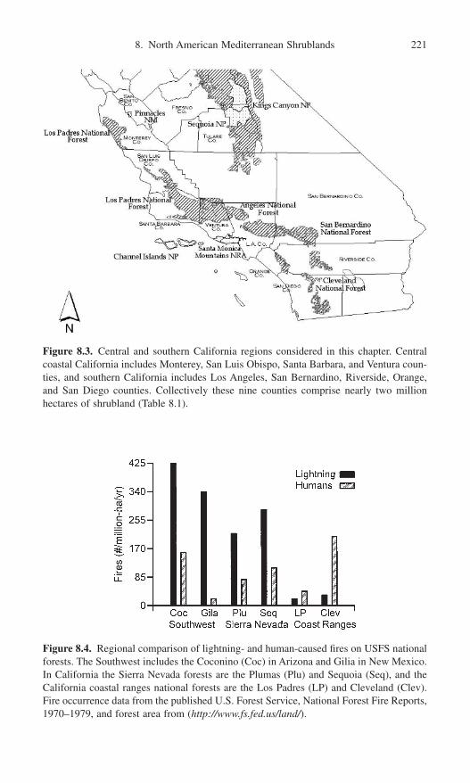
8. North American Mediterranean Shrublands 221
Figure 8.3. Central and southern California regions considered in this chapter. Centralcoastal California includes Monterey, San Luis Obispo, Santa Barbara, and Ventura coun-ties, and southern California includes Los Angeles, San Bernardino, Riverside, Orange,and San Diego counties. Collectively these nine counties comprise nearly two millionhectares of shrubland (Table 8.1).
Figure 8.4. Regional comparison of lightning- and human-caused fires on USFS nationalforests. The Southwest includes the Coconino (Coc) in Arizona and Gilia in New Mexico.In California the Sierra Nevada forests are the Plumas (Plu) and Sequoia (Seq), and theCalifornia coastal ranges national forests are the Los Padres (LP) and Cleveland (Clev).Fire occurrence data from the published U.S. Forest Service, National Forest Fire Reports,1970–1979, and forest area from (http://www.fs.fed.us/land/).
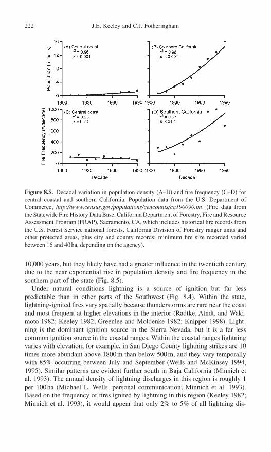
10,000 years, but they likely have had a greater influence in the twentieth centurydue to the near exponential rise in population density and fire frequency in thesouthern part of the state (Fig. 8.5).
Under natural conditions lightning is a source of ignition but far less predictable than in other parts of the Southwest (Fig. 8.4). Within the state, lightning-ignited fires vary spatially because thunderstorms are rare near the coastand most frequent at higher elevations in the interior (Radtke, Atndt, and Waki-moto 1982; Keeley 1982; Greenlee and Moldenke 1982; Knipper 1998). Light-ning is the dominant ignition source in the Sierra Nevada, but it is a far lesscommon ignition source in the coastal ranges. Within the coastal ranges lightningvaries with elevation; for example, in San Diego County lightning strikes are 10times more abundant above 1800m than below 500m, and they vary temporallywith 85% occurring between July and September (Wells and McKinsey 1994,1995). Similar patterns are evident further south in Baja California (Minnich etal. 1993). The annual density of lightning discharges in this region is roughly 1per 100ha (Michael L. Wells, personal communication; Minnich et al. 1993).Based on the frequency of fires ignited by lightning in this region (Keeley 1982;Minnich et al. 1993), it would appear that only 2% to 5% of all lightning dis-
222 J.E. Keeley and C.J. Fotheringham
Figure 8.5. Decadal variation in population density (A–B) and fire frequency (C–D) forcentral coastal and southern California. Population data from the U.S. Department of Commerce, http://www.census.gov/populations/cencounts/ca190090.txt. (Fire data fromthe Statewide Fire History Data Base, California Department of Forestry, Fire and ResourceAssessment Program (FRAP), Sacramento, CA, which includes historical fire records fromthe U.S. Forest Service national forests, California Division of Forestry ranger units andother protected areas, plus city and county records; minimum fire size recorded variedbetween 16 and 40ha, depending on the agency).

charges ignite a wildfire. In other words, 95% of all lightning discharges strikeinadequate fuels, or are extinguished by rain, before they reach a detectable size.
Lightning ignitions in coastal and southern California shrublands account fora highly variable amount of burning, ranging from less than 1% to more than50% of the landscape per decade (Table 8.1). Both spatial and temporal factorsare involved. Considering all of California, lightning ignitions account for anincreasing fraction of burning from the coast to the interior and from south tonorth (Keeley 1982). Occasionally lightning may coincide with severe weatherand fuel conditions and result in massive fires such as the Marble Cone Fire in1977 on the Los Padres National Forest (Table 8.1). Longer-term data sets for theLos Padres show this to be an infrequent event (Davis and Michaelsen 1995),suggesting that lightning fires in these coastal ranges are capable of reachingextraordinary size but the temporal variance is high.
Lightning is more predictable in the higher interior Sierra Nevada Range (Fig. 8.4), and it varies inversely with elevation (van Wagtendonk 1992). InSequoia National Park (located in the southern Sierra Nevada, Fig. 8.3) lightning-ignited fires reach a peak at elevations between 2000 and 3000m and are con-siderably less frequent in the lower-elevation shrubland-dominated foothills(Parsons 1981; Vankat 1985). Within the park the lower-elevation shrublandsexperience fewer lightning-ignited fires than would be expected based on shrub-land area (p < 0.001 with c2 test), and the opposite is true for higher-elevationmixed-coniferous forests. This pattern is repeated throughout the Sierra Nevada;
8. North American Mediterranean Shrublands 223
Table 8.1. Total number of fires and hectares burned and percentage due to lightningduring the 1970s decade for lower-elevation foothills (California Division of ForestryJurisdiction) and higher-elevation interior mountains (U.S. Forest Service national forests)in southern and central–coastal California
CDF Ranger Total fires Total area Fires due to Area due toUnit/USFS (106 ha/ burned lightning lightning National Forest decade) (ha) (%) (%)
Foothills (CDF)Monterey/San Benito 3,140 53,570 2 <1San Luis Obispo 3,310 44,130 2 <1San Bernardino 9,680 12,240 4 11Riverside 17,620 332,950 1 5Orange 42,900 120,830 <1 <1San Diego 9,450 20,930 3 6
Mountains (USFS)Los Padres 2,340 49,720 9 56a
Angeles 4,980 214,460 15 4San Bernardino 4,400 41,030 24 6Cleveland 4,870 121,370 11 <1
Source: Keeley 1982.Note: Sites are arranged from north to south, and national forest locations are shown in Figure 3. Allof these ranger units or forests are dominated by chaparral, but they also include mixtures of grass-land, sage scrub, woodlands, and forests.a Much of this is due to a single lightning-ignited fire (Marble Cone Fire) in 1977.

foothill shrublands average about 10 lightning-ignited fires per year per millionhectares and the higher-elevation montane forests experience 100 to 200 per yearper million ha (Keeley 1982). Of course, making predictions about the elevationalpatterns of burning by lightning alone (i.e., in the absence of anthropogenic inter-ference) is complicated by the likelihood that along this elevational gradient, con-ditions conducive to fire spread are inversely related to lightning fire frequency.Modeling is perhaps the only means of understanding the natural fire regimes inthese ecosystems (e.g., Greenlee and Langenheim 1980; Davis and Burrows1993; Davis and Michaelsen 1995; Zedler and Seiger 2000).
In general, rain or high humidity accompanies lightning fires, and there is oftena time lag between ignition and changes in weather conducive to rapid fire spread.Thus, in forested ecosystems where lightning is the dominant ignition source(e.g., the Southwest, Fig. 8.4), fire suppression has been extraordinarily effective.Fire detection has become increasingly more reliable (Chandler 1960), and thereis reason to believe that many suppressed lightning-ignited fires, in both forestsand shrublands, would have burned out if never detected. This is supported by agreater number of reports of lightning-ignited wildfires in the latter half of thetwentieth century (Keeley 1977, 1982; Greenlee and Moldenke 1982; Vankat1985); however, it could reflect changes in fuel structure as well (Weatherspoonand Skinner 1996).
In the coniferous forests of the Sierra Nevada, lightning-ignited fires peak inthe summer months of July and August and match closely the monthly distribu-tion of human-ignited fires (Parsons 1981; Vankat 1985; van Wagtendonk 1992).Throughout the chaparral-dominated coastal ranges lightning-ignited fires arealso concentrated in the summer months of July and August (Keeley 1982).However, humans are the dominant source of ignition (Fig. 8.4), and their impacton fire season varies from apparently very little effect in the central coast, as illus-trated by a summer peak in burning to a much greater impact in the south, whereanthropogenic fires result in a longer fire season and greater autumn burning (Fig. 8.6). Thus, in contrast to the situation in forests throughout the westernUnited States where lightning is the dominant source of ignition and humans havesuccessfully suppressed most fires, the vast majority of fires in chaparral andcoastal sage scrub in the coastal ranges are ignited by humans (Keeley, Fotheringham, and Morais 1999; Keeley and Fotheringham 2001b). In short, firesuppression has not eliminated burning on this shrubland landscape. Humanimpact is most pronounced at lower elevations and in proximity to metropolitanareas. On shrubland landscapes under natural conditions, lightning is a pre-dictable source of ignition but variably distributed in time and space.
Fuels and Weather
The spatial and temporal arrangement of fuels is a critical determinant of firebehavior, and fuel loading is determined largely by differences in site productiv-ity and vegetation age. The extent to which fire will propagate across a landscape
224 J.E. Keeley and C.J. Fotheringham

is determined by the spatial arrangement of fuels and weather conditions prior toand during the fire. Fuel structure needs to be considered at different scales. In astand of vegetation on a single slope face, the important fuel characteristics arethe vertical and horizontal placement of fuels, fuel surface-area/volume ratio, andthe moisture status of leaves and stems. At this scale shrubs are of uniform ageand may be rather coarse grained in monotypic stands, becoming finer grainedas the mixture of species increases. At the landscape level fuels are fine grained,and large expanses of homogeneous fuels are the exception. Barriers of reducedfuel loading, which could include rocks, rivers, alluvial fans, young age classes,or less flammable vegetation types, may inhibit fire spread. As seasonal droughtprogresses, different portions of the landscape are added as potential fuels, furthercontributing to inherent landscape heterogeneity of fuels. This interaction amonglandscape structure, fuels, and moisture limits the ability of models to predict firespread, and the fine-grain nature of fuels leads to potentially large errors (Kesselland Cattelino 1978).
Fuel Structure and Fuel Moisture
In mature shrublands, surface fuels are insufficient to carry fire, and thus firespropagate through the canopy as crown fires. Recently burned sites have suffi-cient herbaceous growth to carry surface fires (Haidinger and Keeley 1993), andthis may be exacerbated by artificial seeding of nonnative grasses (e.g., Zedler,
8. North American Mediterranean Shrublands 225
Figure 8.6. Seasonal distribution of burning reported for 1970 to 1999 for selected counties (data from the California Statewide Fire History Database; see Fig. 5).

Gautier, and McMaster 1983). However, sufficient herb biomass to carry surfacefires is unlikely following dry winters or on highly infertile coarse-textured soils,such as occur in certain coastal sites (e.g., Lompoc, CA) or the interior ranges ofBaja California (Franco-Vizcaino and J. Sosa-Ramirez 1997).
Normally, following a wet winter, high fuel moisture in chaparral shrubs makesthem relatively resistant to fire in spring and early summer. However, as theamount of herbaceous matter in the stand increases, the seasonal window ofburning increases. Dead herbaceous fuels dry rapidly and are capable of carry-ing fire within days of a rainfall event (Chandler 1963), and species compositionplays a role as nonnative grasses typically die many weeks earlier than nativeherbs (Keeley, personal observations). As a result certain herbaceous fuels greatlyextend the length of the fire season.
Shrublands that have been partially or fully type-converted to grasslands (e.g.,Bentley 1967) have a greater probability of igniting but do not represent anextreme fire hazard as fire intensities are low and the fine herbaceous fuels failto sustain embers or create the vortexes that carry the fire ahead of the movingfront (Regelbrugge 2000). Even so, fires in a dense growth of non-native herbs,such as mustards (Brassica nigra and Hirschfeldia incana) on steep slopes, havebeen known to generate fire intensities sufficient to destroy homes (J. Keeley, per-sonal observation).
For intact shrublands, two factors affect woody fuel moisture: the physiologi-cal activity (water potential) of live foliage and the quantity of dead fuels (Green1981). Shrub species differ markedly in moisture status of foliage due in part todifferences in rooting depth (Davis, Kolb, and Barton 1998)—shallow-rootedshrubs, such as chamise (Adenostoma fasciculatum) and Ceanothus spp., typi-cally experience water potentials two to three times lower than more deeplyrooted shrubs such as scrub oak (Quercus berberidifolia). Under prescriptionweather conditions fires may readily spread through Adenostoma-dominatedchaparral but extinguish when they encounter patches of scrub oak (Chandler1957; Green 1981). However, under extended drought, foliage moisture in scruboak may drop to levels conducive to rapid-fire spread (Olsen 1960; Pirsko andGreen 1967; Green 1981).
Dead fuels lack an internal water source and respond rapidly to changes in humidity; small diameter stems can dry completely within hours and largerfuels within days of experiencing low humidity (Chandler 1963; McCutchan1977). Dead fuels not only combust readily, but as the proportion of dead/live material increases, there is an elevated potential for dead fuel combustion tocause drying of living foliage to a level sufficient for combustion. Because dead fuel carries fire and live fuel absorbs energy, the ratio of dead/live fuel iscritical. This increase in combustibility of live fuels is enhanced by the commonposition of dead fuels beneath the living foliage. Topography plays a similar role. On steep terrain, head fires burning upslope enhance the combustion of fuels ahead of the front and may spread two to three times faster than on levelground—fire spread will roughly double for each 13 degree rise in slope (Green1981).
226 J.E. Keeley and C.J. Fotheringham

Fuel Structure and Wind
At low wind speed, fuel structure and arrangement plays a critical role in firespread. For example, fine-textured, low, compact fuels—particularly subshrubswith extremely high levels of volatiles, for example Salvia spp. (sage)—mayreadily combust and spread fire rapidly. However, under the same weather conditions, fire might naturally extinguish in a taller chaparral stand in whichfuels are more widely scattered in the canopy, and there is little continuity withground-level fuels (Green 1981). Under low to moderate wind conditions species-specific fuel characteristics in chaparral can promote fire spread. Many charac-teristics of Adenostoma fasciculatum (chamise) make it far more flammable thanassociated shrub species. About two-thirds of the plant is composed of twigs <25mm diameter and thus has a stem surface area–volume ratio greater than thatof other species (Conard and Regelbrugge 1994). Individual chamise leaves havea relatively low surface area/volume ratio, but they have an extremely highcontent of volatile compounds that vaporize and increase combustibility (Philpot1969). On a whole plant basis, Adenostoma leaves have a very high surfacearea/volume ratio; they comprise 67% of surface area but only 16% of plantvolume, reflecting the loose packing of foliage (Countryman and Philpot 1970;Barro and Conard 1991).
One of the key factors affecting flammability of Adenostoma is the fact that itdoes not self-prune dead twigs and branches; instead, they are held aloft in thecanopy and increase canopy porosity (shrub canopy volume/leaf and stemvolume), which often exceeds 99% (Rundel, Parsons, and Baker 1980). Highcanopy porosity increases flammability and extends the seasonal window of flam-mability. Also experimental studies demonstrate that this natural retention of deadbranches substantially increases fire intensity over an artificial treatment of clip-ping and leaving as surface fuels (Schwilk 2000). Species with more denselypacked fuels, and that self-prune dead branches and have thicker twigs and stems(e.g., scrub oak, Quercus, or chaparral holly Heteromeles arbutifolia), often willnot burn under conditions suitable for fire spread in Adenostoma-dominated chaparral. It has been hypothesized that characteristics enhancing flammabilityhave adaptive value (Mutch 1970) and shrubs with seedling recruitment restrictedto postfire environments (Adenostoma, Ceanothus, Arctostaphylos) have signifi-cantly higher flammability than species that recruit independently of fire (Prunus,Rhamnus, Quercus) (Bond, unpublished data).
While high-canopy porosity increases flammability, it leads to lower bulkdensity (mass/volume) and fuel loading (mass/area), reducing the total energy available for combustion. Thus the Adenostoma fuel structure increasesflammability under a wide range of conditions, whereas the Quercus fuel structure is limited in the range of conditions suitable for burning, but under the severest conditions Quercus fuels should be expected to generate the highestintensities.
Fuel structure appears to play a less deterministic role under windy conditions,but there is a complex interaction of wind, humidity, fuels, temperature, and
8. North American Mediterranean Shrublands 227
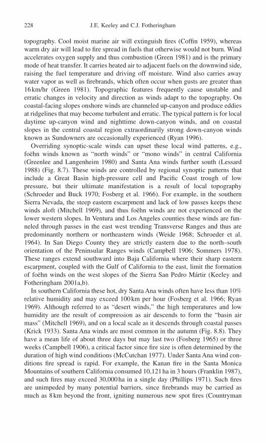
topography. Cool moist marine air will extinguish fires (Coffin 1959), whereaswarm dry air will lead to fire spread in fuels that otherwise would not burn. Windaccelerates oxygen supply and thus combustion (Green 1981) and is the primarymode of heat transfer. It carries heated air to adjacent fuels on the downwind side,raising the fuel temperature and driving off moisture. Wind also carries awaywater vapor as well as firebrands, which often occur when gusts are greater than16km/hr (Green 1981). Topographic features frequently cause unstable anderratic changes in velocity and direction as winds adapt to the topography. Oncoastal-facing slopes onshore winds are channeled up-canyon and produce eddiesat ridgelines that may become turbulent and erratic. The typical pattern is for localdaytime up-canyon wind and nighttime down-canyon winds, and on coastalslopes in the central coastal region extraordinarily strong down-canyon windsknown as Sundowners are occasionally experienced (Ryan 1996).
Overriding synoptic-scale winds can upset these local wind patterns, e.g., foëhn winds known as “north winds” or “mono winds” in central California(Greenlee and Langenheim 1980) and Santa Ana winds further south (Lessard1988) (Fig. 8.7). These winds are controlled by regional synoptic patterns thatinclude a Great Basin high-pressure cell and Pacific Coast trough of low pressure, but their ultimate manifestation is a result of local topography(Schroeder and Buck 1970; Fosberg et al. 1966). For example, in the southernSierra Nevada, the steep eastern escarpment and lack of low passes keeps thesewinds aloft (Mitchell 1969), and thus foëhn winds are not experienced on thelower western slopes. In Ventura and Los Angeles counties these winds are fun-neled through passes in the east west trending Transverse Ranges and thus arepredominantly northern or northeastern winds (Weide 1968; Schroeder et al.1964). In San Diego County they are strictly eastern due to the north–south orientation of the Peninsular Ranges winds (Campbell 1906; Sommers 1978).These ranges extend southward into Baja California where their sharp easternescarpment, coupled with the Gulf of California to the east, limit the formationof foëhn winds on the west slopes of the Sierra San Pedro Mártir (Keeley andFotheringham 2001a,b).
In southern California these hot, dry Santa Ana winds often have less than 10%relative humidity and may exceed 100km per hour (Fosberg et al. 1966; Ryan1969). Although referred to as “desert winds,” the high temperatures and lowhumidity are the result of compression as air descends to form the “basin airmass” (Mitchell 1969), and on a local scale as it descends through coastal passes(Krick 1933). Santa Ana winds are most common in the autumn (Fig. 8.8). Theyhave a mean life of about three days but may last two (Fosberg 1965) or threeweeks (Campbell 1906), a critical factor since fire size is often determined by theduration of high wind conditions (McCutchan 1977). Under Santa Ana wind con-ditions fire spread is rapid. For example, the Kanan fire in the Santa MonicaMountains of southern California consumed 10,121ha in 3 hours (Franklin 1987),and such fires may exceed 30,000ha in a single day (Phillips 1971). Such firesare unimpeded by many potential barriers, since firebrands may be carried asmuch as 8km beyond the front, igniting numerous new spot fires (Countryman
228 J.E. Keeley and C.J. Fotheringham

1974). Under these conditions stands may burn regardless of stand age or speciescomposition (Keeley, Fotheringham, and Morais 1999).
Fuel Mass and Stand Age
It has long been held that fuel mass increases with stand age (Philpot 1977), butthis has been criticized as oversimplistic because it ignores tremendous species-specific variability in rates of biomass accumulation (Fig. 8.9). For example,some Ceanothus species may accumulate many times more biomass in less than20 years than Adenostoma fasciculatum does in 60 years (Riggan et al. 1994;Regelbrugge 2000). Also at 10 years of age north-facing aspects may have greaterbiomass accumulation than drier south-facing slopes do at 80 years of age (Black1987). This fact alone makes landscape-scale predictions of flammability basedon stand age extremely difficult. Complicating the prediction of flammability withstand age is the increasing proportion of biomass in large diameter stems that
8. North American Mediterranean Shrublands 229
Figure 8.7. Surface weather map during the Great Basin high-pressure air mass that generates foëhn winds in central and southern California (from Phillips 1971).

combust only under the most extreme burning conditions. Also highly produc-tive stands are often more mesic sites, and this, plus greater fuel density andhigher fuel moisture, may reduce flammability. However, under extreme condi-tions, once ignited, productive sites sustain greater energy release than less pro-ductive stands (Riggan et al. 1988).
Successional changes in biomass (live and dead kg/ha) range from 1200 to 9000in the first postfire year to 8000 to 13,000 after a decade, and 30,000 to 66,000
230 J.E. Keeley and C.J. Fotheringham
Figure 8.8. Seasonal distribution of fireoccurrence and area burned during the twentieth century in Los Angeles County(data from Statewide Fire History Database;see Fig. 8.5) and seasonal distribution ofSanta Ana winds (from Weide 1968).
Figure 8.9. Live and dead abovegroundbiomass for chaparral shrubs at different timessince fire based on several studies (data fromRegelbrugge 2000).

(sometimes 100,000) in mature stands (Specht 1969, 1981; Green 1970; Keeleyand Keeley 1984). Specht (1969) reported that the proportion of dead biomassexceeded 50% in mature chamise chaparral, and Green (1970) found 66% dead in mature Cercocarpus betuloides. These early reports led to the generalization of1% dead for each year after canopy closure (Green 1981). However, more exten-sive studies (Fig. 8.10) report 30% dead/live ratios across the span from 20 to 60years and no significant relationship with age (Paysen and Cohen 1990; Conardand Regelbrugge 1994; Regelbrugge 2000). It is apparent that dead/live ratios area complicated function of many aspects of site composition and history. Forexample, unusually severe soil droughts may dramatically increase mortality, particularly of shallow-rooted Ceanothus shrubs, and this can occur in young orold stands (Keeley 2000; Davis et al. 2002). Also prior fire history may play a role;for example, chaparral stands burned by light fires leave large volumes of standingdead biomass that can produce very high dead/live ratios in young successionalstands where high volume of dead fuels is not expected (e.g., Fig. 8.10).
In general, chaparral less than 25 years old has less than 20% dead, and this isinsufficient to carry fire under “prescribed fire weather conditions” (Green 1981).Under severe weather conditions stand age (and total biomass and propor-tion dead) is less important in determining fire spread (Dunn 1989; Keeley, Fotheringham, and Morais 1999; Zedler and Seiger 2000).
The conclusion that older stands of chaparral generate fires of greater intensityneeds to be viewed with caution. Fire intensity, which is often measured as fire-line intensity or energy released per meter of fire front (Borchert and Odion 1995),can vary greatly depending on the interaction between weather and fuels. Some-times intensity is equated with fire severity, which is defined as the ecologicalimpact of the fire, and is often measured by mortality or the amount of plantbiomass consumed, or alteration of nutrient cycles. However, a fast-moving firethat consumes little fuel and a slow-moving fire that consumes more fuel canachieve the same fireline intensity, and thus intensity and severity can not alwaysbe equated. In general, fire intensity is important to understanding options for firesuppression (Countryman 1974), whereas fire severity is most relevant to post-fire ecosystem recovery (Keeley 1998b). Lastly, large fires often are equated withfires of high intensity, but they need not be. Large fires or mass fires are oftendescribed as catastrophic fires, but this latter term best refers to the impact of fireupon property and lives.
8. North American Mediterranean Shrublands 231
Figure 8.10. Fraction of total biomasscomprising dead material for chaparralshrubs at different times since fire based onseveral studies (data from Paysen and Cohen1990; Regelbrugge 2000).

Past and Present Shrubland Fire Regimes
Understanding the extent of human impact on chaparral ecosystems requires thatwe reconstruct historical fire regimes. Stand-replacing crown fires typical ofshrublands (Fig. 8.2) are not conducive to the formation of a tree-ring record offires, as with surface fire regimes in montane coniferous forests. Thus recon-structing historical burning patterns for chaparral requires alternative approachessuch as interpretation of sedimentary charcoal records.
Charcoal deposits in varved sediment cores from the Santa Barbara Channelhave generated estimates of prehistoric fire frequency. Byrne, Michaelsen, andSoutar (1977) calibrated this procedure by comparison of annual varves frommodern cores with U.S. Forest Service fire records. They found a significant cor-relation between large charcoal deposition events and incidence of large fires(>20,000ha) in the adjacent mountain range less than 50km from the core site.Using a core for the period from AD 730 to 1505, they were able to detect sig-nificant charcoal deposition but less than in the modern period, suggesting a lackof frequent small fires, unlike the contemporary pattern (Moritz 1997). They did,however, find two major peaks approximately 100 years apart with smaller peaksat 20- to 60-year intervals, and suggested this period had few fires, widely spaced,which became large conflagrations capable of generating large pulses of char-coal. Mensing, Michaelsen, and Byrne (1999) analyzed similar cores at a finerresolution and concluded that large fires were a feature of this region long beforemodern fire suppression.
Native American Impacts
Tree-ring records of fire scars from the coastal ranges and the Sierra Nevada have been interpreted to suggest that during the few hundred years prior to Euro-American colonization fire frequencies exceeded the level expected from light-ning alone (Reynolds 1959; Greenlee and Langenheim 1990). From historicalrecords and ethnographic accounts there can be no doubt that California Indiansregularly utilized fire to manage their environment (e.g., Lewis 1973; Timbrook,Johnson, and Earle 1982; Wickstrom 1987; Anderson and Moratto 1996). Theextent to which this management practice altered landscapes is a matter of debate.Due to the naturally high fire frequency of lightning fires in the coniferous forestsof the Sierra Nevada, Vale (1998) has argued that the additional burning byIndians did not alter landscapes except in localized areas (but cf. Anderson,Barbour, and Whitworth 1998). On the other hand, it has been hypothesized thatdirect use of fire by Native Americans greatly altered landscape patterns in thelower elevation coastal range foothills, primarily through type conversion ofshrublands and woodlands to grasslands and other herbaceous associations(Cooper 1922; Wells 1962; Huenneke 1989; Keeley 1990, 2002; Hamilton 1997).This hypothesis is supported by the low lightning activity, high Indian popula-
232 J.E. Keeley and C.J. Fotheringham
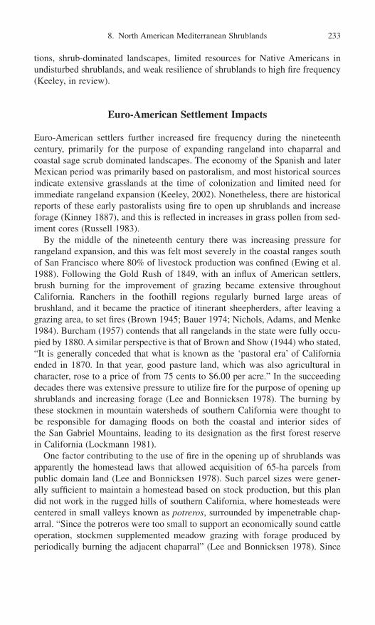
tions, shrub-dominated landscapes, limited resources for Native Americans inundisturbed shrublands, and weak resilience of shrublands to high fire frequency(Keeley, in review).
Euro-American Settlement Impacts
Euro-American settlers further increased fire frequency during the nineteenthcentury, primarily for the purpose of expanding rangeland into chaparral andcoastal sage scrub dominated landscapes. The economy of the Spanish and laterMexican period was primarily based on pastoralism, and most historical sourcesindicate extensive grasslands at the time of colonization and limited need forimmediate rangeland expansion (Keeley, 2002). Nonetheless, there are historicalreports of these early pastoralists using fire to open up shrublands and increaseforage (Kinney 1887), and this is reflected in increases in grass pollen from sed-iment cores (Russell 1983).
By the middle of the nineteenth century there was increasing pressure forrangeland expansion, and this was felt most severely in the coastal ranges southof San Francisco where 80% of livestock production was confined (Ewing et al.1988). Following the Gold Rush of 1849, with an influx of American settlers,brush burning for the improvement of grazing became extensive throughout California. Ranchers in the foothill regions regularly burned large areas of brushland, and it became the practice of itinerant sheepherders, after leaving agrazing area, to set fires (Brown 1945; Bauer 1974; Nichols, Adams, and Menke1984). Burcham (1957) contends that all rangelands in the state were fully occu-pied by 1880. A similar perspective is that of Brown and Show (1944) who stated,“It is generally conceded that what is known as the ‘pastoral era’ of Californiaended in 1870. In that year, good pasture land, which was also agricultural incharacter, rose to a price of from 75 cents to $6.00 per acre.” In the succeedingdecades there was extensive pressure to utilize fire for the purpose of opening upshrublands and increasing forage (Lee and Bonnicksen 1978). The burning bythese stockmen in mountain watersheds of southern California were thought tobe responsible for damaging floods on both the coastal and interior sides of the San Gabriel Mountains, leading to its designation as the first forest reservein California (Lockmann 1981).
One factor contributing to the use of fire in the opening up of shrublands wasapparently the homestead laws that allowed acquisition of 65-ha parcels frompublic domain land (Lee and Bonnicksen 1978). Such parcel sizes were gener-ally sufficient to maintain a homestead based on stock production, but this plandid not work in the rugged hills of southern California, where homesteads werecentered in small valleys known as potreros, surrounded by impenetrable chap-arral. “Since the potreros were too small to support an economically sound cattleoperation, stockmen supplemented meadow grazing with forage produced byperiodically burning the adjacent chaparral” (Lee and Bonnicksen 1978). Since
8. North American Mediterranean Shrublands 233

brush burning was an essential resource use practice for stockmen, they burnedextensive areas of chaparral (Barrett 1935; Brown and Show 1944; Brown 1945).For instance, in 1887 it was reported, that in the southern portion of San DiegoCounty that “at least one third of the land covered with brush, grass and oaktimber has been burnt off by settlers in the past eighteen months” (Lee and Bonnicksen 1978). As a consequence of early settler burning, fire control lawswere enacted soon after statehood in 1850 (Clar 1959). Not surprisingly, in theearly part of the twentieth century, ranchers were often the primary opponents tofire exclusion policies, which in southern California was prompted by the needfor watershed protection in the coastal plain (Lee and Bonnicksen 1978).
In summary, it is apparent that during this settlement period the primary altera-tion in fire regime was to increase the frequency of fires on shrubland landscapes.This was an era of very limited fire suppression, and yet fires were much as theyare today in that large crown fires covering tens of thousands of hectares werenot uncommon (Kinney 1900; Barrett 1935; Brown and Show 1944; Brown 1945;Minnich 1987). For example, one of the largest fires in Los Angeles County(24,000ha) occurred in 1878 (Keeley, Fotheringham, and Morais 1999), and thelargest fire in Orange County’s history was over a quarter million hectares andoccurred in 1889 (Lee and Bonnicksen 1978).
Twentieth-Century Patterns of Burning
Burning patterns during the twentieth century are shown for the nine counties incentral and southern coastal California (Fig. 8.11). Most counties exhibited littleor no change in area burned except for Los Angeles and Riverside counties insouthern California, which exhibited highly significant increases in area burnedduring the twentieth century. In contrast to the situation in western U.S. conifer-ous forests, fire suppression clearly has not excluded fire from these shrublandlandscapes. Collectively the 1920s, 1940s, and 1970s were high decades, and the1930s and 1960s were low. Possible explanations for these patterns are that theyresult from (1) decadal-scale variation in climate, (2) natural cycles resulting fromfuel buildup, and/or (3) human demographic patterns.
Role of Climate/Weather
There are numerous suggestions in the literature of extended droughts contribut-ing to extraordinarily severe fire seasons, but with a few notable exceptions, mostlack statistical rigor. Minnich (1983) reported that there was a significant posi-tive relationship between precipitation and area burned in coastal sage scrub ofsouthern California and adjacent Baja California, but he presented no statisticsto support this contention. He also inspected patterns of chaparral burning overthis time period and concluded no such relationship existed with chaparral.However, others have reported a relationship between precipitation and burning
234 J.E. Keeley and C.J. Fotheringham

in chaparral. One line of evidence is the spatial relationship between average pre-cipitation and fire occurrence within the chaparral zone of San Diego County(Krausmann 1981). Another line of evidence is the demonstration that chaparralburning varies temporally with changes in precipitation; little area is burned following rainfall years where spring precipitation is >200mm (Davis andMichaelsen 1995). These observations have been interpreted to mean that morerain translates into more biomass and thus greater fuels for burning in the sub-sequent fire season.
Using the FRAP data set (Fig. 8.11), we found few statistically significant cor-relations between patterns of rainfall and burning for chaparral and coastal sageshrublands combined. For each county separately, or all counties collectively,there was no significant relationship between total acreage burned per year andthe nearest station with long-term records for:
1. total annual (January–December) precipitation,2. growing season (November–June) precipitation,
8. North American Mediterranean Shrublands 235
Figure 8.11. Area burned per decade and 10-year running annual average during the twen-tieth century for nine counties in central and southern California (data from the StatewideFire History Database; see Fig. 8.5). Shrubland area in thousands of hectares shown inparentheses following the county name (from Callaham 1985).

3. spring (January–May) precipitation,4. summer (June–August) precipitation, or5. previous growing season’s precipitation.
There was, however, a weak, but significant negative correlation (p < 0.05, r2 = 0.05–0.06, n ≥ 88) between October precipitation and area burned in eachof the southern California counties, indicating that early autumn rains cut shortthe fire season at its peak.
Weather conditions affecting autumn foëhn wind-driven fires are most criticalin determining area burned. Santa Ana wind conditions are largely responsiblefor fires becoming large and is reflected by the strong correlation between firesize and high temperatures. On the Los Padres National Forest fires generallyignite on days when the temperature is 3 to 5°C greater than the monthly average,and large fires never originate on days where temperatures are <25°C at the SantaBarbara airport (Davis and Michaelsen 1995; Moritz 1997). Moritz (1999) exam-ined this relationship between severe fire weather (defined as days with maximumtemperatures at the Santa Barbara airport ≥32°C) and extreme fire events in the central portion of the Los Padres National Forest. He found that large fires(>4000ha) were strongly associated with severe fire weather. In this part of California severe fire weather is often, but not always, associated with foëhnwinds (Schroeder et al. 1964; Dunn and Piierto 1987; Ryan 1996). However,farther south, for example, in the Santa Monica Mountains, all large fires appearto be driven by Santa Ana winds (NPS, Santa Monica Mountains National Recreation Area, unpublished data). In general, the largest wildfires in the centraland southern coastal region are during severe fire weather conditions that includehigh temperatures, coupled with low humidity and high winds (Coffin 1959;Pirsko 1960; Schroeder et al. 1964; Weide 1968; Countryman, McCutchan, andRyan 1969; Phillips 1971; Countryman 1974; Dunn and Piierto 1987; Gomes etal. 1993; Davis and Michaelson 1995; Minnich and Chou 1997).
Role of Fuel Cycles
Fuel accumulation was implicated in burning patterns in California shrublandsby modeling studies published in the 1970s (Rothermel and Philpot 1973; Philpot1974a,b). Based on untested assumptions about rates of fuel accumulation andeffectiveness of fire suppression, it was concluded that large fires were increas-ingly more common because of an accumulation of older age classes of vegeta-tion (Fig. 8.12). In support of this idea are many anecdotal references that firefighters and fire researchers often relate about the tendency of fires to stop uponencountering young age classes of fuels (e.g., Philpot 1974a,b; Minnich 1998).An example of how these anecdotes are often used is the story about the 1970Laguna Fire (one of the largest in California’s history), in which it is claimed thefire died out when it encountered young age classes of vegetation (Rich Minnich,public communication, National Public Radio’s “All Things Considered” radiobroadcast, June 10, 1999). While that observation may be true, the deduction that
236 J.E. Keeley and C.J. Fotheringham
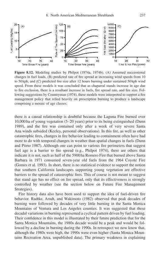
there is a causal relationship is doubtful because the Laguna Fire burned over10,000ha of young vegetation (5–20 years) prior to its being extinguished (Dunn1989), and the fire was contained only after a week of very severe Santa Ana winds subsided (Keeley, personal observations). In this fire, as well as othercatastrophic fires, changes in fire behavior leading to containment often have hadmore to do with temporal changes in weather than spatial changes in fuels (Dunnand Piirto 1987). Although one can point to various fire perimeters that suggestfuel age is a barrier to fire spread (e.g., Philpot 1974), there are others that indicate it is not, such as half of the 5900ha Romero Fire that burned above SantaBarbara in 1971 consumed seven-year old fuels from the 1964 Coyote Fire(Gomes et al. 1993). In short, there is no statistical evidence to support the notionthat southern California landscapes supporting young vegetation are effective barriers to the spread of catastrophic fires. This of course is not meant to suggestthat stand age has no effect on fire spread, only that its effectiveness is stronglycontrolled by weather (see the section below on Future Fire Management Strategies).
Fire history data also have been used to support the idea of fuel-driven firebehavior. Radtke, Arndt, and Wakimoto (1982) observed that peak decades ofburning were followed by decades of very little burning in the Santa MonicaMountains of Ventura and Los Angeles counties. It was suggested that thesedecadal variations in burning represented a cyclical pattern driven by fuel loading.Their confidence in this model is illustrated by their future prediction that for theSanta Monica Mountains, the 1980s decade would be a peak and would be fol-lowed by a decline in burning during the 1990s. In retrospect we now know that,although the 1980s were high, the 1990s were even higher (Santa Monica Moun-tains Recreation Area, unpublished data). The primary weakness in explaining
8. North American Mediterranean Shrublands 237
Figure 8.12. Modeling studies by Philpot (1974a, 1974b). (A) Assumed successionalchanges in fuel loads, (B) predicted rate of fire spread at increasing wind speeds from 10to 50kph, and (C) predicted fire size after 12 hours burning under sustained 50kph windspeed. From these models it was concluded that as chaparral stands increase in age dueto fire exclusion, there is a resultant increase in fuels, fire spread rate, and fire size. Fol-lowing suggestions by Countryman (1974), these models were interpreted to support a firemanagement policy that relied heavily on prescription burning to produce a landscapecomprising a mosaic of age classes.
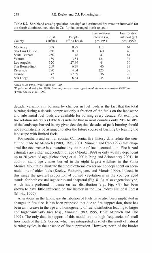
decadal variations in burning by changes in fuel loads is the fact that the totalburning during a decade comprises only a fraction of the fuels on the landscapeand substantial fuel loads are available for burning every decade. For example,fire rotation intervals (Table 8.2) indicate that in most counties only 20% to 30%of the landscape burned in any given decade; thus decades of peak burning shouldnot automatically be assumed to alter the future course of burning by leaving thelandscape with limited fuels.
For southern and central coastal California, fire history data refute the con-tention made by Minnich (1989, 1998, 2001; Minnich and Cho 1997) that chap-arral fire occurrence is constrained by the rate of fuel accumulation. Fire hazardestimates are either independent of age (Moritz 1999) or only weakly dependentup to 20 years of age (Schoenberg et al. 2001; Peng and Schoenberg 2001). Inaddition stand-age classes burned in the eight largest wildfires in the SantaMonica Mountains illustrate that these extreme events are not dependent on accu-mulations of older fuels (Keeley, Fotheringham, and Morais 1999). Indeed, inthis range the greatest proportion of burned vegetation is in the younger agedstands, for both coastal sage scrub and chaparral (Fig. 8.13). Also vegetation type,which has a profound influence on fuel distribution (e.g., Fig. 8.9), has beenshown to have little influence on fire history in the Los Padres National Forest(Moritz 1999).
Alterations in the landscape distribution of fuels have also been implicated inchanges in fire size. It has been proposed that due to fire suppression, there hasbeen an increase in the age and homogeneity of fuel distribution leading to largerand higher-intensity fires (e.g., Minnich 1989, 1995, 1998; Minnich and Cho1997). The only data in support of this model are the high frequencies of smallfires south of the U.S. border, which are interpreted as solely the result of naturalburning cycles in the absence of fire suppression. However, north of the border
238 J.E. Keeley and C.J. Fotheringham
Table 8.2. Shrubland area,a population density,b and estimated fire rotation intervalsc forthe shrub-dominated counties in California, arranged north to south
Fire rotation Fire rotationBrush People/ interval (yr) interval (yr)
County (103 ha) 106 ha brush pre-1951 post-1950
Monterey 358 0.99 115 64San Luis Obispo 250 0.87 60 48Santa Barbara 250 1.48 47 81Ventura 189 3.54 121 34Los Angeles 320 27.69 44 30San Bernardino 209 6.79 46 37Riverside 290 4.04 225 38Orange 42 57.39 36 29San Diego 365 6.84 35 41
a Area as of 1985, from Callaham 1985.b Population density for 1990, from http://www.census.gov/population/cencounts/ca190090.txt.c From Keeley et al. 1999.

fire suppression activities have not resulted in fire exclusion (Moritz 1997;Conard and Weise 1998; Keeley, Fotheringham, and Morais 1999; Weise et al.,in press). Thus the patterns north and south of the border, while interesting, cannotbe held up as an example of what happens to landscapes subjected to a fire sup-pression policy. Such fire management policies can not be held responsible forlarge destructive wildfires (Keeley and Fotheringham 2001a,b) as large fires havebeen a common feature of the southern California landscape throughout the nin-teenth and twentieth centuries (Keeley, Fotheringham, and Morais 1999; Keeleyand Fotheringham 2001a). Additionally sediment cores show the frequency oflarge fires has not changed during the past 450 years (Mensing, Michaelsen, andByrne 1999), and colorful, but less authoritative, is the Digueño Indian legend ofa large catastrophic fire sufficient to lead to migrations of tribes in San DiegoCounty at about the time of Columbus (Odens 1971, p. 8). All of these observa-tions suggest large fires are not a modern artifact of fire suppression as proposedelsewhere (Minnich 1989, 1995, 1998; Minnich and Dezzani 1991; Minnich andChou 1997).
We now know that although the models developed by Philpot and others maybe sound, their conclusions were flawed by incorrect assumptions. The assump-tion of a steady increase in fuels was inaccurate (Figs. 8.9 and 8.10), and theassumption that fire suppression was effectively excluding fire from shrublandlandscapes was wrong (Fig. 8.11). In short, patterns of burning on shrubland land-scapes cannot be explained solely by changes in accumulation of fuels (Moritz1997, 1999; Conard and Weise 1998; Keeley, Fotheringham, and Morais 1999;Peng and Schoenberg 2001). Indeed, modeling studies that consider landscapepatterns of fire spread conclude that stand age alone cannot constrain fire size(Zedler and Seiger 2000). If that were true, then just a single large Santa Anawind-driven fire would reset the landscape to the same age class, which would
8. North American Mediterranean Shrublands 239
Figure 8.13. Age classes of chaparral and coastal sage scrub stands burned by all firesover 5000ha from 1967 to 1996 in the Santa Monica Mountains (data from the U.S.National Park Service, Santa Monica Mountains National Recreation Area, ThousandOaks, CA). Greater burning of young age classes of coastal sage scrub is likely due tomore flammable fuels, longer fire season, and the concentration of this vegetation adja-cent to urban centers, which are major sources of ignition.

forever be doomed to burn as a single large unit. Zedler and Seiger’s model showsthat even in the absence of Santa Ana fires, if stand age were the only control-ling factor, over time, burn units would coalesce and become larger and largerwith each fire cycle.
Role of Human Demography
Clearly, humans have perturbed shrubland fire regimes, but unlike the situation inmany western U.S. forests, the primary impact has been through increased fire fre-quency (Table 8.1, Figs. 8.4 and 8.5c–d) and not through fire exclusion (Fig. 8.11).Collectively, across all counties considered in Figure 11, there was a significantcorrelation between fire frequency and population density and between fire fre-quency (r2 = 0.51, p < 0.05, n = 9) and area burned (r2 = 0.71, p < 0.01, n = 9).Southern California (defined in Fig. 8.3 legend), with the highest rate of popula-tion growth (Fig. 8.5b), also has had the greatest increase in wildfire ignitions (Fig. 8.5d). In contrast, the central coastal region has far fewer human ignitions(Figs. 8.4 and 8.5c), which is in line with the much lower population (Fig. 8.5a).
Indirectly the public infrastructure of roads contributes to patterns of burning.The central coastal region has substantial portions of its landscape lacking publicroads, which is in stark contrast to the vast highway network connecting mostparts of southern California. Fully one-third of all human-caused fires on ForestService and CDF protected lands in southern California occur along roads (Gee1974; Conard and Weise 1998). On shrubland landscapes near metropolitan areas,such as the Santa Monica Mountains, the vast majority of fires originate alongroadways (Los Angeles County Fire Department, unpublished data).
In light of these considerations it seems probable that some portion of thedecadal variation in burning during the twentieth century (Fig. 8.11) may have ahuman dimension. In the early part of the twentieth century populations in manyparts of California were increasing rapidly (Fig. 8.5a–b). With this influx ofpeople, came increased anthropogenic impact on the natural fire regime, drivenlargely by the increased mobility the automobile afforded; car registrations inCalifornia rose from 191,000 in 1915 to 1,500,000 in 1925 (Davis 1967). Duringthe period 1908 to 1920, every county in southern California voted large bondsfor road building (Davis 1967). Roads provided increased access to wildlandareas. For example, a doubling in wildland use between 1916 and 1920 (Showand Kotok 1923) coincided with a marked increase in wildfire incidence in south-ern California (Fig. 8.5d). This rapid population growth and increased mobilitystrained the ability of fire protection in California during the early part of thetwentieth century (Clar 1959). With the expanding population came an expan-sion of development at the urban–wildland interface, which then increased publicsusceptibility to wildfire impacts. As a consequence the decade of the 1920s wit-nessed some particularly destructive wildfires that increased public pressure forfire protection and prevention (Clar 1959).
In response, during the 1930s fire management agencies stepped up their attackon wildland fires by the introduction of lookout towers and aircraft for better
240 J.E. Keeley and C.J. Fotheringham

reconnaissance, which decreased the size of some fires due to early detection(Clar 1969; Pyne 1982). During this period various innovations were introducedto suppress fires, although effective suppression was elusive due to the inacces-sibility of remote wilderness areas (Brown and Show 1944; Pyne 1982). A systemof fuel breaks was one early answer to this problem, and creation of 200 CCC(Civilian Conservation Corp) camps throughout the state during the Depressioncontributed significantly to this network. Increased fire suppression activities dueto an excess of man power from federal relief programs (Clar 1969 described itas a “forced feed” of the California Division of Forestry), coupled with reduced“motor touring” (e.g., AAA memberships dropped 40% in the five years follow-ing 1929; Davis 1967) perhaps contributed to the drop in area burned during theGreat Depression in many counties.
Diversion of resources to the “war effort” during the first half of the 1940scontributed to diminished fire suppression capacity (Brown 1945; Clar 1969) andmay account for the peak burning that occurred in some counties during thatdecade (Fig. 8.11). San Diego County stands out because its worst decade forwildfires was the 1940s. Zahn (1944) suggests the extraordinary fires of this erawere the result of the aircraft industry, which had concentrated a great deal of thewar effort in San Diego County. He described the situation at the time as follows:“Bootleg fuel, high payrolls and a yen for the open spaces have resulted in hun-dreds of aircraft workers motoring to the hills—night or day—between workshifts. Most of these workers are newcomers to California, unfamiliar with thetinder-box potentialities of local brush.”
The modern era of effective fire suppression was introduced in the 1950s withthe development of air tankers for fire fighting (Pyne 1982), and this impact wasevident in a 10-fold drop in burning across the country (Dombeck 2001).However, in California these techniques have not proved very successful inhalting fires during extreme Santa Ana wind conditions (Countryman 1974).
In short, despite innovations, fire suppression has not diminished the wildlandfire problem in California. Indeed, since the 1950s, there has been an increase inthe allocation of funds to the California brushfire problem (Bonnicksen and Lee1979; Kinney 1984), and an increase in the loss of property and lives (Rogers1982; Martin and Sapsis 1995). Additionally, due to television, there has beenincreased public awareness of large-scale wildfires. Over this period there havebeen a number of workshops, conferences, and proceedings volumes publishedon this wildland fire problem—roughly one every 5 to 10 years since 1950—andthese offer a diversity of opinions on the role of fire in the California landscape.Although not a popular view, it has been frequently suggested that the problemstemmed in large part to the burgeoning population and poor zoning regulationsattendant with urban sprawl into the foothills. The problem was evident 50 yearsago. For example, Zivnuska, Amold, and Arment (1950) warned of this “poten-tially explosive situation,” and noted “it is known that one of the significant trendsin recent population changes has been the increase in number of residences in theflash-fuel types adjacent to primary watersheds.” Under these conditions cata-strophic fires are not necessarily the largest fires, as witnessed by the rather small
8. North American Mediterranean Shrublands 241

Oakland Hills Tunnel Fire in October 1991 (725ha) that burned nearly 3000structures and killed 25 people (Booker, Dietrich, and Collins 1995).
In summary, severe fire weather occurring each autumn coupled with humandemographic patterns would seem to explain patterns of burning (Fig. 8.11) far better than changes in available fuels. During the twentieth century anychanges in the fire regime have been dwarfed by the changes in land develop-ment patterns, which have increasingly placed more people at risk to the naturalforces long present on the landscape (Davis 1965; Bradshaw 1987). This patterncontinues—for example, in the 25 years prior to 1980, 2408 homes and other structures were destroyed by wildfires in California but in the subsequent14 years the number tripled (http://www.prefire.ucfpl.ucop.edu/wildfire.htm).Preference for a rural lifestyle and the skyrocketing cost of suburban housing inlarge metropolitan areas has progressively increased the urban–wildland inter-face. Of particular concern is the prediction that rural population will exceedurban growth in the foreseeable future (Bradshaw 1987). For both economic andpolitical reasons the notion that urban sprawl is responsible for natural wildfiresbecoming catastrophic fires is unpopular, in part, because it seems to defy the inherent belief that it is possible to engineer solutions to all environmentalproblems.
The Contemporary Versus Natural Fire Regime
There is reason to believe that the contemporary fire regime in these shrublandsmirrors the natural crown fire regime far more than is generally accepted (cf. Bonnicksen and Lee 1979; Minnich 1983; Pyne 1982). Today in southern Cali-fornia, fire incidence peaks in the summer, but most area burned is from autumnfires (Fig. 8.8a). Likewise the natural fire regime was probably characterized bymany small summer lightning-ignited fires and a few large autumn fires drivenby Santa Ana or Mono winds that burned large areas (Keeley and Fotheringham2001a). This model would seem to be contradicted by the fact that Santa Ana orMono winds are northeast winds, whereas summer thunderstorms are associatedwith south winds, and the two do not commonly coincide (Coffin 1959). Conse-quently today it is rare for Santa Ana wind-driven fires to be other than anthro-pogenic in origin. However, under natural conditions the fact that lightning firesburned for months (Minnich 1987), coupled with the relatively close temporaljuxtaposition of the July–August lightning fire season (Keeley 1982) with theSeptember–November Santa Ana winds (Fig. 8.8b), makes it inevitable that light-ning ignitions would occasionally have been spread by these foëhn winds (Keeleyand Fotheringham 2001a). While such events could not have been frequent, weknow from historical documents that summer lightning-ignited fires can burn formore than a month and consume on the order of 103 ha (Minnich 1987). Thispales in comparison to the 104 ha that are often covered in a single day by a SantaAna wind-driven fire (Phillips 1971).
Davis and Burrows (1993, 1994) modeled the long-term fire regime in chap-arral by linking physical models based on fire spread equations to fuel models of
242 J.E. Keeley and C.J. Fotheringham

stand senescence. Their simulations predicted a prehistoric fire regime of vari-able sized fires that produced a landscape mosaic of different age classes. Withone ignition every 10 years (typical lightning-ignited fire frequency for coastalCalifornia; Keeley 1982) their model predicted that most fires would be large and over 80% of the landscape would burn at ages greater than 95 years. Theseconclusions are supported by other evidence that points to a natural fire regimeof large fires and long fire return intervals for these coastal range landscapes(Greenlee and Langenheim 1990; Byrne, Michaelsen, and Soutar 1977; Mensing,Michaelsen, and Byrne 1999; Keeley and Fotheringham 2001a).
Alternatively, it has been argued that prior to the current fire suppression policy,landscapes were immune to Santa Ana wind-driven fires because lightning fireskept the shrublands in a fine-scale mosaic of young age classes (Minnich 1989,1995, 1998). It is presumed that this mosaic was quickly erased by highly effective fire suppression during the first couple decades of the twentieth century(Minnich 1990). However, historical records do not support this notion. Forexample, 90% of the 214,000ha of shrublands on the San Jacinto Forest Reservewere estimated to be 30 years or older when surveyed at the end of the nineteenthcentury, which represent far older age classes then present today (Keeley andFotheringham 2001a). Clearly, this landscape was not a fine-scale mosaic immuneto large fires. In addition the early history of forest protection does not supportthe idea that highly effective fire suppression was present in the opening decades of the twentieth century (Clar 1959; Lockmann 1981). Minnich andChou’s (1997) suggestion that fire suppression activities “culminated in exten-sive fire outbreaks as early as 1919” is contradicted by historical documentationthat reports large fires in the region long before this date, and before any fire suppression activities (e.g., Kinney 1900; Barrett 1935; Brown and Show 1944;Brown 1945; Lee and Bonnicksen 1978; Radtke, Arndt, and Wakimoto 1982).Nationwide there is no evidence of substantive reductions in area burned due to fire suppression until midway through the twentieth century (Dombeck 2001).
Historically fire intensity was variable, and there is no credible evidence thatit has increased during the era of fire suppression (Keeley, Fotheringham, andMorais 1999). The primary changes in the fire regime are that humans havereplaced lightning as the primary source of ignition and fire frequency hasincreased, particularly in areas of high population density such as southern California (Figs. 8.4 and 8.5). Because fire prevention has been ineffective ateliminating human fires, presently and for the foreseeable future, fire suppressionis required just to maintain some semblance of the natural fire regime.
Impacts on Vegetation
In contrast to the paradigm suggested for many western U.S. forests, ecosystemhealth of shrublands is threatened not by a lack of fire but by high fire fre-quencies that exceed the resilience of many species. Examples of high fire fre-quency induced extirpations are numerous (e.g., Gause 1966; Zedler et al. 1983;
8. North American Mediterranean Shrublands 243
Haidinger and Keeley 1993; Zedler 1995; Keeley 2000). Generally, the threat ofhigh fire frequency is lessened on very low nutrient soils where postfire annualbiomass is limited and less likely to carry a repeat fire. Where fires occur more thanonce in a decade, nonsprouting chaparral shrubs are entirely lost from the system.Commonly exotic grasses and forbs will take their place, and as these increase inimportance, they appear to competitively displace the native annuals. A similarcourse is evident in coastal sage scrub under higher fire frequency. In both of thesecrown fire ecosystems, high fire frequency favors annuals over woody plants, andthis advantage increases with increasing soil aridity (Wells 1962).
As fire frequency increases, fuel structure changes and subsequent fire behav-ior changes. With increasing exotic herbaceous cover, the seasonal window offlammability increases (Radtke, Arndt, and Wakimoto 1982), and fire behaviorbecomes a mixture of crown and surface fires. This has two very important con-sequences. Surface fires connect the woody fuels where otherwise they might betoo widely spaced to carry a crown fire, and thus exotic herbs shorten the firereturn interval. Another important consequence is that fire intensity is lowerwhere surface fires occur and this contributes to increased survivorship of exoticannual seed banks (Fig. 8.14). With continued disturbance these nonnative inva-sives may replace the entire ecosystem (Keeley, 2001), and type conversions ofshrublands to exotic grasslands are well documented (e.g., Cooper 1922; Bentley1967; CDF 1978; Biswell 1989; Minnich and Dezzani 1998). As a consequenceexotic grasslands tend to replace shrublands in the proximity to urban environ-ments, where the higher ignition sources in the company of flashy fuels have thepotential for even greater fire frequency. Evidence of this is seen in the substan-tially shorter fire return interval in grassland vegetation at the urban–wildlandinterface than observed for shrublands at the interface (J. Spero, California Division of Forestry, personal communication, 1999).
The extent of such type conversion is unknown because of past disturbances,which includes Indian burning throughout the Holocene and burning coupled withintensive livestock grazing in the past 200 years. In the coastal counties fromMonterey southward (Fig. 8.3) exotic annual grasslands cover nearly two millionhectares or 25% of the wildland landscape, and less than 1% has significantpatches of native perennial bunchgrass (Huenneke 1989). Although it is oftentaken as a matter of faith that these landscapes have always been grassland(Heady 1977), there is evidence that many exotic grasslands were formerly dominated by woody associations (Cooper 1922; Wells 1962; Oberbauer 1978;Huenneke 1989; Keeley 1990, Hamilton 1997). Today these landscapes comprisea mosaic of vegetation patterns (Fig. 8.15) that appear to be disturbance induced(Wells 1962). Grasslands on this modern landscape comprise a new quasi-equilibrium of nonnative annuals that are somewhat resistant to recolonizationby native shrubs. It is a dynamic process whereby as disturbances increase orwane, vegetation physiognomy shifts between exotic grassland and shrub-land/woodland (Hobbs 1983; Freudenberger, Fish, and Keeley 1987; Callawayand Davis 1993).
244 J.E. Keeley and C.J. Fotheringham

Future Fire Management Strategies
It has been suggested that “after nearly a century of suppression” there is a needfor a reintroduction of fire into chaparral through prescribed burning (Minnichand Dezzani 1991; Minnich and Franco-Vizcaíno 1999). However, fire historydata do not support this management strategy. On most shrubland landscapesthere is an abundance of fire, and 60- to 70-year-old stands, considered to be thenormal age for burning (Minnich 1989), are rare at the present time (Keeley1992). Indeed, the current fire rotation interval of 30 to 40 years is shorter than
8. North American Mediterranean Shrublands 245
Figure 8.14. Schematic diagram of how rate of fire ignitions in chaparral affects alienplant invasion and how alien invasions affect fuel loads, which in turn alter fire frequen-cies, making sites more conducive to further invasion (from Keeley, 2001).

that calculated for the early part of the twentieth century (Keeley, Fotheringham,and Morais 1999). In light of the expected trends in population growth in California, and the close association between population density and fire inci-dence (Fig. 8.5), increased fire prevention is far more important to protectingnatural resources than prescription burning or other methods of “fire restoration.”
Consequently there is a need to reevaluate prescribed burning strategies for California shrubland landscapes. There are two common motivations for prescription burning: (1) for the benefit of natural resources and (2) as a fuelmanipulation technique, primarily to reduce fire hazard but also to reduce thethreat of soil erosion or air quality hazards, which may be worse under wildfireconditions. In many western U.S. forests, prescription burning provides bothresource benefits and a reduction in fire hazard However, the reality for someecosystems is that prescriptions reducing fire hazard, may not always enhanceresource values and sometimes may detract (Johnson and Miyanishi 1995; Keeleyand Fotheringham 2001b).
Prescription Burning for Resource Benefit
There may be little justification for using fire for resource benefit, since vast portions of shrubland landscape currently experience a higher than normal firefrequency. Lack of fire does not appear to pose a risk because postfire studies
246 J.E. Keeley and C.J. Fotheringham
Figure 8.15. Vegetation mosaic of nonnative annual grassland and shrublands in thecentral coastal ranges of California (photo by J. Keeley).

demonstrate that both chaparral and coastal sage scrub regeneration are highlyresilient to even the most extreme fire events occurring after a long hiatus ofburning (Keeley 1998, 2000).
One proposed benefit of prescribed burns is that they are done under moremoderate weather conditions than are typical for wildfires, leading to less intensefires and less severe impacts on plant and soil resources (Green 1981; Morenoand Oechel 1991; Riggan et al. 1994; Wohlgemuth, Beyers, and Conard 1999).However, some of the experimental work demonstrating fire intensity effects onseed banks and soils have been done on piles of cut fuels, which do not accu-rately represent the fuel structure under natural conditions and are likely to gen-erate unnaturally high soil temperatures. More importantly, however, even themost extreme fire wildfire events today probably do not fall outside the naturalrange of variation for these ecosystems.
Other resource benefits from prescription burning include invasive plantcontrol, but the primary invasive problems involve herbaceous species, whichinvade shrublands when fire frequency increases (Fig. 8.14). It is not likely thatprescription burning would displace these invasive species, unless the target isvulnerable to a particular seasonal window of burning. In shrublands there are nosuch windows of opportunity that are not equally damaging to some nativespecies. Nonnative legume shrubs known as brooms (Cytisus scoparius andGenista monspesulanus) are sometimes targeted for removal with prescriptionburning, but these are inevitably replaced by exotic grasses (D’Antonio 2000).However, prescription burning for restoration of shrubland communities may beuseful if accompanied by vigorous revegetation with native shrubs and herbs.
In general, there are few places where fire-dependent shrublands are threatenedby the lack of fire and few instances where prescription burning is needed fornatural resource benefits. The primary justification for prescription burning is forfire hazard reduction. However, in these ecosystems any additional fire carrieswith it the potential for negative impacts on resources. Negative impacts mayarise not just from burning but can be associated with other fuel manipulations.For example, fuel breaks are possible corridors for bringing nonnative invasivespecies into wildland areas (Keeley, 2001).
Prescription Burning for Fire Hazard Reduction
Prescription burning carries with it a risk of fires escaping, and escaped fires arequite hazardous in crown fire ecosystems, most particularly chaparral landscapeswith a complex urban–wildland interface. In order to ensure successful con-tainment of a prescribed burn, there are strict limitations on the acceptable wind speed, air temperature, relative humidity, and fuel moisture—typically wind speeds below 17kph (10mph), relative humidities above 30%, air tempera-ture below 32°C (95°F), and fuel moisture above 75% (Fenner, Arnold, and Buck 1955; Green 1981). This, of course, varies with the fuel load and landscape,and various combinations will produce acceptable prescriptions (Paysen,
8. North American Mediterranean Shrublands 247

Narog, and Cohen 1998). One approach to reducing the risk of escaped fires is to burn in the spring, assisted by pretreatment of mechanical crushing and drying.Thus the target fuels are surrounded by less flammable living vegetation (Wolfram 1962). This procedure is expensive, and it has the potential for producing resource damage. For example, unseasonable application of fire inhibits postfire vegetation recovery (Florence 1985; Rundel, Parsons, and Baker1987; Parker 1990) and is correlated with increased soil erosion (Turner andLampinen 1983).
Because prescriptions are designed for safety, they are often marginal forburning. Under prescription weather conditions, fire spread is markedly influ-enced by fuel structure, and fire spread is often inhibited in stands less than 20years of age (Green 1981; Paysen and Cohen 1990; Conard and Regelbrugge1994). This is largely due to the lack of sufficient dead fuels required to spreadfire to live foliage, and to the lack of fuel continuity between the ground and theshrub canopy and between adjacent canopies, factors that are extremely criticalto fire spread under low wind and high humidity. Controlled burning of youngerstands requires either prescriptions with risky weather conditions or pretreatmentwith biodegradable herbicides (which increase the dead fuels) coupled withseeding of exotic grasses that increase flashy (readily ignitable) fuels and increasesurface fire spread.
Evaluating the effectiveness of prescribed burning at reducing fire hazard iscomplicated by the fact that such fuel management practices are never going tobe fully effective against all fires. Wildfires are often more readily contained whenthey encounter young stands of vegetation, largely because lower fire intensitiesallow for safer access by fire suppression forces (Countryman 1974). However,landscape age mosaics created by rotational burning will not pose a barrier towildfires ignited under severe fire weather, since the high winds readily push fires through young age classes (e.g., Fig. 8.13). Under these conditions youngvegetation is of minimal value in halting the forward spread, and also firebrandsare capable of spreading the fire kilometers beyond the front. Containment of shrubland fires burning under severe weather conditions usually requires achange to more favorable weather (Rogers 1982; Dunn and Piirto 1987; Gomeset al. 1993).
Thus prescription burning presents a catch-22 situation. It can only be donesafely under weather conditions that require mature chaparral, 20 years of age ormore, but stands of vegetation this age and younger will not form effective bar-riers to fire spread under severe weather conditions. Modeling studies indicatethat to be effective even under moderate weather conditions requires a substan-tial portion of the landscape be treated (Mark Finney, public communication,2001). Thus, while landscapes managed by rotational burning may contribute toeasier containment of fires burning under moderate weather conditions, they areof limited value during severe weather. However, these latter fires are the onesthat become truly catastrophic and are responsible for the greatest losses. Con-sequently National Forest Service policy of landscape-scale rotational burning toproduce a mosaic of age classes needs to be reconsidered (Conard and Weise
248 J.E. Keeley and C.J. Fotheringham

1998). This type of fuel management is extremely expensive, unlikely to preventcatastrophic wildfires, and has little resource benefit.
Future fire management policy needs to steer away from extensive landscape-scale prescription burning and focus on intensive and strategic use of fire hazardreduction techniques, both to minimize negative impacts of high fire frequencyon natural resources and to maximize fire hazard reduction. The marked dif-ferences observed between the central coastal ranges and southern California(Fig. 8.5) suggests that regions may require different fire management strategies.Greater focus needs to be given to transportation corridors as roadways areprimary sites of ignitions, and since roadways are required to connect develop-ments, as the urban/wildland interface increases, these fire hazards increase.Roads could also play a role in minimizing the negative impacts of fire hazardreduction programs, since many of the negative impacts of fuel reduction tech-niques (e.g., aesthetic impacts, promoting invasive plants and animals) are alsoshared by roadways. Thus greater attention needs to be given to co-locating roadsand fuel manipulations such as fuel breaks.
Considering the psychology of many who inhabit the urban–wildland inter-face, it is questionable whether or not education can play a substantive role inreducing future losses from wildfires (Gardiner, Cortner, and Widaman 1987).Regulations requiring fire “safe” construction have been implicated in reducingproperty losses in the past and will possibly reduce the degree of future losses(Cohen 2000). It seems inevitable that fire management policy will increasinglyrequire involvement of city and county planners in order to solve the primary firehazard problem of how to constrain the ever-expanding urban–wildland interface.Fire managers can play a key role in providing accurate analytical models ofcausal factors driving extreme fire events and educating planners on the limita-tions to fire hazard reduction (e.g., Sapsis 2001).
Global Change Impacts on Future Fire Regimes
Fire regime is an emergent property of landscapes arising from the interaction ofvegetation, weather, topography, and land management (Davis and Michaelsen1995). Fire regime is influenced directly by vegetation through flammability char-acteristics and the structural distribution of fuels. Weather affects fire regimesthrough timing of ignitions, and through frequency and severity of burning con-ditions as well as direct effects on vegetation distribution. Topography affectsrates of natural lightning ignitions and wind patterns that ultimately control firebehavior. Land management affects the distribution of vegetation types and thuslandscape patterns of fuels. Land management, in the broad sense, also controlsthe extent and pattern of the urban–wildland interface, which acts as a porousboundary where fires diffuse across in both directions. Wildland fires may diffuseout from the urban–wildland interface, but the most catastrophic fires result fromwildfires burning into the urban environment. Global changes, including directeffects of increased atmospheric CO2 levels, climate changes, and changing land
8. North American Mediterranean Shrublands 249

use, all have the potential for changing fire regimes by altering vegetation,weather, and land management.
Future increases in atmospheric CO2 levels may directly affect plant growthand potentially alter patterns of fuel distribution. In chaparral the effects are pre-dicted to be variable and strongly dependent on levels of other resources (Oechelet al. 1995). Along gradients of increasing soil fertility we might expect increasedbiomass production, but the increased leaf area may place greater demands onthe limited soil water resources in this semi-arid region, dampening potentialincreases in primary production. Further exacerbating this dampening effect isthe expected increase in summer temperature. However, this could be offset byincreased water use efficiency expected with elevated CO2.
Climate change in California shrubland landscapes over the next half-centuryis predicted to increase winter and summer temperatures by 3°C and 1°C, respec-tively, and to increase winter precipitation by 25% (Field et al. 1999). Warmerand much wetter winter conditions will almost certainly contribute to higherprimary production, although the magnitude is likely to decline with decreasingsoil nutrients. It is assumed that this increased production will lead to higher fuelaccumulation and more intense fires. However, these climate changes may alsoaccelerate decomposition of dead fuels, which are critical to fire spread, and theimportance of this dampening effect on fuel accumulation has not been evalu-ated. Expected increases in C :N ratios of dead fuels imply variations in rates ofdecomposition along soil fertility gradients, paralleling expected increases inprimary production. Thus sites with the greatest increases in fuels may also expe-rience the greatest increases in decomposition. Even if the net effect is an increasein rate of fuel accumulation, this should not automatically be assumed to lead tomajor changes in the fire regime. This is based on the fact that currently rates offuel accumulation do not play a highly deterministic role in shrubland fire regimes(Moritz 1999; Schoenberg et al. 2001; Peng and Schoenberg 2001).
Expected changes in climate will affect vegetation structure through changesin energy balance as well as nutrient cycling, but this involves such complexitythat presently one can only speculate what the future holds (Oechel et al. 1995).Attempts to understand how changes in precipitation and temperature will affectvegetation composition include documentation of contemporary climaticresponses (Westman 1991) and growth simulations (Malanson and Westman1991a, b; Westman and Malanson 1992; Malanson and O’Leary 1995). Realisticparameterization of these models is one limitation to their current usefulness, andthus the primary conclusion one can draw at this point is that changes in the rel-ative abundance of species are to be expected. Another possibility is that changesin fire intensity due to greater fuel loads may affect changes in postfire recovery,although shrublands currently exhibit extraordinary resilience to a wide range offire intensities (Keeley 1998). Ecotones are expected to be sites of greatest sen-sitivity to climate change (Peteet 2000), and the complex vegetation mosaic ofCalifornia landscapes (e.g., Fig. 8.15) presents many opportunities for shifts invegetation distribution. Considering the large role played by human interference,
250 J.E. Keeley and C.J. Fotheringham

it seems likely that the greatest alteration in fire regimes will occur at theurban–wildland ecotone.
In general, GCM predictions for twenty-first-century climates in California areof limited value in understanding future fire regimes. Patterns of burning aredriven by extreme events (Moritz 1997), and these are not well modeled (Fieldet al. 1999). One of the primary determinants of area burned is the coincidenceof ignition with severe weather, and future changes in patterns of ignition mightbe expected to play a determining role in fire regimes. Climate-based modelspredict the California region will have a few percent increase in lightning fires(Price and Rind 1994), but this may not affect these shrubland landscapes wherehumans are the primary ignition source (Table 8.1, Figs. 8.4 and 8.5).
Future changes in land use are likely to have a more profound impact on shrub-land fire regimes than other types of global change. Land use may also be theprimary driver behind losses in biodiversity in California as well as in otherMediterranean-climate regions (Sala et al. 2000). Diversity loss is expected toresult from increased population growth contributing to habitat loss, habitat frag-mentation, and loss of corridors. Some of these factors will affect fire regimes,but, we expect that increased fire ignitions predicted from increased populationgrowth will have a far more profound impact on these landscapes. As the firereturn interval shortens, the native shrublands are degraded to mixtures of exoticgrasses and forbs, and these invasives contribute to further decreases in fire returninterval and loss of native plant diversity (Fig. 14). However, dampening thispotential impact of shortened fire return intervals is the stepped-up rate of post-fire shrub recovery expected from predicted increases in winter temperature andprecipitation. The impact of land-use changes on these landscapes makes it likelythat it will far outweigh other global change impacts on fire regimes.
Conclusion
Throughout much of the shrubland landscape humans play a dominant role inpromoting fires beyond what was likely the natural fire cycle. Future climatechange is expected to have a minor role in altering fire regimes relative to otherglobal changes such as population growth and habitat fragmentation. Future firemanagement needs to take a strategic approach to fuel manipulations and movebeyond evaluating effectiveness strictly in terms of area treated. Fire manage-ment should consider designing strategies tailored to different regions as thereare marked differences between the central coastal region and southern California in source of ignition (e.g., Table 8.1, Fig. 8.4), season of burning (Fig.8.6), and historical patterns of population growth (Fig. 8.5a–b) and burning (Figs.8.5c–d and 8.11). Presently we know relatively little about fire regimes in shrub-lands in the foothills of the Sierra Nevada and interior foothills of the northerncoastal ranges, and thus it would be prudent to not transfer the conclusions drawnhere too broadly until we have a clearer understanding of the extent of regional
8. North American Mediterranean Shrublands 251

variation in shrubland fire regimes. One of the primary threats that all regionsshare is the increasing number of people being placed at risk to the natural wildfire threat because of the rapidly expanding urban–wildland interface. Firemanagement will need to play an increasingly active role in the planning process through critical analysis of causal factors driving fire regimes and thelimitations to hazard reduction.
Acknowledgments. We thank Jim Agee, Max Moritz, Carl Skinner, Nate Stephen-son, and Paul Zedler for helpful comments on an earlier version of this ms. CJFacknowledges funding from EPA S.T.A.R. Graduate Fellowship #U-915606. Wethank Karen Folger and Denise Krieger for assistance with data acquisition.
References
Agee, J.K. 1993. Fire Ecology of Pacific Northwest Forests. Covelo, CA: Island Press.Anderson, M.K., Barbour, M.G., and Whitworth, V. 1998. A world of balance and plenty.
In Contested Eden. California before the Gold Rush, eds. R.A., Gutierrez and R.J.,Orsi, pp. 12–47. Los Angeles: University of California Press.
Anderson, M.K., and Moratto, M.J. 1996. Native American land-use practices and eco-logical impacts. In Sierra Nevada Ecosystem Project: Final Report to Congress: Statusof the Sierra Nevada, vol. 2, eds. SNEP Team, pp. 187–206. Davis: Centers for Waterand Wildland Resources, University of California.
Barrett, L.A. 1935. A Record of Forest and Field Fires in California from the Days of theEarly Explorers to the Creation of the Forest Reserves. San Francisco: USDA ForestService.
Barro, S.C., and Conard, S.G. 1991. Fire effects on California chaparral systems: Anoverview. Environ. Int. 17:135–149.
Bauer, D.R. 1974. A history of forest-fire control in southern California. In Symposium on Living with the Chaparral, Proceedings, ed. M. Rosenthal, pp. 121–129. San Francisco: Sierra Club.
Bentley, J.R. 1967. Conversion of Chaparral to Grassland: Techniques Used in California. Washington, DC: USDA Forest Service, Agriculture Handbook 328.
Biswell, H.H. 1989. Prescribed Burning in California Wildlands Vegetation Management.Los Angeles: University of California Press.
Black, C.H. 1987. Biomass, nitrogen and phosphorus accumulation over a southern California fire cycle chronosequence. In Plant Response to Stress: Functional Analy-sis in Mediterranean Ecosystems, eds. J.D. Tenhunen, F.M. Catarino, O.L. Lange, andW.C. Oechel, pp. 445–458. Berlin: Springer.
Bonnicksen, T.M., and Lee, R.G. 1979. Persistence of a fire exclusion policy in southernCalifornia: A biosocial interpretation. J. Environ. Manag. 8:277–293.
Booker, F.A., Dietrich, W.M., and Collins, L.M. 1995. The Oakland Hills fire of October20, 1991, an evaluation of post-fire response. In Brushfires in California Wildlands:Ecology and Resource Management, eds. J.E. Keeley, and T. Scott, pp. 163–170. Fairfield, WA: International Association of Wildland Fire.
Borchert, M.I., and Odion, D.C. 1995. Fire intensity and vegetation recovery in chapar-ral: A review. In Brushfires in California Wildlands: Ecology and Resource Man-agement, eds. J.E. Keeley, and T. Scott, pp. 91–100. Fairfield, WA: InternationalAssociation of Wildland Fire.
Bradshaw, T.D. 1987. The intrusion of human population into forest and range lands ofCalifornia. In Proceedings of the Symposium on Wildland Fire 2000, April 27–30,
252 J.E. Keeley and C.J. Fotheringham

South Lake Tahoe, CA, eds. J.B. Davis, and R.E. Martin, pp. 15–21. Berkeley: USDAForest Service, Pacific Southwest Forest and Range Experiment Station, Gen. Tech.Rep. PSW-101.
Brown, W.S. 1945. History of Los Padres National Forest. Goleta, CA. USDA ForestService, Unpublished rep. on file.
Brown, W.S., and Show, S.B. 1944. California Rural Land Use and Management: AHistory of the Use and Occupancy of Rural Lands in California. Berkeley: USDAForest Service, California Region.
Burcham, L.T. 1957. California Range Land: an Historic-Ecological Study of the RangeResources of California. Sacramento: State of California, Department of NaturalResources, Division of Forestry.
Byrne, R., Michaelsen, J., and Soutar, S. 1977. Fossil charcoal as a measure of wildfirefrequency in southern California: A preliminary analysis. In Proceedings of the Symposium on Environmental Consequences of Fire and Fuel Management in Mediterranean Ecosystems, eds. H. A. Mooney, and C. E. Conrad, pp. 361–367. Washington, DC: USDA Forest Service, Gen. Tech. Rep. WO-3.
Callaham, R.Z. 1985. California’s Shrublands: A Vast Area in Transition and Need.Berkeley: University of California, Wildland Resources Center.
Callaway, R.M., and Davis, F.W. 1993. Vegetation dynamics, fire, and the physical environment in coastal central California. Ecol. 74:1567–1578.
Campbell, A. 1906. Sonora storms and Sonora clouds of California. Mon. Wea. Re. 34:464–465.
CDF. 1978. Brushland Range Improvement. Annual report 1974–1977 inclusive. Sacramento: California Department of Forestry.
Chandler, C.C. 1957. “Light burning” in Southern California fuels. Berkeley: USDAForest Service, California Forest and Range Experiment Station, Forest Res. Notes 119.
Chandler, C.C. 1960. How good are statistics on fire causes? J. For. 58:515–517.Chandler, C.C. 1963. A Study of Mass Fires and Conflagrations. Berkeley: USDA
Forest Service, Pacific Southwest Forest and Range Experiment Station, Res. NotePSW-22.
Clar, C.R. 1959. California Government and Forestry from Spanish Days until the Creation of the Department of Natural Resources in 1927. Sacramento: State of California, Department of Natural Resources, Division of Forestry.
Clar, C.R. 1969. California Government and Forestry—II. During the Young and RolphAdministrations. Sacramento: State of California, Department of Natural Resources,Division of Forestry.
Coffin, H. 1959. Effect of marine air on the fireclimate in the mountains of southern California. Berkeley: USDA Forest Service, Pacific Southwest Forest and RangeExperiment Station, Tech. Pap. 39.
Cohen, J.D. 2000. Preventing disaster: Home ignitability in the wildland–urban interface.J. For. 98:15–21.
Conard, S.G., and Regelbrugge, J.C. 1994. On estimating fuel characteristics in Califor-nia chaparral. In 12th Conference on Fire and Forest Meteorology, pp. 120–129.Boston: Society of American Foresters.
Conard, S.G., and Weise, D.R. 1998. Management of fire regime, fuels, and fire effects insouthern California chaparral: Lessons from the past and thoughts for the future. TallTimbers Ecol. Conf. Proc. 20:342–350.
Cooper, W.S. 1922. The Broad-Sclerophyll Vegetation of California: An Ecological Studyof the Chaparral and Its Related Communities. Washington, DC: Carnegie Institutionof Washington, Pub. 319.
Countryman, C.M. 1974. Can southern California wildland conflagrations be stopped?Berkeley: USDA Forest Service, Pacific Southwest Forest and Range ExperimentStation, Gen. Tech. Note PSW-7.
8. North American Mediterranean Shrublands 253

Countryman, C.M., McCutchan, M.H., and Ryan, B.C. 1969. Fire weather and fire behavior at the 1968 Canyon Fire. Berkeley: USDA Forest Service, Pacific SouthwestForest and Range Experiment Station, Res. Pap. PSW-55.
Countryman, C.M., and Philpot, C.W. 1970. Physical characteristics of chamise as wildland fuel. Berkeley: USDA Forest Service, Pacific Southwest Forest and RangeExperiment Station, Res. Pap. PSW-66.
D’Antonio, C.M. 2000. Fire, plant invasions, and global changes. In Invasive Species ina Changing World, eds. H.A. Mooney, and R.J. Hobbs, pp. 65–93. Covelo, CA: IslandPress.
Davis, F.W., and Burrows, D.A. 1993. Modeling fire regime in Mediterranean landscapes.In Patch Dynamics, eds. S.A. Levin, T.M. Powell, and J.H. Steele, pp. 247–259. NewYork: Springer-Verlag.
Davis, F.W., and Burrows, D.A. 1994. Spatial simulation of fire regime in Mediterranean-climate landscapes. In The Role of Fire in Mediterranean-Type Ecosystems, eds. J.M.Moreno, and W.C. Oechel, pp. 117–139. New York: Springer-Verlag.
Davis, F.W., and Michaelsen, J. 1995. Sensitivity of fire regime in chaparral ecosystemsto climate change. In Global Change and Mediterranean-Type Ecosystems, eds. J.M.Moreno, and W.C. Oechel, pp. 435–456. New York: Springer-Verlag.
Davis, J.A. 1967. The Friend to All Motorists: The Story of the Automobile Club of South-ern California through 65 Years, 1900–1965. Los Angeles: Automobile Club of South-ern California.
Davis, L.S. 1965. The Economics of Wildfire Protection with Emphasis on Fuel BreakSystems. Sacramento: State of California, Resources Agency, Division of Forestry.
Davis, S.D., Ewers, F.W., Sperry, J.S., Portwood, K.A., Crocker, M.C., and Adams, G.C.2002. Shoot dieback during prolonged drought in Ceanothus (Rhamnaceae) chaparra:a possible case of hydraulic failure. Amer. J. Bot. 89:820–828.
Davis, S.D., Kolb, K.J., and Barton, K.P. 1998. Ecophysiological processes and demo-graphic patterns in the structuring of California chaparral. In Landscape Diversity andBiodiversity in Mediterranean-Type Ecosystems, eds. P.W. Rundel, G. Montenegro, andF.M. Jaksic, pp. 297–310. New York: Springer-Verlag.
Dombeck, M. 2001. How can we reduce the fire danger in the interior West? Fire Management Today 61(1):5–13.
Dunn, A.T. 1989. The effects of prescribed burning on fire hazard in the chaparral: Towarda new conceptual synthesis. In Proceedings of the Symposium on Fire and WatershedManagement, ed. N.H. Berg, pp. 23–29. Berkeley: USDA Forest Service, PacificSouthwest Forest and Range Experiment Station, Gen. Tech. Rep. PSW-109.
Dunn, A.T., and Piirto, D. 1987. The Wheeler fire in retrospect: factors affecting fire spreadand perimeter formation. Riverside: USDA Forest Service, Pacific Southwest ResearchStation, unpublished report on file.
Ewing, R.A., Tosta, N., Tuaszon, R., Huntsinger, L., Marose, R., Nielson, K., Motroni, R.,and Turan, S. 1988. California’s Forests and Rangelands: Growing Conflict OverChanging Uses. Sacramento: State of California, Department of Forestry and Fire Protection.
Fenner, R.L., Arnold, R.K., and Buck, C.C. 1955. Area ignition for brush burning. Berkeley: USDA Forest Service, California Forest and Range Experiment Station,Tech. Pap. 10.
Field, C.B., Daily, G.C., Davis, F.W., Gaines, S., Matson, P.A., Melack, J., and Miller,N.L. 1999. Confronting Climate Change in California. Ecological Impacts on theGolden State. Cambridge, MA, and Washington, DC: Union of Concerned Scientistsand Ecological Society of America.
Florence, M.A. 1985. Successional trends in plant species composition following fall,winter and spring prescribed burns of chamise chaparral in the central coast range ofCalifornia. M.S. thesis: California State University, Sacramento.
254 J.E. Keeley and C.J. Fotheringham

Fosberg, M.A. 1965. A case study of the Santa Ana winds in the San Gabriel Mountains.Berkeley: USDA Forest Service, Pacific Southwest Forest and Range ExperimentStation, Res. Note PSW-78.
Fosberg, M.A., O’Dell, C.A., and Schroeder, M.J. 1966. Some characteristics of the three-dimensional structure of Santa Ana winds. Berkeley: USDA Forest Service, PacificSouthwest Forest and Range Experiment Station, Res. Pap. PSW-30.
Franco-Vizcaíno, E., and. Sosa-Ramirez, J., 1997. Soil properties and nutrient relations inburned and unburned mediterranean-climate shrublands of Baja California, Mexico.Acta Oecol. 18:503–517.
Franklin, S.E. 1987. Urban-wildland fire defense strategy, precision prescribed fire: TheLos Angeles County approach. In Proceedings of the Symposium on Wildland Fire2000, April 27–30, 1987, South Lake Tahoe, CA, eds. J.B. Davis, and R.E. Martin, pp. 22–25. Berkeley: USDA Forest Service, Pacific Southwest Forest and Range Experiment Station, Gen. Tech. Rep. PSW-101.
FRAP. 1999. Fire management for California ecosystems. Sacramento: State of California, Resources Agency, California Department of Forestry, Fire and ResourceAssessment Program, http://frap.cdf.ca.gov/projects/fire_mgmt/ftp_main.html.
Freudenberger, D.O., Fish, B.E., and Keeley, J.E. 1987. Distribution and stability of grass-lands in the Los Angeles Basin. Bull. Southern California Acad. Sci. 86:13–26.
Gardner, P.D., Cortner, H.J., and Widaman, K. 1987. The risk perceptions and policyresponse toward wildland fire hazards by urban home-owners. Landscape Urban Plan.14:163–172.
Gause, G.W. 1966. Silvical characteristics of bigcone Douglas-fir. Berkeley: USDA ForestService, PSW-39.
Gee, P.J. 1974. Roadside fire hazard in California. M.S., thesis. University of California,Berkeley.
Gomes, D., Graham, O.L., Jr., Marshall, E.H., and Schmidt, A.J. 1993. Sifting through theashes: Lessons learned from the Painted Cave Fire. Graduate Program for Public Historical Studies, University of California, Santa Barbara.
Green, L.R. 1970. An experimental prescribed burn to reduce fuel hazard in chaparral.Berkeley: USDA Forest Service, Pacific Southwest Forest and Range ExperimentStation, Res. Note PSW-216.
Green, L.R. 1981. Burning by prescription in chaparral. Berkeley: USDA Forest Service, Pacific Southwest Forest and Range Experiment Station, Gen. Tech. Rep.PSW-51.
Greenlee, J.M., and Langenheim, J.H. 1980. The history of wildfires in the region of Monterey Bay. Sacramento: California Department of Parks and Recreation, unpub-lished rep.
Greenlee, J.M., and Langenheim, J.H. 1990. Historic fire regimes and their relation to vegetation patterns in the Monterey Bay area of California. Am. Midland Natural.124:239–253.
Greenlee, J.M., and Moldenke, A. 1982. History of wildland fires in the Gabilan Mountains region of central coastal California. San Francisco: USDI National ParkService, Unpublished rep.
Haidinger, T.L., and Keeley, J.E. 1993. Role of high fire frequency in destruction of mixedchaparral. Madroño 40:141–147.
Hamilton, J.G. 1997. Changing perceptions of pre-European grasslands in California.Madroño 44:311–333.
Heady, H.F. 1977. Valley grasslands. In Terrestrial Vegetation of North America, eds. M.G.Barbour, and J. Major, pp. 491–514. New York: Wiley.
Hobbs, E.R. 1983. Factors controlling the form and location of the boundary betweencoastal sage scrub and grassland in southern California. Ph.D. dissertation. Universityof California, Los Angeles.
8. North American Mediterranean Shrublands 255
Huenneke, L.F. 1989. Distribution and regional patterns of Californian grasslands. InGrassland Structure and Function: California Annual Grassland, eds. L.F. Huenneke,and H.A. Mooney, pp. 1–12. Dordrecht: Kluwer Academic.
Johnson, E.A., and K., Miyanishi. 1995. The need for consideration of fire behavior andeffects in prescribed burning. Restor. Ecol. 3:271–278.
Keeley, J.E. 1977. Fire dependent reproductive strategies in Arctostaphylos and Cean-othus. In Proceedings of The Symposium on Environmental Consequences of Fire andFuel Management in Mediterranean Ecosystems, eds. H.A. Mooney, and C.E. Conrad,pp. 371–376. Washington, DC: USDA Forest Service, Gen. Tech. Rep. WO-3.
Keeley, J.E. 1982. Distribution of lightning and man-caused wildfires in California. In Pro-ceedings of the Symposium on Dynamics and Management of Mediterranean-TypeEcosystems, eds. C.E. Conrad, and W.C. Oechel, pp. 431–437. Berkeley: USDA ForestService, Pacific Southwest Forest and Range Experiment Station, Gen. Tech. Rep.PSW-58.
Keeley, J.E. 1990. The California valley grassland. In Endangered Plant Communities ofSouthern California, ed. A.A. Schoenherr, pp. 2–23. Fullerton: Southern CaliforniaBotanists, Special Publication 3.
Keeley, J.E. 1992. Demographic structure of California chaparral in the long-term absenceof fire. J. Veg. Sci. 3:79–90.
Keeley, J.E. 1998a. Coupling demography, physiology and evolution in chaparral shrubs.In Landscape Diversity and Biodiversity in Mediterranean-Type Ecosystems, eds. P.W.Rundel, G. Montenegro, and F.M. Jaksic, pp. 257–264. New York: Springer-Verlag.
Keeley, J.E. 1998b. Postfire ecosystem recovery and management: the October 1993 largefire episode in California. In Large Forest Fires, ed. J.M. Moreno, pp. 69–90. Leiden,The Netherlands: Backhuys.
Keeley, J.E. 2000. Chaparral. In North American Terrestrial Vegetation, eds. M.G.Barbour, and W.D. Billings, pp. 201–251. Cambridge: Cambridge University Press.
Keeley, J.E. (in press). Fire and invasives in Mediterranean-climate ecosystems of California. Tall Timbers Research Station Miscellaneous Publication 11:81–94.
Keeley, J.E. 2002. Native American impacts on fire regimes of the California coastalranges. J. Biogeogr. 29:303–320.
Keeley, J.E., and Fotheringham, C.J. 2001a. Historic fire regime in California shrublands.Conserv. Biol. 15:1534–1548.
Keeley, J.E., and Fotheringham, C.J. 2001b. History and management of crown-fireecosystems: A summary and response. Conserv. Biol. 15:1561–1567
Keeley, J.E., Fotheringham, C.J., and Morais, M. 1999. Reexamining fire suppressionimpacts on brushland fire regimes. Science 284:1829–1832.
Keeley, J.E., and Keeley, S.C. 1984. Postfire recovery of California coastal sage scrub.Am. Midland Natural. 111:105–117.
Keeley, J.E., Zedler, P.H., Zammit, C.A., and Stohlgren, T.J. 1989. Fire and demography.In The California Chaparral: Paradigms Reexamined, ed. S.C. Keeley, pp. 151–153.Los Angeles: Natural History Museum of Los Angeles County, Science Series 34.
Kessell, S.R., and Cattelino, P.J. 1978. Evaluation of a fire behaviour information integra-tion system for southern California chaparral wildlands. Environ. Manag. 2:135–159.
Kinney, A., 1887. Report on the forests of the counties of Los Angeles, San Bernardino,and San Diego, California. Sacramento: First Biennial Report, California State Boardof Forestry.
Kinney, A. 1900. Forest and Water. Los Angeles: Post.Kinney, W. 1984. Economics and policy of shrubland management. In Proceedings of the
Chaparral Ecosystems Research Conference, ed. J.J. DeVries, pp. 129–136. Davis:University of California, Water Resources Center, Rep. 62.
Knipper, C. 1998. Fire: The rejuvenating force. Explorer 5(8):8.Krausman, W.J. 1981. An analysis of several variables affecting fire occurrence and size
in San Diego County, California. M.A., thesis. San Diego State University.
256 J.E. Keeley and C.J. Fotheringham

Krick, I.P. 1933. Foehn winds of southern California. Beitr. Geophys. 39:399–407.Lee, R.G., and Bonnicksen, T.M. 1978. Brushland watershed fire management policy
in southern California: biosocial considerations. Davis. University of California, California Water Resources Center, Contribution 172.
Lessard, A.G. 1988. The Santa Ana wind of southern California. Weatherwise 41:100–104.Lewis, H.T. 1973. Patterns of Indian Burning in California: Ecology and Ethnohistory.
Ramona, CA: Ballena Press.Lillard, R.G. 1961. Black horizons. Westways 62(10):17–19, 64–65.Lockmann, R.F. 1981. Guarding the Forest of Southern California. Glendale, CA: Clark.Malanson, G.P. 1985. Fire management in coastal sage-scrub, southern California, USA.
Biolog. Conserv. 12:141–146.Malanson, G.P., and O’Leary, J.F. 1995. The coastal sage scrub—Chaparral boundary and
response to global climatic change. In Global Climate Change in Mediterranean-TypeEcosystems, eds. J.M. Moreno, and W.C. Oechel, pp. 203–224. Berlin: Springer-Verlag.
Malanson, G.P., and Westman, W.E. 1991a. Climatic change and the modeling of fireeffects in coastal sage scrub and chaparral. In Fire and the Environment: Ecologicaland Cultural Perspectives, Proceedings of an International Symposium, eds. S.C.Nodvin, and T.A. Waldrop, pp. 91–96. USDA Forest Service Station, SoutheasternForest and Experiment Station, Gen. Tech. Rep. SE-69.
Malanson, G.P., and Westman, W.E. 1991b. Modeling interactive effects of climate change,air pollution, and fire on a California shrubland. Clim. Change 18:363–376.
Martin, R.E., and Sapsis, D.B. 1995. A synopsis of large or disastrous wildland fires. InThe Biswell Symposium: Fire Issues and Solutions in Urban Interface and WildlandEcosystems, eds. D.R. Weise, and R.E. Martin, pp. 35–38. Berkeley: USDA ForestService, Gen. Tech. Rep. PSW-GTR-158.
McCutchan, M.H. 1977. Climatic features as a fire determinant. In Proceedings of theSymposium on Environmental Consequences of Fire and Fuel Management in Mediter-ranean Ecosystems, eds. H.A. Mooney, and C.E. Conrad, pp. 1–11. Washington, DC:USDA Forest Service, Gen. Tech. Rep. WO-3.
Mensing, S.A., Michaelsen, J., and Byrne, R. 1999. A 560-year record of Santa Ana firesreconstructed from charcoal deposited in the Santa Barbara Basin, California. Quat.Res. 51:295–305.
Minnich, R.A. 1983. Fire mosaics in southern California and northern Baja California.Science 219:1287–1294.
Minnich, R.A. 1987. Fire behavior in southern California chaparral before fire control: the Mount Wilson burns at the turn of the century. Ann. Assoc. Am. Geogr. 77:599–618.
Minnich, R.A. 1989. Chaparral fire history in San Diego County and adjacent northernBaja California: An evaluation of natural fire regimes and the effects of suppressionmanagement. In The California Chaparral: Paradigms Reexamined, ed. S.C. Keeley,pp. 37–47. Los Angeles: Natural History Museum of Los Angeles County, ScienceSeries 34.
Minnich, R.A. 1990. Fire suppression in chaparral: what the United States can learn fromMexico. In Environmental Hazards and Bioresource Management in the United States-Mexico Borderlands, eds. P. Ganster, and H. Walter, pp. 329–342. Los Angeles: UCLALatin American Center Publications, University of California.
Minnich, R.A. 1995. Fuel-driven fire regimes of the California chaparral. In Brushfires inCalifornia: Ecology and Resource Management. eds. J.E. Keeley, and T. Scott, pp.21–27. Fairfield, WA: International Association of Wildland Fire.
Minnich, R.A. 1998. Landscapes, land-use and fire policy: where do large fires come from?In Large Forest Fires, ed. J.M. Moreno, pp. 133–158. Leiden, The Netherlands: Backhuys.
Minnich, R.A. 2001. An integrated model of two fire regimes. Conservation Biology15:1549–1553.
8. North American Mediterranean Shrublands 257

Minnich, R.A., and Chou, Y. H. 1997. Wildland fire patch dynamics in the chaparral ofsouthern California and northern Baja California. Int. J. Wild. Fire 7:221–248.
Minnich, R.A., and Dezzani, R.J. 1991. Suppression, fire behavior, and fire magnitudes inCalifornian chaparral at the urban/wildland interface. In California Watersheds at theUrban Interface, Proceedings of the Third Biennial Watershed Conference, ed. J. J.DeVries, pp. 67–83. Davis: University of California, Water Resources Center, Report75.
Minnich, R.A., and Dezzani, R.J. 1998. Historical decline of coastal sage scrub in theRiverside-Perris Plain, California. Western Birds 29:366–391.
Minnich, R.A., and Franco-Vizcaíno, E. 1999. Prescribed mosaic burning in Californiachaparral. In Proceedings of the Symposium on Fire Economics, Planning, and Policy:Bottom Lines, eds. A. González-Cabán, and P.N. Omi, pp. 243–246. Berkeley: USDAForest Service, Pacific Southwest Research Station, Gen. Tech. Rep. PSW-GTR-173.
Minnich, R.A., Franco-Vizcaíno, E., Sosa-Ramirez, J., and Chou, Y., 1993. Lightningdetection rates and wildland fire in the mountains of northern Baja California, Mexico.Atmósfera 6:235–253.
Mitchell, V.L. 1969. The regionalization of climate in montane areas. Ph.D. dissertation.University of Wisconsin, Madison.
Moreno, J.M., and Oechel, W.C. 1991. Fire intensity effects on germination of shrubs andherbs in southern California chaparral. Ecology 72:1993–2004.
Moritz, M.A. 1997. Analyzing extreme disturbance events: fire in the Los Padres NationalForest. Ecol. Appl. 7:1252–1262.
Moritz, M.A. 1999. Controls on disturbance regime dynamics: fire in Los Padres NationalForest. Ph.D. dissertation. University of California, Santa Barbara.
Mutch, R.W. 1970. Wildland fires and ecosystems: a hypothesis. Ecology 51:1046–1051.
Nichols, R., Adams, T., and Menke, J. 1984. Shrubland management for livestock forage.In Shrublands in California: Literature Review and Research Needed for Management,ed. J.J. DeVries, pp. 104–121. Davis: University of California, Water Resources Center,Contribution 191.
Oberbauer, A.T. 1978. Distribution dynamics of San Diego County grasslands. M.S. thesis.San Diego State University.
Odens, P. 1971. The Indians and I. Visits with Dieguenos, Quechans, Fort Mojaves, Zumis,Hopis, Navajos and Piutes. El Centro, CA: Imperial Printers.
Oechel, W.C., Hastings, S.J., Vourlitis, G.L., Jenkins, M.A., and Hinkson, C.L. 1995.Direct effects of elevated CO2 in chaparral and Mediterranean-type ecosystems. InGlobal Change and Mediterranean-Type Ecosystems, eds. J.M. Moreno, and W.C.Oechel, pp. 58–75. New York: Springer-Verlag.
Olsen, J.M. 1960. 1959 green-fuel moisture and soil moisture trends in southern California. Berkeley: USDA Forest Service, Pacific Southwest Forest and RangeExperiment Station, Res. Note 161.
Parker, V.T. 1990. Problems encountered while mimicking nature in vegetation manage-ment: An example from a fire-prone vegetation. In Ecosystem Management: RareSpecies and Significant Habitats. Proceedings of the 15th Annual Natural Areas Conference, eds. R.S. Mitchell, C.J. Sheviak, and D.J. Leopold, pp. 231–234. AlbanyNew York State Museum, Bulletin 471.
Parsons, D.J. 1981. The historical role of fire in the foothill communities of SequoiaNational Park. Madroño 28:111–120.
Payson, T.E., and Cohen, J.D. 1990. Chamise chaparral dead fuel fraction is not reliablypredicted by age. Western J. For. 5:127–131.
Paysen, T.E., Narog, M.G., and Cohen, J.D. 1998. The science of prescribed fire: to enablea different kind of control. Tall Timbers Ecol. Conf. Proc. 20:31–36.
258 J.E. Keeley and C.J. Fotheringham
Peng, R., and Schoenberg, F. 2001. Estimation of wildfire hazard using spatial-temporalfire history data. J. Am. Stat. Assoc., in press.
Peteet, D. 2000. Sensitivity and rapidity of vegetational response to abrupt climate change.Proc. Nat. Acad. Sci. 97:1359–1361.
Phillips, C.B. 1971. California Aflame! September 22–October 4, 1970. Sacramento: Stateof California, Department of Conservation, Division of Forestry.
Philpot, C.W. 1969. Seasonal changes in heat content and ether extractive content ofchamise. Berkeley: USDA Forest Service, Intermountain Forest and Range ExperimentStation, Res. Pap. INT-61.
Philpot, C.W. 1974a. The changing role of fire on chaparral lands. In Symposium on Livingwith the chaparral, Proceedings, ed. M. Rosenthal, pp. 131–150. San Francisco: SierraClub.
Philpot, C.W. 1974b. New fire control strategy developed for chaparral. Fire Manag. 37:3–7.
Philpot, C.W. 1977. Vegetative features as determinants of fire frequency and intensity. InProceedings of the Symposium on Environmental Consequences of Fire and Fuel Management in Mediterranean Ecosystems, eds. H.A. Mooney, and C.E. Conrad, pp.12–16. Washington, DC: USDA Forest Service, Gen. Tech. Rep. WO-3.
Pirsko, A.R. 1960. 1960 fire weather severity in California. Berkeley: USDA Forest Service,Pacific Southwest Forest and Range Experiment Station, Miscellaneous Pap. 54.
Pirsko, A.R., and Green, L.R. 1967. Record low fuel moisture follows drought in south-ern California. J. For. 65:642–643.
Price, C., and Rind, D. 1994. Lightning fires in a 2 ¥ CO2 world. In 12th Conference on Fire and Forest Meteorology, October 26–28, Jekyll Island, GA, pp. 77–84. Washington, DC: Society of American Foresters.
Pyne, S.J. 1982. Fire In America: A Cultural History of Wildland and Rural Fire.Princeton, NY: Princeton University Press.
Pyne, S.J., Andrews, P.L., and Laven, R.D. 1996. Introduction to Wildland Fire. New York:Wiley.
Radtke, K.W.H., Arndt, A.M., and Wakimoto, R.H. 1982. Fire history of the Santa MonicaMountains. In Proceedings of the Symposium on Dynamics and Management ofMediterranean-Type Ecosystems, eds. C.E. Conrad, and W.C. Oechel, pp. 438–443.Berkeley: USDA Forest Service, Pacific Southwest Forest and Range ExperimentStation, Gen. Tech. Rep. PSW-58.
Regelbrugge, J.C. 2000. Role of prescribed burning in the management of chaparralecosystems in southern California. In 2nd Interface between Ecology and Land Devel-opment in California, eds. J.E. Keeley, M.B. Keeley, and C.J. Fotheringham, pp. 19–26.Sacramento: U.S. Geological Survey Open-File Rep. 00–62.
Reynolds, R.D. 1959. Effect of natural fires and aboriginal burning upon the forest of thecentral Sierra Nevada. M.A., thesis. University of California, Berkeley
Riggan, P.J., Franklin, S.E., Brass, J.A., and Brooks, F.E. 1994. Perspectives on fire man-agement in Mediterranean ecosystems of southern California. In The Role of Fire inMediterranean-Type Ecosystems, eds. J.M. Moreno, and W.C. Oechel, pp. 140–162.New York: Springer-Verlag.
Riggan, P.J., Goode, S., Jacks, P.M., and Lockwood, R.W. 1988. Interaction of fire andcommunity development in chaparral of southern California. Ecol. Monogr. 58:155–175.
Rogers, M.J. 1982. Fire management in southern California. In Proceedings of the Symposium on Dynamics and Management of Mediterranean-Type Ecosystems, eds.C.E. Conrad and W.C. Oechel, pp. 496–497. Berkeley: USDA Forest Service, PacificSouthwest Forest and Range Experiment Station, Gen. Tech. Rep. PSW-58.
Rothermel, R.C. 1972. A Mathematical Model for Predicting Fire Spread in WildlandFuels. Ogden, UT: USDA Forest Service, INT-115.
8. North American Mediterranean Shrublands 259
Rothermel, R.C., and Philpot, C.W. 1973. Predicting changes in chaparral flammability.J. For. 71:640–643.
Rundel, P.W., Baker, G.A., Parsons, D.J., and Stohlgren, T.J. 1987. Postfire demographyof resprouting and seedling establishment by Adenostoma fasciculatum in the Califor-nia chaparral. In Plant Response to Stress: Functional Analysis in MediterraneanEcosystems, eds. J.D. Tenhunen, F.M. Catarino, O.L. Lange, and W.C. Oechel, pp.575–596. Berlin: Springer-Verlag.
Rundel, P.W., Parsons, D.J., and Baker, G.A. 1980. The role of shrub structure and chem-istry in the flammability of chaparral shrubs. In Fire Ecology: Proceedings of theSecond Conference on Scientific Research in National Parks, vol. 10, pp. 248–260.Washington, DC: USDI National Park Service.
Russell, E.W.B. 1983. Pollen analysis of past vegetation at Point Reyes National Seashore,California. Madroño 30:1–11.
Ryan, B.C. 1969. A vertical perspective of Santa Ana winds in a canyon. Berkeley: USDAForest Service, Pacific Southwest Forest and Range Experiment Station, Res. Pap.PSW-52.
Ryan, G. 1996. Downslope winds of Santa Barbara, California. Washington, DC: U.S.Department of Commerce, National Oceanic and Atmospheric Administration,National Weather Service, NOAA Tech. Memo. NWS WR-240.
Sala, O.E., et al. 2000. Global biodiversity scenarios for the year 2100. Science287:1770–1774.
Sampson, A.W. 1944. Plant succession and burned chaparral lands in northern California.Berkeley: University of California, Agricultural Experiment Station, Bull. 685.
Sapsis, D. 2001. Development patterns and fire suppression. Sacramento: State of California, Resources Agency, California Department of Forestry, Fire and ResourceAssessment Program, http://frap.cdf.ca.gov/publications/development_patterns/toc.html.
Schoenberg, F., Peng, R., Huang, Z., and Rundel, P. 2001. Exploratory analysis of wildfire data in Los Angeles County, California. http://www.stat.ucla.edu/~frederic/papers/fire1.pdf.
Schroeder, M.J., et al. 1964. Synoptic weather types associated with critical fire weather.Washington, DC: U.S. Department of Commerce, National Bureau of Standards, Institute for Applied Technology, AD 449–630.
Schroeder, M.J., and Buck, C.C. 1970. Fire Weather . . . A Guide for Application of Meteorological Information to Forest Fire Control Operations. Washington, DC:USDA Forest Service, Agricultural Handbook 360.
Schwilk, D.W. 2000. Flammability as niche construction: Canopy architecture’s effect onthe flammability of a chaparral species. In Mediterranean-Type Ecosystems: Past,Present and Future, pp. 68–69. Stellenbosch, South Africa: MEDECOS 2000, Stellenbosh University.
Show, S.B., and Kotok, E.I. 1923. Forest Fires in California 1911–1920: An AnalyticalStudy. Washington, D.C.: U.S. Department of Agriculture, Circular 243.
Skinner, C.N., and Chang, C.-R. 1996. Fire regimes, past and present. In Sierra NevadaEcosystem Project: Final Report to Congress. Status of the Sierra Nevada, eds. SNEPTeam, pp. 1041–1069. Davis: Centers for Water and Wildland Resources, Universityof California.
Sommers, W.T. 1978. LFM forecast variables related to Santa Ana wind occurrences. Mon.Wea. Rev. 106:1307–1316.
Specht, R.L. 1969. A comparison of the sclerophyllous vegetation characteristics ofMediterranean type climate in France, California and Southern Australia. I. Structure,morphology, and succession. Austral. J. Bot. 17:277–292.
Specht, R.L. 1981. Primary production in Mediterranean-climate ecosystems regeneratingafter fire. In Ecosystems of the World: Mediterranean-Type Shrublands, vol. 2, eds. F.di Castri, D.W. Goodall, and R.L. Specht, pp. 257–268. New York: Elsevier Scientific.
260 J.E. Keeley and C.J. Fotheringham
Timbrook, J., Johnson, J.R., and Earle, D.D. 1982. Vegetation burning by the Chumash.J. Cal. Great Basin Anthropol. 4:163–186.
Turner, K.M., and Lampinen, B.D. 1983. Prescribed burning of chaparral: some effects onsoil movement. Sacramento: State of California, Resources Agency, Department ofWater Resources.
Vale, T.T. 1998. The myth of the humanized landscape: an example from YosemiteNational Park. Natural Areas J. 18:231–236.
van Wagtendonk, J.W. 1992. Spatial analysis of lightning strikes in Yosemite NationalPark. In Proceedings of the 11th Conference on Fire and Forest Meteorology, eds. P.L.Andrews, and D.F. Potts, pp, 605–611. Bethesda, MD: Society of American Foresters.
Vankat, J.L. 1985. General patterns of lightning ignitions in Sequoia National Park, California. Proceedings—Symposium and Workshop on Wilderness Fire, eds. J.E.Lotan, B.M. Kilgore, W.C. Fischer, and R.W. Mutch, pp. 408–411. Fort Collins, CO:USDA Forest Service, Intermountain Forest and Range Experiment Station, Gen. Tech.Rep. INT-182.
Weatherspoon, C.P., and C.N., Skinner. 1996. Landscape-level strategies for forest fuelmanagement. In Sierra Nevada Ecosystem Project: Final report to Congress. Status ofthe Sierra Nevada, eds. SNEP Team, pp. 1471–1492. Davis: Centers for Water andWildland Resources, University of California.
Weide, D.L. 1968. The geography of fire in the Santa Monica Mountains. M.S. thesis. California State University, Los Angeles.
Weise, D.R., Regelbrugge, J.C., Paysen, T.E., and Conard, S.G., (in press). Fire oc-currence on southern Californian national forests—Has it changed recently? In Pro-ceedings of Fire in California Ecosystems: Integrating Ecology, Prevention, and Management, eds. N.G. Sugihara, and M.I. Borchert. Davis: University of California.
Wells, M.L., and McKinsey, D.E. 1994. The spatial and temporal distribution of lightningstrikes in San Diego County, California. GIS/LIS Proc. 2:768–777.
Wells, M.L., and McKinsey, D.E. 1995. Lightning strikes and natural fire regimes in SanDiego County, California. In Biswell Symposium: Fire Issues and Solutions in UrbanInterface and Wildland Ecosystems, eds. D.R. Weise, and R.E. Martin, pp. 193–194.Berkeley: USDA Forest Service, Gen. Tech. Rep. PSW-GTR-158.
Wells, P.V. 1962. Vegetation in relation to geological substratum and fire in the San LuisObispo quadrangle, California. Ecol. Monogr. 32:79–103.
Westman, W.E. 1991. Measuring realized niche spaces: Climatic response of chaparral andcoastal sage scrub. Ecology 72:1678–1684.
Westman, W.E., and Malanson, G.P. 1992. Effects of climate change on Mediterranean-type ecosystems in California and Baja California. In Global Warming and BiologicalDiversity, eds. R.L. Peters, and T.E. Lovejoy, pp. 258–276. New Haven: Yale University Press.
Wickstrom, C.K.R. 1987. Issues concerning Native American use of fire: a literaturereview. Yosemite National Park, CA: Yosemite Research Center, Publ. Anthropol. 6.
Wohlgemuth, P.M., Beyers, J.L., and Conard, S.G. 1999. Postfire hillslope erosion insouthern California chaparral: A case study of prescribed fire as a sediment manage-ment tool. In Proceedings of the Symposium on Fire Economics, Planning, and Policy:Bottom Lines, eds. A. González-Cabán, and P.N. Omi, pp. 269–276. Berkeley: USDAForest Service, Pacific Southwest Research Station, Gen. Tech. Rep. PSW-GTR-173.
Wolfram, H. 1962. Brush can be burned in the early spring. Sacramento: State of California, Department of Natural Resources, California Division of Forestry, Range Improvement Studies 6.
Zahn, C. 1944. The San Diego fires . . . an inquest. Am. For. 50:161–164.Zedler, P.H. 1995. Fire frequency in southern California shrublands: Biological effects and
mana-gement options. In Brushfires in California: Ecology and Resource Management.eds. J.E. Keeley, and T. Scott, pp. 101–112. Fairfield, WA: International Association ofWildland Fire.
8. North American Mediterranean Shrublands 261

Zedler, P.H., Gautier, C.R., and McMaster, G.S. 1983. Vegetation change in response toextreme events: The effect of a short interval between fires in California chaparral andcoastal scrub. Ecology 64:809–818.
Zedler, P.H., and Seiger, L.A. 2000. Age mosaics and fire size in chaparral: A simulationstudy. In 2nd Interface between Ecology and Land Development in California, eds. J.E.Keeley, M.B. Keeley, and C.J. Fotheringham, pp. 9–18. Sacramento: U.S. GeologicalSurvey Open-File Rep. 00–62.
Zivnuska, J.A., Arnold, K., and Arment, C. 1950. Wildfire damage and cost far-reaching.Cal. Agric. 4(9):8–10.
262 J.E. Keeley and C.J. Fotheringham

3. South America

This page intentionally left blank

9. Fire History and Vegetation Changes in Northern Patagonia, Argentina
Thomas T. Veblen, Thomas Kitzberger, Estela Raffaele, and Diane C. Lorenz
In recent decades a new understanding of forest dynamics has helped both sci-entists and resource managers appreciate the role of natural disturbances in thedevelopment of stand-level and landscape-level forest patterns in many parts ofthe world (Attiwell 1994; Rogers 1996). An emphasis on the role of disturbance,and especially of fire, is a consequence of the replacement of traditional equilib-rium paradigms by nonequilibrium paradigms of vegetation dynamics (Glenn-Lewin, Peet, and Veblen 1992; Wu and Loucks 1995), and this dynamics isintegral to effective landscape management. The widespread acceptance of nonequilibrium paradigms of vegetation dynamics has profound implications forecosystem management.
In this chapter we examine the history of fire and its ecological consequencesalong one of the world’s most striking vegetation gradients—the west-to-eastreplacement of Andean rain forests by the northern Patagonian steppe at ca. 40°Slatitude, Argentina (Fig. 9.1). Fire has played a major role in the structural patternof this landscape. In this chapter we emphasize the roles of humans in alteringfire regimes, and the interaction between landscape patterns and fire behavior. Westress the profound and long-lasting impacts on the landscape of short periods ofexceptional rates of burning associated with human activities, droughts, and fuelchanges related to the life cycle of dominant understory plants (bamboos). Therole of interannual and longer-term climatic variability, as a conditioning factorpermitting years of widespread fire, of both natural and anthropogenic origin, isdiscussed in detail in Kitzberger and Veblen (Chapter 10, this volume).
265
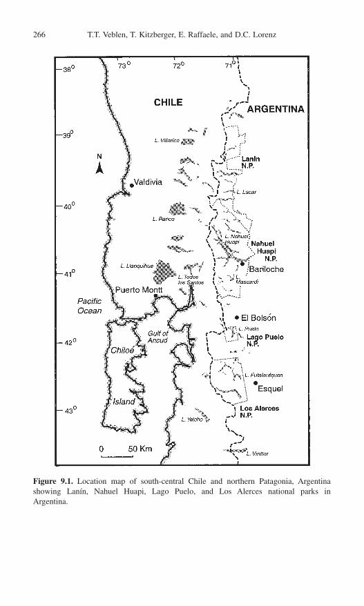
266 T.T. Veblen, T. Kitzberger, E. Raffaele, and D.C. Lorenz
Figure 9.1. Location map of south-central Chile and northern Patagonia, Argentinashowing Lanín, Nahuel Huapi, Lago Puelo, and Los Alerces national parks in Argentina.
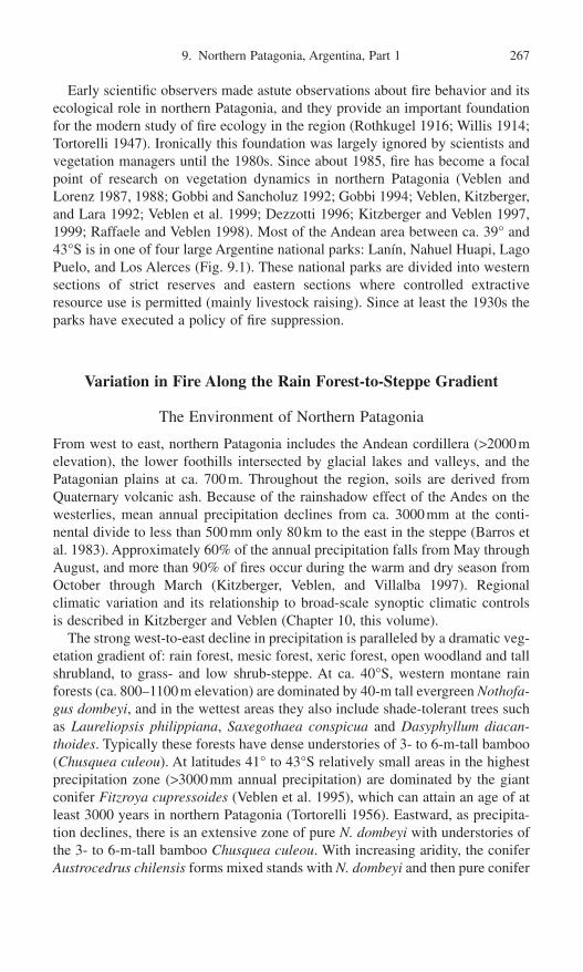
9. Northern Patagonia, Argentina, Part 1 267
Early scientific observers made astute observations about fire behavior and itsecological role in northern Patagonia, and they provide an important foundationfor the modern study of fire ecology in the region (Rothkugel 1916; Willis 1914;Tortorelli 1947). Ironically this foundation was largely ignored by scientists andvegetation managers until the 1980s. Since about 1985, fire has become a focalpoint of research on vegetation dynamics in northern Patagonia (Veblen andLorenz 1987, 1988; Gobbi and Sancholuz 1992; Gobbi 1994; Veblen, Kitzberger,and Lara 1992; Veblen et al. 1999; Dezzotti 1996; Kitzberger and Veblen 1997,1999; Raffaele and Veblen 1998). Most of the Andean area between ca. 39° and43°S is in one of four large Argentine national parks: Lanín, Nahuel Huapi, LagoPuelo, and Los Alerces (Fig. 9.1). These national parks are divided into westernsections of strict reserves and eastern sections where controlled extractiveresource use is permitted (mainly livestock raising). Since at least the 1930s theparks have executed a policy of fire suppression.
Variation in Fire Along the Rain Forest-to-Steppe Gradient
The Environment of Northern Patagonia
From west to east, northern Patagonia includes the Andean cordillera (>2000melevation), the lower foothills intersected by glacial lakes and valleys, and thePatagonian plains at ca. 700m. Throughout the region, soils are derived fromQuaternary volcanic ash. Because of the rainshadow effect of the Andes on thewesterlies, mean annual precipitation declines from ca. 3000mm at the conti-nental divide to less than 500mm only 80km to the east in the steppe (Barros etal. 1983). Approximately 60% of the annual precipitation falls from May throughAugust, and more than 90% of fires occur during the warm and dry season fromOctober through March (Kitzberger, Veblen, and Villalba 1997). Regional climatic variation and its relationship to broad-scale synoptic climatic controls is described in Kitzberger and Veblen (Chapter 10, this volume).
The strong west-to-east decline in precipitation is paralleled by a dramatic veg-etation gradient of: rain forest, mesic forest, xeric forest, open woodland and tallshrubland, to grass- and low shrub-steppe. At ca. 40°S, western montane rainforests (ca. 800–1100m elevation) are dominated by 40-m tall evergreen Nothofa-gus dombeyi, and in the wettest areas they also include shade-tolerant trees suchas Laureliopsis philippiana, Saxegothaea conspicua and Dasyphyllum diacan-thoides. Typically these forests have dense understories of 3- to 6-m-tall bamboo(Chusquea culeou). At latitudes 41° to 43°S relatively small areas in the highestprecipitation zone (>3000mm annual precipitation) are dominated by the giantconifer Fitzroya cupressoides (Veblen et al. 1995), which can attain an age of atleast 3000 years in northern Patagonia (Tortorelli 1956). Eastward, as precipita-tion declines, there is an extensive zone of pure N. dombeyi with understories ofthe 3- to 6-m-tall bamboo Chusquea culeou. With increasing aridity, the coniferAustrocedrus chilensis forms mixed stands with N. dombeyi and then pure conifer

stands; understories become less dense as Chusquea is replaced by xeric shrubsand small trees such as Aristotelia chilensis and Lomatia hirsuta. Near theecotone with the steppe, Austrocedrus stands form open woodlands with bunchgrasses and low shrubs such as Discaria articulata and Mulinum spinosum.
The small deciduous tree Nothofagus antarctica often dominates sites that areunfavorable for development of tall forest including (1) relatively xeric sites thatare transitional to the steppe; (2) bottoms of broad valleys that have more finelytextured soils and a high probability of cold-air drainage resulting in temperatureinversions; (3) sites along streams and bogs with elevated water tables; (4) mid-slope sites of shallow soils, often on north-facing slopes that become extremelydry during the summer; and (5) high-elevation sites exposed to strong winds thatprevent a protective snow cover from forming (McQueen 1976; Seibert 1982).Open woodlands of 4- to 6-m-tall N. antarctica are most common in broad valleysin the transition toward steppe. On midslopes from 900 to 1200m, at intermedi-ate positions along the precipitation gradient, N. antarctica forms dense 2- to 4-m-tall shrublands with xerophyllous tree or shrub species such as Schinuspatagonicus, Lomatia hirsuta, Embothrium coccineum, Diostea juncea, Maytenusboaria, and/or the bamboo Chusquea culeou (Rodríguez et al. 1978; Seibert1982). Subalpine forests of the deciduous Nothofagus pumilio occur at elevationsof 1100 to 1200m, above either midslope shrublands or mesic montane forests.North of ca. 40°30¢, the deciduous Nothofagus nervosa (syn. alpina, procera) andN. obliqua occur at mid-elevations below subalpine N. pumilio forests and abovethe more xeric habitat of Austrocedrus (Veblen et al. 1996). Nothofagusobliqua–N. nervosa forests are mainly restricted to elevations of 600 to 900m insouthwestern Lanín National Park. North of 40°20¢S, Araucaria araucana occursalong the west-to-east precipitation gradient from mesic forests with N. dombeyior N. pumilio to tall shrublands of N. antarctica and open woodlands with steppeshrubs and grasses (Veblen et al. 1995). Its main distribution is centered around39°S in northern Lanín National Park.
Fire Behavior and Its Consequences in the Major Ecosystem Types of Northern Patagonia
Rain Forest Dominated by Fitzroya Cupressoides and Nothofagus Dombeyi
Despite the high precipitation characteristic of Fitzroya-dominated forests, fire isa major source of disturbance. Fires in these rain forests occur naturally or areset by humans during infrequent dry years (Kitzberger, Veblen, and Villalba 1997;Veblen et al. 1999). Because the bark is typically greater than 20-cm thick onlarge (>1.5m diameter) trees, Fitzroya often survive intense fires that kill all associated thin-barked tree species (e.g., Laureliopsis philippiana, Nothofagusdombeyi, and Saxegothaea conspicua; Table 9.1). Age structures in these forestsindicate that scattered old (>1000 years) Fitzroya may continue to dominate a sitethrough several cycles of fire-induced mortality and regeneration of N. dombeyiand S. conspicua (Veblen et al., unpublished data). Stand-replacing fires alsocreate open conditions suitable for the seedling establishment of the highly
268 T.T. Veblen, T. Kitzberger, E. Raffaele, and D.C. Lorenz

9.N
orthern Patagonia, Argentina, Part 1
269Table 9.1. Traits of common trees and shrubs of northern Patagonia relevant to their resistance to and recovery from fire
New recruitmentfrom
Think-barked Prolific Buriedfire and Resprouting postfire viable
Species resistant capacity seeding seed Notes
TreesAraucaria araucana ¥ ¥ Irregularly root suckers and basal sproutsAustrocedrus chilensis Large trees resist fireFitzroya cupressoides ¥ ¥ Large trees resist fire; irregularly root suckersNothofagus antarctica ¥ Vigorously resprouts from lignotubers and basal budsN. dombeyi ¥ Large trees weakly resist fireN. nervosa ¥ ¥ ¥ Large trees resist fire; resprouting is irregularN. obliqua ¥ ¥ ¥ Large trees resist fire; irregularly resproutsN. pumilio Small trees are thin-barked and easily killed by fireSaxegothaea conspicua ¥ Even large trees are thin-barked and easily killed by fire
ShrubsAristotelia chilensis ¥ ¥ Resprouts from basal budsBerberis spp. ¥ Vigorously resprouts from basal budsChusquea culeou ¥ Vigorously resprouts from extensive rhizomesDiostea juncea ¥ ¥ Vigorously resprouts from roots and stemDiscaria articulata ¥ Resprouts from rhizomes; highly flammableEmbothrium coccineum ¥ Highly flammable; resprouts from basal budsFabiana imbricata ¥ ¥ Resprouts from large tap rootsLomatia hirsuta ¥ Highly flammable; vigorously resprouts from basal budsMaytenus boaria ¥ Resprouts from basal buds and lateral rootsSchinus patagonicus ¥ Vigorously resprouts from basal roots
Sources: Tortorelli 1947, 1956; McQueen 1976; Seibert 1982; Veblen and Lorenz 1987; Ghermandi 1992.

shade-intolerant Fitzroya, which tends to be replaced by other tree species in theabsence of coarse-scale disturbance. New cohort development plus resistance oflarge trees to burning, ensures the persistence of Fitzroya when rain forests areburned. The dependence of Fitzroya on coarse-scale disturbance (fire, landslides,and floods) over most of its range in northern Patagonia results in stands of oldcohorts with scant regeneration, which formerly was interpreted incorrectly asevidence of a species in decline due to long-term climatic change (Kalela 1941;Tortorelli 1956; Rodríguez et al. 1978).
Nothofagus Dombeyi Dominated Mesic Forests
Throughout the zone of mesic Nothofagus dombeyi forests, postfire age structuresand charcoal in the soil indicate the widespread importance of fire (Eskuche 1968;Singer 1971; Seibert 1982; Veblen and Lorenz 1987). N. dombeyi is thin-barkedand does not regenerate vegetatively. Small-diameter stems, such as those inyoung postfire cohorts, are easily killed by fire, but sporadic large-diameter treescan survive and provide seed sources (Tortorelli 1947). It is a prolific seeder, andat favorable sites it grows rapidly into extensive even-aged stands (Fig. 9.2e–f).Thus postfire regeneration from seed is typically successful as long as seedsources are within about 50 to 100m (Veblen and Lorenz 1987; Kitzberger andVeblen 1999).
Toward the drier end of its range, N. dombeyi jointly colonizes postfire siteswith Austrocedrus chilensis. However, over most of the moisture gradient wherethe two species co-occur, Austrocedrus is often markedly less abundant in early(<20 years old) postfire stands (Veblen and Lorenz 1987). Age structure analy-ses of co-dominated postfire stands indicate that the populations of both speciesare of similar age (Fig. 9.2c–d). As mesic Austrocedrus–N. dombeyi postfirestands develop, large gaps (>1000m2) are created by the death of large N. dombeyiindividuals. In gaps of this size, small numbers of both N. dombeyi and Austrocedrus may establish, and eventually all-aged tree populations develop inolder stands (Veblen 1989). At edaphically less favorable sites in valley bottoms,postfire stands may be initially dominated by the short-lived, resprouting N.antarctica which is eventually replaced by the long-lived N. dombeyi (Veblen and Lorenz 1987). Frequent burning, often followed by livestock browsing, mayconvert some former N. dombeyi sites to long-lasting shrublands (Tortorelli1947).
Nothofagus Pumilio Subalpine Forests
Subalpine Nothofagus pumilio forests occur in cooler, more mesic habitats thanmany of the neighboring vegetation types. This may account for its relatively lowcontribution to the total area burned despite the great extent of this cover type inthe landscape (Fig. 9.3). N. pumilio is thin barked, easily killed by fire, and generally does not resprout after fire (Table 9.1). If postfire site conditions arefavorable (i.e., not too xeric) and seed sources are available, it can regenerateabundantly following stand-replacing fires (Fig. 9.2g). However, after some fires
270 T.T. Veblen, T. Kitzberger, E. Raffaele, and D.C. Lorenz

9. Northern Patagonia, Argentina, Part 1 271
Figure 9.2. Tree age frequency diagrams for postfire stands of pure Austrocedrus chilen-sis (a and b), mixed Austrocedrus-Nothofagus dombeyi (c and d), pure N. dombeyi (e andf), and pure N. pumilio (g). (Data from Veblen and Lorenz 1987; Kitzberger 1994; Veblenet al., unpublished.)
it fails to regenerate (Veblen et al. 1996). In the case of intense fires affectinglarge surface areas, the absence of surviving seed trees is clearly an importantfactor in the lack of tree regeneration. For example, following the intense andextensive burning of N. pumilio forests in 1999 in southern Nahuel Huapi
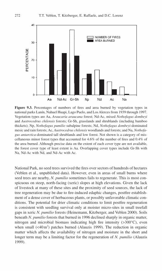
National Park, no seed trees survived the fires over sectors of hundreds of hectares(Veblen et al., unpublished data). However, even in areas of small burns whereseed trees are nearby, N. pumilio sometimes fails to regenerate. This is most con-spicuous on steep, north-facing (xeric) slopes at high elevations. Given the lackof livestock at many of these sites and the proximity of seed sources, the lack oftree regeneration may be due to fire-induced edaphic changes, postfire establish-ment of a dense cover of herbaceous plants, or possibly unfavorable climatic con-ditions. The potential for drier climatic conditions to limit postfire regenerationis consistent with seedling survival only at moister micro-sites in small treefallgaps in xeric N. pumilio forests (Heinemann, Kitzberger, and Veblen 2000). Soilsbeneath N. pumilio forests that burned in 1996 declined sharply in organic matter,nitrogen and microbial biomass indicating high fire intensity (>300°C), evenwhen small (<40m2) patches burned (Alauzis 1999). The reduction in organicmatter which affects the availability of nitrogen and moisture in the short andlonger term may be a limiting factor for the regeneration of N. pumilio (Alauzis1999).
272 T.T. Veblen, T. Kitzberger, E. Raffaele, and D.C. Lorenz
Figure 9.3. Percentages of numbers of fires and area burned by vegetation types innational parks Lanín, Nahuel Huapi, Lago Puelo, and Los Alerces from 1939 through 1997.Vegetation types are Aa, Araucaria araucana forest; Nd-Ac, mixed Nothofagus dombeyiand Austrocedrus chilensis forests; Gr-Sh, grasslands and shrublands (including bamboothickets); Np, Nothofagus pumilio subalpine forests; Nd, Nothofagus dombeyi-dominatedmesic and rain forests; Ac, Austrocedrus chilensis woodlands and forests; and Na, Nothofa-gus antarctica-dominated tall shrublands and low forest. Not shown is a category of mis-cellaneous minor forest types that accounted for 4.6% of the number of fires and 0.4% ofthe area burned. Although precise data on the extent of each cover type are not available,the forest cover type of least extent is Aa. Overlapping cover types include Gr-Sh withNa, Nd-Ac with Nd, and Nd-Ac with Ac.

Nothofagus Obliqua and N. Nervosa Forests
Both Nothofagus obliqua and N. nervosa have moderately thick bark and resproutafter being cut or burned (Veblen et al. 1996). Most N. obliqua-dominated forestsare second-growth stands that originate after burning and cutting, and have beensubject to heavy, long-term livestock impacts. N. obliqua occurs mostly in rela-tively open stands where multiple fire scars on it indicate its ability to survivesurface fires. In the north, N. obliqua occurs sporadically at the steppe ecotoneand in association with Araucaria araucana where fire scars indicate its abilityto tolerate surface fires. At more mesic sites (higher elevation and south-facingslopes), N. nervosa co-occurs with the evergreen N. dombeyi where fires are morelikely to be stand replacing.
Austrocedrus Chilensis Forests and Woodlands
Austrocedrus is killed by intense fires due to its relatively thin bark and is gen-erally not capable of vegetative reproduction. Stand-replacing fires are typical ofdense pure Austrocedrus stands and result in even-aged postfire cohorts (Fig.9.2a–b). Eastward, under more xeric conditions, fuels are discontinuous and lowintensity surface fires predominate. Many adult trees survive these surface fires.Toward the steppe, or on xeric slopes, Austrocedrus regeneration occurs sporad-ically in space and time resulting in open woodlands with heterogeneous age dis-tributions (Veblen and Lorenz 1988; Burns 1991; Villalba and Veblen 1997a). Incontrast to the mesic, dense stands where regeneration is limited by light condi-tions and competition, the limiting factors for seedling establishment in the openwoodland habitat appear to be the desiccating effects of open sites (Kitzberger,Steinaker, and Veblen 2000). Large herbivores (mainly introduced deer and live-stock) also can inhibit the regeneration of Austrocedrus (Veblen et al. 1989, 1992;Relva and Veblen 1998). In early postfire stages, Austrocedrus seedlings typicallyestablish in association with shrubs such as Discaria articulata, Schinus patag-onicus, Berberis spp. and Lomatia hirsuta. These resprouting species, many ofwhich have spines or thorns, form dense patches beneath which Austrocedrusseedlings occur. This shrub cover offers protection against browsing and providesprotection from excessive temperatures and moisture stress in the drier habitats(Kitzberger, Steinaker, and Veblen 2000).
Araucaria Araucana Forests and Woodlands
Araucaria araucana occurs in habitats that are prone to fire due to the intensityof the summer drought and frequent ignitions by humans (Tortorelli 1947; Veblenet al. 1995). Although this forest type covers less area than most or all other foresttypes, it accounts for the largest percentage of area burned in any vegetation typeover the 1938 to 1997 record (Fig. 9.3). Fire-promoting characteristics of thisforest type include the highly flammable wood and leaf litter of Araucaria andrapid accumulation of dead branches from the common crown dieback of theassociated Nothofagus antarctica. Large Araucaria have fire-resistant thick bark
9. Northern Patagonia, Argentina, Part 1 273
and an umbrella crown shape that places foliage out of reach of surface fires. Fol-lowing fire it sprouts weakly from basal epicormic buds, and the protected ter-minal buds on branches survive many fires (Tortorelli 1947; Burns 1993).
At the moderately xeric sites occupied by the Araucaria–N. antarctica associ-ation, postfire sites are initially dominated by the resprouting N. antarctica withscattered large Araucaria that survive the fire. Araucaria seedlings emanatingfrom trees surviving the fire or newly dispersed seed to the site, establish underpartial shade and dominance gradually shifts from N. antarctica to Araucaria.After about 150 years without further fire, Araucaria suppresses and excludes the senescent N. antarctica subcanopy so that the vegetation develops into anAraucaria-dominated forest (Burns 1993). At mesic sites, postfire cohorts of N.pumilio or N. dombeyi may establish concurrently with Araucaria, but typicallymany large Araucaria also survive the fires (Burns 1991).
Nothofagus Antarctica Woodlands and Other Tall Shrublands
Given their proximity to the open steppe and their utilization by cattle, Nothofa-gus antarctica woodlands in broad valley bottoms tend to be sites of frequenthuman-set fires. Heavy epiphyte loads of the highly flammable Usnea lichen, aswell as abundant partially dead crowns of N. antarctica, contribute to the flam-mability of N. antarctica-dominated vegetation. The surprisingly small extent offire in this type reported in national park data (Fig. 9.3) undoubtedly reflects theinclusion of N. antarctica-dominated stands in other vegetation types (mainlygrassland-shrubland and Araucaria araucana woodlands). Many N. antarctica-dominated shrublands are early stages of postfire succession that eventually resultin recovery to N. dombeyi and/or Austrocedrus forests (Seibert 1982; Veblen andLorenz 1987; Kitzberger and Veblen 1999). Recovery to forest is often retardedby repeated burning, heavy livestock pressure, and severe erosion followingintense fires on steep slopes.
Shrublands dominated by Nothofagus antarctica, Lomatia hirsuta, Schinuspatagonicus, Embothrium coccineum, Chusquea culeou, and/or Diostea junceaare highly prone to burning due to fuel and site conditions. In dense shrublandsthe decurrent multistemmed growth form of the small trees and shrubs providefuel ladders for crowning of surface fires. Vigorous resprouting of all the tree andshrub species (Table 9.1) allows for rapid fuel recovery that in turn permits shortfire return intervals (Veblen, Kitzberger, and Lara 1992). The midslope habitat ofshrublands on north-facing slopes is exceptionally dry during the summer monthsdue to higher temperatures and low soil moisture capacity of the thin soils(Rodríguez et al. 1978; Seibert 1982). Climbing daisies, Mutisia spp., are abun-dant in tall shrublands, and the annual dieback of their stems probably enhancefire spread from the ground into shrub crowns.
Steppe
Fire is an important disturbance in the western extent of the Patagonian steppewhere plant cover is more extensive than in the interior of the continent. Near
274 T.T. Veblen, T. Kitzberger, E. Raffaele, and D.C. Lorenz

the Andean foothills, plant covers of approximately 60% correspond to between700 and 1100kg/ha of fine fuels (Bran 1996). Here the steppe consists of a matrixof scattered cushion shrubs (Mulinum spinosum) interspersed with tussockgrasses (Stipa speciosa, Festuca pallescens), forbs (e.g., Euphorbia collina, Solidago spp.), and exotic herbaceous species such as Rumex acetosella. Mostspecies are flammable due to the consistently warm dry summers of the steppe.Fire is sometimes used for improving forage quality for livestock over smallareas; however, steppe fires can also become large and out of control as in thecase of a fire that lasted for six days and burned over 8000ha in Nahuel HuapiNational Park in 1996 (Delegación Técnica Regional Patagonia 1996a).
Recovery after fire in the steppe is rapid due the capacity of nearly all thecommon shrubs and herbs to resprout from basal buds on stems or root crowns,or from rhizomes and other underground organs. At some sites, however, post-fire erosion can impede recovery, as can livestock that are attracted to recentlyburned steppe by the abundance of tender new shoots.
Human Impacts on Fire Regimes
Pre-1880: Native American Influences
Paleoenvironmental records document fire at least as early as 12,600BP in thesouthern Andean region (Heusser 1987, 1994; Markgraf and Anderson 1994).During the prehistoric period in northern Patagonia, fires were ignited both byhumans and lightning. The earliest evidence of human occupation in northernPatagonia dates from 8000 to 7000BP (Crivella and Silveira 1983), and sedi-mentary records of charcoal have been dated to as early as 3000 years BP(Heusser et al. 1988). Native Americans affected fire regimes and the landscapesof northern Patagonia through intentional burning for hunting purposes, agricul-tural practices, collecting seed, opening of travel routes through dense forest, andperhaps also for pasture management after European livestock arrived in the seventeenth and eighteenth centuries.
Use of Fire at the Woodland/Steppe Ecotone
Use of fire in northern Patagonia for hunting guanacos (Lama guanicoe, an American camelid), rheas (Pterocnemia pennata, a 1.5-m-tall ratite bird), andhuemules (Hippocamelus bisulcus, a deer) in the ecotone of open Austrocedruswoodlands and steppe is well documented by archeological evidence and by theobservations of early explorers and missionaries (Veblen and Lorenz 1988). Theassociation of human remains with guanaco bones dates from ca. 6340 years BPand suggests that the earliest human inhabitants were hunters (Crivella and Sil-veira 1983). Explorers of northern Patagonia provide eyewitness accounts of theuse of fire by native hunters to encircle and drive guanacos and rheas (Cox 1863;Fonck 1896; Musters 1871).
9. Northern Patagonia, Argentina, Part 1 275

Possession of European livestock by the native inhabitants of northern Patagonia as early as the seventeenth century (Furlong 1964) may have been amotive to burn to create or improve pasture. Cox (1863) noted that the abundanttoldos (shelters) at Caleufú were periodically moved when the horses and sheepexhausted the local grass supply. Burning of “pasture” is reported for northernPatagonia (Musters 1871), and the same ethnic group (Mapuches) is described as“annually burning the grass” in nearby livestock raising areas in southern Chile(Smith 1855). According to Mapuche oral traditions, fires were intentionally setto improve pasture (Salguero 1998). Signal fires were widely used by the indige-nous population of Patagonia, and occasionally they may have escaped to becomewildfires (Moreno 1897).
Fire frequencies began to increase at most Austrocedrus woodland sites about1840 and peaked in the late nineteenth century (Fig. 9.4). The midnineteenthcentury increase in fires is coincident with increased use of the Austrocedrushabitat by Native American hunters as a result of immigration across the Andes,stimulated by the European colonization of southern Chile (Cox 1863). A prob-able increase in burning of Austrocedrus woodlands by Native American huntersin the mid-1800s is suggested by contrasting fire-scar records from two adjacentsites separated by the large Limay River (Fig. 9.5). The West Limay site wassettled by native hunters in the nineteenth century and earlier (Cox 1863; Musters1871; Crivella and Silveira 1983) and shows a substantial increase in fire occur-rence beginning in the mid-1800s (Fig. 9.5). In contrast, the location of the EastLimay site east of the river would have impeded human access and/or fire spreadfrom the western settled area. The East Limay site does not show an increase inburning in the mid-1800s. Prior to 1800 both sites supported similar rates ofburning, which suggests that the increased rate of burning in the mid-1800s atWest Limay is at least partially due to humans. However, when major fire years(i.e., years in which fire scars occur on more than a single tree) are considered,there is a regionally extensive increase in burning beginning in the mid-1800sthat coincides with greater interannual climatic variation (see Kitzberger andVeblen, Chapter 10, this volume). Thus both humans and climatic variationappear to be responsible for increased burning after the mid-1800s.
Fires in the Mesic Forest Zone
Burning believed to have been anthropogenic was also reported for the mesic andrain forest districts. Large burns (quemazones) were observed in 1787 by PadreFrancisco Menéndez (Fonck 1896) in the Nahuel Huapi region and, in particu-lar, along the camino de Vuriloche, the famed Andean crossing southwest of LakeNahuel Huapi (Fig. 9.1). All mid-nineteenth-century explorers (Emilio Valverde,Oscar de Fischer, Juan Steffen, Francisco Fonck, and Fernando Hess) observedextensive burns in the mesic forests of the Andes, from Lake Nahuel Huapi south-ward to Rio Puelo (42°S) and Rio Palena (43°40¢S; Fonck 1896).
Some of the burns reported along Andean travel routes by eighteenth- and nineteenth-century explorers, may have been intentionally set to keep clear the
276 T.T. Veblen, T. Kitzberger, E. Raffaele, and D.C. Lorenz

9. Northern Patagonia, Argentina, Part 1 277
Figure 9.4. Records of regional trends in fire occurrence based on (a) percentage ofFitzroya cupressoides rain forest trees recording fire in the same years (40 trees from 3sites) and (b) percentage of Austrocedrus woodland sites at which at least 10% of therecorder trees recorded fire in the same year (16 sites with a total of 331 fire-scarred trees).Sample depth lines give (a) the number of fire-scarred trees alive and (b) the number ofsites with fire-scarred trees alive. (Data from Veblen et al. 1999.)

trading routes across the Andes (Alvarez 1984; Bengoa 1985). Without fire orfrequent cutting, the rain forest routes across the Andes become nearly impene-trable to humans because of the dense understories of Chusquea bamboos. Thenative inhabitants of the Lake Nahuel Huapi region also used fire to prepare sites
278 T.T. Veblen, T. Kitzberger, E. Raffaele, and D.C. Lorenz
Figure 9.5. Records of fire scars on individual trees (top) and composite fire chronolo-gies (below) for West Limay (a) and East Limay (b) sample sites in Austrocedrus wood-land. The two 2-km2 area sites are adjacent but separated by the large Limay River. Eachhorizontal line represents an individual tree on which dates of fire scars are indicated byshort vertical lines. Pith dates and bark dates are indicated by vertical lines at the begin-ning or end, respectively, and dates of innermost and outermost rings are indicated by half-arrows, respectively. Dashed lines indicate years prior to the occurrence of the first scaron that tree. Vertical lines drawn to the x-axis indicate occurrence of fire scars on at leastone tree in the sample area and are the composite fire chronologies. (Data from Kitzbergerand Veblen 1997.)

in the humid forest district for crop cultivation (Furlong 1964; Cox 1863). Earlytwentieth- and nineteenth-century observers in the Araucaria forests of northernPatagonia report intentionally set fires for clearing the understory to facilitate col-lection of the large Araucaria seeds (Rothkugel 1916; Tortorelli 1947).
Lightning- Versus Human-Set Fires
Although the native inhabitants undoubtedly set fires throughout their long occu-pation in northern Patagonia, it is not known what percentage of fires recordedeither in sedimentary records or in tree-ring records were ignited by humans orby lightning. Comparison of tree-ring records of fire history with documentaryrecords of lightning-ignited fires suggests that for northern Patagonia, NativeAmericans increased the rate of burning over the natural rate. In all four north-ern Patagonian national parks (ca. 1.4 ¥ 106 ha), 46 lightning-ignited fires wererecorded in only 22 years from 1938 to 1996 or 1.57 fire years per 100,000ha(Administración de Parques Nacionales, unpublished data). In contrast, for the59 years preceding Euro-American settlement (1822–1880), the mean number offire years is 6.4 for 8 sample areas of about 400ha each in Austrocedrus wood-lands, or 1600 fire years per 100,000ha. During the preceding 59-year period(1764–1822), when fire frequency was lower, 688 fire years occurred per 100,000ha. Even allowing for omission of some lightning-ignited fires from the parkobservations, these large differences in numbers of fires suggest that the high rateof burning prior to 1880 could not be accounted for by lightning alone.
European Settlement in the 1880s to 1920s
The 1890s to early 1900s was a period of extensive forest burning by Europeansettlers to create cattle pasture (Moreno 1897; Steffen 1909; Willis 1914;Rothkugel 1916). For the Provinces of Neuquén, Rio Negro, and Chubut,Rothkugel (1916) mapped 692,000ha (37% of the total forest area) as havingburned during the European settlement period prior to 1915. This burning alsoresulted in the establishment of extensive even-aged, pure Nothofagus forestswith cohort ages indicating a marked peak in burning ca. 1900 (Fig. 9.6). Simi-larly a sedimentary record from a bog at 41°16¢S contains a 50-cm-thick layer of charcoal dating from this period (Markgraf 1983). In Fitzroya rain forests fire records from accessible sites near important trans-Andean travel routes show increased burning in the 1890s and early 1900s (Fig. 9.4a) in contrast tono increase at a remote, inaccessible Fitzroya site (Veblen et al. 1999).
Modern Fire Exclusion Period: Post-1920s
Following the 1880s the fire-scar record indicates a sharp decline in fire in Austrocedrus woodlands near the steppe (Fig. 9.4). Three factors contribute tothe low incidence of fire in the open Austrocedrus woodlands during the twenti-eth century relative to the nineteenth century: (1) decrease in intentionally setfires, (2) fuel reductions due to increased grazing by livestock, and (3) active fire
9. Northern Patagonia, Argentina, Part 1 279

suppression. With the demise of the Native American hunting populations, thenumber of intentionally set fires in the woodland/steppe ecotone declined in the1890s to early 1900s. This was also a time of increased livestock utilization ofthis habitat (Willis 1914; Eriksen 1971). Despite the efforts of local authoritiesto suppress fires as early as 1913, most fires appear to have been extinguished byrain due to the absence of fire-fighting infrastructure (Rothkugel 1916). Relativelyrapid access by horse and motor vehicle to sites in the woodland/steppe habitatafter about 1920 facilitated fire suppression efforts in that habitat. In contrast,even today, access to much of the wet forest zone is limited, and it is unlikelythat active fire suppression has had much impact on fire in these forests. It appearsthat the decline in fire frequency was primarily the result of a decrease in human-set fires in the Austrocedrus woodlands and possibly decreased fuels due tograzing rather than active fire suppression.
National park records since 1938 indicate that in some years, fires continue tobe common and extensive despite the adoption of a fire exclusion policy by parkauthorities in the 1920s (Figs. 9.7 and 9.8). The relative scarcity of fire scarsduring the post-1938 period (Fig. 9.4) is a reminder that trends in fire-scar dataare only relative indicators of past fire. In particular, the extensive zone of mono-typic N. dombeyi forests lack species that are good recorders of fire scars; thusthe absence of fire scars does not necessarily imply absence of fire. The nationalpark records do not include the pre-fire exclusion period which limits evaluationof the effect of fire suppression. However, since 1938 there is no trend towarddeclining fire frequency (Fig. 9.7), and years of widespread fire continued tooccur during the 1980s and 1990s (Fig. 9.8).
280 T.T. Veblen, T. Kitzberger, E. Raffaele, and D.C. Lorenz
Figure 9.6. Dates of stand-initiating fires in 10-year classes for 31 Nothofagus dombeyiand Austrocedrus chilensis stands located between Lake Lacar in the north and LakeNahuel Huapi in the south. (Data from Veblen et al. 1992a.)
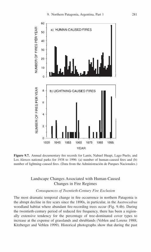
Landscape Changes Associated with Human-Caused Changes in Fire Regimes
Consequences of Twentieth-Century Fire Exclusion
The most dramatic temporal change in fire occurrence in northern Patagonia isthe abrupt decline in fire scars since the 1890s, in particular, in the Austrocedruswoodland habitat where abundant fire-recording trees occur (Fig. 9.4b). Duringthe twentieth-century period of reduced fire frequency, there has been a region-ally extensive tendency for the percentage of tree-dominated cover types toincrease at the expense of grasslands and shrublands (Veblen and Lorenz 1988;Kitzberger and Veblen 1999). Historical photographs show that during the past
9. Northern Patagonia, Argentina, Part 1 281
Figure 9.7. Annual documentary fire records for Lanín, Nahuel Huapi, Lago Puelo, andLos Alerces national parks for 1938 to 1996: (a) number of human-caused fires and (b)number of lightning-caused fires. (Data from the Administración de Parques Nacionales.)

100 years or so, especially Austrocedrus, but also other trees and tall shrubs suchas Lomatia hirsuta, Maytenus boaria, and Schinus patagonicus, have formeddense stands at sites that were formerly covered in grasses and low shrubs (Veblenand Lorenz 1988). At sites of increased tree density near the steppe, absence ofburnt spars, logs, and cut stumps indicate that burning or logging had notdestroyed a former forest cover in the nineteenth century. Instead, these open veg-etation types were maintained by fires occurring frequently enough to preventdevelopment of dense stands. Comparison of historical and modern photographs,as well as age structure data, indicate that abundant establishment of Austroce-drus began at the ecotone in the late 1800s (Veblen and Lorenz 1988). Reduc-tion in fire occurrence allowed much greater survival of juveniles of thisfire-sensitive species. The rate and timing of Austrocedrus establishment havebeen influenced by interannual and decadal-scale climatic variation (Villalba andVeblen 1997a; Kitzberger, Steinaker, and Veblen 2000) as well as by livestockimpacts (Veblen et al. 1992; Relva and Veblen 1998).
The increase in tree density in Austrocedrus woodlands and invasion of treesinto the steppe have created more contiguous woody fuels (Veblen, Kitzberger,and Lara 1992; Kitzberger and Veblen 1999) so that sites previously supportingonly surface fires are now susceptible to stand-replacing fires. In the submesicarea, remnant forest patches, resulting from widespread early twentieth-centuryburning, expanded and in many cases coalesced into continuous forest(Kitzberger and Veblen 1999). Thus, although forest fragmentation is considereda common trend under increasing human influences on wild landscapes elsewhere(e.g., Harris 1984), in protected areas of the forest-steppe ecotone the reverse offorest fragmentation has been the norm over the past approximately 70 years.
282 T.T. Veblen, T. Kitzberger, E. Raffaele, and D.C. Lorenz
Figure 9.8. Total area burned (hectares) for Lanín, Nahuel Huapi, Lago Puelo, and Los Alerces national parks for 1938 to 2001. (Data from the Administración de ParquesNacionales.)
Consequences of the Late-Nineteenth-Century Episode of Mesic Forest Burning
Extensive burning of mesic forests by Euro-American settlers in the 1890s to1920s resulted in vast areas of even-aged, regenerating Nothofagus-Austrocedrusforests (Veblen and Lorenz 1987; Veblen, Kitzberger, and Lara 1992; Kitzbergerand Veblen 1999). Thus most of the mesic forest zone is in a middle-aged (ca.80–110 years) postfire stage of stand development during which self-thinning produces abundant intermediate-sized fuels that may favor fire spread. We haveobserved some fires spreading through nearly 100-year-old postfire stands that didnot burn adjacent tall N. dombeyi forests. At a regional scale the synchronizationof stand development in the N. dombeyi forest zone resulting from the late 1800sburning may have increased the potential for fire spread at a regional scale.
During the Euro-American settlement period many forest sites were burnedmore than once (Rothkugel 1916). The initial burning of wet N. dombeyi forestsprobably increased the subsequent flammability of the site by eliminating the tallshade-producing overstory. Subsequent burns would have reduced seed sourcesfor arboreal species and promoted dominance by bamboo and shrubs that sproutvigorously after being burned (Table 9.1). Multiple burning of the same sitesresulted in extensive conversion of forests to shrub-dominated communities,which at some sites recovered to forest but at others have remained in shrublands.Once tall forest is converted to a bamboo thicket or shrubland, it is much moreflammable and likely to sustain higher fire frequencies than adjacent tall forests(Veblen et al. 1992a). In general, following forest burning, shrublands tend topersist where moisture conditions are marginal (e.g., on steep sites of easilyeroded soils), where repeated fires occurred, or where livestock impacts havebeen severe (Veblen et al. 1992b; Relva and Veblen 1998).
Configuration of remnant forest patches plays an important role in subsequentchanges in landscape pattern through its influence on dispersal of the obligateseed-reproducing N. dombeyi and Austrocedrus (Kitzberger and Veblen 1999).Postfire forest regeneration, at least over a period of less than a single tree gen-eration, is highly concentrated in a distance of about 25m from remnant forestpatches. In general, in Northern Patagonia the extensive even-aged postfirecohorts of N. dombeyi and N. dombeyi–Austrocedrus (Veblen and Lorenz 1987;Veblen Kitzberger, and Lara 1992) must have developed within the relativelyshort range of remnant seed-bearing trees (i.e., within 40 to 80m radii of thetallest trees).
It has been suggested that some of the strikingly sharp boundaries betweensubalpine N. pumilio forests and adjacent shrublands are maintained by differ-ences in flammability of these communities (Veblen and Lorenz 1988). N. pumilioforests have often been noted to burn less frequently than adjacent shrublands(Rothkugel 1916; Tortorelli 1947). The closed-canopies of the subalpine forestsproduce cool mesic microenvironments with short understory plants, and the mor-phology of the dominant tree does not provide fuel ladders for easy crowning offires. In contrast, micro-sites in the midslope shrublands are characterized by high
9. Northern Patagonia, Argentina, Part 1 283

temperatures and dry soils, and the multistemmed habit of the shrubs and smallN. antarctica facilitates fire-crowning. Furthermore the Chusquea bamboosprovide continuous fine fuels from near the ground surface to the top of the shrubcanopies. Where subalpine N. pumilio forests were burned during the early 1900s,in some (but not all) cases they may have been converted to shrublands that arelargely self-replacing because of their greater flammability.
The regional trend for grassland and shrubland vegetation types to be replacedby forest has been documented by comparing the 1913 vegetation map of Willis(1914) with modern vegetation maps of northern Patagonia (Kitzberger andVeblen 1999). These regional-scale vegetation transitions reflect both tree regen-eration at sites of forests burned in 1880 to 1920 and succession from grasslandor shrubland to forest cover during the post-1920 fire exclusion period. Compar-ison of aerial photographs of mosaics of N. dombeyi–Austrocedrus forests, shrub-lands and grasslands taken in 1940 and 1970 show that shrubland and grasslandareas have become more disjunct and in many cases have been completelyreplaced by tree cover (Kitzberger and Veblen 1999). Many areas that were grass-lands in 1940 were replaced by shrublands in 1970, and only areas relatively iso-lated from tree seed sources remained stable. During this period of reduced firefrequency there was a shift in dominance from species with short life spans andre-sprouting capacity (e.g., shrubs) toward longer-lived species and obligate seed-dispersers (e.g., Austrocedrus and N. dombeyi). The relatively restricted seed dis-persal ability of N. dombeyi and Austrocedrus may also explain the presence ofextensive shrublands of fire-resprouting species (e.g., N. antarctica, Maytenusboaria, and Lomatia hirsuta), where today small numbers of N. dombeyi and/orAustrocedrus are slowly invading. Similarly dendroecological studies in moremesic stands have demonstrated a shift during long fire-free periods from theshort-lived, postfire resprouting N. antarctica toward the long-lived, nonsprout-ing N. dombeyi (Veblen and Lorenz 1987).
Synergisms of Natural Variability and Anthropogenic Influences
Synchronous Flowering of Chusquea Bamboos
Chusquea bamboos are keystone species in the dynamics of the forests of south-ern Chile and northern Patagonia due to their importance as fuels and theirinhibitory influence on tree regeneration. At long intervals, estimated at 17 to over70 years, some Chusquea species flower synchronously over a two- to three-yearperiod and die massively over areas of many hundreds of square kilometers(Veblen 1982; Pearson, Pearson, and Gomez 1994; Gonzalez and Donoso 1999).Given the slow decay rate of the bamboo leaf litter and culms, such a massivedie-off results in an enormous amount of dry understory fuels in these forests forat least four or five years after flowering. When these flowering events coincidewith a dry year, the mesic forests of northern Patagonia and southern Chilebecome much more flammable. A massive flowering of Chusquea culeou affect-
284 T.T. Veblen, T. Kitzberger, E. Raffaele, and D.C. Lorenz
ing much of Lanín National Park and adjacent areas in Chile was initiated inNovember 2000, and it is the first regional-scale Chusquea flowering event innorthern Patagonia since 1940.
The peak of European burning of mesic forests in the 1890s to 1910s was facil-iated by unusually warm-dry weather and probably also by one or more massiveflowerings of Chusquea culeou. Hosseus (1915) noted that in 1914 someChusquea culeou were in flower around Lake Nahuel Haupi, and he believed thatthis was a harbinger of a massive flowering. Although we have been unable tounequivocally document this flowering, many long-term residents of northernPatagonia have reported to us that their grand parents or great grand parentsdescribed a massive flowering early in this century. Informants interviewed byPearson et al. (1994) reported a massive flowering between 1900 and 1904.Hosseus (1915) reported that local residents claimed that there had been a massiveflowering in 1890 too. It is probable that at least one massive flowering ofChusquea culeou occurred in northern Patagonia between 1890 and 1915, whichcoincides with the period of extensive burning of the mesic Nothofagus forestsby European settlers.
The late 1800s and early 1900s was also a time of severe droughts. Based onthe growth rings of Austrocedrus sampled throughout northern Patagonia, 1899to 1917 is the longest period of below-average tree growth (i.e., moisture deficit)since 1700 (Villalba and Veblen 1997b). Temperature reconstructions fromNothofagus pumilio and Fitzroya indicate that the first two decades of the twen-tieth century were among the warmest of the past 230 years (Villalba 1990; Villalba et al. 1997), and precipitation reconstructions from Austrocedrus iden-tify 1895 to 1919 as the driest 25-year period since 1599 (Villalba et al. 1998).Thus an abundance of dry fuels resulting from a probable massive flowering ofChusquea culeou during a period of prolonged drought coincided with the arrivalof European colonists intent on converting forest to pasture by extensive burning.
The 1944 Fire Year
The year 1944 was a year of extraordinary forest burning in northern Patagonia(Fig. 9.8). Since the beginning of the national park records in 1938, the 44,855ha burned in the four national parks in 1944 is by far the greatest area burned in any single year (Administración de Parques Nacionales, unpublished data).Almost all the area burned in the national parks in that year was due to human-set fires (Administración de Parques Nacionales, unpublished data). Most of thearea affected was in the south in Los Alerces National Park where a settler inten-tionally set a fire that burned 36,200ha of forest. Tortorelli (1947) reported onthe extensive burning that occurred outside of the national parks in 1944 in theprovince of Chubut and burned an estimated 275,000ha. Most of the fires wereset in Chile as rozas (for agricultural clearing) and spread into Argentina, butmany of the fires were also set in Argentina (Tortorelli 1947).
Such extensive human-set fires in the wet forest district were promoted by theoccurrence of drought and the massive flowering of Chusquea culeou. Eleven
9. Northern Patagonia, Argentina, Part 1 285
“credible” long-term residents of northern Patagonia reported a masive flower-ing of Chusquea culeou in about 1940 in around a 230km south-to-north stretchof the Andes from Lago Futalaufquén (43°S) to north of Lake Nahuel Huapi(41°30¢S). Massive flowering of Chusquea culeou is also reported for 1940 to1942 in adjacent parts of Chile (Gonzalez Cangas 1998). Thus extraordinaryquantities of drying bamboo fuel characterized the wet forests of northern Patagonia during the early 1940s. The springs and summers of 1942 and 1943were extremely dry throughout northern Patagonia, and especially near latitude43°S. For example, Martonne’s (1926) aridity index for November through February in 1943–44 indicates that this fire season was the second driest of thecentury and that no two-year period since 1905 had drier spring–summers thanthose of 1942 to 1944 (based on the Esquel climate station). As reconstructedfrom Austrocedrus tree rings throughout northern Patagonia, the lowest spring(November–December) precipitation from 1599 to 1988 occurred in 1943 (Villalba et al. 1998). Fire was also widespread in the summer of 1943 in the north-ern part of northern Patagonia, where Tortorelli (1947) described the rapid spreadof fire through 3500ha of Araucaria forest in January 1943 at the northern limitof Lanín National Park. He noted that the rapid spread of the fire was favored bycaña coligue seca (“dead bamboo”), suggesting that the flowering of Chusqueaculeou documented for ca. 42°S may have extended as far north as 39°S.
The 1996 and 1999 Fire Years
In 1996 approximately 8000ha of steppe and shrubland communities burned inthe national parks of northern Patagonia. This was the highest amount of burningrecorded in these community types since the begining of record keeping in 1938(Administración de Parques Nacionales, unpublished data). The previous spring(September–December 1995) precipitation was 1.7 standard deviation (SD)below the historical mean (1905–1996, Bariloche weather station), and earlysummer temperature (December) was 1 SD above the historical mean (1914–1996, Bariloche weather station). In 20 days four major fires burned over 12,000ha near the resort town of Bariloche. Two major fires occurred in steppe/ecotoneareas; one was ignited by lightning and burned nearly 8000ha mainly in steppevegetation (Delegación Técnica Regional Patagonia 1996a). This lightning-ignited fire began on a ranch where five years earlier livestock had been removed,resulting in a marked increase in fine fuels (Salguero 1998). Given a trend towardreduced livestock pressure (especially reduced sheep grazing) in northern Patag-onia during the 1990s, there may be a general increase in fire hazard due to greaterfuel accumulation in the steppe.
The second steppe fire, and two other large events that burned extensive areasof shrubland and xeric woodlands, were set by humans, possibly intentionally.Increased arson in the 1990s in the urban–forest interface may reflect socioeco-nomic tensions from the juxtaposition of an economically marginalized popula-tion surrounding the posh resort city of Bariloche. Accidental fires may also beon the increase due to greater recreational and residential use of the area. Aban-
286 T.T. Veblen, T. Kitzberger, E. Raffaele, and D.C. Lorenz

doned, unthinned Monterey pine (Pinus radiata) plantations contributed to thespread of one of the 1996 fires from its point of origin on the outskirts of the cityinto Challhuaco Valley in the adjacent national park (Delegación TécnicaRegional Patagonia 1996b).
During the 1998–99 fire season more than 14,000ha burned in Nahuel HuapiNational Park alone (Administración de Parques Nacionales, unpublished data).This major fire year followed the driest calendar year (1998) recorded in the 1905to 1999 Bariloche weather record as well as the warmest spring (October–Decem-ber) on record. Martonne’s (1926) index of aridity for the October 1998 throughFebruary 1999 period indicated moisture availability of only 10% of the long-term average. This extraordinary drought was associated with much more wide-spread burning in the zone of mesic forests than in the 1996 fire season, duringwhich fires occurred mainly in xeric woodland, shrubland, and steppe ecosys-tems. The susceptibility of mesic forests to widespread burning only during years of exceptional drought is also documented by the tree-ring record of fires(Kitzberger and Veblen, Chapter 10, this volume). The 1998–99 year of droughtand widespread burning also coinicided with a La Niña event, which typicallypromotes dry springs in northern Patagonia (Kitzberger and Veblen, Chapter 10,this volume). Although such intense drought is essential for fire spread in themesic forest zone, the major forest fires of 1999 were set by humans rather thanlightning (Delegación Técnica Regional Patagonia 1999). Preliminary data on firehistory in this zone indicate that much of the same area that burned in 1999 alsoburned in 1908 during a period of severe drought combined with abundant inten-tional burning by early colonists (Veblen et al., unpublished data).
Nothofagus Dieback
In addition to changes in fuels related to increased or decreased anthropogenicburning, natural stand dieback may contribute to increased fire hazard. Nothofa-gus pumilio and N. antarctica stands are characterized by an abundance of treeswith partially dead crowns. Although the etiologies of these dieback phenomenaare uncertain, contributory factors are believed to include (Veblen et al. 1996) (1) sites of marginal moisture availability, (2) cohort senescence following disturbance-induced regeneration, (3) partial recovery following defoliation byinsect outbreaks, and (4) heavy loads of the semiparasitic Misodendrum mistle-toe. Several or all of these factors may interact synergistically with interannualclimatic variability to promote in Nothofagus crown dieback. For example, warmwinters and dry springs are often associated with outbreaks of defoliating insectsfrom which Nothofagus often only partially recover (Veblen et al., unpublisheddata). Intense drought probably also contributes directly to the dieback in N.pumilio and N. antarctica.
Drought appears to be a major cause of mortality and dieback in Nothofagusdombeyi in the mesic forest zone. For example, following the severe 1998drought, there has been widespread mortality of N. dombeyi in northern Patagonia, especially in southern Nahuel Huapi National Park. Entire stands of
9. Northern Patagonia, Argentina, Part 1 287

large (>1m diameter) N. dombeyi, principally at sites located near the moisturelimits of this species, were dead by the summer of 1999–2000. In many cases,however, the tree survived while a few large branches or stem bifurcates died,thus creating a general appearance of stand-level partial dieback. We speculatethat earlier droughts contributed to the dieback N. dombeyi forests that was wide-spread prior to the 1998 drought.
Although photographs indicate that dieback in Nothofagus pumilio and N.antarctica was already widespread by 1900 (Willis 1914; Rothkugel 1916), European impacts on fire regimes may have increased the extent of dieback intwo ways. The extensive burning associated with European settlement has createdenormous areas of similarly aged cohorts that may dieback synchronously. Fur-thermore, in the case of N. antarctica, fire exclusion has substantially increasedthe percentage of its population that is in a senescent state. N. antarctica becomesmarkedly senescent at ages of 80 to 100 years and rarely survives beyond agesof around 150 years. However, burning rejuvenates it by promoting vigorousbasal sprouting, and younger trees show less incidence of dieback (Veblen andLorenz 1988). Reduction of fire in N. antarctica woodlands may also favor thebuildup of large epiphytic loads of the flammable Usnea lichen. At the same time,infection by the Misodendrum mistletoe probably increases in the absence of fire.Thus flammability and potential fire intensity have probably increased due to thereduction in fire frequency in N. antarctica woodlands and shrublands.
Introduced Animals and Plants
Introduced Large Herbivores
Introduced livestock and cervids have greatly affected the vegetation of the northern Patagonian landscape (Martín, Mermoz, and Gallopin 1985; Veblen etal. 1989, 1992; De Pietri 1992b; Relva and Veblen 1998). They have impededpostfire recovery at many sites, and they may have had a significant impact onfuel quality and quantity. Livestock numbers in the region peaked during the1930s (Ericksen 1971) and locally probably impeded the afforestation of somegrassland and shrubland areas (Tortorelli 1947). Although the major tree speciesare relatively resistant to browsing once they reach sapling stages, exceptionallyheavy cattle pressure during early postfire recovery can locally impede tree regen-eration and instead result in herbaceous turfs (with abundant exotic species) orshrublands of spiny shrubs and dwarfed trees (Veblen et al. 1992; De Pietri 1992b;Relva and Veblen 1998).
Large livestock populations since around 1890 are believed to have reducedplant cover in the steppe and probably also in open Austrocedrus woodlands. Forexample, overgrazing in some areas of steppe is believed to have reduced plantcover from initial values of 60% to less than 40%, which in turn has probablyreduced the spread of fires (D. Bran, personal communication, 1998). In someplant communities, however, livestock browsing may have increased flammabil-ity. Heavy pressure from introduced herbivores has shifted dominance toward lesspalatable species in shrublands (Veblen et al. 1992; Relva and Veblen 1998), and
288 T.T. Veblen, T. Kitzberger, E. Raffaele, and D.C. Lorenz
the morphological (rapid resprouting) and chemical features (secondary com-pounds) associated with defense against herbivory often increase flammability(Bond and Wilgen 1996).
In some northern Patagonian shrublands dominated by the relatively nonflam-mable but highly palatable Maytenus boaria, heavy livestock pressure has shiftedthe composition toward less palatable but more flammable species such as Dis-caria articulata, Diostea juncea, and Lomatia hirsuta. Conversely, monitoring oflivestock exclosures indicates that there is a shift back toward dominance by thepalatable Maytenus boaria that has a high moisture content, and other less flam-mable shrubs such as Berberis buxifolia and Ribes magellanicum in the absenceof cattle (Raffaele and Veblen, 2001). Outside the exclosures the highly flamma-ble Discaria articulata remained the dominant shrub in the community. Othershrublands that supported historically high levels of grazing are dominated by theunpalatable and flammable Diostea juncea and Lomatia hirsuta, both of whichare characterized by high foliar lignin content which results in slow decomposi-tion and abundant litter accumulation.
In forests with understories dominated by Chusquea culeou, livestock greatlyreduce the size and cover of the bamboos so that fuel loads and heights aremarkedly less. For example, heavy impact of livestock in Nothofagus dombeyiand Austrocedrus forests creates nearly bare understories where the lack of under-story fuels is striking (Veblen et al. 1992; Relva and Veblen 1998). Althoughmuch research remains to be done on fuel patterns and their modification by her-bivores in northern Patagonia, the overall impact of livestock appears to havebeen a generalized decrease in fine-fuel quantity in grasslands and forest under-stories and a possible shift toward more flammable species compositions in someshrublands.
Invasive Plant Species
There are more than 300 exotic vascular plant species that have naturalized innorthern Patagonia (Rapoport and Brión 1991). Exotic species are particularlycommon in habitats severely disturbed by livestock and logging, which have sig-nificantly altered natural fuel patterns and/or the capacity of the native vegeta-tion to respond to fire (Veblen et al. 1992b; Gobbi, Puntieri, and Calvelo 1995;Relva and Veblen 1998). Rumex acetosella is common in recently burned areasand propagates both vegetatively and from a persistent seed bank (Gobbi, Puntieri, and Calvelo 1995). The European broom (Sarothamnus scoparius) iscommon along roadsides and is highly flammable. Similarly Douglas fir(Pseudotsuga menziesii) has naturalized from timber and ornamental plantingsand is a common invader along trails and abandoned logging roads in the mesicNothofagus dombeyi forest. Thus Douglas fir is encroaching into high-light sitesthat otherwise would be occupied by the shade-intolerant N. dombeyi, and it isproviding more flammable fuels as well as fuel ladders into the tree canopy.
Probably the most conspicuous invading shrub in northern Patagonia is theEuropean rose (Rosa rubiginosa) which is especially common in the steppe
9. Northern Patagonia, Argentina, Part 1 289

ecotone but also occurs in anthropogenically disturbed mesic forest habitats.Although it is not particularly flammable, it may be important as a keystonespecies that alters rates of postfire recovery. R. rubiginosa appears to act as anurse plant for native woody species that are less browse-resistant but are capableof eventually replacing the invader (De Pietri 1992a).
Plantations of Exotic Tree Species
In the 1930s to 1950s, small areas of the national parks were planted to exoticconifers such as Sequoiadendron giganteum, Sequoia sempervirens, Picea spp.,and Pinus spp. (Dimitri 1972). In recent decades, planting of exotic trees has beenlimited to the national reserve eastern parts of the parks, where large areas ofPinus ponderosa have been planted since about 1980. By 1996 there were about4000 and 3500ha of exotic conifer plantation (90% Pinus ponderosa and 10%Pseudotsuga menziesii) in Nahuel Huapi and Lanín national parks, respectively,and a much larger area has been planted to Pinus ponderosa on properties justoutside the national parks. The highly flammable pines have been planted in areasthat were formerly open woodland or steppe where lack of fuel continuity wasan important limitation to fire spread. Today, however, large areas of these exoticconifers have created the potential for extensive crown fires in habitats formerlycharacterized only by surface fires. Poorly managed plantations that are unthinnedand lack fire breaks have further increased the potential for rapid spread of crownfires (e.g., the 1996 Challhuaco fire).
Conclusion and Management Considerations
Human activities and climatic variation are fundamental influences on fireregimes and landscape patterns in northern Patagonia. Although interannual cli-matic variation has a controlling influence in creating fuel conditions for thespread of fires in northern Patagonia, human activities also have had significantimpacts on fire regimes and landscape patterns in this region. Prior to the late1800s, fires set by Native Americans were important throughout the wood-land/steppe hunting grounds and were important locally along trans-Andeantravel routes in the mesic forest district. The impacts of increased burning in themesic forest zone by European settlers in the 1890s to 1910s remains conspicu-ous in the extensive even-aged Nothofagus stands in the modern landscape. Themodern fire exclusion period has been a time of transition from seral shrublandsto forest and expansion of Austrocedrus trees into grasslands. Interannual anddecadal-scale climatic variation has been an important preconditioning agent forthe spread of fires (Kitzberger, Veblen, and Villalba 1997; Veblen et al. 1999) andfor postfire vegetation responses (Villalba and Veblen 1997a; Kitzberger andVeblen 1999).
Major human-caused changes in fire regimes are also important to the spreadof fire in northern Patagonia landscapes. Potential fire spread in submesic areas
290 T.T. Veblen, T. Kitzberger, E. Raffaele, and D.C. Lorenz

has increased as trees regenerate following episodes of major anthropogenicburning in the early 1900s and early 1940s, and as formerly disjunct patches offorest coalesce. Similarly, near the steppe ecotone, formerly open woodlands ofAustrocedrus have been replaced by relatively dense stands during nearly 80years of reduced fire frequency. Thus, even if fewer human-set fires maintain arelatively low fire frequency, the increased connectivity of fire-susceptible vege-tation types probably has created a greater potential for high rates of fire spread.
One of the most obvious implications of the documented increase in fuel con-tinuity in the woodland/steppe ecotone is the need for public education of theincreased potential for stand-replacing fires. Many areas in this habitat are expe-riencing rapid residential growth that is exposing humans and property to highfire hazards. A major research need for effective planning of human activities inrelation to fire hazard is the development and implementation of a fuels classifi-cation and mapping program in northern Patagonia. Experimentation with dif-ferent mitigation strategies also is needed. For example, experimental prescribedburning should be examined as a technique for reducing fuels and fire hazard inareas of steppe and xeric woodland that have experienced decreases in grazingpressure.
Acknowledgments. This review is based on research funded by the NationalScience Foundation of the United States, the Fundación Nacional de Ciencia yTecnología of Argentina, the National Geographic Society, the UniversidadNacional del Comahue, and the Council for Research and Creative Work of theUniversity of Colorado. For critically commenting on the manuscript, we thankL. Daniels. For sharing insights about fire ecology and fire management and forfacilitating our research, we thank Mónica Mermoz, Juan Salguero, and CarlosMartín of Argentine National Parks.
References
Alvarez, G. 1984. Donde Estuvo el Paraíso del Tronador a Copahue. Siringa Libros,Neuquén, Argentina.
Alauzis, M.V. 1999. Cambios en la fertilidad química, físico-químico y biológica del sueloen parches incendiados de un bosque de Nothofagus pumilio. Thesis, UniversidadNacional del Comahue, Bariloche, Argentina.
Attiwell, P.M. 1994. The disturbance of forest ecosystems: The ecological basis for con-servative management. For. Ecol. Manag. 63:247–309.
Barros, V., Cordón, V., Moyano, C., Méndez, R., Forquera, J., and Pizzio, O. 1983. Cartasde precipitación de la zona oeste de las provincias de Rio Negro y Neuquén. Reportto the Facultad de Ciencias Agrarias, Universidad Nacional del Comahue, Cinco Saltos,Neuquén, Argentina.
Bengoa, J. 1985. Historia del Pueblo Mapuche (Siglo XIX y XX). Santiago, Chile: Ediciones Sur.
Bond, W.J., and van Wilgen, B.W. 1996. Fire and Plants. London: Chapman and Hall.Bran, D. 1996. El fuego en las estepas de la Patagonia Norte. Patagonia Silvestre 3:7–8.Burns, B.R. 1993. Fire-induced dynamics of Araucaria araucana—Nothofagus antarctica
forest in the southern Andes. J. Biogeogr. 20:669–685.Burns, B.R. 1991. Regeneration dynamics of Araucaria araucana. Ph.D. thesis. Univer-
sity of Colorado, Boulder.
9. Northern Patagonia, Argentina, Part 1 291

Cox, G. 1863. Viajes a las regiones septentrionales de Patagonia 1862–1863. An. Univ.Chile 23:3–239, 437–509.
Crivella, M.E.A., and Silveira, M.J. 1983. Radiocarbon chronology of a tephra layer in RioTraful Valley, Province of Neuquén, Argentina. Quat. S. Am. Antarc. Penin. 1:135–150.
Delegación Técnica Regional Patagonia. 1996a. Incendios Rincón Grande y Villa Lanquín,Reserva Nacional Nahuel Huapi. Unpublished Rep. Delegación Técnica RegionalPatagonia, Parques Nacionales, Bariloche, Argentina.
Delegación Técnica Regional Patagonia. 1996b. Incendio Forestal Valle del Challhuaco,Reserva Nacional Nahuel Huapi. Informe de consecuencias ecológicas. UnpublishedRep. DelegaciónTécnica Regional Patagonia, Parques Nacionales, Bariloche,Argentina.
Delegación Técnica Regional Patagonia. 1999. Informe Sobre Las Consecuencias Ecológicas de los Incendios Forestales. Unpublished Rep. Delegación TécnicaRegional Patagonia, Parques Nacionales, Bariloche, Argentina.
De Pietri, D.E. 1992a. Alien shrubs in a national park: Can they help in the recovery ofnatural degraded forest? Biol. Conserv. 62:127–130.
De Pietri, D.E. 1992b. The search for ecological indicators: Is it possible to biomonitorforest system degradation caused by cattle ranching activities in Argentina? Vegetatio101:109–121.
Dezzotti, A. 1996. Austrocedrus chilensis and Nothofagus dombeyi stand developmentduring secondary succession, in northwestern Patagonia, Argentina. For. Ecol. Manag.89:125–137.
Dimitri, M.J. 1972. La Región de los Bosques Andino-Patagónicos. Colección Científica.10. Buenos Aires: Instituto Nacional de Tecnología Agropecuario.
Eriksen, W. 1971. Betriebsformen und Probleme der Viehwirtschaft am Rande der Argentinischen Südkordillere. Zeit. Ausländ. Landwirts. 10:24–27.
Eriksen, W. 1975. Disruptions in ecosystems of the steppe and forest regions of Patagonia by climate and man. Appl. Sci. Dev. 6:127–142.
Eskuche, U. 1968. Fisionomía y sociología de los bosques de Nothofagus dombeyi en laregión de Nahuel Huapi. Vegetatio 16:192–204.
Fonck, F. 1896. Libro de Los Diarios de Fray Francisco Menéndez. Valparaiso, Chile:Niemeyer.
Furlong, G. 1964. Nícolas Mascardi, S.J. y Su Carta Relación (1670). Buenos Aires: Edi-ciones Theoria.
Ghermandi, L. 1992. Caracterización del banco de semillas de una estepa del Noroeste dePatagonia. Ecologia Austral 2:39–46.
Glenn-Lewin, D.C., Peet, R.K., and Veblen, T.T., eds. 1992. Plant Succession: Theory andPrediction. London: Chapman and Hall.
Gobbi, M. 1994. Regeneración de la vegetación en incendios recientes de bosques de“Cipres de la Cordillera” (Austrocedrus chilensis) en el area del Parque NacionalNahuel Huapi. Medio Ambiente 12:9–15.
Gobbi, M., and Sancholuz, L. 1992. Regeneración post-incendio del ciprés de la cordillera(Austrocedrus chilensis) en los primeros años. Bosque 13:25–32.
Gobbi, M., Puntieri, J., and Calvelo, S. 1995. Post-fire recovery and invasion by alien plantspecies in a South American woodland-steppe ecotone. In Plant Invasions: GeneralAspects and Special Problems, eds. P. Pysek, K. Prach, M. Rejmánekm, and Wade, M.pp. 105–115. Amsterdam, The Netherlands: SPB Publishing.
Gonzalez Cangas, Y. 1998. Memoria historica y saber cotidiano: Validación delconocimiento en el florecimiento de la Chusquea quila en el sur de Chile (X Región).M.S. thesis. Universidad de la Frontera, Temuco, Chile.
Gonzalez, M.E., and Donoso, C. 1999. Producción de semillas y hojarasca en la bambúceaChusquea quila (Kunth) (Poaceae: Bambusoideae), posterior a su floración sincrónicaen la zona centro-sur de Chile. Rev. Chil. Hist. Nat. 72:169–180.
Harris, L.D. 1984. The Fragmented Forest: Island Biogeography and the Presevation ofBiotic Diversity. Chicago: University of Chicago Press.
292 T.T. Veblen, T. Kitzberger, E. Raffaele, and D.C. Lorenz

Heinemann, K., Kitzberger, T., and Veblen, T.T. 2000. Influences of gap microhetero-geneity on the regeneration of Nothofagus pumilio in a xeric old-growth forest of north-western Patagonia, Argentina. Can. J. For. Res. 30:25–31.
Heusser, C.J. 1987. Fire history of Fuego-Patagonia. Quat. S. Am. Antarc. Penin. 5:93–109.Heusser, C.J. 1994. Paleoindians and fire during the late Quaternary in southern South
America. Rev. Chil. Hist. Nat. 67:435–442.Heusser, C.J., Rabassa, J., Brandani, A., and Stuckenrath, R. 1988. Late-Holocene vege-
tation of the Andean Araucaria region, Province of Neuquén, Argentina. Mount. Res.Dev. 8:53–63.
Hosseus, C.K. 1915. Las cañas de bambú en las cordilleras del Sud. Bol. Minis. Agric.(Buenos Aires) 19:195–208.
Kalela, E.K. 1941. Über die Holzarten und die durch die klimatischen Verhältnisse verursachten Holzartenwechsel in den Wäldern Ostpatagoniens. Ann. Acad. Sientar.Fennicae (ser. A) 2:5–151.
Kitzberger, T. 1994. Fire regime variation along a northern Patagonian forest-steppe gra-dient: stand and landscape response. Ph.D. thesis. University of Colorado, Boulder.
Kitzberger, T., and Veblen, T.T. 1997. Influences of humans and ENSO on fire history ofAustrocedrus chilensis woodlands in northern Patagonia, Argentina. Ecoscience 4:508–520.
Kitzberger, T., and Veblen, T.T. 1999. Fire-induced changes in northern Patagonian land-scapes. Landscape Ecol. 14:1–15.
Kitzberger, T., Steinaker, D.F., and Veblen, T.T. 2000. Establishment of Austrocedruschilensis in Patagonian forest-steppe ecotones: Facilitation and climatic variability.Ecology 81:1914–1924.
Kitzberger, T., Veblen, T.T., and Villalba, R. 1997. Climatic influences on fire regimesalong a rain forest-to-xeric woodland gradient in northern Patagonia, Argentina. J. Biogeogr. 24:35–47.
Markgraf, V. 1983. Late and postglacial vegetational and paleoclimatic changes in sub-antarctic, temperate, and arid environments in Argentina. Palynology 7:43–70.
Markgraf, V., and Anderson, L. 1994. Fire history of Patagonia: Climate versus humancause. Rev. Instit. Geográf. Sao Paulo 15:33–47.
Martín, C.D., Mermoz, M., and Gallopín, G. 1985. Impacto de la ganadería en la cuencadel Rio Manso Superior. Report, Administración de Parques Nacionales, Buenos Aires.
Martonne, E. de. 1926. Une nouvelle fonction climatologique: L’indice d’aridité.Météorologie 2:449–458.
McQueen, D.R. 1976. The ecology of Nothofagus and associated vegetation in SouthAmerica. Tuatara 22:38–68.
Molina, R., and M. Correa. 1996. Territorios y Comunidades Pehuenches del Alto Bio Bio.Santiago, Chile: Corporación Nacional de Desarrollo Indígena.
Moreno, F.P. 1897. Reconocimiento de la región andina de la República Argentina.Apuntes preliminares sobre una excursión a los Territorios de Neuquén, Rio Negro,Chubut y Santa Cruz. Rev. Museo Plata 8:1–180.
Musters, G.C. 1871. At Home with Patagonians: A Year’s Wandering over UntroddenGround from the Straits of Magellan to the Rio Nergo. London: Murray.
Pearson, A.K., Pearson, O.P., and Gomez, I.A. 1994. Biology of the bamboo Chusqueaculeou (Poacaeae: Bambusoideae) in southern Argentina. Vegetatio 111:93–126.
Raffaele, E., and Veblen, T.T. 1998. Facilitation by nurse shrubs on resprouting behaviorin a post-fire shrubland in northern Patagonia, Argentina. J. Veg. Sci. 9:693–698.
Raffaele, E., and Veblen, T.T. 2001. Effects of cattle grazing on early postfire regenera-tion of matorral in northwest Patagonia, Argentina. Nat. Areas J. 21:243–249.
Rapoport, E.H., and Brión, C. 1991. Malezas exóticas y plantas escapadas de cultivo enel noroeste patagónico: segunda aproximación. Cuad. Alternat. (Bariloche) 1:1–19.
Relva, M.A., and Veblen, T.T. 1998. Impacts of introduced large herbivores on Austroce-drus chilensis forests in northern Patagonia, Argentina. For. Ecol. Manag. 108:27–40.
9. Northern Patagonia, Argentina, Part 1 293

Rodríguez, D., Sourrouille, A., Gallopín, G.C., and Montaña, C. 1978. Estudio ecológicointegrado de la cuenca del Rio Manso Superior (Rio Negro, Argentina). II. Tipos devegetación. An. Parq. Nacion. (Argentina) 14:231–248.
Rogers, P. 1996. Disturbance ecology and forest management: A review of the literature.USD Agriculture Forest Service, Gen. Tech. Rep. INT-GTR-336.
Rothkugel, M. 1916. Los Bosques Patagónicos. Buenos Aires: Ministerio de Agricultura.Salguero, J. 1998. Subprograma: Ecología del Fuego. Unpublished rep. Delegación
Técnica Regional Patagonia, Parques Nacionales, Bariloche, Argentina.Seibert, P. 1982. Carta de vegetación de la región de El Bolsón, Rio Negro y su aplicación
a la planificación del uso de la tierra. Doc. Phytosociol. 2:1–120.Singer, R. 1971. Forest mycology and forest communities in South America. II. Mycor-
rhiza sociology and fungus succession in the Nothofagus dombeyi-Austrocedrus chilen-sis woods of Patagonia. USDA Miscellaneous Pub. 1189.
Smith, E.R. 1855. The Araucanians. New York: Harper.Steffen, H. 1909. Viajes de Exploracion: Estudio en la Patagonia Occidental. Santiago,
Chile: Imprenta Cervantes.Tortorelli, L.A. 1947. Los Incendios de Bosques en la Argentina. Buenos Aires: Ministe-
rio de Agricultura.Tortorelli, L.A. 1956. Maderas y Bosques Argentinos. Buenos Aires, Argentina: Editorial
Acme.Veblen, T.T. 1982. Growth patterns of Chusquea bamboos in the understory of Chilean
Nothofagus forests and their influences in forest dynamics. Bull. Torrey Botan. Club109:474–487.
Veblen, T.T. 1989. Nothofagus regeneration in treefall gaps in northern Patagonia. Can. J.For. Res. 19:365–371.
Veblen, T.T., Kitzberger, T., and Lara, A. 1992. Disturbance and forest dynamics along atransect from Andean rain forest to Patagonian shrubland. J. Veg. Sci. 3:507–520.
Veblen, T.T., and Lorenz, D.C. 1987. Post-fire stand development of Austrocedrus-Nothofagus forests in Patagonia. Vegetatio 73:113–126.
Veblen, T.T., and Lorenz, D.C. 1988. Recent vegetation changes along the forest/steppeecotone in northern Patagonia. Ann. Assoc. Am. Geogr. 78:93–111.
Veblen, T.T., Burns, B.R., Kitzberger, T., Lara, A., and Villalba, R. 1995. The ecology ofthe conifers of southern South America. In Ecology of the Southern Conifers, ed. N.J.Enright and R.S. Hill, pp. 120–155. Melbourne: Melbourne University Press.
Veblen, T.T., Donoso, C., Kitzberger, T., and Rebertus, A.J. 1996. Ecology of southernChilean and Argentinean Nothofagus forests. In The Ecology and Biogeography ofNothofagus Forests, eds. T.T. Veblen, R.S. Hill, and J. Read, pp. 293–353. New Haven:Yale University Press.
Veblen, T.T., Kitzberger, T., Villalba, R., and Donnegan, J. 1999. Fire history in northernPatagonia: The roles of humans and climatic variation. Ecol. Monogr. 69:47–67.
Veblen, T.T., Mermoz, M., Martín, C., and Ramilo, E. 1989. Effects of exotic deer on forestregeneration and composition in northern Patagonia. J. Appl. Ecol. 26:711–724.
Veblen, T.T., Mermoz, M., Martin, C., and Kitzberger, T. 1992. Ecological impacts of intro-duced animals in Nahuel Huapi National Park, Argentina. Conserv. Biol. 6:71–83.
Villalba, R. 1990. Climatic fluctuations in northern Patagonia during the last 1000 yearsas inferred from tree-ring records. Quat. Res. 34:346–360.
Villalba, R., and Veblen, T.T. 1997a. Regional patterns of tree population age structuresin northern Patagonia: Climatic and disturbance influences. J. Ecol. 85:113–124.
Villalba, R., and Veblen, T.T. 1997b. Spatial and temporal variation in tree growth alongthe forest-steppe ecotone in northern Patagonia. Can. J. For. Res. 27:580–597.
Villalba, R., Boninsengna, J.A., Veblen, T.T., Schmelter, A., and Rubulis, S. 1997. Recenttrends in tree-ring records from high elevation sites in the Andes of northern Patagonia. Clim. Change 36:225–254.
294 T.T. Veblen, T. Kitzberger, E. Raffaele, and D.C. Lorenz

Villalba, R., Cook, E.R., Jacoby, G.C., D’Arrigo, R.D., Veblen, T.T., and Jones, P.D. 1998.Tree-ring based reconstructions of precipitation in Patagonia since A.D. 1600.Holocene 8:677–692.
Willis, B. 1914. El Norte de la Patagonia. Buenos Aires: Dirección de Parques Nacionales.Wu, J., and Loucks, O.L. 1995. From balance of nature to hierarchical patch dynamics: A
paradigm shift in ecology. Quart. J. Biol. 70:439–466.
9. Northern Patagonia, Argentina, Part 1 295

10. Influences of Climate on Fire in Northern Patagonia, Argentina
Thomas Kitzberger and Thomas T. Veblen
One of the major challenges in ecology is to identify and quantify the ecologicalmechanisms that control ecosystem responses to climatic variation. Such studiesare required to understand how present landscape patterns have been influencedby past climatic variation and to predict how landscapes may change in responseto future climatic variation. Climate-induced vegetation changes result from both direct effects of climatic variation on individual species’ performances(Körner 1996; Lloyd and Gramulich 1997; Pederson 1998) and indirect effectsmediated by climatically altered disturbance regimes (Gardner et al. 1996; Larsen and MacDonald 1998). Climate-model simulations of vegetation under a 2 ¥ CO2 scenario suggest that increased disturbance by drought, fire, and wind storms will significantly accelerate rates of forest change compared to the rates that would result from climatic change alone (Overpeck, Rind, and Goldberg 1990; Alaback and McClellan 1993; Franklin et al. 1991; Price andRind 1994).
Climatically altered fire regimes, in particular, are expected to be importantproximate causes of source of climatically driven vegetation change because mostof the factors that control fire regimes are directly or indirectly controlled byclimate (Chandler et al. 1983). Understanding and separating influences of long-term versus high-frequency climatic variability is critical in predicting the effectsaltered climate on vegetation change (Baker 1990; Baker et al. 1991; Bergeronand Archambault 1993; Johnson and Larsen 1991; Malanson and Westman 1989;Sirois and Payette 1991; Gardner et al. 1996).
296

By varying the spatial scale of interest, it is possible to distinguish responsesof fire to environmental variations occurring on hemispheric, continental, re-gional, landscape, or local scales. At the broadest scale, mean positions of atmospheric circulation features, such as subtropical jets and semipermanent subtropical anticyclones, influence temperature, precipitation, and lightning pat-terns that control the timing and nature of the fire season in a particular region.Anomalies of large-scale climatic features driven by global phenomena such as the El Niño–Southern Oscillation (ENSO) can produce climatic anomalies that synchronize fire regimes over regional to global scales (Swetnam and Betancourt 1990; 1992; 1998; Johnson and Wowchuck 1993; Kitzberger andVeblen 1997; Veblen et al. 1999; Kitzberger, Swetnam, and Veblen 2001). At finerspatial scales, fire regimes may be more strongly influenced by local land-usepatterns (fire suppression, logging) and less controlled by regional synoptic cli-matic patterns (Swetnam 1993; Kitzberger and Veblen 1997; Veblen et al. 1999).
In this chapter we provide an overview of the current knowledge of climaticinfluences on fire regimes in northern Patagonia along the gradient from tem-perate rain forest to steppe (see Veblen et al., Chapter 9, this volume, for a de-scription of the vegetation). We emphasize seasonal, annual, and multi-annualvariability in regional climatic patterns and atmospheric circulation features. Thesteep west-to-east rainfall gradient from the humid Andes to the xeric steppeoffers a unique opportunity for analysis of how different vegetation types respondto the same pattern of regional climatic variation. Recent development of net-works of tree-ring records of climatic variation (Villalba 1995; Villalba andVeblen 1997a) and of fire history (Kitzberger 1994; Kitzberger and Veblen 1997;Veblen et al. 1999) from ca. 39° to 43°S latitude allows analysis of within regionspatial variability of climate and fire history and linkages to large-scale atmos-pheric circulation features.
Regional Climate and Synoptic Influences
The climate of the mid-latitudes of southern South America is most proximatelycontrolled by the mid-latitude westerlies with their cyclonic storms, the south-east Pacific subtropical high-pressure cell, and the topographic barrier of theAndes (Miller 1976), but also shows significant relationships to higher-latitudecirculation patterns and southeastward movement of maritime and continen-tal subtropical air masses (Taljaard 1972; Villalba et al. 1998). The AndeanCordillera reaches elevations of more than 2000m and is an effective barrier tomoisture-laden storms that flow westerly from the Pacific into the continent at ca. 35° and higher latitudes. Most of the precipitation is discharged in thecoastal mountains of Chile and on western slopes of the Andes. In the rain shadowof the Andes, precipitation declines dramatically from west to east. For example,at ca. 41°S mean annual precipitation declines along nearly a 100-km west–easttransect from about 4000–6000mm in the Chilean Andes to about 200–300mmin the Patagonian plains (Barros et al. 1983). The Andes are also important in
10. Northern Patagonia, Argentina, Part 2 297

funneling humid subtropical air masses southward from Brazil and sometimesbringing convective storms to northern Patagonia (Taljaard 1972).
The southeast Pacific anticyclone is most intensively developed between 27°and 38°S off the coast of Chile, and seasonally shifts poleward about 4° to 7°during the summer (Taljaard 1972). In northern Patagonia autumns and wintersare wet when westerly storm tracks are at their most equatorward position. Relatively dry springs and summers result from the poleward shift of the anti-cyclone which effectively blocks the westerly flow of moisture into the continent(Schwerdtfeger 1976).
Interannual variability of rainfall over southwestern South America is closelycontrolled by variations in the latitudinal position and intensity of the southeastPacific anticyclone. A stronger and more poleward located cell produces negativeprecipitation anomalies between ca. 35° and 45°S (Pittock 1980; Villalba 1990a).In turn, the strength and latitudinal position of the subtropical anticylcone isclosely related to anomalies in the Pacific tropical convection associated with theENSO. During the positive (La Niña) phase of the SO, the southeast Pacific hightends to be intensified and displaced poleward during the austral winter (Aceituno1988). Thus during La Niña events negative rainfall anomalies occur over south-central Chile during the winter and spring (May–November) (Rutllant andFuenzalida 1991; Aceituno 1988). In northern Patagonia during the La Niña phase,winter–spring precipitation is below average and temperature is above average(Aceituno 1988; Fig. 10.1). During the El Niño phase, summer precipitation isbelow average and temperature is above average. Rainfall in northern Patagoniaalso is influenced by high-latitude circulation features. Blocking high-pressureevents at ca. 60°S over the Antarctic Peninsula sector of the Southern Ocean drivewesterly storms northward into South America, resulting in positive precipitationanomalies in northern Patagonia (Villalba et al. 1998).
In northern Patagonia positive temperature anomalies also result from incur-sions of subtropical air masses from northern Argentina and Brazil. When the
298 T. Kitzberger and T.T. Veblen
Figure 10.1. Correlations of spring (October; upper) and summer (January; lower) precip-itation (left) and temperature (right) with the Southern Oscillation Index (SOI; 1882–1996).SOI is the standardized sea level pressure difference between Tahiti and Darwin, Australia(Ropelewski and Jones 1987). Isolines indicate points of equal correlation based on anetwork of 12 weather stations located between ca. 36° and 46°S latitude and 68° and 76°Wlongitude in south-central Chile and northern Patagonia. Correlations are significant (P < 0.05) when >0.20 or <-0.20 (hatched isolines). Dark areas indicate negative correla-tions or high/low values of the variable related to El Niño/La Niña phase, respectively. Con-versely, light areas indicate high/low values of the variable related to La Niña/El Niñophase, respectively. Weather stations and lengths of their records are (precipitation/temperature) Concepción (1876–1968/1951–1990). Temuco (1951–1990). Valdivia(1853–1973/1941–1990), Pt. Montt (1862–1993/1919–1990), Is. Guafo (1908–1996/1910–1986), Pt. Aysén (1931–1990/1953–1990), Esquel (1896–1993/1901–1990),Sarmiento (1904–1961), Bariloche (1905–1990/1914-1990), Collún Co (1912–1989),Neuquén (1900–1993/1957–1993), and Chosmalal (1904–1961/1931–1960).
�

10. Northern Patagonia, Argentina, Part 2 299
300 T. Kitzberger and T.T. Veblen
southeastern Pacific anticyclone is intensified and more southerly located, thesesubtropical air masses are more likely to reach mid-latitudes (Taljaard 1972). Astrong Atlantic influence on temperature variability in northern Patagonia is alsoevident from high correlations found between tree-ring reconstructed sum-mer temperature and temperature records from stations located eastward acrossPatagonia to the Atlantic coast at 38° and 50°S (Villalba 1990b). Correlations tothe west fall sharply along the continental divide suggesting that the Atlanticinfluence, either related to the South Atlantic Polar front or to a southern incur-sion of subtropical air masses, is restricted by the Andes to the eastern sector ofsouthern South America.
Fire Occurrence, Extent, and Behavior
Fire Seasonality
A documentary record of fire beginning in 1938 is available from the four largeNational Parks covering much of the Andes and foothills from ca. 37° to 43°S(see map in Veblen et al., Chapter 9, this volume). Based on this documentaryrecord, the fire season in northern Patagonia coincides with the period of great-est water deficit, which extends from October through April. Larger fires are con-centrated in the summer months of January through March, and only one-fourthof fires occur in spring and early summer (October–December). Seasonality offire based on Austrocedrus chilensis fire-scar samples in which the intra-ring posi-tion of the fire-scar tip could be determined indicates that for the period 1573 to1944, 41% of fires (n = 23) occurred during the dormant season and the seasonof earlywood formation (early spring); 59% (n = 33) occurred during middle earlywood, late earlywood, and latewood formation (summer).
Fire Extent and Climatic Control Along the Precipitation Gradient
In the mesic Nothofagus-dominated forests, years of high fire activity occurredat an average rate of two fire years per decade from 1940 to 1996, and years oflow fire activity occurred at rate of 5.6 years per decade over this 57-year period(Administración de Parques Nacionales, unpublished data). In the dry woodlandsand grasslands further east, the most frequent type of fire year was one of inter-mediate fire activity (10–1000ha burned), which occurred at a rate of 4.7 yearsper decade; in this vegetation zone, years of high fire activity occurred at a rateof only 0.9 years per decade. In comparison, the strongly bimodal distribution offire activity in mesic Nothofagus forests may reflect climatic thresholds that dra-matically increase the flammability of these forests under relatively infrequentweather conditions. In fact, the relationship of area burned in the wet forest zoneincreases exponentially with increasing spring–early summer water deficit (Fig.10.2a and b). Long and pronounced drought periods including months that arenormally moist (e.g., August–October) appear to be important in desiccating the coarse fuels characteristic of wet forests (Kitzberger, Veblen, and Villalba1997). In the mesic forest zone, soil moisture storage is high in the deep porous

10. Northern Patagonia, Argentina, Part 2 301
soils derived from volcanic ash, and desiccation of the vegetation requires pro-longed drought. In contrast, in the dry woodlands and grasslands nearly allsummers are dry enough for adequate fuel desiccation. Years of widespread firein this vegetation type tend to lag anomalously wet springs by one year, suggesting that above-average production of fine fuels is important to fire occurrence in the drier habitats (Kitzberger, Veblen, and Villalba 1997; Veblen et al. 1999).
Figure 10.2. Annual area (log transformed) burned of Nothofagus-dominated mesicforests in relation to spring and early summer integrated water deficit for (a) Lanin andNahuel Huapi national parks (ca. 39–41°30¢S) and (b) Los Alerces and Lago Puelo nationalparks (ca. 42–42°30¢S). Climate data are from the Bariloche Airport weather station andEsquel, and are for the months of September through December and October throughJanuary, respectively. Water deficits were computed as precipitation minus potential evap-otranspiration in mm (Thornthwaite 1948). Years are plotted only if >10ha of forest wereburned. Adjusted exponential regressions were significant. p < 0.01).

The fire-climate relationships suggested by the relatively short documentaryrecord of fire history are confirmed by tree-ring records of fire and climatic vari-ation over the past several hundred years (Kitzberger, Veblen, and Villalba 1997;Veblen et al. 1999). For example, fire history data from 10 sites ranging from rainforest to xeric woodland (Kitzberger, Veblen, and Villalba 1997) indicate that forall vegetation types considered together, fire years (n = 74) and the year prior tofire occurrence are characterized by below-average spring–summer moistureavailability over the period 1820 to 1974 (Fig. 10.3a). In contrast, years in whichno fires were detected in scar samples (n = 82) had above-average moisture avail-ability during the fire year and the previous year ( p < 0.05; Fig. 10.3b). Thesestrong climatic relationships held true only when the analysis included major fireyears as indicated by a regional fire index (RFI). RFI of 3 and 4 includes yearsin which fire scars occurred over areas >1000ha and in large disjunct areas,respectively. RFI of 1 and 2 are years in which fire scars were limited to a singlearea or scarred only one or a few trees (Kitzberger, Veblen, and Villalba 1997).For years of major fire (RFI = 3 or 4; n = 53) moisture availability is well belowaverage, but for years of minor fire occurrence (RFI = 1 or 2; n = 21), it is notsignificantly different from the long-term average (Fig. 10.3c–d).
Analogous to the results based on fire reports, tree-ring dated fire years in mesicNothofagus forest (n = 27) were associated with greater moisture deficits thanwere fire years in the dry vegetation types (-1.22SD and -0.80SD, respectively;Fig. 10.3e–f). Over the period of the tree-ring index of moisture availability(1722–1974), the moisture availability index fell only below -1.22SD in only 55of 252 years, suggesting that there had been 2.2 potential opportunities per decadefor fire in the wet forests. This contrasts with 76 years over 252 years, or 3.0years per decade, during which the moisture index fell below -0.83, potentiallycreating fire opportunities in the dry vegetation types (Kitzberger, Veblen, andVillalba 1997). Analogous to the results from the documentary fire record,however, in dry habitats fire years tend to lag years of significantly above-averagemoisture by two years.
Regional Fire Synchrony
A more extensive network of 21 fire history sites located between 39° and 43°Slatitude (Veblen et al. 1999) permits a more regionally extensive analysis of cli-matic variability and regional patterns of fire synchrony over the period 1600 to1988. Synchronous occurrence of fires in the same years over extensive areasindicates a strong influence of interannual climatic variation on fire occurrence.For example, in 1827, tree-ring fire histories indicate that 11 of 21 sites burnedsynchronously spanning a N–S distance of nearly 300km. Similarly, in 1897, 10of 21 sites burned simultaneously over a N–S distance of nearly 380km.
Both spring (November–December) and spring–summer (October–March)rainfall as reconstructed from Austrocedrus tree-rings (Villaba and Veblen 1997)decline sharply for years of increasing regional fire synchrony (Fig. 10.4a–b).Summer temperature, as reconstructed from Fitzroya tree-rings over the period,
302 T. Kitzberger and T.T. Veblen

Figure 10.3. Mean tree-ring index moisture availability for all vegetation types duringfire years (a); non-fire years (b); years of extensive fires, when the regional fire index (RFI)is £3 (c); and years of localized fire, when the regional fire index (RFI) is ≥2 (d); fire yearsin wet Nothofagus forests (e); fire years in dry vegetation types (f); years in which theupper edge of the tallest scar (Hmax) was >2.2m above the ground (g); years in which theupper edge of the tallest scar (Hmax) was £2.2m above the ground (h); years in which the elevation of the highest trees scarred (Amax) was located £950m in elevation (i); andyears the elevation of the highest trees scarred (Amax) was located ≥800m in elevation (j).The eight-year window includes values for five years prior to and two years after the fireseason. Bootstrap 95%, 99%, and 99.9% confidence intervals derived from Monte Carlosimulations indicate the significance of departures from the long-term mean (1820–1974)(*p < 0.05, **p < 0.01, ***p < 0.001. Sample sizes are 74 in (a), 81 nn (b), 27 in (c), 60 in (d), 53 in (e), 21 in (f) 12 in (g), 12 in (h) 20 in (i), and 10 in (j). (Data are fromKitzberger, Veblen, and Villaba 1997.)

304 T. Kitzberger and T.T. Veblen
Figure 10.4. Relationships between fire synchrony expressed as the percentage of sitesrecording fire in a particular year based on a network of 21 fire history sites locatedbetween 39° and 43°S in northern Patagonia (Veblen et al. 1999) and mean (±SE) valuesof tree-ring reconstructions of late spring (November–December) rainfall (a), spring-summer (October–March) rainfall (b), summer temperature (c), and annual rainfall for theyear after the occurrence of fire (d). Precipitation reconstructions are based on a networkof 25 Austrocedrus chilensis tree-ring chronologies located of northern Patagonia (Villalbaand Veblen 1997) and summer temperature is reconstructed from a Fitzroya cuppressoideschronology located at ca. 41°10¢S (Villalba 1990b). Probability levels indicate the sig-nificance of the effect of classifying into synchroneity classes defined as 0%, 1–10%,11–20%, and >20% of the sites recording fire in the same year (based on one-wayANOVA).

appears to be an important influence only for years of the most widespread fire(i.e., years with >20% of the sites recording fire; Fig. 10.4c). Warm and drysummers are probably especially critical to fuel desiccation in the otherwise moistwestern forests. In these forests with their large leaf areas and biomass, prolongedwarm temperatures in the absence of precipitation induce high transpiration ratesof live fuels and eventually desiccate the coarse dead fuels. As discussed below,warm summers in northern Patagonia are also associated with enhanced lightningactivity.
Somewhat surprisingly, the instrumental climate record shows that over the1938 to 1996 period the winters following years of major forest burning areanomalously high in precipitation (Veblen et al. 1999). Tree-ring reconstructedannual precipitation, which is mainly influenced by variability in winter–springprecipitation, over the period 1600 to 1988 also increases following years whenlarge percentages of the 21 fire history sites recorded fire scars (Fig. 10.4d). Thisconsistent pattern is explained by the influences of the ENSO cycle on climateand fire in northern Patagonia as discussed below.
In contrast to the clear influence of interannual climatic variability on fireregimes in northern Patagonia, over longer time periods the relationship of firesynchrony to mean climatic conditions is weaker and less consistent (Veblen etal. 1999). For example, over the period 1599 to 1989, the five driest single years(derived from tree-ring reconstructions) coincided with positive departures(91–445%) from the long-term mean number of sites recording fire. Analogously,the 5 single years of wettest springs and spring–summers in the record were yearsof little or no fire occurrence. At the pentad scale, climatic control on fire syn-chrony was weaker; only 3 of the 5 driest pentads coincided with positive depar-tures (62–118%) from the long-term mean number of sites recording fire, andduring the 5 wettest pentads very few sites recorded fire. Association of fire extentwith mean climatic conditions at 25- and 50-year scales is weak or inconsistent(Veblen et al. 1999). For instance, 1843 to 1892 is one of the three wettest 50-year periods in the record, but shows an 88% positive departure from the long-term mean number of sites recording fire. The lack of consistent patterns of fireoccurrence and mean climatic conditions at 25- and 50-year time periods is atleast partially explained by changes in land use (see Veblen et al., Chapter 9, thisvolume). However, as explained below, changes in interannual climatic variabil-ity, in contrast to multidecadal mean conditions, at a 50-year time scale alsoappears to influence fire regimes in northern Patagonia.
Fire Behavior
Analysis of fire-scar heights on trees and the elevations of fire-scarred trees fromfour nearby fire history sites of Austrocedrus-dominated woodlands and shrub-lands permit some tentative inferences about changes in fire behavior in relationto interannual climatic variability. As flame height is proportional to fire inten-sity (Chandler et al. 1983), higher scars on trees generally indicate more intensefires that presumably resulted from drier or more abundant fuels. Even allowing
10. Northern Patagonia, Argentina, Part 2 305

for uncontrolled influences such as changes in wind speed that also affect scarheights, years with taller mean maximum scar heights (Hmax) are believed to beyears of more intense fires permitted by fuel conditions and/or quantities. Meantree-ring reconstructed moisture availability is significantly below average foryears when mean maximum scar heights were >2.2m above the ground (n = 12);in contrast, years in which mean maximum scar heights were £220cm tall (n = 12) showed no significant climatic anomalies (Fig. 10.3g–h). This suggeststhat greater desiccation of coarser fuels during drier years promote more intensefires.
Similarly, annual variation in the mean maximum elevation (Amax) at whichindividual fire-scarred trees record fires shows a strong climatic influence. Yearsduring which trees recorded fires at elevations above 950m (n = 20) are years ofdrought, whereas years in which fires remained below 800m in elevation (n =10) did not differ significantly from the long-term mean moisture index (Fig.10.3i–j). Historical and modern observations in northern Patagonia indicate a ten-dency for many fires to burn upslope from Austrocedrus-dominated vegetationbut to often extinguish themselves when they reach the more mesic subalpineforests that occur above 1000m (Rothkugel 1916; Tortorelli 1947; Veblen andLorenz 1988; Veblen, Kitzberger, and Lara 1992). Generally, fuel structure iscoarser and fuels have higher moisture contents at higher elevations due toreduced water demand (see Veblen et al., Chapter 9, this volume). Thus, simi-larly to mesic western rain forest, burning of subalpine forests appears to bedependent on more severe drought.
Lightning
Although most modern fires are set by humans, lightning in Patagonia is animportant source of ignition. From 1938 to 1996 in the four national parks ofnorthern Patagonia (1,400,000ha), lightning accounted for 64 ignitions or 8.9%of the 722 ignitions for which cause was reported (Bruno and Martin 1982;Administración de Parques Nacionales, unpublished data). More significantlyhowever, lightning-ignited fires accounted for 16.5% of the total area burned(119,469ha), which suggests that lightning coincides with weather that createsfuel conditions conducive to extensive spread of fire. Over the 1938 to 1996period, 64% of lightning ignitions occurred during the summer months of Januaryand February, and approximately 31% occurred in the late spring and late summermonths of December and March (Bruno and Martin 1982; Administración deParques Nacionales, unpublished data).
Although lightning-ignited fires are not frequent, single thunderstorm eventscan ignite fires over relatively large areas. For example, on February 24, 1987, asingle storm event ignited several fires over 150km of north–south distance fromLake Tromen (ca. 39°30¢S) to Volcano Puyehue (ca. 40°42¢S). Three days later,the same weather pattern resulted in a 2000ha lightning-ignited fire at Brazo Tristeza (Lake Nahuel Huapi, ca. 41°04¢S), 50km further south. Similarly, onDecember 26, 1995, a thunderstorm ignited at least four fires over a 100km dis-
306 T. Kitzberger and T.T. Veblen
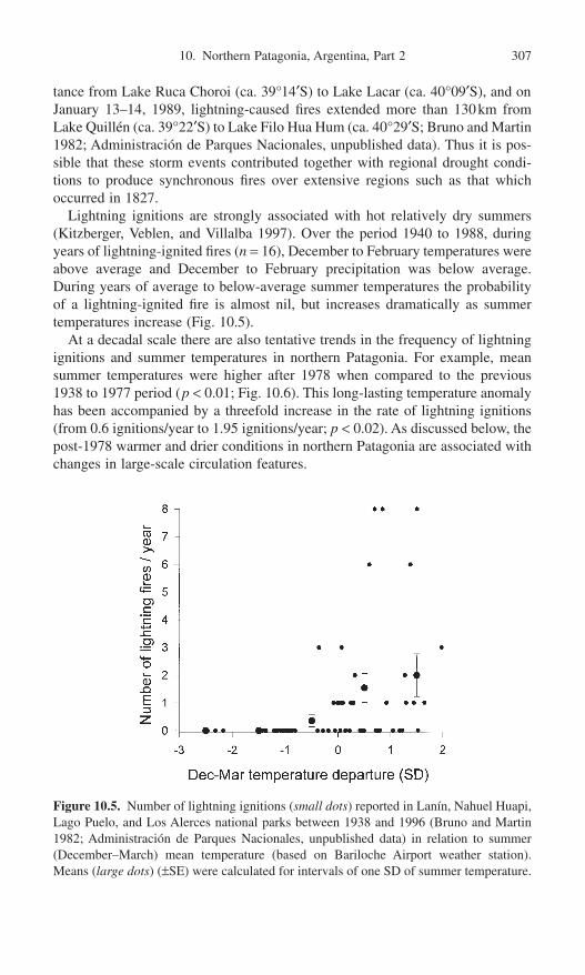
10. Northern Patagonia, Argentina, Part 2 307
tance from Lake Ruca Choroi (ca. 39°14¢S) to Lake Lacar (ca. 40°09¢S), and onJanuary 13–14, 1989, lightning-caused fires extended more than 130km fromLake Quillén (ca. 39°22¢S) to Lake Filo Hua Hum (ca. 40°29¢S; Bruno and Martin1982; Administración de Parques Nacionales, unpublished data). Thus it is pos-sible that these storm events contributed together with regional drought condi-tions to produce synchronous fires over extensive regions such as that whichoccurred in 1827.
Lightning ignitions are strongly associated with hot relatively dry summers(Kitzberger, Veblen, and Villalba 1997). Over the period 1940 to 1988, duringyears of lightning-ignited fires (n = 16), December to February temperatures wereabove average and December to February precipitation was below average.During years of average to below-average summer temperatures the probabilityof a lightning-ignited fire is almost nil, but increases dramatically as summertemperatures increase (Fig. 10.5).
At a decadal scale there are also tentative trends in the frequency of lightningignitions and summer temperatures in northern Patagonia. For example, meansummer temperatures were higher after 1978 when compared to the previous1938 to 1977 period (p < 0.01; Fig. 10.6). This long-lasting temperature anomalyhas been accompanied by a threefold increase in the rate of lightning ignitions(from 0.6 ignitions/year to 1.95 ignitions/year; p < 0.02). As discussed below, thepost-1978 warmer and drier conditions in northern Patagonia are associated withchanges in large-scale circulation features.
Figure 10.5. Number of lightning ignitions (small dots) reported in Lanín, Nahuel Huapi,Lago Puelo, and Los Alerces national parks between 1938 and 1996 (Bruno and Martin1982; Administración de Parques Nacionales, unpublished data) in relation to summer(December–March) mean temperature (based on Bariloche Airport weather station).Means (large dots) (±SE) were calculated for intervals of one SD of summer temperature.

308 T. Kitzberger and T.T. Veblen
Large-Scale Circulation Anomalies
Influences of the Southeastern Pacific Subtropical Anticylone
Years of relatively high fire activity in wet Nothofagus forests are years when thesoutheastern Pacific anticyclone is strong and displaced towards the south duringwinter and spring (Fig. 10.7; Kitzberger, Veblen, and Villalba 1997). One yearprior to the summers of high fire activity, the Pacific anticyclone is also displacedsouthward during spring (Fig. 10.7). Thus a stronger and more southerly locatedanticyclone is important in blocking westerly cyclonic storms and creating dryconditions conduce to widespread burning in the mesic Nothofagus forests(Kitzberger, Veblen, and Villalba 1997).
Precipitation anomalies in northern Patagonia are also associated with high lati-tude blocking events at 60°S in the Antarctic Peninsula–South America sector of the Southern Ocean. These blocking events drive westerly storms northwardinto Patagonia and are associated with positive precipitation departures based ontree-ring reconstructions of pressure and precipitation for the period 1746 to 1984(Villalba et al. 1998). Thus years of synchronous fire in northern Patagonia areassociated with below-average summer atmospheric pressure in the AntarcticPeninsula sector due to the association of less precipitation with an absence ofblocking highs (Veblen et al. 1999). The strength of the relationship between pre-cipitation in northern Patagonia and summer atmospheric pressure at ca. 60°S,however, has been greater during the twentieth century than during the preced-ing 150 years (Villalba et al. 1998). The strength of the teleconnections between
Figure 10.6. Eleven-year moving sum of lightning ignitions (solid line) reported in Lanín,Nahuel Huapi, Lago Puelo, and Los Alerces national parks between 1938 and 1996 (Brunoand Martin 1982; Administración de Parques Nacionales, unpublished data) and 11-yearmoving mean summer temperature (dotted line) (based on Bariloche Airport weatherstation). Horizontal lines are means for the 1938–1977 and 1978–1996 periods.

10. Northern Patagonia, Argentina, Part 2 309
middle and high latitudes in the South American sector varies with changes inthe degree of zonal versus meridional airflow. Increased precipitation variabilityand stronger correlations of precipitation with high latitude pressure since 1900may reflect stronger meridional circulation across South America and strongerinteraction between mid- and high-latitude circulation features (Villalba et al.1998).
Years in which lightning-ignited fires occur in northern Patagonia are associ-ated with changes in circulation features that are manifested in the southernAtlantic Ocean. Such years (n = 7; considering only lightning fires that occurredin February) are associated with above-average sea-level atmospheric pressure at
Figure 10.7. Intensity and location of the southeast Pacific subtropical anticyclone duringyears of high versus low fire activity in wet Nothofagus forests in Nahuel Huapi and LanínNational Parks, northern Patagonia. (a) Mean (±SE) deviations from the long-term meansea-level atmospheric pressure (millibars) at Punta Galera Chile (1911–1960) over 23months prior to the fire season. (b) Mean (±SE) deviations from the long-term mean lati-tudinal position of the southeast Pacific anticyclone (1943–1962) along coastal Chile overthe 23 months prior to the fire season. High fire activity years had >100ha burned(1940–1988) or a regional fire index of 4. Low fire activity years had <10ha burned or aregional fire index of 0. Sample sizes in (a) and (b), respectively, are 15 and 9 for highfire years and 20 and 9 for low fire years. (Pressure data are from Pittock 1980.)

310 T. Kitzberger and T.T. Veblen
high latitude east of southern South America during February (Fig. 10.8). Duringsummers of anomalously high pressure at 45° to 55°S in the Atlantic Ocean, the Atlantic portion of the subtropical high-pressure belt is located further south, which allows Atlantic subtropical air to flow southwestward into northernPatagonia (van Loon, Kidson, and Mullan 1993). These moist, warm air massesspawn thunderstorms and lightning through convective uplift over the heatedPatagonian plains or by advective or orographic uplift when they reach cooler airin the Andean foothills.
ENSO Influences
High-Frequency Climatic Variability
Both the documentary and tree-ring records of fire in northern Patagonia reflectstrong influences of ENSO activity (Kitzberger and Veblen 1997; Veblen et al.1999). The area of forest burned annually in northern Patagonia is strongly asso-ciated with variations in the standardized Southern Oscillation Index (SOI;Ropelewksi and Jones 1987) and sea surface temperatures (SST) in the easternEcuatorial Pacific (Niño regions 1 + 2). Over the period 1882 to 1989, years ofextensive fire in northern Patagonia tend to be associated with late stages of the
Figure 10.8. February mean sea-level pressure anomalies over the ocean near southernSouth America over seven years (1950, 1953, 1957, 1982, 1987, 1989, 1990) in whichlightning fires were reported during the month of February in Lanín, Nahuel Huapi, LagoPuelo or Los Alerces national parks. Sea-level pressure data are taken from the global 4 ¥ 4° grid of ocean sea level pressure anomalies (Lamont Doherty Earth Observatory IRI RSA COADS).

10. Northern Patagonia, Argentina, Part 2 311
positive phase of the Southern Oscillation or cold La Niña stage indicated by pos-itive SOI anomalies and negative SST anomalies about two years before the fireseason (Fig. 10.9a). Years of lightning-ignited fires show similar timing relation-ships with SST and SOI. However, the cold La Niña preceding period tends tobe shorter, and the strong El Niño pattern (negative SOI anomalies and positiveSST anomalies) after the fire season strongly suggests that lightning ignitions may
Figure 10.9. Mean sea surface temperature (SST) in the eastern equatorial Pacific (NiñoRegions 1 + 2; solid line) and mean Southern Oscillation Index (SOI) calculated for amoving window of 48 months centered (a) on years of extensive fire £2000ha burned(1950–1996) (n = 14) and (b) on years when two or more lightning fires occurred Febru-ary in Lanín, Nahuel Huapi, Lago Puelo or Los Alerces national parks (n = 9; dotted line).The shaded area is the fire season of the fire-event year (i.e., year 0). (Fire reports arebased on Bruno and Martin 1982 and Administración de Parques Nacionales, unpublisheddata.)

also be due to late-developing El Niño events that are related to warmer summers(Fig. 10.9b).
Although the most common pattern is for years of major fire activity to occurduring the late stages of La Niña events, major fire years also can coincide withEl Niño events (Veblen et al. 1999). Among the 10 years of greatest fire occur-rence between 1740 and 1995, as determined from percentages of 21 fire-historysample sites recording fire, six years coincide with moderate to very strong ElNiño events (Quinn 1992; Ortlieb and Macharé 1993). The timing of ENSOwithin the annual cycle is critical in determining its influence on fire occurrence.El Niño events most frequently begin to develop in March to May (Kiladis andDiaz 1989) which for northern Patagonia tends to increase winter–spring (June–November) precipitation during the same calendar year. However, El Niño eventsthat begin to develop after the winter rainy season (e.g., after October) do notresult in increased winter–spring precipitation until after the summer dry season.Thus the warm temperatures associated with late-developing El Niño events moreeffectively desiccate fuels and can promote widespread fire. For example, the ElNiño events of 1965 and 1972 began to develop in April, and by the winter rainyseason (July–August) were well developed; consequently little or no burningoccurred during the summer fire seasons (Fig. 10.10). In contrast, the 1969 and1986 El Niño events did not develop early enough in the preceding calendar yearto enhance winter precipitation prior to the fire season of each respective year.By January and February of 1969 and 1986 each event was well developed andincreased burning is associated with the warm El Niño summers (Fig. 10.10).Thus 1969 and 1986 are classified as years of El Niño events (Díaz and Kiladis1992; Quinn 1992) and are also years of high fire activity. The preceding years,1968 and 1985, are not classified as La Niña events (Díaz and Kiladis 1992), buteach pair of years could be considered a transition from “Niña-like conditions”to El Niño conditions under which warm summers tend to follow winter–springsof normal or below-average precipitation.
There are two ENSO-related patterns associated with years of extreme burning:warmer summers associated with El Niño events that develop after the preced-ing winter rainy season, and reduced winter–spring precipitation during La Niñaevents preceding the summer fire season. The latter is the most common patternbecause most El Niño events start early enough in the calendar year to increasewinter–spring precipitation prior to the summer fire season. Despite the associa-tion of 6 of the 10 most extreme fire years from 1520 to 1929 with El Niño events(that probably developed late in the calendar year), most major fire years between1520 and 1929 (n = 88) are the year prior to the beginning of El Niño events inQuinn’s (1992) record (Veblen et al. 1999). This is consistent with the tendencyof ENSO to switch from one extreme to the other in consecutive years (Díaz andKiladis 1992), so many of these major fire years would have followed dry LaNiña winter–springs. Some of the others would have been associated with earlystages of late-developing El Niño events. This pattern is also consistent with theoccurrence of above-average precipitation during the year following major fireyears based both on the instrumental record as well as tree-ring records of pre-
312 T. Kitzberger and T.T. Veblen

10. Northern Patagonia, Argentina, Part 2 313
cipitation (Veblen et al. 1999; Fig. 10.4). Given the greater abundance of El Niño events that start in March through May (Kiladis and Díaz 1989), but theassociation of widespread fire with El Niño years is less frequent than for La Niñayears.
Fire records from 1938 to 1996 indicate that during middle to late La Niñastages (i.e., during the middle to final months of extended periods of positivedepartures of SOI) there was a higher relative percentage of spring as opposedto summer fires (ca. 80% vs. 50%, respectively). In contrast, a much larger per-centage of summer as opposed to spring fires occurred during early to middle ElNiño stages (i.e., early to middle months of extended periods of negative SOIanomalies; ca. 40% vs. 8%, respectively). Season of fire occurrence and stage ofENSO (mid to late La Niña vs. early to mid El Niño were significantly associ-ated (p < 0.05 Fisher exact test).
Lightning activity in northern Patagonia can also be linked to ENSO events.Although lightning activity is strongly associated with pressure anomalies in thesouthern Atlantic Ocean (Fig. 10.8), the incursion of tropical air masses into the
Figure 10.10. Monthly Southern Oscillation Indexes for early-developing (1965 and1972) and late-developing (1969 and 1986) El Niño events and areas (in hectares) burnedin Lanin, Nahuel Huapi, Lago Puelo and Los Alerces national parks (Bruno and Martin 1982; Administración de Parques Nacionales, unpublished data). Only the late-developing El Niño events are associated with high rates of burning.
mid-latitudes of South American may be favored by a strong and southerlylocated southeast Pacific anticyclone that shifts the zone of westerly flow farthersouth. Thus the interaction of Atlantic and Pacific circulation features appears toinfluence lightning ignitions in northern Patagonia. Of the seven years of majorlightning-ignited fire between 1938 and 1996, five coincided with late La Niñato early El Niño transitions. This association probably reflects a combination ofenhanced lightning activity associated with warmer El Niño summers and/orgreater fuel desiccation related to drier La Niña springs or early El Niño summerdrought.
Precipitation anomalies in northern Patagonia are linked both to ENSO eventsand high-latitude circulation features, which themselves may be coupled. Varia-tion in the southeast Pacific anticyclone and high-latitude atmospheric circula-tion is also linked to ENSO events (Díaz and Kiladis 1992). Major blocking highssouthwest of South America at ca. 55°S, 90°W tend to coincide with warm SOevents (Rutllant and Fuenzalida 1991). Furthermore there are similar periodici-ties (3 to 5 years) of interannual variations in the circumpolar flow at ca. 55°S,interannual variations in sea-level atmospheric pressure, and sea-ice extent(White and Peterson 1996; Villalba et al. 1998).
Low-Frequency Changes in ENSO
Given the strong association of years of widespread fire in northern Patagoniawith interannual climatic variability, it is likely that ENSO-induced changes ininterannual climatic variability at multidecadal scales would also influence fireregimes. Periods of greater frequency and/or amplitude of ENSO events are likelyto be periods of greater fire occurrence due to the more frequent alternationbetween fuel-enhancing wet periods and fuel-desiccating dry periods.
Tree-ring derived fire histories from 1650 to 1990 based on hundreds of widelydistributed fire-scarred trees from 39° to 43°S in northern Patagonia indicateimportant decadal-scale fluctuations in fire frequency that closely mirror varia-tions in ENSO activity (Kitzberger and Veblen 1997; Veblen et al. 1999). Fre-quency of years of widespread fire (i.e., years in which >30% of the trees recordedfire) is relatively high in the mid-1700s, reaches a nadir about 1800, and increasesto a peak in the late 1800s (Fig. 10.11a). Years of less widespread fire (>15% ofthe trees recorded fire), which would be expected to be somewhat less controlledby climate and perhaps are more responsive to changes in human-set ignitions,show less variation in frequency. In particular, the greater reduction in the fre-quency of widespread fires (>30% scarred) from ca. 1780 to 1830s relative to thedecline in years of moderate fire occurrence (>15% scarred) may be a responseto decadal-scale change in ENSO activity. The variation in frequency of wide-spread fires closely tracks variation in several independently derived reconstruc-tions of ENSO activity (Fig. 10.11b, c, and d). These include tree-ring calibratedreconstructions of Southern Oscillation indexes from regional tree-ring networks(Villalba 1994), records of El Niño/La Niña events from Spanish archival docu-ments (Quinn and Neal 1992), and d18O time series from tropical coral (Dunbar
314 T. Kitzberger and T.T. Veblen

10. Northern Patagonia, Argentina, Part 2 315
Figure 10.11. Number of regional-scale fire years over a moving 49-year window innorthern Patagonia (a), and multi-proxy reconstructions of low-frequency changes inENSO activity between 1650 and 1990 based on (b) La Niña and El Niño events recon-structed from tree-ring chronologies in Patagonia and central Chile (Villaba 1994) and (c)moderate to very strong El Niño events reconstructed from archival documents (Quinnand Neal 1992), (d) record of ENSO-related central Pacific upwelling based on the d18O(%0) coral record from Urvina Bay, Galapagos Islands (Dunbar et al. 1994). In (a) fireyears are years in which more than 15% (solid line) or more than 30% (dotted line) of alltrees in five sites recorded fire (data from Kitzberger and Veblen 1997). Plots in (b) and(c) are mean number of events per year based on moving 49-year sums, and in (d) is the49-yr running mean of d18O (%0) coral. In all cases the horizontal solid line representslong-term mean values.

et al. 1994). Reduced amplitude of the ENSO during 1780 to 1830 is indicatedby all these records (Fig. 10.11). This pattern, in combination with the previouslydocumented association of fire and ENSO-induced climatic variation (Fig. 10.8;Kitzberger and Veblen 1997; Veblen et al. 1999), suggests that fire regimes innorthern Patagonia reflect long-term changes in the amplitude and/or frequencyof ENSO events.
Conclusion
In northern Patagonia interannual variations in fire regimes closely track regionalclimatic variability, which is linked to large-scale atmospheric circulation anom-alies. Although climatic variability overrides human influences on fire regimes atan interannual scale, human activity can be of equal or greater importance indetermining fire frequency at multidecadal scales (Veblen et al., Chapter 9, thisvolume). However, by focusing on years of widespread fire, which are mainlycontrolled by climate, it is feasible to relate changes in fire regimes and climateat decadal to centennial scales.
In northern Patagonia years of widespread burning in mesic forests coincidewith drier and warmer than average spring–summers, but in the grassland zonesummer drought is severe enough in normal years to permit burning. Years of extensive grassland burning, however, do tend to follow wetter than normalsprings one year prior to the fire season, which may increase the availability offine fuels through enhanced growth of grasses. Years in which the southeastPacific subtropical anticyclone is more intense and located further south are yearsof greater drought and fire. Climatic conditions conducive to widespread fire inboth rain forests and xeric woodlands are also closely related to ENSO events.Despite the significant influence of tropical Pacific atmospheric phenomena,ENSO activity is not the sole determinant of fire weather in northern Patagonia.Years of widespread fire are also associated with an absence of atmosphericblocking events at ca. 50 to 60°S that would otherwise steer cyclonic stormsnorthward into northern Patagonia.
The strength of the relationship between ENSO events and climate is knownto have varied at hemispherical and global scales over decadal and centennialtime scales (Díaz and Pulwarty 1994). In northern Patagonia, although spring andsummer temperature and precipitation variations are significantly correlated withthe SOI over the full instrumental record (ca. 1915–1997), correlations are nearlyabsent during the 1930s and 1940s (Villalba and Veblen 1998; Daniels and Veblen2000). The relationship between climate and ENSO-forcing in northern Patago-nia is highly variable according to the timing and strength of events (Villalba1994). Thus, despite the statistically significant associations demonstrated here,variation in fire regimes in northern Patagonia can only be partially explained byENSO forcing.
Analyses of fire–ENSO relationships between widely separated ENSO-sensitive regions such as the southwestern United States and northern Patagonia
316 T. Kitzberger and T.T. Veblen

show similar interannual and decadal changes. In both regions there was a declinein widespread burning from 1780 to 1830 that coincides with reduced amplitudeand/or strength of the teleconnections of ENSO (Swetnam and Betancourt 1998;Kitzberger, Swetnam, and Veblen 2001). Multicentury time series of regional fire activity in the two regions are also spectrally coherent within the dominantENSO frequency band (i.e., 2–7 years; Kitzberger, Swetnam, and Veblen 2001). These synchronous changes suggest that regional forest fire regimes inthese regions may be phase-locked with the Southern Oscillation and may be responding synchronously to long-term changes in the modal frequencies or amplitudes of the Southern Oscillation (Kitzberger, Swetnam, and Veblen2001).
The relationships of fire and ENSO summarized for northern Patagonia are ofpotential value in forecasting fire hazards and planning mitigation activities a yearor more in advance. Furthermore, in the context of longer-term modeling of theecological effects of global waring, these results indicate the importance of con-sidering year-to-year variability rather than just long-term mean climatic condi-tions. At much longer time scales, increased fire has also been linked to periodsof greater climatic variability. Comparison of sedimentary charcoal records withfossil pollen records from different environments in southern South America indi-cate increased fire occurrence for periods of greater climatic variability duringthe late-Glacial and late-Holocene periods (Heusser 1987; Markgraf and Ander-son 1994). The greater late-Glacial variability has been attributed to fluctuationsin the extent of Antarctic sea ice, which, in turn, influence the latitudinal posi-tion of the westerly storm tracks. The variability of the late Holocene appears tobe related to the onset of ENSO as an important influence on mid-latitude cli-mates along the west coast of South America (McGlone, Kershaw, and Markgraf1992; Markgraf and Anderson 1994).
Similar to the association of drought and fire demonstrated here, other studiesin northern Patagonia (Villalba and Veblen 1997b; Villalba and Veblen 1998)show that the establishment of seedlings and mortality of adult trees of Austro-cedrus are strongly associated with variations in ENSO and in the strength andposition of the southeastern Pacific anticyclone. For example, the predominanceof the negative mode of the Southern Oscillation (i.e., El Niño conditions) sincethe late 1970s is reflected by warmer summers and a lack of Austrocedrusseedling survival in dry habitats (Villalba and Veblen 1997b). Analogously, thestepped increase in the frequency of lightning-ignited fires since the mid-1970s(Fig. 6) also coincides with the increase in El Niño events. However, tree-ringproxy records indicate that over the past 250 years or so there have been impor-tant variations at decadal- to centennial-time scales in major circulation features,such as ENSO activity and blocking events at high latitudes, and also in the rela-tionships of climate in northern Patagonia to these circulation features. For under-standing possible impacts of global climate change on regional fire regimes andforest dynamics, it is important to consider past variations in large-scale atmos-pheric circulation features and fluctuations in the strengths of their influences onregional climates.
10. Northern Patagonia, Argentina, Part 2 317

318 T. Kitzberger and T.T. Veblen
Acknowledgments. This review is based on research funded by the NationalScience Foundation of the United States, the National Geographic Society, andthe Council for Research and Creative Work of the University of Colorado. Forproviding unpublished data, we thank R. Villalba, and for assistance with thefigures, we thank D.C. Lorenz.
References
Aceituno, P. 1988. On the functioning of the Southern Oscillation in the South Americansector. Part 1. Surface Climate. Mon. Wea. Rev. 116:505–524.
Alaback, P., and McClellan, M. 1993. Effects of global warming on managed coastalecosystems of western North America. In Earth System Response to Global Change:Contrasts between North and South America, eds. H.A. Mooney, E. Fuentes and B.I.Kronberg, pp. 299–327. New York: Academic Press.
Baker, W.L. 1990. Climatic and hydrologic effects on the regeneration of Populus angus-tifolia James along the Animas River, Colorado. J. Biogeogr. 17:59–73.
Baker, W.L., Egbert, S.L., and Frazier, G.F. 1991. A spatial model for studying the effectsof climatic change on the structure of landscape subject to large disturbances. Ecol.Model. 56:109–125.
Barros, V., Cordón, V., Moyano, C., Méndez, R., Forquera, J., and Pizzio, O. 1983. Cartasde precipitación de la zona oeste de las provincias de Rio Negro y Neuquén. Reportto the Facultad de Ciencias Agrarias, Universidad Nacional del Comahue, Cinco Saltos,Neuquén.
Bergeron, Y., and Archambault, S. 1993. Decreasing frequency of forest fires in the south-ern boreal zone of Quebec and its relation to global warming since the end of the “LittleIce Age.” Holocene 3:255–259.
Bruno, J., and Martin, G. 1982. Los incendios forestales en los Parques Nacionales.Unpublished report, Administración de Parques Nacionales, Buenos Aires.
Chandler, C., Cheney, P., Thomas, P., Trabaud, L., and Williams, D. 1983. Fire in Forestry.Volume I: Forest Fire Behavior and Effects. New York: Wiley.
Daniels, L.D., and Veblen, T.T. 2000. ENSO effects on temperature and precipitation of the Patagonian-Andean region: Implications for biogeography. Phys. Geogr. 21:223–243.
Díaz, H.F., and Kiladis, G.N. 1992. Atmospheric teleconnections associated with extremephases of the Southern Oscillation. In El Niño: Historical and Paleoclimatic Aspectsof the Southern Oscillation, eds. H.F. Díaz and V. Markgraf, pp. 7–28. Cambridge:Cambridge University Press.
Díaz, H.F., and Pulwarty, R.S. 1994. A comparison of the Southern Oscillation and El Niñosignal in the tropics. In El Niño: Historical and Paleoclimatic Aspects of the SouthernOscillation, eds. H.F. Díaz and V. Markgraf, pp. 175–192. Cambridge: Cambridge University Press.
Dunbar, R., Wellington, G.M., Colgan, M.W., and Glynn, P.W. 1994. Eastern Pacific seasurface temperature since 1600 A.D.: The d18O record of climate variability in Gala-pagos corals. Paleoceanography 9:291–316.
Franklin, J.F., Swanson, F.J., Harmon, M.E., Perry, D.A., Spies, T.A., Dale, V.H., McKee,A., Ferrell, W.K., Means, J.E., Gregory, S.V., Lattin, J.D., Schowalter, T.D., and Larsen,D. 1991. Effects of global climatic change on forests in northwestern North America.Northwest. Environ. J. 7:233–254.
Gardner, R.H., Hargrove, W.W., Turner, M.G., and Romme, W.H. 1996. Climate change,disturbances and landscape dynamics. In Global Change and Terrestrial Ecosystems,eds. B. Walker and W. Steffen, pp. 149–172. Cambridge: Cambridge University Press.

Heusser, C.J. 1987. Fire history of Fuego-Patagonia. Quaternary of South America andAntarctic Peninsula 5:93–109.
Johnson, E.A., and Larsen, C.P.S. 1991. Climatically induced change in fire frequency inthe southern Canadian Rockies. Ecology 72:194–201.
Johnson, E.A., and Wowchuk, D.R. 1993. Wildfires in the southern Canadian RockyMountains and their relationship to mid-tropospheric anomalies. Can. J. For. Res. 23:1213–1222.
Kiladis, G.N., and Díza, H.F. 1989. Global climatic anomalies associated with extremesin the Southern Oscillation. J. Climate 2:1069–1090.
Kitzberger, T. 1994. Fire regime variation along a northern Patagonian forest-steppeecotone: Stand and landscape response. PhD. dissertation. University of Colorado,Boulder.
Kitzberger, T., and Veblen, T.T. 1997. Influences of humans and ENSO on fire history of Austrocedrus chilensis woodlands in northern Patagonia, Argentina. Ecoscience 4:508–520.
Kitzberger, T., Veblen, T.T., and Villalba, R. 1997. Climatic influences on fire regimesalong a rainforest-to-xeric woodland gradient in northern Patagonia, Argentina. J. Biogeogr. 23:35–47.
Kitzberger, T., Swtenam, T.W., and Veblen, T.T. 2001. Inter-hemispheric synchrony offorest fires and the El Niño–Southern Oscillation. Global Ecol. Biogeogr. 10:315–326.
Körner, C. 1996. The response of complex multispecies systems to elevated CO2. In GlobalChange and Terrestrial Ecosystems, eds. B. Walker and W. Steffen, pp. 20–42. Cambridge: Cambridge University Press.
Larsen, C.P.S., and MacDonald, G.M. 1998. An 840-year record of fire and vegetation ina boreal white spruce forest. Ecology 79:106–118.
Lloyd, A.H., and Graumlich, L.J. 1997. Holocene dynamics of treeline forests in the SierraNevada. Ecology 78:1199–1210.
Malanson, G.P., and Westman, W.E. 1989. Modeling the interactions of fire regime, airpollution, and CO2-induced climate change on Californian coastal sage scrub. Clim.Change 18:363–376.
Markgraf, V., and Anderson, L. 1994. Fire history of Patagonia: Climate versus humancause. Rev. Instit. Geogr. Sao Paulo 15:35–47.
McGlone, M.S., Kershaw, A.P., and Markgraf, V. 1992. El Niño/Southern Oscillation climatic variability in Australasian and South American paleoenvironmental records.In El Niño. Historical and Paleoclimatic Aspects of the Southern Oscillation, eds. H.F.Díaz and V. Markgraf, pp. 435–462. Cambridge: Cambridge University Press.
Miller, A. 1976. The climate of Chile. In World Survey of Climatology, ed. W. Schwerdtfeger, pp. 113–145. Amsterdam: Elsevier.
Ortlieb, L., and Macharé, J. 1993. Former El Niño events: records from western SouthAmerica. Global Planet. Change 7:181–202.
Overpeck, J.T., Rind D., and Goldberg, R. 1990. Climate-induced changes in forest dis-turbance and vegetation. Nature 343:51–53.
Pederson, B.S. 1998. The role of stress in the mortality of Midwestern oaks as indicatedby growth prior to death. Ecology 79:79–93.
Pittock, A.B. 1980. Patterns of climatic variation in Argentina and Chile. I. Precipitation,1931–60. Mon. Wea. Rev. 108:1347–1361.
Price, A.J., and Rind, D. 1994. The impact of 2 ¥ CO2 climate on lightning-caused fires.J. Clim. 7:1484–1494.
Quinn, W.H., and Neal, V.T. 1992. The historical record of El Niño events. In Climate since A.D. 1500, eds. R.S. Bradley and P.D. Jones, pp. 623–646. London: Routledge.
Quinn, W.H. 1992. A study of the Southern Oscillation-related climatic activity for A.D.622–1900 incorporating Nile river flood data. In El Niño: Historical and Paleoclimatic
10. Northern Patagonia, Argentina, Part 2 319

Aspects of the Southern Oscillation, eds. H.F. Dıaz and V. Markgraf, pp. 119–149.Cambridge: Cambridge University Press.
Ropelewksi, C.F., and Jones, P.D. 1987. An extension of the Tahiti–Darwin SouthernOscillation Index. Mon. Wea. Rev. 115:2161–2165.
Rothkugel, M. 1916. Los Bosques Patagónicos. Ministerio de Agricultura, Buenos Aires.Rutllant, J., and Fuenzalida, H. 1991. Synoptic aspects of the central Chile rainfall vari-
ability associated with the Southern Oscillation. Int. J. Climatol. 11:63–76.Schwerdtfeger, W. 1976. Introduction. In World Survey of Climatology, ed. W.
Schwerdtfeger, pp. 1–12. Amsterdam: Elsevier.Sirois, L., and Payette, S. 1991. Reduced postfire regeneration along a boreal forest–tundra
transect in northern Quebec. Ecology 72:619–629.Swetnam, T.W. 1993. Fire history and climate change in giant sequoia groves. Science
262:885–889.Swetnam, T.W., and Betancourt, J.L. 1990. Fire–Southern Oscillation relations in the
southwestern United States. Science 249:1017–1020.Swetnam, T.W., and Betancourt, J.L. 1992. Temporal patterns of El Niño/Southern
Oscillation—Wildfire teleconnections in the southwestern United States. In El Niño:Historical and Paleoclimatic Aspects of the Southern Oscillation, eds. H.F. Díaz andV. Markgraf, pp. 259–270. Cambridge: Cambridge University Press.
Swetnam, T.W., and Betancourt, J.L. 1998. Mesoscale disturbance and ecological response to decadal climatic variability in the American Southwest. J. Clim. 11:3128–3147.
Taljaard, J.J. 1972. Synoptic meteorology of the Southern Hemisphere. Meteorol. Monogr.13:139–213.
Thornthwaite, C.W. 1948. An approach toward a rational classification of climate. Geogr.Rev. 38:55–94.
Tortorelli, L.A. 1947. Los Incendios de bosques en la Argentina. Ministerio de Agricul-tura, Buenos Aires.
van Loon, H., Kidson, J.W., and Mullan, A.B. 1993. Decadal variation of the annual cyclein the Australian data set. J. Clim. 6:1227–1231.
Veblen, T.T., and Lorenz, D.C. 1988. Recent vegetation changes along the forest/steppeecotone in northern Patagonia. Ann. Assoc. Am. Geogr. 78:93–111.
Veblen, T.T., Kitzberger, T., and Lara, A. 1992. Disturbance and forest dynamics along atransect from Andean rain forest to Patagonian shrubland. J. Veg. Sci. 3:507–520.
Veblen, T.T., Kitzberger, T., Villalba, R., and Donnegan, J. 1999. Fire history in northernPatagonia: The roles of humans and climatic variation. Ecol. Monogr. 69:7–67.
Villalba, R. 1990a. Latitude of the surface high-pressure belt over western South Americaduring the last 500 years as inferred from tree-ring analysis. Quat. S. Am. Antarc. Penin.7:273–303.
Villalba, R. 1990b. Climatic fluctuations in northern Patagonia during the last 1000 yearsas inferred from tree-ring records. Quat. Res. 34:346–360.
Villalba, R. 1994. Tree-ring and glacial evidence for the Medieval Warm Epoch and theLittle Ice Age in southern South America. Clim. Change 26:183–197.
Villalba, R. 1995. Climatic influences on forest dynamics along the forest-steppe ecotonein northern Patagonia. Ph.D. dissertation. Department of Geography, University of Colorado, Boulder.
Villalba, R., and Veblen, T.T. 1997a. Spatial and temporal variation in tree growth alongthe forest-steppe ecotone in northern Patagonia. Can. J. For. Res. 27:580–597.
Villalba, R., and Veblen, T.T. 1997b. Regional patterns of tree population age structuresin northern Patagonia: Climatic and disturbance influences. J. Ecol. 85:113–124.
Villalba, R., and Veblen, T.T. 1998. Influences of large-scale climatic variability onepisodic mortality at the forest-steppe ecotone in northern Patagonia. Ecology 79:2624–2640.
320 T. Kitzberger and T.T. Veblen

Villalba, R., Cook, E.R., Jacoby, G.C., D’Arrigo, R., Veblen, T.T., and Jones, P.D. 1998.Tree-ring based reconstructions of northern Patagonia precipitation since A.D. 1600.Holocene 8:677–692.
White, W.B., and Peterson, R.G. 1996. An Antarctic circumpolar wave in surface pres-sure, wind, temperature and sea-ice extent. Nature 380:699–702.
10. Northern Patagonia, Argentina, Part 2 321

11. Fire Regimes and Forest Dynamics in the Lake Region of South-Central Chile
Antonio Lara, Alexia Wolodarsky-Franke, Juan Carlos Aravena, Marco Cortés, Shawn Fraver,
and Fernando Silla
Fire is one of the major disturbances shaping the vegetation and landscape pat-terns in the Lake Region of south-central Chile (39°30¢–43°30¢S). Most of thesefires occurred after the European settlement in the area, which started ca. 1750,but it was not until the 1850s that extensive settlement took place which led tomassive burning and clearing of forests for agriculture and pasture land (Elizalde1970; Wilhelm 1968). Recent research from tree rings in the Cordillera Pelada,(ca. 40°S) has documented fires in the last 600 years, that may be attributed toboth lightning and the native human population (Lara et al. 1999a). Researchfrom pollen records and Quaternary stratigraphy indicates the extensive occur-rence of fire in southern South America, since about 13,000BP (Heusser 1994).A long history of fire occurrence has also been found in central Chile (see Aravenaet al., Chapter 12, this volume) and in Patagonia, Argentina (Veblen et al., Chapter9, Kitzberger and Veblen, Chapter 10, Huber and Markgraf, Chapter 13, thisvolume).
Forest dynamics of various vegetation types in the region and their relation todifferent kinds of disturbances—especially volcanism, landslides, logging, andfire—have been described by several studies (Veblen and Ashton 1978, 1982;Veblen et al. 1981; Veblen 1983, 1985; Veblen et al. 1996). Nevertheless, thedetailed study of fire regimes, and their relation to forest dynamics is only incip-ient in the Chilean Lake Region (Lara et al. 1999a). In contrast, the ecologicalrole of fire has received substantial research attention in the forests of northern Patagonia, Argentina (Veblen et al. 1995, Veblen et al., Chapter 9, this volume).
322

In this chapter we describe the environmental and vegetation patterns in theLake Region; we analyze fire regimes from recent fire records and the influenceof fire on the dynamics of Fitzroya cupressoides forests. We also analyze theinfluence of fires on forest conservation in the region, and we make some rec-ommendations for future research.
The Lake Region of Chile
The Lake Region of Chile extends from ca. 39°30¢ to 43°30¢S and correspondsto the Xth Administrative Region of the country. Three main physiographic fea-tures characterize the region: the coastal range, the Central Depression, and theAndean Range (Fig. 11.1). The coastal range is a relatively low, narrow moun-tain range with rounded tops and gentle slopes, reaching up to 1048m elevationat Cerro Mirador (40°10¢S), and decreasing toward the south. The CentralDepression represents an extensively glaciated low and relatively flat area, withelevations under 150m (Fig. 11.1). The Andean Range is characterized by fre-quent steep slopes and several peaks and volcanoes above 2200msl, with itseastern slopes located in Argentina.
Geology, Soils, and Climate
Most of the Central Depression and Andean Range of the Lake Region wascovered by ice during the Quaternary glaciations, until ca. 15,000 to 13,000BPwhen glaciers retreated (Mercer 1976; Porter 1981; Denton 1993; Clapperton1994). These glaciations originated most of the lakes in the area, and left an exten-sively glaciated landscape.
The geology and soils of the region vary with the previously mentioned phys-iographic features. The coastal range is a chain of metamorphic bedrock of Paleozoic to Precambrian age. Soils vary from moderately deep and well drainedat mid-elevations to thin, acidic, sandy, and poorly drained soils with varyingdegrees of formation of a gley horizon toward the flat tops (Lusk 1996). In theCentral Depression, soils are developed from thick layers of Quaternary flu-vioglacial and volcanic sediments. Soils developed from old tephra on morrainesare typically deep (80–120cm), loamy or clay in texture, and well drained. Soils,developed on outwash plains of fluvioglacial pavement and other flat areas, calledñadis are thin (20–30cm deep), poorly drained or seasonally flooded (INIA 1985).The Andean Range in the Lake Region is a geologically complex system domi-nated by granitic and sedimentary rocks, with the local presence of metamorphicrocks (Levi, Aguilar, and Fuenzalida 1966; Servicio Nacional de Geología yMinería 1982; Kühne 1985). Plio-pleistocene and Holocene volcanic sedimentsare widespread, and glacial and fluvioglacial sediments are common (Levi,Aguilar, and Fuenzalida 1966; Mercer 1976; Servicio Nacional de Geología y
11. The Lake Region of South-Central Chile 323

Minería 1982). The Lake Region is an active tectonic zone, with the Liquiñe-Ofqui fault running from north to south along the region and further south (Fig.11.1; Hauser 1984). Soils below 1500m elevation, where most forests occur, arecalled trumaos. These are volcanic soils, generally deep (80–150cm), loamy, andwell drained (INIA 1985).
324 A. Lara et al.
Figure 11.1. Location map of the study and sampling areas in the Lake Region in south-central Chile. Sampling sites: (1) Cordillera Pelada, (2) Pto. Montt, (3) Astilleros, (4)Contao, (5) Alerce Andino, and (6) Abtao. (Cover of Fitzroya and other forest types devel-oped from CONAF et al. 1999.)

Climate of the Lake Region in Chile is characterized by high annual precipi-tation, with a somewhat lower rainfall in summer. It is classified as oceanic wettemperate with mild Mediterranean influence (Fuenzalida 1950; Di Castri andHajek 1976). There is a general increase in precipitation and decrease in season-ality toward the south. Since moisture is brought by the westerly winds, there isan important west-to-east gradient, with a strong rainshadow effect in the CentralDepression and in the eastern slopes of the Andes in Argentina. Annual rainfallranges from 1800mm in the Central Depression to more than 4000mm at the topsof the coastal and the Andean Ranges. Average July and January temperatures atthe Central Depression are 8° and 16°C, respectively (Almeyda and Saez 1958).
Vegetation and Disturbance Regimes
Vegetation varies dramatically within the Chilean Lake Region, according to thenorth-to-south and west-to-east physiographic zones and environmental gradi-ents, and the degree of human disturbance. The total area covered by nativeforests is 3.6 million hectares, representing 54% of the Lake Region. Forest plantations (mainly Pinus radiata and to a less extent Eucalyptus spp.) cover117,000ha (CONAF et al. 1999).
Most of the native forests are concentrated in the Andean Range (59% of thetotal), where the influence of human disturbance by fire and clearing for agricul-ture and pasture has been more restricted. Conversely, only 10% of the nativeforests are currently located in the Central Depression because of extensive clear-ing that began in the 1850s. The coastal range has an intermediate situation witha 31% of the native forests cover (Lara 1991).
In the Lake Region, forests are dominated by the Valdivian rain forest (tipoforestal siempreverde according to the current classification of forest cover types,Donoso 1981), representing 54% of the native forests in the region (CONAF etal. 1999). This forest type occurs at low and mid-elevations across the region,and is characterized by mixed forests with a high vascular plant diversity. Theflora of these forests includes 155 woody species, 44 tree species, and 28 genera,28% of which are endemic to Chile and the adjacent area of Argentina (Kalin etal. 1996). The main tree species are Nothofagus dombeyi, N. nitida, Eucryphiacordifolia, Laureliopsis philippiana, Weinmannia trichosperma, as well as severalspecies in the myrtaceae family such as Amomyrtus luma, A. meli, Myrceugeniaplanipes, and Tepualia stipularis (Donoso 1981; Donoso 1993).
Other important forest types in the region are the Nothofagus dombeyi–N.alpina–Laureliopsis philippiana forests, occurring mainly as old-growth atmid-elevations (500–1000m), as well as Nothofagus obliqua–N. alpina–N.dombeyi forests, mainly as second-growth forests at low and mid-elevations(50–1000m); each forest type covers 8.3% and 7.8% of the forests in the LakeRegion, respectively (CONAF et al. 1999). In the Andes, Nothofagus pumiliosubalpine forests dominate from ca. 1000m, and form the treeline at ca. 1400 to 1600m in elevation, representing 15.9% of the forests in the region (CONAF
11. The Lake Region of South-Central Chile 325

et al. 1999). N. betuloides forests also grow in the subalpine zone, and this speciesis also mixed with N. pumilio. Among the conifer forests the most extensive arethe Fitzroya cupressoides forests that grow from 600 to 1000m elevations in thecoastal range, and from 400 to 1200m elevation in the Andes. Some smallremnant populations are also found in the Central Depression (Lara et al. 1999b;Silla 1997; Fraver et al. 1999).
Disturbance regimes vary significantly with vegetation along the environmentalgradients created by the coastal range, the Central Depression, and the AndeanRange (Fig. 11.2). Fire is a widespread disturbance across the region. It is the maindisturbance in the Central Depression and toward the summits of the coastal range,and at lower elevations in the Andes (Fig. 11.2). In the Andes there are severalother kinds of disturbances, such as volcanism, landslides, wind throw, and snowavalanches, of varying relative importance according to elevation (Fig. 11.2).
Fire Regimes from Recent Fire Records
The Chilean Forest Service (CONAF) is in charge of fire suppression, and haskept reliable fire records in the Lake Region since 1979 (CONAF 2000). Theserecords are organized according to vegetation cover type where they occur: native
326 A. Lara et al.
Figure 11.2. Present vegetation and disturbance regimes across the Lake Region in Chile.The relative widths of the different kinds of disturbance indicate their relative importanceat a given position in the west-to-east and elevation gradients.

forests (including old-growth and second-growth forests of various heights andcrown cover classes, under the categories arbolado and matorrales), forest plan-tations, and grasslands. For the purpose of this analysis, we considered the firesthat have affected native forests in the Lake Region (Xth Administrative Region).Following Schulman’s (1956) convention for tree rings in the Southern Hemisphere, the fire seasons (October–March of the following year) were namedaccording to the calendar year in which the fire season began (e.g., 1979 for thefire season that starts in 1979 and ends in 1980).
Available records about fire origin cover the 1985 to 1999 period (Table 11.1).All fires in the Lake Region are attributed to human action (CONAF 2000).Although lightning and volcanism have been documented as sources of ignitionin this region (Veblen et al. 1996; Lara et al. 1999a), these natural fires are lessfrequent and are not recognized as a separate ignition cause by the availablerecords. The main causes of fires are classified as intentional (i.e., started withthe purpose of forest clearing) and forest activities (i.e., started from logging oper-ations, burning of slash for establishing plantations) accounting for 30% and 24%of the number of fires in the period 1985 to 1999, respectively (Table 11.1;CONAF 2000).
Forest fires show great annual variability, related to summer precipitation (Fig.11.3). The annual area of native forests burned in the Lake Region ranges between69 and 38,387ha, with a mean area of 4969ha (SD = 8930ha). The correlationcoefficient (r2) of the logarithm of December through February precipitation withthe logarithm of the burned area in the 1979 to 1999 period is 0.42, which is statistically not significant. The forest area burned annually in the period 1979through 1999 shows a flat curve with most years below the mean, and five outlieryears which match dry summers (December–February precipitation <45mm:1982, 1986, 1987, 1995 and 1997, Fig. 11.3). Three of these dry summers, witha large burned area, are related with very strong ENSO warm events (1982–83,1986–87, and 1997), whereas the 1991–92 ENSO warm event did not cause adecrease in the precipitation in southern Chile (Thudhope et al. 2001). However,dry summers occurred in 1988, 1990, and 1998 do not show an increase in the
11. The Lake Region of South-Central Chile 327
Table 11.1. Number of fires in the Lake Region classifiedby their origin
Fire origin Number of fires (%)a
Intentional 30Forest activities 24Unknown causes 19Agriculture activities 12Transportation 10Recreation 5
Source: CONAF 2000.a Includes a total of 8624 fires recorded from 1985 to 1999 and allvegetation cover types (native forests, forest plantations, grasslands,and pastures).

area of forests burned (Fig. 11.3), indicating that fire occurrence is influenced bythe variability of both climate and ignition by humans, and probably by otherfactors that have not been identified yet. The total number of fires affecting nativeforests in the period 1979 to 1999 is 8624 with an average of 410.7 fires per year(CONAF 2000). The mean area per fire is 9.9ha (SD = 14.5ha), with extremevalues of 0.6 and 63.4ha per fire for 1999 and 1997, respectively (Fig. 11.4;CONAF 2000). Years with a large area burned also have large mean area per fire (Figs. 11.3 and 11.4), with a positive correlation between both variables (r2 = 0.96, p < 0.001).
Spatially, there is also a wide range of variation in the rate of forest destruc-tion by fire in the 1979 to 1999 period among the counties in the Lake Region(Fig. 11.5). This rate for a given county was defined as the ratio between the areaof native forests burned in the 1979 to 1999 period and the area of native forestsat the beginning of the period multiplied by 100. The latter was estimated as thearea of native forests in 1999 plus the area of native forests burned in the periodin a given county. Data were taken from CONAF et al. (1999) and CONAF
328 A. Lara et al.
Figure 11.3. Area of native forests burned per fire season (hectares) in the Lake Region(bars; CONAF 2000). December through February summer precipitation in Valdivia forthe 1979 to 1999 period (lines; Huber, unpublished data). Fire seasons include Octoberthrough March, and both fire and precipitation in a particular summer are named accord-ing to the calendar year in which the fire season began. Native forests include dense andopen old-growth forests as well as second-growth forests of various crown cover andheight classes.

(2000). The county of Fresia has the highest rate of forest destruction by fire(>15%), followed by San José de la Mariquina (North of Valdivia) and Castro (inthe center of Chiloé Island) both in the category 11.01–15.0% (Fig. 11.5). Coun-ties near the cities of Valdivia, Osorno, and Puerto Montt have intermediate ratesof fire occurrence (5.01–11%, Fig. 11.5). Counties located in the Andean Rangeand the southern portion of Chiloé Island show low rates of forest destruction byfire (Fig. 11.5).
Fire Regimes and Dynamics of Fitzroya cupressoides Forests
Fitzroya cupressoides is the largest and longest-lived conifer that grows in Chileand Argentina; it reaches up to 5m in diameter and 50m in height, living up to3600 years (Veblen, Delmastro, and Schlatter 1976; Lara and Villalba 1993). InChile it grows as discontinuous populations from 39°50¢ to 43°30¢S in humidareas on nutrient-poor soils. The dynamics of Fitzroya forests are related to dis-turbances, mainly volcanism, landslides, and fire (Veblen and Ashton 1982; Lara1991; Donoso et al. 1993; Lara et al. 1999a). Extensive logging and destructionfrom human-set fires have reduced the natural range of the species (Veblen, Delmastro, and Schlatter 1976; Donoso 1993).
The main regeneration mechanism in Fitzroya is by root sprouting on sitesaffected by low-intensity fires in the coastal range, and by layering of low branchesin the Central Depression (Cortés 1990; Silla 1997; Silla et al. 2001). In theChilean Andes regeneration is both by root sprouting and seeds (Lara 1991).
11. The Lake Region of South-Central Chile 329
Figure 11.4. Mean area burned of native forests per fire (hectares) during the 1979 to1999 period in the Lake Region. (Area burned according to CONAF 2000.)
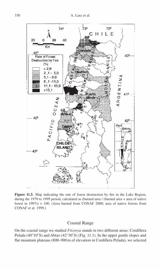
Coastal Range
On the coastal range we studied Fitzroya stands in two different areas: CordilleraPelada (40°10¢S) and Abtao (42°30¢S) (Fig. 11.1). In the upper gentle slopes andflat mountain plateaus (800–900m of elevation in Cordillera Pelada), we selected
330 A. Lara et al.
Figure 11.5. Map indicating the rate of forest destruction by fire in the Lake Region,during the 1979 to 1999 period, calculated as (burned area / (burned area + area of nativeforest in 1997)) ¥ 100. (Area burned from CONAF 2000; area of native forests fromCONAF et al. 1999.)

four stands that differ in the time since the last stand-devastating fire: from standA (most recently disturbed) through D (free of disturbances for a long period).Detailed methods and site descriptions are given in Lara et al. 1999a). In Abtaowe analyzed stand E, located on the flat tops of Cordillera de Piuchué withinChiloé National Park at 650m of elevation. Further descriptions for this stand aregiven in Armesto et al. (1996).
The stands and the area around Piedra del Indio (elevation 900m) and otherneighboring areas in Cordillera Pelada were searched for stumps with fire scars,following methods described by Dietrich and Swetnam (1984). We used standard
11. The Lake Region of South-Central Chile 331
Figure 11.6. Age structures at coring height. Stands A, B, C, and D are located inCordillera Pelada; stand E is located in Abtao. Stands TPU, CTP, AST1, and FNU arelocated in the Central Depression. (Data from Lara et al. 1999a; Aravena, unpublisheddata; and Silla 1997.)
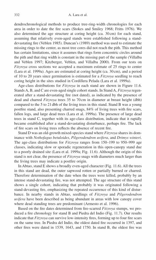
dendrochronological methods to produce tree-ring-width chronologies for eacharea in order to date the fire scars (Stokes and Smiley 1968; Fritts 1976). We also determined the age structure at coring height (ca. 30cm) for each stand,assuming that relatively even-aged stands were established following a stand-devastating fire (Veblen 1985). Duncan’s (1989) method was used to estimate themissing rings to the center, as most tree cores did not reach the pith. This methodhas certain limitations, since it assumes that rings form concentric circles aroundthe pith and that ring width is constant in the missing part of the sample (Villalbaand Veblen 1997; Kitzberger, Veblen, and Villalba 2000). From our tests onFitzroya cross sections we accepted a maximum estimate of 25 rings to center(Lara et al. 1999a). Ages are estimated at coring height (ca. 30cm), and a periodof 10 to 20 years since germination is estimated for a Fitzroya seedling to reachcoring height in the sites studied in Cordillera Pelada (Lara et al. 1999a).
Age-class distributions for Fitzroya in each stand are shown in Figure 11.6.Stands A, B, and C are even-aged single cohort stands. In Stand A, Fitzroya regen-erated after a stand-devastating fire (not dated), as indicated by the presence ofdead and charred Fitzroya trees 35 to 70cm in diameter at breast height (dbh)compared to the 5 to 21dbh of the living trees in this stand. Stand B was a youngpostfire stand, also presenting charred snags, 84% of living trees with fire scars,fallen logs, and large dead trees (Lara et al. 1999a). The presence of large deadtrees in stand C, together with its age-class distribution, indicate that it rapidlybecame established after a stand-devastating disturbance, perhaps fire. The lackof fire scars on living trees reflects the absence of recent fire.
Stand D was an old-growth mixed-species stand where Fitzroya shares its dom-inance with Nothofagus betuloides, Pilgerodendron uvifera, and Drimys winteri.The age-class distributions for Fitzroya ranges from 150–199 to 950–999 ageclasses, indicating slow or sporadic regeneration in this open-canopy stand dueto a poorly drained site (Lara et al. 1999a; Fig. 11.6). Although the origin of thisstand is not clear, the presence of Fitzroya snags with diameters much larger thanthe living trees may indicate a postfire origin.
In Abtao, stand E shows a broadly even-aged character (Fig. 11.6). All the treesin this stand are dead, the outer sapwood rotten or partially burned or charred.Therefore determination of the date when the trees were killed, probably by anintense stand-devastating fire, was not attempted. The age structure of this standshows a single cohort, indicating that probably it was originated following astand-devasting fire, emphasizing the repeated occurrence of this kind of distur-bance. In nearby stands in Abtao, seedlings of Fitzroya and Pilgerodendronuvifera have been described as being abundant in areas with low canopy coverwhere dead standing trees are predominant (Armesto et al. 1996).
Based on the fire dates determined from fire-scarred Fitzroya stumps, we pro-duced a fire chronology for stand B and Piedra del Indio (Fig. 11.7). Our resultsindicate that Fitzroya can survive low-intensity fires, forming up to four fire scarson the same tree. In Piedra del Indio, the oldest dated fire occurred in 1397, andother fires were dated in 1539, 1643, and 1750. In stand B, the oldest fire was
332 A. Lara et al.
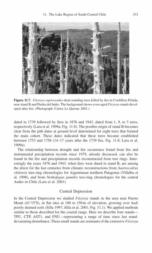
dated in 1739 followed by fires in 1876 and 1943, dated from 1, 9, to 3 trees,respectively (Lara et al. 1999a; Fig. 11.8). The postfire origin of stand B becomesclear from the pith dates at ground level determined for eight trees that formedthe main cohort. These dates indicated that these trees became establishedbetween 1753 and 1756 (14–17 years after the 1739 fire, Fig. 11.8; Lara et al.1999a).
The relationship between drought and fire occurrence found from fire andinstrumental precipitation records since 1979, already discussed, can also befound in the fire and precipitation records reconstructed from tree rings. Inter-estingly the years 1876 and 1943, when fires were dated in stand B, are amongthe driest for the last centuries from climatic reconstructions from Austrocedruschilensis tree-ring chronologies for Argentinean northern Patagonia (Villalba etal. 1998), and from Nothofagus pumilio tree-ring chronologies for the centralAndes in Chile (Lara et al. 2001).
Central Depression
In the Central Depression we studied Fitzroya stands in the area near Puerto Montt (41°15¢S), in flat sites at 100 to 150m of elevation, growing over ñadipoorly drained soils (Silla 1997; Silla et al. 2001; Fig. 11.1). We applied methodssimilar to those described for the coastal range. Here we describe four stands—TPU, CTP, AST1, and FNU—representing a range of time since last stand-devastating disturbance. These small stands are remnants of the extensive Fitzroya
11. The Lake Region of South-Central Chile 333
Figure 11.7. Fitzroya cupressoides dead standing trees killed by fire in Cordillera Pelada,near stand B and Piedra del Indio. The background shows even-aged Fitzroya stands devel-oped after fire. (Photograph: Carlos Le Quesne 2001.)

forests that covered this area before the European settlement that started in the1850s (Wilhelm 1968; Donoso 1993; Fraver et al. 1999). Despite the devastatingfires to which these forests were exposed, Fitzroya was capable of colonizingcertain sites, creating dense even-aged stands (Silla 1997; Silla et al. 2001).
Stands TPU, CTP, and AST1 show bell-shaped age structures, which indicateeven-aged cohorts and a rapid establishment of Fitzroya after a stand-devastating disturbance. Presence of charred snags and stumps indicate that thisdisturbance probably was fire (Fig. 11.6). Stand FNU shows two cohorts withages at coring height ranging from 80 to 109 years for the oldest one and 20through 49 years for the youngest one, according to the age classes that arepresent (Fig. 11.6). The oldest cohort was originated after a stand-devastating dis-turbance, probably fire. The youngest cohort seems to have been established aftera low intensity fire, which many older trees survived. This latter interpretation issupported by the presence of a growth release of many of the older survivingtrees starting in 1943 and of abundant charred older living trees (Silla 1997).
334 A. Lara et al.
Figure 11.8. Fire chronology (top) and tree-ring-width chronology (bottom) for stand B in Cordillera Pelada. The horizontal lines represent the lifespan of individual trees, indicating the pith date. Black triangles are fires from scars, indicating their date on top.The tree-ring chronology used 10 to 15 trees and a horizontal standardization. Tree-ringindices provide a dimensionless indicator of radial growth.
Andean Range
The most important disturbances in the Fitzroya forests in the Andes are tephradeposition, landslides, lava flows, and logging (Schmidt and Burgos 1977;Rodríguez 1989; Lara 1991; Fig. 11.2). Fire is a minor type of disturbance in thisarea (Lara 1991). Available data indicate that in two study areas in the Andes(Contao and Alerce Andino National Park, Fig. 11.1), over a total area of 26,900ha, human-set fires represent 0.45% of the total disturbed area (13,260ha)in the 1943 to 1990 period (Lara 1991).
Fitzroya regeneration in areas affected by clear-cutting, selective logging, orhuman-set fires in the Andes is absent or extremely scarce (Veblen, Delmastro,and Schlatter 1976; Schmidt and Burgos 1977; Rodríguez 1989; Lara 1991;Donoso et al. 1993). Nevertheless, there are no specific studies addressing theinfluence of fire in the dynamics of Fitzroya forests in the Chilean Andes.
Fires and Forest Conservation
Human-set fires for clearing of forests for the development of pasture and agri-culture land has been a major disturbance and the main cause of reduction offorest cover in the Lake Region since the extensive European settlement startingin the 1850s (Wilheim 1968; Elizalde 1970; Donoso 1983). This settlement ofthe Lake Region resulted in one of the most massive and rapid deforestationprocesses recorded in Latin America, which prevailed until the early 1980s(Veblen 1983).
The reconstruction of forest cover prior to the European settlement from his-torical documentary data, and potential sites using Geographic InformationSystem (GIS) estimates that prior to the European settlement, native forestscovered 5.6 million hectares in the Lake Region (Lara et al. 1999b). This meansthat the present native forest cover of 3.6 million hectares in this region repre-sents 62% of the presettlement condition. The forest cover types that were moredramatically affected are Pilgerodendron uvifera, Nothofagus spp., and Fitzroya,with remaining fractions of 22%, 39%, and 46%, respectively, compared to thepresettlement condition (Lara et al. 1999b). At the same time the area of grass-lands, shrublands, and agriculture land increased from covering less than 1% ofthe region to 29% after the European settlement (Lara et al. 1999b).
By the turn of the nineteenth century extensive areas formerly covered bynative forests in the Lake Region had been burned by human-set fires and con-verted to pasture and agriculture land, especially in the Central Depression(Elizalde 1970; Donoso 1983). Although reliable data are not available, the rateof forest destruction by human-set fires probably decreased through the twenti-eth century. Nevertheless, as previously discussed, fire records demonstrate thathuman-set fires have continued as an important disturbance and cause of forestdestruction in the Lake Region in the last two decades until present. Other impor-tant causes of native forest destruction and degradation in this recent period have
11. The Lake Region of South-Central Chile 335
been the conversion to Pinus radiata and Eucalyptus spp. plantations and loggingthrough high-grading (Lara, Donoso, and Aravena 1996).
Fire records for the last two decades indicate that there is a high spatial het-erogeneity in the rate of forest destruction by fire through the Lake Region (Fig.11.5). Rate of forest destruction by fire in the 1979 to 1999 period varies from<2% of the area of native forests existing in 1979 in 16 counties to 11.1–15% intwo other counties (Fig. 11.5). If this latter rate is maintained in the future, itwould take between 140 and 191 years to burn an area equivalent to the total areaof native forests existing in 1979 in these counties (i.e., rotation period; sensuWhite and Pickett 1985). These are rough estimates limited by the short periodof observations, the high annual variability of the area burned, and the uncer-tainty of how the area burned each year will vary in the future. Nevertheless,these estimates indicate that human-set fires are an important threat to nativeforests in some counties, and that action should be taken for the conservation ofthe remaining native forests in these counties.
The impact of fire on forest conservation is higher in the counties located inthe coastal range and the Central Depression compared to that in the Andes (Fig.11.5). The areas that show low fire incidence coincide with those located withinnational parks, which are mainly concentrated in the Andes. The insufficientamount of protected areas in the Central Depression and the coastal range (withless than 1.4% and 4.4% of forest area being protected, respectively; Lara 1991)adds an extra pressure over these forests. This contrasts with the Andean Range,where 17% of the forests are within national parks and reserves.
Although fire records are not separated by forest type, these records have beenkept for Fitzroya forests since 1987. These records indicate that human-set firesare an important threat to the conservation of Fitzroya forests. Due to its high-quality wood which is resistant to decay, Fitzroya forests have been extensivelylogged since the European settlement until now (Elizalde 1970; Veblen, Delmastro, and Schlatter 1976; Lara 2000). Exports of Fitzroya timber have con-tributed to increase the pressure over these forests. The awareness of the inter-national community about these issues determined that in 1973 Fitzroya becamelisted in Appendix I under the Convention on International Trade of EndangeredSpecies (CITES), and its international trade was forbidden until today. Fitzroyahas also been included as a threatened species in the U.S. Endangered SpeciesAct since 1979, which prohibits its importation into the United States (Anony-mous 1979). The Chilean law has forbidden cutting of living Fitzroya treesthrough the Supreme Decree 490 since 1976. Nevertheless, this law permitscutting and trading of timber coming from trees that have been killed by fire, cutor were dead by natural causes before 1976 (Anonymous 1976). This weaknessin the law has permitted, and to a certain extent promoted, intentional fires ofFitzroya forests with the purpose of getting dead trees for which a logging permitmay be obtained, circumventing the law since the trees were killed after 1976.The law is also circumvented through the cutting of living trees and trading thewood as if it came from previously dead trees. Law enforcement by CONAF(Chilean Forest Service) in the remote areas where Fitzroya forests occur has
336 A. Lara et al.

been problematic and insufficient. In addition legal actions taken by the LocalCourts of the Counties have been weak. Only in a small percentage of the casesdenounced by CONAF have these Courts determined fines and sanctions againstthe violators of the law protecting Fitzroya (Lara 2000). The international pro-tection of this species has also been difficult. Different interpretations of CITESregarding the restrictions on Fitzroya exports as well as limitations in the enforce-ment of the treaty have determined that the timber of this species continues to be exported mainly to Japan and Argentina and also to Australia, Spain, theNetherlands, and the United States (Lara 2000).
An extreme example of the threat to Fitzroya forests by human-set fires to killthe trees and then log them, circumventing the law is the case of the Fresia county.This county has the highest rate of forest destruction by fire in the Lake Region(28.8% between 1979 and 1999, which provides an estimation of the rotationperiod of 73 years). In the dry summer of 1997 in the Lake Region produced byan ENSO warm event, 9477ha of Fitzroya forests were burned in the Fresiacounty, representing 68% of the total forested area burned that year in the county.In 1987, in another dry summer associated with an ENSO warm event, 11,000haof native forests were burned in Fresia, 12% of which corresponded to Fitzroyaforests.
The large surfaces of burned forests in the coastal range and Central Depres-sion, together with the scarce protection of forests in these areas, indicate theneed to carry out programs toward the protection and conservation of theseforests. Threatened forest types such as Fitzroya forests in the Central Depres-sion and the coastal range should be considered a priority. Changes in the lawprotecting Fitzroya and the improvement of law enforcement are needed as wellas the creation of new protected areas, especially in the coastal range and theCentral Depression (Lara 2000). Studies on the genetic variability using DNAmarkers (RAPDs) have demonstrated important genetic variations of Fitzroyathrough its geographic range in Chile and Argentina (Alnutt et al. 1999). Ongoingecological restoration efforts in the Central Depression using nursery-producedseedlings of local provenances to promote the genetic conservation of fewremnant fragmented Fitzroya populations need to be strengthened and expandedto other areas (Gardner et al. 1999; Silla et al. 2001). The development of alter-natives for the owners (e.g., use of other species for wood or nontimber forestproducts, eco-tourism) should also contribute to the conservation of these forests(Lara 2000).
Conclusion and Future Research
Vegetation patterns at a regional scale are a response to the combined effect ofthe environmental gradients (physiography, soils, moisture, temperature, etc.) andthe disturbance regimes (Fig. 11.2). Since the disturbance regimes vary graduallyalong these environmental gradients, we propose that the physical environmentcontrols vegetation both directly and indirectly through the disturbance gradient.
11. The Lake Region of South-Central Chile 337

Fire has been an important disturbance throughout the Lake Region. Fire datesreported in this chapter, starting in AD 1397, indicate that some fires occurredprior to the European settlement of the Chilean Lake Region. In this period (priorto ca. 1850) fires might have been started by the native people, who traveledthrough the coastal range, or by lightning, which occasionally occurs duringspring and summer storms. Several authors have presented evidence, from his-torical documents, of the influence of Native American hunters on fire ignition,in northern Patagonia, Argentina, prior to ca. 1890–1900 (Veblen and Lorenz1988; Veblen and Markgraf 1988; Markgraf and Anderson 1994).
Most of the fires that have affected natural forests in the Lake Region in the1979 to 1999 period are intentionally set by people or due to forest use and otheractivities, and are concentrated during the summer months. The annual variabil-ity of the burned area coincides with five dry summers, but there are three drysummers in which the burned area did not increased. This indicates that climateand human ignition variability, both factors and probably others that need to beidentified, influence the fire regime of the Lake Region. Similarly detailed studiesin northern Patagonia, Argentina, have shown important influences of climate andhuman activities on fire regimes along the gradient from the xeric woodlands near the Patagonian steppe to Nothofagus and Fitzroya rain forests in the Andes(Kitzberger and Veblen 1997; Kitzberger, Veblen, and Villalba 1997; Veblen etal. 1999; Veblen et al., Chapter 9, this volume, Kitzberger and Veblen, Chapter10, this volume).
Repeated fires have played a major role in the dynamics of Fitzroya forests inthe coastal range and Central Depression during the last 600 years. In contrast,fires do not seem to have played a crucial role in the forest dynamics of this foresttype in the Chilean Andes. Thus the Fitzroya forests in the coastal range differfrom those of the Chilean Andes in both their disturbance regimes and their abilityto regenerate following fire. These differences in Fitzroya response to fire maybe explained by reduced competition from other species under the lower soilnutrient availability of the coastal range compared to the Andes, but this hypoth-esis needs to be further investigated.
Our results indicate that there is a significant potential for the development ofa network of fire chronologies from tree rings for the last 1000 years or more.Other potential studies on fire regimes could focus on the distribution of theserecords along latitudinal, longitudinal, and elevation gradients in order to producea long-term, regional view and a better understanding of the relationships amongthe climate variability, fire regimes, and vegetation responses to both. Thesestudies could be compared to similar ones already done in drier areas in centralChile and Argentinean Patagonia, and in North America. Specific aspects thatneed to be addressed are (1) parameters of the fire regimes such as intensity, meanreturn interval, and ignition sources; (2) the variation of these parameters alongenvironmental gradients; and (3) the combined effect of different types of dis-turbance (i.e., fire, logging, grazing) on the regeneration and dynamics of dif-ferent forest types, such as Fitzroya cupressoides, Pilgerodendron uvifera,Araucaria araucana, and Nothofagus spp. forests. Future research on fire regimes
338 A. Lara et al.

should be taken as a basis for adequate planning and for improving decisionmaking related to forest management and conservation.
Acknowledgments. Financial support for this work was provided by FONDECYT(Project 1-93-0049), the National Geographic Society (Project 4987-93), Fundación Andes (Project C12600/9), a Darwin Initiative for the Protection ofSpecies grant administered through the Royal Botanical Garden Edinburgh, European Commission DGXII (Contract ERBIC18CT970146), the CRN03project of the Inter-American Institute for Global Change Research (IAI), andvarious grants from WWF. We are grateful to CONAF for providing permits forsample collection, for the use of the forest cover GIS database, and for theirsupport during fieldwork. We thank J. Bosnich, L. Escandar, and S. Mendoza forproviding the fire records database and E. Neira for preparing the figures.
References
Allnutt, T.R., Newton, A.C., Lara, A., Premoli, A., Armesto, J.J., Vergara, R., and Gardner,M. 1999. Genetic variation in Fitzroya cupressoides (alerce), a threatened South American conifer. Mol. Ecol. 8:975–987.
Almeyda, A.E., and Sáez, S.F. 1958. Recopilación de datos climáticos de Chile y mapassinópticos respectivos. Ministerio de Agricultura, Santiago.
Anonymous. 1976. Decreto Superemo 490 que declara Monumento Natural al Alerce. Santiago: Ministerio de Agricultura.
Anonymous. 1979. Determination that Fitzroya cupressoides is a threatened species. Fed.Reg. 44:64730–64733.
Armesto, J.J., Aravena, J.C., Villagrán, C., Pérez, C., Parker, G.G., and Villagrán, C. 1996.Bosques templados de la Cordillera de la Costa. In Ecología de los Bosques Nativosde Chile, eds. J.J. Armesto, C. Villagrán, and M.K. Arroyo, pp. 199–212. Santiago:Editorial Universitaria.
Clapperton, C.M. 1994. The quaternary glaciation of Chile: a review. Rev. Chil. Hist. Nat.67:369–383.
CONAF, CONAMA, Universidad Austral de Chile, P. Universidad Católica de Chile and Universidad Católica de Temuco. 1999. Catastro y Evaluación de los Recursos Vegetacionales Nativos de Chile. Informe Final. Santiago: Corporación Nacional Forestal.
CONAF 2000. Información estadística histórica de ocurrencia y daño de los incendiosforestales: Período 1979–1999. Décima Región de Los Lagos. Puerto Montt: Corporación Nacional Forestal.
Cortés, M.A. 1990. Estructura y dinámica de los bosques de alerce (Fitzroya cupressoides)en la Cordillera de la Costa de la Provincia de Valdvia. M.S. thesis. Facultad de Ciencias Forestales, Universidad Austral de Chile, Valdivia.
Denton, G.H. 1993. Chronology of late Pleistocene glaciation near Lago Llanquihuebetween Puerto Varas and Puerto Octay. In El Cuaternario de la Región de los Lagosdel Sur de Chile, ed. C. Villagrán, pp. 53–63. Taller Internacional “El Cuaternario deChile,” Santiago, November 1–9, 1993. Guía de Excursión.
Di Castri, F., and Hajek, E. 1976. Bioclimatología de Chile. Santiago: VicerrectoríaAcadémica de la Universidad Católica de Chile.
Dieterich, J.H., and Swetnam, T.W. 1984. Dendrochronology of a fire-scarred ponderosapine. For. Sci. 30:238–247.
Donoso, C. 1981. Tipos forestales de los bosques nativos chilenos. Proyecto CONAF/FAO/PNUD. Documento de Trabajo 38. Santiago.
11. The Lake Region of South-Central Chile 339
Donoso, C. 1983. Modificaciones del paisaje forestal chileno a lo largo de la historia. InProceedings of the Symposium Desarrollo y perspectivas de las disciplinas forestalesde la Universidad Austral de Chile, pp. 365–438. Valdivia.
Donoso, C. 1993. Bosques templados de Chile y Argentina: Variación, estructura ydinámica. Santiago: Editorial Universitaria.
Donoso, C., Sandoval, V., Grez, R., and Rodríguez, J. 1993. Dynamics of Fitzroya cupres-soides forests in southern Chile. J. Veg. Sci. 4:303–312.
Duncan, R.P. 1989. An evaluation of errors in tree age estimates based on increment coresin kahikatea (Dacrycarpus dacrydioides). New Zealand Nat. Sci. 16:31–37.
Elizalde, R. 1970. La sobrevivencia de Chile. Santiago: Ministerio de Agricultura, Servicio Agrícola y Ganadero.
Fraver, S., González, M.E., Silla, F., Lara, A., and Gardner, 1999. Composition and struc-ture of remnant Fitzroya cupressoides forests of southern Chile’s Central Depression.J. Torrey Bot. Soc. 126:49–57.
Fritts, H. 1976. Tree Rings and Climate. London: Academic Press.Fuenzalida, H. 1950. Biogeografía. In Geografía Económica de Chile, ed. CORFO,
pp. 371–428. Santiago: Editorial Universitaria.Gardner, M.F., Thomas, P., Lara, A., and Escobar, B. 1999. Fitzroya cupressoides
(Cupressaceae). Curti’s Bot. Mag. 16:229–240.Hauser, A. 1984. Consideraciones Geológicas y, Geotécnicas en Relación con la Con-
strucción del Camino Longitudinal Austral, X y XI Regiones. Santiago: ServicioNacional de Geología y Minería.
Heusser, C.J. 1994. Paleoindians and fire during late Quaternary in southern SouthAmerica. Rev. Chil. Hist. Nat. 67:435–443.
INIA. 1985. Referencia suelos volcánicos de Chile. Santiago: Ministerio de Agricultura.Kalin, M.T., Cavieres, L.L., Peñaloza, A., Riveros, M., and Faggi, A.M. 1996. Relaciones
fitogeográficas y patrones regionales de riqueza de especies en la flora del bosque llu-vioso templado de Sudamérica. In Ecología de los Bosques Nativos de Chile, eds. J.J.Armesto, C. Villagrán, and M.K. Arroyo, pp. 71–99. Santiago: Editorial Universitaria.
Kitzberger, T., and Veblen, T.T. 1997. Influences of humans and ENSO on fire history ofAustrocedrus chilensis woodlands in northern Patagonia, Argentina. Écoscience 4:508–520.
Kitzberger, T., Veblen, T.T., and Villalba, R. 1997. Climatic influences on fire regimesalong a rain forest-to-xeric woodland gradient in northern Patagonia, Argentina. J. Bio-geogr. 24:35–47.
Kitzberger, T., Veblen T.T., and Villalba, R. 2000. Metodos deudrocromológicos Suy susaplicaciomes eu estudios de dinamica de bosques templados de d’américa. In Dendro-cronologia ou America Latina, ed. F.A. Roig, EDIUNC, Mendoza, Argentina.
Kühne, A. 1985. Estudio pedológico y geomorfológico de Contao a Río Negro en la XRegión de Los Lagos. Boletín Técnico 20. Santiago: Corporación Nacional Forestal.
Lara, A. 1991. The dynamics and disturbance regimes of Fitzroya cupressoides forests inthe south central Andes of Chile. Ph.D. dissertaiton. University of Colorado, Boulder.
Lara, A. 2000. Importancia Científica, protección legal y uso destructivo de los bosquesde alerce (Fitzroya cupressoides): Una contradición que debe resolverse. Bosque Nativo27:3–13.
Lara, A., and Villalba, R. 1993. A 3620-year temperature record from Fitzroya cupres-soides tree rings in southern South America. Science 260:1104–1106.
Lara, A., Donoso, C., and Aravena, J.C. 1996. La conservación del bosque nativo de Chile:problemas y desafíos. In Ecología de los Bosques Nativos de Chile, eds. J.J. Armesto,C. Villagrán, and M. K. Arroyo, pp. 335–362. Santiago: Editorial Universitaria.
Lara, A., Fraver, S., Aravena, J.C., and Wolodarsky-Franke, A. 1999a. Fire and dynamicsof Fitzroya cupressoides forests of Chile’s Cordillera Pelada. Ècoscience 6:100–109.
340 A. Lara et al.

Lara, A., Solari, M.E., Rutherford, P., Thiers, O., and Trecamán, R. 1999b. Cobertura dela vegetación original de la Ecoregión de los Bosques Valdivianos de Chile hacia 1550.Informe Técnico. Valdivia: Universidad Austral de Chile-World Wildlife Fund.
Lara, A., Aravena, J.C., Villalba, R., Wolodarsky-Franke, A., Luckman, B., and Wilson,R. 2001. Dendroclimatology of high-elevation Nothofagus pumilio forests at theirnorthern distribution limit in the Central Andes of Chile. Can. J. For. Res. 31:925–936.
Levi, B., Aguilar, A., and Fuenzalida, R. 1966. Reconocimiento geológico de las Provin-cias de Llanquihue y Chiloé. Boletín N°. 19. Santiago: Instituto de InvestigacionesGeológicas.
Lusk, C.H., 1996. Gradient analysis and disturbance history of temperate rain forests ofthe coast range summit plateau, Valdivia, Chile. Rev. Chil. Hist. Nat. 69:401–411.
Markgraf, V., and Anderson, L. 1994. Fire history of Patagonia: Climate versus humancause. Rev. Instit. Geogr. Sao Paulo 15:35–47.
Mercer, J.H. 1976. Glacial history of southernmost South America. Quat. Res. 6:125–166.Porter, S.C. 1981. Pleistocene glaciation in the southern Lake Region of Chile. Quat. Res.
16:263–292.Rodríguez, J.P. 1989. Estrategias regenerativas de Alerce (Fitzroya cupressoides (Mol.)
Johnston) en el sector de Contao, Cordillera de los Andes, Provinicia de Palena. M.S.thesis. Facultad de Ciencias Forestales, Universidad Austral de Chile Valdivia.
Schmidt, H., and Burgos, P. 1977. Estructura y desarrollo natural del bosque de Alerce.In Informe Forestal de las Areas de Futaleufú y Contao en la X Región. Facultad deCiencias Forestales, pp. 57–64. Santiago: Universidad de Chile.
Schulman, E. 1956. Dendroclimatic change in semiarid America. Tucson: University ofArizona Press.
Servicio Nacional de Geología y Minería. 1982. Mapa Geológico de Chile Escala 1 :1.000.000. Santiago: SERNAGEOMIN.
Silla, F. 1997. Dinámica regenerativa del alerce (Fitzroya cupressoides) de la DepresiónIntermedia. M.S. thesis. Facultad de Ciencias. Universidad Austral de Chile, Valdivia.
Silla, F., Shawn, F., Lara, A., Allnut, T., and Newton, A. 2001. Regeneration and standdynamics of Fitzroya cupressoides (Cupressaceae) forests of Southern Chile’s CentralDepression. For. Ecol. Manag., in press.
Stokes, M.A., and Smiley, T.L. 1968. An Introduction to Tree-Ring Dating. Chicago: University of Chicago Press.
Tudhope, A.W., Chilcott, C.P., McCullock, M.T., Cook, E., Chapell, J., Ellam, R.M., Lea,D.W., Lough, J.M., and Shimmield, G.B. 2001. Variability in the El Niño–SouthernOscillation through a Glacial-Interglacial cycle. Science 291:1511–1517.
Veblen, T.T. 1983. Degradation of native forest resources in southern Chile. In History ofsustained-yield forestry: A symposium, pp. 344–352. Durham, NC: Forest HistorySociety.
Veblen, T.T. 1985. Stand dynamics in Chilean Nothofagus forests. In The Ecology ofNatural Disturbance and Patch Dynamics, eds. S.T.A. Pickett and P.S. White, pp.35–51. New York: Academic Press.
Veblen, T.T., and Ashton, D.H. 1978. Catastrophic influence on the vegetation of the Valdivian Andes. Vegetatio 36:149–167.
Veblen, T.T., and Ashton, D.H. 1982. The regeneration status of Fitzroya cupressoides inthe Coastal Range, Chile. Biolog. Conserv. 23:141–161.
Veblen, T.T., and Lorenz, D.C. 1988. Recent vegetation changes along the forest–steppeecotone in northern Patagonia. Ann. Assoc. Am. Geogr. 78:93–111.
Veblen, T.T., and Markgraf, V. 1988. Steppe expansion in Patagonia? Quat. Res. 30:331–338.
Veblen, T.T., Delmastro, R.J., and Schlatter, J.E. 1976. The conservation of Fitzroyacupressoides and its environment in southern Chile. Environ. Conserv. 3:291–301.
11. The Lake Region of South-Central Chile 341

Veblen, T.T, Donoso, C., Schlegel, F.M., and Escobar, B. 1981. Forest dynamics in south-central Chile. J. Biogeogr. 8:211–247.
Veblen, T.T., Burns, B.R., Kitzberger, T., Lara, A., and Villalba, R. 1995. The ecology ofconifers of southern South America. In Ecology of the Southern Conifers, eds. N.J.Enright and R.S. Hill, pp. 120–155. Melbourne: Melbourne University Press.
Veblen, T.T., Kitzberger, T., Burns, B.R., and Robertus, A.J. 1996. Perturbaciones ydinámica de regeneración en bosques andinos del sur de Chile y Argentina. In Ecologíade los Bosques Nativos de Chile, eds. J.J. Armesto, C. Villagrán, and M.K. Arroyo, pp.169–198. Santiago: Editorial Universitaria.
Veblen, T.T., Kitzberger, T., Villalba, R., and Donnegan, J. 1999. Fire history in northernPatagonia: The roles of humans and climatic variation. Ecol. Monogr. 69:47–67.
Villalba, R., and Veblen, T.T. 1997. Improving estimates of total tree ages based on incre-ment core samples. Écoscience 4:534–542.
Villalba, R., Cook, E.R., Jacoby, G.C., D’Arrigo, R.D., Veblen, T.T., and Jones, P.D. 1998.Tree-ring based reconstructions of norhern Patagonian precipitations since AD 1600.Holocene 8:659–675.
White, P.S., and Pickett, S.T.A. 1985. Natural disturbance and patch dynamics: an intro-duction. In The ecology of natural disturbance and patch dynamics, eds. S.T.A. Pickettand P.S. White, pp. 3–13. New York: Academic Press.
Wilhelm, E.J. Jr. 1968. Fire ecology of the Valdivian rain forest. Proceedings 8th Tall Timbers Fire Ecology Conference, Tallahasee, FL, Tall Timbers Research, Inc. pp. 55–70.
342 A. Lara et al.

12. Fire History in Central Chile: Tree-Ring Evidence and Modern Records
Juan Carlos Aravena, Carlos LeQuesne, Héctor Jiménez, Antonio Lara, and Juan J. Armesto
Wildfires in Chile are believed to have originated primarily from fires set byhumans to clear natural vegetation to permit agriculture (also see Montenegro etal., Chapter 14, this volume). Besides the intentionally set fires, rapid populationgrowth during the last several decades of the twentieth century has further con-tributed to an exponential increase in fires set accidentally by motor vehicles along roadsides and by careless campers, especially in central Chile where thehuman population is concentrated (CONAF 2000). Of course, some fires areignited naturally by lightning and volcanic eruptions, but the frequency of suchignitions is relatively low in comparison with human-set fires. It is likely that sucha low-frequency fire regime may have prevailed before the arrival of indigenouspopulations to this region, as suggested by sedimentary records of charcoal andfossil pollen covering the past 40,000 years (Heusser 1994).
Effects of fires on the sclerophyllous vegetation of central Chile have been thoroughly studied from a physiological and ecological point of view (Montenegro et al., Chapter 14, this volume). However, long-term records of firehistory, derived either from sedimentary charcoal or from tree rings are extremelyscarce for Chile, in general, including central Chile which is the focus of thischapter (Heusser 1994). Tree rings permit the dating of past fires to an annualresolution and thus can provide useful information on the frequency and recur-rence intervals of past fires. Additional information on fire extent, intensity, anddirection of spread may be derived from data on spatial patterns of fire-scarredtrees. In central Chile (32° to 38°S) several woody species produce annual tree
343

rings that are appropriate for the study of fire history. In particular, montane andsubalpine conifer forests of Austrocedrus chilensis, discontinuously distributedthroughout central Chile, are dominated by long-lived trees highly resistant tolow-intensity fires (Veblen et al. 1995). These trees can provide valuable infor-mation about fire regimes associated with human occupation of this region dur-ing the past 100 to 1000 years, as well as the association of fire with particularweather conditions. This chapter is the first attempt to reconstruct fire historiesin forests of Austrocedrus chilensis in central Chile. It is based on data from ourongoing dendrochronological studies and the analysis of modern historical recordsof fire.
Modern Records
Historical Data
Complete statistics of the occurrence and intensity of wildfires in Chile are avail-able only for the last three decades (CONAF 2000). For earlier periods the his-torical record is incomplete and fragmentary. Although historical records for thepre-1970 period do not provide a complete record, they do allow the detection ofsome qualitative patterns of fire occurrence in relation to human activities, andpermit tentative interpretations of the impacts of changes in fire regimes on thevegetation.
Archaeological data document the beginning of human occupancy in Chile as late Glacial, as occurring 14,000BP. The first inhabitants were hunters ofmegafauna who reached the southernmost tip of the continent at the start of theHolocene period (Mostny 1994; Dillehay 1988; Nuñez et al. 1994). Pollen recordsshow remarkable increases of charcoal traces that coincide with this early Paleo-Indian occupation (Heusser 1994). This evidence suggests that the setting of fireswas common practice among early inhabitants; presumably it served the purposeof opening hunting grounds. Heusser (1994) postulates an anthropogenic causefor the charcoal evidence in the period from 44,000 to 15,000BP, and assumesintermittent human presence during interglacials periods. This hypothesis, how-ever, is not supported by any archaeological evidence. After the extinction of the megafauna, the human populations survived as hunter-gatherers during theHolocene until ca. 2300BP. The effect of these activities on natural vegetation isconsidered to be negligible given the low human population density of this period.
In the following cultural period (from 2300BP), called agroalfarero, the highernumber of settlement sites implied an increase in human population density.Encina (1940–52) estimated that the number of inhabitants living during thatperiod between Aconcagua and Seno Reloncaví (32° to 42°S) reached one million,and concomitantly, there was an increase in the use of fire to eliminate native vegetation. Fire was used to prepare croplands and grazing areas for camelids inthe Aconcagua and Maipo Valleys under the Inca dominion (until the beginning ofsixteenth century).
344 J.C. Aravena et al.

During the Spanish Conquest and Colonial Period (1540–1810), the use of fire was intensified in the central valley between Aconcagua and Bío Bío (32° to38°S). This increase in burning indicates more intensive agriculture, cattle ranch-ing, and mining practices (Mooney et al. 1972). In particular, in the late 1700swheat was introduced, and its cultivation became widespread to meet an exportmarket created by the mining operations of neighboring colonies (Amunategui1940). In addition there was a selective exploitation of commercially valuabletree species such as Quillaja saponaria, Austrocedrus chilensis, Cryptocaryaalba, and the endemic Palm Jubaea chilensis. Despite this early exploitation of timber resources in central Chile, the period from the mid-1800s to the latetwentieth century is clearly when the most intensive and devastating exploita-tion of forests has occurred. Since the second half of the 1800s, the deciduouscoastal forest of this region dominated by many species of the genus Nothofa-gus, was cleared to open lands for wheat crops to be exported to Perú, to northern Chile whose growth was due to silver and copper mining, and to California during the nineteenth-century gold rush (Amunategui 1940; Pérez-Rosales 1980).
Recent Fire Records
The statistics for the last 25 years (CONAF 2000) on the number of forest firesrecorded for central Chile (32° to 38°S) show an increasing trend in wildfires(Fig. 12.1a). Fire seasons (October–March of the following year) were namedaccording to the calendar year in which the fire season began, according to Schulman’s (1956) convention for tree rings in the Southern Hemisphere. In con-trast to the number of fires, the total area burned by wildfires each year showslarge fluctuations from year to year (Fig. 12.1b). Thus, although the number offires has increased over the past few decades, the land area burned by fires hasfluctuated widely during the same period (Fig. 12.1c). Fluctuations in the areaburned may be related to dry years which occur in central Chile in associationwith the cool phase of the Southern Oscillation (i.e., La Niña events; Aceituno1988; Rutlland and Fuenzalida 1991).
The origins of all these fires have been attributed to human activity (Fig. 12.2).The two main causes were careless activity from roadside motor vehicles (transportation = 27%) and intentional ignitions (26%). Forestry, agriculture, andrecreation activities together accounted for almost one-third of the wildfires. One interesting point is the different trends of these fire-causing factors duringthe last three decades of the twentieth century (Fig. 12.2). While the fires set by activities related to forestry and agriculture show a clear descending trend toward the present (r 2 = 0.71, slope = -1.07), both intentionally set fires and firesdue to transportation increased remarkably. Intentionally set fires increased sevenfold (r 2 = 0.81, slope = 1.56), whereas transportation fires more thandoubled in an 18 year period (r 2 = 0.30, slope = 0.51). This reinforces the ideathat the increase in the human population is the major cause of the increasing fire frequency.
12. Central Chile 345

Tree-Ring Evidence
Austrocedrus chilensis Forests
Austrocedrus chilensis (“ciprés de la cordillera”) is a dioecious tree of pyrami-dal habit that grows on steep slopes in highly eroded and rocky substrates. Thisspecies, which is morphologically similar to the genus Libocedrus extant in NewZealand, has an austral-antarctic origin and is endemic to the temperate montaneforests of Chile and Argentina (32°39¢–44°S; Fig. 12.3). The northern Austroce-drus populations are isolated patches of long-lived individuals occurring in thearid margin of the Mediterranean-climate region, and are subjected to strong
346 J.C. Aravena et al.
Figure 12.1. (a) Number of fires, (b) area affected by fires, and (c) mean area per firebetween 1976 and 1999 in central Chile (CONAF 2000).
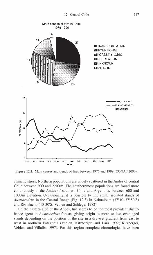
climatic stress. Northern populations are widely scattered in the Andes of centralChile between 900 and 2200m. The southernmost populations are found morecontinuously in the Andes of southern Chile and Argentina, between 600 and1000m elevation. Occasionally, it is possible to find small, isolated stands of Austrocedrus in the Coastal Range (Fig. 12.3) in Nahuelbuta (37°10–37°50¢S)and Río Bueno (40°30¢S; Veblen and Schlegel 1982).
On the eastern side of the Andes, fire seems to be the most prevalent distur-bance agent in Austrocedrus forests, giving origin to more or less even-agedstands depending on the position of the site in a dry-wet gradient from east towest in northern Patagonia (Veblen, Kitzberger, and Lara 1992; Kitzberger,Veblen, and Villalba 1997). For this region complete chronologies have been
12. Central Chile 347
Figure 12.2. Main causes and trends of fires between 1976 and 1999 (CONAF 2000).

developed that document fire occurrence over the last 450 years (Kitzberger,Veblen, and Villalba 1997; Kitzberger and Veblen 1997; Veblen et al. 1999).These authors have studied the influence of climate on fire regimes of wetNothofagus-dominated forests and Austrocedrus chilensis dry woodlands. For the wet forests there is a strong relationship between total annual area burned anddrought during spring and summer of the same year, whereas for xeric Austro-cedrus woodlands fire recurrence appears related not only to droughts during thefire season but also to the precipitation conditions during the preceding 1 or 2growing seasons (see Kitzberger and Veblen, Chapter 10, this volume).
Although detailed studies of the role of fire in the Austrocedrus forests ofcentral Chile have not yet been conducted, preliminary evidence and field observations indicate an important role for fire in these forests (Donoso 1982;LeQuesne 1988). Veblen et al. (1995) suggested that the diameter growth curvesof Austrocedrus trees presented by LeQuesne (1988) might be the result of post-
348 J.C. Aravena et al.
Figure 12.3. Geographical distribution of Austrocedrus chilensis forests and dendroeco-logical study sites in central Chile: (1) El Asiento, (2) San Gabriel, (3) Río Clarillo, (4)Río Cipreses, and (5) Alto Bío Bío.

fire sapling establishment and initial suppression of growth by the shrub layer.We are currently studying Austrocedrus sites in the northern portion of its distri-bution range (Fig. 12.3). From north to the south, our study sites are El Asiento(32°40¢S, 70°49¢W), where lies the northernmost population of the species, withscattered trees located on a polar slope between 1700 and 2200m; San Gabriel,in the Maipo River valley, between 1100 and 1400m; Rio Clarillo Forest Reserve(33°55¢S, 72°25¢W), 20km south-east of Santiago, at 2200m of altitude; RioCipreses Forest Reserve (34°49¢S, 70°51¢W), with populations occurring in aglacial valley near Los Cipreses Glacier front, between 1500 and 1900 m.a.s.l.The southernmost Austrocedrus site studied by us is Alto Bio Bio (38°00¢S,71°42¢W), located at 900-m elevation. Precipitation in these localities increasesfrom north to south from about 800mm annually to more than 3000mm in AltoBío Bío. The Austrocedrus populations that we studied in all sites are near tree-line and hence are exposed to low winter temperatures and snowfall.
Evidence of Fire in Central Chile
In all the above-mentioned sites in central Chile the same methodology was used:sampling was conducted in plots of 80 ¥ 40m placed perpendicular to the direc-tion of the slope, and all the trees reaching at least 1.3m in height were mapped,cored (using increment borers), and their diameter at breast height (dbh) recorded.Cross sections were obtained from dead Austrocedrus present within the plot orin its neighborhood in order to obtain an expanded record of fires and other dis-turbances that had occurred in the area.
In all study sites we found abundant evidence of fire, such as presence of char-coal in standing or fallen dead trees, and/or fires scars in dead and living trees. InRío Cipreses and Alto Bío Bío we were able to date fire scars observed in cross sections of stumps using standard dendrochronological methods (Fritts 1976;Schweingruber 1988; Stokes and Smiley 1968). These methods included crossdat-ing (matching ring-width patterns) ring-width patterns in fire-scar samples in deadspecimens with tree-ring-width chronologies developed for each study site.
In the Alto Bío Bío study site it was possible to date and estimate the areaaffected by fire disturbance. Here the positions of trees that were fire scarred incombination with the positions of trees showing changes in growth rates due to the fire were used to estimate the direction and extent of the fire (Fig. 12.4;Jiménez 1995). A large section of this stand was affected by more than one firefront. Unfortunately, only one of these fronts could be effectively dated, and con-sequently it was not possible to estimate the frequency of fire. Sharp reductionsof tree growth rates are often due to damages to tree crowns or the phloem whentrees survive fires (Schweingruber 1988). Surviving trees may also increase theirgrowth rates after recovery from the initial fire damage if the fire kills neigh-boring trees and reduces competition (Kitzberger, Veblen, and Villalba 2000).Such patterns of tree growth were sought for trees within the plot as well as inthe neighboring area. Radial growth increments of four trees located near theboundary of the fire front (labeled 1 to 4), as reconstructed from fire scars in AltoBío Bío, showed a pronounced growth decrease in the year 1893, which supports
12. Central Chile 349
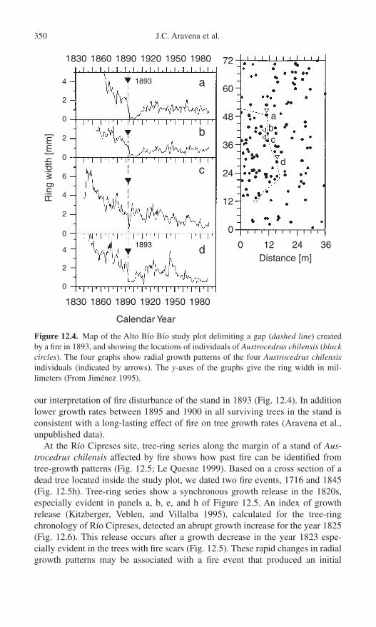
our interpretation of fire disturbance of the stand in 1893 (Fig. 12.4). In additionlower growth rates between 1895 and 1900 in all surviving trees in the stand isconsistent with a long-lasting effect of fire on tree growth rates (Aravena et al.,unpublished data).
At the Río Cipreses site, tree-ring series along the margin of a stand of Aus-trocedrus chilensis affected by fire shows how past fire can be identified fromtree-growth patterns (Fig. 12.5; Le Quesne 1999). Based on a cross section of adead tree located inside the study plot, we dated two fire events, 1716 and 1845(Fig. 12.5h). Tree-ring series show a synchronous growth release in the 1820s,especially evident in panels a, b, e, and h of Figure 12.5. An index of growthrelease (Kitzberger, Veblen, and Villalba 1995), calculated for the tree-ringchronology of Río Cipreses, detected an abrupt growth increase for the year 1825(Fig. 12.6). This release occurs after a growth decrease in the year 1823 espe-cially evident in the trees with fire scars (Fig. 12.5). These rapid changes in radialgrowth patterns may be associated with a fire event that produced an initial
350 J.C. Aravena et al.
1830 1860 1890 1920 1950 1980
4
2
0
2
0
6
4
2
0
4
2
0
1893
1893
1830 1860 1890 1920 1950 1980
Calendar Year
a
b
c
d
72
60
48
36
36
24
24
12
12
0
0
abc
d
Distance [m]
Rin
g w
idth
[mm
]
Figure 12.4. Map of the Alto Bío Bío study plot delimiting a gap (dashed line) createdby a fire in 1893, and showing the locations of individuals of Austrocedrus chilensis (blackcircles). The four graphs show radial growth patterns of the four Austrocedrus chilensisindividuals (indicated by arrows). The y-axes of the graphs give the ring width in mil-limeters (From Jiménez 1995).

growth suppression followed by a growth increase due to a higher level ofresources availability (Le Quesne 1999).
Examination of the age structure of Austrocedrus in many stands providesanother way to detect the effect of recurrent fire events on forest dynamics (Fig.12.7). In Alto Bío Bío the age structure suggests that a regeneration pulse wasinitiated nearly 100 years ago. This pulse probably followed fire disturbance, andthe recruitment period lasted for the next 60 years (Fig. 12.7a). These youngerindividuals are primarily located within the area affected by the 1893 fire (Fig.
12. Central Chile 351
1500 1600 1700 1800 1900 2000
2
0
2
4
02
2
01
1
0
2
2
2
0
0
0
0
0
(a)
(b)
(c)
(d)
(e)
(f)
(g)
(h)
(i)
1500 1600 1700 1800 1900 2000
Calendar Year
1845
1845
1845
1845
1845
1845
1845
184517161657
1716
1716
1716
1716
Rin
g w
idth
[mm
]
Figure 12.5. Tree-ring series from living trees with fire scars (a, b, f, g, i), living trees atthe limit of the fire front (c, d, e), and a dead tree with fire scars (h). From this dead treewe dated two fires: 1716 and 1845 (LeQuesne 1999). Shaded bars indicate periods of synchronous growth release.
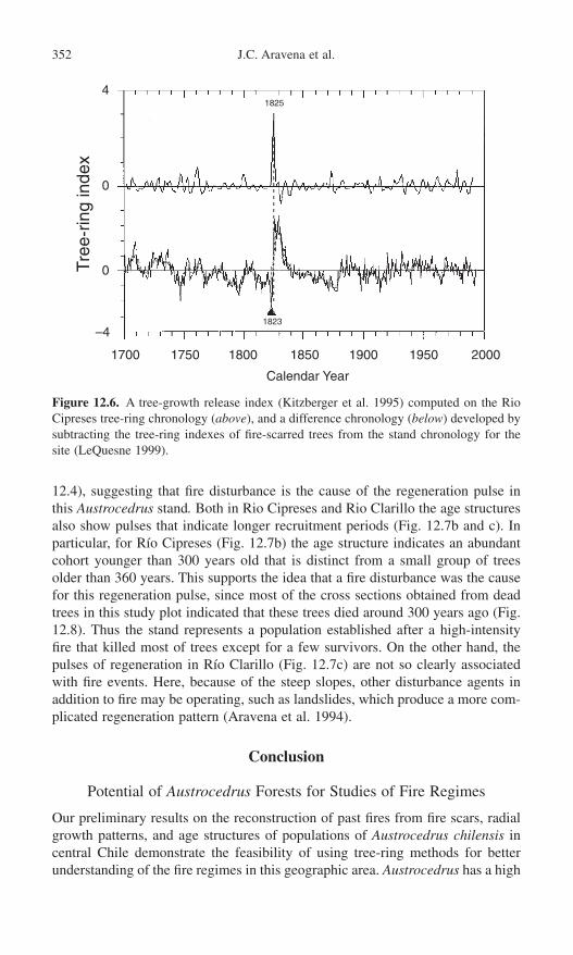
12.4), suggesting that fire disturbance is the cause of the regeneration pulse inthis Austrocedrus stand. Both in Rio Cipreses and Rio Clarillo the age structuresalso show pulses that indicate longer recruitment periods (Fig. 12.7b and c). Inparticular, for Río Cipreses (Fig. 12.7b) the age structure indicates an abundantcohort younger than 300 years old that is distinct from a small group of treesolder than 360 years. This supports the idea that a fire disturbance was the causefor this regeneration pulse, since most of the cross sections obtained from deadtrees in this study plot indicated that these trees died around 300 years ago (Fig.12.8). Thus the stand represents a population established after a high-intensityfire that killed most of trees except for a few survivors. On the other hand, thepulses of regeneration in Río Clarillo (Fig. 12.7c) are not so clearly associatedwith fire events. Here, because of the steep slopes, other disturbance agents inaddition to fire may be operating, such as landslides, which produce a more com-plicated regeneration pattern (Aravena et al. 1994).
Conclusion
Potential of Austrocedrus Forests for Studies of Fire Regimes
Our preliminary results on the reconstruction of past fires from fire scars, radialgrowth patterns, and age structures of populations of Austrocedrus chilensis incentral Chile demonstrate the feasibility of using tree-ring methods for betterunderstanding of the fire regimes in this geographic area. Austrocedrus has a high
352 J.C. Aravena et al.
4
0
0
–4
1700 1750 1800 1850 1900 1950 2000
Calendar Year
1823
1825
Tree
-rin
g in
dex
Figure 12.6. A tree-growth release index (Kitzberger et al. 1995) computed on the RioCipreses tree-ring chronology (above), and a difference chronology (below) developed bysubtracting the tree-ring indexes of fire-scarred trees from the stand chronology for thesite (LeQuesne 1999).

potential for use in fire history studies because the species is long-lived (up to1000 years old) and many trees survive fire. Furthermore tree-ring widths are sen-sitive to climatic variations, which permits analysis of climatic influences on fireregimes. The distribution of Austrocedrus forests in central Chile, especiallytoward their northern limit, is particularly attractive for studies of climatic in-fluences on fire regimes because of the sensitivity of this region to moisture variability related to ENSO (El Niño–Southern Oscillation) episodes (Aceituno1988). Fire regimes in Austrocedrus forests in northern Patagonia, Argentina, aresignificantly linked to ENSO activity at annual and multi-decadal time scales(Kitzberger and Veblen 1997; Veblen et al. 1999). However, the linkage of cli-
12. Central Chile 353
Figure 12.7. Age structures of Austrocedrus chilensis stands in (a) Alto Bio Bio (Jiménez1995), (b) Rio Cipreses (Rci), and (c) Rio Clarillo (RCL). The number of trees is givenby n.

354 J.C. Aravena et al.
matic variation in central Chile to ENSO activity is stronger and more predictablethan in the case of the climate-ENSO linkages for northern Patagonia. Thus thepotential for relating past fire to ENSO activity in central Chile is high.
Future Research Needs
The quantitative study of forest dynamics and disturbance history in the Austro-cedrus forests of central Chile is in an incipient stage. In our studies we neednow to include more analyses of stand regeneration, age structure, tree sex ratios,and spatial distribution of trees. This information is essential for better under-standing the effects of disturbance regimes and climatic fluctuations in the historyof these stands. We have regarded factors such as climatic trends, reproductioncosts, and intraspecific interactions in our study of stand dynamics and fireregimes. We hope to expand our scope to include evidence of fire occurring overthe entire landscape and to obtain more precise dating of outlying fires in thesampled stands.
Another line of research would be comparative studies of fire history patternsin the Austrocedrus of central Chile with those of nearby regions in southernSouth America and then with distant regions (e.g., western North America) wherethe local climate is teleconnected to ENSO. Already for northern Patagonia there are abundant fire history data and related climatic analyses for Austroce-
Figure 12.8. Dating of dead stems (n = 15) of Austrocedrus chilensis from Río Clarillo(1 to 7) and Río Cipreses (A to K). The horizontal bars approximate the life of the tree.The shaded area shows overlapping range for the outermost rings in several trees in RioCipreses, which implies an episode of synchronous tree mortality.

drus forests (see Kitzberger and Veblen, Chapter 10, this volume) as well as docu-ments on human activity affecting the patterns of stand and landscape dynamics(Veblen et al., Chapter 9, this volume). Larger databases for Austrocedrus forestsin central Chile might include comparisons of the effects of fire in these tworegions and significant differences in human history and ENSO-related climaticpatterns. Analogously, such data on fire history in the Austrocedrus forests ofcentral Chile would permit comparisons with other forest types in southern SouthAmerica, for example, Fitzroya cupressoides whose fire history is currently under study (see Veblen et al., Chapter 9, this volume, Lara et al., Chapter 11,this volume). Future research on fire scars in nearby forests of Araucaria arau-cana, which also forms fire scars and where fire has been a major agent of dis-turbance (Veblen et al. 1995), could also be useful in providing a regional historyof forest fires in the southern cone of South America.
Although we have stressed tree-ring studies of fire history, sedimentary recordsof fire in central Chile could also yield promising results (see Whitlock andAnderson, Chapter 1, this volume; Huber and Markgraf, Chapter 13, this volume).Together, dendrochronologic data and sedimentary charcoal analyses can extendour knowledge of fire history in the Holocene period. Finally there are the archae-ological studies of the evidence of prehistoric human settlement and resource useto consider. Such studies would add much to our understanding the causes ofchanges in fire regimes in southern South America.
Acknowledgments. We are grateful to T. T. Veblen for the opportunity to presenta previous version of this work at the IAI Fire Meeting, Silver Falls, Portland,Oregon, in 1996, from which this chapter was developed. Funding was pro-vided by projects UE CI1*CT93-0336, Sarec/Conicyt “Climate change duringHolocene in Chile,” and CRN03 project of the Inter American Institute for GlobalChange Research (IAI). We would like to thank CONAF (Corporación NacionalForestal) for permission to collect samples and logistic support. Support to JJAwas provided by the A. W. Mellon Foundation, and to C.L.Q. through a DoctoralGrant from CONAF and Universidad de Oviedo, Spain.
References
Aceituno, P. 1988. On the functioning of the Southern Oscillation in the South Americansector. Part I: Surface climate. Mon. Wea. Rev. 116:505–524.
Amunategui, D. 1940. Estudios históricos. Santiago de Chile: Ediciones de la Univer-sidad de Chile.
Aravena, J.C., LeQuesne, C., Jiménez, H., Hinojosa, L.F., and C. Peña. 1994. Estudio deun rodal de Austrocedrus chilensis (D.Don) Pic.Ser. et Bizz. en la Reserva NacionalRío Clarillo. (Antecedentes preliminares). CONAF, Santiago, Chile.
CONAF, 2000. Manejo del fuego. Resultados Temporada 1999–2000. Unidad de GestiónManejo del fuego. Santiago, Chile.
Dillehay, T.D. 1988. Early rain-forest archaeology in Southwestern South America:Research context, design an data at Monte Verde. In Wet Site Archaeology, ed. B. Purdy.pp. 177–206. NJ: Telford Press.
Donoso, C. 1982. Reseña ecológica de los bosques mediterráneos de Chile. Bosque 4:117–146.
12. Central Chile 355

Encina, F.A. 1940–1952. Historia de Chile, 20 vols. Santiago, Chile: Editorial Nascimento.
Fritts, H.C. 1976. Tree Rings and Climate. San Diego, CA: Academic Press.Heusser, C.J. 1994. Paleoindians and fire during the late Quaternary in southern South
America. Rev. Chil. Hist. Nat. 67:435–442.Jiménez, H. 1995. Reconstrucción dendroecológica de la historia de un rodal de
Austrocedrus chilensis (D.Don.) Pic. Ser. et Bizz. en la cuenca superior del Río BioBio. M.S. thesis. Facultad de Ciencias, Universidad de Chile.
Kitzberger, T., and Veblen, T.T. 1997. Influences of humans and ENSO on fire history ofAustrocedrus chilensis woodlands in northern Patagonia, Argentina. Ecoscience 4:508–520.
Kitzberger, T., Veblen, T.T., and Villalba, R. 1995. Tectonic influences on tree growth innorthern Patagonia, Argentina: the roles of substrate stability and climatic variation.Can. J. For. Res. 25:1684–1696.
Kitzberger, T., Veblen, T.T., and Villalba, R. 1997. Climatic influences on fire regimesalong a rain forest-to-xeric woodland gradient in northern Patagonia, Argentina. J. Biogeogr. 24:35–47.
Kitzberger, T., Veblen, T.T., and Villalba, R. 2000. Métodos dendroecológicos y sus aplicaciones en estudios de dinámica de bosques templados de Sudamérica. In Dendrocronología en América Latina, ed. F. Roig, pp. 17–78. Mendoza, Argentina:Editorial de la Universidad del Cuyo.
LeQuesne, C. 1988. Caracterización de los bosques de ciprés de la cordillera (Austroce-drus chilensis (D.Don.) flor. et Bout.), en Radal Siete Tazas, Séptima región, Chile.M.S. thesis. Universidad Austral de Chile, Valdivia.
LeQuesne, C. 1999. Dendrocronología de Austrocedrus chilensis (D.Don.) Pic. Ser. et Bizz. (Cupressaceae) en el límite norte de su distribución, Chile. Ph.D. dissertation.Universidad de Oviedo.
Mooney, H.A., Dunn, E.L., Shropshire, L., and Song, Jr. 1972. Land use history of California and Chile as related to the structure of the sclerophyll scrub vegetations.Madroño 21:305–319.
Mostny, G. 1994. Prehistoria de Chile. Santiago: Editorial Universitaria.Núñez, L., Varela, J., Casamiquela, R., and Villagrán, C. 1994. Reconstrucción multidis-
ciplinaria de la ocupación prehistórica de Quereo, centro de Chile. Lat. Am. Antiquity5(2):99–118.
Pérez-Rosales, V. 1980. Recuerdos del pasado. Editorial Andrés Bello. Santiago, Chile.Rutlland, J., and Fuenzalida, H. 1991. Synoptic aspects of the central Chile rainfall
variability associated with the Southern oscillation. Int. J. Climatol. 11:63–76.Schulman, E. 1956. Dendroclimatic Change in Semiarid America. Tucson: University of
Arizona Press.Schweingruber, F.H. 1988. Tree-Rings: Basics and Applications of Dendrochronology.
Dordrecht: Riedel.Stokes, M.A., and Smiley, T.L. 1968. Introduction to Tree-Ring Dating. Chicago:
University of Chicago Press.Veblen, T.T., and Lorenz, D.C. 1987. Post-fire stand development of Austrocedrus-
Nothofagus forests in Patagonia. Vegetatio 73:113–126.Veblen, T.T., and Schlegel, F.M. 1982. Reseña ecológica de los bosques del sur de Chile.
Bosque 2:73–115.Veblen, T.T., Kitzberger, T., and Lara, A. 1992. Disturbance and vegetation dynamics along
a transect from rain forest to Patagonian shrublands. J. Veg. Sci. 3:507–520.Veblen, T.T., Burns, B.R., Kitzberger, T., Lara, A., and Villalba, R. 1995. The ecology
of the conifers of southern South America. In Ecology of the Southern Conifers, eds.N.J. Enright and R.S. Hill, pp. 120–155. Melbourne: Melbourne University Press.
Veblen, T.T., Kitzberger, T., Villalba, R., and Donnegan, J. 1999. Fire history in northernPatagonia: The roles of humans and climatic variation. Ecol. Monog. 69:47–67.
356 J.C. Aravena et al.

13. Holocene Fire Frequency and Climate Change at Rio Rubens Bog, Southern Patagonia
Ulli M. Huber and Vera Markgraf
Over the last decade, growing concern over the ecological effects of globalwarming has fueled interest in the mechanisms of climate-induced vegetationchange. Vegetation model results indicate that global warming may favorincreased frequency and severity of forest disturbance, thus increasing the rate atwhich vegetation responds to climate change and the magnitude of this response(Overpeck, Rind, and Goldberg 1990; Gardner et al. 1996). Fire is one of themost important climatically linked disturbance agents in temperate forest systems(Fig. 13.1). Climate variability on different time scales can influence fire regimesthrough its effects on both ignition sources (lightning frequency) and fuel char-acteristics (fuel type, fuel structure, fuel accumulation, fuel desiccation) (Renkinand Despain 1992). Understanding the links among climate variability, fireregimes, and vegetation in different environments requires a long-term perspec-tive. Sedimentary records of macroscopic charcoal can provide important infor-mation concerning submillennial and millennial scale changes in local firefrequency during periods of major reorganizations in climate and vegetation (e.g.,Clark 1990; Clark and Royall 1996; Long et al. 1998; Millspaugh, Whitlock, andBartlein 2000).
Patagonia and Tierra del Fuego are well suited for studies of past climate andthe paleoenvironmental role of fire. Fire has been an important disturbance agentin many bioclimatic regimes of this region (Veblen, Kitzberger, and Lara 1992;Veblen et al. 1996). Tree-ring research in northern Patagonia (Kitzberger, Veblen,and Villalba 1997; Veblen et al. 1999) has confirmed a strong relationship
357

between interannual climate variability and the occurrence of widespread firesduring the last ca. 550 years. On decadal time scales, human activity seems tostrongly impact fire frequency, although longer-term changes in atmospheric cir-culation may still have a significant impact (Veblen et al. 1999). Sedimentarycharcoal records from Patagonia and Tierra del Fuego indicate that fires have beenimportant during different periods throughout the late Quaternary (Heusser 1987,1994, 1995b, 1998; Markgraf and Anderson 1994). On these longer time scales,the interactions among climate variability, fire regimes, and vegetation are notwell understood. In addition, the causes for fires in southern Patagonia and Tierradel Fuego in the late Quaternary have been, and continue to be, an issue of debate.Both human impact (Heusser 1987, 1994, 1998) and climate (Markgraf andAnderson 1994) have been invoked to explain the observed temporal and spatialpatterns of fire occurrence. Heusser (1987, 1994, 1998) attributed the occurrenceof fires to the impact of Paleo-Indian hunters, European settlers, and volcanicactivity, and suggested that lightning as an alternative ignition source has beenvirtually nonexistent in southern high latitudes. In contrast, Markgraf and Anderson (1994) proposed that although lightning is uncommon at present, itmight have been more important under different climate conditions in the past.Furthermore, whereas humans may have been critical as initiators of fires in many instances, the determining factor in frequency, spatial extent, and intensityof fires has been climate.
Although multi-proxy paleoenvironmental reconstructions do not directlyaddress the issue of ignition sources, they provide important information forunderstanding how climate variability influenced vegetation and fire occurrences
358 U.M. Huber and V. Markgraf
Figure 13.1. Effects of climate on fire ignition and fire spread. Climate variability caninfluence ignition by changing lightning frequency. Changes in climate influence fuel type,accumulation, structure, and moisture content, and hence the spread of fires. Even in thepresence of ignition sources, fuel characteristics have to be conducive for fires to spread.

over a range of temporal scales in the presence of ignition sources (human fireuse and/or lightning). In southern Patagonia and Tierra del Fuego, the linksbetween century and millennial scale climate variability and fire frequency havenot been addressed adequately. First, the available sedimentary charcoal recordslack high temporal resolution. Second, microscopic charcoal has not been sepa-rated into different size fractions and therefore represents a range of source areas.These factors preclude assessments of local versus regional fire activity and quan-titative estimates of fire frequency. Furthermore these low-resolution recordscannot address century-scale changes in fire occurrence.
The aim of this multi-proxy study is to examine the relationships between pastvariability in moisture regimes, fire frequency, and vegetation in southern Patago-nia on different time scales. Here we present a summary of our results from theHolocene section of the Rio Rubens peat core (52°08¢15≤S, 71°52¢53≤W) (Huber2001). In this study, analyses of peat macrofossils and macroscopic sedimentarycharcoal particles >125mm in diameter in contiguous samples allow an assessmentof relationships between changes in local effective moisture and fire frequency onorbital (multimillennial) and shorter (century-to-millennial) time scales.
Site Location
Rio Rubens Bog (52°08¢15≤S, 71°52¢53≤W, elevation ca. 220m) is located east of the Andean cordillera in southern Patagonia, Chile (Fig. 13.2). The sizeof the mire is approximately 25ha. Empetrum rubrum and the moss Polytrichumstrictum dominate the bog surface. Mires in this area are typically located in elongate depressions that appear to be part of a system of former glacial melt-water channels.
The regional climate of southern Patagonia is characterized by a steep west-to-east precipitation gradient, which is related to the orographic effects of theAndes and is strongly reflected in the vegetation. With decreasing precipitation,evergreen rain forests are replaced by mixed evergreen-deciduous forests, decidu-ous forests, open woodlands, and finally steppe (Fig. 13.2). Prior to European settlement, Rio Rubens Bog was situated in the deciduous Nothofagus forest formation (Huber 2001) in close proximity to the steppe-forest ecotone. In the deciduous forest region, mean annual precipitation ranges from ca. 650 to 450mm/yr (Tuhkanen et al. 1989–1890). Precipitation is fairly evenly distributedthroughout the year with a slight maximum in fall and minimum in spring.Nothofagus pumilio dominates the deciduous forests, which have been stronglyaffected by recent burning and logging (Cruz and Lara 1987). The immediatevicinity of Rio Rubens Bog is heavily impacted by human disturbance, and openNothofagus antarctica woodlands, Chiliotrichium shrub, and grasslands domi-nate. The mean annual temperature at the site is ca. 5.2°C (interpolated tempera-ture from the climate station in Torres del Paine National Park, ca. 120kmnortheast of the site, applying an environmental lapse rate of 0.55°C/100m). Interpolated mean temperatures for the coldest and warmest month in the Rio
13. Rio Rubens Bog, Southern Patagonia 359

Rubens region are ca. -2°C and 11°C, respectively (Tuhkanen 1992). During shortperiods, especially in winter, temperatures can be influenced by northward intru-sions of cold Antarctic air masses, which are accompanied by southerly winds(Zamora and Santana 1979; Tuhkanen et al. 1989–1990). However, throughoutmost of the year, strong westerly winds associated with moderate temperaturesprevail.
Environmental conditions at Rio Rubens Bog make this site ideal for investi-gating the links between past changes in effective moisture, fire regimes, and veg-etation. Local mire hydrology in this moisture-limited region should have reactedquickly to variability in effective moisture. In addition, the location of the steppe-forest ecotone in Patagonia is highly sensitive to changes in effective moistureand fire regimes (Veblen and Markgraf 1988; Villalba and Veblen 1997a, 1997b).
Interpretation of Charcoal Data from Peat Cores
Sedimentary charcoal records can provide a long-term perspective of fire frequency changes and their relationship to climate. However, prior to using these records as a proxy of local fire frequency, two fundamental issues must
360 U.M. Huber and V. Markgraf
Figure 13.2. Location of Rio Rubens Bog in relation to major vegetation zones in south-ern Patagonia and Tierra del Fuego. Rio Rubens Bog is situated in the steppe-forestecotone. (Based on field observations from Tuhkanen 1992.)
be addressed: (1) at what spatial scales are fires recorded in peat sediments, and(2) how reliable are peat sediments as recorders of local fires?
At What Spatial Scales Are Fires Recorded in Peat Sediments?
A major assumption in sedimentary charcoal analysis is that charcoal from localsource areas can be distinguished from regional charcoal input. Charcoal trans-port modeling results, experimental burn data, and comparisons of sedimentarycharcoal profiles with known fire events suggest that both total charcoal accu-mulation rates and particle size distributions may be used to distinguish betweenlocal and regional charcoal input (e.g., Clark 1988, 1990; Whitlock andMillspaugh 1996; Clark et al. 1998; Long et al. 1998; Ohlson and Tryterud 2000;Gardner and Whitlock 2001; Whitlock and Anderson, Chapter 1, this volume).Models of charcoal transport (Clark 1988) indicate that the majority of charcoalparticles >50mm in diameter are deposited in close proximity to a burn. Also,charcoal accumulation rates have been shown to decrease sharply at the edge ofhigh-intensity experimental burns in west-central Siberia and Scandinavia, andlarge particles are more abundant closer to the burn (Clark et al. 1998; Ohlsonand Tryterud 2000). A comparison of dendrochronologically dated fire-scarrecords with sedimentary charcoal data from lakes in northwestern Minnesotasuggests that charcoal particles >80mm in diameter originate primarily from firesthat occur within the catchment of a lake basin (Clark 1990). A study examiningcharcoal deposition associated with fires in Yellowstone National Park indicatesthat charcoal particles >125mm in diameter are deposited within a 10km radiusof a fire (Whitlock and Millspaugh 1996), and fire events are expressed as dis-tinct peaks in sedimentary charcoal in small lakes within the burnt watersheds(Millspaugh and Whitlock 1995).
Charcoal accumulation rates and particle size distributions likely vary for dif-ferent types of fires (Clark et al. 1998), and sharp thresholds between local andregional sources do not exist (Clark and Patterson 1997). However, macroscopiccharcoal analysis of peat sediments can, in part, circumvent the problem of sourcearea. Peat sediments often contain charred peat macrofossils, which indicates thatfires spread onto the peatland surface. The actual location of the burn can there-fore be determined, which provides the spatial precision otherwise lacking inlacustrine sedimentary charcoal records (Tolonen 1983; Clark and Richard 1996).
How Reliable Are Peat Sediments as Recorders of Local Fires?
In order to recognize individual fires in sedimentary charcoal records, high tem-poral resolution is required. The sampling has to be continuous, and samplingincrements have to be shorter than fire return intervals. If sampling intervals aretoo large, a single charcoal peak may represent more than one fire event. Whetheror not individual fires are recorded in the sediment may also be related to char-coal deposition processes. In lakes, charcoal is deposited to deep-water sedimentsby atmospheric fallout, saltation, surface runoff, stream input, and sedimentfocusing within the lake basin itself (Clark and Patterson 1997). These processes
13. Rio Rubens Bog, Southern Patagonia 361

may concentrate charcoal in the lake (Clark and Patterson 1997), and fires burningwithin a catchment are likely to be recorded as distinct charcoal peaks.
In peatlands, charcoal is predominantly derived from atmospheric falloutand/or in-situ production as fires spread onto the wetland surface (Tolonen 1986).Smoldering peat fires may destroy some evidence of previous fire events (Clarkand Richard 1996). Also, the absence of processes that concentrate charcoal (i.e.,lacustrine sediment focusing, input from streams and runoff) probably diminishesthe expression of fires that did not burn across the wetland surface. Together,these factors suggest that peat charcoal records may underestimate local fireoccurrence and that fires recorded in peat sediments may represent a subset offires in the catchment.
Interpretation of Macrofossil Data from Peat Cores
Mires are sensitive to changes in hydrology, which in turn can lead to changesin peatland vegetation (e.g., Barber 1981; Moore 1986; Barber et al. 1994; Glaseret al. 1996). The hydrology of mires is controlled by the complex interplaybetween regional climate, local geomorphology, and site history (Almquist-Jacobson and Foster 1995). Major climatic controls on mire hydrology arechanges in temperature and precipitation, which in turn impact both the evapo-transpiration regime and the surface and groundwater flow (e.g., Moore 1986;Gignac, Halsey, and Vitt 2000). Modifications of these moisture fluxes influencethe effective moisture that is available to mire vegetation. In addition, noncli-matic processes may lead to changes in mire hydrology (Moore 1986). Peat accu-mulation and erosion, and changes in the vegetation of the catchment and themire surface itself, can influence both influx and efflux terms of the water balance.Ombrotrophic bogs obtain water predominantly through precipitation. In contrast,minerotrophic fens receive water primarily through groundwater input, and secondarily through precipitation and surface runoff. The response of fens to climatic change may be less direct because time lags generally exist betweengroundwater recharge and discharge, whose length depends on the size and physiography of the catchment.
Peat macrofossil stratigraphy can be used to detect past changes in mire hydrol-ogy (e.g., Barber et al. 1994; Hughes et al. 2000). The primary assumption in theuse of peat macrofossils as paleoclimate indicators is that climate plays an over-riding role in mire hydrology. In southern Patagonia and Tierra del Fuego, thepresent-day geographic distribution of different bog and fen types is closelyrelated to climate (Roivanen 1954; Auer 1963; Moore 1979, 1983; Tuhkanen et al. 1989–1990; Tuhkanen 1992). Mire types change along a west-to-east gra-dient in effective moisture. Ombrotrophic Sphagnum bogs are dominant in thedeciduous forest zone (Fig. 13.2) but extend into the evergreen forest region(Roivanen 1954; Moore 1983). Mean annual precipitation in the deciduous forestzone ranges from ca. 450 to 650mm/yr (Tuhkanen 1992). In areas of decreas-ing precipitation toward the eastern limit of the deciduous forest zone,
362 U.M. Huber and V. Markgraf

Marsippospermum bogs become characteristic (Moore 1983). At the steppe-forest ecotone and in the steppe region, ombrotrophic mires are replaced byminerotrophic fens that are restricted to valleys and depressions with ground-water influence. Mean annual precipitation in this zone ranges from ca. 250 to 500mm/yr (Tuhkanen et al. 1989–1990). Sedges and grasses are common on the drier fens and mesic grasslands of the steppe region and the steppe-forestecotone (Roivanen 1954; Moore 1983). Fen mosses, such as Drepanocladus spp.,become more dominant with increasing wetness toward the deciduous forest zone(Roivanen 1954).
These observed spatial differences in mire vegetation can also be recognizedin down-core changes in mire stratigraphy. Considering the strong climatic influ-ence on mire vegetation at present, it is likely that climate has also been a sig-nificant factor for peatland differentiation in the past. However, climatic responsethresholds may vary between mires in different geologic and geomorphic settingsand in different climate regimes. The climatic impact on mire hydrology shouldbe particularly pronounced in moisture-limited areas, where mires may have verylow response thresholds for changes in effective moisture. Throughout theHolocene, Rio Rubens Bog has been located in the drier region of the deciduousforest formation or at the steppe-forest ecotone (Huber 2001), where even minorchanges in temperature and precipitation probably had large effects on mirehydrology. Hence, the response of peatland vegetation to climate change shouldhave been particularly pronounced and rapid.
Methods
Chronology
A 716-cm-long sediment core of 5-cm diameter was retrieved from the center ofRio Rubens Bog with a Livingstone piston corer (Wright, Mann, and Glaser1983). The chronology for the last ca. 100calyr is based on 210Pb age determi-nations (Huber 2001). A total of 12 AMS radiocarbon (14C) ages and the Hudsontephra layer (Stern 1992) provide the chronological control for the last 13,000years (ca. 460cm) of the Rio Rubens core (Fig. 13.3), which are the focus of thischapter. Wherever possible, mosses (Drepanocladus spp., Sphagnum magellan-icum, Polytrichum strictum) and aboveground parts of macrofossils (wood,leaves) were picked for dating to avoid contamination with younger carbonthrough roots. Radiocarbon years were converted to calendar years using the cal-ibration program INTCAL98 (Stuiver et al. 1998). The age model for the entireRio Rubens record is based on 9 210Pb and 19 14C ages from both the Holoceneand the late-glacial sections of the core (Huber 2001). A weighted sixth-orderpolynomial curve fit was applied to the core section between ca. 16,900 and 3500calyrBP. The age model between ca. 3500calyrBP and AD 1995 (year of coreretrieval) is based on a third-order polynomial equation. Details of the age modelare described in Huber (2001).
13. Rio Rubens Bog, Southern Patagonia 363

Macroscopic Charcoal Analysis
The Rio Rubens peat core was sampled continuously at 0.5- to 1-cm incrementsfor charcoal analysis. Sample preparation followed methods described inMillspaugh and Whitlock (1995) and Whitlock and Anderson (Chapter 1, thisvolume), adjusted for peat sediments (Huber 2001). Subsamples of 1cm3 weredispersed in a 5% solution of hot KOH for about 30 minutes, and then gentlywashed through a set of nested sieves with 125 and 250 mm screens. The sievedresidues were dispersed in water and placed in a gridded petri dish. Charcoalpieces in the size classes 125–250 mm and >250mm were counted separatelyunder a stereomicroscope at 40¥ and 10¥ magnification, respectively. Charcoalconcentrations were divided by the deposition time to obtain charcoal accumu-lation rates (number of charcoal particles/cm2/calyr). Charcoal accumulationrates were corrected for tephra dilution in some sections of the core (Huber 2001).
364 U.M. Huber and V. Markgraf
Figure 13.3. Summary diagram of pollen percentages and macroscopic charcoal accu-mulation rates (CHAR) from Rio Rubens Bog for the last ca. 13,000calyr (Huber 2001).Gray bars indicate the width of charcoal peaks. Herb taxa (grasses excluded) primarilyconsist of Asteraceae tubuliflorae, Caryophyllaceae, and Acaena. Ferns mainly comprisePolypodiaceae. Fen taxa consist of Cyperaceae and Eleocharis-type. Bog indicatorsinclude Ericaceae (primarily Empetrum) and Nanodea pollen, and spores of Sphagnumand Tilletia sphagni.

Temporal resolution in the Rio Rubens record is high with continuous sam-pling increments of ca. 10 to 160calyr per sample and a mean resolution of ca.25calyr (Huber 2001). In most sections of the core, sampling resolution rangesbetween ca. 10 and 35calyr. Low temporal resolution of >100calyr per sampleonly occurs between 48 and 59cm depth (ca. 3000 to 1600calyrBP), during atime period when charcoal peaks are very rare. Charcoal peaks are in most casesdistinct and narrow with very low background values between peaks. Thus, thesampling appears to be at sufficiently high resolution to discern individual firesin most sections of the core. A calibration of the Rio Rubens charcoal record withhistorical fire data is not possible. Forestry fire records only date back to 1986and are spatially not very specific, and dendrochronologic records of fire do notexist for the region.
Charcoal size fractions >125mm were analyzed to emphasize the local scale ofthe recorded fires (Millspaugh and Whitlock 1995; Long et al. 1998; Whitlockand Anderson, Chapter 1, this volume). Many charcoal peaks contain charred peatmacrofossils, which indicates that fires spread onto the wetland surface (Huber2001). Consequently, distinct charcoal peaks in the size fractions >125mm areinterpreted as local fire events. Estimates of fire occurrence in the Rio Rubenscore are considered minimum estimates of fires in the catchment, because (1) thesampling resolution may not be high enough in all sections of the core, (2) smol-dering peat fires may destroy some evidence of previous fires (Clark and Richard1996), and (3) peat sediments may primarily record peat fires and therefore asubset of all catchment fires (Tolonen 1983; Huber 2001).
Peat Macrofossil Analysis
Sieve residues (>250mm), retrieved for charcoal analysis, were also analyzed formacrofossil composition (Huber 2001). Relative abundances of the primaryorganic peat constituents in the >250mm size fraction were estimated on a 1 to 5scale (0, 25, 50, 75, and 100 volume %) by scanning the entire petri dish undera dissecting scope at 10¥ magnification. Volumetric estimates were assigned tothe nearest relative abundance increment. Major peat components include rootsof vascular plants, and fen and bog mosses (Drepanocladus spp., Sphagnum spp.,and Polytrichum strictum). This semiquantitative approach only records majorchanges in peat stratigraphy but enables continuous analysis of macrofossils atthe same temporal resolution as macroscopic charcoal data. It would be prohib-itively time-consuming to achieve decadal-scale resolution over a ca. 13,000calyr record with a more detailed approach (e.g., Janssens 1983; Barber et al. 1994;Kuhry 1997).
The Rio Rubens peat stratigraphy is divided into minerotrophic fen peat andombrotrophic bog peat, based on pollen assemblages of mire plants (Fig. 13.3)and peat macrofossil data (Fig. 13.4). Further, peat macrofossils are grouped intodry and wet fen and bog indicators as a proxy for local effective moisture changes.In the Rio Rubens record, the moss Drepanocladus spp. is considered a wet-fenindicator, whereas root-rich fen peat represents drier conditions. Pollen data from
13. Rio Rubens Bog, Southern Patagonia 365

the fen section of the core (Huber 2001) suggest that rootlets are most likely ofthe genus Cyperaceae but may also originate from Poaceae and other vascularplants. Sedges and grasses dominate the present-day mesic grasslands in thevalleys and depressions of the steppe region (Moore 1983). With increasing
366 U.M. Huber and V. Markgraf
Figure 13.4. 13,000calyr record of bog hydrology and macroscopic (>125mm) charcoalfrom Rio Rubens Bog (Huber 2001). The macrofossil diagram shows the relative per-centages of wet versus dry bog and fen indicators. An exaggeration factor of 10¥ wasapplied to charcoal peaks between ca. 5500 and 400calyrBP.
moisture, fen mosses (Drepanocladus spp.) become more prevalent (Roivanen1954).
In the Rio Rubens record, Sphagnum (primarily S. magellanicum) is theprimary wet-bog indicator. Dry-bog indicators include roots of vascular plants,the moss Polytrichum strictum, and strongly decomposed organic matter. Bogpollen assemblages (Huber 2001) indicate that unlike the situation in fen peat,rootlets are not predominantly of Cyperaceae and Poaceae. Instead, root-richombrotrophic peat may form in Marsippospermum bogs (Moore 1983) that arecharacteristic of the drier areas of the deciduous Nothofagus forest zone and thewoodlands of the steppe-forest ecotone (Fig. 13.2) (Tuhkanen 1992). Marsip-pospermum grandiflorum (Juncaceae) produces abundant roots but is virtuallyabsent in the pollen record. The dominance of the moss Polytrichum strictum ischaracteristic of the very dry bog surfaces at the eastern limit of bog growth atthe steppe-forest ecotone (Roivanen 1954; Oberdorfer 1960; Tuhkanen et al.1989–90). Sections of the ombrotrophic peat in the Rio Rubens core (ca. 500–400and 1300–1800calyrBP) are strongly decomposed and contain very few identi-fiable macrofossil remains in the size range >250mm. In these intervals relativepercentages of peat constituents could not be reliably estimated. Strong decom-position of peat is likely related to increased microbial activity during periods ofstrong drying of the bog surface (Kuhry 1997). Highly decomposed peat sectionsthat lack macrofossils in the >250-mm-size class are therefore assigned a valueof 100% dry-bog indicators.
To test whether local changes in mire hydrology have been predominantly dic-tated by regional climate variability rather than autogenic processes, the macro-fossil data from Rio Rubens Bog are compared to pollen data from the site (Huber2001) and other paleoclimate data from the region.
Results
Based on peat macrofossil assemblages and macroscopic charcoal data the RioRubens Bog profile is divided into three major zones (Fig. 13.4): zone 1 prior toca. 11,700calyrBP, zone 2 from ca. 11,700 to 5500calyrBP, and zone 3 from ca.5500calyrBP to present. Details of the peat macrofossil and macroscopic char-coal data from Rio Rubens Bog are described in Huber (2001).
Zone 1: Prior to ca. 11,700calyrBP
From prior to 12,700 through ca. 11,700calyrBP, charcoal peaks are absent, andcharcoal accumulation rates are £3 particles/cm2/calyr (Fig. 13.4). Wet-fen indicators dominate the sediment, representing up to 75% of the macrofossils.However, century scale variability in peat macrofossil stratigraphy is high, andperiods with high percentages of wet-fen macrofossils are repeatedly interruptedby periods dominated by dry-fen indicators.
13. Rio Rubens Bog, Southern Patagonia 367

Zone 2: ca. 11,700 to 5500calyrBP
Macroscopic charcoal accumulation rates increase abruptly at ca. 11,700calyrBP,and large charcoal peaks (ca. 15–175 particles/cm2/calyr) become frequent. Char-coal peaks are most frequent between ca. 11,700 and 7500calyrBP and becomeless frequent thereafter. Century-to-millennial scale variability of dry-fen and wet-fen macrofossils is high. Charcoal peaks concentrate in core sections with≥75% dry-fen indicators and rarely occur in intervals with high amounts (50%)of wet-fen indicators.
Zone 3: ca. 5500calyrBP to present
After ca. 5500calyrBP and prior to ca. 400calyrBP (zone 3a), charcoal peaksbecome infrequent and are much smaller (ca. 1–5 particles/cm2/calyr) than priorto ca. 5500calyrBP. One prominent charcoal peak occurs at ca. 1600calyrBP.After ca. 400calyrBP, charcoal peaks are again more frequent, and peak sizesincrease to between 5 and 40 particles/cm2/calyr. At ca. 5500calyrBP, macro-fossils switch abruptly from fen to bog indicators, and bog macrofossils are sub-sequently dominant throughout the entire zone. Changes in peat macrofossilstratigraphy occur on century-to-millennial time scales but are markedly less fre-quent than prior to 5500calyrBP. An exception is the transition period from fento bog peat between ca. 5500 and 5000calyrBP when variability is high. Inter-vals with high amounts (100%) of dry-bog indicators occur between ca. 3500 and2500calyrBP, 1900 and 1300calyrBP, and after 500calyrBP. Distinct charcoalpeaks are limited to those intervals.
Discussion
Peat macrofossil and macroscopic charcoal data from Rio Rubens Bog show distinctly different early and late Holocene climate and fire histories that are sep-arated by a rapid transition at ca. 5500calyrBP (Fig. 13.4, zones 2 and 3). Short-term variability in effective moisture and fire frequency is superimposed on thesemulti-millennial trends and occurs on century to millennial time scales.
Early and Mid Holocene (11,700 to 5500calyrBP)
Prior to ca. 11,700calyrBP, very low macroscopic charcoal accumulation ratesindicate the absence of fires at Rio Rubens Bog (Fig. 13.4, zone 1). Near the tran-sition to the Holocene (zone 2), charcoal abundance increases sharply, and fre-quent large charcoal peaks suggest that fires became an important disturbancefactor. Charred peat moss fragments in these layers demonstrate that the fensurface itself burned repeatedly, and large charcoal peaks are primarily associ-ated with peat fires (Huber 2001).
Pollen data from Rio Rubens Bog (Huber 2001) show that, with the onset offrequent fires, vegetation switched repeatedly between grass-dominated steppe,
368 U.M. Huber and V. Markgraf

and open herb- and fern-rich Nothofagus woodlands (Fig. 13.3, zone 2). Fur-thermore, high grass and low tree pollen percentages are frequently associatedwith peaks in charcoal accumulation rates, implying that distinct reductions intree cover were associated with many of the local fires. However, not all localfire events show a clear vegetation response. The temporal resolution of the pollendata may not be high enough to register a response for every fire. Also, distinctreductions in woodland cover were likely associated with stand-devastatingcrown fires, whereas low-intensity surface fires may have left little trace in thepollen record.
A number of records from the modern mixed evergreen-deciduous and decid-uous forest zones in Tierra del Fuego and southern Patagonia show increasedcharcoal levels between ca. 11,700 and 5500calyrBP (Heusser 1987, 1990, 1994,1995a, 1995b, 1998; Markgraf and Anderson 1994). The concurrent increase infire activity over a large area of Fuego–Patagonia at the late-glacial to Holocenetransition suggests a large-scale climatic forcing. Warmer-than-present conditionsin the early Holocene (Markgraf and Kenny 1997; Grimm et al. 2001) could havedecreased effective moisture in the region. In the Rio Rubens macrofossil record,high percentages of wet-fen indicators suggest that effective moisture was highbefore ca. 12,000calyrBP (Fig. 13.4, zone 1). Subsequently, an abrupt increasein dry-fen indicators implies a pronounced drying of the fen surface. This local,and possibly regional, decrease in effective moisture started about three centuriesprior to the first occurrence of local fires at Rio Rubens Bog (Fig. 13.4). A changeto drier, more fire-conducive climate conditions approximately coincidental withthe start of the Holocene may be responsible for “synchronizing” the onset ofhigh fire activity in Fuego–Patagonia. Increased aridity throughout the earlyHolocene likely maintained a low fuel moisture content in the xeric woodlandsaround Rio Rubens Bog, and frequent drying of the fen surface would haveenabled the spread of fires onto the mire surface. Consequently, in the presenceof ignition sources (humans and/or lightning), the probability of fire occurrencewas high during this interval.
Paleo-Indian hunters may have been important initiators of fires (e.g., Heusser1999). Archaeological evidence suggests the presence of humans in southernPatagonia since at least ca. 13,000calyrBP (Dillehay et al. 1992; Borrero andMcEwan 1997). Early explorers describe the use of fires by northern PatagonianIndians for hunting of guanacos and rheas in the steppe and steppe-forest ecotone(Cox 1863; Musters 1871; Fonck 1900), although earlier use of fire by prehis-toric people is not known. In addition to human ignition sources, warmer-than-present conditions during the early Holocene could have favored convectivestorms and increased lightning strikes in a region where lightning-caused firesare rare at present (Markgraf and Anderson 1994).
In the early Holocene, when fires were widespread in southern Patagonia andTierra del Fuego, pollen records indicate that open Nothofagus woodlands weremuch more extensive than at present (Heusser 1987, 1990, 1994, 1995a, 1995b,1998; Schäbitz 1991; Markgraf 1993; Huber 2001). In Tierra del Fuego thestrongly moisture-limited steppe-forest ecotone was located west of its present-
13. Rio Rubens Bog, Southern Patagonia 369

day location throughout the early Holocene, and only shifted eastward whenmoisture levels increased and fire frequency declined in the late Holocene(Heusser 1993, 1994). Drier-than-modern climate during the early Holocene maybe related to differences in the width and seasonal migration patterns of the south-ern westerly belt relative to today. Under modern conditions, the zone ofmaximum westerly precipitation migrates seasonally and extends from ca. 55° to45°S in summer to ca. 55° to 35°S in winter (Lawford 1993). During the earlyHolocene, regional moisture patterns, based on pollen and lake-level data, indi-cate that the southern westerlies may have been focused between latitudes 45° to50°S year-round (Markgraf et al. 1992). A focusing of the westerly stormtracksin a narrower latitudinal band may have been related to changes in the seasonalcycle of insolation associated with variations in the earth’s orbital parameters(Markgraf et al. 1992; Whitlock et al. 2001). In the early Holocene, the ampli-tude of the seasonal cycle was smaller than at present at southern high latitudesbecause perihelion occurred during the southern hemisphere winter and theearth’s axial tilt was greater (Berger 1978). Reduced seasonality, in turn, couldhave caused a reduction in the seasonal migration of the westerly stormtracks(Whitlock et al. 2001). More narrowly focused westerlies would have kept mois-ture levels low at southern high latitudes (Whitlock et al. 2001), therefore pro-viding ideal conditions for the persistence of fire-prone xeric woodlandenvironments.
The Rio Rubens peat macrofossil data indicate that local effective moisturethroughout the early Holocene was highly variable on century-to-millennial timescales (Fig. 13.4). This short-term variability in moisture is superimposed on cli-matic conditions that were drier than today between 11,700 and 5500calyrBP(Fig. 13.5). Local fires cluster in century-to-millennial scale intervals with rela-tively low effective moisture, as evidenced by 75% to 100% dry-fen indicators.These long intervals of dry conditions and high fire frequency were repeatedlyinterrupted by century-scale periods of increased effective moisture and reducedfire activity. Century-to-millennial scale dry periods that favored low fuel mois-ture in the woodlands around Rio Rubens Bog would have enhanced the rapidspread of fires. Under these circumstances, the occurrence of fires was determinedby fuel availability and ignition sources. In contrast, during century-scale inter-vals of overall increased wetness, sufficient fuel desiccation would have beenachieved less frequently, reducing the likelihood of fires. Several centuries ofincreased effective moisture and decreased fire frequency appear to have favoredthe expansion of woodland cover at the steppe-forest ecotone (Fig. 13.3), andthese prolonged wet periods may have been essential for the buildup of coarsewoody fuel over grassy fine fuel in these moisture-limited environments.
Century-to-millennial scale variability in effective moisture in southern Patagonia during the early Holocene could have been caused by small tempera-ture fluctuations and/or changes in precipitation. Under modern climate condi-tions, an increase in the meridionality of the southern westerlies leads todecreased precipitation in southern Patagonia and increased precipitation innorthern Patagonia (Pittock 1980; Rutllant and Fuenzalida 1991; Villalba et al.
370 U.M. Huber and V. Markgraf
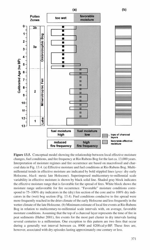
Figure 13.5. Conceptual model showing the relationship between local effective moisturechanges, fuel conditions, and fire frequency at Rio Rubens Bog for the last ca. 13,000 years.Interpretation of moisture regimes and fire occurrence are based on macrofossil and char-coal data in Fig. 13.4. (a) Effective moisture and fuel conditions at Rio Rubens Bog. Multi-millennial trends in effective moisture are indicated by bold stippled lines (gray: dry earlyHolocene, black: mesic late Holocene). Superimposed multicentury-to-millennial scalevariability in effective moisture is shown by black solid line. Shaded gray block indicatesthe effective moisture range that is favorable for the spread of fires. White block shows themoisture range unfavorable for fire occurrence. “Favorable” moisture conditions corre-spond to 75–100% dry indicators in the (dry) fen section of the core and to 100% dry indi-cators in the (wet) bog section (Fig. 13.4). Fuel conditions conducive to fire spread weremore frequently reached in the drier climate of the early Holocene and less frequently in thewetter climate of the late Holocene. (b) Minimum estimate of local fire events at Rio RubensBog in relation to multicentury-to-millennial scale intervals with, on average, favorablemoisture conditions. Assuming that the top of a charcoal layer represents the time of fire inpeat sediments (Huber 2001), fire events for the most part cluster in dry intervals lastingseveral centuries to a millennium. One exception to this pattern are two fires that occurduring a generally wet interval between ca. 8900 and 8200calyrBP. These fires are,however, associated with dry episodes lasting approximately one century or less.
371

1997, 1998). More meridional westerly circulation, in turn, is associated with aweak and more northerly located southeast Pacific anticyclone and/or theincreased occurrence of blocking highs at southern high latitudes (Villalba et al.1998; Veblen et al. 1999). In contrast, strongly zonal westerlies, associated withthe absence of high-latitude blocking highs and a more intense southeast Pacific anticyclone, cause higher precipitation in Fuego–Patagonia, while decreasing pre-cipitation in northern Patagonia (Villalba et al. 1998; Veblen et al. 1999). Suchchanges in the zonality of the westerlies provide a possible explanation for short-term variations in effective moisture and fire frequency at Rio Rubens Bog duringthe early Holocene.
After ca. 6700calyrBP (Fig. 13.3), sharply increasing southern beech pollenpercentages indicate a shift from open woodlands to closed Nothofagus forests(Huber 2001). Decreasing fire frequency (Fig. 13.5) and increasing forest density(Fig. 13.3) mark the transition from warmer and drier conditions in the earlyHolocene to cooler and wetter conditions in the late Holocene.
Late Holocene (ca. 5500calyrBP to present)
Between ca. 5500 and 400calyrBP, charcoal peaks are infrequent in the RioRubens record (Fig. 13.4, zone 3a), suggesting a distinct decrease in local fireactivity. Many sedimentary charcoal records from southern Patagonia and Tierradel Fuego exhibit a similar pattern of lower charcoal concentrations after ca. 5500calyrBP (Heusser 1987, 1989, 1993, 1994, 1995a, 1995b, 1998; Rabassa,Heusser, and Rutter 1989; Markgraf 1993). However, the presence of widelyspaced charcoal peaks in the Rio Rubens record demonstrates that local fires did occur in this time period, although with greatly reduced frequency. The abrupt decrease in fire frequency at Rio Rubens and over a large area of Fuego–Patagonia after ca. 5500calyrBP is likely caused by a pronounced and pro-longed regional increase in effective moisture. Further, charcoal peaks during thelate Holocene are substantially smaller than during the early and mid Holocene (Fig. 13.4). A distinct decrease in charcoal peak sizes may be primarily relatedto shallower burning of the bog surface due to a higher water table under moremesic climate conditions (Huber 2001).
Contemporaneous with the decrease in frequency and size of macroscopiccharcoal peaks, peat macrofossil (Fig. 13.4) and pollen (Fig. 13.3) assemblagesindicate that the Rio Rubens wetland changed from a minerotrophic fen to anombrotrophic bog. Several peat records from the present-day deciduous andmixed forest zones in southern Patagonia and Tierra del Fuego show that datesfor Sphagnum peat inception cluster around 5500calyrBP (e.g., Heusser 1989,1995b, 1998; Rabassa, Heusser, and Rutter 1989), approximately synchronouswith the switch from fen to bog conditions at the Rio Rubens site. A shift fromminerotrophic to ombrotrophic peatlands over a large area is likely related tobroad-scale climatic forcing rather than autogenic peatland processes. Increasedglacial activity in the southern Patagonian Icefields, located >120km northwestof Rio Rubens Bog, indicate decreased temperatures and/or increased precipita-
372 U.M. Huber and V. Markgraf
tion after ca. 5400calyrBP (e.g., Mercer 1970, 1976, 1982; Aniya 1995; Clapperton and Sugden 1988; Wenzens 1999; Porter 2000). This change in pre-cipitation and/or temperatures may have increased effective moisture enough topass a critical threshold for ombrotrophic bog establishment (Heusser 1998). Atpresent, the northeastern limit of Sphagnum bog distribution in Fuego–Patagoniaapproximately follows the ecotone between Nothofagus pumilio forests andsteppe (Roivanen 1954; Tuhkanen et al. 1989–90), where mean annual precipi-tation ranges between ca. 450 and 650mm.
The increase in effective moisture after ca. 5500calyrBP may have been asso-ciated with changes in the average position and the seasonal migration patternsof the southern westerlies. In the late Holocene, seasonality at southern high latitudes increased because perihelion occurred during the Southern Hemispheresummer and the earth’s axis was less tilted (Berger 1978). Increased seasonality,in turn, could have led to a more pronounced seasonal migration of the westerlystormtracks (Markgraf et al. 1992; Whitlock et al. 2001), causing higher pre-cipitation and decreased fire frequency in Fuego–Patagonia.
The Rio Rubens pollen data (Huber 2001) suggest that, after ca. 5500calyrBP,tree cover in the vicinity of the bog increased rapidly (Fig. 13.3). Pollen assem-blages are characteristic of closed Nothofagus forests with limited understory(Markgraf, D’Antoni, and Ager 1981; Heusser 1989, 1995b). At about the sametime, forest cover expanded over a large region in Tierra del Fuego and southernPatagonia. Closed forests were established in the present-day evergreen, mixedevergreen-deciduous and deciduous forest zones (Markgraf 1983, 1993; Heusser1995a, 1995b, 1998). This expansion of Nothofagus forests was approximatelysynchronous with the oligotrophication of peatlands and the decrease in fire activ-ity. In addition, the steppe-forest ecotone in southern Patagonia and Tierra delFuego migrated eastward after ca. 5500calyrBP (e.g., Heusser 1993, 1994; Huber2001). Increased forest cover at the expense of steppe and woodland vegetation islikely due to a combination of higher effective moisture and reduced fire frequency.Whereas closed Nothofagus forests would have provided ample coarse fuel, fueldesiccation was likely the limiting factor for the spread of fires under the wetterclimate conditions of the late Holocene. Also, cooler climate would have greatlyreduced the likelihood of convective storms and thus lightning-ignited fires,although human ignition sources were probably present throughout the Holocene.
The Rio Rubens pollen data (Huber 2001) do not register a strong vegetationresponse to fires between ca. 5500calyrBP and the onset of European settlementin the early 1900s (Fig. 13.3). Increased effective moisture likely favored rapidtree regeneration after fire events. Also higher resolution pollen data may be nec-essary to record the effects of infrequent fire events on late Holocene vegetation.Furthermore, wind-dispersed Nothofagus pollen is strongly overrepresented inpollen records (e.g., Markgraf, D’Antoni, and Ager 1981). Thus, fires in denseNothofagus forests would have to be very large-scale in order to be registered inthe pollen record.
Rio Rubens peat macrofossil data indicate that century-to-millennial scale variations in effective moisture were also superimposed on the generally wetter
13. Rio Rubens Bog, Southern Patagonia 373

climate conditions of the late Holocene (Figs. 13.4 and 13.5). Drying of the bogsurface (100% dry-bog indicators) occurred between approximately 3500 to 2500calyrBP, 1900 to 1300calyrBP, and after 500calyrBP. Distinct charcoal peaksonly occur during these relatively drier intervals (Fig. 13.4). The continuous pres-ence of dense forest cover after 5500calyrBP and prior to the time of Europeansettlement (Fig. 13.3) suggests that late-Holocene moisture decreases were moderate in magnitude and had limited impacts on the vegetation surroundingthe bog. In the closed Nothofagus forests, fuel accumulation was not limiting,and fuel desiccation alone likely determined the frequency of fires at Rio RubensBog. Episodes of moderate drying appear to have been necessary in order to raisethe probability of fires in the mesic Nothofagus forests and allow fires to spreadonto the bog surface. These prolonged periods of lower effective moisture wouldhave led to more frequent desiccation of the peatland surface and of coarse woodyfuels in the surrounding forests.
Late-Holocene periods of increased effective moisture at Rio Rubens Bog areapproximately coeval with intervals of Neoglacial ice advances in the southernPatagonian Icefields (Mercer 1970, 1976, 1982; Clapperton and Sugden 1988;Aniya 1995; Wenzens 1999). Increased moisture and lower peat fire frequencymay have been caused by increased precipitation and/or cooling. In contrast,intervals with relatively higher temperatures and/or decreased precipitation mayhave caused negative glacier mass balance, while also increasing the likelihoodof peat fires at Rio Rubens Bog. As in the early Holocene, variable moisture atRio Rubens Bog on century-to-millennial time scales may be related to changesin the zonality of the southern westerlies. Westerly flow may have been morezonal during wet intervals with low fire activity. In contrast, intervals withdecreased moisture and increased fire frequency may have been associated withmore meridonal westerly flow.
After ca. AD 1600 (zone 3b), fire frequency increased abruptly (Fig. 13.4).Contemporaneously, European weeds occurred for the first time at the site (Fig.13.3), suggesting that increased fire activity was associated with early Europeancontact. The opening of the Nothofagus forests in the early 1900s (Fig. 13.3) waslikely associated with European settlement in the region (Huber and Markgraf in press; Huber 2001). European settlement was accompanied by widespreadburning, logging, and the introduction of livestock (Butland 1957; Martinic1997). These combined effects of human activity were likely responsible for therapid and drastic reduction in forest cover that culminated in the replacement ofthe previously dense forests with a mosaic of grass steppe and small remnants ofNothofagus woodlands (Huber and Markgraf in press; Huber 2001).
Conclusion
Peat macrofossil and macroscopic charcoal data from Rio Rubens Bog, southernPatagonia, suggest a strong relationship between past variability in effectivemoisture and fire frequency at the eastern limit of the deciduous forest zone. Thisrelationship seems to hold on different temporal scales. Fires could have been
374 U.M. Huber and V. Markgraf
ignited by lightning and/or humans, but it appears that climate had to be favor-able for fires to spread in deciduous Nothofagus woodlands and forests and toburn the peatland surface.
On multi-millennial timescales, increased aridity appears to have favored fireoccurrence at Rio Rubens Bog. Regionally low effective moisture levels betweenca. 11,700 to 5500calyrBP were associated with frequent fires (Figs. 13.4 and13.5, zone 2). In the early and mid Holocene, increased aridity combined withhigh fire frequency likely maintained open woodland and steppe vegetation (Fig.13.3, zone 2). Under drier-than-present climate conditions, fuel moisture contentprobably remained low for extended periods, and in the presence of ignitionsources, fires would have spread rapidly. In contrast, regionally wetter climateconditions from ca. 5500calyrBP to present (Figs. 13.4 and 13.5, zone 3) were, prior to European impact, associated with infrequent fires. The combinedeffects of increased effective moisture and reduced fire frequency were pro-bably essential for the development of closed Nothofagus forests near the site.Under generally wetter climate conditions, fuels would have frequently been toomoist for fires to spread in the dense Nothofagus forests and to affect the bogsurface. Hence fires would have been infrequent even in the presence of ignitionsources
At Rio Rubens Bog, century-to-millennial scale variability in effective mois-ture is superimposed on the long-term climatic trends (Fig. 13.5). This short-termmoisture variability had important effects on fire frequency near the steppe-forestecotone. During the early Holocene, century-to-millennial scale dry intervals,inferred from peat macrofossils, were associated with frequent fires, and fire fre-quency declined when climate became too wet. Increased aridity likely main-tained the fuel moisture content of the xeric Nothofagus woodlands close to thecritical threshold for fire spread, and frequent drying of the fen surface wouldhave enabled the spread of fires onto the mire surface. In contrast, during century-scale periods with relatively high effective moisture levels, coarse woody fuelwould have less frequently reached low desiccation levels, leading to a lowerprobability of widespread fires (Fig. 13.5). These wetter periods were likelyimportant for the expansion of woodlands at the steppe-forest ecotone, whereasfrequent fires in combination with dry climate conditions led to the expansion ofthe steppe. Under the markedly wetter climatic conditions of the late Holoceneafter ca. 5500calyrBP, infrequent fire events occurred during century-to-millennial scale intervals of moderately wet conditions and fires were absentduring the wettest periods (Fig. 13.5). In the closed Nothofagus forests of the lateHolocene, fuel desiccation likely was the limiting factor for fire occurrence.
The combination of peat macrofossil and macroscopic charcoal records allowsindependent reconstructions of local moisture conditions and fire frequency andtherefore provides a powerful tool for evaluating the relationship between climatevariability and fire frequency on a range of timescales.
Acknowledgments. M. Reasoner, C. Whitlock, and T. Veblen provided sugges-tions which greatly improved this chapter. J. Turnbull, at the INSTAAR radio-carbon laboratory, and J. Southon at Lawrence Livermore National Lab, are
13. Rio Rubens Bog, Southern Patagonia 375
gratefully acknowledged for their support with radiocarbon dating. The Univer-sity of Arizona’s AMS facility provided two radiocarbon dates for the Rio Rubenscore. We thank D. Engstrom at the St. Croix Watershed Research Station, ScienceMuseum of Minnesota, for support with 210Pb-dating and M. Reasoner and P.Bradbury for help with fieldwork. Research for this chapter was supported byNational Science Foundation grants NSF-ATM 9321857 and NSF-EAR 9709145to V. Markgraf, and two Geological Society of America student research grantsand a University of Colorado Dean’s Small Grant to U. Huber.
References
Almquist-Jacobson, H., and Foster, D.R. 1995. Toward an integrated model for raised-bogdevelopment: Theory and field evidence. Ecology 76:2503–2516.
Aniya, M. 1995. Holocene glacial chronology in Patagonia: Tyndall and Upsala glaciers.Arct. Alp. Res. 27:311–322.
Auer, V. 1963. Die geographischen Gebiete der Moore Feuerlands. Mitteil. Fränk. Geograph. Gesells. 10:31–38.
Barber, K.E. 1981. Peat Stratigraphy and Climatic Change: A Palaeoecological Test ofthe Theory of Cyclic Peat Bog Regeneration. Rotterdam: Balkema.
Barber, K.E., Chambers, F.M., Maddy, D., Stoneman, R., and Brew, J.S. 1994. Asensitive high-resolution record of late Holocene climatic change from a raised bog innorthern England. Holocene 4:198–205.
Berger, A.L. 1978. Long-term variations of caloric insolation resulting from the earth’sorbital elements. Quat. Res. 9:139–167.
Borrero, L.A., and McEwan, C. 1997. The peopling of Patagonia: The first human occu-pation. In Patagonia. Natural History, Prehistory and Ethnography at the UttermostEnd of the Earth, eds. C. McEwan, L.A. Borrero, and A. Prieto, pp. 32–45. Princeton:Princeton University Press.
Butland, G.J. 1957. The human geography of southern Chile. Instit. Br. Geogr. Pub. 24:1–132.
Clapperton, C.M., and Sugden, D.E. 1988. Holocene glacier fluctuations in South Americaand Antarctica. Quat. Sci. Rev. 7:185–198.
Clark, J.S. 1988. Particle motion and the theory of charcoal analysis, source area, trans-port, deposition and sampling. Quat. Res. 30:81–91.
Clark, J.S. 1990. Fire and climate change during the last 750yr in northwestern Minnesota.Ecol. Monogr. 60:135–159.
Clark, J.S., and Patterson, W.A. 1997. Background and local charcoal in sediments: Scalesof fire evidence in the paleorecord. In Sediment Records of Biomass Burning andGlobal Change, eds. J.S. Clark, H. Cachier, J.G. Goldammer, and B. Stocks, pp. 23–48.Berlin: Springer-Verlag.
Clark, J.S., and Richard, P.J.H. 1996. The role of paleofire in boreal and other cool-coniferous forests. In Fire in Ecosystems of Boreal Eurasia, eds. J.G. Goldammer, andV.V. Furyaev, pp. 65–89. Dordrecht: Kluwer Academic.
Clark, J.S., and Royall, P.D. 1996. Local and regional sediment charcoal evidence for fireregimes in presettlement northeastern North America. J. Ecol. 84:365–382.
Clark, J.S., Lynch, J., Stocks, B.J., and Goldammer, J.G. 1998. Relationships betweencharcoal particles in air and sediments in west-central Siberia. Holocene 8:19–29.
Cox, G. 1863. Viajes a las regiones septentrionales de Patagonia 1862–1863. An. Univ.Chile 23:3–239, 437–509.
Cruz, G.M., and Lara, A.A. 1987. Regiones naturales del area de uso agropecuario de la XII region, Magallanes y de la Antartica chilena. Santiago, Chile: Instituto de Investigaciones Agropecuarias (INIA).
376 U.M. Huber and V. Markgraf
Dillehay, T.D., Calderon, G.A., Politis, G., and da Conceicao de Moraes Coutinho Beltrao,M. 1992. Earliest hunters and gatherers of South America. J. World Prehist. 6:145–204.
Fonck, F. 1900. Viajes de Fray Francisco Menéndez a Nahuelhuapi. Valparaiso, Chile:C.F. Niemeyer.
Gardner, J.J., and Whitlock, C. 2001. Charcoal accumulation following a recent fire in theCascade Range, northwestern USA, and its relevance for fire-history studies. Holocene11:541–549.
Gardner, R.H., Hargrove, W.W., Turner, M.G., and Romme, W.H. 1996. Climate change,disturbances and landscape dynamics. In Global Change and Terrestrial Ecosystems,eds. B. Walker and W. Steffen, pp. 149–172. Cambridge: Cambridge University Press.
Gignac, L.D., Halsey, L.A., and Vitt, D.H. 2000. A bioclimatic model for the distributionof Sphagnum-dominated peatlands in North America under present climatic conditions.J. Biogeogr. 27:1139–1151.
Glaser, P.H., Bennett, P.C., Siegel, D.I., and Romanowicz, E.A. 1996. Palaeo-reversals ingroundwater flow and peatland development at Lost River, Minnesota, USA. Holocene6:413–421.
Grimm, E.C., Lozano-Garcia, S., Behling, H., and Markgraf, V. 2001. Holocene vegeta-tion and climate variability in the Americas. In Interhemispheric Climate Linkages, ed.V. Markgraf, pp. 325–370. San Diego, CA: Academic Press.
Heusser, C.J. 1987. Fire history of Fuego–Patagonia. Quat. S. Am. Antarct. Penin. 5:93–109.
Heusser, C.J. 1989. Late Quaternary vegetation and climate of southern Tierra del Fuego.Quat. Res. 31:396–406.
Heusser, C.J. 1990. Late-Glacial and Holocene vegetation and climate of subantarcticSouth America. Rev. Palaeobot. Palynol. 65:9–15.
Heusser, C.J. 1993. Late Quaternary forest-steppe contact zone, Isla Grande de Tierra delFuego, subantarctic South America. Quat. Sci. Rev. 12:169–177.
Heusser, C.J. 1994. Paleoindians and fire during the late Quaternary in southern SouthAmerica. Rev. Chilena Hist. Nat. 67:435–443.
Heusser, C.J. 1995a. Palaeoecology of a Donatia–Astelia cushion bog, Magellanic moorland–subantarctic evergreen forest transition, southern Tierra del Fuego,Argentina. Rev. Palaeobot. Palynol. 89:429–440.
Heusser, C.J. 1995b. Three late Quaternary pollen diagrams from southern Patagonia andtheir palaeoecological implications. Palaeogeogr. Palaeoclim. Palaeoecol. 118:1–24.
Heusser, C.J. 1998. Deglacial paleoclimate of the American sector of the Southern Ocean:Late Glacial–Holocene records from the latitude of Canal Beagle (55°S), ArgentineTierra del Fuego. Palaeogeogr. Palaeoclim. Palaeoecol. 141:277–301.
Heusser, C.J. 1999. Human forcing of vegetation change since the last Ice Age in south-ern Chile and Argentina. Bamb. Geograph. Schrif. 19:211–231.
Huber, U.M. 2001. Linkages among climate, vegetation and fire in Fuego–Patagonia duringthe late-Glacial and Holocene. Ph.D. dissertation. University of Colorado, Boulder.
Huber, U.M., and Markgraf, V. In press. European impact on fire regimes and vegetationdynamics at the steppe-forest ecotone of southern Patagonia.
Hughes, P.D.M., Mauquoy, D., Barber, K.E., and Langdon, P.G. 2000. Mire-developmentpathways and palaeoclimatic records from a full Holocene peat archive at Walton Moss,Cumbria, England. Holocene 10:465–479.
Janssens, J.A. 1983. A quantitative method for stratigraphical analysis of bryophytes inHolocene peat. J. Ecol. 71:189–196.
Kitzberger, T., Veblen, T.T., and Villalba, R. 1997. Climatic influences on fire regimesalong a rainforest-to-xeric woodland gradient in northern Patagonia, Argentina. J. Biogeogr. 24:35–47.
Kuhry, P. 1997. The palaeoecology of a treed bog in western boreal Canada: A study basedon microfossils, macrofossils and physicochemical properties. Rev. Palaeobot. Palynol.96:183–224.
13. Rio Rubens Bog, Southern Patagonia 377

Lawford, R.G. 1993. Regional hydrologic response to global change in western NorthAmerica. In Earth System Responses to Global Change: Contrasts between North andSouth America, eds. H.A. Mooney, E.R. Fuentes, and B.I. Kronberg, pp. 73–99. SanDiego, CA: Academic Press.
Long, C.J., Whitlock, C., Bartlein, P.J., and Millspaugh, S.H. 1998. A 9000-year fire historyfrom the Oregon Coast Range, based on a high-resolution charcoal study. Can. J. For.Res. 28:774–787.
Markgraf, V. 1983. Late and postglacial vegetational and paleoclimatic changes in sub-antarctic, temperate, and arid environments in Argentina. Palynology 7:43–70.
Markgraf, V. 1993. Paleoenvironments and paleoclimates in Tierra del Fuego and south-ernmost Patagonia, South America. Palaeogeogr. Palaeoclim. Palaeoecol. 102:53–68.
Markgraf, V., and Anderson, L. 1994. Fire history of Patagonia: Climate versus humancause. Rev. Instit. Geograf. São Paulo 15:35–47.
Markgraf, V., and Kenny, R. 1997. Character of rapid vegetation and climate change duringthe late-Glacial in southernmost South America. In Past and Future Rapid Environ-mental Changes: The Spatial and Evolutionary Responses of Terrestrial Biota, eds. B. Huntley, W. Cramer, A.V. Morgan, H.C. Prentice, and J.R.M. Allen, pp. 81–90.Berlin: Springer-Verlag.
Markgraf, V., D’Antoni, H.L., and Ager, T.A. 1981. Modern pollen dispersal in Argentina.Palynology 5:43–63.
Markgraf, V., Dodson, J.R., Kershaw, A.P., McGlone, M.S., and Nicholls, N. 1992. Evo-lution of late Pleistocene and Holocene climates in the circum–South Pacific land areas.Clim. Dyn. 6:193–211.
Martinic, M.B. 1997. The meeting of two cultures. Indians and colonists in the Magellanregion. In Patagonia. Natural History, Prehistory and Ethnography at the UttermostEnd of the Earth, eds. C. McEwan, L.A. Borrero, and A. Prieto, pp. 110–126. Prince-ton: Princeton University Press.
Mercer, J.H. 1970. Variations of some Patagonian glaciers since the late-Glacial. Am. J.Sci. 269:1–25.
Mercer, J.H. 1976. Glacial history of southernmost South America. Quat. Res. 6:125–166.Mercer, J.H. 1982. Holocene glacier variations in southern South America. Striae 18:
35–40.Millspaugh, S.H., and Whitlock, C. 1995. A 750-yr fire history based on lake sediment
records in central Yellowstone National Park. Holocene 5:283–292.Millspaugh, S.H., Whitlock, C., and Bartlein, P.J. 2000. Variations in fire frequency and
climate over the past 17,000yr in central Yellowstone National Park. Geology 28:211–214.
Moore, D.M. 1979. Southern oceanic wet-heathlands (including Magellanic Moorland).In Heathlands and Related Shrublands: Descriptive Studies, ed. R.L. Specht, pp.489–497. Amsterdam: Elsevier.
Moore, D.M. 1983. Flora of Tierra del Fuego. Oswestry: Nelson.Moore, P.D. 1986. Hydrological changes in mires. In Handbook of Holocene Palaeoecol-
ogy and Palaeohydrology, ed. B.E. Berglund, pp. 91–107. New York: Wiley.Musters, G.C. 1871. At Home with the Patagonians: A Year’s Wanderings over Untrodden
Ground from the Straits of Magellan to the Rio Negro. London: Murray.Oberdorfer, E. 1960. Pflanzensoziologische Studien in Chile. Ein Vergleich mit Europa.
Weinheim: Cramer.Ohlson, M., and Tryterud, E. 2000. Interpretation of the charcoal record in forest soils:
Forest fires and their production and deposition of macroscopic charcoal. Holocene10:519–525.
Overpeck, J.T., Rind, D., and Goldberg, R. 1990. Climate-induced changes in forest dis-turbance and vegetation. Nature 343:51–53.
Pittock, A.B. 1980. Patterns of climatic variation in Argentina and Chile—I. Precipitation,1931–60. Mon. Wea. Rev. 108:1347–1361.
378 U.M. Huber and V. Markgraf

Porter, S.C. 2000. Onset of neoglaciation in the Southern Hemisphere. J. Quat. Sci. 15:395–408.
Rabassa, J., Heusser, C.J., and Rutter, N. 1989. Late-Glacial and Holocene of ArgentineTierra del Fuego. Quat. S. Am. Antarct. Penin. 7:327–351.
Renkin, R.A., and Despain, D.G. 1992. Fuel moisture, forest type and lightning-causedfire in Yellowstone National Park. Can. J. For. Res. 22:37–45.
Roivanen, H. 1954. Studien über die Moore Feuerlands. Ann. Bot. Soc. Zool. Bot. Fenn.“Vanamo” 28:1–205.
Rutllant, J., and Fuenzalida, H. 1991. Synoptic aspects of the central Chile rainfall vari-ability associated with the Southern Oscillation. Int. J. Climatol. 11:63–76.
Schäbitz, F. 1991. Holocene vegetation and climate in southern Santa Cruz, Argentina.Bamb. Geograph. Schrif. 11:235–244.
Stern, C.R. 1992. Tefrocronología de Magellanes: Nuevos datos e implicaciones. An. Instit.Patagonia 21:129–141.
Stuiver, M., Reimer, P.J., Bard, E., Beck, J.W., Burr, G.S., Hughen, K.A., Kromer, B.,McCormac, F.G., van der Pflicht, J., and Spurk, M. 1998. INTCAL98 radiocarbon agecalibration, 24,000–0cal B.P. Radiocarbon 40:1041–1083.
Tolonen, K. 1983. The post-glacial fire record. In The Role of Fire in Northern Circum-polar Ecosystems, eds. R.W. Wein, and D.A. MacLean, pp. 21–44. New York: Wiley.
Tolonen, K. 1986. Charred particle analysis. In Handbook of Holocene Palaeoecology andPalaeohydrology, ed. B.E. Berglund, pp. 485–496. New York: Wiley.
Tuhkanen, S. 1992. The climate of Tierra del Fuego from a vegetation geographical pointof view and its ecoclimatic counterparts elsewhere. Acta Bot. Fenn. 145:1–62.
Tuhkanen, S., Kuokka, I., Hyvönen, J., Stenroos, S., and Niemelä, J. 1989–1990. Tierradel Fuego as a target for biogeographical research in the past and the present. An. Instit.Patagonia, Ser. Cie. Nat. 19:1–107.
Veblen, T.T., and Markgraf, V. 1988. Steppe expansion in Patagonia? Quat. Res. 30:331–338.
Veblen, T.T., Kitzberger, T., and Lara, A. 1992. Disturbance and forest dynamics along atransect from Andean rain forest to Patagonian shrubland. J. Veg. Sci. 3:507–520.
Veblen, T.T., Donoso, C., Kitzberger, T., and Rebertus, A.J. 1996. Ecology of southernChilean and Argentinean Nothofagus forests. In Ecology and Biogeography of Nothofa-gus Forests, eds. T.T. Veblen, R.S. Hill, and J. Read, pp. 293–353. New Haven: YaleUniversity Press.
Veblen, T.T., Kitzberger, T., Villalba, R., and Donnegan, J. 1999. Fire history in northernPatagonia: The roles of humans and climatic variation. Ecol. Monogr. 69:47–67.
Villagrán, C. 1980. Vegetationsgeschichtliche und pflanzensoziologische Untersuchungenim Vincente Perez Rosales Nationalpark (Chile). Dissert. Bot. 54:1–165.
Villalba, R., and Veblen, T.T. 1997a. Regional patterns of tree population age struc-tures in northern Patagonia: Climatic and disturbance influences. J. Ecol. 85:113–124.
Villalba, R., and Veblen, T.T. 1997b. Spatial and temporal variation in tree growth alongthe forest–steppe ecotone in northern Patagonia. Can. J. For. Res. 27:580–597.
Villalba, R., Jones, P.D., Salinger, M.J., Palmer, J., Cook, E.R., D’Arrigo, R.D., andJacoby, G.C. 1997. Sea-level pressure variability around Antarctica since AD 1750inferred from subantarctic tree-ring records. Clim. Dyn. 13:375–390.
Villalba, R., Veblen, T.T., Jones, P.D., Cook, E.R., Jacoby, G.C., and D’Arrigo, R.D. 1998.Tree-ring based reconstructions of northern Patagonia precipitation since AD 1600.Holocene 8:659–674.
Wenzens, G. 1999. Fluctuations of outlet and valley glaciers in the southern Andes(Argentina) during the past 13,000 years. Quat. Res. 51:238–247.
Whitlock, C., and Millspaugh, S.H. 1996. Testing the assumptions of fire-history studies:An examination of modern charcoal accumulation in Yellowstone National Park, USA.Holocene 6:7–15.
13. Rio Rubens Bog, Southern Patagonia 379

Whitlock, C., Bartlein, P.J., Markgraf, V., and Ashworth, A.C. 2001. The midlatitudes ofNorth and South America during the last Glacial maximum and early Holocene: Similarpaleoclimatic sequences despite differing large-scale controls. In InterhemisphericClimate Linkages, ed. V. Markgraf, pp. 391–416. San Diego, CA: Academic Press.
Wright, H.E. Jr., Mann, D.H., and Glaser, P.H. 1983. Piston cores for peat and lake sedi-ments. Ecology 65:657–659.
Zamora, E., and Santana, A. 1979. Caracteristicas climaticas de la costa occidental de laPatagonia entre las latitudes 46°30y 56°30 S. An. Instit. Patagonia 10:109–144.
380 U.M. Huber and V. Markgraf
14. Regeneration Potential of Chilean MatorralAfter Fire: An Updated View
Gloria Montenegro, Miguel Gómez, Francisca Díaz, and Rosanna Ginocchio
Mediterranean-type ecosystems, such as the Mediterranean Basin, California,central Chile, South Africa, and Southwest Australia, represent important hotspots for plant diversity as they harbor 20% of the world’s flora in only 5% ofthe earth’s land surface (Cowling et al. 1996; Davis et al. 1997). These regionsalso have been major centers of human population growth (Cincotta, Wisnewski,and Engelman 2000), and thus human impacts on natural ecosystems have beenmany and varied. For instance, the Mediterranean-type climate area of centralChile supports 53% of the total population of continental Chile (INE 1995), 50%of the total plant species, and 45% of endemic plant species described for thecontinental territory (Arroyo and Cavieres 1997). Therefore the long history ofhuman occupation has led to a highly altered landscape and an important reduc-tion of the land occupied by wild vegetation (Fuentes, Avilés, and Segura, 1990;Fuentes et al. 1995).
Besides the direct impacts of human populations on Mediterranean-typeecosystems at the local level, human activities may also have indirect impacts onMediterranean ecosystems due to large-scale changes, such as global climatechange. Climate change and local human activities may thus result in land degra-dation and desertification of Mediterranean-type ecosystems. Therefore the highhuman potential for directly and indirectly altering ecosystems or for introduc-ing new unnatural disturbances to these natural systems are a priority of concernamong ecologists (Fuentes et al. 1995; Mooney, Hamburg, and Drake 1986; Montenegro et al. 2001). An important human impact on some Mediterranean-
381

type ecosystems, such as central Chile and central and southern California, hasbeen an increasing rate of human-induced fires in recent decades (Zunino andRiveros 1990; Keeley Fotheringham, and Morais 1999), as shown by the closelyparallel increase between fire frequency and population growth in these tworegions over the same period (Palmer 1993). Desertification due to global climatechange may also have an important effect on the increasing rate of human-induced fires as a longer dry season would lead to longer periods of dry stand-ing biomass, thus increasing the fire risk. Although fire is an important naturaldisturbance that has long played an important role in the ecology and evolutionof Mediterranean floras, with the exception of the matorral in central Chile, itsrole has been modified as consequence of increased human activities in theseecosystems. Human impacts on natural Mediterranean fire regimes is evident inmany ways, although their net effect on fire regimes is still a matter of somedebate (Minnich 1989; Keeley et al. 1989).
Natural fires seem much less common in Chile than in other Mediterraneanregions, such as California, the southwestern Cape, southwestern Australia andthe Mediterranean Basin (Aschmann 1991; Aschmann and Bahre 1977; Keeleyand Johnson 1977; Rundel 1981a; Araya and Ávila 1981; Ávila, Montenegro, andAljaro 1988). Convective thunderstorms and associated lightning are uncommonin central Chile, thereby providing few ignition sources under natural circum-stances (Rundel 1981a). However, an increasing rate of human-induced fires hasbeen also detected in the Chilean Mediterranean region since the Spanish Conquest in the sixteenth century (Bahre 1979). Since then, fires are quitecommon in the natural vegetation, known as matorral, particularly during thespring and summer (Araya and Ávila 1981; Ávila, Aljaro, and Silva 1981, 1988).
In the context of global climate change, how are Mediterranean-type ecosystemslikely to respond to changes in fire regime? Although similar patterns of climaticchange might be assumed to lead to similar changes in fire regimes, the ecologicalconsequences of altered fire regimes are not necessarily the same for all Mediterranean-type ecosystems. To assess the implications of climatic change forecological processes and patterns in Mediterranean-type ecosystems requires a fine-scale understanding of the current and historical role of fire in these ecosystems. Thestrategy of this chapter is to compare the roles of fire in the regeneration ecology ofCalifornia chaparral and Chilean matorral. Although Mediterranean-type ecosys-tems are generally regarded as being fire-dependent ecosystems, this chapter identi-fies important differences in the nature of fire adaptations and the history of firebetween California chaparral and Chilean matorral. These differences are poten-tially important to the prediction of future ecological patterns in these regions.
Natural Vegetation in Mediterranean-Type Ecosystems of Central Chile: The Matorral
The matorral is the natural shrubby sclerophyll vegetation growing in the semi-arid Mediterranean region of central Chile, that dominates on the slopes of thecoastal range (coastal matorral) and the Andean foothills (mid-elevation mator-
382 G. Montenegro et al.
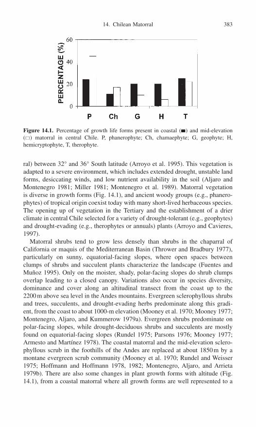
ral) between 32° and 36° South latitude (Arroyo et al. 1995). This vegetation isadapted to a severe environment, which includes extended drought, unstable landforms, desiccating winds, and low nutrient availability in the soil (Aljaro andMontenegro 1981; Miller 1981; Montenegro et al. 1989). Matorral vegetation is diverse in growth forms (Fig. 14.1), and ancient woody groups (e.g., phanero-phytes) of tropical origin coexist today with many short-lived herbaceous species.The opening up of vegetation in the Tertiary and the establishment of a drierclimate in central Chile selected for a variety of drought-tolerant (e.g., geophytes)and drought-evading (e.g., therophytes or annuals) plants (Arroyo and Cavieres,1997).
Matorral shrubs tend to grow less densely than shrubs in the chaparral of California or maquis of the Mediterranean Basin (Thrower and Bradbury 1977),particularly on sunny, equatorial-facing slopes, where open spaces betweenclumps of shrubs and succulent plants characterize the landscape (Fuentes andMuñoz 1995). Only on the moister, shady, polar-facing slopes do shrub clumpsoverlap leading to a closed canopy. Variations also occur in species diversity,dominance and cover along an altitudinal transect from the coast up to the 2200m above sea level in the Andes mountains. Evergreen sclerophyllous shrubsand trees, succulents, and drought-evading herbs predominate along this gradi-ent, from the coast to about 1000-m elevation (Mooney et al. 1970; Mooney 1977;Montenegro, Aljaro, and Kummerow 1979a). Evergreen shrubs predominate onpolar-facing slopes, while drought-deciduous shrubs and succulents are mostlyfound on equatorial-facing slopes (Rundel 1975; Parsons 1976; Mooney 1977;Armesto and Martínez 1978). The coastal matorral and the mid-elevation sclero-phyllous scrub in the foothills of the Andes are replaced at about 1850m by amontane evergreen scrub community (Mooney et al. 1970; Rundel and Weisser1975; Hoffmann and Hoffmann 1978, 1982; Montenegro, Aljaro, and Arrieta1979b). There are also some changes in plant growth forms with altitude (Fig.14.1), from a coastal matorral where all growth forms are well represented to a
14. Chilean Matorral 383
Figure 14.1. Percentage of growth life forms present in coastal (�) and mid-elevation(�) matorral in central Chile. P, phanerophyte; Ch, chamaephyte; G, geophyte; H,hemicryptophyte, T, therophyte.

mid-elevation matorral with increased dominance by phanerophyes and chamae-phytes and a decreased dominance in geophytes and hemicriptophytes (Fig. 14.1and Appendix). However, the transition from coastal matorral to mid-elevationone is more gradual than from coastal sage scrub to chaparral in California(Dallman 1998).
Fires in Central Chile
Almost all literature indicates that wildfires are essentially the result of humancauses in central Chile because natural lightning-ignited fires are rare and absentfrom official records (Fig. 14.2). The high Andean Cordillera protects centralChile from humid subtropical air masses with convectional storms with lightning.This is an important difference with other Mediterranean-type ecosystems aroundthe world such as California, where natural lightning-ignited fires are a commonphenomenon (Table 14.1) (Aschmann 1991; Keeley 1977, 1981; Rundel 1981a;Araya and Ávila 1981; Ávila, Montenegro, and Aljaro 1988).
Nevertheless, Fuentes and Espinoza (1986), using published botanical, paly-nological, and geomorphological evidence, argued that volcanism, a frequentphenomenon in Chile, could have been a nonhuman ignition source in the
384 G. Montenegro et al.
Figure 14.2. Percentage distribution of fires in Chile in the period 1963 to 1998. (Datafrom CONAF, 1998.)
Table 14.1. Frequency and extent of burning by natural lightning fires and human causeson state and federal wildlands in California, 1970 to 1979
Fires, 106 ha/yr Hectares burned, 106 ha/yr
Jurisdiction Humans Lightning Humans Lightning
State of California,Division of Forestry 541 31 3347 416U.S. Forest Service 134 129 669 189
Source: From Keeley 1982.

Mediterranean region of central Chile. However, the relative paucity of volcan-ism compared to lightning implies much less selection of plant traits and there-fore lack of plant–fire-dependence as observed in all other Mediterranean-typeecosystems. Although this is an interesting hypothesis, humans historicallyaccount for a substantial amount of the ignition sources in central Chile.
A further manifestation of the importance of the human component in fireregimes detected in central Chile is the dramatic increase in fire incidenceobserved in recent decades. Historical data from the Chilean Forestry Service(Corporación Nacional Forestal, CONAF 1998) indicates that total fire frequencywas quite low at the country level in the 1960s but has increased in the last threedecades from 500 fires per year in 1963–64 to 5500 fires per year in 1997–98.The area with the most accentuated Mediterranean climate of the country (centralChile) follows the same national trend (Zunino and Riveros 1990), and theincrease in fire frequency closely parallels the rapid population growth producedin central Chile over the same period of time (Palmer 1993).
Fire disturbance in central Chile has not had, however, the same effect onnatural ecosystems as on agricultural lands. Wild areas have been more affectedby human-induced fires in comparison with agricultural ones, such as croplandsand commercial forest. This difference may be the result of high human pressureon matorral areas, such as agricultural and urban expansion pressures on naturalecosystems through controlled fires and more diverse human use of wild areaswith higher fire risks.
The seasonality of the Mediterranean climate strongly influences the seasonaldistribution of fire (Fig. 14.3). High fire frequencies, as high as 90% in January,occur in summer, whereas cold and wet months of winter and autumn reduce firerisk to almost zero. This pattern may not only be explained by changes in climateand natural fuel load accumulation but also by higher human-matorral interac-tions during the summer period. Higher fire frequencies in summer also may havestrong influences on plant regeneration capabilities after fire. Plant reproductiveprocesses in woody matorral species, such as flowering (Fig. 14.3), are concen-trated in those months with higher fire risk, which may greatly reduce sexualregeneration possibilities and mechanisms of temporal fire avoidance.
Despite increased incidence of human-induced wildfires in central Chile, thereis no evidence that the total area burned has increased over the same period(CONAF 1998). Reasons for the lack of congruence between incidence of firesand area burned are multiple and complex, but they clearly point to the obviousconclusion that average fire size has declined over this period. Paramount amongthe reasons is the increased fragmentation of habitats that has accompanied accel-erated population growth and development. Landscapes have been altered byreplacing vast stretches of continuous matorral fuels with patches of vegetationdispersed in a mosaic interspersed with less flammable agricultural and suburbanvegetation as well as nonflammable urban developments.
Coupled with the greater presence of humans in these regions is the increas-ing concern for fire detection and fire suppression. Therefore, despite theincreased fire incidence by human activities, there has not been a net impact on
14. Chilean Matorral 385
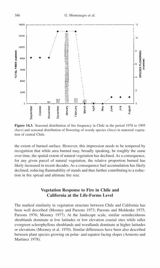
the extent of burned surface. However, this impression needs to be tempered byrecognition that while area burned may, broadly speaking, be roughly the sameover time, the spatial extent of natural vegetation has declined. As a consequence,for any given parcel of natural vegetation, the relative proportion burned haslikely increased in recent decades. As a consequence fuel accumulation has likelydeclined, reducing flammability of stands and thus further contributing to a reduc-tion in fire spread and ultimate fire size.
Vegetation Response to Fire in Chile and California at the Life-Forms Level
The marked similarity in vegetation structure between Chile and California hasbeen well described (Mooney and Parsons 1973; Parsons and Moldenke 1975;Parsons 1976; Mooney 1977). At the landscape scale, similar semideciduousshrublands dominate at low latitudes or low elevation coastal sites while tallerevergreen sclerophyllous shrublands and woodlands dominate at higher latitudesor elevations (Mooney et al. 1970). Similar differences have been also describedbetween plant species growing on polar- and equator-facing slopes (Armesto andMartinez 1978).
386 G. Montenegro et al.
Figure 14.3. Seasonal distribution of fire frequency in Chile in the period 1978 to 1995(bars) and seasonal distribution of flowering of woody species (lines) in matorral vegeta-tion of central Chile.

Even though there are marked similarities in both plant structure and functionbetween central Chile and California, one may expect that different fire distur-bance histories may have led to different plant responses to fire. Plant responsesto fire in central Chile can be seen as strategies to cope with a rather novel evolutionary challenge whereas fires have been a long-term natural disturbancefor Californian vegetation. Since the sclerophyllous shrublands in these tworegions are best known in terms of their response to fire, we have focused on acomparison of chaparral versus matorral. When comparing plant evolutionaryresponses to natural fires at the growth form level, interesting differences can befound (Table 14.2).
Matorral in central Chile has a high diversity of succulent plants, most notablymembers of the Cactaceae, from near sea level to more than 2000msl (Rundel1975, 1977). On the other hand, the chaparral ecosystem of California has a lowdiversity of Cactaceae because fire kills cacti and other succulent plants (Nierigand Lowe 1984). The relatively low natural fire frequency in central Chile compared to California may well be the critical element promoting the survivalof large cacti in matorral vegetation (Fuentes et al. 1995).
14. Chilean Matorral 387
Table 14.2. Regeneration responses to fire disturbance and relative importance* in Californian chaparral and Chilean matorral
Regeneration responseGrowth forms after fire Chaparral Matorral
Phanerophytes (1) Resprouting from ++++ ++++Chamaephytes epicormic stem buds
(2) Resprouting from ++++ ++++rootcrown ++ ++++
(3) Resprouting from ++ —lignotuber + —
(4) Fire-stimulated flowering(5) Release of seeds from +++ +
serotinous cones or fruits(6) Germination of dormant +++ —(?)
soil-seed banks stimulated by heat shock
(7) Germination of dormantsoil-seed banks stimulatedby chemicals from smokeor charred wood
Geophytes (1) Resprouting from deeply +++ +++buried bulbs or corms
(2) Fire-stimulated flowering ++ ++(?)Hemicryptophytes (1) Resprouting from roots (?) (?)
or rootcrownsTherophytes (1) Germination of soil-seed ++++ —
banks stimulated by heat shock
*+ rare, ++ common, +++ abundant, and ++++ very abundant.

Geophytes are a diverse and abundant component of all mediterranean-climateregions (Dafni, Cohen, and Noy-Meir 1981; Le Maitre and Brown 1992; Rundel1993, 1996). For instance, along the north-to-south climatic gradient observed inChile, the highest diversity of geophytes corresponds to the Mediterranean-typeregion (Hoffman 1989; Hoffmann, Liberona, and Hoffmann 1998) whereas alongthe east-to-west altitudinal gradient, the highest diversity of geophytes corre-sponds to coastal areas (Fig. 14.1; Montenegro, unpublished data). MoreoverChile and California are remarkably similar in the proportion of their flora com-prised by geophytes, 5.4% in both regions (Rundel 1996). This is a growth formthat enables plants to avoid water stress; however, in some respects it also pre-adapts them to avoid fires. In the absence of fire their normal seasonal cycleinvolves a dormancy period where the aboveground vegetative material diesback. Typically this resting period coincides with the fire season in these regionsand thus geophytes are well buffered against fires as it seems likely that the deeplyburied corms and bulbs are not negatively affected from fire. However, surficialburied underground structures, such as rhizomes, may be strongly affected byhigh intensity fires (Table 14.2). Montenegro (unpublished data) found high geo-phyte survival in coastal matorral after a fire, were six geophyte species are wellrepresented (Tecophilaea violaeflora, Conanthera trimaculata, Dioscorea humi-fusa, Pasithea coerulea, Fortunatia biflora, and Alstroemeria pulcra).
The geophyte life form may also respond favorably to fire because of the muchgreater frequency of flowering apparently stimulated by enhanced nutrients andlight (Table 14.2; Stone 1951; Rundel 1981b,c; Le Maitre and Brown 1992). Inone extreme example of flowering stimulation by fire, the geophyte Cyrtanthusventricosum, which flowers immediately (and only) after fire, is triggered bysmoke (Keeley 1993). Smoke-triggered flowering has never been described forany Chilean geophyte, but enhanced flowering after fire has been mentioned byHoffmann, Liberona, and Hoffmann (1998) for some geophytes belonging to theAlstroemeria genus.
Hemicriptophytes are well represented in the Chilean matorral (Fig. 14.1). This plant growth form is also well adapted to seasonal climates such as theMediterranean-type climate. It has a herbaceous root crown with dormant budsat ground level that are protected by a dense rosette of death leaves. Lack of hard-bark formation in this structure with proper cell suberization may lead to its complete death under high-intensity fires, but they may be able to survive underlow-intensity fires. There is no published information about the fire survival capa-bility of hemicriptophytes in central Chile and in California (Table 14.2).
Although herbaceous annuals are diverse in the matorral, they are less diversethan in California (Fuentes et al. 1995). It has been shown that seed germinationof Chilean herbaceous annual species is significantly decreased by fires, while“fire-endemic” annuals are common in chaparral (Carter 1973; Keeley andJohnson 1977; Ávila, Aljaro, and Silva 1981). Again, differences in natural firefrequency may have played a determining role in this phenomenon.
Phanerophyte adaptative traits to fire in California are more diverse andcomplex than the other growth forms perhaps due to their longer generational
388 G. Montenegro et al.
times. Phanerophyte survival after fire in chaparral is mainly the result of the fol-lowing mechanisms: (1) vegetative regeneration from buds buried in undergroundstructures (root crown and lignotuber) or epicormic stem buds and (2) sexualregeneration due to fire-stimulated flowering, fire-stimulated seed release fromfruits, or heat-shock-enhanced germination (Trabaud 1987). These contrastingstrategies, although not mutually exclusive, have been emphasized in the literature of almost all fire-disturbed Mediterranean-type ecosystems (Keeley 1977; Cody and Mooney 1978; Kruger 1983; Keeley 1984; Keeley and Keeley1984; Keeley et al. 1986), but they have not been described for matorral (Table 14.2).
It has been shown that most matorral species are able to resprout after fire(Cody and Mooney 1978; Araya and Ávila 1981; Montenegro, Ávila, and Schatte1983; Ginocchio, Holmgren, and Montenegro 1994) as in chaparral (Kruger1983). However, matorral significantly differs from chaparral because all woodyspecies can resprout after fire (Parsons 1976; Mooney 1977; Araya and Ávila1981; Montenegro, Ávila, and Schatte 1983), whereas a substantial portion of theCalifornian chaparral shrub species fail to resprout, even following low-intensityfires (Table 14.2; Wells 1969).
Montenegro and Ginocchio (1995) found that a common ecomorphologicalcharacter shared by shrubs of matorral and chaparral is the development of under-ground lignified stems or lignotubers. Lignotubers have been defined as a sourceof dormant epicormic buds buried in a modified stem (Montenegro, Ávila, andSchatte 1983). Such buds are capable of resprouting after the crown is killed,consumed by fire, or removed by mechanical means, regenerating the aerial partof the plant. Another shared character in both regions is the presence of epicormicbuds that can sprout after fire. Although both ecomorphological characteristicshave not been the result of fire selective pressure in matorral as in chaparral, theymay have been the result of seasonality in climate (Montenegro and Ginocchio1995) and thus represent a “pre-adaptation” to human-induced fires.
Presence of adventitious buds in root crowns of woody plants is nearly a ubiq-uitous trait in dicotyledonous plants (Wells 1969). Although wildfires are animportant feature of many ecosystems worldwide and have been present sincethe early evolution of angiosperms, there are other disturbance factors that couldselect for this trait, such as seasonal climate. Storage of carbohydrates is anotherimportant role of adventitious buds, and there is strong circumstantial evidencefrom comparison of burning and cutting experiments that seasonal depletion ofcarbohydrates may strongly affect regenerative capacity (Rundel et al. 1987).
Mediterranean-climate ecosystems are unusual in having a large percentage ofthe landscape dominated by lignotuberous species. These structures are ontoge-netic features that are adapted to initiate development early in seedling growth(Wells 1969; Montenegro, Ávila, and Schatte 1983). This is in contrast to ligno-tuber development in most non–Mediterranean-climate species where these basalswellings are a wound response to having the aboveground stems destroyed(Keeley 1981). A recent interesting anatomical study has shown that buds aredeveloped in lignotubers from the vascular cambium, and they have not seen to
14. Chilean Matorral 389

be developed from cortical parenchyma (Montenegro, personal observations).Therefore bark thickness is of great importance in protecting these buds as wellas the cambium during fire. Some bark loss is usual during fires, but restorationmay take place if fire interval is long enough.
Our evidence suggests that resprouting capability differs among species, bothin the proportion of individuals that exhibit the response and in the amount offoliage they produce (Ginocchio et al. 1994). Resprouting can immediately occurafter a fire independently of the time of the year (Montenegro, Díaz, Lewin, andGómez, unpublished data). Figure 14.4 shows biomass change in time ofresprouts generated from lignotubers in several woody species after a fire pro-duced in late summer in central Chile. It is clear that although all species wereable to resprout from lignotubers in autumn, there were interspecific differences.Lithrea caustica showed a significantly higher biomass recovery than the otherfour species. However, these species normally start their vegetative growth laterin the season when mean temperatures reach higher values in summer (Montenegro et al. 1981, 1989). Rapid shoot production from lignotubers may betriggered by changes in water balance due to higher root to shoot ratios typicalat burned shrubs, and high nutrient availability from lignotubers.
Another interesting aspect of resprouting capability from lignotubers relates tothe age of the plant, and therefore the age of its underground structure. Some evi-dence suggests that older plants have larger lignotubers, and therefore increasedresprouting capabilities (Montenegro, Díaz, Lewin, and Gómez, unpublisheddata) may be due to higher starch reserves in parenchymatic cells of larger underground woody structures (Montenegro, Ginocchio, and Segura 1996). Carbohydrate levels have been detected as high as 4.5% to 10.2% dry weight inlignotubers of Erica australis in Mediterranean-type ecosystems of Spain
390 G. Montenegro et al.
Figure 14.4. Dynamics of resprouts in some burned matorral shrubs after fire.

(Cruz and Moreno 1997a,b,c). Resprouting capability after fire is only affectedby very low carbohydrate levels in lignotuber that are not observed in the field,at least in this plant species.
Besides observed changes in plant productivity, leaf size and secondary prod-ucts are other plant characteristics that can also be affected by fires. Montenegroand collaborators (unpublished data) found important changes in leaf size ofshoots generated after fire in four evergreen matorral shrubs species when com-pared with normal leaves present in adult shrubs that have not been affected by fire. Leaves generated after fire are larger than unburned adult shrub leaves(Fig. 14.5) leading to a rapid recovery of plant photosynthetic structure. Theseyoung large leaves formed after fire may be heated by higher solar radiationobserved in open areas produced by fires and may also be a good food source toherbivores. However, preliminary data indicate chemical protection against bothfactors through increased phenol concentrations in new formed leaves after fire(Gómez 2000).
A second general phanerophyte survival mechanism involves fire-stimulatedflowering, fire-stimulated seed release from fruits, or heat-shock-enhanced germination. This is an uncommon plant responses in matorral (Table 14.2). InCalifornia, nonsprouters or obligate-seeders recruit massive seedling populationsafter fire and are considered highly specialized “fire-dependent” species (Keeley1986a, 1994). This phenomenon has not been observed in Chile (Muñoz andFuentes 1989).
Fire-stimulated flowering has not been detected in Chile, although it is a phenomenon described in other Mediterranean-type ecosystems, such as south-western Australia (Specht 1988). The rapid recovery of sexual reproductionobserved in Trevoa trinervis motivated its classification as a pyrogenic species
14. Chilean Matorral 391
Figure 14.5. Leaf area per shoot formed by some woody matorral shrubs 240 days aftera summer fire (�) and in control shoots (�).

(Montenegro and Teillier 1988). However, results of Ginocchio et al. (1994) indi-cate that flowering is not really stimulated after fire; it only reaches similar levelsobserved in control plants growing in undisturbed sites. Rapid flowering recoverymay be the result of branch types of T. trinervis. In comparison with most ever-green species, the canopy of T. trinervis is mainly built by short shoots or brachy-blasts where reproductive and vegetative plant functions cannot be separated andtherefore are not constrained (Ginocchio and Montenegro 1992; Montenegro andGinocchio 1993). In other words, stem production in T. trinervis not only led toleaf production but also to inflorescences in the same growing season. The fact thatresprouting shrub of T. trinervis can generate and disperse seeds faster than othermatorral species is another indicator of the potential of this species to establishnew individuals at burned sites. This may explain the relatively large cover of T.trinervis seedlings observed at burned sites one year after the fire.
From both laboratory and field experiments it has been shown that unlike thefindings in California (Keeley 1986b, 1987; Keeley et al. 1986), neither fires norash-enriched soils induce the germination of seeds in the matorral (Muñoz andFuentes 1989). It appears that high seed mortality occurs with intense fires, withthe exception of Muehlenbeckia hastulata and Trevoa trinervis (Keeley andJohnson 1977; Muñoz and Fuentes 1989). In the former species, however,seedling frequency observed under burned shrubs is the same as under cut shrubs(Muñoz and Fuentes 1989). Therefore it cannot be said that fire specifically stimulated their germination. All fire-stimulated Ceanothus species in chaparraland Phylic species in South African fynbos as well as T. trinervis belong to thefamily Rhamnaceae (Keeley and Bond 1997). This pattern may be the result ofsome similarity in seed coat characteristics in plants belonging to Rhamnaceaethat allow them to survive and germinate after fire, such as hard and thick coatsthat can be scarified by fire.
Germination triggered by chemicals from charred wood or smoke is wide-spread in Californian chaparral, South African fynbos, and Australian kwongan,heath, and other associations (de Lange and Boucher 1990; Brown 1993; Keeley1994; Dixon et al. 1995; Keeley and Fotheringham 1997). This is clearly the mostspecialized postfire germination pattern. To date it has not been reported fromChile (Table 14.2). However, based on the relatively depauperate flora of post-fire species that recruit from seed banks in Chile, it seems unlikely that thisresponse will be widespread in Chilean matorral.
Species that accumulate seed banks between fires and produce a pulse of seedling recruitment in the first growing season after fire are common inMediterranean-climate regions (Keeley 1994). However, in this respect, Chilediffers greatly from the other four regions. Canopy storage of dormant seeds inserotinous cones or fruits, which is well developed in South Africa and Australia,and present in California and the Mediterranean Basin, is unknown from Chile(Table 14.2). Deeply dormant seeds stored in the soil are common and widespreadin the other four regions but only weakly developed in Chile.
We can conclude, in this section, that a large proportion of the growth formsof the matorral flora fails to recruit seedlings immediately after fire, as is clear
392 G. Montenegro et al.

from Figure 14.6 (see also Appendix). For instance, approximately half ofphanerophyes present either in coastal or mid-elevation matorral are able toresprout after fire while the other half, which cannot regenerate vegetatively afterfire, is eliminated from the burned site. Exceptions are T. trinervis and M. hastulata. Most coastal and mid-elevation matorral plant species would be locally extirpated from burned sites if it were not for their vegetative regenera-tion from epicormic buds or underground structures (lignotubers, woody rootcrowns, bulbs). While resprouting is clearly adaptive in this context, it is a matterof some debate as to whether resprouting was initially selected in response to lowfire frequencies produced by volcanism (Fuentes and Espinoza 1986) or whetherit was mainly selected in response to seasonality and water stress.
Vegetation Response to Fire in Chile and California at Community and Landscape Levels
Fire not only initiates cycles of vegetation succession in chaparral of Californiabut contributes to the maintenance of ecosystem structure and function, providedthat its occurrence does not greatly exceed the natural fire frequency (Pickett and
14. Chilean Matorral 393
Figure 14.6. Percentage distribution of natural regeneration capabilities by growth formin coastal (�) and mid-elevation (�) matorral of central Chile. Plg, phanerophyte withlignotuber; Ps, phanerophyte that regenerates from seeds; Gb, geophyte that regeneratesfrom bulbs; Gr, geophyte that regenerates from rhizome; Gt, geophyte that regeneratesfrom tuber; Hrc, hemicryptophyte that regenerates from root crown; T, therophyte thatregenerates from seeds.

White 1985). Natural selection has acted to maintain relatively flammable vege-tation structure and chemistry to favor high combustibility (Rundel 1981b;Keeley et al. 1989) and to select adequate plant regeneration mechanisms as discussed in previous section. Hanes (1971) has used the term “auto-succession”to describe postfire community-level response in Californian chaparral, where the pre-fire flora is fully represented in the immediate postfire flora. Neverthe-less, fire does generate major structural and floristic changes in this community.In particular, dominant shrubland communities are typically replaced by short-lived herbaceous or subligneous vegetation. The woody flora itself changesin structure because shrubs are replaced by either seedlings or herbaceousresprouts from basal lignotubers or root crowns (Fig. 14.7a and b). Thereforechaparral is resilient to natural fires. Vegetation recovery after fire involvesendogenous processes of local plant species which restore burned areas to asimilar state as that before the fire (Fig. 14.7a and b), with very few pioneerspecies colonizing such systems (Trabaud 1987). Recuperation of the plant com-munity in California is achieved within the first 10 years after the fire (Keeley1986a).
In Chile very limited research has been conducted on matorral resilience tofire. However, there are two observations that may suggest that this plant com-munity is not necessarily resilient to human-induced fires. The first is that coastalmatorral recovers less rapidly than chaparral. Recovery may require from 25 to30 years, or the vegetation maybe never recover to the pre-fire community,leading to an alternative plant community dominated by T. trinervis (Lazo, unpub-lished data). The second is that pioneer species colonizing burned areas are dif-ferent from those found in undisturbed matorral communities and from “natural”pioneer matorral succession processes described by Armesto and Pickett (1985).Consequently the plant community becomes dominated by nonnative annualgrasses and forbs (Montenegro, personal observation).
An important characteristic of human-induced fires in central Chile is the high variability in intensity. Not all fires affecting matorral are intense enough to consume all the aboveground biomass on a slope. Fires usually have patchyeffects that leave a slope as a mosaic of consumed shrubs mixed with lightlyburned ones. High- and low-intensity human-made fires can produce ecologicallydifferent effects in the Chilean matorral, determining species distribution patterns(Segura et al. 1998).
High-intensity fires tend to destroy the seed bank in the matorral and thus elim-inate the possibility of recolonization by this mechanism (Muñoz and Fuentes1989). In such cases resprouting from underground structures (lignotubers,woody rootcrowns, bulbs) allows the maintenance of previously colonized space(Fig. 14.8a and b). However, only some matorral species are able to resprout afterfire and not all have the same resprouting capability. Trevoa trinervis and M. hastulata show the lowest resprouting capability when compared with othermatorral shrub species (Segura et al. 1998). In addition high rates of human-induced fires in the same area can limit resprouting capability and generate a complete change in matorral structure and functioning. This contributes to
394 G. Montenegro et al.

14. Chilean Matorral 395
Figure 14.7. Vegetative (a) and sexual (b) regeneration models for chaparral vegetationafter fire. P, phanerophyte; Gb, geophyte that regenerates from bulbs; T, therophyte.
(a)
(b)

396 G. Montenegro et al.
(a)
(b)
Figure 14.8. Vegetative (a) and sexual (b) regeneration models for matorral vegetationafter a high-intensity fire. P, phanerophyte; Gb, geophyte that regenerates from bulbs; Gr, geophyte that regenerates from rhizome; Gt, geophyte that regenerates from tuber;Hrc, hemicryptophyte that regenerates from root crown; T, therophyte that regeneratesfrom seeds.

landscape fragmentation that can lead to plant extintion and therefore to land-scape desertification (Armesto and Gutiérrez 1978).
Low-intensity fires leave lightly burned shrubs and some soil seed bank thatallow seedling establishment from seeds and resprouting from epicormic stembuds besides resprouting from underground structures (Fig. 14.9a and b).However, seedling establishment under lightly burned shrubs differs amongspecies. Trevoa trinervis and Muehlenbeckia hastulata show the strongestresponse among all woody species (Segura et al. 1998). It is clear that not allmatorral plant species are equally adapted to negative effects produced by fires.Different fire frequencies and fire intensities also can change from place to placeand time to time. This can result in vegetation mosaics and landscape hetero-genity (Keeley and Swift 1995) of greater biological diversity at broad spatialscales, but due to colonization by foreign species.
Fires were a natural part of the Californian Mediterranean-climate ecosystemsprior to human influences, but in contrast, Chilean matorral appears to have hadlittle evolutionary exposure to fires. As a consequence we see a substantial portionof the Californian flora as “fire dependent.” Specific fire-related chemical germi-nation cues are required for many species to complete their life cycles. Such is notthe case in Chile because all species appear to have some significant capacity forregeneration in the absence of fire, and thus represent a very different successionalmodel than chaparral (Armesto and Pickett 1985). Models of plant community-level response to human-induced fire disturbances in central Chile may vary fromsituations where vegetation is totally replaced by temporary successional stage ofexotic species, to communities where immediate postdisturbance regeneration isfrom the original vegetation, depending on fire intensity and frequency.
The present human impact on these regions appears to be one of increasingfire frequency. In California, the impact of increasing fire frequency is a functionof whether or not fires occur frequently enough to prevent the nonsprouting shrubelement from establishing a seed bank sufficient to regenerate the population. InChile, this is apparently not an issue. In addition fire frequency may reduce sur-vivorship of resprouting species and over time thin perennial plant populationsboth in matorral and chaparral.
In contrast to chaparral, matorral suffers from pressures in addition to fire, suchas intensive browsing by domestic goats and wood gathering for charcoal pro-duction. The main consequence of these diverse and intense human impacts incentral Chile is that areas near urban developments often exhibit marked declinesin the woody component and an increase in nonnative annual grasses and forbs.For instance, Matthei (1995) has recently shown that central Chile is a strongfocus for the concentration of invasive and native weedy species.
Conclusion
At a global scale it is attractive to assume that global warming would have highly similar effects on ecosystem structure and function in the five regions ofMediterranean-type ecosystems. Indeed, the similarity of these ecosystems is
14. Chilean Matorral 397
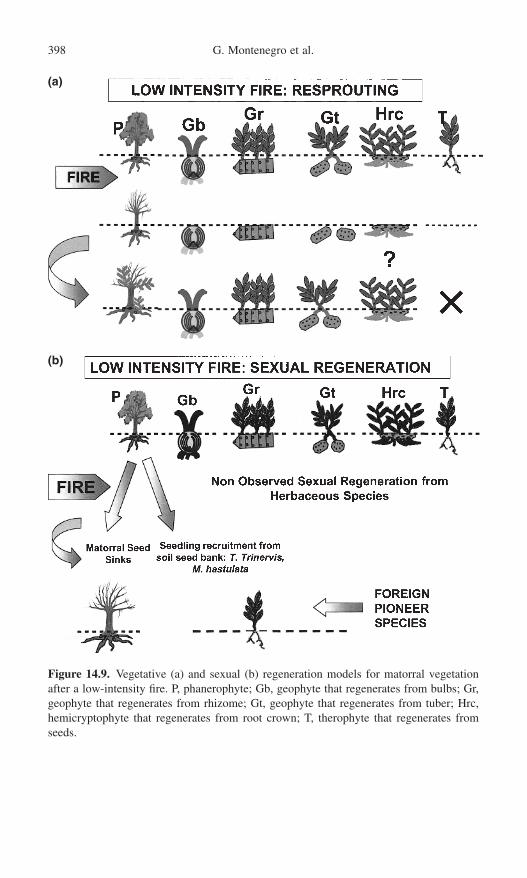
398 G. Montenegro et al.
(b)
(a)
Figure 14.9. Vegetative (a) and sexual (b) regeneration models for matorral vegetationafter a low-intensity fire. P, phanerophyte; Gb, geophyte that regenerates from bulbs; Gr,geophyte that regenerates from rhizome; Gt, geophyte that regenerates from tuber; Hrc,hemicryptophyte that regenerates from root crown; T, therophyte that regenerates fromseeds.

commonly attributed to the similarity of their climates, and it is not unreasonableto assume that similar patterns of climate change will lead to similar ecologicalchanges in these ecosystems. However, the comparison in this chapter of Chileanmatorral and Californian chaparral demonstrates the importance of fine-scale dif-ferences in the plant adaptations and history of human impact that are likely toaffect future responses to climate change. Differences in the role of fire in theregeneration ecology of these two regions are likely to result insignificantly dif-ferent outcomes of climatically induced ecological change.
Acknowledgments. The work was supported by grant NIH-NSF-USDA 2UO1TW 00316-09 to B. N. Timmermann and Fundación Andes Research Fellow toR. Ginocchio. We thank also Corporación Nacional Forestal, CONAF, for theaccess to the fire data and to grant FIA CO1-1-G-OO2.
References
Aljaro, M.E., and Montenegro, G. 1981. Growth of dominant Chilean shrubs in the AndeanCordillera. Mount. Res. Dev. 1:287–291.
Araya, S., and Ávila, G. 1981. Rebrote de arbustos afectados por fuego en el matorralChileno. An. Mus. Hist. Nat., Valparaíso 14:107–113.
Armesto, J.J., and Gutiérrez, J.R. 1978. El efecto del fuego en la estructura de la veg-etación de Chile central. An. Mus. Hist. Nat., Valparaíso 11:43–48.
Armesto, J.J., and Martínez, J.A. 1978. Relations between vegetation structure and slopeaspect in the Mediterranean region of Chile. J. Ecol. 66:881–889.
Armesto, J.J., and Pickett, S.T.A. 1985. A mechanistic approach to the study of succes-sion in the Chilean matorral. Rev. Chil. Hist. Nat. 58:9–17.
Arroyo, M.T.K., and Cavieres, L. 1997. The Mediterranean-type climate flora of centralChile. What do we know and how can we assure its protection? In Taller Internacionalsobre aspectos ambientales, ideológicos, éticos y políticos en el debate sobre bioprospección y uso de recursos genéticos en Chile, eds. G. Montenegro and B.T. Timmermann, pp. 48–56. Santiago: Noticiero de Biología, Sociedad de Biologíade Chile.
Aschmann, H. 1991. Human impact on the biota of Mediterranean-climate regions of Chileand California. In Biogeography of Mediterranean Invasions, eds. R.H. Groves, and F. di Castri, pp. 33–42. New York: Cambridge University Press.
Aschmann, H., and Bahre, C. 1977. Man’s impact on the wild landscape. In ConvergentEvolution of Chile and California Mediterranean Climate Ecosystems, ed. H.A.Mooney, pp. 73–84. Stroudsburg, PA: Dowden, Hutchinson and Ross.
Ávila, G., Aljaro, M.E., and Silva, B. 1981. Observaciones en el estrato herbáceo despuésdel fuego. An. Mus. Hist. Nat., Valparaíso 14:99–105.
Ávila, G., Montenegro, G., and Aljaro, M.E. 1988. Incendios en la vegetación Mediterránea. In Ecología del paisaje en Chile central: Estudios sobre sus espaciosmontañosos, eds. E.R. Fuentes, and S. Prenafeta, pp. 81–88. Santiago: Ediciones Universidad Católica de Chile.
Bahre, C.J. 1979. Destruction of the natural vegetation of north-central Chile. Univ. Cal.Pub. Geog. 23:1–117.
Brown, N.A.C. 1993. Promotion of germination of fynbos seeds by plant-derived smoke.New Phytol. 123:575–584.
Carter, S. 1973. A comparison of pattern of herb and shrub growth in comparable sites inChile and California. M.S. thesis. California State University, San Diego.
14. Chilean Matorral 399

Cincotta, R.P., Wisnewski, J., and Engelman, R. 2000. Human population in the bio-diversity hotspots. Nature 404:990–992.
Cody, M.L., and Mooney, H.A. 1978. Convergence versus nonconvergence in Mediterranean-type ecosystems. Ann. Rev. Ecol. Syst. 9:265–321.
Corporación Nacional Forestal (CONAF). 1998. Impacto del fuego sobre el medio ambi-ente. Unidad de Gestión Manejo del Fuego, pp. 1–16. Santiago
Cowling, R.M., Rundel P.W., Lamont, B.B., Arroyo, M.K., and Arianoutsou, M. 1996.Plant diversity in Mediterranean-climate regions. Trends Ecol. Evol. (TREE) 11:362–368.
Cruz, A., and Moreno, J. 1997a. Fire intensity effects on plants of Erica australis withmodified lignotuber TNC content. In Eighth Conference on Mediterranean-TypeEcosystems in a Changing World, Proceedings, 20. University of California: SanDiego.
Cruz, A., and Moreno, J. 1997b. Seasonal course of TNC in Erica australis, a lignotuberplant from western Spain. In Eighth Conference on Mediterranean-Type Ecosystemsin a Changing World, Proceedings, 21. San Diego, CA.
Cruz, A., and Moreno, J. 1997c. Resprouting of Erica australis along a resource availability gradient: relationship to plant TNC reserves. In Eighth Conference onMediterranean-Type Ecosystems in a Changing World, Proceedings, 21. University of California: San Diego.
Dafni, A., Cohen, D., and Noy-Meir, I. 1981. Life-cycle variation in geophytes. Ann. Missouri Bot. Garden 68:652–660.
Dallman, P.R. 1998. Plant Life in the World’s Mediterranean Climates. Berkeley: California Native Plant Society and University of California Press.
Davis, S.D., Heywood, V.H., Herrera, O., MacBryde, J., Villalobos, J., and Hamilton, A.C.1997. Centers of Plant Diversity: A Guide and Strategy for Their Conservation.Cambridge, U.K.: IUCN Publications Unit.
de Lange, J.H., and Boucher, C. 1990. Autecological studies on Audouinia capitata (Bru-niaceae). I. Plant-derived smoke as a seed germination cue. S. Afri. J. Bot. 56:700–703.
Dixon, K.W., Roche, S., and Pate, J.S. 1995. The promotive effect of smoke derived fromburnt native vegetation on seed germination of Western Australian plants. Oecologia101:185–192.
Fuentes, E.R., and Espinoza, G. 1986. Resilience of shrublands in central Chile: Avulcanism-related hypothesis. Interciencia 11:164–165.
Fuentes, E.R., and Muñoz, M.R. 1995. The human role in changing landscape in centralChile: implications for intercontinental comparison. In Ecology and biogeography of mediterranean ecosystems in Chile, California, and Australia, eds. M.T.K. Arroyo,P.H. Zedler, and M.D. Fox, pp. 401–417. New York: Springer-Verlag.
Fuentes, E.R., Montenegro, G., Rundel, P., Arroyo, M.T.K., Ginocchio, R., and Jaksic,F.M. 1995. Functional approaches to biodiversity in the Mediterranean-type ecosystemof central Chile. In Mediterranean-Type Ecosystems: The Function of Biodiversity, eds.G.W. Davis, and D.M. Richardson, pp. 185–228. Berlin: Springer-Verlag.
Ginocchio, R., and Montenegro, G. 1992. Interpretation of metameric architecture in dominant shrubs of the Chilean matorral. Oecologia 90:451–456.
Ginocchio, R., Holmgren, M., and Montenegro, G. 1994. Effect of fire on plant architec-ture in Chilean shrubs. Rev. Chil. Hist. Nat. 67:177–182.
Gómez, M. 2000. Respuestas morfofisiológicas de rebrotes producidos después del fuegoa partir de lignotuber, en Cryptocarya alba (Mol.). Looser, en el matorral de Chilecentral. MS, thesis. Universidad de Chile, Santiago.
Hanes, T.L. 1971. Succession after fire in the chaparral of southern California. Ecol.Monogr. 41:27–52.
Hoffman, A.E. 1989. Chilean geophyte monocotyledons: Taxonomic synopsis and con-servation status. In Red Book of Chilean Terrestrial Conservation Status, ed. I. Benoit,pp. 140–151. Santiago: Corporación Nacional Forestal (CONAF).
400 G. Montenegro et al.

Hoffmann, A.J., and Hoffmann, A.E. 1978. Comportamiento fenológico de plantas de lacordillera de los Andes. Arch. Biol. Exp. 11:188.
Hoffmann, A.J., and Hoffmann, A.E. 1982. Altitudinal ranges of phanerophytes andchamaephytes in central Chile. Vegetatio 48:151–163.
Hoffmann, A.J., Liberona, F., and Hoffmann, A.E. 1998. Distribution and ecology of geophytes in Chile: Conservation threats to geophytes in Mediterranean-type region.In Landscape Degradation and Biodiversity in Mediterranean-Type Ecosystems, ed. P. Rundel, pp. 231–253. Berlin: Springer-Verlag.
Instituto Nacional de Estadísticas (INE). 1995. Chile. Ciudades, pueblos y aldeas. Santiago: INE.
Keeley, J.E. 1977. Seed production, seed population in soil and seedling production afterfire for two congeneric pairs of sprouting and nonsprouting chaparral shrubs. Ecology58:820–829.
Keeley, J.E. 1981. Reproductive cycles and fire regimes. In Proceedings of Conference on Fire Regimes and Ecosystem Properties, eds. H.A. Mooney, T.M. Bonnicksen, N.L. Christensen, J.E. Lotan, and W.A. Reiners, pp. 231–277. USDA Forest Service,Gen. Tech. Rep. WO-26.
Keeley, J.E. 1984. Factors affecting germination of chaparral seeds. Bull. S. Cal. Acad.Sci. 83:113–120.
Keeley, J.E. 1986a. Resilience of Mediterranean shrub communities to fire. In Resiliencein Mediterranean-Type Ecosystems, eds. B. Dell, A.J.M. Hopkins, and B.B. Lamont,pp. 95–112. Dordrecht: Junk.
Keeley, J.E. 1986b. Seed germination patterns of Salvia mellifera in fire-prone environ-ments. Oecologia 71:1–5.
Keeley, J.E. 1987. Role of fire in seed germination of woody taxa in California chaparral.Ecology 68:434–443.
Keeley, J.E. 1993. Smoke-induced flowering in the fire-lily Cyrtanthus ventricosus. S. Afri.J. Bot. 59:638.
Keeley, J.E. 1994. Seed germination patterns in fire-prone Mediterranean-climate regions.In Ecology and Biogeography of Mediterranean Ecosystems in Chile, California andAustralia, eds. M.T.K. Arroyo, P.H. Zedler, and M.D. Fox, pp. 239–273. New York:Springer-Verlag.
Keeley, J.E., and Bond, W.J. 1997. Convergent seed germination in South African fynbosand Californian chaparral. Plant Ecol. 133:153–168.
Keeley, J.E., and Fotheringham, C.J. 1997. Trace gas emissions in smoke-induced seedgermination. Science 276:1248–1250.
Keeley, S.C., and Johnson, A.W. 1977. A comparison of the pattern of herb and shrubgrowth in comparable sites in Chile and California. Am. Midl. Nat. 97:120–132.
Keeley, J.E., and Keeley, S.C. 1984. Post fire recovery of California coastal sage scrub.Am. Midl. Nat. 111:105–117.
Keeley, J.E., and Swift, C.C. 1995. Biodiversity and ecosystem functioning in Mediterranean-climate California. In Mediterranean-Type Ecosystems: The Function of Biodiversity, eds. G.W. Davies, and D.M. Richardson, pp. 121–183. Berlin: Springer-Verlag.
Keeley, J.E., Fotheringham, C.J., and Morais, M. 1999. Reexamining fire suppressionimpacts on brushland fire regimes. Science 284:1829–1832.
Keeley, J.E., Brooks, A., Bird, T., Cory, S., Parker, H., and Usinge, E. 1986. Demographicstructure of Chaparral under extended fire-free conditions. In Proceedings of the Chaparral Ecosystem Research Conference, eds. F.J. Kruger, D.T. Mitchell, andJ.U.M. Jarvis, pp. 133–137. Davis: California Water Source Center, University of California.
Keeley, J.E., Zedler, P.H., Zammit, C.A., and Stohlgren, T.J. 1989. Fire and demography.In The California Chaparral: Paradigms Reexamined, ed. S.C. Keeley, pp. 151–153.Los Angeles: Natural History Museum of Los Angeles County.
14. Chilean Matorral 401

Kruger, F.J. 1983. Plant community diversity and dynamics in relation to fire. In Mediterranean-Type Ecosystems: The Role of Nutrients, eds. F.J. Kruger, D.T. Mitchel,and J.U.M. Jarvis, pp. 446–472. New York: Springer-Verlag.
Le Maitre, D.C., and Brown, P.J. 1992. Life cycles and fire-stimulated flowering in geophytes. In Fire in South African Mountain Fynbos, eds. B.W. van Wilgen, D.M. Richardson, F.J. Kruger, and H.J. van Hensbergen, pp. 145–160. Berlin:Springer-Verlag.
Matthei, O. 1995. Manual de las malezas que crecen en Chile. Santiago: Alfabeta Impresores.
Minnich, R.A. 1989. Chaparral fire history in San Diego County and adjacent northernBaja California: An evaluation of natural fire regimes and the effects of suppressionmanagement. In The California Chaparral: Paradigms Reexamined, ed. S.C. Keeley,pp. 37–47. Los Angeles: Natural History Museum of Los Angeles County.
Montenegro, G., and Ginocchio, R. 1993. Modular interpretation of architecture in shrubspecies. An. Acad. Bras. Ci. 65:189–202.
Montenegro, G., and Ginocchio, R. 1995. Ecomorphological characters as a resource forillustrating growth-form convergence in matorral, chaparral and mallee. In Ecology andBiogeography of Mediterranean Ecosystems in Chile, California and Australia, eds.M.T.K. Arroyo, P.H. Zedler, and M.D. Fox, pp. 160–176. New York: Springer-Verlag.
Montenegro, G., and Teillier, S. 1988. Species richness. In Mediterranean-Type Ecosystems: A Data Source Book, ed. R.L. Specht, pp. 811–893. Dordrecht: KluwerAcademic.
Montenegro, G., Aljaro, M.E., and Kummerow, J. 1979a. Growth dynamics of Chileanmatorral shrubs. Bot. Gaz. 14:114–119.
Montenegro, G., Aljaro, M.E., and Arrieta, A. 1979b. Dinámica de crecimiento y produc-tividad de especies dominantes en un transecto altitudinal de la Cordillera de los Andes.In Proceedings Seminario sobre el Programa de Investigación Integrada “Impacto delhombre en los ecosistemas de montaña”, MAB 6, UNESCO.
Montenegro, G., Ávila, G., and Schatte, P. 1983. Presence and development of lignotu-bers in shrubs of the Chilean matorral. Can. J. Bot. 61:1804–1808.
Montenegro, G., Ginocchio, R., and Segura, A. 1996. Effect of global change on naturalecosystems: matorral of central Chile as a case of study of global change through effectof fire and UV-B radiation. IAI Fire workshop. Oregon, September 9–13.
Montenegro, G., Aljaro, M.E., Walkowiak, A., and Saenger, R. 1981. Seasonality, growthand net productivity of herbs and shrubs of the Chilean matorral. In Dynamics andManagement of Mediterranean-Type Ecosystems, eds. C.C. Conrad, and W.C. Oechel,pp. 135–141. USDA Forest Service, Gen. Tech. Rep. PSW 58.
Montenegro, G., Ávila, G., Osorio, R., and Gómez, M. 1989. Chile. In Plant Phenomor-phological Studies in Mediterranean-Type Ecosystems, ed. G. Orshan, pp. 347–387.Dordrecht: Kluwer Academic.
Montenegro, G., Patrick, G., Echenique, P., Gómez, M. and Timmermann, B. Mechanismstoward a sustainable use of Chorizanthe vaginata Benth, var. maritima Remy: Amedicinal plant from Chile. Phyton, Int. J. Exp. Bot. 68:91–106.
Mooney, H.A. 1977. Convergent Evolution of Chile and California MediterraneanClimate Ecosystems. Stroudsburg, PA: Dowden, Hutchinson and Ross.
Mooney, H.A., and Parsons, D.J. 1973. Structure and function of the California chaparraland example from San Dimas. In Mediterranean Ecosystems: origin and Structure,eds. F. di Castri and H.A. Mooney, pp. 83–112. New York: Springer-Verlag.
Mooney, H.A., Hamburg, S.P., and Drake, J.A. 1986. The invasions of plants and animalsinto California. In Ecology of Biological Invasions of North America and Hawaii, eds.H.A. Mooney and J.A. Drake, pp. 250–272. New York: Springer-Verlag.
Mooney, H.A., Dunn, E.L., Shropshire, F., and Song, L. 1970. Vegetation comparisonsbetween the mediterranean climatic areas of California and Chile. Flora 159:480–496.
402 G. Montenegro et al.

Muñoz, M.R., and Fuentes, E.R. 1989. Does fire induce shrub germination in the Chileanmatorral? Oikos 56:177–181.
Nierig, W.A., and Lowe, C.H. 1984. Vegetation of the Santa Catalina mountains: Com-munity types and dynamics. Vegetatio 58:3–28.
Palmer, T. 1993. California’s Threatened Environment. Washington, DC: Island Press.Parsons, D.J. 1976. Vegetation structure in the Mediterranean climate scrub communities
of California and Chile. J. Ecol. 64:435–447.Parsons, D.J., and Moldenke, A.R. 1975. Convergence in vegetation structure along
analogous climatic gradients in California and Chile. Ecology 56:950–957.Pickett, S.T.A., and White, P.S. 1985. The Ecology of Natural Disturbance and Patch
Dynamics. San Diego: Acadanic Press.Rundel, P.W. 1975. Trichocereus in the mediterranean zone of central Chile. Cactus Succ.
J. 46:86–88.Rundel, P.W. 1977. Population variability in the genus Trichocereus (Cactaceae) in central
Chile. Plant Syst. Evol. 127:1–9.Rundel, P.W. 1981a. The matorral zone of central Chile. In Mediterranean-Type
Shrublands, eds. F. di Castri, D. Goodall, and R.L. Specht, pp. 175–201. The Hague:Elsevier.
Rundel, P.W. 1981b. Structural and chemical components of flammability. In Fire regimesand ecosystem properties, eds. H.A. Mooney, T.M. Bonnicksen, N.L. Christianson, J.E.Lotan, and W.A. Reiners, pp. 183–207. Washington DC: USDA Forest Service Gen.Tech. Rep. WO-26.
Rundel, P.W. 1981c. Fire as an ecological factor. In Physiological Plant Ecology. I., eds. O.L. Lange, P.S. Nobel, C.B. Osmond, and H. Ziegler, pp. 501–538. New York:Springer-Verlag.
Rundel, P.W. 1993. Adaptative significance of some morphological and physiological char-acteristics in mediterranean plants: Facts and fallacies. In Time-Scales of Water StressResponse of Mediterranean Biota, eds. F. di Castri, and J. Roy, pp. 119–140. Berlin:Springer-Verlag.
Rundel, P.W. 1996. Monocotyledoneous geophytes in the California flora. Madrono 43:355–368.
Rundel, P.W., and Weisser, P.J. 1975. La Campana, a new national park in central Chile.Biol. Conserv. 8:35–46.
Rundel, P.W., Baker, G.A., Parsons, D.J., and Stohlgren, T.J. 1987. Postfire demographyof resprouting and seedling establishment by Adenostoma fasciculatum in the California chaparral. In Plant Response to Stress: Functional Analysis in Mediter-ranean Ecosystems, eds. J.D. Tenhunen, F.M. Catarino, O.L. Lange, and W.C. Oechel, pp. 575–596. Berlin: Springer-Verlag.
Segura, A.M., Holmgren, M., Anabalón J.J.,and Fuentes E.R. 1998. The significance offire intensity in creating local patchiness in the Chilean matorral. Plant Ecol. 139:259–264.
Specht, R.L. 1988. Mediterranean-Type Ecosystems: A Data Source Book. Dordrecht:Kluwer Academic.
Stone, E.C. 1951. The stimulative effect of fire on the flowering of the golden brodiaea(Brodiaea ixiodes Wats. var. lugens Jeps.). Ecology 32:534–537.
Thrower, N.J.W., and Bradbury, D.E. 1977. Chile-California Mediterranean Scrub Atlas:A Comparative Analysis. Stroudberg, PA: Dowden, Hutchinson and Ross.
Trabaud, L.V. 1987. Dynamic after fire of sclerophyllous communities in the Mediter-ranean Basin. Ecol. Med. 13:25–37.
Wells, P.V. 1969. The relation between mode of reproduction and extent of speciation inwoody genera of the California chaparral. Evolution 23:264–267.
Zunino, S., and Riveros, G. 1990. Cartografia de los incendios forestrales en la 5 region. An. Mus. Hist. Nat., Valparaíso 21:89–94.
14. Chilean Matorral 403

Appendix
Species list of coastal and mid-elevation matorral in central Chile (designed byG. Montenegro for medicinal plants regeneration in central Chile, Grant NIH-NSF 2UO1 TW 00316-06). Growth forms are phanerophyte (P), geophyte (G),hemicryptophyte (H), therophyte (T) and chameophyte (Ch).
404 G. Montenegro et al.
Scientific name Growth form Organ Family
I. COASTAL MATORRALAdesmia angustifolia H. et A. P Lignotuber PapilionaceaeAextoxicon punctatum R. et P. P Lignotuber AextoxicaceaeAlstroemeria haemantha R. et P. G Bulb AmaryllidaceaeAlstroemeria pelegrina L. G Bulb AmaryllidaceaeAnemone decapetala Ard. H Root crown RanunculaceaeApium sellowianum Wolff. H Root crown UmbelliferaeAristolochia chilensis Bridges ex. H Seed Aristolochiaceae
Lindl.Astragalus amatus Clos. T Seed PapilionaceaeBaccharis concava (R. et P.) Pers. P Lignotuber CompositaeBaccahris linearis (R. et P.) Pers. P Lignotuber CompositaeBahia ambrosioides Lag. P Lignotuber CompositaeBipinnula fimbriata (Poepp.) Johnst. G Seed OrchidaceaeBrodiaea porrifolia (Poepp.) Meigen G Bulb LiliaceaeCalandrinia arenaria Cham T Seed PortulacaceaeCalandrinia sericea H. et A. T Seed PortulacaceaeCalandrinia grandiflora Lindl. H Root crown PortulacaceaeCalystegia soldanella (L.) Roem. et T Seed Convolvulaceae
Schult.Camassia biflora (R. et P.) Coc. G Bulb LiliaceaeCarpobrotus aequilaterus (Haw.) H Root crown Aizoaceae
N. E. Br.Chloraea bletioides Lindl. G Rhizome OrchidaceaeChloraea chrysantha Poepp. G Rhizome OrchidaceaeChloraea galeata Lindl. G Rhizome OrchidaceaeChloraea disoides Lindl. G Rhizome OrchidaceaeChorizanthe vaginata Benth. H Root crown PolygonaceaeCissus striata R. et P. P Lignotuber VitaceaeCitronella mucronata (R. et P.) P Lignotuber Icacinaceae
D. DonColletia ulicina Gill. et Hook. P Lignotuber RhamnaceaeCristaria glaucophylla Cav. T Seed MalvaceaeErigeron fasciculatus Colla H Root crown CompositaeEuphorbia portulacoides L. T Seed EuphorbiaceaeFluorensia thurifera (Mol.) DC. Ch Root crown CompositaeFrankenia chilensis K. Presl. Ch Root crown Frankeniaceae
ex Roem. et Schult.Fuchsia lycioides Andr. P Lignotuber OnagraceaeGlandularia laciniata (L.) Schnack et T Seed Verbenaceae
Covas

Glandularia sulphurea (D. Don) H Root crown VerbenaceaeSchnack et Covas
Gnaphalium viravira Mol. T Seed CompositaeHaplopappus foliosus DC. P Lignotuber CompositaeHippeastrum advenum (Ker-Gawl.) G Bulb Amaryllidaceae
Herb.Hippeastrum rhodolirion Baker G Bulb AmaryllidaceaeLeucheria cerberoana Remy T Seed CompositaeLeucocoryne ixioides (Hook.) Lindl. G Bulb LiliaceaeLinum chamissons Schiede T Seed LinaceaeLlaqunoa glandulosa (H. et A.) P Seed Sapindaceae
D. DonLobelia Tupa L. Ch Root crown CampanulaceaeLupinus microcarpus Sims. T Seed PapilionaceaeLycium chilense Miers. ex A. DC. P Seed SolanaceaeMalesherbia fasciculata D. Don T Seed MalesherbiaceaeMargyricarpus pinnatus (Lamb.) O.K. Ch Root crown RosaceaeMonnina angustifolia DC. T Seed PolygalaceaeMyrceugenia exsucca (DC.) Berg. P Lignotuber MyrtaceaeNicotiana acuminata (Graham) Hook. T Seed SolanaceaeNolana crassulifolia Poepp. Ch Root crown NolanaceaeNolana sedifolia Poepp. Ch Root crown NolanaceaeOchagavia carnea (Beer) L. B. Sm. H Root crown Bromeliaceae
et LooserOenothera acaulis Cav. H Root crown OnagraceaeOenothera affinis Cambess. H Root crown OnagraceaeOxalis carnosa Mol. H Root crown OxalidaceaeOxalis laxa H. et A. H Root crown OxalidaceaePeumus boldus Mol. P Lignotuber MonimiaceaePhycella ignea Lindl. G Bulb AmaryllidaceaePodanthus mitiqui Lindl. P Seed CompositaePouteria splendens (A. DC.) O.K. P Seed SapotaceaeProustia cuneifolia D. Don P Lignotuber CompositaePuya chilensis Mol. H Rhizome BromeliaceaeRibes punctatum R. et P. P Lignotuber SaxifragaceaeSchizantus litoralis Phil. T Seed SolanaceaeSchizantus pinnatus R. et P. T Seed SolanaceaeScyphanthus elegans D. Don H Root crown LoasaceaeSenecio cerberoanus Remy Ch Root crown CompositaeSisyrinchium junceum E. Mey. G Rhizome Iridaceae
ex K. Presl.Solanum maritimun Meyen ex Nees Ch Root crown SolanaceaeSolenomelus pedunculatus G Rhizome Iridaceae
(Gill. ex Hook.) Hochr.Sphacele salviae (Lindl.) Briq. Ch Root crown Labiatae Sphaeralcea obtusiloba (Hook.) Ch Root crown Malvaceae
D. DonStachys albicaulis Lindl. H Root crown Labiatae Trichocereus litoralis (Johow) Looser P Seed CactaceaeTrichopetalum plumosum (R. et P.) G Bulb Liliaceae
Macbr.
14. Chilean Matorral 405
Scientific name Growth form Organ Family

Tweedia confertiflora (Dcne.) Malme H Seed AsclepiadaceaeVerbena litoralis H. B. K. H Seed VerbenaceaeVerbena porrigens Phil. H Seed VerbenaceaeVicia vicina Clos. T Annual PapilionaceaeII. MID ELEVATION MATORRALAcacia caven (Mol.) Mol. P Lignotuber MimosaceaeAdenopeltis serrata (W. Aiton) Johnst. P Lignotuber EuphorbiaceaeAdesmia arborea Bert. P Lignotuber PapilionaceaeAdesmia phylloidea Clos T Seed PapilionaceaeAdesmia radicifolia Clos T Seed PapilionaceaeAdesmia viscosa Gill. ex H. et A. T Seed PapilionaceaeAlonsoa meridionalis (L. F.) O.K. T Seed ScrophulariaceaeAmsinckia calycina (Moris) Chater T Seed BoraginaceaeAnemone decapetala Ard. H Root crown RanunculaceaeAzara celastrina D. Don P Lignotuber FlacourtiaceaeAzara dentata R. et P. P Lignotuber FlacourtiaceaeAzara petiolaris (D. Don) Johnst. P Lignotuber FlacourtiaceaeAzara serrata R. et P. P Lignotuber FlacourtiaceaeBaccharis linearis (R. et P.) Pers. P Lignotuber CompositaeBaccharis marginalis DC. P Lignotuber CompositaeBaccharis racemosa (R. et P.) DC. P Lignotuber CompositaeBeilschmiedia mersii (Gay) Kosterm P Lignotuber LauraceaeBerberis actinacantha Mart. P Lignotuber BerberidaceaeBerberis chilensis Gill. ex Hook. P Lignotuber BerberidaceaeBerberis grevilleana Gill. ex H. et A. P Lignotuber BerberidaceaeBerberis montana Gay. Ch Lignotuber BerberidaceaeBuddleja globosa Hope. P Seed BuddlejaceaeCaesalpinia spinosa (Mol.) O.K. P Lignotuber CaesalpiniaceaeCalceolaria ascendens Lindl. G Tuber ScrophulariaceaeCalceolaria corymbosa R. et P. G Tuber ScrophulariaceaeCalceolaria hypericina Poepp. ex DC. G Tuber ScrophulariaceaeCalceolaria petiolaris Cav. G Tuber Scrophulariaceae Calceolaria polyfolia Hook. G Tuber ScrophulariaceaeCassia closiana Phil. P Lignotuber CaesalpiniaceaeCentaurea chilensis H. et A. T Seed CompositaeCestrum parqui L’Herit. P Lignotuber SolanaceaeChusquea quila Kunth G Rhizome GramineaeCitronella mucronata (R. et P.) P Lignotuber Icacinaceae
D. DonClarkia tenella (Cav.) Lews et Lewis T Seed OnagraceaeColletia spinosa Lam. P Lignotuber RhamnaceaeColliguaja odorifera Mol. P Lignotuber EuphorbiaceaeColliguaja salicifolia Gill. et Hook. P Lignotuber EuphorbiaceaeCollomia biflora (R. et P.) Brand T Seed PolemoniaceaeConanthera bifolia R. et P. G Bulb TecophilaeaceaeConanthera campanulata (D. Don.) G Bulb Tecophilaeaceae
Lindl.Conanthera trimaculata (D. Don.) G Bulb Tecophilaeaceae
MeigenConvolvulus chilensis Pers. G Rhizome Convolvulaceae
406 G. Montenegro et al.
Scientific name Growth form Organ Family

Corynabutilon ceratocarpum (H. et A.) Ch Root crown MalvaceaeKearney
Crinodendron patagua Mol. P Lignotuber ElaeocarpaceaeCryptocarya alba (Mol.) Looser P Lignotuber LauraceaeDiplolepis menziesii Schult Ch Seed AsclepiadaceaeDiscaria trinervis (Gill. ex H. et A.) P Lignotuber Rhamnaceae
ReicheDrimys winteri J.R. et G. Forster P Lignotuber WinteraceaeEccremocarpus scaber R. et P. P Seed BignoniaceaeEphedra andina Poepp. ex C.A. Mey P Lignotuber EphedraceaeEscallonia revoluta (R. et P.) Pers. P Lignotuber SaxifragaceaeEscallonia illinita K. Presl. P Lignotuber SaxifragaceaeEscallonia pulverulenta (R. et P.) Pers. P Lignotuber SaxifragaceaeEscallonia rosea Griseb P Lignotuber SaxifragaceaeEscallonia rubra (R. et P.) Pers. P Lignotuber SaxifragaceaeEupatorium glechonophyllum Less. P Lignotuber CompositaeEupatorium salvia Colla P Lignotuber CompositaeFabiana imbricata R. et P. Ch Seed SolanaceaeFuchsia magellanica Lam. P Lignotuber OnagraceaeGeranium berterianum Colla ex Savi. H Seed GeraniaceaeGethyum atropurpureum Phil. G Bulb LiliaceaeGochnatia foliolosa (D. Don) D. P Lignotuber Compositae
Don ex H. et A.Gymnophyton isatidicarpum Ch Root crown Umbelliferae(K. Presel. ex DC.) Math et Const.Haplopappus canescens (Phil.) Ch Root crown Compositae
ReicheHaplopappus integerrimus (H. et A.) Ch Root crown Compositae
Hall.Haplopappus multifolius Phil. ex Ch Root crown Compositae
ReicheHaplopappus paucidentatus Phil. Ch Root crown CompositaeHomalocarpus dichotomus (Poepp. T Seed Umbelliferae
ex DC.) Math. et Const.Jubaea chilensis (Mol.) Baillon P Seed PalmaeKageneckia oblonga R. et P. P Lignotuber RosaceaeLarrea nitida Cav. P Seed ZygophyllaceaeLathyrus subandinus Phil. T Seed PapilionaceaeLeucheria cerberoana Remy T Seed CompositaeLithrea caustica (Mol.) H. et A. P Lignotuber AnacardiaceaeLlagunoa glandulosa (H. et A.) P Seed Sapindaceae
G. DonLoasa pallida Gill. ex Arn. T Seed LoasaceaeLoasa sigmoidea Urban et Gilg. T Seed LoasaceaeLoasa tricolor Ker-Gawl. T Seed LoasaceaeLoasa triloba Domb. ex A.L. Juss. T Seed LoasaceaeLobelia excelsa Bonpl. Ch Root crown CampanulaceaeLobelia polyphylla H. et A. Ch Root crown CampanulaceaeLuma chequen (Mol.) A. Gray P Lignotuber MyrtaceaeMadia sativa Mol. T Seed Compositae
14. Chilean Matorral 407
Scientific name Growth form Organ Family

Malesherbia fasciculata D. Don. T Seed MalesherbiaceaeMalesherbia lirana Gay. T Seed MalesherbiaceaeMaytenus boaria Mol. P Lignotuber CelastraceaeMoscharia pinnatifida R. et P. T Seed CompositaeMuehlenbekia hastulata (J. E. Sm.) Ch Lignotuber Polygonaceae
Johnst.Mutisia decurrens Cav. P Seed CompositaeMutisia acerosa Poepp. ex Less. P Seed CompositaeMutisia spinosa R. et P. P Seed CompositaeMutisia subulata R. et P. P Seed CompositaeMyoschilos oblonga R. et P. P Lignotuber SantalaceaeMyrceugenia rufa (Colla) Skottsb. ex P Lignotuber Myrtaceae
CauselNotanthera heterophylla (R. et P.) D. P Seed Loranthaceae
DonNothofagus obliqua (Mirb.) Oerst. P Lignotuber FagaceaeOxalis articulata Savigni G Bulb OxalidaceaePasithea coerulea (R. et P.) D. Don G Rhizoma LiliaceaePassiflora pinnatistipula Cav. P Seed PassifloraceaePersea lingue (R. et P.) Ness ex P Lignotuber Lauraceae
Kopp.Peumus boldus Mol. P Lignotuber MonimiaceaePhacelia magellanica (Lam.) Coville H Seed HydrophyllaceaePhycella ignea Lindl. T Bulb AmaryllidaceaePodanthus mitiqui Lindl. P Lignotuber CompositaePorlieria chilensis Johnst. P Lignotuber ZygophyllaceaePouteria splendens (A. DC.) O.K. P Seed SapotaceaeProsopis chilensis (Mol.) Stuntz P Lignotuber MimosaceaeProustia pyrifolia DC. P Lignotuber CompositaePsoralea glandulosa L. P Lignotuber PapilionaceaePuya chilensis Mol. H Rhizoma BromeliaceaePuya coerulea Lindl. H Rhizoma BromeliaceaePuya venusta Phil. H Rhizoma BromeliaceaePuya berteroniana Mez. H Rhizoma BromeliaceaeQuillaja saponaria Mol. P Lignotuber RosaceaeRetanilla ephedra (Vent.) Brongn. P Lignotuber RhamnaceaeRhaphithamnus spinosum P Lignotuber Verbenaceae
(A. L. Juss.) Mold.Rhodophiala rhodolirion (Baker) G Bulb Amaryllidaceae
Traub.Ribes polyanthes Phil. Ch Lignotuber SaxifragaceaeSalix humboldtiana Wild. P Lignotuber SalicaceaeSalpiglossis sinnuata R. et P. Ch Root crown SolanaceaeSatureja gilliesii (Graham.) Briq. Ch Lignotuber LabiataeSchinus latifolius (Gill. ex Lindl.) P Lignotuber Anacardiaceae
EnglesSchinus montanus (Phil.) Engles P Lignotuber AnacardiaceaeSchinus polygamus (Cav.) Cabr. P Lignotuber AnacardiaceaeSchizanthus pinnatus R et P. T Seed SolanaceaeSenecio cerberoanus Remy Ch Root crown Compositae
408 G. Montenegro et al.
Scientific name Growth form Organ Family
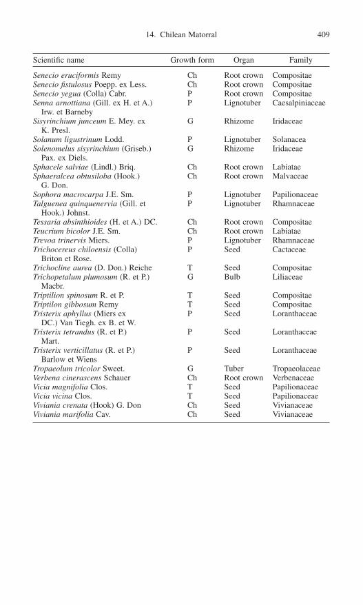
Senecio eruciformis Remy Ch Root crown CompositaeSenecio fistulosus Poepp. ex Less. Ch Root crown CompositaeSenecio yegua (Colla) Cabr. P Root crown CompositaeSenna arnottiana (Gill. ex H. et A.) P Lignotuber Caesalpiniaceae
Irw. et BarnebySisyrinchium junceum E. Mey. ex G Rhizome Iridaceae
K. Presl.Solanum ligustrinum Lodd. P Lignotuber Solanacea Solenomelus sisyrinchium (Griseb.) G Rhizome Iridaceae
Pax. ex Diels.Sphacele salviae (Lindl.) Briq. Ch Root crown LabiataeSphaeralcea obtusiloba (Hook.) Ch Root crown Malvaceae
G. Don.Sophora macrocarpa J.E. Sm. P Lignotuber PapilionaceaeTalguenea quinquenervia (Gill. et P Lignotuber Rhamnaceae
Hook.) Johnst.Tessaria absinthioides (H. et A.) DC. Ch Root crown CompositaeTeucrium bicolor J.E. Sm. Ch Root crown LabiataeTrevoa trinervis Miers. P Lignotuber RhamnaceaeTrichocereus chiloensis (Colla) P Seed Cactaceae
Briton et Rose.Trichocline aurea (D. Don.) Reiche T Seed CompositaeTrichopetalum plumosum (R. et P.) G Bulb Liliaceae
Macbr.Triptilion spinosum R. et P. T Seed CompositaeTriptilon gibbosum Remy T Seed CompositaeTristerix aphyllus (Miers ex P Seed Loranthaceae
DC.) Van Tiegh. ex B. et W.Tristerix tetrandus (R. et P.) P Seed Loranthaceae
Mart.Tristerix verticillatus (R. et P.) P Seed Loranthaceae
Barlow et WiensTropaeolum tricolor Sweet. G Tuber TropaeolaceaeVerbena cinerascens Schauer Ch Root crown VerbenaceaeVicia magnifolia Clos. T Seed PapilionaceaeVicia vicina Clos. T Seed PapilionaceaeViviania crenata (Hook) G. Don Ch Seed VivianaceaeViviania marifolia Cav. Ch Seed Vivianaceae
14. Chilean Matorral 409
Scientific name Growth form Organ Family

This page intentionally left blank

4. Practical Implications

This page intentionally left blank

15. Management Implications of Fire and Climate Changes in the Western Americas
Penelope Morgan, Guillermo E. Defossé, and Norberto F. Rodríguez
Fires have shaped the structure, composition, and function of temperate eco-systems worldwide. In many forest, shrubland, and grassland ecosystems of temperate and boreal zones, biomass production exceeds decomposition. Whenlightning or people ignite fires, and when the weather and climatic conditions areconducive, this accumulated dead and live biomass burns. Particularly when thesefires burn in extremely hot, dry, windy conditions, they threaten people and theirproperty. That fire has played an important ecological role in these ecosystemsmakes fire management challenging, for ecological integrity and sustainabilitydepend on fires and other disturbances (Pickett and White 1985).
In the temperate and boreal zones of western North and South America, fireregimes have changed in response to both climate and human action, though therelative influence varies. Fire regimes (occurrence, frequency, severity, intensity,and extent; Pickett and White 1985) reflect both the physical and sociopoliticalenvironment, and they influence the type and abundance of fuel and therefore fire behavior and effects through time. Forest fire occurrence and effects are intimately linked with climate (Weber and Flannigan 1997; Flannigan, Stocks,and Weber, Chapter 4, this volume). Climate influences lightning occurrence(Price and Rind 1994) as well as fire behavior and effects. Fire, climate, and land-scape-scale heterogeneity interact (Miller and Urban 1999; Swetnam and Betan-court 1998). There is growing evidence that the temperature increases associatedwith global climate change may be most pronounced at higher latitudes (IPCC2001; Flannigan, Stocks, and Weber, Chapter 4, this volume) where temperate
413

414 P. Morgan, G.E. Defossé, and N.F. Rodríguez
and boreal forests are found. The effects of climate change on vegetation will bemediated through fire and other disturbances (Swetnam and Betancourt 1998;Flannigan, Stocks, and Weber, Chapter 4, this volume). Changes in the globalclimate will alter the fire disturbance patterns that so strongly influence the struc-ture, composition, and function of forest and other wildland ecosystems. Thosealtered fire regimes will be important determinants of rates and directions ofecosystem change, and they have powerful feedback to global climate changethrough their influence on carbon, nitrogen and water cycles (Flannigan, Stocks,and Weber, Chapter 4, this volume).
Scientists have begun to explain the complex interactions among fire, climate,vegetation, and land use across time and space. Such research is sorely needed(Schmoldt et al. 1999), for the human population is growing and the climate ischanging. An understanding of fire regimes, how they have changed through time,and their interaction with climate is critical to fire management decisions todayand for a future that will be shaped by a different climate and increasingly inten-sive and extensive land use by people.
Humans have long sought to control fire ignition, spread and effects. Fire man-agement goals reflect the social, cultural, political, legal, and biophysical condi-tions, as well as the broader goals for natural resource management (Pyne,Andrews, and Laven 1996; Chandler et al. 1983). People both suppress and usefire to achieve a variety of goals. Fires may be suppressed and fuels are oftenmanaged to protect human life and property, prescribed burns are sometimes pur-posefully ignited to burn debris, enhance habitat for plants or animals or to restoreecological conditions, and in some areas lightning-ignited fires are managed toallow fire to play a natural or seminatural role (Pyne, Andrews, and Laven 1996).In 1996 the Argentine federal government started a National Fire ManagementPlan to support provincial states with human and material resources to fight wildland fires (Dentoni and Cerne 1999). The United States has recently adopteda national fire plan (http://www.fireplan.gov/ ) focused on suppressing severewildland fires, reducing hazardous fuels, rehabilitating fire damage and restor-ing ecosystems, and assisting people in local communities. Both the Canadian(Canadian Forest Service 2001) and U.S. plans state that fire should assume amore natural role. Fire managers are only beginning to understand and plan forthe synergy between fire and climate change. For instance, only the Canadian fire management plan (Canadian Forest Service 2001) reflects concerns over the effects of global climate change.
Because forests can either emit or absorb carbon, depending on their use, forestand fire management will be important in efforts to mitigate human-inducedclimate change. Increasingly, land managers will be pressured to manage land toabsorb carbon. This will be a new challenge faced by land managers, particularlyin fire-prone environments.
This chapter focuses on the practical, management implications of the fire andclimate change research that is reported in the earlier chapters of this volume. Westart with an overview of fire management goals and strategies, and then drawsome parallels among vegetation, climate and land use history in the temperate

15. Management Implications 415
and boreal zones of North and South America. We then contrast the role of landuse and climate in influencing change in three major fire regimes. We concludewith the implications for the future and challenges for fire managers as they usethe information from this book. Although our comments are primarily focusedon temperate and boreal forests, the management implications extend to thewoodlands, shrublands, and grasslands. Our comments are directed to scientists,as well as to land managers and wildland fire management specialists involvedin planning and implementing fire management programs at regional and nationallevels.
Fire Management
Fire management goals reflect the social, cultural, political, legal, and biophy-sical conditions, as well as the broader goals for natural resource management(Pyne, Andrews, and Laven 1996; Chandler et al. 1983). Natural resource man-agement goals vary greatly across the spectrum of landownership (e.g., privatenonindustrial, private industrial, and public, including municipal, county, state orprovincial, tribal and federal). Even within the same land ownership, land man-agement objectives can be very different. For instance, while all federal landsmanaged by the U.S. Forest Service are considered for multiple uses, some aremanaged primarily for timber and other commodities, while others are managedprimarily to provide wildlife habitat or recreation, and still others are protectedas wilderness areas. Units of the extensive national park systems in both Northand South America are managed for a combination of visitor recreation, protec-tion of natural features, and maintenance of natural or historical conditions orprocesses. Some national parks (e.g., Grand Teton National Park in the UnitedStates, and national reserves in Argentina) are open to livestock grazing. Themany other natural areas, including reserves, wildlife refuges, and state or provin-cial parks are typically smaller, have a heavier emphasis on visitor recreation,and often have ecological objectives more narrowly focused on individual speciesor groups of species. For these reasons fire management is more consistentlyfocused there on suppression alone, with some notable exceptions. State andprovincial lands are often logged or grazed for economic returns, with attendantfire management that largely focuses on protection from fire and other distur-bances that will impact those commercial uses. Private industrial lands are typi-cally managed intensively for timber production with commercial tree plantationsand harvesting on relatively short rotations for timber and fiber production. Forinstance, many forests in the Valdivian region of Chile have been commerciallylogged since 1912 and intensively harvested since the 1980s (Veblen and Alaback1999). Private, nonindustrial lands vary greatly in ownership and owner objec-tives, but protection from fire is an almost universal goal of managers andlandowners.
The goals for fire management include (1) reducing fire hazard to protecthuman life and property or ecological values, (2) altering vegetation composition

416 P. Morgan, G.E. Defossé, and N.F. Rodríguez
and structure to enhance habitats for plants or animals, (3) restoring ecologicalconditions and integrity, and (4) managing for natural or seminatural conditions(i.e., with minimal human impact) in parks, wilderness areas, or natural areas(Pyne, Andrews, and Laven 1996). Of these, reducing fire hazard to protecthuman life and property is the most widely applied, particularly near towns or inmunicipal watersheds. Fuels management to reduce fire hazard is often accom-plished mechanically, although prescribed fires are commonly used followingtimber harvest. Mechanical, burning, or other treatments to reduce fire hazard areoften legal requirements following logging on private, state, and federal lands,and prescribed burns are sometimes used to burn debris and prepare sites for treeregeneration following logging. Similarly prescribed burns are used for favoringhabitat for particular plant and wildlife species. Restoration is much less commonthan the first two objectives. Ecological restoration is often accomplished withcutting, burning, or a combination of treatments designed to alter vegetation com-position and structure and to restore past conditions and ecological integrity(Arno and Hardy 1996). Managing for fire as a natural process is largely limitedto a few of the larger wilderness areas, national parks, and nature preserves.Although U.S. and Canadian policy allows for lightning and human-ignited firesto burn under carefully prescribed conditions, fire suppression is the mostcommon management decision in parks and wilderness areas. In the UnitedStates, policy changes since 1988 sharply limit the conditions when lightning-ignited fires are managed to accomplish resource benefits (Parsons and Landres1998). As a result many of the most ecologically significant fires (those that arelarge and intense) are being suppressed in all wilderness areas in the United States(Parsons and Landres 1998) and in most national parks in both North and SouthAmerica.
Fire management goals are typically accomplished through some combin-ation of suppression, planned and natural ignitions, and fire surrogates (grazing,mowing, logging, etc.) (Christensen 1995), as well as through education (Pyne,Andrews, and Laven 1996). Natural ignitions are lightning fires managed to burnwithin prescribed limits of time, place, fuels, threats to people and their property, and so on. Surrogates, including logging and prescribed fires with planned igni-tions, can approximate some aspects of fire disturbance (e.g., some changes instructure, fuel reduction) but are less likely to simulate many of the functionaleffects of fires. Fuels management can include reducing debris by burning orchopping, converting to less combustible types, and isolating fuels throughsystems of fuel breaks or areas of limited access (Pyne, Andrews, and Laven1996). Fires are suppressed when the risks to people or their property from firesand smoke is unacceptable, or when resources could be damaged. In the UnitedStates, fire suppression strategies include controlling fire by extinguishing it, con-taining a fire within firelines along its actively burning perimeter, or confiningfire to an area defined by topographic and other boundaries beyond which the firewill not be allowed to spread (Pyne, Andrews, and Laven 1996). Confine andcontain strategies may result in additional area being burned if the lines are farfrom the flames.

15. Management Implications 417
Fire management is expensive. Wildland fire management represents 25% ofthe cost of forest management in Canada (Canadian Forest Service 2001). In the United States, federal agencies spent an average of $629,905,720 in each of the last five years on fire management (http://www.nifc.gov/stats/wildlandfirestats.html#costs). Large, severe fire events account for a majority of the total area burned over time (Strauss, Bednar, and Mees 1989) and re-source losses, as well as threats to people and their property (Maciliwain 1994;Defossé et al. 2001). For instance, 2% to 3% of all fires that exceeded 200ha in size accounted for 98% of the area burned from 1950 to 1995 in Canada (http://nofc.forestry.ca/fire/frn/English/frames.htm; Amiro et al. 2001). InCanada’s 417 million hectares of forest, about 10,000 fires occur each year,burning an average of 2.5 million ha/yr (http://nofc.forestry.ca/fire/frn/English/frames.htm). In the United States, between 1919 and 1999, on average, more than 13,000 fires burned more than 500,000ha each year, but the area burned was highly variable from year to year. In Chile, more than 5000 wildfires burnedapproximately 50,000ha of land each year between 1989 and 1994 in 29 million hectares of native forests, shrublands, and grasslands (http://www.2.ruf.uni-freiburg.de/fireglobe/iffn/country/cl/cl_2.htm). In Argentina, fires increased innumber and size from 1997 (281 thousand hectares burned in 4774 fires) to 2000(2.8 million hectares burned in 10,596 fires) (SRNyDS 1997, 1998, 1999;SDSyPA 2000).
Historical range of variability (HRV) is widely used by forest managers in theUnited States and Canada in planning for sustainability and conservation of bio-logical diversity (Landres, Morgan, and Swanson 1999; Swetnam, Allen, andBetancourt 1999), as well as in ecological restoration (White and Walker 1997).Similar concepts have long provided management direction for many parks andwilderness areas in the United States and Canada (Christensen 1995; Parsons and Landres 1998; http://www.parcscanada.pch.gc.Canada/library/fire/fire_e.htm). Cissel, Swanson, and Weisberg (1999) used historical disturbance regimes(fire and landslides) to guide management. In the United States, departures fromhistorical fire frequencies have been used to target restoration (Caprio and Graber2000), to estimate areas at risk to catastrophic fires (GAO 1999; Hardy et al.2001) and as a baseline for national regional, and local fire planning (Hann andBunnell 2001). Using natural variation in management is grounded on ecologi-cal premises (Landres, Morgan, and Swanson 1999). However, recent reviewssuggest that HRV has greater value in understanding and evaluating ecosystemchange, and in communicating about the type and degree of change to be expectedin ecosystems, than it does in determining management goals (Landres, Morgan,and Swanson 1999; Swetnam, Allen, and Betancourt 1999; Holling and Meffe1996). Thus management should be informed by past variation, but even thosemanagement goals focused on restoring natural processes and conditions willmore appropriately focus on ecological integrity, sustainability, and resilience forcurrent and future conditions (Pavlik 1996; White and Walker 1997).
Fire management is central to ecosystem management, a framework that has been widely adopted for management in the United States and Canada.

418 P. Morgan, G.E. Defossé, and N.F. Rodríguez
Christensen et al. (1996) summarize ecosystem management as including inter-generational sustainability—with goals built on sound ecological models andunderstanding of ecological complexity, ecosystem dynamics, context andscale—as well as the role of humans in ecosystems and their accountability.Further we must be humble and include enough future flexibility to accommo-date uncertainty, surprise, and limits to our knowledge (Christensen et al. 1996;Landres, Morgan, and Swanson 1999). One model program for restoring firewhile incorporating the best available knowledge about long-term fire history andclimate change is in the Sierras (Fig. 15.1). This effort uses models based on firehistory, ecosystem processes, and climate (Swetnam 1993; Miller and Urban1999, 2000; Millar and Woolfenden 1999).
Figure 15.1. In the Sequoia and Kings Canyon National Parks in California, prescribedfire is used as part of a management framework to restore natural fire regimes (from Keeleyand Stephenson 2000).

15. Management Implications 419
Similarities in Environment, History, and Fire Management Policy
The following discussion focuses on commonalities in environment, humanhistory, and fire management policy in temperate and boreal forest zones of Northand South America. We use three broad fire regime classes to frame our discus-sion. These are associated with wet forests (Agee 1993; Veblen and Alaback1996), subalpine and boreal forests (Agee 1993; Flannigan et al. 1998), warmand dry forests (Swetnam and Betancourt 1990, 1998; Veblen et al., Chapter 9,this volume), chaparral and matorral (Armesto, Vidiella, and Jimenez 1995;Fuentes and Muñoz 1995), shrub-steppe, and grasslands. There are, of course,distinct differences in climate, land use and evolutionary history (Veblen andAlaback 1996; Armesto, Vidiella, and Jimenez 1995; Fuentes and Muñoz 1995),as well as in legal mandates and the sociopolitical environment. We focus on theimplications of changing land use and climate for fire management.
Fires have shaped the structure, composition, and function of forest, woodland,shrubland, and grassland ecosystems, as well as the human response to them.These ecosystems are shaped as well by episodic droughts associated with oceanconditions, including ENSO (Swetnam and Betancourt 1990, 1998; Flannigan,Stocks, and Weber, Chapter 4, this volume; Kitzberger and Veblen, Chapter 10,this volume) and others (Baker, Chapter 5, this volume), as well as by a legacyof past climate change and disturbance.
In both North and South America, indigenous people used fires to manipulatethe vegetation around them (Pyne 1982; Claraz 1988; Veblen et al., Chapter 9,this volume), although the extent and degree of influence clearly varied throughtime and from place to place. Following the first contacts with Europeans, thepopulations of indigenous peoples declined sharply, first through introduced dis-eases and then through war and other means of displacement in both NorthAmerica (Pyne 1982) and southern South America (Roux 1987). That and thevery intensive livestock grazing that followed, along with fire suppression, roads,and settlement of Euro-Americans in valleys, reduced the fire frequency dramat-ically in many ecosystem types early in the 1900s in western North America andin southern South America (Tortorelli 1947; Pyne 1982; Veblen et al., Chapter 9,this volume).
Large wildfires caused by lightning or by indigenous people covered largeareas, and were the dominant fire events a century ago in the forests, Monte, andsteppe zones of the Patagonian region of Argentina and the matorral region ofChile (Musters 1871; Claraz 1988; Veblen and Lorenz 1988). Similarly fires wereextensive in western North America prior to 1935. Forests were burned to facil-itate mining, logging, and agriculture in both North and South America in the late1800s and early 1900s. In dry forests, woodlands and shrublands, fewer surfacefires occurred following the introduction of domestic livestock. Intensive grazingdramatically reduced the abundance of fine fuels that affected the spread ofsurface fires. In South America, domestic livestock have been grazed intensivelyfor more than 60 years in Chile and Argentina, and introduced deer species, European hares, and wild boars have had major impacts on vegetation dynamics

420 P. Morgan, G.E. Defossé, and N.F. Rodríguez
(Armesto, Vidiella, and Jimenez 1995; Veblen and Alaback 1996). Ranchers, sol-diers, and Euro-American settlers also suppressed fires (Pyne 1982, 1995).
Logging commenced with colonization by Europeans. Readily accessible areaswere logged early. Logging became more intensive and extensive as populationincreased, technology became available, and railroads and road networks facili-tated transportation. Early logging was selective; clear-cutting became muchmore prevalent in the 1960s in both North and South America, particularly in themost productive wet forests (Agee 1993; Veblen and Alaback 1996). Rapid,extensive clearing of valleys in the Pacific Northwest and California occurred inthe mid-1800s to 1940s (Veblen and Alaback 1996; Pyne, Andrews, and Laven1996).
Based on the assumptions that fires were destructive, the fire policy imposedby Euro-Americans was one of suppression. Efforts to detect and attack firesbecame increasingly effective as funding, trained manpower, and technologybecame widely available in the 1930s and 1940s in both North and SouthAmerica. This was triggered by public awareness and concern after large wild-fires occurred (e.g., the fires of 1910 and 1933 in the United States), and afterWorld War II when airplanes and smoke jumpers were increasingly used to fightfires (Pyne 1982, 1995; Pyne, Andrews, and Laven 1996).
Today increasingly effective fire suppression and diverse policies for land usehave attempted to exclude fires from many wildland ecosystems. Especially inthe dry temperate forests, shrublands, and grasslands, fuels have accumulated.Thus, fire suppression and other land uses have increased the potential for futurefires to be intense and severe. When fires are intense and large, they can exceedour capacity to suppress them. Furthermore values at risk have increased as morepeople have moved to and built homes in areas that once burned often, particu-larly in the rural areas adjacent to towns and cities (Davis 1989; Haltenthoff 1994;Hirsch 2000; Rodríguez 1999).
Localized, but extensive invasions by exotic plants (e.g., Bromus tectorum inthe shrub-steppe of the Great Basin (Knick and Rotenberry 1997), Rosa eglante-ria and Spartium junceum in the forest-steppe ecotone of northern Patagonia, andothers in the chaparral of California (Keeley and Fotheringham, Chapter 8, thisvolume) often fuel fires that are so frequent and extensive that the structure, function, and pattern of vegetation is greatly altered. People have establishedextensive plantations of introduced pine and other tree species as part of government-sponsored afforestation efforts. Many of these plantations are at riskfrom and fuel fires (Rodríguez 1997).
There are more than 15 million hectares at risk to stand-replacing fires in theconterminous United States, mostly in the warm, dry forests and in the shrub-lands and grasslands of the western United States (GAO 1999). With 8 of the 10fastest growing states in the United States in the west, the risk to people and property continues to increase. In recent years enormous, intense fires have defiedfire-fighting efforts and burned until fuels or weather limited them. In southernArgentina and Chile large fires occurred in 1986–87, 1993–94, and 1997–98(http://www2.ruf.uni-freiburg.de/fireglobe/iffn/country/cl/cl_3.htm, http://www2.

15. Management Implications 421
ruf.uni-freiburg.de/fireglobe/iffn/country/ra/ra_8.htm), and also in the summer of2000–2001. In that season and as an example, the city of Puerto Madryn inArgentina was surrounded by a wildfire that burned 30 thousand hectares ofshrub-grassland, threatening people and properties for about a week until it wascompletely extinguished. 25 people died fighting the fire (Dentoni et al. 2001).Just as in the United States and Canada, the risk to people and their property isenhanced as the areas prone to large, intense fires are now increasingly popu-lated, especially near towns and cities (Fig. 15.2). Large, severe fire events maybecome more common in the future in the western Americas through the influ-ence of human-induced changes in climate and vegetation. Climate change drivesecological change through its effects on the rates of fire ignition (e.g., lightning)and spatial patterns of wildfires (Price and Rind 1994; Baker, Chapter 5, thisvolume). Humans have altered the climate, which affects the probability of igni-tion by lightning, fire occurrence, fire behavior, length of the fire season, and theeffects of fire on vegetation, animals, soil, and air.
Fire management policies and science are evolving from fire suppression tofire management in response to scientific understanding of the ecological role offire in ecosystems. Fire suppression is recognized as one of the leading threats tothe integrity of wilderness and natural areas (Christensen 1995). While policyreviews following the large fires of 1988, 1994, and 2000 in the western UnitedStates and 1996 and 2000–2001 fires in Argentina have emphasized fire suppres-sion capabilities, they have also broadened fire management to encompass activeprescribed burning and restoration to enhance ecological integrity and naturalresource sustainability (Mann and Plummer 1999; Hann and Bunnell 2001; Hardyet al. 2001). Policies are often reviewed and modified following large fire eventsin which the public felt threatened, or when firefighters die.
Scientists, managers, and the general public are more aware of the complexecological roles played by wildfire. Global efforts to address climate change(United Nations Framework Convention on Climate Change, known as the Kyoto protocol), conservation of biological diversity (International Conventionon Biological Diversity), and natural resource sustainability (Working Group on Criteria and Indicators for the Conservation of and Sustainable Management ofTemperate and Boreal Forests, known as the Montreal Process) reflect com-mitments from many nations to reduce anthropogenic carbon emissions, con-serve biological diversity, and practice sustainable forest management. Although these commitments are not yet mandatory, many government and nongovernmentorganizations are working to implement them. Accomplishing these goals in fire-prone environments will, by necessity, require progressive fire management.
Fire Regimes
Fire regimes have changed within the last century, but the degree and type ofchange varies with fire regime and geographic location in both North and SouthAmerica. Although fire regimes have always changed in response to variations

422 P. Morgan, G.E. Defossé, and N.F. Rodríguez
Figure 15.2. In the Patagonian region of Argentina, many of the population centers occurin high fire occurrence along the base of the Andes. As in the lake region of Chile, and inthe western United States, much of the rural population growth is occurring in scenic areaswhich are also prone to fires.

15. Management Implications 423
in climate (Clark 1990; Swetnam 1993), these recent changes are commonlyattributed to land use.
We use three broad fire regime classes to frame our discussion of the degreeto which fire regimes have changed and why in the temperate and boreal forestzones of North and South America. Hardy et al. (2001; http://www.fs.fed.us/fire/fuelman) grouped historical fire regimes into three broad classes based upon firefrequency (<35yr, 35 to 100yr, and 200+yr between fires) prior to intensive Euro-American settlement and then mapped them for the conterminous United States(Fig. 15.3). Similar maps have been developed for Canada (Canadian ForestService 2001). These were mapped using rules based on expert opinion informedby fire history, fuels, and succession research; by necessity some judgments weremade with little supporting information. Few data were available for some geo-graphic areas and biophysical settings, and they were largely lacking for others,so the accuracy, which was not assessed, likely varies greatly. Clearly, histori-cal fire frequency varied through time (e.g., Swetnam 1993; Swetnam and Betancourt 1998). Also we do not have very comprehensive information on theextent of stand-replacing fires historically, and the data for judging this has notbeen collected systematically across the landscape, potentially biasing our inter-pretation of historical fire regimes (Morgan et al. 2001; Baker and Ehle 2001).Unfortunately, such limitations are unavoidable at this scale. Nonetheless, such
Figure 15.3. Mapped historical fire regimes classes for the conterminous United States(from http://www.fs.fed.us/fire/fuelman; Hardy et al. 2001).

424 P. Morgan, G.E. Defossé, and N.F. Rodríguez
maps are useful for strategic planning, particularly when current fire regimes arecontrasted with historical fire regimes (Morgan et al. 2001; Hardy et al. 2001).
Fire Regimes with Very Frequent Fires
Fire historically occurred very frequently (at intervals of less than 35yr) on 61% of the land area in the conterminous United States (Hardy et al. 2001;http://www.fs.fed.us/fire/fuelman) (Fig. 3). Currently fires are both less frequentand more likely to be severe on 43% (grasslands) to 59% (forests) of the area onwhich these fire regimes occurred prior to the 1850s—making these fire regimesthe most changed by land use. This fire regime encompasses a variety of eco-systems, including woodlands, dry forests, such as the Monte region in northernPatagonia in Argentina (Kitzberger and Veblen 1997; Kitzberger and Veblen1999; Veblen et al. 1999, Chapter 9, this volume; Dentoni et al. 2001) and pon-derosa pine and Douglas-fir forests of North America (Agee 1993; Covington andMoore 1994; Swetnam and Betancourt 1990, 1998; but see Baker and Ehle 2001and Shinneman and Baker 1997 for contrast), as well as shrub-steppe (Wrightand Bailey 1982) and most grasslands (Wright and Bailey 1982). As a result of fire exclusion, woody debris has accumulated, the size and frequency of regeneration gaps has declined (Stephenson 1999; Veblen et al., Chapter 9, thisvolume), and composition and age structure have changed (Veblen et al., Chapter9, this volume; Covington and Moore 1994; Swetnam and Betancourt 1998).
Chaparral and other ecosystems found in Mediterranean climates in both Northand South America also historically experienced fires at very frequent intervals(less than 35yr) (Hardy et al. 2001; http://www.fs.fed.us/fire/fuelman). Evergreensclerophyll shrublands and low forest dominate in the Mediterranean-type cli-mates on the west coasts of Chile and California. Although the vegetation sharesbroad physiognomic similarities, there are distinct differences (Armesto, Vidiella,and Jimenez 1995; Fuentes and Muñoz 1995). For instance, lightning fires havealways been more common in the chaparral (Armesto, Vidiella, and Jimenez1995; Fuentes and Muñoz 1995). The structure, composition, and dynamics ofboth chaparral (California) and matorral (Chile) vegetation are greatly influencedby people through fire, grazing, agriculture, urban and rural development, andother land uses (Minnich 1983; Armesto, Vidiella, and Jimenez 1995; Fuentesand Muñoz 1995; Keeley, Fotheringham, and Morais 1999). In contrast to otherparts of this fire regime, suppression has not diminished fire on the landscape inchaparral systems (Keeley, Fotheringham, and Morais 1999). Most of the areathat burns each year does so under high winds; most ignitions are by people. Sig-nificantly increased number of fires and area burned per decade from 1910 to 1990 were correlated with increasing population density rather than with firesuppression (Keeley, Fotheringham, and Morais 1999). In fact fire frequency hasincreased and often resulted in conversion to grasslands dominated by nonnativespecies (Keeley, Fotheringham, and Morais 1999). Introduced annual grasseshave similarly transformed parts of the shrub-steppe and other ecosystems inNorth America (Knick and Rotenberry 1997).

15. Management Implications 425
Fire Regimes with Fires of Intermediate Frequency
Where fires historically occurred less frequently (i.e., every 35 to 100yr), theyhad mixed or stand-replacing effects on the dominant overstory (Hardy et al.2001; http://www.fs.fed.us/fire/fuelman). These fire regimes historically occurredon approximately 34% of the conterminous United States. They too have changedwith land use, so that fires are now more likely to be severe on more than half(56%) of the area that historically burned at moderate frequency. Examples ofecosystems typical of these fire regimes are the mixed conifer forests of middleelevations in the mountains and foothills of both North America (Agee 1993;Arno 1980) and South America (Veblen et al., Chapter 9, this volume).
In semiarid forests and adjacent shrub-steppe of northern Patagonia, the largestfire years occur when fires burn following periods that are sufficiently wet tosupport the growth of grasses as abundant and continuous fine fuels (Kitzbergerand Veblen, Chapter 10, this volume). This also holds true for the dry forests ofthe southwestern United States (Swetnam and Betancourt 1990, 1998) wheregrasses grow in abundance during wet years.
Fire Regimes with Infrequent Fires
The third group of fire regimes identified by Hardy et al. (2001) were those withrelatively infrequent fires (more than 200-yr intervals, between typically stand-replacing fires). Where these fire regimes occurred historically, fires now typi-cally occur less frequently, and they are more severe on about one-quarter (27%)of the 5% of the conterminous United States where these fire regimes occurredhistorically (Hardy et al. 2001; http://www.fs.fed.us/fire/fuelman). The ecosys-tems associated with these fire regimes are moist forests of subalpine zones (Agee 1993; Arno 1980) and near coastal regions (Veblen and Alaback 1996) and interior warm, mesic forests (Veblen and Alaback 1996; Agee 1993; Arno1980). Extensive fires are associated with extended droughts in these fire regimes(Agee 1993; Swetnam and Betancourt 1990, 1998; Rollins et al. 2000a,b, 2001).Similar trends hold for Patagonia in Argentina (Veblen et al., Chapter 9, thisvolume).
Wet forests are characterized by high precipitation (>1400mm), cool summers,and mild winters (Veblen and Alaback 1996). Such forests are more extensive inChile than in Argentina due to the rain-shadow effect of the Andes. In SouthAmerica the temperate rainforests are a mix of evergreen conifer and broadleaftree species (Veblen and Alaback 1996), with gradual changes in species com-position and decreasing richness with increasing latitude. The pattern is similarbut more gradual in North America (Veblen and Alaback 1996). Similar forestsare also found to a limited extent in the Rocky Mountains (Agee 1993). Distur-bances are prevalent. Wet forests historically experienced fire every 100 to 300years overall, with more frequent fires at lower latitudes and further east or wher-ever seasonal drying was more pronounced (Agee 1993; Veblen and Alaback1996; Amiro et al. 2001).
426 P. Morgan, G.E. Defossé, and N.F. Rodríguez
The Relative Importance of Land Use and Climate
These fire regimes vary along environmental gradients. Fire is a major control-ling disturbance all along these gradients, but its ecological role, degree of influ-ence by land use, and current departure from past conditions vary from site tosite. Forest fires were historically more frequent at low elevations and less fre-quent at high elevations (Swetnam 1993; Baker, Chapter 5, this volume; Veblenet al., Chapter 9, this volume), and more frequent on drier aspects and watershedsthan mesic ones (Heyerdahl, Brubaker, and Agee 2001). Baker (Chapter 5, thisvolume) hypothesized that the relative importance of fuels decreases and theimportance of fire weather increases as one moves along the environmental gra-dient described above from warm, dry sites at low elevations to relatively coldand moist sites at high elevations. Rollins et al. (2000a,b, 2001) demonstratedthis with empirical data for two contrasting Rocky Mountain wilderness areas inthe United States.
Regional fire events, when many extensive fires occur, are typically associatedwith widespread droughts (Swetnam 1993; Swetnam and Betancourt 1990, 1998),account for the majority of the area burned (Strauss, Bednar, and Mees 1989;Kitzberger and Veblen, Chapter 10, this volume). During such years the threatsto people and their property are highest (Maciliwain 1994; Defossé et al. 2001).Thus weather is a major driver of severe fire events in particular, and climate offire regimes in general (Clark 1990; Swetnam and Betancourt 1998; Miller andUrban 1999).
Land use and human activity is also critical in determining fire patterns. Whileland use has influenced all three fire regimes, humans have most directly influ-enced fires where fires once occurred most frequently (Pyne 1982; Veblen et al.,Chapter 9, this volume). Resulting trends in dry forests include increased treedensity and invasion of trees into shrublands, woodlands, and grasslands. Togetherthese trends have led to an increasingly continuous fuel, both from the ground to the tree crowns (i.e., fuel ladders), and from tree crown to tree crown across landscapes (Covington and Moore 1994; Kitzberger and Veblen 1997, 1999;Swetnam and Betancourt 1998; Kitzberger and Veblen, Chapter 10, this volume).
In the Andean-Patagonian region of Argentina, people currently ignite morefires than lightning does (Kitzberger and Veblen, Chapter 10, this volume). Forexample, Rodríguez (1999) reported that people ignited more than 60% of allfires that occurred during the 1990s in the northern area of that region. The sta-tistics for Canada are similar (Canadian Forest Service 2001). Similarly most of the fires that occur in the Mediterranean climate regions of California and Chile are caused by people, as there is little lightning (Haltenhoff 1994; Armesto,Vidiella, and Jimenez 1995; Fuentes and Muñoz 1995; Keeley, Fotheringham,and Morais 1999). However, for fire spread, weather is a more important con-trolling factor than ignition source (Kitzberger and Veblen, Chapter 10, thisvolume; Keeley, Fotheringham, and Morais 1999).
The relative importance of land use and climate is important to fire managers,for it determines to some extent the potential for changes in land management
15. Management Implications 427
policy to affect fire regimes. We can readily manipulate vegetation and fuels, andthrough education, patrols, and other fire suppression measures, we can alter theprobability of ignition by people. We can do less to alter climate and weather.
Changes in fire regimes through time are only partially explained by climateand climate variability (Weber and Flannigan 1997; Flannigan, Stocks, andWeber, Chapter 4, this volume; Veblen et al., Chapter 9, this volume). This isbecause land use is also important. While climate is a driver of fire patterns inall fire regimes, land use and fire suppression have most altered fire regimes indry forests and elsewhere where historically frequent surface fires were fueled bygrasses and other fine fuels. Thus fire frequency and severity have changed dra-matically with the initiation of intensive grazing in dry forests (Swetnam andBaisan 1996; Swetnam and Betancourt 1990, 1998), with the onset of increas-ingly effective fire suppression (Rollins et al. 2000a,b, 2001), and other land uses.Where stand-replacing fires were the norm, these changes are less pronounced.For instance, Keeley, Fotheringham, and Morais (1999) found that fire size had not changed in the twentieth century in chaparral ecosystems in southern California. Large fires occurred during droughts and were little influenced by fuel management. Climate has an overriding importance at both broad and finescales (Swetnam and Betancourt 1998; Heyerdahl, Brubaker, and Agee 2001),particularly for extreme fire events. Human impacts are ubiquitous as well, butmore pronounced in altering fire regimes where fires were historically frequent(Hardy et al. 2001) and where human population density is high and land use isintense (e.g., chaparral in California; Keeley, Fotheringham, and Morais 1999).Fire regimes have changed more in locations where human influence is greatest(Hardy et al. 2001).
Implications for Future Fire Management
We must better understand the complex interrelationships among fire, climate,vegetation, topography, and land use (Fig. 15.4) if we are to effectively managefire as climate changes (Overpeck, Rind, and Goldberg 1990). Understanding thelinkages among fire, climate, land use, and vegetation is useful as a reference orbaseline for understanding and evaluating ecosystem change (Morgan et al. 1994;Landres, Morgan, and Swanson 1999; Swetnam, Allen, and Betancourt 1999).Historical range of variability in fire frequency and vegetation composition iswidely used by natural resource managers in North America as a reference indetermining goals for restoration and sustainability (Landres, Morgan, andSwanson 1999; Mann and Plummer 1999). The degree of departure of currentfrom historical fire regimes has been included in broad ecological assessmentsand national strategic planning for fire management because managers find ituseful for identifying areas of low ecological integrity, accumulating fuels andassociated fire risk, and to prioritize restoration or other active management(Brown et al. 1994; Landres, Morgan, and Swanson 1999; Caprio and Graber2000; Hardy et al. 2001; Hann and Bunnell 2001). Characterizing past fire

428 P. Morgan, G.E. Defossé, and N.F. Rodríguez
regimes is also useful for parameterizing and validating ecosystem models, andfor extrapolating point and other local information to a continuous map (Morganet al. 2001). Mechanistic models can be parameterized using empirically definedfire regimes and fire–climate–landscape relationships (Keane and Long 1998;Keane and Finney, Chapter 2, this volume).
However, taking full advantage of the lessons of history depends on identify-ing the drivers of change, such as land use and ocean temperatures (Swetnam,Allen, and Betancourt 1999) and their interactions. To do so, we need models thatlink fire behavior and fire effects (including hydrologic processes) to vegetation,land use, climate change, weather, and topography. In particular, spatially explicitmodels that use remotely sensed data and our best understanding of ecosystemprocesses would be most helpful (Keane, Burgan, and van Wagtendonk 2001;Keane and Finney, Chapter 2, this volume).
We are only just beginning to do strategic fire management at the landscapescale. To some degree our ability to do so is hampered by our relatively poorunderstanding of the spatial fire effects at landscape scales, which integrate theregional forcing by climate with the effects of local vegetation and topography.Also we know more about changing fire frequency at points than we do aboutother, especially spatial, aspects of fire regimes, such as fire severity, rotation,and spatial pattern (Morgan et al. 2001). The vegetation mosaics that developwith mixed fire regimes at middle elevations are complex and little understood,yet they occur widely in mesic forests (Agee 1993, 1998). Fires create and areinfluenced by spatial pattern (Agee 1998). Mixed severity fire regimes, in par-ticular, create complex mosaics of vegetation. Our fire history data are limited ingeographic extent, primarily to the dry forests that historically burned in non-lethal fires (Morgan et al. 2001). In grasslands we are often limited to archivalrecords of actual fire events, which are typically limited to the years since thelate 1800s at best, or to relatively coarse temporal resolution and geographicallylocalized records provided by paleoecological records. In boreal forests and else-where where stand-replacing fires occur, we can reconstruct the spatial pattern of
Greenhouse Gases
VegetationHuman Activities
Fire
Climate
Figure 15.4. The linkages among fire, climate vegetation, the atmosphere, and land useare complex (from Canadian Forest Service 2001).

15. Management Implications 429
the last fire, but we don’t know much about previous fires. Many landscapes havecombinations of all of these vegetation types and associated fire regimes that arethemselves changing in response to past climate, making strategic fire manage-ment more challenging.
Human-induced climate change will have dramatic impacts on fires. Thenumber of lightning fires may increase by 30% (Price and Rind 1994) with a dou-bling of the carbon dioxide content of the atmosphere. Flannigan et al. (1998)suggest that the fire weather index, a measure of variables influencing fire inten-sity, may increase by two to five times under the same scenario. Future vegeta-tion patterns may be very different than today (Bartlein, Whitlock, and Shafer1997). Changing climate would have both direct and indirect effects on vegeta-tion. Past climate changes have altered species distributions, influenced biologi-cal diversity, and altered tree mortality and disturbance rates. Coupled with effectson fire occurrence and severity, climate change could result in ecological, eco-nomic, and social consequences (Crutzen and Goldammer 1993). Further a posi-tive feedback is possible, with higher carbon dioxide content in the atmosphereleading to more fires and more fires reducing forest cover and its potential to actas a carbon sink (Amiro et al. 2001). If extensive plantations are established tooffset carbon emissions elsewhere, and they burn, those plantations could besources rather than sinks for atmospheric carbon.
The area burned by fires in the western United States declined as fire sup-pression efforts became increasingly effective until the 1950s (Fig. 15.5). Afterthat date more area burned despite increasing efforts and expenses in fire man-
Figure 15.5. Area burned by wildfire in the western United States, 1915 to 1990 (fromAgee 1993) reflect the effect of increasingly successful fire suppression efforts early in thecentury, and then an increase in area burned despite continued and increasing expendi-tures for fire suppression and fire management programs.

430 P. Morgan, G.E. Defossé, and N.F. Rodríguez
agement programs (Agee 1993; Hann and Bunnell 2001). A similar trend inCanada has been attributed to the combined effects of fire suppression and climatechange (Amiro et al. 2001). Recent national assessments reflect increased risk tohuman life and property, as well as ecosystem health, streams, and native species(Hann and Bunnell 2001). The focus on fuels management as part of national fire management programs in the United States and Canada are motivated by concerns over public safety and the hope that fire suppression costs ($U.S. 350million each year in Canada; Amiro et al. 2001) will be reduced. Hann andBunnell (2001) suggest that with restoration and maintenance on 2% of the landbase each year, many of the trends for the twentieth century could be reversed.However, their projections did not include climate change. We will have to relyheavily on prescribed fire and fire surrogates to subsidize lightning ignitions, evenin very large wilderness and natural areas, but especially in small ones, and cer-tainly in the majority of other lands. Lightning fires alone cannot recreate naturallandscapes fragmented by roads, invaded by introduced species and heavily usedby people. Fires will be suppressed whenever they threaten commercial timberand houses.
Future fires are likely to be severe and intense in response to a climate that is both more variable and changing in response to human action (Weber and Flannigan 1997; Swetnam and Betancourt 1998; Flannigan, Stocks, and Weber,Chapter 4, this volume). In Canada the annual area burned is projected to increaseby 50% (Flannigan et al. 1998; Amiro et al. 2001).
Furthermore socioeconomic trends will augment this trend. With human population increases, the number of houses in the wildland–urban interface isgrowing, facilitated by improved communication systems (cellular phones, Inter-net, etc.) and a greatly improved transportation infrastructure. These trends aremost pronounced in rural counties near wilderness areas, parks, or other ameni-ties. For instance, such counties grew 13% in the 1970s and 34% from 1980 to1987, compared to an average of 6.9% for other rural counties in the United States(Pyne 1995); trends are similar elsewhere. People moving to the interface fromurban areas do not expect fire to occur around their dwellings, and often do notunderstand the propensity of wildland ecosystems to burn frequently. Anotherproblem is that the lay public, the media, and some environmentalists do not fullyunderstand the threats that increased amounts of fuels in those interface areaspose to managers and firefighters attempting to suppress fires in extreme condi-tions (Davis 1989; Hirsch 2000). The resort city of Bariloche in Argentina is anexample. Surrounded by lakes and ancient forests of the Nahuel Huapi NationalPark, fire suppression was (and still is) the prevalent fire policy. Today more andmore city dwellers are moving to live within the forest and other interface areas,where vegetation has been allowed to accumulate, no trees and shrubs were per-mitted to be cut, and very little fuels management has been done for years. Thissituation poses a tremendous danger for people and property, especially if dryand windy conditions prevail during the summer.
Managing fire effectively depends on understanding how fire, climate, vegeta-tion, land use, and topography interact. Over extensive areas, fires now occur less

15. Management Implications 431
frequently, but with potentially more severe effects on plants, animals, soils, andwater. While fire patterns have not changed to the same degree everywhere, thechanges often threaten people and their property, as well as long-term ecologicalintegrity and sustainability. Based on the case studies presented in previous chapters, climate clearly influences fire frequency and severity. Further, simula-tion models of climate change and fire suggest that disturbances, including fire,insects, wind, and weather, will accelerate the rates of forest change due toclimate shifts (Weber and Flannigan 1997; Flannigan, Stocks, and Weber, Chapter4, this volume; Kitzberger and Veblen, Chapter 10, this volume). Many of thedisturbances, including fire, are directly and indirectly influence by climate. Thishas important management implications. Unfortunately, separating the effects ofhuman-induced climate change from the jointly contributing and interactingfactors of land use, climate variability, fire, and other disturbances is challeng-ing. Simulation models enable us to study the interactions among fire vegetation,climate, topography, fuels, and land use (Keane and Finney, Chapter 2, thisvolume). It is critical to do so in a way that is cognizant of the biophysical andsocial context, for the characteristics of the surrounding landscape and the legacyof the past will influence the response of fire and vegetation to climate change(Baker, Chapter 5, this volume; Veblen et al., Chapter 9, this volume).
Fires are often synchronous across widely separate areas with distinctly dif-ferent forest types and land use, and those synchronous events are correlated withENSO or other interannual global climate variations (Swetnam and Betancourt1990, 1998; Swetnam and Baisan, Chapter 6, this volume; Kitzberger and Veblen,Chapter 10, this volume). This suggests an opportunity to fire managers. BecauseENSO can be forecast in advance, fire managers should strategically plan accord-ingly, targeting prescribed burning for those years in which fire events are lesslikely to be synchronous, and devoting most of the fire personnel to fires sup-pression in years, like 2000 in western north America, when the climate forecastssuggest extensive and severe wildfires are likely over large geographic areas(Swetnam and Betancourt 1998). Synchronous events have tremendous implica-tions for the combined threats to people and property, for they can quickly over-whelm our ability to suppress them. They are also likely to “reset” successionover large areas, potentially contributing to a positive feedback with an increas-ingly homogeneous landscape (Veblen et al., Chapter 9, this volume).
Addressing Fire Management Goals and Challenges in a Changing Future
How will and should fire managers and the stakeholders in their decisions respondto our growing understanding of the interactions between fire regimes andclimate, as represented by the material in this book? First, we must accept thatfires will occur, and their timing and intensity will be greatly influenced byclimate change. In fact fires will mediate vegetation response to climate change(Swetnam and Betancourt 1998; Flannigan, Stocks, and Weber, Chapter 4, this

432 P. Morgan, G.E. Defossé, and N.F. Rodríguez
volume). Second, it is clear that the risks to people and their property will con-tinue to grow as more people settle in and otherwise use fire-prone environments.Keeley et al. (1999) recommend focusing fuels and fire management efforts inthe strategic locations near towns to address the risk of ignition and fire risk.Third, continued attempts at fire exclusion may result in accumulating fuels wher-ever biomass production exceeds decomposition and removal. In such casesadvance forecasting of ENSO and similar global circulation patterns affecting firepatterns will assist fire managers in strategically planning resource allocation tofire suppression (in those years where regional fire events are most likely) or pre-scribed burning (in other years and places where fire can be used effectively toaccomplish resource management objectives) (Swetnam and Betancourt 1993,1998). Fourth, we must analyze alternatives, including the implications of con-tinued efforts at fire exclusion. The increasing availability of remote sensing,spatial analysis tools and models linking fire behavior and effects to climatechange will assist scientists and managers in understanding the effects of alter-native management and climate change scenarios (Miller and Urban 1999; Keane,Burgan, and van Wagtendonk 2001; Keane and Finney, Chapter 2, this volume).Thus we are poised to move from fire suppression to fire management as the dominant paradigm.
Managers find it challenging to incorporate our rapidly developing knowledgeabout fire, climate, and ecosystem dynamics with social values and fiscal andlegal constraints. The public support and infrastructure for fire suppression arestill far more developed than infrastructure for fire ecology research, and fire sup-pression paradigms still dominate most fire management programs. It will alsodepend on the social, political, and economic environment as well as biophysi-cal factors. Nonetheless, we organize this part of our discussion around the firemanagement goals introduced in the beginning of this chapter. To this we addwhat we view will be an increasingly important goal, managing emissions.
Protecting People and Property
Protecting human life and property from both direct and indirect effects of fireswill continue to be a major focus of fire management no matter what the landmanagement goals are. Residential use of large areas adjacent to forests and parksmeans that fire hazard mitigation will be a major driver of fire management. Firerisk has and will continue to increase because there are more people in exurbanareas, less grazing by domestic livestock contributes to more fuels on the land-scape, more introduced grasses, shrubs, and trees fuel fires, and fuels are accu-mulating through our relatively effective fire exclusion. Fuels managementprograms are designed to reduce the likelihood that fires will grow out of control.In addition fire management programs focus on education to reduce accidentalignition of fires and to ensure that the landscaping around homes does not add tothe risk.
Fuels management programs are generally more likely to be effective wherefires burn less intensely, and where horizontal and vertical continuity of fuels

15. Management Implications 433
influences fire spread. Fuels management is less effective for fires burning undervery hot, dry, windy conditions. Unfortunately, there has been little assess-ment about whether fuels management can effectively mitigate fire hazard in aclimate that is changing. This is one of the primary focuses of the Joint Fire Sciences Program of the US federal government agencies (http://www.nifc.gov/joint_ fire_sci/jointfiresci.html) and of concerted research efforts elsewhere.
Clearly, climatically induced changes in fire regimes will greatly influence thestructure, composition, and function of the forest ecosystems in North and SouthAmerica (Veblen and Alaback 1996). However, fires in grasslands, shrublands,and woodlands often pose management challenges that are greater than in forestfires. More people die in grassland fires, and grassland fires more frequentlythreaten people and their property. For example, in 1994, 25 people died fight-ing a fire that burned close to Puerto Madryn, a small coastal city in the Patagonian region of Argentina (Dentoni et al. 2001). Indeed, most of the caseswhere firefighters or others have died in fires have been in nonforested or openwoodland areas, including Mann Gulch in Montana (13 people died) and SouthCanyon/Storm King (14 people died there in 1994). More effort is focused onfire-related ecological and suppression research in forests than in these otherecosystems.
Enhancing Habitat
Prescribed fires are conducted to improve habitat for individual species or com-munities of plants and animals. It is possible that such efforts will increase asthere is a growing body of research about the importance of fire in maintainingthe landscape diversity on which many different birds, animals, and plantsdepend. Further the viability of many different plant and animal species is threat-ened by human action, including fragmentation and conversion of habitat, introduction of exotics, altered disturbance patterns, and exurban development.Conservation strategies increasingly focus at the landscape scale (Franklin 1993).Where species are endangered, land management activities, including fire man-agement, are legally constrained in the United States.
Ecological Restoration
Efforts to restore ecological conditions, functions and integrity are increasinglycommon in ecosystems from prairies to forests. Many of these efforts havefocused on restoring some “presettlement” (usually defined as prior to intensiveEuro-American use of the land) structure or other condition, although someefforts focus on restoring native five regimes. The management mandate of manynational parks in the United States, Canada, Chile, Argentina, and other countriesof South America is often interpreted as requiring natural conditions.
Clearly, our deeper understanding of the ecological implications of climatechange and the dynamics of ecosystems reinforces the need for a broader focuson restoring ecological integrity, resilience, and sustainability rather than on

434 P. Morgan, G.E. Defossé, and N.F. Rodríguez
restoring some “vignette” or past condition (Pavlik 1996, White and Walker 1997,Landres et al. 1999). This is a focus on restoration of processes rather than struc-ture (Stephenson 1999), though the most viable programs will integrate consid-erations of both process and structure.
Natural Process
Although the fire management in some wilderness areas, national parks, andnature preserves is focused on fire as a natural process, fires are often suppressed.Even in the areas where fires were historically infrequent, the fire rotation haschanged in the twentith century (Rollins et al. 2000a,b, 2001; Baker 1992).Although it is possible that natural fire regimes will be restored in these and surrounding areas, it is most likely that such restoration will have to rely uponlightning ignitions. It is more likely that many of the ecologically significant fires will be suppressed (Parsons and Landres 1998), and it will be very chal-lenging to establish prescribed fire programs approximating even a fraction of the frequency and extent of historical fires in most natural areas.
Managing Emissions
Smoke and atmospheric emissions from fire may well determine the future of firemanagement. Smoke emissions are of increasing concern because of the hazardsto people who breath in particulates, reduced visibility especially in scenic areasbut also along roads, and impacts on ozone (Riebau and Fox 2001). Concernsabout smoke emissions have greatly altered fire management programs in manyareas, and more changes will come. As efforts to mitigate the impacts of climatechange grow, so will the impetus to sequester carbon in forests and grasslands.Such efforts must consider the impossibility of controlling all fires as well as theecological consequences of not burning.
Land management agencies will get increasing pressure to sequester carbon,for instance, by planting trees. Historical ecological studies and projectionssuggest that this might be very challenging because extreme droughts and otherweather events will make it difficult to prevent fires and smoke with the relatedemissions of carbon. In Argentina large afforestation programs have promotedplanting trees in the shrub-steppe, and recent plantations have been justified assequestering carbon. A central question is whether those trees can be harvestedbefore they burn.
Conclusion
One of the clearest lessons from history is that fires have always occurred, andthat they will continue to occur despite our efforts to detect and suppress them.The long history of fire in the temperate and boreal forests of North and SouthAmerica emphasizes the prevalence and inevitability of fires. People have long

15. Management Implications 435
feared, used, and sought to control fire (Pyne 1982, 1995), yet fires resist ourefforts to control them completely. Thus fire managers should be cognizant notonly of the complex interplay of fire, climate, vegetation, and land use but alsoof the need for managing for landscapes that are resilient to fire effects, and adapting our land use and housing patterns to the inevitability of fire occurrence.
National fire plans must address the implications of climate change for fire pat-terns. Flannigan et al. (1998) estimated that the annual area burned in Canadamight increase by as much as 50%, especially in the West. The Canadian ForestService (2001) is adapting fire management accordingly. In the United States,however, the national fire plan (http://www.fireplan.gov) recently adopted and currently being revised does not mention climate change or its implications.Similarly the Argentine National Fire Management Plan does not yet includeclimate change. Fire management in temperate and boreal forests of North andSouth America continue to focus primarily on suppression, although the naturalrole of fire is recognized as being important. Fire management must be broaderthan suppression, for even the most effective fire suppression cannot prevent all fires and that is not desirable ecologically or socially—because then the next fire that occurs may burn through accumulated fuels with greater intensity.Fire scientists and managers must work together to learn from one another about the complex interactions and synergies among fire, climate, vegetation, theatmosphere, and land use (including exurban development) (Fig. 4), and then toteach politicians, journalists, nongovernmental organizations, media communi-cators, teachers at all levels, and concerned citizens about the important role fireplays in nutrient cycling and other processes critical to ecosystem sustainabilityand the long-term implications of global climate change. To be successful, thesenational fire management programs must approach fire suppression as only onepart of a more complex fire management strategy that includes fuels manage-ment, education and risk assessment, changes in land use, and land-use regula-tion and development, and they must recognize the reality of a changing climate.In short, we must change the dominant paradigm from one of fire suppression tofire management.
The global climate is changing under human influence (IPCC 2001). Humanshave also greatly altered fire regimes through land use and introduction of exoticspecies. The synergies among climate, vegetation, land use, and fire has tremen-dous and challenging implications for the future. Particularly in dry forests,shrublands, and grasslands heavily used by people, there are powerful feedbacksbetween climate, fire, and vegetation (Flannigan, Stocks, and Weber, Chapter 4,this volume) that threaten long-term sustainability of the ecosystems on whichwe depend. Many have proposed sequestering carbon in forest ecosystems to mitigate the influence of fossil fuel emissions on global climate. Any such strategy to accumulate carbon in biomass must consider the likelihood that accumulated biomass will eventually fuel fires.
Climate change offers some great challenges to researchers. One is predictingthe impact of climate change. A second is understanding the synergies amongfire, vegetation, land use, atmosphere, and climate. A third is communicating
436 P. Morgan, G.E. Defossé, and N.F. Rodríguez
those lessons clearly enough that managers, policy makers, and others can decidehow the associated challenges in fire management should be addressed.
This volume offers much of use to managers, just as it raises further questionsfor scientists. The great challenge for the future is for scientists and managers towork together to anticipate how climate change, land use, and vegetation willinteract with fire in the future.
References
Agee, J.K. 1993. Fire Ecology of Pacific Northwest Forests. New York: Island Press.Agee, J.K. 1998. The landscape ecology of western fire regimes. Northwest Sci. 72(4):
24–34.Amiro, B.D., Stocks, B.J., Alexander, M.E., Flannigan, M.D., and Wotton, B.M. 2001.
Fire, climate change, carbon and fuel management in the Canadian boreal forest. Int.J. Wildl. Fire 10:405–413.
Armesto, J.J., Vidiella, P.E., and Jimenez, H.E. 1995. Evaluating causes and mechanismsof succession in the Mediterranean regions in Chile and California. In Ecology andBiogeography of Mediterranean Ecosystems in Chile, California and Australia, eds.M.T.K. Arroyo, P.H. Zedler, and M.D. Fox, pp. 418–434. New York: Springer-Verlag.
Arno, S.F. 1980. Forest fire history in the northern Rockies. J. For. 78(8):460–465.Arno, S.F., and Hardy, C, eds. 1996. The Use of Fire in Forest Restoration. Gen. Tech.
Rep. INT-GTR-341. Ogden, UT: USDA Forest Service, Intermountain ResearchStation.
Baker, W.L., and Ehle, D. 2001. Uncertainty in surface-fire history: The case of ponderosapine forests in the Western United States. Can. J. For. Res. 31:1205–1226.
Bartlein, P.J, Whitlock, C., and Shafer, S.L. 1997. Future climate in the YellowstoneNational Park region and its potential impact on vegetation. Conserv. Biol. 11(3):782–792.
Brown, J.K., Arno, S.F., Barrett, S.W., and Menakis, J.P. 1994. Comparing the prescribednatural fire program with presettlement fires in the Selway-Bitterroot Wilderness. Int.J. Wildl. Fire 4:157–168.
Canadian Forest Service. 2001. Forest fire: Context for the Canadian Forest Service’sscience program. 2001. <http://www.nrcan-rncan. gc. ca/cfs-scf/science/context_fire/index_e.html>. Accessed November 2001.
Caprio, A.C., and Graber, D.M. 2000. Returning fire to the mountains: Can we success-fully restore the ecological role of pre-European fire regimes to the Sierra Nevada? In Wilderness Science in a Time of Change Conference: Wilderness Ecosystems Threats and Management, vol. 5, comps. D.N. Cole, S.F. McCool, W.T. Borrie, and J. O’Loughlin, pp. 233–241. USDA Forest Service Proceedings RMRS-P-15.
Chandler, C., Cheney, P, Thomas, P., Trabaud, L., and Williams, D. 1983. Fire in Forestry.New York: Wiley.
Christensen, N.L. 1995. Fire and wilderness. J. Wilderness 1:30–33.Christensen, N.L., Baruska, A.M., Brown, J.H., and 10 colleagues. 1996. The report of the
Ecological Society of America committee on the scientific basis for ecosystem man-agement. Ecol. Appl. 6(3):665–691.
Cissel, J.H., Swanson, F.J., and Weisberg, P.J. 1999. Landscape management using his-torical fire regimes: Blue River, Oregon. Ecol. Appl. 9(4):1217–1231.
Claraz, J.E. 1988. Viaje de exploración al Chubut 1865–1866. Buenos Aires: Marymar.Clark, J.S. 1990. Patterns, causes, and theory of fire occurrence during the last 750yr in
northwestern Minnesota. Ecol. Monogr. 60:135–169.Covington, W.W., and Moore, M.M. 1994. Southwestern ponderosa forest structure
changes since Euro-American settlement. J. For. 92:39–47.

15. Management Implications 437
Crutzen, P.J., and Goldammer, J.G. 1993. Fire in the Environment: The Ecological, Atmospheric, and Climatic Importance of Vegetation Fires. New York: Wiley.
Davis, J.B. 1989. The wildland-urban interface: What it is, where it is, and its fire management problems. Fire Manag. Notes 50(2):22–33.
Defossé, G.E., Rodríguez, N.F., Dentoni, M.C., Muñoz, M., and Colomb, H. 2001. Condi-ciones ambientales y bióticas asociadas al incendio “San Ramón” en Bariloche, RíoNegro, Argentina, en el verano de 1999. In 1° Reunión Binacional de Ecologia, XXReunión Argentina de Ecologia, X Reunión de la Sociedad de Ecologia de Chile, p. 91. Bariloche, Argentina.
Dentoni, M.C., and Cerne, V. 1999. La atmósfera y los incendios. Plan Nacional de Manejodel Fuego: Secretaría de Recursos Naturales y Desarrollo Sutentable. Buenos Aires.Argentina.
Dentoni, M.C., Defossé, G.E., Labraga, J.C., and del Valle, H.F. 2001. Atmospheric andfuel conditions related to the Puerto Madryn fire of 21 January, 1994. Meteorol. Appl.8(3):361–370.
Flannigan M.D., Bergeron, Y., Engelmark, O., and Wotton, B.M. 1998. Future wildfire incircumboreal forests in relation to global warming. J. Veg. Sci. 9:469–476.
Franklin, J. 1993. Preserving biodiversity: Species, ecosystems, or landscapes? Ecol. Appl.3:202–205
Fuentes, E.R., and Munoz, M.R. 1995. The human role in changing landscapes in centralChile: Implications for intercontinental comparisons. In Ecology and Biogeography of Mediterranean Ecosystems in Chile, California and Australia, eds. M.T.K. Arroyo,P.H. Zedler, and M.D. Fox, pp. 401–417. New York: Springer-Verlag.
Government Accounting Office (GAO). 1999. Western national forests: a cohesive strategy is needed to address catastrophic wildfire threats. GAO/RCED-99–65. Washington, DC. <http:///www.gao.gov> [10 September 2001].
Haltenhoff, H. 1994. Forest fires in Chile. IFFN No. 11. <http://www.2.ruf.uni-freiburg.de/fireglobe/iffn/country/cl/cl_2.htm> [10 October 2001].
Hann, W.J., and Bunnell, D.L. 2001. Fire and land management planning and implemen-tation across multiple scales. Int. J. Wildl. Fire 10:389–403.
Hardy, C.C., Schmidt, K.M., Menakis, J.P., and Sampson, R.N. 2001. Spatial data fornational fire planning and fuel management. Int. J. Wildl. Fire 10:353–372.
Heyerdahl, E.K., Brubaker, L.B., and Agee, J.K. 2001. Spatial controls of historical fireregimes: A multiscale example from the Interior West, USA. Ecology 82(3):660–678.
Hirsch, K. 2000. Canada’s wildland urban interface: Challenges and solutions. CanadianForest Service.<http://www.nofc.forestry.ca/fire/frn/English/wui/UrbanInterface_e.htm> [20 September 2001].
Holling, C.S., and Meffe, G.K. 1996. Command and control and the pathology of naturalresource management. Conserv. Biol. 10(2):328–337.
Intergovernmental Panel on Climate Change. 2001. Climate change 2001: Impacts, adap-tation and vulnerability. <http://www.ipcc.ch/> [1 May 2001].
Keane, R.E., and Long, D.G. 1998. A comparison of coarse-scale fire effects simulationstrategies. Northwest Sci. 72:76–90.
Keane, R.E., Burgan, R., and van Wagtendonk, J. 2001. Mapping wildland fuels for firemanagement across multiple scales: Integrating remote sensing, GIS, and biophysicalmodeling. Int. J. Wildl. Fire 10:301–319.
Keeley, J.E., and Stephenson, N.L. 2000. Restoring natural fire regimes to the SierraNevada in an era of global change. In Wilderness Science in a Time of Change Con-ference: Wilderness Ecosystems Threats and Management, vol. 5. comps. D.N. Cole,S.F. McCool, W.T. Borrie, and J. O’Loughlin, pp. 255–265. USDA Forest Service Proceedings RMRS-P-15.
Keeley, J.E., Fotheringham, C.J., and Morais, M. 1999. Reexamining fire suppressionimpacts on brushland fire regimes. Science 284:1829–1832.

438 P. Morgan, G.E. Defossé, and N.F. Rodríguez
Kitzberger, T., and Veblen, T.T. 1997. Influences of humans and ENSO on fire history of Austrocedrus chilensis woodlands in northern Patagonia, Argentina. Ecoscience4:508–520.
Kitzberger, T., and Veblen, T.T. 1999. Fire-induced changes in northern Patagonian land-scapes. Landscape Ecol. 14:1–15.
Knick, S.T., and Rotenberry, J.T. 1997. Landscape characteristics of disturbed shrubsteppehabitats in southwestern Idaho (U.S.A.) Landscape Ecol. 12:287–297
Landres, P.B., Morgan, P., and Swanson, F.J. 1999. Overview of the use of natural variability concepts in managing ecological systems. Ecol. Appl. 9(4):1179–1188.
Maciliwain, C. 1994. Western inferno provokes a lot of finger-pointing, but little action.Science 370:585.
Mann, C.C., and Plummer, M.L. 1999. Call for “sustainability” in forests spark a fire.Science 283:1996–1998.
Millar, C.I., and Woolfenden, W.B. 1999. The role of climate change in interpreting historical variability. Ecol. Appl. 9:1207–1216.
Miller, C., and Urban, D.L. 1999. Forest pattern, fire and climate change in the SierraNevada. Ecosystems 2:76–87.
Miller, C., and Urban, D.L. 2000. Modeling the effects of fire management alternativeson Sierra Nevada mixed-conifer forests. Ecol. Appl. 10:85–94.
Minnich, R.A. 1983. Fire mosaics in southern California and northern Baja California.Science 219:1287–1294.
Morgan, P., Aplet, G.H., Haufler, J.B., Humphries, H.C., Moore, M.M., and Wilson, W.D.1994. Historical range of variability: A useful tool for evaluating ecosystem change. J. Sust. For. 2(1/2):87–111.
Morgan, P., Hardy, C., Swetnam, T.W., Rollins, M.G., and Long, D.G. 2001. Mapping fire regimes across time and space: understanding coarse and fine-scale patterns. Int. J. Wildl. Fire 10:1–14.
Musters, G.C. 1871. Vida entre los Patagones. Buenos Aires: Solar/Hachete.Overpeck, J.T., Rind, D., and Goldberg, R. 1990. Climate-induced changes in forest dis-
turbance and vegetation. Nature 343:51–53.Parsons, D.J., and Landres, P.B. 1998. Restoring natural fire to wilderness: how are we
doing? In Fire in Ecosystem Management: Shifting the Paradigm from Suppression toPrescription: Tall Timbers Fire Ecology Conference Proceedings, eds. T.L. Prudent andL.A. Brennan, pp. 366–373. Tallahassee, FL: Tall Timbers Research Station.
Pavlik, B.B. 1996. Defining and measuring success. In Restoring Diversity, eds. D.A. Falk,C.I. Millar, and M. Olwell, pp. 127–155. Washington, DC: Island Press.
Pickett, S.T.A., and White, P.S. 1985. Patch Dynamics and Natural Disturbance Regimes.New York: Academic Press.
Price, C., and Rind, D. 1994. The impact of a 2 ¥ CO2 climate on lightning-caused fires.J. Clim. 7:1484–1494.
Pyne, S. 1982. Fire in America. Princeton: Princeton University Press.Pyne, S. 1995. World Fire: The Culture of Fire on Earth. New York: Holt.Pyne, S., Andrews, P.L., and Laven, R.D. 1996. Introduction to Wildland Fire. New York:
Wiley.Riebau, A.R., and Fox, D. 2001. The new smoke management. Int. J. Wildl. Fire 10:
415–427.Rodríguez, N.F. 1997. Risk of mortality from wildfire in ponderosa pine (Pinus ponderosa)
plantations in the Andean region of Patagonia, Argentina M.S. thesis. University ofIdaho, Moscow.
Rodríguez, N.F. 1999. Incendios forestales, estadísticas, causas, combustibles (descomposición), medidas de prevención y control. In Curso-taller de actualizaciónen silvicultura de los bosques de ciprés de la Cordillera, eds. G.A. Loguercio, M. Rajchenberg, N.F. Rodríguez, and P. Pantaenius, Río Negro, Argentina: El Bolsón.
15. Management Implications 439
Rollins, M., Swetnam, T.W., and Morgan, P. 2000a. Twentieth-century fire patterns in theGila/Aldo Leopold Wilderness Complex in New Mexico and the Selway-Bitterrootwilderness area Idaho/Montana. In Crossing the Millennium: Integrating Spatial Tech-nologies and Ecological Principles for a New Age in Fire Management: Proceedingsfrom the Joint Fire Science Conference and Workshop, pp. 161–169. Moscow: Uni-versity of Idaho.
Rollins, M., Swetnam, T.W., and Morgan, P. 2000b. Twentieth-century fire patterns in theSelway-Bitterroot Wilderness Area, Idaho/Montana and the Gila/Aldo Leopold Wilder-ness complex. In Wilderness Science in a Time of Change Conference: WildernessEcosystems Threats and Management, vol. 5, comps. D.N. Cole, S.F. McCool, W.T.Borrie, and J. O’Loughlin, pp. 283–287. USDAForest Service Proceedings RMRS-P-15.
Rollins, M.G., Swetnam, T.W., and Morgan, P. 2001. Evaluating a Century of Fire Patterns in Two Rocky Mountain Wilderness Areas Using Digital Fire Atlases. Can. J. For. Res. 31:2107–2123.
Roux, C. 1987. Las matanzas del Neuquén. Buenos Aires: Plus Ultra Impresiones SudAmericana Ed.
Schmoldt, D.C., Peterson, D.C., Keane, R.E., Lenihan, J.M., McKenzie, D., Weise, D.R.,and Sandberg, D.V. 1999. Assessing the effects of fire disturbance on ecosystems: Ascientific agenda for research and management. Gen. Tech. Rep. PNW-455. Portland,OR: USDA Forest Service, Pacific Northwest Research Station.
Secretaría de Recursos Naturales y Desarrollo Sustentable (SRNyDS). 1997, 1998, 1999.Estadísticas de incendios forestales. Buenos Aires, Argentina: Dirección Nacional deDesarrollo Sustentable, Dirección de Recursos Forestales Nativos.
Secretaría de Desarrollo Sustentable y Política Ambiental (SDSyPA). 2000. Estadísticasde incendios forestales. Buenos Aires, Argentina: Dirección Nacional de DesarrolloSustentable, Dirección de Recursos Forestales Nativos.
Shinneman, D.J. and Baker, W.L. 1997. Nonequilibrium dynamics between catastrophicdisturbances and old-growth forests in ponderosa pine landscapes of the Black Hills.Conserv. Biol. 11:1276–1288.
Stephenson, N.L. 1999. Reference conditions for giant sequoia forest restoration: Struc-ture, process and precision. Ecol. Appl. 9(4):1253–1265.
Strauss, D., Bednar, L., and Mees, R. 1989. Do one percent of forest fires cause ninety-nine percent of the damage? For. Sci. 35:319–328.
Swetnam, T.W. 1993. Fire history and climate change in giant sequoia groves. Science262:885–889.
Swetnam, T.W., and Baisan, C.H. 1996. Historical fire regime patterns in the southwest-ern United States since A.D. 1700. In Proceedings of the 2nd La Mesa Fire Sympo-sium, ed. C.D. Allen, pp. 11–32. Gen. Tech. Rep. RM-GTR-286. Fort Collins, CO:USDA Forest Service, Rocky Mountain Research Station.
Swetnam, T.W., and Betancourt, J.L. 1990. Fire–Southern Oscillation relations in thesouthwestern United States. Science 249:1017–1020.
Swetnam, T.W., and Betancourt, J.L. 1998. Mesoscale disturbance and ecological responseto decadal climatic variability in the American Southwest. J. Clim. 11:3128–3147.
Swetnam, T.W., Allen, C.D., and Betancourt, J.L. 1999. Applied historical ecology: Usingthe past to manage for the future. Ecol. Appl. 9(4):1189–1206.
Tortorelli, L. 1947. Los incendios de Bosques en la Argentina. Buenos Aires: Ministeriode Agricultura de la Nación, Dirección Forestal.
Veblen, T.T., and Alaback, P.B. 1996. A comparative review of forest dynamics and dis-turbance in the temperate rainforests of North and South America. In High-LatitudeRainforests and Associated Ecosystems of the West Coast of the Americas: ClimateHydrology, Ecology and Conservation, eds. R.G. Lawford, P.B. Alaback, and E.Fuentes, pp. 173–213. New York: Springer-Verlag.
Veblen, T.T., and Lorenz, D.C. 1988. Recent vegetation changes along the forest/steppeecotone in northern Patagonia. Ann. Assoc. Am. Geog. 78:93–111.

440 P. Morgan, G.E. Defossé, and N.F. Rodríguez
Veblen T.T., Kitzberger T., Villalba, R., and Donnegan, J. 1999. Fire history in northernPatagonia: The roles of humans and climatic variation. Ecol. Monogr. 69:47–67.
Weber, M.G., and Flannigan, M.D. 1997. Canadian boreal forest ecosystem structure andfunction in a changing climate: Impact on fire regimes. Environ. Rev. 5:145–166.
Weber, M.G., and Stocks, B.J. 1998. Forest fires and sustainability in the boreal forests ofCanada. Ambio 27(7):545–550.
White, P.S., and Walker, J.L. 1997. Approximating nature’s variation: selecting and usingreference information in restoration ecology. Conserv. Biol. 5(4):338–349.
Wright, H.A., and Bailey, A.W. 1982. Fire Ecology, United States and Southern Canada.New York: Wiley.

AAnthropogenic disturbance. See Land useAraucaria araucana, 273–274Argentina, 265–293, 296–317Austrocedrus chilensis, 273, 346–355
CCalifornia
chaparral, 218–252, 386–399charcoal study, 23–24northern, 23–26Sierra Nevada, 23–26, 72–73, 80–90,
159–190Canada, 97–114Carbon, Canadian forests, 110–113Chaparral. See Sclerophyllous vegetationCharcoal
Canadian forests, 102–103chronological issues, 16–20high-resolution studies, 21–24in peat sediments, 361–362,
364–365site selection, 9–11spatial resolution, 361
taphonomy, 4–6transport, 5–6
Chile, central, 343–355matorral, 381–399, 404–407Patagonia, 357–375south-central, 322–338
Chronologies, fire. See Fire chronologiesChusquea bamboos, Argentina, 284–286Climate
Northern Patagonia, Argentina,297–300
Rocky Mountains, U.S., 123–127and fire, 70, 78–88
Canadian forests, 97–105early to mid-Holocene, Patagonia,
368–372late Holocene, Patagonia, 372–375
and fuels, Rocky Mountains, U.S.,134–136
and land use, 426–427and vegetation, northern Patagonia,
267–268Sierra Madre Occidental, Mexico,
198–200
Index
441

442 Index
Climate (cont.):southern Patagonia, Chile, 359–360,
368–374and vegetation change, 70–71
Rocky Mountains, U.S., 143south-Central Chile, 325
Composite chronologies. See Firechronologies
Conservation, Fitzroya cuppressoides,336–337
DDisturbance. See Fire regime
EEl Niño—Southern Oscillation
Argentina, 310–316Mexico, 210–211western U.S., 178–179, 182–184
ENSO. See El Niño—SouthernOscillation
Exotic species. See Introduced species,Northern Patagonia
FFESM. See Fire Effects Simulation ModelFire breaks, 138–140Fire chronologies
Northern Patagonia, 278South-central Chile, 334Southwest U.S., 165–169
methods, 161–165regional, 173–175
Fire datessynchrony
Sierra Nevada, CA, U.S., 172,173–175
Southwest U.S., 172–173, 175verification, Southwest U.S., 171
Fire Effects Simulation Model, 34–54implementation, 53–55landscape processes, 36–45stand and organism processes, 45–53
Fire frequency, Canadian forests,101–102. See also Fire regime
Fire historyreconstructions based on charcoal,
11–20in sclerophyllous vegetation, 232
modern period, central Chile, 345See also Fire regime
Fire regimeAustrocedrus chilensis, 347–352California chaparral, 219–220, 242–243Chilean forests, 326–335, 338Chilean matorral, 384–386Fitzroya cupressoides, 331–335pine-oak forests, Mexico, 199–202temperate and boreal forests, 421–425and climate
California chaparral, 234–236Canadian forests, 97–105Giant Sequoia, 184–189Northern Patagonia, Argentina,
300–306, 308–310pine-oak forests, Mexico, 206–211Sierra Nevada, CA, U.S., 173,
175–184Southwest U.S., 173, 175–184
and climate changeCalifornia chaparral, 249–251detecting change, 144–148Rocky Mountains, U.S., 143–147
and ENSOArgentina, 304–310Mexico, 210–211western U.S., 178–179, 182–184
Fire regime shifts, 179–184frequent fire regimes, 424infrequent fire regimes, 425mixed fire regimes, 425potential, in Rocky Mountains, U.S.,
143–148sclerophyllous vegetation, 424
Fire season, Rocky Mountains, U.S., 127Fire suppression
California chaparral, 240–241northern Patagonia, Argentina, 279–282
Fire weather, 129–130Canadian forests, 99–100, 103–105Rocky Mountains, U.S., 128–131
Fire-scarred trees, selection, 160–161Fitzroya cupressiodes, 268, 272, 329–335,
336–338Fuel moisture, California chaparral,
225–226Fuel-bed connectivity, FACET Model
version 97.5, 78–80

Index 443
Fuels, 38–40, 76–77California chaparral, 224–231, 236–240
fuels and stand age, 229–231fuels and wind, 227–229
management, 416Rocky Mountains, U.S., 131–136
GGiant sequoia, 184–189Grazing, Argentina, 288–289
HHistorical legacy, 140–142Human land-use. See Land use
IIgnition, lightning
Argentina, 279, 305–307, 313–314California, 222–226
Introduced species, Northern Patagonia,289–292. See also Land use,grazing
LLand use, 141–142, 147–148, 419–421
Argentina, 275–280, 288–289, 290–291California chaparral, 232–234,
240–242Chile, central, 335–336, 344–345Chilean matorral, 384–385grazing
Argentina, 288–289California chaparral, 233–234Mexico, 212–213Rocky Mountains, U.S., 141–142Southwest U.S., 168–169, 175
Mexico, pine-oak forests, 211–212Northern Patagonia, Argentina,
275–280, 290–291Southern Patagonia, Chile, 368Southwest U.S., 168–171See also Native American land use
Land use and climate, 426–427Legacy, historical, Rocky Mountains,
U.S., 140–142Livestock
Argentina, 288–289California chaparral, 233–234Mexico, 212–213
Rocky Mountains, 141–142Southwest U.S., 168–169, 175
MMacrofossils, peat, 365–367Management, fire
California chaparral, 245–249prescription, 246–249
goals, 415–418, 431–434landscape-scale, 427–431
Matorral. See Sclerophyll vegetationMediterranean shrublands. See Sclerophyll
vegetationMexico, 196–213Model
climate and fire, Canadian forests,105–109
FESM, 34–54landscape change, 54–55validation, FACET Model (FM) version
97.5, 77–78Montane forests
northern Patagonia, Argentina, 267Rocky Mountains, U.S., 131–132, 136,
146
NNative American land use, 169–171
California chaparral, 232–233Chile, 344Northern Patagonia, Argentina, 275–279paleo-Indians, Southern Patagonia, 369Southwest U.S., 169–171
Nitrogen cycling, Canadian forests,112–113
Nothofagus antarctica, 274Nothofagus dieback, 287–288Nothofagus dombeyi, 268, 270Nothofagus forests, late Holocene, Chile,
372–374Nothofagus nervosa, 273Nothofagus obliqua, 273Nothofagus pumilio, 270–272
OOregon, charcoal study, 21–23
PPacific Northwest, U.S., 21–25
444 Index
PatagoniaArgentina, 265–291, 296–317Chile, 357–367
Peat chronologyinterpretation
late Holocene, Patagonia, 372–374early to mid-Holocene, Patagonia,
368–372methods, 363–365southern Patagonia, 363–368
Peat mires, hydrology and vegetation,362–363
Pollen, in charcoal studies, 13Prescription, California chaparral,
248–251
RRain forest
northern Patagonia, Argentina, 268, 270
Pacific Northwest, 21–25Rocky Mountains, U.S., 120–148
SSclerophyllous vegetation
description, Chilean matorral, 382–384landscape-level response to fire,
393–397plant-level response to fire, 386–393
Sediments, Yellowstone National Park,7–8, 17–18
Peat. See Peat chronology; Peat mires,hydrology and vegetation
Shrublands, Nothofagus antarctica,Argentina, 274. See alsoSclerophyllous vegetation
Sieving method, macroscopic charcoal,14–15
Simulation, FACET Model (FM) version97.5, 71–88. See also Fire EffectsSimulation Model
Soils and geology, South-Central Chile,323–324
Southwest U.S., 159–184, 189–190Spatial process, in fire regimes, 140, 147Steppe, Northern Patagonia, Argentina,
272–275, 276
Subalpine forestsNorthern Patagonia, 270–272Rocky Mountains, U.S., 125–127,
137–138, 140, 140, 146–147Superposed epoch analysis, 175–178,
181–183Synchrony, fire dates, 172–173, 175
in Argentina, 285–287, 302–305,308–309
TTemporal process
high-frequency climatic variability,310–314
in fire regimes, 142, 147large-scale circulation anomalies,
308–310See also Synchrony, fire dates
Topography, effect on local climates,137–138, 140
UUnited States. See California; Pacific
Northwest, U.S.; RockyMountains, U.S.
VVegetation, south-central Chile,
325–326Vegetation change
and climate, 70–71and fire
California chaparral, 245–247Canadian forests, 109–110Northern Patagonia, Argentina,
281–284Vegetation dynamics, Northern Patagonia,
Argentina, 262–269
WWoodlands
Araucaria araucana, Argentina,273–274
Austrocedrus chilensis, Argentina, 272Nothofagus antarctica, Argentina, 274Pygmy conifers, Rocky Mountains,
U.S., 131–132, 135–136, 146