dr. guruprasad mohapatra takes charge as aai chairman...
TRANSCRIPT

1
INSIDE
GAGAN Exhibition and Symposium Organized at “GeoSmart India
2016” Expo Center Greater Noida
Aircraft Equipage
Development of Instrument flight procedure
Sixth Meeting of Ionospheric Studies Task Force (ISTF/6)
30th Interoperability Working Group Meeting (IWG-30)
India Completes IRNSS Constellation
GBAS Remains Operational During Winter Storm Jonas
GAGAN to Provide Navigational Support Systems to Indian Railways
GAGAN software updated...
AAI Establishing 3rd Indian Master Control Centre (INMCC) of GAGAN
at Delhi
Aviation case study: Landing with satellite navigation
Dr. Guruprasad Mohapatra Takes Charge as AAI Chairman
Dr. Guruprasad Mohapatra, IAS, Chairman, Airports Authority of India
INSIDE
GAGAN Exhibition and Symposium Organized at “GeoSmart
India 2016” Expo Center Greater Noida
Aircraft Equipage
Development of Instrument flight procedure
Sixth Meeting of Ionospheric Studies Task Force (ISTF/6)
30th Interoperability Working Group Meeting (IWG-30)
India Completes IRNSS Constellation
GBAS Remains Operational During Winter Storm Jonas
GAGAN to Provide Navigational Support Systems to Indian
Railways
GAGAN software updated...
AAI Establishing 3rd Indian Master Control Centre (INMCC)
of GAGAN at Delhi
Aviation case study: Landing with satellite navigation
Dr. Guruprasad Mohapatra took over as Chairman,
Airports Authority of India, on 19th of July, 2016. He is
an Indian Administrative Service (IAS) Officer and has
served Government of India in various capacities.
He has worked extensively towards infrastructure
development in various sectors including urban
development, power sector, and other industries. He was
instrumental in implementing comprehensive reforms in
the urban development and power sector in the state of
Gujrat which is jewel in the crown of India from where
the present Honorable Prime Minister of India, Mr.
Narendra Modi hails. He has been Managing Director in
several listed public Sector Units in India and has shown
great acumen in leading these on growth path.
Dr. Guruprasad Mohapatra has also held various
responsibilities with the Government. He worked as a
Municipal Commissioner in Surat, Gujrat and he was
actively involved in the process of converting Surat into
one of the models of urban governance with its thrust on
Solid Waste Management, quality infrastructure and
sound financial management which are also essential
ingredients of Aviation industry as well. He has also
worked as a Municipal Commissioner in Ahmedabad for
more than 3 years, during which he was instrumental in
developing iconic projects such as Sabarmati Riverfront,
BRTS, Kankaria Lakefront and Heritage Promotion
thereby giving an unprecedented boost to Aviation and
tourism.
Prior to joining AAI, he worked as a Joint Secretary
in the Department of Commerce in Government of India.
Incentivizing/Mandating the Use of GAGAN
A. National Aviation Policy (NCAP) Directive
The Hon’ble Minister of Civil Aviation Shri P.
Ashok Gajapathi Raju released the National Civil
Aviation Policy 2016 on 15th June 2016 in New
Delhi. Recognizing the benefits accruable
through SBAS implementation, NCAP provides
following directives related to GAGAN:
1. All aircraft being registered in India
from 1st Jan 2019 will mandatorily have to
be GAGAN enabled. 2. AAI will explore opportunities to
incentivize the airlines by way of
concessions in ANS charges for getting
their existing aircraft retrofitted with
GAGAN receivers.
B. National Security Council Secretariat
(NSCS) Inputs
A meeting on incentivizing / mandating the use
of GAGAN was held at Kailash Conference Hall,
Sardar Patel Bhawan , New Delhi on 24th June
2016 under the Chairmanship of Deputy NSA &
Secretary NSCS(DNSA).
C. AAI Board Decision
AAI Board in its 166th Board Meeting held on
25th August 2015 approved to provide financial
incentive of 5% from the total RNFC charges per
year only to the domestic airline for equipage of
aircraft with GAGAN capability operators for a
period of 3 years restricted up to the cost of
upgrades for aircraft equipped with retrofits or
forward-fits to those airlines who have entered
into MOU with AAI for ensuring Aircraft
Equipage.

2
GAGAN Exhibition and Symposium Organized at “GeoSmart India 2016” Expo
Center Greater Noida
Airports Authority of India organized an exhibition from 1st to
3rd March 2016 and held a symposium on GAGAN in the
recently concluded “Geo Smart India 2016” which was
sponsored by Geospatial Media and Communications Pvt. Ltd.
and cosponsored by Ministry of Science and Technology &
Ministry of Earth Sciences.
Participants from Geospatial Industry and other potential
organizations who would be users of GAGAN services visited
the exhibition and attended the symposium in large numbers.
Shri P.K Bandopadhyay, Executive Director, Airports
Authority of India, while welcoming the delegates emphasized
that the ICAO Global Plan recognizes the Global Navigation
Satellite System (GNSS) as a key element of Air Navigation
Services, which can provide seamless navigation for all phases
of flight.
He informed that the new Civil Aviation policy envisages
regional connectivity at affordable rates, which could be
implemented by widespread use of GAGAN Services thus
reducing Navigational infrastructure.
Dr Yogita Shukla currently Fellow (Honorary) with Geospatial
Industries highlighted the various flagship programme
initiated by GOI to make extensive use of GAGAN signals.
She emphasized the key consideration for exploiting fully
GAGAN potential is to have a GNSS policy , measures
undertaken to attract industry and through collaboration.
Shri A S Ganeshan, outstanding Scientist (Retd.) and
currently GAGAN advisor to AAI urged industry to take note
of the tremendous progress achieved in the space segment
and develop applications to suit the ever evolving needs of
consumers.
Dr Muralikrishnan, Head Digital Photogrammetry NRSC,
ISRO highlighted the tremendous benefit being reaped by his
dept. while using affordable GAGAN receivers in the diverse
fields of mapping, forest surveying & urban planning.
Sh S V Satish Executive Director (IT & AVS) AAI, highlighted the big role industry has to play in making
GAGAN usage affordable. AAI has developed GAGAN based procedures for runways and Airlines industry
has now to come forward and equip their aircraft with compliant receivers to make flying affordable.
GeoSmart India 2016 Photographs

3
Aircraft Equipage
As Air Navigation service provider,
Airports Authority of India has carried-
out extensive ground/ obstacle surveys
at 24 Airport and has designed
instrument flight procedures to LPV
Minimum for 8 runway ends based on
PANS, OPS criteria .These procedures
are undergoing ground/flight validation.
Regulatory frame work for Aircraft and
OPS approval for SBAS implementation
has been notified there by facilitating
implementation of SBAS procedures.
Publications of IAP (Instrument
Approach procedure) chart and final
approach segment (FAS) data block are
under process.
AAI encouraging airlines through incentive
mechanism for retrofitting /forward fitting
of Aircraft avionics for GAGAN operation.
AAI is under process of upgrading flight
calibration Aircraft (FIU Aircraft) for GAGAN
operation. It is planned to utilize this
capability from August 2016 for conducting
flight validation of draft instrument
approach procedure to LPV minimum.
Development of Instrument flight procedure

4
Sixth Meeting of Ionospheric Studies Task Force (ISTF/6) Bangkok, Thailand, January 19-21, 2016
The Sixth Meeting of Ionospheric Studies Task Force was held at ICAO APAC office Bangkok, Thailand
from January 19-21, 2016. The Meeting was attended by 26 participants from 8 Administrations
(Australia, China, India, Japan, Indonesia, Thailand, Singapore, and USA), and 3 Industry organizations
(NEC company Japan, CETC Xiandai Navigation Technology Co., Ltd and Aviation Data Communication
Corporation).
India has contributed significantly in the tasks of ISTF by sharing the data and results thereof.
India presented an Information Paper IP/5 titled “Status Update of GNSS Activities in India” about the
current status of GNSS (SBAS and GBAS) activities in India and informed that Indian airspace and
airports are now GAGAN (GPS Aided Geo Augmentation Navigation) capable with effect from 21st April
2015.
India also informed that installation of GBAS with FAA approved version of Block-2 software at Chennai
was completed, however issues related to the high ionospheric gradient in equatorial region and therefore
requirement of developing ionospheric threat model for low latitude region remained the major concern
related to performance of the system.

5
Sixth Meeting of Ionospheric Studies Task Force (ISTF/6) Bangkok, Thailand, January 19-21, 2016
India further presented the IP/6 on Overview of India’s contribution in Ionospheric Studies Task
Force. The contributions made by India in achieving the objectives of Ionospheric Studies Task Force
(ISTF) were summarized in this paper. In particular, India reminded that out of total 37 stations
nominated by APAC States as data sources of ionospheric scintillation measurements, 23 are from India.
The participating States (China, Japan, and Indonesia) presented their status report on their GNSS
activities. China reported that a commercial Ground Based Augmentation System (GBAS) and a GBAS
prototype had been installed in Shanghai Pudong Airport and Tianjin Airport respectively. Japan
introduced its Project for Solar-Terrestrial Environment Prediction (PSTEP), aiming mainly at delivering
products for space weather users.
Finally, the Terms of Reference were reviewed and completion was assessed. As a result, the meeting
estimated that the dissolution could take place in 2016 and agreed to the draft decision for consideration
by CNS SG. Subsequently it was decided to dissolve the Task Force.
30th Interoperability Working Group Meeting (IWG-30) Changsha, China, 16-17th May 2016
The Satellite-Based
Augmentation System
(SBAS) Interoperability
Working Group (IWG)
provides a forum for
current and future
SBAS service providers
to discuss topics of
mutual benefit to
improve existing SBAS
service and develop
enhanced SBAS
service.
30th Interoperability Working Group (IWG-30) Meeting was hosted by China from 16-17 May 2016 and
following countries participated in the meeting:
India, China, USA (WAAS & GPS), Russia, Europe, South Korea, Japan, Africa, Canada.
Representative from USA & Europe were co-chair of the meeting. All countries presented status of
implementation of SBAS programs in the respective countries. Highlights of their status are as follows:

6
30th Interoperability Working Group Meeting (IWG-30) Changsha, China, 16-17th May 2016
GAGAN: India
Sri Pan Singh, General Manager (CNS-O&M) led the presentation for India wherein current status of
GAGAN was presented before the IWG members. It was informed that India is playing a dominant role
in the field of GNSS as India is the 4th country in the world to implement SBAS (GAGAN) in its Flight
Information Region and is the third country in the world who has implemented APV service in its
landmass since 21st April 2015. The ionospheric algorithm implemented by India is unique as it has
been developed in the equatorial region.
BeiDou System: China
China is in the process of implementation of its BeiDou System which is a Global Navigation Satellite
System. China has already added 15 satellites in BeiDou constellation and planned to complete its
full constellation of 30 satellites by 2018. China is also coming up with the SBAS system (BDSBAS)
for its BeiDou system and expected to be completed by 2020.

7
30th Interoperability Working Group Meeting (IWG-30) Changsha, China, 16-17th May 2016
MSAS: Japan
A team from Japan presented the status and performance analysis on MTSAT Satellite Based
Augmentation system. It is operational for RNP 0.3 operations since 2008. MSAS has developed RNAV/
RNP approach for 51 airports. They informed that Japanese aircraft Mitsubishi Regional Jet (MRJ) 70-
90 seat with SBAS capability has completed flight test and first delivery of MRJ is planned in 2017.
Japan has also planned to provide SBAS service with QZSS by 2020-23.
ASECNA (Agency for Aerial Navigation Safety in Africa and Madagascar)
African representative informed that a contract has been signed with EGNOS service provider to
implement SBAS in Africa.

8
30th Interoperability Working Group Meeting (IWG-30) Changsha, China, 16-17th May 2016
KASS: Korea
South Korea is coming up with its SBAS system
named as KASS which is an 8 years programme
and being developed in 3 phases. They are in the
stage of finalization of contract with suppliers. Open
service of KASS will be available by 2020. South
Korea is interested in utilizing GSAT-15 for Testing.
EGNOS: Europe
European Geostationary Navigation Overlay System
(EGNOS) is the European SBAS and operational
since 2011. EU adopted implementation of Dual
Frequency service in July 2015. EU has planned for
launch of new GEO ASTRA-5B – PRN-123. They are
adding new reference stations totalling to 39 sites.
WAAS: USA
Wide Area Augmentation System (WAAS) is the first
SBAS system in the world and operational since
2005. FAA has planned to launch of new GEOs
(GEO-5: June 2016, GEO-6: 2019). They have also
planned for dual frequency operations by 2019 and
also working out technology refresh to address
equipment obsolescence, infrastructure
modifications to support future L1/L5 user
capability, transition from use of L2 P(Y) to L5 in
WAAS and provide dual-frequency service.

9
April 28, 2016, the Indian Space Research Organization (ISRO) successfully launched the
seventh and final spacecraft for the Indian Regional Navigation Satellite System (IRNSS). The
satellite, IRNSS-1G, was placed into orbit by a Polar Satellite Launch Vehicle (PSLV-C33).
India Completes IRNSS Constellation
PSLV-C33 with final IRNSS satellite lifts off
The prime minister of India, Narendra
Modi, watched the launch and
“heartily thanked and congratulated”
all the scientists and ISRO team for
completing the IRNSS constellation,
which he dedicated to the nation as
“NavIC” (Navigation Indian
Constellation).
After separation from PSLV-C33, the
solar panels of IRNSS-1G were
deployed automatically. ISRO's
Master Control Facility at Hassan,
Karnataka took over the control of the
satellite. After few orbit manoeuvres
the satellite is positioned in
geostationary orbit at 129.5 degrees
East longitude.
IRNSS is an independent regional
navigation satellite system designed
to provide position information in the
Indian region and 1,500 kilometres
around the Indian mainland.
IRNSS provides two types of services:
Standard Positioning Services (SPS), available to all users and
Restricted Services (RS), provided to authorized users.
A number of ground facilities responsible for satellite ranging and monitoring, generation
and transmission of navigation parameters, etc., have been established in eighteen locations
across the country. The successful launch of IRNSS-1G signifies the completion of the
IRNSS constellation.

10
AAI has taken up this pilot project in collaboration with the US-India Aviation Cooperation Programme
(ACP), US Trade and Development Agency (USTDA) grant. The GBAS will support future demand at the
Chennai international airport by reducing delays, operational costs and increasing traffic throughput.
GBAS Remains Operational During Winter Storm Jonas (Excerpts from SATNAV NEWS Volume 56 modified for GAGAN)
Ground Based Augmentation System (GBAS)
remained operational at Newark International
Airport during winter storm Jonas. Newark and
surrounding airports (Kennedy and LaGuardia) ILS
systems were out of service for high snow
conditions; however, the Newark GBAS remained
operational throughout the snowstorm. CAT I
GBAS operations are now standard operations at
Newark and Houston airports. As of December
2015 a total of 2,394 GLS approaches had been
conducted at Newark, NJ and Houston, TX by
United Airlines, Delta Air Lines and international
airlines (Lufthansa, Cathay Pacific, British Airways,
and Emirate Airlines). GLS equipage grows with the
implementation of new Boeing and Airbus aircraft
capable of GLS approaches.
The GBAS program achieved a milestone in October
2015 with the approval of an important
modification (Block II update) of the previously
approved GBAS CAT I system (Honeywell SLS-4000
Block I) configuration. This modification will
enhance system availability through an updated
signal deformation monitoring algorithm and more
efficient multipath masking techniques. An option
to leverage use of WAAS real-time ionospheric
monitoring was also approved as part of this block
update; this option may provide a path to
approving auto land capabilities.
The primary focus of the FAA GBAS program for
the past year has been validation of the ICAO
Standards and Recommended Practices (SARPS)
for GBAS Approach Service Type D (GAST-D)
requirements. GBAS GAST-D supports Cat II/III
approach and landing operations. The ICAO target
date for final SARPS review and acceptance is
planned for Summer 2016. In parallel to the final
ICAO requirements validation efforts the FAA and
Honeywell have started the system design
approval (SDA) process for the Honeywell SLS-
5000 system, which will be Honeywell’s GAST-D
capable GBAS system. The kickoff meeting was
held at Honeywell’s Coon Rapids, MN facility in
January 2016. The SLS-4000 Block II design
approval will serve as the GAST-D design baseline
with the GAST-D ICAO SARPS as the approval
basis. Work done under the FAA’s GAST-D
prototyping contract with Honeywell which ended
in May 2015 will contribute to the total SDA effort.
The next International GBAS Working Group
(IGWG) will be hosted by the Norwegian Service
Provider in Oslo, Norway April 18-21, 2016. The
IGWG is chaired by FAA and EUROCONTROL with
over 100 participants from twelve nations,
international service providers, industry, airlines
and aircraft manufacturers attend the meeting
and working sessions, which focus on GBAS
development and implementation activities.
11
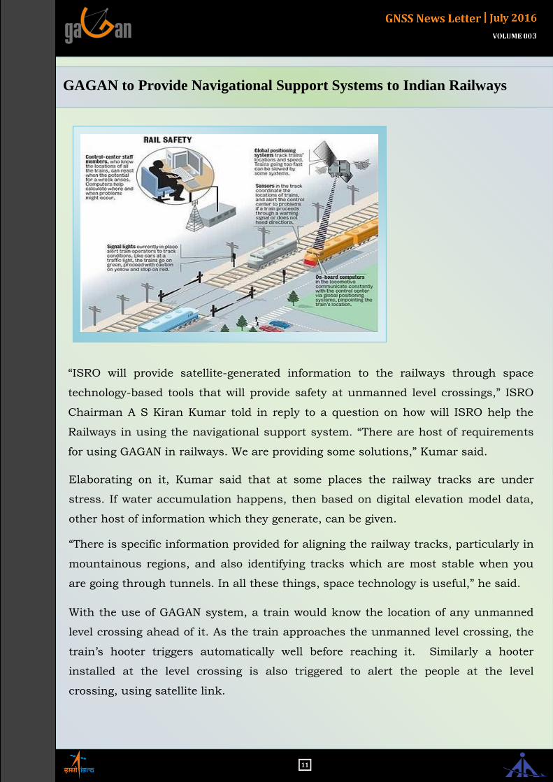
GAGAN to Provide Navigational Support Systems to Indian Railways
“ISRO will provide satellite-generated information to the railways through space
technology-based tools that will provide safety at unmanned level crossings,” ISRO
Chairman A S Kiran Kumar told in reply to a question on how will ISRO help the
Railways in using the navigational support system. “There are host of requirements
for using GAGAN in railways. We are providing some solutions,” Kumar said.
Elaborating on it, Kumar said that at some places the railway tracks are under
stress. If water accumulation happens, then based on digital elevation model data,
other host of information which they generate, can be given.
“There is specific information provided for aligning the railway tracks, particularly in
mountainous regions, and also identifying tracks which are most stable when you
are going through tunnels. In all these things, space technology is useful,” he said.
With the use of GAGAN system, a train would know the location of any unmanned
level crossing ahead of it. As the train approaches the unmanned level crossing, the
train’s hooter triggers automatically well before reaching it. Similarly a hooter
installed at the level crossing is also triggered to alert the people at the level
crossing, using satellite link.

12
GAGAN software updated...
GAGAN system design is primarily based on WAAS 8/9.2. Whenever any anomalies
are observed in the GAGAN system operational build, the same are mitigated by
modification of build with the support of System designer.
In the process of mitigation of certain system anomalies, on 16th May 2016, Raytheon
delivered an updated software build N3.027LN addressing one Hazard record #13,
namely DU count which was inherited from WAAS baseline 8/9.2. Also, the GEO
transponder offset values for GSAT 8 & GSAT 10 were updated as per current OCXO
values of GEO transponder. Control loop lock fault time for L5 is modified in the new
software build.
Upgraded software has been validated by AAI GAGAN Team during 30 days stability
test from 26th May 2016 to 24th June 2016. Evaluated the GAGAN performance on
daily basis and observed system performance satisfactory and addressed anomalies
are resolved.
All GAGAN subsystems were used during the Stability Test, including the INLUS-RFU
and GEO subsystems. The stability test included a series of switch over tests where
single subsystems were taken offline to demonstrate that the system correctly switches
over to a redundant component.
The stability test demonstrated that the software does not have any latent defects
which cause a sub-system to fail.
GAGAN Performance during 30 days Stability Test:
GAGAN
Change Management Document
approved by
DGCA
13
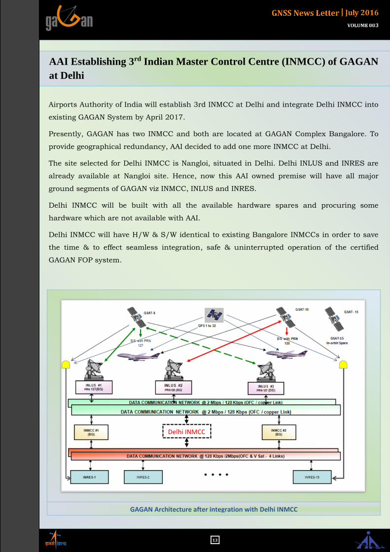
AAI Establishing 3rd Indian Master Control Centre (INMCC) of GAGAN
at Delhi
Airports Authority of India will establish 3rd INMCC at Delhi and integrate Delhi INMCC into
existing GAGAN System by April 2017.
Presently, GAGAN has two INMCC and both are located at GAGAN Complex Bangalore. To
provide geographical redundancy, AAI decided to add one more INMCC at Delhi.
The site selected for Delhi INMCC is Nangloi, situated in Delhi. Delhi INLUS and INRES are
already available at Nangloi site. Hence, now this AAI owned premise will have all major
ground segments of GAGAN viz INMCC, INLUS and INRES.
Delhi INMCC will be built with all the available hardware spares and procuring some
hardware which are not available with AAI.
Delhi INMCC will have H/W & S/W identical to existing Bangalore INMCCs in order to save
the time & to effect seamless integration, safe & uninterrupted operation of the certified
GAGAN FOP system.
Delhi INMCC
GAGAN Architecture after integration with Delhi INMCC
14
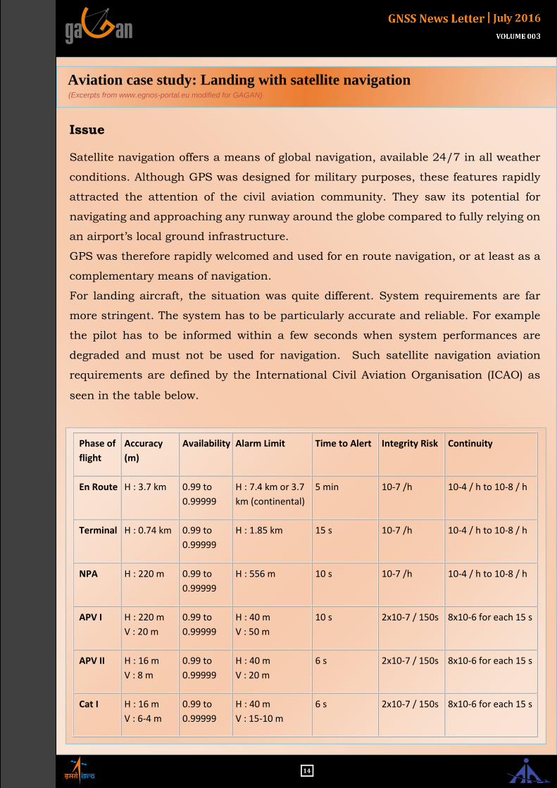
Phase of
flight
Accuracy
(m)
Availability Alarm Limit Time to Alert Integrity Risk Continuity
En Route H : 3.7 km 0.99 to
0.99999
H : 7.4 km or 3.7
km (continental)
5 min 10-7 /h 10-4 / h to 10-8 / h
Terminal H : 0.74 km 0.99 to
0.99999
H : 1.85 km 15 s 10-7 /h 10-4 / h to 10-8 / h
NPA H : 220 m 0.99 to
0.99999
H : 556 m 10 s 10-7 /h 10-4 / h to 10-8 / h
APV I H : 220 m
V : 20 m
0.99 to
0.99999
H : 40 m
V : 50 m
10 s 2x10⁻⁷ / 150s 8x10⁻⁶ for each 15 s
APV II H : 16 m
V : 8 m
0.99 to
0.99999
H : 40 m
V : 20 m
6 s 2x10⁻⁷ / 150s 8x10⁻⁶ for each 15 s
Cat I H : 16 m
V : 6-4 m
0.99 to
0.99999
H : 40 m
V : 15-10 m
6 s 2x10⁻⁷ / 150s 8x10⁻⁶ for each 15 s
Aviation case study: Landing with satellite navigation (Excerpts from www.egnos-portal.eu modified for GAGAN)
Issue
Satellite navigation offers a means of global navigation, available 24/7 in all weather
conditions. Although GPS was designed for military purposes, these features rapidly
attracted the attention of the civil aviation community. They saw its potential for
navigating and approaching any runway around the globe compared to fully relying on
an airport’s local ground infrastructure.
GPS was therefore rapidly welcomed and used for en route navigation, or at least as a
complementary means of navigation.
For landing aircraft, the situation was quite different. System requirements are far
more stringent. The system has to be particularly accurate and reliable. For example
the pilot has to be informed within a few seconds when system performances are
degraded and must not be used for navigation. Such satellite navigation aviation
requirements are defined by the International Civil Aviation Organisation (ICAO) as
seen in the table below.

15
Aviation case study: Landing with satellite navigation (Excerpts from www.egnos-portal.eu modified for GAGAN)
As the performance of GPS is not fixed, the
service cannot be guaranteed and there is no
feature to alert the user in case of a failure
that impacts the quality of the positioning
measurement and consequently the safety of
the user. This restricts the use of GPS as an
instrument to assist in aircraft landing
operations by imposing important safety
buffers to compensate for the lack of
precision.
The EGNOS solution
The EGNOS ground infrastructure
continuously monitors GPS performance for
all of the European Union and beyond and
provides the user with error corrections,
considerably increasing the navigation
accuracy of the signal. In addition, EGNOS
is able to detect GPS satellite faults, to assign
a confidence level to the data transmitted to
a user and to provide timely warnings when
GPS or its data should not be used for
navigation. Satellite navigation therefore
becomes within reach for Instrument Flight
Rules. To formalise it, EGNOS was certified
by civil aviation authorities and was officially
declared as appropriate for civil aviation
landing (APV) in 2011.
The first commercial operation using a final
approach with EGNOS was the Trislander
aircraft operated by Aurigny Air Services, a
regional airline operating connection flights
between the Channel Islands and the UK and
France, from December 2011 onwards.
The US WAAS system provides similar
capabilities for the North American region.
The impact is therefore sizeable. Aircraft will
be able to land in all locations where
adequate procedures are published, without
requiring a huge investment in airport
equipment and maintenance.
Approach operations will be less constrained
by ground equipment features; they will be
more precise, increasing airport runway
capacity and overall airport efficiency.
General aviation, business jet services and
regional airlines have rapidly identified the
benefits of such use of the
technology. Avionics equipment
manufacturers are already proposing
EGNOS-enabled equipment and the
retrofitting of GPS equipment with EGNOS
capability.
The commercial aviation sector is also
joining the club. For example Airbus is
equipping its A350 XWB with a satellite-
based augmentation system (SBAS) receiver,
providing their customers with the capability
of landing without navigation ground
infrastructure and providing a geometric
vertical guidance, free of temperature and
barometric setting errors.

16
We’re collecting testimonials about the benefits of GAGAN navigation from users. If you are a pilot,
passenger, airport manager, controller, dispatcher, airline employee, or involved in aviation in any capacity
- whether you fly fixed-wing or vertical flight aircraft - we want to hear from you! Please send your
experience, thoughts and contact information to S V Satish at [email protected]
For more technical information:
GENERAL MANAGER (CNS) Airports Authority of India,
GAGAN Complex, ITPL Road, Kundalahalli,
Bangalore - 560037,INDIA
Email : [email protected]
Tel: +91 80 28543788 / Fax: +91 80 28543788
OPERATIONS CENTRE, Bangalore Email : [email protected]
Tel: +91 80 28541455
EDITORIAL TEAM
MOHAN LAL MALVI
Deputy General Manager (CNS-GAGAN), AAI A K TIWARI Senior Manager (CNS-GAGAN), AAI
BHARAT PRAJAPATI
Manager (ATM), AAI A KARTIK Project Manager, ISRO