cruising european waters version 6
TRANSCRIPT

SOME OBSERVATIONS ON
CRUISING EUROPEAN WATERS
Version 6.1
June 2006
Walter R. Paul Disclaimer: This document was compiled from information supplied by members of the Cruising Club of America and from various publications and websites to which the reader is referred for more detailed and current information. While the Club has no reason to believe that any of the information is inaccurate, it has not confirmed the accuracy or completeness of the information and makes no representation with respect thereto. Furthermore, this document does not purport to supply all of the information someone should have before embarking on an offshore passage. Note: Reference to a commercial product or service does not imply any endorsement by the Cruising Club of America as to function or suitability for any purpose or environment.

Ver. 6.1 June 2006 2
FOREWORD Things are different in other countries as you would expect and is usually the reason for a cruising yacht going there. Europe is one of the great venues for cruising, ranging from the near Artic to the Mediterranean and days with twenty four hours of sun in the summer to days of almost no sun in the winter. Besides different navigational considerations, there are many other factors to be considered by a captain planning on a cruise in these waters. Certainly, yachts cruising northward, particularly above Bergen will want a way to heat the interior of the boat if for nothing else but to dry it out. They will also want to confirm that their insurance extends beyond Bergen. Yachts wintering over from England northward will find a dehumidifier a great help to cabin comfort. On the other hand, yachts cruising in the Mediterranean during the summer will be mostly focused on how to stay cool. We find we spend a lot of time at the dock or bulkhead rather than anchoring out. Although we like being on the hook, we experience far more European flavor and a chance to meet others when at the dock. One of the side effects of this is we now have a small inflatable and outboard as compared to the large inflatable and powerful outboard we felt was appropriate for the Caribbean. This paper addresses some personal observations and opinions about cruising in European and Mediterranean waters. A Few Administrative Notes: 1. All frequencies and SSB modes described are kHz and USB unless otherwise noted. 2. Although Ham radios and other equipment operate in single sideband mode, SSB throughout this paper unless otherwise stipulated, pertains to Marine Single Sideband Radios. 3. Schedules, frequencies, web sites and the like were current in the spring of 2005. Changes do occur and they should be verified before casting off. NOAA’s name change from Marine Prediction Center to Ocean Prediction Center in 2004 resulted in a revision to all the URLs for this important weather center. 4. Greenwich Mean Time (GMT), Coordinated Universal Time (UTC) and Zulu (Z) are used interchangeably throughout to remain consistent with the various agencies and sources. LT or L (Lima) signifies Local Time. 5. The International Telegraphic Union (ITU) is a UN body located at Geneva, Switzerland that regulates radio usage including frequency and channel allocations. The US along with most maritime countries is party to treaties supporting these regulations. They are promulgated in the US by the Federal Communications Commission (FCC) and administered by various agencies. The US Coast Guard has responsibility for maritime applications.

Ver. 6.1 June 2006 3
6. Hyperlinks, charts and significant changes are presented in color and all connected at the time of posting.
7. It has been suggested that an index be added. Actually, a facility in Adobe Acrobat is available for this. Simply click on “Edit” on the Tool Bar, then “Find” and type in the reference word. The program will do the rest. 8. Downloading this paper to a computer running on Windows XP requires Acrobat Reader Version 6.0 or higher. Acrobat Reader Ver. 5.0 was released prior to Windows XP and while the display will appear correct on the computer screen, printing it out will not. Acrobat Reader Version 7.0 or better (available free at this website) will do the job properly. 9. For printing setup, margins, top and bottom, left and right should be set as follows:
a. Top and bottom – 1.0” b. Left and right – 0.6” c. Header and footer – 0.5”
It is important to acknowledge and thank those who have commented and made suggestions since this paper was first posted. Along the way, Bill and Pam Kellett of the CCA contributed to first version. Peter Price of the Royal Cruising Club provided invaluable assistance revising some of the computer programming to enable Acrobat Reader to be correctly presented on European Computers. Clearly, this material is not all inclusive and is dated by its nature. It was current in April 2005. Suggestions on how to improve this paper along with updates, corrections, and comments are most welcomed; please do not hesitate to send an email. By all means, the latest version should always be consulted. Best wishes for fair winds and good sailing.
Walt Paul Chair
Offshore Communications and Electronics CCA
June 2006

Ver. 6.1 June 2006 4
CHANGES AND CORRECTIONS Major changes, additions and corrections in this version are highlighted in YELLOW where practical to assist in recognizing them. Where a new section or paragraph has been added, the title in the Table of Contents and the title (only) in the body of the paper are highlighted. Corrections and Addendum: Ver 3.04:
Added chart/guide sources Added charts on Meltemi winds
Added GPRS Added section on anchoring and mooring
Added section on the Mediterranean Added some weather sources on the internet Enlarged font size for tired eyes Expanded cruising charges Miscellaneous minor corrections Reorganized for continuity and flow
Updated Radio Monaco Ver 4.04: Corrections: Mistrals and Bora directions
Enabled European Symbols Lunch Time
Market Days Port Signals
Ver 5.1 Corrected Port Signals illustration (missing white lights) Added Voice Over IP (Voice Over Internet Protocol) phone calls Added Crew List and Yacht Information Sample form Changed version numbering system and labels Expanded section on Croatia Updated fuel prices Miscellaneous corrections and editing Ver 6.1
Added Switzerland to the Schengen Country List Added European Emergency Number "112" Gibraltar now subject to EU tax rules Noted different names for fuel Clarified Greek sailboat tax for foreigners Added visiting yacht tax at Sardinia

Ver. 6.1 June 2006 5
TABLE OF CONTENTS
1 Navigation
1.1 Buoyage ……………………………………………………………………….. 8 1.2 Buoy Identification ………………………………………………….……….. 8 1.3 Charts …………………………………………………………........................ 8 1.4 Nautical Almanacs ………………………………………………….……….. 9
1.5 Cruising Guides and Chart Sources ……………………………………... 10 1.6 European Datum …………………………………………………………….. 11 1.7 Harbor Traffic Control Signals …………………………………………… 12
2 Weather and Seas 2.1 Marine Weather Services …….…………………………………………… 14
2.2 Forecast Sea Areas ………………………………………………………… 14 2.3 Tidal Ranges ..………………………………………………….................... 14
2.4 Wind Speed ………………………………………………………………….. 15 2.4.1 Conversion Table: Beaufort, Meters per Second, Kilometers
Per Second and Knots …………………………………………… 16 2.5 Radio Monaco ………………………………………………………………... 16 2.6 Weather Services On The Internet ……………………………………….. 17
3 Administration and Formalities
3.1 Value Add Tax on Recreational Vessels .……………………………..… 18 3.2 Schengen Signature Countries ..………………………………………….. 20 3.3 Cruising Charges …………………………………………………………… 20
3.3.1 Sardinia ………………………………………………………… 20 3.3.2 Greece ……………………………………………………….... 21 3.3.3 Croatia ………...………………………………………………. 22 3.3.3.1 Entry Ports ………………………..…………………. 22 3.3.3.2 Cruising Charges ….……………………………… 23 3.3.4 Turkey …………………………………………………………. 24 3.5 Some Effects of Neighborhood Hostilities …………………………….. 25
3.6 Israel and the Israeli Navy …………………………………………………. 25
4 Dockage 4.1 Rusty Mooring Rings ……………………………………………………… 28
4.2 Canals and Locks …………………………………………………………… 29 4.3 Med Mooring ...………..……………………………………………………. 31

Ver. 6.1 June 2006 6
5 Utilities
5.1 Electricity ……..………………………………………………………………. 33 5.2 Propane …..………………………………………………………….............. 34
6 Communications 6.1 Telephone Protocol …...………………………………………………….… 35 6.2 Summer Time And Daylight Savings Time ……………………………... 35 6.3 Cell Phones ……………...…………………………………………………… 36 6.4 GPRS …………..……………………………………………………………... 36 6.5 Internet Phone Calls - Voice Over IP …….………………………………. 37 6.6 Anodes ……………………………………………………………………….. 37 7 Snippets from the Med
7.01 The Environment ………………………………………………………….. 38 7.02 Meltemi Winds …………………………………………..………………….. 38 7.03 Haze ……………………………………………...…………………………… 41 7.04 Dirt ……………………………………………………………..……………… 41
7.05 Wildlife …..……………………………………………………….................. 41 7.06 Local Weather ………………………………………………………….…..… 42 7.07 Morning Weather Broadcasts …………………………………................. 43 7.08 Tides ………………….……………………………………………………….. 44
7.09 Anchors …………………………………………………………..…………… 45 7.10 Cash .……………………………………………………………………….….. 46 7.11 Language and Signs …….………………………………………………….. 46 7.12 Fuel Prices ………………………………………..……………………….…. 47 7.13 Medical Prescription Availability ………………………………………… 47 7.14 Bug Season ………………………………………………………………….. 48 7.15 Lunch Time …………………………………………………………………… 48 7.16 Market Days ……………………………………………………………..…… 48 8 Wintering Over ………………………………………………………………………..… 49
9 Miscellaneous 9.01 Broadcast Radio ……………………………………..……………………. 50
9.01.1 FM Broadcast Reception ….…………………………………… 50 9.01.2 VOA and BBC …..……………………………………………….. 50 9.01.3 Satellite Radio .....…...………………………………………..…. 51 9.02 Calculators ………………..…………………………………..…………...... 52
9.03 Carts …..……………………………………………………..…….……….... 52 9.04 Dinghies .…………………………………………………..………………… 53
9.05 Filters ….………………………………………………..…………………… 53 9.06 Fishing Boats ……………………………………………………………..... 53
9.07 Frank Singleton Website ..………………………………………………… 54 9.08 Galley Measurements ……………………………………………………… 54

Ver. 6.1 June 2006 7
9.09 Medical Facilities In Croatia And Turkey ………………………………. 54 9.10 Oil …………………………………………………………………………….. 55 9.11 Outboard Motors …..…………………………………………………….…. 55 9.12 Paper Towels .………………………………………………………………. 55
9.13 Part Shipments from the US .………………………………………..…… 55 9.14 Ship's Papers ……………...………………………………………………… 56
9.15 Lavatory and Holding Tank Pump Out …………………………………. 56 9.16 Crew List And Yacht Information ……………………………………….. 57
10 Crew List And Yacht Information Form …………………………………………….. 58

Ver. 6.1 June 2006 8
1 NAVIGATION 1.1 Buoyage In the US, Canada and Bermuda, buoy orientation is International Association of Lighthouse Authorities (IALA) System B, the familiar “red-right-return”. However, most other countries use IALA System A, green-right-return. Red and green marks, while in the minority, are often deployed in Ireland and in England, particularly on the southern coasts. On the other hand, Cardinal Marks seldom seen in the US are prevalent in much of Europe and the Mediterranean. Captains and crew should familiarize themselves with their shapes and what they mean; north and south with a triangular (one or two) shape pointing up or down. Remembering the difference between east and west is simplified by the jingle "wasp waisted western women" where west is signified by two triangular shapes pointing at each other. 1.2 Buoy Identification Many European countries, particularly Ireland and England list buoys by name rather than number. The prudent navigator will have a list of these buoy names in sequence and available during the approach since without numbering, there is no apparent sequence. Failure to list the buoys can lead to exciting moments, particularly when you can’t see the bow through the fog. From personal experience, this is not good. 1.3 Charts The North American captain may want to sail with NOAA or DMA charts when cruising in foreign waters, but unfortunately, they are not always as up to date as might be expected. British Admiralty (BA) charts are often more up to date than DMA, printed on better paper and also more expensive. Local charts are very good and well tailored to the cruising yacht’s needs. Norwegian, Swedish, German and French charts oriented to yachts are available in kits with plastic jackets. Blowups of harbors and the like are included. They are superior in many respects and some are near works of art. There most likely are other kits like these we haven’t encountered.
Aside from chart kits, Imray Charts for Yachtsmen with coverage for Europe, the Mediterranean (and even the Caribbean) are difficult to beat although not as detailed as BA large scale charts. They are waterproof and have an extensive listing of chart symbols, cardinal marks and the like on the backside of each chart where you need it. Surprisingly, Imray does not have large scale charts for Italy but many for Greece and chart sets for Croatia.

Ver. 6.1 June 2006 9
Some UK organizations offer these charts along with pilot books and almanacs at a discount which can quickly become noteworthy. Computer software programs such as C-Map are also available and amazingly detailed. Caution should be exercised using older version electronic charts in areas where new bridges always seem to be under construction such as in Norway, but that aside, they are a great step forward. These, along with the many cruising guides available are more than adequate for areas such as the Iberian Atlantic coast. The guides are a great help in knowing what to expect and sometimes what to do once you get there. Total reliance on electronic charts can be kept to a minimum by acquiring small scale (planning) charts covering large areas and using them in conjunction with Cruising Guides. Computers do crash, shut down due to viruses, are intolerant of spilled red wine and so on. Nevertheless, the cost for the great number of charts appropriate for cruising European Waters can be substantial and the quantity can present a storage problem. 1.4 Nautical Almanacs A nautical almanac is an important reference in many cruising areas. For European Atlantic waters, a current copy of Macmillan - Reeds Nautical Almanac is near essential. These telephone book size compendiums of information cover Ireland, the UK, the Channel Isles, The Atlantic coasts of Denmark, France and Germany, the Netherlands, Belgium, and to a small degree, Spain and Portugal. The information includes coastal navigation, weather, communications, tides, currents, marinas, harbor charts with details, phone numbers and on and on. Unfortunately, the Baltic, Norway and Sweden are not included nor is the Mediterranean. Two prominent almanacs published in the UK were affectionately known as “Reeds” and “Macmillans”. Reeds and Macmillans consolidated a few years ago and the name is now Macmillan - Reeds Nautical Almanac although in practice, called by either or both names. The price in the UK is about US$ 50 at the current conversion rate. Rather than tote one of these across the Atlantic, a copy can be obtained through the Kinsale YC in Ireland or one of the nautical bookstores at Falmouth, England, etc. There is a similar French almanac called “Votre Livre De Bord” covering the North Sea south to the Spanish coast. While written in French, some of the harbor descriptions are also in English. Other almanacs are available, but these are the two most often seen. These books are published annually and while navigational obstructions don’t usually change, facilities, marinas, formalities and the like do. Macmillan - Reeds also include schedules and frequencies of voice weather broadcasts in English available on SSB radio which change from time to time. Tide predictions and current charts by the hour are updated each year as well. A Mediterranean Almanac published by Imray is also available. While there aren’t many current concerns in the Mediterranean aside from a few locations such as the Straits of Gibraltar and

Ver. 6.1 June 2006 10
Messina, the almanac is a great source of timely information for the cruiser. Unfortunately, it lists mostly marinas that charge rather than harbors of refuge and the like. A cruising guide it is not. Similarly, "The Straits Sailing Handbook" published annually contains hourly forecasts of currents in the Straits, information on the three marinas (soon to be two because Shepard's property is scheduled to become a landfill and condominiums) and other useful information. As with the Mediterranean Almanac, it includes information, sources of supply on the peninsula and harbor information on the surrounding area. It is invaluable and should be acquired before departing US shores. 1.5 Cruising Guides and Chart Sources Many Cruising guides are available for Europe, the Mediterranean and the canal systems. However, unless you or the crew can read a foreign language, it is best to obtain these from an English publisher ahead of time. The Irish Cruising Club, the Royal Cruising Club (RCC Pilotage Foundation), the Clyde Cruising Club, the Royal Yachting Association, the Cruising Association (at Limehouse, London), Yachting Monthly and many others publish cruising guides that are informative and add greatly to the enjoyment of visiting various ports and countries. In some areas such as the coast of Portugal, a cruising guide accompanied with a small scale passage chart, while not the best, can usually suffice. Obtaining cruising guides written in English can be difficult particularly in countries with an alternative guide written in the local language. Yachts entering the Mediterranean are advised that the last real opportunity to obtain guides written in English will be at Gibraltar and even then, the source will be England. Some sources for cruising guides and charts are: In the US:
Armchair Sailor www.bluewaterweb.com Landfall Navigation www.landfallnavigation.com New York Nautical www.newyorknautical.com
In England:
Kelvin Hughes www.Bookharbour.com Marine Instruments - Falmouth www.marineinstruments.co.uk
In Denmark:
Iver C. Weilbach & Co www.weilbach.dk

Ver. 6.1 June 2006 11
In The Netherlands: Datema Amsterdam B. V. dwww.datema.nl In Gibraltar
Gibraltar Chart Agency www.gibchartagency.com Not all cruising in Europe is on the high seas. The canal systems in France and Belgium are wonderful and enjoyed by many. Things can become crowded during school vacation although the crowds can be avoided with a little planning. Yachts considering cruising in the canal systems must meet some physical requirements. The maximum draft is 1.5 meters (4.9 feet) and overhead is about 4 meters (13.1 feet). Many locks are limited to 5 meters (16.4 feet) beam although canals used by commercial traffic are certainly wider. Cruising speed is generally limited to 6 knots and pleasure vessels are often not allowed to operate after dark. These and other regulations are listed in publications available from the VNF (France) when obtaining a permit to use the canals. Several canal permit plans are available and are not necessarily expensive. Cruising in the canals without a compass is not a problem, but without a set of charts would be a mistake. The French Navicarte series of charts and guides written in French, English and German is excellent. #21 covers all of France while #23 covers Belgium. These charts, chart-lets and booklets can be found in many marinas although the selection may be limited. One comprehensive source for these and other charts including Imray is in Paris:
Librairie Maritime Outremer 17, rue Jacob 75000, Paris www.librairie-outremer.com
Tel: 33 (0) 1 46 33 47 48 Fax: 33 (0)1 43 29 96 77
1.6 European Datum Many European charts use European50 as a datum instead of WGS 84. Older British Admiralty charts may not indicate the datum but are roughly considered to be the same or close to European50. With the many unique and sometimes local datum used on European charts, the prudent navigator will ensure the GPS datum is reconciled to the chart in use, logged and updated. Caution: Charts for adjoining areas may not be to the same datum. The significance of using the wrong datum can be more than trivial. A comparison between WGS 84 and European50 taken at the dock at Lefkas, Greece had our European50 position about 365
Ver. 6.1 June 2006 12
feet north and 198 feet east of our WGS 84 position. This is a difference of about 415 feet between the two chart datum without moving the boat! 1.7 Harbor Traffic Control Signals Major harbors and many small harbors employ a light system for vessel traffic control. Macmillan-Reeds Nautical Almanac is a good source for a description of the light systems used at various harbors which should be but are not all the same. Light signals are also used in other places such as lock entries, the storm gates on the Thames and so on. Harbor entrance including England is always to starboard. Where single lights are used, red always means vessels shall not proceed and green means vessels may proceed. White or yellow lights may also be displayed with special meaning delineated in the nautical almanacs. International Port Traffic Signals are used in larger harbors, particularly on the west coast of Continental Europe. These signals are a set of three lights in a vertical line and sometimes a fourth to the left of the uppermost. With the International System, vertical lights are red or green and some white. The only lights that flash are the red which means an emergency situation exists. The only light to the left of the uppermost light is yellow. This yellow light means that vessels able to navigate outside the main channel need not comply. Some harbors may have other lights to the right. Once again, consult with the nautical almanac for their meaning. Sometimes, particularly with a late night arrival, a call on VHF 16 helps to speed things up. Note however that unless a vessel’s arrival is expected, the radio operator may not be at his station, or may not speak your language and maybe is going to get someone who can. Or maybe not. Be patient …. for a little while at least. A chart of the International Port Traffic signals and their meaning follows on the next page to present all of it together:

Ver. 6.1 June 2006 13
Harbor Traffic Control Lights:
White or yellow lights displayed to the right of the main lights have local meaning and is published in local port notices.

Ver. 6.1 June 2006 14
2 WEATHER AND SEAS 2.1 Marine Weather Services The Met Office in England and Meteo-France are two of many authorities issuing weather notices and bulletins. Unfortunately, most of their services are for a fee necessitating a European account or other arrangement for payment and accordingly, must be set up prior to the need. A European address is usually required to open a European bank account. This is of little help to the offshore Non-European yacht closing on Europe in need of a weather forecast. With this bureaucratic obstacle in mind, WX services discussed here and in the Offshore Communications Memorandum are all without charge. 2.2 Forecast Sea Areas The western coast of Europe, the Baltic and the Mediterranean are divided into regional areas with names to identify them. These names are used in Navtex weather forecasts and voice weather broadcasts. The French use English names for English waters, but have their own set of identifying names for areas of immediate concern to them such as the Bay of Biscay which they subdivided. In these locations, the names differ from the English. In the same manner, the Spanish have their own set of names for some areas covered by the French in the Mediterranean. Adding to this, sea area names for common Greek and Turkish waters are not always the same. Accordingly, the navigator must ascertain the source of the Navtex broadcast. Knowing these names is essential to understanding voice and Navtex WX forecasts. This continues with other countries throughout Europe including the Baltic. Charts of these are illustrated in Macmillan - Reeds Nautical Almanac. Pictures of the UK, French and Spanish waters and others are included in the paper “Sea Area Designations Used for Offshore Weather Forecast” at this website. 2.3 Tidal Ranges In and around Ireland, England and the North West coast of France, tidal ranges can be dramatic, particularly at springs where 25 feet or more can occur. This means that tidal current can be substantial with standing waves at some locations such as the Chenal Du Four near Ouessant (Ushant) or the Raz De Seine. Attempting to sail against these currents can be an exercise in patience. Attempting to sail against these currents when the wind is against the current can give new meaning to big waves and is flat out dangerous. It follows that these great tides are accompanied by strong tidal currents. Comparing the GPS SOG (Speed Over Ground) with the knot meter instantly determines the current and if you

Ver. 6.1 June 2006 15
are going with it or against it. This is a serious matter for many reasons besides just getting to your destination. For example, the hull speed of many sailing yachts is not great enough to anchor in places such as the Chenal Du Four (one of the worst) if you could find a place shallow enough to anchor and get the anchor to hold. The prudent captain will time arrival at these locations for near slack. Aside from commercial harbors, many bays in England particularly on the east coast dry out at low tide. It is possible to enter some at high tide and anchor in a low tide pool, but this often requires local knowledge. These great tides also mean that tying onto a bulkhead without long lines parallel to and down the bulkhead can produce an awkward yacht attitude, require a gimbaled stove and will inspire considerable comment from the First Mate and the many onlookers who suddenly materialize. With these berthing difficulties in mind, many harbors are gated and open only at or near high tide enabling near constant flotation levels within. St. Peter Port at Guernsey, Channel Islands has a sill that achieves a minimum flotation level but also limits crossing the sill until at least mid tide and perhaps higher. Further, the harbor is silting and there is not much room for yachts with drafts of 2 meters or more. Harbors with gates or locks usually have a floating dock close by the entrance called a pontoon to tie onto until the gate opens. Note: There are fees for anchoring in some English waters, particularly on the southern coast as well as at some locations in the Mediterranean. 2.4 Wind Speed Beaufort wind scales are usually used to define wind velocity throughout much of the world and particularly in Europe.
Mean Wave Beaufort Velocity Height Number Knots Description Deep Sea Condition Feet
0 < 1 Calm Mirror Flat --- 1 1 -3 Light Ripples 0.25 2 4 - 6 Light Breeze Small Glassy Wavelets .5 – 1 3 7 - 10 Gentle Breeze Large Wavelets, Scattered White Caps 2 – 3 4 11 - 16 Mod. Breeze Small Waves, Frequent White Caps 3.5 – 5 5 17 - 21 Fresh Breeze Long Waves Form, Many White Caps 6 - 8.5 6 22 - 27 Strong Breeze Large Waves, White Foam Crests 9.5 – 13 7 28 - 33 Near Gale Sea Heaps, Foam Streaks Start 13.5 – 19 8 34 - 40 Gale Moderately High Waves, Foam In Streaks 18 – 25 9 41 - 47 Strong Gale High Waves, Foam Streaks, Crests Topple 23 – 32
10 48 - 55 Storm Very High Waves, Overhanging Crests, Sea White 29 – 41 11 56 - 63 Violent Storm Long Foam Patches, Poor Visibility 37 – 52 12 63 + Hurricane Sea White With Foam & Spray, Bad Visibility 45 +
Ver. 6.1 June 2006 16
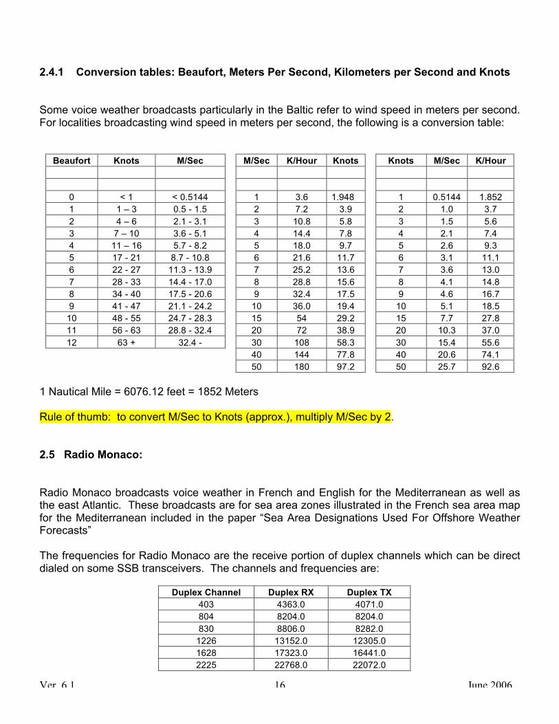
2.4.1 Conversion tables: Beaufort, Meters Per Second, Kilometers per Second and Knots Some voice weather broadcasts particularly in the Baltic refer to wind speed in meters per second. For localities broadcasting wind speed in meters per second, the following is a conversion table:
Beaufort Knots M/Sec M/Sec K/Hour Knots Knots M/Sec K/Hour 0 < 1 < 0.5144 1 3.6 1.948 1 0.5144 1.852 1 1 – 3 0.5 - 1.5 2 7.2 3.9 2 1.0 3.7 2 4 – 6 2.1 - 3.1 3 10.8 5.8 3 1.5 5.6 3 7 – 10 3.6 - 5.1 4 14.4 7.8 4 2.1 7.4 4 11 – 16 5.7 - 8.2 5 18.0 9.7 5 2.6 9.3 5 17 - 21 8.7 - 10.8 6 21.6 11.7 6 3.1 11.1 6 22 - 27 11.3 - 13.9 7 25.2 13.6 7 3.6 13.0 7 28 - 33 14.4 - 17.0 8 28.8 15.6 8 4.1 14.8 8 34 - 40 17.5 - 20.6 9 32.4 17.5 9 4.6 16.7 9 41 - 47 21.1 - 24.2 10 36.0 19.4 10 5.1 18.5
10 48 - 55 24.7 - 28.3 15 54 29.2 15 7.7 27.8 11 56 - 63 28.8 - 32.4 20 72 38.9 20 10.3 37.0 12 63 + 32.4 - 30 108 58.3 30 15.4 55.6
40 144 77.8 40 20.6 74.1 50 180 97.2 50 25.7 92.6
1 Nautical Mile = 6076.12 feet = 1852 Meters Rule of thumb: to convert M/Sec to Knots (approx.), multiply M/Sec by 2. 2.5 Radio Monaco: Radio Monaco broadcasts voice weather in French and English for the Mediterranean as well as the east Atlantic. These broadcasts are for sea area zones illustrated in the French sea area map for the Mediterranean included in the paper “Sea Area Designations Used For Offshore Weather Forecasts” The frequencies for Radio Monaco are the receive portion of duplex channels which can be direct dialed on some SSB transceivers. The channels and frequencies are:
Duplex Channel Duplex RX Duplex TX 403 4363.0 4071.0 804 8204.0 8204.0 830 8806.0 8282.0
1226 13152.0 12305.0 1628 17323.0 16441.0 2225 22768.0 22072.0

Ver. 6.1 June 2006 17
The schedule and ITU channels for Radio Monaco are:
Time North Med North West Med East Atlantic 0715 Z 804 & 830 403
0903 LT 403
0930 Z 804
830
1226
1628
2225
1403 LT 403
1830 Z 804 & 830
1915 LT 403 Note: The broadcast time schedule varies between LT (Local Time) and Z (UTC or GMT). 2.6 Weather Services On The Internet: Anywhere: www.oceanweather.com www.windguru.com Europe: German: www.wetterzentrale.de Norway http://met.no/english/maritime/index.html UK: www.weatheronline.co.uk/sail.html Mediterranean: See Section 7, Snippets From The Med

Ver. 6.1 June 2006 18
3 ADMINISTRATION AND FORMALITIES 3.1 Value Add Tax on Recreational Vessels The European Union or EU (formerly the EC) has promulgated rules on a wide variety of items in an attempt to achieve some standardization and a common approach to things throughout member countries. For example, any traveler in Europe knows that while electrical AC power is all the same (230 VAC, 50 Hz), the plugs used to connect electrical appliances vary from country to country and a variety of adapters are required. Electrical outlets at marinas (on the docks) however have been standardized. AC dock connections from Ireland to Turkey and Egypt are all the same, varying only by the amp service required with greater amperage requiring larger male plugs. In the same way, the EU has rules on all sorts of things including the importation of recreational vessels into any EU country. The rules are extensive and can be found in the Official Journal of the European Communities. Those related to yachts are around Chapter 5, Articles 560 & 561. Naturally, this sort of thing is written to cover all "loop holes” and can take a lot of time to read. Within Europe, the word “yacht” has a different connotation than in the United States. Generally speaking, the word “yacht” refers to a sailboat with living accommodations but will be used here to include both sail and power boats. The rules regarding the importation of yachts changed on July 1, 2001. Prior to that time, a non-EU yacht could be brought into the EU duty free for six months. Vessels staying longer were required to pay Value Add Tax or VAT on the current value of the boat. The purpose of this was to preclude EU residents from avoiding tax on their boat under the guise of a foreign flag. While VAT rates vary from country to country, they are generally about 20% and paying that much on the value of a boat is a serious matter. Once VAT has been paid in any EU country, it is paid for all of them. Unfortunately, having paid sales tax in the US on a yacht does not satisfy the VAT obligation for the same yacht. Failure to pay VAT can incur steep penalties. They can be as high as 80% of the VAT due on the present value of the yacht bringing the total to about 36%. There were some exceptions to the old six month rule. The clock stopped if a yacht was out of commission, undergoing extensive repairs, on the hard for the winter, tied up in a marina with the wheel detached (disabled) and so on. As it was, VAT regulations encouraged a visiting yacht to depart Europe in the winter months when weather conditions are bad. Although rumored, the age of an older boat (built before 1985) did not constitute an exception. The new rule effective July 1, 2002 allows a yacht to stay up to eighteen months. Generally, the clock runs whether the yacht is disabled or not.

Ver. 6.1 June 2006 19
These rules prompt a visiting yacht to leave the EU periodically so that reentry can restart the clock. Going offshore such as crossing Biscay Bay from Brest to Cabo Finisterre is not considered having departed the EU even though the rhumb gets about three hundred miles out. What is necessary is to get stamped into a non-EU country such as Norway, Morocco, Turkey, etc. The English Commonwealth countries such as The Isle Of Man, the Channel Islands and Gibraltar are officially not members of the EU although VAT is paid on some items brought in. Whether a visit to one of these countries qualifies for having departed the EU was fuzzy when discussed with four different customs officers at Gibraltar in August 2003. Note: The International Herald Tribune reported on 22 Jul 05 that the European Union’s top court ruled Gibraltar was subject to EU rules about member states sharing information on taxation. Britain had argued (unsuccessfully) that Gibraltar should be excluded from rules “which facilitated communications between member states on VAT and exercise duties under an agreement the exempts the territory from EU laws on turnover taxes.” The newspaper concluded that “Gibraltar is subject to EU Tax”. It isn’t clear yet what this means about VAT on foreign flagged yachts and their presence in the EU, but it certainly would make sense to keep an eye on this. Yachts visiting Gibraltar for the purpose of departing the EU might want to consider S’Mir, Morocco, twenty five miles to the south as an overnight alternative. While S’Mir is perfectly safe (the king keeps two or three of his boats there and they are well guarded), one night there is more than enough for many cruisers. Malta, formerly a non-EU haven, entered the EU in April 2004. Southern Cyprus' rejection of the "join EU referendum" eliminates North Cyprus from the EU for the time being while Southern Cyprus is now operating according to a phase-in plan as it enters the EU. The net effect to cruisers is non-EU yachts can use Girne (Kyrenia), a delightful port in North Cyprus with relatively inexpensive fuel as a haven from the EU while Larnaca, Limassol and Paphos in Southern Cyprus are eliminated. One has to be born in Cyprus to understand the politics. The length of time a visiting yacht must be out of the EU to restart the clock is also fuzzy. Eighteen months certainly qualifies, but at the other extreme, whether 24 hours qualifies is not clear. Naturally, most non-EU yachts consider 24 hours adequate. Normally, the qualifying question is, “When did the yacht enter the EU”? Enforcement of these rules for visiting yachts varies from country to country. England welcomes visiting yachts. If appropriate, they will issue a letter (Form C104A) stating the yacht qualifies as a temporary importation of a residence and all VAT obligations have been satisfied. The Baltic countries, the Spanish, the Italian authorities along with the French in the Mediterranean seem to be indifferent to these regulations and have even waved us off when we attempted to check in. The relaxed Mediterranean approach to these rules by most countries doesn’t always apply in Greece. Greek authorities are notorious for local interpretation of the rules and impound yachts and level fines upon the basis of whether the toast was burnt that morning. On the other hand, it is understood that fines collected by French Customs Agents on the Atlantic Coast go directly to their pension fund which may explain why they are so zealous although polite.

Ver. 6.1 June 2006 20
The authorities in Portugal can be every bit as aggressive if not more so and like the Greeks, typically not polite. 3.2 Schengen Signature Countries Seven European Union countries met at Schengen, Luxembourg in March 1995 to enter a treaty ending internal border checkpoints and controls. Since then, additional countries joined the Treaty bringing the total to 16 countries.
The Schengen countries are: Austria, Belgium, Denmark, Finland, France, Germany, Iceland, Italy, Greece, Luxembourg, Netherlands, Norway, Portugal, Spain and Sweden. Switzerland approved joining by referendum in July 2005. Except for Iceland, Norway and now Switzerland, these countries are all European Union members. It is notable that Ireland and the UK are not Schengen member countries.
Free movement for nationals of non-Schengen countries is limited to periods not exceeding three months in any six month period without specific authorization.
Turkey has a similar regulation, but the time limit is 90 days rather three months. This seemingly minor distinction of 2 days has tripped up more than one visitor with expensive consequences; aside from any three months in sequence that include February, three months is always 92 days.
While many countries may ignore this rule for visiting yachts, there are exceptions considering the number of individuals in the Customs/Immigration/Police/Harbor Master organizations. The only instance we have heard occurred in 2002 at a Greek island which resulted in a 200 € (euro) fine.
Note: This is separate from and not related to VAT.
For more information, see the Schengen website at: www.eurovisa.info 3.3 Cruising Charges Some countries particularly in the Mediterranean have cruising fees for non EU yachts. In addition, transit fees are applied to all yachts in some of these countries regardless of the flag of the craft. In particular are Greece, Croatia and Turkey. 3.3.1 Sardinia On 16 June 2006, the Sardinia regional government introduced a tax on resident yachts, second homes and private aircraft. The taxes affect any visiting yacht of 14 m (45.9 ft) LOA and over visiting the island between June 1st and September 30th.

Ver. 6.1 June 2006 21
That this tax is in violation of many rules and international agreements about the use of navigable waters should not be an issue but until it is challenged and overthrown, that is the scene now at Sardinia. Let the cruiser beware. The following is the new tax rate table for Sardinia: 3.3.2 Greece Greece has two cruising fee rates called “Traffic Dues” based upon LOA in addition to Transit Log charges. The first is for up to a month and the second for up to three months at a slight discount.
Up to one month: 5.87€ per meter LOA
Up to three months: 14.67€ per meter LOA For example, a 12 meters yacht (39 1/4’) would pay 70.44 € for up to one month and 176.04 € for up to three months. Three months and a day would bring the total to 246.48 € (70.44 + 176.04). In late 2003, the then applicable law was revised to modify the “Traffic Dues” (L. 3182/2003). This revision excused EU flag crafts visiting Greece from paying these fees. However, EU yachts are still obliged to obtain a Transit Log at a cost of 30 € (US$ 39). Most EU yachts do not comply. Unfortunately, the Transit Log at 30 € is in addition to the Traffic Dues applied to non-EU yachts. Depending upon where the first port of call is, a broker may be needed to facilitate the incredible bureaucracy involved and distance between the various offices. In 2004, a broker at Patria, Greece charged 60 € (US$ 78) for this service and was worth it. Unless money is not a problem, Patria should be avoided as a first port of call. For more conflicting information (not updated) from the Greek Ministry of Tourism, see:
www.gnto.gr/pages.php?pageID=163&langID=2
LOA - M LOA - FT TAX - €
14 45.9 1,000 16 52.5 2,000 20 65.6 3,000 24 78.7 5,000 30 98.4 10,000
>60 196.8 15,000

Ver. 6.1 June 2006 22
From time to time, there have been misunderstandings raised by guidelines concerning the payment of sailboat taxes. The Greek Financial Ministry promulgated a new law (N. 3427/2005, article 35) effective January 1, 2006 for clarification. This new law expressly clarifies that foreigners with a permanent or temporary mooring in Greece are excluded from any income tax due to the possession of their boat. Stay tuned. 3.3.3 Croatia A Navigation Permit issued by the Harbor Master at the nearest port open to international travel is required. Yachts of international registry can stay and sail along the Croatian coast only if they are registered as yachts in their own country, have the customary maritime documents, are outfitted according to the regulations of their own country and the crew have valid documents showing their qualifications. 3.3.3.1 Entry Ports: Some of the locations given below may not be correct because there are some ports with a common name and the location of entry ports is not specified by the Ministry of Tourism. These locations wire derived using a computer plotting program and are for harbor entrances as appropriate. They are correct to the best of my knowledge but should not be relied upon as authoritative or official.
Year Round Seasonal: 1 Apr - 31 Oct La - N Lo - E La - N Lo - E
Deg Min Deg Min Deg Min Deg Min
Dubrovnic 42 40.1 18 4.7 Ubli 42 44.9 16 49.3 Vela Luca 42 57.7 16 42.6 Korcula 42 57.8 17 8 Metkovic 43 2.4 17 25.2 Up Neretva River Ploce 43 2.4 17 25.2 Lastova 42 46.3 16 53.7 Viska 43 3.7 16 11.4 Hvar 43 10.1 16 26.2 Maslinica 43 23.9 16 12.2 Split 43 30.1 16 26 Primosten 43 35.1 15 55.8 Ravni Zakan 43 43.5 15 26.2 Sibenik 43 43.9 15 53.7 Sali 43 56.3 15 10.2 Soline One of several Zadar 44 7.2 15 13.4 Mali Losinj 44 32.2 14 27.7

Ver. 6.1 June 2006 23
Pula 44 52.6 13 50.5 Rasa 44 56.9 14 3.6 Senj 44 59.5 14 53.9 Rovinj 45 4.6 13 37.9 Porec 45 13.7 13 35.3 Novigrad 45 19.1 13 33.3 Rijeka 45 19.8 14 25.1 ACI Marina Umag 45 26.3 13 30.7 Umag 45 26.3 13 31.2
Charges for cruising in Croatia are listed below. The charge covers 365 days, is good for multiple entries and reportedly “well worth it”. We agree. Croatia Cruising Charges at $1 = 6 HR (Kunas) – 2005)
METERS KUNA US $ METERS KUNA US $
< 7 525 93 11 - 12 1050 185 7 - 8 630 111 12 - 15 1225 216 8 - 9 735 130 15 - 20 1400 247
9 - 10 840 148 20 - 30 1575 278 10 - 11 945 167 > 30 1750 308
In addition to these charges, there is a Lighthouse fee of US$ 4.90/meter and an Administration Tax of 40 Kunas ($6.67) per person. "Information For Boaters" is a comprehensive paper for foreign flagged yachts cruising in Croatia. It is a paper presented by the Ministry Of Tourism and available at the following website:
www.croatia.hr/misc/brosure.aspx?menuid=m8_i1
Note the underline dash between "8" and "I" (m8_i1). Once at that website, scroll down and click on "Information For Boaters". An excellent cruising guide for Croatia, Slovenia and Montenegro is titled "777 harbours and anchorages" by Karl-H. Bestandig.
www.magnamare.com The English edition by Anna & Rod Bailey with 750 maps and 46 charts is available from an Italian chart firm and Kelvin Hughes for 20 £. Use the search function and enter 777 to find it. www.bookharbour.com

Ver. 6.1 June 2006 24
Check-in day for charter boats is usually Saturday and many boats return to home base by Friday night. As with any country with a large number of charter boats, the trick is to be close to or at the harbor they depart from during the week while they are out and, out where they might go on the weekends when they are all returning for check-in/out. That is if you like peace and quiet, are not interested in someone else’s all night parties and don’t want someone anchoring intrusively close to you. 3.3.4 Turkey Turkey requires a transit log and all non-citizens must leave the country once every ninety days (again, not three months). Most cruisers take a day ferry over to a nearby Greek Island to get their passports stamped and shop in the convenient Duty Free Shops which are well stocked and conveniently located there for that reason. They then return to Turkey on the same day. It is difficult to understand why a government would institute a rule that encourages visitors to leave the country to spend their money elsewhere, but that is the net effect of the rule. The Transit Log, good for one year, includes transit fees and separately, berthing duties based upon Gross Tonnage. In 2004 for our boat at 23 GRT, the charges in Turkish Lira (TL) converted to Euros and US dollars (at US$ 1.20 = 1 €) were: TL € US$ @ 1.30 Transit log 45,806,340 30.00 39.00 Berthing Duties (up to 49 GRT) 3,000,000 1.96 2.55 Total 48,806,340 31.96 41.55 Note that the Euro in April 2005 had been holding at about US$ 1.30 = 1 € but has recently (2006) weakened to about $1.27 = 1 €. Many of the large Turkish marinas have an Immigration officer stationed on the premises who can provide visas. Contrary to the Turkish website for the Consulate at New York, charges for visas are now US$ 20 per person. They are good for 90 days (again, not three months) and can be obtained at the Istanbul Airport or marinas with an agent at the time the yacht is checked in. For more information, go to:
www.turkishembassy.org/traveltourism/tips.htm

Ver. 6.1 June 2006 25
3.5 Some Effects of Neighborhood Hostilities With the inability of many eastern Mediterranean countries to get along with each other, some minor difficulties for the cruiser can result: 1. Yachts visiting Northern Cyprus cannot go directly to Southern Cyprus for their next port of call. The other way around, calling in Southern Cyprus first and then proceeding to Northern Cyprus is OK. 2. Depending upon where a yacht lies, correctly specifying where the next port of call is may incur a bureaucratic hassle if the next country is not friendly with the present. As a reciprocal to the previous point, a yacht passage from South Cyprus to North Cyprus is frowned upon by the South Cyprus authorities in the same way as from Lebanon to Israel. The authorities may only too well know where you are going, but they don't want you to declare it. 3. Neighboring countries to Israel will not allow passage of people holding passports that have been stamped by Israel. The Israelis know this and willingly issue a stamped paper for use as a supplement to the passport if and when requested. 4. Passports are collected and retained in Syria, Lebanon and North and South Cyprus by the authorities upon entry. Shore passes are issued as part of their formalities. Upon departure, the shore passes are turned in and the passports handed back. This means that a yacht and crew must return to the port of entry before proceeding onto the next port where the formalities are repeated. This is time consuming in the least but it ensures that all local charges have been paid. It would be easy to pass judgment on these seemingly high school shenanigans, but that's the way it is. If you want to go there, you should be prepared for these and other obstacles keeping in mind that the people administrating them are only doing their job. More follows. 3.6 Israel and the Israeli Navy Most countries in Europe consider territorial waters extend out twelve miles from their coast unless another country shares that body from the other side such as the Kattegat between Denmark and Sweden. In these instances, some arrangement is usually negotiated defining who owns what. Where two countries have an abutting border terminating at the sea, the territorial waters extending from the land are usually drawn perpendicular to the coast at that point. The situation with Israel is different. Israel considers their territorial waters to extend out 25 nautical miles. We understand this is not only perpendicular to their land but rather simply the radial distance from their land borders with Lebanon and Egypt. This can be interpreted as along the shoreline as well, createing an overlap on each end of their coast with their neighbors. Our impression was that neither Lebanon nor Egypt seemed to be policing these areas, but the Israeli Navy was very active and out in force during July 2004.
Ver. 6.1 June 2006 26
We had joined a cruising rally visiting World Heritage sites in the Eastern Mediterranean coast countries during the summer of 2004 called the EMYR (Eastern Mediterranean Yacht Rally). The itinerary included stops in Israel because of the many archaeological and religious sites there. As we approached Israel, we were required to stay 15 miles offshore at the border and no less than six mile offshore thereafter. There are many prohibited areas along the coast. All yachts approaching Israel are required to contact the Israeli Navy on VHF 16. Unfortunately, the Navy jams VHF 16 for some unknown reason, mitigating the use of VHF 16 as a safety and hailing channel. The effect on a cruising yacht is that you can't dual watch Channel 16 and some other channel because your radio will stay locked onto the jamming signal. The Israeli Navy is apparently not affected by this although yachts as far away as North Cyprus, over 200 miles away are. Approaching yachts are required to call the Navy every five miles until they answer. In the meantime, they have been tracking your progress on radar, know where you are and have been listening to your calls even though they have not responded. When they do respond they will have you switch to international channel 10 or 11 which is very busy with traffic making it difficult to understand their radio operators who are sometimes struggling with English. The Navy's operators will want the name of your boat spelled phonetically, the flag, the number of crew and nationality, the color and length of the boat, your course, position and speed, your last port and time of departure, your destination and ETA. We were also asked to spell our names phonetically, give our passport numbers, where we were born and even the names of our fathers (also spelled phonetically). After our initial contact with them, they called us five more times on the jammed VHF 16 and asked most of these questions again as we approached Ashkelon. We surmise that the Israeli Navy was nervous about the number of yachts in our group and perhaps concerned with a subversive slipping in and with good reason. The Israeli Navy has high speed gunboats patrolling their waters with manned guns fore and aft. They are menacing. They sped up to us, asked the same questions, circled around leaving a big wake and sped off. It was early twilight so we could see them approaching. At night however, they operate with silenced engines and without lights. They will suddenly appear close aboard, turning a brilliant light on you. This does a great job of scaring the wits out of everyone on board because up until that moment, their presence was not realized. We were told they are going to discontinue this practice. We were also told their boats don't show up on radar although looking at them later in the daylight, it isn't clear why they wouldn't reflect a radar signal. We didn’t think to check this as they sped off. The Navy also had a helicopter out there doing the same thing and we observed one intercepting another sailboat in the dark. All of this may sound negative but answering the same questions for the fifth time at 0200 hrs can require a lot of patience. We were then pleasantly surprised at the hospitality and warm reception we received when we arrived. The authorities, the management at the marina and the people we met were gracious and accommodating.

Ver. 6.1 June 2006 27
As an example, a 53’ sailboat in our group with only husband and wife on board had to return to the marina at Herzliya because the captain threw his back out. The Israeli Navy came to their assistance, offered to tow the boat back, assisted in the docking (at night) and had an ambulance waiting upon arrival. In addition, the marina manager had a crew with him on the dock as the boat came in to ensure that everything was being done right and to see if they needed anything else. That level of hospitality and concern is rare anywhere these days.

Ver. 6.1 June 2006 28
4 DOCKAGE Anchoring at some locations in Europe can be a chancy business. There is a lot of old chain down there particularly in the deeper harbors of the UK and Ireland where the Royal Navy may have left some behind in a rush to depart or for a variety of reasons. Scuba divers do well in harbors such as Kinsale, Ireland retrieving anchors. At Calais, France, one of the basins (not for anchoring) has not been dredged for fear of live munitions down there. There are so many new and old chains crossing the harbor bottom at Paphos, Cyprus that retrieving an anchor without some difficulty has to be a surprise. With some of these thoughts in mind along with depth concerns, anchoring out is not always as prevalent as it is in the US. Dockage involves being tied onto a pontoon (floating dock), tied onto a bulkhead or Med moored in the Med or in a lock controlled basin elsewhere, onto a rock in the Alands with a stern anchor deployed, or hanging on a mooring with a rusty ring for the attachment point in England. Large marinas along the Atlantic Coast with accommodations for over 1,000 yachts are not uncommon. With so many yachts vying for the same Med-moor space, it is not uncommon for anchor chains to cross. If one is on top of yours, the one on top will come up on your anchor (if you have an electric windlass). How to undo this can be difficult because of the strain from lifting the other anchor and chain which has the effect of trying to pull the other boat away from the bulkhead where it is tied fast. Some chandleries sell a hook for about 20 € that slips onto the other boat's chain allowing you to lift that chain off yours so you can retrieve your chain unencumbered. The offset attachment point on these hooks allows the other chain to be easily dumped when ready. It works well. 4.1 Rusty Mooring Rings Normally, a mooring in the US has a painter attached for the pick-up. This is usually not the case in England where an attachment ring protrudes from the top of the mooring. The ring is normally rusty and capable of sawing through your painter at the worst time and certainly overnight. The condition of the ring is not necessarily an indication of the quality of the mooring however. Attachment devices sold in English chandleries facilitate attachment and even more critical, removal of a carabiner on the end of your painter once it is attached to the ring. If you plan to pick up a mooring, having one of these makes sense. As with anywhere else, if a mooring is available it should always be tested by backing down on it. Many English towns charge a fee for anchoring even on your own hook. Further, the charges can be almost the same as that for tying onto a floating pontoon with water and electricity. This makes for an easy decision unless there is a disco in the area. Anchoring up a quiet estuary away from towns is great for solitude and relaxation, but that’s not why one sails across the Atlantic. For this reason, we often find ourselves tied onto a bulkhead or in a marina rather than anchoring out. Bulkheads are usually near or at the center of town. Some but not all locations charge for this. Particularly in the Med, it is the place to be.

Ver. 6.1 June 2006 29
Yachts over 15 tons gross are exempt from VAT on their dockage charges in the EU. Restated, yachts less than 15 tons pay VAT on their dockage; usually about 20%. Most marinas pretend this exception doesn’t exist. 4.2 Canals and Locks Much had been written about the magnificent and extensive canal systems of continental Europe and deservedly so. Cruising guides are numerous. The canals are a delight and many cruisers, having discovered them, spend their entire summers enjoying the wonderful food, the ambience and the great local wine. Cruisers considering a canal passage should be forewarned that the maximum draft in most places is 5’ and oftentimes less. Unfortunately, even 5’ will probably incur groundings at shallow spots in even the supposedly deepest canals and particularly along the sides. Draft under bridges can be dangerous due to the practice of locals dumping trash difficult to dispose elsewhere. Items one encounters near a bridge include things like concrete blocks and one cruising sailboat drawing 5’ ran into a sunken car in Canal du Midi in 2001! Spring floods do not raise the water level much in the canals. The authorities control this to prevent flooding in the fields adjacent to the canals. Overhead clearance is also restricted by the many bridges. For example, the maximum overhead clearance on the Seine on the approach to Paris is about 12 feet. Canals can have many locks and be tricky to negotiate for the uninitiated. Most cruisers develop their own set of procedures learning the hard way as they go along. The following sequence evolved for the two of us on Nefertari going up the Seine where there were lockkeepers with large and deep locks for commercial traffic. Things were going bad when we first started but worked much better once we figured out what to do and not do. Going down was much easier than going up. Unattended locks may be a different story and do not necessarily have very deep walls. A review of the process prior to entering each lock helps maintain the peace; great cooks don't necessarily spend a lot of time thinking about the locking sequence:
1. When approaching a lock, there will be some way to determine if the lock is already in use. It could be a red/green signal light and many attended locks use VHF to communicate. Knowing what to say in the local language is helpful and usually appreciated.
2. Commercial vessels always have right of way as well as vessels going downstream.
3. The lockkeeper may hold the lock until an out of sight commercial vessel arrives. Get
out of the way. If the lockkeeper doesn’t signal when it is OK to enter the lock, follow the commercial vessel in. If the lockkeeper doesn’t want you to enter at that time, he’ll let you know.

Ver. 6.1 June 2006 30
4. Use tires instead of fenders while in the canals. Tires are throw-away items and provide great protection. With a hole drilled in the bottom, they will drop below the waterline which is necessary for transiting viaducts where the side wall clearance above the water may only be a few inches. The tire should be tied on in a way to allow the tire to drop down to half immersed if transiting a viaduct is planned.
Most European tires are steel cord, so you will have to have a good quality hole drill to put the holes in.
5. We found we needed five tires tied on each side for our 47’ cutter. This includes one
near each end to cushion the ends when swinging into the slimy wall of the slimy lock and three in the middle. Tie some used carpeting face side to the hull to avoid getting tire marks on the hull. Some cruisers wrap the tire, but that is a lot of work for ten or more tires, retards their ability to submerse and makes them very heavy to raise when they fill up with water.
6. The bow of the boat can and probably will swing violently about due to turbulence,
particularly when going upstream if the lockkeeper lets the water in too fast. A tire located on each side of the hull towards the bow can save the bow pulpit and the paint job. If the yacht has a bow sprit, a stout beam tied crosswise to the deck at the bow should be considered.
7. There is not always a choice on which side of the lock to tie onto, so protection and
control lines should be on both sides of the hull. This should be set up ahead of time to avoid drama on the deck, strong words and applause from the spectators.
8. Fenders, even very large fenders can conveniently fit into the steel shoring in some
locks, rendering them useless unless strung horizontally. All fenders are useless when going down in a lock because they ride up as the boat drops. Tires are the way to go and since you need them going down, you might as well get them for going up.
We didn't think tires were important going upstream and had a bit of drama as a result. Learning the hard way, we discovered that our 10" diameter fenders neatly fit into the groves of the steel shoring in one lock.
9. The water level entering a lock going upstream is low reducing wind effects on the boat. Significant winds outside a deep lock all but disappear once the lock is entered.
10. Try to avoid going to the front of a lock when going upstream. The turbulence there is
greatest and can dramatically move the boat about. Halfway up or at the back of the lock is a good place to be if you can manage it.
11. There are fittings in the wall to tie onto inside the lock. This is usually a ring or post in the
wall and can even be a floating pontoon. Tie a short length of line from amidships tightly to this tie-on point to temporarily keep the boat in place while the control lines are being rigged. If there are plenty of tires protecting the hull, you won’t have to worry about either end swinging into the slimy lock wall.

Ver. 6.1 June 2006 31
12. Have long control lines previously attached to cleats on both sides and at both ends of the boat. These four lines should all be long enough to reach the top edge of the lock (or the bottom when going down), around a bollard or through a ring at the top, back to the edge and back down to the deck. The bollards may not be close to where you are, so this surprise should be anticipated.
13. Try to avoid having two lines joined together because the knot will invariably hang up on
the bollard, the ring or something else. 14. To get the lines up to the top when going upstream, tie bowlines in the ends of all four
control lines prior to entering the lock. Slip your arm into the two side-to bowlines to climb up the slimy ladder. Loop the forward line around the forward bollard or ring and drop it back over the edge so the First Mate can retrieve it, take the bowline out and then standby at the bow. Loop the aft line around the other bollard, put your arm back into it and climb down the slimy ladder. Once at the deck, untie the short mid-line and move aft with the control line to standby and control the orientation of the boat. Have a paper towel handy to remove the slime from hands and deck shoes.
15. The First Mate and the Captain should be facing each other so they can react together in
controlling the boat’s position along the wall, pulling in or easing the control lines as appropriate and in conjunction with each other. The First mate should not be looking around the lock to see who is there while the boat is moving up or down.
16. The lockkeeper will signal when he wants you to move out. Move out promptly. A thank
you in the local language is always appreciated.
17. Once underway, startup the deck washdown pump to get the slime off. It hoses off easily, but will tend to become a permanent part of your boat if it dries first.
18. Lunch time is observed in attended locks even when boats are in the lock.
4.3 Med Mooring Heading south and starting about Spain, most docks are stern or bow-to in order to maximize the number of yachts they can accommodate. Typically, the marina or yacht club will have deployed some large concrete blocks in the water connected by a heavy chain running parallel to the pontoon. A light line attached at the pontoon is connected to a heavier line lying on the bottom which in turn is attached to the chain. These lines are called “Lazy Lines”. If there are Lazy Lines available, there is at least one for each boat position and sometimes two. The Med Mooring procedure is: Bring the boat in either bow or stern first, pickup one of the lazy lines with a boat hook, secure it to a cleat at the outer end of the boat and then move the boat closer to the pontoon deploying lines at

Ver. 6.1 June 2006 32
the dock end to secure the boat. The outer line should be stretched tight using the engine to ensure the boat doesn’t run into the dock from the wind later on. Fenders on both sides are important for you and your neighbor’s protection. Med mooring often involves a "shoe-horn" fit with yachts to either side lying on each other’s fenders. A big fender at the stern when “stern in” is important for the gel coat. It is easiest to bring the bow in first, but most experienced cruisers come in stern first for several reasons. First, it reduces the need for extra long power cords and gets the boat’s water tanks closer to the water tap. Secondly, the lazy lines can and will abrade the hull if the boat has a reverse transom and the mooring chain is not located far enough away from the dock to provide a shallow angle to the cleat. Attaching the Lazy Line(s) at the bow gets all that business away from where you live on the boat and also makes the windlass available for adjustments. Thirdly, with the bow in, the First Mate will have to climb over the bow pulpit and jump down to the pontoon, may need a boost to get back on and will have a field day letting the captain know how difficult that is. There are some drawbacks to stern in. The most significant is getting from the boat to the pontoon which can be some distance away for boats with a reverse transom without a sugar scoop. Most boats cruising in the Mediterranean have a passerelle (French for gangway) to get on and off at the stern. This can be as simple as a plank, a section of an aluminum ladder with plywood attached between the rails or a manufactured folding product. A passerelle can be fairly exotic with hydraulically controlled telescoping sections on some of the larger yachts with “garage door opener” type remote controls. For those temporarily cruising in these waters, a plank or a ladder will work fine and is common. Another drawback to stern-in is a lack of privacy down below on aft cockpit yachts. This can be overcome by dropping a curtain over the companionway. An anchor will have to be dropped when lazy lines are not available. Tying on bow in and deploying an anchor from the stern is easy, but getting it back up is something else. Without a windlass available at the stern, this can be very difficult particularly when some other yacht’s anchor chain lies across yours. Situations like these lead to “sea stories” especially when there is a good breeze blowing and you have to leave in a rush. It is another reason for coming in stern-to. To facilitate leaving the dock, most yachts loop their dock lines around the bollard or through the cleat and return them to the boat. Managing the lines upon departure can then be controlled from the boat without dockside assistance. This calls for long dock lines (old and not necessarily clean because if they are clean, they won't be that way for long). If your boat has a cavalier attitude about what direction it wants to go when backing up as does ours, a bow thruster can be a nice thing to have available.
Ver. 6.1 June 2006 33
5 UTILITIES 5.1 Electricity AC electricity in Europe is usually 230 volts 50 Hertz (Hz) which is different than that in North America and much of the Caribbean where it is 125 / 250 volts, 60 Hertz. A transformer is required to reduce the European line voltage to that used on a boat wired for 125 / 250 volts. While transformers are available in some European entry ports, it is better to have one installed at home where you can speak with the people doing the work and ensure it meets standards. A 250 volt waterproof male power inlet connector should be wired to the transformer for the dock power cord to plug into. There must also be a means to switch from "Off to 120 to 250" volts input as well. This will also enable a yacht to also use 230 volt service available at some US docks. The heavy yellow power cables used in North America become ballast in Europe. The dockside connector will not attach to anything and the wire size, intended for higher frequency and lower voltage is inappropriate. As a substitute, a 50 meter length of standard 15 amp dock cable (blue) can be purchased at the first port and made up into long and short power cords (2/3 and 1/3). EU male and female connectors are readily available at local hardware stores and chandleries. With the short cable, wire a US style 250 volt female connector to one end and an EU male connector at the other end. The long cable wired with EU connectors will serve as an extension if needed. Of course, these can be purchased as well. With some left over wire, other adapters can be made up. One, called a "pig tail" is simply a male connector on one end to two female connectors on the other enabling one dockside power tower outlet to service two yachts. Another adapter would be a four prong male connector to a three prong female connector enabling use of higher amperage power outlets when all the smaller terminals are taken. Similarly, a male two prong French connector with side ground to an EU female connector is needed for some non-EU marinas. Some power points on the pontoon don’t have enough 15 amp outlets but at the same time, 30 amp outlets are often unused. An adapter to the larger plug will make life better. Any licensed electrician should be able to make up these cords and adapters for you. Although the voltage can be stepped down through the use of a transformer, nothing can be done about the frequency without getting exotic. The way around this is to ensure that all AC motors on board including the refrigeration compressor and lift pump will operate on 50 Hz as well as 60 Hz. Most do, but those that don’t will quickly let you know. Most if not all computers, particularly laptops and printers have this capability built in. Unfortunately, the 60 Hz ferro-resonate transformers in some battery chargers designed for use in North America will not operate on the lower frequency (50 Hz) of European power. With ferro-resonate transformers, it is one frequency or the other, but not both. Boats equipped with these battery chargers which work well at home will have to replace them with a design that automatically adjust to a range of voltages and frequencies before heading east.

Ver. 6.1 June 2006 34
An alternative to the electrical service challenge is to purchase an off the shelf transformer in England or Ireland used by the construction trades. They are readily available because the law mandates construction workers use 110 volt power tools. They are plugged into the dockside power-point with a cable mentioned above and then into a short adapter cable to the boat’s system using a US type watertight power inlet connecter. The total cost for this is about US$ 225. While you are bringing in European electricity, it makes sense to install a few European AC outlets inside the boat. This will allow you to use locally purchased appliances such as electrical fan heaters, hair dryers etc. If you don't and are wintering over, you will wish you had when your US fan heater (high current, low voltage) decides to stop. 5.2 Propane Most yachts from North America use propane for cooking. Except for Spain, propane is available throughout Europe although many gas supply firms are not located close to port towns. Arrangements can oftentimes be made to have the tanks picked up and refilled. However, US tanks are not the same as that used in Europe including the fitting. To fill a US tank will require adapters which seem to be available at many but not all gas suppliers. Once on the Continent however, things change. First, most European yachts use “cooking gas” or butane for their stoves and although propane is available, it is not prevalent. Secondly, propane when it is available comes in either very small or very large tanks with incompatible fittings. Thirdly, fitting adapters for US propane tanks aren’t readily available so you might want to consider bringing your own. Fourthly, gas suppliers don’t like to fill US aluminum tanks because they believe there is a component in their propane that attacks the aluminum. One solution to this dilemma is to decant from a local tank into the yacht’s tank. This is easier said than done because it requires an adapter hose to make the transfer and the dirty, rusty replacement tanks are heavy and difficult to manage. It is also dangerous and must be done a safe distanced away from any boat since propane is heavier than air and can ignite and explode if it gets in the bilge. Recharging American propane tanks is also sometimes available in Eastern Mediterranean (non EU) countries. In Croatia where some autos run on propane, gas stations (not petrol) are generally available on the edge of town. Adapters seem to be readily available for the recharge (but not for sale). Another solution is to convert over to a European propane system such as the French “Le Cube”. Le Cube replacement tanks are sold at French supermarkets and are therefore readily available anywhere in France. A fully charged (13.2 kg) spare tank was purchased at Bonifacio, Corsica in 2003 for 25 € (euros), about the cost of an empty steel tank in the US. The cost for a recharged tank was about 9 €. Converting from and to American tanks and the Le Cube system is quick and simple.

Ver. 6.1 June 2006 35
6 COMMUNICATIONS Almost all cruisers visiting Europe have a computer on board. While there are many applications, the primary reason is to stay in touch with home via email. Those that don't have a computer can often be advised on where the closest internet café is if one is not available at the local marina office. The point is, email is the medium most often employed because using a phone can be very expensive and is not always available. 6.1 Telephone Protocol Most European phone numbers have a format or sequence such as (0) 1 2345 6789 although UK phone numbers can vary in the number of digits. The leading (0) is used only when making a call within that country and ignored otherwise. When calling from the US, dial 011 to get into the international network, then the country code followed by the phone number. When calling from one European country to another, dial 00 to access the international network followed by the country code and then the number. For example, to dial our old number at the marina in Paris, France which was 33 (0) 6 7303 2128: From the USA: 011 33 6 7303 2128 (33 is the French country code) From another European country: 00 33 6 7303 2128 From within France: 0 6 7303 2128 The European Emergency number is 112 and is similar to 911 in the US. 6.2 Summer Time And Daylight Savings Time (DST) Time differences to the US can be significant and in addition, there is a gap between the US Daylight Savings Time and the European version called Summer Time. Summer Time starts on the last Sunday in March and ends the last Sunday in October. Summer Time begins and ends at 1 a.m. Universal Time (UTC or GMT) through out Europe. In the EU, all time zones change at the same moment as contrasted with the US where they occur by time zone. In the US, Daylight savings time occurs at 0200 on the first Sunday of April and ends at the same time on the last Sunday of October in most states and possessions (Indiana still isn't sure if they want to adopt DST).

Ver. 6.1 June 2006 36
6.3 Cell Phones With few exceptions, most cruising in Europe is coastal or nearly so. Because of the land configuration, cell phones (called mobile phones there) seem to be and work everywhere. The technology is also considered advanced compared to that in North America. For example, some European phones referred to as "International" will work in North America while ours will not work there. This of course is changing with time. Most cruising yachts purchase a European mobile phone to maintain contact with family and friends. As in North America, these phones require a SIM card containing all the important data about your phone such as the phone number for that country, phone numbers you dial, addresses, setup and so on. Unless a user likes paying for long distance calls, a new SIM card must be purchased in each country visited resulting in a new phone number as well. A SIM card can cost anywhere from 10 to 60 €. Most cruisers pay for the phone calls made by purchasing a prepaid phone card at a tabac shop in the same way as in North America. Phone calls are charged against the card which must be replaced when the credit has been used up. Not all phone card rates are the same and it pays to shop around for them. 6.4 GPRS New on the scene are GPRS (General Packet Radio Service) mobile phones with a dual function. In addition to regular phone service, these phones will transmit data at high rates allowing connection to the internet and enable email. GPRS is fast with a top speed of about 171 k baud although many service providers will only enable speeds of about 57 k baud (Vodafone enables 115 k baud). This is still reasonably fast, certainly a lot faster than CPM at speeds of 9.6 k baud. GPRS speeds can vary particularly during peak times, but overall, it is surprisingly good. For regular phone service, charges are based upon the number of minutes connected in the conventional way. For GPRS however, the charges in Europe are based upon the number of megabytes transmitted rather than time, making it very economic and convenient (except in Italy where it seems the time on line is charged). If the server will allow, it can be left on connected to the web all the time although this might prevent incoming calls on some phones. This differs from the older CPM technology where CPM enabled phones charged for the time on line and was rather expensive. GPRS is available in most European countries but with limited access in some cases due to governmental restrictions. For example, users of GPRS in Greece were required to have paid federal taxes to qualify for the service. Effectively, this means you must have a residence in Greece. Vodafone seems to have a way around this, but TIM does not. GPRS products are relatively new and people knowledgeable in this can be few and far between. It works well for email, accessing the web and downloading files once it is set up. Since cell phones are ubiquitous, all of this can be done on the boat while anchored in a quiet cove. Getting it set up however can be a frustrating and trying process, but worth it once operating.

Ver. 6.1 June 2006 37
GPRS phones cost about 150 €, about the same as regular phones. SIM card costs vary but can be as much as 60 € although we paid only 10 € to Vodaphone at Trieste, Italy in 2006. Prepaid phone cards come in a variety of prices and generally, a 20 € card is sufficient. If you purchase a GPRS enabled phone, be sure to get the cable that connects to a USB port on your laptop. An attractive alternative is to install "Blue Tooth" on your laptop if your phone will accept this technology. We have been told that Motorola phones are the least expensive and seem to work the best with GPRS. We have had mixed results with our Siemens GPRS phone, the same as other cruisers with Nokia. Sometimes ours worked and sometimes it didn’t. The problem mainly occurs when going from one country to another after installing new local SIM cards to avoid roaming charges. When GPRS doesn’t work, it can be very frustrating and time consuming. On the advice of other cruisers, we bought a Vodaphone GPRS-Edge modem in Croatia on special (US $82) with an 18 month contract that can be suspended for up to six months while we are off the boat. It is good anywhere in Europe, runs at 115 kb and works great in cell phone range. GPRS is now becoming available in North America as well. Our mobile phones at home (new October 2004) have this capability although special steps have to be taken to install the software and activate the system. Note: Many of the new Windows XP laptops do not have a serial port. At this writing, many USB to Serial port adapter cables don’t seem to work. If you elect to use a cable connection to your phone, be sure the cable has a USB connector on one end and that the shop demonstrates that it works. 6.5 Internet Phone Calls - Voice Over IP Things in the electronic communications arena move fast. New on the scene (perhaps not so new but not well known up until now) is the ability to make free phone calls over the internet. It is called Voice over IP (Internet Protocol) or more commonly, VOIP. A separate paper entitled “Voice Over IP (Internet Protocol)” is available at this website. It discusses in some detail how to use the Skype program to make free phone calls. 6.6 Anodes Salt water sailors are well aware that zinc anodes are a necessity. However, zinc doesn’t work well in fresh water because fresh water is less conductive. Many locked harbors such as St. Katharine’s in London or Port de Plaisance in Paris are fed by fresh water as is tied on upstream in rivers. A magnesium anode should be connected to the ship’s ground and dropped over the side in these locations for extended stays such as wintering over.

Ver. 6.1 June 2006 38
7 SNIPPETS FROM THE MED 7.01 The Environment Most of the Mediterranean Sea is really blue, something akin to the Gulf Stream. It is also very salty. If you have trouble floating when taking a swim in a fresh water lake, you shouldn’t have any difficulty in the Med. This greater water density has traditionally been attributed to the salt concentration left behind from the evaporation that takes place during the summer months. While there are four major rivers empting into the Med (Ebro at NE Spain, Rhone at SE France, Po at NE Italy and the Nile at N Egypt) along with the Black Sea and the Straits of Gibraltar (there is no practical flow through the Suez Canal), the fresh water inflow is not enough to replace the evaporated water and maintain the same salinity level as the Atlantic. Recently however, the EC sponsored a project called Biodeep to explore some deep basins between Greece and Libya. According to an article in the NY Times on January 11, 2005, these basins at depths of 10,000 feet have been found to contain vast salt deposits making this among the saltiest places on earth. To add to this, an earthquake occurred undersea in this area on January 8, 2006, so even greater salinity may be experienced. Whatever the source, this saltier water has an intensified effect on deck hardware and running rigging. Dock lines quickly become stiff. Although it may be our imagination, our head pumps also seem to calcify at a faster rate (bring spare parts). 7.02 Meltemi Winds Much of the summertime weather in the Mediterranean Basin is placid leading to a lot of motoring rather than sailing. Also a lot of oil filters. The usual wind in the afternoon particularly in the Eastern Med is the sea breeze out of the southwest which can get up to 15 to 20 knots to the north and east coasts and the opposite along the African Coast. The wind drops off when the land cools and nights are often windless. Strong northerly winds, are created by pressure differences between high pressure cells moving across the Balkans, the Persian Low and to a lesser degree, the Azores High. These highs can be on the order of 1025 mb or more. While the Azores High is typically stationary, the highs in the Balkans are transitory, moving west to east and warrant the skipper’s ongoing attention. A major stationary low dominates the Eastern Med during the summer months. This is the Persian Low with pressures of about 1005 mb or lower and is normal. It is not indicative of stormy weather but rather is often accompanied by sunny, balmy dry days with welcomed onshore afternoon breezes when the land heats up. While the primary direction is from the southwest in most northern coastal areas, the winds tend to follow the coasts and can even become westerly in the Turkish area.

Ver. 6.1 June 2006 39
With the rising hot air to the south over the Sahara Desert, strong transitory highs in Europe and the Balkans and the stationary Persian low, conditions are ripe for a strong flow of wind from the north. The valleys between the many mountains ranges around the Mediterranean Basin (the Alps, the Pyrenees, the Sierra Nevada range in Spain, etc.) become channels for fast flowing northerly winds. These winds can exceed 40 knots and last for the several days (four to six) it takes the transitory highs to move off to the east. These strong winds are often called Meltemi by cruisers for lack of a better name. They are also known by several other names depending upon where you are, who you are and how long you have been waiting for them to subside. Actually, their seasonal occurrence and direction are sufficiently routine to be named and there are 45 of them. The seven principle winds are: Levante – Winds flowing from the east through the Straits of Gibraltar Westerly – Winds flowing from the west through the Straits of Gibraltar Sirocco – Winds flowing from the south off the desert in the south from Tunisia to the Nile Bora / Aegean – Winds flowing from the north and northeast into the Aegean Sea from Croatia Bora / Etesian – Winds flowing from the north and northeast into the Aegean Sea from
Greece and Northern Turkey Bora / Adriatic – Winds flowing from the north and northeast into the Adriatic Sea Mistral – Winds flowing from the north and northwest off the Spanish and French border
Brody, L. R. & Nestor, M.J.R. (1980). Regional Forecasting Aids for the Mediterranean Basin (Handbook for Forecasters in the Mediterranean, Part 2).Naval Research Laboratory, 7 Grace Hopper Avenue, Monterey, California, 93943-5502, 178 pp. Although Meltemi's can occur anytime, they mainly occur during the summer months. Winds can begin in May and June or even earlier, reach full strength in July and August and taper off in

Ver. 6.1 June 2006 40
September although sometimes extending into October as well. The strongest typically are the Mistral and the Boras (Aegean and Estesian). The most intense area for these winds in the western Mediterranean is in the Gulfe du Lion extending South-South East into the region between the Balearics and over towards Sardinia. These winds drop off a bit but continue to be strong flowing southeasterly to the Tunisia – Libyan border area. In the east, the most intensive winds occur in the Southeast Aegean from about 37ºN and 25ºE southeasterly to the eastern end of Crete over to Rhodes and then Northerly to Turkey (see the illustration below). These winds are often forecast over Navtex. All Meltemi’s can be dangerous and great caution should be exercised when they are forecast or if a cigar shaped cloud appears on an otherwise clear day. The prudent sailor gets into a port as quickly as possible and deploys two anchors with as much scope as possible if not tied on. At sea, get the big sails down right now. No one will have to suggest looking for a harbor to tuck into. With the Persian Low routinely forming every summer, the concerned skipper interested in keeping the domestic tranquility will keep an eye on strong highs approaching and crossing to the north and get out of the high intensity areas (see below). What happens afterward is predictable in more ways than one. If in the unfortunate event the anchors are not well set, “you know who” will have a lot to say about you know what, including perhaps some other unrelated items saved for the right occasion.
Wind speed in Beaufort - Courtesy of the Joint Research Centre, European Commission In addition to these dramatic winds are weather troughs indicated on synoptic charts and mentioned in Navtex forecasts. If a trough moves through the vicinity where you are, you can anticipate strong and squirrelly winds often accompanied with rain. This is common for troughs almost anywhere although in the Mediterranean, there can be the added feature of dirty rain. With a Meltemi or a trough in the vicinity, it would be a good idea to get into a marina because troughs take about three days to pass.

Ver. 6.1 June 2006 41
7.03 Haze Winds from the south during the summer can be a problem as well. The afternoon southwesterly breezes although often light, bring with it fine dust particles from the Sahara that remain suspended in the air. This leads to reduced visibility and coats everything in the eastern Med and sometimes all the way west to Gibraltar with dust. With little to no rain during much of the cruising season, the atmosphere doesn't get cleaned. This dust forms a haze at low altitudes over the water reducing visibility. The haze looks like fog although it isn't damp. To the contrary, the atmosphere is very dry. The haze can also be a navigational hazard as well because it can be difficult to see a ship at close range at sea level although an object at a higher altitude and longer range in the same direction may be visible and present a false sense of security. For example, a medium size containership popped out of the haze one afternoon at a range of 3 miles and was lost again at 3.1 miles off Cyprus in July 2004. A mountain top at 13 miles in the same direction was visible at the same time. On the surface, other ships on radar just beyond 3 miles were not visible. With most merchant vessels on autopilot and many watch captains unable to speak English, things can get dicey. The crew always needs to stay alert, but particularly when there is haze. Visibility forecasts are included in Navtex weather broadcasts. 7.04 Dirt Sahara dust also means brown rain and is not one of the Mediterranean’s advertised attractions. While rain doesn't happen often during the summer if at all, it is a mess when it does. The running rigging, the standing rigging, the sails and the dock lines become brown and sticky to touch along with the elk hide covered grab bar on the dodger and the wheel. Although the lines do wash up well and we try to keep after these things, we often find ourselves constantly washing our hands when underway. The net of this is, if you have an old set of dirty lines particularly dock lines, you might want to consider leaving the clean new ones at home. If you don’t, you will certainly have another set of dirty lines when you return. Sahara dust also means there is little chance of a green flash during the summer months. 7.05 Wildlife The Mediterranean has been fished for centuries without effect, but the more efficient and heavy fishing of the past century along with pollution has overdone it. Judging by the number of fishing boats around, there aren't many fish left. Those that remain seem to be mainly small and local.

Ver. 6.1 June 2006 42
There are always exceptions of course. Fishing boats and seagulls are seen along both shores of the Adriatic Sea, particularly in the north and along the Italian coast. Another exception is at the eastern end of Cyprus where several larger fishing boats were observed in operation. Fishing boats do berth at Istanbul but they mainly ply the waters of the Bosporus Strait and the Black Sea. Anyone eating fish taken from the Black Sea does so at their own risk. Some cruisers we know have caught tuna as they sail along which is a good sign. We have also seen a school of dolphins, but only once in three years. Birdlife such as seagulls, terns and the like are not in abundance in the Med. Seagulls, ubiquitous most places are seldom seen except for the northern Adriatic. No food, no birds. 7.06 Local Weather Many of the countries bordering on the Mediterranean have identified sea areas for weather forecasting. Maps of these areas are included in a new paper in these series called “Sea Area Designations Used For Offshore Weather Forecasts”.
WX Fax broadcasts from Northwood and Hamburg are good for a more global perspective on the area, but localized forecasts are more critical in the Med and these are mainly available to the cruiser by Navtex or VHF. These maps indicate areas referenced in Navtex broadcasts. Italy broadcasts the weather on VHF 68 (international) 24 hours a day in Italian and English. Similarly, Turkey does the same in Turkish and English on VHF 67 from Istanbul, Antalya and Samsun. With the mountainous terrain in Turkey however, these broadcasts are very localized. We haven't been able to receive them. Perhaps the best source of weather in the Mediterranean with all the localized variations is the internet and locally, the Navtex. Recognizing these variations and the need for localized forecasts, some of the countries maintain detailed graphic presentations of what is to be expected. Among them are: Anywhere: www.windguru.com www.oceanweather.com Greece: University of Athens http://forecast.uoa.gr Poseidon www.poseidon.ncmr.gr/weather_forecast.html
(Note the underlined dash between weather and forecast)
Italy: Eurometeo www.eurometeo.com/english/seawatch
Monaco: www.monaco-radio.com
Turkey: www.meteor.gov.tr/indexmaster_eng.htm
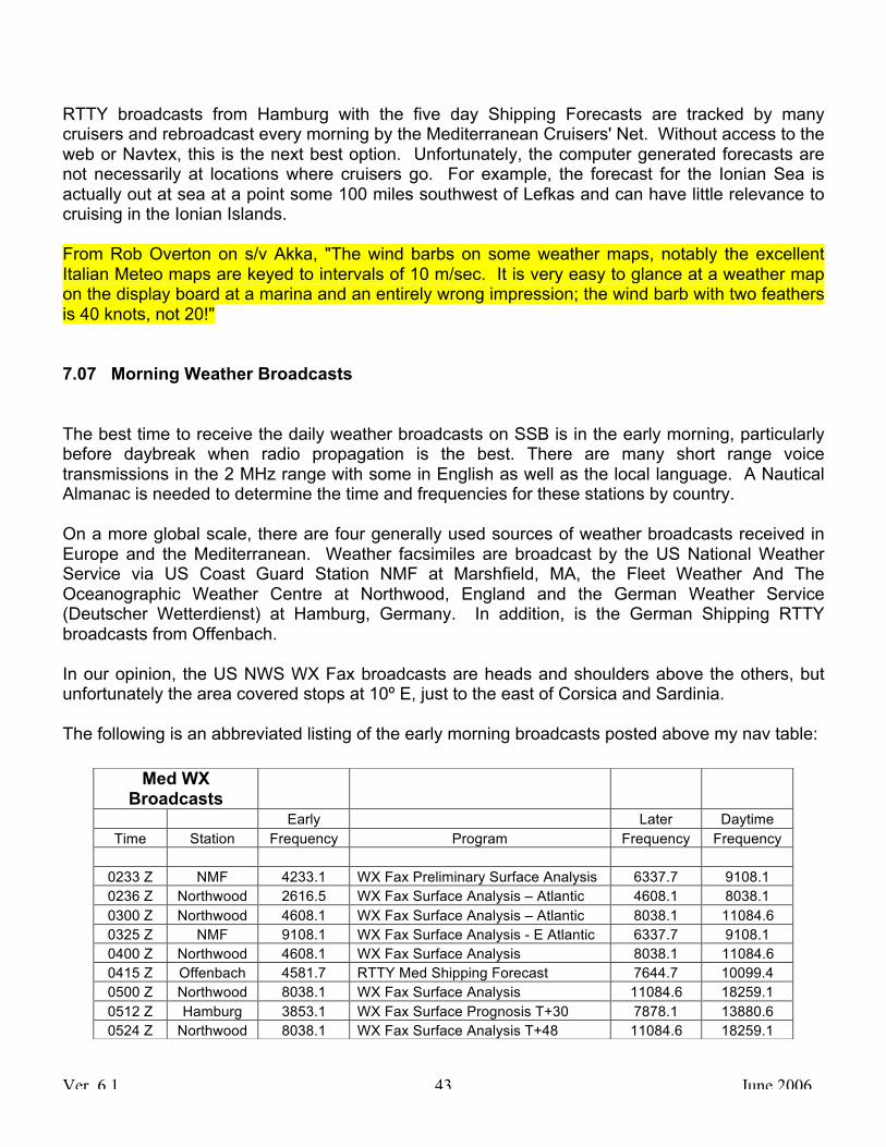
Ver. 6.1 June 2006 43
RTTY broadcasts from Hamburg with the five day Shipping Forecasts are tracked by many cruisers and rebroadcast every morning by the Mediterranean Cruisers' Net. Without access to the web or Navtex, this is the next best option. Unfortunately, the computer generated forecasts are not necessarily at locations where cruisers go. For example, the forecast for the Ionian Sea is actually out at sea at a point some 100 miles southwest of Lefkas and can have little relevance to cruising in the Ionian Islands. From Rob Overton on s/v Akka, "The wind barbs on some weather maps, notably the excellent Italian Meteo maps are keyed to intervals of 10 m/sec. It is very easy to glance at a weather map on the display board at a marina and an entirely wrong impression; the wind barb with two feathers is 40 knots, not 20!" 7.07 Morning Weather Broadcasts The best time to receive the daily weather broadcasts on SSB is in the early morning, particularly before daybreak when radio propagation is the best. There are many short range voice transmissions in the 2 MHz range with some in English as well as the local language. A Nautical Almanac is needed to determine the time and frequencies for these stations by country. On a more global scale, there are four generally used sources of weather broadcasts received in Europe and the Mediterranean. Weather facsimiles are broadcast by the US National Weather Service via US Coast Guard Station NMF at Marshfield, MA, the Fleet Weather And The Oceanographic Weather Centre at Northwood, England and the German Weather Service (Deutscher Wetterdienst) at Hamburg, Germany. In addition, is the German Shipping RTTY broadcasts from Offenbach. In our opinion, the US NWS WX Fax broadcasts are heads and shoulders above the others, but unfortunately the area covered stops at 10º E, just to the east of Corsica and Sardinia. The following is an abbreviated listing of the early morning broadcasts posted above my nav table:
Med WX Broadcasts Early Later Daytime
Time Station Frequency Program Frequency Frequency 0233 Z NMF 4233.1 WX Fax Preliminary Surface Analysis 6337.7 9108.1 0236 Z Northwood 2616.5 WX Fax Surface Analysis – Atlantic 4608.1 8038.1 0300 Z Northwood 4608.1 WX Fax Surface Analysis – Atlantic 8038.1 11084.6 0325 Z NMF 9108.1 WX Fax Surface Analysis - E Atlantic 6337.7 9108.1 0400 Z Northwood 4608.1 WX Fax Surface Analysis 8038.1 11084.6 0415 Z Offenbach 4581.7 RTTY Med Shipping Forecast 7644.7 10099.4 0500 Z Northwood 8038.1 WX Fax Surface Analysis 11084.6 18259.1 0512 Z Hamburg 3853.1 WX Fax Surface Prognosis T+30 7878.1 13880.6 0524 Z Northwood 8038.1 WX Fax Surface Analysis T+48 11084.6 18259.1

Ver. 6.1 June 2006 44
Note: The WX Fax frequencies are all kHz and adjusted 1.9 kHz for USB reception. The RTTY frequencies are adjusted 1.4 kHz and AFC is used to achieve the 1.34 kHz offset. A SSB, a ham radio or a portable "short wave" receiver with a connection to a laptop computer and a weather fax program is necessary to receive and present the data. In the Med, the Mediterranean Cruiser's Net reads the RTTY Shipping Forecasts shortly after 0530Z on 8122 kHz, USB. Yachts that miss the first reading are invited to go to 8131 kHz for a fill after the net about 0600 Z. The net operates throughout the summer season from April 1 to October 31. 0530 Z may sound like an ungodly hour, but most of the Med is two hours ahead of UTC plus another hour for Summer Time. This puts the usual starting time of the net at 0730 LT. For additional details, see the two papers "Offshore Communications Memorandum" and its Appendix now called “Frequencies, Nets, WX Schedules and Tables” available at www.cruisingclub.org. Another advantage of monitoring the Med Cruiser's Net has been Dr. Salah Yashruti. Salah (as he prefers to be called) is a retired surgeon from the Seattle, Washington area who monitors the Cruiser's Net every morning. He provides medical advice to any cruiser requesting help and is a wonderful example of cruisers helping each other in the finest traditions of the sea. Fortunately, Salah is not cruising up the Danube and may still be available on the net. If not, hopefully, someone will pick up where he left off. Still with the weather but on a separate note, it is not a surprise that daytime temperatures can be very high during the summer, particularly in August. What is a surprise some nights however is the need for a light blanket except in August when even a sheet may be too much. 7.08 Tides With no effective discharge from the Mediterranean Sea, tidal changes are slight. The Straights of Gibraltar have the highest tides as would be expected. Gibraltar tides max out at about 1 meter (3.3 feet) and about 1.4 meters at Tangier, Morocco, a city better visited by a day trip via high speed ferry from Algeciras, Spain just east of Gibraltar then by private yacht. East of Gibraltar, the highest tides are along the southern shore with max tides of 1.1 meters at a few places in Tunisia. This shore is thought to be frequented by drug traffickers, is patrolled by the authorities to some degree and is best avoided. The rest of the Med has maximum tides of about a half meter more or less which generally become less the farther east one goes. At that point, pressure differences and wind generated tides become dominant. At Mahon on the island of Menorca, Balearics, the tidal change due to atmospheric pressure is thought to be about a foot and a half. The same applies to the top of the Adriatic.

Ver. 6.1 June 2006 45
All of this nets out to little tidal change. What change there is, is often not noticeable unless the passerelle starts dragging on the bulkhead and needs adjustment. With little tidal change, currents other than those at the Straits of Gibraltar, Messina and the Straits of Dardanelle are mainly wind generated and generally run clockwise around the Med and counterclockwise in the Adriatic. Notable for current is the eastern end of Cyprus and any other major island if commercial fishing boats can be seen operating. The Mediterranean Almanac published by Imray includes Tide tables for Gibraltar with deviations for other locations around the Med based upon Gibraltar. 7.09 Anchors Easily a controversial subject, it is nevertheless worthwhile to make some observations about the anchors seen in the Med. In very general terms, the topography in the Eastern Med is mostly rocky with a dirt mantle in places while that of the Western Med is more alike with that of the Central East North America coast. The bottom in the east will sometimes have very soft mud or silt in the small anchorages although it is often deep and rocky while sand and mud can be expected in the west. These differing conditions suggest that any kind of a bottom can be expected. Many of the anchorages in the Eastern Med are deep. The trick to anchoring in one of these places is to drop the anchor on the incline and back in towards shore using a line to shore around a tree or rock to hold things in place. A chain rode is essential. West of Italy, our 55 pound Delta worked very well, but in the east, we sometimes had had difficulty getting it to set. The soft mud or silt encountered in some places is also not the best for a Delta. In one harbor with a soft bottom, our 44 pound Bruce did a far better job than the Delta which was dragging at the time. Several anchor styles seen in Europe are not often seen in North America. One such anchor is the "Spade" anchor, designed and manufactured in Tunisia and available through West Marine in the US. A boat we have cruised with has one and we are impressed with how well it digs in all bottoms as compared to our Delta and another yacht's CQR. Gullets are a type of boat design common in the eastern Med and their anchoring approach is something to watch. They are often large vessels used for tourist excursions, have two masts to give the appearance of a sailing vessel (some actually sail but most don't and can't). They carry a lot of light chain and deploy one anchor in deep water a good distance from the shore, then back up to attach a line to shore holding themselves just a short distance off the shore. Gullets use a fisherman type anchor and seem to have complete faith in the fisherman's holding power. One gullet captain we spoke with told us their specifications are: LOA: 25 Meters = 82 feet Anchor: 125 kg = 275.6 pounds Chain: 225 Meters = 738 feet

Ver. 6.1 June 2006 46
If there is a lesson to be learned from a gullet, it is that you can't have too much ground tackle. That's not new news. 7.10 Cash Automatic Teller Machines (ATMs - also called a "Hole-In-The-Wall” in England) are available everywhere and offer the best currency conversion rates to debit card holders. Vendors catering to the tourist trade in non-EU countries in the eastern Mediterranean and Africa where the currency is not hard will usually accept the Euro (€) or the US dollar. At the moment, the Euro is preferred due to the weakness of the US dollar. The carpet dealers in the eastern Med selling at five times the value will seemingly accept anything including wampum. 7.11 Language & Signs In our cruising of Western Europe, we found that almost all young people speak English and are happy to talk with us if for no other reason than to practice. That doesn't necessarily hold in more rural areas and particularly with older folks who seldom have an opportunity to encounter foreigners. Just about everyone we have met has been helpful even at places that have not enjoyed that reputation in the past. In the eastern Mediterranean countries where hostility concerns exist, we have been welcomed everywhere we have cruised. Our American Flag is up on the backstay day and night and seeing that, people have waved or come over to welcome us. There are some obstacles however. We found that reading signs and converting verbal instructions to a sign post was difficult in Norway and Sweden and impossible in the Mid East. Accordingly, taking a bus to visit some site of interest on our own is usually exciting. Once east of Italy, the different alphabets of Greek, Turkish, Hebrew and Arabic made getting around on a bus a real adventure. English speech is available in much of Greece, in Israel and many coastal locations in Turkey. After that, English speech is sparse and written English seldom occurs except for some road signs and places that cater to tourists. On the other hand, English has become the international language and is used by young people from differing countries working in a third country to communicate with each other. Credit card receipts in some cases are indecipherable. We have receipts with no idea what they were for, when they occurred and where we did whatever the receipt is about. We found that the only way around this is to immediately write on the receipt what it is about. No matter what the language is however, Evelyn can always spot a sign that translates to "Sale".

Ver. 6.1 June 2006 47
7.12 Fuel Prices Diesel fuel is expensive everywhere these days but can be relatively expensive in the Mediterranean in spite of the fact that the source and refining are not far away. The table below is a sampling of fuel prices in terms of US$ and US gallons starting in mid-summer 2004 before the escalation that occurred in the fall of 2004 and a snap-shot in 2005 and 2006. The cost conversions of the euro in 2004 was 1€ = US$ 1.20. In April 2005, it was about 1€ =US$ 1.30, a double whammy. In June 2006, the Euro was trading at about 1€= US 1.28. The price of diesel fuel is fluctuating daily as we all know.
Country Port % Δ Local / Transit % Δ 2004 2005 2004 - 05 2006 2005 – 06
Croatia Split / Vrsar 4.60 4.65 1.01 Egypt Port Said / N. Suez 1.51 2.71 1.79 1.89 1.05
France Toulon 5.99 Gibraltar 3.16
Greece – East Patmos 3.54 4.48 1.27 4.82 / 3.60 1.08 Greece – West Lefkas 3.39 4.43 1.31
Italy Rome / Trieste 5.90 6.09 1.03 Spain Rota 4.89 Turkey Kemmer 4.05 5.32 1.31 6.05 1.14
A reader in Norway commented that “every year a number of vessels are topped up with the wrong type of fuel. Gasoil, diesel oil, fuel oil, diesel fuel, household fuel and several other names are used. Sometimes the same name can have a different meaning in a neighboring country. One solution to prevent a costly mistake is to look at the sticker on the fuel pump picturing either a tractor or a motorbike. Motorbikes use only gasoline often called petrol and tractors use only diesel.” 7.13 Medical Prescription Availability It is important to have various prescription medicines and antibiotics on board when cruising, particularly in remote areas where immediate help may not be available. The same applies for having spare eyeglasses. Some of the eastern Mediterranean countries including Greece, North and South Cyprus and Turkey do not require a doctor's prescription to obtain most medicinal drugs. This is particularly convenient since some antibiotics have shelf life and require periodic replacement which can be done locally.

Ver. 6.1 June 2006 48
Bring a copy of the prescription so you will know what to get. Also be able to demonstrate to the authorities that you are supposed to have what you have with you. 7.14 Bug Season September is "Fly Season" in the Eastern Mediterranean. They are persistent, fast and bite. A fly swatter (can be taken on an airplane) or insect repellant (which may not but is usually available) are important tools for personal comfort. September also seems to be the time bees prevail although perhaps we hadn’t noticed them previously. If you are hypersensitive to bee stings, bring along a bee sting kit. The ability to get to a hospital is gaited partly on an ability to speak and understand the language. Unless you are anchored in a harbor at a town, the only way to get to help could be by boat, much too slow in these emergencies. 7.15 Lunch Time Starting in Spain on the Atlantic and throughout most of the the Med, long lunch breaks are observed. This is practical because during the summer, it can be too hot to do anything besides go home and rest. Most shops open about 0900 hrs and close about 1300 hrs. They reopen for the “afternoon” at about 1600 or 1700 hrs and remain open until about 2100 hrs and sometimes later. Schools follow the same schedule. With such a constraint on personal time, people have little optional personal time. 7.16 Market Days Most towns have a market day during the week where local produce and items necessary for everyday living are sold. The produce is seasonal, usually vine ripened and excellent. Good buys prevail and many First Mates make sure they are there at the get go (usually about 0800 hrs).

Ver. 6.1 June 2006 49
8 WINTERING OVER Spending the winter in Europe on a boat can be a marvelous experience. Reasonably priced dockage is often available near or in the center of principle cities and with a little planning along with a very important reservation, a new world opens in terms of language, food, customs and an opportunity to get to know a foreign city on a daily basis. Spending the winter on a boat in cold climes can have some special considerations in northern waters. Night time comes early in the winter and the cold can be penetrating. It is strongly recommended that anyone considering this be tied to a dock with water and electricity. For heat, we found that two electric fan heaters purchased locally were more than adequate and far better than diesel heaters which require refueling. Heating oil while less expensive, often is somewhat contaminated with dirt and may only be available during off season via jerry jug and cart. Unfortunately, heating the cabin often leads to lots of humidity due to condensation. We were surprised at the amount of moisture accumulated and installed a dehumidifier to combat it. This worked well for us, but it only gets rid of the moisture that condenses and does not prevent condensation from occurring. Aluminum hatches are guaranteed to collect moisture and drip. If a hatch is right over your bunk, you know what to expect. Surprisingly, our aluminum ports were relatively free of condensation. The aluminum hatch problem can be easily contained by purchasing an inexpensive storm window kit for a sliding door such as the Storm King Patio Door Insulation Kit available at many hardware stores in the US. The plastic film is cut to approximate size of the hatch and attached inside with the double sided tape included in the kit. Blue masking tape should be put on the frame (not the hatch) first because the double sided tape will be very difficult to remove in the spring. It also lifts varnish. The plastic film is attached in place, shrunk with a hair dryer and trimmed. No more condensation from the hatch and plenty of material left over for other hatches. The film is also very clear. Another major source of condensation is aluminum toe rails. Each thru-bolt becomes a drip point which you don’t realize because it is silent and out of sight. Care must be given to the electronics having connections that might extend underneath the deck to the toe rail. A practical solution to this is to tape a piece of stiff plastic over the back of the units to shield the equipment and connectors. Condensation also shows up in the bunks. With the cold hull temperature and the warm cabin atmosphere, the bedding gets damp and even little pools of water can form on the plywood bunk platform. Our solution was to put plastic mattress covers on and to provide airflow under the mattress. To get the moisture out, we opted for a commercial building insulation product available in England. It is comprised of stiff random coils of a plastic material separating two outer sheets of waterproof material by about an inch. It worked well. West Marine sells a plastic product for this which was used by another cruiser with success as well. Some of this may not sound important, but if you winter over, it will be.

Ver. 6.1 June 2006 50
9 MISCELLANEOUS Things not being the same will have a direct bearing on the operation and maintenance of the boat as well as everyday life. The following are some minor observations (and more opinions) on cruising in Europe: 9.01 Broadcast Radio Separate and distinct from VHF and SSB traffic, broadcast radio is receive only and typically is news of in some cases, music. Unless you speak another language while in Europe, BBC and VOA are the primary broadcasts listened to. Some countries have English broadcasts in addition to the local language, but it takes some research to determine the time and frequency for these broadcasts which are often mainly local news. 9.01.1 FM Broadcast Reception The range of frequencies used for FM broadcast radio in Europe is about the same as that of the USA. However, the specific frequencies differ. In the US, FM broadcast frequencies are limited to odd tenths of a mega-Hertz such as 96.3 MHz. In Europe however, even tenths are also used such as 96.2 or 96.4. Cruisers planning to spend time cruising Europe may want to upgrade their broadcast receivers (available in the States) before leaving. In our opinion, Classic Radio FM in England is one of the best classic radio stations anywhere. They broadcast from over 40 locations throughout England on frequencies between 100.0 MHz and 102.0 MHz including even and odd tenths. In the London area, it is on an even tenth with the result that a yacht spending the winter at St. Katharine Haven may not be able to receive it clearly or any other even tenth stations. On the web, Classic FM is at www.classicfm.com. Unfortunately, new regulations prohibit their broadcast on the web outside of the UK! 9.01.2 VOA and BBC Reception of Voice of America broadcasts on SSB in English is now rather poor in the Mid-East and the eastern end of the Mediterranean. In the contest between the need to make friends and budget limitations, the budget won out. BBC has also reduced their coverage in the Mediterranean Basin as well.

Ver. 6.1 June 2006 51
VOA: The VOA schedule and frequencies vary by season; summer and winter. The frequencies currently in effect are from Mar 2006 until 29 Oct 2006. The English schedule for Europe has been greatly reduced.
The frequencies and schedule can be somewhat difficult to find on the web. They are at:
www.voanews.com/english/about/Frequenciesatoz_a.cfm
Note the underline dash between the z and a. BBC: The BBC carries a surprising amount of news about the US, comes in well throughout the Mediterranean area and is the mainstay for news and other items about the world for cruisers. Their frequencies and schedule also went into effect in Mar 2006 and will probably continue through the end of October. British Broadcasting Company www.bbc.co.uk
Go to Radio (bottom center) Click on World service (upper left) Click on Radio Schedules (lower right) Or, you can go to the following and not have to hunt for it:
www.bbc.co.uk/worldservice/schedules/internet/800/radio_frequencies_eastern_europe.shtml
Note there are underlying dashes between "radio_frequencies_eastern_europe". 9.01.3 Satellite Radio As in the Americas and Asia, satellite radio service is available in Southern Europe, Africa and the Mid-East through the World Space™ digital satellite system. The AfriStar™ satellite, located just below the equator at λ = 21º East, broadcasts three beams, each with about 50 BroadCaster channels, up to eight Service Channels used for data transmission and broadcast programming. Several free channels are available including CNN, Radio France (in French), WRNI and other stations with African and Arabic music, 16 channels in total at Southern Turkey. Other channels (23 on one beam) including NPR, Bloomberg and Fox News are available on a subscription basis. World Space has moved most of its programming such as classic music (labeled Maestro which was free) to subscription service only. We understand the current price is US$ 165 per year. Eastern Italy, the Adriatic and Greece down to about Crete are fringe areas for reception.

Ver. 6.1 June 2006 52
The clarity of the sound is notably good. Receivers sell for about 200 € and run on both 220-240 VAC and 110-127 VAC with a standard plug adapter, 12 VDC through a special cigarette lighter adapter that drops the voltage to 6 VDC and internal D cell batteries. They come with a semi directional antenna that doesn't lend itself to boats swinging on an anchor or even moving about tied to a pontoon. An omni-directional antenna is available for about an additional 50 € and is worth the added cost. Contrary to the instructions for the TravelStar Omni-directional Antenna (written in German), the omni-directional antennas when placed upon a metal surface such as a car roof or a cookie sheet will most likely not work. We purchased one of these because we thought the regular broadcast music in the mid-east is something one has to be born into. However, we find our satellite radio was seldom used because there is often a radio station in range that broadcasts western type music. And, there are always CDs when that fails. One tricky technique for important events is to tune to CNN on local TV and substitute the local language audio with that of the satellite radio. It is often the same feed. For more information, see www.worldspace.com 9.02 Calculators In everyday life, we think in terms of inches and feet, gallons, Fahrenheit, etc. However, Europe uses metric scales for weight, volume and distance. There are some exceptions to this such as in England where road distance is still given in miles and distance on the seas is in nautical miles. An inexpensive metric conversion calculator goes a long way to smoothing out shopping for groceries and other items until "thinking metric" takes hold. Until you get a calculator, for quick and rough approximations, a kilometer is about 60% of a statute mile; multiply kilometers by 0.6 to get miles or divide miles by 0.6 to get kilometers. A gallon is 3.8 liters which is a little less than 4 liters. A kilogram is about 2.2 pounds. 9.03 Carts Hard luggage, not welcomed onboard a cruising yacht is typically equipped with wheels these days and even some soft luggage. Most duffel bags and sail bags however are not and can be a hassle getting to the airline terminal, from the terminal to the bus or train, perhaps to a hotel and eventually to where the boat is located. A stout folding cart that can be taken on the airlines will make life a lot easier. Carts such as Products Finishing Corp’s Model 950 (www.pfc-cart.com) available at some large discount stores are rated at 250 pounds and will seemingly carry more than that. We also use it for the laundry, shopping for groceries, getting more beer and wine (heavy and often far away), propane, etc. besides luggage when taking side trips. With carts, strong and large wheels are better.

Ver. 6.1 June 2006 53
9.04 Dinghies A large dinghy and powerful outboard is the way to go in the Caribbean and the Pacific where an anchorage can be a long distance from town, diving site, etc. For the most part, this doesn’t hold in Europe where the town is usually close by if you do elect to or can anchor out. While most cruisers have some kind of dinghy, they don’t get used very often unless there are children aboard. We have found that our inflatable is usually rolled up in its bag and the outboard seldom used. Unless you have a very large boat, you may find that a large dinghy is cumbersome and unnecessary. 9.05 Filters There is almost always enough wind to sail in Atlantic waters, but in the Med, there is often either too much wind to go out, or not enough. Particularly in the Med and to some extent in the Baltic, the engine runs many hours at a time. This leads to the need for a good supply of Raycor and fuel and oil filters for your particular engine. Oil filter substitution can be a risky practice. Some filters are spring loaded and work in conjunction with the engine's oil pressure regulation. Note also that your particular make and model may not be available in Europe. Parts needed for the boat will almost always involve a long walk or a taxi and usually, what you need is not there. Stock up with filters before crossing or have guests bring them. 9.06 Fishing Boats Purportedly the most dangerous occupation in the US, commercial fishing in European waters is also a difficult way of life. Need, economics and in southern waters, the depletion of fish stocks leads to shortcuts that the cruiser should be aware of. Aside from entering and leaving harbors, fishing boats are almost always operated on autopilot as are most commercial vessels. However, with a shortage of manpower available and fatigue, the bridge on many commercial fishing boats is not manned except while actually fishing and even then, other duties prevail. The smart skipper gives commercial fishing boats a wide berth not only because they may be restricted in their ability to maneuver while fishing, but because there may be no one at the helm. Further, some fishing boats move surprisingly fast and warrant a constant watch since you may be the only one watching. VHF calls to commercial fishing boats even out on the Atlantic are often not answered. This could be a combination of being too busy, not manning a radio watch or language. Also, we belatedly learned that fishing boats off Ireland watch VHF Channel 6 rather than 16.

Ver. 6.1 June 2006 54
9.07 Frank Singleton Website Frank Singleton is a sailor and retired English meteorologist who is usually off cruising in Turkey on his boat, Clara. He has written extensively about cruising and communications in European waters. His papers are posted on the web at: www.franksingleton.clara.net/home.html 9.08 Galley Measurements Measuring cups, spoons and so on critical to the galley's result should be on board before departing because they probably won’t be available in Europe where the metric measuring system is the rule. All is not lost however if some of the utensils are misplaced or dropped overboard. The following are some conversions:
Cup = Fluid Oz = Tablespoon(s) = Teaspoon(s) = Milliliter(s)
C oz. tbsp. tsp. ml 1/16 ½ 1 3 15 1/8 1 2 6 30 ¼ 2 4 12 60
1/3 3 5 1/3 16 80 ½ 4 8 24 120
2/3 5 10 2/3 32 160 ¾ 6 12 36 180 1 8 16 48 240
9.09 Medical Facilities In Croatia and Turkey The facilities and professionalism in these countries can be first rate while prices are very low by comparison to that in the USA. Although the buildings and accommodations at state facilities in Turkey may not be up to the level we are accustomed to, the equipment to this untrained eye appears to be excellent. The staff also seem to be at a level that instills confidence. We have been very pleased and are having dental work and physical check-ups here. As with any purchases made in Turkey or this part of the world, it is always best to agree upon the price in advance. And anywhere else for that matter.

Ver. 6.1 June 2006 55
9.10 Oil With extensive use of the engine, locally available engine oil may not be up to the job. We purchased twenty five liters of oil at a fisherman’s coop in Belgium which was all that was available. We thought a local brand used by fishing boats would be more than adequate, but it wasn’t. After several hours of engine run time, we noticed the oil pressure would drop when throttled down to an idle. Our recommendation is to stay with the major brands of oil and ensure that it is rated for heavy duty. This was our mistake and shouldn't be new news. 9.11 Outboard Motors From outward appearances, all outboards of a particular brand and horsepower for a given year are the same. Unfortunately, they are not always. As is the case in the Caribbean, manufacturers often have different products “under the hood” with the result that parts for an outboard purchased in North America may not be available in Europe. A parts manual can be an important document to have on board. Depending on how long a yacht is expected to stay in Europe, consideration should be given to purchasing an outboard at a duty free port such as Gibraltar. 9.12 Paper Towels Paper products are readily available throughout the EU, Scandinavia and the Mid East. They are of good quality and sometimes better than what we normally encounter at home. However, being on the metric system, the size of these products is usually different. Paper towels in North America are larger in width making our paper towel holders useless in Europe. Most North American marine chandleries have paper towel holders with a rod through the center which will solve the problem and work just fine. 9.13 Part Shipments from the US Maintenance is a way of life when off cruising and it is a rare cruising yacht that doesn’t have to replace some parts on occasion. Duty will be charged when parts are shipped from the US to Europe unless "For Vessel in Transit" or similar statement is clearly written on the package. In addition, the sender must complete some special paperwork prior to the actual shipment; just writing “For Vessel in Transit” is often not enough. For reasons not clear, West Marine enjoys an enviable reputation for shipping parts quickly and without customs delays in many countries, particularly those of the EU. This is significant because

Ver. 6.1 June 2006 56
packages held up in Customs may be at a location hundreds of miles away, will usually need a broker to clear and even then, are often lost. One major US Courier, UPS, seems to have a standard broker charge of 100 €, about US$128 plus additional charges for shipping, handling and storage for small miscellaneous items in EU countries. The charges for this bureaucratic rip-off can easily exceed the value of the item. To be practical, small items should be sent by other means such as parcel post through the post office if possible. A favored destination for part shipments is Gibraltar where there is no tax and everything is within walking distance. 9.14 Ships Papers Clearing in with the authorities and marinas will call for the boat’s length, beam and draft in meters. It's handy to do the conversion and write it down with a pencil on your documentation paper ahead of time. Surprisingly, net tonnage is calculated the same as ours. See the paper “Frequencies, Nets, WX Schedules and Tables” formerly called Offshore Cruising Memorandum Appendix for a series of conversion tables. It is also handy to have your documentation renewal date and EPIRB registration set up for a time when you are normally at home. Many of the forms to be completed by the authorities must be in duplicate or even triplicate. Unfortunately, the forms are often not supplied with carbon paper or, the carbon paper expired a long time ago. A couple of sheets of carbon paper given to the authorities will be much appreciated as well as speed up your clearance in. 9.15 Lavatory And Holding Tank Pump Out Some things are different with bathrooms and some things are not depending upon where you are. In France, bathrooms are co-ed! Even at new facilities, you can encounter someone of the opposite sex at the next wash basin. Showers and toilets are partitioned or screened off of course, but it is France and different. The bathrooms we have visited in Ireland and England have been mostly mediocre in terms of layout, cleanliness and modernized with the Falmouth public dock being the exception. Along the French Atlantic Coast, they are generally an improvement over those in the UK, co-ed or not. Perhaps the best facility (anywhere) is at Netsel’s Marina, Marmaris, Turkey followed closely by that at Primosten, Croatia. They are spectacular by any standard; always gleaming clean and superbly constructed with marble floors, walls, etc. being the standard. POSH!

Ver. 6.1 June 2006 57
On the other hand, fairly poor facilities can also be found at many marinas just like some in the US. The ACI chain of marinas in Croatia are mediocre to bad as is the attitude of many of their staff. In common with the US east coast, we have not encountered or even heard of any pump-out facilities any where in our cruising travels in the UK, the Baltic, the Atlantic coasts of France, Spain, Portugal, or at any Mediterranean country. There may be some, but none we are aware of. A lot of lip service is given to holding tanks, but the bottom line is, it is business as usual! 9.16 Crew Lists And Yacht Information On occasion, we have been asked for a listing of the crew and other information about the boat. A copy of the form we use which has always been accepted is attached below.

Ver. 6.1 June 2006 58
10 Crew List and Yacht Information Sample Form
s/v NEFERTARI______________________________________________________________ number and street address city, state, Zip, USA Tel: xxx-xxx-xxxx E-Mail xxxxxxxxxxxxxxx CREW LIST AND VESSEL DATA MASTER: Capt. xxxxxxxxxxxxxxx USCG Lic. xxxxxx Citizenship: USA Date/Place of Birth: xxxxxxxxxxxxxxxxxxx, USA Passport No: xxxxxxxxx, Issued xxxxxxxxxx at xxxxxxxxxxxxxx Expires xxxxxxxxxx Crew: xxxxxxxxxxxxxx Citizenship: USA Date/Place of Birth: xxxxxxxxxxx, xxxxxxxxxxxxx, USA Passport No: xxxxxxxxx, Issued xxxxxxxxxx at xxxxxxxxxxxxxxxxx Expires xxxxxxxxxx VESSEL INFORMATION VESSEL NAME: Nefertari OWNER: xxxxxxxxxxxxxxxxxxx HAILING PORT: City, State, USA, HOME PORT: City, State, USA FLAG & REGISTRY: USA, US Coast Guard Official Number xxxxxx LENGTH: xxx Ft = yyy meters BEAM: xxx Ft = yyy meters DRAFT: xxx Ft = yyy meters ENGINES: NO: xxxx HP: xxxxx GENERATOR: xxxxx TONNAGE: GROSS: xxxx NET: xx DESCRIPTION: Sailboat, dark blue hull, white cabin, single mast, center cockpit, HIN: xxxxxxxxxxxxxx CARGO: None FIREARMS: None PASSENGERS: None ANIMALS: None The above is true and correct to the best of my knowledge. DATE ____________MASTER ________________________________ Sail No. 43897 Radio Call Sign: xxxxxxx Ham: xxxxx