cic-14report collection - fas
TRANSCRIPT

LA-10428-MS—-...--...——.——
! CIC-14REPORT COLLECTION
C3* Reproduction
I COPY :,;-.+Z;LJJ.n.Tm.—.— —.Los Alamos Nationel Laboratory IS operated by the Unlverslty 01 California for the Uruted States Department of Energy undercontiact W-7405 .ENG-36.
,-. .,
.— -
.,,.,
~...
.
.
.!.
.
,..
. -. ,. .. .
“- , . .,, i. ,,
. .. . . . . . . ,.-
. ... ,<.- ....-;; . . .: :
...,.:-” ,,,.,, , -; ,. ,. ., , .,-,.
.N, u “, ,, ~ : “,,; ,’.... ..,,,.. ,.., .. ...
# ,,..
.
.. ..,,. ,. .
,,
.- . . .
“..
Trip (iuidebook1984
Nevada Test Site Field‘..,.,. ,...,,.., ,,4,,d. .,}.., ,,“ :. . . .. “: .-,,. .,-. !
,., ,
————.
.--.—.. -:----s ● H.-: --r., -. .,% .~hd.?
I ..-.— —. .. . — . . .— —.— —...———
LosAlamosNationalLaboratoryLosAlamos,NewMexico87545LosAllallT10s

k AffiitiveActlosa/Equdt)p@UOity fh@oyS?S
This work was supported by the US Department of Energy, Waste ManagementProgram/Nevada Operations Ofiiee and Los Alamos Weapons Development Pro-gram/Test Operations.
Edited by Glenda Ponder, ESS Division
DISCLAIMER
This report waspreparedas an account of work sponsoredby an agencyof the LhdtedStatesCoverrrment.Neitherthe United States Governmentnor any agencythereof, nor any of their employees,makesanywarranty, expressor irnpIied,or assumesany Iegatliabilityor responsibilityfor the accuracy,wmpletenesa,or usefutncasof any information,apparatus, product, or processdisclosed,or representsthat i!ausewouldnot infringeprivatelyownedrights. Reference hereinto any specificcommercialproduct, process,orserviceby trade name, trademark,manufacturer,or otherwise,doesnot newaaarilywnatitute or Irssplyitsendo~ment, recommendation,or favoringby the United States Gwernrnent or any agencythereof. Theview and opinionaof authors expressedherein do not neceawily atate or reflect those of the UnitedStates Governmentor any agencythereof.

LA-10428-MS
Uc-11Issued: April 1985
Nevada Test Site Field Trip Guidebook1984
CompiledbyHollyA.Dockery*F.M. Byers,Jr.PaulP.Orkild**
Contributors
HarleyBarnest F.G.Poole**DavidE.Broxton RobertB.Scott**W. J.Carr** RalphR.Shroba**BruceM. Crowe MarthaG.Van De Werken**Ward L.Hawkins DavidT.VanimanEvanC.Jenkins** RichardWaddell**DonathonJ.Krier RichardG.WarrenSchonS.Levy
J = --- ~ ----— - +. T. .--37. . <.. . . . . -7. -.. —-. -.-r,— .— .!- .-— - .,.-.!..- . . . . . AA
— .-. .. ———.——-——-.— - - ..— . . . - .. -—.. . . . . . . . . . - . . - . . .
. -.
~al :— ---- .- , -, .:,..... -—..— .
~g~-”:-::”-*- -=--%-,..4
---- . -Jv+ - ,+
Consultant.LosAlamosNationalLaboratory,NSP/SP,MSF681,LosAlamos,NM87545.●*USGeologicalSurvey,Denver,CO80225.‘- “ -=fDeceasedm.--— + !-,.0.,’ .1’1--..,- -.... —.-.— .-...—.— -— 1.— ----- ..-.. !,—- —— +
Los.—,.,, ., - - —..-,. ., .- .
A[A
,,
- z ..
.,. “.
allnrilosLosAlamosNationalLaboratoryLosAlamos,NewMexico87545
.
.
,. ..-- .-
,—m-
- + .
PREFACE
The Nevada Test Site (NTS) was established on December 18, 1950, toprovide an area for continental testing of nuclear devices. In January of1951, testing began with an airdrop into Frenchman Flat in conjunctionwithOperation Ranger. In addition to airdrops, aboveground testing includedsurface detonations, tower shots, and balloon suspensions. Undergroundtesting began in 195~ and since 1963, all events have been buried inlarge-diameterdrill holes or tunnels. Geologists from the U.S. GeologicalSurvey (USGS)mapped much of the NTS region between 1960 and 1965. These mapsformed the basis for subsequent studies by geologic support groups from theLos Alamos National Laboratory,Lawrence Livermore National Laboratory, SandiaNational Laboratories, and the USGS. A good geologic understanding of thestratigraphy,structure,geochemistry,and physical properties of the rocks isessential for adequate containmentof underground nuclear tests. Many of therecent geologic studies at NTS, particularly in Yucca Flat, Pahute Nlesa,andMid-Valley, are aimed at understanding subsurface geology to help ensurecomplete containment. Since 1978, the massive ash-flow tuff beds under YuccaMountain have been intensively studied to determine their potential as aradioactive waste repository. These investigations involved volcanic andearthquake hazard studies, detailed geochemical studies of compositionalzonation in ash-flow tuffs, and studies of secondarymineralization.
The rock sequence at NTS is composed of upper Precambrian and Paleozoicrocks which were complexly deformed by Mesozoic compressional tectonismoTertiary and Quaternary volcanic and elastic rocks overlie the older rocks andwere deposited concurrent with Cenozoic extensional faulting. The upperMiocene ash-flow tuffs and lavas found in this area issued primarily from theTitier Mountain-Oasis Valley caldera complex located in the western part ofNTS. Studies performed in conjunction with nuclear testing and radioactivewaste isolation have addressed many aspects of the geologic history of NTS,which have in turn greatly enhanced our understanding of the geology of thesouthernGreat Basin.

NEVADA TEST SITE FIELD TRIP GUIDEBOOK 1984
Compiled by
Holly .4.Dockery, F. M. Byers, Jr., and Paul P. Orkild, trip leaders,withcontributionsfrom Harley Barnes, David E. Broxton,W. J. Carr,
Bruce M. Crowe,Ward L. Hawkins, Evan C. Jenkins, DonathonJ. Krier,Schon S. Levy, F. G. Poole, Robert B. Scott, Ralph R. Shroba,Martha G. Van De Werken, David T. Vaniman, RichardWaddell,
and Richard G. Warren
ABSTRACT
The Nevada Test Site (NTS), located in southern Nevada, wasestablishedin 1950 as an area for testing nuclear devices. Variousgeologic studies performed in conjunctionwith these activities aswell as recent work oe a proposed radioactivewaste repository arereported in detail in this guidebook and include studies on thestructure,stratigraphy,geochemistry,and physical propertiesof therocks at NTS.
The oldest sequence of rocks exposed in the NTS region is com-prised of late Precambrian to Permian miogeoclinal rocks which weresubsequently deformed during Jura-Cretaceous contraction, probablyrelated to the Sevier orogeny. These rocks were then locallyintruded by late Mesozoic (@93 m.y.BP) plutonic rocks related ti theSierra Nevada batholith. A soil horizon mantling the older rocksoccurs in portions of Frenchman and Yucca basins as well as in someof the upthrownblocks bordering the basins.
Voluminous calcalkalineash-flow tuffs and associated volcanicrocks originating from the Timber Mountain-Oasis Valley calderacomplexwere extruded over much of NTS and adjacent areas from @16 to10 m.y.BP. Peralkaline rocks intercalatedin the volcanic sequenceissued from both Silent Canyon (15-13m.y.BP) and Black Mountain (9-7m.y.BP) volcanic centers. These ash-flow units are characterizedbyinterflow as well as intraflow mineral zonations. Some restrictedoccurrences of older ash-flow tuff units and tuffaceous sedimentaryrocks (approximately30-16 m.y.BP) are also found; however, they donot appear to be associated with the major volcanic centers citedabove.
The youngest igneous rocks at NTS are composed of basalticrocks, primarily hawaiite,the older of which are associatedwith theevolving silicic volcanic centers and the younger associated withCenozoic regional extension. Late Tertiary to Recent alluviumderived from the ranges form large, coalescing fans which fill thebasinswith sedimentsand reach thicknessesof over 1 km.
7

Regional crustal extension, initiated possibly as long as 30m.y.BP and continuing to the present, has produced numerous basin-range style normal faults as wel1 as a few prominent strike-slipfaults in this area. Displacementalong these faults was concurrentwith depositionof volcanics as old as @14 m.y.BP, although most ofthe developmentof the basins appears to be very recent (<3 m.y.BP).Continuous clockwise rotation of the least principal stress hasstrongly influenced orientationof some of the faults and theirrelativeamounts of movement.
The geologic studies conductedat NTS have thus been valuable intwo ways. First, they solve the immediate problems at hand such asdetermining the viability of an area for radioactivewaste storage,studies of physical properties of certain testing media as occurredduring formation of Sedan Crater, and hydrologic transportof radio-active nuclides traced in Frenchman Flat. Second, the synthesis ofthis vast body of data has done much to further the general under-standing of the development of this portion of the Basin and RangeProvince.
ROAD LOG
DAY 1
GENERALIZEDSTRUCTURALGEOLOGY FROM LAS VEGAS TO MERCURYThe Las Vegas Valley shear zone, one of the major structuralfeatures of
the Basin and Range physiographic province, is reflected topographicallybythe northvest-trendingLas Vegas Valley (Fig. 1). The Spring Mountains,culminating in Charleston Peak (3633 m), parallel Las Vegas Valley on thesoutlwest, whereas several smaller northerly trending ranges have southerlyterminationson the northeast side of the valley. The sharp westerly bendingor “drag” into the Las Vegas Valley shear zone of major northerly structuraland topographictrends (indicatedby ranges on the northeast side of Las VegasValley) and offset of Paleozoic facies markers (Stewart, 1967) and majorthrust faults on either side of the valley (Burchfiel,1964) indicate right-Iateral movement along the zone. Studies of stratigraphic and structuralevidence indicate an aggregate right-lateral offset of 60-75 km occurringbeWeen about 17 to 11 m.y.BP (Longwell, 1974). The absolute amount ofstrike-slipmovement along the shear zone cannot be determined,in part due toalluvial cover, but estimates range from 27 to 30 km (Fleck, 1970). The restof the offset is attributed to structuralbending or “drag.”
The area traversed on this field trip lies in a belt of extensive thrustfaults that occur along the east side of the Cordilleran miogeocline. Thesethrust faults are of Mesozoic age and occur in the hinterland of the Seviererogenic belt. U.S. Highway 95 follows the valley for about 90 km from LasVegas to the vicinity of Mercury, Nevada (Fig. 1).
2

---2-.,[‘7’
//f’
IE
?L-
..

CumulativeMilcage
0.0 Las Vegas, intersectionof Interstate15 and U.S. 95. Proceed northon U.S. 95.
2.7 Decatur Blvd. overpass.
9.1 Craig Road turnoff. Potosi Mountain at 8:30 o’clock is capped byMonte Cristo Limestone of Mississippian age. Prominent ridgebetween 8:00 and 9:00 is capped by Permian Kaibab Limestone. WilsonCliffs between 8:30 and 9:30, composed of buff and red AztecSandstone of Triassic(?) and Jurassic age, form the lower plateoverriddenby Keystone thrust. Narrow ridge at 9:30 is an erosionalremnant of Keystone thrust; the ridge is capped by gray GoodspringsDolomite of Cambrian and Ordovician age overlying red AztecSandstone. On La Madre Mountain between 9:30 and 11:00 are exposedcarbonate rocks of Cambrian, Ordovician, Silurian(?), Devonian,Mississippian,Pennsylvanian,and Permian age. On Sheep Range at1:00, the outcrops are rocks of Cambrian through Mississippianage.On Las Vegas Range between 1:00 and 3:00 most outcrops are the BirdSpring Formation of Pennsylvanianand Permian age. Muddy Mountainsat 4:00. Sunrise and FrenchmanMountainsbetween 4:30 and 5:30.
14.8 View of La Madre Mountain stratigraphy between 9:00 and 10:00.Lower thin black band is dolomite of Devonian age (probably IronsideDolomite Member of Sultan Limestone). It rests with apparentunconformity on a very thin gray dolomite of Devonian or possiblySilurian age, which in turn rests unconformably on gray and brownsilty and clayey carbonate of the Pogonip Group of Ordovician age.Above the Ironside is limestone and dolomite of the Devonian SultanLimestone. The main ridge is capped by Monte Cristo Limestone ofMississippianage. Small outlier just north of the end of the mainridge is composed of the Bird Spring Formation of PennsylvanianandPermian age.
16.1 CharlestonPark Road - Kyle Canyon turnoff (Nevada State Highway 39).
19.4 Rest area on right ... continue straightgeologic features exposed in the next few mi”Road (Nevada State Highway 52) are outlinedof the Wheeler Pass and Gass Peak thrustssumort of riqht-lateralmovement alona the
ahead. A few of thees near the Lee Canyonon Fig. 1. The offsetis commonly cited inshear zone. The con-
trast in rock~acies and thicknesseson-opposite sides of the valleyoffers corroborativeevidence of strike-slipmovement.
To the northeast: The rocks of the Sheep Range between 2:00 and3:00 are the typical thick miogeoclinal section of eastern Nevada.The two prominent black bands at 3:00 are the lower member of theEly Springs Dolomite repeated by faulting. Beneath the upper of thetwo black bands is the light-coloredEureka Quartzite. The Eurekais underlain by brownish-gray Pogonip Group carbonate rocks, whichin turn are underlain by the Nopah Formation, the uppermost part ofwhich has prominent black and white stripes. Above the black lower

25.3
26.0
29.5
33.0
34.9
39.0
member of the Ely Springs is a unit of light-gray dolomite repre-senting the upper member of the Ely Springs and lower part of theSi1urian. The thin black band is a dark dolomite unit within theSilurian section.The Devonian rocks above are similar to the NevadaFormation of former usage and the Devils Gate Limestone of the TestSite.
To the southwest: The ridge east of Lucky Strike Canyon consistsof a much thinner section than in the Sheep Range and containsseveral different lithofacies. At 10:00 a white streak representingthe distal end of the Eureka Quartzite may be seen just below aprominent black unit, which is probably equivalent to the IronsideDolomite Member of the Sultan Limestone. A thin light-graydolomiteseparates the Eureka and Ironside. This dolomite interval consistsof the Ordovician Ely Springs Dolomite and possibly a thin sequenceof Silurian rocks. The Devils Gate Limestone forms the remainder ofthe ridge above the black Ironside. The MississippianMonte CristoLimestone forms the north-dippingslope of the main ridge and cannotbe seen from here. The well-beddedoutcrops at 11:00 north of LuckyStrike Canyon are the Pennsylvanian and Permian Bird SpringFormation. Below the Eureka at Lucky Strike Canyon, the section isgray and brown silty and clayey carbonate rocks of the PogonipGroup. The black dolomite just above the valley fill at 9:30 is theupper part of the Nopah Formation.
Fossil Ridge atl 4:00 is composed of Cambrian and Ordovicianrocks. Gass Peak thrust (Fig. 1) at 4:30 separates upper plate ofCambrian rocks on left from lower plate of Pennsylvanianand Permianrocks of the Las Vegas Range on the right.
Lucky Strike Canyon Road to left. Road to right leads to Corn CreekSprings Field Station of U.S. Fish and Wildlife Service, whichmanages the Desert Game Range. Continue straightahead.
Badland topography at 3:00 developed on Las Vegas Formation. NearLas Vegas, similar yellowish-gray fine-grained beds have yieldedfossil mollusks and mammals of Pleistoceneage.
Lee Canyon turnoff. Nevada 52 on left .... continue straight ahead.At 9:00 on skyline is Charleston Peak, elevation 3633 m. BlackRidge at 3:00 is composed of Cambrian and Ordovician strata. DesertRange at 2:00 is composedof Cambrian to Devonian strata.
Playa of Three Lakes Valley at 2:00. Pintwater Range at 1:00 iscomposed of Cambrian to Devonian strata. Indian Ridge at 10:30 iscomposed of Cambrian and Ordovician rocks. Ridge between 8:00 and10:00 is composed of Bird Spring Formation. The Wheeler Pass thrustprobably separatesthese two ridges.
State Correctional Facility, Camp Bonanza (Boy Scouts of Anerica),and Cold Creek Road on left .... continue straightahead.
Southwest end of Pintwater Range between 1:00of Ordovician, Silurian, and Devonian rocks.sists of gray cliffs of Monte Cristo Limestonesilty-sandy limestone and gray limestone
and 3:00 is composedRidge at 10:00 con-and alternatingbrownof the Bird Spring
5
41.0
42.1
45.4
47.7
49.5
52.7
55.1
Formation. Prominent high point on skyline ridge at 9:30 is WheelerPeak.
Light-gray outcrop, at 3:00, is mostly Devonian carbonate rocks.Near this point, the trend of Las Vegas Valley changes from north-west to west-southwestpast Indian Springs, reflectingeither a bendin the Las Vegas Valley shear zone or the presence of a conjugatenortheast-trendingfault.
Village of Indian Springs. Indian Springs Valley is at 3:00. Whiteand brown outcrops in distance at 1:00 are Eureka Quartzite. Darkdolomite on ridge at 12:30 is Upper Cambrian Nopah Formation. Grayand brown outcrops forming prominent ridge south of town, 9:00 to11:00, are Bird Spring Formation.
Village of Cactus Springs. Prominent black and white bandeddolomite on ridge between 1:00 and 3:00 is upper part of NopahFormation.
Prominent ridge on skyline between 9:00 and 12:00 is northwest endof Spring Mountains;Wheeler Peak at 9:30, Mount Stirlingat 10:30.
Road to right leads to test well 4 . . . continue straight ahead.Lake beds of the Las Vegas Formation form the yellowish-graybadlandtopographyalong highway. These beds, marking a significant shore-line of a large lake, continue westward only a few more miles wherethey reach a maximum altitude of about 1100 m. They are continuousfrom that point back to an altitude of about 800 m in the Las Vegasarea, suggesting a southeasterly tilting during the last millionyears of approximately5 m/km.
Brown and gray outcrops immediately north of highway are PogonipGroup.
STOP 1: View of Paleozoic units in the Spotted Range between 12:00ZiiinEoo. Park off highway on right side near sign designatingNye-Clark County line. Rocks seen to the north in the Spotted Rangeare typical thick miogeoclinal strata similar to those in the SheepRange section. Visible units include limestone of the OrdovicianPogonip Group, Eureka Quartzite,and Ely Springs Dolomite (see TableI); Silurian and Lower Devonian dolomite; Lower and Middle Devoniandolomi~ and quartziteof the Nevada Formation,and Middle and UpperDevonian Devils Gate Limestone (includes some dolomite andquartzite). Uppermost Devonian and Lower and Upper Mississippianrocks cannot be seen from here, but are present in an overturnedsyncline on the far side of the ridge on the skyline. Strata seengenerally dip 30” to 40” northwestwardand form the southeast limbof the Spotted Range syncline. The rocks are displaced by aprominent system of northeast-trending faults. White quartzitemember of the Eureka just above valley fill at 1:30 is overlain byblack dolomite of the lower member of the Ely Springs. Ridge onskyline between 12:30 and 2:30 is South Ridge capped by Devils GateLimestone. Nevada-Devils Gate contact is on skyline at 1:30.Prominent black band with brownish slope-former below is the
6
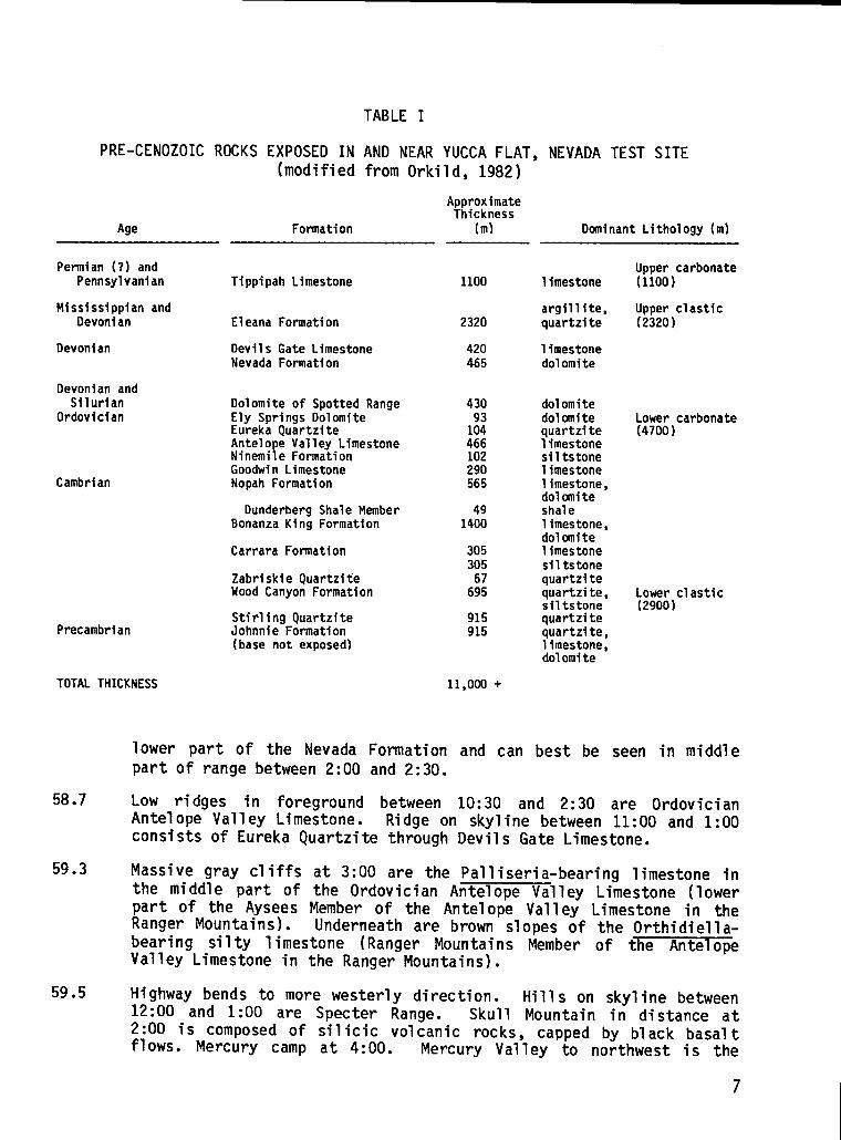
TABLE I
PRE-CENOZOICROCKS EXPOSED IN AND NEAR YUCCA FLAT, NEVADA TEST SITE(modifiedfrom Orkild, 1982) -
Age Formation
ApproximateThickness
(m) DominantLithology(m)
Permian(?)andPennsylvanian
MississippianandDevonian
Devonian
DevonianandSilurian
Ordovician
Cambrian
Precambrian
TOTALTHICKNESS
58.7
59.3
59.5
TippipahLimestone
EleanaFormation
DevilsGateLimestoneNevadaFormation
DolomiteofSpottedRangeElySpringsOolomiteEurekaQuartziteAnteloe ValleyLimestone
tNinemle FormationGoodwinLimestoneNopahFormation
DunderbergShaleMemberBonanzaKingFormation
CarraraFormation
ZabriskieQuartziteWoodCanyonFormation
StirlingQuartziteJohnnieFormation(basenotexposed)
1100
2320
420465
430
1:?466102290565
491400
30530567695
915915
11,000+
limestone
argillite,quartzite
limestonedolomite
dolomitedolomitequartzitelimestonesiltstonelimestonelimestone,dolomiteshalelimestone,dolanitelimestonesiltstonequartzitequartzite,siltstonequartzitequartzite,limestone,dolomite
Uppercarbonate(1100)
Upperelastic(2320)
Lowerelastic(2900)
lower part of the Nevada Formation and can best be seen in middlepart of range between 2:00 and 2:30.
Low ridges in foreground between 10:30 and 2:30 are OrdovicianAntelope Valley Limestone. Ridge on skyline between 11:00 and 1:00consists of Eureka Quartzitethrough Devils Gate Limestone.
Massive gray cliffs at 3:00 are the Palliseria-bearinglimestone inthe middle part of the Ordovician Antelope Valley Limestone (lowerpart of the Aysees Member of the Antelope Valley Limestone in theRanger Mountains). Underneath are brown slopes of the Orthidiella-bearing silty limestone (Ranger Mountains Member of t%e AntelopeValley Limestone in the Ranger Mountains).
Highway bends to more westerly direction. Hills on skyline between12:00 and 1:00 are Specter Range. Skull Mountain in distance at2:00 is composed of silicic volcanic rocks, cappedby black basaltflows. Mercury camp at 4:00. Mercury Valley to northwest is the
7
60.8
63.1
63.7
66.6
67.5
68.5
69.1
69.8
70.8
74.8
75.3
79.3
80.3
80.8
82.0
last topographic expression of the northwest-trendingLas VegasValley or La Madre shear zone. Northeast-striking structures,including thrusts in the Specter Range (Sargent and Stewart, 1971)and Spotted Range, can be correlated across Mercury Valley withlittle or no offset. No significantnorthwest-strikingfaulting ispresent in Plioceneand Pleistocenedeposits of Mercury Valley.
Mercury interchange. (Mercurycamp 4:00)0
Army #2 well site on right.
Right side of road is southeast end of the Specter Range; left sideis northwest end of Spring Mountains. Rocks in canyon alongsidehighway are largely Bonanza King Formation of Cambrian age.
Telephone relay station on right. Bonanza King Formation at 3:00,Nopah Formationat 9:00.
On right, large fault brings Cambrian Bonanza King down againstuppermostPrecambrianand Lower CambrianWood Canyon Formation.
On right, contact between Upper Precambrian Stirling Quartzite andWood Canyon Formation.
On left, Miocene and Pliocene gravels contain at their base ash-falltuff layers correlativewith those at the base of the upper MiocenePaintbrushTuff (Table II), whose source is near the western edge ofNTS, 56 km to the northwest. Unconformablybeneath the ash beds aresteeply tilted upper Miocene tuffaceoussediments.
Intersection of U.S. 95 and road to Pahrump. On skyline at 11:00are the FuneralMountains.
Light-gray hills at 3:00 are hig~Limestone.
Low pass through Silurian Lone MountaFormation on left.
To right, exposure of Ely Springs atlain by Eureka Quartzite just above
ly faulted Antelope Valley
n Dolomite on right and Nopah
2:30-3:30 (dark band), under-valley fill and overlain by
undifferentiatedSilurian dolomite. AmargosaDesert to left.
Low hills of Stirling Quartzite to right and left of highway. At1:00 low hills of Carrara and Wood Canyon Formations.
Bonanza
Bonanza
Rock Va
King Formationoutcrops to right.
King Formationexposures on left.
ley Wash.
8

TABLE II
PRINCIPALCENOZOICVOLCANIC AND SEDIMENTARYUNITS(modifiedfrom Orkild, 1982 and Carr, Byers, and Orkild, in press)
FORMATION,MemberApproximate
Inferred Volcanic Center General Composition Age (my.)
YOUNGER BASALTS
THIRSTY CANYON TUFF
RHYOLITE OF SHOSHONE W3UNTAIN
BASALT OF SKULL MOUNTAIN, EMAO
TIMBER MOUNTAIN TUFFIntracaldera ash-flow tuffsAnsnonia Tanks MemberRainier Mesa Member
PAINTBRUSH TUFFIntracaldera ash-flow tuffsTiva Canyon MemberYucca Mountain MemberPah Canyon MemberTopopah Spring Member
WAHMONIE ANO SALYER FORMATIONS
CRATER FLAT TUFF (coeval with tuffsof Area 20)Prow Pass MetierBullfrog MemberTram Member
STOCKAOE UASH TUFF (coeval with CraterFlat Tuff)
BELTEO RANGE TUFFGrouse Canyon MemberTub Spring Member
TUFF OF YUCCA FLAT
REOROCK VALLEY TUFF
FRACTION TUFF
RCCKS OF PAVITS SPRING (underliesCrater Flat Tuff)
HORSE SPRING FORMATION
NUMEROUS Basalt (hawaiite)
BLACK MOUNTAIN CALOERA Trachytic soda rhyolite
SHOSHONE MOUNTAIN High-silica rhyolite
JACKASS FLAT(?) Quartz-bearing basaltic andesite
TIMBER MOUNTAIN CALOERA Rhyolite to quartz latite
CLAIt4 CANYON CALDERA Rhyolite to quartz latite
WAHMONIE-SALYER CENTER Oacitic tuffs and lavas
CRATER FLAT(?). Calderas Rhyoliteburied under basalt andalluvium
SILENT CANYON CALOEILA Rhyolite
SILENT CANYON CALOERA Peralkaline Rhyolite
UNCERTAIN Rhyolite
UNCERTAIN Rhyolite
CATHEORAL RIOGE CALOERA Rhyolite
OISPERSEO Tuffaceous sediments
OISPERSEO Mostly sediments
0.3-7
7-9
9
10
10-12
12-13
13-13.5
13.5-14
14
14-15
15
16
17
14-?
30
83.0 Fresh water limestone beds in low hills on right and left. Equiva-lent beds have been dated at 29.3 f 0.9 my. in Frenchman Flat area.Hills at 9:00 are composed of Bonanza King Formation.
83.5 Lathrop Wells Paleozoic section (Sargent, McKay, and Burchfiel,1970), in Striped Hills at 2:00 to 3:00, begins in Wood CanyonFormation just above the sand fan. Essentially complete Cambriansection is vertical to slightly overturned. In ascending order -Wood Canyon Formation, Zabriskie Quartzite, Carrara, 130nanzaKing,and Nopah Formations. The Bishop ash occurs in sandy alluviumforming large fan on south slope of hills at 3:00. The Bishop asherupted from Long Valley caldera, approximately 235 km to thenorthwestabout 730,000 yr ago.
84.9 Tunnels for MX experimentsin Little Skull Mountain visible at 3:00.
9
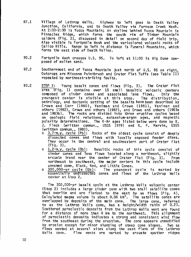
87.1
90.2
92.2
93.2
Village of Lathrop Wells. Highway to left goes to Death ValleyJunction, California, and to Death Valley via Furnace Creek Wash.At 2:00-2:30 is Yucca Mountain; on skyline behind Yucca $lountainisPinnacles Ridge, which forms the south rim of Timber Mountaincaldera (Fig. 2), discussed in detail on second day of field trip.Also visible is FortymileWash and the varicoloredvolcanic rocks ofCalico Hills. Range to left in distance is Funeral Mountains,whichforms the east side of Death Valley.
Fortymile Wash crosses U.S. 95. To left at 11:00 is Big Dune com-posed of eolian sand.
Southernmostend of Yucca Mountain just north of U.S. 95 on right.Outcrops are Miocene Paintbrushand Crater Flat Tuffs (see Table II)repeated by northeast-striking faults.
STOP 2: Young basalt cones and flows (Fig. 3). The Crater Flatarea (Fig. 1) contains over 15 small basaltic volcanic centerscomposed of cinder cones and associated lava flows. Only theyoungest center is visible at this stop. The distribution,petrology,and tectonic setting of the basaltshavebeen describedbyCrowe and Carr (1980), Vaniman and Crowe (1981), Vaniman andothers (1982), Crowe and others (1982), and Crowe and others (1983aand 1983b). The rocks are divided into three eruptive cycles basedon geologic field relations, potassium-argon ages, and magneticpolarity determinations. The K-Ar ages listed below were done by R.J. Fleck (written commun., USGS 1979) and R. F. Marvin, USGS(writtencomnun., 1980).o 3.7-m.y. cycle (Pb): Rocks of the oldest cycle consist of deeply
dissected cones and flows with locally exposed feeder dikes.They occur in the central and southeastern part of Crater Flat(Fig. 3).
o 1.2~m.y. cycle (Qb): Basaltic rocks of this cycle consist ofcinder cones and lava flows located along a northeast, slightlyarcuate trend near the center of Crater Flat (Fig. 3). Fromnortheast to southwest, the major centers in this cycle includeunnamed cone, Black, Red, and Little Cones.
o 300,000-yr cycle (Qb): The youngest cycleessentially undissected cones and flows of thecenter at Stop 2.
The 300,000-yr basalt cycle at the Lathrop Wells(Stop 2) includesa large cinder cone with two small
is marked byLathrop Wells
volcanic centersatellitecones
that overlie and are flanked to the east by aa flows (Fig. 4).Calculated magma volume is about 0.06 km’. The satellite cones areoverlapped by deposits of the main cone. The large cone, referredto as the Lathrop Wells cone, has a height/width ratio of 0.23.Scattered pyroclasticdeposits from the Lathrop Wells vent are foundfor a distance of more than 4 km to the northwest. This alignmentof pyroclastic deoosits indicates a strong and consistent wind flowfrom the southeast during the eruption. The cone appears unmodifiedby erosion except for minor slumping of steep cone slopes. Two aaflows vented at several sites along the east flank of the LathropWells cone. Flow vents are marked by arcuate spatter ridges
10

BIACK MOUNTAINCALDERA
L?-.
TOLICHAP&ZK A SILENTCANYONCALDERA
\
‘;L?;:~”~OASIS VALLEY-
CALDERA SEGMEN
BEAIN
T
PROW PASS ANDBULLFROG CALDERA
\
0—
10 20 MILES
OAK SPRINGBWE
o lb io
OUTERLIMITOFTIMBER tllllcMOUNTAIN-SILENTCANYONCALDERACOMPLEX.DASHEDWHERE INDEFINITE.
Fig. 2.
. . .KILOMETERS
PERIPHERYOFTIMBERMOUNTAINRESURGENTDOME.
NTS region showing caldera outlines,known and inferred.
extending east and southeastof the cone. The 1avas have unmodifiedflow margins and rubbly flow surfaces consistent with their youngage. They are 1ocally covered by loess and eolian sands. Theprobable oldest deposits of the Lathrop Wells cone are well-beddedpyroclastic (base) surge deposits (Fig. 5) that are exposed only onthe northwest side of the cone where they overlap a topographicridge upheld by welded tuff. They probably underlie the scoriadeposits of the cone and thus record an episode of phreatomagmaticactivityduring the early eruptive stages of the center.
The ages of the Quaternary alluvial deposits are consistent withages on the basalt. Before eruptions, alluvium of middle Pleisto-cene age locally developed a dense K-horizon that gave a uraniumseries age of about 345,000 yr (Fig. 5). The pyroclasticmaterialbecame incorporatedlocally in upper Pleistocene alluvium (Fig. 5),
11

ll& 35’
3& 45’
N1/ 9 n QUATERNARYALLUVIUM
u!;;:$:QUATERNARYBASALTLAVAm,’.:~PLIOCENEBASALTLAVA
QUATERNARYOR PLIOCENEPYROCL4STICDEPOSITS
- SLIDEBLOCKOFu~.:;’;:”.~PALEOZOICROCKS
MIOCENE-TUFFS,LAVAS,SEDIMENTS
,,:;...:+,:,PALEOZOICSEDIMENTARYm~“::+::ROCKS
o 5
Fig. 3.Southern Crater Flat area showing basalt centers and Stops 2 and 3 (modifiedfrom Crowe and Carr, 1980).
and a Ioessial silt deposit accumulated on the cinder cone andregionallyon the Q2 alluvium before about 25,000 yr ago.
The structural controls for the location of the center are notobvious. The cone, Suinmitcrater, and the satellite cones arealigned northwesterly,probably due to northwest-trendin9structuralcontrol. Faults striking north-northeastare also present thoughpoorly exposed. The center is located on a regional northeast-trending structural lineament marking the western edge of theSpotted Range-hline Mountain northeast-trending structural zone(Figs. 3 and 6); faults west of this Iineament have a more northerlytrend. It is suggested that the strike of the faults influencedthelocation of the center; that is, the eruptions were fed from dikeswhose trends were controlled by the regional stress field, i.e.,least compressivestress direction.
12

.nm
l
u.1-0-10
13

c.-
I!il:.:....::......B :,”..::.
.............:::,:.::,..................,...~..::........::
.-Nuw
-=mv‘G>*mUI
E.1-.s
14

1I& 30’
EXPLANATION
L
{
APPROX. AGE, M.Y
~ [~~ CINDERS
~ ~~ ~A~~~~~”A
(0.3)
s
{
~ TIMB.ERMCWNTAIN?’”FF (112)
# [~] PAINTBRUSHTUFF (12.8)
~ ~j CRATERFL4TT”FF (13.5)
m ~FFANDsEDIME~ARYR~C~s
~ ‘- FAULT,BARAND BAU ON DOWNTHROWN SIDE
Fig. 6.Generalized geologicmap of type section area of Crater F1at Tuff (Stop3).
The basalts of the Lathrop Wells center are sparsely porphyriticwith olivine as the major phenocryst phase (3 modal percent). Theydiffer from the 1.2-m.y. basalts by having a slightly greaterolivine content and a greater amount of unaltered basalt glass.Also the cores of olivine phenocrystsare slightly more forsteritic(Fe,,–,, ) than 01ivines of the 1.2-m.y. CYC1e (Fe,,–,. ), asdetermined by probe. Groundmass phases also include plagioclase(zoned from An,, to more alkaline compositions)and minor amounts ofolivine, pyroxene, and iron-titaniumoxides plus interstitialglass.Textures of the basalts of the Lathrop Wells center are hyalopiliticto pilotaxitice A detailed discussion of the mineralogy and geo-chemistry of the Lathrop Wells center is found in Vaniman and Crowe(1981) and Vaniman and others (1982).
Lavas of the Lathrop Wells center have been dated at about300,000 yr, consistent with the lack of erosional modification ofboth cones and flows. The basalts are normally magnetized and thus
15
assigned to the Brunhes Normal Magnetic Epoch. The three K-Ardatesare 300,000 yr for agglutinate in the sumnit crater, 290,000 yr forthe lava, and 230,000 yr on a bomb (Fig. 5) collected near the baseof the cinder cone. We believe the age on the bomb is probably theleast reliable age because of its discordance with the older ages,which are in close agreement.
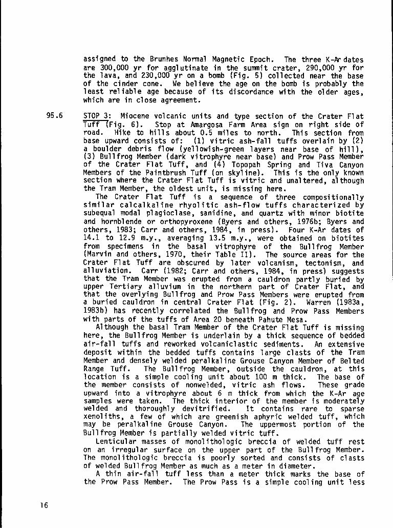
95.6 STOP 3: Miocene volcanic units and type section of the Crater Flat~Fig. 6). Stop at Amargosa Farm Area sign on right side of
● Hike to hills about 0.5 miles to north. This section frombase upward consists of: (1) vitric ash-fall tuffs overlainby (2)a boulder debris flow (yellowish-greenlayers near base of hill),(3) Bullfrog Member (dark vitrophyre near base) and Prow Pass Memberof the Crater Flat Tuff, and (4) Topopah Spring and Tiva CanyonMembers of the PaintbrushTuff (on skyline). This is the only knownsection where the Crater Flat Tuff is vitric and unaltered,althoughthe Tram Member, the oldest unit, is missing here.
The Crater Flat Tuff is a sequence of three compositionallysimilar calcalkaline rhyolitic ash-flow tuffs characterized bysubequal modal plagioclase,sanidine, and quartz with minor biotiteand hornblende or orthopyroxene(Byers and others, 1976b; Byers andothers, 1983; Carr and others, 1984, in press). Four K-Ar dates of14.1 to 12.9 my., averaging 13.5 my., were obtained on biotitesfrom specimens in the basal vitrophyre of the Bullfrog Member(Marvin and others, 1970, their Table II). The source areas for theCrater Flat Tuff are obscured by later volcanism, tectonism, andalleviation. Carr (1982; Carr and others, 1984, in press) Sug9eStsthat the Tram Member was erupted from a cauldron partly buried byupper Tertiary alluvium in the northern part of Crater Flat, andthat the overlying Bullfrog and Prow Pass Members were erupted froma buried cauldron in central Crater Flat (Fig. 2). Warren (1983a,1983b) has recently correlated the Bullfrog and Prow Pass Memberswith parts of the tuffs of Area 20 beneath Pahute Mesa.
Although the basal Tram Member of the Crater Flat Tuff is missinghere, the Bullfrog Member is underlainby a thick sequence of beddedair-fall tuffs and reworked volcaniclasticsediments. An extensivedeposit within the bedded tuffs contains large clasts of the TramMember and densely welded peralkalineGrouse Canyon Member of BeltedRange Tuff. The Bullfrog Member, outside the cauldron, at thislocation is a simple cooling unit about 100 m thick. The base ofthe member consists of nonwelded, vitric ash flows. These gradeupward into a vitrophyre about 6 m thick from which the K-Ar agesamples were taken. The thick interior of the member is moderatelywelded and thoroughly devitrified. It contains rare to sparsexenoliths, a few of which are greenish aphyric welded tuff, whichmay be peralkaline Grouse Canyon. The uppermost portion of theBullfroq Member is partiallywelded vitric tuff.
Lent~cular masses of monolithologicbreccia of welded tuff reston an irregular surface on the upper part of the Bullfrog Member.The monolithologicbreccia is poorly sorted and consists of clastsof welded BullfrogMember as much as a meter in diameter.
A thin air-fall tuff less than a meter thick marks the base ofthe Prow Pass Member. The Prow Pass is a simple cooling unit less

103.9
105.8
109.9
113.8
115.2
117.4
119.0
119.5
120.1
120.7
123.7
125.2
125.4
than 50 m thick, having a nonwelded vitric basal zone, a partiallywelded devitrifiedinterior,and a nonweldedvitric upper zone.
The Prow Pass is overlain by several meters of bedded tuff and bythe Topopah Spring and Tiva Canyon Members of the PaintbrushTuff.
After stop, turn around and return east on U.S. 95.
Turn left on road to Lathrop Wells guard gate of the NTS.
Entrance to NTS through Lathrop Wells guard gate. Badge check.
At approximately3:00 view Little Skull Mountain, capped by Miocene(approximately10 my. R. F. Marvin, USGS written commun., 1980)basalt of Skull Mountain, underlain by faulted Miocene TopopahSpring Member of the Paintbrush Tuff and tuffs of the WahmonieFormation. Low hills at foot of mountain contain outcrops of theTram and Bullfrog Members of the Crater Flat Tuff. Busted Butte at10:00 is a complete section of the Topopah Spring Member overlainbyTiva Canyon Member of the Paintbrush Tuff. Low, white water tank isat Well J-12 at the edge of Fortymile Wash. Long ridge on skyline tonorthwestis Yucca Mountain.
Low hills at 10:00 are Topopah Spring Member capped by 9.6 m.y.-oldbasalt (R. F. Marvin, USGS written commun., 1980) of [EngineMaintenanceand Disassembly(EMAD)I.
North side of Skull Mountain at 1:30. Fran top to bottcxnis basaltof Skull Mountain, Rainier Mesa Member of Timber Mountain Tuff,Topopah Spring Member of PaintbrushTuff, and Wahmonie lavas.
Turn left onto road next to the Nevada Research and DevelopmentArea(NRDA) facility (formerlyNuclear Rocket DevelopmentStation).
On skyline at 12:00 Shoshone Mountain is capped by 8.9 m.y.=yr oldrhyolite lavas (R. F. Marvin, USGS written commun., 1980).
Turn left and proceedwest toward Yucca Mountain.
EMAD facility to left. Originally used for nuclear rocket enginemaintenance,now operated by Westinghousefor handling and temporarystorageof nuclear waste.
Rocket assembly facility at 3:00, one of several built in con-junction with NRDS in 1960’s.
Busted Butte at 11:00.
Road to water Well J-13. Fran Ridge in foreground to west iscomposed of Topopah Spring Member, overlain by light-coloredbeddedtuff and Tiva Canyon Member.
Crossing FortymileWash.
17

125.9 Turn left at sign for Nevada Nuclear Waste Storage Investigations(NNwSI) drill hole USW G-3. Follow geography and generalizedgeology on Fig. 7 to Stop 4.
128.1 Round southern end of Fran Ridge. To south at 9:00 is Busted Buttecomposed of Paintbrush Tuff cut by a narrow structural slicecontaining parts of the entire Tiva Canyon Member. Dips range fromsteeply westward to overturned within a 100-m-wide zone. On theright are exposures of lithophysal cavities and north-northwest-strikingfracturesin Topopah Spring Member in outcrops along wash.
128.4 On the skyline at 10:00 is Yucca Crest, at 12:30 Boundary Ridge, at2:00 Bow Ridge, at 2:45 P-1 Hill, and at 3:30 Fran Ridge, allexposing Paintbrush sequence. Ridges are created by west-dippinqmajor normal faults on west side of each ridge. Strata underlyingridges dip eastward; major normal faults are accompanied by highlybrecciatedwest-dippingstrata.
130.0 To right along Boundary Ridge, a 20° angular unconformity existsbetween 11.3 my. Rainier Mesa Member and the underlying 12.6 my.Tiva Canyon Member (Marvin and others, 1970). Rainier Mesa Memberlaps across major faults with only minor displacement of theRainier Mesa.
130.6 Turn left toward Yucca Crest. On either side are a series ofwest-dipping normal faults that displace the caprock of Tiva CanyonMember, repeating the section. At 12:00 approaching a 20° to 30°dip slope; this contrasts with Yucca Crest that dips at only 5° to7°.
130.8 STOP 4: Park bus at drill hole WT-1 site at mouth of AbandonedWash. Hike west about 1.5 km to road at top of Yucca Mountain;examine fault patterns and compositional and cooling zonations inthe Tiva Canyon Member. The generalized map and accompanyingdetailed geologic section (Fig. 7) show this part of Yucca Mountainto consist of a series of north-trending,eastward-tiltedstructuralblocks, repeated by west-dippingnormal faults. West-dipping strataalong these normal faults are interpretedas drag zones. On YuccaCrest strata dip eastward at 5° to 7°; however, to the east, strataalso dip eastward, but conunonlyfrom 20° to vertical. Coincidentwith the dips greater than 20° are abundant west-southwest-dippingfaults with 1 m to 5 m of vertical displacement. These faults andrelated fractures are nearly perpendicularto tuff foliations, sug-gesting rotation. In addition to required rotation of the faultplanes and interveningblocks, graben-likefeatures (Fig. 7+h~u~~f:ta geometric control by the shape of major normal faults.tude of major faults decreases from the average of 70° at the sur-face to 60° at depth as suggestedby some drill holes. The develop-ment of tension gashes would evolve into rotated normal faults andrelated grabens with qreater degrees of extension. On Busted Butte,rotated fault slices extend to depths greater than 200 m; if thisgeometry is typical, then any decrease in dip on the major normalfaults must occur at greater depths.
18

..e-
.uL19

139.3
145.0
157.3
158.7
162.7
163.6
164.7
166.6
169.6
173.0
20
From the top of Yucca Mountain,you can see the upper Precambrianand Paleozoic rocks of Bare Mountain and Pliocene and Pleistocenecinder cones and basalt lavas in Crater Flat. The steep east-facingfront of Bare Mountain may be a major bounding fault formed duringsubsidence of the caldera complex (Fig. 2) that is the probablesource of the Crater Flat Tuff.”
LunC’h. Hike back down to bus. Turnturn off for NNWSIdrill hole G-3.
Turn left on main paved road at sign(USW) drill-holeUSW G-4.”
around and retrace route to
“Underground Storage, Waste
(Dependingon time,STOP 5: this stop may be canceled). Explora-tory Hole USW G-4 for proposed exploratory shaft to test TopopahSpring Member as candidate host for nuclear waste repository. Turnaround and retrace route back to NRDA facility.
Turn right at NRDA camp facilities.
Proceed through intersection;Bare Reactor Experiment-Nevada(BREN)Tower (height480 m) at 10:00.
At the divide, Skull Mountain is separated from Little SkullMountain to southwestby northeast-strikinghigh-angle fault system,down to the northwest. There is also probably a strong left-lateralstrike-slipcomponent.
Light-coloredmassive tuff at 3:00 is nonwelded Bullfrog Member ofthe Crater Flat Tuff.
Specter Range at 12:00 composed of lower Paleozoiccarbonate rocks.
Road crosses southeast-facingeroded fault scarp in alluvium; faultis part of Rock Valley system of northeast-striking Quaternaryfaults (locationB, Fig. 8).
Turn off at 5310 Road.
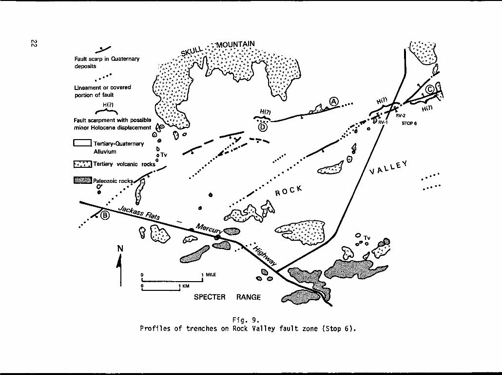
STOP 6: Trench RV-2 on strand of Rock Valley fault system. In~two trenches were dug across one of the most prominentQuaternary strands of the Rock Val1ey fault system, a part of amajor northeast-striking,seismicallyactive, structuralzone in thesoutheastern NTS area. The location of the fault scarps andtrenches is shown on Fig. 8. The stop is at trench RV-2.
The trend (RV-2,Fig. 9) is cut across the scarp at a point whereit is only about 1.5 m high and has a maximum slope angle of about6°. Along most of the scarp, farther northeast, the height of thescarp, accentuated somewhat by erosion, is as much as 4 m and theslope angle is about 8°. In several drainages the scarp has beencompletely breached and removed by erosion east and west of thetrench location.
The trench is cut mainly in Q2 alluvium, whose age is generallybetween about 35,000 and 750,000 yr (Hoover and others, 1981).

SO uth
-- .. . . .
Main ~OU/tWestWall,TrenchRV-f North
Surfaco Scrmpl. RV-lU
moula~rmSample 97
XJ & L LXJJ ~ -- x---. Gray slightly indurotod san~ . Qz )+ . \ . !.-. J”. ,“>\;:
wilh scatltrod P6 bbloa, - — ‘“-”—’ ‘“—” —”—”-” —”—”-”cobblos and bouldore 02
~—–“s-i-”:”-lJ t‘‘i
‘amp’” ‘“-’L \!
EXPLANATIONN ~Dislurb@d zone, Modern raollots ond
Xxxxx Soil Calictlo j~f Root tubts coIicho - fi Ilsd root tu bcs.
—.—. —. — Clayey horizonSloughs due to weak comento Ilan
— --- Contoct, dashed where vogue or uncartain AGES
&’ Faull or fracture, dashed where uncertainSomplo97:1 230 Th/234u 098 of>5,000yrS.Som~lo82:
I
Qf Holocene alluviumSom~t 307: U-Trendof38,000t 10,000yrs.
02 Inlarm#dIot# olluvlum(Middle and LOie PI eistocena)SompleRV-tU: U-Trendageof31,000k5,000yrs.
QTo Old#r olluvlum ( Pliocon@ (?J ond Earl} plol~~Oc~n*JSomplc RV-l L: U- Trend age of 310,000 f 30,000yrs.
3 U- Trend Sampla Ioca tlon
Nor? h EastWall,TrenchRV-2 Ma#n FaultLlafIl orrsnae - brown. cla YoY 1
SOU thScarp
Sample 307 -
QI... . ......... ..:..:.,
J
10
5
r
3QTa: Probable K zone of
burltd B zone h
5 /0 tro nch B zone ~ ‘“’th ‘“’t ‘f ‘r’nchDIsturbed zone i Many root tubes
Fig. 8.Sketch map of Quaternaryfaults in Rock Valley (Stop6).
N
\““.
I““.
22
i-+0Ln
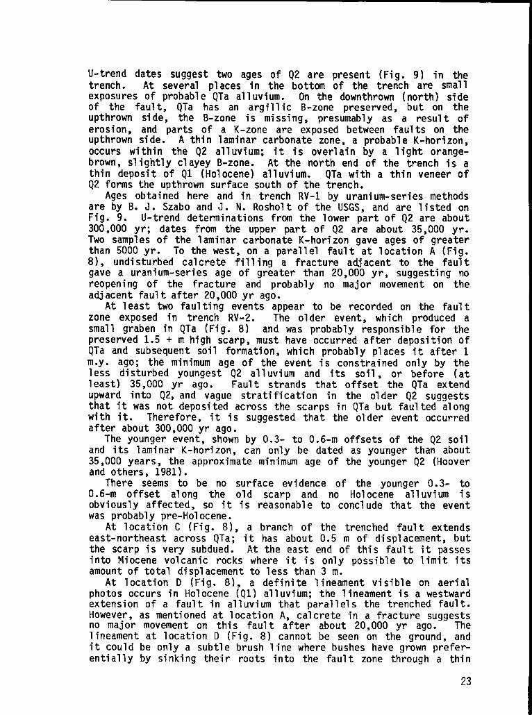
U-trend dates suggest two ages of Q2 are present (Fig. 9) in thetrench. At several places in the bottom of the trench are smallexposures of probable QTa alluvium. On the downthrown (north) sideof the fault, QTa has an argillic B-zone preserved, but on theupthrown side, the B-zone is missing, presumably as a result oferosion, and parts of a K-zone are exposed between faults on theupthrown side. A thin laminar carbonate zone, a probableK-horizon,occurs within the Q2 alluvium; it is overlain by a light orange-brown, slightly clayey B-zone. At the north end of the trench is athin deposit of Q1 (Holocene)alluvium. QTa with a thin veneer ofQ2 forms the upthrown surface south of the trench.
Ages obtained here and in trench RV-1 by uranium-seriesmethodsare by B. J. Szabo and J. N. Rosholt of the USGS, and are listed onFig. 9. U-trend determinationsfrcnnthe lower part of Q2 are about300,000 yr; dates from the upper part of Q2 are about 35,000 yr.Two samples of the laminar carbonate K-horizon gave ages of greaterthan 5000 yr. To the west, on a parallel fault at location A (Fig.8), undisturbed calcrete filling a fracture adjacent to the faultgave a uranium-seriesage of greater than 20,000 yr, suggesting noreopening of the fracture and probably no major movement on theadjacent fault after 20,000yr ago.
At least two faulting events appear to be recorded on the faultzone exposed in trench RV-2. The older event, which produced asmall graben in QTa (Fig. 8) and was probably responsible for thepreserved 1.5 + m high scarp, must have occurred after depositionofQTa and subsequent soil formation,which probably places it after 1my. ago; the minimum age of the event is constrained only by theless disturbed youngest Q2 alluvium and its soil, or before (atleast) 35,000 yr ago. Fault strands that offset the QTa extendupward into Q2,and vague stratification in the older Q2 suggeststhat it was not deposited across the scarps in QTa but faulted alongwith it. Therefore, it is suggested that the older event occurredafter about 300,000yr ago.
The younger event, shown by 0.3- to 0.6-m offsets of the Q2 soiland its laminar K-horizon, can only be dated as younger than about35,000 years, the approximateminimum age of the younger Q2 (Hooverand others, 1981).
There seems to be no surface evidence of the younger 0.3- to0.6-m offset along the old scarp and no Holocene alluvium isobviously affected, so it is reasonable to conclude that the eventwas probably pre-Holocene.
At location C (Fig. 8), a branch of the trenched fault extendseast-northeastacross QTa; it has about 0.5 m of displacement,butthe scarp is very subdued. At the east end of this fault it passesinto Miocene volcanic rocks where it is only possible to limit itsamount of total displacementto less than 3 m.
At location D (Fig. 8), a definite lineament visible on aerialphotos occurs in Holocene (Ql) alluvium;the lineament is a westwardextension of a fault in alluvium that parallels the trenched fault.However, as mentioned at location A, calcrete in a fracture suggestsno major movement on this fault after about 20,000 yr ago. Thelineament at location D (Fig. 8) cannot be seen on the ground, andit could be only a subtle brush line where bushes have grown prefer-entially by sinking their roots into the fault zone through a thin
23

cover of Holocene alluvium. Because the evidence that the latestevent was pre-Holocene is not compelling, however, it is notpossible to rule out an important earthquake of Holocene age on theRock Valley fault system.
176.9 Turn left onto Jackass Flats Highway.
183.6 Junction of Jackass Flats Highway and road to Camp Desert RockAirport.
188.0 STOP 7: Arrive Mercury, visit USGS Core Library. (Depending ontime schedule, the ~resentationsulanned for this sto~ may be qivenin the
Introduction
Theat the
evening after dinner at the’Mercury Steakhouse.)’ “ -
Geologic Data Center and Core Library, maintained by the USGSNTS, is a depository for systematic processing,cataloging,
and storage of drill-bit cuttings, drill” core, and other rocksamples from the NTS and other test areas. The facility maintainsreference files of reports,maps, aerial photographs,downhole videotapes of selected drill holes, geophysical logs for NTS and othertest areas, and waste-managementdrill holes. Handling of watersamples for both chemical and radiologicalanalyses is expedited ina hydrologic-chemicallaboratory. The facility serves as field head-quarters for USGS geologists, hydrologists, and geophysicists andserves as a work area for earth scientists in support of weaponstesting and waste-managementprojects of the Department of Energy(DOE).
The Data Center complex comprises the three conjoined buildingsat Stop 7 and three other buildings. To date, storage has beenprovided for about 760,000 m of drill-hole samples stored in about50,000 boxes. Drill-hole samples include drill-bit cuttings,nominally collected each 3 m of drilled interval, borehole sidewallsamples, Percussion-gunborehole sidewall samples, and conventionaldiamond-bitcore samples ranging in diameter from about 2-1/2 to asmuch as 20 cm. Samples represent rocks penetrated in vertical,horizontal,or oblique-angledrill holes, which average about 550 min length, but range from about 60 m to 4,171.5 m in depth and fromabout 2 m to 1,124.7 m in horizontalpenetration. Detailed records,comprising thousands of data cards, are maintained on all samples,including date received at the library, source, and final storage ordisposition.
Use of Rock Samples
Continuous core, sidewall samples, and rock cuttings stored atthe Core Library have been used to resolve geologic problemsencountered by programs such as nuclear test containment and radio-active waste storage. Primary minerals and whole rocks are analyzedto help correlate volcanic units found at NTS, and secondary(diagenetic) minerals have been studied intensively for theircapability in inhibiting migration of radioactive nuclides.
24

Examples of both types of work are descrit)edbelOW. Petrographiccexhibits of various types of rock samples wi11 be available forinspectionat the Core Library.
PrimaryMinerals
One major project undertaken by Los Alamos National Laboratoryhas been to analyze phenocrystminerals and whole rocks to model theentire upper Tertiary volcanic sequence at NTS. Recent work hasallowed accurate correlation of individual petrologic units, gener-ally corresponding to member rank,(i.e.,
and entire petrologic suitesTimber Mountain or Paintbrush Tuffs), which occur in two
widely separated locations– Yucca Mountain and Pahute Mesa (Warren,1983a, 1983b) . Spatial distribution patterns of correlativepetrologic units define the Timber Mountain-Oasis Valley magmaticsystem as the primary source for the entire volcanic package. Thisfact, along with supportinggeochemicaldata, indicates that the NTSvolcanic pile is indeed the effusive product of a single, large,evolving rhyolitic magma body (e.g., Hildreth, 1981) that waslocated beneath the present expression of the Timber Mountainca1dera. The model inferred for the sequence involves bvo pro-cesses: injectionsof new magma and heat from below and continuingmagmatic differentiation. Successive petrologic suites exhibitdramatically different mafic mineral chemistry, which is theorizedto be the result of influxes of magma (usuallybasaltic) from depth.Individual petrologic units within the petrologic suites each show adistinctive feldspar chemistry (Broxtonand others,1983), whichprobably is caused by differences in pressure, temperature, andcompositionalregims within the evolving magma body.
Good evidence for the probable cause of chemical changes betweensuccessive petrologic units can be seen in the transitional-beddedtuff unit (Tmpt), which lies between the Timber Mountain andPaintbrush Tuffs and shows petrochemistry characteristic of bothvolcanic suites. It contains quartz phenocrysts along with asubstantial ZiI’IIOUnt Of fOrS&2ritiC OliVinE! (F076- 80). Severa1observations indicate that this nonequilibriummixture is caused bythe mixing of rhyolitic and basaltic liquids. At one drill site, anolivine-bearingalkali basalt layer was cored between the Tmpt unitand the top of the Paintbrush Tuff. AlSO , basalt fragments arepresent in all samples of Tmpt. A particularly large basaltfragment seen in thin section shows i highly reacted and poorlydefined boundary with the tuff matrix, which suggests that thebasalt was still liquid when mixed with the tuff. Finally, olivinexenocrysts observed in the inclusions or in Tmpt have altered rimspresumably due to reaction with a rhyolitic magma having a highsilica activity. These features are all illustrated in core, thinsections, chemical diagrams, and photomicrographsdisplayed at thisstop.
SecondaryMinerals - Zeolitizationat Yucca Mountain
Many of the glassy volcaniclasticrocks at NTS have been zeoli-tized during low-temperature diagenesis. Typical hydrous mineralproducts of glass alteration are clinoptilolite,mordenite, and, at
25
greater depths, analcime. Diagenetic processes and products at NTShave been describedby Hoover (1968)and Moncure and others (1981].
Drill cores, sidewall cores, and outcrop samples from YuccaMountain, Busted Butte, and vicinity contain examples of zeolitizedtuff that may not have resulted from diagenesis. The lower vitro-phyre (densely welded glassy tuff) in the Topopah Spring Member ofthe Paintbrush Tuff has been altered to smectite and the zeoliteheulandite along the boundary between the vitrophyre and overlyingdevitrified densely welded tuff. This boundary, as seen in outcropat Busted Butte and in drill holes, Fig. 10, is actually a transi-tion zone about 6 m thick with interpenetratinglobes of vitric anddevitrified tuff. Fractures extending downward into the vitrophyreare bordered by devitrified zones, composed mostly of feldspar andcristobalite (Vaniman and others, in preparation) as much as 0.3 mthick. The outermost portions of these fracture-controlleddevitrified zones contain heulandite and smectite. Core fran drillhole USW GU-3 (sample at 364.2-m depth) contains an excellentexample of such alteration. The textural associationof heulanditeand smectitewith devitrificationproducts suggests that the hydrousminerals may have crystallizedduring subaerial cooling of the tuff(Levy, 1983).
The degree and extent of alteration w-thin the vitrophyre arehighly variable (Fig. 10). At some sites, the hydrous minerals formonly a thin rind along the boundary between devitrified tuff andvitrophyre and comprise about 1 wt% or less of the altered vitro-phyre (e.g., drill core USW GU-3, outcrop at Busted Butte). Else-where the vitrophyre is highly altered to depths of up to 15 m belowthe devitrified-vitricboundary and locally contains up to about 15wt% heulandite and 60 wt% smectite, based on x-ray diffraction(e.g., sidewall core USW H-5 and drill core UE25a#l). The reasonsfor this variability are unclear. Highly altered vitrophyre hasbeen observed only in drill cores (it may weather too easily to bepreserved in outcrop), which provide minimal information aboutpossible alteration-controllingfactors such as fracture abundance.The proposed exploratory shaft at the USW G-4 site may answer someof these questions.
DAY 2
0.0 Leave Mercury heading north on Mercury Highway (Fig. 1) from housingarea. View of Red Mountain-Mercury Ridge geology (Barnes andothers, 1982). Red Mountain, between 9:00 and 12:30, is composed ofgray and brown Ordovician Antelope Valley Limestone through EurekaQuartzite on left, Ely Springs Dolomite and Silurian dolomite onright. Strata on Red Mountain generally dip eastward. MercuryRidge, between 1:00 and 2:00, is composed mainly of Devonian NevadaFormation and Devils Gate Limestone. North Ridge, between 2:00 and3:00, is composed of Middle and Upper Cambrian carbonate rocksthrust over Devonian and Mississippian rocks (Spotted Range thrust)in the axial portion of the Spotted Range syncline. South Ridge,between 2:30 and 4:00, consists of Ordovician through Mississippianrocks that form the southeast limb of the Spotted Range syncline.Tower Hills, at 4:00, are Devils Gate Limestone. Specter Range indistance, between 7:00 and 9:00, contains Cambrian through Devonian
26

704
6P
50-
40-
30-
20-
lo-
FT.
21
18
’15
’12
“9
“6
-3
M.
t, ,, !/t -. -J\
1
.:< -t/,s
k..... ,’,:
“.,-:, y
-:
<
,.; \/ - .>:., .,. ~ .
!.,-,!’ ,,, -... .-. ,,~,“.:.
. . . .
,., - &“’-_”’
5!5=f?---..--.,.:.+,J
,,, ,.. ., . .
,-. .. ‘~’..... -.
-.--
-=
—
.’.
.-
0--”
DEVITRIFIEDDENSELYWELDED TUFF
DENSELYWELDED GLASSYTUFF(VITROPHYRE)
AODERATELYWELDED GLASSYTUFF
FRACTURES
HYDROUS ALTERATlONPRODUCTS
SURFACE
500ft
~i
250m
100oftTOPOPAHSPRINGMEMBEROFPAINTBRUSHTUFF
CANDIDATEINTERVALFOR1500ft REPOSITORYCONSTRUCTION
500m EXPANDEDINTERVALAT LEFT
Fig. 10.Lithology of the vitrophyre of the Topopah Spring Member of the PaintbrushTuff (Stop 7), generalizedfrom dri11 holes on Yucca Mountain.
rocks, and a major thrust fault (Specter Range thrust) that bringsUpper Cambrian and Ordovician rocks over middle and upper Paleozoicrocks (Sargentand Stewart, 1971), a structural situation similar tothat mentioned at Stop 1 in the southwestern part of the SpottedRange. The Spotted Range thrust and the Specter Range thrust may beparts of a single major thrust system (CP thrust) in the NTS area.Northeast-trending topography is controlled by N45”-60”E trendingTertiary left-lateral strike-slip faults of the Spotted Range-MineMountain structuralzone.
1.9 CheckpointPass
3.3 STOP 8: Turn left off road at Pump Station No. 4. Facing north and‘g counterclockwise: Ranger Mountains at 2:00 are composed of
27

southeast-dipping Paleozoic rocks from carbonate rocks of theOrdovician Pogonip Group through Devonian Nevada Formation. 01derTertiary gravels form low hills in foreground. At 1:00 is FrenchmanLake playa and beyond is Nye Canyon, containing several basaltcenters dated between 6.0 and 7.0 my. (R. F. Marvin, USGS writtencommun., 1980). High peak on skyline is Bald Mountain in the GroomRange 80. km to north-northeast. French Peak and MassachusettsMountain at 12:00 on the northwest side of Frenchman Flat consistprimarily of faulted Paintbrush and Timber Mountain Tuffs.Flat-toppedmountain on distant skyline at 11:30 is Oak Spring Butteat north end of Yucca Flat. Stratigraphic relationships in theareas of Yucca and French Flats are shown in Fig. 11.
At northwestcorner of Frenchman Flat are CP Pass and CP Hogback(named after Control Point Headquarters). To left of CP Pass arethe CP Hills composed of Cambrian rocks and Mississippianrocksoverlain by Tertiary volcanic rocks. High skyline in far distanceat 11:00 is Rainier Mesa. Directly to the left of Rainier Mesa onthe skyline is Tippipah Point. At 10:00 on skyline is ShoshoneMountain, which forms part of the southeast rim of Timber Mountaincaldera. In the intermediate foreground at 10:00 are the inter-mediate lavas of the Wahmonie-Salyervolcanic center on the north-east end of Skull Mountain. Hampel Hill at 9:30 in intermediatedistance is capped by the Ammonia Tanks Member of the TimberMountain Tuff, which is underlainby eolian sandstone.
At 10:00 and 2:00 in the near distance (1.6 to 3 km) are hills ofTertiary gravels and the tuffaceous sedimentary rocks of PavitsSpring. Light-coloradlacustrinelimestonesof the underlyingHorseSpring Formation are seen at 7:00 to 8:00 where they onlap or arefaulted against the Paleozoic rocks. The Horse Spring contains atuff bed dated at 29.3 my. (Marvin and others, 1970), which isprobably airfall of the Needles Range Formation of eastern Nevada(Barnes and others, 1982). Continue north on Mercury Highway.
5.3 At junction of Mercury Highway and 5A Road proceed straight on 5ARoad into FrenchmanFlat.
6.0 To left, look along Rock Valley where Quaternary fault scarps havebeen recognized. Fault zone crosses road at approximately thispoint and continuesnortheastto foot of Ranger Mountains.
7.0 Gravel pits to right provide material used in the stemming of drillholes used for nuclear tests. Thickest alluvium (1220 m) inFrenchman Flat, as determined by gravity, is approximately 3 kmnorthwestof FrenchmanLake.
10.0 Y in road. At 9:00 observe structurestested by nuclear blasts.
11.6 At 10:00 dark re-entrant is vitrophyre lava of the WahmonieFormation onlapped by Topopah Spring Member of the PaintbrushTuff.
12.5 Turn left.
12.9 STOP 9: Turn left onto gravel road. Radionuclide Migration (RNM)project site (Fig. 12). The RNM project was initiated in 1974 to
28

NORTH SOUTH
N.W.FrenchmanFlat
salt
I I I I I I \) 1 1 1 I I I
1 I I 1 I I I1 1 I I 1 I 1 i
Y km Lu
c1QTalALLUVIUMQ
:4 ~’”GROUSECANYON
“<. MEMBER,BELTED‘ RANGETUFF
n“;;;;.TIMBERMOUNTAINTUFF c1 TUBSPRINGMEMBER,T BELTEDRANGETUFF,.● ...
c1P PAINTBRUSHTUFF c1YTUFFOFYUCCAFIAT
1
cl-:-:-:-_WAHMONIE-SALYERm...,.:l.:.-—--
-=~-=--VOLCANICS “;.”::;;;:REDROCKVALLEYTUFF;:.
STOCKADEWASH TUFFc1
F FRACTIONTUFF
t 1I PS I ROCKSOF PAVITS SPRING
Q...o~~f~. HORSESPRINGFORMATION
❑M SHINGLEPASS ANDMONOTONY TUFFS
m\\’$. TUFFSAND TUFFACEOUSt SEDIMENTS, UNDIFF.
Q~O& COUUVIUM AND●●“* CARBONACEOUSCLAYSTONE
mPALEOZOICROCKS
Fig. 11.Diagrannnaticcross section from oak ‘Spring Butte to northwestern FrenchmanF1at, NTS, Stops 8 and 10.
study rates of the underground migration of radionuclides fromexplosion-modifiedzones at NTS. The Cambric event, detonated inFrenchman Flat in 1965, was chosen for the study for severalreasons. The Cambric explosion cavity is within the NTS Area 5water-supply aquifer, where leakage could have contaminated thewater supply. Hydrologic modeling indicated that sufficient timehad elapsed for ground water to fill the cavity and chimney to thepreshot static water level, which is 73 m above the detonationpoint. The Cambric detonation point is only 294 m below groundsurface, and thus the re-entry drilling and sampling operationswereless difficult and expensive than for more deeply buried tests. Thesite is also far enough from the areas of active nuclear testing sothat damage or interruptionof the re-entry and sampling operationsfrom those activitieswould be unlikelv. Sufficient tritium (3H orT) was present to providethe cavity region. Thecavity and chimney alsofission products so that
.an easily measurable tracer for water frompostshot debris and ground water in thecontained enough plutonium, uranium, andthey could be measured and compared. The
29

15.4
17.0
18.0
18.5
20.5
22.3
23.7
24.7
small nuclear yield from the Cambric event was expected to havelittle effect on the local hydrology. Further, it was judged thatthe alluvium constituted a good medium for hydrologic studiesbecause it was more permeable than tuff and did not have largefissuresor cracks through which the water might selectivelyflow.
The Cambric field studies can be divided into two phases. (1)The Cambric cavity region was recentered in 1974, and samples weretaken to determine the radionuclide distribution between the solidmaterial and water. (2) Beginning in October 1975, water was pum ed
Rfrom a satellite well located 91 m frcm the Cambric cavity; t isinduced a sufficient artificial gradient to draw water from theCambric cavity and provide an opportunity to study radionuclidetransportunder field conditions.
The RNM-25 satellite well has been pumped at the rate of about600 gal/rein. Samples are analyzedweekly for tritium. Beginning inthe summer of 1978, tritium was first detected and reached a peak of7000 pCi/m~ by late sumner of 1980, when the concentration oftritium began to decrease. By September 30, 1982, over 42% of thetritium from Cambric had been removed by the satellitewell. Thesetests significantly enhance our understanding of the ground-watertransport of radionuclides from nuclear explosion cavities ingeneral (Daniels,1983).
At 8:00 - 10:00 east-northeast-trendingQuaternary fault scarpsmay be visible in fans at the base of the Ranger Mountains. Returnto paved road, turn left.
Turn right at junction with Mercury Highway. Wahmonie rhyodaciticlavas form hills to west.
Intersectionof Mercury Highway and Cane Spring Road.
Dark layer low on cliff at 3:00 is the upper part of the Wahmonielavas underlyingvitrophyreof the Topopah Spring Member.
In distance at 10:30 is blue-gray limestone of the Cambrian BonanzaKing Formation Limestone thrust over brown argillites of theDevonian and Wis..sfssippianEleana Formation, overlapped by Tertiaryvolcanic rocks.
CP Hogback at 1:30 is composed of faulted blocks of Ammonia TanksMember of Timber Mountain Tuff dipping towardyou.
Cambrian Carrara Formation at 11:00 is folded into asymmetricanticline (McKeown and others, 1976). Vitrophyre of the TopopahSpring Member at 10:00; the same unit forms the low hill at 1:00,where it is faulted against the Amnonia Tanks.
Crest of CP pass.
STOP 10: View of Yucca Flat from News Knob.north of warehouse by News Knob. Facility to(CP), which houses equipment used to monitorNews Knob. Facing northward,at 3:00 to 1:00
Turn right onto roadwest is Control Pointnuclear tests. Climbis Halfpint Range; at
30

3fj050t&71
36°47’30” <
I o 1 2’
KM
CONTOUR INTERVAL 30.5 MFig. 12.
West-centralFrenchman F1at, showing I;cation of the RNM ExperimentNo. 1 site(stop 9)●
1:30 Slanted Buttesare capped by Rainier Mesa Member; at 1:00 isBanded Mountain (type locality of the Banded Mountain Member of theBonanza King Formation). At 12:00 is Oak Spring Butte cut on theeast side by the Butte Fault (a northward extension of the YuccaFault) which drops the caprock of Grouse Canyon Member 425 km downto the east; to the left of Oak Spring Butte is Argillite Ridge andTwin Peaks, which is on the east flank of a broad depositionalsyncline in Tertiary tuffs and underlying sediments with thinlaminae of coal. At 10:00 - 11:00 is Rainier Mesa, at 9:30 isTippipah Point, to the west at 7:00 to 10:00 are Paleozoic rocks ofthe CP Hills.
The southwest edge of Yucca Lake playa is parallel to andcoincident with an element of the Walker Lane belt -- theYucca-Frenchman right-lateral shear and flexure zone (Fig. 13).This structure trends northwest for about 40 km from the Spotted
31

EwUNATION
F;EE;9
+
i-
Southern
CONTACT BEIWEEN BEDROCK ANDALLUVIUM
FAULT--DOTI%D WHERE BURIED
FAULT OR FRACTURE OF QUATERNARY AGE
EARTHQUAKE EPiCENTER SHOWING THE
TWO FAULT-PLANE SOLUTIONS AND
PRESSURE AXIS (heavy line), AND DATE
AFTERSHOCK EPICENTER SHOWING
PRESSURE AXIS
115’52”30”
Fig. 13.Yucca F1at and Frenchman area. showinq structuralpattern, Quaternary
faults and fractures, and location- of earthquakes, their aftershocks,fault-piane solutions, and pressure axes (Stop 10).
Range, across northern Frenchman Flat, through the hills betweenYucca and Frenchman Flats, and along the southwesternside of YuccaF1at. It is exposed only in the hills southeast of Yucca Flat,where it consists of a complex shear zone exhibiting right-lateraldrag. This zone also marks the termination of a major system ofnortheast-striking, essentially left-lateral faults. Major faultzones of this Spotted Range-Mine Mountain structural zone includethe Mine Mountain,Cane Spring, and Rock Valley faults.
Extensive drill-hole data collected in Yucca Flat have been usedto construct isopach and structure contour maps of Cenozoic unitsoccupying the basin. The configuration of these units indicatesthat the north-trending faults controlling present-day basinmorphology were inactive during deposition of volcanics fromapproximately25 to 11 my. However, after 11 my., the overlyingsedimentary sequence was strongly influenced by these faults. Inparticular, an inordinately thick section of upper Tertiary andQuaternary alluvium occurs at the southwestern end of Yucca Flat(Fig. 14). It is probably a pull-apart developed at the inter-section of the north- and the northeast-trending faults (Ander,
32

\
CONTOUR INTERVAL
200 Meters
Scsle
o—ailmeters
n+
)
N810,000+ +N810,000
E867,000 E700,000
N
1
Fig. 14.Isopach map of upper Tertiary and Quarternaryalluvium in yucca Flat (StoP 10J●
1983; Ander and Oldow, 1983; Ander, 1984)9 or between ‘he ‘Orth-trending Carpetbag fault and Yucca-Frenchmanshear and flexure zone(W. J. Carr, 1984). Geologic relations, as well as slickensideanalyses, indicate that the pull-apart, along with much -of yuccaFlat, was formed during a N78°W directed extension. Sometime afterdeposition of much of the alluvium, probably about 8 my. ago, theextension direction rotated to the currently active direction ofN60”W (Ander, 1983; 4nder and Oldow, 1983; Ander, 1984). Schematiceast-west cross sections of north, central, and south Yucca Flat areshown on Fig. 15.
In the last 5 yr, during operation of the southern Great Basinseismic net, the Yucca-Frenchmanshear and flexure zone has been aboundary between the seismically active Spotted Range-Mine Mountainstructural zone to the southwest and a much lower rate of activitY
33

:),
>Iuz
.J-
W<e1
-m
4w0
●
✎0
34

25.2
27.0
28.0
31.5
31.8
33.1
40.2
41.2
to the northeast. Before the present seismic network, two medium-sized earthquakes (ML 3.5-4.0) occurred near the Yucca-Frenchmanshear and flexure zone, one in 1971 at the intersectionof the CaneSpring fault zone, the other in 1973 near the intersectionof theRock Valley fault zone. In the case of the event near Yucca playa(the Massachusetts Mountain earthquake), slip occurred as eitherright-lateralmotion on a northwest-strikingfault plane or left-lateralmotion on a northeast-strikingfault plane.
Yucca and Frenchman playas display a feature found in most playasin tectonically active areas: tension cracking. Air photos showthat FrenchmanLake playa cracked at some time just before 1950, asdid Yucca playa, but cracking, now nearly obliterated, recurred onYucca playa in 1960, 1966, and 1969 (Fig. 16), migrating in a south-eastward direction. The evidence that the cracking is tectonic andnot due to desiccationis as follows: (1) the cracks in Yucca playaand in all the other playas of the region trend consistently northto northeast, regardless of playa shape; (2) the cracks tend to becurvilinear, not polygonal; (3) in Yucca playa the cracks trend atright angles to the gravity gradient and to the side of the basin,contrary to what would be expected if they were caused by shrinkageresulting from desiccation; (4) one of the cracks is aligned with asmall fault scarp (now obliterated) in alluvium, which in turntrends toward a bedrock fault just south of News Knob; (5) topo-graphic and leveling data for Yucca playa indicate no subsidencehasoccurred in the area of the cracks, as might be expected with lossof soil moisture; (6) 1arge quantitiesof water flow into the crackswhen they are new, indicating they go to considerable depths,probably into rocks beneath the alluvium; (7) although no verticaloffset occurred across the cracks, detailed topography suggestsslight displacements in alluvium beyond the northeast end of thecracks.
Return to Mercury Highway and turn right.
Orange Road junction on left, weather station on right.
Tweezer Road on right. Mine Mountain at 9:00 has Devonian carbonaterocks thrust over the Devonian and MississiDDian Eleana Formation(Orkild,1968; Stop 16).
Area 6 Birdwell casing yard.
Brick houses at 9:00 are structuresbuiltnuclear testing.
Reynolds Electric Company drilling support
during era of aboveground
yard.
At Y (BJ Wye Junction) in road veer left
East-facingYucca fault scarp at 3:00.
Turn left onto Road 2-04 (markedU2FA).
onto Rainier Mesa Road.
35

\
%% — WELLC
Fig. 16.Map of Yucca Lake playa area showing cracks (lettered A to F) and detailedtopography. Shaded area is apparently depressed with respect to unshadedareas, based on distributionof water in the lake in March 1973 (Stop 10).
42.0 STOP 11. Morphology of the Carpetbag fault. Park bus and walk 0.3miles to Carpetbag fault scarps (Fig. 17).
The north-trendingCarpetbag fault system consists of a series ofeast-dipping Basin and Range style faults that traverse the lengthof Yucca Flat on the western side (D. L. Healey, USGS unpublishedgravity data). Post-tuff dip-slip displacementis 300 m in the areaof Carpetbag scarp (Ander, 1984); a large amount of right-lateralmotion has also been postulated (Carr, 1974). Two major fault scarpsof the system were propagated to the surface as a result of thedetonation of the Carpetbag event in 1970. This event also causedthe Carpetbag sink and a series of concentric cracks extending outabout 1000 m from the edge of the sink. This type of surfacecrackingmay have been due to detonationof the nuclear device belowthe staticwater level, a practice now avoided.
The graben bounded by the two fault scarps extends for about 2600m on the western side, where 11 to 590 cm of post-testing dip-slip
36

Fig. 17.Carpetbag fault system (Stop 11).
displacementhas been documented on the western fault scarp. On theeastern side, three fault strands ranging in trend from N-S to N40”E(E= c. Jenkins, USGSwritten commun., 1973) form two major Scarps,1525 m long, with dip-slip displacementsof 9 to 490 cm. About 0.9 mof right-lateralmotion has been recorded along the system since1970.
Ramp features extending northeast from the northern end of thewestern fault scarps have surfaces that dip 10° to the southeastandare bounded by low scarps at the toe of the slope. Trenching Fig.17 reveals that the ramps are shallow features that die out a shortdistance from the main fault. The ramps are proposed as resultingfrom one or more of the following possible causes: (1) surfaceexpression of splays or “horsetails”from the main Carpetbag fault;(2) lowering of ground-water table causing surface subsidence; and(3) underground nuclear testing causing differential ground sub-sidence.
37

Surficial deposits exposed in the wall of the graben help con-strain the ages of recent fault movement. Young fluvial sands,gravel, and slopewash postdate the last major movement on theCarpetbag fault. These deposits have stage I soil-carbonatemorphology of Gile and others (1966)and are probable equivalentsofHolocene units described by Hoover and others (1981). The olderunits predating fault movement have a thin K-horizonwith stages IIIto IV morphology and have uranium-trenddates of 270,000 to 310,000yrs (J. N. Rosholt, USGS written commun., 1983). Uranium-seriesdating of secondary carbonatealong fractures brackets the displace-ment between 93,000 and 37,000 yr (Knauss, 1981), which correlateswell with the lack of distinguishablefault scarps in the younger(Holocene?)gravels before nuclear testing in 1970.
42.8 Turn left on Rainier Mesa Road then turn right on17).
44.4 Yucca fault scar~ (early Holocene) in foreground
2-05 Road (Fig.
at am.moxirnately12:00 is 18 to 24”m high: Climax stock in ba~kground. ““
45.8 Yucca fault scarp crosses road. Roughness of road is due torepeated fault displacementtriggeredby nearby nuclear tests.
46.5 Turn right to Sedan Crater.
46.9 STOP 12: Sedan Crater and discussionof containmentgeology at NTS.Undergroundtests requirea comprehensivegeologic site characteriza-tion to help ensure complete containment of radioactive debris andgases created by the nuclear explosion. Based on device parameters,an appropriate site is selected. Following completion of theemplacement hole, using large-hole (up to 3.7 m in diameter)drilling techniques developed at the NTS, it is sampled and loggedwith large-diameter tools that are also unique to the test site.These data are evaluated and the detailed site characterizationisprepared (Fig. 18). Items of interest are the mineralogy/petrology,stratigraphy and structure, surface features both natural andcultural, densities, moisture contents, noncondensible gasgeneration (COZ), depth to the static water level, acousticimpedances, and any unusual features. Adequate characterizationoften requires drilling exploratory holes, detailed geophysicalsurveys, and other specialized investigative techniques such asborehole photography. Most of the tests are conducted in alluviumor tuff, but some have been in carbonate or granitic rocks. Oncethe geologic setting i,sunderstood, the response of the medium tothe explosion is predicted and the potential for complete con-tainment of the radioactivityis evaluated. Not until the site hasbeen thoroughlyreviewed and approved by the DOE’s panel of expertsis the experimentallowed to proceed.
The explosive device is placed into a large rack that containsthe diagnostic systems. This rack is lowered into the hole, alongwith more than one hundred power and signal cables, using a wirerope harness on a large crane. After detonation,the effects on thegeologic medium are evaluated through surface mapping, ground motionmeasurements,seismic information,and other data as available.
38

WEST Pr@xtedEAsTA u4j Ue7f U7br U7U Io-’
Alluvium . . . . . . . “..2oo-
tiintbrd I yuccafiat / - “~.gm ‘pWI
am.%1
and
lm-Sea Level
SWL: Static Water Levelo m 10001
Meters
Fig. 18.Geologic section through an emplacementsite (Stop 12).
Peaceful nuclear explosions in the U.S., as encompassed in thePlowshareProgram, began as a series of meetings and panels in 1956.Massive nonnuclear high-explosiveexcavation and fracturing experi-ments were conducted at the NTS to derive proper scaling laws to beapplied to the use of low- to intermediate-yieldnuclear explosivesfor excavations. In all, some 15 nuclear cratering experimentswereconducted between 1962 and 1968, with a few experimentalundergroundapplications,mostly gas stimulation,taking place in New Mexico andColorado (ProjectsGNOME,GASBUGGY,RULISON,RIO BLANCO) as late asMay 1973. The USSR has used nuclear explosives for oil and gasstimulationas well as for constructionof earthen dams.
Sedan crater, created in one second on July 6, 1962, testifies tothe excavation ability of nuclear explosives. A 100-kT device wasdetonated at 193.5-m depth in tuffaceous alluvium. The resultantcrater is 390 m in diameter, 97.5 m deep, and has a volume ofapproximately5 x 10’ ms. The height of the lip ranges from 6 to 30m above preshot levels. Ejecta were found as far as 1770 m fromground zero. The seismic energy release was 2.45 x 10¹⁰ ergs,equivalent to an earthquake magnitude of 4.8. A cross sectionthrough the crater lip (Fig. 19) shows thrusted and overturnedmarker beds resulting from the explosion in this poorly induratedalluvium.
47.3 Return to paved road and turn left at stop sign.
39

GRAVEL M~RKER BED “A” .. .. .
ModifiedfromShorf(19(W)DISTANCES FROM GZ
Fig. 19.Geologic section through the Sedan Crater lip exposed in cross sectiontrendingN58”W from ground zero (Stop 12).
48.9 Turn right on Road 2-07.
51.4 Turn right onto Rainier Mesa Road.
55.6 Area 12 camp on right. At 3:00 are the orange to brownish-graytuffs of the Miocene Tunnel Beds. The welded unit overlying theTunnel 8eds approximately two-thirds of the way to the top isMiocene Grouse Canyon Member of the peralkaline Belted Range Tuff.Keep to left on Stockade Wash highway, continuing southward towardpass at south side of Rainier Mesa.
57.3 Thrust fault between the Devonian Devils Gate Limestone and Devonianand MississippianEleana on right.
57.9 To left observe Tunnel 8eds filling paleovalleyin Eleana Formation.Bright red zones are areas of intenseweathering and alteration.
59.1 Tuff/Paleozoiccontact, very altered.
60.4 STOP 13: Pass on south side, Rainier Mesa (see Fig. 1). Walk_mately 100 m to eastern overlook. To the east is erosionalunconformityof Tunnel Beds on Eleana. In distance to northeast isthe Groom Lake Playa. Pahranagat Range on skyline. On SurveyButte, just to left of Area 12 camp, are small faults in RainierMesa Member. In same area, welded Grouse Canyon Member can be seenfilling erosionalvalleys in Tunnel Beds.
Lunch. Return to StockadeWash Highway, turn right.
61.6 Stockade Wash Tuff forms bluffs on either side of Stockade Wash andthickens westward. Mesas on both sides of road are capped byresistant ledges of Tiva Canyon and Rainier Mesa Members, down-faulted to the west along outer ring fracture faults associatedwiththe Timber Mountain caldera collapse.
40

62.1
64.1
64.4
65.6
66.6
67.9
69.6
72.0
Wide valley held up by dip slope of densely welded (erosionresistant) but unexposed Grouse Canyon Member. Configuration ofless resistant on resistant units allows valley to widen butinhibits down-cutting.
Intersectionwith Pahute Mesa Road, continue straightahead.
Road parallels rim of caldera marked by cuesta of onlap~ing intra-caldera Ammonia Tanks Member to left. ‘Flat-1ying tuffS”of”/lrea20underlyingStockadeWash Tuff to the right.
At 1:00 is Rattlesnake Butte capped by Rainier Mesagoes up dip slope of welded peralkalineGrouse Canyon.
Road cut exposes peralkaline air-fall tuff aboveCanyon. At 12:00, upthrown fault block approximatelyis welded Grouse Canyon.
Member. Road
welded Grouse1 km from road
Contact between Grouse Canyon welded tuff and underlying GrouseCanyon air-fall tuff.
Grouse Canyon air-fall tuff thickenswestward toward Split Ridge.
STOP 14: Near the rim of Pahute Mesa (see Fig. 1), bus dropsparticipantsoff and continues to Echo Mesa Road to turn around (1.1km). To south overlookingBig Burn Valley, cuestas of Ammonia Tanks4 km away are dipping into the Timber Mountain caldera, withStockade Wash Tuff and Grouse Canyon Member forming the walls of thecaldera. On the distant skyline to the south, the rhyolite ofShoshone Mountain overlies the southeastern caldera wall and rim.Visible on the far skyline to the southeast are the SpringMountains. Rainier Mesa can be seen to the left, capped by RainierMesa Member; the bench part-way up side of mesa is formed by TivaCanyon Member. Cuestas ringing Big Burn Valley are welded GrouseCanyon Member.
In the road cut we see bedded vitric tuff of Area 20. At thewestern end of the road cut, this tuff is overlain unconformablybya 2-3-cm-thick ash fall and the base surge of the Rainier MesaMember. The entire section of Paintbrush Tuff is absent here.Although the spectacular erosional unconformity might suggesterosional stripping of the Paintbrush, no part of the Paintbrushother than its uppermost mmber, the Tiva Canyon, has been found bygeochemical sampling in this general area. The absence ofPaintbrush Tuff at this exposure and the thinning of the RainierMesa Member toward the southern rim of Pahute Mesa indicates thatthe rim of Pahute Mesa was topographically high during all ofPaintbrush time.
To the northwest of us is located a major volcano-tectonicsubsidence feature, the Silent Canyon caldera (Orkildand others,1968;1969). This is actually a very complex feature, all but hiddenbeneath outflow sheets from the Timber Mountain caldera to thesouth. The earliest volcanism associated with the Silent Canyoncenter erupted >200 km’ of comenditic (highly alkalic rhyolite)magma, largely beneath Pahute Mesa and the Belted Range to the east
47

80.0
80.7
81.2-82.2
84.2
84.3
86.0
86.3
87.0
87.4
(Noble and others, 1968). Major outflow sheets are the Tub Springand Grouse Canyon Members of the Belted Range Tuff, the latter(younger) unit exposed in the valley below. Calcalkaline volcanicrocks containing Mg-rich mafic minerals are interbedded with theBelted Range Tuff.
Following cessation of comenditic volcanism, a sequence of calc-alkaline volcanics containing Fe-rich mafic minerals was erupted.These are the tuffs and lavas of Area 20 at Pahute Mesa, and theCrater Flat Tuff, tuffs and lavas of Calico Hills, and the rhyolitic(lower) portion of the Topopah Spring Member of the PaintbrushTuffat Yucca Mountain. Return to bus and continuedown Pahute Mesa Road.
Turn right (south)on Pahute Mesa Road.
Turn right on airstrip road entering caldera. Ammonia Tanks Memberat 3:00.
Traverse alluvialcaldera fill.
End of pavement.
Turn right onto head 18.01. At 7:00 to 8:00 is Timber Mountainresurgent dome. Also to southwest are 2.8 my. basalt cinder conesand lavas of Buckboard Mesa. The basalts were erupted where Basinand Range faults intersectinner caldera ring fracture zone.
Cuesta of Ammonia Tanks Member, which was banked into scallop ofcaldera.
Unconformablecontact and debris flows between Split Ridge lavas toleft and Ammonia Tanks tuff to right.
At 9:00 is Split Ridge lava overlain by bedded peralkalinetuffs andwelded Grouse Canyon Member.
STOP 15: Timber Mountain caldera wall at Well 8 (Fig. 20). Here weare in a deep paleotopographic “scallop” in the wall of TimberMountain caldera (Byers and others, 1976a). At this scallop thetopographic wall of the caldera changes direction from northerly towesterly. This wall is the result of cauldron subsidence related tothe eruption of more than 1250 kms of the Rainier Mesa Member, theolder of two major ash-flow tuff sheets of the Timber Mountain Tuff(Byers and others, 1976b). The caldera collapse associatedwith theyounger ash-flow sheet, the Ammonia Tanks Member, is nested withinthe collapse area associated with the eruption of the Rainier Mesa(Byers and others, 1976a, 1976b). Timber Mountain resurgentdome inthe central part of the caldera (Carr, 1964; Carr and Quinlivan,1968) occurred soon after collapse related to the Ammonia TanksMember and exposes about 1000 m of the intracalderafacies of theAmmonia Tanks (Byers and others, 1976a, 1976b).
At Well 8 (Fig. 20), the cuesta rim to the south is an eroded rimof onlapping Ammonia Tanks ash-flow tuff, underlain by interbeddedcoarse reworked tuff and cauldron subsidence-relateddebris flows.
42

NORTH SOUTH
Tbg
I~ ~ Qtal - Quaternary-Tertiaryalluvium
1
~ Tpb-BeddedTuffm Tta-AmmoniaTanksMember ~ Tpw -StockadeWashTuff~ $ Ttr-RainierMesaMember $ Tbg-Grouse Canyon Member$% Ttt - Reworked tuff~ j Tdf - Debris flows
~ Tbt - Bedded tuff
& Trsr - Rhycditeof splitRidge
Fig. 20.Sketch of geologic relationsat Wel1 8 (Stop 15).
To the north, the rim of the caldera wal1 is welded Grouse Canyonunderlain by bedded peralkaline tuff onlappeal by the upper1ithic-bearing,intracaldera Rainier Mesa Member of quartz 1atiticcomposition. Lithic clasts in the Rainier Mesa are derived not onlyfrom the welded Grouse Canyon rim above but also from a basalpartially welded rhyolitic Rainier Mesa ash-flow, which was formerlyin the caldera wall above the Grouse Canyon but is now eroded away.Sparse granitic xenoliths, presumably frcm depth, indicate crystal-line rocks above the magma chamber at the site of Rainier Mesaash-flow tuff vent(s). Well 8 penetrated 45 m of quartz latiticfacies of the uppermost Rainier Mesa Member before penetratingprecaldera rocks. The quartz latite represents the lowest eruptedportion of the magma column, 11.3 my. ago (Marvin and others, 1970).
90.4 Turn left onto Airstrip Road.
94.1 Turn right on Pahute Mesa Road.
94.4 Road parallels wall of caldera, with intracalderaAmmonia Tanks onright lapping on wall of Stockade Wash Tuff underlain by GrouseCanyon Member.
96.5 Leave caldera wall. At 12:00 are Big Butte and Sugar Loaves cappedby Tiva Canyon Member. At 9:00, Pinyon Butte.
43

98.3
98.9
99.2
101.5
103.8
105.7
111.0
112.9
113.2
113.5
114.3
Altered multicolored tuffs and thin Grouse Canyon Member cut byminor fault crossing the road.
Contact between Redrock Valley Tuff and underlying Eleana Formationat 1:00. Valley at 9:00 to 12:00 is type locality of Redrock ValleyTuff.
On left, contact between Redrock Valley Tuff and Eleana Formation inroad cut.
Highway parallels Syncline Ridge at 12:30 formed by Pennsylvanianand Permian Tippipah Limestone.
Pass the axial trace of Syncline Ridge, best exposed on right(south) side of bus; 1100 m of Pennsylvanian and Permian TippipahLimestone is exposed in the west limb. From 1977-79, several drillholes were drilled on the flanks of Syncline Ridge to test theunderlying argillite of the Eleana for suitability as a nuclearwaste repository. The site was rejected, primarily because of itsproximity to nuclear testing.
Turn right on Orange Road (TippipahHighway).
Turn right on Mine Mountain Road.
Entering east side of Mine Mountain, Devils Gate Limestone thrustover Eleana Formation.
Thrust contact between red Eleana argillite and upper plate of 1gray Devils Gate Limestone.
Structure to left is old mercury retort.
ght
STOP 16: Mine Mountain thrust. The route to this stop crosses theMine Mountain thrust fault, which separates argillite of theDevonian and MississippianEleana Formation in the lower plate fromcarbonate rocks of the Devonian Devils Gate Limestone and NevadaFormation in the upper plate (Fig. 21). Overlook Point offers anexcellent panoramaof Mine Mountain thrust and of Yucca Flat.
Several thrust faults in the region of the NTS emplace upperPrecambrian and lower Paleozoic rocks on top of middle and upperPaleozoic rocks. These occurrencesinclude the Mine Mountain and CPthrusts in the Yucca Flat area, the Specter Range thrust west ofMercury, and the Spotted Range thrust (also seen from Stop No. 1)east of Mercury. Similar klippen are distributedover a distance of120 km along north-trendingaxes of major synclines east of the TestSite. Regionally the direction of movement is toward the southeastbut local underthrusting,as in the CP hills, has resulted in saneoverturning of folds toward the west. The preponderanceof evidencesuggests that folding and thrusting occurred at moderate depthsduring Mesozoic time. Most of the thrust plates have been exten-sively sliced by strike-slip faults and by later normal faultsduring Tertiary time. Bus continues on to Mid Valley and turnsaround for return (6 km).
44

m,.;.,..Alluviummd VokanK..:,.,:..:;:: Rocks
1Chtomary-lerliaty... .
El&WA FORMATION
u. . .. . . ~~ J. . .
1
M A SOLEOFGRAVITYSLIDESHEET 1l&’m” //\
EzlUni I IMissisipim
1NEVAOAFORIU41WN
EiiwL@p9f.(! bawwP-
106vis Gm LimesIm*md Na@dd FWmtih,
UndvidedOubmiteof SpottedRange,Ihditi ‘
Owchan
SilUdm
htebpa Valley
1OrdOvicim
Iklesmne
ThrustFauk SWAWth on UPPW?lata
(kavity SlideFSUL %wtneth on UpperPMe
NormalFauh, Won OOWIIUOWS&
n 1maa
o I km
Fig. 21.Geology in vicinity of Mine Mountain (Stop 16).
117.6 Turn right on Tippipah Highway for
145.4 Exit NTS at main guard station incheck. Return to Las Vegas. Hope
ACKNOWLEDGMENTS
The editors would like to thank al1 of
return to Mercury.
Mercury. Turn in badges, RAD-safeyou enjoyed the field trip.
the co-authors who contributed to
sections of this guidebook in their areas of expertise. Special thanks to W.J. (Wil1) Carr whose numerous additions and corrections to the road log were
incorporatedinto the final draft. M. B. Myers and D. L. Nealey of the USGSand D. F. Broxton of the Los Alamos National Laboratory reviewed the
manuscript. Virginia Glanzman expedited the USGS peer review process. At
Los Alamos,Glenda Ponder and Marjorie Wilson performed editorial duties;
Barbara Hahn typed the manuscript;and Mary Ann Olson and Luween Smith drafted
many of the illustrations. Without the support of Jack House and Wes Myers of
Los Alamos National Laboratory,this field trip would not have been possible.
45

REFERENCES
Ander, H. D., 1983, Ash-flow tuff distribution and fault patterns asindicators of late-Tertiary regional extension, Nevada Test Site:Proceedings Second Symposium on Containment of Underground NuclearExplOSIens, K1rtland AFB, Albuquerque, NM August 2-4,~ivermore National Laboratory CONF-830682, v. 1,
983Cliffo~d a~~~~~~
Compiler,pp.155-174.
Ander, H. D., 1984, Rotation of late Cenozoic extensionalstresses,Yucca Flatregion, Nevada Test Site, Nevada, Ph.D. thesis, Rice University,Houston,Texas, 77 pp.
Ander, H. D., and Oldow, J. S., 1983, Late Cenozoic rotation of extensionalstresses,Yucca Flat region, Nevada Test Site, Nevada (abs.): EOS Trans.Am. Geophys. Union, v. 64, no. 45 (FallMeeting Abstracts),p. 858.
Barnes, Harley, Ekren, E. B., Rogers, C. L., and Hedlund, l). L., 1982,Geologic and @ctonic map of the Mercury quadrangle, Nye and ClarkCounties,Nevada: U.S. Geol. Surv. Misc. Inv. Map 1-1197, scale 1:24,000.
Broxton, D. E., Vaniman, l).,Caporuscio,F., Arney, B., and Heiken, G,, 1983,Detailed petrographic descriptions and microprobe data for drill holesUSW-G2 and Ue25b-lH, YticcaMountain, Nevada: Los Alamos NationalLaboratoryreport LA-9324-MS,168 pp.
Burchfiel, B. C., 1964, Precambrian and Paleozoic stratigraphy of SpecterRange quadrangle, Nye County, Nevada: Am. Assoc. Petroleum GeologistsBull., V. 48,pp.40-56.
Byers, F. M.,Jr., Cam, we J., Christianson, R. Lo, Lipman, p. w., Orkild,Paul, and Quinlivan, W. D., 1976a, Geologic map of Timber Mountaincaldera, Nye County, Nevada: U.S. Geol. Surv. Misc. Geol. Inv. Map1-891, scale 1:48,000.
Byers, F. M.,Jr., Carr, W. J., Orkild, Paul p., Quinlivan, N. Do, and Sargent,K. A., 1976b, Volcanic suites and related cauldrons of TimberMountain-OasisValley Caldera complex, southern Nevada: U.S. Geolo SurvoProf. Pap. 919, 70 pp.
Byers, F. M.,Jr., Carr, W. J., Orkild, Paul P., Scott, R. B., and warren, R.G 1983, Volcano-tectonicrelations and some petrologic features of theC~~ter Flat Tuff, southwesternNevada (abs.): Geol. SoC. Amer. Abs. withPrograms, v. 15, no. 5, p. 280.
Carr, W. J., 1964, Structure of part of the Timber Mountain dome and caldera.Nye County, Nevada; in Geological Survey ResearchSurv. Prof. Pap. 501-B~ppoB16-B19.
Carr, W. J., and Quinlivan, W. D., 1968, Structureresurgent dome, Nevada Test Site, in Geol. Soc. Amer.
46
1964: U.S. Geol;
of Timber MountainMere.110,PP.99-108.
Carr, W. J., 1974, Summary of tectonic and structural evidence for stressorientationat the Nevada Test Site: U.S. Geol. Surv. Open-File Report74-176, 53 pp.
Carr, W. J., 1982, Volcano-tectonic history of Crater Flat, southwesternNevada, as suggested by new evidence from drill hole USW-VH-1 andvicinity: U.S. Geol. Surv. Open-FileReport 82-457, 23 pp.
Carr, W. J., 1984, Reqional structuralsettinq of Yucca Mountain, southwestern‘Nevada; and ‘lat& Cenozoicsouthwestern Great Basin,Open-FileReport 84-854.
Carr, W. J., Byers, F. M.,Jr.,volcano-tectonicrelationsunits, Nye County, Nevada:
Crowe, B. M., and Carr. W. J.,
rates of te~tonic activity in part of theNevada and California: U.S. Geol. Surv.
and Orkild, Paul P., 1984, Stratigraphicandof Crater Flat Tuff and some older volcanicU.S. Geol. Surv. Prof. Pap. 1323 (in press).
1980, Preliminary assessment of the risk ofvolcanism at a proposed nuclear-waste repository in the southern GreatBasin, Nevada and California: U.S. Geol. Surv. Open-File Report 80-357,15 pp.
Crowe, B. M., Johnson, M. E., and Beckman, R. J., 1982, Calculation of theprobability of volcanic-disruptionof a high-level radioactive WaSterepositorywithin southernNevada, USA: RadioactiveWaste Management andthe Nuclear Fuel Cycle, v. 3(2),PP.167-190.
Crowe, B. M., Vaniman, D. T., and Carr, W. J., 1983a, Status of volcanichazard studies for the Nevada Nuclear Waste Storage Investigations: LosAlamos NationalLaboratoryreport LA-9325-MS,47 PP.
Crwe, B., Self, S., Vaniman, D., Amos, R., and Perry, F., 1983b, Aspects ofpotential magmatic disruption of a high-level radioactive wasterepositoryin southernNevada: J. Geol., V. 91, pp.259-276.
Daniels, W. R. (cd.), 1983, Laboratory and field studies related to theradionuclide migration project: Los Alamos National Laboratory reportLA-9691-PR,63pp.
Fleck, R. V., 1970, Age and possible origin of the Las Vegas Valley shearzone, Clark and Nye Counties, Nevada: Geol. Soc. Amer. Abs. withPrograms (RockyMtn. Sec.), V. 2, no. 5, p. 333.
Gile, L. H., Peterson, F. F., and Grossman, R. B., 1966, Morphological andgenetic sequences of carbonate accumulation in desert soils: SoilScience, v. 101,pp.347-360.
Hildreth, W., 1981, Gradients in silicic magma chambers: Implications forlithosphericmagmatism: J. Geophys. Res., v. 86(B11),PP.10153-10192.
Hoover, D. L., 1968, Genesis of zeolites, Nevada Test Site: Geol. Soc. Amer.Mere.110,pp. 275-284.
47

Hoover, D. L., Swadley, w. CO, and Gordon, A. J., 1981, Correlation ~hara~-teristics of surficial deposits with a description of surficialstratigraphy in the Nevada Test Site region: U.S. Geol. Surv. Open-FileReport 81-512, 27 pp.
Knauss, K. G., 1981, Dating faults and associatedQuarternarymaterial from theNevada Test Site using uranium-seriesmethods: Livermore, California,Lawrence LivermoreNational Laboratory,UCRL-53231,51 pp.
Levy, S. S., 1983, Studies of altered vitrophyre for the predictionof nuclearwaste repository-inducedthermal alteration at Yucca Mountain, Nevada:(abs. ) Materials Research Society 1983 Annual Meeting Final Program andAbstracts, p. 222.
Longwell, C. R., 1974, Measure and date of movement on Las Vegas Valley shearzone, Clark County, Nevada: Geol. Soc. Amer. Bull., v. 85, pp.985-990.
Marvin, R. F., Byers, F. M.,Jr., ~ehnert, H. H., C)rkild, Paul P., and stern,T. W., 1970, Radiometric ages and stratigraphicsequence of volcanic andplutonic rocks, southernNye and western Lincoln Counties, Nevada: Geol.Soc. Amer. Bull., V. 81, pp.2657-2676.
McKeown, F. A., Healey, D. L., and Miller, c..Ho, 1976, Geologic map of theYucca Lake quadrangle,Nye County, Nevada: U.S. Geol. Surv. Geol. Quad.Map GQ-327, scale 1:24,000.
Moncure, G. K., Surdam, R. C., and McKague, H. LO, 1981, Zeolite diagenesisbelow Pahute Mesa, Nevada Test Site: Clays and Clay Minerals, v. 29,PP.385-396.
Noble, D. C., Sargent, K. A., Mehnert, H. Ho, Ekren, E. Bo, and Byers, F. M*Jr., 1968, Silent Canyon volcanic center, Nye County, Nevada: Geol. Soc.Amer. Mere. 110, pp.65-76.
Orkild, Paul, 1982, Geology of the Nevada Test Site: ProceedingsFirstSymposium on Containmentof UndergroundNuclear Explosions, Monterey,~allfornla, August 26-28, LOS Alamos National Laboratory reportLA-9211-C, B. C: Hudson, E: M. Jones, C. E. Keller, and C. W. Smith,compilers,PP.323-338.
Orkild, Paul, 1968, Geologic map of the Mine Mountain quadrangle,Nye County,Nevada: U.S. Geol. Surv. Geol. Quad. Map GQ-746, scale 1:24,000.
Orkild, Paul, Byers, F. M- Jr., Hoover, D. La, and Sargent, Kc A., 1968,Subsurface geology of Silent Canyon caldera, Nevada Test Site, Nevada:Geol. Soc, Amer. Mere. 110, pp.77-86.
Orkild, Paul, Sargent, K. A., and Snyder, R. P., 1969, Geologic map of PahuteMesa, Nevada Test Site and vicinity, Nye County, Nevada: U.S. Geol.Surv. Map I-567, scale 1:48,000.
Sargent, K. A., McKay, E. J., and Burchfiel, B. C., 1970, Geologic map of theStriped Hills quadrangle, Nye County, Nevada: U.S. Geol. Surv. Geol.Quad.Map GQ-882, scale 1:24,000.
48

Sargent, K. A. and J. H. Stewart, 1971, Geologic map of the Specter Range NWquadrangle,Nye County, Nevada: U.S. Geol. Surv. Geol. Quad. Map GQ-884.
Short, N. C., 1964, Nuclear explosions, craters, astroblemes, and crypto-explosion structures: Universityof Californiareport UCRL-7787,75pp.
Stewart, J. H., 1967, Possible large right-lateral displacement along faultand shear zones in the Death Valley-Las Vegas area, California andNevada: Geol. Soc. Amer. Bull., v. 789pp. 131-142.
Vaniman, D. T. and Crowe, 6. M., 1981, Geology andCrater Flat: Applications to volcanic riskNuclear Waste Storage Investigations: Losreport LA-8845-MS.
petrology of the basalts ofassessment for the NevadaAlamos National Laboratory
Vaniman, D. T., Crowe, B. M., and Gladney, E. S., 1982, Petrology and geo-chemistry of hawaiite lavas from Crater Flat, Nevada: Contrib. Mineral.Petrol., V. 80,PP. 341-357.
Vaniman, D., Bish, D., Broxton, D., Byers, F., Heiken, Go, Carlos, Bo,Semarge, E., Caporuscio, F., and Gooley, R., in press., Variations inauthigenic mineralogy and sorptive zeolite abundance at Yucca Mountain,Nevada, based on studies of drill cores USW GU-3 and G-3: Los AlamosNational Laboratoryreport LA-9707-MS.
Warren, R. G., 1983a, Geochemical similaritiesbetween volcanic units at YuccaMountain and Pahute Mesa: Evidence for a common magmatic origin forvolcanic sequences that flank the Timber Mountain Caldera: ProceedingsSecond Symposium on Containment of Underground Nuclear Explosions,Kirtland Al-B, Albuquerque, NM, August 2-4, 1983s Lawrence LlvermoreNational LaboratoryCONF-830882,v. 1, Clifford Olsen, compiler,213-244.
Warren, R. G., 1983b, Geochemical similaritiesbe~een volcanic units at YuccaMountain and Pahute Mesa: Evidence for a common magmatic origin forvolcanic sequences that flank the Timber Mountain Caldera: EOS Trans.Am. Geophys. Union, v. 64, no. 45 (FallMeeting Abstracts),p. 896.
&U.S.GOVERNMENTPRlNllNGOFFlCE19S5-57502412W72 49

NnsPage Range Price Code
001.025 A02026050 A0305 !.075 A04076.100 A05101.125 A06126.150 A07
Printed in the United Statesof AmerimAvailable from
National Technical Information Scr}iceUS Dcpm’tmetuof Commerce
5285 Port Royal RoadSpringfield,VA 22I6l
Mimofiche (AOI)
Page Range
1s1-175176-200201.2252262s02S1.275276.300
NTISPricecode
A08A09AIOAllA12A13
pa8c RangeNTIS
Pricecode
301-325326.350351.375376-4S4401-425426.4-s0
A14A15A16A17A18A19
Page Range
451475476.500501-525526.550551.575576.600601+IP”
NTISPrice code
A20A21A22A23A24AZAP9
“Contact NTIS for a price quote.

bwlannlos