advancing climate prediction: the climate test bed climate prediction: the climate test bed ... •...
TRANSCRIPT

1
Advancing Climate Prediction:The Climate Test Bed
• Jointly established in 2004 by NCEP and NOAA Climate Program Office• Serves as conduit between the operational, academic and research
communitiesMission• To accelerate the transition of scientific advances from the
climate research community to improved NOAA climateforecast products and services
AONCEP Co-PI
LOIProposal
R2O
O2R
Improved products and
services
Research OperationsClimate Forecast
ProductsMME
CFS Improvements
• Reanalysis / Reforecasts
• Earth System Modeling
• Tropical oscillations
• Model physics
• Etc.
Res
earc
h To
pics
AONCEP Co-PI
LOIProposal
R2O
O2R
Improved products and
services
Research OperationsClimate Forecast
ProductsMME
CFS Improvements
• Reanalysis / Reforecasts
• Earth System Modeling
• Tropical oscillations
• Model physics
• Etc.
Res
earc
h To
pics
R2O and O2R• Focus Areas
– CFS Improvements– MME– Climate Forecast Products
• Competitive Grants Program• CTB Seminar Series• CPC-RISA-Partners Program• Distinguished Visiting
Scientist Program (FY09)

2
CTB Structure
Present• Oversight Board• Science Advisory Board• Announcement of
Opportunity (AO)• NCEP Co-PI identified in
advance• LOI• Proposals• Links to NIDIS
Future (new charterunder development)
• Steering Committee (SC)• Science teams to work with
PIs• Visiting scientists and post-
docs• AO/LOI with CTB, SC
involvement• Proposals evaluated with
criteria from CTB, SC• NCEP Co-PI tbd• Project relevance to society
in general

3
Climate Test BedCurrently Funded Projects
• 10 ongoing projects– 1 transitioned in FY08– 1 in the “funnel” FY08 (not funded for
FY09)– 1 identified as unsuitable for
transition FY08– 3 for transition in FY09– 4 for transition in FY10
• 3 new projects funded for FY09

4
CTB Focus Areas
• Climate Forecast System (CFS) Improvements– Dynamics– Physics– Coupled Ocean Atmosphere Land Cryosphere
• Multi Model Ensemble Prediction System– International– National
• Climate Forecast Products– Forecast evaluation tool (FET)– NIDIS Pilot Project– Improving NWS Products and Services in Partnership with
the External Community• Push for O2R
– CPC to stage subset of reanalysis data for community– March 2010: Conversion of CPC operational monitoring
products from CDAS-based to CFS-Reanalysis based– Establish Model Test Facility

CTB Seminar SeriesFor 2008-2009
Schedule of Speakers

High-Resolution Global Precipitation AnalysesHigh-Resolution Global Precipitation AnalysesBased on Multiple Satellite Observations and In situBased on Multiple Satellite Observations and In situ
MeasurementsMeasurements
PingpingPingping XieXieNOAANOAA’’s Climate Prediction Centers Climate Prediction Center
2009.04.28.2009.04.28.

Objective:Objective:
To create an analysis system of high-resolution precipitation over the globe usingall estimates available from GPM and othersatellites as well as other sources ofinformation
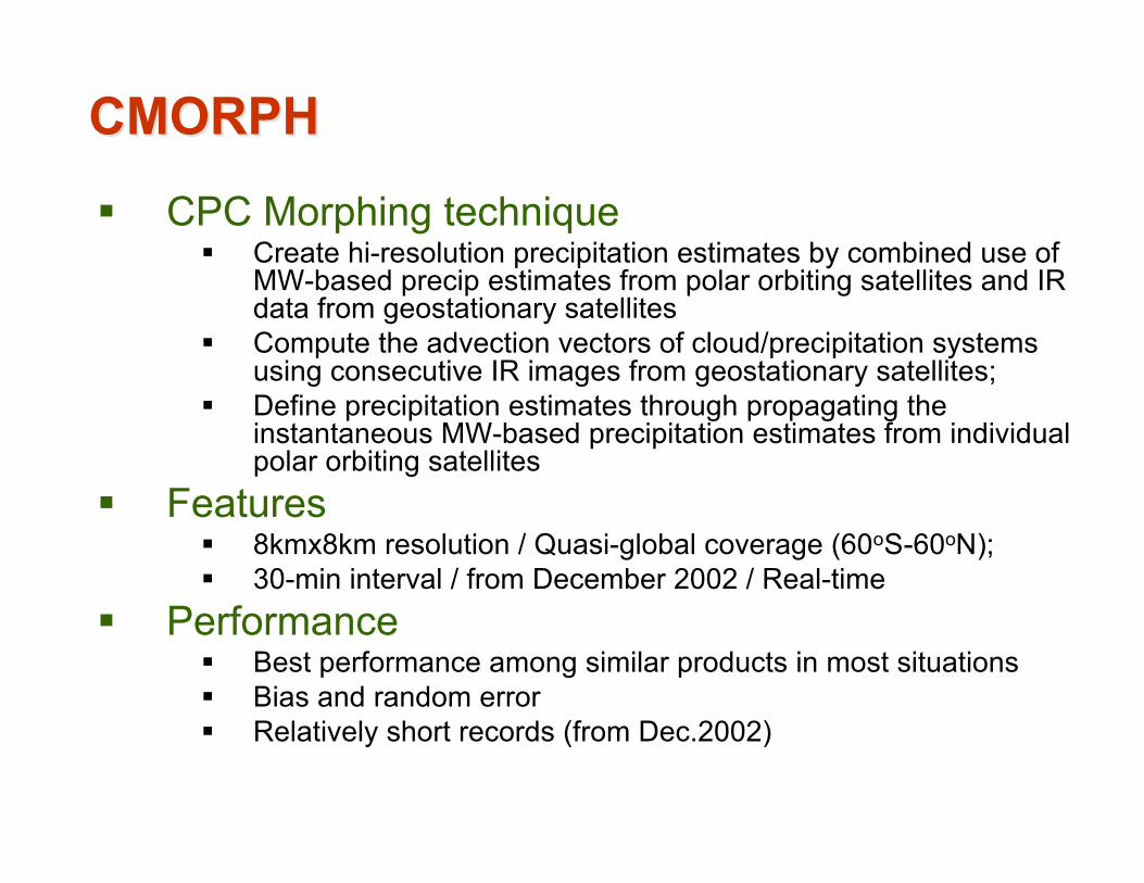
CMORPHCMORPH
CPC Morphing technique Create hi-resolution precipitation estimates by combined use of
MW-based precip estimates from polar orbiting satellites and IRdata from geostationary satellites
Compute the advection vectors of cloud/precipitation systemsusing consecutive IR images from geostationary satellites;
Define precipitation estimates through propagating theinstantaneous MW-based precipitation estimates from individualpolar orbiting satellites
Features 8kmx8km resolution / Quasi-global coverage (60oS-60oN); 30-min interval / from December 2002 / Real-time
Performance Best performance among similar products in most situations Bias and random error Relatively short records (from Dec.2002)

Example of CMORPH EstimatesExample of CMORPH EstimatesExample CMORPH Precipitation for Aug.18, 2003Example CMORPH Precipitation for Aug.18, 2003

StrategyStrategy
Improving CMORPH satellite-based high-resolution precipitation estimates throughadopting Kalman Filter technique
Removing the Bias in the CMORPH satelliteestimates through combination with gaugeanalysis

Improving CMORPH [1]Improving CMORPH [1]MethodologyMethodology
• Taking inputs from more satellites– Microwave estimates from all available satellites– IR-based precipitation estimates to fill gaps of MW observations
• Combining satellite estimates throughKalman Filter
– Weights inversely propor-tional to the error varianceof each satellite estimates
– Error variance of eachsatellite estimates as afunction of advection timefrom its observed time
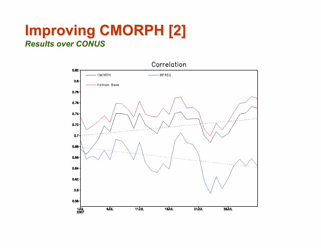
Improving CMORPH [2]Improving CMORPH [2]Results over CONUSResults over CONUS

Improving CMORPH [3]Improving CMORPH [3]Sample Sample KalmanKalman Filter CMORPH for July 10, 2007 Filter CMORPH for July 10, 2007

Combining with Gauge [1]Combining with Gauge [1]Removing Bias Through PDF MatchingRemoving Bias Through PDF Matching
• Construct PDF for CMORPH and gauge-observed dailyprecipitation using co-located data pairs
• Correct the bias in the CMORPH through matching thePDF of CMORPH against that of the gauge data
• Cross-Validationresults over China
0.785-0.0%Adjusted
0.706-9.7%Original
Corr.Bias (%)CMORPH

Combining with Gauge [2]Combining with Gauge [2]Blending Bias-Corrected CMORPH with GaugeBlending Bias-Corrected CMORPH with Gauge
• Combine the bias-corrected CMORPH with CPC Unifiedgauge analysis through the OI to further improve the qualityof precipitation analysis
• Bias-correctedCMORPH as firstguess, gauge dataas observations tocorrect the firstguess over regionswith coverage

Combining With gauge [3]Combining With gauge [3]Merged Analysis for August 1 Merged Analysis for August 1 –– 10, 2007 10, 2007

Final GoalFinal Goal
• CMORPH satellite high-resolution satellite precipitation
estimates improved and constructed for a period from
1998 to the present
• High-Resolution (0.25olat/lon) satellite-gauge merged
analysis of precipitation created over the globe by
combining with CPC Unified Gauge Analysis

SummarySummary
• Improving CMORPH through including observations from more
satellites and applying Kalman Filter technique
• Reducing error in CMORPH through combining information from
gauge observations
• PDF matching to remove bias
• OI blending to reduce random error
• Work underway to implement the techniques over global domain
and to construct high-resolution precipitation analysis

Backup SlidesBackup Slides
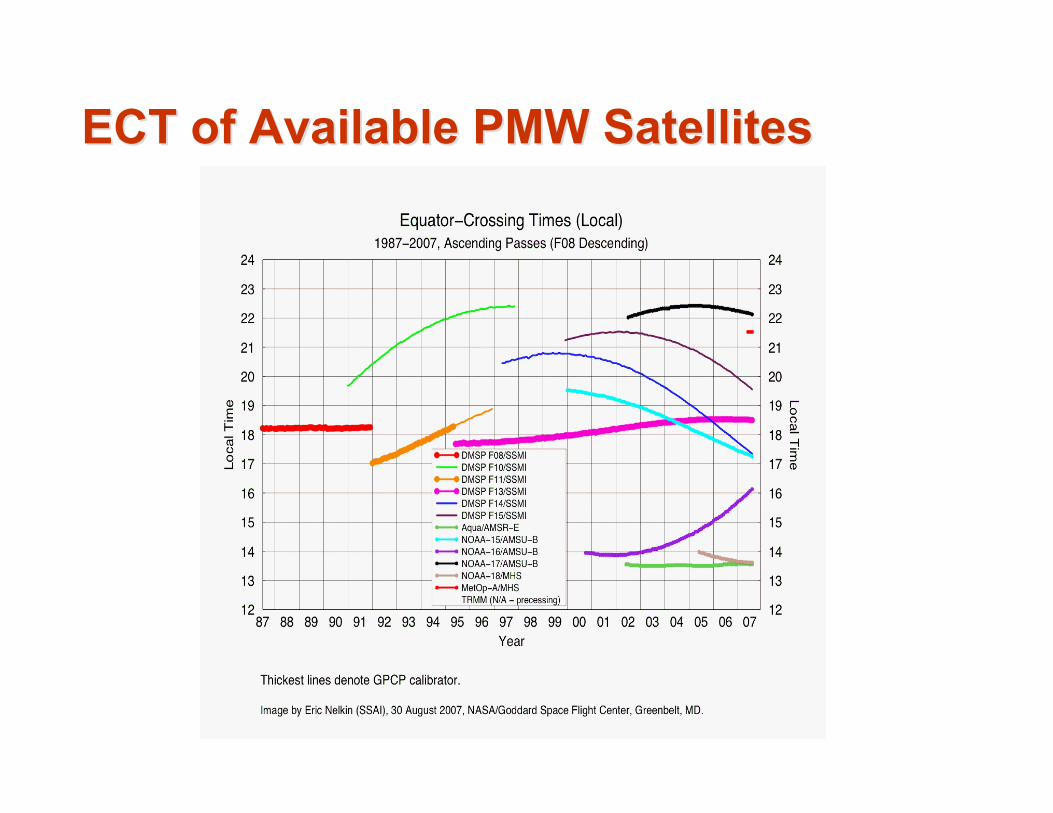
ECT of Available PMW SatellitesECT of Available PMW Satellites

CPC Unified Daily Gauge AnalysisCPC Unified Daily Gauge Analysis for July 1, 2003for July 1, 2003
Major precipitation activities well depicted with reasonabledetails