2.introduction of surveying
TRANSCRIPT

INTRODUCTION OF SURVEYING
Dept. of Civil EngineeringMarwadi Education Foundation’s Group of Institution

SURVEYINGSURVEYING• Objects• Types• Classification• Principles• Scale
• Objects• Types• Classification• Principles• Scale

Surveying is defined as the process of measuringhorizontal distances and included angles to determinethe location of points on, above or below the earthsurfaces. ORSurveying is the art and science of determining of therelative positions of various points or stations on thesurface of the earth by measuring the horizontaldistances, angles and taking the details of these pointsand by preparing a map or plan to any suitable scale.The term surveying is the representation of surfacefeatures in a horizontal plane.The process of determining the relative heights in thevertical plane is referred as levelling.

The data obtained by surveying are used to prepare theplan or map showing the ground features. Setting out of any engineering work like buildings, roads,railway tracks, bridges and dams involves surveying.
Objectives of SurveyingObjectives of Surveying

To prepare a topographical mapTo prepare a cadastral mapTo prepare an engineering mapTo prepare a contour mapTo prepare geological map
Uses of SurveyingUses of Surveying
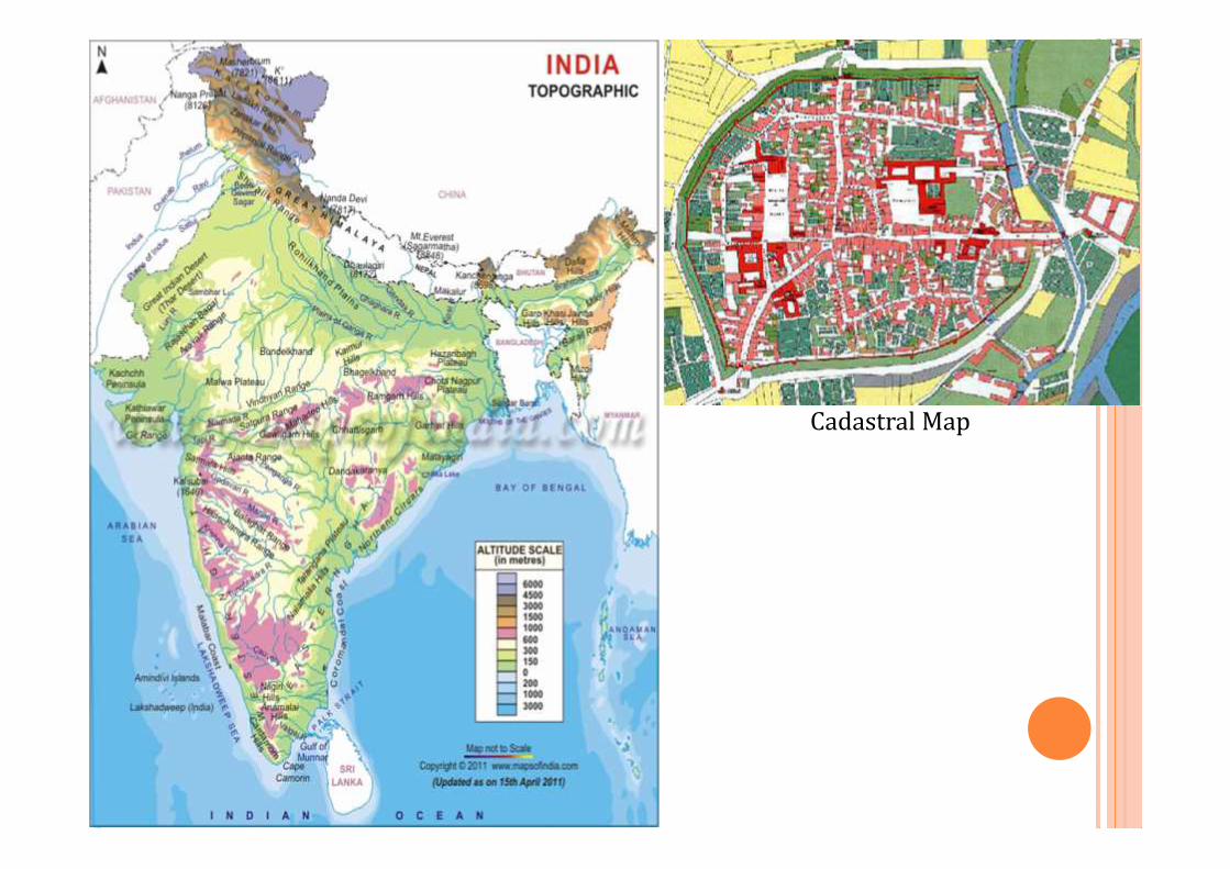
Cadastral Map

Contour Map

1) Plane surveying2) Geodetic surveying
Since the shape of the earth is spheroidal, the lineconnecting any two points on the earth surface is nota straight line, but a curve.When the surveys extend over a large areas or whenthe accuracy required is great, the curvature of earthhas also to be taken into account.
Primary divisions of surveyingPrimary divisions of surveying

The surveying where the effect of curvature of earth isneglected and earth’s surface is treated as plane, is calledplane surveying. The degree of accuracy in this type of surveying iscomparatively low. Generally when the surveying is conducted over the arealess than 250 Sq.Km., they are treated as plane surveying. Plane surveying is conducted for the purpose ofengineering projects and tackle by local authorities.
Plane SurveyingPlane Surveying

The effect of curvature is taken into account and itgenerally extends over large area. It is also known as “Trigonometrical Surveying”. It is a special branch of surveying in which measurementsare taken with high precision instruments. Calculations are also made with help of sphericaltrigonometry. It is generally adopted by the Great Trigonometrical SurveyDepartment of India”. (GTS).
Geodetic SurveyingGeodetic Surveying


Based on Instruments
Based on Methods
Based on Purposes
Based on Nature of field
Classification of surveyingClassification of surveying

CLASSIFICATION BASED ON INSTRUMENTS
Chain survey – for linear distance measurementCompass Survey – for measurement of horizontal anglesPlane table survey – for preparing plan of given dataTheodolite survey – for measuring ver. & hori. anglesTacheometric survey – for measuring ver. & hori. Dist.Photographic & Aerial survey – Photographs taken fromhigher altitude for collecting details of earth’s featuresEDM survey – for determining the distance between twointervisible objectsRemote sensing – Data collected from satelites fordetermining the positions of earth’s features

Theodolite
ChainCompass

Photographic & Aerial Survey Electronic DistanceMeasurement (EDM)
Remote Sensing
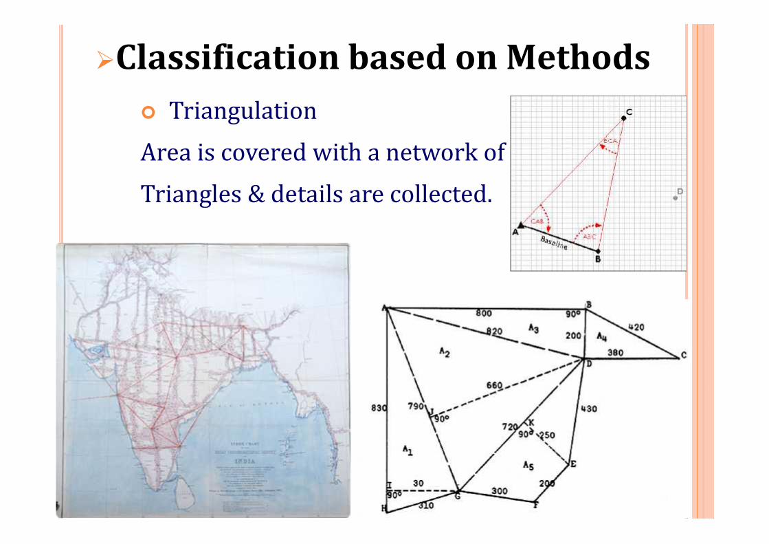
Classification based on Methods TriangulationArea is covered with a network ofTriangles & details are collected.
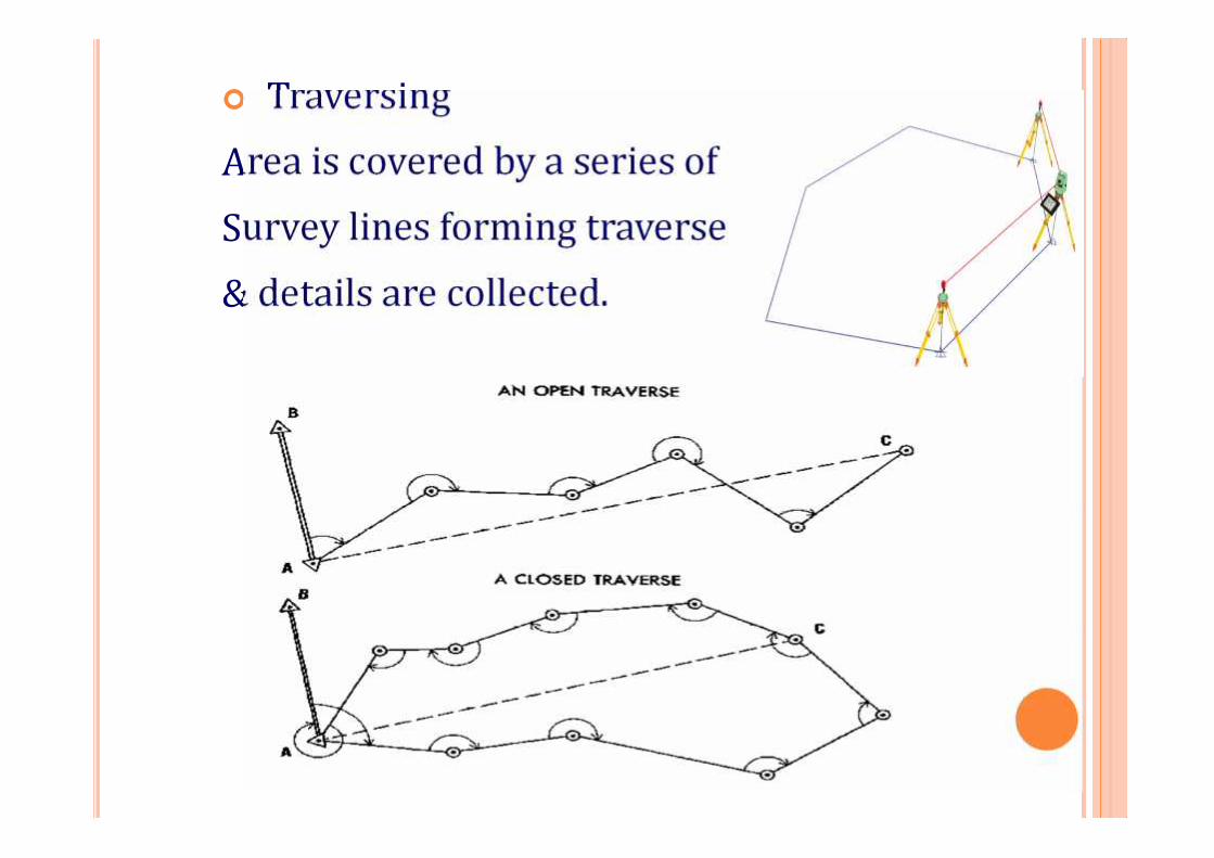
TraversingArea is covered by a series ofSurvey lines forming traverse& details are collected.

Classification based on Purposes Engineering survey – for collecting data fordesigning civil engineering projects like road,bridges, railways, etc. Geological survey – for determining the differentstrata in the earth’s crust. Mine survey – for exploring mineral wealth. Archaeological survey – for unearthing relics ofantiquity. Military survey – for military purpose & workingout plans of strategic importance.

Classification based on Nature ofFieldLand survey – conducted on the earth’s surfaceHydrographic survey – conducted on water bodieslike ocean, rivers, etc.Astronomic survey – conducted to study theposition & movement of celestial bodies.

Principle 1:
A number of control points are fixed in the areaconcerned by adopting very accurate and precisemethods.The lines joining these control points will be controllines.Other measurements are made to locate pointsinside these control lines.Thus, main triangles and traverses are formed first.
Principles of SurveyingPrinciples of Surveying

The main triangles and traverses are divided intosmaller ones by using less rigorous methods.By doing so, accumulation of errors is avoided andany local error can be easily identified. If survey work is started from a part (smaller triangleor traverse) and proceeded to whole there arechances of errors getting multiplied at every stage.Hence any survey work should be from whole to
part and not from part to whole.

Principle 2:
New points should be fixed by at least twoindependent measurements.
l1 l2
P Q
R
Figure 1P Q
R
θ1 θ2
Figure 2P Q
R
θ1
Figure 3
l1

As per the Principle 2, the location of a new pointinvolves one of the following.(a) Measurement of two distances.(b) Measurement of two angles(c) Measurement one angle and one distance

Fig 1: It shows the method of locating R with reference toknown length PQ by using the known distances of PR (l1) andQR (l2) Fig 2: It shows the method of locating R with reference to thelength PQ by using the known angles QPR (θ1) and PQR (θ2) Fig 3: It shows the method of locating R with reference toknown length PQ by using the known distance of PR (l1) andknown angle QPR (θ1)
l1
l2
P Q
R
Figure 1P Q
R
θ1 θ2
Figure 2P Q
R
θ1
Figure 3
l1

Plan
A plan is a graphical representation, to some scale,of the features on, near or below the surface of theearth as projected on a horizontal plane. In plan, the areas involved are small, and is drawnon a relatively large scale. In plan, the earth surface may be considered asplane, so that plan is constructed by orthographicprojections and is drawn on a relatively large scale.


Map
If the scale of the graphical projection on ahorizontal plane is small, the plan is called map. Thus, graphical representation is called plan if thescale is large while it is called a map if the scale issmall. On a plan, only horizontal distances and directionsor may be angles are shown, while on atopographic map, the vertical distances are alsorepresented by contour lines.


Scale
The ratio by which the actual length of the object isreduced or increased in the drawing is known as theScale. Its used to represent large distance on paper.Representative Fraction (RF) It is the ratio of the distance of object on drawing tothe corresponding actual distance of object onground. If a line 1 cm long on the drawing sheet represents50 m on ground, this scale can be expressed as1 cm = 50 m

The ‘scale’ and ‘RF’ can be converted from one tothe other.For Example :1 cm = 50 mRF = dist. Of object on drawing sheetcorresponding actual dist. Of object on ground= 1 cm/(50)(100) cm= 1/5000
RF = 1 : 5000

Example :1. 5 cm = 1 m

Scale may be classified into three categories.a) Plain scaleb) Diagonal scalec) Vernier scalea) Plain scale Plain scale is used to represent two successiveunits such as meters and decimeters.
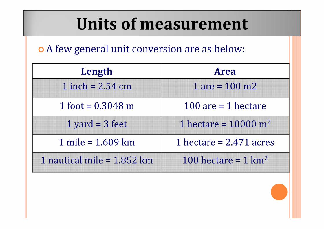
A few general unit conversion are as below:Units of measurementUnits of measurement
Length Area1 inch = 2.54 cm 1 are = 100 m21 foot = 0.3048 m 100 are = 1 hectare1 yard = 3 feet 1 hectare = 10000 m21 mile = 1.609 km 1 hectare = 2.471 acres1 nautical mile = 1.852 km 100 hectare = 1 km2