introduction to engineering surveying (ce … information in... · introduction to surveying....
TRANSCRIPT

INTRODUCTION TO ENGINEERING SURVEYING
(CE 1305)
Sr Dr. Tan Liat Choon
Email: [email protected]
Mobile: 016-4975551
Surveying Information In Civil
Engineering Projects
1
Introduction to Surveying
Definition:
Surveying may be defined as the art of making measurements of the relative positions of natural and man-made features on the earth’s surface, and the plotting of these measurements to some suitable scale to form a map, plan or section
(S. Raymond, 1979)
2

Introduction to Surveying
Definition:
Surveying is the art of making relatively large precise measurements with a maximum of accuracy and with a minimum expenditure of time and labour
(Philip Kissam, C. E., 1956)
3

Introduction to SurveyingWhat is surveying?
Surveying or land surveying deals with determination of relative location of point on or near the surface of the earth. It is concern with measurement of distance on land and area of object
It involves measuring horizontal or vertical distribution between terrestrial object, measuring craggy between terrestrials lines, determining direction of lines, establish point by determine angular and linear measurement
It involve measurement a relative position of points on earth surface, whether natural and artificial
4

Introduction to SurveyingWhat is Surveying?
It is the technique, profession and science of accurately determining the terrestrial or 3D position of points and the distances and angles between them. These points are usually on the surface of the earth and they are often used to establish land maps and boundaries for ownership or governmental purposes
It is the art of making suitable measurements in horizontal or vertical planes. This is one of the important subjects of civil engineering. Without taking a survey of the plot where the construction is to be carried out, the work cannot begin
It is the art of determining the relative positions of different object on the surface of the earth by measuring the horizontal distance between them and by preparing a map to any suitable scale. Thus, in this process, the measurements are taken only in the horizontal plane
5

Introduction to SurveyingThe purpose of Surveying:
Is to locate the positions of points on or near the surface of the earth. Some surveys involve the measurement of distances and angles for the following reason:
(1) To determine horizontal positions of arbitrary points on the earth’s surface
(2) To determine elevations of arbitrary points above or below a reference surface, such as mean sea level
(3) To determine the configuration of the ground(4) To determine the directions of lines(5) To determine the lengths of lines(6) To determine the positions of boundary lines(7) To determine the areas of tracts bounded by given lines
Such measurements are data-gathering measurement6

Introduction to Surveying
The purpose of Surveying:
In other surveys, it is required to lay off distances and angles to locate construction lines for buildings, bridges, highways, and other engineering works, and to establish the positions of boundary lines on the ground. These distances and angles constitute layout measurements
(Francis H. Moffitt, 1982)
7

History of Surveying1) Egyptian: Surveying had it’s beginning in Egypt about 1400 BC
Land along the Nile River was divided for taxation. Plots were swept away by annual floods of Nile River
The “ROPE-STRETCHERS” Egyptian surveyors were called to relocate the land boundaries with ropes having markers at unit distances
Extensive use of surveying in building of Egyptian monuments
2) Greeks: Expanded Egyptian work and developed science of geometry
Developed one of the earliest surveying instruments • Diopter (a form of level)
8

History of Surveying3) Romans: Developed surveying into a science to create the Roman roads,
aqueducts, and land division systems
Surveyors held great power, had schools and a professional organization Developed several instruments:
• Groma – cross instrument used to determine lines and right angles• Libella – “A” frame with a plumb bob used for leveling• Chorobates – 20’ straight edge with oil in notch for leveling
4) 13th Century: The Arabs kept Greek and Roman science alive and the Italian wrote the instructions o surveying, called Practical geometry
Quadrans – square brass frame capable of turning angles up to 90° and has a graduated scale developed by an Italian named Von Piso
9

History of Surveying5) 18th & 19th Centuries: The need for maps and locations of national boundaries
caused extensive surveying, especially by the English
1785: United Stated began extensive surveys of public lands into one mile square sections• 30 states surveyed under the U.S. Public Land System (also called the Rectangular System)
1807: United States Geological Survey founded to establish an accurate control network and mapping
Famous American Surveyors: George Washington, Thomas Jefferson, George Rogers Clark, Abe Lincoln and many more
10

History of Surveying6) 20th Century and Beyond: As technology advanced, population increased, and
land value caused development of licensure for surveyors in all states
Educational requirements for licensure began in the early 1990’s Capable of electronic distance measurement, positioning using Global Positioning
System (GPS), construction machine control, and lidar (scanning) mapping Involvement in rebuilding of the infrastructure and Geographic Information System
(GIS) Shortage of licensed professionals is projected well into the 21st century
11

Today Land SurveyingToday land surveying affects most everything in our daily lives. A few of the areas where surveying is being used are as follow:
To map the earth above and below the sea To prepare navigation maps (digital or hardcopy) To establish boundaries of public and private lands To develop database for natural resource management and sustainable
development To develop engineering data for:
• Bridge construction• Roads• Buildings• Land development
12
Land Surveyor
1) The job of the land surveyors is to find and mark certain locations on land
2) Over time, development, vandalism and acts of natural often wreak widespread destruction on documentation, so the land surveyor is often forced to consider other evidence such as fence locations, monuments on neighboring property, recollections and relocation of the features
13

Land Surveyor
3) The work of the land surveyor is very varied and his practice may fall under one or more of various categories, such as cadastral surveying or surveying for title, engineering surveying, topographical surveying, photogrammetry, geodetic surveying and hydrographic surveying. Except for geodetic surveying and photogrammetry, the other categories in land surveying involve essentially large-scale surveys.
14

The Work of the Land Surveyor
1) Research, analysis and decision making Selecting techniques, equipment and final point locations
2) Fieldwork & Data Acquisition Making measurements and recording data in the field
3) Computing & Data Processing Preparing calculations based upon the recorded data to
determine locations, areas, volumes, etc.
4) Mapping or Data Representation Plotting data to produce a map, plan, or chart in the proper
form
5) Setting Locating and establishing monuments or structure in the
proper locations in the field
15

Importance of Land Surveying
Surveying can be carried out to achieve all or any of the following purpose:
For the determination of the earth size and shape
For setting out construction works and roads
For navigational purposes
The making plans, chart and maps
For collection of tracts and details
For location of features
16

Purpose of Surveying in the Field of Civil Engineering
Surveying can be carried out to achieve all or any of the following purpose:
To determine the relative positions of the existing futures of the ground
To layout our marked positions of proposed structures on the ground
To determine areas, volumes and other related quantities
To prepare a map of a country of detailed out location of cities, towns, villages and major roads
To prepare the engineering detailed plans and sections of various sections such as roads, railways, bridges, dams and other structure
To prepare a topographical map showing details of hills, valleys and rivers
17

Primary Classification of Land Surveying
1) Geodetic Surveying – Surveying technique to determine relative positions of widely spaced points, lengths, and directions which require the consideration of the size and shape of the earth
Field measurements for geodetic surveys are usually performed to a higher order of accuracy than those for plan surveys
Involves large areas (in excess of 250km2) where the curvature of the earth is important and needs to be taken into consideration
The line joining any two points considered as a curved line
Very refined methods and instruments are used in this type of surveying
This method needs very high precision or accuracy is required
18

Primary Classification of Surveying
2) Plane Surveying – Surveying with the reference base for fieldwork and computations are assumed to be a flat horizontal surface
Involves small areas and the curvature of the earth is not taken into account. In other words, it assumes that the earth’s surface is flat
Is done on an area of less than 250km2
The degree of accuracy required in this type of surveying is lower than geodetic surveys
19

Primary Classification of Surveying
To avoid the accumulation of errors, extensive surveys should proceed from the whole to the part, by first establishing a network of primary triangulation points. The primary triangulation is broken into secondary triangulation, which is again further broken into tertiary triangulation. These triangulation networks are supplemented by precise traverses until there is a sufficient density of control points for the whole country, at which stage there is a comprehensive geodetic survey for the country.
Geodetic surveying is the responsibility of the national surveying and mapping organization, which undertake geodetic surveys, using precise instruments and surveying techniques to a very high order of accuracy over relatively large areas. Apart from serving national interests, geodetic surveys also contribute towards a study of the size and shape of the earth. 20

Secondary Classification of Surveying
1) Based on instrument
Chain Survey Compass Survey Plane Table Survey Theodolite Survey Tacheometric Survey Photographic Survey
2) Based on method
Triangulation Survey Traverse Survey
21

Secondary Classification of Surveying
3) Based on object
Geological Survey Mine Survey Archeological Survey Military Survey
4) Based on nature of field
Land Survey Marine Survey Astronomical Survey
22

Classes of Survey-Based on Instrument
Chain Survey
Linear surveying which include the use of chain or tape to measure distances
Is conducted using different lengths of chains specifically made for the surveying purpose
23

Classes of Survey-Based on Instrument
Compass Survey
Involves the use of compass in getting bearing
Also known as Angular Surveying
24

Classes of Survey-Based on Instrument
Plane Table Survey
It is a graphical method of surveying in which field work and plotting are done simultaneously in the field.
It is very effective method of surveying for preparing small or medium size topographical plans.
It is not as accurate as the other survey methods and results
25
Classes of Survey-Based on Instrument
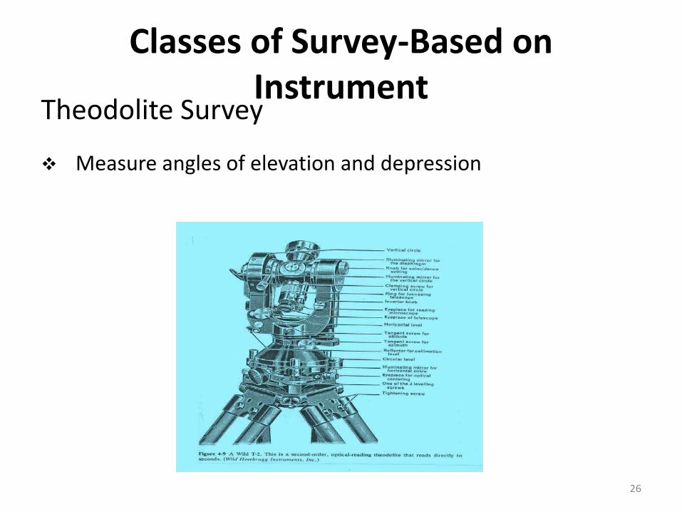
Theodolite Survey
Measure angles of elevation and depression
26

Classes of Survey-Based on Instrument
Tacheometric Survey
Is a survey to quickly determine the horizontal distance and elevation of a point
Stadia observations are obtained by sighting through a telescope equipped with two or more horizontal cross hairs at a known spacing
The apparent intercepted length between the top and bottom hairs is read on a graduated rod held vertically at the desired point
The distance from telescope to rod is found by proportional relationships in similar triangles
27

Classes of Survey-Based on Instrument
Photogrammetry Survey
Mapping utilizing data obtained by camera or other sensors carried in airplanes or satellites for highways, railroads, pipelines, and transmission lines
Generally are used in conjunction with limited ground survey
28
Classes of Survey-Based on MethodTriangulation Survey
The series or network of triangles into which the face of a country, or any portion of it, is divided in a trigonometric survey; the operation of measuring the elements necessary to determine the triangles into which the country to be surveyed is supposed to be divided, and thus to fix the positions and distances of the several points connected by them
(Webster, 1913)
A method of determining the relative positions of points in space by measuring the distances and angles, between those points and other reference points whose positions are known. Triangulation often involves the use of trigonometry. It is commonly used in the navigation of aircraft and boats, and is the method used in the Global Positioning System , in which the reference points are satellites
29

Classes of Survey-Based on MethodTriangulation Survey
A surveying technique in which a region is divided into a series of triangular elements based on a line of known length so that accurate measurements of distances and directions may be made by the application of trigonometry
A trigonometric method of determining the position of a fixed point from the angles to it from two fixed points a known distance apart; useful in navigation
A method of surveying; the area is divided into triangles and the length of one side and its angles with the other two are measured, then the lengths of the other sides can be calculated
30

Classes of Survey-Based on MethodTraverse Survey
Traverse is a series of consecutive lines whose ends have been marked in the field and whose lengths and directions have been determined from observations
Traversing is the art of making the lines, i.e., establishing traverse stations and making the necessary observations, is one of the most basic and widely practices means of determining the relative locations of points
31
Classes of Survey-Based on Object
Geological Survey
Generic term for a survey conducted for the purpose of recording the geologically significant features of the area under investigation
Is carried out by geologists. It is usually for the purpose of the study of earth’s rock structure. It helps to determine different strata in the earth’s crust
32

Classes of Survey-Based on Object
Mine Survey This is a plane surveying used in determining the position
and dimension of underground passage of the mine and also the natural and artificial feature of the mine, the data include both horizontal and vertical parts, length direction and slope of the turning and geological and topographic characteristics in a particular surrounding district
Involve exploration of mineral wealth in the country. This would include minerals such as gold, copper, coal, silver etc.
Performed above and below ground to guide tunneling and other operations associated with mining. This classification also includes geophysical surveys for mineral and energy resources exploration
33

Classes of Survey-Based on ObjectArcheological Survey
Used to accurately assess the relationship of archaeological sites in a landscape or to accurately record finds on an archaeological site
Is carried out by the archeological for the purpose of their study concerning the past. This survey helps to trace the relics of the past
34

Classes of Survey-Based on Object
Military Survey
Is carried out by every country in the world
Helps in determining the points of strategic importance of the country
35

Classes of Survey-Based on Nature of Field
Land, Boundary and Cadastral Survey
Oldest type of survey and has been performed since earliest recorded
A survey made to determine the lengths and directions of boundary lines and the area of the tract bounded by these lines or a survey made to establish the positions of boundary lines on the ground
Establishing property corners, boundaries, and areas of land parcels
Involves measuring, delivery, recording the boundaries of precipitate, supplies map plan beyond a parcel of land described in land register 36

Classes of Survey-Based on Nature of Field
Land, Boundary and Cadastral Survey
This is kind of plane surveying used in committed areas of land mostly private properties it is mainly used to establish boundary of the precipitate
Using its legal description, which involves the setting or restoration of monuments or markers at the corners or along the lines of the parcel, often in the form of iron rods, pipes or concrete monuments in the ground, or nails set in concrete
Are used to produce plans of property boundaries
Involves a little more precision and detailing in the process. Maps are drawn to a more larger scale as compare to topographical survey maps
37

Classes of Survey-Based on Nature of Field
Land, Boundary and Cadastral Survey
Cadastral surveys or surveys for title are made to establish and record property boundaries and may form the bulk of a land surveyor's work. Cadastral surveys are controlled by law and the surveys within the meaning of Section 396 of the National Land Code (Act 56 of 1965). Those permitted to do cadastral surveying field-work are, firstly, the employees of the Survey Department working under the supervision of the District Surveyors, and, secondly, the articled pupils and fields assistants working under the immediate personal direction and field supervision of surveyors licensed under the Licensed Land Surveyors Act 1958
The Survey Department imposes stringent regulations on cadastral surveying. Such regulations and the categories of persons permitted to do cadastral surveying, reflect the importance attached to the cadastral plan, the usual end product of a cadastral survey. The plan should unambiguously identify a particular parcel of land for purposes of proprietorship and registration, and the survey should be of technical standards required in the legislation governing the registration of title to land and of dealings herewith
38

Classes of Survey-Based on Nature of Field
Land, Boundary and Cadastral Survey
The National Land Code, mentioned in above, amended and consolidated "the law as relating to land and land tenure, the registration of title to land and of dealings therewith and the collection of revenue therefrom" within the States of Semenanjung Malaysia. Similarly, the Land Ordinance (Sabah Cap. 68) sets out "to regulate the alienation and occupation of State lands, " while the Land Code (Sarawak Cap.81) is "An Ordinance to make better provision in the law relating to land.“
The Licensed Land Surveyors Act, 1958, provides for the establishment of the Land Surveyors Board, to deal with "the licensing and control of land surveyors and for matters connected therewith." To carry out the objectives and purposes of the Ordinance, the Licensed Land Surveyors Regulations, 1959, were made
In this connection, it should to be mentioned that the Licensed Land Surveyor Act, 1958, is largely outdated. It was promulgated to meet a situation that existed almost forty years ago
39

Classes of Survey-Based on Nature of Field
Marine Survey
Related to hydrographic survey but they are thought to cover a broader area
40

Classes of Survey-Based on Nature of Field
Astronomical Survey
Generally involve imaging or "mapping" of regions of the sky using telescopes
Taking advantage of technological improvements in the construction of telescopes, and following a general expansion in our understanding of astrophysics at all levels, it has become commonplace to conduct surveys that join together many different observations of a given region in the sky, obtained with different telescopes at different wavelengths
Allow astronomers to catalogue celestial objects and perform statistical analyses on them without making prohibitively lengthy observations
41

Classes of Survey-OthersTopographic Survey
A survey conducted to determined the configuration of the ground
Collecting data and preparing maps showing the locations of natural man-made features and elevations of points o the ground for multiple uses
This is a plane surveying used in purchasing map’s and plans of natural and mammals features such as relief, elevation, unequal land surfaces.
There is no clear differences between a plan and a map of this nature, it is generally accepted that open details are rail drawn to a chosen scale while in map many textile has to be represented in symbol
42

Classes of Survey-OthersTopographic Survey
Topographical surveys are made to establish the positions and shapes of natural and artificial features in a given area for the purpose of producing a topographical plan or map
The relative positions and heights above mean sea level of the control points, forming the network, have to be established in order to provide the horizontal and vertical control for the subsequent survey of topographical detail
The traditional base-line measurement and triangulation network to establish the horizontal control, has been largely replaced by trilateration, because distances of up to more than 100 kilometres can be rapidly measured by electronic distance-measuring equipment. The vertical control is established by levelling or trigonometrical heightening, which is usually referred to as mean sea level datum
Topographical surveying for the country is the responsibility of the Department of Survey and Mapping but detailed topographical plans of relatively small areas are required by various Government departments and statutory bodies for project planning and design. Such topographical surveys are undertaken by licensed surveyors. A word of caution may perhaps be necessary here. Clients resorting to the easy way out by blowing up small maps, suitable for feasibility studies, for large scale survey information, can expect to find trouble in the design and planning phase of the project
43
Classes of Survey-Others
Topographic Survey
A chosen scale while in map many textile has to be represented in symbol
Topographic plan survey are used for engineering or design and administrative purpose only whereas topographic map are found useful in navigation, constructional activities
A survey that measures the elevation of points on a particular piece of land, and presents them as contour lines on a plot
The survey is performed to determining the natural features of the country such as rivers, mountains, valleys etc. and also artificial features such as canals, railways, roads, towns etc. This help to keep a record of existing natural features of the country
44

Classes of Survey-OthersEngineering Survey
Providing points and elevations for the building civil engineering projects
This embraces the survey work require before, during and after a engineering work, it is done for the construction and design of new roads and rails roads
The type of scale of engineering surveying of architectural work drawing are 1 – 50 or 1:50, 1:100, 1:200 for sight plane and civil engineering work, scale of 1:500, 1:1000, 1:2000, 1:2500 for town survey or highway survey, scale of 1:2000, 1:2500, 1:5000, 1:10000 etc.
Those surveys associated with the engineering design (topographic, layout and as-built) often requiring geodetic computations beyond normal civil engineering practice
45

Classes of Survey-OthersEngineering SurveyEngineering survey is further classified into the following three types:
1) Reconnaissance Survey This survey is performed for determining the feasibility
of work and to estimate the rough cost of the scheme
2) Preliminary Survey This survey is performed for collecting more precise
data to choose the best location for the work and to estimate the exact quantities and cost
3) Location Survey This survey is performed for setting out the work on
the ground
46

Classes of Survey-OthersEngineering Survey
To dispel any possible misconception, it is stated here that engineering surveying is still land surveying, done specifically for engineering purposes. Engineering surveying is ultimately tied to cadastral surveying, because an engineering survey is hardly ever done in isolation. It must be properly orientated and must be tied to the survey marks authorized by the Survey Department, such as boundary marks, triangulation points whether primary, secondary or tertiary. The licensed surveyor is thus the proper person to undertake an engineering survey, because by law, he is authorized to undertake a cadastral survey
Large scale and engineering surveys form a very important part of a licensed surveyor's practice, because surveying is fundamental to any project planning. Licensed surveyors are thus appointed by various Government technical departments and statutory bodies to carry out engineering surveys, with the object of providing large-scale plans and profiles, showing topographical detail and additional information, necessary for the design and planning of engineering projects
Unlike cadastral surveying, there is no statutory control over the conduct of engineering or topographical surveys. However, it should be remembered that the Malaysian land administration system, which make tenure secure and title readily transferable, subject to certain controls, has the cadastral plan and the land register as its twin pillars of its machinery of record
47

Classes of Survey-OthersControl Survey
A survey made to establish the horizontal or vertical positions of arbitrary points
Establish a network of horizontal and vertical monuments that serve as a reference framework for initiating other survey projects
Provides vertical and horizontal reference points
48

Classes of Survey-OthersRoute Survey
Topographic and other surveys for long – narrow projects associated with civil engineering projects
Location of natural and artificial objects along a proposed route for a highway, railroad, canal, pipeline, power line or other utility
49

Classes of Survey-OthersRoad Survey
It is a plane surveying carried out for the purpose of locating and constructing cones of transportation and communication such as highways, rail roads, canal pipeline etc.
Primary work usually involve topographic survey
50
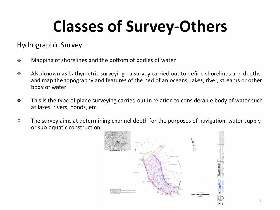
Classes of Survey-OthersHydrographic Survey
Mapping of shorelines and the bottom of bodies of water
Also known as bathymetric surveying - a survey carried out to define shorelines and depths and map the topography and features of the bed of an oceans, lakes, river, streams or other body of water
This is the type of plane surveying carried out in relation to considerable body of water such as lakes, rivers, ponds, etc.
The survey aims at determining channel depth for the purposes of navigation, water supply or sub-aquatic construction
51

Classes of Survey-OthersHydrographic Survey
In the case of river hydrographic survey is made for flood control, water storage and supply, navigation and power supply
Some of the process in hydrographic survey include (i) topographic survey of shore and river bank, levelling to determine underground profile etc.
A survey conducted with the purpose of mapping the coastline and seabed for navigation, engineering, or resource management purposes
Pertain to lakes, streams and other bodies of water
Hydrographic surveys are used to produce coastline and seabed maps for engineering purposes
52

Classes of Survey-OthersHydrographic Survey Hydrographic surveys have traditionally been carried out for the
compilation of nautical charts and the construction and maintenance of harbours. However, because of the increasing development of off-shore oil and natural gas exploitation, there is a corresponding increasing demand for hydrographic surveys
The principles underlying land surveying and hydrographic surveying are essentially the same; however the surveying techniques and equipment used are obviously different. The scope of hydrographic surveying is wide, ranging from surveys of rivers and estuaries to surveys of off-shore sites for oil and natural gas exploitation and to surveys involving sea and ocean beds
One well-known example of a hydrographic survey is the joint hydrographic surveys of the Straits of Malacca and Singapore carried out from 1969 to 1974 by Japan, Indonesia, Malaysia and Singapore. The objective was to promote navigational safety in view of the increasing number of vessels navigating the Straits and the obsolescence of old navigation charts which were based on surveys done up to the 1930s
53

Classes of Survey-OthersAs-built Survey
It document the precise final locations and layouts of engineering works and record any design changes that may have been incorporated into the construction
A survey carried out during or immediately after a construction project for record, completion evaluation and payment purposes
Known as a 'works as executed survey' documents the location of the recently constructed elements that are subject to completion evaluation
54

Classes of Survey-Others
As-built Survey
As-built surveys are typically presented in red or redline and overlay over existing design plans for direct comparison with design information
Provide the positions and dimensions of the features of the projects as they were actually constructed
is surveying carried out after the completion of any construction. As built drawings provide the actual location of buildings, utility networks, roads as constructed on site. This information is very useful for the owners
55
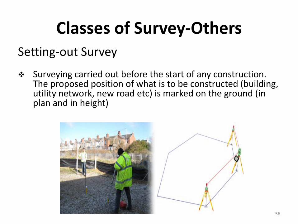
Classes of Survey-OthersSetting-out Survey
Surveying carried out before the start of any construction. The proposed position of what is to be constructed (building, utility network, new road etc) is marked on the ground (in plan and in height)
56

Classes of Survey-OthersDeformation Survey
A survey to determine if a structure or object is changing shape or moving
The three-dimensional positions of specific points on an object are determined, a period of time is allowed to pass, these positions are then re-measured and calculated, and a comparison between the two sets of positions is made
57

Classes of Survey-OthersStrata Title, Condominium Survey
A building survey to produce plans of the building
Survey may be conducted before renovation works, for commercial purpose, or at the end of the construction process
58

Classes of Survey-OthersStructural Survey
A detailed inspection to report upon the physical condition and structural stability of a building or other structure and to highlight any work needed to maintain it in good repair
59

Classes of Survey-OthersTape Survey
This type of survey is the most basic and inexpensive type of land survey
Popular in the middle part of the 20th century, tape surveys while being accurate for distance lack substantially in their accuracy of measuring angle and bearing
60

Classes of Survey-OthersCity, Municipal Survey
Use to lay out streets, plan sewer systems and prepare maps
Is carried out in connection with various engineering work such as roads, railways etc. and it can also involves various works related to water supply sectors such as reservoirs, well etc.
61

Classes of Survey-OthersConstruction Survey
Locating structures and providing required elevation points during their construction
Provide line, grade, control elevations, horizontal positions, dimensions and configurations for construction operations
62

Classes of Survey-OthersLevelling Survey
Is the art of representing relative positions in the vertical plane of different points on the earth’s surface. It helps in determining the areas that are to be levelled to achieve a certain slope
Which make use of abnormal level, land standard pole; levelling is defined as the process of finding the differences between in height of any 2 points on the ground
For the purpose of: • Tracing contour line• Plotting vertical section• Establishing point at given any elevation in constructional project
63
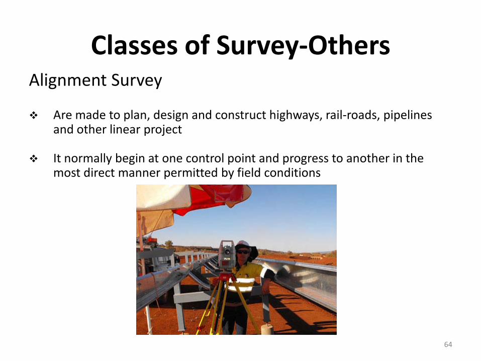
Classes of Survey-OthersAlignment Survey
Are made to plan, design and construct highways, rail-roads, pipelines and other linear project
It normally begin at one control point and progress to another in the most direct manner permitted by field conditions
64

Classes of Survey-OthersGlobal Positioning System Survey (GPS) Developed in early 1980’ s (Dept. of Defense)
Made up of 26 satellites (24 functioning & 2 spares)
Each satellite is 20,000 km high (off Earth’s surface)
Each satellite is in a fixed position
Minimum of 3 satellites needed, but 4-5 preferred
Need satellites at least 15° above horizon
Locate positions on Earth by distance-distance intersection
Need 2-3 receivers (about $80-$100K per system depend on the accuracy)
Most accurate with double occupancy (no other checks)
Differential GPS – one receiver on known point, other receiver on unknowns
65

Classes of Survey-Others
Global Positioning System Survey (GPS)1) Biggest advantage
Distance and direction in-between 2 points without being seen
2) Downfalls/Limitations of GPS
Multipath – bouncing off of walls of buildings Blocked signals – clouds, trees, etc. Sunspot – diffractions from atmosphere DOP (Delusion of Position) – bad satellite position Set up error – not set up exactly over point (human
error – most common)66

Classes of Survey-Others
Global Positioning System Survey (GPS)
3) Methods
Static – observation time is at least an hour• Ideally set points in triangular fashion• Accuracy – 1/10 million
RTK (Real Time Kinematic) – stand for 30-60 seconds minimum• Base receivers transmission, does corrections, sends
corrections to receivers• Limitations – limitation of transmitter signal
67

Classes of Survey-OthersGeographic Information System (GIS)
GIS are computer-based systems that allow users to store, integrate, retrieve, manipulate, analyze and display virtually and type of spatial data
Spatial Data (Geographic data) – any data that represents information about the Earth
DEM (Digital Elevation Model) – Digital terrain representation technique, where elevation values are stored in raster cells
GIS components Recent definitions of GIS suggest that is consists of:
• Hardware (computer and operating system)• Software• Data• Human Operators and Institutional Infrastructure
Geographic/SpatialNon-Geographic/Spatial/Attribute
68

Classes of Survey-Others
Geographic Information System (GIS) Vector – Made up of points, lines, and polygons
69

Classes of Survey-Others
Geographic Information System (GIS)
Raster (Grids) – Made up of pixels of computer screen
70

Classes of Survey-OthersGeographic Information System (GIS)
Nowadays, the traditional surveying and mapping end products (such as topographic maps, geodetic control date, cadastral plans) are not sufficient for users. More value added spatial referenced information is required in order to support multidisciplinary applications for natural resources, environment, facility and utility management, infrastructure, economic development,..etc.
GIS/LIS technology has become a popular tool for the implementation of the above multidisciplinary applications. By virtue of his training and core expertise in data collection and data handling, a surveyor is in a natural position to progress beyond the traditional surveying and mapping operations, by engaging himself in spatial information management operations through GIS/LIS operations
71
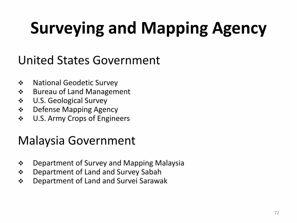
Surveying and Mapping Agency
United States Government
National Geodetic Survey Bureau of Land Management U.S. Geological Survey Defense Mapping Agency U.S. Army Crops of Engineers
Malaysia Government
Department of Survey and Mapping Malaysia Department of Land and Survey Sabah Department of Land and Survei Sarawak
72

Surveying and Mapping Profession Organisation
Abroad
American Congress on Surveying and Mapping (U.S.) American Society for Photogrammetry and Remote Sensing (U.S.) Geomatics Division of American Society of Civil Engineering (U.S.) Urban and Regional Information Systems Association (U.S.) Canadian Institute of Geomatics (Canada) International Federation of Surveyors (worldwide)
Malaysia Royal Institution of Surveyors, Malaysia (Malaysia) Persatuan Juruukur Tanah, PEJUTA (Malaysia) Land Surveyors Board of Peninsular (Malaysia)
73

Measurement of Distance
Linear measurement is the basis of all surveying and even though angles may be read precisely, the length of at least one line in a tract must be measured to supplement the angles in locating points
74

Type of Measurement in Surveying
1) Horizontal Angle – e.g. bearing
2) Horizontal Distance – e.g. distance between two points
3) Vertical Angle – degree of slope of a road
4) Vertical Distance – e.g. elevation of a point above a benchmark
5) Slope Distance – e.g. distance along slope of a railroad track
75
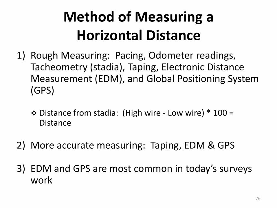
Method of Measuring a Horizontal Distance
1) Rough Measuring: Pacing, Odometer readings, Tacheometry (stadia), Taping, Electronic Distance Measurement (EDM), and Global Positioning System (GPS)
Distance from stadia: (High wire - Low wire) * 100 = Distance
2) More accurate measuring: Taping, EDM & GPS
3) EDM and GPS are most common in today’s surveys work
76
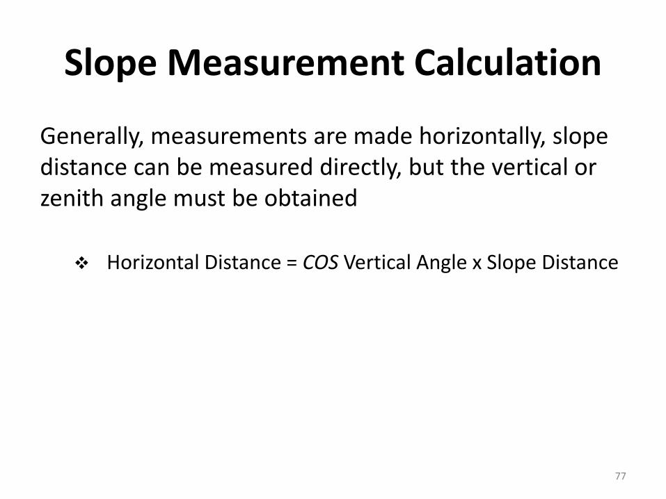
Slope Measurement Calculation
Generally, measurements are made horizontally, slope distance can be measured directly, but the vertical or zenith angle must be obtained
Horizontal Distance = COS Vertical Angle x Slope Distance
77

Surveying Metric Conversion
Length
1 millimeter (mm) = 1000 micrometers (µm)1 centimeter (cm) = 10 mm1 meter (m) = 100 cm1 m = 39.37 inches (in) [U.S. Survey Foot]1 kilometer (km) = 1000 m1 km = 0.62137 miles1 in = 25.4 mm1 feet (ft) = 304.8 mm1 mile = 5280 ft1 nautical mile = 6076.10 ft = 1852 m1 rod = 1 pole = 1 perch = 16.5 ft1 chain (ch) = 66 ft = 4 rods1 mile = 80 ch
78

Surveying Metric Conversion
Area
1 mm2 = 0.00155 in2
1 m2 = 10.76 ft2
1 km2 = 247.1 acres1 hectare (ha) = 2.471 acres1 acre = 10 ch2 , i.e. 10(66 ft x 66 ft)1 acre = 4046.9 m2
1 ft2 = 0.09290 m2
1 ft2 = 144 in2
1 in2 = 6.452 cm2
1 mile2 = 640 acres
79

Surveying Metric Conversion
Volume
1 m3 = 35.31 ft3
1 yd3 = 27 ft3 = 0.7646 m3
1 liter = 0.264 gal [U.S.]1 gal = 3.785 liters1 ft3 = 7.481 gal1 gal [Imperial] = 4.546 liters = 1.201 gal [U.S.]
80
Surveying Metric Conversion
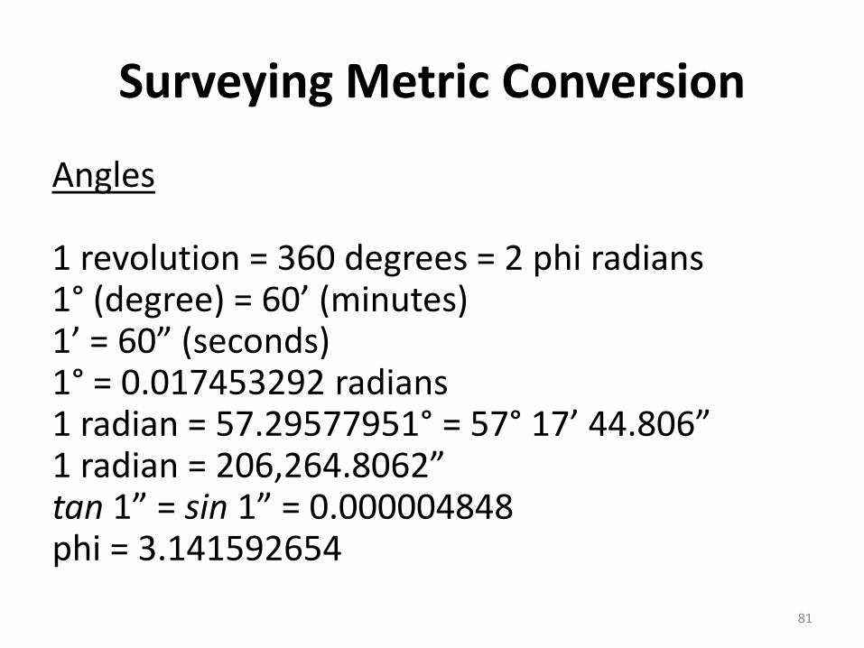
Angles
1 revolution = 360 degrees = 2 phi radians1° (degree) = 60’ (minutes)1’ = 60” (seconds)1° = 0.017453292 radians1 radian = 57.29577951° = 57° 17’ 44.806”1 radian = 206,264.8062”tan 1” = sin 1” = 0.000004848phi = 3.141592654
81

Principles of Surveying
All the surveys that are conducted are based on two fundamental principles:
1) Working from whole to part In order to localize errors and prevent their
accumulation, a set of control points is always established with great precision first for the whole area to be surveyed. Late on, details or filled in between these control points to a relatively smaller precision
2) Fixing a point with reference to two fixed points Survey stations are fixed by at least two measurements,
either both linear or angular measurements or linear and angular measurements from two control points
82
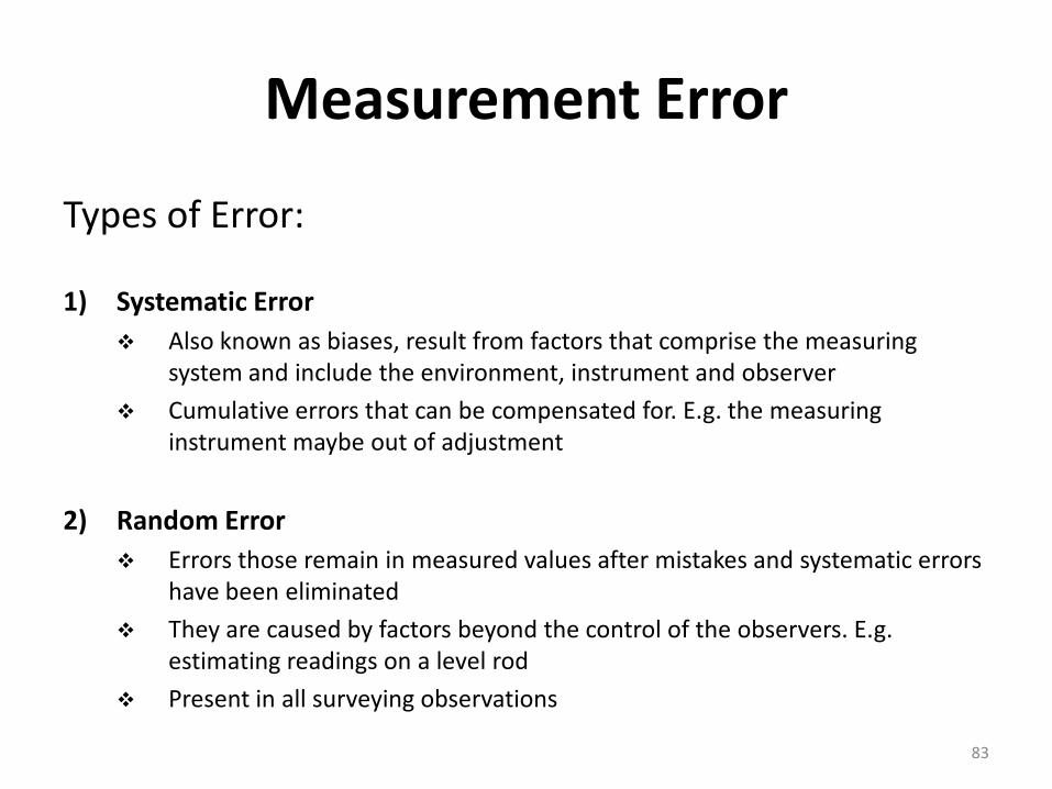
Measurement Error
Types of Error:
1) Systematic Error Also known as biases, result from factors that comprise the measuring
system and include the environment, instrument and observer
Cumulative errors that can be compensated for. E.g. the measuring instrument maybe out of adjustment
2) Random Error Errors those remain in measured values after mistakes and systematic errors
have been eliminated
They are caused by factors beyond the control of the observers. E.g. estimating readings on a level rod
Present in all surveying observations
83

Measurement Error
Sources of Random Error:
1. Instrument Error
Error may be arise due to imperfection or faulty adjustment of the instrument with which measurement is being taken
Imperfections in construction or adjustment of the measurement equipment. Can be reduced or eliminated by adopting proper surveying procedures
2. Personal Error Error may also arise due to perfection of human sight in observing and of touch in
manipulating instrument
3. Natural Error Error may also be due to variations in natural phenomena such as temperature,
humidity, wind, refraction, magnetic field and gravity. If it is not properly observed while taking measurements, the results will be incorrect
84

Precision And Accuracy In A Survey Precision refers to the degree of refinement or consistency of a group of
observations and is evaluated on the basis of discrepancy size. If multiple observations are made of the same quality and small discrepancies result, this indicates high precision. The degree of precision attainable is dependent on equipment sensitivity and observer skill
Accuracy denotes the absolute nearness of observed quantities to their true values
The difference between precision and accuracy is perhaps best illustrated with reference to target shooting
85
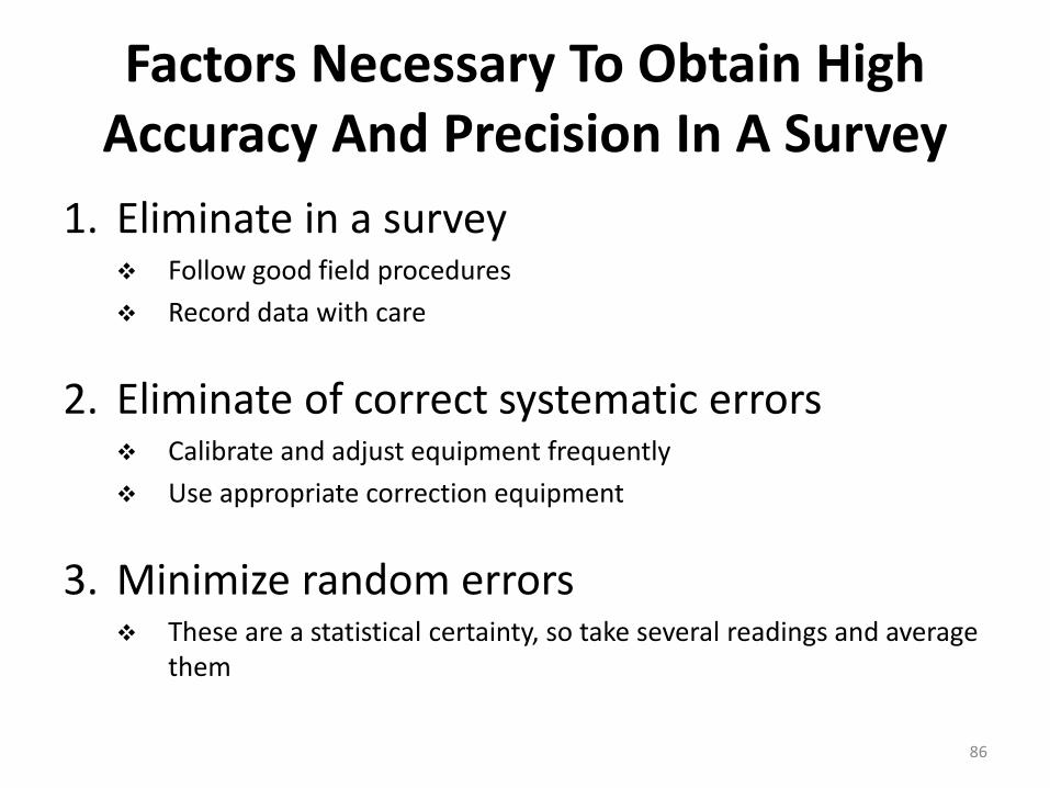
Factors Necessary To Obtain High Accuracy And Precision In A Survey
1. Eliminate in a survey Follow good field procedures
Record data with care
2. Eliminate of correct systematic errors Calibrate and adjust equipment frequently
Use appropriate correction equipment
3. Minimize random errors These are a statistical certainty, so take several readings and average
them
86

Future Challenge in SurveySurveying is currently in the midst of a revolution in the way data are measured, recorded, processed, stored, retrieved and shared. So, in future:
Computers and computer related technologies are widely use at all levels
With technological advancements, society continues to demand more data, with increasing higher standards of accuracy
GPS with help of satellites are widely used to record all type of physical data
GIS with help of various software are currently used to process and analyse the data (MapInfo, ESRI, Bantley, Global Mapping, Super Map, AutoCAD etc.)
87
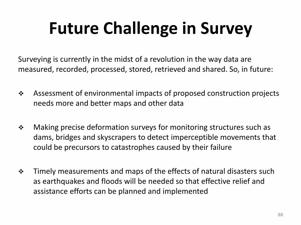
Future Challenge in Survey
Surveying is currently in the midst of a revolution in the way data are measured, recorded, processed, stored, retrieved and shared. So, in future:
Assessment of environmental impacts of proposed construction projects needs more and better maps and other data
Making precise deformation surveys for monitoring structures such as dams, bridges and skyscrapers to detect imperceptible movements that could be precursors to catastrophes caused by their failure
Timely measurements and maps of the effects of natural disasters such as earthquakes and floods will be needed so that effective relief and assistance efforts can be planned and implemented
88

T H A N K Y O U&
Q u e s t i o n a n d A n s w e r
89