~+ 4 - usgs
TRANSCRIPT
RIVER BASIS BULLETIN 3
WATER RESOURCES
OF THE
POTOMAC RIVER BASIN,
WEST VIRCXHIA0
William A* Bobbav Jr. 9 Eugene A. Friel; and Jaaea L. United States Geological Survey
holm
Prepared by the United States Geological Survey
in cooperation with the West Virginia Geological and Economic Survey
and theWest Virginia Department of natural Resources
Division of Water Resources1972
~+ 4

CONTENTSPACK
Summary ............................ 1
Introduction ......'................... 7
Purpose and scope . ........... 11»
Water resources ........................ 12
the hydrologic cycle ................... 18
Interrelationships between ground water and surface water 26 * *
Gaining and losing streams «......*.*... 32
Streamflow separation ................. 37
Base flow ...................... 42
Surface water ...*...................... 49
Source ........................... 49
average Streamflow ................... 50
Low-flow magnitude and frequency ............. 59
Average 7-day low flow ............... 65
Flood magnitude and frequency ........ «. 68
High-flow frequency ................. 72
Water-supply storage requirements ............ 75
Flow duration ...................... 80
Effects of impoundments on flow duration ...... 85
Time of travel .....*................. 88
Ground water .*.....<, ................ 100
Source .......................... 100
Hydrology ........................ 101
High-relief areas of the Valley and Ridge province 102

' ,; CONTENTS ; ' ... i '
Ground water - Continuad
; Hydrology - Continuad
High-relief araaa of the Valley and Ridga province - ContinuedPAGE
Anticlinal ridgaa ................. 102
Synclinal ridgaa and other araaa ......... 119» »Low-relief araaa of the Valley and Ridga province 121
Springs ...................... 121,
Walla and caves .................. 122,'; -, . ' .
Appalachian Plateau section .............. 124
Storage and water-level fluctuation .......... 128
Natural ...................... 128
Man1 , affect .................... 132
Availability ......................... 135
Aquifer characteristics .......... ...... 139
Quarries and nines aa sources of ground water 146
Problems ......................... 152
Vater quality .......................... 155
ground water ........................ 163
Temperature ...................... 166
Specific conductance and dissolved solids ....... 170
Pollution and other water quality problems ...... 176
Classification .................... 183
Surface water ....................... 193
Temperature ......«........«« « 200
Specific conductance and dissolved solids ....... 204
ii

CONTESTS
Water quality - Continued
Surface water - Continued
Hydrogen-ion conceatratioa (pH)
Hardaeee »
Iron .............
Dissolved oxygen .......
Biochemical oxygen demand ...
Dissolved oxygen-biochemical oxygen demand relationship for a selected stretch of the North Branch of the ?otbmac ........
Problem* and treatment methods
Present use sad future development ,
PAGE
209
212
215
.216 ,
219
220
223
225
iii

ILLUSTRATIONS .PAGE
1. Index map of the Potomac River basin in West Virginia 8
2. Relief nap and cross sections shoving physiographicprovinces and general rock structure ............ .9
3. Map showing average annual precipitation ......«.. 14
4* Graph shoving variation, duration, and frequency of annual precipitation at Hartinsburg 17
5. Diagram of the hydrologic cycle in the Potomac Riverbasin in West Virginia .................. 19
6. Graph shoving average evaporation from class A pans atWardensville and Parsons ................. 20
7. Graph shoving monthly potential evapotranspiration andprecipitation at Petersburg and Bayard .......... 23
8. Hap of average annual -panrrfpi tattAai*,..-iiinoff, MI* vater loss 25
9. Flow-duration curves of selected streams in the Potomac .River basin ........................ 29
10* Graphical analysis of streamflov of South BranchPotomac River at Franklin ...........*.. .. 39
11* Graph shoving changes in quality and quantity ofsurface vater at base flov as related to changes inthe geology of the stream beds .............. 47
12* Chronological variation of'annual runoff of CacapottRiver near Great Cacapon ................. 51
13. Map shoving average annual runoff ............. 53
!* Relation of average annual discharge to drainage area , . . . 54
15* Annual variation of lovest mean flow for South BranchPotomac River at Franklin ................. 60
lo. Low-flow frequency curves for Back Creek and Opequon Creek 61
. . 66Map shoving lowest mean flow for 7-consecutive days
having a recurrence interval of 2 years and 10 years .
iv

ILLUSTRATIONSFAGS
18 Frequency of annual flood stages on South Branch ?otomacRiver near Petersburg ................... 70
19* Draft-storage-frequency curves for North Fork South BranchPotomac River at Cabins .................. 79
20. Range of flow duration for 17 gaging stations ........ 84
21. Flow-duration differences of Patterson Creek near Headaville 86
22. Hap shoving locations of time-of-travel sampling sites * 89
23. Profile of South Branch Potomac River ........... 91
24. Observed time-concentration curves for South BranchFotonac River between Petersburg and Romney ..... 92
25. Observed time-concentration curves for South BranchPotomac River between Romney and the mouth ........ 93
26. Peak-concentration attenuation curve ............ 96
27. Travel time-distance relation on South Branch Fotomac River 97
28. Photographs of .limestone quarrys at (A) Mechanicaburg Gap near Romney 9 (B) a gap near New Creek, and (C) a gap near Baker ....*....*....*.... .. 104
29 Diagram shoving the general hydrology of a high-reliefarea near Wardensville ..» .. 108
*>. (Deleted)
31 » (Deleted)
32. Graph showing water levels in wells 23-7-18 and 23-2-12, precipitation at Romney, and chloride content in water from well 23-7-18 ..................... 113
33. Cross section of Knobley Mountain near Short Gap showingrailroad tunnel, sampling sites, and probable water table . 114
** Fhotograph of jointing in Oriskany Sandstone ........ 117
**» Bydrograph of water-level fluctuations in well 20-5-7precipitation at Kartinsburg ............. 129

ILLUSTRATIONSPAGE
36* Graph showing water-level fluctuations in a deep artesian well compared to water-level fluctuations in an adjacent shallow water-table well and precipitation at Mborefleld
37.
38.
39.
40.
41.
42.
Graph showing water levels of wells 22-3-21 and 23-1-23» precipitation at Romney, and approximate water level fluctuations in reservoir near well 22-3-21 . . . . *
Diagram showing places to-obtain? relatively large quantities of good quality ground water * *£ 4*- .<
Diagram showing places to develop moderate to large ground-water supplies in areas underlain by carbonate rocks ........................ <
Graphs showing approximate lowest water level in OpequonQuarry, average daily pumpage from the quarry, and
relation of water level in the quarry to pumpage . . .
Graph showing water temperature at various depths in the Kartlnsburg Quarry near Martinsburg and average monthly air temperature at Martinsburg Airport . . .
Graph showing water level and specific conductance of water in well 26*2-14 and precipitation recorded at Franklin ......................
43. Graph of dissolved solids versus specific conductance of ground water . .................
44. Graph showing water level and specific conductance ofwatet frott well 23-5-17 and precipitation at Romney ...
45. Diagram showing relative chemical content of ground water from various sources ..................
Diagram showing the zones of fresh and salty ground 'water in the synclinal beds of shale and silt a tone beneath Patterson Creek and Mill Creek Valleys . .
Changes in proportion of major ions with changes in flow .
Graph showing once daily water temperature for the first and fifteenth day of each month for South Branch Potomac River at Franklin and Petersburg ............
Graph, of and daily water temperature forthe first and fifteenth day of each month for Stony River near Mount Storm ......«..'.
131
133
136i
137
148
169
171
172
175
185
191
194
202
203
vi

ILLUSTRATIONS
. Graph showing ratio of dissolved solids to specific conductance of streams .............
SO* Duration curves of specific conductance of SouthBranch Potonac River at Franklin'and near Springfield
51* Iron concentration of surface water at low flow
52* Hardness of surface water at low flow . . *
53* Graph showing dissolved oxygen-biochemical oxygen, demand , relationships on North Branch Potoaac River <
PACT
205
208
210
213
218
vii

TABLESPAGS
! Summary of data regarding hydrologic unita andground vater (also on pi. 1) ........ *..*. 5
2. Summary of facts about the Potomac River basin inVest Virginia ...................... 6
3« Adjusted potential evapotranapiration ..... ».. 22
4, Measured discharge and specific conductance ofSmith Creek at Zigler and near Franklin 34
5« Low-flow measurements and chemical quality ofselected streams and springs ......*...**.. 44
6. Selected data from streamflow records 55
7« Availability of streamflow records ~. ............ 56
8.. Mean monthly discharge at stream-gaging stations 57
9. Magnitude and frequency of annual low flow at cream-gaging stations .................. 64
10. Station flood-frequency relation ............... 71
11 Magnitude and frequency of annual high flow atstream-gaging station* .......... »» 74
12«. Draft-storage-frequency relations at stream*gaging stations ..................... 77
13. Flow duration at stream-gaging stations. .........; 83
!* Selected data on floodwater retarding structures . . . . . 87
15. Summary of tlme-of-travel computations .......... 98
*£ Ranges of transmissivity and storage coefficients forAllegany and Washington Counties, Maryland ....... 140
17 Values for transmissivity and recharge based onmeasured and estimated streamflow. and ground-waterlevel measurements ' 142
viii

TABLESPAGE
). Ranges of field hydraulic conductivity (K) of about the top 50 feet of bedrock as determined by the U. S. Soil Conservation Service ............... 143
9. Source or cause and significance of dissolved mineralconstituents and properties of water ............ 156
D. Recommended maximum concentrations of major chemical constituents of water for industrial, domestic, and agricultural uses ...................... 157 ,
1. j#esticideVanalyses/«g. ground water . ............. 180
J. Chemical analyses of ground water .in the,Potomac/^ JCiver basin in West Virginia v. /^* + ../....... . ^ 184-"
3. "Typical" analyses reconstructed from median valuesobtained from 1960*1970 .................. 197
4. Chemical analyses of selected streams - median,maximum, and minimum values » « « 198
5.. Chemical analyses of selected'streams - median, maximum, and ^ trf <« values (data furnished by West Virginia Department of Natural Resources) ....... 199
£V£ :6. .Effect of temperature on properties of water ......... 201
7. Frequency of specific conductance of selectedstreams in the Potomac River basin ........ * . . . . 206
8. Nnfabur of streaMarandapLluaa iu ihe-Potomac-Rtvgrhflnln havlng-vatei liatduiAgg"values~aajahovn~r^r ...... 212
>9. Hardness of surface water, July 1967 to December 1969(data from West Virginia Department of Natural Resources) . 214
10. Chemical analyses for the North Branch Potomac River ..... 222
11 Selected ways of removing or reducing chemical constituents that exceed recommended maximumconcentrations ........................ 224 *
'* Public and some industrial water-supply systems in thePotomac River basin in West Virginia ............ 227
ix

FLAXES
1. Ground-water hydrology o£ tha ?otoaae Rtvar baain, West Virginia
A Availability of ground water
B Suitability of chemical quality of ground water for domestic or public supplies f
C Water-table contours, large springs, and faults in _ Berkeley and Jef f eraon Counties.
D Diagram showing the general hydrology of a high-relief area near Wardenaville
B East-west cross section through the central part of tha study area showing walla and the approximate geology, structure, and water table
2. Locations of low-flow water-quality sampling sites and U. S. Soil Conservation Service flood-retarding dams
3« Locations of wells, test borings, and springs in the Potomac River baain. West Virginia .

FACTORS FOR CONVERTING ENCUSH UNITS TO INTERNATIONALSYSTEM (SI) UNITS
The following factors may be used to convert the English units published herein to the
TTubiished4A* SI units*Multiolv English unite
. - * inches (in)
feet (ft) .. yards (yd) rods xniks(mi) * .
acres
square miles (mi3 )'
^pVTcrip* ri«wrfctfon«. vnffi such time -that iMl data will be-*
By To obtain SI units
length
25.4 .0254 J048
5!0292 1.609
Area
4047.4047 .4047 .004047
X590
millimeters (mm) meters (m) meters (m) meters (m) meters (m) ' . ' ' ' . kilometers (kin)
square meters (m* ) hectares (ha) ' . square hectometer (hm2 ) square kilometers (km* )
. : square kilometers (km* ) ' '
gallons (gal)
million gallons (10* gal)
cubic feet (ft*)
cfe-day(ft*/s-day)
acre-feet (acre-ft)
. 'Volume
3.785 3.7853.785x10*
37853.785X10T*
28.32.02832
2447
cubic feet per second (ft*/*)
gallons per minute (gpm)
Bullion gallons per day (ingd)
(short)
12331.233x10* 1.233xlOT*
Flow
28.3228.32
.02832
.06309
.06309 6.309x10-*
43.81 .04381
Mass *
.9072
**liters(l)cubic decimeters (dm9 ) cubic meters (m3 ) cubic meters (m3 ) cubic hectometers (hm3 ) cubic decimeters (dm1 ) cubic meters (m3 ) cubic meters (m3 ) cubic hectometers (hm3 ) cubic meters (m3 ) cubic hectometers (hm3 ) cubic kilometers (km3 )
liters per second (1 /s)cubic decimeters per second (dm*/s)cubic meters per second (m3 /s)liters per second (1/s)cubic decimeters per second (dm3 /s)cubic meters per second (m3 /s)cubic decimeters per second (dm3 /s)cubic meters per second (m'/s)
tonne (t)unit hectare Is approved for UM with the International System (Si) for a Umited timo. See NUS Special Bulletin
P-13,1972 edition. The unit iite* la accepted fotf «ae with the International System (SO. See NBS Special Bulletin 330, p. 13,1972

RIVER BASIN BULLETIN 3
WATER RESOURCES 0? TEE POTOMAC RIVER BASIN, WEST VIRGINIA
By William A* Hobba, Jr., Eugene A. Priel, and Jaaaa L. Chiahola
'SUMMARY
This report describes the vatar resources of the Potomac River basin
in Waat Virginia* This baain includes an area of 3,464 square miles or
about 15 percent of the State. The present population la 125,500. Con
siderable future increases la population, with increases ixr recreational
and industrial expansion and in the demand for vatar, era anticipated. Thus,
a knowledge of the water resources is. essential in propar planning for development, c//*/**//y Essentially all water in the baain la derived from precipitation. Average
Annual precipitation la 38 inches per year; of this amount 25 inches la
returned to the atmosphere by evapotranspiration, 8 inches becomes ground-
water recharge, and 5 inches becomes direct overland runoff.
The hydrology of both surface water and ground water la related to
geology. In numerous places perched streams are losing water to underlying
cavernous limestone and fractured sandstone. In other places streams are
Saining water that la discharged from adjacent aquifers. Ground water dis
charging to streams in the central part is derived mainly from springs in
anticlinal structures of sandstone and limestone. Discharge to streams in
**** eastern part is derived mainly from springs on faults or other fractures
la the carbonate rocks. Studies of treamflow at gaging stations indicate
*hat from 60 to 85 percent of stream discharge in the 1969 water year was
**lved from ground-water sources.
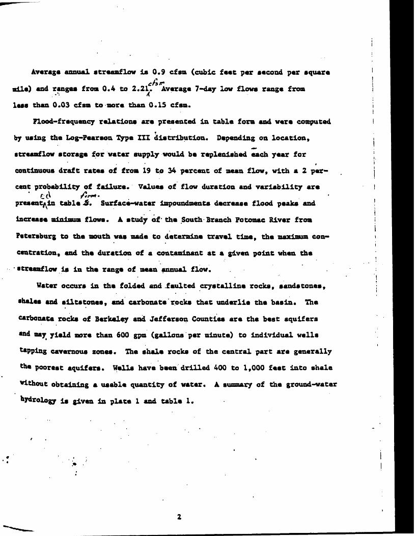
Average annual streaaflow is 0.9 cfsm (cubic feet per second per square
aile) and ranges froa 0.4 to 2.21. Average 7-day low flows range froa
lass than 0.03 cfsm to more than 0.15 cfsa.
Flood-frequency relations are presented in table fora and were computed
by using the Log-Fearson Type III distribution. Depending on location,
ttreaaflow storage for water supply would be replenished each year for
continuous draft rates of froa 19 to 34 percent of mean flow, with a 2 per
cent probability of failure. Values of flow duration and variability are
present^ in table <5. Surface-water impoundments decrease flood peaks and
increase minimum flows. A study of* the South Branch Fotoaac River froa
Petersburg to the mouth was aade to determine travel time, the maximum con
centration, and the duration of a contaminant at a given point when the
streaaflow is in the range of mean annual flow.
Water occurs in the folded and .faulted crystalline rocks, sandstones,
shales and siltstones, and carbonate rocks that underlie the basin* The
carbonate rocks of Berkeley and Jefferson Counties are the best aquifers
and may yield more than 600 gpa (gallons per minute) to individual wells
tapping cavernous zones. The shale rocks of the central part are generally
the poorest aquifers. Wells have been drilled 400 to 1,000 feet into shale
without obtaining a usable quantity of water. A summary of the ground-water
r is given in plate 1 and table 1.

The chemical quality of both aurface water and ground water la very
poor to excellent, depending on location. In places, water from the ahale
contains as much aa 7*900 mg/1 (milligrams per liter) dissolved solids.
In places water from the coal-bearing rocks contains eoneentrationa of
sulfate and iron in excess of 2,006 and 300 mg/ly respectively. The surface
water of poor quality is commonly derived from ground water of poor quality,
although in some streams (such as in the North and South Branches of the
Potomac River .and Opequon Creek) poor quality is due to pollutants.
Table 2 is a summary of facts about the Potomac River basin in West
Virginia.

Plate 1
Ground-v«tor hydrology of the Potomac River Baa in, Vest Virginia

Tabla 1
Suaoary of Data Bagardiag Hydrologic Units and Ground Water
jo

INTRODUCTION
The study area lies in eastern West Virginia (fig* 1) and includes
eight counties and what is commonly referred to aa the "Eastern Panhandle"
It is underlain by rocks of varied age, composition, and structure* The»
geologic nanaa used throughout this report conform to those used by the
Vest Virginia Geological .Survey and are not necessarily the same aa those
used by the U* S* Geological Survey. Elevation of the land surface generally
increases from aaat to vest, and both the lowest and highest elevations in
Wast Virginia are found in the basin (fig. 2). The lowest elevation 1(250
ft. above mean sea level) is at Harpers Ferry, at the junction of the Potomac
and Shenandoah Rivers. The highest elevation (4,860 ft, above mean,sea
level) is at Spruce Knob, near Circleville in Pendleton County*
Consolidated rocks of four types underlie the basins crystalline rocks;
andstones; shales and silts tones; and carbonate rocks. These rock types
h*ve been mapped aa aquifer unita (pi. 1) and are described in detail in
table 1« This table summarizes data regarding the composition of the various
quifers, the quality of their water, and the yields of walla and springs
*PPing them.

Index Hap of th« liv«r Ba*in la V«ac VirginlA
8

'!': : : : , ' ; '.': :'* ' '. ~ '' *' '
\ : . '
MAO andfAg Physiographic
and Ganaral Rock Strr
.. . . .. . i.. .- . , .. ..:. " '-\i' .-....* ; ;» .
' . '' -
.
I '
f. ' ' ' . *:' "'
t . ' . ' '«.' *' '
I

Rock composition and structure are both related to topography. The
shale and limestone are easily weathered and eroded and generally underlie
valley areas. Sandstones are more resistant to weathering and erosion and,
therefore, generally underlie ridge areas. This is apparent when comparing
the geology (pi. 1) to the relief map (fig. 2). Crystalline rocks, under
lying less than 1 percent of the basin, are also resistant to weathering and
erosion and form the ridge at the extreme east edge of the basin. Rocks
of the Valley and Ridge province form anticlines and synclines. Anticlines
are beds of rock folded into an arch. Synclines are beds of rock folded/ 4 itr*»if/i I e~*f>*.^j
' into^an iavecteu-erch4 Many anticlines^of sandstone form ridges, and many
synclines^pt shale form valleys* Some anticlines of easily weathered shale
or limestone form valleys, and some synclines of resistant sandstones form
ridges.
The Appalachian Plateau province is underlain by relatively flat-lying
sandstone and shale* However f/1 at depth/ foldlng^may-be more intensive-.
Bere, too, the more resistant sandstone generally underlies ridges, and less
resistant shale underlies slopes and valleys.
The major rivers are the North and South Branches of the Potomac, the
Potomac, the Shenandoah, and the Cacapon (fig. 2). The upper reaches of the
South Branch Potomac, the Shenandoah, and the Cacapon Rivers are fairly
traight or gently meandering and generally flow in northeast-trending
valleys along beds of weak, easily eroded rocks. At some places the rivers
cross the ridges at right angles through water gaps in the more resistant
rocks. . '
X. .N.

Purpose and Scope
This report presents basic information and interpretations regarding
the occurrence, availability, and Quality of the water resources of the
Potomae River basin in West Virginia. The report is the result of one of
a series of reconnaissances designed to evaluate the water resources of
the river basins of West Virginia. The study was done by the U. S. Geolo
gical Survey, in cooperation with the West Virginia Department of Natural
Resources Division of Water Resources and the West Virginia Geological and
Economic Survey. The basin includes 3,464 square miles, or about 15 percent
of West Virginia. Tiwt water resources are important to the baa in and will
play on important role, in its future,go«io nJiHoet-vithogtruayiag. Recrea
tional and industrial development is anticipated because most of i-fr lies
within a few hours driving time from Washington and Baltimore. As the
*ree grows, knowledge of the water resources is mandatory- if they are to
be properly developed. managed, and protected.
Many of the basic data Jit this report were obtained in the field by
personnel of the U. S. Geological Survey between July 1968 and July 1971.
Plates 1, 2, and 3 show locations where most data were collected.
ft .n«/

WATER RESOURCES
Water in the Potomac River basin ia mainly derived from precipitation,
and most of West Virginia has abundant rainfall. Although that pact of the
State vest of the AUeghenys has an average annual precipitation of 45
inches* the basin has an average precipitation of 38 inches annually. This
difference is largely attributed to differences in elevation and storm ,
patterns. Because most of the basin's water comes from precipitation, some
knowledge of climate is essential to understanding its water resources.
The central part lies about 200 miles from the ocean. The basin lies
on the eastern slopes of the Appalachians, and its climate is more continen
tal than maritime. The area is influenced by prevailing westerly winds,
which are frequently interrupted by surges of cool northerly and warm
southerly air masses. These surges are accompanied by.the passage of high
and low pressure zones; associated with the latter are large-dimension
toroa, which are most common in the colder half of the year. Large storms
re usually responsible for flooding the larger streams. In the warmer half
oi the year, the basin is affected by the showers and thunderstorms that
occur in the broad current of air that tends to sweep northeastward from
the Gulf of Mexico. Storms of this type often cause flash flooding in
narrow valleys*
12

Figure 3 shows areal differences in average annual precipitation,
rate of the variations are dramatic; for examplev from the mountains along
tie vest edge of the basin to Petersburg, annual precipitation decreases 29
aches in an airline distance of only 15 miles. The vegetation also changes»
espectively, in thia distance froa birch v spruce, and rhododendron to
car let oak9 Virginia pine, and some prickly pear cactus. A marked rain
hadow occurs east of the Alleghenys because westerly winds become warmer
s they descend the east and leeward slopes of these mountains* The atmos-
here is thereby capable of holding more moisture, and precipitation is
arrespondingly reduced. Precipitation increases farther eastward, where
topographic Influences are more favorable and where the influence of the
>cean and coastal storms is more pronounced (U. S. Weather Bureau, I960)*
fcakened hurricanes traveling -northeastward along the east side of the
Alleghenys occasionally cause heavy rainfall and flooding during late summer
md early autumn.
the extremes of monthly precipitation at Martinsburg during fehe- period)
IB92 to 1969 rangei fromta--min±mum-of) 0.07 inchtitf in October 1963 to(a~max±
*»-of )l0.67 inches in May 1921. These extreme monthly values (and their/fear of occurrence) along with the 1931-60 monthly normals are as follows:
it« i
.
13

il
- r , .
. . ' ' ' . ...: .
I ..

Month
January .
.February
March V { '; _
April -,./:
j«n« -.,-;.;/July . ;-
k August ; ;
Oetobar '
ftnrob.r ',
DwMbM'
MaiclwiiBC '*«. *<*)
.5.49 ;
! v 4.90
.V-!' !' ;'.-' 6.76
: 8.62
;.:>. " ; 10.67
:;:..' - 7.54
; 9.30
.V; : 10.00*' » * ' .' ; ; .-.- 9.49
;A 10.38
I;:.:',.;.!;:. 6.17- '"r:- -.5.25
V - .
lYeari MliC:
(1937)
(1897)
(1936)t
(1918)
(1921)
(1896)
(1905) .
(1911)
(1945)
(1942)
(1963)
(1901)
nlmtira.\--Kci)
0.25
.25
.17
.74
.35
.88
.72
.57
A7 **/
.07
.41
..19
CYear>j^^^^ r
(1955)
(1901)
(1910)
(1946)
(1900)»
(1966) *.
(1966)
(1962) : ;
(1943)
(1963)
(1960)
(1955)
NomaJL (
2.
'';.': 2 -
3,
..,-' r- 3,
/ ' .:.'. '. 3 i
" :.' '.' 3,
;:- : j.;;.v ;. : 3
' .;.'::; .:: 2
.. / "''/- ";2
t o^l A^^.Ly JA-OUy
63 ' ' '
14
,26
.81
.16
.58 ;
>
! 28 ^ :: ;.53
*74

The variation* duration, and frequency of annual precipitation at
Martinsburg are shown in Figure 4. The duration graph shows the percentage
of total years in which a given value-was equaled or exceeded, and the
frequency graph shows the recurrence interval, in years, of a given annual
value* *
Drought is difficult to define. Hoyt's (1936) drought index, which isi
one of many definitions, states chat a drought exists when annual precipita
tion is less than 85 percent of the mean. Using this criterion, droughts
have occurred at Martinsburg during 15 percent of the years (1892 to 1969)
(fig* 4). Annual precipitation as low as that of 1930 has a recurrence
interval of at least 80 years. During the 17-year period sine* 19537 annual
precipitation was below the 78-year mean in 14 of those years and was below
the 85-percent drought index in 6. Perhaps the greatest economic impactA
of the entire 78-year period was from 1963 to 1966, when annual precipitation
** below the 85-percent drought index for 4 consecutive years. The
verity of a drought in some respects is determined by the amount of preci
pitation during the growing season; therefore, annual precipitation does
always reflect the severity of a drought*

Figure 4
Variation, Duration, and Frequency of Annual Precipitation at Martinsburg*
tick Shows 85-perceatila Value, caa Drought Index of .feoyt (1936). , i V
17

The hvdroloeic Cycle
Water moves continuously from the atmosphere to the earth and back
to the atmosphere* This movement is termed the hydro logic cycle. Figure 5
depicts the hydrologic cycle in the basin and the approximate yearly amounts
of water involved in each, phase. It is emphasized that the amounts shown
are averages for the entire basin. However, within the basin, variations
may be wide from one locality to another.
Variations are caused not only by precipitation but also by temperature,
vlnd, humidity, and length of growing season* These factors profoundly affect
evaporation; data from the class-A type evaporation pan. as recorded by the
U. S. Weather Bureau for the April-to-October period, show that for each
1,000-foot increase in altitude (with its decrease in temperature) evapora
tion decreased by about X inch (fig. 6). The growing season also becomes
shorter with increasing altitude and decreasing temperature; thus, trans
piration should generally decrease also. Therefore, more water is available
to become overland runoff or ground-crater discharge because of lesser evapo-
transpiration demands at higher elevations*
18

9
*i *. *
«*
Figure 5 . . ' , . .
Tha Hydrologio Cycia in tha Potoomc Rivar Baaia in Waat Virginia
f
19

r\

Potential evapotranspiration (Et) is the water loss under the
lOthetical condition of no deficiency of water In the soil at any time
r use of the type and density of vegetation that would develop (Langbeln
I Iseri, 1960). Monthly adjusted potential Et values for eight stations*
computed by the Thornthwalte (1958) method, were furnished by Robert 0.
sdfal-1, State Climatologiat, and Walter H. Dickerson, Professor of Agricul-* i ral Engineering, West Virginia University, and are shown in table 3.
a monthly potential Et In the valleys and at low elevations throughouti
a basin exceeds precipitation from Hay through September on the average,
t, et higher elevations and la areas of higher precipitation, it does not,
is Illustrated in figure 7. Theoretically, ground-water recharge should
t occur in vegetated areas during the period when potential Et exceeds
ecipitation* Therefore, ground-vater storage should be steadily depleted
Et demands and continuous seepage to streams*
*i
lit
21

*..
' ' . ' '..».'I "
Tabl« 3
Adjusted Potential
'".. "'::' '.' " '»'-: '..-.' . '
- vxV ;-" > ' ' ' : " - - "- ,
...' !...'« '.
. . '"' ' '.' ' ' '.
. * .:i'< ;/ ': : ;
/-. : .';. ;'ti.. :... ,'. : .
. ',:- '",'.:, j'' 1-/-.: '. - ; , .'':.. '* ;: "'';'' "' ' ' ' ' ; ' .' ' '
"' "!:.'' ' ' ' . i
22

- \ '.- , "' "'" ' ' / ',
, . . . ' . .
. .- - ..." . ,'v'.:^-.'.' ; .
.' ! ''":'.' '.'.* .'.'
' '.'' . *: ' = " .--.: ;! '
. ' ' ' . .. . ' '..- ". . :
..'. \ ..- .'.'.'';:: .' -. . -
: I
/"">^-:: ;.' ; -:' Figure 7
«a :; :,, ;.; / .'' ',.'.'
Pecaraburg and Bayard "
'% ;J i.»
. ; 1'
- '. ' ' ' ' *. '. . * . »
'- ' ' : .' :. '. :" .' '. ..-
lM. "?t-t
«
* W : .:-.-..' / "
: .'". ' . , V -. .* «».
' ' ;.
' . ' t
I
' r
I
i

The hydrologie cycle is in balance at all tinea. Therefore, total
water input must equal total water output. Neglecting any interbaain
underflow, water input ia precipitation, and water output ia total streaa-
flow plua total water loaa (fig. 5). .Total streaaflow ia conpoaed of
overland runoff plua ground-water diaeharge to streams. Total water loaa
ia the water that returns to the atmosphere by Et. Figure 8 "shows the
variations of total water loaa aa total precipitation minus total runoff'/^
during 1930-67 for 20 sub^baaina. Because the values ahown in figure 8
are average for the 38-year period, year-to-year change in ground-water
storage nay be neglected. The variation in water loaa froa one part of
the basin to another ia caused by precipitation differences and probably/7>
by interbaain transfer of ground water froa one aub/baain to another.
The degree to which nan1 a activities affect .the hydrologie cycle la
poorly understood. However, holding water in dams and ponds, pumping of
**Ua, irrigation, and clear cutting of forests do affect the amounts of
vatar paaalng through the various phases of the hydrologie cycle*

. } . ' ': "''.
'- : .
. . . -: ,-.
' ' : ' '
.: . ''.' '"'."' ' " ! ' i ; . , i :' . .''* - - : '.: ' -
-.
.. -, . ' '
..
.. ,." i . .

Interrelationships Between Ground Water and Surface Water
There la -aa-5t03nBt*» relationship between the ground-water and surface f
water phases of the hydrologic cycle. The discharge of most streams is
composed of a mixture of overland runoff and ground-water discharge that
varies in time and place* During dry periods streamflow may be all ground-
water discharge. During floods it may be all overland runoff. Overland ,
runoff reaches streams quickly, and most of it is discharged from the basin
within a few days* In contrast, ground-water discharge continues over a
prolonged period and is greatest when the water table is highest, usually
in the spring. It continues at a decreasing rate through summer and autumn,
. even when there is no ground-water recharge. Most of the large perennial
streams discharge relatively large amounta of ground water annually. These
streams are incised to a water table that generally slopes toward the
Cream and continuously feeds ground water to it. The smaller ephemeral
treams of the upland part of tha basin discharge only small amounta of
ground water during dry summer and fall, when tha water table drops beneath
the bed of the stream and the stream goes dry. During such dry periods, a
part of any overland runoff entering a stream may percolate'to the water
table through the stream bed and become ground water. This aspect of the
of ground water to surface water is further discussed and
are cited in a following section, "Gaining and Losing Streams. 19

Geology and topography hava a marked affect on tha relationship of
ground water to surface water. This affect is uaualiy determined by permea
bility of the various rocks and the alopa of tha land surface* Tha four .
basic types of rock in tha basin crystalline, sandstones, shales and silt-
cones, and carbonates generally have different hydraulic characteristics.
Tha crystalline rocks and tha shales and siltstones ara tha laaat permeable,i
and the sandstones and carbonate rocks are tha moat permeable. Hence, an
area underlain by Impermeable shale and silts tone would permit a large
percentage of percipitation to become overland runoff. An area of equal
ize underlain by permeable, fractured, cavernous limestone receiving an
tqual amount of precipitation would permit moat of tha precipitation to
become ground-water recharge* The greater amounts of ground-water recharge
«nd storage ara reflected in tha high levels .of .base flow maintained in
araaa underlain by limestone.' -Topography affects ground-water recharge
by causing greater runoff from ataep slopes than from.flat-lying araaa
tffldcrlain by rocka of similar permeability receiving similar amounts of
Palpitation,
27

The interrelated and variable influence of geology and topography on
und-water recharge and discharge and streaaflow are illustrated by the
aoatf low-duration curves shown in figure 9.
The slope of a flow-duration curve has a direct relation to ground-
:er recharge and discharge. If little or no artificial surface storage
present » a gently sloping flow-duration curve reflects the discharge of
latively large quantities of ground water. A steeply sloping curve
fleets less discharge of ground water and indicates that the stream may
i flashy due to a great contribution from surface runoff. The lower part
: the curve reflects ground-water discharge almost entirely. The slopes
E all the duration curves in the basin are rather flat compared with those
a other areas of the State* indicating high ground-water storage and con-
equent high base flows. ...
The South Branch Potomac River above Franklin and Opequon Creek above
l*r tins burg are underlain by a highly permeable cavernous limestone. During
periods of precipitation direct storm runoff is reduced because much of the
**ter Infiltrates the limestone and is stored there* Recharge to the lime
stone is greatest during the winter and spring. The stored, water is gradually
teltased throughout the rest of the year, resulting in high base flow duringj « periods. Thus, the ste» a a«f low-duration curves for South Branch Potomac
w«r at Franklin and Opequon Creek above Martinsburg have relatively flat
*°pe»« The upper parts of the curves are low, and the lower parts of the high.***»
* a
;|.if 1' i t i jf ..'
28

.
t
'
.
. '"*!.
'
' .' ''
'.^-:
'r;:':^
^^vV
,i;^v
-::;':;
v;..'->
";,;*
:,,.:.:--
Vj..-
fv- "
'}, :.' ..
-. :
: ;
v>'-
--^;
-;.-
:-
'">
. r-
N-.V
-^-"
'^"'"'
":
:'.*:
.
> <
:' .»
;, : '
-.-v.
.;v
.- .
'. -':
-.-;
;;,--
-.-.
.v^:
.:;.!
.-
; :: .
..;:^
:v.'::.
.--.:-
v
. .,..
> -
/"; ,
:: ..
. :
,...:
...,/
-
':-
-
V
-.
- .
.- :
-.;
/
;
.-fr
r--:
-'
»!,
" :
"
-^
."
- -''."
'
". .-
- \
' -
..
;:v
. .:-
-:- -
?:^'
.';:.
:
-'
M:..--
: ;
" . -
;:
> :
.::.-"-
'-; v
.:,-
, ;-.
.
-.' -"
-''
.::;'.'i
:i-"--?
:"-:-';
i": r
irf':
v:"-"
; :
:" :;
''.." "
;.' '' :
-..- '
:' ; ".
..- - ;:
':A-":
,;,^;-
v^^.^
| . ^
r-,:
^;^
:-^^;^
- '-.
, -.
-..
'.v.;'
"-
-» :.
."..:
' e
= .=
::
.:' :"
: "
-i,'
..
- "I"*!
' .
- .
. .
»'
;/-'
;Vi:^
'2';-
'::;^
*-"" '
*
. '.
'.
\

The Patterson Creek basin above Headaville and the Back Creek basin
nre Jones Springs are generally underlain by relatively impermeable shale
1 siltstone beds, which have a low capacity for ground-water storage.
it precipitation runs off overland. Hence, there is little ground-water
charge and, therefore, low base flows/ The s tin am flow-duration curves
r these streams, thus, have relatively steep slopes. These streams are
id to be "flashy1* because they have a high variability of flow.
The North Branch Potomac River above Steyer, Maryland, is underlain by
derately permeable sandstone and shale. Thus, moderately large amounts of
ter Infiltrate and become ground water. Although the slope of the middle
rt of this curve is about the same as that for the areas underlain by
aestone, the upper part of the curve- Indicates that the rocks of this area
re not as effective as the; limestones in taking on recharge, and the lower
irt of the curve Indicates that these rocks do not have as much stored
iter to release as the limestones. The entire curve for this stream has
fce highest position on the graph because the annual precipitation in this
is the highest.
:-'3 '
rj|l
3iiHfe
30

Tha low-flow frequency curves shown in figure 16 also Illustrate the
.uence of geology on the low flow of atrearns. For example, the median
ly value (at the 2-year recurrence interval) for Opequon Creek is 0.17
(cubic feet per aecond) per square mile, aa compared with 0.03 cfs per
ire mile for Back Creek* The difference between the two seta of curves
raes even greater with longer recurrence intervals. The flatter slope
higher position of the curves for Opequon Creek ia another indication
ligher infiltration rate and atorage capacity in this basin. The loweat
i flow each year* for at leaat the 7-conaecutive-day periods, consists
jely of ground-water diacharge to the atreana.
The variation in contribution to atreamflow by ground-water diacharge
overland runoff ia various sub-basins ia discussed in more detail in a
lowing section.
if1
H
31

Gaining and Losing Streams »
Streams, or parts of streams, may be classed as either gaining or
osing. The flow of gaining streams is maintained or increased by the
aflux of ground water* The flow of losing streams is depleted by leakage»
:o an aquifer below the bed of the stream* Although losing streams are
Bore prevalent than generally thought, in the eastern United States the ,
Saining stream is the more common type.
Several large losing streams exist in the Fotomac River basin*
Probably Lost River is the best-known* Three miles west of Wardensvilla,
at Route 55 and 259, the river goes underground (pi* 1). It probably
drains into the fractured Orlskany Sandstone and cavernous limestone of
the Helderberg Group to a point about 2 miles downstream, where it emerges
s the Cacapon River. Surf ace- flow takes place during periods when the
level of water in the ground rises above the bottom of the stream channel
ad when flood flows ia the river exceed percolation capacity of the stream
btd.
32

Of the smaller losing streams, Smith Creek from Zigler (4 milesi
southwest of Franklin) to the South Branch is the only one that has been
studied* The measured flows of Smith Creek upstream from Zigler ranged
from as little as 0*1 cfs during periods of base flow to 18 cfa'(table 4).
During periods of low flow the stream disappears at or just below Zigler*
During periods of high flow it generally disappears within 2 miles downstream
from Zigler, but, during wet periods in the spring, it sometimes flows
over the entire length from Zigler to the South Branch Pocomae River.
Wells in the valley bottom at and downstream from Zigler show the water
table to be as much as 200 feet lower than the land surface* Well 26-5-26
was .drilled 80 feet deep in October 1967. At that time the water level in -
it was reported to be 30 feet below land surface* In June 1970 the well
vent dry and was drilled to a depth of 160 feet. The water level declined
gain, it was then drilled to 240 feet. At this depth the water level
was measured on August 13, 1970, to be 194 feet below land surface. This
decline in water level with well depth indicates an underground discharge
oae or drain* The water level on January 21, 1971. was 172 below land
urface, indicating recharge.

Tabla 4 . » . . .Maaaurad Diacharga and Spacific Conductance of Smith Craak
', ' ,"' ' : t -- ; aft Ziglar and naar Franklin-.'. »... .*: ..:' >.- :.
. t. -. ' _

It la difficult to determine the exact location and nature of the drain
la the Smith Creek area. However, the lowest elevation of the water table
beneath Smith Creek is about 1,850 feet above mean sea level. Thus, the
water level is high enough that a hydraulic gradient probably could exiat
from beneath the creek south beneath Fickle Mountain along limestone caverns
in the anticlinal structure to the South Branch Potomac River. Apparently,
the water is not flowing in alluvium beneath and parallel to Smith Creek
because the flow is less near the mouth, at Route 220, where it crosses over
beds of shale, than it is at- Zigler. These relatively impermeable shale
beds overlie the sandstone and limestone and should force to the surface
any large quantity of water moving .beneath the creek. The water, apparently,
Is not discharging beneath the mountains to Friends Run, in the next east-
west valley to the north, because.that stream was dry over most of ita
lower 3 miles when observed during a base flow period in October 1970. In
fact, the lack of perennial atrearns tributary to Friends Run suggests that
the same underground drain is conducting water from beneath Friends Run
outhward beneath Smith Creek and discharging to the South Branch Potomac River*
Several other streams were found to be losing water at the time base-
flow measurement* were made in October 1969* (See base-flow section.) The
"ounts of the losses are shown in figure 11. The measurements show that
tasae* take place not only on limestone formations but also on shale and
aodatone formations. Losses on shale and sandstone are attributed to high
r*tes of evapotranspiration and to underflow in the fractures along which
ttreaa channel has developed.
35

There are probably many more losing streams in the study area.
Bovever, it is not always possible to detect these streams visually.
Bovever, much of the limestone favor* the formation of caverns, which,
IA turn, may create losing streams. Many structural features", including
bedding surfaces, fractures, and some of the important Joint sets, strike
northeast. Underground drainage follows many of these features, regardless
of the original direction of streamflow on the surface. Where streams
lose water to areas underlain by shale and sandstone, underground flow
Is probably along fractures or faults beneath the stream channel, along
which the stream channel has developed. Water-table contours indicatek
that underground drainage in Berkeley and Jefferson Counties (pi. 1-C) is
controlled in part by faults. The nature of underground drainage for both
High* and low-relief areas of the Valley and Ridge Province is further
cribed la the hydrology section.

Streamflow Separation
As noted earlier, the relative amounts of overland runoff and ground-
vater discharge in streamflow vary with time and place. , Continuous recordingC H'H.fli _.<..../"' / t
«.< t >
instruments monitor the stage (which c an-be- converted-Hso-dischar ge) of major'\
ttreams throughout the basin. The following procedure was used in estimating
the daily proportion of overland runoff to ground-water discharge to streams
la various streams throughout the study area*
Wyrick (written com., 1972) describes a method of streamflow separation
based on channel-method formulas discussed by Stall man (In Ferris and others,
1962, pp. 126-131). For Stall man* s formulas to be applicable, the following
assumptions are made:
1. The stream flows along a straight line of infinite length
and fulljr penetrates the aquifer. ' .
2. The aquifer is semi-infinite In extent (bounded on one side
only by the stream).
3. The head in the stream changes, abruptly in response to
recharge at time equal 0 days.
4« The direction of ground-water flow is perpendicular to
the stream.
5* The change in discharge from the aquifer is derived from
changes in storage by drainage after abrupt recharge.
\
37

A type curve was plotted to represent the drain-function formulas. By
mparlng records of dally stream discharge and dally precipitation, periods
; streamflow record were selected for analysis beginning 1 day after abrupt
tcharge by precipitation and followed by several days of no precipitation.
:reamflow data for these periods were plotted on log-log paper against time,
i days, since recharge (fig* 10). The plotted points were matched to<
tie type curve by keeping the axes of both graphs parallel. Points on the
treaaflow hydrograph matching the type curve were assumed to represent
round-water discharge. By projecting the type curve beneath the earlier
lots of stream discharge, the amount of ground-water discharge was
termlned back to the first day after recharge* The dally ground-water
iischarge was determined and tabulated for all periods of streamflow record
luited to this method of analysis. The ground-water discharge for inter
vening days not suited to this method of analysis was estimated from a
inllar period of record when similar ground-water levels and evapotranspira
tion conditions prevailed. For a few periods, this method of estimating4
could not be used, and discharges were estimated from known discharges and
S?ound~water levels. After ground-water discharge values were assigned tof> '
** 365 days, the total was computed and expressed as a percent of total
tr«am discharge.

; '«; .1
*^.- :'£
^ .,t?f--T3
» . %
: i . :; ' -. I:'i .. . ':.'
«.
» " ,' -.« '
I ''..'.: :». ; : ;.
-' : .' .* '.''.'' -' .'
.. . « . . ' * :: > .. {' .-.- ;.-.'; . . -:---"s;.-.,V--.-
. .-".-'^:-v-'. '-r-iv-1--.'. ' ' "' ' . : :-\:V':-'r .
. ;. . . .-.«.- v. '../ r '. /:"': '. ' :'" " fi..'."i; r.l!V."/.
. . -I... , .. j. ; '. :. -.. .. !.-...: ....... ,.* .. .- « . ....,...-..: .:-...'.;' . » - '. .-: ' - ' :' '
OT
" .'. ._».'.
.^li"-'-.'-.''' i^H:;'-''' '^:. . '. .' ; -
' ' : , ;: ! :; : ' " ' '
t. t ,.
*' . ' ' . ". i r . ' ' '.*' * , .
'." ' .
' -V ..-.' -'^ :' ' .: .'':; ..' :*. .
'* ' ! ' . ' ' * .
'. ' ' ' '. .'"
. f '. ' '; ' :
' .' ' ' ' \ ' '
» ' *
: .%//:% * . ; v^'-VvOV.. .! .-:: ->.Xi-;. .-." :' :,> ' . .
-\:' -^ " . *.."r: ' ":"."'
/:-ft>'-::-^':?«v' ' i -.; :.'. . '

The analyses of several streamflow records for 1969 showed that ground-
vter discharge ranged from about 60 percent of annual streamflow in areas
nderlain by shale and sandstone to 85 'percent in areas underlain by carbonate
vcks. These results were compared with results obtained by arhydrograph-
leparation technique (Linsley and others , 1949) . This technique produced
'alues that were lower but - generally within about 10 percent of the values
ib Gained by the described method. As stated earlier, the lower parts of
flow-duration curves give some indication as to ground-water-storage charac
teristics in a basin. These flow-duration curves served as guidelines**-\
rhen assigning values for grounds-water storage to various subi^basins, as did
»*ae-f low measurements (table 5) and the draft-storage curves (fig* 19)."
the draft-storage curves show that subAbasins having large amounts of ground-
rater storage require less surface storage than those having small amounts
In order to supply a continuous draft of a given quantity.
The amount of ground-water-discharge to streams from each of several
basins, as determined by the described method of streamflow separation ,
* converted to ground-water discharge per square mile and was mapped
** plate I -A on the basis of the underlying geology. Because 1969 was a
year of little ground-water recharge, the ranges shown in plate 1-A have
been adjusted slightly upward to approximate estimated values for an "average"
7«ar. 7^0 ranges in ground-water discharge per square mile shown in this
Plate indicate the approximate amounts of (ground water that can be removed
°a an annual basis from the various aquifers under prevailing conditions
"Ithout depleting (or mining) the supply.

-. ' - ."' ' '. » ' '. * ',' '. i '.' '." '' ' . ' ,.'. ' '
». . '«,.' . '' : j" ! -,:, '* '* .
. -. ; -.- ; ./ " ".. l -.
' ' ' ' _i . .' t .
V ' '.'' ' t ' 'I , !.. t .
.-:. .' . '; ' I.
'. 1 - '. . ». . .'
' '" . . i '* . S ' t " *'.
>' '.' ' ' ' .'. , ' ; - ' . .
»
, ' '.. '.('.': . .1

Base Flow
A stream is at base flow when all its water is derived from ground-
water discharge* The base-flow characteristics of a stream are, therefore,
determined largely by f ground-water environment. The amount of water and the
rate at which it moves through aquifers to sustain the low flow in streams
depends upon the amount of water in storage, the slope of the water table,
tnd the permeability of the aquifer material* Storage is related to volume
of Interconnected openings in the rocks* Permeability is related to shape,
ize, and degree of interconnection of openings in the rocks. Storage and
permeability are both normally low in shale and low to high in sandstone
tnd carbonate rocks. Thus, the base flow of streams draining shale is
coBBonly lower than that of streams draining sandstone and limestone.
The length of time it takes for a stream to reach base flow after
precipitation depends upon numerous factors. Some of the most importantif-. -''
re the amount of precipitation and evapo transpiration; and the geology.
ta general v the greater the rainfall, the longer it takes streams to
reach base flow. However, streams reach base flow in a relatively abort ji ' >
Period where rocks are permeable or evapo transpiration is high. During-
v^ter, truo-baae flow may seldom be reached because of the effects of
freezing and thawing on overland runoff and ground-water discharge.
> i
/, >>,*./ ,it
£/ - .

In October of 1969, the base flow of 170 snail streams and springs,
each draining one type of rock, was measured and sampled for partial
analysis* All flow measurement* were made by a pygmy current meter or
bucket and stop watch* The pH, hardness, and specific conductance were
determined with portable field kits and are approximate* Chloride concen
tration was determined in the laboratory and is more accurate! Analyses
and discharge measurements are shown in table 5, along with discharges
for several other streams. All but two of the measurements shown were
aade between October 13 and 21, 1969. The last rain preceding this period
vas on October 8, when. 0.34 inches* of rain fell throughout the basin 5 days
btfore measuring began* Ground-water levels during this period were near
the lowest on record. (See 'section on "Storage and Water-Level Fluctua
tions1".) . : ...These base-flow measurements are significant in that they give some
Indication of the quantity of ground water being discharged to streams.
Host of the streams measured drained a single geologic formation or aquifer
during a period of base flow when ground-water levels were low and trans-'°
Plration was minimal; therefore, the, base-flow discharges should be indica
tive of minimum
ar* shown in table 5 in
ater yields from the various aquifers. v These yields
^million gallons per day per square tailed, . -
\
*
ff /,
*.W- * "<*

'".. I* ". ' ' '.:."
I ;
'.. . . *' v . * .
'. ' 'V . V ' ' ', '" ' ' -
' ' ' ' ' .' ' '' " '* - ' .; " ; l;-j> .'. < r " .'.'', '. ','->.,' ..:' V.-''-'.''--'.' 1 '.- '." '.': ' - -
. .' -i.- ..-.',-. ; ..... . . ' » " ' ' "
'" i . '..:-.' : '.'.'' ' . ; _.? .
'. '. V . ..i .!." i ' " : '
" ?' . ' ':'. ' " .
- . ' .;. ;'. _« ; ..- -. , . Loif
. .... ' 5. ..: : ; -4 ... .
'-'."' "' '' ' ' : v-':"..!'
l ". '/ *' i - '. .' ! "v
of S«laecad Si
..'.::: » '. ": ' ! i. . ' . '«
Chamical Quality ,.;;,. , > . V. .
ind Spring* .'.;.: .: ! '-,. 1 :. ' .; , ; ..; ; .'.!« v :' ' '. r .1-
' '
_. i
44

Care mist be exercised in assigning significance to these data:
Firsty streams were selected that drained a single geologic formation. The
flow of streams having larger drainage areas are probably more representative
of the minima yields of the formations they drain than the flow of smaller
streams. Secondly, the shale is character is tically found in the valleys,
and the more resistant sandstones and associated limestones -are found on
ridges. Streams in the ridge-forming formations may be small in drainage
ires, may not be incised to the water table, and are losing water instead
of gaining it over parts or all of their courses. Streams in the valley
formations may be larger in drainage area, incised to the water table,
ad gaining water-over most of their courses. Therefore, the base-flow of
valley streams is probably representative of the ground-water yields of
the valley-forming aquifers, whereas the base flow of upland streams is
laterally not representative of the ground-vater yields of ridge-forming
quifers. Thirdly, when measuring the drainage areas, it was assumed that
twtmd-water and surface-water divides coincide. This may be true for mostA
ft as underlain by shale and some sandstone, but it is probably not true
cor many areas underlain by Oriskany Sandstone and carbonate rock. As tnen-
Above, streams flowing over these latter rocks are often losing rather gaining; in other places the streams may be draining ground water from
*rcaCer area than indicated by the surface drainage area. Thus, yields of teams draining these aquifers may range from zero to greater than 0.800
(when underground drainage is greater than the measured surface area, the yield per square mile is excessively high). The true
Ids of the various geologic formations probably lie between given in the table for each formation. What are probably more
«^estimates of areal yield, based on streamflow separation, recessionflow-duration data, and low-flow 4ata are given in plate l-A.
3IS£>/" - . .^ '

The base flows of several streams were measured and sampled at or nearV- jf -i ^ '
the points where the streams flow from "one formation to another* Figure 11
shows both losing and gaining segments of streams. Note in the graphs for
Dillions and Mudlick Runs that both streams have lost water after flowing
over Oriskany Sandstone. . The fact that a small spring (site 61-A) discharges
from the Oriskany Sandstone into Mudlick Run between the measuring points at
sites 61 and 62 suggests that there is both a gain and loss over the sand
stone.
These base-flow measurements .also indicate that streamf low decreases
in rock formations other than the limestones and the. Oriskany Sandstone.
Figure 11 shows that Rough Run loses 0.7 cfs as it flows over the Chemung
Group* The local geology and topography suggest that the stream follows
local fracture zone, and the lost water may be flowing beneath the
tream channel. Notice that the water quality at sites 132 and 133 is
tssentially the same. Apparently water quality did not change over this
losing segment. However, between sites 133 and 134, streamf low increased
lightly, and specific conductance also increased.

, ,
. .. ,
,.''
'
. -
.
I
H -« I
44 U
1
, »
o 8
- «
-3$ I--
1-1-
BMI«MO
1s
I I f1

In Howards Lick Run, which traverses the same geologic units, water
quality changes between sites 69 and 72, as it gains a slight amount of
rater from the Chemung Group* Using specific-conductance and discharge
values for sites 69 and 72 in October 1969, the approximate specific conduc
tance of ground water discharging to the stream between sites 69 and 72 is
computed by the following relationships: ~
Cl <*1 * C2 Q2 " C3 (Ql + V
where Q^ is the discharge of the stream at the upstream measuring site,
Q£ is the total ground-water discharge to 'the stream between the upper and
lower measuring sites, Q^ + Q2 ia the discharge of the mixture at the down-
Cream measuring site, and the three C quantities represent the specific
conductance for each of the three discharges (Hem, 1970, p. 273). The
conputed specific conductance was 220 micromhos.wheceas the measured con
ductance for water discharging from a flowing well (25-4-9) near the stream
between sites 69 and 72 was 290 micromhos in August 1969. The difference
between the computed and measured values is generally attributable to
changes in equilibrium conditions- (temperature, pressure, aeration, etc.)
that occur when ground water is discharged to the land surface. These
cause some of the dissolved minerals to deposit, in the stream bed,
specific conductance is, correspondingly, reduced.
48

SUBFACE WATER
Source
r Streaaflow is derived either from direct overland runoff or froa
Jgruimd wear! discharge froa springs and seeps* Streaaflov is influenced
by natural basin and climatic characteristics as well as by the activities
of nan, soae of which are analyzed in this section of the report*

Average Streamflow
The average flow of the Po comae River at Harpers Ferry is 5.4 billion
gallons of water per day. This is equal to about 8,300 cfa (cubic feet
p«r second) and represents an average runoff of 12 inches of water per year
from the basin*
Streamflow during any given, year may be greater or smaller than the,
average but seldom, if ever, exactly equals it. Average values of stream*
flow serve as a base to which other factors of streamflow may be related.
Ibs variation of annual discharge of Cacapon River near Great Cacapon
(fig. 12) is typical of the streams in the basin. The extremes of annual
discharges of the Cacapon River have ranged from 33 to 177 percent of theyyi»w*»n .
verage daring 1924 to 1970. .Although the average annual runoff of the
River is 11 inches, extremes in annual, precipitation caused runoff
totals of only 3.6 inches in 1969 and 19.5 inches in 1955. Some of the
ftctors influencing precipitation runoff relations are: precipitation» ,
aunt and intensity, land and channel slope, forest cover, stream dcnaity,
l**logy, evapo transpiration, and activities of man.
50

" "
'
-
/ .' '
. " .
. -:'
».
».
%
. i.
'
'
." ''- :; '
' '''.-
* /;-:>v'-. : '
'..» !-»','
.-.'.-
'
.
. > '
. /
": ,..
".. -
"_ -.'.
' '' '
'*r
' '.
;.. ..
,.._ '
' -'
.';" ;' '-. .
-J.-.
;- .' '
'.
.-. :. '\ . : ." ''. -
. ".'* ..
.
* «
* *
'"* *,.' i *
* '~' *'
' '»*.*t^*
*
.' '.*
- ' ' k
' '
...
V , ' ' "

The avaraga annual runoff from the basin above Harpers Ferry ia 0.9
fa par square mile. Baaed on the period 1930 to 1967, yields from various
arts of the basin range from 0.4 to 2.2 cfs par square mile (fig. 13). The
elation of avaraga annual discharge to drainage area is shown in figure 14*.1
Average discharge and years of record at stream-gaging stations ara
Iven in table 6, and the years of record ara praaantad graphically in
Able 7. Mean monthly discharges for the period of straamflov record at
tach station are given in table 8.
Mean annual discharge (Qa) at ungaged sites may be estimated by a
regression aquation (Frya and Runner, 1970). The equation, developed by
i computer program, is in the form .of:
0.87 1.15 5.80 J.42 -£14 £66 -1.80 -642 Qa» 1.10 A S St E F ? I SI
the drainage-basin characteristics ara: .
(A) ia drainage area, in square miles.
(S) is main-channel slope, in feet par mile, determine^ from elevations
*t points 10 percent and 85 percent of the distance along the channel from
*** gaging station to the basin divide.
(St) ia the area of lakes and ponds, in percentage of drainage area
(plus 1 percent).
(E) ia mean basin elevation, in thousands of feet above mean sea level.
(F) is foraat area, in percentage of drainage area.

. I
'!" ' ' '.'
:^:'- :j^ ' ' ' -''.." ' .- '.. '
! ' . » ! ' . '!v'.''"',': ' ".
' - : » '.-' "
°, .*. <'.-.'. ' "" ',< * '*/. '.';' ; '' : ' .' ' *' ' " '
'
, - I- - t .- ' .
..' '/ ': '..;' . *'-' ' '--'':
.' ''. -.:. A t.\ ' ; .' '.
'. « .' i ' ' ' '' '. .'"' ' i ' . ' '
'
' . ' . ' t
*'. *; "
" . ' .. i ' '' <

-.'..' '' ' 4 '. " ' : -
'* \. : .. -:x " . ; - '
' ' v.i' : /.:. \ " , ,.' ' ;'"« *'" . ' : * " \-
I.' ' ' '
''.' ' ' '
, i
: i
' <..;."' ', .: ' ("...
. .. '.V';/V " A-" 1-".'"" » ' " ",.-'.' '"". '
\^' ' ' .- ' '
>."*
co Drainaga- Area ' - ;- " ^ . :
^.^}L''^'^::,\:. '. ** ' .!' ' *
; ' i ' '' ' . ' '
I .
54
',&

.. v
. ....'.' ... J ...." ' " .."' '.. '
:'- ? :. + : '::' ' " . .; " ' ': ."'.. - . ' '. ^ ; -' : ' ; .-,; -. . ::m'Y-.,/.:'.
'. .... ... ..'...-.. :; . - ; " . .
'. : ./ :: I ',"- ':'": / ' '.. ' :' ' 'f'.'.-- ;" V.- ; - :* ? . .. r '
*
.. . '...!
: '"
i * ' '
. .! '' " .;. Table 6
!.' .»
' : - -: ; . >: ' -. «. .' ..-i " '' -'' '
. . . .: - t : . -.V- ''" " .; :
; .. ...-' i '/ .' - :
' ' . « . '' . I ...
'. " * I . . ...
. i-* '; ' .'
' I
55

. -. .' . » r ' V « «. '. .. ''.'. .-* >.. '
.' . . i . ... '.'» -.' ' ' '."; ' ' ,'v ..i ' ' *.-!' '/ ' . ' '. . '
'.' ' " ' ., ' '../.! .».'.'" '
'
'
Tabla 7
Availability of
:, . .:''
' ';": '' ;' ; ' '. : ' »,' V.''. . ' .. . » * . - '.4 .i . :. '
«.
' ' »' '. " : !'' i
56

- '* ". * ':'..'. * . ' ;
' "* ' . '' '' C;"-''-. ;/ ' " '
< ' : -' * . : ' ;.' :: ' -: : ..'-' ..' '. ; '' ' »
*: '
: "'' ' ' "' . ' '
:
' ' ' ' . - .' rm'
« ' .'.-;;.
; '
,. '-, ; ], r
" ' ' i if, ... - ' : - ' - .-'" i
-. ; -' '. . .; Tabl« 8 . /' - ,-' _ . '
Monthly Diachargs at Str mam-gaging Station*''
; * '' ' «V . '': ;>{ - ; , ' , .. V i ' 1 ' '
.',' ''. ' ' ' ' '.' ' ' 'r '.
. .' . ' ' I * .
' ' .':'' ' '-' '''-- : . i5 ;

(?) is mean annual precipitation, in inches (minus 20).
(I) is precipitation intensity, in inches, expected in 24 hours
once each 2 years.
(S'i) is soils index, as determined from a soils-index map prepared
by the Soil Conservation Service.
Estimates of Qa obtained by the equation have a standard error of
estimate of 3.2 percent.
Use caution in estimating Qa for areas underlain by cavernous lime
stone where streambeds are dry during periods of each year*

"' Low-Flow Magnitude and Frequency :
Magnitude and probable frequency of lowflow data are necessary forA
tconomic design of systems that utilize surface water* With the rapidly
Increasing use of water and its increasing cost, cost-benefit analysis.
h«a become standard practice for design engineers. To compare advantages
of alternate designs and to estimate the most economical solution, data,
on the frequencies of droughts and the a tor age requirements to maintain
uninterrupted drafts are necessary.
Redaction of streamflov data into more- usable table form by digital
computers has made the determination of annual values of the lowest mean
discharge of streams practicable for periods of various lengths. The
tables of lowest mean discharge for each station give the lowest average
discharge, in cubic feet per second, in each climatic year (April 1 to
March 31) for periods of. time consisting of 1, 3, 7, 14, 30, 60, 90, 120,
*nd 183 consecutive days and for the climatic year.
These low-flow data show the extremes of low flow during the period
°f record and may be used to determine the dependable lowflow yield of
*** stream at a stream-gaging station. Figure 15 shows the year-to-year
variation of the lowest mean flow for 7- and 180- consecutive days for
Branch Potomac River at Franklin. Low-flow frequency curves of
M* such as those shown in figure 16, indicate the chancea \that/
than a specific amount wi-li- occur. The curves *alao show how&'/.//.',Of* ti. .., .. - . . .« ,-
: /i*"***!8*11* »ay~fail to* provide; various average rates fc$?HElow) uriier ?S)V)A tab '-"' * '
. cural conditions and the amount of water available for use.
59

Figure 15
Annual Variation of Lowest Mean Flow for
South Branch ?otomao Bivar at Franklin.
.r t-
60
60

.
16
for tha Back
i

Low-flow frequency curves are constructed from streamflow data by
ranking all the yearly discharge values for a specific consecutive-day
period according to magnitude (rank), starting with the lowest discharge
as number 1. The discharge.values are plotted against the recurrence
intervals, which are computed by the formula (N-H,)/M, where N is the number' - / * -,,' A / »«'.'
of yeara^jused and H is the order number, as determined by the-ranking.* - - - .1 All points are plotted on log-probability paper, and a smooth curve is
drawn through them. This curve, or family of curves (when more than 1
consecutive-day period is used), represents the lowest mean discharge for
the indicated number of consecutive days for recurrence intervals, as picked
from the curve* A family of nine curves showing the low-flow frequency
for' specif led mean flows for each period is possible if all consecutive-
day periods are used. It may b« sufficient to draw only a few curves
concentrated in one part of the family for a particular analysis (Miller
«nd McCall, 1961).»*
As probability is the reciprocal of recurrence interval, the low-
flow frequency curves indicate the probability of occurrence of annual
minimum flows of various magnitudes. They are useful in determining storage
requirements to maintain desired rates of flow for water supply during low-
flow periods.
Low-flow frequency differs, from flow duration in that the information
1* given as a chronological sequence of .flows. For example, flow duration
<taes not indicate whether the lowest 60 days of record were consecutive . . * 4 * ' "^ one rare-drought or were a few dry days nearly every year; in low-flow
(T*quency, consecutive days are treated as a unit*
62

Although low flow for short periods of time is largely ground-water
discharge to the stream, flows for longer periods y such as 120 and 183
consecutive days, contain direct contribution from rainfall and runoff.
This contribution varies from tributary to tributary within the basin, as
do the rates of infiltration. :
The low-flow frequencies of 15 gaging stations were analyzed during
this investigation* The stations have 12 or more years of record of daily
discharge and are not affected by appreciable regulation or diversion* The
base period for the study was. April 1, 1930, to March 31, 1967. This 38-
year period, the longest that was practical to use, includes the drought
years of 1930, 1953, and 1963-66. The discharge figures obtained from this
Analysis are shown in table 9 and provide the data needed to construct the
low-flow frequency curves for all 15 stations. V
The magnitude and frequency of low flows (inminof f - per-sq- mi}- vary <c~
throughout the basin. This variation is caused mainly by differences in
precipitation and ground-water storage, which, in this instance, are
influenced by topography and geology. The stations chosen to show the
in low-flow runoff are Back Creek near Jones Springs and Ope-
Creek near Hartinsburg (fig. 16).
63

Table 9
Magnitude and Frequency of Annual Low Flow
at Stream-gaging Stations

Average 7-day Low Flow
The average of the lowest annual flows for 7 consecutive days in each
ear of record having a 2-year .recurrence interval (7Q2) is a convenient
index for low flow. There is an even chance in any one year that the lowest
7-consecutive day flow will be greater (or less) than the 7_Q2 value. On
che average, this median value corresponds approximately to the 94 percent
of flow duration for stations in the basin 'and may be considered to be the
normal low flow.
The average 7-day low flow represents the discharge of ground water into
the streams (base flow). Therefore, there is a relation between low flow
and the water-bearing properties of the basin's rocks. The influence of the
rocks' properties is obscured somewhat by the influences of precipitation
and evapotranspiration. The greatest 7Q~ low-flow yields in the basin are
0.15 to 0*17 cfs per square mile in the eastern and southern parts, where
permeable, cavernous limestone underlies the surface* However, zero or
near-zero flows are found in areas underlain by cavernous limestone where
Che water travels underground through solution channels, leaving the stream-
beds dry during most of the drier periods of the year. In areas underlain
ty less permeable sandstone, siltstone, and shale, such as the Fatterson
Creek and Back Creek basins, low flows are on the order of 0.03 cfa per
aquare mile, or less. The geographic variation of the 7-day low-flow values
computed at atreamgaging stations is shown in figure 17.
The median 7-day low-flow values along the South Branch Fotomac River
downstream from 0.15 cfs per square mile at Franklin to 0.08 cfs
P«r square mile near Springfield.
65

': ..';.
" "
! -«
".- '
*
... -
; -
. ' ...; .:;.
'-'" *''Ti.-*?'v - ".-.;.:..'
"' " .* ' '.
' '''." «
/

Baain character la tica other than drainage-area size having a definite
influence on 7-day low-flow values in the Potonac basin include geology,
charm*! slope, foreat cover, annual precipitation, and snowfall*
Numeroua apringa having unknown drainage areaa are evident through
out the basin. Aa these apringa eventually feed into streams, the
contributing underground drainage area for a stream may not correspond
to the surface drainage*
67

Flood Magnitude and Frequency
Flood inundation in the Potomac River basin in West Virginia does not
cause a problem at present in most areas because the flood plains of mosti
creams have been developed only for pasture or cropland. Heavy propertyT
damage from flash flooding has occurred in the past and probably will in
the future in local areas. Knowledge of the magnitude and frequency of
floods is necessary for future flood-plain zoning and for the design and
location of highways and bridges.. In practice, a flood of a certain magni
tude is chosen to determine the design of a project or the type and degree
of use of the flood plains. The design of dams and other structures* whose
failure would result in major property damage or loss of life, is usually
based on extreme floods rather than a flood- of specific frequency. Other
structures, such as bridges and highways, may be such that the inconvenience
of occasional inundation or failure-would not warrant the cost of construction
to aecomodate extremely large and rare floods. Certain land uses require j
inmunity from flooding, whereas other uses permit occasional flooding.*
Therefore, the practical uses of flood-frequency analyses are: (1) Predicting
frequency of occurrence of a given flood discharge on the basis of past
and (2) selecting the proper structural design and size to withstand
flood of a given magnitude.
The flood-frequency relations, as defined in this report, are based
011 fH analyses of flT*T""»i myKlT""* floods that (have occurred at stream-gaging», '
tattoos before September 30, 1967. ' V"
68

Recurrence interval, as applied to floods, la the average number of
years that will elapse between floods that equal or exceed a certain discharge*
<^ It is related inversely to the chance of a certain flood being equalled or
txceeded in any year. Thus, a 25-year flood would have I chance in 25 of/-^
being equalled or exceeded in any year* This does not mean that a flood
of a given recurrence interval will be equalled or exceeded~only once during
the 25 years only on the.average* It may be equalled or exceeded one or
sore times in any year or in successive years, or it may not be equalled or
^ txcaeded in a much longer period of time.
from
The time it takes for a flood peak to reach downstream points is greater/ .-.' »' -' 'I- ' - -
headwater storms than fotf baainwide storms because of the itravel
. v , '
\time-of the klooii peak* , (S±mu3rtaneotia~concributiotr-of flow- -throughout the * v \{r - *>. .«* '. « . \ j'-- ,\ *** !»-from a-ibasinwide atorm,«otrtributes-to* a-f lood/ peak io£ luiigei" duration
( nd m tarlier- maximum- then - a- flood peak from a. headwater., storm). \k-tloQdi-I ' I I \. I fa ' ' -{P^k^ist-generally spread over a]longer period-of time-forj large streams than
p*\ -i^0«/Small *tT*ama. iAliJft_a_£li3c
I*
1
I
for/ small streams. \Alao_A-flood peal^ will -occur sooner on small streams/
"Hie area of flood inundation is directly related to flood stage. A
*^°°d-stage-frequency curve for South Branch Potomac River at the gaging
Cation 2% miles west of Petersburg is shown in figure 18. '
A convenient way of estimating the relation between floods and their
is by use of the station-frequency curve. Station flood frequencies
*7 tream-gaging stations based on the period of record at each station
given in table 10. These values were obtained by a computer program, "
* th* tog-Pearson Type III distribution as the base method (United States%
*«Bources Council, 1967).
./.

- .
"
" .'
V
' . 7
.
-
:.
-.
-..
'.,.
-/.."".
«i
" '
..
....-
:
- '
:
.-:
' .
'.'
.
<-.'
.
;
'.."
-
.-
......
. .
-...
. -.
-...
.-.
..-...-
.
....-
.' '
-..
;
*-'
..
' '>
:.-.-
;. ' -
..-
'
-.
. .
-;..:
. .
-.% -
. .
..-.
..-:.r
.:-. .
-y.
::. ?
.: .:
;_.-V
. .
/ .
- ..
-
/-.-
;..;
. v;
;/- :
.:. .
:-..
-.
} .. "
." 'r
^'
Vv.
:;..:
^r^^
V':'
.-;:
:': ;.
;-.- V
- '
"-'
-" ;.'
. ~-
;.;-
*''.-
-JJ
V
''
: .'..."'" :
. ,.
' ."
.
.'
, .-.'>
.
'.*'
"
-.*-
.
-.:,
...
. -.
-.
-.
.y-:
,'.:
.-.- - .
:
. ; -
. -.-
. ^
.. .-
VV
-.-;
- .
..
t. V
.r
-. .
..v.
,. :
...
'- '.
y'
'. ' ' "
"r:
.-:"
-r.
. .-
>
":
*
. ..
-:
;-:
-.-
'
' 1'
-T
. :
.
" '
;.'"
' /
-
....-.
.-
; «.,
'..'iy-
... =
-.
-..V
.. ..
.,-,
., ,
..;.
^/
:Vv-.
.;-
' *
. -.-v
.8-"-
.'. /
:./v
sl/ ;
::v'
'
8-
.:. .:-
-«r
.
-'/*v;
' =. "
:.
'-:
. -
':'
-.:
.-.-
. :*
.:.
. *-;
v -
'* '-
V
I :
% -
*' -'
-'"'"
«'.'"
' . '-
;
...:':
;"~i
^^\V
:^itv
^C/'"
--.'
:;- '
-'K
:v''
- '
:^~'".
- ;':
'
C.:''
~'Z. ^
' '.'"
.-- -'

'**. '''. ' . '
7\H';!x?V^S v^-X:'".' .'.: .' ' ; : .' ' : '." ' .'. ' .' ' '
-.- .. -i ' ; ,... " . .. % f ,/,- .- ; ,-y -.-'".'.' ',':. ' - : " ' : ' '
' - ': V-V. : ' "'..; ;V-./ ! ' -' '. "
'».... ; : ,-.'.;. ... ., .; -. '" ; .' ': '-: :..:-!.. ' " : --..
, ' '' - : ' ";V 'v':V" : : : ; ' «.. . ' ....-, ' ] V-: i : V- ' ' -' : -' .'
' . : . '. - l -. .: ; -' r;i/'--:;;,-. ; ; . .-" '.-. ;'-VT;::..: ::.: ' ." -
v i-s^-.r .- -. .- .. /:- -A-::..- -. .;.-.;. : ..
.'. -. . :.,--.; ...,« .' r--'--.1 '*--':-:'--!:/...'--'1 ' '' :'.; '."." "' ^."'i ' :"' ' '
"'/ ' ' " "«V v * ' v .'; '..»*' StAtloa. .. . -'..,'-.' !' -, . > ' i. - -. v 1 '.-" 1*?: / i. . ; ..-,.::;.«. .. '.
fc . t
' ..' ;'»
t.> i '
Table 10
" ;! :. l '.': ' '' - : ' : '."' :..'.!';'.; ..|-':,;!.,. i: ...;:; ; i.,
- ... ^ - t> yi. \- " . ' ' '.'.'.-, '*.'.'' ' ''. ' » ... X1 ;.,
- i- -.V..: ' <! :/',fc -!---: - ; -;-- 1 .'.' ,. ;''; ' '. ';..'.:;: -. j '
- ! ' *; >: 1 ' : :: ; ; , ! ;-.- ' ' !.' ... .-.- »;» ... :
' |. -.;: . ... * .- , -. ' ''.'l-.u ' .'.', ' ' " . -
i'. .' ' ' f .;ioa .) }.-.-'.i^';.- - .--..' -..: -. i- 1:..:;- -v,... » -. :. : -'viv" "f :.-. ;
! .'... * ' ' ' . .' ' '..-.- ' . . " '.' ' - . f: *. '_ , '. . . .
. .',; »_.;/ / .. >.'". : , . 1 *» ' ' ' ..'
* * * . ; H
: "" f * ' ..
"."'" * ' * ». '
'«») ' I '' * ' I
I ' , "
..
- «
.»'** ! '. '' ' '. '
. ' . t . -. r . .. ' .-' .'.'.' '''.' ' '.',' . ' '..' ' '*. '. '
7171

The ?earson Type III distribution, is commonly fitted to the logarithms/ / .
of flood magnitudes rather than to the magnitudes themselves(becauaa_i£~
lesults in- The skewness of this distribution varies. The
Pearsou Type lit distribution, having zero skew (symmetrical distribution).
Is identical to the normal distribution (Riggs, 1968).
Flood-frequency information can be developed for points~where stream-
flow records are not available by multiple-regression analysis. "This
analysis produces a regression equation that can be used to compute the flow
characteristics at any point on natural streams in West Virginia" (Frye and
Runner, 1970). An estimate of the 50-year flood discharge, ini^efs^ (Q5Q), on
ay natural-flow stream in the Fotomac River basin in West Virginia with a
W/"< ''''"'///.-*./* /f r**'^
.drainage area ovev SO square miles can be obtained by the regression equation,
0.88 167 A , where A is the' size of drainage area. Fifty-year flood
values obtained by this equation have a standard error of estimate of 30
.High-flow Frequency
There are certain problems In which flood volumes must be considered.
problems include reservoir design, where it is desirable to provide
dequate flood-control storage (Dalrymple, 1960). The frequency of flood
aa te determined by using values of highest mean discharge for periods
various consecutive-day lengths, such as 1, 3, 7, 15, 30, 60, 90, 120, and
seetttive day^. Highest mean discharges are the highest average values
the specified consecutive-day periods for each water year. High- flow
values were obtained by computer program, using the Log-Fearaon
III distribution as the base method.
72

The reader la reminded that the values used are for calendar days*
The aayimim average discharge computed for 1 calendar day i* usually lover
than a mmrlimim average discharge computed for a 24-hour period. The percen
tage difference in discharge between maximum daily values and «"» »-* i« 24-
hour values would be greater for small streams than for large ones*
High-flow frequency data for 17 stream-gaging stations 'are presented
la table 11* These data are based on the period of record at each station;
therefore, data for a given station may not represent the same time as that
for another station.
73

. _ .
'\ -i"- ' / '
, .-j.-J',..{.»- ;=- - : : :-\-"* '* ": ':''"-'
' " ":X- ' ':' : ". . : - : : ; '' * '. *«.... I.- »*' . i-,., ' »: ;.-. '.'.* ;' ' *
' ; - - -« ..'. : ..;!- -:i ;
Table 11
Frequency of JH-gfo '" ",»"'! *. r ' ( * '9 . . -i; < '-}.. t i :-- :: -:\ J:'= :-' -' -:-
. >!:.'^ i: '^ -Ij " ^ . .;:; :*, . ... .:,- ..../..:- . . .....--.-.. .;v'\' ", ,f..A- :.
'.:: :."V;- ':--.. / : - /- ' ' . .' . . -. , , -' ' ' ' , ' r .' r -.- » ' ' * ... ; -. ; . .,.......' . , :. ; :.. ..t : - '/.»?:: .-.- ,:. .;./ .:..-, . :.. - .':. .'. ..;.-..-;:.,, . '.
;. .',- ; if ** . ,' .-.../. .: f- ' ' .... .- '.' '-' - . - ' '-' ' . .-. -. ..- -... .:
. :-:.v- .-.-' ' .'». ' ." >
.
I.
'.',' "' t ;.' ''' > "
... . .1 '.'." -'- '
74
'*.'' "''. ?

Water-Supply Storage Requirements
Host major streams have an average flow that is more than sufficient to
set the present and foreseeable future demands for surface water within the
basin. However, during the low-flow season of late summer and fall, the
unregulated flow of the streams may not be enough to meet these demands.
tfhen the demands for water become greater than "inl"!* atreamflow, artificial
storage becomes necessary, so that water can -be impounded during periods of
high flow and used during periods of low flow. The frequency at which given
sounts of storage are required provides a basis for obtaining an economical
balance between the cost of providing storage and the loas caused by insuf
ficient water supply.
The analysis of storage requirement for a specific project involves (the^I » ;« ^ **' . -% '
coaaider^fi&oirfol i factors// such/ as: (1) the amount and variability of stream-
flow, (2) the geology and topography at the reservoir site, (3) the time
Pattern of withdrawal, (4) the reduction of reservoir capacity by sedimenta
tion, (5) the possible modification of the reservoir to provide for f lood-
**ter storage and recreation, and (6) the anticipated amount of evaporation
from the reservoir.
To obtain net water yields in various areas, the increase in water loss
by evaporation from the storage reservoirs must be determined. This increase
i* water loss is the difference between evaporation from a reservoir and the
°*tural evapo transpiration from the same ground area with its normal vegeta
tion (Lof 004 Hardison, 1966). Evaporation from reservoir surfaces isestimated from records of pan evaporation, which is a good index on
annual basis. At Wardensville, the difference between annual pan evapora- iach ^ inches) and estimated annual evapo transpiration (26 inches) is 10
a Per year. The loss of water from the reservoir by evaporation is of f- toma excent by the gain due to precipitation on the reservoir (Rigga,
75

Storage may be classified as within-year or carry-over storage,
according to the length of time required for its replenishment . For uniform
draft rates less than the nrinlimua- annual mean flow, the required storage will
usually be replenished each year. Such storage is within-year storage, and
its amount is a function of the mean ; and within-year variability of flow.
Draft rates greater than the minimum annual mean flow requite storage larger
than can be replaced annually. This carry-over storage may not be replaced
for several years. Storage required for these high draft rates depends
principally on the mean flow and the variability of annual mean flows.
Storage requirements depend on the chronological variation and magnitude
of precipitation. A frequency curve of storages required shows the probabi
lity of failure but not the magnitude of the failure or its extent in time.
The storage-requirement values given in this report (table 12) are based on
ttreamflow records at Individual stream-gaging stations for 15 locations.
The computations were based mostly on natural flow conditions and neglect
evaporation and seepage. Depending on location, these streams would replenish
torage each year for continuous draft rates of from 19 to 34 percent of mean
*low, with a 2 percent probability of failure. Continuous draft rates of 40
to 65 percent of mean flow, depending on location, would have a 20 percent
probability of failure. Draft rates exceeding these values would require
e*rry-over storage from year to year or for several years*
76

u u
: i
.. ..,. ..*?
' 11 ' . «.
* ' ' ' '" 1* ' _ _
.-.' -: . : ;:"," v. ':;:';;-:'|j«'"; /.'
. ' . ; i: '«.
'.: ,.. -.'. t ' . . « : ' . . . -..' .» t .:
' ' ' ' ' . ' ' ' .' ... '.: '. '
.' * .; ' ' i
'. '
' » : ' '." '.' ' «*'
I ;

The method of analysis used here is baaed on vithin-year storages
required to sustain selected continuous draft rates. Daily discharges from
ttreamflow records and selected draft rates are furnished to the computer.
The daily discharges are for each year of streamflow record, beginning April 1
and ending March 31. The program assumes a full reservoir on April 1 and
provides the msYJimim deficiency (which is the storage requited) and the
deficiency v if any, from a full reservoir at the end of the year. On those
days when the streamflow is greater than a selected draft rate, a positive
storage value accrues* ' When the streamflow is less than the selected draft
rate y a negative storage value accrues. .The computer prints out the nundnnim
torage requirement during each year for each of the selected draft rates.
A set of draft-storage-frequency curves for each stream-gaging station can
be prepared from these data* Figure 19 is an example* No curves are shown
far draft rates greater than 134 cfs in figure 19 because the within-year
torage was not replenished for. one or more of the years during the period
«< record. "n c ft <> ""
Table 12 gives the continuous draft rates Cc s> that can be sustained
US
- - *,--
far various reservoir capacities '£Ln cfs-days per square mile) and the
Percentage probability the reservoir would fail to sustain the draft rates.
*Muaing similar climatic conditions in the future, this information will
indication of the amounts of water available with the provision of
artificial storage. For example, a continuous draft rate of
(21 percent of the mean flow) on Cacapon River near Great Cacapon
require wichin-year storage of 20 cfs-days (39.6 acre-feet) per square
°* drainage area above the reservoir site. There would be a 2 per-
P^obability (once in 50 years, on the average) that 116 cfs could not
Stained, and a draft rate greater than this amount would require 'T-over storagm.
78

' ' '. . *
'.'';' . '
''
' '.- «
.
. -I. Worth Fork
19
for
Rivor at
* '' >; . ' .' .'., i' . '. i ' '?!. '
J ' . ; : i : ' !
; " . ""! : - . ! . '
'' ' ' ' ' *.
, ! ; .'. ! ' .'.
.1 .
79

Flow Duration
Flow-duration studies are used when considering stream* for: (1) hydro*
electric power, (2) general investigations of water supply, and (3) the
dilution and. disposal of wastes. Flow-duration data show the frequency«
of various rates of flow, irrespective of chronological sequence, throughout
the entire flow range. They indicate the percentage of time, within a given
period, during which any given rate of flow was equalled or exceeded. The
tnalysis utilizes past data that will probably not be duplicated in the
future. Nevertheless, if the record covers a representative span of mateo-
rologic events over a long period, the data nay be used to estimate the
probability of a specified rate of flow. One concept of the flow-duration
carve is that it is a means of representing in one curve the flow character-
la tics of a stream throughout the range* of discharge. The curve provides
convenient means for studying the flow characteristics of streams and
for comparing one basin with another.
One primary use of flow-duration data is to show and compare the
^viability of the flow of streams, as is done in the section describing
Interrelationships between ground water and surface water. Variation
treamflow reflects variations in precipitation and differences in basin
ctUr*cteris tics . 4 Discharge of (stored surface water or ground water, \i \j /-+'' *+^*'' f - '* r//t,*.'vi..'/r«/.
f iervea to reduce the variability of '^i
1fe'
'
f 9 *+ \ fi f '
80

The slope of the duration curve is a quantitative measure of varia- ' ".'
bility. Lane and Lei (1950) introduced an index of variability defined as
the standard deviation of the logarithm of the stream discharge. On log-
probability paper this index represents the fall (in tenths of a log cycle)
of the duration curve in one standard deviation. To compute the index,
first obtain values of discharge from the duration curve at 10-parcant
intervals from 5 percent to 95 percent of the time. Next, obtain the log
arithms of these discharges and compute the mean logarithm. Compute the
difference of each of the 10 logarithms from the mean and square the dif-
ftrance. Obtain the sum of the squares, divide by (19-1), and obtain the
quare root.
The variability indexes (based on daily discharge) from the duration
carves were computed for 17 stations.and are given in table 13* These
values vary from basin to basin. They are a direct measure of the slope of
th* flow-duration curve* The highest values of variability indicate steeper
lopa of the curves and more "flashy" streamflow. The lower values of(>~,:. .
friability indicate higher (natural)storage capacity, resulting in higher
attained streamflow during dry periods. No attempt was made to adjust
*** values for the size of the drainage area. These indexes can be used as
1 to°l to determine carry-over storage requirements for log-normal distri
bution of annual discharges, where more storage is required than can be
in any one year (C« H. Hardiaon, U. S. Geological Survey, oral
, 1964).
81

The results of flow-duration analyses of 17 stations for the period
of record at each station are shown in table 13. All the stations have
at leaet 11 years of record and include the 1967 water year. The range
of flow duration for all 17 stations in the basin fall within the shaded
area shown in figure 20* There are only minor differences in the slopes of
the duration curves for the various streams in the basinv as indicated by*
the variability indexes* The major differences are in curve positions,
which indicate volume of flow per unit area*
82

»'
; « : : ;f
t . '
.'. / ' : '; ' '
'!.\\''-.''{-- .' * ' '.**
1 .'''' ' ' '."'' . v. '
VS
r-^' -.
' 'V":^l;-:;.vi:^ / '-..V-'i- /'v'
. 4 .; '.-
.' ' . I . « ' . ..«'.
t ' ' _' . '
. -. ' '. ' '.'.'.'. ' '. .
. f ' ',.! ». ; ;,n.... >* : : ' 1
:lf. ,-;' ' ' ' ";s" '" iia IIOTI^-"' ''." ; <:' '
. ' .' > !
: s--:lr:v- " . " . -: '' .'. ' ' -i:'.:-.^^ ' ."/ f ' -
'. '. 'I'.i . > ' ; ; : ;. : ' «' »
: . » ' . /» » f
-'-' -r''
. .. . ' . . »
' :"'*'» .... t

y '"
v:. . ' .'. v ' .' ...*.. '.-.. V
.
.- '"'
.' ' - 1 --- -- ;...,. ,- » ; '.
i'. ' ! '< ' . : ',' . Bflngn *..... .1.. /. . .*., .
I :' . ' *'' ' '*' ' "';.»
of Flow
" ,*'" ' "' ; - ' ' : I'..''.'-!
'"
' ' ?'.! " ','.>.;- ,: " " ' ' ' ; '. . .' ' '.; ,. ;; '' «..* : ' ; ' ' ! ' r'1 .'"- ". ' " '' ':
; -. ! - : - t!' : ;V;:i'',:: '.'" : ,'!' '«"'!'. ' » ; ."-,. i ' . L ; : . .;. . .':'^-;V,-f/:y!«-.t..'i : ;:.- ,: : i;'-;: :., '..
' .." .:';; ' ": f.: ..' .i. .' . :; ;.' -.i'i. ' '. '.'.' ' '.. -. ..'-- ' '' ";'" :
" '»-,:' : « ': ::'.'"':.' ; :; ;/. . .'. ''' '.
, ,: ':) '
. . I . . .'-.-«.. I .,.._. f
84

Effect* of Impoundments on Flow Duration
There are 20 flood-retarding structures in the Patter son Creek basin,
upstream from the stream-gaging station near Heads villa, which were con*
tructed between 1963 and 1970 by the Soil Conservation Service (pi. 2).
These structures retard flood waters from 45 percent (97 square miles) of
the drainage area above the stream-gaging station and have a total temporary
floodwater-storage capacity of about 16,700 acre-feet (table 14). The flow-^
duration curves shown in figure 21 indicate a change in flow duration caused
by these structures* The curve for the 1970 water year shows a decrease in
high-water discharge* even though the monthly average for the wet part of
the year (January through April) was slightly above normal. The curve shows
«n increase in nrlnlimim flow, even though the monthly averages were below
normal during the dry part of the year* The structures have a total minimum
pool volume of about 1,300 acre-feet. The increase in minimum flow wasA
conceivably due to leakage and seepage from the minimum pool volume. .The
tatr aean flow for the 1970 water, year (about 18 percent below average,
« Indicated by the middle part of the curve in figure 21) was due to below-
precipitation because the dams should not appreciably affect the
flow.
85


Tabl* 14»
Bat* on Floodwatar Ratarding 8
. '' . ' "'.-
' V '''
- . " *
: ' . .. i
-,.-.. .,.'.
I . '
'.
..» ':
87
n-9

Time of Travel
Tina of travel refers to the movement of water or waterborne material*
from point to point in a stream for steady or gradually varied flow condi
tion*. Tha use of fluorescent dyes and tracing techniques provides a means
of measuring the tina^bfytravel and dispersion characteristics, of tha flow
la stream. Dye tracing simply means that a dye is injected at some location
along a stream and detected at other locations downstream.
In recent years attention has bean focused on tha growing problems
Mociated with using streams to dilute and carry away was tea and contami
nant*. Tha mixing and rates of movement of tha wastes and contaminants
in streams are of major concern.
A study was made to provide a guide for predicting the timer-of-travel
ad concentration attenuation of water-soluble materials in tha South Branch
tatoaac River from Petersburg to the mouth. This was done by introducing
fluorescent dye known as "Rhodamine B" into the river and monitoring the
<y« cloud by sampling at selected points along the river (fig. 22). Graphs
from data collected during tha study can ba usad to predict the
time, the maximum concentration, and tha duration of a contaminant
*- given point when tha streamflow is in tha range of tha mean annual
as

*

For purposes of this study, the 69-mile reach of the river was divided
into two subrsaches* Dye was injected simultaneously at the upstream end
of tach subreach to shorten the overall sampling time required. The flow
vts not obstructed by impoundments and was sufficient to lessen the effects
of local pools and riffles. The study was made on November 18-20, 1970,
when the reach was relatively free of suspended sediment and algae. A
profile of the South Branch Potomac River is shown in figure 23.
The upstream subreach waa 37.2 miles in length, with an average fall of
7*6 feet per mile. Twenty-nine and siacT tenths pounds of 40-percent solution
Rhodamine B dye was injected instantaneously at site one, 250 feet upstream
from U. S. Highway 220 bridge at Petersburg* Water samples were collected
Periodically at sites 2 through 7.
The downstream subreach was 30.1 .miles in length, with an average fall
°f 3.9 feet per mile. Fifty pounds of 40 percent solution Rhodamine B dye
*** injected instantaneously aC site 7 at the B. & 0. Railroad bridge, about
* Hie downstream from Romney. Water samples were collected periodically
** tites 8 through 11.
Discharges at the U. S. Geological Survey stream gages near Petersburg,
"°orefield, and Springfield were computed from recorded stages and stage-
discharge relations. The discharges at intermediate sites were prorated on
*"* basis of time and drainage area. The discharges at the three stream-
***ing stations were approximately at the 32-percent flow-duration point and
r* about equal to the mean annual flow.
,. **AU«t
fluorometer, calibrated with standard solutions of known dye concen- r?8 ' wa* "**** to determine the d7e concentration in each water sample. reiations of observed concentrations to elapsed time since injection arerated in figures 24 and 25.
90

f
. ...
- .
V
- *
""'..' ' '".
f ..
. i
. «:" .»
t'"
* - *
* .""" " ' .' "
"'
" "- *
*'""-
K«
a!<MO -.
. - :.
-,- .
. :
-
'-' ' s-'-.
: .
' ...
.. . :
' '.-". <
..'..:.' .''
. : ': :.
- ..:- -
-
' *"
**""
;
' '
' :.
« '
....-.-
..-.
....' ;-. .
^ . .
-:.".' '
. .
. .'.-
- 5' V: .'*
=-/x ' '; ;.> .'..V
V .-t 'I."- '; ;-.
..'./ .''

Figure 24
Observed Time-concentration Curves for
South Branch Potomac Rivar between Petersburg. and Ronnay
92

\
..
-. ...
«
-. 'i'.i.'"' ' r
o «
«. I
Hw J
"
3I
jai1^- *y-:-r.
&

Due to various physical, chemical, and biological processes, part of
ebe tracer dye is always lost* The observed concentrations are always less
than would be expected from a conservative solute. A conservative solute
is a solute which, although it becomes diluted and dispersed as it moves
downstream, has no loss in total volume*. The observed dye concentrations
v*re adjusted upward to reflect a percentage recovery (PR) of 100 percent of
ebe dye and, hence, would represent the concentration of a conservative
eiuta, by the equation
Amount of dye recoveredPR
Amount of dye injectedX 100
orr/i*'
PR - 2.25 X 10' Q AcWd Cs
Q is maxlTotim discharge in the subreach, inlefs; Ac is the mean area
the time-concentration (TC) curve, in micrograms per lit^-houra; Cs is
anufacturer's stock solution, in micrograms per lit^tj (40 percent -*9
*» X 10 ); and Wd is the pounds of dye injected, having a concentration Cs.
The use of conservative concentrations in reporting time-of-travel
rt«ulta avoids the problems of variable dye losses due to type of dye, time,
pace* Conservative concentration (Cc) is the observed concentration
to that of a conservative solute; it can be computed by the equation
CC C0b8 *
PRMk
9 Cob» ** observed concentration, in micrograms per li^ed (or parts per
9A

The utility of time-of-travel data is enhanced if reported in terms of
unit concentration. Unit concentration is the concentration of a conservative
contaminant resulting when i pound is injected into 1 cfs of flow, assumed
to be existing throughout the reach. Essentially, unit concentration removes6f . ;.-«
the diluting effect*increasing? discharge at downstream points* Unit con
centration <CU) nay be computed by the equation
Hicrograms per lit^i X cfsCu - Cr X Q -
Pounds of dye
wherec -r w.
f is the relative concentration or the conservative concentration that
result from injection of 1 pound of contaminant, and W is pounds of
dye (100 percent concentration)
The time-concentration curves were used to compute unit concentration
each sampling site. The unit concentrations corresponding to the peaks
* ?* plotted versus lapsed time, resulting in the peak-concentration-attenua
tion curve shown in figure 26. The curve presents a convenient method of
tlmating a tnaiHtmtm peak concentration of a conservative solute. Depending
the loss characteristics of the particular solute, the observed maximum
should always be less than that of a conservative solute.
of the time-of-travel computations are summarized in table 15.
The tlmea-of-travel relations of cumulative lapsed time to distance for
*** leading edge of the dye cloud, the peak concentration, and the trailing
** («t 5 percent of peak concentration) are illustrated in figure 27.
95

Figure 26
Peak-concentratioa-attenuation Curve
96

-.' : ' ; ;. ' ; .
' . " .' ' '. .. I *
» ' * - ' "*- i : :^ ;'>. '
»- . < *' .'
_ - :.- .' -., ; -
VX -. i' 'v:-'.'-' f -. : -
t27 '
South Branch ?o*..".'.' * " '' ':.
: i. t .
River ' '; - ; -i' ',.,
; ' ' ' '
" " ' '* . . * * ' ' ' ' *. ', . ' ' '
97

.» ' '
i ' .
. ;'.- " : " » ' : . ' *
!.... ! ' :' ":''. '
'' '
T*bl« 15
'
' '' ' I..I;'-.- >
98

Diaparaion studies have shown .that each stream and reach of stream haa
uoiqua diaperaion characteristics. Even in the same reach, the rate of
diaperaion varies with discharge, aa different proceaaea and physical factors
become more, or less, dominant.
Attentuation of peak concentration varies with travel time, which is
dependent on discharge. However, the time-of-travel and pea£ concentration
attenuation do not vary in the same ratio aa the discharge. For example,
if the discharge were halved, the peak concentration at a given point down-
scream would be somewhat leaa than double. The tina^of4travel could ba
anywhere from slightly longer to many times longer. Local pools and rifflea
in a stream greatly increase the lapse time between tha leading edge, peak
concentration, and trailing edge of the dye at low discharges.
The tlme^ofYtravel and dilution of materials not completely soluble in
***** Are beyond tha acope of this report. Large and rapid changes in the
discharge could cauaa significant differences in the travel times and dia-
P*r»ion characteristics. These results do not apply to the velocity of a
*lov wave, which normally moves faater than the average velocity of the stream.
Th* results obtained from this study are valid only for the dischargee
*** other conditions prevailing during the study. At leaat two additional
**udies et approximately 70 and 95 percent flow-durations would allow inter-
?°l*tion of traveltimaa for varloua discharges. It would also provide greater
iftht into the diaperaion characteristics of the stream and greatly enhance
<w«fttlneaa of tha data.
99

GROUND WATER
Sdurce
Precipitation ia the ultimate source, of all water in the study area
(fig. 5). Although precipitation ia intermittent, [ground)'water ia con
tinually moving from atorage in the rocka to atreama and, in places, from
the atreama to the ground.
In addition to natural recharge from precipitation and streams, man
sometimes artificially recharges aquifers. Wells are used for artificial
recharge p£Hrhis typej in the carbonate rocka of the easternmost two countiea
to drain low areaa of exceaa overland runoff. Man-made lakea also recharge
aquifers by seepage (fig* 37). Septic-tank effluent ia another source of
artificial recharge.
The only ground water in the basin .that possibly was not derived from
precipitation in the recent geologic past ia connate water encountered in
gas wells* Connate water is sea water that waa trapped in sediments
the rocks were deposited millions of years ago. Aa the rocka are
eroded and fresh irowd) water circulates through the rocks, this old sea
is flushed and again enters the hydrologic cycle.
.' if.
100

Hydrology
Water is found in practically all rock formations in the study
res* However, the quantity of water contained largely depends on the kind,
ize, and degree of interconnection of the openings in the rock. The rocks
have openings or pore space that are classified as primary or secondary,
According to how or when they were formed. Primary openings are inter-
granular pore spaces that have existed since sediment deposition. Secondary
openings are Joints, fractures, faults, caverns, or intergranular porosity
foned since consolidation of the original sediment.
Alluvial and colluvial deposits are the main fresh-water aquifers In
the study area having primary (intergranular) porosity. Most of the inter-
framilar porosity in consolidated aquifers is probably secondary fcorosicy -
foned by the solution of cement by ground water* However, [it is-possible-
^thad gone Injter^ranalar porosity -is) primary, for example^, in the Orlskany.' V' I
adstone* The Orlskany is known for the-gas it produces, and, perhaps,
ftMi&tation never took place in pores occupied by gas (Thomas Arkle, Jr.,
Virginia Geological Survey, oral communication, 1970)* Also,
connate water ment±oned-prev±ous£y)- was probably trapped in primary
°9*&lng8.pf the sediments, as they were deposited millions of years ago.
* the salt water is flushed, these openings can be occupied by fresh ground)
"* *-
101

It is in the secondary openings .of aquifers that most fresh fgvotnxd)-
water is found. Nearly all bit- the secondary openings are the jdimilC 01"*"V \
^adiseett result of rock movement or solution since deposition and consoli
dation. The effect each type of secondary opening has on the hydrology
depends upon the type of rock -and on its location with respect to rock folding
and topography* The nature of secondary openings and their effect should
be apparent in the following discussion of the hydrology of the various parts
of the basin.
High-relief Areas of the Valley and Ridge Province
Anticlinal ridges
Most of the central and western part of the Pototnac Basin is underlain
by intensely folded rocks, which form a series of northeast-trending ridges
nd valleys (fig* 2). Many of the ridges are underlain by sandstone and
lines tone folded into arches, or anticlines; the valleys and some ridges
underlain by shale and silts tope folded into inverted arches, or synclines.
/anticlinal ridges underlain by Oriskany Sandstone are of particular
interest because they are recharge areas, which are also generally more
Permeable than the shale xalleys.
Sjgrings.. Springs yield clues to the local and regional hydrology in
*** hfgh relief areas. Major springs occur mainly: (1) in water gaps
through anticlinal ridges, (2) at the noses of plunging anticlinal ridges,
(3) *t the bases of sandstone ridges, and (4) on the upper slopes of the
102

Host of the large springs are in gaps eroded through ridges capped by
cbe Orlskany Sandstone and underlain by limes tones of the Helderberg Group
and Tonolovay Formation (Hydrologic Unit 5, see table 1). Many of these
springs are located on nearly vertical fractures, or on bedding-plane
fractures, which tend to parallel the anticlinal axis. These fractures
apparently formed as a result of rock folding or rock expansion, brought
about by the removal of the weight of the overlying bedrock by erosion, or
combination of the two*
One of these fracture planes is visible in the photograph of the lime-
atone (Helderberg Group) quarry in Mechanicaburg Gap (fig* 28) . The south-
tut vail of the quarry on the right side of the photograph lies along a
Marly vertical fracture plane. Part .of this fracture plane can be seen in
the rocks near the road in the foreground. Directly across 1 the road from
** quarry and nearly in line with the fracture plane is a large spring
. This spring yields 150 to 1 ,000 gpm, depending on the time of the
and it apparently drains parts of the ridge on either side of the gap.
*°** gap springs discharge along steeply dipping bedding planes. Solution
*Aong these fractures and bedding planes, exposed in various gaps, in lime
*tone quarries, and in one underground mine, has formed large caverns.
** though no caverns are apparent in the photograph of the limestone (Wills
Formation) quarry in (B) of figure 28, the photograph illustrates the ge of ground water along the nearly vertical bedding planes and some horizontal release fractures between 20 and 30 feet from the top of
Note the lack of ground-water discharge from the thickbedded the center of the photograph. It is easy to visualize that if a
**tt e to ba drilled into a vertical impermeable bed, such as this, no ^ r would be obtained: (I) until an occasional water-bearing fracture
acount£red in the impermeable unit or (2) until the well completely attd the impermeable unit to obtain water from the more permeable
rocks. v V
103

of
(B) A gap
* ".
... . . . . .' .- . .
Figure 28
Quarries a (A) Mechanicaburg Gap
NeW Greek, and <C> a gap
;
.' ' i ' ' ' ...
. . . . ' . ;--.'
i '
i ; -.
.1-
104

Figure 28-C is a photograph of another limestone (Helderberg Group)
luarry in a gap on the west n«h of an anticlinal ridge. A* mine opening
can be seen at the right edge of the photograph. Near the center of the
photograph is a small amount of talus. Before quarrying began about 30
years ago, a spring reportedly discharged near the base of the talus.
Directly behind the talus a large .cavern was recently encountered while
sluing. The cavern, which developed in the nearly vertical beds, has a '
50-foot-high ceiling in one place and extends for 300 feet or more along
the strike of the rocks. It is reported that during or shortly after a
htavy rainfall on the ridge above the mine, In 1969, water discharged from
the cave and flooded the mine. This rapid response to rainfall suggests
that this cavern is directly connected to a large sinkhole on the ridge
*bout 2 miles from -the mine. There is almost no leakage through the roof
** vails of the mine. The floor of the mine generally slopes downward. and
the lowest part of the mine, 500 to 600 feet from the entrance, is flooded
**>th 1 to 2 feet of water. This part of the mine is near river level, and
*** water level in the mine reportedly rises and falls with the stage of
t**t River, which passes within about 200 feet of the mine entrance.
Not all springs in gaps discharge at land surface. Several springs
^ charge beneath the South Branch Fotomac River in the gap through Mill
Crtelc Mountain, 3% miles north of Romney. Spring discharge was discovered
** this gap while making a time-of -travel study with red Rhodamine 8 dye.
* the reddish-colored river water passed through the gap, several springs
** the river remained clear because of the upwelling of ground' water from
me springs. Local residents report that cold spots are encountered
river here and at other locations in the gap while swimming.
105

In 1971 the village of Springfield developed a small spring (23-1-31)
[B a gap east of Springfield for a public water supply. The orifice of the
ipring vaa about 1 foot above the level of the stream in the gap. A pit
}»feet square was dug in limy sandstone bedrock directly across the stream
from the spring for the construction of r a reservoir. At a depth of about
10 feet, a large volume of water entered from the bottom of the'pit. The
Catic water level in the pit stood about 1 foot above the creek level, and
pooping at 140 to 150 gpm lowered the water level about 7 feet, or to
vitbin about a foot of the bottom* This situation is comparable to the
one described above for South Branch Potomac River in the gap through Mill
Creek Mountain. The only difference is that at Mill Creek Mountain Gap
oat of the {gceuna water is being discharged beneath the river's surface,
vHereas near Springfield most of the water discharges at the spring above
level of the scream*
106

Springa at tha noses of plunging anticlines are apparently supplied
with water through the same fractures and aolution openings that supply water
to springa in gaps. Tha only difference is that tha tilt or plunge of tha
anticline may help direct water along tha fractured cavernous zone and
bedding planes, which trend with tha axis of the ridge, to the noae of the
anticline-, whara tha sandstone plunges banaath relatively impermeable shale
of the Harcellus Foundation. The shale cannot transmit all the water moving
through tha more permeable sandstone and limestone of the anticline, and
this water discharges to tha surface at a spring. Springs of this type
ere commonly found at or near tha larger streams/and omatlmesj form haad-< /< ' ' \
waters of/perennial streams. Three such springs near Wardensville, are
shown in figure 29 and plate 1-D. The figure also shows tha probable ,
direction of ground-water movement and tha lowering effect of tha drainage
to the springa on tha water table beneath the ridges. One spring (25-2-3)
t, U located on Trout Run. Its yield ranges from about 5,000 to 15,000 gpm.
; A second spring (25-2-8), just eaat of Wardensville is used as a public
ttPPly by Wardenaville. It yields about 65 gpm. The third spring (25-2-4)
?. U located about 2 miles northwest of Wardensville. Ita yield ranges between
fcout 150 and 400 gpm. Other springa of this type are also located at the
1°M °* plunging* anticlines formed by hydrologic Unit 6. .
3.--
il" &"
107

. ^ £
( ;*
*
.. * *
- ';
M* V
Ai''-
n-
.
, 'f
't
'
.' >
. ' '-.'
'"' :'. "" ',". -
' ..
'
. ..'.J*. V'"'
V. " '
' ' . -
-~ J*."
. '
- " ."..-..
. '""
. *
'
' '
. :
' '
... . -
.'* * .!. :.'

601
t
. ..' ' -v .;.
* i
- i ; «. ' * .. . '' '/* ". . ... ''.., i
;.^"-::;V-':
i ,..' ' > ,' * "
- t . . «
. *'. ' i ' , ' :. ' *' '. ;.
- y;.:-:.;!;';.* '. 1 '"j I '.
** ' *'* * "
' ' "" ,,. ' '' ' '.: * '
-.'^l- ':: ^:?:;;;-,;^-7/:ii : ." ' ,':' :, "; ' ' > ».'--Vv..*
... f> .... ' »'.» '
' .- . :* «'.' ' . ' ; " '
"'*! '
''I . « - .
'. ' .' ' . > ' .' * '
,.-.. .-.' v;.-;.;;-'v,x--.. ' .." .' '.*'''' t . » ' '; '
. .' '*' -
(a) i
..- ..,- .-.>..: . ., -..-... - . . .. '. -... -... . i - .... : , ». -... .1 : i ;
. ' i ' . .' .."; . .i " . -...- . .«; - .* .-.;... .^ _.-
' , \" ''. :. : ' - /'':- : '-V'- ,' . " ' '

Over a long period of time, ground-water recharge and discharge are
approximately equal. If it is assumed that, on an average, approximately 9
inches of precipitation, or 150 million gallons per year per square mile,
recharges the sandstone-limestone ridges, then, by knowing the average annual
discharge at a spring, it is possible to calculate the approximate area of
recharge for the spring. Provided there are no other significant areas of
discharge from the ridge, the computed recharge area can be used to approxi
mate the surface boundaries of the recharge area. By knowing the approximate
boundaries of the recharge area, it could be protected from contamination or
recharged artificially.
The above method of computing recharge area may be sufficiently accurate
for determining the recharge area for springs discharging at the noses of
anticlines; however, gap springs may be recharged from one or both sides of
the gap. Thus, water-level data may be necessary to determine the recharge
area more accurately.
Wells and caves. Water-level data from wells in anticlinal ridges^
suggest that extensive areas are drained by springs in gaps or at the nose
of anticlines. The block diagram in figure 29 shows the low water level
in well 25-2-37. Ground water is apparently being drained from the area of
the well southwestward along the anticline to discharge in the gap at the
Cacapon River.
110

' i ( /
// ; ?>
The cross-section in plate 1-E also shows low water levels in deep
wells tapping ridges underlain by Units 5 and 6 (table 1) near Capon Bridge.
Fluctuations of the water level measured in well 23-3-12 on Schaffnaker
Mountain (pi. 1-E and fig. 32) indicate recharge. Discharge is also
occurring beneath these ridges in order to have these depressions in theI -^-^^_jm - f
water table. r^toiTnal-ly^ ground-^water-f-luctuatione- on ridges are"/on the~order *(---' -- -<_ ( __.. , ,'L-z ^ '' l-a£-jtens~of-feet (figr 32) ; whereas, fluctuations,,^ most valley wells are
on the order offf to 3 'feet (fig. 42)/T The small annual fluctuations
observed in well 23-3-12 in conjunction with the fact that ground-water
recharge is high (inferred from the lack of observed overland runoff) suggest
that ground-water storage is large and that the well is tapping an area near
the base level of underground drainage.
A railroad tunnel near Short Gap, West Virginia, also gives some clues
to the hydrology of ridges underlain by Units 5 and 6. The tunnel passes
east-west through a ridge formed by limestone, sandstone, and shale of Units 5,
* 6, and 7, respectively (fig» 33). The tunnel is approximately 30 feet in
diameter and is essentially a horizontal well. The measured flow leaving the
west end is about 300 gpm. The tunnel is about 4,160 feet long; therefore,
the yield is only 0.072 gpm per foot of length. This low yield can be
explained by the snape of the water table. The approximate water table
shown in figure 33 was drawn on the basis of observed wet and dry parts of
the tunnel. Its slope indicates that discharge is occurring in the ridge
beneath the tunnel near the contact of the Helderberg Group with the Oris-
kany Sandstone. The shape of the water table indicates that ground water is
discharging parallel to the bedding beneath the ridge.
Ill

" »
.-,, .-
*..
- ; . .V .' «
.
'. .
k. *

Precipitation at
in Wells 23-7-18 and 23-2-12,
i Chloride Content in Water from Well 23-7-18
' '' ' *
113
i

. .
. ' : *'
} . ' »
'». > ' ..
. ' ' / '.* .
' i' "'' '.' \~.:7 ;:!::: ' : ' : ... i'/ : ' '.. .;. . } \ ;'
33
of Knobley Short Gap
'« '.
1 ' i
Railroad Tunnel, Sampling Sitea,,". ' ' '' ''.. i . '' '.. « .''.''>' ": ..;./' ; , ' and ?robabla Water tabla : ;.,\: .V- ;'
. "' ' "'*» .' ' ' . ... ; .'.' ' -,-' .
"'
114

Field observations and data presented by Davies (1958) indicate that
numerous caverns occur at or near the crests of anticlinal ridg.es or on the
liobs of anticlines along bedding planes* Dry caves may be found in various
gaps at different elevations, indicating that ground water has drained along
these fracture zones and bedding planes in earlier geologic time* Presently
ground water is following some of' the same fractures, cavernsr and bedding
planes. However, ground water is. now discharged at a lower level because
trosion and solution have lowered both the level of underground channels and
the levels of local streams to which the springs discharge*
The development of caverns beneath these ridges may be largely restricted
to specific rock layers* A tabulation of the caverns given by Davies« as
they occur in the different limestone rocks of the high-relief areas, show/ .
52 caves in the Helderberg Croup and 27 in the underlying Tonoloway -Limestone
*nd Wills Creek Formation* The Helderberg Group is reported to be a purer
limestone than the Tonoloway or Wills Creek Formations (Reger, 1924, p. 662,
669, 672), and it is mined in many places in the basin* The fact that / .
nearly twice as many caves are known to exist in the Helderberg Group as in
M. im ' Y« Tonoloway and Willa Creek Formations supports the concept of cavity
development described by Kauch and White (1970, p. 1191). They report, for
geologically similar carbonate rocks in Pennsylvania, that "cavity develop
ment la enhanced by purity of the bulk rocks, small grain size (micrite),
od possibly by silty streaks. Cavity development is inhibited by high
Co^centration of 5102, A120«, dolomite, sparite, and impurities, or by very
dolomite concentrations."
115

Some springs are found on the lower slopes of anticlinal ridges at or
below the contact of the Mar callus Formation with the Oriskany Sandstone.
These springs are probably on joints or fractures normal to the strike of
the bedrock of the ridges. Figure 34 shows the characteristic "X" shaped
Joints in the Oriskany Sandstone. Springs commonly occur on the lower valley
wall at joints in the Karcellua, which coincide with water-bearing jointa» ,
in the underlying Oriskany. Water recharging these springs enters through
Joints in the Oriskany on the slopes of the ridge and percolates downward
along open joints and bedding planes to 'connecting joints in the overlyingI ;
Kareellus -shale, which carry the water to a surface spring. Occasionally,
the water discharges directly to the surface from joints in the Oriskany.
Springs of this type discharging through ahale commonly yield from 5 to 50
Spa. However, one exceptional spring (25-4-10) near Romney was estimated
to yield 90 gpm. A group of small apringa (25-2-9) near Wardenaville
yields 740 gpm of water, which is derived directly from the Oriakany (fig.
29)* On the flank of at least one anticlinal ridge 9 where the Oriskany
**ndstone and Helderberg Group have been removed by erosion, two apringa
(24-1-1 and 22-3-10) discharge from the baae of the hill directly from the
Toaolovay and Wills Creek Formations. Each is estimated to yield over 1,000
IP*.
Springs of another type are found higher on the flanks of anticlinal
They are small apringa or seeps discharging from perched water tables
"feathered reaidium overlying hard, leaa permeable layera of sandstone*
18» of this type commonly yield 1 to 5 gpm. Some are perennial and
r* go dry in the summer and fall.
116

'%
. '.
v
* '
" '-
'
' .
.' "-.
. "'.
' '
.-f
'.' '
::'.
'".'.
* « -"
-;;.^
tsr':
" *
1 '*
"* .-
'
'
-. «'
.«'*
,."
'...
..
" -
" '
.' '*
;";
'
-.''"
"' _
'
" .'
. V
'-.
.' '
. -a
'
;r"'*"
""
-
tf-
"'
4
. *
i \
* :

Still another type of spring la found on many of the anticlinal
ridges in places where the sandstone la folded into small synclinal structures.
These structures generally contain weathered shale or chert and are relatively
impermeable Thus, they supply relatively small <juantities of water to wells
nd springs. i
An Investigation was made on one synclijae near the top of Cooper Moun
tain, in Hampshire County Just west of Capon Bridge. Water levels in wells
on Cooper Mountain indicated that the water table was very low in the Oris
kany Sandstone but high in the syncllne (pi. 1-E ). A test well (23-7-31)
drilled in June 1971 near the axis of the syncline revealed that the syncline
contained a brown and white silty and in part sandy clay. Measurements of
the static water level, or head, after the well was completed to different"'"'
shoved ; the water level declined, Indicating greater head near the
of the well than at the bottom. Because water moves from high head to
head^ the general direction of water movement in the vicinity of the well
downward. The fact that a nearby domestic well (23-7-18) flows duringf _ .
periods in the spring indicates that flow is upward during this time
of year and that recharge is entering the synclinal clay at depth from the
layers of the Oriskany Sandstone. Short-term rises in the water
in the test well (23-7-31) in response to rainfall suggests that
recharge is taking place at depth through the sandstone. However, during
** Periods this "water/logged" syncline is surrounded by "dry" Oriskany
*ndstone, and perched water from the syncline gradually drains into the.' ^*
crlying sandstone. Thus, large annual water-level fluctuations are
0 eerved in the syncline. Annual fluctuation of water level in the domestic
(23-7-18) is about 30 feet.
118

Springs discharge from some, of these synclines where gulleys have been
eroded into the ridges and intersect the water table in the synclines* One
such spring (23*7-13) is on Cooper Mountain near the test well* The flow
of the spring ranges from 2 gpm in the summer to about 20 gpm in the spring*
The yield of such springs is probably'greatest when they are near the axis
of the synclines and near the contact of the clay and sandstone* where
horizontal permeability may increase* Spring 23-4-13* near Romney, is
probably near such a contact, and its yield ranges from about 5 to 90 gpm*
Synclinal ridges and other areas
Nearly all the several synclinal ridges in the high-relief area are
underlain by Hydrologic Unit 8. Because these rocks are not very permeable,
the water table generally parallels the land surface (pi* 1-E ) and lies
less than 100 feet below it, even at the tops of ridges, ' For example,
veil 26-3-5 is at the very crest of the Shenandoah Mountains, and the water
table la only 34 feet below land surface* However, the water table may be
deep as 200 feet, where there is underground drainage along permeable zones** *?*
Ground water moves from the ridges to the valleys, where it discharges
to streams and springs. Most large springs discharge along major fractures
od along streams incised on or near synclinal axes* For example^see
?rlng*i3-6-2. Artesian conditions probably exist beneath Meadow Run down-
itream from this spring. The rocks on either side of the stream dip toward
the stream, and, thus, ground water tends to be funneled along open bedding
Planes toward the stream*
119

Faults and fractures generally form the most permeable openings in
lese rocks, and streams overlying them may be losing streams. An example
i shown in figure 11, Observation well 19-4-8 is near a fault, and,
Lthough the well is within about 50 feet of a small perennial stream, the
iter level in the well is about 60 feet below the level of the stream.
The hydrology of the remainder of the Valley and Ridge Province is
uch the same as described here, but in the less permeable shale the faults
nd other fractures have less effect on the ground-water regimen*
Iil
120
H

Low-relief Areas of the Valley and Ridge Province
Much of the two easternmost counties is underlain by folded and faulted
carbonate rocks and shale* Because these rocks are easily eroded, a wide?
valley (commonly called the "Great Valley1') of low relief has formed on them.
The hydrology of this area is somewhat different than that of the high-relief
areas because of low relief, different rock composition, and the presence of
numerous faults* .
Springs
Many springs discharge from these carbonate rocks. In fact, Bieber
(1961, p. 23-24) reports that the combined discharge of 112 inventoried
springs in Berkeley and Jefferson Counties is more than 100 mgd (million
gallons per day) except during weather extremes.
Plenty-five of the 112 springs were measured or estimated to discharge
over 1,000 gpm each* Of these, 16 are on or near mapped faults. Apparently
the fatiltsTsTe\constitute permeable zones that act as drains, collecting
water along their length from tributary faults, fractures, lineaments, sink
holes * and solution channels.. Ground water entering a fault zone moves
downgradient along or near the fault to the point of discharge at a spring.
The springs usually discharge near a stream or form the headwaters of a stream*
water-table map (pi. i-C ) was constructed from water-level data from
and from spring elevations. The path of ground-water movement and the
tree supplying water to these springs can be inferred from it. The direction
°* ground-water movement can also be inferred from the movement of polluted
ground water. In three incidents (pi. 1-C , see section on "Ground Water
Quality" for details on these incidents) the direction of ground-waterml »
movement indicated by pollution movement was generally the* same as the direc-*
tion of ground-water movement indicated by the water-table contours*
121

and caves
It can be seen from the slope of the water table in plate 1-C that
Harland spring (20-2-46) is probably deriving most of its water from the
quadrant lying southwest of the spring. A lineament that trends to the
northeast through Harland Spring approximately follows the dashed line that
represents the boundary between magisterial districts 20-1 and 20-2. It is
probably along this lineament that much of the water moves to the spring.
The lineament may represent a continuation of the fault that passes near
spring 20-1-85. A study of the lineament was made 0.8 miles south of Harland
Spring. A survey was first made by hand-held fluxgate magnetometer. The mag
netometer was read every 25 feet or less along three east-west lines, which
were about 900 feet long and ran approximately normal to the strike of the
rocks. Each reading of the magnetometer was made with the operator facing
north, and readings were made at a base station at least every half hour,
so that changes in magnetic background could be detected and subtracted
from the observed readings. Higher, or more positive, readings were generally
obtained for the valleys traversed, and more negative readings were obtained
over the hilly areas or where bedrock cropped out. Three test wells were
then drilled to determine the nature of the geology beneath the areas where
positive and negative readings were obtained. Well 20-2-52 was drilled at a point on line two, where one of the greatest positive anomalies was observed. The top of bedrock was 8 feet below land surface at this site, and, after drilling about 2 feet, there was only partial return of the drill water being pumped into the hole. Between depths of 27 and 42 feet, three cavernous openings were penetrated. Total depth of this hole was 56 feet, and water was encountered at about 55 feet. Well 20-2-53 was drilled at a point on line one, where a negative anomaly was observed. The top of bedrock was 1 foot below land surface, and, after drilling to about 16 feet, .there was no return of drill water. No caverns were encountered; however, a 1 -foot-thick clay layer, penetrated at about 30 feet, may have been a clay-filled solution opening.
122

A third well (20-2-54) was drilled at a point on line one, where
another positive anomaly was observed. The top of bedrock was at 16 feet,
and there was no return of the drill water from a depth of 17 feet to the
bottom of the hole at 44 feet. The water table is about 41 feet below land
surface in this well, or about 24 feet higher than the water level in well
20-2-52. This suggests that 20-2-52 is in a discharge zone, probably the
one carrying a part of the water that discharges at Harland spring.
It is probable that most fault zones or lineaments, such as those
conducting water to Harland spring, are cavernous. However, as indicated in
an earlier section, the development of caves may be restricted to specific
types or layers of rock. This is also suggested by the similar chemical
composition of water from four large springs on faults. (See section on
Ground Water Quality.) Data presented by Davies (1968) show that thereii /
are nine known caverns developed in the Chambersburg Limestone, seven inA
i-:. the Beekmantown Group, and six in the Conococheague Limestone, Many of
these caverns are developed along Joints. r
123

Appalachian Plateau Section
The Appalachian Plateau province (fig. 2) is distinctly different
from the rest of the basin with regard to climate, geology, and hydrology.
Much of this part of the basin lies at altitudes between 2',500 and 4,860
feet, which is the highest point in West Virginia (Spruce Knob in Pendle-
ton County). Because it lies at a high elevation, it generally receives
more precipitation and has cooler temperatures and a shorter growing season,
Its rock strata are relatively younger and flat-lying and also contain beds
of coal.
The geology is the key to understanding the hydrology. The rock in
this area may be described as being multiple layers of slightly tilted
strata of varying thickness, permeability, and porosity. The strike is
to the northeast, and the dip is generally less than 10° to the east or
west. However, at depth, dip may be greater and folding more intense.
The more resistant sandstone generally underlies the ridges, and the less
resistant shale, coal, and limestone underlie the slopes and valleys.r
Most of the same types of rocks underlie much of the Monongahela River
basin, and the following description of the hydrologic character of these
rocks has been largely taken from a report on the Monongahela River basin
(Friel and others, 1967).
124

In general, shallow ground water in the basin moves slowly from topo
graphically high intake areas to nearby valleys, where it is discharged as
seeps and springs or discharged directly to stream channels; Variations in
permeability and structural attitude of the rocks may control or alter the
pattern of movement. Where the rocks are relatively flat lying, deeper
ground water may move laterally without being influenced by the topography
and shallow hydrologic conditions. The velocity of ground-'water flow in
most of the rocks is usually low, ranging perhaps from a few inches to\
several hundred feet per year. The velocity is controlled primarily by
the hydraulic gradient and by the ability of the rocks to transmit water
(hydraulic conductivity).
The sedimentary rocks form a series of complicated aquifer systems,
each composed of several hydraulically connected beds. The degree of hydrau
lic connection ranges from direct contact with free hydraulic connection to
very little connection through poorly permeable intervening strata. »
Beds of sandstone are generally the best aquifers, although, locally,
limestone can be an excellent aquifer* Fractures and intergranular openings
in the sandstones facilitate storage and movement of water. Shale is usually
fractured also, but, except under unusual local conditions of extremely dense
and interconnected fracturing, shale does not permit rapid transmission of
large quantities of water.
125

Springs and seeps discharge throughout the basin, usually on hillsides,
near the edges of valleys, and along streams. Springs usually issue from
fractures in the sandstone and shale, the water being diverted to the surface
by rocks of relatively low permeability beneath the fractured zone. Most
of the springs issuing from sandstone and shale yield only a few gallons
per minute but are adequate for domestic or farm requirements. The larger
springs, yielding several hundred to several thousand gallons per minute,
generally flow from solution channels in limestone. These water-filled
channels are formed in the limestone mostly by the enlargement of joints
and fractures by the chemical and abrasive action of water.
Past and present deep and surface mining operations affect the ground-
water hydrology of this part of the basin, some places more than in others.
Most of the deep coal mining has been along the North Branch Potomac River
and near the mouths of major tributaries to the North Branch. Deep mining
has partly drained aquifers in other parts of West Virginia, and the lowering1 )
of the water level 90 feet in an observation well is illustrated by Friel
and others (1967, p. 99). There are only three mines for which the ground-
water drainage has been measured in the study area. Although all three
mines are near the top of the same hill, their combined discharge was
about 140 gpm in March of 1950.
126

Base-flow measurements (table 5) and water-budget analyses (fig. 8)
suggest that underground drainage may be occurring beneath a part of Abram
Creek basin. The measurements indicate that some streams near Emorysville
have a lower runoff per square mile than other streams in the same vicinity.
This lower runoff may be due to mine drainage beneath this area to Deep
Run, which lies to the north. Although deep mines exist in the south side
of Deep Run, their extent is unknown. However, the rocks in this area
generally slope toward Deep Run, and drainage from the mines would probably
enter the Run*
127

Storage and Water-Level Fluctuations
Natural
One way to monitor the relative volume of water in the ground-water
phase of the hydrologic cycle is to measure water levels in wells on a
continuous or periodic basis. Graphs of water-level fluctuations are
useful in that they show when and relatively how much ground-water recharge
takes place. As the period of record becomes longer, they are useful in
showing cyclical variations and long-term trends in ground-water storage.
Records for some observation wells in West Virginia show that over ,, -...//'./ /.. the past 30 years ground-water levels have neitherfincreased or decreased /
i (Friel and others, 1967, p. 95). This means that ground-water storage in/-/;..--^I most areas is about the same today as it was years ago. For example, the
hydrograph of well 20-5-7 in figure 35 shows annual and multi-year cyclical
variations; although the minimum water levels show a slight downward trend,
the maximum water levels have not changed essentially for 13*$ years.
,- c
,- i n
128

Figure 35 also shows that the time of year in which precipitation occursi
is critical to ground-water recharge. Consider the period from 1959 to
1966. The graph shows 33.19 inches of precipitation in 1959, causing a peak
water level of AA feet below land surface. In 196A, which had even less
precipitation (29.96 in.), the peak water level was 32 feet, the second
highest on record and approximately equal to the maximum water level of 31.5
feet in 1961, when precipitation was 38.77 inches. The height of the water
table is not directly proportional to precipitation because much of the
precipitation is evaporated or transpired by plants and never reaches the
water table when the bulk of annual precipitation occurs in summer (as in
1959). If the bulk of annual precipitation occurs in the fall, winter, or
spring (as in 196A), when vegetation is dormant, it has the opportunity to
infiltrate to the water table if the ground is unfrozen. Note also that
1969 had 27.75 inches of precipitation. Although this is only 2 inches less
than in 196A, most of the precipitation occurred in the summer, and record ^
i ' * lowest^ maximum and minimum water levels were recorded*
128-A

*. i-.4 i.
r; t M<:
irp

Figure 35 also ahowa what appears to ba multi-year cyclical trends.
lowaat annual watar level declined from 53 feat ia 1957 to 60.5 feat inp f / ' r» \
J. The lowest*level roaa to 52 feat at the end of 1960 and gradually1 / . ^' / -I 1 * / ' /.'»:
reaaed to .a jnaTianm low -oft about 65 feet in 1969. These long-term flue-
tiona probably reflect the cumulative effect of several deficits ia
ual ground-water recharge.
Figure 36 ahowa hydrographa for a deep artesian and a shallow water-
ile well. The wella are about 5 feet apart, and the hydrographa exhibit
i variations typical of moat wella in the basin. Although the water-levelst/t '.. & "/' - / ' / ff
ipond similarly to recharge, the water level in the dug'well has a greater, // / " f\Age of fluctuation than uui MIILBI level in the deep artesian well.
A posaible explanation ia that the water-table aquifer waa receiving
greater amount of recharge* Perhaps this recharge came from the upward
^charge of water from the artesian system aa well aa from downward
nrcolation of precipitation*
130

' '.:' I -V' '
' : ' ' - : -. - ' ; > ; ' / '. . '' I,"''!
'. : . X.,1.. ' ' »:* .
' *' : ;,.' ». . . i ' '» .
'. '; :,< I V "' * . ' ..,!.,.;:.- . ': .: U . i f »: .» . » . :... ....,".- ." v "." :' j; ; :-.. : . : ... ^' - ;" , . ; .-.- «
" - '..-. .- '. ' ' /' ' :' '"'' -.-...' ' '.''.'' ! ' ' ' '. ' '..'.- ; .' ' :] -.. . . ; . . . ., _,. .. . : ;
-.» *''; * '. ... j,
. . . . - . (.'" , .. -,. .. i'..- .- ; . ':::.,- . '. ;
. .-. -.- .- -.' ;>. ./-': ; .-" ; - .^;vv.. ;> -M . -: ^ '-^ --v;:-;--: ....* .' . .r »
Figura 36
. ..: wacer-i«v«j. Fluctuations in a Daap Artesian WallV/,.-y; . . . ...':..'. . Gonparad to Watar-laval Fluctuations in an^AdJacant .. .;.
' ';/ Shallow Watar-Cabla Wall and Precipitation at Uoocafiald ,
:''.' . .1.'. '. ' : ' ' ' "' ' ." r «';'. i- - . -it' ',' ' ' ;> '"'
'* i ' ' -. ' '.- *;:
' ' '
. if >
U
j ? .i
. ^ ^ | *. 11 ' i
- i :
'*! it
, i / »

Ta affect
Han'a activities can alao affect ground-water levels. The hydrograph
veil 22-3-21 (fig. 37), within 150 feet of a dam, ahowa that in 1968,
[ore the dam impounded water, the loweat water level in the well waa
rot 30 feet. Impoundment began in April'of 1969. Since that time, water*
rel fluctuationa of leea than 1 foot have generally been maintained by
a dam. The loweat water level in the well waa only 25 feet in 1969
a year of extremely low ground water recharge) and about 24 feet in 1970.
ea figure 35.)
Railroad tunnela alao affect ground-water levels. There are six
town tunnela in the study area located near Ridgeley and Paw Paw. They
merally penetrate lobes of land lying between meandera of the Potomac
Lver. The tunnela are much like deep coal mines in that .they drain ground
tter, which lowers the water table. One of the tunnela waa studied and
a further discussed in the "Availability" faction.
132

r
. .
.
I '""
'
..
*****
. ' *
* *
*.

During the construction of Interstate Highway 31 near Bunker Hill,
sting near the intersection of Route 81 and Sylvan Run, reportedly
ised Sylvan Run to go dry from Route 81 to a point 1.4 miles to the
it. The site of the blasting was 1.2 miles southwest of Le Fevre
ring (20-6-52), which is used as a source of water by the Berkeley County
>lic Service District. The superintendent at the water plant has observed
it rainstorms south of the spring make the spring water cloudy. Since
isting for Route 81, he has observed that the water becomes cloudy sooner
ter a storm than it did before. The water-table map in plate 1-C and
s hydrologic map in plate. 1 Indicate that the recharge area for the spring
es to the west-southwest. Sylvan Run is perched above the water table*
t blasting apparently opened fractures beneath the Run, and now a part
d sometimes all the water in the stream goes underground; Six hundred
unds of salt flushed into a sinkhole near the stream showed that water
rom this area emerges at Le Fevre Spring.
Although we have no hydrographs to illustrate It, undoubtedly there
? places in the western part of the basin where the water table has been/' -
nrered by drainage or \pumpage from active or abandoned deep and strip
oal mines. The hydrograph for an observation well at Mason town, in
earby Preston County, indicates that the water level in the well declined
bout 90 feet in 1 year because of deep mining in the area (Frlel and others,
p. 99).
134

Availability
Ground water Is generally available throughout the basin; however, the
Ity available varies from one aquifer to another and from one place
other within a given aquifer. The largest 'groimd»wa*ed supplies are
Able from sandstone and carbonate-rock, aquifers containing secondary
Jigs, such as faults, lineaments, Joints, or solution cavities'within'/ i' '
tone of saturation* 'Figure 38 and 39 illustrate areasito-develop moderateh /' i
trge supplies of ground water,in high-end low-relief areas. The least
: is available from shale and siltatone aquifers containing almost no
idary openings. Although nearly all rocks contain fewer secondaryM'.r '
Ings with increased depth below, land surface, the decrease is .marked
bale. Shale is more plastic than sandstone or carbonate rocks v and,
epth, the weight of the overlying rock squeezes openings shut. The lack
econdary openings dramatically affects the yield of deep wells. Some
a (23-4-19, 24-2-5) have been drilled in shale to depths of about 900 feet
tout obtaining a usable quantity of water. In contrast,'a gas well (23-1-22)
itrating limestone at a depth of about 10,600 feet produced about 16 gpm.
Table 1 summarizes the ground-water availability for the hydrologic
ts in the basin. Plate 1-A shows the range of (ground-irate^ yields that-** v. { ^* t ' /'* ^./
be expected from wells land from the-various areas , of the Potomac-Rivel1 '
la» The ranges of area! yield shown on the map are based on ground-water
toff values obtained from streamflow analysis described in the section on
reamflow separation* Because the streamflows analyzed were for the 1969
*r year, when ground-water recharge was below average, the ranges shown«
the map h$ve been adjusted upward to approximate values for an "average19
135

9CT
.^ -,..-;/ > '
-jLi^BatiO "^*
''

J.
3
. V
.^N
^
V
: -
.'.. '
. ' '"" *' "
.- '.
'" "
'
'
. *
- ' ' '
* *
*. *

The areal yields'given in plate UA, indicate the amount of
ir that annually discharges from each square mile of aquifer as stream-
?. These figures also roughly indicate the quantity of water that
Id be pumped from each square mile of aquifer without dewatering the
Ifer under prevailing conditions
138

Aquifer Characteristics
fa addition to Unowing th. probabl. yi - «* ** **
P.r aou«. ail.. it i. I* to *nov th. -PP^t. hydra-lic
4 far. BY knowing the transmissivity and icients of the various aquifers, ay «»» *
<*!* to predict drawdown of water levels at tge coefficient, it is possible to preo^
«d well for various pumping rates and durations. >us distances from a pumped wejj. *»«
4 wlls so that drawdown created by pumping data are useful when spacing wells, so «*
not result in significant well interference.
0 _____ of determining transmissivity and storage coefficient: is the
,er test. This normally involves pumping a well at a constant rate while
^ me nearby observation well. By analyzing luring the drawdown created la e nearoy
. ^ aethods described by Ferris and others drawdown data in accordance wltn m««i
, , .^ «nd storage coefficient can be obtained. 62), values of transmissivity and storag
Counties in **** * ***"**'
»ti« li. ^.c«t to th. ~rth.» ,o«<l« of th. -tud, «. and ar.
,4«n« Thus, th. hydtologic corffi- letlain by th. .ao. g.ologic fonnation.. inu.,
«!£« twt. (tabl. W) "Hould b. applicable «nt« datermlnad from th... .«!««« cea v
. th. Poto«.c Ri,.r ba.in in W..t Virginia- »££. ! ta * 8tttdy "- chann.! -chod d..c,ib.d b, *. W. StaH-
and oth.,.. »«. FP- «««
£low condition. «ith uniform r.charg..
/a
: * .'-lilf
' I
139

<MO

The method assumes:
(1) The existence of.an aquifer bounded on two sides byparallel streams of infinite length, which fully penetrate the aquifer.
(2) The aquifer is homogeneous and isotropic and is recharged at a rate constant with respect to time and space.
(3) Flow is one dimensional, and a ground-vater divide is located midway between the streams. ~~
By using estimated and measured base flow of segments of several streams
nearby measurements of ground-water level, it was possible to calculate
ues for recharge and transmissivity for three geologic formations
ble 17). These values of transmissivity compare favorably with the values
en for the same geologic formations in table 16.
Table 18 shows ranges of hydraulic conductivity determined by the U. S.
LI Conservation Service for drill holes penetrating approximately the
>cr 50 to 75 feet of rock in hydrologic' units 7 and 5. The conductivities
re generally determined for 5-to 10-foot segments of drill hole sealed
Jve and below by packers. Water was then pumped into the <section of holeI
a constant head, and the loss of water into the section of hole recorded.
e quantity of water lost per unit time at constant head was used to
Iculate conductivity in feet per day.
141


Table 18
Ranges of Field Hydraulic Conductivity (K) of about
the top 50 Feet of Bedrock, aa Determined by the
U. S« Soil Conservation Service
143

The upper range of conductivity given in the table ia often high and
be misleading. For example, moat of the hydraulic-conductivity data
in in table 18 are for drill holes 50 to 75 feet deep on the slopes of
Leys near small streams. The data for many wells indicate relatively
bi hydraulic conductivity in the upper 25-35 feet of hole. However, the
er table often lies below or toward the bottom of this permeable zone
ept in valley areas* The table below shows the change of hydraulic
ductivity with depth in well 26-6-39:
Depth Interval (feet below land surface)
5-10 10 - 15 15 - 20 20 - 25 25-30 30 - 35 35 - 40 40 - 45 45 - 50 50 - 67
Hydraulic Conductivity (K)
(ft/day)
16.0
8.49 7.67.09
2.03.22
. .09.09.04
Transmissivity (T) <ft2/day)
12.9
The water level in this well is 32 feet below land surface. If this
re a water-supply well, most of the pumped water would move to the well
trough the zone of lower hydraulic conductivity. Using an average conduc-
Lvity of 0.35 ft/day, the transmiasivity of the saturated zone is calculated
> be 12.9 ft2/day (T - K x aquifer thickness). Wells tapping rocks of
»is transmissivity are often drilled deep, so that water drains from the
ore permeable upper zone into the well and is stored between periods of
144

Hydraulic conductivity typically decreases with depth in all types of
icks* Although there are occasionally permeable zones at depths of 200-300
set in shale, beyond this depth conductivity is snail. In limestone and
mdstona, conductivity decreases with depth, but permeable zones bearing
tit water have been found at depths of over 10,000 feet. For example, one
as well (23-1-22) is reported (F. H. Jacobean, Jr, Washington Gas Company,
ral communication, 1971), to have flowed 16 gpm of salt water under an
rtesian head of about 200 feet from a permeable zone in the Beelonantown
brmation at a depth between 10,496 and 10,631 feet* However, this is
tnusual. Most gas wells encounter very little water below a depth of
ibout 1,000 feet. Well 25-3-40 yielded only one-fourth gallon per hour at
i depth between 1,141 and 1,159 feet* Seldom do water-bearing zones at
lepth produce more than 1 or 2 gpm*
145

Quarries and Mines as Sources of Ground Water
The hydraulic conductivity or storage capacity of aquifers has been
iged locally by quarries or open-pit nines and deep mines in limestone
coal deposits. Some of these mines drain water from aquifers, but
s others, abandoned, become filled with water and increase the hydrau-
conductivity and'storage capacity of the rocks. When quarries and
es are hydraulically connected to water-bearing zones of high hydraulic
ductivity they are likely sources of large quantities of water. Some
adorned limestone quarries in Berkeley County have been developed for
ilic water supplies near Bunker Hill by the Berkeley County Public Service
itrict and near Martinsburg by the Opequon Public Service District. These
irries are, in effect, large dug .wells that extend a considerable distance
Low the water table. . :
The quarry developed by the Opequon Public Service District near
ftlnaburg illustrates the quantity of ground water made available,
i* quarry is excavated in the Stones River Group of rocks (Unit 2) about 4
Its north of the center of Martinaburg. Five pits have been dug along
* strike of the rocks* The Opequon Public Service District pumps water
>OB the third quarry from the north, which is approximately 200 x 1,500 x
>0 feet deep. It is connected to the next quarry, 120 feet to the north,i
r a 20 x 20-foot tunnel below the water surface. This latter quarry is
>out 250 x 1,700 x 150 feet deep. fej
146

Since pumping began in 1962. average monthly water use has increased
m about 2 million gallon* to 5.5 million in 1970 (fig. 40-B). Only a
t water-level data are available for the Opequon quarry and some of the
jacent quarries. However, nearly complete pumpage data are available
r the Opequon quarry. Figure 40 was prepared from these records in an
tempt to predict the maximum sustained yield of the quarry. Figure 40-A
LOWS the water levels in the Opequon quarry, as recorded by consulting
igineers employed by the Opequon Public Service District and by Hydro-Space
-search Corporation employees who use the quarry adjacent to and north of
lie Opequon quarry for underwater testing of instruments. The line is
rawn to represent the average annual lowest water level in the quarry over
he period of record. The highest water mark on the quarry wall indicates
hat the static level before pumping began was at about 415 feet elevation
>r about 40 feet below land surface. Water-level measurements indicate that
the water level in the quarry had stabilized at about 8 feet of drawdown
In 1967, at an average pumping rate of 70,000 gallons per day. In June 1968
» large industry went into operation, and pumpage increased to about 180,000
gallons per day. This additional pumpage caused a decline in the water level
that continued until October 1969. The lowest annual water level in 13
years of record, recorded at well 20-5-7 in Martinsburg (fig. 35) in 1969, reflects decreased ground-water recharge in the fall and winter of 1968 and spring of 1969. The lowest water level in the well in 1969 was about 5 feet below water-level lows recorded in 1959 and 1966. Thus, in drawing the line on graph A, it was considered that, if 1969 had been a "normal year, the*nnual lowest water level would have been at least 5 feet higher then shown <m the graph. In extending the line into 1970, it was assumed that the annual lowest water level in 1970 would occur in October and would be at 395 feet elevation, or slightly higher than the lowest annual water level *or 1969. This is probably a reasonable estimate of water, level because 1970 W a normal amount of recharge, as shown in figure 35. and pumpage from
' the quarry was somewhat reduced from that of 1969 (fig. 40-B)
147

V
. '. ''..* . . * * '! *
'.- Figure 40
Approximate Lowest Vatar Level in Opequon Quarry,
Average Daily Pumpaga froa the Quarry, and Relation
:\ , - of Water Level in the Quarry to Puvpaga .,;

Graph B shows annual average daily punpage from the quarry during
70* Punpage generally increased from 1963 to 1967, but from 1968 to
increased more sharply because of use by new industry.
In graph G the trend of the two average lines in graph A and B are
:ed against each other. Based on punpage 9 future water leve'ls in the
Tf can be estimated from this graph. Because the original depth of
e was about 115 'feet, nrt.fftnq drawdown probably should not exceed 80
because 90 percent of the « ' »*« « yield is being obtained (Edward E.
on, Inc. 1966, p. 107) at 80 feet of drawdown (67 percent of maximum
down). The dashed line on graph G indicates that, with 80 feet of
down, pumpage would be approximately 730,000 gallons per day. However,
Luae water-table conditions exist at the quarry, the relationship between
>age- and drawdown would approximate a straight line only for the first. 40
t of drawdown. After that, yield per foot of drawdown would decrease as
rocks surrounding the quarry were dewatared. The solid line indicatesr
t the yield at 80 feet of drawdown may be more or less than the 650,000
Ions indicated on the graph because of (1) annual fluctuations in the»
er-table and (2) error in drawing the line representing the average annual
r«at water level in graph A.
149

The superintendent of the Opequon Public Service District was employed
3ie quarry before its shutdown in 1949. He reports that a 25-horsepower
trifugal pump, which normally operated continuously at about two- thirds
imum discharge against a head of 160 feet, kept the quarry dry before
ing operations ceased* However, three additional 30-horsepower pumps
ie with a 4-inch discharge line and two with 6-inch discharge lines) were
trated for 5 or 6 days after rainy periods to keep the quarry dry. The 25-
rsepower pump, if 70 percent efficient, should be capable of pumping 450
n against a head of 160 feet. . If operating at two-thirds capacity, it
old have been pumping about 300 gpou Estimating that total annual pumpage
on the other three pumps would average 100 to 200 gpm, the total yield of
e quarry at Tmrffi'^ra drawdown would be 400 to 500 gpm, or 600,000 to 700,000
id. This agrees fairly closely with the estimate obtained from graph C.
Abandoned deep coal and limestone mines that are filled with water can
Uo supply large volumes of water. An abandoned limestone mine about 2
iles south of the center of Martinsburg is the only mine in the basin known
o have been developed as a source of ground water. The volume of rock
'emoved from the mine is unknown, but mining has taken place on several
different levels, and the bottom of the mine is about 650 feet below land
turface. In 1968, Capitol Cement Company drilled an 18-inch* well to a depth
°* 565 feet, where it intersected an 80 -foot-high room in the abandoned
*ine. An average of 0.75 mdg is pumped from this well to supplement an equal
aount of recycled water, which is pumped from an old quarry. The city of
"*vtlnaburg also drilled a well that taps these underground mine workings;
it erves as an auxilliary source of water for the city.V
150

One coal company pumps water from a deep mine through a well (24-1-38)5
c Henry* The water is pumped out in order to lower the water level, so
t coal can be mined and air properly circulated in active workings at
llower depths* Water is pumped at a rate of about 2,000 gpm 4 or 5 days
week, or 210 to 260 days per year. Using these values of time and pumpage,
touted values of annual daily pumpage range from 1.6 to 2.0 mgdT
Slaughter (in Slaughter and Darling, 1962, p. 130) reports that the
If man drainage tunnel was constructed to drain coal-bearing rocks in nearby
ryland that are similar to those in the study area. The tunnel penetrated
cata from the upper part of the Honongahela Group to the middle of the
aemaugh Group. It had a total length of 10,646 feet and approximately 2,600
at of auxiliary tunnels and 26,700 feet of connecting drainage ditch. The
nnel drained about 14 square miles, and its mean flow in 1958 and 1959 .
« 9,170 gpm or about 0.94 mgd per square mile. However, as much as 50 per-
tnt of this water may be derived from, streams that are losing water to theilne«
It is apparent from these two examples that large quantities of water t
re available from mines and tunnels in coal-bearing rock. However, the
ater is generally acidic and contains excessive concentrations of iron
ad sulfate or other constituents (aea-analyses -for~24-t-38r±ir table 22)V
nd must be treated belbre being suitable for most uses*/
Some abandoned strip mines are also located in the Appalachian Plateauy» f J
>art of the basin. When ground water fills such mines, they may also (Supply
Large quantities of water* Here, also, the water is generally acidic and
Bay be high in iron and sulfate. Thus, treatment may be necessary beforei ' t
using the water for most purposes*
151I

Problems
Problems concerning ground-water quantity generally arise because
good aquifers are unevenly distributed throughout the area, (2) water
ing openings are unevenly distributed within each aquifer, (3) physical
acteristics of some aquifers make well construction difficult, and
in places deep water tables make both well construction and pumping,
icult and costly.
Shale is generally the poorest aquifer in the basin/and generally
trlies the valley areas, where much of the population is concentrated*
efore, low well yield is a common problem where demand is greatest,
example, three wells completed in shale about 4 miles west of Romney
i 200, 400 (23*5-8), and 960 (23-4-15) feet deep but encountered no
ir. A fourth well (23-5-7) in the same vicinity, about 125 feet deep,
iuced about 3 gpm. Another well (24-2-17) located in shale near Petersburg».
800 feet deep andJ was also, reportedly, dry.
152

Some wells tapping good aquifers yield less than expected. For example,
lonata rocks are the beat aquifers in the area; however, some wells
ring locally impermeable zones yield less than 5 gpm. Other wells tapping
same rocks but penetrating larger water-bearing Joints, faults, fracture
:es or cavities may yield over 500 gpm; Often associated with the high
Id is turbidity. The turbidity may be caused by turbid recharging water
turbulent flow created in the aquifer or well by high rates of pumping.
. turbulent flow picks up sediment in fractures and caverns and carries
into the well. The turbidity problem can sometimes be reduced or elimi-
:ed by installing screened, gravel-packed wells, by reducing pumping rates,
both* In areas underlain by limestone there have been Instances in which
i pumping of wells has caused sinkholes to develop* Sediment from the
ikholes, in turn* may produce more turbidity. Two sinkholes developed
thin 200 feet of well 20-5-61 in Berkeley County, as it was pumped at
out 250 gpm (Guy Reynolds; Corning Glass Co., oral communication, 1970).
nearby Maryland, sinkhole development is also reported (Slaughter and
trling, 1962, p. 60) at a disposal eite_for water pumped, from .a well .during
wpinft, in both instances sinkhole development may have been partly caused
F soil saturation and loading caused by discharging the pumped water to
*e land surface. However, lowering the water level by pumping was probably
be major factor contributing to the development of the sinkhole. Lowering
he water table removes buoyant support of residual clay roofs of cavities
A bedrock* Thus, the roofs are prone to collapse (Newton and Hyde, 1971,
' 17).
I'-
153

Wells tapping the Oriskany Sandstone usually producer water, but
lionally the rocks are tightly cemented and contain few Joints and
Cures, and, thus, wells nay yield only 1 to 5 gpm. In many places the
stone is well jointed and (or) poorly cemented, so that it is friable,
although it may yield ample water to wells, flowing sand or caving
and rocks can be a problem when drilling* Unless such wells are
erly cased, screened, and developed, flowing sand can also be a
lea later when the well is pumped.
Caving sand and rocks are commonly associated with wells drilled in
;es underlain by Oriskany Sandstone. Permeable zones of ground-water
Jiage, found beneath many of these ridges, create low water tables.
is, when wells are drilled on these ridges, construction may be difficult
costly because of the physical character of the rock, and pumping may
i be costly because of the extreme depth to the water table*
t- *
Isitil
154
Si.n

11
WATER QUALITY
. The chemical quality of water in the Potomae River basin ranges from
r poor to excellent and depends upon the history of the water before
time of sampling* Host of the chemical analyses given in this report,'*' ./. i i». . t ,
» made by U, S. Geological Survey personnel on samples/collected
ireen 1968 and 1971. ' "* i
In considering the development, of water resources, quality as well
quantity is important because most water uaes have limiting water-quality
.teria. Table 19 shows the source and significance of dissolved minerals/ Z£r»it»f«mA*</ /T- - A " ''" >. ^u/r//c /4'r--//-/ *£»/ *" *W <"'*?..)
waterv and table 20 gives jreconmumdfd/mayf mum concentrations* of major </'\ N>
odcal constituents in water for industrial, domestic, and agricultural
*
As water.moves through some phases of .the hydrologic cycle, it dissolves
Cerials it contacts Even atmospheric water contains dissolved material
on gas, dust, smoke, or other particulate matter. However, the dlssolved-
lids content of two -samples of precipitation collected near Romney, was
ftremely email less than 5 mg/1. Precipitation downwind from industrial
Ltes probably contains greater amounts of dissolved solids.
The mineral matter water dissolves depends principally upon the
stability of the mineral, the surface area and contact time between the
ineral and water, and the physical and chemical characteristics of the
*ter. Because ground water is in intimate contact with rock minerals for
*datively long periods, it is usually more highly mineralized than runoff.iri
. i *
155

' .-"" Sourca or
Table 19
Significance of Dissolved
, -!-: -.. -., .-. -.- ? :.. -. -r: :v-^ : :'i ;'-. :.- . / ' :^--::--':.' i ^v/ .:': -
' .v ' -
> -.1 ';. " t .
:'.* ':'.';'. ' '.' '. i .:
;' «V ; :' . :'. ' ':>' '" '
. ... .-.,. - ..,,....: .,-- '.'- ; :; !vr^V^ : :.
«... ; ; ..». ' , .- '. ... : »:;«'; - ; *. ...> - ; - -;;:i. r
' - 1-'- ' -
' '. '. -. : .' v ' ' ; ' : ' ' '.. ' ' ... ' '
' : ',-. '.... . ' . . :'...'» '....
3
...
' . . ' i '
1 "

Table 20*
Recommended Main mm Concentrations, in Milligrams
per Litter], of Major Chemical Constituents of Water
for Industrial, Domestic, and Agricultural Uses
157

Stream water la usually a mixture of overland runoff and ground-i
discharge. However, the flow in stream may be sustained solely by
r source at times. During floods, most water in streams is composed( i
erland runoff, and the dissolved-solida content is usually much lower
during low-flow periods when stream flow is sustained by ground-water
arge.
In describing the quality of the waters of the Potomac River basin,
tas been made of the chemical, physical, and biological parameters
ided in table/ 19. and-2£, as defined below.
Temperature. Observations are made at the time of sample collection.
lermograph Installations, automatic equipment measures and records
iratures hourly.
Specific conductance. Water containing dissolved minerals, salts,
son* mineral acids and basesy conducts an electrical current. Dissolved-
is content is related to the conductivity of the water* A measurement
pacific conductance, therefore, permits an estimate of the dlssolved-
ds content of a sample of water.
Hydrogen ion concentration - pH. Acids have a pH leas than seven.and
(or bases) have a pH more than seven, as illustrated below:
. " »
\i; '
n;i-lis
pH 7 (neutral)
0 i 2 3 4 5 6 7 8 9 10 11 12 13 14 more acidic more basic I
158

It is difficult to express exactly what pH means in terms of water use.
r with a range of pH over several units may often be suitable for some
ises, but for others the pH may be so critical as to allow only a 0.2 -
>H unit variation. Rainwater and Thatcher (U. S. Geological Survey,
, p. 237) state that "the pH of potable water is not pathologically
if leant." The Federal Water Pollution Control Administration'(now
ronmental Protection Agency) recommends a "permissible criterion"
.0 to 8.5 for public water supplies derived from surface-water sources
6.0 to 9.0 for the fresh water aquatic life environment (U. S. Department
nterior, 1968).
Aside from physiological concerns, knowledge of pH is necessary when
:ening and purifying water by excess lime and in selecting proper
fulents for water purification*. When pH, calcium, and alkalinity are
ra, it is possible to evaluate the "corrosive potential" of water
flis, 1935).
Hardness. Water is characterized as being soft or hard according
its reaction with soap. The greater the amount of soap required to
duce sudsing, the greater the hardness. For convenience, degrees of
tineas are usually expressed/^ according to the following arbitrary ranges s
0-60 mg/1 - Soft
61 - 120 mg/1 - Moderately hard ,
. 121 - 180 mg/1 - Hard V / ,, / '
more than 180 mg/1 - Very hard . / /<* , I'' « / L '
" .' I /.,'/ / 0
I . » » ' /
M
; . 3 \ %4 1
'A
159

Hardness is caused by calcium and magnesium ions. The calcium and
esium in solution that is chemically equivalent to bicarbonate is
ally called "carbonate hardness" and can be removed by boiling. The
forces the carbon dioxide from the water, causing the formation of
iluble carbonates', which subsequently precipitate as boiler or kettle /
.e. The hardness in excess of carbonate hardness is "permanent" or
icarbonate" and is usually attributed to the sulfates' or chlorides of
sium and magnesium* The chlorides are highly corrosive when the water
mes heated*
Softening water for home use is much more common today than it was
w years ago. Softening units for the home are readily available and
yield a saving sufficient to cover costs, while providing the conven-
ces of soft water. Hard water costs are often unnoticed by the consumer,
the expense is real and continuing. For example, by considering increased
nbing and fuel bills due to scale in hot water systems, additional soap
isumed, and decreased life of clothing and other fabrics, it has been
:iaated that, for a* family of four, moderately hard water (61 - 120 mg/1)
* cost $44 annually (Steel, 1960, p. 313). The loss or cost to industrial
comerclal water users may be proportionally greater and may be an
Portant consideration in locating plants and other facilities.
160

Iron. Iron, due to Its nearly universal occurrence, Is likely to be
ind in most water. It la present In practically all soil, sand, and rock,
in water containing dissolved iron, as ferrous bicarbonate, is exposed to
:, oxidation yields ferric hydroxide, which is Insoluble and drops out of
Lution as a red-brown precipitate* Its formation can often be noticed
irtly after some we^l water first comes in contact with air.
Iron degrades water by imparting a metallic taste, staining fixtures,
i discoloring clothing and other fabrics washed in it* A major problem
sated by iron In a water supply is that it incrusts and blocks distribu-
nt pipes.
Iron is essential to the nutritional requirements of the body. The
Iting amount of 0.3 mg/1, as recommended by the U. S. Public Health
tylce, "la not likely to have any toxicological significance" (U. S.
bile Health Service, 1962).
Dissolved Oxygen. Diaaolved oxygen (DO) is a desirable constituent
rosily found in surface water in varying amounts, dependent mainly upon
:°08pherlc pressure and water temperature.- At normal temperatures and
ftoapherlc pressures, the DO concentration of natural water ranges
iproximately from 7.5 - 13.0 mg/1.
In evaluating stream "health", dissolved oxygen is an excellent indica-
>r of the status of the biochemical balances essential to stream aelf-
wtficatlon.
f 1
161

Certain minimum concentration* of dissolved oxygen are necessary
sustaining desirable biota of a stream. Trout require a DO concentration
,t least 6.0 mg/1; other species may tolerate lower dissolved-oxygen
;entrations for short periods of time (U. S. Department of Interior, 1968).
Biochemical Oxygen Demand. Dissolved oxygen is chiefly responsible
natural purification of streams by oxidization of organic wastes and »
ler but possibly significant amounts of inorganic contaminants. The
tarn's natural content of oxygen is used up in this process, and a
lure of the'oxygen depletion provides a means of assessing the degree
effect of pollution entering a stream. The biochemical oxygen demand
0 is a test that measures the amount of oxygen required for stabilize*
i of organic wastes in a stream* The BOD of a sample is measured by
difference between its initial DO concentration and the DO concentration
i sealed sample et the end of a 5-day incubation period.
The purity of river wastes has been defined by lay lor (1958) ,
reding to the biochemical oxygen demand expressed in milligrams per
BOD, as followss
Classification
Very clean rivers Clean rivers Fairly clean rivers Rivers of doubtful
purity Polluted rivers
BOD
1 mg/1 2 mg/1 3 mg/1 5'mg/l
10 mg/1
. UK
162

Ground Water
The quality of ground water varies widely from aquifer to aquifer
within individual aquifers with time and place because of local varia
nt in mineral composition of the aquifer, ground-water flow paths, and
meabilitles. Some general statements regarding ground-water quality in
i basin can be made based on these considerations: Ground water beneath
i ridges in the basin has a lower concentration of dissolved minerals ,
in that beneath valleys because the ridges are mainly recharge areas and
i valleys are mainly discharge areas. Thus, a well on a ridge usually
:aina relatively "young" and pure ground water near the start of its
nr path. A well in a valley usually obtains relatively "old" and impure
rand water near the end of its flow path (fig. 29). Another reason for
La difference is that the valleys .are commonly underlain by low permeability
ale. Water moves through shale slowly, and it dissolves a large amount
mineral matter. Some anticlinal ridges are commonly capped by relatively
soluble and permeable Oriakany Sandstone underlain by cavernous limestone**
though the limestone is soluble, in water it is locally extremely per-
«ble, and water moves rapidly through it. Thus, neither type of rock
^tributes heavily to dissolved minerals In the ground water.
163

Some synclinal ridges are capped by other sandstone beds and underlain
hale and sandstone. These are less permeable than the anticlinal ridges,
water moves more slowly through .them. However, approximately the same
entracion of dissolved minerals may be contained In water from shallow
hs because of the lack of soluble minerals in the rocks that characterls-
ily underlie these ridges. A greater concentration of dissolved mineralsi
be contained in water from greater depths because slower water movement
tits more time for solution.
Ground water becomes more highly mineralized with depth beneath both
;es and valleys. With Increased depth beneath ridges, length of flow
is and times of contact with the rocks Increase and permeability decreases;
>, diasolved-minerala content of the ground water Increases. With
'eased depth beneath'most valleys, the length of flow paths and time of
:act with the rocks decreases (but they are still longer than beneath
ridges), but permeability also decreases* This decreased permeability* t
ilts only very slow ground-water circulation at depth. Thus, highly
trallzed water may be expected.
Trapped sea water (connate water) may also contribute to the salinity
rater at depth. Records for one gas well (23-1-22) in Hampshire County
Icates that saline water having a chloride concentration of about 13,000
L was encountered between 10,496 and 10,631 feet. This is approaching
chloride concentration of sea water, which is 13,931 mg/1 (Rankama and
, 1950).
164

Drillers' records of deep gas wells drilled in the study area indicate
: "fresh" water extends to a maximum .depth of about 2,000 feet. However,
drillers' definition of "fresh" water is unknown. Three inventoried
sampled wells (23-5-13, 22-6-5, and 22-4-12) were from 392 to 640 feet
p and yielded water containing from 400 to about 3,500 mg/1 chloride.
areas where ground water less than 500 feet deep is too saline for use
domestic water supplies are shown as areas of high chloride or sulfate
plate 1-B.
165

Temperature
The temperature of ground water in the basin is almost always within
gree or so of the average annual air temperature. But, just as the* *
ge annual air temperature varies throughout parts of the basin, so
ground-water, temperature. For example, the average a^m«*l air tempera-
in the Allegheny'Mountain section is 47.0° F, and ground-water tempera-
t is 9° C (48° F). Average annual air temperature near Romney is 52.5° F,
ground-water temperature is 13° C (55° F). The constant temperature of
pound water was demonstrated by a thermograph from a recorder placed' in
old Romney town spring (23-4-9) just west of Romney. The temperature
ird spans the period July 22, 1969, to April 20, 1970. The temperature »
.ined from a high of 13.5° C in the fall of 1969 to a low of 13.0° C in
11 of 1970.
Although the temperature of most fresh ground water lies between 9°
13 C, both unusually warm and cold ground water, is found in the basin.
warm water is probably moving upward from depth. For edcample, the
perature of water from warm springs at Berkeley Springs ranges from 19°
23° G (66° to 73° F). The water temperature measured in two deep gas
la (26-4-9 and 23-1-22) increases an average of 6.3° C (12.2° F) per 1,000
>t of depth. If the gradient is about the same throughout the basin and
is assumed that the ground-water temperature at land surface is 11.1 C
F), it would suggest that water discharging at the warm springs
^perature - 23° C, or 73° F) at Berkeley Springs is moving upward from .
fopth of 1,750 feet or more. The chemical quality of the water and a lack..
known geologic agents by which the water could be warmed, suggest thatT 1
ating is due to,the increase of rock temperature at depth.
166

Unusually cold water is obtained from a small spring at the base of
Mountain* The temperature of water from this spring was measured to be
0 C (49.5° ?) in late August of 1969. This temperature is one that may
expected at the higher elevations in the western part of the basin.
ever, the elevation of the spring is about the same as the elevation of
mey, where water temperature is usually 12° to 13° C. The ridge upslope
IB the spring is composed of large angular fragments of Oriskany Sandstone
Lus and largely barren of vegetation. It is reported that ice is preserved»
rveen these rock fragments and boulders until about July each year. At
i time the spring was sampled, air emerging from the rocks at the base
the mountain near the spring had an air-conditioning effect* A logical
planation of this phenomenon may be that in most parts of the basin frost
aetrates the ground to depths less than 3 feet. Perhaps frost penetrates
cks of this ridge more than 3 feet. The greater thickness of cooled rock
7 be enough to* lower the temperature of shallow ground water. _ "The temperature of shallow ground water can also be changed by rapid
charge of cold or warm surface water to permeable aquifers. Such recharge
"Betimes occurs in areas underlain by cavernous limestone, where surface
iter may be channeled directly Into the ground. Similarly, the temperature
' water in alluvial aquifers adjacent to streams may fluctuate in response
1 the temperature of water in the stream, particularly if (1) the stream
1 a losing one, (2) pumping from the aquifer induces infiltration from the
tteaa to the aquifer, and (3) flooding surface water creates a hydraulic
c*4ient from the stream to the aquifer*
*"" t
167

Whan ground water is exposed to. the atmosphere in open pita or quarries,
temperature is affected.' Figure 41 shovs how water temperature in a
i water-filled limestone quarry 4 miles north of Martinsburg fluctuates
i average monthly air temperature and water depth. Large temperature
rtuations are observed at the surface, but only minor fluctuations
observed 100 faat below the surface. Notice that the highest" temperature
100 faat is 43° ?. This is colder than, moat ground water and the avaraga
ual air temperature in the vicinity of the quarry* The lower temperature
ba caused by cold water that sinks to the bottom of tha quarry in winter
spring as surface lea and snow malts.
168

« "
* "
' .
"'
"
"
'.
_
I'T.T
. ...
; v
-/
;
.'
"7
* V
' ".'
.
r.
__.
, *
. -
v '-:'.
P
"
*«
<
2fi
S *
R &
*^
..*»
.
I
I

Specific Conductance and Dissolved Solidsi
Owners of domestic wells may be annoyed by changes in the quality of
lr veil water, such as Increases in hardness and hydrogen sulfide content*
se increases often occur in late summer and fall in wells tapping shale
valley areas. The probable explanation is that in the summer and fall*
a the water tafele is near its lowest level y the greatest part of the,
tped water is derived from deep flowing, highly mineralized water. At
tes of the year when the water table is higher, the greater part is
rived from less mineralized local recharge. Figure 42 Illustrates the
ilical variation in specific conductance of water from well 26-2-14.
Some well owners report a correlation between precipitation and hydro-
& tulfide (H^S) odor in their water. A possible explanation is that
ring times of recharge, percolating ground water flushes oxidized minerals
OB the unsaturated zone into the water table. Because less than 1 mg/1
HjS will create a strong, objectionable odor, bacterial action plus
i ' *J-7 a slight increase in flushing action of sulfide minerals could cause
» odor (Hem, 1970, p. 168-170).
j
170

Figure 42
Graph Showing Water Level and Specific Conductance of Water
in Well 26-2-14, and Precipitation Recorded at Franklin .1;
171

Figure 43
Dissolved Solids Versus Specif die Conductance of Ground Water
172

The specific conductance of water from most of the observation wells
iled have trends comparable to that 'of well 25*2-14. However, the
lific conductance of water from carbonate rocks does not always
Low the same cyclical pattern as water from other rocks, perhaps because
iuctivity is related to recharge* and carbonate rocks are often not
tiarged in the same cyclical pattern as other rocks* Carbonate" rocks
Cain cavernous openings, which permit recharge any time of year when
cipitation is adequate* Other rocks generally permit recharge only in
fall, winter, or spring* when evapotranspiration rates are low, soil*
cure requirements are satisfied, and water availability is high*
:
173

Another exception to the cyclical pattern ia shown by the specific
ictance of water from well 23-5-17 (fig. 44). Over short periods of
r the specific conductance of water from this well seems to respond
Bcharge, similarly to that of well 25-2-14. However, over the period
cord, the conductivity (thus, dissolved solids) J seems to be decreasing.
gradual decrease is probably related to decreasing solution-activity
shale borrow pit and fill nearby.. In July 1967, the Highway Depart-
; opened a borrow pit about 300 feet long and 50 feet or more wide just
h of the highway and about 100 feet upalope from the well. Some shale
rved from the pit waa depoaited as fill on the south edge of the highway
idiately upslope from and adjacent to the observation well. The borrow
has been inactive since 1967 or 1968, but the pit, fill, and slumping
irantly caused an increase in the exposure of fresh unweathered shale .
a corresponding increase in diaaolvad minerals in the local ground
er. Because no additional fresh shale is now being exposed, the removal
minerals by percolating water ia gradually decreasing aa the shale
tthera. '
174

' 1
'./ »' .' - - ' ' '.":' .- '. '".' . . V. .....--.. > . I , .
t
i
' (' . « .
' '
.
I .
'
... ....» .*
K ^;:-«" ' ** . : i -. . *' ' ' '' ; '* '.
'''tt
. ' ' \ ' ' ' .'
', ' **~ ' '..
* .' '.'
' ' f''vv//.\ '} jvj- ' . '
..'. !.- '. .; "\"; '/ ' ! '",.(;'. .;.-: -''.' -'^W\. ".; ..'.';:''.. \'.v.
. ..' ',"" ' /'t;:':-':"V/ ''-.'... ' .: ': :'
Vt . ;». "M ,i:' ' ,-i 'r V

Pollution and Other Water-Quality Problems
Chemical and bacterial pollution is a water-quality problem in some
IB of the study area. Although its extent is largely unknown, it is
>ably most widespread in the carbonate rocks of the two easternmost0\ !>' ,
ities. Pollution da.'water .of rfche- carbonate rocks has been reported
c Inwood. When waste water from a fruit-processing plant was "ponded on
land surface about a mile north of Inwood, leakage from the pond polluted
water that discharged at a- spring 3% miles south of the pond near
kar Hill. When the pond was relocated about a mile to the east, pollution
the spring reportedly ceased. Plate 1-C lends credence to this report*
it indicates a high in the water table north of Inwood, and the 500-foot
itour shows that the water table slopes from the Inwood area to the spring,
mnd water is probably flowing toward the south'along a- permeable fault
ie, which lies on the west side of the shale formation that passes
rough the area (pi. 1-C).
Plate 1-B showa 'areas where chemical analyses indicate ground water
atains greater than 45 mg/1 nitrate. Nitrate is generally considered
be an Indicator of pollution from fertilizers and human or animal waste
oducta. However, some nitrate may be derived from the solution of lime-
one minerals or from biological processes in the soil. Nitrate concentra-
on in water in excess of 45 mg/1 is harmful to infants (table 19) (U. S.
Health Service, 1962, p. 47-50). Monthly analyses by Corning Glass
of water samples from two wells (20-5-61, 62) tapping limestone revealf
nitrate content ranged from 25 mg/1 to 100 mg/1 from March 1967 to
1976. !
176

Water samples collected from several wells and springs near Charles
a by the State Health Department suggest a relation between high preeipi-
ion and high bacteria concentration in ground water. A high bacteria
tent in the water of one well was later determined by a salt-tracer study
be coming from overland runoff 'entering a nearby highway drainage well*
h bacterial content in water from the other wells and springs in the<
ia may have been coming in part from water rater ing the drainage well,
; possibly by recharge at other points*
Other drainage'wells along highways in Berkeley County permit contaminants
enter the limestone* Salt, oil* gas, and possibly other contaminants are
Lng flushed into these wells by runoff from highways. These aquifers
ild become extensively polluted, for example* if a truck carrying chemicals
mid spill its load within the area drained by wells. Once a contaminant
iches the water table, it may be flushed downgradient by natural ground-
ter movement, thus spreading the contaminant. Because ground-waterH \
venent is generally slow, it could take years for the contaminant to
flushed from the aquifer*
177

One well about half a alia southeast of Lee town la reported to have
i contaminated by gasoline from a leaking gasoline-storage tank about
t a mile southeast of the well. After the tank vaa repaired, contamina-
i reportedly ceased at the well. Plate l-C shows that the water table
pes to the northwest in this area. Contamination of this type may render
und water nonpotable, and it may also constitute a hazard to life and
party, if explosive gaseous mixtures are formed in well bores or struc
es housing wells. Gasoline was found in a well tapping limestone in
naylvania after the well had exploded (Gold and others, 1970), excavating
trater 20 feet in diameter and more than 9 feet deep. The explosion
tolished a concrete.pump house, and flying rock and debris caused con-
Lerable damage to buildings within 180 feet of the well. After the
plosion, it was determined that a buried gasoline storage tank 150 feet
om the well was leaking. Calculations showed that as little as 2.5
lions of gasoline could supply the gasoline vapor required to produce
explosion capable of this amount of damage*
178

Another potential source of chemical contamination of ground water
re pesticides used on orchard and farm lands. Although analyses to date
eveal no significant pesticide contamination (table 21), the analyses
epresent the content of the water at only one time and place. In limestone
reaa, especially in Berkeley and Jefferson Counties, where in 1967
6,500 acres was in orchard and 98,000 acres in tilled farmland"'(U. S. Dept.
f Agriculture, 1970), some ground water may become contaminated. Pesticides
end to be retained and concentrated in soil and plants* Thus, in areas
oderlain by cavernous limestone and overlain by tilled soil, pesticides
nd other contaminants may be flushed to the water table by overland runoff.
As the foregoing statements indicate, the highest incidence of contami-
lation is in the carbonate aquifers because of solution cavities and
ilnkholes, through which water can enter without being filtered through
3ie toil mantle* However, contamination is by no means restricted to them*
Ugh chloride in water from some wells tapping shale and sandstone near
up tic tanks and barn yards suggests that the water is polluted. However,
iparte population in parts of the basin underlain by shale and sandstone
prevents pollution from being a major problem.
179

UUl
f
. :. ') ( ' -. ' -.-,
:<ixi' '. . - '/ '«\ -"I
..,- .. . '
'V
...

Changes in chemical quality can take place in water from a well tapping
i or more aquifers of varying permeabilities and yielding water of
fferent quality* The following analyses are for samples collected from
& a well (19-2-11) in 1969.
Total 'Hard- ">
role ness Ca
1
2
Mg SO^ Cl £H Fe Ma Remarks
169.4 53.7 8.4 98.4 1.5 6.0 0.4 0.01 Pumping continuously50 gpm.
372.1 120.9 16.4 214 2.5 6.65 1.2 0.33 Pumping at requireddaily volume (18 gpm). Sample taken after 48 hour shutdown.
3 151.2 49.2 6.6 77.8 1.5 6.2 0.4 0.22 Pumping continuously 18gpm.
4 467.2 149.1 20.3 256.8 3.5 6.7 5.6 0.67 Pumping at required. * daily volume (18 gpm).
Sample taken after 62 hour shutdown.
The well penetrates 430 feet of Marcellus Shale and 35 feet of Oriakany
tndstone. The shale*is relatively impermeable and yields water high in
Lasolved solids. (See table 1.) The sandstone is more permeable than the
iala and yields water low in dissolved solids. Analyses for samples one
id three show that, while pumping continuously, most of the water (low
taeralization) was coming from the more productive sandstone. During
eriods of shutdown, water (high mineralization) (has entered the well from
be loss productive shale. Thus, analyses for samples two and four repre-
*at different mixtures of water from the sandstone and shale aquifers.
181

11
Water from wella, tapping limestone aquifers and clayey formations is
equently turbid. [Some**iewiy^r4±ied~weJLLs tapping nearly~~4ny-formation*
**4 t\iybid water*.) In limestone aquifers, turbidity may be caused by
ipid entrance of surface water through sinkholes, whichy--in. turn,\ disturbs{\ '<- ' -,
te sediment on the bottom of cave streams. Some surface water is'.turbid ) rT < >
tfore entering a sinkhole. Turbidity is reportedly caused by a"well that
rains surface water from a low area along a road near Charles Town* About 2
>urs after runoff enters the drainage well, sediment is reportedly pumped
com a domestic well 300 feet away* A test made by the U. S. Geological
irvey showed that when 200 pounds of salt (NaCl) was flushed with 1,000
illons of water down the drainage well, chloride concentration began to
icrease at the domestic well in about 2 hours and reached a peak concen-
ration in less than 5 hours. Other drainage wells exist, but the extent
£ problems created by them is unknown.
Some wells tap formations containing clay layers adjacent to relatively«.
rateable openings* As pumping lowers the water levels in these wells,
ater enters through the permeable openings at increased veolcitiea* When
a trance velocities become turbulent, clay and other fine particles are
icked up by the water*
In wells tapping nearly all formations, turbidity may be a problem
or a time after the well is constructed. This turbidity is caused by the
eooval of fine drill' cuttings from the well bore and clay from pore and
'rtcture space adjacent to the well bore*
. t
182

Classification
pk:-C /-&It is apparent from the preceding discussion and cable-22- that ground-
:er quality varies. widely throughout the study area* An attempt to
issify the ground waters of the basin was made by use of a trilinear
igraa suggested by Piper (Hem, 1970, p. 268), (fig* 45). In using this
igrarn, the concentration of each major cation and anion is expressed as
percentage of the total milliequivalents per liter, or epm (equivalentsi
r million), in each sample* The major cations are usually Calcium (Ca),
{nesium (Mg), podium (Na), and JPotassium (K) Major anions are usually
sarbonate (HCO_), carbonate (C0_), chloride (d), and sulfate (SO^)*
tier constituents, such as nitrate (N0^) t fluoride (F), iron (Fe), manga-
e (Mn) t free silica (SiOj), and others are usually present in mdnor amounts
naturally occurring waters* The percentages of cations and anions in
each sample is then plotted as a single point on each of the .two triangles
the lower left and right parts of the diagram* These two points, in turn,
* used to determine a single point in the plotting field, which lies
'tween the two triangles* If, for example, most of the points describing
m composition of water from a particular formation fall near the upper
tat of the plotting field, then the water may be classified as a calcium
tgneaium aulfate or chloride water*
h
183

1 . i p .:, ' '' I J *
". * ': ..' '* '.' ' - ' ' ' '; - . ' ' > l' >; -. . ' : - :
. ' '.' i : .^ _.. I'.'.
' '. . ; < *
'.."'*' V
! * ? V i
%> ~ 'I "" " .' . **
..».' "' / . " '
;.';,' ;« ;
of Ground Water in th« 5' ' : :' ' ! I .
. ' .
\t;
i
1 * ' * '.' ' ' ' .. . *. . .' *. * ' : * .' ' . ' ':.".' .
? ;. i
? j -?

' « .': .
< ' ' I'.-' ':!"{ .- '
1 ' j- .1
.'' ' =' '.' ' ,"' :. - - . :.- ' , ' *:.. / -;. ^;:V-- ;:-...' '
: '.'.'-' ' !0 ' : ' .-.".
;;/v'; ; : : : d^M'v'.-..:." ' "" ': ' - " :' . ". ' ;
\ 'i: rv ' :;.'.. ' . : - * .
I
: '!. » *
*." ' :
... ' -: /!;.'.:.
Figure 45
Diagram Showing Relative' ' of- ' ' 'i 1- ' ' .;' '
'.' ' ' 1 ' ' '
» . ' ' " ' . *
- . .' -.'{ . ' '
|j
I ..>
i
'.*'."', ... : Z . " ' I ;
165

By plotting the! chemical data presented in table 22^ in this fashion,
nne relationships of water composition to geology are apparent. Figure 45
lows that water from all the carbonate rocks (Units 2, 5, and 9) and from
le Oriskany Sandstone (Unit 6) is of the same general composition. That
i, the percentage of each constituent or group of constituents represented
f the area shown in the plotting field is approximately the same. However,
lie concentrations are usually much higher in water from the limestone of
nit 2 than they are in, water from sandstone of Unit 6 and the limestone
£ Unit 5. Perhaps this difference can be explained by the relative
olubilities of the minerals In the various units and may also be related
o topographic differences in the areas underlain by the units. Unit 2
argely underlies the low-relief area of the eastern part of the basin; Units
and 6 largely underlie ridges of the high-relief area in the central part
'f the basin. Because of low relief and low hydraulic gradients, it is
ikely that ground-water movement is slower in Unit 2 than it is in Units 5
°d 6« Thus, water la In contact with Unit 2 longer than it is with Units 5
t&d 6 and is able to dissolve more minerals from the rocks*
186

Note that the composition of seven samples of water collected at
ferent times from four of the large springs (20-1-85, 20-5-58* 20-6-52,*n«rv'f»t *<*
t 21-2-43; all yield oxarA 1,000 gpm) discharging from the carbonate rocks
Unit 2 in Jefferson and Berkeley Counties is represented by a small area
the plotting field in figure 45 This suggests that water discharging
m these springs is derived from the same aquifer or combination of aquifers.
Is is of interest because these springs probably discharge water that
Hows faults or fault zones (pi. 1-C). Although the faults cut across
[ferent rock formations or form the contact between two different rock
motions, the composition of the water varies but little* This suggests
it the solution openings supplying most of the water to the springs have
iferentially developed along particular types of rock cut by the faults
fault zones. :
167

Tha plotting f ie^d shows that some watar from tha Tonoloway and Wills
sk Formations in Unit 5 has a highar percentage of sulf ata than watar
tha other carbonate rocks. High sulf ata may ba expected in watar from
se rocks because of tha presence of anhydrite (CaSO.); Martens (1939* p.
38) reports that daap gas walla tapping rocks of Unit 5 west of tha study
a penetrated much dolomite and anhydrite, and one gas wall ixrDoddridga
nty penetrated about 50 faat of salt (Nad). Both anhydrite and salt ara
;hly soluble, and, in parts of tha Potomac basin where Unit 5 is at or
ir land surface, much anhydrite and salt has bean removed by circulating
rand water* Where Unit 5 is deeply buried , moat of these mineralsl\ t ' * A.- r * "> vr
ibably l at! n watar".
Tha diagram shows that tha composition of watar from walla tapping - '/,.'.' "
rbonata aquifers varies more than- that from large springs trapping tha
na aquifers* If ground-water quality is related to solubility of minerals
> tha aquifer, tha time of contact with tha rocks, and tha araa of contactt
* unit volume of water, than it can ba inferred that tha water discharged
> tha sampled springs passes along flow paths of similar length through
)cks of similar mineralogy containing parmeabla openings of similar size,
la composition of water from tha sampled walls probably varies aa it doaa
ecause tha watar passes along flow patha of different length through rocks. jif '-vf. ^
* diffar^nir minerology containing permeable opaninga of differing; size.
possible source of variation may ba an influx of surface watar to
v*lla.
} ,
* i
188

The composition of water from Unit 4 is represented in the diagram by
aorizontal band in the plotting field. The content of the water generally
ages from high calcium bicarbonate to relatively high sodium chloridei
ater from one well is extremely high in aodium bicarbonate and waa neglectedi
drawing the band ahown.). Because about half the rock formations con-
ituting this Unit are of Silurian age a time when moat aalt deposits were
rmed the high salt content of water from some wells may indicate areas
ere the salt depoaita have not been completely flushed from the rocks,
ich areas as these may be tapped by. wells 22-1-4, 22-3-7, and 22-:
A band showing the composition of. water discharging from Warm Springs
.9-1-1) at Berkeley Springs lies between the bands shown for the carbonate
icka and unit 4* The spring water varies from a'composition similar to
iter from the carbonate rocks to one where the percentage of chloride and
Ufate is higher than in Units 4 or, 5. One of the samples from thia spring
Lao has an unusually high concentration of chloride (42 mg/1). The fact
bat the water from the spring is unusually warm (66*73° F) and at times
nusually high in chloride suggests that it cornea from considerable depth*
oasibly, the water is a mixture of cool calcium bicarbonate water from
***^surface sandstone and carbonate rocks and warm aodium chloride water
rota deep aquifers. Because Unit 4 is the only aquifer beneath the spring
***t has water similar in quality to the spring water, it seems likely that
't least a part of the aprlng water is derived from Unit 4*
139

The area shown on the diagram (fig. 45) representing the composition
; water from the Hampshire Formation and Chemung Group shows that water
on both £e*aatrienSf is similar. This similarity reflects a similarity
i the bulk mineral composition (Martens, 1939, p. 22-23) of the formations.
iwever, some differences in mineral composition contribute' to differencest
i the quality of the ground water. The Hampshire Formation has much hema-
Lte cement, whereas the Chemung Group has little, but the Chemung contains/
msiderably more pyrite (FeS) and organic materials than the Hampshire. The
icoBposition of the' pyrite and sulfur in the Chemung probably forms locally.
Lgh concentrations of iron and sulfate, which are common in water from this
iraation but uncommon in water from the Hampshire.
The composition of water from Unit 7 varies more than the composition
f water from any other hydrologic unit in the basin. As shown in figure 45,
one of the water has a composition similar to that of water from the car-
onate rocks, but most of the samples are higher in sulfate.and chloride.
hree samples of water from just south of Moorefield contain high concentra-
lons of magnesium and sulfate. Analyses of water from five other wells
Apping Unit 7 plot erratically on the diagram, which probably reflects
ta diversity of mineral composition of the rocks and, possibly, the influ
ence of saline water moving upward from depth. The areas known to be Influenced by saline water are the synclinal valleys of Patterson Creek md Mill Creek, which lie west of Mill Creek Mountain (pi. 1-B). These areas ire underlain by a thick shale, and the water from some wells is soft and tigh In chloride (fig. 45A). The deeper wells generally have water of*lgher chloride content. For example, well 22-4-3 is only 170 feet deep and fields water having a chloride concentration of 312 mg/1. Another well (22-6-5) in the same general vicinity la reported to be 530 feet deep and*° yield water having a chloride concentration of about 3,700 mg/1 {table 22)
190

Figure 45A
Diagram Showing the- Zones of Fresh and Salty Ground Water in the
Synclinal Beds of Shale and Silts tone Beneath Fatteraon Creek and
LI Creek Valleys. Veil A Yields Fresh Water and Well B Yields Salty Water.
I.
191

It is apparent that there are two different types of ground water in
le synclinal valleys, when analyses of water from streams at base flow.- t
shallow wells are compared Cof analyses of water from deeper wellsi
; ASA). Water of one type is found near the surface in the zone of
Lve ground-water circulation. Water from this zone is acidic and hard*
other is found in the deeper zone of slow ground-water circulation,
er from this zone is alkaline, soft, and high in chloride. A probable
lanation for the difference la~qua!ity_aj:. waters is that the salt has
n flushed from the upper zone by active circulation of ground water,
harge entering this zone from the surface is acidic and able to dissolve
bonate minerals, where present, from the rocks. Thus, the water becomes
d. The water moving upward to the land surface from depth flushes salt
m the intervening rocks* Thus, the water is high in chloride.; and,
Muse it is alkaline, it is unable to dissolve carbonate minerals and is
isrally soft.
Unit 7 underlies most of. the larger streams in the basin; therefore, it
10 underlies most alluvial aquifers* Because the alluvium has been partly
rived from -and overlies Unit 7, the composition of water from the alluvium
generally similar to that from Unit 7. It seems likely that in places
are alluvium is underlain by other units, the water's quality will be
ailar to that of water from the underlying units.t
The composition of water from Unit 10 generally falls within the large
'*** shown for water from Units 3 and,J7 on the diagram.
192

Surface Water
The quality of surface water in the Potomac basin varies greatly
im stream to stream and within a given stream* Many factors r both man-
Le and natural 9 determine the water quality.
Water quality in streams ranges from poor to excellent. Water/ ofT
Iferson and Berkeley Counties are- highly mineralized and contrast; sharply 9 V '
:hfthe dilute tributaries of the Cacapon River. Hardness ranges from
ift" to "very hard", and iron is usually found in trace amounts but
:en in quantities sufficient to restrict water use.
Under natural conditions, most streams contain water of the calcium
tarbonate type; a few tend toward rather high sulfate and chloride;
.fate concentration is generally higher than that of chloride. Water
» some streams is difficult to classify.because of changes in the pro-<&rt£(. dst*tyt.*J **. xo^u^.»»y//£-O .
rtions of major fiiiinjuln n liTnrJiai'iiT i IUIIIM n ^yeyily North River and Lost
r«r, the main headwaters of the Cacapon River y are high in bicarbonate
moderately low to base flow. At high flow the North River has increased
.fate concentration' (fig. 46), which may be due to the "washing" of
ithered pyritic materials by runoff. As a result, ithej Cacapon River...- /' ^ __ \ . ii ..,. ( i .
**Claes~"Haaj water/ moderately high in sulfate. The Shenandoah River varies
>* a calcium bicarbonate type at high flow to calcium sulfate chloride
>e at baae flow.
if!
193

I.T
* .'*
"
^'
H .
: '
' ''*.'
' '
" "*
'
'»
«
-
.
*:
"
;'-'
'. ;
;'..
'.' V.
- '
: ' .
' . "
-" '-
.' ".
: ".
: "
-1"''
!"''*''
1 "'
" ""
"*
''' ''
** **

The major water-quality problems in the Potomac basin are the result
o{ coal mining and inadequate treatment of wastes released to streams.
Acid mine drainage has resulted in severe deterioration of the water
quality of a 30-mile stretch of the North Branch from Kitzmiller to near
pinto. The basins of Stony River and Abram Creek are also subjected to acid
mine drainage, and, as a result, many of the tributary streams are highly
acid, and a few have iron concentrations as great as 600 mg/1. For example,
Little Buffalo Creek normally has a pH of 6.6 and an iron concentration of
less than 1.0 mg/1 upstream from a coal-mining operation; downstream from
the jcaal-mining operation, the pH is often as low as 3.3, and the iron zmwm
con-t«ttt is , 300 mg/1.
1 Industrial development is extensive along the North Branch of the
Potomac, and concentrated industrial wastes are discharged to the river.
A long stretch of the North Branch is unfit for recreation or water supply,
and the dissolved-oxygen content is not adequate to support a balanced fish
population.
Municipalities discharge inadequately treated sewage into the streams
of the Potomac basin. The water quality of many of the receiving streams
has been degraded severely. Opequon Creek, for example, frequently has
3.0 mg/1 or less dissolved oxygen and high coliform counts* The South Branch
of the Potomac between Moorefield and Sector also receives inadequately
treated municipal and industrial wastes. Foul odors are often detected
along this stretch of the South Branch.
195

Chemical analyses of surface waters of the basin show that surface-vater
ility varies areally and can be regionalized, in order of increasing
leral concentration, as follows:
1. Cacapon River and its major tributaries
2* South Branch Potomac and its major tributaries
3. Abram Creek and Stony River ~"
4* Small streams in Jefferson and Berkeley counties
ble 23 shows a "typical" analysis based on median values of each measured
rameter for each group of streams*
During the study period, water analyses were made at several stream
tes by U. S. Geological Survey personnel. Table 24 shows' the median,
xiaum, and minimum values of these analyses.
The West Virginia Department of Natural Resources routinely collects
d analyzes samples for chemical and biological parameters. Table 25 shows
K median, «M<*>l"«"«i jr and <«* *« « values of selected parameters analyzed
iring the study period* Ji '
' \
196

Z61
«
, »I .
f '..'.
' ' . ».'
: ' ' ' '.- ,«'. '. V.. ( v." - . ..?* '. * .'. , > .-' '
t
" . '
' . : . ;, I.« : ».- :' '' '" ;' '.I
... .'- . . ' ;: '.." . '' '»' t ' -; .- : ; " ,.:: * ;:.. ''y : ' .: fi- -.»
;- . "" ' -V.-
'.;../ "/. lrj:;;»||v''^: ;;» / ' -.- :
-:- «. , " ';. . '' /
" ' ' ; .. - .
- '.
' ' ,' .' , f . ' : -
>::
096T '
" "''' ; :, " .,'"! .V.;'.. t . ' *
' ' " '. ' ' '.;. V _ ;.-. '. '
' <
; .. .. r'lV.^v. .. -... ... ; ' . ' i '

961
. :'. .-,.."'
. .-. ::'.- '.. '
i
'' '.' ' '# .
1 . . ,
' , ' . *' ' . '..!,' '
' .
1 !. I
f
: /'. :
> .'
. 1'/'v<-'.-:'-/': .. . ' -. I ,"- ..'.-^ .
-. . .... : '; -, ..-,..,.; ?: :.. :.: -;:* . ' :
J.-I." ..-.' -- . " » - tl"--» -.-
' ': " ''<: '!-:'i ' '
. .. . v . .. . .-..-. , : . ' i
^.:;-'uK':; * .'" .' '..*;' ' . " ; ' . .; ' ,\ i
.' v:- ^ :-'x;:;-;-:^-.; ' '-
-...- . :\
' ' ,: v '". ' ' '.''
. . :' *{ it;..».?' I .1-
.. . ' . . ' . :' -. ' "- . ' ' ' r i. ;, . . .

I.
(Data
Table 25
Analyses of Selected S
iaxiaum v and Minimum
by Weac Virginia
... l -, '.." ' . : .," '"' ' :
.-: . : v ' -i.
* '..
'" , «
»
> ' .
\
'. . '
. .* 'i ;

Temperature
temperatures' of the Fotomac River basin streams range
0 C to 31° C (88° F). The daily temperature range of larger streams
Drmally small 9 whereas that of smaller streams is larger and closely
ted to range of air temperature.
Figure 47 shows. the water-temperature relationship between South
ich Potomae at Franklin and South Branch Potomac at Petersburg. The
ir at Petersburg is 37 miles downstream, from Franklin and is usually a
degrees warmer than that at Franklin. During the winter, water tempera-
i at both stations approach freezing. This is usual for larger streams
:he basin* particularly those fed by springs.
Figure 48 shows the daily maximum and minimum water temperatures of
ny River near Mount Storm. At this station* Stony River has a relatively
U drainage area (48 sq mi) and would normally be expected to have a
later daily fluctuation in temperature than observed. However, its
tptrature is aff acted by imppundment in the Stony River Reservoir 14 miles
itreau.
Temperature affects solubility of dissolved gases and solids, viscosity,
i density. Increases in water temperature cause increases in the ability/
the water to hold dissolved solids, but cause decreases in viscosity,
Baity, and dissolved gas content of the water.
200

T .
> ' 4
i
ii
'. .. ' '. '.
' . , ' ' » . «
.. * ,* . * .' ' ' '. ;V.
. ;
. . ' ..- '
':;. ; . ::," : . .! *
] . .'
.' ' " ' '' ''' ' I'' '':t',''':'-ili S
...... » : »s.; - « ' :* . .. -!..V - '. . ; -.-
: . : r -' ' '
^* ;' ' .. '.' '', I1-.1. 0 . '-" ..- .
. ' ,, .' ..- . ' : .
. i,.--. -. -:;..v -. t "- . :' :-. . : .-.'. .. -v^i . - , - . :.-'? . > .. \.^ .-.'
. , .. ' t ' . , ": «;-... .. '' " "
. ' '
-4fc i - '. ' V . »r .. .

. ,.-,.; .'.- ,! ; '.' -' _ t I
. * ' '*
' . -
'. . " ' * .- "; . - .- ;
. ' *.'/ ; '' -
. " 'i
Figure 47
Daily Water Temperature for the First and Fifteenth
* day of Each Month for South Branch Potcmac River '. .
/ :':' ';'. '.«t Franklin and Petersburg .;; ','/ ;' : - '' '
i
./yyv^'\'C.: --:/\:.i!.*; : ..'v.A^' .-.' .'. " ' : >'...^"'/-: "'--. - ;'.' :V 7 /
.-.- '' '.
* * .' . " .« '" *'' _; ' I ' ' _ ' .. '
' . ' I " * '. '! » ' ',
'*. . ' ' ''".'.' . ' - " .*
202

" J* -f, .
..^/;; ; '; f : ; .-; ; ; ;-,-:'. ; '.'
'"' " f '"" '
Figure 48
Daily Watar Temparatura for
Fiftaanth of Bach Monti^fo* v ?
Rivar naar Mount Storm .:::,: > ?
t;-
''! r - i : ' '' '
- ."" i" .
' i . .» * . .
; » .

Specific Conductance and Dissolved Solids,
/ Moat^streams-ini the study area have a dissolved solids to specific
due tance. ratio of 0.63.- Opequon Creek and the Shenandoah River have a
solved solids to specific conductance ratio 0.55 (fig. 49).7 Table 27
we the frequency of specific conductance for selected streams.
Specific-conductance values of most surface waters are related to
:h cultural and natural factors. For example, coal mining in the north-
item part of the basin has exposed large quantities of pyrite (iron
Lfide) to weathering by water and air* Sulfuric acid, a byproduct of
La weathering, dissolves other minerals, which are added to the dissolved-
Lids load in overland runoff. The increased dissolved-solids load is
fleeted in high specific-conductance values for Stony River, North Branch
tomac, and Abram Creek. The North Branch Potomac at Luke, Maryland, .
tquently has specific-conductance values of 250 micromhos.
Towns and industries discharge liquid wastes that contain chloridew
d nitrate. These are not removed by the sewage-treatment methods generally
*d throughout the basin. Opequon Creek, immediately downstream from a
"age outfall, has nitrate in concentrations four times those found in the
Yearn 2 miles upstream.
The mineral content of geologic formations plays an important role in
le quantity and type of dissolved solids in streams. Limestone and dolomite
iderlia the valleys between the Shenandoah River and Back Creek. As water
tatacts these materials, some carbonate and sulfate minerals are dissolved
*4 added to the streams or to ground water. Opequon Creek has sulfate
9ncentratlons that often exceed 40 mg/1 and specific-conductance values that
exceed 400 mifcromhos. '
204

-'.' f / ' \ . ' .. JL ', * ; .:: « '. .'* V . : ;
. ..; .:: ;
Batio of D±Aaolv«<i^^^^^^^ ^^ ^^^» ^V^V^V^^Vfli V^P^P
,49
Solid* to Specific
.
'
.*.
. . > : '-- ! r . ': I-: ; ' * ' '.''
' , '".' . . '. .
': > :-'*:' :''
205

1
' ?
jj
f .\ *.
' '. '
»' . . '.- '".- ' "'.''.«' 'i ' ' I
' ' '
' ' <;'fi'-:.. ".:."
" * *i ' ' . ;.
' ' * ' !'. " ' :_
' .-'..-«. !:' 'i1!'".'.
' '.-.'. .'' ''".
I ' *.l''"
H
^ I:
, .;; ;; J « ;. ;'... .V ,*. 7 i- ..
V , ' ',: -4. . )..
,';i
i.
I
i »'
*> *: / '
.
'
."''t.* ' ' * . * * * * .

Just east of the Shenandoah River is a narrow band of relatively
.able quartzitie rock. Water discharging from this rock contributes
.e to the dissolved-solids content of local streams and mayy in fact,
:e the dissolved minerals in the Shenandoah River.
Ground water entering Patterson Creek and South Branch Potomac River
Moorefield contains high concentrations of iron and sulfateT Figure 50
astrates the control ground-water discharge has on dissolved solids'in
r of the South Branch Potomac at Franklin. At this site there is a
tively large volume of ground water of fairly uniform dissolved-solids
ent mixing with overland runoff. The result is that specific conductance
es only slightly* This contrasts markedly with the South Branch Potomac
Springfield, where relatively larger volumes of overland runoff, having«.Mui»'fr*'f/>1*'
.able dissolved-solids caataat, controls water quality more than dis
king ground water, and where the effects of culture sometimes mask
iral water quality*
,
207

t '
'' .'..' 1' .-'.,..' '. ' !; '.. "''/;'..;:. . '; ... ' ..' " ' ''..
' . '.'.:;..-.;' .-,: . . «
. « . * . * ' ' I
!!OS
» : .
:v-i -.-;! /;: '.<
. ' ' ' : -.-. ..
' '.' ' i '' -' ! '
' ' . ' '
' ' ' ' *'.-'' .,.
* ' .
""' '.', '. .--.
' ,' «

i I
Hydrogen Ion Concentration (pH)
Tha pH of water in the Potomac River basin ranges from 3.3 to 9.0,
about 90 percent of tha basin yields water with a pH of 6.5 - 8.2,
"acceptable" range. This is true for tha waters'of tha South Fork
cha Potomac, Cacapon, and Little Cacapon and all tha major tributary
lama in Jefferson,«Berkeley, and Morgan Countiea. *~
Streams in, the Stony River and Abram Creek basins have pH valuaa that
of streams in tha rest of tha study area. Stony River^
largest North Branch tributary, is tha aita of] two large private impound-
ts. A few miles eaat is Abram Creek, which flowa parallel to Stony
er (fig. 51). These streams and many of their tributaries receive acid
tnage from mines. Median pH valuaa for tha region are about 5.0; tha pHf Jtd~lee fee^exceed 5.5 at Abram Creek at Oakmont, where samples were takan
ut every 2 months from May 1969 to March 1971. According to a report't
the West Virginia Dapartment of Natural Resources (1969), "pollution . . .
i destroyed any fishery present in Abram Creak1' and Stony River generally
ia no fishabla population." Tha North Branch of tha Potomac also receives
Id-mine drainage and, consequently, its fish production haa baen reduced.
The acidic waters in the North Branch become neutral or slightly
caline by the time tha water reaches Keyser* This increase in pH is due
6 only to tha buffering effects of calcium bicarbonate water entering the
la stem from runoff and ground-water discharge but also to tha discharge
waste water from water-treatment plants.
209

» '» ' " . \ ';, '"' '*,' '*' ' . . '».''.' I.-- 1 ' t ». ' . . ' '
""I..-'
t.. /*: ; -' . : i .-.' '' ". ... - ;' '.'. ; . :;;:* ;s.rr: ; ' .: : .-::.;.;:: .: :, t^^r'ti^r^-
, ' ; : ' * i '' ; .-. .; v . . >. .:
-.' : - .. ...' /. : : - . -.;. . ;. ' .. ...-;. ..i ;| , '.'-. '. ' ..; . , i . : . ':. ' . : . > ..' .! ^v : - '' : - ; - '; ':' ; ' : ' :: - ; '. ; -- .'' , ' '" . -. ' i :.-:/.' «' v. Hi ' ..>: - :: .'. .:;.'-.
'.. .,; .;/. ;' .-: _ v. .-.- . s - '- j : { ': --,.-, ... s > « " . ' ; ' '
, « '
'*'*-* \
." ' 1''^; ; ' I ^1- tM»: 'c'^ t .-» * . ,. ^^
' ':<'!'i;-v'! ft:-.^ : >:.' .V1-'"'.--^ : :'*.
.'* i -; -.' i ,' , , . . i
- " -. j. r: t * ' . . i ' '. ' * "; .('. " *1 '. ' ' : . . :
.'«'. '. '.' -. ..-... '...; ;
> -...: » ' , - '. -.V :. /r / . - '.; '.:-';'\i.. .-.': " .-..- v ' .
: -\U'i :;-.' "'.-' ' :.-. . : ^>:-- '. -, - :; .- . -
"> '.. !. " ' : . . ' '' . » . :. '' . --r ..' :» - : - ; . .
« 4
.. , '. f' . .-.
_.-. , -
«' .' t
i i

In summary, the pH of moat stream water in the basin ia within a range
: satisfies criteria for public water supplies* recreational facilities*
aquatic habitats. But there is a snail area in the western part of the
Ln where pH values are extremely low and are directly related to acid
i drainage*
I!;
*!!%in? ''
itif! 1
211

Hardneaa
During October 1969, when atreama were at low flow, water hardness
determined at 136 atraaa aitea and 37 spring sites. Water from two-
da of the springs ranged from hard to very hard, as did the water fromi
at half the stream aitea sampled. Water from approximately one- third
he basin had a hardness of less than 60 mg/1 (fig. 52). Water from. thehfot'X't
ilnder of the basin waa generally hard, ramlLtgg a "**Kt"""n Of 932 mg/1.
hardest water waa found in an area(underlain by limes tona^afew miles
to of Martinsburgr) The North Fork of the South Branch and mains tern of
Potomac yield water with hardness greater than 200 mg/1. The rangea
tardneaa found in water from both springs and atreama at low flow are
m in table 28.
At moderate f Iowa Fatter son and Opequon Creeka have the hardest water,
r of the Cacapon River and reachea of the South Branch of the Potomac
natream from Moore field alao rangea from hard to very hard.' Table 29
va water hardness for some of the large atreama of the basin.j j» JL ^^ " " * " '
j0j* t +^ftojfc+ »^M ~J 69 ^vwf!
le 28» Nmubei uf jBtgealud uud sprrtngti-ii\ the PuLuuuu Rivtfr baa in" hsvinn wator~hardncB a__aa_
Soft (0-60 mg/1)
ModeratelyHard
(61-120
Hard Very Hard(121-180 mg/1) (180 mg/1 _________or more)
of Streams0*-f^ 49 30 24 33
212

1 »-.
. f .' ; ' -* .' .- '!'
» : '"' :-'' r'.' '. !
52 i - 'Vr^.->,v.; --. ..' -iv...-:; .i-.K , .., ;.- ,
" . /" " ; ' /.-' i ' - ; .': . % -> ,: ' , ,;..':/.'
' ' "' *. . * ".'. ' '. .*'.. * ' " . .
\ 1
' «'*.'
I
,2X3

» .-.. ' ..... ... ; J
: -.:..' ,-.
i /
; ... . : \\..,.;,..*.;;...;'r.v. .! ; .... _ .. . .- -,- .....';.-; .£ /.';.-: ,. i. ; .. ..; ; -.:.. ;|"j :: .; : -.-^. ::.i. :v. . ; . - : '. ..,-' /! '' ' '' .' -. '.'.: ", .A.'{.».;,..; '
'.' 4':;.M^'S^-^K:3';; '' ;:.''''"^;I''^^' ^'i^B----
w«cd ;. '; -. >'
6Z
* .

Iron
During the October 1969 low-flow period, samples from 169 springs and
11 streams were analyzed for iron content; 21 samples had concentrations
0.3 mg/1 or more iron, and a few had no iron (fig. 51). An iron concen-
ition of 300 mg/1 was found in Elk Run at Henry and Little Creek near
imarck. The high concentration is a result of coal mining in the area,
t Stony Creek-Abram Creek drainage area generally has an iron concentration
tging from 0.5 mg/1 to 5.0 mg/1. Along the North River from Loom to
rgent, values of 0.3 to 0*5 mg/1 are common. Water from the remaining
reams contained about 0.1 mg/1 dissolved iron.
Monthly sampling of some larger streams reveals iron concentrations
iging from trace amounts to 10.0 mg/1. Opequon Creek near Terico Heights
sasionally contains 5.5 mg/1 iron, but it is usually less than 0.1 mg/1*
the Potomac River at Paw Paw iron concentrations reach 9.0 mg/1, but
Lues of 0*2 - 0.5 mg/1 are much more common* In the North Branch at
a to, Maryland, iron concentration reaches a maximum of 3.9 mg/1, but
e median value of 24 samples is 0.9 mg/1*
t ;
215

Dissolved Oxygen . /.., i
/ N/' '
Generally, DO J I dissolved-oxygen concentrations^] in surface waters of
basin represent from moderately high to very high percentage oxygen
.ration. About: two samples per month were taken at 18 stations during
study period* Most of the samples, except those from the North Branch
:he ?otomac, had DO concentrations that represented greater than 88 ,
:ent saturation and were often greater than 100 percent (super-satura-
i). At various points throughout the basinv oxygen-consuming domestic
industrial wastes are discharged into streams. Immediately downstream
B these points, the DO content is generally severely depressed, but it4 7/
nally recovers /after the stream flows a few miles, and nuisances are not
ted.*.-. ». . .
Exceptions are Opequon Creek and the North Branch of the Potomac.
quon Creek receives large amounts of domestic wastes, as indicated by
icrmittent high bacteria counts (coliform) and elevated BOD (biochemical
rgen demands)* Of 48 samples, 2 had a DO concentration of less than 6.0 »
rl t and 42 had 8.0 mg/1 or greater* Sharp fluctuations in DO can be
Crimental to higher forms of aquatic life, particularly when minimum DO* t
Ages from 5*0 - 5.5 mg/1 .as it does in Opequon Creek.
216

Tha vatar quality of North Branch of the Potonac ia degraded by indua-
Ul and municipal affluent (fig. 53). Approximately a 40-mile reach
this stream (from near Bloomington, Md. to a few miles downstream fron
berland, Md.) has a low diaaolved-oxygen concentration, .which rangea from
percent to 50 percent saturation, and a high biochemical oxygen demand,
ter quality in this reach ia further degraded by acid waters from the
ial mining areas of Stony River and Abram Greek. Diasolved-oxygen conden
sations along this reach of the North Branch are frequently aa low aa 3.0
(/I. Eighteen of 24 samples collected during June, July, and August 1969
id DO concentrations of leaa than 6.0 mg/1, and 12 had less than 5.0 mg/1.
ia minimum DO of 2.0 mg/1 waa recorded at mile 313.5 near Cresaptown at a
Lte immediately downstream from an indua trial waate discharge point. During
bis period, only one value greater than 6.0 mg/1 waa recorded in this reach
f the river*
217

''
. -
' .-. . - . ' .-..:-:
'
3 .
":.'.. ".-" '.y\ ' V
'. '". ; !' /'.' r" ...'-. - ..
". .
": ' / * ".'.''.A
'.-'V/-.'. *.'"'"; :/ '-V
"" : :' -^ ":"" .'" ' "''-" ' i'.". .' '-'* .' *" :r'> * '
- " "'.. f.
. ? -. :
: V .. . .' - .
i -... -.'
.. .. ..-..-.
.
. ."
.-
.:.* '"
...
-r -..
. -.: .-.:.
.: -...
.. .
.... . -.-.
.:. ' '".'' r
"' ' :?. :;--"':?-'. '
:.- -.
V1':".".. '.':^":*:--'- ":' '' -'"""

Biochemical Oxygen Demand
Opequon Creek near Terico Heights haa BOD (biochemical oxygen demand)
tea ranging from lesa than 1.0 mg/1 to more than 5.6 mg/l» Twenty
m percent of the water aamplea from Opequon Creek had a BOD value of
to 5*7 mg/1.iA -Values fBOD for the South Branch of the Potomac River are mostly in, the
ge of "very clean" to "fairly clean". For example, from July 1967 to
ember 1969/ only three of the 24 aamplea taken from the South Branch
as tream from Franklin had a BOD valuea slightly greater than 2.0 mg/1.
The North Fork of the South Branch at Judy Gap is normally low in
gen-consuming substances, but on. July 25; 1967, an unusually high BOD'>''/ >
ue of 6.8 mg/1 waa recorded. On the aame date, a,,coliform bacteria "\
nt of 33,000 colonies per 100 ml waa reported. ^
The highest BOD valuea in the baa in are found in the water along a
-mile reach of the North Branch of the Potomac. Water in this segment
the Potomac frequently haa high BOD valuea and depreaaed DO content
Lg« 53). From mile 337.5 downstream to mile 313.5, BOD fluctuates
lely over a range of 9.0 - 43 mg/1. Of 24 aamplea taken from this reach
ing June, July, and August 1969, 14 had BOD valuea greater than 20 mg/1.
219

Diasolved Oxygen-Biochemical Oxygen Demand Relationahip for a Selected Stretch of the North Branch of the Potomac
A cloae relationahip normally exiata between DO and BOD. When one la
thv the other ia low. For example, when BOD ia high it may remove oxygeni
m the stream faater than it can be repleniahed by the atmosphere. Thue,
concentration decreases. This situation ia often referred to aa the
Laaolved-oxygen sag". Aa the water flows downstream, the oxygen content
entually returns to normal (saturation) because of reaeration inflow of
tier water or bio-degradation of the organic waata.
BOD, oxygen aagv and reaeration may be demonstrated by observing the
-BOD relationships on the North Branch Potomac River from mile 338*2 to
La 277, aa shown in figure 53. The graph shows BOD and DO changes at
rioua points on the atream, aa related to discharges of organic wastes. .
Upstream from mile 338.2, DO ia 9.0 mg/lv and BOD ia relatively low
.0 mg/1). Both factora indicate relatively clean water* Immediately
wnatreaa from mile 338.2, DO and BOD quickly respond to an effluent of
'ganic waate. BOD increases to 22 mg/l v and DO decreases to 5.0 mg/1»*
2 percent saturation). About 7 milea downstream, additional organic waate
^charges into the atream. Dissolved oxygen "reserves" being exhausted,
>D and DO reapond by rising to 24 mg/1 and declining to 4.0 mg/1, respecti
vely. In this condition>. the atream ia unable to sustain deairable biota,
&d ita capacity for neutralizing organic wastes ia negated. From mile 326
9 314, DO risea to 5 mg/1 and BOD declines to 8.0 mg/1.
220

Immediately downstream from mile 314 the stream receives a concentrated
ganic-vaste effluent* and BOD reaches a high of 42 mg/1. DO reaches a low
2.5 mg/1 (29 percent saturation). Reaeration and the addition of cleaner
tar from the South Branch and other tributaries cause BOD and DO to
turn to "normal" by the time mile 277 la reached. (Data are incomplete
oa mile 312.5 to mile 277.)
Table 30 shows the median* nunrfTmim, and «* «<« « values of several
urameters observed on the North Branch during June, July, and August 1969.
221

.
." "* .'- ' ; . l ' ' ';
. ' ;'- . '
' ' , l i. : .- Chamlcal Analyaaa for tha North Branch> * '
(from mtla 338.2 'to iila .277)' ;;,; j.-;'1 :; '. ; . '.';'-. '.-- ''.'v-; Tr! 1 ., U! 1 !,' '''.'.'; '.'.' ', l' ! '
, ;:: / ^^i
...-y.-i.- .. .. : '. M .-'. . : V ': :.-.; . .-sv :» vt . .'.. » . ^:^--. * > : //.;: ; , ,. : ^ i;^^ ;;; ; - ..:.; : :*: : : - - : .. . >.
! :
* . i
' i
1 '»' .. ' * ' . . *' i i .
*'. t ' .
"l ,
.« * t . '
,'.» '*'
' ' . ' ' ' ' .''.'
. : '; i ': : '. ! r- - . » ' ' .'' -'" " ' : ' '
«
222

Problems and Treatment Methods
From the foregoing discussion, it may be concluded that natural water
Lty is often unsatisfactory in much of the river basin* The unsatis-
ory quality and variability of the chemical character of ground water
surface water largely reflects the mineral content of the formations
quifers with which the water comes in contact* Water from carbonate
.fera is almost always very hard, occasionally contains iron, and is't
;eptable to pollution from surface sources* Water from shale almost
lys contains objectionable amounts of iron, is usually hard, and may
lain excessive chloride or sulfate* Water from sandstone is commonly
I and acidic* Water from the coal-bearing rocks is commonly soft,
die, and high in iron.
Most of the people in the basin live in valley or lowland areas, which
i usually underlain by shale or limestone. Rocks of this type commonly
ild water containing excessive dissolved solids for satisfactory domestic
i. Although water in the streams of these valley areas generally contains
is dissolved solids than ground water, certain chemical constituents may%
excessively high in both surface water and ground water*
The area! distribution of some water-quality problems can be seen in
ate 1-B. The general causes for the dissolved constituents are summarized
. table 19, and some methods of treatment* to remove objectionable consti-
«ats are given in table 31*
223

' ' . '.
-,-. ' ;'
' \
i.1 '...'.'
Tabl* 31
Ways of Removing or Raducing
*:
icr,
',.''
... ' '\..-' \ ':
' :. .'.
. ' *''.'
I .
Vv; : .' ' ' .1
T ;
If

PRESENT USE AND FUTURE DEVELOPMENT
Although the 1970 census shows a decrease in population of West
ginia, the population of the Eastern Panhandle remained about the same
it was in 1960. However, the population is expected to increase in the
r future because of the growing popularity of the Panhandle as a recrea-
n area. With the completion of* "Corridor H" highway, the area will be
a more accessible to industry and people from more densely populated
as to the east.
As the. population and economy of the area expand, more water will be
ded. Much of this water will probably come from ground-water sources,
e wells will be needed to supply water for rural residences. Also, as
population of shale valley areas becomes great enough to justify
ablishment of public water systems, other large springs or wells at
bases of sandstone and limestone ridges will be developed. Berkeley
Jefferson Counties will need more water than other counties if they
ome even more industrialized and populated. Nearly all municipalities
industries in these two .counties use ground-water supplies, largely
ause the area is underlain by limestone aquifers, and copious supplies
i available from springs, abandoned limestone quarries, and wells. In
> future, it may become necessary to develop other springs or to tap
feeable fracture traces or fault zones with wells of high yield in order
supply enough water.
225

Problems of waste disposal and ground-water pollution will ba
lociated with increased population and. industrial development* Careful
udy and planning will be needed to determine directions of ground-water
rement and* thus, safe areas for sewage and waste disposal, ground-water
velopment, and perhaps grounds-water recharge, particularly in areas
derlain by carbonate rocks. In areas underlain by shale and Sandstone,
nrelopment poses somewhat lass of a problem with respect to ground-water
illution because the ridges are generally recharge areas and the valleys
re generally (but not always) discharge areas. Thua, contamination of
ist of the ground water can be avoided simply by keeping potential con*
nainants off the ridges.
Gross water-use figures are given in table 2, and detailed water use
igures are given in table 32 for specific public and industrial, systems,
he figures indicate that municipal and domestic supplies are largely
rived from ground-water sources and that industrial supplies are largely
rived from surface-water sources in the basin.
Some of the larger villages use surface water because they are underlain
7 shale aquifers that furnish water of a poor quality for domestic con-
lumption. Most of the recent water systems developed for small areas
utilize water discharged from larga springs at tha bases of sandstone and
l**estone ridges.
226

r.
i -.' '"
.
*
=. :; ; '
Public
. » '.:'': ' -. :'; . .' . . > .' - '
; ' : . :,. ..-. f . . '' '
Table 32 .' ; .':
ratar-aupply Syatana in V
Ilivar Basin in Vaat Virginia ''' > .: ;
-:. '. ' '' ' '
.

Although no figures are available for recreational use of water, it la
scorning increasingly important. The Soil Conservation Service plana to
lild dans in addition to the ones shown in plate 2. Some of these will
i used for water-related recreation, as will a large dam under construction
r the U. S. Army Corps of Engineers on the North Branch Potomac River at
Loomlngtoa and another planned for the South Branch Potomac River near*
it era burg.
228

Mr
SELECTED REFERENCES
den, T. W. , ; pverbeck, R. M., and Martin* 0. R« y 1954, Geology and ground** water resources of Garrett County s Md* Gaol* Surv*, Dept* of Geology, . Mines, and Water Resource*., Bull* 13, 349 p.
lylis, J. R., 1935,Jour. Am. Water Works Aasoc., v. 27, no., 4, p. 220.
Lsbar, Paul P., 1961, Ground-water faaturea of Berkeley and Jefferson Counties, West Virginias W. Va. Gaol. Surv., Bull* 21, 8i~p.
ilrympla, Tata,' I960, Flood frequency analysis! U.'Sij Gaol. Survey Water* Supply Paper 1543-A, 80 p.
vies, William E., 1958, Caverna of Weat Virginias W. Va. Gaol, and Econ. Surv. , v* 19A, 330 p. (Reprinted with 72-page supplement, 1965) .
all, Warwick L. , Meyer, Gerald,. Archer, Roger J. , 1963, Water resources of West Virginias W* Va* Dept. of Natural Raaourcas, Div. of Water Resources Pub., 134 p. , .
urfor, C. N., and Backer, E. , 1964, Public water aupplies of the 100 largest. citiaa in the United States, 1962 1 U. ,S* Gaol. Survey Water-Supply Paper 1812, 364 p. ;
irakins, H. M. , 1948, Principal springs of West Virginia! Conservation Com mission of West Virginia Pub., 50 p. '
'tdsral Water Pollution Control Administration, 1968 j Report of the committee on 'water quality criteria! Federal Water Pollution Control Administration, U« 8* Dept. of the Interior, p. 20, 32. ( '
!
Harris, J. G. , and others, 1962, Theory of aquifer tests s U. S. Gaol* Survey Water-Supply Paper 1536-E, 174 p.
foose, Richard M. , 1953, Ground-water behavior in the Kersey Valley,Pennsylvania! Geol. Soc. Am., Bull* 64, p. 623-645. '
^ ?riel, E. A., Wilmoth, B. M. , Ward, P. E., and Wark,. J. W., 1967, Water
resources of the Monongahela River basin, West Virginia! W. Va. Dapt. ofNatural Resources, Div. of Water Resources, 118 p.
i rye, P. M., and Runner, G. S., 1970, A proposed streamflow data program for
Wast Virginia! U* S. Gaol. Survey open-file report, 38 p.
, D. P., Parizek, R. R., and Giddings, T. , 1970, Water wall explosions! an environmental hazard! Earth and Mineral Sciences, The Pennsylvania State University Earth and Mineral Sciences Continuing Education, v* 40, no* 3, p» 17*21* . .
V/
3

iaff, G. D., Jr., 1953, Ground water conditions in a typical limestone area near InwoodV West Virginia: U. S. Geol. Survey open-file rept., 7 p.
H 11 \Lmaley, G. P., 1916, County reports Jefferaon, Berkeley, and Morgan
Counties s W. Va'.i Geol.. Surv., 644 p.
IB, J. D., 1970, Study and interpretation of the chemical characteristics of natural waters U. S. Geol. Survey Water-Supply Paper 1473, 363 p.
yt, J. C., 1936, Drought of 1930-341 U. S. Geol. Survey Water-Supply Paper 680, 106 p». '--
kf fords, R. M., 1945a, Water aupply at the NewtonD; Baker Hospital near Martinaburg, Weat Virginia: U. S. Gaol. Survey open-file rept., 12 p.
. 1945b, Water aupply at Martinaburg, Weat Virginias U. S. Geol. Survey open-file rept., 10 p.
>hnaon. Edward E., 1966, Ground water and wallas St. Paul, Minnesota, Edward E. Johnson, Inc., 440 p. ' .
Bhnaton, Paul M., at. al., 1963, Potomac River basin report, appendix G and Hs U. S. Army Engineer District, Baltimore, Md», 189 p.
ana, E.. W., and Lei, Kai, 1950, Streamf low variability s Proc. Am. Soc. Civil Engineers Trana., v. 115, p. 1084-1134. .
angbein, W. B., and laeri, Kathleen T., 1960, General introduction and hydro- logic definitional U. S. Gaol. Survey Water-Supply Paper 1541-A, 29 p.
attman,' L. H., and Parixek, R. R., 1964, Relationship between fracture traces and the occurrence of ground water in carbonate ^ockas Jour, of Hydrology, v* 2, p, 73-91.
*inaley, Ray K., Jr., Kohler, M. A., and Paulhus, Joseph, L. H., 1949, Applied hydrology: New York, McGraw-Hill, p. 400-404.
t*s1t G. 0. G., and Hardiaon, C. H., 1966, Storage requirements for water inthe United Statesi Water Resources Research, Am. Geophysical Union, v. 2, no. 3, p. 329.
HcKee, J. E., and Wolf, H'. W.,' 1963, Water-quality criteria: The Resources Agency of California Stats flatar-Quality Control Board., 2nd edition, Pub. no., 3-A, 548 p. ' " - ' ' * '
, J. H. C., 1939, Petrography and correlation,of deep well sections in Weat Virginia and adjacent atateas W. Va. Geol. Surv., 255 p.
ar, E« G.., and McCall, J. E., 1961, New Jeraey streamflow .recorda analyzed with electronic computers New Jersey Dept. of Conserve and Econ. Develop., Div« of Water Foliay and Supply, Water Reaourcea Cir«'6.
230

twton, J« G., and Hy4e, L« W., 1971, Sinkhole problem In and near Roberta Industrial Subdivision Birmingham, Alabama: Alabama Gaol. Surv* Cir. 68, 42 p.
itrick, J. G., 1948, Exploration of salt deposits in the Piedmont, West Virginia and Luke, Maryland area: Luke, Md., W. Va. Pulp and Paper Co., unpublished report*
rice, Paul H. f McCue, J. B. 9 and Hoskina, H* A., 1936, Springs of West Virginia: W. Va* Geol. Surv., 146 p.
routy, W. F., et. al., 1927, County reports - Hampshire and Hardy Counties: W. Va. Geol* Surv., 624 p.
aimrater, F. H., and Thatcher, L. L. f I960, Methods of collection and analysis of water samples: U. S. Geol. Survey Water-Supply Paper 1454, p. 237.
ankama, K., and Sahama, T. G., 1950, Geochemistry: Chicago, Chicago Univer sity Press.
auch, H. W., and White, W. B., 1970, Lithologic controls on the development of solution porosity in carbonate aquifers: Water Resources Research, v. 6, no. 4, p. 1175-1192.
leger, David B., 1924, County reports - Mineral and Grant Counties: W. Va. Geol* Surv., 866 p*
liggs, H. C., 1966, Hydrologic data for reservoir design - in sumposium of Garda 1966: Internet. Aasoc. of Sci. Hydrol., no* 71, p» 540-550.
- _» 1968, Frequency curves: U. S. Geol* Survey Tech* Water Resources Inv., book 4, chap. A2, 15 p. f
«Slaughter, Turbid H., and Darling, John M., 1962, The water resources of
Allegheny and Washington Counties: Md. Dept* of Geology, Mines, and Water Resources, 408 p.
stailings, James L., et. al*, 1967, Resources of the Upper South Branch Valley, West Virginia: W. Va* Univ. Agricultural Experiment Station, Bull* 551, 72 p.
stael, E. W., I960, Water supply and sewerage: New York, McGraw-Hill, fourth edition, p. 213, 422-423.
?*ylor, E. W., 1958, The examination of waters and water supplies: Boston, Little Brown and Company, seventh edition, p. 57
*tarnthwaite, 'C. W., Mather, J. R., and Carter, D. B., 1958, Water balance naps of eastern North America: New York, Resources fpr the Future, Inc.
231

JLton, John L., et. al. v 1927, County reports - Pendleton County: W. Va« Geol. Surv. t 384 p.
, S« Department of Agriculture, 1970, Watershed work plan South Branch sub- watershed of the Potomac River: Soil Conservation Service, 62 p.
. 1970, West Virginia soil and water conservation needs inventory: Soil Conservation Service, 189 p.
S. Public Health Service, 1962, Drinking water standards: U. S. Dept. of Health, Education, and Welfare, Public Health Service, Pub. no. 956, 61 p.
S. Water Resources Council, 1967, A uniform technique for determining flood flow frequencies: U. S. Water Resources Council, Bull. IS, 15 p.
. S. Weather Bureau, I960, Climates of the states - West Virginia: dimatography of the United States, no. 60-46.
edfall, R. 0., et. al., 1967, The climate of Berkeley County, West Virginia: W. Va* Univ. Agriculture Experimental Station, Current'Report 49, 24 p.
est Virginia Department of Natural Resources, 1969, Stream survey of district II, West Virginia: Div. of Wildlife Resources, p. 43-45.
fest Virginia Pulp and Paper Co., 1948, Exploration of salt deposits in the Piedmont, West Virginia -Luke, Maryland areas.Laboratory Report no* 5544 and 146, Research Project £-41, 165 p.
232

Sum
mar
y of
dat
a fw
r h
yd
rolo
glc
unit
s/
CLN
c
9ro
<jY
l</
Cro
lag
lc
,*yst
*a*
'4 \ ,3 3
i 1. -J
»
*vfl
j£
^u* '
yH
oU
ceae
4~
Kid
dle
lever
Ojp
er
/;c
*
/ C
Hoc
k B
it*
All
uvlu
*)
3 t
Mon
onga
hala
C
roup
Con
raau
gh
.All
eghe
ny
Pora
atlo
a
Po
tt*
ril
l*
Cro
up
Kau
ch
Chu
nk
Cro
up
Cro
up
J 3
fth
lck
nee
e
0-35
0-18
0
780-
840
130-
200'
330-
450
300-
800
lOO
tfW
V
OcT
2F .1
Kal
a ro
cV EH3
P^
Hyd
ro-
log
ic
un
it
11 10
DM
cri
p ti
e*
An
aly
alt
of
dri
ll
log
s by
Ove
rbec
V
(19
34
, p
. 30-
In C
arr
ett
C
ount
y,
Mar
ylan
d.
Ind
icat
e th
at
20 to
33
p
erce
nt
of
the
Con
euug
h C
roup
la
aa
ndst
ona
thou
ght
to
be alo
llar
to
that
of
th
e C
oneu
ugh.
the
coal
be
ds
are
loca
ted
la
th
e C
onei
uugh
an
d A
lleg
heny
F
ors
utl
one.
O
ccaa
lon
al
thin
be
da of
llo
esto
ne
(less
th
an
3 fa
et
thlc
V)
occ
ur
In all
ef
The
K
tuch
C
hunk
, th
e lo
wer
mos
t gr
oup
la
thl*
gre
en ah
alaa
.
The
C
reen
brl
ar
Cro
up
la au
lnlv
ll
o*
sto
ns;
ho
w
ever
, ap
pro
xim
atel
y
the
uppe
r 10
0 fe
at
la u
aual
ly
re
dd
ish
ca
lcar
eou
s sh
ale.
T
ha bott
oa
halt
la
ao
oet
leea
aa
ndy
and
sep
arat
ed
fro
o
the
top
half
by
a
3-
to
7-f
oot
thic
kn
ess
of
blu
ish
. eo
srtl
M*
eh
erty
, ll
nest
one.
The
bas
al
300
f«et
la
m
ost
ly
blu
e,
gra
y,
or
reddis
h
llcw
scona.
T
he upper
ooat
la
thic
kest
an
d re
lati
vely
pu
re
In P
endle
toa
to b
ecoo
e no
re
aand
y to
th
e n
ort
her
n
par
t of
th
e
Ing
, po
or
e»po
»ure
s of
Uni
t 9
are
conon,
and
It
rich
so
il.
Vei
l de
pth*
4-33
11-3
23
to
Vei
l y
ield
*
(IP
*)
0-40
2-23
0
<30
Bate
r q
\iali
ty p
araa
eter
*
Iron
<0
. 1-3
.0
« 0.1
- >5
ej
<O
.I
<o.
t
Ch
lori
de
2.0
-72
< <I-
S&
< 1.3
-«
<«
lUrd
ness
(
I/I)
<S
1-29
0
<u,
< 17
-200
110
<16
0-20
0
180
Sp
ecif
ic
(adcr
o *
>So*
l
100-
760
280
00-1
010
200
340-
390
3*5
Han
g*
Med
ian
Han
g*
Med
ian
Han
g*
Hed
lao
lem
ark
*
t
Wat
er «
uall
ty
t*
oft
en (t
ail
lar
ta th
at
tovm
t in
fo
rmat
ion
s under
lyin
g
tha
allu
rlu
ai.
Sa«
l
la
v u
att
r ta
ble
s la
al
luv
ium
are
au
jcep
tabla
j to
p
oll
uti
on
. O
ne
larg
e dlx
xet
er v
eil
ec
P
eter
sburg
yie
lds
about
430
gv*.
Ave
rage
y
ield
o
f w
ell*
la
ab
out
13 r?
" t»
th
e M
onon
gahe
la
Cro
up;
the
aver
age
yie
ld
gra
dual
ly lo
crea
aes
dow
nwar
d ar
uj
la
about
O
gpa
IB
the
Po
tCav
llla
C
roup
. T
ha
Kau
ch
Chu
*k
Cro
up
gen
eral
ly y
ield
s le
aa
than
3
gpei
t»
veU
a (P
tlal.
I.
A
. m
ad et
her
a.
1967
. p.
(JO
- 81).
acid
ic.,
S
oft
wat
er li
ujo
all
y
ob
tain
ed
froa
i th
e P
ott
av
tlle
, fo
rc«tl
o« a
nd c
oat
sp
rin
t*.
foun
d In
fo
r&at
len
a ef
th
e A
lleg
Seo
y aa
at
Pott
ivll
le.
nail
p
art
of
the
atudy a
rea.
- "
o v
ell
a
wer
e In
ven
tori
ed
that
tap
thl*
v
ait
. B
ovcv
cr,
spri
ng
) y
ield
fr
on
30
to
2000
rpa
a.
Frl
el
and
oth
ers
(196
7.
p.
81)
report
veil
*
M
deep
as
31
0 fe
et
yie
ldin
g
3 to
10
0 gp
« an
d av
erag
ing
43
gp
a.
Ove
rbec
k (A
nide
n ta
d oth
er*.
veil
*
are
as
deep
ai
200
feet,
y
ield
ing
1
to
20
rpo,
and
aver
age
14
gp
a.
The
ch
e=lc
al dat
a
ple
a (T
able
3).
T
hus,
dis
solv
ed «
lnera
l* ta
gr
ound
wat
er
SLIT
be
sl
ightl
y h
igh
er.
D
ye atu
dle
i In
P
oca
honta
j C
ount
y,
Ver
t
tola
unit
ben
eath
se
ver
al rl
dgei
(Cav
l**,
V.
I.,
19
63
Su
pp
lece
at,
p.
1-2
).
Slc
llen
r
fcodlc
coo C
ount
y,
- j.i
-\
-e

Table
-Sum
mary
of
da
ta for hy
drol
ogic
units.-Cont.
Geo
log
ic
yct
em*
/'
NISSUSl/PLUI pry i»oxaa
/
tovar'
J Kld
dla
Lov
er
lock
unit
a
Foc
ono
Cro
up
. R
aap
shlr
*
For
mat
ion
V./JV
iiT
Che
mun
g
irall
lcr
For
mat
ion
(In
clude.
H
a tra
il
Shal
e)
Hah
ants
ngo
For
mat
ion
Har
c.ll
ua
For
mat
ion
Wee
d ao ra
S
Hal
a
lange
of
th
lck
nes
*
200-
600
1200
-300
0
1200
-330
0
1500
-230
0
300-
1000
500-
900
Mai
n ro
ck
I''-
..
Bydm
lo
gic
unit 1
7
Des
crip
tion
Iden
tifi
ed
In
th
e fi
eld
on
th
a bss
l*
of
colo
r an
d ll
tholo
gy.
The
Fo
cono
Cro
up
1*
a gr
ay re
lati
vely
C
hin
form
atio
n
com
pose
d m
ainl
y at
har
d m
axlv
e a
nd
sto
n*
w
ith
so
n*
shal
e be
d*.
The
wnder
lyln
g
-Cat
sMll
F
orm
atio
n la
m
aroo
n to
re
ddis
h
brow
a at
esp
ecia
lly
st
ands
out
vhen
wet
. Th
a' up
per
300-
40
0 fe
et
of
this
fo
rmat
ion
Is
ell
tsto
ne
snd
shal
*.
The
lo
ver
par
t la
n
earl
y all
fi
ne-g
rain
ed
, w
ell
-
brow
n In
co
lor.
A
pp
rox
liu
tely
th
e to
p h
alf
of
the
form
atio
n
Is
Chi
n-be
dded
, har
d,
hloc
ky
*and
- t
one.
The
bo
ttom
hal
f Is
p
rin
cip
all
y
chln
-bed
-
are
is.
It
shou
ld
be
note
d h
ere
that
b
oth
th
a Fo
cono
an
d O
ieau
ng
Cro
ups
occ
asio
nal
ly
conta
in
hir
e.
Llk
evls
e,
the
HaA
pjhl
re
For
mat
ion
so**
thla
hip
pen
s,
bedd
ing
iblc
kn
ess
1*
a go
".!
Ind
l-
Rao
pabl
re
and
tha
adja
cent
grou
p*.
The
Bra
llle
r F
orm
atio
n la
a
gre
enls
h-g
rsy
(h
ale
, sl
lcic
one,
and
eand
scon
e.
The
sandst
ones
In
th
la
form
atio
n ar
e 2
to 6
In
ches
th
ick
and
ar
e chara
ct
eri
stic
all
y
flag
gy.
San
dsto
ne
and
(llt
ston*
may
co
sprl
se
abou
t 33
per
cent
of
the
form
atio
n.
The
lo
wer
50
to
400
fe
et
of
this
fo
rmat
ion
(actu
all
y
the
Har
rell
S
hsl
e)
Is
bla
ck
shal
e w
hich
la
ck.
bedd
ed
san
dst
one
or (l
ift.
B
elow
, li
e
the
brow
n
ish
asnd
y sh
ales
of
th
e K
iKan
tsnt
o F
orm
atio
n.
brow
n or
br
owni
sh
buff
an
d de
velo
p re
d to
bro
wn
loan
so
il.
Tow
aro
the
base
of
th
is
form
atio
n.
Man
y co
ncr
etio
ns
are
norm
ally
fo
und
nea
r th
e co
n
tact
vlc
h
the
under
lyin
g
bla
ck
Har
cell
us
For
ma
ti
on
. Th
e H
arce
llus
Is
a bla
ck
carb
on
aceo
us,
cl
ayey
, fi
ssil
e
shal
e w
hich
co
nta
ins
con
sid
erab
le
of
abo
ut
20
to
40 fe
et
(feg
er,
D.
».,
19
24.
occ
ur
nea
r th
e ba
se
of
this
fo
rmat
ion
as
w
ell
a*
an
unus
ual
thin
be
d of
ro
ck
com
mon
ly re
ferr
ed
ta
as
the
"bro
wn
bre
sk"
or b
ento
nlt
e by
dri
ller*
an
d]
1*
an e
xcell
en
t m
arke
r be
d w
hen
recent.
Vei
l de
pth*
(f
eet)
1«-«
40
130
»u
73
Vei
lyie
lds
1-73
10 0-73
S -
Wacer-
^all
ty
par
amet
er.
Iron
<0
.1-3
0
0.4
0.1
-X >'
Ch
lori
de
(«g/D
1-80
< 2-12
70
<
Har
dne*
* («
*/!
)
34-1
36
3 U-4
370
170
Spe
cifi
c
(edcr
o m
ho*
38-3
90
230
75-1
000
480
Ran
g*
Med
ian
San
g*
Ked
lan
taoar
k*
Tha
H
aapsh
lra
For
mat
ion
gen
eral
ly y
ield
*
tha
least
asw
unt
of
wat
er,
end
tha
Che
atin
g g
ener
all
y y
ield
s th
e aost
*
imii
ii|.a
f ir
*t*T
Je
m-
aver
, w
ater
fr
om
the
Cft
eaun
g v
ery
oft
en eo
n-
tslo
i obje
ctio
nab
le ae
ounts
of
Iron,
whe
reaj
i w
ater
fr
om
tha
Ein
psh
lre
and
FDCO
DO
caU
aei
d*d
o*
..
'
Tha
Sra
lllc
r F
orm
atio
n gen
eral
ly yie
ld*
las*
w
ater
th
an
the
oth
er
form
atio
n!
In
tM*
hydro
- lo
gic
un
it.
V'*
ter
from
th
e B
rall
ler
Fo
rmat
ion
1*
al
*o
gen
eral
ly
low
er
In Ir
on
, h
ard
ne.s
. am
i to
tal
dis
solv
ed
soli
ds
than
th
e K
ar c
ell
o,
and
Hah
anta
ngo
Fo
rmat
ion
*.
Uat
er
from
th
a N
arce
llu
s gen
eral
ly
ha*
the
hig
hes
t co
nce
n
trati
on
, o
f Ir
on,

Tabl
e /. Sunmary of da
ta fo
r hy
drol
ogic
units.-Cont.
Ceo
loglc
v
lyit
em
*'"
>
.- ./.
.-
4a 3 . g u ^i o
/ l!
ov*r
Cpp
«r
Kid
dle
Low
er
Roc
kunit
*
/
Ori
akaa
yI
and*
ton*
Sh
rlw
T
Chart
/'
Rel
der
ber
g
Cro
up
To
no
lov
ay
Form
atio
n
/
Wil
l*
Cre
ek
Form
atio
n
tfll
llaasp
oft
San
d it
cm
*
/
'. H
cXen
ile
Form
atio
n
Cli
nto
n
Cro
up
Tu
acar
or*
S
and*
ton
*
Jun
lata
F
orm
atio
n
Oiv
ego
form
atio
n
Ran
g*
of
thlc
knen
<f«
«t>
100-
300
300-
600
200-
400
200-
400
60-1
00
130-
400
300-
600
50-3
00
300-
1000
100-
200
Mal
a ro
cktyp
«
Hyd
ro-
lotl
e
unit 6 5 4
tVce
rlp
tlo
a
Thlf
u
nit
1*
B
*ln
ly
conprl
ied
of
cin
dtt
on
e
*an
d-
wlc
hed
b
etw
een
tw
o l*
yer
«
of
gen
era
lly
to
ft
cal
care
ous
chert
. T
he u
pp
er c
hert
la
yer
ran
ge*
la
th
lcknen
froa
zero
to
10
0 fe
et
and
in
coae
ej
rpo
- lu
re*
1*
hig
hly
wea
ther
ed
bro
vn
*an
dy la
yer
con
tain
ing
an
all
blo
ck*
of
chert
. T
h« O
rlik
any
S
and-
ato
ne
1*
a aed
lue-
to
thic
k-b
edded
bro
vn-t
o-v
hlt
*.
har
d (l
llcs
ceaen
t;
la oth
er
pla
ce*
they
conta
in
ott
er
carb
onate
ce
rten
t;
In (ti
ll oth
er
pie
ce*
they
are
fr
iab
le
and
coti
ple
telv
, d
evo
id of
ceo*nt.
T
he
lover
dar
k chert
la
ver
(Shrl
ver
Ch
ert)
ra
ng
a*
in
thlc
itnes
*
froa n
e«r
zero
In
M
orga
n C
ounty
to
31
2 fe
et
In
Pen
dle
ton
C
ou
nty
. It
w
eath
er*
muc
h
logic
unit
cO
ED
only
ca
p*
or
torn
*
th*
elo
pe*
o
f anti
cli
nal
ridge*.
v/
Th*
upper
part
o
f th
e H
eld
erb
erg
C
roup
con*l*
t*of
thin
-bed
ded
li
gh
t-co
lore
d
ch
ert
y
llm
eit
on*.
The
eld
dle
p
art
1*
ih
aly
*n
d th
in-b
ed
ded
. T
h*
lln
eit
on
*
that
1*
com
on
ly c
lned
fo
r ro
ad-b
uil
d
ing
purp
ose
*.
, The
underl
yin
g gra
y,
flaggy,
thin
bed
i of
the
Tonolo
uiy
F
orm
atio
n conta
in
eom
e >
lllc
a
and
dolo
nlt
e
and
gra
de
dow
nwar
d In
to
thai
har
d
flar
.gy
li
mes
tone
and
calc
areo
u*
*h*le
*
of
the v
m.
Cre
ek
Shal
*.
Tha
basa
l 2
5-1
00
fe
et
- -
fine-g
rain
ed
har
d
icn
dit
on
e .
bed
vh
lca
ran
ge*
la
th
lckne*
*
froo
5 .t
o
50 fe
et.
__
. _ -
-~
~'
,-(>
c*
< '*
' ''
< "
, .. .
./ "*
**
.£.c*
r*<^
i-vw
^"**
-. .
- **
"
The
K
cKen
zle
Form
atio
n
1*
blu
l*h-g
ray w
avy
b
edd
ed fl
iggy ll
ncst
on
*
«nd
llre
y (h
ale
th
at
form
* th
e u
pp
er part
o
f th
i* hydro
lojl
e unit
. T
n«adja
cent
Cli
nto
n
Cro
up
1*
pre
dom
inat
ely
red
ahal*
to
ne
len
an
or.
layer*
. T
he
underl
yin
g
thic
k-
bedd
ed
Tu
acar
ora
S
and
ito
ne
varl
e*
In
colo
r fr
on
gr«
y
to
pin
k
and
1*
extr
emel
y
har
d
and
re*l*
tant
to w
eath
eri
ng
. /I
n part
*
of
Pem
llet
on
Cou
nty
ver
ti
cal
bed*
o
f T
uje
aro
ra
**
nd
*to
ne
form
ap
ecta
e
Ju
nli
ta
Form
atio
n
con
al*
t o
f C
hin
-bed
ded
blo
cky
andft
one
and
ihal*
. S
oac
tliM
*
thl*
fo
rmati
on la
u
nd
erl
ain
by
th
ick-b
edded
gr*
y
Oaw
ego
Sin
dat
cm*.
>sC
on
-'
' '-
*"'
Vei
l d
epth
*
(feet)
10-5
52
100
13-4
20
100
\ O U-2
65
100
Vei
l yie
ld*
<«P>
)
1-13
0
13 2-20
0
20 0-40
Wat
er-q
uali
ty p
aram
eter
*
Iron
(«
t/l)
0.1
-1.0
<O
.I
0.01
-6.3
<0.1
<0
.1-5
0.3
Chl
orid
e («
yj/l
)
<8-
8S
0 1.1-
43
<8 1.1-
<B
<8
Rar
dne*
* (
*/»
C17
-476
<83 6-39
0
<20
0
6-25
8
<10
0 . 1
Sp
ecif
ic
(mic
ro n
hoc)
< 50
-8 7
0
140
73-6
70
410
OO
-475
200
Ran
ge
Med
ian
lang
a
Med
ian
Ran
g*
Med
ian
Otu
rka
For
bel
t y
ield
*,
wel
l*
tapp
ing
thl*
unit
h
ould
b*
lo
cate
d lo
w o
n th
* fl
ank*
of
anti
cli
nal
ridg
e* o
r at
gap*
la
the*
* ri
dge*
. O
ne
dug
wel
l 10
fe
et d
eep
loca
ted
la'e
uch
*
g*p
prod
uce*
ov
er
150
gpni
S
prin
g* y
ield
ing
fr
oa
1 te
15
,000
gp
» ar
*
no**
of
plu
ngin
g an
ticl
ine*
an
d *o
»«ti
»«4
*lon
( th
* fl
ank*
of
ri
dg
e*.
Th*
Eel
derb
erg
Cro
up
gen
eral
ly y
ield
* n
em
w«t
*r
thin
oth
er
form
atio
n*
In th
is u
nit
. W
ater
li
al
co*
t al
vay*
al
kal
ine.
V
ater
oec
ar-
lonal
ly c
onta
in*
(lig
htl
y o
bje
ctio
nab
le
con
ce
ntr
atio
ns
of
Iron
whe
n de
rive
d fr
oa
th»
- U
»
Spr
ing)
y
ield
ing
fr
oa
5 to
600
0 gr
m a
r*
foun
d In
th
l* u
nit
usu
ally
in
w*t
*r
gap*
. T
hl*
un
it p
roba
bly
(to
re*
muc
h of
th
* w
ater
dla
cbir
grd
to l
arg
e ip
rlng* i
n t
h* o
v*r-
3fT
^32
fVa
well
* w
ere
Invento
ried ta
ppin
g
the
Oaw
ego
and
Juhta
ta
Form
atio
ns,
an
d only
2
vell
f w
er*
Invento
ried
tip
pin
g
the
Tu
itaro
r*
6'*
nd«to
ne.
, T
hu
«,
the*
*
d*
t* la
rgely
ra
pr*
- e
nt
th*
MtK
enzl
e F
orm
atio
n.
Th*
oth
er
lorn
- t
lcn
*
In
thi*
unit
p
rob
ably
y
ield
la
ia vata
r b
ut
, of
bett
er
qu
ali
ty
than
th
at
froai
th
«
McK
enzl
e F
orm
atio
n.
15

Table /. Summary of data for
hydr
olog
ic u
nits
.-Ce
nt.
Ceo
losj
c
U P A
1
CAKBXUUf
CPP
-C
Kid
dle
Lev
er
r Mid
dle
Lev
er
\ \ \ \
.AX
SUA
*.
Roc
k u
nit
*
For
mat
ion
Tra
nto
o
and
*I*
ck R
iv.r
C
roup
e
St.
F
aul
Cro
up
Bee
kman
tovn
C
roup
Con
cede
s fu
* F
oro
atlo
n
r' Elb
rook
For
mat
ion
Vay
neib
oro
For
mat
ion
ToM
tovn
D
olom
ite
An
tlat
aai
For
mat
ion
Har
per*
F
orm
atio
n
Vev
erto
o-
Lou
doun
F
orm
atio
n
C. t
oe ti
n
For
mat
ion
Ran
ge
of
thlc
kn
eaa
(f**t)
1300
-230
0
400-
500
500-
800
2000
-230
0
1500
-180
0
2200
-230
0
1300
-1(0
0
1000
300
1200
300-
«00
Kal
a ro
ck
type
Hyd
ro-
logic
volt 3 2 1
Des
crip
tio
n
The
up
per
par
t of
tbla
u
nit
la
rgely
conaia
u
of
blo
cky
aand
y ah
ale
wit
h -i
nter
bedd
ed
aaodst
one.
D
ownw
ard,
th
e ro
cka
grad
a in
to
thin
-bed
ded
ahale
, an
d n
ear
the
baj
e of
th
e unit
ar
e gen
eral
ly cal-
ca
reou
a w
ith
ao
ne
lena
e*
and
bed*
of
li
mea
ton
e.
How
ever
, th
e u
nit
se
ldoa
conta
in*
Ilex
* to
ne
in
Har
dy C
ount
y.
IB
Ber
kley
an
d Je
ffer
son C
ountl
ea.
the
ahal
e la
er
unpl
ed
and
fold
ed
and-
la
ulne
d ID
pla
cea
for
uae
la
the
man
ufac
ture
of
b
rick
*.
/.
The
T
ren
ton
-Bla
ck (
Ivar
C
roup
i*
ah
aly
ae
ar lt
»
con
tact
wit
h
tha
Hjr
tin
abu
rg
Fo
rmat
ion
. D
ownw
ard,
It
gr
adea
in
to
a har
d,
thln
-brd
drd
, blu
e-bla
ck
lioea
tone
that
la
flsc
gy o
r co
bbly
In
wea
ther
ed
ou
tcro
p*.
The
up
per
par
t of
th
e u
nd
erly
ing
S
t.
Fau
l C
roup
co
nsl
au
of
th
in-b
edd
ed
qu. t
e pu
re li
me
of d
olo
slte
an
d ll
ceat
ooe
whi
ch ar
e o
ftec
hi
gh
la
ail
lca,
eapecla
lly n
ear
the
bas
e.
The
high
sil
ica
conte
nt
conti
nue)
in
to
the
under
lyin
g
Con
ococ
hea-
qu
* F
ore
jtlo
n.
Alt
houg
h th
la
form
atio
n
ia
larg
ely
Elti
'rooV
F
onutl
on
i< ea
lnly
th
in-b
edded
ll
eest
on
o
and
cher
t i*
ab
unda
nt
thro
ughout.
T
he ed
jace
nt
and
are
locall
y m
ined
. Th
e up
per
bed)
of
the
Tom
e-
and
dolo
alte
*.
Lov
er
IB
the
for r
at
Ion
are
mas
sive
) be
d*
of
alll
ceo
u*
d
olo
alte
wit
h th
in
beda
of
re
l
ati
vely
pu
re
lim
esto
nes
. C
onsi
der
able
aa
ouat
*
of
ahal
a o
ccu
r ne
ar
the
baaa
of
th
e fo
rmat
ion.
The
An
tlet
vn
F
orm
atio
n i*
g
ener
ally
a
thlc
k-b
ed-
fold
ed
and
unif
orm
sa
ndr
*h*l
*.
The
un
der
lyin
g
We^
erto
n-L
oild
oun
Fo
nat
lon
~la
ai
alnl
y quart
xlt
e
froo n
earl
y
wh
ite
to p
urp
lish
bla
ck
and
In
aom
*
bas
al
par
t of
th
la
un
it
la
fam
ed
fro
n grc
enia
h-
gray
ro
cks
of
the
Cat
oct
ia
Fori
utl
ne
whi
ch
la
larg
ely ach
lat.
Wel
l d
«p
tbi
(feet)
24-1
7J
«3 11-7
03
130
18-2
12
130
Vei
l F
ield
J-5
0
20 1-43
0
35 1-43
7
Vac
tr-q
ual
lty
pa
ram
eter
*
Iro
n
0.1
-10
2 0.1
-0.7
<0.2
«.,
"c-
Chlo
rld
1-12
1
13 3-24 <3
Har
dnea
a (
I/I)
111-
340
230
216-
436
290
<10
0
Spe
cifi
c
(mic
ro m
ho*
234-
1020
350
300-
840
340
<21
2
Ran
ge
Med
ian
Ran
ge
Med
ian -
Ran
go
Med
ian
Inn
rme.
Blg
hea
t pro
duci
ng w
ell*
ar
e bell
ere
d to
ce
p ar
eaa
whe
ra p
erm
eab
illr
y h
aj
been
ln
cr*a
Lao
4
oval
of
calc
areo
ua
ceae
nt
or
beda
by
ola
r-
tlo
n.
The
la
rgest
lu
pp
llea
o
f w
ater
ar
e uat
uU
yo
bta
ined
fr
o*
wel
la
tappin
g
tbe
Bec
kmaa
tow
*
char
ge*
of
1000
to
50
00
gpa
occ
ur
fro
a 2
3 sp
rings
in th
is unit
. A
bout
2/3
o
f th
e**
are
alao
oa
fau
lts.
)T
he
wat
er is
poll
ute
d
ia pla
cea
whe
re d
rain
ag
e w
all*
o
r so
luti
on
open
ings
p
enci
l eu
rfac
*)
to
the
wat
er ta
ble
. T
he
Tre
nto
o'B
lack
R
iver
Cro
up,'
B«e
kaan
to*«
ably
Dor
a ca
vern
ous
than
th
* oth
er
rock
a la
th
l* unit
.
Ho w
ella
ta
ppin
g
the
Ca'
toet
la
For
mat
ion
ver
v
iov
en
torl
ed
. H
owev
er,
amal
l to
m
oder
ate
nrf
-
atlo
na
In th
i* ualt
.

Summary of facts about Liic t - Lpinac KJLVUL uaein in
Drainage area in W. Va. 3,464 square miles or 15% of West Virginia,
population 125,495 in 1970 (1960 population - 120,596).
Average annual precipitation - 38 inches (see figure 3 ). Annual temperature - varies from 54°F in lowlying valleys in the central and eastern part of the basin to 47°F in the high mountains along the western edge of the basin.Annual snowfall - varies from about 24 inches in lowlying valleys to over 80 inches in the higher elevations along the western edge of the basin. Annual growing season - varies from 180 days in valleys to 110 days in mountains.
Topography Generally a series of northeast-trending mountains and narrowvalleys bordered by broad valleys on the east and a high plateau on the west. Elevations range from 250 to 4,860 ft.
Geology The extreme eastern part of the basin is underlain by crystallinerocks of Pr'ecambrian age. The extreme western part of the basin is under lain by flat-lying sandstone rocks of Pennsylvanian age. In between these extremes are highly folded sandstone, shale, and limestone rocks of intermediate age.
River discharge at Shepherdstown, W. Va.: Minimum 282 cfs, August 1, 1966 Maximum 335,000 cfs, March 19, 1936.
Number of flood-retarding dams in Potomac River basin 64 (37 more are presently proposed).
Industries Coal and limestone mining, fanning, pulpwood, manufacturing, and canning.
Surface water
Ground water
Total
Use
Domestic (Unknown) Municipal 1.40 mgd
-^Industrial 10.8 mgd (self supplied)
Use
Domestic 2.5 mgd Municipal 5.5 mgd
^Industrial 5.5 mgd (self supplied)
25.7 mgd
Problems
Turbidity and high temperatures
Problems
Inadequate supplies mainly from shale for mations. Poor quality water mainly from shale and coal-bearing form ations.
Federally owned forest Approximately 172,500 acres (7.9% of basin) State owned forest Approximately 46,383 acres (2.1% of basin)
Largest city Martinsburg (14,626 population)
Land use, 1967 inventory Cropland 11.5%, Pasture 14.9%, Forest 61.7%, Orchards, vineyards, bush fruit 1.1%, Other 10.3%.

JTable
potential evapottansplratlon
potential
evap
o transpiration, in
in
ches
Mont
h
January
Febr
uary
March
Apri
l
May
June
July
Augu
s t
September
Octo
ber
Nove
mber
Dece
mber
Annual
Bayard
0.00 .00
.31
1.62
3.11
4.25
4.76
4.23
2.96
1.65 .51
.00
23.4
0
Fran
klin
0.04 .14
.63
1.94
3.49
4.57
5.26
4.75
3.31
1.98 .73
.05
26.8
9
Kear
neys
vill
e
0.05 .10
.
.66
1.94
3.65
5.06
5.87
5.19
3.57
1.97 .74
.10
28.90
Mart
insb
urg
0.02 .06
.58
1.88
3.64
5.14
6.02
5.28
3.56
1.93 .66
.07
28.84
Pete
rsbu
rg
0.07 .16
.70
2.08
3.61
4.92
5.63
5.02
3.49
2.03 .73
13
28.57
Pied
mont
0.01 .03
.56
1.87
3.52
4.82
5.58
5.00
3.46
1.95 .65
.03
27.4
8
Romney
0.02 .11
.68
1.90
3.50
4.93
5.63
5.10
3.50
2.03
...70
.06
28.1
6
Wardensville
0,01.
.04
.58
1.80
3.46
4.73
5.47
4.86
3.36
1.88 .68
.03
26.90
Data
fu
rnis
hed
by Robert 0. We
edfa
ll,
Stat
e Climatologist, an
d Walter Di
cke,
rson
, Pr
ofes
sor,
Ag
ricu
ltur
al En
gine
erin
g, We
st Virginia Un
iver
sity
.

Table 4. Measured discharge and specific conductance of Smith Creek at Zigler and near Franklin.
Date
Smith Creek . at Zigler, W. Va.
Smith Cr. Nr. Franklin, W. Va.
Discharge Conductance Discharge Conductance (cfs) (micro mhos) (cfs) (micro mhos)
5-7-68
6-4-68
6-5-68
6-20-68
8-1-68
9-16-68
11-5-68
12-19-68
1-23-69
3-7-69
4-29-69
6-2-69
1-21-71
6-24-71
7.55
20.0
7.4
1.2
0.12
0.59
3.0
3.3
5.8
,17.5
5.4
10(est.)
16.41
480
80
55
75
105
110
55
60
55
295
60
70
0.4 180
60
0.2 170
0.04 435
0
0
0
0 (frozen)
0
0.5(est.)
5.02
Remarks
Stream dry 2% mi. down stream from Zigler

Table J. tow-flow MaeureMnti aiul field chealcal analyse* of eelacteO I ! and
^ -~
K ' '71 / ~ 3§ «> BS f 0**s -« ~ va f IT * m n 5 3 3 v o 3 T: ' >« i-( .0 « tr » * S. ; H o iH? A . 0 U »> «| « » tl U M M ki CO u i .-.<-_ " * O * W « 0g ' Itatlon w i- «^ <» a. >" < ' . Sawuuaa 3 v . ' w ir « o oJ? -'-' . ' £ «2. 5 P Q £ M
^~~ "" ' 1--.. -L- U -_J -J
1 Abru Crtsk Trlb. nr. Oikaont . 1.31 13 0.029 0.012 0.0 2 Hap la Run nr. Emoryvilla ' 1.50 13 ,069 .028 .9 3 Emory Run nr. Emoryvilla 3.28 13 .389 .078 .6
81 Elk Run at Henry 3.76 14 .628 .110 3.0 63 Red Oak Creek at Wilson 3.06 14 .902 .188 .3 84 Difficult Creek nr. Cormania 6.6° 14 1.75 .168 .2 65 Mill Run nr. Mt. Storm 5.01 14 1.43 .188 1.0 86 Johnnycake Run nr. Mt. Storm 4.12 14 .758 .117 .1
- 4 Piney Swamp Run nr. Piedmont .74 14 .120 .105 1.0 67 Little Creek nr. Bismarck .68 15 .366 .162 5.0
104 Roaring Creek nr. Onego 7.67 13 3.12 .155 .1 107 Laurel Run nr. Simoda .12 14 .058 .310 .1
,6-1-11 Spring on Roaring Cr. nr. Onego 13 2.13 .1 jfc-1-12 Spring on Long Rn. nr. Onego 13 1.39 .1"" 105 lanyard Run nr. Riverton .12 14 .010 .054 .1
106 Unnamed Run nr. Riverton .18 14 .015 .054 .1 108 Back Run nr. Cherry Grove . .65 14 .005 .004 .1
~ ~ 80 North River Trib. nr. Rio 1.68 21 .052 .020 .1 110 Laurel Run Trib. at Simoda .16 14 .002 .008 .1
,6-1-13 Spring on Roaring Cr. nr. Onego . 13 .390 .1 111 Briery Gap Rn. Trib. at Simoda .31 14 0 0
,6-1-14 Spring on Roaring Cr. at Onego - 13 3.79 .1 194 Rockwell Run nr. Paw Paw .43 13 0 0 -
-~" 34 N. Fk. Little Cacapon R. nr. Shanka 10.46 16 .221 .014 .1 35 Three Churches Rn. nr. Three Churches 3.52 14 .030 .006 .2 43 Fine Draft Rn. nr. Pleaaantdale 2.13 16 .006 .002 - 44 Gibbons Run nr. North River Mill* 6.38 17 .063 .006 .2 45 Maple Run nr. North River Hill* 7.03 17 .079 .007 .1 47 Critton Run nr. Lsrgent - 7.98 17 .090 .007 .2 67 Skagga Run at Inkerman 6.04 21 .238 .020 .1 69 Howards Lick Rn. nr. Hsthiaa 6.64 20 .111 .010 .1 70 Wetzel Hollow nr. Ma this* 6.29 20 .173 .014 .1
15-4-15 Lee Sulfur Spring at Loat River Btata Park ' 20 .002 .1 163 Unnamed Run nr. Johnstown . .43 15 0 0 - 103 Seneca Creek nr. Onego 23.18 13 3.95 .110 .1 109 Teter Camp Rn. nr. Cherry Grove 4.82 14 .648 .084 .1 132 Rough Rn. nr. Ft. Seybert , 3.64 16 .770 .130 .1 211 Unnamed Rn. nr. Stotlera Croaaroada .52 14 .001 .001 .1 213 Unnamed Rn. nr. Stotlera Croaaroada .40 14 Trace .1 214 Mountain Rn. Trlb. nr. Johnson's Hill .62 13 .012 .012 .171 Sperry Run Trlb. nr. Rio 1.96 20 .033 .011 .1 72 Howards Lick Rn. nr. Mathiss 6.60 20 .124 .009 .1 28 Broad Run nr. Cracs . 3.37 14 .011 .002 .2 40 Bearvallow Creek nr. Augusta 5.05 16 .056 .007 0 41 Bell Hollow nr. Auguata 4.74 16 .148 .020 .1 42 5. Fk. Little Cacapon R. nr. Auguata 7.93 16 .116 .010 .1 18 Wild Meadow Run nr. Burlington 2.53 15 0 0 22 Mikea Run Trlb. nr. Antioch 1.05 15 1.71 1.05 1.0 193 Potomac R. Trlb. nr. Doe Gully .11 13 .0 0 200 Unnamed Run nr. Stotlers Crosarosd* .46 14 0 0 - 204 Dry Run nr. Berkeley Springe 1.32 13 .012 .006 .4 205 Swim Hollow nr. Berkeley Springe .92 13 .007 .005 .4 209 Iden Run nr. Stotlera Crossroads .69 14 Trace .1 221 Sleepy Cr. Trib. nr. Stotlera Croosroad* .60 14 .004 .004 .2
r 133 Rough Run nr. Ft. Seybert 4.84 16 .014 .002 .124 Broad Hollow nr. Green Spring . 1.79 14 .012 .004 .1 25 Round Bottom Hollow nr. Green Spring 2.03 14 .001 .0003 .1 56 Mill Branch Trlb. nr. Capon Bridge .63 16 0 0 66 Durgon Creek nr. Durgon 1.79 17 .018 .006 .1 73 Howards Lick Run at Hathis* 9.30 20 .125 .009 .1 92 Thorn Run at Forman 2.71 15 .057 .014 0 21 Staggs Run nr. Headaville 3.60 13 .030 .005 93 Patteraon Creek nr. Lahmanaville 1.95 15 Trace .8 134 Rough Run nr. Ft.'Seybert 5.15 16 .220 .028 .1
197-A Sleepy Cr. Trib. nr. Stotlera Croaaroada .61 14 Trace .2 198 Unnamed Run nr. Smith Crossroads .53 14 0 0 - 206 Sleepy Cr. Trib. nr. Rideravillt 1.98 13 .028 .009 .1
206-A Unnamed Run nr. Rldersville .66 13 .014 .014 .1 218 Unnamed Run nr. Sleepy Creek .43 14 0 0 .2 219 Sleepy Cr. Trib. nr. New Hopo .46 13 .002 .003 .1
_220 Sleepy Cr. Trib. nr. Johnson's Mill .42 13 0 0 .195 Roblnuon Run Trlb. nr. Cablna 1.92 15 - .067 .023 .2 96 lloglar. Run nr. Cablna 3.33 15 .075 .015 .3 164 Back Creek Trlb. nr. Allensville . 2.71 15 .013 .003 .1 165 Wlii tea Run Trlb. nr. Johnstown .02 15 0 0 , - 167 Back Creek Trib. nr. Clengary .83 14 0 0 .1 168 Back Creek Trlb. nr. Shanghai 1.34 15 .013 .006 .1 169 Bock Creek Trib. nr. Shanghai ,95 IS 0 0 170 Bock Cteek Trlb, nr, lledgesvllla _ .43 15 .005 .008 ,1
<s uA « o -t 0 <-. «-» «. fl «J
*«, oo S o v 41 0 ** i/> t M<** ^ o n -^j y.H » 3 T H»-» ) -o tJ -» n2 S g I £
* o t |v 5 o f. r a o j£ -H a ' «j h H <M 0 M U ft -H W. HQ O N U U U fl1-1 «J <l T* WO
6 0 o. to n v H v> £ VB. no
7,7 51 115 5.8 13.3 PC 5.8 26 <50 6.6 19.0 PC '
32.8 205 640 <4.0 12.0 PC 30.0 6800 <4.0 12.5 PC 1.3 17 <50 6.9 11.8 PC 1.9 17 <50 6.8 11.5 PC 7.7 205 420 6.2 11,5 PC
24.5 51 118 7.0 11.6 PC16.7 -17 63 5.8 12.2 Pa 32.0 ' 2420 5.0 5.3 Pa9.0 34 51 7.0 14.0 Mmc 1.3 42 90 7.0 17.5 Mmc 3.2 34* 65 7.0 13.5 Mmc .1 17 51 6.8 12.5 Mrac_
5.8 162 340 7.6 13.0 Mg 2.6 162 340 7.9 14.0 Hg 1.3 204 390 8.0 11.0 MR3.9 17 <50 6.0 11.1 Mp 3.9 8 <50 5.8 12.0 Mp 3.6 34 85 7.5 14,0 Mp
1.3 34 95 7.2 13.0 Mp Mp .11. 1 51 135 6.6 11.6 Dha 21.8 68 170 7.0 14.5 Dha 25.6 51 285 6.3 11.5 Dh* 9.0 51 145 6.5 11.5 Dh* 13.5 68 180 7.0 9.8 Dhs 21.2 51 165 6.5 11.5 Dhs 14.2 51 145 7.0 12.5 Dha 14.8 51 135 7.0 13.8 Dha 1.3 34 95 7.0 11.6 Dhs 5.6 51 340 8.5 10.0 Dha
3.9 51 88 7.2 13.5 Dha 9.6 34 90 7.0 11.0 Dha 2.6 17 <50 6.5 9.5 Dh* 6.4 34 79 5.5 13.5 Dha
5.6 68 142 7.0 13.9 Dha 10.3 34 105 7.0 16.0 Dha10.3 51 135 7.0 17.0 Dch 12.2 51 142 6.0 14.0 Dch '6.4 51 155 7.0 14.0 Dch 18.7 51 200 7.5 14.5 Dch 18.7 51 150 6.8 17.2 Dch 7.7 51 138 7.0 14.2 Dch
6.4 137 210 6.0 18.0 Dch Dch
10.3 51 126 6.0 18.5 Dch 9.6 51 125 6.0 20.0 Dch
26.4 51 103 7.0 14.0 Dch 2.6 68 157 7.0 15.0 Dch 2.6 17 <50 6.0 12.0 Dch5.2 51 135 6.5 15.5 Db 7.1 51 105 6.5 15.0 Db
6.4 76 210 7.9 19.0 Db 12.2 51 122 7.5 16.2 Db 12.9 68 190 6.4 12.2 Db 18.7 Db 2.6 68 190 6.2 12.8 Db 4.5 26 58 6.0 12.5 Db 23.6 68 198 7.0 16.5 Db Db5.2 68 165 7.0 16.0 Db 18.7 68 190 7.0 16.0 Db 4.5 51 105 6.0 14.5 Db 34 103 ' 7.0 15.6 Db 12.2 51 102 6.5 17.5 Db5.1 137 260 7.5 12.8 Dmt 5.2 205 430 7.5 13.9 Dmt 5.2 68 . 159 6.5 13.0 Dmt
68 195 6.0 14.3 Dmt 6.4 68 156 7.0 12.0 Dot
12.2 65 185 6.0 14.0. Dmt

l«bl* )..< Lov-(lov tMi**ur**»>nt* *ml fl«lu oi »*l«t.i«d *ti«<iM *IMJ . -Coal,
>
Station
« tiki rHg) «^
tlM tl
is« crkl O ^ a
^^KH U
tlMki
U
O
tlw-l
tlki
3trM
tlM kikl tl « P.f.u p > yO "^
<*%P^
*0
e0u M
OTrtjf~*rH
M
^^
tl
ki O
e
~LrH -»
U+^
Id
tla okia^
4J
O H
o <^3 0
0kl IOti n n u P *OU
0
IM O H ki U Utl -J0. Bv> -^
.J
\
\I
C
k]34J
kltl
tl4J
kltlAJ
O
o&195196199
199-A716
"26-6-916-2-16
161760
16-A3132
10110-4-79
"""25-2-4
24-3-230
13-7-5504852556364
23-7-413-7-17
6115-1-27
626578
19-1-1125126
16-6-1024-3-7
^22-6-2854
23-2-422-6-6
7925-3-5
1026-5-726-5-8Z6-2-1723-7-1
1711721748999100
24-3-3535657
15-3-51 1314
19-4-4127
J6-5-926-6-1116-2-18_26-2-t9
909194 979867
9J *-2-20
W*rn Spring Run nr. B*rk*l*y SpringsRock Cap Rn. Trib, or. Rock C«pUnnamed Run nr. Smith Crossroad*Unnamed Run nr. Smith Crossroad*Unnamed Run nr. Cherry RunPuffenburger Spring nr. Sugar Grov*Spring on Deer Rn. nr. Upper TractRocky Run nr. Short C*pRocky Run Trib. nr. Short CapS. Br. Potomac R. Trib. nr. Kes**lHill Creek Trib. nr. RadaS. Br. Potomac R. Trib. nr. Crac*S. Br. Potomac R. Trib. nr. Hille*ton«i* MillJohnson Run Trib. nr. PetersburgSulfur Spring *t ShenghaiJones Spring at Jones SpringSpring on State Farm nr. Wardensvlll*)Hatchery Spring at PetersburgCore Run nr. RomneyBubbling Spring at Bubbling SpringCastle Run nr. Fork* of CaceponKale Hollow *t Bubbling SpringYellow Spring Creek *t Yellow SpringDillon* Run nr. HillbrookS. Br. Potomac River at HcNeillS. Br. Potomac River at Cleb*
Capon Springs at Capon Spring*Yellow Spring at Yellow SpringHudlick Run nr. Old Field*Spring on Hudlick Run nr. Old Fit Id* .Hudlick Run nr. Old Field*Unnamed Run nr. Bes* " Brushy Hollow nr. Loet Riv*rWarm Springs at Berkeley Spring*Streight Creek nr. Klin*Shaver Run nr. Klin*Hiner Springs nr. Hoy«r*Big Spring at MasonvilleElllber Spring nr. Russeld*!*Dillon* Run nr. HillbrookCr*ig Spring nr. North Riv*r Mill*Spring nr. AntiochThorny Bottom nr. Wardensvlll*Spring on Dumpling Run at Brak*Waxter Hollow nr. Keysa.r Pitzenberger Spring nr. FranklinCress Spring nr. Franklin ,Big Spring at Eegle Rock nr. Upper TractBeall Spring nr. MillbrooV.Beck Creek Trib. at TomahawkBack Creek Trib. nr. Jones SpringTilhance Creek Trib. nr. TomahawkLunice Creek Trib. nr. Haysvlll*Patterson Creek Trib. nr. WilliamaporcBrushy Run Trib. nr. Old ArthurPoor Farm Spring at CabinsDillons Run nr. HillbrookNorth River Trib. nr. Hanging RockHlett Run at North River HillsSpring on Warner Farm nr. K*s**l .Turner* Run nr. Short Cap Cabin Run Trib. nr. KeyscrZiler Spring nr. LargentShaver Run Trib. nr. KlineSpring on Hoyers Farm at HarperSpring on Sanders Farm nr. Hoyer*Reeds Creek Spring nr. RuddleSpring on Waggy Farm nr. HuddleN. Fk. Patterson Cr. Trib. at GreenlandNew Creek nr. Mountain ValleyLunlce Creek Trib. nr. Mayevill*N. Fk. Patterson Cr. Trib. nr. Haysvlll* Patterson Cr. Trib. nr. WllllemsportHill Run nr. AntiochNew Cr. Trib. nr. New CreekHill Run Trib. nr. Antioch Limestone Run nr. KeyserSpring on Waggy Far* nr. Ruddle
1.17.94.74.39.90
. -
.08
.212.14.75.46.41.50
. 1.37 1.213.75.92
2.051294.001300.00
19.68 19.81- 1.53
.44
3.14 - - 2.02 .15.60
1.20
. 1.60.47.45
1.06.85.31
. 2.011.104.06
.65
.33. 1.46 1.361.781.28 1.79.35.63.82 .90
3.21 * **
141414141415161414171414141515152115161717171616221622161721212117211316161515161617132117 1415IS1616151515ISIS151516161717 1414141615151616151515 15151313 131316
0.013.004.013.005.020.250.960
00.210
000.008.006.022.347.904.002.161.009.006.262.515
149.0194.0158.0.737.189.831.003.714.020.007
2.560Trac*1.00 .003.668 .
02.08 '
0.170
1.812.31.515.210
Tree*001.0602.50.641.009.107.140
00.535
0.310.628
2.56 .007.085.032
0.225 .004
0.032.073
0.007.003.012.008.014 . _
00.064
000.010 .' . . .001. .005.001.182.162.075.096.079 .027 .023 ..003 '.
0 . - . .21) .
0
0
... .. .840
00.810
0 ..207.005.017
00
0
.003.031.016
0.415
.003 0.006
0.1.2.1.1.1.1.1
. .1 . .1.1.1.1.0.0.1..5.1
.3. .1.3.1
- .1M
. .1
.1: '.s
.1 .1.1
0.1
0.1.1
- .1
.1
.1
.10.1.1 .. -0. -00.3 .1
.1 .1.1.1.1
1.0.5
. .2
00.1
0.1
64.451.518.039.39.04.56.4
___ 3.9 . .7.7
15.56.42.64.56.42.66.410.92.63.97.18.4
11.6.1
2.6
24.0* 9.7
1.32.61.9
. 12.92.66.41.96.42.65.2
. .1
2.6. 6.43.98.49.3
5.8_-_6.46.47.1
_. 5.2
6.4 5.12.66.412.26.47.76.4
18.012.9'
109.0
14.25.2
1701196811968153136 -
230
85
1712221363741711191881545115411911911917117
22129023816217
153. .2676
20434
171188290 136
11010213685
273222. 290
171171171_-_357
136 13676102110154137103
290239308
340136
500328208320262325290
440
...
. 19039042026061033023035028085
275255235255280<50422580468310<50291 7515536090
280335500 275
220210315180470375
560
335275280335660
-255 290155220240360230225
560420750
630255
7.07.07.07.06.57.28.0 ._ 8.0
6.88.07.0
7.0
7.07.37.06.97.17.08.08.07.98.07.26.48.07.58.07.65.07.0 5.97.88.06.86.47.27.4
7.0
7.57.57.26.88.08.0
8.0. 7.07.58.0--_7.0
7.5 7.28.07.87.87.27.57.2
7.07.57.7
7.07.6
15.) Dmt13.2 Dmt14.0 Dmt14.5 Dmt15.0 Dn,t13.0 Dmn12.5 Dmn Dmn Dmn11.0 Dmn
- Dmn- Dmn Dmn18.3 Dmn13.0 Dmn12.0 Dmn12.4 Do12.8 Do10.0 Do13.0 Do11.5 Do11.5 Do12.5 Do14.0 Do12.2 13.8 12.6 15.6 Do12.0 Do 18.8 Do13.7 Do14.0 Do11.5 Do10.8 Do22.8 Do Do13.0 Do12.0 Do11.1 Do12.8 Dhl13.5 Dhl10.5 Dhl11.5 Dhl Dhl12.0 Dhl Dhl 11.0 Dhl11.5 Dhl11.5 Dhl11.5 Stw11.0 Stw12.0 Stw Stw Stw11.1 Stw Stw12.8 Stw13.0 Stw11.8 Stw9.5 Stw12.0 Stw
Stw10.6 Stw Stw12.0 Stw12.5 Stw11.5 Stw11.0 Stw7.8 Smc7.8 Smc8.0 Smc Smc 11.7 Smc21.5 Smc14.8 Smc
16.0 Smc11.0 S-c

Tabl* 5t 'Low-f low *«a*virrmr nl - «nU fitilrl 'n-ilini in<ily»«» of (elected atrvama and
Stationa 5
H 3
W V Ck
u O
128 Shaver Run Trib. nr. Kllne 1.14 16 0 Srac123
26-1-137475
75-A7677
25-4-120-2-49
176186187114113116117116119122
20-2-50136120162186
20-6-52137138140145146
21-3-23176183147148
21-1-44' 150
151177179180181182153154155^156157158 159160161
94-A96-A95-B52-A45-A46-A162-A217-A
Unnamed Run on N. Fk. He. nr. FranklinSpring nr. Hnrper. CapLower Cove Run nr. Lost CityAdams Run nr. Lost f~LtyLower Cove Run nr. Lost CityUpper Cove Run mt BaaoreTrout Run nr. WordensvillaSpring nr. BascrePorterfleld Blue Sulfur Spring at B*din|teaMill Cr. Trib. at CerrardatownThree Run nr. Tarico HelghtaGoose Creek nr. InvoodDry Run Trib. nr. Cherry GrovaDry Run Trib. nr. Cherry GrovaDry Run Trib. nr. Cherry CrovaPike Gap Run at CirclevlllaTeter Run nr. CirclevilleNelson Run Trib. nr. JudyNorth Fork Trib. nr. Harper CapPorterfleld Lltnestona SpringOpequon Cr. Trib. nr. LeetovnMill Creek nr. RivertonOpequon Cr. Trib. nr. Greenaburg Potonac R. Trib. nr. Spring HlllaLeFerve Spring nr. Bunker HillTurkey Run Trib. nr. MiddlewayBullskln Run nr. WheatlandEvitta Run nr. Charles TovnRockymnrah Run Trib. nr. ShepardatownRockymarah Run nr. Morgan GroveEngle Spring nr. Charles TownMill Creek Trib. nr. CerrardatownMiddle Creek Trib. or. ArdenPotomac R. Trib. nr. ScrabbleRock/marsh Run Trib. nr. ScrabbleSpring at ShepardatownPotonac R. Trib. nr. ShepardatovnRattlesnake Run nr. ShepsrdstovnMill Creek Trib. nr. GcrrardstovnMiddle Creek Trib. nr. Gerrardt tovnMiddle Creek Trib. nr. ArdenEvsna Run nr. ArdenTuscsrors Creek Trib. at NollvillaLong Marsh Run Trib. nr. Franklin tovnElk Branch Trib. nr. Charles tovnRattlesnake Run Trib. nr. ShepardstovnElks Run Trib. nr. Harpers FerryRocky Branch nr. MyerstownHog Run nr. Myerstown Furnace Run nr. Mountain MissionForge Run nr. Mountain MissionShenandoah R. Trib. nr. Silver CrovaLunice Creek nr. Petersburg 5JMill Creek nr. Petersburg ^/Robinson Run nr. CabinsCncopon R. at Yellow Spring 3_/ North River at North River Mills 2/Little Cacapon R. at Higginsvllla 3/S. Fk. S. Br. Trib. nr. Sugar GroveSleepy Creek nr. Berkeley Springs 3/
.45 5.604.099.695.4414.01. .^~1.162.071.87.88.40.96
.502.54.40
3.20.
.315.121.97.91
4.215.453.403.873.52
- 1.76.51.62
1.08
.513.171.12.69.42.63
1.083.20.88
'1.03.67.69
1 fcfli . DO
3.621.42.85
64.1- 93.9
3.43306.018367.6
.92133
1413202020202120151615151515151416141315171415151517171716161716161616161616161616161617161616ib 161616161514IS1617141514
.0240.409.481.890.411
1.38.194.002
000.030
0.030.003' .137'
.001
.022
.1090.210
001.5001.24.140.125
01.35.338
001.23.005
0.053.011
00.011
01.2800.008
Trace 0.361.003.016
3.466.26.70
36.23.611.35.232.98
.034
.047
.076
.060
.049
.064. .. .
000.022
0.020.004.035.002.004
o.027
00
. 0.150.027.021
0
. .12300.740
0.011.006
00.011
0.260
00
. .008
0.042.001.136.035.043.130.122.013.013.162.005
.1
.1
.1 .1.1.1.1.1
.
.1
.1. .1.1 1 ..r- a.1. .1. _.1 -.1.1.1. .1.1.
.- .1.1 .3.1
_ . .1 _.1 1.0.1
.3
.2
.2
.10.1.2.3.1.1.2
1.9
7.12.63.95.83.96.5
255.07.7
13.512.27.1
. 1.9
12.24.56.45.8
20.0 10.9 12.2 8.49.011.6 :6.411.0. . 9.3
39.9 10.311.0 21.3. 9.3 12.23.9
6.49.013.54.57.112.210.910.311.63.95.1
8.5
511198511934153357102204187153. 180230212.238154-
323 135 923 239205273 256325
239376. 256171. .
341 256
35917
516810215417120586685118034
<50
lie24619225596
3301450235422367320. 395665615445410620
330 590 455400515 452570 465775
465600
640 472
62545
10516022530530042027516013537089
6.2
7.08.07.5e.o7.06.07.57.57.07.07.B 8.08.06.07.08.08.0 7.8 . 7.0 8.08.08.0 7.0e.o
e.o7.0 8.07.0 7.5 B.O
8.05.5
7.07.5e.o7.87.06.57.87.06.56.57.0
12.0 St OJo14.3 OJo16.0 Ore15.0 Oo16.8 On11.8 On10.8 Om13.0 Om8.5 On7.3 Om9.0 Om13.0 On On11.0 On13.0 On13.0 On14.0 Om22.0 Om14.0 Otbr Otbr14.0 Otbr Ob Ob11.3 Ob Ob10.1 Ob11.2 Ob12.7 Ob . ' Ob12.1 Ob8.6 EC EC EC14.0 EC12.0 EC EC17.0 EC8.9 EC EC EC11.7 EC ,' EC10.8 EC EC F-c14.6 Ewy13.2 Fn Eh
14.2 Eh13.5 Eh14.3 Eh10.6 12.8 12.6 14.5 12.0 16.0 10.0 15.0
\J Concentration of chloride is within ona Bllligraa per liter of value shown.2/ Total hardness concentration is no graatcr than value ahovn and la within 17 nllligrana per liter of value ehown.2/ Low-flow partial record tation.
1 PC - Conemaugh Croup ' Pa - Allegheny Formation .Kmc - Hauch Chunk CroupHg - Creenbrler CroupMp - Pocono CroupDha - H.itnpshire FormationDch - Chcmung GroupDb Bra'lller Formationthat - Hnhontnngo Formation
- Don Oncequelh«v-Crovp t ' Do Orlskany Sandctona
Dhl - Helderberg CroupStw - Tonoloway, Wills Creek, and Williamaport ForMtion*Sac - McKenzle Formation and Clinton CroupSt - Tuflcarora SandstoneOjo - Junlata and OHWCRO Formation!On - Marklnsburp, KormationOtbr - Trenton and Black Rivet Croup!Ob - Beekmantown GroupEC - Conococheafjue FormationEvy - Weyneaboro FormationSh - Harpers Formation

Table , Selected data from atreaaflov records
-
Ml
5»SJ
J»S3
"»
>fH
JfM
If95
MX»
>030
00
050
OJJ
060
o«s
070
075
D«0
»l
100
05
HO
IS
30
»0
Stream and location of gage
(downstream order)
So. Br. Potomac R. aC Steyer, Hd.
Stony R. nr. Mount Storm *
Abraa Cr. at Oakoont
No. Br. Potomac R. aC Kltimiller, Md. *
No. Br. Potomac R. aCJaraum * "
Ho. Br. Potomac R. at Bloomlngton, Md. *
Ho. Br. Potomac R. at Luka, Md. *
New Creak nr. Kaiyeer
Ho. Br. Potomac R. aC Pinto, Md. *
Ho. Br. Potomac R. nr Cumberland, Md. *
Patteraon Cr. or. Headavllle
Patteraon Cr. at Alaska
So. Br. Potomac R. at Franklin
Ho. Fk. So. Br.Potomac R. et Cablna
So. Br. Potomac R. at Petersburg
Big Spring aC Mason ville
So.Fk.So.Br. Potomac R. at Brand/wine
So.Fk.So.Br. Potomac R. nr. Moorefleld
So. Br. Potomac R. nr. Springfield
Little Cacapon R. nr. Levels
Potomac R. at Paw Paw *
Cacapon R. at Yellow Spring
Cacapon R. at Capon Bridge
Cacapon R. nr. Great Cacapon
Potomac R. aC Hancock, Md. *
*«ck Cr. nr.Jonee Spring
Drainage erea
n aquare miles
73.0
48.8
47.3
223
266
287
404
43,7
396
875
219
249
182
314
642
. 102
283
1,471
108
3.109
306
367
677
4.073
243
Zero of
elevation in ft above
mil
2,276.01
2,334.34
1,840.
1,372.26
1,131.93
931.98
946.25
870*
648.23
583.22
624.90
580*
1.692.5
1.050.13
962.00
1.180.
1,356.35
861.51
562.02
340*
487.88
858.51
800.
456.78
383.46
416.42
^pTflT&rfr^ period
of record (water years)
1956-69
1961-69
1956-69
1949-69
1966-69
1924-27 1927-50
1899-1905 1949-69
1930-31 1947-63*
1938-69
1929-69
1938-69
1930-31
1940-69
1940-61*
1928-69
1945-58 1968-69
1943-69
1928-35 1938-69
(1894-96) (1899-02) (1903-06) 1928-69
1966-69
1938-66
1939-51
1930-32
1922-69
1932-69
1928-31 1938-69
Maximum dlacherge
(cfa)
6,240 (b
3,120
2,120 (3.830
33,400
12,200
22.500 (29.000
39,400
3.110
37,000 (35,000
88,200
16,000
3.850
15.000
30,000
62,000
600
41,200
39,000
143,000
3,510
111,000 (240,000
36,700
46,000
87,600
340,000
22,400
Flood data
Cage height la ft
above zero of gage
9.13 13.0
8.41
7.78 9.82
13.73
9.70
14.85 17.0
17.15
7.40
. 23.23 24
29.1
12.20
8.20
11.40
18.0
22.83
2.68
14.6
16.1
34.2V
10.24
38.36 54.0
22.22
b
30.1
47.6
25.17
Calender year of
occurrence
1963 1954)c
1963
1963 19S5)o
1954
1967
'1936,37 1924)o
1954
1955
1954 1924)o
1936
1955
1931
1949
1949
1949
1949
1949
1949
1936
1967
1942 1936)o
1942
1936d
1936
1936
1942
Minimum flow
Minimum daily
discharge (cfa)
3.1
1.9
0.2
4.6
10
3.4
6
0.4
33
38
1.3
0.4
14
3.0
43
4.9
1.3
4.4
52
0. 01
172
19
17
26
205
1.1
Calendar year
of occurrence
1965
1968
1959,64
1953
1968
1932
1904
1939
1943
1932
1965
1930
1966
1953
1959,66
1948
1965
1966
1966
1968
1966
1944
1932
1966
1966
1930
Average discharge
(cfa)
159
83.1
59.6
418
492
670
44.1
845
1,188
156
160
384
672
13.0
92.0
204
1,226
3.057
256
349
3,871
183

Table Selected data fro* etraeaflov recarde Continued
Streaa and location of gage
(dovnatrean order)
Opequon Cr. nr. Htrtinaburg
Tuacarore Cr. abovetertlnsburg
Po Comae R. at Sbepherdatown *
Shenandoah R. et Hlllvllle *
Drainage area
In aquare nile*
Zero of gage
elevation in ft ebove
Ml
period of record (water yeara)
Maximum discharge
(cfa)
272 ' 354.89 1905-06 9,100 1947-69
11.3 450* 1949-63 2341968-69
5,936 281 1928-53 333,000 1964-69
3,040 293 1895-1909 230,000 1928-69
Flood date
Cage height In ft
above zero of gage
14.12
5.01
42.1
32.4
Calender year of
occurrence
Hlnlnun flow
Minimum daily
discharge (cfa)
1950 26
1960 0.3
1936 185
1942 194
Calendar year of
occurrence
Averege discharge
(cfa)
1947,66 193
1954 9.35
;
1966 5,575
1930 2,588
* Flow effected by regulation.a. Altitude determined by topographic *ape,b. Mot determined.e. Occurred prior to period of record.
d. Occurred after period of record.e. Maintained aa pertiel record etation through 1969,f. Inetentaneoue dlecherge.

Table; . Availability of ktreaaflow racord*.
i
0 2 3 5a0 5 5
10 !5 10 .5 50 55 50 &5 &7 70 72 75 80 85 98 198 00 02 ,05 LIO 112 L15 130 134 UO 165 170 180 365
Station
Ho. Br. Po comae R. at Steyer, Md. * Stooy River near Mount Storm Akraa Creek at Oakaont Ho. Br. Potomac R. at Kitzmlllar, Md. Ko. Br. Potomac R. at Barnum, Md. Ho. Br. Potomac R. at Bloomington, Hd, Ho. Br. Potomac R. at Luke, Md. Sew Creek near Keyser Ha. Br. Potomac R. at Pinto, Md. Ha. Br, Potomaa R. at Cumberland, Md. Ha. Br. Potomac R. near Cumberland, Md, Pattarson Creek near Headaville Patterson Creek at Alaska So. Br. Potomac R. at Franklin Ho. Fk. So. Br. Potomac R. at Cabins So. Br. Potomac R. near Petersburg Lunice Creek near Petersburg 111 Spring at Masonvllle Kill Creek near Petersburg So. Fk. So. Br. Potomac R. at Brandyvine So. Fk. So. Br. Potomac R. near Mo ore fie Id So. Br. Potomac R. near Springfield Little Cacapon River at Hlgginevill* Little Cacapon River near Levels Potomac River at Paw Paw Lest River at McCaulay near Baker dcapon River at Yellow Spring Cacapori River at Capon Bridge Sorth River at North River Mill* Cacapon Klver near Great Cacapon Potomac River at Hancock, Md. * Sleepy Creek near Berkeley Spring* Sack Creek near Jones Spring Opequon Creek near Martinaburg Tuscarora Creek above Martinaburg Potonac River at Sheperdstown * Shenandoah River at Mlllville
Pariod of record
o*OO~<«-<«Hr4i»>f*i*T.^tfiin«o*o i
1
1
at
K
"3SSS&
m K
i
i
'
i
i i
^m sw
i
Ǥ 'X&NRoM
*K
SL
SSS^
1
JSiKSl
1
XJHH
El
CD
ifMe)*f*ir~te^
BET
EZE
g
I^KP*'"^^!^
*k** ~m^'
me
VIK.1 TL
1
t! '..'2'.: .':*,
fzz-i-rrvr*- r-~V;3
Kai-Jl£l:o31 *~*
.4'.il«A« * 4. ll^lfv/fc'-'X-JA SFTKi ' ? 'i"» M jwfc 3
xrcTiisr1" -aa
ieTK*Kr"rat "1 "
-~-^=- =
i-iKiTH'i^ -~73C2»a
3ES*znri2
l^..-
m -f _ *! * fUA lMJWli£ 1fr-i -v'Jiftfc * m--A .«* ».
E |
^
'^z^tr-1 "_ 7u 3
T-.rv-rr-' -r-. Z* r:«»i < '-? . ' i
i 1
-~ J Discharge recorda. ©££& Stage and annual maximum discharge. ^$$SS Records at stage in reports of U. S. Weather Bureau. ^ ' One or more low-flow Beaaurementa made during year.
3tr*an-gaging station operated by U. 8. Geological Survey - Maryland District,

8T
abla
. M
ean j
Don
taly
dis
char
ge
at
stre
ao-g
agin
g st
ati
ons
Station
umber
015953
015995
016045
016055
016060
016065
016075
016080
016085
016105
016115
016 140
016165
016170
016365
Station
Abram Creek at
Oakmont
Nev
Creek at Keyset
Paccersoa Creek near Headsville
So.
Br.
Po Com
ae R. at
Franklin
No FV So Br
Po
comae R
at Ca
bins
So Br Po
Comae R
near Petersburg
SoFkSoBr Po
comae R
at Br
and/
vine
SoFkSoBr Po
toia
ac R
nr Moorefield
So Br
PoCocuc
R nr
Springfield
Cacapon River
at Yellow Spring
Cacapon Ri
ver
nr Creac Cacapon
Back Creek nr
Jo
nes
Spri
ngs
Opequan Creek nr
Martinsburg
Tu.iearora Cr ab
ove
Martinaburg
Shenaadoah River at Millville
Jan. 79.0
52.*
187
189
487
848
110
216
1,45
026
8
570
208
226 9.
952,910
Feb.
101 81.6
304
252
705
1,10
014
731
21,
920
381
847
328
307 13. B
3,700
Mar.
191
126
444
396
839
1,590
237
474
2,97
043
9
1,300
461
406 19.3
4,940
Mean monthly discharge, in
cu
bic
feet
pa
r
Apr.
1
May
1 June
1 July
1 Aug.
144
84.2
35.2
13.3
9.51
92.5
57.8
36.8
12.2
14.4
299
197
107
45.2
51
.8280
219
126
72.9
67.2
733
531
281
129
156
1.27
0 93
6 51
3 284.
269.
156
121
69.0
28.8
26
.839
8 307
157
79.8
98
.42,300
1,710
1,010
520
518
426
369
229
105
123
1,130
860
393
172
256
338
221
121
51.4
67.4
327
234
158
108
118
17.9
13.0
9.16
6.68
3.55
4,260
3,240
2,280
1,440
1,750
aecond
Sept. 6.67
5.65
40.6
64.7
99.2
217 3fl.
l71.6
374
111
170 53.9
93.7
4.75
1.280
Oct. 15.8
10.4
70.6
66.6
120
273 46.4
109
534
198
301
100 88.7 3.96
1,880
Nov. 21.4
12.4
48.6
81.9
169
333 54.3
110
584
138
286
110
116 5.
291,
510
Dec. 48.2
35.8
130
148
382
372 88.3
166
991
300
410
166
177 7.
982.
260

TobJ« .--M/ignlliide Bin) fi
(Annual minimum (low (or Indicated recurrence Interval and Indicated period of consrcutlv* day* are adjutted to period 1930 to 1967 on bnglt of long-term Btrcnmflow record*).
Station Hunber
015953
015995
016045
016055
016060
016065
016075
016080
016085
016105
016115
016140
016165
016170
016365
Strea»-gaging atation
Abrau Creak at Oek»ont ,'
Maw Creek naar Kayeer
.
Pattereon Crack near Haadavilla
South Breach FotooM River at Frenklin
North Fork South Breach Potomac River atCabina
South Branch Pot ova c River naerPateraburg
South Fork South Branch Potomac River atBrindyvlne
South Fork South Branch Potomac Rivernaar Hooraflald
South Branch Potomac River bearSpringfield
Cacapon River near tallow Spring
.
Cecepon River near Great Cacapon,
Beck Creek naar Jonee Spring
Optquon Creak near Kartlnaburg
Tuacarora Creak ebova Kartlnaburg
Shcnendoah River et Killvllle
Period loneecu- tlve d"ya)
73060120183
73060120183
73060120183
73060120183
73060120183
73060120183
73060120183
73060120183
73060120183
73060120183
73060120183
73060120183
73060120183
730 60120183
730601201 A 1
Lowest
1.04
8.212223750
4.96.4
111827
16233582
130
445183120150
4773
120230320
140180250430560
1421346590
375277130210
230300440770
1,100
405288150250
82100170270460
213465110170
7284
110150220
average (low, In cubic feet per eecond recurrence Interval, In yeara
1.25
4.86.7
101931
3.14.05.7
1016
9.714193868
3439466996
273656120200
100120160250360
8.011153151
233039
. 66120
160200260430650
32385280130
6577100150250
1319295684
586782no150
3.9 2.1
2
2.43.44.99.618
2.02.53.35.8
10
6.08.3
111935
2730344664
15192762-110
7586
' 100150230
4.86.47.9
1527
1519233761
110130150250390
2529
. 344572
51597092140
7.410132142
4552586887
1.24.7 2.7 1.57.0 3.9 2.09.6 5.3 2.8
17
9701,2001,5002,100
8.2 4.1
660780940
1,300\ inn
510570640790
\ nnn
5
0.841.42.24.98.8
1.21.62.03.35.2
3.45.37.0
1218
2124283342
7.210153157
576471100150
2.94.15.18.6
14
1013152233
7590110160240
20232535
, 49
4046527198
4.76.38.11425
3942465872
10
0.35.62
1.43.05.1
.901.31.62.33.5
2.44.05.29.113
1821242834
5.08.2
112036
50606690
120
2.33.34.26.5
10
7.811131825
6282100130180
1720223144
3640466486
3.84.96.S
1119
343741S365
, for Indlcetad
2&
0.20. .50
.861.72.8
.701.01.31.82.4
1.82.83.86.08.8
1618202428
4.06.48.41322
4554607389
1.82.83.65.17.5
6.39.3
111520
567686110130
1516212636
3236435471
2.73.85.07.712
3033374656
50
0.15.32.50.70
1.1
.50
.771.01.21.5
1.31.72.43.04.5
1315161821
3.54.55.57.0
10
4044475058
1.52.43.13.85.4
5.08.0
101215
5263707790
1417192326
2734384452
1.42.83.44.16.0
2629323643
.64 .46 .31 .1
.80 .56 .42 .3
.95 .68 .52 .31.72.5
390430470580
1.31.8
340360410500
.911.2
290340370430
.5
.8
240310350380

Table Station flood - frequency relation
StationNumber
015950015953015955015995016045
016055016060016065016075016080
0160650161050)6115016140016165
016170016365
Station
No. Br. Potomac R. at Steyer, Kd.Abr«m Creek at OakmontNo. Br. Potomac R. at Kitzmillar, Hd. *Hew Creek near KeysetFattereon Creek near Headavllla *
So. Br. Fotomac R. at FranklinHo. Fk. So. Br. Potomac R. at CabinaSo. Br. Fotomac R. near PetersburgSo. Fk, So. Br. Potomac R. at Brand/vineSo. Fk. So. Br. Potomac R. near Moor afield
So. Br. Fotomac R. near SpringfieldCacapon River at Yellow SpringCacapon River near Great CacaponBack Creek near Jones SpringaOpeqon Creek near Kartlnaburg
Tuscarora Creek above MartlnaburgShenandoah Rivar at Millville *
Flood discharge, in cubic- feet per aecond for Indicated recurrence interval In years
1.01
530
208737
1,0302,9904,1801,2101,840
6,0601,0102,4402,0501,630
427,630
1.05
714.
3701.420
1,5703,6605,3801,5002,460
8,3301,6403,8302,5201,840
6511,000
1.11
838 492
1,950
1,9604,170
' 6,2701,7502,940
10,1002,5504,9302,8701,990
8113,600
1.25
1,020 681
2,600
2,5505,0107,6902,1803,720
12,9003,7906,7703,4402,250
10217,800
2.00
3,590 1,4906,3601,2005,190
4,2007,70012,1003,7306,250
22,1008,16012,8005,2103,050
15131,400
5
4.820 2,2009,9201,9608,760
6,85013,30020,8007,64011,500
41,10017,70025,3008,7104,600
20559,400
10
5,650 2,70013,8002,47011,100
8,81018,50028,60012,00016,500
59,00026,70036,80011,9005,960
23385,200
25
6,700 3,360
21,1003,08014,000
11,50027,40041,40020,60025,000
89,000'41,60055,70017,1008,140
262128,000
50
___ 16,000
13,60036,00053,400 .30,20033,200
118,000 73,30022,000
.168,000
100
_ ..
- i
~
217,000
Affected by regulation

Tabla .- Magnitude and frequency of annual high flow at etrea»-gaglng etatione
Station Hu»ber
0159)0
015953
015955
015995
016045
016055
016060
016065
016075
016080
016085
016105
Btreaa-gaging atation
North Branch Potoaac River at Btayar, Md,
'
Abrav Craak at Oalwont
North Branch Potoaac Rlvar at KltMrtllar, Md. a
Nav Ctaak naar Keyeer
Pattaraon Craak naar Haadaville
South Branch FotoMO River at Franklin
North Pork South Branch Fotoame Rlvar at Cabina
South Branch Potooae River near Petersburg
South Fork South Branch Fotoaac Riverat Brand/vine
South Fork South Branch Poto»ae Rivarnaar Mooraflald
'
South Branch Potomac Rivar naar Springfield
C*capon Rlvar at Yallow Spring
Period Conaccu-
tlva daya)
137
137
153060
137
137
153060
11 3
7153060
137
153060
137IS3060
137
153060
137
153060
137153060
137
153060
137
153060
Highest average flow, in cubic feat for indicated recurrence interval,
1.05
__... -
353286209164125106
250183120877157
,010716461315244182
941800547395297231
2,7401,9401,270993791612
4,0003,1102,1501,5501,290999
B33658439279194146
1,7201,29084753341530B
7,4505,7403,9602,7002,3601,610
1,3501,090659442326263
1.25
...
...-~
637485349258192148
43331520514511093
1,8701,300
826551405314
1,5001,120
730516390311
3,7202,5601,7101,220
955773
5,6604,1902,9002,0701,6501,300
1,270850534351244186
2,4501,8201,160746554414
10,1007,6805,3603,7902,9802,330
2,3401,6101,010
686517405
2
2,3201,5701,130
985716515371266194
4,5303,3902,530
710499319222161135
3,2602,1501,310873618475
1,3701,5901,010
703518404
5.1603,4402,3201,5701,190969
8,4405,9204,0402,8602,1601,690
2.0101,190
698464315239
3,7702,6301,6201,050
731544
15,50011.3007,6705,4403,9203,060
4,2902,6001,6301,070
777' 574
5
3,2102,0901,410
1,300912664481329237
6,3804,4103,140
1,080710443307216171
5,2403,1601,8301,230849626
3,6402,2501,440
991687502
7,2404,6603,1502.0901,5001,190
13,1008,6405,7304,0102,8502,160
3,2701,800
981640415304
6,1903.8102,2601,470940690
26,70018.10011,4007,8905,3404,050
8,1304,5502,7501,6601,080
737
10
3,8102,4401,560
1,420988724530353257
7,9705,0703,470
1,300822504351245185
6,5103,7002,0701,420
966690
4,5002,6901,7401,200
797553
8,6705,4703,6902,4501,7101,320
16,70010,7006,9304,8303,3002,450
1 4,2602,3101,210
771483343
8,2504,6302,6901,7401.060
769
37,50024,00014,3009,6106,3604,710
11,5006,3003,6702,0801,250
812
par aacond, in yaara.
25 .
...
...
1,5201,050
774575373275
10.5005,8703,820
1,560937563395275196 .
8,0304,2602,3001,600
' 1,080743
5,6103,2602,160
. 1,490933605
10,5006,5104,3702.9401,9701,460
22,00013,5008,5305,9103,8702,780
5,7003,1001,550
954572389
11,4005,7103,2402,0801,200856
56,00033,50018,50011,9007,7405,550
16,8009,1305,0402,6301,440
881
50
~-...
___. .
. .......
...
.
._.
.
.
9,1004,6102,4201.7101,150
769
6,4303.6802,4901,7201,030
638
26,40015,8009,7806,7604,3003,010
6,9003,7901,8401,100639422
14,3006,5403,6602,3301.290912
74,30042,20022,00013,7008.8506,180
-._

Table .--HagnitiMle end frequency of annual high flow at atrea*-gaglng atatlone Continued
Station Nunb«r
016115
016140
016U5
0)6170
016365
StreaM-gaglng atatloo
Cacapon River near Cravat C» capon
.
Back Creek near Jooaa Springe
Opaquon Creak near Martlnaburg
Tuacarora Creek above Martioaburg
Shenaadoah River at Millvillt *
Period [Consecu
tive daya)
137
153060
137153060
137
153060
13
. 7153060
137
153060
Hlgtiaet average flow, in cubic feat for indicated recurrenca interval,
1.05
3,2202,4501,6601,210950726
1,6701.260
770499348256
1,350917562350261200
29211511108
9,9007,5405,7304,2603,3902,770
1.25
5,3003,6202,5601,6101,3601,020
2,4401,6301,010
674467366
1,6301,130
723502401303
45342520IB14
15,90012,1006,6706,3104,7603,620
2
9,5206,3504,1202,7601,9501,440
3,4502,2601,390
930669501
2.1801,510
985719556437
685340322722
27,40020,50013,6009,7006,9905,390
5
16,30011,0006,7404,2402,7802,010
5,2703,3802,0101,300
684655
3,2502,1901,4101.010
739590
997455443530
49,60036,20022,70015,20010,4007,660
10
26,50015,0006,6005,3203,3302,380
6,7904,3102,4701,5501,010
740
4,1902,7501,7401,200
644674
1166663493933
69,40049,50029,80019,40012,9009.250
per aecond, la yeere.
25
40,200 . 21,20011,7006,7704,0302,860
9,1205,7203,1301,8701,150
632
5,7103,6102,2001,440
960762
142 9970544236
101,00070,00040,40025.40016,30011.300
50
53,30026,60014,2007,9304,5503,210
11,2006,9603,6702,1201,240
691
___
-
129,00088,10049,30030,20019,10012.900
Flov influenced by regulation

/zTeble , Urafl-aioi g*-li«quenc.y r>)aliona at airman-gaging atationa
StationNunbar
015950
0)5953
015995
016045
016055
016060
016065
016075
016080
016085
016105
016115
016140
016165
016170
1
Strata-gaging atation
North Branch Fotonac River at Stayer, Kd.
AbraB Crtak at Oalusont
New Craak naar Keyaar
Fattereon Craak aaar Ua ad a villa
South Branch Fotomac Rivar at Franklin
North Fork gouth Branch Fotcmac Rivar atCabin*
South Branch Fotonac Rivar naar Fatereburg
South Fork South Branch Potomac Rivar atBrand/wine
South Fork South Branch Potoaac Rivar naarHoorafiald
South Branch Fotonac Rivar naar Springfield
Cacapon Rivar at Yallov Spring
Cacapon Rivar naar Craat Cacapon
"
Back Craak naar Jonaa Springa
Opaquon Craak naar Kartlnaburg
Tuacarora Craak abova Kartinaburg
1
'ercent roba- lllty
ofallure
20105
20105
20105
201052
201052
2010 5
201052
201052
201052
201052
2010
201052
201052
20103
20105
Allowable draft, in cubic feat per in cfa-du/a par
5
141311
4.93.6
5.14.1
1917IS14
38343230
423530
12010910169
1211109.5
35302622
211180156125
4945
97907870
24211711
655649
2.52.01.3
10
191714
7.25.5
6.95.7
26242219
46403936
554840
15413312488
15141312
47403530
273242206170
6157
12511510088
33302618
786958
3.02.41.7
15
242017
9.37.3
8.57.4
35312723
53454441
676050
180154141105
19181716
56494237
325292252211
7267
149136119103
42383324
888067
3.32.82.0
20
272319
118.8
9.98.7
41363227
59504846
787159
203175155122
23212018
64574943
372341292248
8076
170154136116
50464028
988874
3.63.12.3
25
302521
1310
119.9
47423732
64565250
888168
224197170139
27242220
726556
416387331287
8884
192173153
57534732
1069681
3.93.42.5
aecond, aquara
30
332824
1512
1311
53_-.
68605553
999177
245218184155
29272422
7972
.
459428367321
9691
209190
63595236
. .
_ .
for indlcatad atorege, ila.
35
353026
1613
14129.7
58. .
7365
.
10910185
264237197170
31292624
85.
498467403
104
228. ..
706557
.
. _
40
383228
181410
1513
63...
7770
.
11810993
282256211184
34312826
._. .
536.
Ill
. _ .i .
76. . .
. _-
. .
50
423632
211712
17
_..
8478
__-
137127109
313294238213
3835
-
- .
614. . .
124
...
86. .
. .
_ >
60
474036
231914
19
.
.
...
.
155144124
42. .. .
...-.
686.
. __
__. .
. _ -
.
.
.
Notai One cfa-day tquala 86,400 cubic f«at or 1.98 ecre-feet.

OD C
TV o
cn
OL
nm
o
oo
OD o
> w
o v
o c*
m
a>
-j £
a
*
B *
SO
O
I*
OB
O
vO
~-
O O
)
KI
OU
>
»-
->
- o
O
O
O
O
o
O
-
o O
>
- O
^.
K-
t- O
O
O
O
O
O
O
O
O O
O
O
O
vO
-
O
O
O
O
O
O
O
O
O O
O
O O
Vari
abil
ity
index
2.5
H-
C

scsSite
Number
Table l*. -Selected data on u. B.
Strsaat
Boll conservation Service
Latitude
South Fork
12
4 '3691011121314151617 *1819 *20 *21273233 *353637
Shocks Run. Stump Run \ ,Rohrbaugh RunRodabeugh RunWilson RunDies RunStony RunRosd RunDetimer Run Haves RunBroad RunMiller RunGeorge RunLick Run . 'Stony RunBrushy Run <* XSo. Fk. So. Branch Fotostao R.Little Rough RunDry River HollovTributary to South ForkTributary to South ForkTributary to South ForkLittle Stony RunCamp Run
38°38°38°38°38°38°38°38°38°38°38°38°'38°38°38°38°38°38°38°38°38°38°38°38°
56'59'50'48'47'40'39'38'38'36'36'35'35'33'29'28'26'42'36'28'28'27'29'45'
Leet River
410162327
Klmasy RunCamp BranchLower Cove RunCuller RunUpper Cove Run
38°38°38°38°38°
57'02'55'51'50'
Warm Spring
123456789
Unnamed Run 'Unnamed RunTributary to Van Spring RunTributary to Warm Spring RunUnnamed RunTributary to Wan Springs RunUnnamed RunWarn Spring RunTributary to Wan Spring Run
39°39°39°39°39°39°39°39°39°
37'37'36'36'35'35'35'34'36'
Watershed
20"33"04"33"07"37"30"56"25"06" '56"30"08"32"44"IB"25"20"23"55"27"24"57"20"
Watershed
26"48"29"08"39"
1100
Longitude
78°79°79°79°79°79°79°79°79°79°79°79°79°79°79°79°79°79°79°79°79°79°79°79°
78°78°78°78°78°
59'00'03'05'16'10'11'12'13'12'14'14'15'16'15'19'21'09'12'19'19'20'IB 107'
4B 147'49'55'49'
54"35"59"33"10"03" .21"00"14"24"39"52"13" .40"05"35"43"06" .10"02" .06"44"57"31"
43"53"52" '09"46"
Drainage area
(squarsBllSs)
6.424.169.052.344.732.682.682.922.343.695.555.583.78
17.274.3915.1510.812.582.200.380.850.542.935.63
32.616.70
27.429.953.32
Surfacs area(a) (acres)
563147172923232627325639491382512B104IB22B
19113439
Temporary f loodwetar storage capeclty (acre feet)
1,7801,1102,385
4981,009
571571627503B03
1,1681.189
B054.605
9364.0412,306
55048182
. 1B2115651
1,200
Run Watershed
15"02"22"35"23"21"36"37"41"
78°78°78°78°78°78°78°78°78°
13'13'13'14'14'13'14'15'13'
13"19"46"08"16"52"13"23"01"
. 0.140.130.450.250,310.160.130.240.18
1.9 2.16.14.24.82.91.78.23,3
171671464820143826
Mots - Data for this table vas obteined from published U.* - Planned structurea - Surface area at emergency spilling crsstb - In aeries with alts No. 41c - Located in Vlrginled * Date not available
8. Soil Conservation Service watershed work plans.

Table 14. Selected data on U. 8. Boll Conaervation Service floodwater retarding atructurea.
scsSite
N unbar
14 36 *791011 *12141617
Stream
Mew
Tributary to New CraakParr Spring RunTributary to New CreakTributary to New CraakTributary to New CreekTributary to New CreekTributary to Ash Spring RunTributary to New CreekTributary to New CraakLlnton CreekThunderhill RunAah Spring Run
Latitude
Craek - Vhlta'a Run
39° 26' 00"39° 24' 45"39° 23' 40"39° 22' 35"39° 22' 15"39° 22' 55"39° 21' 10"39° 20' 30"39° 17' 35"39° 16' 20"39° 26' 25"39° 21' 25"
Longitude
Watarahed
78° 59' 50"79° 00' 25"79° 01' 05"79° 02' 35"79° 02' 20"79° 00' 30"79° 03' 25"79° 04* 40"79° 06* 50"79° 07' 50"79° 00' 25"79° 03' 25"
Drainage area
(aquara ilaa)
0.351.271.050.630.541.160.700.460.485.071.301.70
Surface araa(a) (acraa)
6.4IB. 834.912.49.3
22.79.45.07.8
67.212.4 14.3
Temporary floodwater atoraga capacity (acre feet)
9024420511386
2321257580
844244358
Fatteraon Craek Watarahed
12346
121314152021 *2223 2425 2627283031323637384143 *4445464748 *4950 52
Fatteraon CraakTributary to Pattaraon CreekThorn RunMiddle ForkTributary to Elklick RunThorn RunRoaaer Run . Harneaa RunMlkea RunLlller RunMill RunWild Meadow RunElliber RunTributary to Pattaraon CreakJohnaon RunTributary to Fattaraon CraakTributary to Fatteraon CraakCabin RunTributary to Cabin RunTributary to Cabin RunPargut Run ' 'Tributary to Pattaraon CraakTributary to Pattaraon CraekHollenbeck RunNorth ForkStagga RunLong Paatura RunGraveyard RunPainter RunTributary to Fattaraon CreakPuraley RunTributary to Fattaraon CreekHoraeshoa CraakMud Run
39° 07' 19"39° 07' 18"39° 08' 35"39° 10' 41"39° 12' 30"39° 12' 30"39 13' 02"39° 15' 23"39° 17' 12"39° 21' 00"39° 20' 03"39° 18' 43"39° 16' 43"39° 19' 26"39° 21' 35"39° 22' 03"39° 22' 17"39° 24' 48"39° 25' 50"39° 27' 09"39° 27' 22"39° 25' 16"39° 25' 39"39° 24' 58"39° 11' 36"39° 23' 34"39° 28' 42"39° 29' 23"39° 28' 58"39° 17' 54"39° 16' 21"39° 07' 49"39° 28' 30"39° 21' 04"
79° 05' 36"79° 04' 54"79° 04* 58"79° 04' 37"79° 10' 00"79° 12' 41"79° 02' 29"79° 00' 24"78° 58' 21"78° 58' 40" '78° 59' 38"78° 56' 57"
' 78° 55' 58"78° 54' 51"78° 54' 16"78° 53' 27"78° 52' 59"78° 56' 00" ,78° 54' 15"78° 52' 33"78° 52' 17"78° 52* 00"78° 52' 11" :78° 50' 40"79° 03' 29"78° 54' 27"78° 46' 48"78° 46' 24"78° 45' 34" '78° 56' 09"78° 59' 20"79° 04' 28"78° 49* 06"78° 53' 22"
3.062.672.697.732.10b8.746.861.55
17.811.565.25
'" 2.922.561.111.12
. 1.661.146.561.532.343.44
' 0.972.963.40
29.531.931.210.561.760.691.672.2711.030.98
48.535.0
35.170.016.874.023.014.9
176.815.455.229.625.515.513.919.615.778.514.729.035.012.540.334.7
186.820.119.88.9
25.510.220.734.7106.216.2
513450469
1.296309
1.781, 1,174
2433. 590
2511.017
550467163166269170
1.182222416606136576554
3.20332022193
20496
312310
2,024162
South Branch Potomac Sub waterahed
6710111719
. 2023
Reeda CraakMill RunBlackthorn CraekSmith CreekWhitethorn CraekStrait Creek (c)S. Branch Potomac River (c)S. Branch Potomac River (c)
38° 45' 48"38° 47' 20"38° 37' 20"38° 37' 40"38° 30' 12"38° 26' 35"38° 29' 12"38° 29' 00"
79° 19* 38"79° 15' 30"79° 20' 00"79° 20' 05"79° 22' 17"79° 31' 50"79° 34' 58"79° 31' 42"
14.5516.1416.6720.4710.954.5113.64 .29.47
113.0102.4123.0112.8110.229.8191.062.8
2,5772,5362,7863,5082,220
7732,8032,595
Lunice Creek Wctarahad
5 *9
101117 *
S. Fk. Lunica CreakLunlca CreekSaltblock RunUnnamed RunLunice Craak
39° 04' 40"39° 06' 30"39° 07' 40"39° 08' 25"39° 06' 00"
79° 08' 30"79° 14' 15"79° 12' 45"79° 12' 20"79° 08' 35"
21.703.962.013.4616.28
148.018.818.725.8132.2
3,270525256416
2,923
Korth and South Mill Craak Vaterahed
23467
16IB
Long RunRough RunTributary to South Hill CreekWolfpen HollowSouth Mill CreakTributary to Johnaon RunNorth Mill Creak
39° 55' 43"38° 54' 05"38° 53' 15"38° 52' 23"38° 51* 26"38° 57' 58"38° 52' 45"
79° 06' 32"79° 06' 54"79° 07' 38"79° 08' 18"79° 09' 36"79° 09' 13"79° 12' 42"
ddddddd
ddddddd
ddddddd

'
Table
-Summary of
ti
me-o
f-tr
avel
co
mput
atio
ns
Distance
Samp
le
from
si
te
mout
h
(mil
es)
Area
Time-of-travel_____
Discharge
T-C
Percent
Leading
Peak
Trailing
curv
e re
cove
ry
edge
edge
Peak co
ncen
trat
ion
cfs
/jg
/l-h
rshours
hours
ho
urs
Vel
oci
ty
Obs
erve
d A
dju
sted
R
elat
ive
Unit
of
peak
C0
bs
Cc
Cr
C^
MPH
yu
g/1
/jg/1
yu
R/1
yu
g/1
x cfs
Ibs
Ibs
. 1* 2 3 4 5 6 7 7* 8 9 10 11
69.0
66.2
58.6
54.0
42.2
31.8
30.7
30.7
27.1
23.4
13.4 0.6
600
700
800
850
880
900
900
900
1180
1150
1000 985
63.2
54.7
42.6
35.7
37.0
51.8
52.3
50.8
52.5
84 83 69 60 63 69 68 57 58
0 1.6
7.6
10.8
21.1
32.4
(33.
6)0 2.
26.0
14.0
25.2
0 1.8
9.1
13.4
24.4
36.6
(37.8)
0 3.0
7.0
16.0
30.0
0 3.3
12.8
18.1
30.2
47.8
(49.0)
0 4.4
10.0
22.0
40.0
. 1.56
1.04
1.07
1.07
0.85
0.92
. 1.20
0.92
1.11
0.91
86 25 14.9 6.7
5.2
___
53 33 14.5
8.4
___
102 30 22 11 8.
3
__
_77 49 25 14
___
8.61
2.53
1.86
0.93
0.70
. ___
3.85
2.45
1.25 .
0.70
___
6030
2020
1580 820
630
___
___
4540
2820
1250 690
* Dy
e inje
ctio
n site.
yug/
1 - Micrograms pe
r liter
(or
part
s per
billion)

Tabla 16. Ranges of tranamissivity and storage coefficients for Allegany and Washington Counties, Md. (Slaiightar and Darling, 1962)*
Range of Range ofHydro logic Geologic Storage
Unit Formation Coefficient1 j , c ti*4'i
10 | Conemaugh r ., I 1 ; t> ' / Pottsville ) x
: * \ ( \ ' ^ Allegheny >
C-Mauch Chunk ^/
8 j Pocono .0042-. 0006
1 . j . Hampshire
! Chaining
7
6 7 » -,-PTTT
5 ' Helderberg") ' 1 \ .002-. 004 ! I Tonoloway J
i; , Tonoloway ~)
' .. \ .001-. 008 \ Wins Creek J
Wills Creek
4 | Clinton 1
1 Juniata j
3 Martinaburg
; 2 Beekmantown .0014-. 145
' Conococheaguai / ' Toms town *
1 t HarpersI \
1 Catoctin .002-. 004
Mote-Transmiaaivity and storage coefficients Potooac River baa in in West Virginia.
^
Transmissivity Coefficient (ft2/day)
' 818-1,380
63.0
129-210
28.2-71.0
20.1-174
3.4-322
1,880-5,360
1,610-6,030
1,340-1,740
4.0-2,010
16.8-161
10.1-29.5
16,100-36,200
295-^,540
6.0-576
67
242-590
are probably similar for the
\
J

3
Cu
o
o u

Tablet
Source or cause and significance of dissolved mineral constituents and properties of water
CenitltiMflt
tile* (lit*)
Ire* ( )
CeUlue (te), KtfneilM (Mff)
luei (M)
llcarkonete (HCOe) terbonete (CDeJ
(» )
(ei)
iwrltf* (F)
tint* (We)
SeoclflC
Alkyl kentvne; iwtfenete (Ml)
DliaolvW ffow prectlcelly !! rochi M Will.
tlltolved fro» ereetlcelly all rockl end Milt. found In tone IndvitrleJ M*«tei. ten fc« eorro<"«d froa lr*n
y»»l and «th«r yilp fit.
end tlllc* f
lf«olv*4 from KVM rocki, telli, *Nt Uk« bottom Mrflvmtl. lowrcci **ocllt*4 with thoM »f Iron.
l*alv*4 fro* pr«ctlc»lly nil toll* rockl, bwt ipx.lclly fro*
DliMlv«d fron pr*cClc(lly ill rockl n4 >ol1i. found In Indvltrlll «* «! « »nd MW*O*.
Action ef cirfcon dloxld* In iMtif Ml c*rVon*t* eonvntlng iut«rl*l »nd rockl, tuch i| llnaiton* end dolonlt*.
tll»ol<r*d frot rockl *ntf Mill ' contclnln) fypitw, |ulfld«i, *n4 , othor mlfur ccnooundi. n»y k* d«rl<r*d fro» Indultrl*! ~*tt»f t both llowld mnt itnoiprwrlc.
lwd fro* rockl «n4 folll. nl In IOKOOI W»d Indvitrl*!
Illiolvcd In *n«ll to alnwt* ou*ntltl»f fro* «oit rock! »nt tolll. A<M»4 to Mty Mtcri by flwrlditlon «f fubllc
Mclyln) oroenle (Mltcr, t«M*ye, ferllllierl end nllretel In Mill
Blltolved' wlldi Chiefly Mineral conitlluanli dlitolvW(reildue on fro* rockl end Mill. Includei *on«
veeeritlejA) water ef cryilil I Itetlon.
Keren*11 *i CeCOa, In noil wateri rv*erly ell lieu'eVmii eVaf » ulclwe end Menallue.
Mln«r«l content of In* ««t«r<
v«9«titlon; pelt, le»vel, rooti »nd etner orgenlc lubltencll f Indultrlil weitel end iew«o* end certeln vlnerell.
luip«7id»d end colloldel Mtter. towrcei c*n be toll erollon, loduitrlel weitel, eiltro-oreenl »!.
eVitervefitl In l veiMI.
Together with celclum en , heet conducting herd oleily toll In bolleri end tvrblnet. illlce Inhibit! deter lore t Ion of tenllte-type weter aoft« enert end corroilon of Iran plpei by *ofl weter.
ntor
»r« objict lomfcli In food, b«vir*9«, t««tll» proctiMi »nd lc« nufictur* « 1 1 if outing problem In *o^«ttlc vi« tuch « (tilnlnj plumblnj (l«tur»« *n4 ( undry. F»diril dr Ink lnj-««t»r fttndcrdf rcconncnd M«|WM of 0.3 pt~ In flnl«h*d fupply. J^/
S»-» objict lonabli f««tur«i «i Iron. C'uiii dirk brown or blcck »t»lni. r«dir*l dr Inklnj-witir it*ndirdi rcctmnd m»mlmum conunt rit Ion of O.OJ »pm. _[/ M«nj«nii« rv«ev(l i»ocl«t«d with tSo»« of Iron bvt Mr* difficult (nd »»n«r»lly l«l< co-»l«t».
Ciuin matt of t"« Kardnan »nd ic«li-fon«lnf prop«rtl«l of «<«tir; d«tir)*nt con»unln) (i«> hardniii). W»t«r low In c*lclv« »nd <Mfr<*ilw> dulrid In lictropl it In?, trnnlnf, dyclnf, and In tut II* fmnvl »c twr Inj . S>n*ll mounti
lc»l« fonwtlon end eo'TOllon. Hur« thin *5 ppn of odlt«v cc c*u»« probl»i>i In let ouinufccluri. (Ourf«r »d l.ck.r, }#*», ,. 17)
froduc*! (Ikjillnlty. On Ka.tlng In lh« prftinc* of cclclum »nd >«9n»llum c«i fon* lcdil In plptl *nd riltiM corroilv* c*rbon-dloxldi 9*1. Aid In co»9ul<tlon for th« r«movil of iuip«n4«d Mttcr from xctir.
Sulfil* In wit«r contclnlny c*lcli/< fonui htrd ic»l« In it»m boiler*. In Itrgt ixountl, lulfit* In co"4>l nit Ion with other loni flvci bitter Kit* to >Mt«r. Son* ctlclm lulfcti It conildcrid b«n«flclil In brewing proc«n«t. T»diril drlnklny-wctir itodirdi rtccrwrwnd th«t th« lulfiti contint iSould not «xc««* ?>0 ppm. ±/
pcopli c« «dln 9 100
Mlty Uro*
In tltli
t loni i th«
ink In9-w*t«r «l*nd*rd conc«ntrit Ion of ISO pp*. J^/
fr»l*nt »vlll»bl« tr«*tn*nt iwtriodl not 9«n*r«lly cono»lc*l for wolt ui«i.
Fluorldi coocmt r*t loni of VM 1 1 magnitude h»v» b«r,.f! c l«l .ff.ct on the , (ruelur. »n4 r«|l|t«nc« to dic*y of chlldrin'i t*«th. fluorld. In odd of 8.0 PP e»ut«i pronounced nottllnj »nd dliflfurltlon «f teeth. J^/
Smell enounti of nitrate help reduce ereekln9 of hljh- preiiure boiler Heel. It encouregei growth of elqee end other orfenlvni whldi produce vndeil reb le teite end odori. federel drlnklno-««ter itenderdi reurvond neilnux concent ret Ion of Vfr »p«i I/; concent re t lonf In axceu of thli limit ere impeded ei ceJ«e of m«th*i«>f loblne«li In Infentl.
500 pp*. J./ Vete dlieolvW eolldi
m*«l-u of 1,000 pan ef
ContvMt »o^ »nd lynthetlc deterv«nti. Altnouyh lell of factor with ryntt<«tlc detertjenti then with leap, It It itlll »e<yno»lcel «o eoftvn herd weteri ,-f
Culd« to «lrverel content. It It «e«lure of thecepecltf of the weter to conduct e current of electrl* «lty, e»«d verlel with the con«»»ilrelle»< end degree ef lonlietlon ef the different vlnereli In tolutlon.
A p* of 7.0 l>Wlcetei Mutrellty of e wlutlon. V.l.ei hl)K*r tKen 7.0 4«note lncr»e>*d elkxllnlty; veluee lower tKen 7.0 Indicate lncr»e»*4 ecldlty. Corroilve- neil of ueter oerterllly IncreetW with decreeiln^ pM, b«t eicenlrvly elkellne weteri «*y eleo etteck xelili.
Veter fer dc*>«<llc end trm» Indultrlil UMI » Sow Id kt free, fro« perceptlkl* Color. Color In wetir It object loneble In food end beverio* procelllnf end «enf
Turbid veter eelthe t Icelly objec t lo^eble. » I », object- lovable In m*r\y Irwjuftrlel procvftei. 9*nere'ly re^rjvod ky tv^lxen tet Ion, clarification or flltretlon.
Ceuieiteitei end oeon end ceuvel fo on ttre*»i end In treatment plenti. revere)) drlnklnj-weter itenderdi
e Unit of 0.) pp«. I/ Treetievnt Pu»o«««Hen* jene^l'T IncneiTet*.
J/ «.». fS*llc Heattli Wrvlee (IjW).
. '
82 -

^oTable\
Recommended maximum concentrations, 4FvparU=petrrullronv-of major chemical constituents of water for industrial, domestic, and agricultural uses.
KM
tevwitlc
Industrie!Air conditioning
to) ler fee4 Meter0-150 (Pfl)
150-250 (pil)
250-<iOO (pll)
over fcOO (psl)
tre«lng end dlttlllln,
Cennlng *nd f reefing
Photographicprocessing
Food equipment,M*shlng
Food processing,etnerel
Ice menuf ectur Ing
Cleer plestlcm»nuf ectur Ing
feper menuf eeturln| Fine P»per
Kreft peper bleeenctfKreft pep«r
unb leechedSod* end sulfete
peperGround wood pulp
Revon menUfecturlng
Textile menufectuflni
leunderlng
Delry ««»h wtterl
Steel memifeetur'lng
Agriculture) 1 rrlgetlon
livestock
fish »nd otherequetlc life
Silica BtO,)
..
"
to
20
5
1
$0
..
..
..
..
..
20
50100
20
50
..
-
».
10-
50
.-_.
Iron (F«)
O.JO
"
..
.«
..
.10-
1.0
.20
.10-
a.o
.10
.20
.20
..
..
.10
.201.0
.10
.JO
0-
.05
.10-
1.0
.201.0
.102.0
.
-
1- 0
2
Man.r*-rxse (Mn)
0.0$
so
-
..
..
"
.10
.20
.20
.20
..
.20
.10
.02
.05
.19 SO
.05
50
OJ
.as
..
.20
.50*
10 f/
1.0
Cal. civra (Ca)
JO-
SO
-
..
..
..
--
100-JOO
..
a..
»»
..
..
mm
..
.»
20
..
10
0
...
1,000
300-1,000
I/ Various chntlcels themselves n«y not hive herwfu
M> luna
125-500
.-
..
».
JO
..
e>
..
..
..
.
..
.-
12
..
5
..
mm
2ft
500
..
Sodium <Na)
10
Po-
lurn (K)
1,000-1,000
50
5°
SOi
SO
.. .
..
..
..
(5
».
.;
»..-
-
..
..
^
100-
200
1,000
..
..
..
mm
..
..
..
..
..
..
-
e>e>
'
..
..
"
..
Blear. bonaU (HCO^
..
-
.-
».
75-150
..
JO-170
..
JO-150
..
..
1.5-7575
ISO
75
ISO
75
"
60
t35
^.
170
..
Ni trate (NO,)
-*^10
»
..
"
JO
1
1,
..
I..
..
.»
..
..-
"
*.
..
k.
..700
..
SulfaU (BOj
250
" :
-
..
..
"
100- fe/soo..
,
100 fc/
..
..
. ..
..
k.
.. -
*
100
..
..
60
100-
$00
500
..
Chloride)(Cl)
ISO
-
..
-
e,o-' 100
1,000- fj1,500
150
15
ISO
..
JOOi/
..
..
100
75
; 7S..
loo
..
..
. JO
175
100
1,500
1400-
1,000
effect! et certiln concentretlons; however, vh«i pliced In cor*
Fluo-
(F)
0.0-
' 7
*
-
-
.-
-
1.0
1.0
.2-
1.0
10
1.0
1.0
1.0
..
..
-
*
"
..
..
..
._
_^
(0
1.0
1.5
DUiolred OlIdB
ai 180*C)
S"0
-
500-J,000 e/
500-2,500 e/
100-
1,500 e/SO a/
SOO.
1,000
850.
850
850
850
170-
1,300
200
200
300500
250
500
1 DO-200
'--
..
«50
7M
1,500
2,500
Herdnetlel CeCO,)
500
so
80
to
10.2
200-
JOO
50-
85
200-
250
200
10
ID-
250
«
--
loo
100200
too
200
8-55
0- 50
0-
50
SOUS
..
50
"
..
netlon M! th other
~ inlnertls they m*y produce detrlmentel effects. Henoe, »wny Hulling concentration* ere given et r in 9*1 r«th«r th*« es ilxole velw«li U.S. PublK Heellh Se'vlce (1962), KcKee An4 Votf (19*J) »* Burfor -unt leeker (I964)fjhould k« soniulUd If there K any oueitlbn et
to the suitability of given w4t«r for given purp«Mi . Tefcli^of Dili report give!c*uie* end ilgnlfleence of chweleal cociltl tu*"tl. /^
»/ Depends upon dellgn of boiler.
by A» c.? so« ' s~^Z.it At KaCl. . . / OL
e"/ Varies with plent species. T/ Verlei with type of livestock.I/ Oependi topott »N ef tetter. . .
lupplwwnUry InfonMtloti ebwit etwrcci er ._ __ .
~~ ~~~r "" ' ' N< f> -1- -C- ThT^r-f«V ( / 76 0 /
' ' *? ' &
- 83 - .,-

K> £ MK> Kl -
' e.Q-~-*-*-~-l-'r-r-i O O I I I I I I I' oo oo co u> >~ >- m " i/i ui i- > oo ON
O« r^ Wall Nuabar
Kl K> O.>- »- I K> Kl >- f-Data of Collection
u> u> K> Specific Conductance S o S (nicro-mhoa at 25°C)
Kl Kt Kl Kl C* G M »-
Tenparatura (C°)
ij ~ b li ^ ia Silic* (8102)
Calciua (Ca)
o» «J t~ o>
£vo)O>>»-«-<O Kl Kl <O
Magneaiua (Mg)r . *. o> j- wi * K S 'Sodiua (Na)V* O «J * W
Kl O
b In
l~ M >- H<
2 VC 00N K> M
s s00 00 00
r ? V* .M Potaa«iu» (K)w» <o \* at
K 3 S S 5 Bicarbonate (HCO3)
K « C S d S K Bulfete (604)o * b
jo N N Chloride (Cl) o
? ? P ttuoride (F)
o o o
e> o lo J-
o o o o
p p »- M Hitrate (NOj)UI * O OO
« m ooIroa (Fa)
Hanganeae (Mn)
Kl K» UI Kl ^J 00 K» -J
M t~ Kl i-
K» 10 Kl
Kl K> K» Kl
Diaaolved Solids (calculated)
^ »- Calciun, * o 3 Magneaiua
O B
p jo
UI Is! Kl Kl
nOo*oo*oo'«3o*Ov?po*
£ - xg -8 >$ ^B -
Kon-carbonaCe
Color
Field Specific Con ductance (nlcromoha)
Geology
2 < P. H-
O K>H» OO f
- 3p; *-
8 8 O -O -O TO T TO -O
nonitckcrnnck o. n o. o. o o. tx o o.
g k< c me"-h 1^ W Kl **i CO r^ln »- K> it >- KI n
,n*o C 7oo**ft ^"oi ** itii-iitiw n n ja i
tih-w-oy w-os* kO^- Un-0 BitJ
n d w C b « C O -<-« !1 "i «i B RCBirtO XJnO "O n»wre'^ t-ftl ^*
RS

20-2
-42
20-2-49
20-2-50
20-3-17
20-3-26
20-3-30
20-3-36
20-3-48
20-4
-2
20-4-15
20-4-35
20-4-37
20-4-59
20-4-65
-£0-
4-72
20-4-79
20-4
-79
20-5
-6
20-5-16
20-5-17
20-5-23
20-5-26
20-5-43
20-5-43
20-5-52
20-5
-56
20-5-58
do
*
20-6-33
20-6-44
20-6-52
do do
5-14-70
719
5-21-35
5-21-35
5-14-70
557
9-12-57
9-13-57
do do
9-12-57
do da do do do
5-8-70
649
5-21-35
10-15-69
410
9-26-45
1943
do
1-25-45
do
6-25-56
3-30-56
9-13-57
5-21-35
4-25-68
580
5-28-68
530
9-13-57
do
4-11-68
515
5-26-68
498
9-lt
,-66
5J
B
7.6
7.8
7.9
7.1
7.3
7.2-
6.4
8.0
7.1
7.3
6.7
7.2
7.5
14 8.4
7.4
8.0
7.7
'
6.9
7.3
7.4
7.3
6.8
7.9
8.0
7.3
6.8
7.8
8.2
l.t
4.7
82
U
14
100
13
11
92
11
110
62 62 75 62 60 56 55 60 56 58
13
83
27.0
46
11
13.0
10
46
9 102 79
16
110
50 65
39
186
25
192
60 12
10
91
"12
11
' 94
16
11
98
57 57 12
7.9
91
U
9.5
88
16
\0
9ft
35
12
14
346
32
26
5 29
1
11
9.9
266
6.0
3.3
2.1
302
360
375
292
280 5° 128
138
344 60
385
34
3.4
1.6
370-
18
148
60
13
15
1.2
148
16
24
342
9 3.
6 27
5
4 29
3
162
242
35
6 3
281
38
31
3.6
290
162
9.6
4.5
281
15
4.2
1.9
336
14
3.5
1.8
335
456
112
17
2.2
2.3
320
16
2.4
2.3
314
11
2.«
1.8
3*1
51
237 35 23 15
167 34 13 6.8
8.8
8.6
32 15 103 27 11 64 42 11 20 145
381
359
436 57 11
18 '17
67
' 47 22 22 22
12
349 9.
5
7.2
19 '
. 5.
0
7.5
5.6
6.0
5.0
1.0
16 4.0
121 4.
6
0.2
15 18 3 5.5
78 15 14
11 16 2.0
6.3
6.5
24 16 5.9
5.6
t.3
0.4
0.2
0.4
0.3
0.5
0.1
0.1
0.2
0.2
0.4
0.2
0.1
0.3
0.1
0.2
0.5
0.2
0.2
0.2
0.5
0.2
0.3
0.2
0.2
48 0.0
9.0
19 12 0.4
7.1
16 0.3
0.1
2.9
44 0.2
3.1
29 0.2
29
1.4
46 0.0
0.1
0.2
14.0
14
. U 2.
4
3.0
12 11
7.S
0.14
0.12
0.24
0.02
0.17
2.8
0.26
0.15
5.0
0.32
3.3
0.22
3.0
0.30
0.46
0.15
0.3
10 1.7
3.1
1.7
0.12
0.70
0.82
0.02
42
9 349
1175 331
0.01
331
229
329
428
282
257 60 84 111
334 43
498
375
347
306
240
169
417
320
297
234
612
291
375
540
786
607
883
636
168
321
330
296
328
302
417
146
318
297
311
286
334
313
65 52 34 121 43 28 0 0 0 52 0
183 44 47 9 51 35 21 28
'
44 54
'
35 28 34
0 69
0
Ob Ob
1 54
0
623
789
523
475
146
217
234
675
126
1020
0 64
0
4 390
Dat
352
Oc or
Ob
0
Ob
0
840
318
0 Cb
0 0
»2J
.1/H
25"
13-2
Al-
0.0
.

*Jr-|]l|liiiii » lL»*~*>«-»>*-*>LJVJLJ
> V | I I I I I I I I IVf * 0»NI»-J>-I-VOVIOIK>».»i » > vo t> oo O". f co atUl O
I I I I
^^11, O> VI 01 01VO 01 VO VI
VO Ol Ol VO Ot Ol O* - III I I I I I f f* OO *- CO CO LJ M
o, u> * i o. ui i i iI I I i i
VI Ol I I I vi Il-U>O»-*U>O.«>U>
I I I I I 01 I O I I ON Ot ^J Ol ON I Ol **l Ol OD VI O Vf ON VI VI O VI
Datt of Colltctioa
Sptciflc Conductance (alcro-Bhot at 25°C)
w ^, ON ooV| VI VI
h> 00 OO M Ul VO vl
h~ ON ON t-O 04 6 M
»- Ul M
ti
VO M
M 00
£ EK> K>LJ Ol
t- MLJ ON00 *
M LJVI OON *
H
ONw T«mparatur« (C°)
M Silica (B102).
2 Calciua (Ca)
ui Bodluri (H«)
j- PotMiua (K)oo
£ oo Blcarbonati (UCOj)
M LK Ul »- Ul Ol MVO O ON VO
-t-»-*-MM»-U>>-»-^ CD VI
O * ONi, O O O
OOOOOOOOOO V«.UVVoNvlONUIN
>- . Kl Kl r> Kl M Ol Ul * Ul 01 Ul
o o o o o o o
O vo oo vo M * O
o o o o o
VI VO
o o o oO O O
** ** M S»- »- o8
»- o o o »- ON VI vo O vl
O O O
Ul ON 00
S oO O Ul VO ON
CO ON *
o ob b o o
Ul * Ul M
Ol »- f» O
M U> M M M Ulf~ «J VI VI O9 UlVO LK VI Ul O VO
Q O O O O
*- O *
o o o o ob >- M b b t- O4 > VI VO
O 00»- >- o
Ul * 01 Ul«- vl * OCD CD O O
N> N> LJ > K> LJOl O9 VI f Ol ONVI ON O VI VO *
Bulfat* (804)
Chlorlda (Cl)
Fluorid* (F)
Nitrat. (HOj)
Iroa (1*) .
Kangan««a (Ma)
Dlnolved Solid* (calculated)
Calcium, Kagnealua
u ct> Ln K> w o >- *
01 M Mo o> o M* * vo w Kon-carbonat«
Color
LKMVIVIVIVIONOI«* > LJ OD CD Ul l-> O> OO O> O Ol O<
Ol Ul f O VI Ul M O
Ol * * Ol f * O * O »-
ON OO Ol ON
§01 Ul
Fl«ld Spaciflc Con- ductanct (alcromoha)
ecology

22-1-4
22-1-6
22-3-7
22-3-8
22-3-9 do
22-3-10
do do
22-3
-17
22-4-3
22-5-17
22-5-22
22-5-23
22-5
-26
22-6-5 do
23-1-16
23-1-16
23-1-17
23-1-19
23-1-20
23-1-22
23-2
-17
23-2-18
23-2-20
23-3-10
23-3-11
23-4-9 do
23-5-13
23-6-3
23-6-22
2-15
-61
1946
11-29-46
4-3-
68
5-25
-35
4-9-68
5-16-68
9-18
-68
11-1
3-69
12-20-69
4-16
-69
12-20-69
4-16
-69
1-19-71
12-15-42
6-5-43
5-7-69
12-69
11-1
4-69
12-2
2-69
10-6-69
2-£4
5-16
-69
5-7-69
12-22-69
5-6-
69
11-1
4-69
3-29-68
5-12
-69
11-1
3-69
2-14
-61
5-6-
69
337
485
220
250
380
188
157
381 56 279
727
200
275
321
958
326
304
128
575
301
450
492
S110 278
296
6.3
8.2
11 12
8.2
9
7.8
8.1
11
8.2
9.3
7.0
10.9
7.2
6.6
7.5
7.3
4.9
7.9
13.3
7.3
8.3
15
7.0
11.3
7.1
8.6
76.5
8.0
7.7
6.2
10.4
7.9
8.1
11. 5
8.0
7.8
13.0
8.5
6.8
53
7.7
16 6.2
12.0 5.0
6.1
7.1
7.1
7.6
7.0
6.3
6.7
5.6
9.6
20 10 15 20 20 19 18 10 7.4
18 8.3
22
.
16
29 83 76 31 37 56 8.2
26 32 2.3
28 16
49 65 35 32 46 182
448 30 29 3.9
98 38 84 79 18 19
35
8.7
13 12 6.3
7.9
12 13 2.4
12 3.1
4.8
12 2.7
0.01
10 7.8
.26
332 18 15 11 16 13 9.6
18 4.4
17
12
22 3.3
2.1
1.0
1.9
1.6
2.5
1.0
16 0.4
17 96
b2410
b2280
1.8
11 10 12 7600
13 13 6.0
7.1
2.5
1.0
1.5
990 13 9.9
1.0
48
2.4
248
1.6
247
2.3
89
1.1
105
1.0
140
1.5
102
1.3
80
2.1
88
1.2
21
2.3
55
2.9
2
403
392
0.5
112
1.0
158
4.0
177
1.2
449
540
32
1.3
206
0.8
178
1.2
78
0.7
285
1.1
194
1.3
164
1.0
264
1.8
375
0.4
165
0.3
167
48
1483
39 31 28 40 74 4.1
10 25 8.7
34 12 11 7.1
32 185
2280
3.5
8.9
0.4
80 1.8
27 44
8300 23
0.
1
141
576 9.
0 0.3
1.5
3.4
0.2
3.0
0.2
2.0
0.2
4.8
0.1
1.0
0.4
56
0.3
0.3
0.1
36
0.2
210
0.1
3720
3515 0.
8 0.1
5 0.
1
4.0
0.2
3.6
0.2
11
0.2
1.0
0.2
2.6
0.2
1.2
0.1
1.9
0.2
1.0
0.1
1.5
0.1
1.5
0.2
75
1270
1.8
5.6
6.2
4.5
0.2
8.8
0.2
36 4.1
A.O
1.3
1.0
1.4
1.4
1.3
0.5
0.1
2.6
5.1
0.3
0.0
0.3
0.0
0.1
0.8
0.1
0.3
0.2
5.2
4.0
0.0
0.4
0.1
0.06
0.
02
208
282
0.3
277
122
150
224
6.5
0.52
95
0.08
0.
02
90 201
12
0.50
35 159
0.20
0.
31
363
. 117
0.03
. 20
9
0.06
0.15
167
201
0.62
0.06
653
186
178
81 362
2.5
0.20
16
3
167
297
0.11
0.
00
2570
0.11
0.06
16
5
170
2300 109
261
104
125
189 82 75 130 19 90 98 99
104
121
147
561
2840
149
134 55 311
149
249
271 63 120
137
69 58 31 39 75 0 10 58 2 45 96 7 0 2
193 0 0 0
.77 0 33 55 0 0 0
1 2 2 0 1 4 0 1 0 3 5 0 2 7 0 0 0 0 0 3 0 2 1 0
well 640
ft de
ep w
hen
sacp
led.
fcnm
P04-
0.02.
Al-0.1.
6/vell 290
fc de
ep w
hen
samp
led;
total
solids -
672
Eg/1.
6/sa
cple
d between
depths of
1682 and
16S9
ft.
Dhl
Dhl
Sew
385
190
SBC
170
Do
395
Fc
Zn-7.3 mg/1.
108
?pv
Zn-2.51
mg/1.
250,
Fc Ppv
high chloride po
ssib
ly de
rive
d fr
om s
alt
u»oj
on h
ighw
ay.
6/total
aoUds-6258 eg/1.
6/total
goli
ds-6
277
Kg/1.
202
Do
Do
7/
273
Dch
310
Qal
870
Bat
8/0)3-44.
Specific co
nduc
tanc
e-44
,500
. Cl-13.400. Dissolved
soli
ds-2
5.24
0.
315
Dhl
295
Dh«
241
Deb
&00
Dmn
300
Soc
Dhl
470
4500
Dbh
' *
Dch
slightly milky.
P04-
O.07.
Al-0.1.
310
Dch

a I a
23-6
-24
23-7
-4 do
23-7
-17
23-7
-17
23-7
-18
o «4
U
U
II
ft U 0 * o
12-2
1-69
5-23
-35
10-1
7-69
5-23
-35
1-18
-71
£
Specific Conductan
ce ( icro-Bhoa at
25°C
) v
Jo vta
44
2880
7.6
7.2
f> ^ Temperatura (C°
)
19 12 12 1.0
r«O
H m
u *4
ft H 4.1
8.6
10.1
7.3
8.0
6.1
u a 3
.H
U 3 12
50 50 5.6
4.0
160
| * 2.9
7.6
6.0
0.9
1.1
9.7
z H
CD 3.6
5
6.8
0.5
0.9
410
rt II O
fe 4.0
.9
1.1
1.0
1.2
3.6
^« * a o JO
hi U M
31
166 24 19 185
CO a u 3
CO 20
12.0
7.3
2.7
2.7
40
»- J"
Chloride
(Cl) o o
° Fluor id
a (F)
0.3
.
1.0
0.1
1.7
8.2
0
.2
MU
Mu
o
0
s . a
=2
3.3
0.
55
0.04
0.4
0.28
0.1
0
.1
0.1
ro Dissolved Solid* ?
o (calculated)
^ Calci
um, p ro Magnes
ium jj
&8
«j Hon-carbonata *
hi 0 ft o u
. 1
r- Field
Specific
Con-
in ductance
(micronoha)
0 o II o
Qal
Stw
Rem
arks
l/C
Oj-
lll,
L
i-4.7
.
31 36
1540
18
440
0
290
1 10
50
2700
Do
Do
Do
field
pH
-6.4
.
I/
hig
h
chlo
ride poss
ible
deri
ved
froa
salt
u
sej
on
high
way
.23
-7-3
0
24-1
-23
24-1
-26
24-1
-27
24-1
-38
24-3
-1
24-3
-2
24-3
-6
24-3
-7 do do do
25-1
-1
25-2
-10
25-2
-26
25-2
-27
25-2
-28
25-2
-37
25-3
-25
25-3
-26
ZS
-5-1
7
11-3
0-69
4-16
-69
12-2
0-69
12-2
0-69
12-1
6-70
2-15
-61
5-30
-33
2-15
-61
4-4
-68
9-16
-68
3-20
-70
5.3
1-3
5
3-27
-70
1-4-
61
5-8
-69
5-8-
69
11-1
3-69
1-18
-71
5-26
-69
4-17
-69
4-17
-69
138
373
466
440
3700 19
2
192
258
295
282-
432 60 18 129
144
7570
3580
1150
6.2
8.2
8.4
7.3 2.6
6.9
6.9
7.8
8.3
7.6
7.7
6.8
7.1
4.7*
8.1 7.2
7.8
7.5 4.9
11 11.0
10.0
44 13 12 13 12 6.8
50 11.5
9 12.2
12
3.7
6.2
8.4
6.3
39 3.6
13 3.6
6.2
8.0
6.0
5.6
12 6.2
6.3
6.8
8.1
10 13 11
58 1.8
60 310 32 104 32 46 48 47 39 72 8.8
0.4
22 19
360
403
105
'
9.5
0.4
20 100 2.
9
15.0
2.9
5.0 7.3
3.7
6.4
3.4
9.8
1.8
0.4
1.9
4.9
1330 382 78
0.9
112 3.
9
12
1.8
8
1.8
0.6 1.0
0.9
2.
7.9
3.8 1.0
0.7 1.0
0.6
99 56 34
1.6
0.7 1.1
1.8
0.2
.0
0.2 1.0
0.7
9
2.3 1.3
0.5
0.3
0.7 0.7
2.1 1.3
12
84 152
266
266 0 84 205 84 146
154
143 72 213 33 0 76 68 170
365 2
3.8
9.5
22 26
2090
_20 140 20 12 20
' 10 50 47 4
.3
4.7 1.8
15
5980
2150
632
1.0
34
0.1
1.1
0.3
7.8
0
.2
2.4
1.2
"
2.0
0
.1
1.7
2.0
0
.1
1.0
0.1
0.9
0.1
5.0
0
.2
1.0
11
0.1
3.0
0
.1
0.6
0
.1
1.1
0.1
0.6
0.0
1.0
0.1
12
0.2
76
1.2
22
1.1
0.1
0.9
0.3
0.
04
0.04
16
0.01
0.
02
0.1
32
0 4
.8 .3.1
0.0
6
0.01
1.3
3.1
0.
06
0.01
2.8 1.3
8.0 1.3
10
0.0
0
0.0
0
0.9
0.
84
9.8
0.3
0.1
0.
01
0.1
0.0
2
0.0
0
0.1
0.0
5
0.00
19 0.0
18
8.7
16
"
196
284
252
3330 10
8
462
108
147
167
218
168
166
258 40 14 72 82
7900
3260 917
64 184 6
232
1190 92 92 136
150
150
120
221 30 3 63 68
6370
2580 583
59 0 47
3170 24 24 16 18 61 44 3 3 1 12
6240
2280
582
0 0 2 1 1 2 1 0 2 0 0 2 5 7 0 0
380
455
421
310
242 70 50 135
7000
4000
PC Sac
Dh
l
Qal
&
Don
Do
Stw
4D
hl
Qal
Dan
Do
Do
Do Do
Dm
n i
Dot
th
at
Dn
t
'' '.'
' ,
smal
l psr
t o
f th
isfr
on m
ine
wor
king
s P
04-Q
.02.
A
l-0.1
.
JL/
"
*/ I/ well
unuse
d
sin
ce
P04-
0.2
0.
Al-
0.1
.
wat
er
der
ived
in M
aryl
and.
, .
1949
.
for
7 m
onth
s b
efo
re analy
sis.

p-3
-*5
4-1
7-6
9
1950
8.5
9.6
9
.6
2.1
47
0 0
.9
p-3
-52
4-1
7-6
9
460
8.4
13
81
7
.0
5.6
1.
1
J5-4
-15
5-2
1-3
5
* 13
36
8.4
4
.8
66
2.9
6-1
-6
2-2
0-7
0
521
8.0
8.2
52
8
.5
45
2.5
6-1
-14
4-1
-63
83
7.3
7
3.4
13
1.4
1
.0
0.5
6-4
-11
5-9
-68
92
7.3
11
3.4
14
1.
5 1.3
.
1.0
do
6-5
-68
100
7.3
12
4.4
16
1
.7
I.I
0.7
k-5
-l
4-1
7-6
9
164
7.7
11
3
.9
30
2.6
0.5
0.9
b-5
-7
5-18
-35
. »
C
.8
28
1.7
1.9
1.0
k-S
-10
5-18
-35
12
7.2
38
3
.6
1.0
0.9
B-5
-26
1-21
-71
217
7.5
6.6
35
2
.9
2.5
1.
1
(,-6
-1
3-18
-60
8.1
22
6.0
21.9
10
.8
7.8
1 do
2-
21-6
1 23
3 7
.1
55
12
17
8.8
18
0.3
1-6-
12
6-1
-35
12
5.5
39
4.4
6
.6
1 J/
Anal
ysi
s ta
ken
fr
om P
rice
an
d o
thers
, 19
36.
1 2/
Ana
lyze
d by
Vfa
yne
Lab
ora
tori
es,
Uay
nesb
oro,
P
a.1
3_/
All
det
erm
inat
ion
s b
ut
pH w
ere
mad
e on
fi
ltere
d
sam
ple
s.1
*/
Ana
lyze
d by
Wes
t V
irg
inia
Dep
artm
ent
of
Hea
lth.
1 _5
/ A
naly
zed
by
Pen
nii:
aa
and
Bro
wne
, In
c.,
Bal
tim
ore
, M
d.1
«/
Ana
lyze
d by
Ves
t V
irg
inia
Pul
p an
d P
aper
Co.,
Luk
e,
Md.
1 2.
1 A
nal
ysi
s re
po
rted
by
S
uch
art
& H
orn.
1 £
/ A
naly
zed
by H
all
Lab
ora
tori
es
for
Shel
l O
il C
ompa
ny,
Mid
land
, T
exas
1 «.
Su=
of
det
erm
ined
const
ituents
.1
b.
Cal
cula
ted.
;1
c.
Cal
cula
ted
from
ip
eclf
ic c
on
du
ctan
ce.
I A
l -
Alu
=ia
ua
1 0)
3 -
Car
bona
te
1 C
r -
Chr
oniu
a1
HjS
-
Hyd
roge
n S
ulf
ide
1 11
-
Lic
hiu
a 1
fb -
Lea
d1
fO^
- P
hosp
hate
1 S
r -
Str
on
tiu
m1
Za
- Z
inc
876
211
209
196 34 45 53 91 85 124 54 80 101
129
0.0
56 26 48 9.2
5.6
6.4
7,2
6.5
5.8
11 32.0
32 7.4
200
3.9
0.0
0.0
9
0.00
11
50
33
0
5.1
0.2
3.3
28
2 23
1 48
1
l'9
39
0.3
0
.1
0.52
0.
05
300
165
4 0
0.7
0.0
1.6
48
39
11
3
*1.0
0
.1
1.0
51
41
4 2
0.8
0.
1 0.7
58
47
4
0
0.9
0
.1
0.8
92
86
11
2
0.8
0
.8
0.4
93
0.6
1.0
0.4
11
9
7.0
0.2
46
0.0
9
0.0
0
138
100
56
5
2.0
0.0
e!98
80
19
.2
25
1.5
0.2
0
.5
0.1
4
0.18
14
1 78
0
2
1.1
0.8
18
3-
Db
- B
rall
ier
Fo m
at i
on
2200
D
mt
&Po
m50
0 D
mt
&D
on.
Ohs
J1
/H2S
~4.0
mg/
1.
675
Smc
Hp
Stw
175
Stv
Stw
If
Dhl
I/
205
Do
Db
Db
PO^-
O.C
K,
Al-
0.1
.
Do
& J/
«p
tin
g
report
edly
fl
ows
2 hrs
th
enD
on
!
dry
2
hra
.
* "I
t /t
';
' i
i.\
i t /
v >.
Dbh
-
Bra
llte
r F
orm
atio
n i
Har
rell
S
hale
.
' '.
/ "
" ''
' i
; ga
sw
ell.
Dch
- C
hem
ung
Cro
upD
hl -
Uel
Jerb
erg
Cro
upD
hs -
Ham
pshi
re
For
mat
ion
. Don
- O
neiq
uech
au C
roup
Dm
t -
Mah
antn
ngo
For
mat
ion
Do
- O
risk
any
San
dsto
ne;
. . ;
'
EC -
Con
ococ
heag
ue F
om
atlo
nM
p -
Poco
no
Cro
up,
Ob -
Bee
kman
tow
n C
roup
, .' ;
,'
Jf F
c
Con
emau
gh C
roup
-' fr
pv -
Pocts
vil
le C
roup
Oal
- Q
uate
rnar
y A
lluv
ium
- /
/'
' , ij
I .
»[,
".,
, L
J .
, .
',!
-/
' >
*"'
i
' 'v
i
'
' ' '
,i P
' -.
.''\,'i
i {. .
}.-,
j ;s
..
-'-.
/;,,
j
. d'--.!..,
, j
, -^
_.
^
Smc
- M
cKen
zie
For
mat
ion
i C
linto
n C
roup
,
^-
Se -
Tu
scar
ora
San
dsto
neSe
w -
Ton
olov
ay,
Wil
ls
Cre
ek,
£^"^
ft
.; -
Wil
liam
aport
F
orm
atio
ns.
'4.'

Tabla 23. "Typical" analysaa reconstructed from madlan valuaa obtained from 1960 to 1970.
Cacapon River S. Br. Potomac Abram Ck. Small Streams,Parametera and
(mg/1) major tribe.
Calcium (Ca)
Magneeium(Mg)
Sodium(Na)
Potaeaium(K)
Bicarbonate (HC03>
Sulfate(S04)
Chlorida(Cl)
Nitrate(N03)
Dissolved solids
Hardneaa aa CaC03
Hardness noncarbonata
pH*
Conductance**
19
3.5
2.0
1.4
62
11
2.6
0.4
68
57
11
7.5
110
and and Jefferson and major triba. Stony River Berkeley Countiea
30
4.4
2.0
1-1
94
17
2.0
0.2
111
89
14
C 7.5
182
12
3.0
3.0
0.8
2.0
66
8.0
1.2
195
100
76
5.6
350
82
13
3.4
3.1
264
24
6.0
12
' 294
253
33
7.9
462
* units ** micromhoa at 25°C

- CtiSiUCAi- ANALYSES OF SELECTED MEDIAN, MAXIMUM,vMINIMUM
itr
.yses
Mad. Max.Min.
Specific Conductance (Micromhos at 25.0'C) "^H
Chloride (Cl) mg/1
Hardness as CaC0 3
mg/1
Iron (Fe) mg/1
01595200 Stony River near Mt. Storm
)
8
5
Med. Max.Min.
Med.1 Max.Min.
Med. Max.Min.
155 275 50
5.0 7.8 4.0
8-16 30
8.0
34-42 68-77 17-34
.1
.6
.0*
01595300 Abraras Creek at Oakmont360
1,000 195
01599500260 280 235
4.5 5.54.0
8.6 2/»24
- 6 . 43 .
94-102 308-325 51-60
.61.3 .0
New Creek near Keyser7.2 8.0 7.2
15-22 30-37 7-15
103-120 120-137 86-102
.3
.1
.1
(
18Med. Max. Min.
11604500 Patteraon Creek near Headsville265 335
80
7.2 8.0 7.0
8-16 16-24
5.1ft
93-102 144-153
17-26
.1
:i014)05500 So. Branch Potomac River at Franklin
4
Med.Max.Mln.
200200165
8.08.07.2
7-157-152
86-103103-12068-86
.1
.5
.1
15Med. Max.Min.
01605600- Friends Run near Franklin130 220
55
7.8 8.0 6.8
8-16 22-30 3.14
42-51 85-94
8.6-17
.1
.3
.0mtmmmm
SI
mmm
.606000Med. Max. .Min*
No. Fork of So. Br150 255 120
7.4 8.0 6.8
anch Potomac River at Cabins11.6
15-22 8
51-68 94-102 43-51
.1. *.0
^^^ 01606500 So. Branch Potomac River near Petersburg
13Med. Max.Min.
185 255 100
7.58.0 6.0
8 15-22 6-22
. 60-68 85-94 26-34
.1
.3 0

7*1/6 2V.- Ca*ttICAL AiNALYSiiS Otf SjiLEC'l'iiDMEDIAN. MAXIMUM. MINIMUM VAW4*«
A *'*
^^i«»b«rofmlyses
Mad.Max.Min.
SpecificConductance(Micromhoaat 25.0*C)
pHChloride
(Cl)mg/1
Hardness asCaC03
*fiff?-31S*mg/1
Ifcon(Fe)mg/1
01607500 So. Fork of So. Branch Potamac River at Brandyvine
17Med. Max.Min.
155 215 90.0
7.5 8.0 6.0
8 15-22 6-22
60-68 . 85-94 26-34
.1
.6
.0
01608000 Si Fork of So. Branch Potomac River near Moorefield
18Med. Max.Min.
160 225115
7.0 8.0 6.6
8 15-22 6.4
68-106 94-102 34-43
.3
.6
.0
016080500 Fort Run near Moorefield
17 .Med. Max.Min.
80 155 65
6.8 7.0 6.0
8 8-166.41
17-34 43-51 17-26
.1
.3 ' .0
01608400 Buffalo Creek near Romneyi
1*Med. Max.Min.
105 280 60
6v4 7'.0. 6.0
- 01608500 So. Branch Potomac
18Med. Max.Min.
220 317 155
7.5 9.0 6.0
8-16 15-22 4.5
34-43 42-51 17-26
.0
.6
.0
River near Springfield8-16
34-51 7-15
86-103 128-137 -60-68
.1
.6
.0
*^-, 01609800 Little Cacapon River near Levels
18Med. Max.Min.
120 130 80
x^^ 01611500 Cacapon
18Med. Max.Min.
135 250 100
7.0 7.2 6.0
River7.2 a.'O 5.5
8-16 15-22 6-43
near Great10.7 15-22 6.43
34-42 51-60 17-26
Cacapon51-68 92-111 26-34
.1
.2
.0
.1
.6
.0
^^ 01614000 Back Creek near Jones Springs
18Med. Max.Min.
180 325 110
7.0 8.0 '
6.4
8-16 15-22 '
6.4
86-102 106-111 26-34
.1
.6
.0

Z/.- GHEMZCAI. ANALYSES OP SELECTED STREAMS MEDIAN. MAXIMUM, MINIMUM
168
Med.Max.Min..
SpecificConductanceMicromhosat 25.0'C
r'TPH .
Chloride(Cl)ma/1
Hardness asCaC03
CCa*Jlj$rag /I
Iron(Fe)rns/1
01616500 Opequon Creek near MartinsbursMed. Max.Min.
575 670 360
8.0 9.0 7.0
16-24 32-40 9.6
256-273 462-4$! 137-145
.1 1.0 .0
0161700 Tuscarora Creek above MartinsburgMed. Max.Min.
520 570 360
7.9 9.0 6.6
8-16 15-22 6.4
256-265 481-500 145-154
.1 .6 .0
01636500 Shenandoah River at MillvilleMed. Max.Min.
350 610 220
7.9 9.0 7.0
8-16 22-30 7-15
154-162 180-188 86-103
.1 2.0 .0

CHEMICAL ANALYSES OF SELECTED (DATA FURNISHED BY W.. VA. DEPARTMENT OF NATURAL RESOURCES MEDIAN, MAXIMUM^MINIMUM --- ""-
ami,
*rr
.yae*'V
Med.Max.Min.
SpecificConductance(Micromhosat 25.0°C)
PHChloride<a>ng/1
n Hardnessi^-AS cftc&3
torSdf)ma/1
Iron(Fe)mg/1
DissolvedOxygen(DO)ma/1
Ooequon. Creek. Rt. 51 Bridge, near Terico Heights
>Med. Max.Min.
540 700 303
8.2 8.57.6
19 38 ' 7
270 205116
.06 5.5
- .01
10.5 15.4 5.6
Back Creek, Rt. 9 Bridge, vest of Hedeesville
»Med. Max.Min.
205 250 73
7.9 8.3 7.1
5 13 2
94 126 34
.14
.41
.01
9.7 13.8 6.9
Back Creek. Rt. 45 Bridze. west of Mill Gao
iMed. Max.Min.
119 275 72
8.0 8.3 7.1
5 14 2
92 134 34 .
.15 1.9 .01
10.0 13.7 5.7
Sleeov Creek. Rt. 9 Bridee. 5 mi. east of Berkeley Sorinzs
>Med. Max.Min.
94 139 52
7.3 7.96.3
4 271 .
38 60 8
.25 3.1 .02
9.2 13.7 5.8
North Branch Potomac at Pinto. Rt. 9 Bridee
^Med. Max.Min.
680 1400 179
7.0 7.6 5.1
83 212
9
214 370 76
.9 3.9 .2
South Branch Potomac. Rt. 33 Bridze. at Franklin
1
>
Med. Max.Min.
194. 220 139
8.3 8.9 7.4
2 9 0
102 120 74
.6
.3
.0
7.6 11.8 4.3
11.4 15.7 7.5
North Fork South Branch Potomac, at Rt. 33 BridzeMed. Max.Min.
140 191 70
7.8 8.4 6.9
3 220
64 92 36
.04
.22
.01
10.0 12.9 7.8
- Opequon Creek, at Rt. 12 Bridze. near Bedineton
I^
Med. Max.Min.
539 685 212
8.1 8.3 7.6
19 35 7
1 276 308 116
.1 5.1 .01
11.0 5.3 15.1
Potomac B
IMed. Max.Min.
420 950 128
J.ver at Paw Paw, Rt. 9 Bridze7.5 1 28 8.3 89 6.6 1 3
144 246 54
.2 9.7 .01
9.8 14.0 5.9
South Branch Potomac, Rt. 33 Bridze. near Sprinefield
^ta
Med.Max.Min.
219300114
8.08.2 7.2
511
2
98140
50
.08
.42
.01
9.013.7 5.7

Table 26. Effect of temperature on properties of water*
Temperature Density (gm/cm3)
045 .10152025303540
3239.241505968778695104
0.999871.000000.999990.999730.999130.998230.997070.995670.994060.99224
Abs. Viscosity (eentipoises)
1.7921
1.51881.30771.14041.00500.89370.80070.72250.6560
Pressure (ma Kg)
4.58
6.549.2112.817.523.831.842.255.3
Dissolved Oxygen Saturation
(mg/1)
14.6
12.811.310.29.28.47.67.16.6
From Federal Water Quality Administration, Industrial Waste Guide on Thermal Pollution, 1968.

Frequency of apecific conductance of aelected acreama in the Potomac River Baain during the study period
STREAM AND LOCATION
Abraa Creek at Oakmont
South Branch of the Potomac atFranklin
South Branch of the PotoaacNear Springfield
Patteraon Creek near Headaville
Cacapon River near Great Capon
Opequoa Creek near Martinaburg
Shenandoah River at Millville
igpecific conductance/ in nicronhoa at 25° celaiua iMlihieh waa equaled or exceeded for indicated
percent of time.5Z I
-
200
324
290
172 .
627
525...
25Z
865
198
241
274
165
620
485
502
286
183
194
247
121
595 .
390
75Z
215
172
171
165
109
535
305
95Z
165 .
169
145
*100 \
104 (305 !
250 ,

. /,y-*- , ,-t »\- c
/ / t * »~*"-' ',,X- / - --, /"
frQ.-'-Nwnhgr nf H freeing-and- springs'in the Fotomae River baa in'having hardna»a_valuea aa shown.
Soft Moderately Hard
Hard Vary Hard
Stream^ v- 49 30 24 33
15

Table 29. Hardness of surface water. July 1967 to December 1969.(Data from Weat Virginia Department of Natural Resources)
TREAM AMD LOCATION
orth Fork South Branch Potomac River at Judy Gap
outh Branch Potomac River near Franklin
iouth Branch Potomac River near Springfield
forth Branch Potomac River at Pinto
forth Branch Potomac River at Paw Paw
lleepy Creek near ' Berkeley Springs
lack Creek near Hedgeeville
lack Creek nearMill Gap
>pequon Creek atRoute 12 Bridge
Jpequon Creek near Terico Heights
Number of
Analyses
24
24
24
24
31
25
24
24
24
24
Hardness exceeded
1Z
92
120
140 '
370
246
60
126
134
308
306
v aa CaC03 in mg/1* that waa equaled for indicated percent of time.
10Z 50Z 90Z
90
110
122
348
212
58
124
132
300
296
64
102-
98
214
142
38
94
96
276
270
38
84
70
98
72
20
42
46
142
148
or
99Z
36
74
50
70
54
8
34
34
116
116

Tabla 30. Chemical analyses for the North Branch the Potonac River from mile 338.2 to mile 277. (Values for June, July, 'August 1969)
Biochemical DissolvedNumber
of Analyses
6
6
-6
6
3.
3
.6
2
Med. Max.Min.
'
Med.Max.Min.
Med.Max.Min.
Med.Max.Min.
Med.Max.Min.
Med. Max.Min.
Med.Max.Min.
Med.Max.Min.
Med.Max.Min.
PH
3.94.03.5
5.27.54.8
7.07.44.8
7.27.65.1
7.07.06.5
6.87.06.7
7.27.54.2
__8.17.6
Oxygen Demand (BOD) mg/1
AX MILE 338.22.02.01.0
AX MILE 337.5222818
AX MILE 331201228
AT MILE 326 .' 24
269
AX MILE 3148.09.06.0
AX MILE 313.5424326
AX MILE 308.5__
AX MILE 2771.7*2.70.6
Oxygen (DO) mg/1
9.09.08.0
5.05.04.0
5.06.04.0
4.07.03.0
5.06.04.2
2.53.02.0
____ -
7.9*10.05.9
Dissolved Oxygen (Percent Saturation)
M.
11386
__6244
»
.
_ 7043
-8036
6951
*
3629
""
__
12174
* Mean

Table 31. Selected ways of removing or reducing che»lcsl constituent* that exceed recouended concentrations,
ProblemChemical
Constituent Syaptoi Trsstment
Hardness Calcium (Ca) and rUgnealusi (Mg)
Form whits seals in tss kettles, plumbing, and es rings In bath tubs. Also conauae* eoap.
1. Line-soda treatment '- chemical reactions convert most of Ca and Hg in solution to inaoluable calcium carbonate end magnesium hydroxide. The resulting sludge csn than be removed by sedimentation snd filtration.
2. Ion exchange - zeolite minerals or synthetic resin besds exchange sodium (Na) ions in their structure for Cs snd Hg in the water. When the exchange capacity is exhausted, regeneration is accomplished by beck flushing with e strong sslt (sodium chloride) solution. The resin besds heve e greater exchange capacity than the zeolite minerals.
Iron <fe)
)Ungaa«ae (Mn)
Fora* hard raddiah. brown etains on sinks, commodes, snd tube. Hay stsin Isundry brown and impart objectionable taste to food and beverages such as coffee snd tea. A slimy deposit Indicstes the presence of iron bactsrle.
Seme objectionable features ss iron, but fom* brovn or black tains.
1. Oxidation and filtration - aeration followed by sedimentation will usually remove Fe snd Mn when organic mat tar ia not present. Chloride or potassium permanganate is slso used to oxidize Fe snd Mn which is then filtered from the wster. These agents are commonly used when ths water ia high in organic matter as it may be in aurface water or ground water containing iron bacteria. The water should be made alkaline before any Fe or Mn removal is attempted.
2. Oxidation and filtration through manganeas grsan aand - the green ssnd gives up oxygen to produce Insolusbls iron hydrox ide and manganese oxide. When the available oxygen is ex hausted, regeneration is accomplished by back flushing the green aand with potassium permanganate.
3. Chemical stabilizer - sodium hexametaphosphste (polyphos-phate) stabilizes Fe and Mn and delays precipitation. Dalay time varies with ths amount of polyphosphats added. Ths polyphosphste must bs sdded before ths weter is exposed to air.
HydrogenSulfide(H28)
Has foul rotten egg email and ie usually corrosive to plumbing.
Aerstlon - permits H.S to escape to atmoaphare, Asrstion csn be accomplished by spraying watar into ths air, trickling it through beds of coarse coke or stone, permitting It to csscada ovsr steps, or by bubbling air into it (either in an open tank or ic a closed ystem). After aeration, water may still be corrosive because of dissolved oxygen.
Chloride (Cl)
Sulfete (S04)
Nitrate
Others
Has sslty tsste and is ueuelly corrosive.
Has bitter tssts and Bay have laxative effect end ie usually corrosive.
Hay or may not have unuaual odors associated with It. More thsn 45 mg/1 may cause methemogloblnenis in infants but not adulte.
Deminsrslizetion by ion exchange - two types of resin baade removs nearly all dissolved mineral matter by cation snd snion exchange. When ths exchange capacity ia exhausted, regeneration is accomplished by bsck flushing ons type resin with acid (usually eulfurlc acid) and the other type with alkali (usually sodium hydroxide). Cost is quite high for wster containing more than 2500 mg/1 diaaolved solids. Cost can be reduced if mixing deminsralized wster with rsv water will produce an accept able watar.

Tmbl* 32. Public And *o«t* Industrial water-supply eyates* ia the PotoMc liver basia in Wait Virginia.
V 11V
Approximatepopulation Approx. amount of
eerved vater used (ngd)
Ground water
Surface water
Sourca of water
|'fout V
'
Berkeley Co,
Blair Li»«etone Co., Blairton 300 0.15 Berkeley Co. Public Service District. Bunker Hill 4,000 0.660Kartinsburg Hunicipal Water Work* 18,000 2.0 Opaquon Public Service District, Kartinsburg 2,000 0.216Veterans Administration Center, Martinsburg 0.27Capital Cement Co., Kartinsburg 1.5C. H. Muialeman Co., Invood 0.5
Grant Co.
Bayard Water Co. ' 450 0.050 Petaraburg Municipal Water Work* 2.000
Petersburg Trout Hatchery 0.58 Spring Run Trout Hatchery
VeilSpring and 1luxetone quarrySpring and lines ton* quarry, wellLimestona quarryWelleWellsBerkeley Co. Pub. Ser. Diat., well*
Spring and welle0.273 South Branch Potoaao R., auxiliary well used when
river is Buddy Spring
' Spring
Ronney Municipal Water Work* Springfield Watar Work*
Hampshire Co.
2,200 0.300.006
Hardy Co.
Moorefield Water Work* . 2,000 Warden*villa Water Work* 250
Charle» on)water Department ' 7,200 Hsrpers Ferry Hunicipal Water Work* ' ' 2,700Shepherdstovn Water Works
. Charleston)Race Track Shenandoah Downs Race Track Leetown Fish Hatchery . «j
Elk Garden Water Work* 473 Fort Aahby Water Works . . ' 1,000 Keyser Water Works . 7,100 Piedmont Water Works 1,730 Short Cap Water Work*
0.02
Jefferson Co.
0.650.17
0.0250.0601.2
Mineral Co.
0.021
0.410
South Branch Potomao River Spring
0.33 South Pork South Branch Fotoetaa River. Spring
Evitta Run .well, aprlng*SpringPotomac River .WellSpringSpring and well*
Well and spring 0.037 Painter Run 0.410 Spring, New Creek 0.250J/ Savage River in Maryland
Spring
Berkeley Springs Water Work* 1,300 Paw Paw Public Service District 800
Morgan Co.
0.185 ' 0.040
Fend 1«ton Co.
Spring Welle
75700
Circlevllle Watsr Department. . Franklin Hunicipal Water Work* Navy base near Sugar Grove
±J Water obtained outside of the Potomac River basin of Weet Virginia..
0.300.001
0.020 Bouies RunSpring
0.023 Well and South Pork South Branch Potomsc River.

0
71'
Figure 1. Index map of the Potomac River basin in West Virginia.

Shews
average
annu
al pr
ecip
itat
ion
Inte
rval
, 4
laches
Derived
from
st
atio
n da
ta from
U. S. Weather
Bure
au publications.
Baaed
on pe
riod 19
31 to
1960.
Average
annu
al pr
ecip
itation
38 inches _i.
SOURCE DATA
tH S
. 0«t
Ol >
* I
nN
rio
c-G
»o
lo«*»
l S
utv
ry t
oo
otn
o'ii
c m
U.
S.
Oio
L <
*
Figure 3. Map sh
owin
g av
erag
e annual pr
ecip
itation,

ANNUAL VARIATION
1890 1900 1910 1920 1930 1940 1950 I960 1970
I I DURATION
OF AVERAGE^31.42 INCHES
O
u01
a.
2 5 10 flf.f. 20 30 40 50 60 70 80 90 95 98 99 99.8 99.9
PERCENT'OF TOTAL YEARS PRECIPITATION EQUALLED OR A EXCEED THAT SHOWN
60
50
99.99
J \ I I
FREQUENCY
irct*^ f~ OF AVERAGE =31.42 INCHES
1.1 1.2 1.3 1.4 15 2 3 4 5 6 7 6.910 20 30 40 50
RECURRENCE INTERVAL, IN YEARS100
Figure A.-Variation, duration, and frequency of annual precipitation at Martinsburg.

- f~
-'
» * J
..
""
4.
- '
£
<-
--x
c: .
c~r~
>
. 4
rS
- .
. -^
C
; r>
<"
"
. -'
"-"
""
i--
' -"
'
^ "
":"^
" r
~rff
'-'
p
.; X
,
;^
" '-
"-.-:
'T
, y
c-'*
11^"
'/^
' r
" -
"
-" -'^
-.
i -
^ "
r .
. .V
-*h
« '
"^* .
i -' >
._
i
>
~
=:
.-
.-
I
r ^-
T
»'
*
-,
~
*-
J *^i
-
-
*
1
* =
r ..
- r
<- *r
- -K
_
_,"
..
_
«
-^
r*
';
. -
-."
--
^
* -
:
^
J
'-
_>
'*'
,:w
*
Figure 5. The h
ydro
logic
cycl
e in
th
e Potomac
Riye
r basin
in W
est
Virg
inia
.

Mr.
i -=
,
-I 1
! -
1 i,e i
PA
N
EV
AP
OR
AT
ION
, IN
IN
CH
ES
01
4^
oi
r -

BAYARD
4
co 3IU
i 2I
. .. 0
6
5
co *IUX0 * 5
2
1
0.
*v
Xs
'''***^%
POTENTIAL
EVAPOTRANSPIF
****
//
»
IAT10^
y
/N
PETE
_P01
"EVAF
"" *
r, "*
J 1
ENTI
HDTR/
X,'
/
AL^NSPIF
7f
IATIO
J/
N ^
^P
r '
PREC
SX.y*\
\.
PRECI1
\\
3 !TATI
\\
ON
X.
^SBURG
^
Nf**&
:IPJTA
^^^
m^TION
^/W X ^
k
*'1
«pf7^/«
y^«/K
4^*CM«
x/»<
|\
kS
/Wtplt
*j*Sf*t
\\
**£*«
^JU-
\FMAMJJASONC
MONTH
FIGURE 7- MONTHLY POTENTIAL EVAPOTRANSPIRATION AND
PRECIPITATION^-FOR-PETERSBURG AND BAYARD.

^;^<
' >
7V
*?^
M ^
j^<
V^^ s
- <
>^
^^^^X
^
r xr
>>
><
-,,<
*;-V
^7^>
i^X
vX
- ^v>
>
xX
^^^::
^^
v- -\
^-^o
"^ V
*KV
,/ ^
.>^
;-v '&
^^
^^ <"3;
:^\
<^>^
\ s;
^" x
-'x
-^r'^
<:>V
fir'
Ve<
0^-
ir'x V
&
^..^
°V%
c^-^
<
'
v --
"- v^
-,;->
3: -
V-'
V ^
i^
. tV
,1
-t
«I*
-.X
*EX
PLA
NA
TIO
H-
$M A
/t .
.,.,/<
S
ub
are
a boundar
y
35-1
0
Pre
cip
itati
on C
inch
es)
-Runoff
(in
chea
) 25
W
ater
lo
ss (
inch
es)
ou
nce D
ATA
U. V
CW
«L >
Wv.
IM<
n*r
GM
IIX
UI S
u^
U.
S. O
nt
W H
i* t
nn
r-C
*^)
W E
Min
Hrt
UW
SfM
Mc
«M;I
M
SO K
ilom
otm
Figure 8. Average an
nual
pr
ecip
itat
ion-
^-ru
noff
;«an
d water
loss

'" ;
\
>N
\*
\
^
^.
V
vN
V XI«.
\
\
\\- V
\
\
\\\\\
\ \\* **\
\\
4
'\
\
\
\\\\\.
1
Nx
% %
\
\"%
\
\\
,0
5\ ' \
A-V
" so>RTH BRANCH POTOMAC RIVER
UTH BRANCH POTOMAC RIVER
AT
AT
-,-._.O pfQUON CREEK NEAR MARTINSBURO
-PATTERSON CREEK NEAR HEDCESVIllf .
\ \
.
\ VV\v\
" »A
\
\ k *.4^
> \v\
\\\
>^.
\V\
CK CREEK NEAR JONES SPRING
-V
\' >
,
\\
h
\
^\
.*. *^
\y\NA\\
\
.^
**'-X
\\\\
%
^ :N\ \ \
\\\\
"** "»*
\>
vs\'^
>
\
Jv
*tr
v
\
;
9
.
ST
r*t
, t
*,
^\
:YER t MO.
kNKLIN
" * ...
^
0.01
P e r c e n20 30 50 60 70 80 90 95 9B 99- 5 99 - 9
J(. -f II rn *~*
11^'o f^ Di $ c h a rg e Equaled or Exceeded That Shown«
Figure 9. Flow-duration curves of selected streams in the Potomac River !>'<^,n

00c
to rt H
OC rt
to
O rt
O
P0 H-
(Urt
m
o
c/>
DISCHARGE, IN CUBIC FEET PER SECOND
T)moc
rnO. TIo'73
.C,zo
GROUND WATER RUNOFFS
0o
3DC Zo rf--n ^T1
O< m 3
c o OQ rt C O co 3 rt &>
O
rt <O fo
H
n> (u O rt
n> ^0 Hcr p>n> p
Ni H«- P
O a4(0m
ed stre
ow of Sou
vo
I I

Site Number
Geology pH
Hard
ness
(m
g/1)
Chloride (m
g/1)
Specific conducta
nce
. _
- (nicrorhos)
Flow (cfs)
Strean name
and
location
Howa
rds
Lick
Run
nr.
Math
ias
Rough
Run
nr
Fort Seybert
Dillons
Run
nr.
Millbrook
Mudlick
Run
nr.
Old
Fiel
ds
i ; . ,
i ,S. Br.
Poto
mac
River
nr.
Glebe
f^.
EXPLANATION
All
types'various
combinations of
geologic formations.
/ /
Dhs
Hampshire
Formation
Stw
Tono
lowa
y and
Wills
Creek Fo
rmat
ions
tf Dc
h Chemung
Group
Dhl
Helderberg Group
J <
Db
Bral
lier
Fo
rmation
Do
Oriskany Sandstone
Note
: St
rear
Lilo
w is fr
om low
site
numbers
to hi
gh site nu
mber
s.
Sites
are
located
at or
ne
ar ge
olog
ic co
ntac
ts.
Site
lo
cati
ons
are
shown
on Plate 2.
11. Changes in
Qu
alit
y and
quan
tity
of surface
water
at ba
sefl
ow as related
to ch
ange
s in the
geoloey
-fc^
noo?
£- :
». the
stream/

20i
1925
AV
ER
AG
E
1930
1935
1940
19
45
1950
WA
TE
R
YE
AR
1955
I960
1965
1970
.}}$p
-
-^ M ^
Figure 12. Chronological variation
of an
nual
runoff of
Ca
capo
n Ri
ver
near
Gr
eat
Caca
pon.
Is
'

mE ,1I'! M i"II ,!-'
i
n i i i i
;!;!'',i ! i'i 1] ! ^^ISiinna ,,ini i ^&i^^ J I I I I I ,V^<-A.:.:.:.
SI I 14 ' I I fC, ,,_,,
ti \ ft !Q!j ! j! ! > v« i ri i &%"*' il' I' ' ^fr/fy
^'l ! ^ <^ W^1 \VW-iW%*, A
^1 '!W^^^^\ l|i ^^^^^^^
ijii iijii^apiii'^"'" ^lifiii i jiji }' * Al ' ' ' ' ' -1 ' »!i!i!'!'.i ' ^^^^^^^^
1 ' i' i' i' i' i' r I'^ii^i^&S*! *^1' ''J 'V^zizvitm* f . l ' i I l I i ' i ' I i I ' ' *t/s////s////SsS* . w
'riVrri'l I ' I ' t ' I i * 1 I '
WS'l'.l'i'l'WWW* * ii i i i i - -i-1 i i i i i i i i i i11' i ' \\&y%fy'lts-tf-Ii i i!i i i '«t ' l 'I'r'P '
^\\ i i li ij ii i i Mi i i in
iii - it .i,111 11, 'I'l'i' i' i 'i i .i|i 111 111111 111 , i 11111111111« . i ri' i i' i i' i' 11 i' L r* ' i' i' i' i' i' i' ij l l 'r ' i i'i It* i' i i' i i' i i' i r i 'p i 'i&zty »i'i'i t'li'i1!1 <*! ' i' i' i' i' i' f' i' i' i' i' i' X&f&d, j'l'i1 *i' 'I'l'i 'i' i' i' i' i' i' i' i' i' i' i' 111'VSS29 ti'i'l i'i t'l'l' i'i ' l 1111' i' 11111' i I 111' |' i ' Z%Zv i' i' 11' 11'i' 11' i'111' i' i' i' i' i' 111' i' i' i \yy% VMM iMiMii IM M'I'I'I'IMM||'I'|||'I' \?ss VI11 I.I Up, I I.I i' ill1 i'|l 11 ill I J i«i "I1! I ,^
Ml i'ri'l'1 i'i ' I I I' I' I' I' I' l' I I' l i' I V% 'iii i.ri.iii i.i 111111.111.11111. i j i .I, i. i i»/gN'| I -f' I I'l'i l'l ' I ' I ' I I I ' I ' I ' I I I I !*»' I ' I ' l" \& ^\ IM' 'i'i' 'i' i' i'i' i' i' i' i' i' i «'i'(' i 'i 'K
\Tfl I I II IVI II I I I l I I I I I I I \\\[>*.,Nl'l ^^\ i'! '!!!!!'!!!'!!!i!'j{i!'i "A. W\- J ' *<['>. }!'}'! j I'si'j ! la rv ' l l li N %W ' ' i i i ' ' i i i ' ' l >>^ \ -"Ti'i'i >i'i'iViM'i'i1 I'IM'I'iy\ t
i\ v.'Si i i i i i i i i i i Ui i rJ\R ' J4 l !\ ,^Vl|' lilllllWl'l^ill'i^V// ; \J** 'A '!'!!!'!'!!!!'!15|l.'!!^ ) l N- t / N ' I ' I 'I''!'111 I 'Kr ' ' "V < ^ ' ' ' ' ' ' ' ' ' ' fi1 ' ' ' *v i r i.\ ;i \i i i i i i j i i irt i i i
! x i i\ ' Ai i i i i i i i i i i ii iI .. J i \ '; .\ ' i ii ii J ' i ' ' i i i i 11 i f'^'i'i'i'i'i'i'i'i'i'i'i'ii....i k4-1 |l|>/ . ' \ ' ' ' ' ' ' ' ' 'Ml ' 'U
g! \\ > >',Y '''*'Wiiu'1 u -»! % (3 ; vl i i i i i\ :' ,\i i i i i i ot^ ^ ^ ^l i i i i\ / \iiH '/
ii
i j1
^
XV

00
00
iOO
1010
i i i i i
Potomac River***,
North Branch Potomac River
louth Branch 'Potomac River
capon River
outh Fork South Branch Potomac River
ittle Cacapon River
100 1000 DRAINAGE AREA, IN SQUARE MILES
iopoo
Figure 14.^-Relation of average annual discharge to drainage area.

1?49
Figure 15. -Annual variation of lowest mean flow for. South Branch Potonac River at Franklin*

OPEQUON CREEK NEAR MARTINSBURG BACK CREEK NEAR JONES SPRINGS
)i 1.1 1.2 1.5 2 345 tO RECURRENCE INTERVAL, IN YEARS
20 30 40 50
Figure 16, Low - flow frequency curves for Back Creek and Opequon Creek.
I


r'i1.1
1.2
1.3
1.41
5 I2
3 4
5 6
7 8
910
20
30
40 5
0R
EC
UR
RE
NC
E
INT
ER
VA
L, I
N
YE
AR
Sto
o

PERCENT PROBABILITY OF FAILURE 25 20 10 54
f (III!
2 3 4 5 6 7 8 9 10 .20 30 RECURRENCE. ^INTERVAL, IN YEARS
Figure 19. Draft-storage-frequency curves for North Fork South Branch Fotomac River at Cabins.

99 11
, Figure2.0 f.-.- M7 2-2-. Range of flow duration. ,.
v v .

,1
I -

ft »' kviNJ* I.'K T «VK '»l"4\ 1Y<lt~i*» \ ^- ijj . | .
Map dhowing location";of time-of-travel sampling sites.*s *

1700
Boo 70
0
X
t:ii:
S *
< *
^;
;;r:
:T^'
^"1^.
:*t;:;
n::::
::.:i:
;:«"
'::"'T
T: \
:r $
3 J
^ j j;
:; ::.?
; : j^
liiiii
nVI-
iP'n
ii'iin
illil:
^ '-'\'
-l'ii lE
ri:":"
'i2;: t]
I 'jrS
: ; :'^
--^-
:^u-^ ^
i-^^
~^"-:
~-%
t ......i
..N
j .
M..
. .
. n
.
5
. ..
^.
J .......
,5-y
: -.5
i§iii
i:f.i[E
^ .^
| j ':;e
: |
:i.:::|-
nil:
to*
39S
oto
fe/O
fti
e
P'J- -
V
Fig
ure
-35T
Pro
file
o
f S
outh
B
ran
ch
Pot
omac
R
iver.

<oFi
gure
-2£-
r Ob
serv
ed time-concentration cu
rves
fo
r South
Branch Potomac
River
between Pe
ters
burg
an
d Romney.

T/M£°,
/f/
:-,
'
Figure -
3-?-
: Observed
time-concentration cu
rves
for
South
Branch Po
toma
c River
between Romn
ey an
d the
mouth.

\
poo
1000
1CJOOO
TI, I I I I I I
! 1 ! I L I
~i i r
SITES 2-6* SITES 8-11
TTL.
10 "
LAPSED TIME, IN HOURS100
Figure 26. Peak-concentration attenuation curve.

0 60 50 40 30 ' 20 DISTANCE UPSTREAM FROM MOUTH, IN MILES
10
igure 27. Traveltime - diacance relation on South Branch Pocomae River.

B
Figure 28
. Ph
otog
raphs
of li
mest
one
quarrys
at (A
) Me
chan
icsburg
Gap
near
Ro
mney
, (B
) a
gap near Ne
w Cr
eek,
an
d (C
) a
gap
near B
aker
.

1 1
spri
ng
O 25-2-37
veil
Prob
able
di
rect
ion
ofgr
ound
water m
ovem
ent
I,Fr
actures
or b
reaks
In r
ock
'3.
*.
5.
6.
7N
umbe
rs
of h
ydro
logl
c u
nit
s d
escr
ibed
In
Xab
le 2
v
7?
-_>
'-\-
v\
.» »
--'-ift
^V
^^^4
^^,?A
^^'--^
Fig
ure
-^-.
Dia
gra
m s
hovi
ng
the
ge-
eral
hyd
rolo
gy o
f &
hig
h-r
elie
f ar

c rl 0» tJ
K>
»
oi
ST
P
-
rtO
(B
n
»t! * O-
M
0)
A
n
(tO
M
a <a
rr re H>
* a
a
Us a M
«f
& ft
10
rt o
n
I ^4
«t»
I M
*-
O
CO
<s (D
O-
M »-
KJ
U»
10
c* i
^>J
I Is
«*4
>
I 1v
>
PR
EC
IPIT
ATI
ON
A
T R
OM
NE
Y,
IN
INC
HE
S
O
WA
TER
LE
VE
L BE
LOW
LA
ND
SU
RFA
CE,
IN
FE
ET
CD
precipitation at
Romney,. and
CO
O)
CO ->l
0
I I
I I
I I
I 1
I
CH
LOR
IDE
CO
HT
EN
T.-
IN-W
AT
ER
JN'»
, / )

\ c:
Sam
ple
site 51 52 53 54 55 56 57
Fe
CO
.l
3.0
0.
Cl
<8
<B
<8
<8
<B
<8
<8
Har
dnes
s
479
<357
<204
>221
<340
>255
<3
23 T
8 7.0
8 <8 8 >88
Sp.
cond.
745
600
340
382
555
410
490
Remarks
Iron
dep
osit
ed on
wal
lDo.
Calclte
depo
site
d on wall
Yell
ow d
eposit o
n wa
ll
mflfodor, very wet
walls
very
wet
walls
samp
le fr
om drainage ditch
{VE
RT
ICA
L
EX
AG
GE
RA
TIO
N
2X)
1000
* 20
00*
3000
* III
i____I
4000
' I
33Fi
gure
-35". Cross s
ection o
f Kn
oble
y Mountain n
ear
Short Ga
p sh
owin
g railroad tu
nnel
, samp
ling
sit
es,
and
probable water t
able
.

UJ UI LJL
idUI
CE UI
I
ui o
(T
UI
CD
UI
U.
§2(O
ICD
COUI
2S ,6la«OL uiO UL ** UI UI
WELL25-3-45(ARTESIAN)
WELL 256-46(WATER TABLE?
n
LAND
[
SURFACE.
! 1968 1969 1970 n 1 1 .
gure 36. Water-level fluctuations in a deep artesian well compared to water- level fluctuations In an adjacent shallow water-table well and

?lgur« 34. Photograph of jointing in Oriakany Sandacona.
!= I
o/f ;-Iff

1t¥D
ftC
M3R
-/tP
H
C t
P A
T I
O
M ill
INC
HE
S.
A-T
M J
TR
, .i »
~ \
t^
"
»
Fig
ure
j£~
H,d
rogra
ph
of
wat
er-level fl
uctu
atio
ns in
well
20-5
-7 an
d precipitation
at M
arti
nsbu
rg.'

UJ UJ
UJg(T
Q
1UJ 00
UJ>UJ
crUl
i
10
15
20
25
30
2-
4-
6-
cnUJx o
o
O UJ (T Q.
UJ
Oo:
9
7
5
3
WELL 22-3-21 ^ x/t
Approximate water level in dam near well 22-3-21
I A-SJ
A
-JenUJZ
1 1968 1969 1 1970 1971
Ktguro 37. Wnter LisvelR of wclla 22-3-21 and 23-1-23, precipitation at Romncy, and approximate water-level fluctuations in dam near well 22-3-21.

Figure A
fT sBe.s-t p
lace
s to o
btai
n re
lati
vely
large q
uantities
of g
ood
quality
ground
uater/from wel
ls o
r sp
ring
s

T<
. Places to
dev
elop
mod
erat
e to
large g
round-water
supplies In
areas un
derl
ain by ca
rbon
ate
rocks.

us tu UJ tu _J o:
tu o C
CL
CO O J
O IU o Q.
O.
tli)
410
40
5
40
0
395
390 5
8°
0
\
-(A
) A
PP
R
OX
IMA
TE'
\^
AN
NU
AL
N
OP
EQ
U
"^\
LOW
ES
T
DN
QU
AR
N\^ W
AT
ER
I
RY
(B)
AN
NU
AL
AV
ER
AG
E
DA
ILY
P
UM
PA
GE
FRO
M
Of>
EQU
ON
Q
_-0 'U
AR
RY
-| ^-
g.-
crt
r -o
<L
\\ Sf
EV
EL
« I
w V
W»*M
0- * "
.^\
» o "
^^^"»
%
"^^D
'
.
' .
(C)
PR
OJE
CT
ED
R
ELA
TIO
N
OF
WA
TER
LE
VE
L
IN
TH
E
QU
AR
RY
TO
PU
NSP
AGE
10
20
30
4
0
50
60
70
80
90
A
NN
UA
L A
VE
RA
GE
LO
WE
ST
W
AT
ER
L
EV
EL
, IN
F
EE
T
BE
LOW
19
63 S
TA
TIC
LE
VE
L or
Figu
re Jt^
: Ap
prox
imat
e lowest wat
er l
evel
in Opequon
Quarry,
average
dally
pumpage
from
the q
uarr
y, an
d relation o
f water
leve
l In t
he q
uarry
to p
umpage.

s
H
H
ft
a:
rt
IB
c t
» t| 5*
SS
P>
.
si
0> T
) z
c.
opi
ft
I* I
f
H
09
It
P A
(D H
m
o
TEM
PE
RA
TUR
E,.D
EG
RE
ES
FA
HR
ENH
EIT
- -
K.
Ol
1*
a>
o sCM
O
TE
MP
ER
AT
UR
E.
DE
GR
EE
S
CE
NTI
GR
AD
E

09
.- .»
.
c ,
- .
* P
RE
CIP
ITA
TIO
N
AT
SPEC
|N1C
M?C
RO
MH
OS
NC
E *
WAT
ER
LEV
EL
BELO
W
-F
RA
NK
LIN
. IN
IN
CH
ES
5
g
g
1 LA
ND
SU
RFA
CE
, IN
F
EE
T
, MI
o
.10
*
<n
o>
o
00
*1
.0
1*0
,0
!O
* P*
1
rt10
(D
» 5
tfr
o
a»2
2
ID
O*
0 4T-0
H-
A
rt
O»
H
- rt
* *
*
0
O
»
0**
o.
0 rt
11 H-
99
0 P rt 0 rt rti
. .
H g <
0)
0)
CD
0)
(D
(D
^^i
O M
»
CD ->!
M
1
1
1
1
1
1
1
1
1
.
-
~~
~ "
1
^ ^J
1 ! -<_.,
^-^
u n ^- ^
^^
'^T
""r^
jl
J^i L
.H
i
<-"«
3<
£-*
^'
1 1
1 1
1 1
1 1
1
.
^^
- .
.
* ~
** " ~
~
-~
.
.
*»
'
. '
s
.
< < f f / ^^
i
jt
^ s^ f
\ \
\ \
. \
\ \ . \
\V
\*»
.,
Vs
\ . \
\.*,
'
1

Line (A) represents the relationship between I dissolved solids and specific conductance foe
ground v«t«r in the basin, and is b«s«don 54 data points.
Line (B) represents the relationship betveendissolved solid* And specific conductance fofsome ground waters in the basin that containexceptionally high aeiounts of sulfote, and labased on data for wells 25-3-25, 26, 27, and
-{ 24-1-38.H-i-1 K;bH hhH-H-Ll-HMif-l-i I t.-i+1-H.-l-
SPECIFIC
rtgutej^ r,--DtM solved rolids verses 'r ccnt}«j( tnncc'of ,;ri tmc!

i i i i i
\ i i I i r
(B)
DIS
SO
LVE
D S
OLI
DS
«0.
9I X
S
PE
CIF
IC C
ON
DU
CTA
NC
E(A
)
©25
-3-2
7
50
0
DIS
SOLV
ED S
OLI
DS
"0.6
1 X
SP
ECIF
IC
CO
ND
UC
TAN
CE
I I
I I
I I
I I
.1 .1
'5
00
SP
EC
IFIC
C
ON
DU
CTA
NC
E , l"
1000
i i
i
Line
(A)
repr
esen
ts the
rela
tion
ship
bet
ween
dissolve
d solids an
d sp
ecif
ic conductance
for
cost
gr
ound w
ater
In
th
e basin, and
is ba
sed
on 5
4 da
ta p
oint
s.
Line
(B)
represents th
e re
lati
onsh
ip b
etwe
en
dissolved
solids and
specific conductance
for
sore
gr
ound w
aters
in the ba
sin
that c
entals
exce
ptio
nall
y high anounts
cf sulfate, and
is
based
on d
ata
for ve
ils
25-3
-25,
26,
27.
and
24-1
-38.
Figu
re J^r
. Di
ssol
ved
soli
ds v
erse
s specific co
nduc
tanc
e of
ground w
ater
,

gure 44 s f O
. rt
A
«u
n t »
M
O
A
H-
<J O
A
*»
I-4
*
S*
rt
9H-
ex.
o t» * o
»
A«n so
HI
O
H- n
mn
cond
ey,
tance of
water from
we 23-5-
PR
EC
IPIT
ATI
ON
A
TR
OM
NE
Y,
IN
INC
HE
So
iu
*
<n
o>
SPE
CIF
IC C
OND
UCTA
NCE,
IN H
ICRO
MHOS
g
o'3
o
WA
TER
L
EV
EL
B
ELO
W
LAN
D
SUR
FAC
E.
!N
FE
ET
o
o»
o
CD
0)
00 D
N

N \
g $
!-A
X-
f\
Water
from
Units 2. 5, 6,
9
Wate
r fr
om l
arge s
prin
gs in
Unit
2/
Wate
r from t
he T
onol
ovay
an
d Wills
Creek
Form
atio
ns in U
nit
5
Water
from t
he H
ampshire F
orma
tion
an
d Ch
emun
g Group
in Uni
t 8
Water
from Uni
t 7
Water
from
Uni
t 4
.
Water
from war
m spring,
Unit
6
Water
from Uni
t 3
Water
from
dep
th o
f about
10,5
00
ft*
int B
eekm
anto
wn l
imes
tone
(w
ell
23-1-."*
l
CATI
ONS
*
. «?
PERCENTAGE REA
CTIN
G VA
LUES
Figure! Tr
ilin
ear
diagram
shov
ing
relative c
he^c
sl content
of ground w
ater fr
oc var
ious
so
urce
s.

.j^yKTT^""^ m^F v ' ' if » ", *"^»Tr *X#^ JI
Diagram showing the zones of fresh and salty ground water in the synclinal beds of shale and silt atone beneath Patterson Creek and Mill Creek valleys. Well A produces* fresh water and well B »i'u salty water. X'' /0/ '

c/l
</>
L-O
W F
LOW
H
IGH
, FLO
W
EX
PLA
NA
TIO
N
No+
K
Mg Co
CI+N
03
SO
C03
+H
C03
WOW
FLO
W£
<
HIG
H, F
LO W
-
NO
RTH
R
IVE
RS
HE
NN
AN
DO
HA
RIV
ER
Figure r6
r--G
hang
es In p
ropo
rtio
n of
major Io
ns with
changes
In f
low,

L.JLJ
1 '
00c It n>
COo c o rt n>
i H.to M 3 VJS-c
o n> rt i-l
i - o> n>o B o
< ton> rrn C
n » n> rt IB
Co
Co H.3 Ma. ID
io to rt 3n> O.to H» o* H.( r^4
t rt oo n>
i,n
5-
TEMPERATURE,IN DEGREES CELSIUS
1 ! I

40
CO 2 to UJ3
0
CO
UJ
UJ 01 o g tof
o: UJ
OL 5 UJ
I *
I *
I""1
I
I
I i
T1
I '
I
I
I T
i i
i i
i i Y
>
r Y
r
.Fi
gure
-XT. Maximum
and minimum wa
ter
temperature
for
the
first
and
fift
eent
h da
y of e
ach
month
for
Stony
River near Mou
nt S
torm
* .
.

SP
EC
IFIC
C
ON
DU
CT
AN
CE
, IN
M
ICR
OM
HO
S
AT
2
5°
ft
IL.
r

*
' *
r *
EXPLANATION
O1^
3 S
AM
PL
ING
SIT
E
NO
. " j
1-
-',"
,M
rfT
TX
- sy
^'' '^
S
HE
NA
ND
OA
H
»>
IN
Mg/L
- T
m
vto
LESS
LESS THAN43
GREATER THAN^.3
fi .?.
rf.vsr
s...-
Figu
re >4-
T- I
ron
concentration, of
surface water
at l
ow f
low

BE
RK
EL
EY
*SP
RIN
GS
EX
PL
AN
AT
ION
o»23
S
AM
PLI
NG
S
ITE
_____
'.L
'&A
Afi
te
?£ £
I 1
0
-60
(S
OF
T)
E&
jgl
61-1
20 (M
OD
ER
ATE
LY
HA
RD
)
&Z
2(
I2H
80(H
AR
D|
f
-» "
"**'
' §£
£3
GR
EA
TE
R T
HA
N 1
80 (V
ER
Y H
AR
D)
a!
AT
/V
Fig
ure
-W".
- H
ard
nes
s co
nce
ntr
atio
n o
f su
rface w
ater
at
low
fl
ow.

ouiovnoSo&o BOD, MILLIGRAMS PER
vn *J 09DO .MILLIGRAMS PER Li
OQ
n
en
<J wre wM o H»
(D X-H O*wM O W X <D «3 CUQO
re
a H> a o o. o H« 3* » (0 9 S
(0 O
M»00H re §3e 3 3 Dre 3
C »-lOQ (0C H»(0 C9r» rrH»>- oNO 3o* mNO 3*
SM
CO
11
33-

340
MIL
ES
FR
OM
M
OU
TH
330
320
30
300
27
7
? D
isso
lved o
xy
gen
-bio
chem
ical
oxy
gen
dem
and
rela
tio
nsh
ips
on N
orth
B
ranc
h P
otom
ac
Riv
er*

The
hig
hest
ele
vatio
n is
4
t860 fe
et
at
Spru
ce K
nob in
P
en
dle
ton
C
ounty
. T
he lo
west
ele
vatio
n is
250
feet
at
the
conflu
ence
of
the
Po
tom
ac and
Sh
enan
do
ah
Riv
ers in
Je
fferso
n
County
.
The v
alle
ys
aya0
9*are
gen
era
lly
un
derla
in
by th
e le
ss re
sis
tant
shale
an
d
limesto
ne.
The
ridges
are
genera
lly u
nd
erla
in by
the
more
re
sis
tan
t sa
nd
ston
e.
+JZ
. '^-m
:. 5 p*"'v
'...- N
6t\
^^5%
-; . ^ W
s^xj^
vT
' ^- v<^*^v-x>
^^-fjF
^c*' y
CR
OS
S
SE
CT
ION
S
j ng physio
gra
phic
pro
vin
ces
SO
UR
CE
D
AT
A
>J. S, D
t-pt. o(
L) S
. Decl. of tf^e A
rmy-C
orp
s of Erg.-neers tcp
oer«D
hir maps
SH
AD
E D
Figure 2. Relief mapfand cross
sections
general rock