volume 2 of 4 - usgs
TRANSCRIPT
February 2004
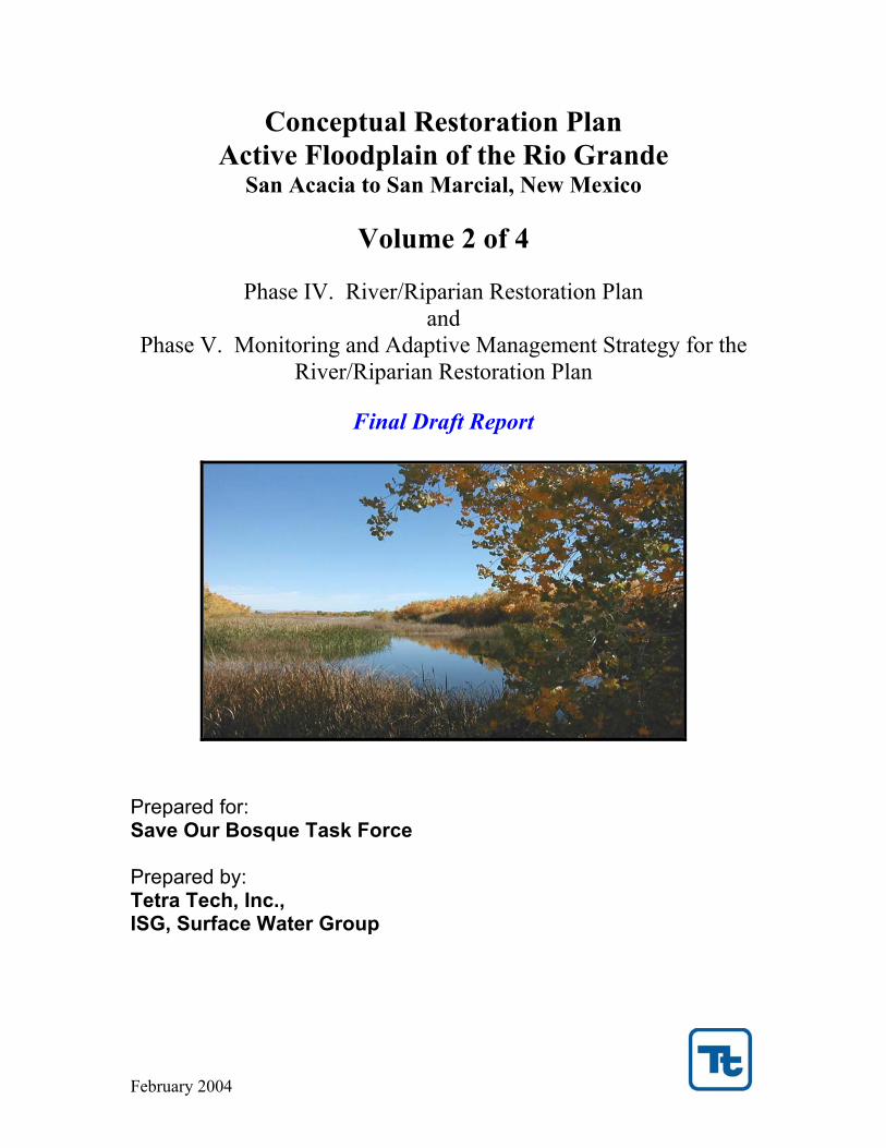
Conceptual Restoration Plan Active Floodplain of the Rio Grande
San Acacia to San Marcial, New Mexico
Volume 2 of 4
Phase IV. River/Riparian Restoration Plan and
Phase V. Monitoring and Adaptive Management Strategy for the River/Riparian Restoration Plan
Final Draft Report
Prepared for: Save Our Bosque Task Force Prepared by: Tetra Tech, Inc., ISG, Surface Water Group

Tetra Tech, ISG Save Our Bosque Task Force ______________________________________________________________________________________
i
Executive Summary The Save Our Bosque Conceptual Restoration Plan for the Rio Grande from San Acacia to San Marcial was created in four phase project that included:
Phase I. Compilation of data and reference material Phase II. Investigation of specific river and riparian issues Phase III. Ranking of restoration priorities and components Phase IV. Development of the Conceptual Restoration Plan
A final Phase V report on Monitoring and Adaptive Management Strategy will complete the restoration plan. The development of Conceptual Restoration Plan (Phase IV) is described in this report. The report highlights several important water resource issues that were researched in Phase II including restoration project water needs, restoration design flow, potential water salvage and depletion, riparian habitat and flood inundation. The Phase III ranking results were reviewed for the selection of the restoration projects. The Phase IV product is a series of GIS maps and site descriptions that depict the restoration projects that can be implemented in a phased approach. The goals of the restoration plan are to enhance natural river functions and increase biological habitat diversity. The plan embodies several key elements of natural river processes including: channel forming flows of a prescribed frequency and duration; an active channel with limited vegetation encroachment; a hydrologic connection between river and floodplain that will regenerate native riparian vegetation and sustain wetlands and marshes; and a dynamic river system that has capacity to respond to large flood events. The plan is presented in a series of GIS maps in the restoration projects have been grouped into six themes:
• Restoration lyte plan • Water salvage • Reducing the impacts of drought • Habitat diversity and supporting endangered species habitat • River dynamics, aquatic habitat and overbank flooding • Long term comprehensive plan
Each theme is presented on an individual set of plan maps. Vegetation composition and habitat, Southwestern Willow Flycatcher habitat, land ownership and flood inundation GIS maps were prepared to overlay and view with the restoration plan maps. There are two types of restoration activities embodied in the plan: 1) Those restoration projects that will reconstruct the physical system (e.g. channel widening); and 2) Those activities that will renew natural functions for benefit of aquatic and riparian habitat (e.g. disk and mowing sandbars). The restoration plan has been designed to reflect the constraints imposed by the existing system. For that reason, the Rio Grande between San Acacia and San Marcial was divided into three subreaches. Each subreach was investigated to identify restoration activities that could be sustained. In the restoration plan, exotic vegetation removal on the floodplain was common to all three reaches to improve riparian habitat and generate water salvage. The upper Escondida subreach (from San Acacia to the North Socorro Diversion Channel) channel is incised and is no longer hydrologically connected to the floodplain. Channel restoration activities are limited to two locations where the channel can be widened and reworked. Two fire breaks are recommended to reduce the fire hazard and reconnect arroyos with the river channel.

Tetra Tech, ISG Save Our Bosque Task Force ______________________________________________________________________________________
ii
The middle San Antonio subreach from the North Socorro Diversion Channel to the North Boundary of Bosque del Apache National Wildlife Refuge is considered to be in sediment transport equilibrium and will support a more dynamic channel with the prescribed restoration flows. For that reason, there are four long reaches of channel bank destabilization, one area of terrace lowering, one reach with secondary channels, one floodplain area with wetland enhancement and a backwater pilot channel for flooded bottomlands. A key component of the restoration plan in this subreach is the extensive mowing and disking to remove recent vegetation encroachment in the active channel. Restoration in the lower Refuge subreach extending from the North Boundary of Bosque del Apache National Wildlife Refuge to San Marcial consists of extensive channel reworking and wetlands enhancements. It has been shown that this subreach is still subject to frequent overbank flooding at lower peak discharges than the upper two subreaches. This subreach is expected to continue aggrading in the future. The frequent overbank flooding in this subreach will support a wider channel and wetland enhancement in several areas. Copies of the GIS maps with the restoration plan themes, vegetation and habitat, land ownership and flood inundation are available on CD for viewing with ArcView 2.0 and higher from the Tetra Tech ISG office in Albuquerque, New Mexico. Copies of the report are available from the Save Our Bosque Task Force in Socorro, New Mexico.

Tetra Tech, ISG Save Our Bosque Task Force ______________________________________________________________________________________
iii
Table of Contents Page
Phase IV. River/Riparian Restoration Plan Introduction....................................................................................................................... 1
Living Document and Disclaimer..................................................................................... 3
Restoration Vision ............................................................................................................ 4
Summary of Phases I to III ............................................................................................... 6
Subreach Delineation........................................................................................................14
Restoration Component Descriptions ...............................................................................16
Selection of Restoration Activities ..................................................................................33
Feasibility Criteria ............................................................................................................37 Capital Cost.................................................................................................................37 Maintenance Plans and Cost .......................................................................................37 Project Life..................................................................................................................38 Management and Institutional Requirements .............................................................38
Restoration Plan Components...........................................................................................39 Introduction.................................................................................................................39 Plan Assumptions and Limitations .............................................................................39 Plan Themes and Mapping..........................................................................................42 Specific Project Descriptions......................................................................................46
Conceptual Restoration Plan Implementation ..................................................................48 Introduction.................................................................................................................48 General Plan Focus .....................................................................................................49 Restoration Project Water Needs ................................................................................50 Potential Water Depletion and Salvage ......................................................................54 Flood Inundation.........................................................................................................58 Implementation – Phased Approach ...........................................................................66 Implementation Methods ...........................................................................................67 Drought Considerations ..............................................................................................70
Additional Data Requirements..........................................................................................72
Monitoring Program and Adaptive Management Strategy Guidelines.............................73
Summary ...........................................................................................................................74
References.........................................................................................................................77
APPENDIX A. Restoration Component Descriptions....................................................A.1

Tetra Tech, ISG Save Our Bosque Task Force ______________________________________________________________________________________
iv
List of Tables
Page Table 1. Restoration Components to Enhance Channel Dynamics ................................34
Table 2. Restoration Components to Expand Native Riparian Habitat ..........................35
Table 3. Structural Restoration Activity Ranking...........................................................36
Table 4. Vegetation Classifications and Habitat Assessment Value ..............................44
Table 5. Estimates of Water Salvage/Depletion .............................................................56
Table 6. Open Sandbar Evaporation and ET ..................................................................57
Table 7. FLO-2D Calibration for Area of Inundation.....................................................59
Table 8. Spatial Variation in Floodplain Roughness ......................................................60
Table 9. Spatial Variation in Restoration Floodplain Roughness....................................61
Table 10. Restoration Component FLO-2D Model Revisions .........................................62
Table 11. FLO-2D Predicted Surface Flow Losses ..........................................................64
Table 12. FLO-2D Predicted Area of Inundation ...........................................................64
Table 13. Phased Restoration Implementation Tasks ......................................................66
List of Figures Figure 1. San Acacia to San Marcial – Thalweg Profile..................................................15
Figure 2. San Acacia Mean Annual Hydrographs ...........................................................52
Figure 3. San Acacia Annual Hydrograph Variation.......................................................52
List of Photos Photo 1. Rio Grande (Discharge = 0 cfs ), October 29, 2003.......................................... 4
Photo 2. Whooping Crane Trust Tractor Used on the Platte River, Nebraska ................17
Photo 3. Mower for the Trust Tractor..............................................................................17
Photo 4. Platte River, Nebraska, Recently Mowed and Disked.......................................18
Photo 5. Reconnaissance Trip by ATV October 29 – 30, 2003.......................................47
Photo 6. Entire flow in the Rio Grande at approximately River Mile 96 ........................47

Tetra Tech, ISG Save Our Bosque Task Force ______________________________________________________________________________________
1
Conceptual Restoration Plan for the Active Floodplain of the Middle Rio Grande – San Acacia to San Marcial
Phase IV. River/Riparian Area Restoration Plan
Introduction A conceptual restoration plan for the Rio Grande riparian corridor from San Acacia to San Marcial was prepared for the Save Our Bosque Task Force. The concept of “restoration” is to enhance channel dynamics and increase diversity of the riparian system. Restoration would be achieved by creating or expanding desirable habitat communities that will be sustained over the long term under current physical and institution constraints. Restoring the river to ‘prehistoric conditions’ is recognized to be infeasible and the restoration plan has been designed to limit or curtail future adverse habitat trends. This report discusses Phase IV of a five phase project that includes:
I. Data Collection and Analysis II. Specific River Issues III. Development of the Restoration Concepts and Strategies IV. Development of the Restoration Plan for the Riparian Corridor V. Preparation of the Monitoring Plan
Phase IV builds on the compiled data base and analysis of specific river issues in Phases I and II and on the Phase III selection and ranking of preferred restoration activities. The preferred restoration projects are assembled into a conceptual river and riparian floodplain restoration plan. A series of restoration scenarios were developed that emphasize the following themes:
A. Restoration light (lyte) plan with removal of channel vegetation B. Water salvage C. Reducing the impacts of drought D. Habitat diversity and endangered species habitat E. River dynamics, aquatic habitat and overbank flooding F. Long term comprehensive plan that maximizes the opportunities for restoration
The preferred restoration activities selected in the Phase III ranking process were applied to each plan theme according to subreach. The long term comprehensive plan consists of all the selected components from each theme. The Save Our Bosque Task Force will undertake restoration projects based on a phased implementation strategy and available budget. Restoration projects have been selected and linked based on consistency of functionality, environmental compatibility, likelihood of success, consistency with existing or planned restoration activities in the subreach, cost, construction feasibility, environmental contribution, long term sustainability, adaptive management response, potential water salvage, and potential conflicts. The long term

Tetra Tech, ISG Save Our Bosque Task Force ______________________________________________________________________________________
2
comprehensive restoration plan has been tested using the FLO-2D model to predict the potential response of the restoration components to high flows. This report discusses the restoration plan formulation, the specific project details and some key issues facing restoration. Each restoration project will be qualitatively evaluated with respect to:
• Restoration objective; • Other project linkage; • Anticipated project outcome and it’s overall subreach habitat compatibility; • Floodability and drought resiliency; • Monitoring requirements and adaptive management response; • Project life and long term sustainability; • Potential water salvage; • Potential conflicts; • Sequence of construction; • Management and institutional requirements; • Feasibility issues such as capital costs and operation and maintenance costs.
A suggested phased implementation of the restoration plan is briefly discussed along with a description of implementation methods. A short list of additional data needed to bring the restoration projects to a feasibility level design is also presented. To implement the Conceptual Restoration Plan, the Save Our Bosque Task Force will seek funding from various private and government sources and will select projects, subreaches and restoration themes to apply the funding. Cooperation with federal and state agencies will be important to both funding levels and projects selection. Integrating projects with the ESA Collaborative Program habitat restoration, the Bureau of Reclamation river maintenance program and other federal projects will streamline the implementation process. A word about the report review…
The draft Phase IV report was submitted to the Save Our Bosque Task Force on November 25 and review comments were accepted until December 17. Chris Gorbach of the Bureau of Reclamation, Gina Dello Russo of the Bosque del Apache National Wildlife Refuge and Yasmeen Najmi, Middle Rio Grande Conservancy District provided written comments. It was decided that because of the number of submitted reviews were relatively few, it was attempted to address all the comments in the report with appropriate editing and direct feedback from the reviewer. A formal comment-response report section was not prepared.

Tetra Tech, ISG Save Our Bosque Task Force ______________________________________________________________________________________
3
Living Document and Disclaimer The Conceptual Restoration Plan for the San Acacia to San Marcial reach of the Rio Grande represents a compilation of information, data, analyses and ideas that were collected or formulated in Phases I through III of the plan and developed into a restoration plan, monitoring and adaptive management plan in phases IV and V. Some of the concepts and analyses address difficult issues involving water depletions, State of New Mexico water delivery to Texas, upstream water reservoir operations, fire hazards, and endangered species. The analyses utilized the best data and information that was available; however, it is recognized that on-going research and potential political and legal decisions in the future may negate or otherwise alter the results or effect of the analyses, interpretations or conclusions documented in this plan. The information contained in this report should not be construed to support a political or legal position on any of the issues discussed. It is intent of the Save Our Bosque Task Force to revisit the Conceptual Restoration Plan periodically as part of the Task Force’s Action Plan. Implementation of the plan will be contingent on available resources and budget as well as future developments. In this sense, the Conceptual Restoration Plan Reports (Phase I-V) should be considered a “living document” that will evolve to reflect the changing physical or political environment and thus ensure its viability to guide future restoration projects. It is expected that the restoration plan will be revised to incorporate new research and data, particularly groundwater and updated vegetation mapping. Some specific aspects of the plan and report that should be updated in the future are:
• General Plan Focus, Plan Assumptions and Limitations • Plan Themes and Mapping • Project Descriptions and Priorities • Unrelated New Projects Within the Study Reach • Restoration Project Water Needs and Potential Water Depletion and Salvage • Flood Inundation and Drought Considerations • Additional Data Requirements
As project plans are updated to a feasibility level investigation, it is anticipated that flood simulations will also be revisited. Five years have passed since a spring flood event of sufficient duration resulted in significant overbank flooding in the San Acacia to San Marcial reach. The FLO-2D model needs to be calibrated to both the area of inundation and discharge at the San Marcial gage. This calibration would be based on aerial videos and photos of the area of inundation, current cross section surveys, and discharge at the San Acacia and San Marcial gages. The gage discharge record should be supplemented with discharge measurements at one or two locations in the study reach. The project feasibility level design could then be revised to reflect the updated flood model. This is one of the concepts of a “living document” to keep river restoration moving forward. Available funding sources and resources should be investigated in the event of an anticipated high spring runoff year for model calibration.

Tetra Tech, ISG Save Our Bosque Task Force ______________________________________________________________________________________
4
Restoration Vision A river and riparian conceptual restoration plan for the San Acacia to San Marcial is presented in this Phase IV report. Restoration projects are evaluated that will create favorable hydrogeomorphic conditions for river and riparian restoration. These conditions include a greater range of flow regimes, enhanced river dynamics, elimination of constraints on channel processes such as invasive vegetation, active floodplain expansion, increased channel-floodplain connectivity, physical reformation of the channel geometry, and enhanced riparian biological diversity. The Save Our Bosque restoration vision statement is:
A riparian ecosystem that functions as natural as possible within the confines of 21st Century infrastructure and political limitations while respecting the traditional customs and cultures of the citizens of Socorro County.
A key to the restoration vision is “a naturally functioning riparian ecosystem” with potential long term sustainability. The vision statement indicates that restoration to some pre-historical condition is not intended. It is also recognized that resource values and water utilization change over time and that restoration projects in the San Acacia to San Marcial reach may evolve or be integrated with system wide river restoration plans in the future. It is unlikely that every restoration objective will be achieved. An adaptive management strategy will be necessary to sustain some of the restoration projects over the long term.
Photo 1. Rio Grande (Discharge = 0 cfs ), October 29, 2003
Tetra Tech, ISG Save Our Bosque Task Force ______________________________________________________________________________________
5
A number of terms are used in this report that refer to restoration including restoration goals, objectives, themes, vision, activities, priorities, components and projects. To clarify these terms in the report the following definitions are provided: Restoration Goals: There only two restoration goals: 1) Restore or enhance natural river functions; and 2) Enhance biological diversity of the riparian system. Restoration Objectives: The two restoration goals and their associated objectives as outlined in the Phase II report are:
Restoration Goal 1 - Restore river functions. Objectives:
1) Enhance channel dynamics. 2) Promote overbank flooding. 3) Increase groundwater storage. 4) Expand marshes, wet meadows and flooded bottomlands. 5) Create water salvage.
Restoration Goal 2 - Enhance riparian biological diversity. Objectives:
1) Protect high quality habitats. 2) Expand native riparian habitats. 3) Improve aquatic habitats. 4) Promote cottonwood/willow regeneration. 5) Support endangered species.
Restoration Themes: The themes refer to the restoration plans outlined in this report. The conceptual restoration plan themes were selected to identify different priorities in pursuing restoration project funding and implementation. The themes are:
A. Restoration light (lyte) plan B. Water salvage C. Reducing the impacts of drought D. Habitat diversity and supporting endangered species habitat E. River dynamics, aquatic habitat and overbank flooding F. Long term comprehensive plan that maximizes the opportunities for restoration
Restoration Vision: The restoration vision statement was defined by the Save Our Bosque Task Force. This vision statement could be refined in the future. The vision statement is provided on the previous page. Restoration Priorities: The restoration priorities were the highest ranked projects or activities that were determined by the Phase III matrix ranking process. Restoration Projects, Techniques, Activities and Components: These terms are interchangeable. They referred to the restoration method such as disk and mow, bank destabilization, channel widening and exotic vegetation removal.
Tetra Tech, ISG Save Our Bosque Task Force ______________________________________________________________________________________
6
Summary of Phases I to III
Phase I. Summary The intent of Phase I was to compile data and reference material to support the Phase IV conceptual restoration plan. The Phase I scope of work was divided into four general categories: coordination, review of historical information, fluvial geomorphology, and habitat analysis. Sixteen tasks were completed as follows:
Coordination • Coordinate oversight committee meetings • Prepare a comprehensive bibliography • Develop GIS base maps
Review of Historical Information • Compile maps and aerial photos • Analyze river morphology and vegetative changes • Compile historic hydrographs for USGS gages • Coordinate oversight committee review
Fluvial Geomorphology • Conduct a bed slope analysis • Conduct bed load, suspended load and wash load analysis • Prepare an overview of geology, river morphology and sediment yield • Delineate subreaches • Analyze bed aggradation and degradation trends • Analyze overbank flooding and flood frequency • Display results on GIS mapping
Habitat Analysis • Develop vegetation classification and mapping • Complete a wildlife inventory
One of the purposes of the Phase I investigation was to explore river restoration from a historical perspective considering hydrology, channel morphology and vegetation composition. Understanding channel morphology changes that occurred in response to water and related land resource development would serve as a basis for exploring restoration opportunities. Historically the Rio Grande had a natural cycle of removal and regeneration of native plant communities that occurred with flooding and channel migration. Portions of cottonwood bosques fell victim to channel migration during spring high flows. Large flood events filled the valley with ponded water. Wetlands, marshes, open scrublands, alkali flats and meadows were a significant portion of the floodplain community when the Spanish first arrived.
Tetra Tech, ISG Save Our Bosque Task Force ______________________________________________________________________________________
7
With the advent of agriculture in the Rio Grande valley about 1,500 years ago, the native vegetation composition and distribution was altered. Landscape fragmentation occurred with deliberate fires and cropland clearing. Our knowledge of the pre-historic “natural” Rio Grande floodplain is largely anecdotal. With increasing populations (both Pueblo and European), land cultivation with irrigation systems gradually decreased flows in the river. Upstream reservoir storage attenuated flood peaks and the channel morphology began to change. As flooding became more infrequent, of shorter duration, and with altered timing, most of the riparian vegetation regenerative processes were interrupted and essentially curtailed. Prominently missing in the river’s hydrologic cycles are the large floods that initiated channel migration and caused extensive bank erosion. In response to decreased flooding and reduced sediment loads, the channel has narrowed. The shift to regulated river hydrology resulted in a loss of channel complexity and channel-floodplain hydrologic connectivity. Vegetation became established on sandbars in the active channel. The reduced flood frequency benefited a salt cedar monoculture and floodplain habitat diversity was adversely impacted. To restore a mosaic of floodplain vegetation communities and enhance river functions, channel-forming flows of sufficient magnitude and frequency must occur. The hydrologic relationship between channel flows and the flooded bottomlands has to re-established. Flushing flows are needed to rework the channel and mobilize sandbars to remove vegetation encroachment. When peak flows are unsuccessful in reworking the channel, aquatic habitat is diminished. Infrequent high flows that are in excess of bankfull discharge are required to reform the full suite of channel and floodplain features. The key to long term channel equilibrium in sand bed river system with a variable sediment supply is to sustain the effective sediment transport discharge with a wide range of seasonal flows. Phase II Summary In Phase II, a number of issues were investigated including flood frequency, sediment loading, channel conveyance capacity, areas of high flood potential, restoration components, riparian and aquatic habitat, evapotranspiration, institutional constraints and potential for water salvage. The tasks completed in Phase II included: Channel Capacity
• Determine bankfull discharge by subreach • Analyze in-channel maintenance flows • Develop a spring flushing flow hydrograph • Assess sediment loading for restoration river functions • Describe problem areas and subreaches for restoration
Tetra Tech, ISG Save Our Bosque Task Force ______________________________________________________________________________________
8
Identify Areas of High Flood Potential • Identify flood inundation areas • High water surface surveys • Assess flood frequency and channel forming discharges
Characterize Condition of Riparian and Aquatic Habitat • Assess habitat value • Describe threats • Prepare habitat GIS maps • Assess trends and conditions with and without restoration
Determine Water Budget • Evaluate evapotranspiration (ET) estimates • Determine losses associated with restoration overbank flows • Evaluate groundwater/surface water interface • Develop a method for determining water salvage
Rio Grande Compact Commitments • Describe compact commitments • Assess compact limitations on water delivery
Establish Criteria for Restoration Areas
• Identify areas for potential restoration on GIS mapping • Describe factors contributing to restoration needs • Determine restoration criteria and constraints • Analyze geomorphic trends for restoration concepts • Investigate land ownership mapping and constraints • Review groundwater data
In Phase II, two important channel morphology and hydrology issues were addressed. The first issue was the long-term decrease in the sediment load at San Acacia. Flood discharges without a corresponding adequate sediment supply can exacerbate local channel incision and reduce potential flooding. The second issue was the flood frequency required to limit the encroachment of exotic vegetation in the active channel. It was necessary to conduct a flood frequency analysis for the San Acacia USGS gage to assess the potential for overbank flooding in the project reach. Previous flood frequency analysis did not have a sufficiently long post-Cochiti Dam record to assess the impacts of all the upstream water resource flow regulation in the Rio Grande basin. It was determined that the post-1974 record was sufficient to develop a flood frequency analysis for restoration purposes (flood events less than the 25-year return period flood). The post-1974 record, however, did not include any major tributary floods from the Rio Puerco or Rio Salado and as a result the entire 1936 to 2002 record (adjusted for flow regulation) was used to estimate the less frequent flood events that are greater than the 25-year return period flood. The flood frequency was divided into two analyses, flood
Tetra Tech, ISG Save Our Bosque Task Force ______________________________________________________________________________________
9
frequency for river restoration and the frequency for flood hazard applications. The two year return period flood based on the San Acacia post-1974 record was 5,660 cfs.
The mean annual flow duration for 5,660 cfs for the post-Cochiti period (1974-2002) is roughly 6 days. For restoration purposes in the San Acacia to San Marcial reach, a spring flushing hydrograph of 5,660 cfs with a duration of approximately 6 days is recommended as a spring restoration design flow. This flow should occur with a frequency of approximately every other year or about 4 times in every 10 years with no more than 2 consecutive years without this spring hydrograph. This spring flushing flow hydrograph has a volume of approximately 68,000 acre-ft not including the rising and recessional limbs of the hydrograph. River discharge in the fall (late October to early November) increases with the decrease in irrigation diversion. To assess an optimum discharge for the fall maintenance flow as discussed in Phase II, the FLO-2D model was applied to the San Acacia South reach using a range of flows from 50 to 1,500 cfs. The analysis indicated that the rate of increase in wetted channel surface area begins to decrease for flows above 500 cfs. It is recommended that 500 cfs be considered as a target fall channel maintenance flow. Flows of 500 cfs or greater have occurred approximately 23 days during the months of October and November for the post-1974 period. Therefore, the target duration for the fall maintenance flow should be 500 cfs or greater for approximately three weeks on an annual basis. This flow constitutes a minimum volume of about 21,000 acre-ft. During drought conditions, water for a fall maintenance flow may not available, but it should be considered in the adaptive management plan. The long term upstream sediment loading to the San Acacia gage has been declining. It is estimated that the current sediment load is only about 30% of the historic sediment load. A sediment supply analysis was conducted to determine the potential bed material sediment load at San Acacia for restoration project design. All the USGS sediment measurement records at San Acacia and San Marcial as well as all known sediment load analyses were compiled. A bed material rating curve was developed and various annual suspended and total sediment loads were computed and compared.
The sediment load being delivered by the Rio Grande to San Acacia is highly variable with sediment supply from the Rio Salado and Rio Puerco tributaries. Under the discharge and sediment load conditions for the last 25 years, the entire reach appears to be slightly aggrading (more sediment entering the reach than is leaving it). Most of the sediment deposition is occurring in the lower Refuge subreach. This is reflected in both the measured load and the regressed sediment load equations. Approximately 2.0 million tons per year of sand-sized sediment is being supplied to this reach. The total annual sediment load including fine sediment is approximately 4.0 million tons per year. An analysis of the channel conveyance capacity or bankfull discharge was conducted. This analysis clearly demonstrated the difference between the potential for flooding in the upper incised Escondida subreach compared to the downstream reach. Flooding initiates in the lower reach at about one-third the discharge of Escondida

Tetra Tech, ISG Save Our Bosque Task Force ______________________________________________________________________________________
10
subreach. For flows ranging between 5,000 cfs and 10,000 cfs, approximately 1,000 more acres are flooded in the Refuge reach than the San Antonio reach for the same discharge. The discharge at which flooding initiates is approximately 10,000 cfs for the Escondida subreach, 3,000 cfs for the San Antonio subreach and 2,700 cfs for the Refuge subreach. It is anticipated that restoration projects that replace exotic riparian plant species with a mosaic of native vegetation would result in water salvage by decreasing evapotranspiration. A number of proposed restoration projects are focused on increasing the overbank flooding to improve the hydrologic connectivity between the river and the floodplain in the upper subreaches. Increased water surface area will result in increased surface water evaporation from both the river channel and the floodplain. Increased evaporation losses can be computed with the FLO-2D model. Estimates of evapotranspiration losses due to restoration activities are more difficult to assess and are subject to significant natural variability and uncertainties. Research at the University of New Mexico indicates that mature stands of cottonwoods with a closed canopy have smaller ET rates for the growing season compared to dense stands of salt cedar and Russian Olives. This is the basis for recommending the eradication of dense salt cedar stands on large tracts of land throughout the San Acacia to San Marcial reach as part of the conceptual restoration plan.
The habitat assessment broadly identified the existing habitat values and potential restoration areas. Based on a review of previous classifications, mappings and a field survey, most of the habitat on the active San Acacia to San Marcial floodplain was classified as medium or low quality. These areas generally contain exotic vegetation as the dominant component of the vegetation community. Areas classified as medium quality were typically a mix of native and nonnative species, whereas the low value habitat areas had a high salt cedar density. There were a few small areas of high quality habitat that generally consisted of native woodland habitat. The high quality habitat areas attract a more diverse fauna than monotypic salt cedar stands. Native woodlands were characterized by an overstory of cottonwood and black willow with understories of coyote willow, New Mexico olive, screwbean mesquite and seepwillow.
The existing cottonwood-willow bosque areas are largely the ecological legacy of past flooding current river regulation. These stands are rapidly senescing and new stands of cottonwood on the floodplain are not being established. In general, existing stands of native woodlands are becoming decadent and are being replaced by nonnative species. This trend toward nonnative vegetation has affected the survival of wildlife species that have evolved in cottonwood bosque. Some obligate riparian species are limited to the cottonwood bosques which are declining in areal extent.
Floodplain restoration will involve a combination of restoring seasonal flooding
and the removal of exotic vegetation. The removal of nonnative plants would be focused on areas of dense salt cedar that have the greatest potential for water salvage. In addition to removing salt cedar to encourage cottonwood growth, some selective vegetation clearing would also reduce the fire potential. Some of these potential fire breaks could be
Tetra Tech, ISG Save Our Bosque Task Force ______________________________________________________________________________________
11
located in tributary arroyos and would also serve to reconnect the arroyo with the river. Those floodplain areas identified as high quality habitat should be protected from fire and complimented with an appropriate hydrologic connection to the river. A brief history of the Rio Grande Compact was presented in Phase II that included a discussion of New Mexico compliance with delivery schedule, pre-Compact groundwater conditions as well as water utilization in the San Acacia to San Marcial reach. The discussion included water rights and surface water diversions by the Middle Rio Grande Conservancy District and the Bosque del Apache National Wildlife Refuge. The drainage system and the Low Flow Conveyance Channel were described.
Changes in depletions related to restoration activities in the San Acacia to San Marcial reach could impact the delivery of water to Elephant Butte Reservoir and New Mexico’s credit or debit status. Restoration activities should result in some water salvage and as result the restoration plan should have no adverse impact on net depletions. The evaluation of depletion or salvage for a given project should be based on the net change in consumptive use based on a “pre-restoration” condition. The areas that have the highest potential for restoration are the areas that are currently experiencing significant evapotranspiration losses.
The quantification of the net depletion or salvage associated with a restoration project should take into consideration the historic changes in depletion in the San Acacia to San Marcial reach. The gross annual depletion in the San Acacia to San Marcial reach has varied between about 71,000 acre-feet and 119,000 acre-feet from both natural causes and human activities since 1937 to the present. Proposed restoration activities should result in channel widths, vegetated floodplains and consumptive use that have been experienced since 1937. Depletions associated with restoration depletions should be within the historical levels experienced in this reach since the signing of the 1938 Rio Grande Compact. Restoration activities may increase groundwater levels. Groundwater and surface water in the Rio Grande Valley are considered to be hydrologically connected. Groundwater that is not lost to evaporation or evapotranspiration represents an increase in groundwater storage. This increase in groundwater storage is still considered as part of the surface water system. The recharge of groundwater aquifers through percolation of surface water would benefit the wetlands, marshes and flooded bottomlands along the river. Flood inundation of the San Acacia to San Marcial reach of the Middle Rio Grande was predicted for various return period flows for existing conditions using the FLO-2D model. The model was applied using both a rigid bed and a mobile bed with a derived bed material rating curve. Channel and floodplain infiltration was computed. The 2002 cross section surveys in this reach were added to the channel data base. Four return period floods were simulated including the 1.25-year event (3,700 cfs), 2-year flood (5,660 cfs), the 5-year return period flood (8,480 cfs) and the 10-year event (10,400 cfs). Flooding in the San Acacia to San Marcial reach initiates on the Bosque del Apache

Tetra Tech, ISG Save Our Bosque Task Force ______________________________________________________________________________________
12
National Wildlife Refuge. The Escondida subreach only experiences a minor amount of overbank flow for the 10,400 cfs event (10-year flood). Most of the flooding for the various return period events occurs south of the Highway 380 Bridge. The flood inundation maps were prepared as GIS overlays so that the flood areas could be viewed with respect to habitat value and land ownership. The approximate land ownership distribution in the Rio Grande Active floodplain from the levee to the east side bluff from San Acacia to the North Boundary of the Bosque del Apache NWR as determined from the vegetation-land ownership GIS maps provided by the Fish and Wildlife Service is as follows: Private Land 2,440 acres MRGCD Land 676 acres FWS Land 318 acres BLM Land 60 acres State Land 50 acres NM Tech Land 48 acres Private land also exists downstream of the Bosque del Apache NWR, but can not be directly quantified from the available GIS mapping. Phase III Summary
Phase III involved a restoration project selection process that required a matrix evaluation of habitats and restoration techniques. It included the following tasks:
• Completion of an evaluation matrix of habitat values and restoration activities;
• Linkage of restoration components linkage based on functionality, geomorphic compatibility, benefits and impacts;
• Prioritizing subreaches, project areas and restoration techniques;
The selection process was completed using an evaluation matrix to quantify and rank proposed restoration components. A linked matrix approach was developed so that the matrix worksheets could be completed by Rio Grande researchers, agency personnel and private citizens. It was created through the research of various planning matrices methods. Careful consideration went into preparing the matrix components, individual worksheets and variable weighting factor approach. The matrix internal linkages required extensive mathematical design and testing. Three workshops were organized to assist the participants in filling out the matrices. Background material and information were also compiled to support the matrix development. A Rio Grande flyover video of the study area was distributed to the workshop participants. Definitions of all the habitat attributes were disseminated to the workshop attendees to assist in the matrix completion.
The Phase III product was the selection of restoration activities and proposed
project areas. The ranking of restoration techniques was accomplished in the linked

Tetra Tech, ISG Save Our Bosque Task Force ______________________________________________________________________________________
13
matrix approach by the workshop participants. The final ranking was based on averaging or combining the results of all the completed matrices. The Refuge and San Antonio subreaches were selected as preferred subreaches, but all subreaches were included in the plan. The proposed restoration activities with the highest ranking regardless of the subreach designation were (in order of ranking):
• Spring flushing flows • Eliminate structural limitations on flooding • Manage future development • Increase flood frequency and duration • Remove exotic vegetation (selective and clear cut) • Create wetlands and marshes • Enhance groundwater storage and interaction • Plant and seed native vegetation • Create flooded bottomlands • Variable floodplain topography • Reconnect oxbow and old channels • Channel widening • Increase groundwater storage on east side • Reconnect oxbow and old channels • Destabilize and lower banks (terrace lowering) • Fall maintenance flows
Tetra Tech, ISG Save Our Bosque Task Force ______________________________________________________________________________________
14
Subreach Delineation In Phase II of the conceptual restoration plan, the reach from San Acacia to San Marcial was divided into three subreaches. It is valuable to review the delineation of the three subreaches for later reference in this report. The three subreaches are: 1. Escondida Reach - San Acacia Diversion Dam to the Socorro North Diversion Channel (13.5 miles). 2. San Antonio Reach - North Socorro Diversion Channel to the North Boundary Bosque del Apache National Wildlife Refuge (18.5 miles). 3. Refuge Reach - North Boundary Bosque del Apache National Wildlife Refuge to San Marcial Bridge (15.6 miles).
The three subreaches were delineated on the basis of river morphology and the potential response of compatible restoration projects. They were not selected on the basis of the existing channel geometry or bed slope. The entire San Acacia to San Marcial reach has a relative uniform sand bed material size, but within each subreach the river has both narrow and wide channel segments and different levels of channel activity. Some of the subreach channel geometry variation has been imposed by river training and maintenance activities including channel dredging. In addition, there is significant variation of vegetation encroachment and overbank flooding.
The river profile in Figure 1 shows the geomorphic trend over the past 40 years.
As was discussed at length in the Phase I report, the Escondida subreach channel has incised since 1962, the San Antonio middle subreach has been approximately in equilibrium and the lower Refuge subreach has been aggrading. While the Escondida subreach is not currently displaying any significant incisional pattern, it is widening. The lower subreach is expected to continue aggrade over the long term; however, if the lowering of Elephant Butte Reservoir water surface is sustained for a number of years, this may induce a short period of channel downcutting sometime in the future. There is a significant break in channel bed slope in the vicinity of river mile 76, just 1.5 miles upstream of the south boundary of Bosque del Apache NWR due to downstream aggradation. Over the long term it is likely that this aggradation will extend further upstream.

Tetra Tech, ISG Save Our Bosque Task Force _________________________________________________________________________________________________________________________________
15
Figure 1. San Acacia to San Marcial - Thalweg Profile
4450
4500
4550
4600
4650
4700
65707580859095100105110115120
River Mile
Elev
atio
n (ft
)
1962 thalweg2002 thalweg
San
Aca
cia
Soc
orro
San
Ant
onio
BD
AW
RN
orth
Bou
ndar
y
BD
AW
RS
outh
Bou
ndar
y
San
Mar
cial

Tetra Tech, ISG Save Our Bosque Task Force ______________________________________________________________________________________
16
Restoration Project Descriptions Both resource management methods and mechanical restoration techniques were explored. The potential restoration projects are described below with further discussion on applying the restoration techniques in the ‘Implementation Methods’ section. Each restoration technique is discussed in the context of how it addresses the overall plan goals and objectives. The restoration techniques discussed in this section are essentially those activities that were evaluated in the Phase III ranking processes. The techniques are referenced on the restoration plan maps (refer to the map legends).
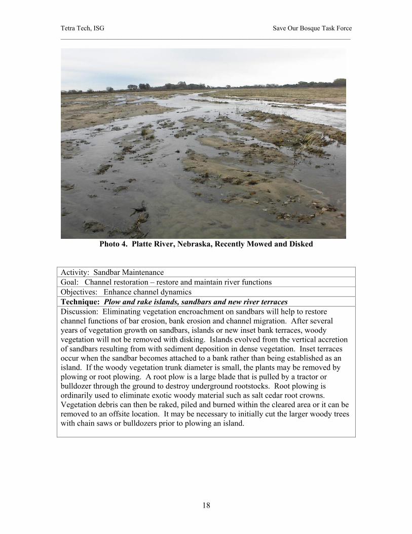
Channel Restoration Activities - Restoration Goal: Restore river functions. The following group of restoration projects are designed to restore the river functions, maintain the active channel geometry, reduce vegetation encroachment and reduce the potential for channel narrowing. Activity: Sandbar Maintenance Goal: Channel restoration – restore and maintain river functions Objectives: Enhance channel dynamics, improve aquatic habitats Technique: Mow and disc sandbar vegetation Discussion: Eliminating vegetation encroachment on sandbars will help to restore channel functions of bar erosion, bank erosion and channel migration. The active channel will be wider and have a braided appearance at low or moderate flows. Vegetation growing on river sandbars can be cut with mowers up to a height of about 3 to 5 ft. This would constitute a vegetation age group of about 2 years. Reworking the sandbars could be accomplished with a tractor such as a Challenger operating a mower and disc plow. Notched disc blades of 24 to 36 inches in diameter are recommended to churn the root systems. Photos 1 and 2 show a Challenger tractor with 36 inch disks and a front mower. Mowing and disking the sandbars must be coordinated to precede high flows to maximum the benefit of reworking the channel. Spring flushing flows of a prescribed frequency and duration and fall maintenance flows will minimize the need frequent mowing and disking of the sandbars. During drought periods when flows are not available for reworking the active channel, sandbar maintenance would be prioritized based on critical aquatic habitat areas. Photo 3 shows a disked sandbar on the Central Platte River prior to spring flushing flows. The river at a low flow condition is reworking the disturbed sandbar. Channel mowing and disking combined with channel forming flows will be the primary method to restore the active channel. It is important to note that the high percentage of fine sediment (silt and clay) deposits in the Rio Grande channel may present a challenge in reworking the sandbars. Mowing and disking would be accomplished during seasonal low water periods.

Tetra Tech, ISG Save Our Bosque Task Force ______________________________________________________________________________________
17
Photo 2. Whooping Crane Trust Tractor Used on the Platte River, Nebraska
Photo 3. Mower for the Trust Tractor
Tetra Tech, ISG Save Our Bosque Task Force ______________________________________________________________________________________
18
Photo 4. Platte River, Nebraska, Recently Mowed and Disked
Activity: Sandbar Maintenance Goal: Channel restoration – restore and maintain river functions Objectives: Enhance channel dynamics Technique: Plow and rake islands, sandbars and new river terraces Discussion: Eliminating vegetation encroachment on sandbars will help to restore channel functions of bar erosion, bank erosion and channel migration. After several years of vegetation growth on sandbars, islands or new inset bank terraces, woody vegetation will not be removed with disking. Islands evolved from the vertical accretion of sandbars resulting from with sediment deposition in dense vegetation. Inset terraces occur when the sandbar becomes attached to a bank rather than being established as an island. If the woody vegetation trunk diameter is small, the plants may be removed by plowing or root plowing. A root plow is a large blade that is pulled by a tractor or bulldozer through the ground to destroy underground rootstocks. Root plowing is ordinarily used to eliminate exotic woody material such as salt cedar root crowns. Vegetation debris can then be raked, piled and burned within the cleared area or it can be removed to an offsite location. It may be necessary to initially cut the larger woody trees with chain saws or bulldozers prior to plowing an island.
Tetra Tech, ISG Save Our Bosque Task Force ______________________________________________________________________________________
19
Activity: Bank destabilization Goal: Channel restoration – enhance or restore river functions Objectives: Enhance channel dynamics and promote overbank flooding Technique: Remove bank vegetation (deformable banklines) Discussion: Creating a more active, wider channel will restore the channel functions of bank erosion, channel migration and give the channel a braided appearance at low to moderate flows. Removal of bank vegetation will encourage deformable banks and initial bank erosion. Much of the Rio Grande banks have been locked in place by dense vegetation and their root systems along the banks. Salt cedar and Russian olive are is the primary species stabilizing the banks because of the extensive root structure. Vegetation can be removed using a variety of methods such as chainsaws, tractor and disc, excavators, root plows or bulldozer. It is suggested that a minimum 50 ft wide strip of bank vegetation be removed to stimulate erosion and channel widening. The process of removing the vegetation and possibly excavating the root systems will help to destabilize the banks. Activity: Bank destabilization Goal: Channel restoration – enhance or restore river functions Objectives: Enhance channel dynamics and promote overbank flooding Technique: Shape curves and banks Discussion: In some reaches deformable bank lines will be an important component of the conceptual restoration plan, but some banks may require definitive slopes, reshaping and radius of curvature to control erosion. It is anticipated that some reworking of the river banks will occur in all three subreaches. Channel bank curve alignments will be determined by right-of-way considerations and hydraulic analysis. Bank shaping can be used to control bank erosion. In most reaches, initiating bank erosion will be an effective method to create a more dynamic channel so detailed bank shaping would not be necessary. Activity: Bank destabilization Goal: Channel restoration – enhance or restore river functions Objectives: Enhance channel dynamics and promote overbank flooding Technique: Widen channels Discussion: Taking the previous restoration technique one step further, this project objective would be to construct a wider channel. After the vegetation is removed along with any jetty jacks, the channel banks can be excavated or plowed to initiate bank erosion. In this case, a new prescribed channel width would be mechanically imposed by bulldozing the banks into the channel or by excavating bank material and creating a spoils pile along the bank to be eroded by the river. In areas where the river is narrow, channel widening could be the primary restoration activity.

Tetra Tech, ISG Save Our Bosque Task Force ______________________________________________________________________________________
20
Activity: Bank destabilization Goal: Channel restoration – restore or restore river functions Objectives: Enhance channel dynamics and promote overbank flooding Technique: Lower terraces Discussion: This restoration activity would expand the active floodplain by providing lower terraces along the river. It would entail excavation of large areas of the floodplain. The lowered terraces would be inundated more frequently increasing river-floodplain hydraulic connectivity, regenerating native vegetation, and improving slow velocity refuge for aquatic organisms at high discharges. Large construction equipment such as bulldozers and graders would be used. Terrace lowering would require analysis to ensure that flood control facilities are not compromised. This restoration activity could be accomplished in conjunction with several of the previously described techniques. Activity: Promote Overbank flooding Goal: Channel restoration – enhance or restore river functions Objectives: Promote overbank flooding; Expand marshes, wet meadows and flooded bottomlands Technique: Create high flow side channels Discussion: One method to enhance the hydrologic connectivity of the river and floodplain is the enhancement of existing or the creation of new overbank side channels that would flood at high flows. The purpose of the side channels would be to flood backwater or wetland areas and provide low velocity flows through the floodplain at higher discharges. The channels would be limited in length and would only be flowing as the river approached bankfull discharge. The side channels may terminate in wetland areas and flooded bottomlands or they may be reconnected to the river downstream. The new backwater habitat would provide slower velocity areas for aquatic and terrestrial species and increase the potential for native species regeneration. The construction procedure would include floodplain vegetation removal and side channel excavation through the bank. Drainage of backwater or wetlands areas with side channels can also be considered. Maintaining the side channel connectivity during recessional limb to avoid sediment deposition would have to be analyzed. Activity: Restore the channel dynamics Goal: Channel restoration – enhance or restore river functions Objectives: Enhance channel dynamics, improve aquatic habitat Technique: Create secondary channels Discussion: Secondary channels are companion channels to the main river channel. These channels will convey flow at less than bankfull discharge, but would not necessary be wet at low flows. Secondary channel construction may involve re-opening old channels or abandoned meander bends or excavating a new channel across a floodplain terrace. The purpose of the secondary channel is to create a wider channel and island complex. The secondary channel construction would include vegetation removal, excavation, grading and spoils disposal. Disposal of excess spoil material in the channel or in a location where it could be removed by the river is preferred.
Tetra Tech, ISG Save Our Bosque Task Force ______________________________________________________________________________________
21
Activity: Restore the channel dynamics Goal: Channel restoration – enhance or restore river functions Objectives: Enhance channel dynamics Technique: Cut pilot channels (to initiate channel avulsions) Discussion: Pilot channels are small excavated channels to initiate river relocation. When flow is introduced, the river reforms to the pilot channel geometry quickly. The purpose of the pilot channel is to create a self-forming channel in a prescribed location. This would minimize the disturbance to the floodplain required to relocate the river channel. It would also minimize the removal of excess spoil material associated with excavating the entire channel. Channel avulsion was an important historical process that kept the channel and floodplain integrated. Historically, the Rio Grande migrated across the floodplain through channel avulsions reworking the wide floodplain. Pilot channels would be used to mimic this process in locations of abandoned channels or in locations where it may be advantageous to move the river further to the east away from the LFCC. It is important to be selective where pilot channels are used. If the pilot channel is excavated through river deposits with extensive silt and clay layers, bank erosion and channel widening would be constrained. Activity: Restore the channel dynamics Goal: Channel restoration – enhance or restore river functions Objectives: Enhance channel dynamics, improve aquatic habitat Technique: Realign channels Discussion: Channel realignment is used to move the river to a new location on the active floodplain by reconstructing the channel. The desired channel geometry rather a pilot channel would be constructed. Realignment might promote new habitat development with flooded backwaters or wetlands or it might be used to mimic channel avulsion or migration. Moving the river to the east may reduce seepage losses to the LFCC. Realignment may also serve to increase sinuosity and increase width to depth ratio. Channel realignment may incorporate deformable banks to establish the new channel pattern. Aquatic and riparian habitat enhancement would accompany any channel realignment. Channel realignment would involve heavy construction equipment to excavation and grade a new channel on the floodplain.

Tetra Tech, ISG Save Our Bosque Task Force ______________________________________________________________________________________
22
Activity: Enhance aquatic environment Goal: Enhance riparian biological diversity Objectives: Improve aquatic habitats, support endangered species Technique: Locate and place large woody debris Discussion: Large woody debris (cottonwood trunks) can be placed at locations within the river channel or along riverbanks to provide aquatic habitat and compliment other channel restoration techniques. Large woody debris can be used to enhance planform stability and promote river bar or island formation with sediment deposition. Cottonwood logs could be placed individually along banks or in piles on sandbars. On the outside of bends, woody debris may enhance bank erosion. Activity: Increase flooded bottomlands Goal: Enhance riparian biological diversity Objectives: Enhance channel/floodplain dynamics, improve aquatic/terrestrial habitat Technique: Reconnect oxbow and old channels Discussion: Oxbows, old meander bends and old channel remnants can be reconnected to the river using high flow side channels, secondary channels, pilot channels or through river realignment. These historic floodplain features are important backwater, wetlands or marsh areas for wildlife habitat and native vegetation regeneration. If reconnected as part of the existing channel system, these areas can be designed to provide silvery minnow slack water or slow velocity habitat. These features will lengthen the channel, increase sinuosity and create a more dynamic river with increased habitat diversity. There are several old oxbows on the river floodplain between the Highway 380 Bridge and San Marcial that can be considered in the conceptual restoration plan. Heavy construction equipment would be required to excavate the connection to the old channel remnants. Some excavation may be required in the old channel remnants due to past sediment deposition and match existing river slopes. Activity: Channel stability maintenance Goal: Channel restoration – restore river functions Objectives: Enhance channel dynamics Technique: Implement river training facilities such as dikes/spurs/rock weirs Discussion: While these training features are not natural for this reach and will not directly support channel dynamics or floodplain interaction, they could serve to support other important channel restoration activities such as pilot channels or channel realignment. A rock spur or dike could be used to constrict the river channel or divert water from the existing channel. River training structures may also be used for influencing flow alignment, bank stabilization and controlling overbank flow. River training facilities should only be considered when river restoration activities alone are inadequate for the protection of critical riverside facilities or in-stream structures.
Tetra Tech, ISG Save Our Bosque Task Force ______________________________________________________________________________________
23
Activity: Channel stability maintenance Goal: Channel restoration – restore river functions Objectives: Enhance channel dynamics Technique: Raise the channel bed (grade restoration facilities) Discussion: Gradient restoration facilities (GRFs) are low head grade control structures with fish passage aprons. These structures are designed to halt channel degradation, reduce upstream velocities and increase water surface elevations. The only beneficial purpose that a GRF would serve in the San Acacia – San Marcial reach would be to raise the water surface in the Escondida subreach where the river channel is incised. An increase in groundwater levels would help to support native riparian vegetation and salt grass meadows on the contiguous floodplain. The GRF might also stabilize the location of other channel restoration components such as high flow side channels. The channel incision in most of the Escondida subreach is too severe for GRF to be used to promote overbank flooding. GRF fish passage would be designed with the most current silvery minnow swim velocity data available. Heavy construction equipment would be used in the channel to drive sheet piles and place riprap. Activity: Channel stability maintenance Goal: Channel restoration – restore river functions Objectives: Enhance channel dynamics Technique: Remove sediment plugs Discussion: Sediment plugs were historically reported in the San Marcial area and became more frequent as the downstream reach responded to the filling of Elephant Butte Reservoir. Sediment plugs also form in the river channel at the mouths of tributary arroyos. In most instances, sediment plugs will increase the channel dynamics by reducing channel capacity and forcing more water overbank onto the floodplain. In extreme cases, sediment plugs could result in channel avulsion. These are desirable river dynamics. In the case where a large arroyo sediment plug might deflect flows into riverside facilities, it might be necessary to consider plug removal or grading, but in general sediment plugs are beneficial to the active channel. If necessary, arroyo plugs can be excavated or graded by dozers or scrapers. Spoil material may be destabilized or relocated along river channel to be naturally redistributed by the river improving sediment supply to the reach.

Tetra Tech, ISG Save Our Bosque Task Force ______________________________________________________________________________________
24
Activity: Channel stability maintenance Goal: Channel restoration – restore river functions Objectives: Enhance channel dynamics Technique: Increase sediment loading Discussion: The San Acacia to San Marcial reach has experienced a sediment deficit over the past 30 years as was discussed in Phase II. Reversing this trend is important for the entire Middle Rio Grande channel. It may be possible to increase the sediment load slightly at San Acacia by improving the sediment exclusion facilities that divert water into the Socorro Main Canal and the Low Flow Conveyance Canal. Reconnecting arroyos to the river where vegetation has blocked the arroyo channel across the floodplain would enhance the arroyo sediment supply. Another option is to mechanically introduced sand into the river. Excess spoil material generated from restoration activities could be made available to the channel. This would enhance the river dynamics in all three subreaches. Additional sediment loading will help support a restored wider, active channel. Any upstream restoration practice or water resource management activity that could increase sediment supply should be considered including sediment passage through upstream reservoirs. Continued cross section monitoring will identify long trend aggradation/degradation trends to support decisions regarding river response to variable sediment supply

Tetra Tech, ISG Save Our Bosque Task Force ______________________________________________________________________________________
25
Floodplain Restoration Activities - Restoration Goal: Enhance riparian biological diversity. The following group of restoration projects are designed to increase riparian native habitat, promote cottonwood and willow regeneration, support endangered species, and protect existing high quality terrestrial habitats. The described techniques can be referenced on the restoration plan maps (refer to the map legends). Activity: Remove exotic vegetation and promote native vegetation Goal: Enhance riparian biological diversity Objectives: Expand native riparian habitats, promote cottonwood/willow regeneration, create water salvage, support endangered species Technique: Remove and control exotic vegetation (monotypic and selective stands) Discussion: Removal and control of exotic vegetation (primarily salt cedar and Russian olive) on the floodplain will promote native species regeneration and increase habitat diversity. Replacing exotic vegetation with native plant communities has the potential benefit of decreasing evapotranspiration. Removing dense exotic vegetation will enhance overbank flooding and improve the opportunities for river bank erosion. Salt cedar removal practices have been successfully implemented at the Bosque del Apache National Wildlife Refuge and other sites throughout the Southwest. Selective removal of exotic vegetation could be used to create fire breaks and buffer zones along agricultural areas. Exotic vegetation control may occur with herbicide treatments, ground crews, burning, heavy equipment or a combination of these techniques. Each project site would have to be evaluated to determine the most effective exotic vegetation control. Activity: Promote native vegetation regeneration Goal: Enhance riparian biological diversity Objectives: Expand native riparian habitats, promote native riparian plant communities, support endangered species Technique: Plant and seed native vegetation Discussion: Planting and seeding native riparian vegetation will promote a mosaic of vegetation communities including grasslands, savannahs, and forest communities. Revegetation can occur through either planting or seed dispersal. Potential planting methods include planting individual pole and willow whips or placing willow bundles/mats. Plantings may be an important component in reestablishing native vegetation on floodplain terraces. Eventually these plantings would create communities of different age groups that would then mimic the historic natural diversity of woody communities.

Tetra Tech, ISG Save Our Bosque Task Force ______________________________________________________________________________________
26
Activity: Expand wetlands habitat Goal: Enhance riparian biological diversity Objectives: Expand native riparian habitats, improve aquatic habitats, support endangered species Technique: Enhance wetlands and marshes Discussion: Wetlands and marshes were an integral part of the historical Rio Grande floodplain. The Phase I report documents the extent of wetlands, flood bottomlands and cienegas throughout the Middle Rio Grande Valley. A series of old oxbows and channels along the east side of the river south of the Highway 380 Bridge are flooded with most spring seasonal high flows. By improving the hydrologic connectivity with the river wetlands and marshes can be perennial and will substantially increase habitat diversity. Selective clearing of woody debris may enhance the wetland habitat. Drainage should be considered for enhanced wetland areas. Existing wetland and marsh areas are topographically conducive to flooding. Heavy construction equipment would be used to enhance these wetland and marsh areas through dredging, connecting with side channels, and creating seasonal drainage. Planting and seeding vegetation may also be used to enhance wetland habitat. Activity: Enhance floodplain hydrologic connectivity Goal: Enhance riparian biological diversity Objectives: Expand native riparian habitats, protect high quality habitats, promote cottonwood/willow regeneration, support endangered species Technique: Enhance flooded bottomlands Discussion: Flooded bottomlands represent a different form of riparian floodplain habitat. At high flow, a flow path extends through the flooded bottomlands and becomes a part of the river channel system. At low flows, the bottomlands function like wetlands. Flooded bottomlands can provide a nutrient rich spawning area, nursery or adult habitat for a variety of aquatic species. Flooded bottomlands were an extensive part of the historical Rio Grande Valley river system. New flooded bottomlands can be created with high flow overbank side channels or pilot channels that will supply water to old channels or oxbows. Existing bottomlands in the Refuge subreach currently flood at moderate flows. Enhancement of the river/floodplain hydrologic connectivity would provide the opportunity for re-establishing naturally generated riparian plant communities. The specific activities associated with flooded bottomlands is hydraulic design to connect the bottomlands with the river, reshaping inlet and outlet topography, excavating for drainage, mimicking historical spring flood hydrographs and clearing woody vegetation.

Tetra Tech, ISG Save Our Bosque Task Force ______________________________________________________________________________________
27
Activity: Shape the floodplain Goal: Enhance riparian biological diversity Objectives: Expand native riparian habitats, protect high quality habitats Technique: Develop variable floodplain topography Discussion: When removing exotic vegetation, lowering the floodplain terrace or otherwise reconstructing the floodplain, topographic variability will create habitat diversity during flooding. This will help generate a mosaic of native riparian vegetation. It may also help with flooding and drainage to improve the hydrologic connectivity. Heavy equipment including bulldozers, rootplows and graders would be applied to shape the floodplain and develop variable topography on the order of several feet. Activity: Improve groundwater and surface water interaction, enhance low flows Goal: Restore river functions Objectives: Increase groundwater storage Technique: Enhance groundwater storage and interaction Discussion: This specific activity is an inherent part of other restoration techniques. There are no specific projects that are designed to pump water directly into groundwater storage. The Low Flow Conveyance Channel and the system of drains have lowered the groundwater levels in the reach from San Acacia to San Marcial. The lower groundwater table adversely affects low flows in the river channel and the perennial nature of wetlands and marshes on the floodplain. Overbank flooding will increase the surface water – groundwater exchange and promote nutrient availability for bosque vegetation. There is potential for increasing the channel low flows by raising the water table. Relocating the river eastward may enhance groundwater levels east of the present river channel. The primary method to increase groundwater levels is to flood wetlands, marshes and bottomlands on the east side of the river. Activity: Reduce the fire hazard and improve the native habitat Goal: Enhance riparian biological diversity Objectives: Protect high quality terrestrial habitats Technique: Mechanically remove woody debris Discussion: This activity includes the removal of deadfall and non-native vegetation beneath a native species vegetation canopy. Woody debris removal would reduce fire hazard while improving the bosque habitat and its appearance. It is important to reduce fuel loads to prevent high intensity fires. Mechanical removal would be accomplished primarily with chainsaws and tractors with rakes and hauling equipment.
Tetra Tech, ISG Save Our Bosque Task Force ______________________________________________________________________________________
28
Activity: Increase access, improve the floodplain native habitat Goal: Enhance riparian biological diversity Objectives: Provide access to restoration sites, remove obstacles to river and floodplain hydrologic interaction Technique: Remove jetty jacks Discussion: Removal of jetty jacks from floodplain areas should be considered where they are no longer necessary, where they create obstructions on the floodplain, or where the jacks pose a hazard in the river channel. The jetty jack lines have no beneficial effect on the riparian habitat or the river channel morphology. Conversely, the jacks pose a serious obstruction to restoration activities and will have to be removed in conjunction with floodplain exotic vegetation removal. The jetty jack fields also obstruct access to the river channel in a number of locations. Jetty jack removal would include clearing vegetation, extraction from the ground, disassembly and hauling. Activity: Improve the floodplain native habitat Goal: Enhance riparian biological diversity Objectives: Protect high quality habitats, promote cottonwood/willow regeneration, expand native riparian habitats Technique: Manage livestock grazing Discussion: Livestock grazing has impacted native tree growth. Livestock have eaten cottonwood and willow seedlings along the river. This has inhibited native vegetation regeneration. Some areas have also been subject to excess grazing that has resulted in overbank side channels along rangelines. If managed properly, livestock grazing can increase the diversity of bosque habitats by developing a series of successional vegetative stages. Appropriate grazing techniques and scheduling would be prepared for restoration sites if requested by landowners or land management agencies. Activity: Improve the floodplain native habitat Goal: Enhance riparian biological diversity Objectives: Protect high quality habitats, promote cottonwood/willow regeneration, expand native riparian habitats Technique: Create a larger floodplain corridor by stabilizing levees Discussion: Enhancing river migration, destabilizing banks and promoting overbank flooding could result in the river impinging on the levee system. Levee stability may enable larger portions of the floodplain to be conducive to river migration. The focus, however, should be realigning the river to the east, away from the levee. Stabilizing levees would include identifying reaches where levee stability may be an issue, installing riprap on the levee face, adding riprap filter material, protecting the levee toe material with riprap or diverting the river away from the levee with dikes and berms.

Tetra Tech, ISG Save Our Bosque Task Force ______________________________________________________________________________________
29
Activity: Improve the floodplain native habitat Goal: Enhance riparian biological diversity Objectives: Expand native riparian habitats Technique: Eliminate structural limitations on flooding Discussion: There are only a few structures that directly affect the magnitude of high flows and potential overbank flooding. These include the San Marcial Railroad Bridge and several buildings on the floodplain. Plans that will relocate or raise the San Marcial Railroad Bridge would eliminate this perceived restriction to higher flows. The few structures that may be flooded at frequent high flows on the east side of the river can be purchased, moved, raised or protected by levees. Conservation easements are a possible approach to eliminating flood hazard and damages to structures on the floodplain. Activity: Improve the floodplain native habitat Goal: Enhance riparian biological diversity Objectives: Expand native riparian habitats Technique: Manage future development Discussion: To avoid potential hazard and damage associated with uncontrolled flooding and possible constraints on future water management, it is recommended that future development be reviewed with respect to a 100-year floodplain delineation. A floodplain regulation program addressing landowners’ rights and responsibilities will reduce the potential flood impact. The restoration plans includes maps associated with different return period floods. Conservation easements and structural flood hazard protection are also methods that would limit flood damage.
Tetra Tech, ISG Save Our Bosque Task Force ______________________________________________________________________________________
30
Water Management Activities - Restoration Goals: Restore river functions and enhance riparian biological diversity. The following group of water resource management activities include planning, water allocation and distribution, and changes in reservoir operation to support restoration. These activities are discussed in more detail in subsequent sections of the report. Activity: Increase spring high flow and flooding Goal: Restore river functions Objectives: Enhance channel dynamics, promote overbank flooding and improve aquatic and terrestrial habitats Technique: Enhance spring flushing flows Discussion: Managing water resources to restore or mimic the natural historical hydrograph is critical to the restoration plan. Providing spring high flows in the river to mimic the historic hydrograph in terms of peak discharge magnitude, timing, frequency, and duration will improve the abundance and diversity of aquatic and riparian species. This was Recommendation 1 of the Bosque Biological Management Plan (Crawford, et al., 1993). Adaptive management strategies will play a major role in assessing the optimal flood frequency for restoration success. For active channel maintenance, it is recommended that no more than two consecutive years pass without a bankfull discharge. Channel forming flows on the order of the bankfull discharge (~ 5,660 cfs) are necessary almost every other year. If three years pass without a high flow of sufficient duration (about six days), the vegetation growth on active channel sandbars will not be removed by successive high flow events regardless of their magnitude or duration. Spring high flows can be augmented by altering storage and release patterns from Cochiti Reservoir to create shorter duration, higher discharge floods. Upstream reservoir release patterns could be investigated to support peak discharge, duration and timing for restoration activities. Activity: Channel maintenance with fall flows Goal: Restore river functions Objectives: Enhance channel dynamics, support endangered species and improve aquatic habitats. Technique: Sustain fall maintenance flows Discussion: Moderate flows of 500 to 1,500 cfs in the late fall after irrigation season have several beneficial effects. Through lateral erosion, fall maintenance flows can rework significant portions of sandbars that are becoming stabilized by vegetation. These flows also serve to flush some of the fine sediments that have deposited in the channel during the summer and fall thunderstorm floods. Concentrated deposits of silt and clay that can be up to a half foot in depth can limit the potential for high flows to rework the channel bed. If the fine sediment can be flushed and dispersed downstream before drying and consolidating, the river channel will be more dynamic during spring high flows.
Tetra Tech, ISG Save Our Bosque Task Force ______________________________________________________________________________________
31
Activity: Enhance low flows conditions Goal: Restore river functions Objectives: Improve aquatic habitats and support endangered species Technique: Return LFCC low flows to the channel Discussion: There are presently four locations in the San Acacia to San Marcial reach where the drainage water in the Low Flow Conveyance Channel is returned to the river by pumping. Unfortunately the river is located close to the LFCC for a large portion of the reach. There is a steep groundwater gradient from the river to the LFCC because of the perched nature of the river bed and the excavated LFCC channel. Some of the benefits of returning the drainage water to the river are lost because the water quickly returns as seepage to the LFCC. Additional opportunities to maximize the efficiency of reusing the LFCC drainage water should be investigated. Activity: Improve groundwater-surface water interaction Goal: Restore river functions Objectives: Increase groundwater storage, improve aquatic habitats Technique: Increase groundwater storage Discussion: From a water resource management perspective it is necessary to assess the groundwater-surface water interaction in the study reach. This would include additional monitoring wells, low flow seepage discharge measurements and groundwater studies. These studies would lead to methods to increase groundwater storage and reduce low flows seepage losses. Maintaining low flows in the Rio Grande channel from San Acacia to San Marcial will support aquatic habitat including silvery minnow habitat during dry periods. One mechanism to enhance low flows is to increase groundwater levels which will reduce the loss of river surface water to groundwater. The Low Flow Conveyance Channel acts as a drain for the river seepage water. In many reaches, the river is close to the LFCC and the groundwater gradient to the LFCC is very steep due to the perched nature of the river and excavated bed of the LFCC. See the analysis in the Phase II report. There are several approaches to reducing this groundwater gradient and all of them are expensive. Wherever possible, the river should be relocated to the east to decrease the groundwater gradient to the LFCC. The old channel bed would then serve as wetland or open area for native plant community establishment. Other solutions would be to raise the bed of the LFCC, line the LFCC, replace the LFCC with a pipe, or provide a seepage cutoff wall at the LFCC levee using sheet piling or a key trench of fine sediment. This task could be accomplished in conjunction with the Corps of Engineers’ levee reconstruction project. Reducing the loss of river low flow seepage to the LFCC may reduce or eliminate the demand for supplemental water requirements in this reach of river during the summer and early fall.
Tetra Tech, ISG Save Our Bosque Task Force ______________________________________________________________________________________
32
Activity: Native Vegetation Regeneration Goal: Enhance riparian biological diversity Objectives: Promote cottonwood/willow regeneration, expand native riparian habitats Technique: Time overbank flows with seed dispersal Discussion: To support bosque regeneration of cottonwood and willow cohorts, overbank flooding should be timed to maximize the germination of cottonwood seedlings on the floodplain. This will optimize the opportunity for cottonwoods to compete with salt cedar seedlings that disperse seed for a much longer period during the growing season.
Tetra Tech, ISG Save Our Bosque Task Force ______________________________________________________________________________________
33
Selection of Restoration Activities The selection of restoration activities for the San Acacia to San Marcial reach of the Middle Rio Grande is based on several factors:
• Fulfilling restoration objectives • Phase III restoration activity ranking • Subreach compatibility • Floodability • Vegetation composition and distribution (existing and restored) • Constraints to restoration • Cost effectiveness
The restoration components have been grouped into a series of themes designed to fulfill the following prescribed restoration objectives:
Enhance River Function Enhance channel dynamics and river function Promote overbank flooding Increase groundwater storage Expand marshes and wet meadows Create water salvage and reduce water losses
Increase Habitat Diversity
Enhance and expand native riparian habitat Improve aquatic habitat Promote cottonwood/willow regeneration Support endangered species
The ranking of restoration techniques in the Phase III study will guide the formulation of a conceptual restoration plan for the San Acacia to San Marcial reach. The restoration plan has been formulated so that landowners and management agencies can review the potential restoration techniques in prioritized project areas. While some of the restoration activities may have scored low for improving habitat diversity or restoring river function, their value to a given restoration site or floodplain area should not be dismissed. For example, mowing and disking vegetated sandbars in the river channel may be identified in the adaptive management program as a critical component to sustaining an active channel during a drought period. In addition, some restoration activities that had a low overall priority will have more importance when considered in conjunction with other components in a conceptual restoration plan. The ranking matrix results were not intended to limit restoration to only a few prescribed activities. In formulating the conceptual restoration plan, each technique was considered for its value to enhancing river functions or increasing riparian and aquatic habitat diversity in each subreach. The matrix ranking scores for enhance channel dynamics were as follows:

Tetra Tech, ISG Save Our Bosque Task Force ______________________________________________________________________________________
34
Table 1. Restoration Components to Enhance Channel Dynamics Restoration Technique Type Score
Spring flushing flows Water 8.40 Eliminate structural limitations on flooding Floodplain 8.20 Increase frequency/duration of flooding Water 7.90 Manage future development Floodplain 6.60 Destabilize and lower banks (terrace lowering) Channel 6.50 Sediment management (increase sediment loading) Channel 6.50 Channel widening (bank destabilization and removal of lateral confinement) Channel 6.40 Fall maintenance flows Water 6.10 Disc and mow sandbar vegetation Channel 5.80 Plow and rake islands Channel 5.80 Cut pilot channels (initiate channel avulsions) Channel 5.40 Remove bank vegetation (deformable banklines) Channel 5.10 Channel realignment Channel 4.90 Reconnect oxbow and old channels Channel 4.80 Raise channel bed (grade restoration facilities) Channel 4.80 Create larger floodplain corridor by stabilizing levees Floodplain 4.70 Remove jetty jacks Floodplain 4.50 Create high flow side channels Channel 4.00 LFCC low flow return to channel Water 4.00 Create flooded bottomlands Floodplain 3.30 Training dikes/spurs/rock weirs Channel 3.20 Create wetlands and marshes Floodplain 3.00 Time flood with seed dispersal Water 3.00 Variable floodplain topography Floodplain 2.90 Remove exotic vegetation (selective and clear cut) Floodplain 2.80 Enhance groundwater storage and interaction Floodplain 2.70 Placement of large woody debris Channel 1.90 Increase groundwater storage on east side Water 1.90 Curve and bank shaping Channel 1.80 Woody debris removal (mechanical) Floodplain 1.80 Manage livestock grazing Floodplain 1.60 Plant and seed native vegetation Floodplain 1.50
It should be noted that floodplain activities scored low in the evaluation of projects to enhance channel dynamics. For the floodplain restoration, the following table illustrates the highest ranked activities. In this case, the channel restoration techniques scored low because they did not contribute to floodplain restoration.
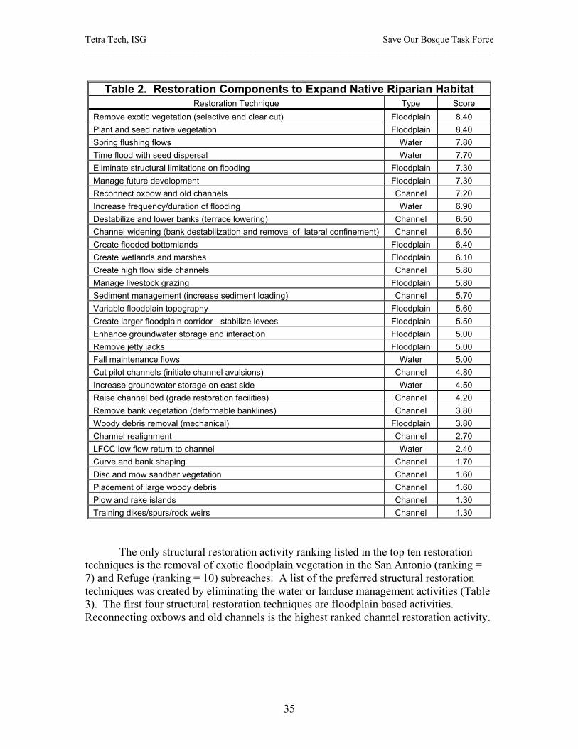
Tetra Tech, ISG Save Our Bosque Task Force ______________________________________________________________________________________
35
Table 2. Restoration Components to Expand Native Riparian Habitat
Restoration Technique Type Score Remove exotic vegetation (selective and clear cut) Floodplain 8.40 Plant and seed native vegetation Floodplain 8.40 Spring flushing flows Water 7.80 Time flood with seed dispersal Water 7.70 Eliminate structural limitations on flooding Floodplain 7.30 Manage future development Floodplain 7.30 Reconnect oxbow and old channels Channel 7.20 Increase frequency/duration of flooding Water 6.90 Destabilize and lower banks (terrace lowering) Channel 6.50 Channel widening (bank destabilization and removal of lateral confinement) Channel 6.50 Create flooded bottomlands Floodplain 6.40 Create wetlands and marshes Floodplain 6.10 Create high flow side channels Channel 5.80 Manage livestock grazing Floodplain 5.80 Sediment management (increase sediment loading) Channel 5.70 Variable floodplain topography Floodplain 5.60 Create larger floodplain corridor - stabilize levees Floodplain 5.50 Enhance groundwater storage and interaction Floodplain 5.00 Remove jetty jacks Floodplain 5.00 Fall maintenance flows Water 5.00 Cut pilot channels (initiate channel avulsions) Channel 4.80 Increase groundwater storage on east side Water 4.50 Raise channel bed (grade restoration facilities) Channel 4.20 Remove bank vegetation (deformable banklines) Channel 3.80 Woody debris removal (mechanical) Floodplain 3.80 Channel realignment Channel 2.70 LFCC low flow return to channel Water 2.40 Curve and bank shaping Channel 1.70 Disc and mow sandbar vegetation Channel 1.60 Placement of large woody debris Channel 1.60 Plow and rake islands Channel 1.30 Training dikes/spurs/rock weirs Channel 1.30
The only structural restoration activity ranking listed in the top ten restoration techniques is the removal of exotic floodplain vegetation in the San Antonio (ranking = 7) and Refuge (ranking = 10) subreaches. A list of the preferred structural restoration techniques was created by eliminating the water or landuse management activities (Table 3). The first four structural restoration techniques are floodplain based activities. Reconnecting oxbows and old channels is the highest ranked channel restoration activity.

Tetra Tech, ISG Save Our Bosque Task Force ______________________________________________________________________________________
36
Table 3. Structural Restoration Activity Ranking Restoration Technique Type Ranking
Remove exotic vegetation (selective and clear cut) Floodplain 6.21 Create wetlands and marshes Floodplain 4.67 Plant and seed native vegetation Floodplain 4.34 Create flooded bottomlands Floodplain 4.02 Reconnect oxbow and old channels Channel 3.90 Variable floodplain topography Floodplain 3.69 Destabilize and lower banks (terrace lowering) Channel 3.58 Channel widening Channel 3.56 Create high flow side channels Channel 2.75 Remove bank vegetation (deformable banklines) Channel 2.37 Create larger floodplain corridor - stabilize levees Floodplain 2.31 Raise channel bed (grade restoration facilities) Channel 2.13 Cut pilot channels (initiate channel avulsions) Channel 2.02 Remove jetty jacks Floodplain 1.63 Woody debris removal (mechanical) Floodplain 1.21 Disc and mow sandbar vegetation Channel 0.93 Plow and rake islands Channel 0.91 Placement of large woody debris Channel 0.84
Channel realignment Channel 0.79 Curve and bank shaping Channel 0.65 Training dikes/spurs/rock weirs Channel 0.27
The procedure for selecting restoration components for integration into the restoration plan was as follows:
• Review existing channel and floodplain conditions by subreach including channel morphology, floodplain vegetation distribution, channel vegetation encroachment, areas of inundation by overbank flooding, habitat and landownership.
• Review the restoration technique ranking.
• Select restoration techniques for the six restoration themes:
Restoration lyte plan (removal of channel vegetation only) Water salvage Reducing the impacts of drought Habitat diversity and supporting endangered species habitat River dynamics, aquatic habitat and overbank flooding Long term comprehensive plan that maximizes the opportunities for
restoration.
• Integrate the restoration techniques into a layered set of plans by theme and subreach.
• Select individual restoration projects for further feasibility study based on the layered plans with respect to flooding, vegetation and land ownership.

Tetra Tech, ISG Save Our Bosque Task Force ______________________________________________________________________________________
37
Feasibility Criteria Feasibility studies for construction of the restoration projects will include estimates of capital cost, estimates of operation and maintenance costs, estimates of expected project life, and management or institutional requirements such as permitting and agency consultation. In Appendix A, a description of each project is presented along with a qualitative assessment each of the following criteria. Capital Cost Capital costs are the initial investment in constructing the restoration project. These are non-reoccurring costs used in procuring assets associated with the restoration development. These capital costs can be annualized to determine the capital recovery cost that then can be combined with the maintenance costs to determine an annual equivalent total project cost. Typical capital costs include labor, equipment purchase, hauling spoil material, clearing and brushing, purchase of seeds, etc. The capital cost criteria is established as follows:
High cost – restoration project has a high cost in comparison to other projects. Moderate cost – restoration project is comparable in cost to most of the other
restoration projects. Low cost – restoration component has a relatively low cost compared to other
project restoration project. No cost – there is no capital investment costs associated with restoration
construction.
Operation and Maintenance Costs Operation and maintenance include any costs associated with annual restoration maintenance such as mowing and disking channel vegetation. Operation and maintenance costs (O & M) may include labor, material and energy consumption costs for equipment operation that are accounted on an annual basis. Monitoring and adaptive management costs should be considered as O & M costs. A qualitative assessment of O & M costs is presented as follows:
High O & M costs – restoration project has a relative high annual maintenance cost in comparison to other components.
Moderate O & M costs – restoration project requires comparable maintenance to most of the other restoration project.
Low O & M costs – restoration project has a relatively low O & M annual cost compared to other project restoration projects.
No O & M costs – there are no O & M costs associated with restoration.
Tetra Tech, ISG Save Our Bosque Task Force ______________________________________________________________________________________
38
Project Life The project life of a restoration project is the long term project functionality. Project life is depends on annual conditions such as peak flow frequency and duration. There is no simple method to evaluate the anticipated life of a project. Subjective judgment is used to compare the project life of one restoration technique to another. Functional or operational project life should be distinguished from economic life (long term benefit to cost ratio) and financial life (project income generation). The project life is evaluated as follows:
Long term project life – restoration project has an anticipated long or unlimited life in comparison to other projects.
Moderate project life – restoration project life is comparable to most of the other restoration projects.
Limited project life – restoration project has an expected limited life time (10 years or less) compared to other project restoration project.
Short project life – the project life is expected to be only 1 or 2 years (annual maintenance is a possibility).
Management and Institutional Requirements
Management and institutional requirements include agency consultation and cooperation, feasibility design documentation, final design plans and drawings, land ownership issues, environmental compliance including NEPA, archaeological consultation, endangered species impact review, depletion analysis, construction permitting such as 404 permits, and any other regulatory requirements. Final design of the project could be extensive and costly as in the case of new channel designs. Surveys for endangered species could be complicated depending on habitat and season. An evaluation of management and institutional requirements is as follows:
Significant management and institutional requirements – design, consultation, compliance and permitting for a restoration project is anticipated to be extensive in comparison to other projects.
Moderate management and institutional requirements – restoration project will be of a similar level of design, consultation, compliance and permitting comparable to most of the other restoration projects.
Limited management and institutional requirements – design and compliance are expected to be relatively simple compared to other project restoration activities.
No management and institutional requirements – design, consultation, compliance and permitted are not anticipated.
Each of these categories will be qualitatively assessed for each project in the description of the restoration activity presented in Appendix A.

Tetra Tech, ISG Save Our Bosque Task Force ______________________________________________________________________________________
39
Restoration Plan Components Introduction The conceptual Middle Rio Grande restoration plan for the reach from San Acacia to San Marcial is described in the following sections. Vegetation removal from the active channel and removal of exotic vegetation on the floodplain are predominant projects in all three subreaches. In the Escondida subreach, a minor amount of bank destabilization and a potential area for a secondary channel are outlined. Two firebreaks are also recommended. In the San Antonio subreach, significant reaches of bank destabilization are prescribed along with area of wetlands enhancements. Six firebreaks and enhancement of arroyo connections with the river channel area are recommended. The Refuge subreach plan includes bank destabilization, channel realignment, high flow side channels (also referred to as secondary channels), wetland enhancement and renewed flooding in the Tiffany Junction area. The restoration plan components are described in Appendix A and are displayed on hardcopy maps accompanying the report. Plan Assumptions and Limitations The goals and objectives of the restoration plan are represented in the selected projects, but not every issue or resource use impact could be folded into the conceptual plan. Some issues and conflicts will have to be resolved during the project feasibility design. The intent of preparing the conceptual plan was to address the major issues, trends, values and impacts for each of primary restoration activities so that the restoration plan would be focused and flexible. In order to formulate this plan, a number of assumptions were made and potential project limitations were acknowledged. These include:
• All restoration activities are contingent upon cooperation or agreement with landowner or administrator.
• Private and agency land issues will include permitting and monitoring requirements.
• The entire restoration plan will require a relatively long period of implementation of perhaps ten years or more. During that period, some restoration techniques and practices will be revised and some projects may require re-working.
• Some annual maintenance of restoration activities both in the active channel with renewed vegetation encroachment and on floodplain areas of exotic vegetation removal is expected.
• Some restoration activities may require further evaluation during feasibility design to determine the final project scope and cost of restoration.
• During the period of restoration implementation, other restoration projects upstream or in the study reach may be proposed that could influence the scope or design of a restoration component.

Tetra Tech, ISG Save Our Bosque Task Force ______________________________________________________________________________________
40
• Groundwater data is limited as discussed in the Phase II report. The lack of groundwater data limits the opportunity to consider groundwater hydrology in more detail. In general, river realignment projects should focus on moving the river to the east away from the LFCC because of the steep groundwater gradients to the LFCC.
• The future disposition or operation of the LFCC was not considered in the selection of restoration techniques.
• The future disposition or operation of the San Acacia diversion dam was not considered in the selection of project components.
• The restoration plan incorporates the Bureau of Reclamation’s new pilot channel as designed. It is anticipated that the channel geometry will evolve with high flows.
• Levee rehabilitation in the San Acacia reach that could affect future restoration activities was not considered in the selection of restoration projects although existing levee stability was considered.
• The possible San Marcial Bridge relocation was not considered in the restoration plan. Depending on the future disposition of the bridge, some restoration projects may have to be reviewed before implementation.
• The lowering of Elephant Butte Reservoir over a long period may eventually affect the channel bed slope at San Marcial or even further upstream. This will impact restoration projects planned in the Refuge reach. This is speculative, however, and will not be considered in the selection of restoration components at this time. It is a consideration for project components that may implemented in the future.
• The potential channel relocation downstream of the San Marcial Railroad Bridge was not considered in the selection of project components.
• Long term sediment supply concerns should be considered in the ultimate funding of restoration projects and the timing of implementation.
• All proposed restoration projects were considered for the potential effects on endangered species habitat. Further endangered species surveys and coordination with the Fish and Wildlife Service would be required prior to project implementation.
• Removal of exotic vegetation and the re-establishment of native vegetation is considered habitat enhancement for the Southwestern Willow Flycatcher.
• The restoration projects would be designed to minimize any adverse effects on low flow velocity aquatic habitat.
• Restoration projects are assumed to reduce the stress on the agricultural community by providing suitable wildlife habitat.
• Fire protection for old growth cottonwood/willow bosque as well as for communities along the river has been considered in the restoration plan.

Tetra Tech, ISG Save Our Bosque Task Force ______________________________________________________________________________________
41
• Conflict resolution may be necessary for the implementation of some restoration project components.
• Sediment bed material size in the San Acacia to San Marcial is relatively uniform and is not anticipated to change during the life of the project.
• Biological Opinion requirements and issues could impact the final restoration project scope or design.
• Incidental impacts on native or endangered species or their habitat may occur during project implementation, but such impacts should be relatively short lived as the restoration activity will have an overall beneficial impact on habitat.
• The restoration projects have been planned based on the post-Cochiti discharge record at San Acacia. During drought periods, restoration design flows may not occur with the prescribed frequency. Allocating upstream reservoir storage and water volumes for restoration flows may affect water rights and water use allocations as well as require changes in water operations. The steps required to secure water augmentation for restoration projects are complicated and may involve federal legislation. An investigation of water augmentation and steps to secure flow augmentation for drought periods is beyond the scope of this plan.
It should noted that the restoration plans discussed in this document do not represent the potential full scope of restoration that could occur if the prescribed constraints were ignored. There are several concepts involving channel morphology, low flows and spring runoff that could be embodied in a sweeping restoration plan that circumvented upstream reservoir controls, landownership and the LFCC. Those concepts include: Opening up the floodplain south of the Highway 380 Bridge by removing the levee to allow channel avulsion, migration and sediment storage on the floodplain; filling in LFCC, raising the LFCC bed elevation, lining or piping the LFCC to reduce seepage losses; and securing historic peak flows that would sustain a wide, dynamic channel. Reconstructing the channel in the Refuge subreach will restore its dynamic nature but not eliminate the sediment deposition on the floodplain that has perched the channel and floodplain. Removing the levee and LFCC, would allow channel avulsion and migration and sediment storage on a wider floodplain. Of these concepts, reducing the seepage to LFCC has least associated constraints and the greatest practical benefit. The LFCC serves as the drainage canal, a function that is normally reserved for the river system. Water seepage from the river to the LFCC has resulted in a dry river channel and can significantly impact river low flows downstream from about river mile 95. By raising the LFCC bed elevation to approximately that of the river between Escondida Bridge and San Marcial, infiltration losses could be curtained while maintaining the conveyance function of the LFCC. It would require a drop structure downstream of San Marcial and possible berms along the LFCC for additional conveyance. Lining or piping the LFCC would also raise the groundwater table to the river. Some drainage canals entering the LFCC might require pumping or other new confluence with the LFCC. Some drainage canals could be combined to simplify the LFCC connection.
Tetra Tech, ISG Save Our Bosque Task Force ______________________________________________________________________________________
42
Plan Themes and Mapping The restoration plan is presented in Appendix B and electronically with the GIS maps in a series of maps on CD. The plan consists of six restoration themes:
• Restoration lyte plan with channel vegetation removal and maintenance • Water salvage • Reducing the drought impacts • Habitat diversity and endangered species habitat • River dynamics, aquatic habitat and overbank flooding • Long term comprehensive plan that maximizes the opportunities for restoration
A spring flushing flow theme is also discussed, but it does not require construction activities. Each plan theme is composed of a series of restoration projects by subreach. Restoration Lyte Plan: The restoration light plan was conceived to provide the most restoration benefit for least cost. It consists of a limited selection of projects for those areas that might be the least costly to implement. The plan is focused on disc and mowing the channel, exotic vegetation removal and some reshaping of the floodplain. All of the proposed fire breaks and the enhancement of three wetlands in the Refuge subreach are also included. Water Salvage Plan: The water salvage plan consists of exotic vegetation removal only. The plan theme is to eliminate exotic vegetation in all proposed low and medium quality habitat areas consisting primarily of dense salt cedar. Revegetation with native plants will improve the riparian habitat and create water salvage from a decrease in the evapotranspiration. Reducing Drought Impacts Plan: Reducing drought impacts through water salvage and wetland enhancement is the basis of this plan theme. The concept is to increase low flows in the river during drought conditions by reducing evapotranspiration depletions and mitigate the drought impacts on wildlife by enhancing wetlands areas. Native vegetation would replace the water consuming dense salt cedar stands. The channel vegetation would be removed through disc and mowing and exotic vegetation on the floodplain would be eliminated. Wetland areas would have more water storage and greater interaction with groundwater. Habitat Diversity Plan: The habitat diversity habitat plan encompasses a number of projects that will enhance the biological diversity in the riparian system. The projects in this plan include disc and mowing the channel vegetation, removing exotic vegetation on the floodplain, some bank destabilization, floodplain terrace lowering and fire break projects. Two side channel projects are planned for the Escondida subreach. One secondary channel, one wetland and one backwater project are prescribed for the San Antonio subreach. Finally, three wetland projects, two side channels projects and the Tiffany Junction project are components in the Refuge subreach.
Tetra Tech, ISG Save Our Bosque Task Force ______________________________________________________________________________________
43
River Dynamics Plan: The river dynamics plan is focused on channel restoration with only limited vegetation removal on the floodplain. This plan consists of disk and mowing sandbar vegetation, bank destabilization projects, lowering the floodplain with associated removal of exotic vegetation, plus a number of channel restoration projects. These include two side channel projects in the Escondida subreach, one secondary channel project, one wetland and one backwater project in the San Antonio subreach, and one pilot channel, three side channels and four wetland projects and the Tiffany Junction project in the Refuge subreach. Long Term Comprehensive Plan: The long term comprehensive plan includes all proposed restoration projects in the above individual theme plans. To review the projects in each plan theme, review the GIS map layers in ArcView on the provided CD. Each restoration project or component is shown on the GIS maps. The restoration themes for the map are broken down by subreach and restoration activity. The reach designations are (E) Escondida subreach (E), San Antonio subreach (S) and Refuge subreach (R). The restoration techniques are labeled as:
a = remove exotics b = bank destabilization c = lower floodplain d = sandbar mow and disk e = floodplain plow and rake f = create pilot channel g = create high flow side channel (secondary channel) h = create/enhance wetland i = fire break j = grade control k = channel diversion berm
Each project is numbered consecutively in the downstream direction. For example, the second bank destabilization project in the San Antonio subreach is represented by Sb2. Removing exotics implies re-establishing vegetation. For removing the exotic vegetation, the existing habitat has been divided into three habitat value categories: High, Medium, and Low as shown in Table 4 (Table 4 is Table 19, page 77 of the Phase II Report). This table shows the relationship between the Hink and Ohmart 1984 classification system and the FWS 2000 study.
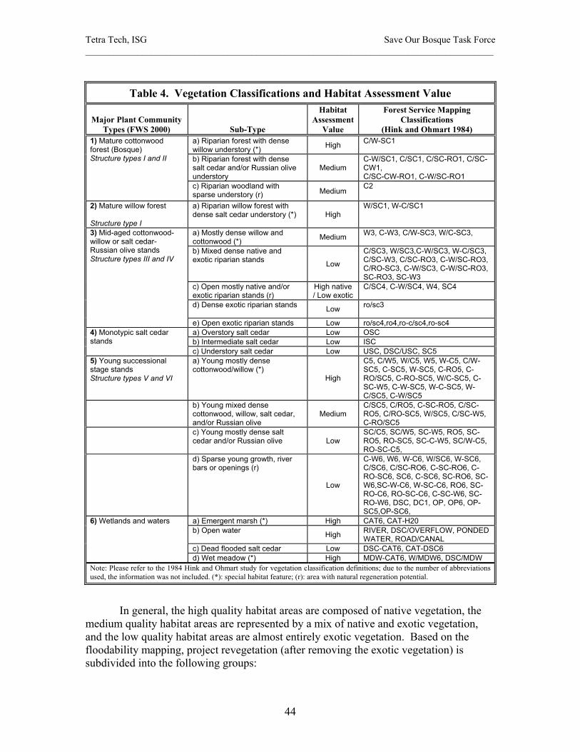
Tetra Tech, ISG Save Our Bosque Task Force ______________________________________________________________________________________
44
Table 4. Vegetation Classifications and Habitat Assessment Value
Major Plant Community Types (FWS 2000) Sub-Type
Habitat Assessment
Value
Forest Service Mapping Classifications
(Hink and Ohmart 1984) a) Riparian forest with dense willow understory (*) High C/W-SC1
b) Riparian forest with dense salt cedar and/or Russian olive understory
Medium C-W/SC1, C/SC1, C/SC-RO1, C/SC-CW1, C/SC-CW-RO1, C-W/SC-RO1
1) Mature cottonwood forest (Bosque) Structure types I and II
c) Riparian woodland with sparse understory (r) Medium
C2
2) Mature willow forest Structure type I
a) Riparian willow forest with dense salt cedar understory (*) High
W/SC1, W-C/SC1
a) Mostly dense willow and cottonwood (*) Medium W3, C-W3, C/W-SC3, W/C-SC3,
b) Mixed dense native and exotic riparian stands Low
C/SC3, W/SC3,C-W/SC3, W-C/SC3, C/SC-W3, C/SC-RO3, C-W/SC-RO3, C/RO-SC3, C-W/SC3, C-W/SC-RO3, SC-RO3, SC-W3
c) Open mostly native and/or exotic riparian stands (r)
High native / Low exotic
C/SC4, C-W/SC4, W4, SC4
d) Dense exotic riparian stands Low ro/sc3
3) Mid-aged cottonwood-willow or salt cedar-Russian olive stands Structure types III and IV
e) Open exotic riparian stands Low ro/sc4,ro4,ro-c/sc4,ro-sc4 a) Overstory salt cedar Low OSC b) Intermediate salt cedar Low ISC
4) Monotypic salt cedar stands
c) Understory salt cedar Low USC, DSC/USC, SC5 5) Young successional stage stands Structure types V and VI
a) Young mostly dense cottonwood/willow (*)
High
C5, C/W5, W/C5, W5, W-C5, C/W-SC5, C-SC5, W-SC5, C-RO5, C-RO/SC5, C-RO-SC5, W/C-SC5, C-SC-W5, C-W-SC5, W-C-SC5, W-C/SC5, C-W/SC5
b) Young mixed dense cottonwood, willow, salt cedar, and/or Russian olive
Medium C/SC5, C/RO5, C-SC-RO5, C/SC-RO5, C/RO-SC5, W/SC5, C/SC-W5, C-RO/SC5
c) Young mostly dense salt cedar and/or Russian olive Low
SC/C5, SC/W5, SC-W5, RO5, SC-RO5, RO-SC5, SC-C-W5, SC/W-C5, RO-SC-C5,
d) Sparse young growth, river bars or openings (r)
Low
C-W6, W6, W-C6, W/SC6, W-SC6, C/SC6, C/SC-RO6, C-SC-RO6, C-RO-SC6, SC6, C-SC6, SC-RO6, SC-W6,SC-W-C6, W-SC-C6, RO6, SC-RO-C6, RO-SC-C6, C-SC-W6, SC-RO-W6, DSC, DC1, OP, OP6, OP-SC5,OP-SC6,
a) Emergent marsh (*) High CAT6, CAT-H20 b) Open water High RIVER, DSC/OVERFLOW, PONDED
WATER, ROAD/CANAL c) Dead flooded salt cedar Low DSC-CAT6, CAT-DSC6
6) Wetlands and waters
d) Wet meadow (*) High MDW-CAT6, W/MDW6, DSC/MDW Note: Please refer to the 1984 Hink and Ohmart study for vegetation classification definitions; due to the number of abbreviations used, the information was not included. (*): special habitat feature; (r): area with natural regeneration potential.
In general, the high quality habitat areas are composed of native vegetation, the medium quality habitat areas are represented by a mix of native and exotic vegetation, and the low quality habitat areas are almost entirely exotic vegetation. Based on the floodability mapping, project revegetation (after removing the exotic vegetation) is subdivided into the following groups:
Tetra Tech, ISG Save Our Bosque Task Force ______________________________________________________________________________________
45
• Sparse cottonwood/willow bosque • Grass and open savannah • Salt grass and upland shrubs
These anticipated habitat groups after restoration are displayed in an additional set of maps in the GIS map base. These maps divide the exotic vegetation removal projects into 3 habitat categories (based on assessment value), each having 3 possible flood inundation zones, for a total of 9 categories. The different flood inundation zones are delineated as follows:
Floodplain areas that will be flooded at least a half a foot deep during a spring hydrograph with a peak discharge of 5,660 cfs for six days;
Floodplain areas that will be not flooded by a peak discharge of 5,660 cfs for six days but are flooded with a peak discharge of 7,440 cfs for six days:
Floodplain areas that will not be flooded with a peak discharge of 7,440 cfs for six days.
The preferred native vegetation types (those that can be expected to regenerate naturally or will be planted) are dependent on frequent overbank flooding. The restoration design peak discharge (channel forming flow) that was selected for San Acacia to San Marcial reach was 5,600 cfs or the two-year return period flood for the post-Cochiti San Acacia gage record. The 7,440 cfs represents the Corps’ projected 2-year flood at San Acacia that includes the historical analysis of the Rio Puerco and Rio Salado tributaries. These two discharges represent a range of channel forming flows that should be reasonably expected approximately 4 out 10 years on the average. Floodplain areas that are inundated at a discharge of 5,660 cfs are expected to support cottonwood/willow bosque, mixed riparian habitat or salt grass meadows, seasonal wetlands and marsh. Areas that flood at 7,440 cfs but not 5,660 cfs are expected to be maintained as open riparian vegetation, savannahs or mixed grasslands. Areas that do not flood at 7,440 cfs are anticipated to be upland vegetation including grasslands and shrubs. The restoration plan themes are presented in ArcView GIS format as layers. For example, the long term comprehensive plan that includes all the possible restoration projects can be visualized on one layer. In addition to the projects layers, several other layers have been created in the GIS mapping including:
• Existing vegetative habitat types; • Endangered Southwestern Willow Flycatcher habitat: • Floodplain inundation areas for discharges of 5,660 cfs, 7,440 cfs and the 100-
year event; • Floodplain geological alluvium soil types; • Land ownership.
These various layers can be combined and overlaid to view multiple restoration project details and combinations. For example, by turning on and off layers the restoration plan themes can be viewed with existing habitat types and land ownership. These GIS maps can also be viewed in ArcView Explorer II.

Tetra Tech, ISG Save Our Bosque Task Force ______________________________________________________________________________________
46
The project areas depicted on the restoration maps indicate where a specific restoration activity will be applied. It should be noted that the entire project area must be evaluated to determine where the restoration technique will be the most beneficial. The restoration technique may not be applied over the whole project area. For example, only the vegetated sandbars in the designated active channel reaches will require mowing and disking. Each sandbar in a given project area will have to be reviewed for the need to remove vegetation and the technique for vegetation removal will then be selected. Similarly the floodplain areas delineated for salt cedar removal will have to be evaluated to determine the need to remove vegetation, the methods for vegetation removal and the required equipment. In some areas selective removal of exotic understory may be sufficient. In other areas complete removal of dense exotic vegetation will be desirable. Specific Project Descriptions A description of each of the restoration projects is presented in Appendix A. The project descriptions are presented in the form of a table. The tables should used in conjunction with the maps to locate the project and understand its contribution to the overall restoration plan as well as its relationship to other projects. The projects are referenced in the table by an ID number that is listed on the maps and the ID numbers increase in downstream direction. All the proposed restoration projects are presented in the long term comprehensive plan. Some projects may appear only in a specific plan theme such as the river dynamics plan or the habitat diversity plan. A series of reconnaissance trips were conducted to verify the restoration activities. One of the reconnaissance trips was made from the Escondida Bridge to the South Boundary of Bosque del Apache National Wildlife Refuge by ATV over a period of two days (Photo 5). This trip was made down the river channel at discharges less than 60 cfs. The last third of the trip was conducted in a dry river channel (Photo 6). Photos and video recordings were taken to support the selection of a restoration component. To compliment the ground surveys, a flyover of the San Acacia to San Marcial reach was performed on October 3, 2003. The river was dry during the flight. A digital video recording of the river flyover was made and processed for use in assessing the restoration components and their potential aerial extent.
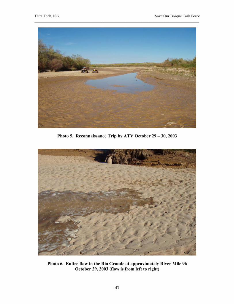
Tetra Tech, ISG Save Our Bosque Task Force ______________________________________________________________________________________
47
Photo 5. Reconnaissance Trip by ATV October 29 – 30, 2003
Photo 6. Entire flow in the Rio Grande at approximately River Mile 96 October 29, 2003 (flow is from left to right)
Tetra Tech, ISG Save Our Bosque Task Force ______________________________________________________________________________________
48
Conceptual Restoration Plan Implementation Introduction The ranking of preferred restoration activities was completed in Phase III. The project restoration components were ranked according to their contribution to restoration objectives based on a linked matrix approach that required extensive mathematical design and testing. The final ranking was based on averaging or combining the results of all the completed matrices. The restoration priorities with the highest ranking were:
• Spring flushing flows • Eliminate structural limitations on flooding • Manage future development • Increase frequency/duration of flooding • Remove exotic vegetation (selective and clear cut) • Create wetlands and marshes • Enhance groundwater storage and interaction (east side of the river) • Plant and seed native vegetation • Create flooded bottomlands • Variable floodplain topography • Reconnect oxbow and old channels • Channel widening • Reconnect oxbow and old channels • Destabilize and lower banks (terrace lowering) • Fall maintenance flows
The first four highest ranked restoration priorities relate to seasonal flood flows. The second and third activities involve improving opportunities for high flows by eliminating existing or future development constraints on flooding. The first and fourth restoration priorities are specific to seasonal overbank flows. Based on the Phase III ranking, it is recommended that spring flushing flows of an appropriate magnitude, frequency and duration be coordinated with the federal agencies. Spring flushing flows were ranked 1, 2 and 9 for the Refuge, San Antonio, and Escondida reaches respectively. Increasing the frequency and duration of flooding were ranked 6 and 8 for the Refuge and San Antonio subreaches respectively. In concert with the spring flushing flows, eliminating flood hazards on the floodplain and managing future development on the floodplain will remove constraints on flood magnitude and duration. Eight out of the top ten ranked restoration activities were related to enhancing the channel-floodplain hydrologic connection.
Tetra Tech, ISG Save Our Bosque Task Force ______________________________________________________________________________________
49
General Plan Focus Using the subreach delineation, the Escondida reach has experienced incision since 1962, the San Antonio subreach is more or less in sediment transport equilibrium and the Refuge subreach is still aggrading. The restoration plan as outlined in the previous section considers the linkage between sediment load and channel form, future aggradation and degradation trends, equilibrium slope, and cross section variability. The selection of restoration projects was unique to each subreach. In the Escondida subreach, the channel incision has had the effect of eliminating overbank flows on the historical floodplain. For that reason and the high cost associated with floodplain terrace lowering and the limitations afforded private land ownership, restoration activities are essentially limited to active channel maintenance. Enhancing or renewing frequent overbank flooding on the historical floodplain was not considered. Based on channel surveys from the last ten years, it is assumed that this reach has ceased incision. The focus for proposed restoration in the Escondida subreach is to remove active channel vegetation as well as the dense exotic vegetation on the floodplain and maintain as much of the channel dynamics in this reach as practical. Two short reaches have been identified for potential bank destabilization and development of a secondary channel. It is hoped that by maintaining the active channel over the long term the river will begin to rework the narrow active floodplain. The San Antonio subreach is considered to be in sediment transport equilibrium. This has helped to sustain the wider channel in the middle reach; although in recent years, virtually all the subreaches have been subjected to vegetation encroachment resulting in a narrower channel. In addition to removing channel vegetation and removing exotic vegetation in extensive areas of the floodplain, a restoration focus in this reach is to improve the channel/floodplain hydrologic connectivity. This would be accomplished by removing bank vegetation and destabilizing the banks over significantly long reaches. An area of wetland enhancement is also recommended. In the lower Refuge subreach, channel and floodplain aggradation are expected to continue. The channel is exceedingly narrow throughout the lower half of this subreach. Overbank flooding occurs frequently at relatively low bankfull discharges. To improve the aquatic habitat in the lower subreach, reconstructing a 360 ft wide channel is proposed. This channel will convey a much high discharge and sediment load and reduce overbank flooding in this reach. Exotic vegetation eradication from the floodplain will encourage reestablishment of native vegetation. Planting and seeding native vegetation in this reach has been identified as a priority. There are also several opportunities to enhance flooding of old meander bends and channels. Side channels and channel realignment is proposed to enhance wetland and marsh areas. Some bank destabilization is also recommended. The Tiffany Junction area can be easily flooded because of its lower floodplain. Reconnection of the Tiffany Junction area to the river channel is proposed.

Tetra Tech, ISG Save Our Bosque Task Force ______________________________________________________________________________________
50
Restoration Project Water Needs All the proposed activities are designed to create favorable hydro-geomorphic conditions for river and riparian restoration. Without the natural river processes associated with seasonal flow variability some of the proposed restoration components could either fail or require annual maintenance. The restoration vision embraces providing a greater range of flow regimes, enhancing river dynamics, reversing the trend of vegetation encroachment, expanding the active floodplain, increasing channel floodplain connectivity and reforming the channel geometry. To accomplish these objectives without frequent maintenance, a suite of diverse seasonal flows is required. Mimicking the natural seasonal hydrograph is the number one recommendation of the Bosque Biological Management Plan (Crawford, et al., 1993). The historical abundance and diversity of native species in the riparian ecosystem were strongly linked to the river’s diverse suite of flows. Both the rising and recessional limbs affect the reproductive life stage of many aquatic and riparian species. Long durations of uniform flow have resulted in a loss of habitat diversity on the Rio Grande. The decline of the river functions and biological diversity of the Rio Grande system can be directly attributed to the reduction in peak flow magnitude, frequency and duration as well as the reduction of sediment loading. Historical river training activities have also contributing to the river’s decline in habitat diversity. Wolman and Miller (1960) emphasized that the channel shape is affected by a range of flows, not just a single peak discharge. The role of large, infrequent flood events on shaping channel morphology is less important than the frequent channel forming flows that strongly control bed material mobility and sediment transport. The channel forming discharge is assigned a flow frequency in the range of the bankfull discharge return period usually about a 2 year flood (Richards, 1982). The San Acacia post-Cochiti 2-year return period flood was determined to be 5,660 cfs (see Phase II flood frequency section). Channel forming flows with a 2 to 3 year return period frequency will sustain channel geometry over the long term. These are the flows that rework the active channel and over the long term provide the maintenance of river form and function (Stanford, 1993). Channel forming flows in the range of the bankfull discharge vary throughout the San Acacia – San Marcial reach. Bankfull discharge has a higher magnitude and is less frequent in the upper Escondida subreach than the middle and lower subreaches. In the middle and lower subreaches, bankfull discharge has a return period that is less than 2 years based on post-Cochiti flows. Maintaining the active channel requires that flows approach the channel forming flows on a sufficiently frequent basis to eliminate vegetation encroachment within the active channel. Generally, bankfull discharge must occur at least once every three years to avoid channel narrowing associated with vegetation encroachment (FLO Engineering, 1995). The San Acacia mean daily peak discharge for the period from 1936 to 1950 is 5,400 cfs or approximately the post-Cochiti 2-year flood event (5,660 cfs). The mean

Tetra Tech, ISG Save Our Bosque Task Force ______________________________________________________________________________________
51
day of peak discharge of the major flood events for the pre-Cochiti period is approximately May 26. The spring peak flushing flow should be timed to occur during the last two weeks of May and it should reflect the shape of the typical pre-1974 hydrograph in terms of the rising and recessional limbs (Figure 2). This peak discharge timing will encourage regeneration of native riparian vegetation.
The mean annual flow duration for flows above 5,660 cfs (post-Cochiti, 2-yr flood) for the pre-Cochiti period 1936 to 1973 was 9.9 days, or about 10 days. For the post-Cochiti period from 1974 to 2002, the mean annual flow duration of the 2-year flood of 5,660 cfs is 5.8 days or roughly 6 days. The annual duration of flows in this range has decreased, promoting channel narrowing. For restoration purposes in the San Acacia to San Marcial reach, a spring hydrograph with a peak discharge of 5,660 cfs with a duration of approximately 6 days is recommended. The rate of change in mean hydrograph as shown in Figure 2 is 175 cfs/day for the rising limb and 135 cfs/day for the recessional limb. This hydrograph should occur approximately every other year or about 4 times in every 10 years with no more than 2 consecutive years without this spring hydrograph. The suggested hydrograph constitutes a peak flow volume of approximately 68,000 acre-ft or a total hydrograph volume of 458,000 acre-ft. Figure 3 indicates the range of the pre-Cochiti hydrograph variation at San Acacia. The recommended restoration design flow for the San Acacia to San Marcial reach is the two year return period flood of 5,660 cfs at San Acacia. This seasonal peak flow is recommended with a frequency of four out of ten years with no more than two consecutive years without attaining a discharge of at least 5,600 cfs. All proposed restoration activities should be designed to be sustained by this seasonal flood event. The design flood frequency and duration should effectively limit vegetation encroachment on the active channel, expand the riparian habitat, regenerate native vegetation and maintain the restored channel geometry without significant annual maintenance.

Tetra Tech, ISG Save Our Bosque Task Force ______________________________________________________________________________________
52
Providing Middle Rio Grande spring peak flows from Cochiti Dam is limited by water availability. Structural constraints such as the San Marcial Railroad Bridge and buildings on the floodplain as well as the Cochiti Dam outlet works limit the peak discharge release to less than 10,000 cfs. Cochiti Dam operational guidelines are mandated in federal law; however, some latitude in restructuring the release hydrographs that is endorsed by the Rio Grande Compact Commission could support restoration
Figure 2. San Acacia Mean Annual Hydrographs
0
1000
2000
3000
4000
5000
6000
1/1 2/1 3/1 4/1 5/1
6/1 7/1 8/1 9/1 10/1 11/1 12/1
Date
Dis
char
ge (c
fs)
Mean 1936-1973 Mean 1936-1950 Mean 1951-1973 Suggest Spring Hydrograph
Figure 3. San Acacia Annual Hydrograph Variation
0
5000
10000
15000
20000
25000
1/1 2/1 3/1 4/1 5/1 6/1 7/1 8/1 9/1 10/1 11/1 12/1 Date
Dis
char
ge (c
fs)
1959 1941 1942 1970 Mean 1936-1973

Tetra Tech, ISG Save Our Bosque Task Force ______________________________________________________________________________________
53
efforts. Releases from Cochiti and Jemez Canyon dams could be orchestrated to benefit restoration objectives by altering the shape and timing of spring release hydrographs. Flows to maintain the maximum channel capacity of 8,000 cfs or more are recommended in the Bosque Biological Management Plan. Providing river restoration flows within the context of the Rio Grande Compact was discussed in the Phase I and II reports. New Mexico has historically relied on three approaches to ensure that the state water delivery remains in compliance with the provisions of the Rio Grande Compact. These approaches are the administration of groundwater uses, implementing water salvage measures and accounting for tributary inflow downstream of the Otowi gage. The Compact does not require that the volume of water mandated by the schedule be delivered to Elephant Butte Reservoir each year and Article VI of the Compact allows for a credit and debit system. The New Mexico accrued water debit may not exceed 200,000 acre-feet, except for those debits caused by the holdover of water in storage in reservoirs constructed in New Mexico after 1929. Furthermore, New Mexico is not charged with greater debit in any one year than the sum of 150,000 acre-feet plus the gain in storage for that year. The annual credit is not to exceed 150,000 acre-feet.
Recognizing that the groundwater in the valley is hydrologically connected to Rio Grande surface water features, the State Engineer issued an administrative order in 1956 that: 1) identified the boundaries of the middle Rio Grande groundwater basin, 2) required that all future wells be drilled under a permit obtained from the State Engineer, and 3) required that all impacts of groundwater pumping on the flow of the Rio Grande be offset with the retirement and transfer of valid existing surface water rights. The State thus reasonably assured that new groundwater development after 1956 would not impair the state’s ability to deliver water to Elephant Butte Reservoir.
New Mexico has also relied on the implementation of water salvage measures that were undertaken in cooperation with the Bureau of Reclamation to reduce the “non-beneficial consumptive use” of water to enhance the middle valley water supply. The construction of the LFCC between San Acacia and Elephant Butte Reservoir was a principle component of these measures. This canal conveyed flows less than 1,600 cfs from San Acacia through the Elephant Butte delta to the reservoir. Although river diversions to the channel were ceased in 1985, the LFCC continues to function as a drain and collects seepage water from the river and the surrounding groundwater table. The water salvage program also included the mowing of vegetation in the Rio Grande floodway and the removal of salt cedar in the Elephant Butte Reservoir area. Although not a firm supply, the tributary inflow downstream of the Otowi gage has enhanced the available water supply to water users in the middle valley and water delivery to Elephant Butte Reservoir. The tributaries below the Otowi gage including the Jemez, Rio Puerco and Rio Salado flows are not accounted in New Mexico’s delivery obligation. Large tributary inflows from the Rio Salado and Rio Puerco that enter the Rio Grande below the major agricultural and domestic use areas in the middle valley can be important to New Mexico’s Compact credit or debit in a given year.

Tetra Tech, ISG Save Our Bosque Task Force ______________________________________________________________________________________
54
While the restoration plan has been formulated to reduce or eliminate the need for channel maintenance on an annual basis, it may be necessary to perform channel maintenance during prolonged dry periods of reduced peak flows. Based on post-Cochiti records, a peak discharge of 5,660 cfs should occur approximately every other year; however, in the event of a sustained drought, several years may pass without a spring flow that exceeds 5,000 cfs. During these drought periods, monitoring will be necessary to identify reaches of the channel that will require maintenance such as mowing and disking. Potential Water Salvage or Depletion Changes in consumptive use and groundwater connectivity related to restoration activities in the San Acacia to San Marcial reach could affect the delivery of water to Elephant Butte Reservoir and therefore could impact New Mexico’s Compact delivery credit or debit status. The most likely impact on water consumption associated with restoration activities in the San Acacia to San Marcial reach would be net water salvage resulting from a decrease in evapotranspiration. Most of the potential restoration project areas are experiencing significant ET losses associated with dense exotic vegetation. Net changes in water depletion or salvage would be based upon the “pre-restoration” floodplain condition including vegetation composition and density. As restoration projects are implemented, regulatory compliance with State law would be initiated to address Compact and water right issues. This reach of river has experienced significant changes in surface water depletion since the signing of the Rio Grande Compact. At one time, floodplain areas on the east side of the river downstream of San Antonio were irrigated. These lands were supplied by the Val Verde Ditch with water diverted from the Rio Grande about three miles north of the southern boundary of the Bosque del Apache National Wildlife Refuge. Irrigation was abandoned, but it was not until after the construction of the LFCC in the 1950s that the Rio Grande channel was completely confined to the east side of the valley in this area. For the past forty years, the water depletion from the reach downstream of San Antonio has been solely a function of the vegetation, composition and density, groundwater levels, and the proximity of the river channel to the LFCC. An analysis of the net depletion or salvage associated with restoration activities should consider the historic change in depletion. In the Phase II report, it was presented that gross annual depletion in the San Acacia to San Marcial reach has varied between 71,000 acre-ft and 119,000 acre-ft since 1937 (see Figure 13, Phase II report). This historical depletion has been both natural and human caused. Restoration activities will result in channel and floodplain conditions that have historically occurred and therefore, the net depletion or salvage would be within the historical levels experienced in this reach since the Rio Grande Compact of 1938 was signed. Some restoration activities may result in a variation in groundwater levels in the project area. Variable groundwater levels may be a function of losses attributed to evaporation or evapotranspiration.

Tetra Tech, ISG Save Our Bosque Task Force ______________________________________________________________________________________
55
Increases in groundwater levels can also be considered as an increase in groundwater storage. Groundwater is considered to be hydrologically connected to the surface waters of the Rio Grande and variability in groundwater storage is not necessarily a long term change in the system. One of the objectives of the conceptual restoration plan is to attempt to maximize water salvage by replacing dense stands of exotic vegetation with native salt grass, shrubs or upland vegetation where appropriate. In the Phase II report, a hypothetical water budget analysis was prepared to show the potential difference in water depletion between the existing and restored condition. The purpose of the analysis was to demonstrate a water budget computation and the potential benefit that restoration projects could have on water depletion. The depletion assumptions included:
• A restored bosque vegetation mosaic that will include young cottonwood, willow, baccharis species, New Mexico olive, screwbean mesquite, and other brush, grasses and forbs. Evapotranspiration rates will vary with density and type of vegetation.
• Open sandbar acreage will be estimated as the difference between existing and proposed restored channel acreage at low flow conditions.
• Increased open water evaporation losses associated with overbank flooding will be based on the difference between existing and restored areas.
An estimate of water salvage or change in depletion can be determined for each restoration project component. Overall, it is presumed that implementing the restoration plan will result in water savings for this reach of river. The example Table 5 below illustrates how habitat types and estimated water use could be computed on a project basis for the feasibility report to estimate potential water salvage. To support this analysis, evapotranspiration estimates as a function of vegetation type and density would have to be determined. In addition, appropriate flooding duration for open water evaporation has to be assumed. Concurrence from agency and institution researchers for estimated ET losses presented in Table 5 should be considered.

Tetra Tech, ISG Save Our Bosque Task Force _________________________________________________________________________________________________________________________________
56
Table 5. Estimates of Water Salvage/Depletion
Dominant cover type
ET or evaporation loss rates8
(ft/yr)
Existing land cover
(acres)
Existing depletion (acre-ft)
Future land cover without
restoration (acres)
Future depletion without
restoration (acre-ft)
Potential net
change in water use (acre-ft)
Future land cover with restoration
(acres)
Future depletion with
restoration (acre-ft)
Potential net change in water use (acre-ft)
Open water at low flows
(>500 cfs)1 3.63
Open water at high flows
(5,660 cfs)2 1.22
Exposed sandbars at low flows1
1.34
Intermediate exotics4 3.27
Dense mature exotics3 4.90
Mature mixed stand with exotics6
3.95
Mature mixed stand without
exotics7 3.00
Shrubs and salt grass meadows
1.99
Upland grasslands
Semi-permanent wetlands
Mixed bosque
vegetation5 3.06
Total for low flow condition 1Includes the months of June thru March, based on a pan evaporation coefficient of 0.85 recommended by ISC. 2Includes the months of April and May, based on a pan evaporation coefficient of 0.85 recommended by ISC. Evaporation has to be prorated based on actual duration. 3Determined by the Evapotranspiration Work Group based on an assumption of dense vegetation. 4Assumes two-thirds of the ET for dense mature exotics. 5The composite cottonwood/willow/salt grass evapotranspiration rate is determined by summing one third of each vegetation type evapotranspiration rate. 6Assumes a 50% mix of mature bosque with intermediate exotics. 7Refers to a mature cottonwood/willow bosque. 8All ET rates are based on values from the Evapotranspiration Work Group as reported in the Environmental Assessment for the Los Lunas Habitat Restoration Project prepared by the Corps of Engineers and Bureau of Reclamation, March, 2002.

Tetra Tech, ISG Save Our Bosque Task Force ______________________________________________________________________________________
57
In restoration areas where exotic vegetation will be removed, it is assumed that a native habitat mix of habitats will be established. Table 6 presents the evaporation or evapotranspiration rates for open sandbars. For April and May the rate of evaporation for open water has been inserted based on the assumption that the sandbars will be flooded during these months. Some inundation of sandbars may also occur in June as well as at other times during the year but this was conservatively ignored in the following table. Open water evaporation rates are presented for two pan coefficients 0.7 and 0.85 as recommended by the Interstate Stream Commission (BOR and Corps, 2002). It is recommended that the higher ISC pan coefficient be used in water budget analyses.
Table 6. Open Sandbar Evaporation and ET Evaporation Pan Coefficients
Month 0.70 0.85 Jan 0.06 0.06 Feb 0.08 0.08
March 0.14 0.14 April* 0.46 0.56 May* 0.54 0.66 June 0.25 0.25 July 0.22 0.22 Aug 0.20 0.20 Sept 0.15 0.15 Oct 0.12 0.12 Nov 0.07 0.07 Dec 0.05 0.05
Annual Rate 2.34 ft/yr 2.56 ft/yr *rates for open water
Restoration activities can reduce water depletion (salvage water) through the
removal of exotic vegetation and eventual replacement with native vegetation. Similarly, the conversion of a vegetated sandbar to an active channel sandbar that is reworked annually or every other year could also result in water salvage. For example, if a vegetated sandbar is converted to an open sandbar which is flooded during April and May, the net reduction in ET for this project component is from 3.27 ft/yr to 2.56 ft/yr, or a water salvage of 0.71 ft/yr depending on depth to groundwater. Multiplying this rate by the original sandbar area will constitute an estimate of the volume of water salvage from mowing and disking this sandbar.
The final estimates of potential water salvage for each project will depend on the selection of the evaporation rates used in Table 5. Further detailed breakdown or description of the vegetation types and density may improve the accuracy of the water salvage estimate. The ET rates used in Table 5 should be consistent with those used in the ESA Collaborative Program and in other studies. Table 5 should be prepared for each project during the project’s feasibility study. It can also be prepared on monthly basis instead of an annual basis.

Tetra Tech, ISG Save Our Bosque Task Force ______________________________________________________________________________________
58
Flood Inundation
The post-Cochiti record (1974-2002) was used to analyze frequent flood events at San Acacia in Phase II. This data base requires no adjustment for upstream storage because the flow regulation is inherent in the record. While it is debatable whether the post-Cochiti record of 29 years is sufficiently long enough to assimilate the Cochiti flow regulation into a current flood frequency analysis, neither the Rio Salado nor the Rio Puerco contributed any significant flood flows during the post-Cochiti period. This is a factor in determining the lower frequency flood events at San Acacia. Without tributary floods, the post-Cochiti record reflects the higher frequency, smaller seasonal peak flows associated with spring flow Cochiti Dam releases. Recently, the Corps of Engineers (2003) conducted a flood frequency analysis at San Acacia reconstructing the using historical flooding from Rio Puerco and Rio Salado and routing the tributary flows to San Acacia with the FLO-2D model. The entire historical Rio Grande record adjusted for upstream storage was used in the analysis. The result was a 2-year flood of 7,440 cfs at San Acacia. This compares with the 2-year flood of 5,660 cfs using the post-Cochiti record described in the Phase II report. Both 2-year return period floods were simulated with the FLO-2D model in testing conceptual restoration plan.
A 10,000 cfs peak discharge for six days was also simulated. This peak discharge
which constitutes approximately a 10-year flood at San Acacia for the post-Cochiti record was requested by the Task Force to evaluate the potential for conservation easements. This peak discharge would require combined flows from both Cochiti Dam releases and tributary inflows. Whereas, a 10,000 cfs discharge release from Cochiti Dam is possible, floodwave attenuation would reduce this the flow to about 7,000 cfs at San Acacia. Calibration The San Acacia to San Marcial FLO-2D model was calibrated in September 2000 using updated cross sections surveyed during the period from May 25-30, 1998 at discharges ranging from 2,200 cfs to 2,500 cfs. The rest of the cross sections were surveyed on several occasions from 1992 to 1998. The model calibration was accomplished using discharge and aerial photography for the period from May 8-13, 1992. The Bureau of Reclamation aerial photography was flown on May 12, 1992 and the Bureau provided estimates of the channel and floodplain wetted surface area. The model was calibrated by adjusting n-values and allowing for some scour in narrow reaches, until the predicted discharge matched the San Marcial gage discharge (predicted 5,240 cfs vs. 5,090 cfs measured). The predicted wetted surface areas correlated well with Bureau’s estimates within a few percent (channel area: 2,810 acres BOR vs. 2,990 acres FLO-2D; floodplain area: 3,010 acres BOR vs. 3,040 acres FLO-2D; Tetra Tech, ISG, 2000). The FLO-2D model now extends from Cochiti Reservoir to Elephant Butte and includes all the recent cross section surveys including those completed in the San Acacia to San Marcial reach in 2002. The channel has narrowed considerably over the last four years and this is reflected in the results. Using the discharge record from May 8-13, 1992

Tetra Tech, ISG Save Our Bosque Task Force ______________________________________________________________________________________
59
(San Acacia mean daily discharge ranged from 5,400 cfs to 5,720 cfs, the approximate 2-year flood), the area of inundation was predicted as shown in Table 7. Manning’s n-values and channel infiltration hydraulic conductivity were adjusted to compute the values in Table 7 over a series of ten to fifteen FLO-2D simulations. No effort was made to further calibrate the model using the mobile bed component because the channel is markedly different now than in 1992 and 1998 and also because there is no recent high flow data (either area of inundation or water surface elevations for a corresponding discharge) to adjust n-values or channel cross section. The 2002 cross sections were surveyed at low flows. There have been no recent spring high flows in the San Acacia to San Marcial reach, so there is no opportunity to calibrate the FLO-2D model to discharges at the two gages or to overbank flooding with aerial videos.
TABLE 7. FLO-2D CALIBRATION FOR AREA OF INUNDATION
BOR Estimated Area FLO-2D Predicted
Area, 2000 FLO-2D Predicted
Area, 2003 Channel Area 2,810 2,990 2,590 Floodplain Area 3,010 3,040 3,900 Total Wetted Area 5,820 6,030 6,490
Existing Conditions The calibrated base model was modified to create an existing conditions model. The BOR new pilot channel in the Bosque del Apache NWR was added to the model. The channel roughness n-values were increased by 20 to 25% to reflect the increase in vegetation encroachment in the active. Spatially variable floodplain roughness n-values were assigned using the vegetation shape files for the vegetation classifications sub-types presented in Table 4. The vegetation sub-type classifications were assigned the n-values as shown in Table 8 and the shape data files were edited accordingly. The shape data files were then imported to the GDS processor program with the overlaid FLO-2D grid system and the vegetation n-values were interpolated and assigned to each grid element in the San Acacia to San Marcial reach. Grid elements with two or more vegetation shape file polygons were assigned n-values that were weighted proportionately the interpolation computation. These changes constituted the existing condition model.

Tetra Tech, ISG Save Our Bosque Task Force ______________________________________________________________________________________
60
Table 8. Spatial Variation in Floodplain Roughness (Manning’s n-values)
Based of Vegetation Classifications (Table 4) Major Plant Community
Types (FWS 2000) Sub-Type n-
value a) Riparian forest with dense willow understory 0.100 b) Riparian forest w/dense salt cedar and/or Russian olive understory 0.125
1) Mature cottonwood forest
c) Riparian woodland with sparse understory 0.085 2) Mature willow forest a) Riparian willow forest with dense salt cedar understory 0.120
a) Mostly dense willow and cottonwood 0.100 b) Mixed dense native and exotic riparian stands 0.110 c) Open mostly native and/or exotic riparian stands 0.075 d) Dense exotic riparian stands 0.125
3) Mid-aged cottonwood-willow or salt cedar-Russian olive stands
e) Open exotic riparian stands 0.080 a) Overstory salt cedar 0.110 b) Intermediate salt cedar 0.120
4) Monotypic salt cedar stands
c) Understory salt cedar 0.125 a) Young mostly dense cottonwood/willow 0.085 b) Young mixed dense cottonwood, willow, salt cedar, and/or Russian olive 0.100 c) Young mostly dense salt cedar and/or Russian olive 0.120
5) Young successional stage stands
d) Sparse young growth, river bars or openings 0.065 a) Emergent marsh 0.040 b) Open water 0.040 c) Dead flooded salt cedar 0.050
6) Wetlands and waters
d) Wet meadow 0.045
Restoration Model The existing conditions FLO-2D model was then revised to include the proposed restoration projects outlined in the Long Term Comprehensive Restoration Plan. The original channel roughness n-values used in the calibrated base model were restored to the restoration model data files based on the assumption that channel maintenance involving disk and mowing would keep the active channel free of vegetation. The channel roughness values would be lower than those in the existing conditions model. Floodplain roughness n-values were assigned in a similar manner to the vegetation interpolation for the existing conditions. The Long Term Comprehensive Restoration Plan projects were assigned representative n-values that were significantly lower than those associated with the dense riparian existing conditions. Each restoration activity shape file polygon was assigned an n-value that was interpolated by the GDS processor program and assigned to individual FLO-2D grid elements. The restoration activity n-values are presented in Table 9. A grid element with two or more restoration polygons was computed using a weighted interpolation.

Tetra Tech, ISG Save Our Bosque Task Force ______________________________________________________________________________________
61
Table 9. Spatial Variation in Restoration Floodplain Roughness
(Manning’s n-values) Associated with Restoration Activity Type of Restoration Activity n-value
1) Remove floodplain exotic vegetation, replace with native vegetation 0.075 2) Bank destabilization and channel widening reaches 0.065 3) Lower floodplain terrace 0.065 4) Disk and mow channel and floodplain vegetation 0.035 5) Floodplain plow and rake vegetation 0.065 6) Pilot and secondary channel area 0.035 7) Enhance wetlands 0.045 8) Fire break area 0.050 9) Grade control area 0.040
The final modification to the FLO-2D model to simulate flooding for the proposed restoration plan was to represent the physical changes to the river channel geometry. Each subreach had several significant channel enhancement projects. These are listed in Table 10 along the with the affected FLO-2D grid elements. The projects are identified by the ID number as listed in the Appendix A Restoration Component Descriptions.

Tetra Tech, ISG Save Our Bosque Task Force ______________________________________________________________________________________
62
TABLE 10. RESTORATION COMPONENT FLO-2D MODEL REVISIONS
Project ID Approximate Location Affected Grid
Elements
Model Revisions
Escondida Subreach Eb1 4 miles downstream of S.A. diversion 24286-24367 Lowered right bank elevation and widened
channel by 500 ft Eg1 4 miles downstream of S.A. diversion 24284-24354 Secondary channel, lowered floodplain
elevations Ee1 5 miles downstream of S.A. diversion 24387-24584 Lowered bank elevation and cut channel
bank back 50 ft Ee2 and Eg2 5 miles upstream of Escondida Bridge,
near cross section SO-1280 24629-24735 Lowered floodplain elevations 1-2 ft to create secondary channel, lowered bank elevations by 4-5 feet
Ej1 and Ej2 Ej1 near cross section SO-1280 Ej2 near cross section SO-1299
24667-24696 24816-24843
Grade control structures, raised bed 2 ft and increase slope for 1,500 ft downstream
San Antonio Subreach Sg1 0.5 miles downstream of the North
Socorro Diversion Channel 25052-25090 Lower floodplain elevations by 1-2 ft to create secondary channels
Se1 and Sb1 5 miles downstream of the North Socorro Diversion Channel near Arroyo del Tajo
25285-25393 Lowered bank elevation and floodplain by1 ft and reworked the channel banks
Sb2, Sb3 Extends from Browns Arroyo to 1.5 miles upstream of Hwy 380 Bridge 25451-25828 Destabilized banks, revised bank slopes
Sb4 Extend from 0.25 miles downstream of Hwy 380 Bridge to about cross section SO-1496, about 1.25 miles
26001-26129 Destabilized banks, revised bank slopes
Se2 and Se3 1 mile upstream of the north boundary Bosque del Apache NWR 26184-26233 Lowered floodplain and island area by 1-3 ft
Refuge Subreach Rf1, Re1 and Rg1 0.5 mile downstream of the north
boundary Bosque del Apache NWR 26332-26464 Created a new channel using cross section 1508.9, used old channel as backwater habitat, lowered banks and floodplain 1-2 ft
Rh1 1.0 mile downstream of the north boundary Bosque del Apache NWR 26450-26496 Enhanced wetland area, lowered floodplain
elevations 1-2 ft, created drainage Re2 2.0 miles downstream of the north
boundary Bosque del Apache NWR 26517-26557 Lowered island/bar and left bank by 1-3 ft
Rg2, Rg3 and Rh2 3.0 – 5.0 miles downstream of the north
boundary Bosque del Apache NWR 26564-26774
Created secondary channels by lowering floodplain 1-3 ft, enhanced wetlands by lowering floodplain elevation 1-2 ft and creating drainage
Rb1 3.0 – 6.0 miles downstream of the north boundary Bosque del Apache NWR 26564-26890 Widen channel by 100 ft,
Rd3 and Re3 4.0 – 3.0 miles upstream of the south boundary Bosque del Apache NWR 26902-26988 New BOR channel was added, lowered
floodplain 1-2 ft, widened channel 100 ft Re4, Re5, Re6, Re7, Re8 and Re9
From 2.0 miles upstream of the south boundary Bosque del Apache NWR to 0.75 miles upstream of the San Marcial Bridge
26995-28300
Widened channel by using cross section SO-1667 to represented new channel geometry, widen channel to 360 ft in some locations. Left narrow channel in reaches of existing preferred vegetation.
Rh4 0.75 miles upstream of the San Marcial Bridge 28338-28518 Enhanced wetland area, lowered floodplain
elevations 1-2 ft, created drainage
In Phase II, an analysis was performed to quantify the existing flooded habitat. Based on the habitat classifications (Table 7 in the Phase II Report), the active floodplain in the San Acacia to San Marcial reach is comprised of 21% high quality habitat (4,440 acres), 61% low quality habitat (12,570 acres) and 18% medium quality habitat (3,660 acres). Most of the high quality habitat is located south of the Bosque del Apache NWR. North of the Highway 380 Bridge there were only two small areas of high quality habitat. These two areas are not currently flooded by the 2-year flood event (either 5,660 cfs or

Tetra Tech, ISG Save Our Bosque Task Force ______________________________________________________________________________________
63
7,440 cfs). These can be reviewed in the flood inundation maps accompanying the report. Most of the land that will be inundated will be low quality habitat. For the 1.25 year return period discharge of 3,770 cfs, only a very limited area constituting primarily low and medium quality habitat is flooded north of the Highway 380 Bridge. South of the Highway 380 Bridge, most of the area inundated is low quality habitat of dense salt cedar stands. Only a small area of the floodplain in the vicinity of San Marcial is flooded that is considered high quality habitat. At the suggested restoration design discharge of 5,660 cfs, most of the habitat that is flooded is considered to be low or medium quality habitat in the San Antonio and Refuge subreaches. Land ownership can be categorized as federal, state or private. There is only a limited amount of state land within the active floodplain and none of it is flooded by the prescribed restoration flow. Note that Middle Rio Grande Conservancy District (MRGCD) lands are classified as private lands in this case, but the MRGCD lands are delineated in the detailed GIS mapping. Most of the land inundated by the 1.25 year flood (3,700 cfs) is on the Bosque del Apache National Wildlife Refuge. A small fraction of private land near the north boundary of the Refuge and near Black Mesa is inundated. For a peak discharge of 5,660 cfs for six days, the area of inundation is split between the Bosque del Apache National Wildlife Refuge and private land. Again, a small area near Black Mesa is flooded, but most of the inundated private land occurs north of the Refuge. The flooding for this recommended restoration flow of 5,660 cfs would not impact any existing structures on private land. Using the FLO-2D model to compare water loss and area of inundation between the existing conditions and the ‘with restoration’ project conditions, a total of eight flood simulations were completed. For each simulation, the peak discharge was assumed to have a duration of six days following the ramp-up rising limb of the flood hydrograph. The peak discharges represent: 1) in-channel flows where flooding is just initiated in the lower portion of the Refuge subreach (3,770 cfs); 2) channel forming flows for San Antonio subreach represented by the 2-year return period flood (5,660 cfs to 7,440 cfs); and, 3) the 10-year flood of 10,000 cfs. The flood simulation was conducted by ramping up to the peak discharge over 24 hours and then simulating the peak discharge for six days. The results are compiled in Tables 11 and 12. For existing conditions, a variable roughness n-values on the order of 0.075 to 0.125 for the floodplain was used to represent dense vegetation (Table 8). For the ‘with restoration’ floodplain with native vegetation, n-values were reduced in the range from 0.045 to 0.065 (Table 9) or about 50% of the existing conditions n-value. Channel restoration conditions were simulated by altering the channel cross section. For example, the new channel south of the North Boundary of Bosque del Apache National Wildlife Refuge was created by substituting an existing cross section geometry that had a width of 360 ft for the existing channel cross section that had a width of less than 200 ft for most of the reach. Finally, side channels were modeled with lower floodplain elevations and reduced n-values.

Tetra Tech, ISG Save Our Bosque Task Force ______________________________________________________________________________________
64
Infiltration losses from the channel and floodplain represent water that enters the groundwater system. This water would either increase groundwater storage or be lost to evapotranspiration. Infiltration is computed by the FLO-2D model using the Green Ampt infiltration equation and spatially variable hydraulic conductivity and soil suction parameters for both the channel and floodplain routing computers in the model. After the infiltration volume has been computed, the FLO-2D model does not differentiate between the water allocated to groundwater storage or evapotranspiration. As was previously noted in the Phase II report, increased groundwater storage is not necessarily considered to be a depletion to the system. FLO-2D also computes open water evaporation using a mean monthly average that is discretized into daily variability. Open water evaporation losses are considered as depletions or losses to the system and are summarized in Table 11. For a more complete discussion of infiltration and evaporation volumes in the FLO-2D model, refer to the Phase II report.
Table 11. FLO-2D Predicted Surface Flow Losses Existing With Restoration
Return Period
Flow (cfs)
Total Inflow
Vol. (af) Loss
Location
Infilt. Vol. (af)
Evap. Vol. (af)
Infilt. Vol. (af)
Evap. Vol. (af)
Net Change in Infil. Vol.2
(af)
Net Change in Depletion2
(af) Floodplain 5,340 285 2,790 144 1.251 3,770 47,000 Channel 7,230 372 7,050 413 -2,730 -100
Floodplain 12,030 643 6,850 355 21 5,660 70,000 Channel 8,020 373 10,370 408 -2,830 -253
Floodplain 16,420 882 12,100 644 22 7,440 90,000 Channel 9,320 373 9,380 411 -4,260 -200
Floodplain 19,390 1,004 17,040 903 101 10,000 119,000 Channel 7,790 360 9,710 410 -430 -51
1Based on a frequency analysis of the San Acacia gage for the post-Cochiti period 1974 to 2001 in the Phase II report. 2A negative value indicates a net decrease in evaporation or infiltration with restoration.
Table 12. FLO-2D Predicted Area of Inundation Maximum Inundation (acres)
Return Period (yr)
Flow (cfs)
Total Inflow
Volume (af)
Loss Location Existing
With Restoration
Net Change2
(acres) Floodplain 2,770 1,470 -1,300 1.251 3,770 47,000 Channel 2,590 2,810 220
Floodplain 6,340 3,740 -3,850 21 5,660 70,000 Channel 2,660 2,920 570
Floodplain 8,160 3,310 -4,050 22 7,440 90,000 Channel 2,700 3,000 300
Floodplain 9,440 8,600 -840 101 10,000 119,000 Channel 2,720 3,070 350
1Based on a frequency analysis of the San Acacia gage for the post-Cochiti period 1974 to 2001 in the Phase II report. 2A negative value indicates a net decrease in the area of inundation with restoration.
The impacts of restoration on infiltration volumes, evaporation and area of inundation are analyzed on the basis that all of the restoration in the long term comprehensive plan are in place. The net change in depletion and in the area of inundation represents the maximum cumulative effect of all potential restoration projects. In those reaches where channel restoration projects were proposed, the goal was to have a
Tetra Tech, ISG Save Our Bosque Task Force ______________________________________________________________________________________
65
more dynamic, wider channel free of vegetation. The proposed wider channel with less vegetation and reduced roughness will convey more discharge. This has the effect of reducing the area of inundation, increasing channel infiltration and decreasing floodplain infiltration and evaporation. For the prescribed restoration discharges in the range from 5,660 cfs to 7,440 cfs, there is a net decrease in evaporation and infiltration based on a decrease in the floodplain open water surface area as reflected in Table 12. There is a net decrease in restored floodplain area of inundation for the design restoration flows. This is because most of the channel widening restoration is prescribed for the Refuge subreach where most of the flooding occurs for the existing conditions. The restored channel in this reach is wider than the existing condition channel by about 200 ft and Table 12 shows an increase of about 500 acres in channel wetted surface area. One of objectives of restoration is to enhance the active channel dynamics in the narrow reaches. Conversely, in the Escondida and San Antonio subreaches, the flood inundation mapping displays increased flooding in the proposed restored floodplain areas. For the 10-year, 10,000 cfs flood, the floodplain area of inundation is essentially the same for both the existing and restored conditions as more of floodplain is inundated. The application of FLO-2D indicates that would be a net decrease in infiltration and evaporation with the long term comprehensive plan. Most of the reduction in floodplain inundation occurs in the reach from the new BOR pilot channel to San Marcial. In turn, more channel-floodplain hydrologic connectivity is prescribed for the Escondida and San Antonio reaches. During a feasibility level study, the actual restoration design will be tested and the final net salvage or depletion volumes will be computed.

Tetra Tech, ISG Save Our Bosque Task Force ______________________________________________________________________________________
66
Implementation – Phased Approach Implementation of the restoration plan will depend on funding and restoration priorities assigned by the Save Our Bosque Task Force. The following recommendations for a phased implementation scheme are suggested for integrating the restoration projects. Some of the restoration projects can be combined and worked on simultaneously. Some of the compliance, regulatory consultations and permitting can be initiated at the feasibility level of the restoration project. Compliance and permitting requirements that would be addressed at a feasibility level study are beyond the scope of this conceptual plan. The purpose of the following table is to outline a simple approach for undertaking integrated restoration projects in a given reach beginning with an arbitrary date of January 1.
Table 13. Phased Restoration Implementation Tasks Months
after Jan 1, 200x Start Date
Restoration Task
Required for Future
Restoration Activities*
1 1 Initiate regulatory consultation, compliance and permitting D 2 2 - 12 Agency consultation on prescribing frequency and duration of flow releases D 3 1 Initiate adaptive management program D 4 2 - 12 Agency consultation on fall maintenance flows P 5 2 Begin feasibility design plans for channel modification/floodplain alterations D 6 2 Initiate consultation on resolution of structural limitations D 7 4 Initiate endangered species surveys and archeological clearance D 8 9 Implement monitoring program with baseline data collection D 9 6 -18 Agency consultation and education on sediment loading M
10 7 - 8 Initiate mow and disk recent vegetation active channel P 11 7 - 8 Begin plow and rake floodplain vegetation P 12 9 Initiate bank vegetation removal, remove jetty jacks M 13 10 Destabilize banks, deformable bank lines, shape and curve banklines M 14 9 - 24 Remove floodplain exotic vegetation, variable floodplain topography N 15 9 - 15 Widen channels, create secondary and side channels N 16 9 - 15 Reconnect old meander bends and wetlands N 17 9 - 15 Enhance wetland and marsh areas N 18 9 - 15 Enhance flooded bottomlands N 19 18 Plant and seed native vegetation N 20 24 Initiate consultation for manage flows for groundwater enhancement N
*D = definitely required; P = probably required, M = maybe required; N = not required
This outline attempts to organize the restoration activities in a logical sequence so that feasibility plans, permitting, compliance and any required construction drawings can be scheduled, prepared and completed in advance. Delays in one component of a restoration project could impede progress on the implementation of other restoration activities. A list of dependent activities is provided in the last column of Table 13 to recognize the potential need for an integrated and phased approach.

Tetra Tech, ISG Save Our Bosque Task Force ______________________________________________________________________________________
67
Implementation Methods The proposed restoration projects generally require equipment and methods that have been used in the past for vegetation removal and channel restoration. With every restoration project it will be necessary to remove some woody vegetation. Vegetation or jetty jack removal may be required to create access to the project site. In some locations, selective understory thinning of exotic vegetation may constitute the restoration activity. For a description of the restoration projects refer to the earlier section on ‘Restoration Project Description. The following activities are listed in the order in which a project with in a given reach of river would be undertaken. Site Access: Most site access will be developed from existing roads and from the west side levee road. For some projects, large equipment will be working in the river channel with access from the levee road. Site access will include vegetation removal in access routes, jetty removal, and road preparation and grading. Jetty Jack Removal: The removal of jetty jacks from the floodplain and river banks should be considered wherever they are encountered. The jacks should be excavated, pulled out intact, cut apart or disassembled, and hauled away for metal salvage. Woody debris removal: Concurrent with the development of site access, the removal of deadfall and woody debris on the floodplain can be initiated. This would require wood cutting and the capability to haul wood and would be contracted out to the private sector. Some large woody debris from floodplain restoration could be placed along the channel banks for habitat diversity. The river is currently devoid of large woody debris. Some wood could be collected and sold as firewood. Manage livestock grazing: During restoration construction, it may be necessary to redistribute permitted grazing animals with new fencing. Vegetation removal: Initially each floodplain area prescribed for exotic vegetation removal must be evaluated to determine the best method to remove the vegetation. When working in the understory, large diameter trees will be cut with power saws. Smaller trees can be sprayed or cut with loping shears. Slash timber and other organic debris will be piled, mulched and removed or burned. Vegetation disposal plans have to be developed. Exposed salt cedar stumps that are not removed can be treated with a herbicide. Future exotic vegetation regrowth may need to be mowed or treated with chemical or biological agents. Large scale exotic vegetation removal techniques must be evaluated. Mechanical removal is more appropriate than chemical control when mature cottonwoods are present and can be used as a seed source. If the woody vegetation trunk diameter is still relatively small (less than 3 inches), the plants can be removed by root plowing. A root plow is a large blade that is pulled by a tractor through the ground to destroy underground rootstocks. The slash and organic debris can then be raked, piled and burned within the cleared area or it removed to an offsite location. Bulldozers can also be used to plow the standing vegetation. A D-7 class bulldozer with a fronted-mounted dirt blade has been used on the Bosque del Apache NWR to rip out the

Tetra Tech, ISG Save Our Bosque Task Force ______________________________________________________________________________________
68
vegetation and then a 1.9 m3 capacity articulating loader with an adapted brush rake was used to pile the slash and debris (Taylor, et al. 1999). Initial clearing can be followed by root plowing. Taylor, et al. (1999) reported that the root crowns were raked with a 6.4 m hydraulic root rake. Floodplain reshaping: The floodplain surface can be reshaped to enhance the floodability of the area or drainage which will assist the regeneration of native species. Floodplain reshaping can be accomplished with plowing and raking exotic vegetation or it can be accomplished in conjunction with bank destabilization and terrace lowering. Variable floodplain topography on the order of 1 to 3 ft will enhance water distribution on the floodplain as well as improved drainage in prescribed areas post flooding. Most floodplain earthwork would require large equipment such as graders and bulldozers. Mow and disk in the active channel: The proposed restoration area will first be evaluated to determine sandbar locations where vegetation should be removed. Vegetation can be cut with mowers up to a height of about 4 to 5 ft. This would constitute a vegetation age group of about 2 years or less. Large diameter woody vegetation would have to be cut with a chain saw. A tractor such a rubber-track Challenger with a mower is used to mow the standing vegetation. The mower shown in Photo 3 on page 16 can cut vegetation up to 0.5 ft in diameter. No site preparation other than access is necessary. The root systems are then destroyed with a disc plow. Large notched discs (24 to 36 inches in diameter) pulled by the Challenger are necessary for deeper roots (Currier, 2001). Channel mowing and disking when combined with channel forming flows on a biannual basis is the primary method to restore the active channel. This activity should precede most of the other planned restoration projects. Channel restoration work with heavy construction equipment: This will include channel widening, channel relocation, pilot channels and side or secondary channels. To rework the channel, access to the site must first be created. Mow and disking of sandbars as well as plow and raking of vegetated islands should then be completed. It may be necessary to create rock spurs and dikes to initiate flow redirection. Some river restoration may occur concurrently with lowering the floodplain terrace or with plowing and raking on the floodplain. Most channel earthwork would require large equipment such as graders and bulldozers. In the active channel where there are significant quantities of fine sediment, equipment with wider tracks or floating tracks should be used. Channel widening and realignment would require significant earthwork that would include spoils piles, hauling and spoils disposition. Enhance wetlands, marshes and flooded bottomlands: The enhancement of wetlands and marshes will be accomplished in bottomland areas that flood at a 5,660 cfs discharge. Exotic vegetation would be selectively removed depending upon the vegetation density. Grading and leveling wetland ground elevations would be based on groundwater levels and optimum river water surface elevations. Heavy equipment would be used to reshape the wetland and excavate secondary channels to connect the wetland and river. Side channels would be used to flood the wetland at high flows and drain it at low flows. It may necessary to excavate a portion of the wetlands area to enhance flooding or drainage.

Tetra Tech, ISG Save Our Bosque Task Force ______________________________________________________________________________________
69
Special dredges and excavators with floating tracks may be required for excavation in areas where muddy conditions exist. Bank destabilization and terrace lowering: At each bank destabilization project, channel banks and floodplain terraces would be evaluated to determine locations where exotic vegetation will be removed. Following vegetation and jetty jack removal, banks would be bulldozed to create an approximate 2:1 slope. Disturbed bank material should be deposited in the channel to encourage further erosion of the bank and to provide the channel with additional sediment supply. Excess bank material would be stock piled along the banks as potential sediment load to the channel as the banks erode. Sediment introduced to the channel with restoration activities will help to maintain an active channel downstream. Bank destabilization will stimulate future channel migration across the floodplain. If the floodplain terrace is lowered, all vegetation would first be removed and heavy equipment then used to excavate alluvium. If the spoil material is deposited in the channel, it would be reshaped to diversify the geometry. Variable floodplain topography with a one to three foot variation from the mean elevation will provide for ponding, drainage and differential growth of native plant species. Plant and seed native vegetation: The type of native vegetation that will be restored will be determined by an investigation of groundwater level, soil salinity and other soil characteristics. These conditions would be monitored to create a planting map. Some possible techniques for re-vegetation are pole planting of cottonwoods and willows, seed dispersal for shrubs and grasses, and natural regeneration. Stabilize levees: Enhancing opportunities for river migration could result in the river impinging on the levee system. Levee stabilization has typically been done by placing rock on the face of the levee riverside slope and burying the rock riprap for a specified distance at the toe of the slope. A rock source is necessary as well as access to the levee toe. Some of the required tasks are vegetation removal, hauling rock and soil, excavation and rock placement.

Tetra Tech, ISG Save Our Bosque Task Force ______________________________________________________________________________________
70
Drought Considerations The lack of any significant high flows in the past several years has resulted in severe vegetation encroachment and narrowing of the active channel. This monitoring program and adaptive management strategy have been prepared to address potential channel maintenance during drought conditions. During a series of consecutive drought years, the following responses are expected:
• A reach of dry channel and loss of aquatic habitat from roughly river mile 95 downstream to San Marcial.
• Wetland and marsh ponded water evaporation and eventual drying. • Stress on floodplain native riparian vegetation, especially new plantings and
young trees and may result in mortality. • Vegetation encroachment in the active channel and channel narrowing.
To address these drought issues within the context of the restoration plan, there are several approaches that could be taken to mitigate drought impacts. The most important step is to manage upstream water supply and storage for the benefit of all users. To maintain the active channel during a drought, clearing vegetation on sandbars on an annual basis may be necessary. Frequent annual or biannual vegetation removal during years without significant spring flooding would reduce the channel narrowing process. The adaptive management program would identify those areas requiring immediate attention during a drought year. Alternatives for operating the Low Flow Conveyance Channel were not considered in this conceptual restoration plan. The LFCC has the lowest drain elevation in the valley in the San Acacia to San Marcial reach. It has replaced the Rio Grande in performing the river function of drainage both surface and ground water. The perched Rio Grande creates steep groundwater gradients to the LFCC drain. A decrease in the seepage loss from the river to the LFCC would help maintain river flows during dry periods. A discussion of the impacts on the river and Bosque due the LFCC operation was presented in the Phase II report. An evaluation of the potential methods for reducing the LFCC negative impacts on the river and Bosque would include:
• Relocation of the river to the east wherever possible to lengthen the groundwater path (decreasing the gradient) between the river and the LFCC.
• Installing groundwater barriers such as a clay key trench or a metal sheet pile cutoff wall into the spoil-bank levee to reduce the seepage rates from the river to the LFCC.
• Re-engineering the LFCC. This might include raising the LFCC invert elevation while keeping the channel functional or abandoning and filling the channel.
• Lining the LFCC with a pvc liner or replacing the LFCC with a pipe system.

Tetra Tech, ISG Save Our Bosque Task Force ______________________________________________________________________________________
71
Implementing any of these methods to decrease the seepage loss in the river would require an extensive analysis of groundwater levels to determine impacts on the river, habitat communities and water salvage or loss to the system.
Tetra Tech, ISG Save Our Bosque Task Force ______________________________________________________________________________________
72
Additional Data Requirements To develop a feasibility level design for restoration, the following additional data should be collected:
• Aerial video and photographs of the area of inundation during overbank flooding. The video and photographs should be correlated with discharge data at the San Acacia and San Marcial gaging stations. Water surface elevations surveys at cross sections together with ground photos of flooding should be coordinated with the aerial photography. Additional discharge measurements within the reach should also be considered.
• Surveys for channel realignment, secondary and pilot channels and wetlands enhancement. This includes channel centerline surveys to determine new channel slopes. Topographic surveys will support estimates of excavation and spoils hauling. The number of survey points must be sufficient to generate an accurate digital topographic map of the restoration area. Access and road construction will have to be considered when preparing feasibility level studies.
• Inventory of archaeology sites in areas that may experience some disturbance.
• Inventory of endangered species in areas that may experience some temporary disturbance.
• Private land boundary surveys for conservation easements and restoration work on private lands.
• A detailed evaluation of site vegetation to accurately define vegetation removal practices.
• Post-restoration construction surveys to prepare as-built drawings for future monitoring of flooding and sedimentation.
• Pre- and post-construction ground photos and aerial photos to document the restoration potential response to flooding and sedimentation.
• Groundwater monitoring wells.
• Soil salinity measurements to determine site suitability for revegetation.

Tetra Tech, ISG Save Our Bosque Task Force ______________________________________________________________________________________
73
Monitoring Program and Adaptive Management Strategy Guidelines The Adaptive Management Plan was developed in Phase V as a separate report and included a monitoring plan to evaluate river and riparian habitat variability and changes. The adaptive management plan discusses habitat and resource assessment methods, provides a field guide for monitoring the river environment, and outlines procedures and decision rules for initiating channel and riparian area maintenance. While the proposed restoration projects should be sustained by the prescribed flow recommendations, the success of some restoration activities will be contingent on an adaptive management plan that has an appropriate maintenance response. Implementing an adaptive management plan will involve marshalling resources to sustain the benefits of restoration activities over the long term. Agency cooperation is a key to implementing an adaptive management response to prevent the development of adverse habitat conditions. The Biological Opinion (BO, 2001) introduces the concept adaptive management principles on the Middle Rio Grande to obtain successful habitat restoration. It states that the Bureau will annually monitor each restoration project for effectiveness for a period of at least fifteen years post-project completion to assess whether native riparian habitats are self-sustaining and successfully regenerating. The key to long-term river restoration sustainability is to design an effective set of adaptive management guidelines and options including mechanical maintenance and flexible flushing flows. The primary goals of an adaptive resource management plan are:
1. Sustaining the restored active channel; 2. Managing flows to maintain channel flood conveyance capacity; 3. Sustaining and enhancing aquatic and riparian habitat for the silvery minnow as
well as the southwestern willow flycatcher; 4. Reducing fire potential; 5. Enhancing sediment movement through reaches; 6. Restoration of channel sandbars and macroform surfaces that have now evolved
into stable floodplain terraces with dense vegetation.
The adaptive management plan will require a baseline assessment of habitat, vegetation composition and distribution and channel morphology. This will include hydrographic surveys at high flows of the proposed restoration reaches. The long term hydrographic data collection plan will be an important component of the adaptive management strategy. The data collection tasks in the monitoring plan will be designed to determine the rate of vegetation encroachment and sandbar stabilization. A proposed Adaptive Management Strategy Work Group would be organized to meet once or twice a year to assess changes in river and riparian conditions. This Work Group should be considered a long term commitment whose responsibilities will increase as water management becomes more focused on the relationship between flow variability, peak flows, sediment transport, vegetation encroachment, overbank flooding and channel maintenance. The Adaptive Management Strategy Plan should be flexible and be able recognize and adapt to failures as well as successes.

Tetra Tech, ISG Save Our Bosque Task Force ______________________________________________________________________________________
74
Summary The conceptual restoration plan for the Rio Grande from San Acacia to San Marcial was created through a process involving four phases that included:
Phase I. Compilation of data and reference material Phase II. Investigation of specific river and riparian issues Phase III. Ranking of restoration priorities and components Phase IV. Development of the Conceptual Restoration Plan
A final Phase V, Monitoring and Adaptive Management Strategy completes the conceptual restoration plan. The restoration plan report highlights several important issues that were researched in Phase II. These include a review of restoration project water needs, the selection of the design restoration flow, a discussion of how to estimate potential water salvage and depletion, and the prediction of project flood inundation associated with long term comprehensive plan. In addition, the vegetation and habitat maps that were compiled in Phase II were input directly into the GIS mapping for review with the flood inundation. The endangered species habitat was also reviewed with respect to the selection of restoration projects. Finally, the Phase III ranking was considered in the selection of the restoration projects. The product of Phase IV is a series of maps and site descriptions of the restoration projects that can be implemented in a phased approach. The conceptual restoration plan embodies several key elements of the processes of a natural river system. These include: channel forming flows of a prescribed frequency and duration; an active channel that is free from vegetation encroachment and has some ability to rework the floodplain; a hydrologic connection between river and floodplain that will regenerate native riparian vegetation and sustain wetlands and marshes; and a dynamic system that has capacity to respond to large flood events. Development of upstream storage altered the relationship between seasonal peak flows and sediment supply to this reach of river. As a result, during recent dry years without adequate spring channel forming flows, the processes of vegetation encroachment and channel narrowing have accelerated. In the San Antonio subreach, there are a number of locations where the active channel width is less than 50% of what it was in 1993. It is necessary, therefore, to restore the active channel and remove dense exotic vegetation on the banks and the floodplain to restore the river’s ability to migrate. The river processes would then be sustained by the prescribed channel forming flows. There are two types of channel restoration activities planned: Those restoration projects that will reconstruct the physical system and those activities that will initiate or renew river processes to benefit aquatic and riparian habitat. Channel widening through bank destabilization and channel relocation are examples of reconstructing the physical system. Channel mowing and disking is an example of a restoration project that will enhance biological diversity. River restoration is dependent on future channel forming flows and without these flows on frequent basis, restoration maintenance will be perpetual and costly.

Tetra Tech, ISG Save Our Bosque Task Force ______________________________________________________________________________________
75
The restoration plan has been designed to reflect the constraints imposed by the existing system. For that reason, the Rio Grande between San Acacia and San Marcial was divided into three subreaches. Each subreach was investigated to identify restoration projects that could be sustained over the long term. Exotic vegetation removal on the floodplain was common to all three reaches to improve riparian habitat and generate water salvage. The upper Escondida subreach (from San Acacia to the North Socorro Diversion Channel) channel is incised and is no longer hydrologically connected to the floodplain. Restoration activities are limited to two locations where the channel can be widened and reworked. Two fire breaks are recommended to reduce the fire hazard and reconnect arroyos with the river channel. The two proposed Bureau of Reclamation gradient restoration facilities (grade control structures) are noted in the plan. While the subreach channel incision appears to have ceased, the gradient control structures may raise the water table slightly and support new riparian habitat. A secondary channel that will be of more benefit has been proposed as part of the restoration plan in the same reach that may negate the value of the gradient restoration facilities. The middle San Antonio subreach from the North Socorro Diversion Channel to the North Boundary of Bosque del Apache National Wildlife Refuge is considered to be in sediment transport equilibrium and will support a much more dynamic channel with the prescribed restoration flows. For that reason, there are four long reaches of channel bank destabilization, one area of terrace lowering, one reach with side channels, one floodplain area with wetland enhancement and a backwater pilot channel for flooded bottomlands. A key component of the restoration plan in this subreach is the extensive mowing and disking to remove recent vegetation encroachment in the active channel. This restoration activity will accomplish the most in terms of re-establishing river functions for the least cost. Restoration in the lower Refuge subreach extending from the North Boundary of Bosque del Apache National Wildlife Refuge to San Marcial consists of extensive channel reworking and wetlands enhancements. It has been shown that this subreach is still subject to frequent overbank flooding at lower peak discharges than the upper two subreaches. It is aggrading and this trend is expected to continue. If Elephant Butte Reservoir remains low for a long duration, then some channel headcutting may occur as the channel incises in response to the low reservoir base level. The frequent overbank flooding in this subreach will support channel relocation and side channels in several locations. In addition, several large wetland areas have been identified for enhancement including the Tiffany Junction area. The Long Term Comprehensive Plan includes all of the proposed restoration projects. The Save Our Bosque Task Force can select from the list of restoration components presented in Appendix A and displayed on the Long Term Comprehensive Plan maps accompanying the report. The selection process will be based on restoration priorities at the time of available funding. To facilitate the restoration component

Tetra Tech, ISG Save Our Bosque Task Force ______________________________________________________________________________________
76
selection process, restoration projects have been grouped into five themes in addition to the long term comprehensive plan:
• Restoration lyte plan • Water salvage • Reducing the impacts of drought • Habitat diversity and supporting endangered species habitat • River dynamics, aquatic habitat and overbank flooding
Each theme is presented on an individual set of plan maps. Components can be selected from these plans using the descriptions provided in Appendix A. Following selection of components from the conceptual restoration plan, a feasibility level study and construction plans can be prepared.
Tetra Tech, ISG Save Our Bosque Task Force ______________________________________________________________________________________
77
References Bureau of Reclamation and U.S. Army Corps of Engineers, 2002. “Final Environmental
Assessment, Finding of No Significant Impact for the Rio Grande Habitat Restoration Project, Los Lunas, New Mexico,” Albuquerque, New Mexico.
Crawford, C.S., A.C. Cully, R. Leutheuser, M.S. Sifuentes, L.H. White, J.P. Wilber,
1993. “Middle Rio Grande Ecosystem: Bosque Biological Management Plan,” Middle Rio Grande Biological Interagency Team, U.S. Fish and Wildlife Service, Albuquerque, NM.
Currier, P.J., 2001. “Adaptive habitat management – an integrated approach to changing
habitat, flows and birds,” In ‘The Braided River,’ No. 15, Publication by the Platte River Whooping Crane Trust, Wood River, Nebraska.
Hink V.C. and R. D. Ohmart, 1984. “Middle Rio Grande Survey: Final Report.” Center
for Environmental Studies, Arizona State University, Tempe. FLO Engineering, 1995. “Green River Flooded Bottomlands Investigation, Ouray
Wildlife Refuge and Canyonlands National Park, Utah,” prepared for the Recovery Implementation Program for the Endangered Fishes of the Upper Colorado River, Breckenridge, Colorado.
Richards, K., 1982. Rivers, Form and Process in Alluvial Channels. Methuen & Co.,
New York. Stanford, J.A., 1993. “Instream Flows to Assist the Recovery of Endangered Fishes of
the Upper Colorado River Basin: Review and Synthesis of Ecological Information, Issues, Methods and Rationale, Univ. of Montana, Polson, MT.
Tetra Tech, ISG, 2000. “Middle Rio Grande FLO-2D Model, Report on the San Acacia –
San Marcial, Predicted Overbank Flooding,” Prepared for: Bureau of Reclamation, Albuquerque Projects Office, Prepared by: Breckenridge, CO.
Taylor, J.P., D.B. Wester and L.M. Smith, 1999. “Soil Disturbance, Flood Management,
and Riparian Woody Plant Establishment in the Rio Grande Floodplain,” Wetlands, V. 19, No. 2, pp. 372-382.
U.S. Army Corps of Engineers, 2003. “Design Documentation Report, Limited
Reevaluation Report, Supplemental Environmental Impact Statement for the Authorized Rio Grande Floodway: San Acacia to Bosque del Apache Unit, Socorro NM, Flood Damage Reduction Project,” Albuquerque District, Albuquerque, NM, August Draft Report.
U.S. Fish and Wildlife Service, 2001. “Programmatic Biological Opinion on the Effects
of Actions Associated with the U.S. Bureau of Reclamation’s, U.S. Army Corps of

Tetra Tech, ISG Save Our Bosque Task Force ______________________________________________________________________________________
78
Engineers’, and Non-Federal Entities Discretionary Actions Related to Water Management on the Middle Rio Grande, New Mexico,” Albuquerque, NM.
Wolman, M.G. and J.P. Miller, 1960. “Magnitude and Frequency of Forces in
Geomorphic Processes,” Journal of Geology, V. 68, pp. 54-74

Appendix A
Restoration Component Descriptions

Tetra Tech, ISG Save Our Bosque Task Force ______________________________________________________________________________________
A-1
Restoration Component Descriptions The descriptions of the individual restoration components (projects) are presented in this appendix from upstream to downstream by subreach. All the restoration components are displayed on the Long Term Comprehensive Restoration Plan GIS maps. The ID character of each component is represented by a capital letter (E = Escondida Subreach; S = San Antonio Subreach; or R = Refuge Subreach) followed by activity keys (a thru j in the map legend and the corresponding component number). Definition of capital costs, operation and maintenance costs, project life and management and institutional requirement categories were presented in the section on Feasibility Criteria. The project descriptions associated with the conceptual plan map depicting the restoration involving exotic vegetation removal are general in nature. The vegetation removal methods will vary with the detailed vegetation maps and floodability maps. In some areas, all vegetation will be removed. In other areas, selected exotic understory may be removed. The resulting vegetation regrowth will consist of a potential mosaic of cottonwood/willow bosque, riparian shrubs and salt grass, savannah grasses or upland vegetation depending on location, existing vegetation and floodability. This variability is depicted in the restored habitat mapping.
Escondida Subreach
Component Description: ID Characters Ea1 Activity Remove exotic vegetation – dense and scattered exotics Location (Rangeline Reference) SA-1218 Length of Reach 5,770 Acreage 182 Land Ownership (Private/Agency Acres) FWS Restoration Objective Increase habitat diversity – expand native riparian habitat Component Linkage/Functionality Provide transition zone to river Anticipated Response Development of upland vegetation Habitat Compatibility Better access to river, open up the floodplain Floodability (depth) None Drought Resiliency Sensitive to drought conditions Adaptive Management/Monitoring Monitor for exotic vegetation growth, no adaptive management response Potential Water Salvage/Depletion Low potential for water salvage, historical floodplain is disconnected Potential Conflicts Potential Endangered Species Habitat No existing habitat – unlikely future habitat Sequence of Construction Follow mow and disking in the downstream subreach Site Preparation and Access Access must be developed across river Capital Cost Low Operation and Maintenance Costs Low Project Life/Long Term Sustainability Moderate project life, exotic invasion will be slow Management/Institutional Requirements Limited agency consultation Further Evaluation Required None

Tetra Tech, ISG Save Our Bosque Task Force ______________________________________________________________________________________
A-2
Component Description:
ID Characters Ea2 Activity Remove exotic vegetation – dense and scattered exotics Location (Rangeline Reference) D/S SA-1221 Length of Reach 2,075 Acreage 20 Land Ownership (Private/Agency Acres) FWS Restoration Objective Increase habitat diversity – expand native riparian habitat Component Linkage/Functionality Provide transition zone to river Anticipated Response Development of upland vegetation Habitat Compatibility Better access to river, open up the floodplain Floodability (depth) None Drought Resiliency Sensitive to drought conditions Adaptive Management/Monitoring Monitor for exotic vegetation growth, no adaptive management response Potential Water Salvage/Depletion Low potential for water salvage, historical floodplain is disconnected Potential Conflicts Potential Endangered Species Habitat No existing habitat – unlikely future habitat Sequence of Construction Follow mow and disking in the downstream subreach Site Preparation and Access Access from the levee road Capital Cost Low Operation and Maintenance Costs Low Project Life/Long Term Sustainability Moderate project life, exotic invasion will be slow Management/Institutional Requirements Limited agency consultation Further Evaluation Required None
Component Description: ID Characters Ea3 Activity Remove exotic vegetation – dense and scattered exotics Location (Rangeline Reference) SA-1231 Length of Reach 3,150 Acreage 27 Land Ownership (Private/Agency Acres) MRGCD Restoration Objective Increase habitat diversity – expand native riparian habitat Component Linkage/Functionality Provide transition zone to river Anticipated Response Development of upland vegetation Habitat Compatibility Better access to river, open up the floodplain Floodability (depth) None Drought Resiliency Sensitive to drought conditions Adaptive Management/Monitoring Monitor for exotic vegetation growth, no adaptive management response Potential Water Salvage/Depletion Low potential for water salvage, historical floodplain is disconnected Potential Conflicts Potential Endangered Species Habitat No existing habitat – unlikely future habitat Sequence of Construction Follow mow and disking in the downstream subreach Site Preparation and Access Access must be developed across river Capital Cost Low Operation and Maintenance Costs Low Project Life/Long Term Sustainability Moderate project life, exotic invasion will be slow Management/Institutional Requirements Limited agency consultation Further Evaluation Required None
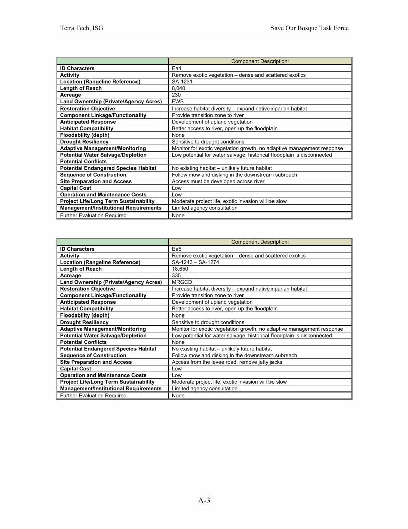
Tetra Tech, ISG Save Our Bosque Task Force ______________________________________________________________________________________
A-3
Component Description:
ID Characters Ea4 Activity Remove exotic vegetation – dense and scattered exotics Location (Rangeline Reference) SA-1231 Length of Reach 8,040 Acreage 230 Land Ownership (Private/Agency Acres) FWS Restoration Objective Increase habitat diversity – expand native riparian habitat Component Linkage/Functionality Provide transition zone to river Anticipated Response Development of upland vegetation Habitat Compatibility Better access to river, open up the floodplain Floodability (depth) None Drought Resiliency Sensitive to drought conditions Adaptive Management/Monitoring Monitor for exotic vegetation growth, no adaptive management response Potential Water Salvage/Depletion Low potential for water salvage, historical floodplain is disconnected Potential Conflicts Potential Endangered Species Habitat No existing habitat – unlikely future habitat Sequence of Construction Follow mow and disking in the downstream subreach Site Preparation and Access Access must be developed across river Capital Cost Low Operation and Maintenance Costs Low Project Life/Long Term Sustainability Moderate project life, exotic invasion will be slow Management/Institutional Requirements Limited agency consultation Further Evaluation Required None
Component Description: ID Characters Ea5 Activity Remove exotic vegetation – dense and scattered exotics Location (Rangeline Reference) SA-1243 – SA-1274 Length of Reach 18,650 Acreage 335 Land Ownership (Private/Agency Acres) MRGCD Restoration Objective Increase habitat diversity – expand native riparian habitat Component Linkage/Functionality Provide transition zone to river Anticipated Response Development of upland vegetation Habitat Compatibility Better access to river, open up the floodplain Floodability (depth) None Drought Resiliency Sensitive to drought conditions Adaptive Management/Monitoring Monitor for exotic vegetation growth, no adaptive management response Potential Water Salvage/Depletion Low potential for water salvage, historical floodplain is disconnected Potential Conflicts None Potential Endangered Species Habitat No existing habitat – unlikely future habitat Sequence of Construction Follow mow and disking in the downstream subreach Site Preparation and Access Access from the levee road, remove jetty jacks Capital Cost Low Operation and Maintenance Costs Low Project Life/Long Term Sustainability Moderate project life, exotic invasion will be slow Management/Institutional Requirements Limited agency consultation Further Evaluation Required None
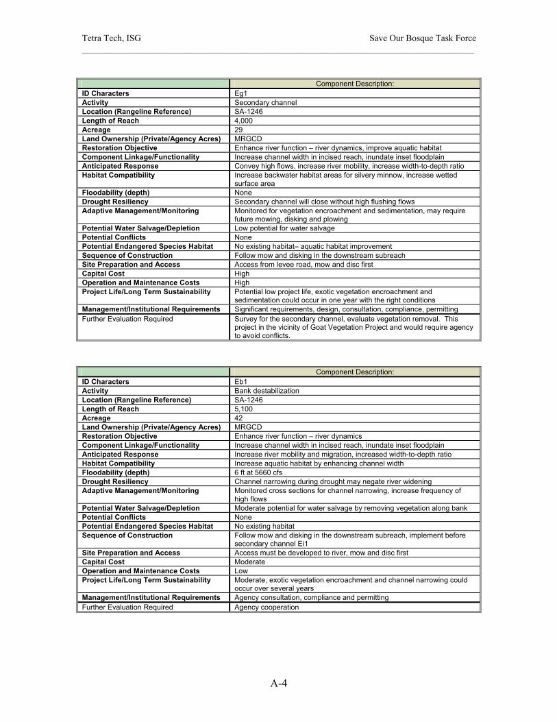
Tetra Tech, ISG Save Our Bosque Task Force ______________________________________________________________________________________
A-4
Component Description:
ID Characters Eg1 Activity Secondary channel Location (Rangeline Reference) SA-1246 Length of Reach 4,000 Acreage 29 Land Ownership (Private/Agency Acres) MRGCD Restoration Objective Enhance river function – river dynamics, improve aquatic habitat Component Linkage/Functionality Increase channel width in incised reach, inundate inset floodplain Anticipated Response Convey high flows, increase river mobility, increase width-to-depth ratio Habitat Compatibility Increase backwater habitat areas for silvery minnow, increase wetted
surface area Floodability (depth) None Drought Resiliency Secondary channel will close without high flushing flows Adaptive Management/Monitoring Monitored for vegetation encroachment and sedimentation, may require
future mowing, disking and plowing Potential Water Salvage/Depletion Low potential for water salvage Potential Conflicts None Potential Endangered Species Habitat No existing habitat– aquatic habitat improvement Sequence of Construction Follow mow and disking in the downstream subreach Site Preparation and Access Access from levee road, mow and disc first Capital Cost High Operation and Maintenance Costs High Project Life/Long Term Sustainability Potential low project life, exotic vegetation encroachment and
sedimentation could occur in one year with the right conditions Management/Institutional Requirements Significant requirements, design, consultation, compliance, permitting Further Evaluation Required Survey for the secondary channel, evaluate vegetation removal. This
project in the vicinity of Goat Vegetation Project and would require agency to avoid conflicts.
Component Description: ID Characters Eb1 Activity Bank destabilization Location (Rangeline Reference) SA-1246 Length of Reach 5,100 Acreage 42 Land Ownership (Private/Agency Acres) MRGCD Restoration Objective Enhance river function – river dynamics Component Linkage/Functionality Increase channel width in incised reach, inundate inset floodplain Anticipated Response Increase river mobility and migration, increased width-to-depth ratio Habitat Compatibility Increase aquatic habitat by enhancing channel width Floodability (depth) 6 ft at 5660 cfs Drought Resiliency Channel narrowing during drought may negate river widening Adaptive Management/Monitoring Monitored cross sections for channel narrowing, increase frequency of
high flows Potential Water Salvage/Depletion Moderate potential for water salvage by removing vegetation along bank Potential Conflicts None Potential Endangered Species Habitat No existing habitat Sequence of Construction Follow mow and disking in the downstream subreach, implement before
secondary channel Ei1 Site Preparation and Access Access must be developed to river, mow and disc first Capital Cost Moderate Operation and Maintenance Costs Low Project Life/Long Term Sustainability Moderate, exotic vegetation encroachment and channel narrowing could
occur over several years Management/Institutional Requirements Agency consultation, compliance and permitting Further Evaluation Required Agency cooperation

Tetra Tech, ISG Save Our Bosque Task Force ______________________________________________________________________________________
A-5
Component Description:
ID Characters Ed1 Activity Mow and disc vegetation in the active channel Location (Rangeline Reference) SA-1252 – SA-1298 Length of Reach 26,100 Acreage 400 Land Ownership (Private/Agency Acres) River Channel Restoration Objective Enhance river function – river dynamics, improve aquatic habitat Component Linkage/Functionality Keep channel active, sustain high width-to-depth ratio Anticipated Response Wider channel with exposed sandbars, sandbar mobility Habitat Compatibility Increase backwater and slow habitat areas for silvery minnow Floodability (depth) 6.5 ft at 5660 cfs Drought Resiliency Vegetation encroachment with 3 years without high flows Adaptive Management/Monitoring Monitor for vegetation encroachment and sedimentation, may require
future mowing, disking and possible plowing Potential Water Salvage/Depletion Moderate potential for water salvage due to large area Potential Conflicts None Potential Endangered Species Habitat No existing – aquatic habitat improvement Sequence of Construction Should be the first restoration activity implemented Site Preparation and Access Access from levee road Capital Cost Low Operation and Maintenance Costs Moderate without frequent high flows Project Life/Long Term Sustainability Moderate project life, exotic vegetation encroachment and sedimentation
could occur in three years with the right conditions Management/Institutional Requirements Limited agency cooperation Further Evaluation Required Evaluate vegetation removal equipment
Component Description: ID Characters Ee1 Activity Evaluate plow and rake floodplain vegetation Location (Rangeline Reference) SA-1268 Length of Reach 9,300 Acreage 132 Land Ownership (Private/Agency Acres) Private Restoration Objective Enhance river function – river dynamics, improve aquatic habitat Component Linkage/Functionality Keep channel active, sustain high width/depth ratio, combine with Ed1 Anticipated Response Increase channel width and improve sandbar mobility Habitat Compatibility Increase backwater and slow habitat areas for silvery minnow Floodability (depth) 6.5 ft at 5660 cfs Drought Resiliency Vegetation encroachment with 3 years without high flows Adaptive Management/Monitoring Monitored for vegetation encroachment and sedimentation, may require
future mowing, disking and plowing Potential Water Salvage/Depletion High potential for water salvage due to large area Potential Conflicts Land ownership Potential Endangered Species Habitat No – aquatic habitat improvement Sequence of Construction Implement with Ed1active channel reworking Site Preparation and Access Access must be developed to and across river Capital Cost Low Operation and Maintenance Costs Moderate without frequent high flows Project Life/Long Term Sustainability Moderate project life, exotic vegetation encroachment and sedimentation
could occur in three years with the right conditions Management/Institutional Requirements Limited, land owner approval Further Evaluation Required Evaluate vegetation removal equipment

Tetra Tech, ISG Save Our Bosque Task Force ______________________________________________________________________________________
A-6
Component Description:
ID Characters Ea6 Activity Remove floodplain exotic vegetation Location (Rangeline Reference) SA-1292 Length of Reach 7,270 Acreage 107 Land Ownership (Private/Agency Acres) Private Restoration Objective Increase habitat diversity – expand native upland and riparian habitat Component Linkage/Functionality Provide transition zone to river Anticipated Response Development of upland vegetation, shrubs and salt grass Habitat Compatibility Open up floodplain Floodability (depth) None Drought Resiliency Sensitive to drought conditions Adaptive Management/Monitoring Monitor for exotic vegetation growth, no adaptive management response Potential Water Salvage/Depletion Some potential for water salvage Potential Conflicts Land ownership, possible grazing issues Potential Endangered Species Habitat No – unlikely Sequence of Construction Follow mow and disking, plow and raking in the subreach Site Preparation and Access Access must be developed across river Capital Cost Low Operation and Maintenance Costs Low Project Life/Long Term Sustainability Moderate project life, exotic invasion will be slow Management/Institutional Requirements Limited, land owner approval Further Evaluation Required Evaluate exotic vegetation removal methods
Component Description: ID Characters Ea7 Activity Remove floodplain exotic vegetation Location (Rangeline Reference) D/S SA-1280 Length of Reach 2,450 Acreage 25 Land Ownership (Private/Agency Acres) Private Restoration Objective Increase habitat diversity – expand native riparian habitat Component Linkage/Functionality Provide transition zone to river, improve opportunity for river migration Anticipated Response Development of cottonwood/willow, salt grass meadow mix Habitat Compatibility Improve riparian habitat near river Floodability (depth) None Drought Resiliency Sensitive to drought conditions Adaptive Management/Monitoring Monitor for exotic vegetation growth, treat new exotic vegetation growth Potential Water Salvage/Depletion Some potential for water salvage Potential Conflicts Land ownership and grazing issues Potential Endangered Species Habitat No – unlikely Sequence of Construction Follow mow and disking, plow and raking in the subreach Site Preparation and Access Access must be developed across river Capital Cost Low Operation and Maintenance Costs Low Project Life/Long Term Sustainability Moderate project life, exotic invasion will be slow Management/Institutional Requirements Limited, land owner approval Further Evaluation Required None
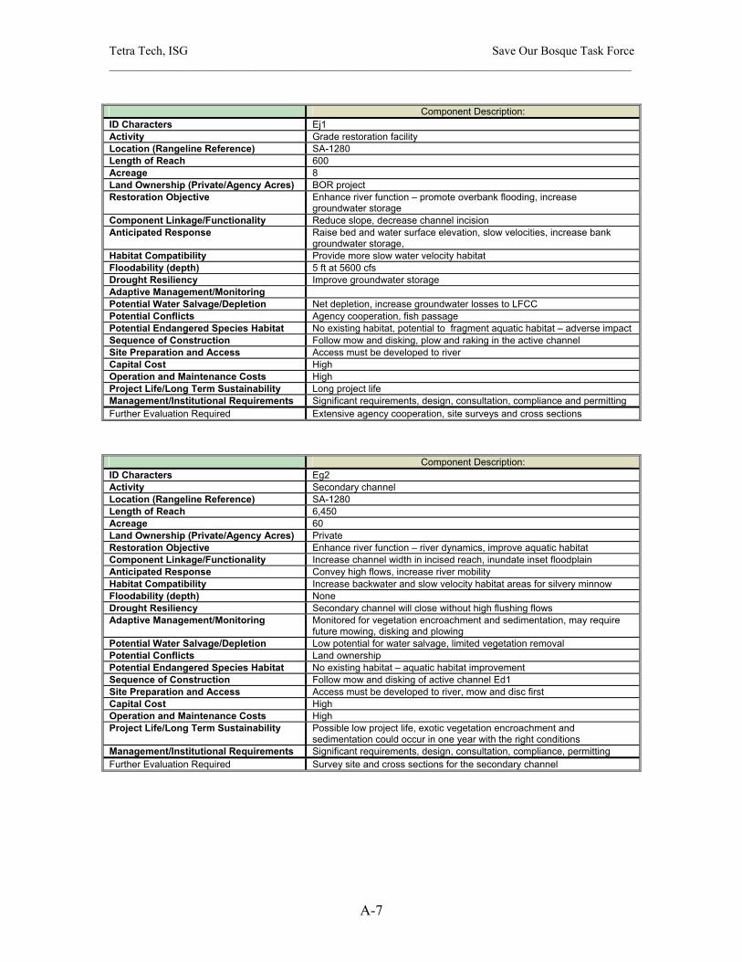
Tetra Tech, ISG Save Our Bosque Task Force ______________________________________________________________________________________
A-7
Component Description:
ID Characters Ej1 Activity Grade restoration facility Location (Rangeline Reference) SA-1280 Length of Reach 600 Acreage 8 Land Ownership (Private/Agency Acres) BOR project Restoration Objective Enhance river function – promote overbank flooding, increase
groundwater storage Component Linkage/Functionality Reduce slope, decrease channel incision Anticipated Response Raise bed and water surface elevation, slow velocities, increase bank
groundwater storage, Habitat Compatibility Provide more slow water velocity habitat Floodability (depth) 5 ft at 5600 cfs Drought Resiliency Improve groundwater storage Adaptive Management/Monitoring Potential Water Salvage/Depletion Net depletion, increase groundwater losses to LFCC Potential Conflicts Agency cooperation, fish passage Potential Endangered Species Habitat No existing habitat, potential to fragment aquatic habitat – adverse impact Sequence of Construction Follow mow and disking, plow and raking in the active channel Site Preparation and Access Access must be developed to river Capital Cost High Operation and Maintenance Costs High Project Life/Long Term Sustainability Long project life Management/Institutional Requirements Significant requirements, design, consultation, compliance and permitting Further Evaluation Required Extensive agency cooperation, site surveys and cross sections
Component Description: ID Characters Eg2 Activity Secondary channel Location (Rangeline Reference) SA-1280 Length of Reach 6,450 Acreage 60 Land Ownership (Private/Agency Acres) Private Restoration Objective Enhance river function – river dynamics, improve aquatic habitat Component Linkage/Functionality Increase channel width in incised reach, inundate inset floodplain Anticipated Response Convey high flows, increase river mobility Habitat Compatibility Increase backwater and slow velocity habitat areas for silvery minnow Floodability (depth) None Drought Resiliency Secondary channel will close without high flushing flows Adaptive Management/Monitoring Monitored for vegetation encroachment and sedimentation, may require
future mowing, disking and plowing Potential Water Salvage/Depletion Low potential for water salvage, limited vegetation removal Potential Conflicts Land ownership Potential Endangered Species Habitat No existing habitat – aquatic habitat improvement Sequence of Construction Follow mow and disking of active channel Ed1 Site Preparation and Access Access must be developed to river, mow and disc first Capital Cost High Operation and Maintenance Costs High Project Life/Long Term Sustainability Possible low project life, exotic vegetation encroachment and
sedimentation could occur in one year with the right conditions Management/Institutional Requirements Significant requirements, design, consultation, compliance, permitting Further Evaluation Required Survey site and cross sections for the secondary channel
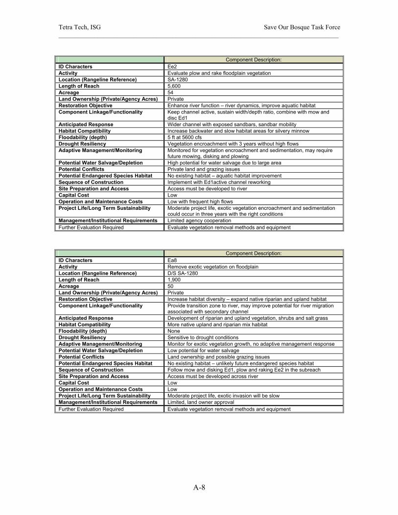
Tetra Tech, ISG Save Our Bosque Task Force ______________________________________________________________________________________
A-8
Component Description:
ID Characters Ee2 Activity Evaluate plow and rake floodplain vegetation Location (Rangeline Reference) SA-1280 Length of Reach 5,600 Acreage 54 Land Ownership (Private/Agency Acres) Private Restoration Objective Enhance river function – river dynamics, improve aquatic habitat Component Linkage/Functionality Keep channel active, sustain width/depth ratio, combine with mow and
disc Ed1 Anticipated Response Wider channel with exposed sandbars, sandbar mobility Habitat Compatibility Increase backwater and slow habitat areas for silvery minnow Floodability (depth) 5 ft at 5600 cfs Drought Resiliency Vegetation encroachment with 3 years without high flows Adaptive Management/Monitoring Monitored for vegetation encroachment and sedimentation, may require
future mowing, disking and plowing Potential Water Salvage/Depletion High potential for water salvage due to large area Potential Conflicts Private land and grazing issues Potential Endangered Species Habitat No existing habitat – aquatic habitat improvement Sequence of Construction Implement with Ed1active channel reworking Site Preparation and Access Access must be developed to river Capital Cost Low Operation and Maintenance Costs Low with frequent high flows Project Life/Long Term Sustainability Moderate project life, exotic vegetation encroachment and sedimentation
could occur in three years with the right conditions Management/Institutional Requirements Limited agency cooperation Further Evaluation Required Evaluate vegetation removal methods and equipment
Component Description: ID Characters Ea8 Activity Remove exotic vegetation on floodplain Location (Rangeline Reference) D/S SA-1280 Length of Reach 1,900 Acreage 50 Land Ownership (Private/Agency Acres) Private Restoration Objective Increase habitat diversity – expand native riparian and upland habitat Component Linkage/Functionality Provide transition zone to river, may improve potential for river migration
associated with secondary channel Anticipated Response Development of riparian and upland vegetation, shrubs and salt grass Habitat Compatibility More native upland and riparian mix habitat Floodability (depth) None Drought Resiliency Sensitive to drought conditions Adaptive Management/Monitoring Monitor for exotic vegetation growth, no adaptive management response Potential Water Salvage/Depletion Low potential for water salvage Potential Conflicts Land ownership and possible grazing issues Potential Endangered Species Habitat No existing habitat – unlikely future endangered species habitat Sequence of Construction Follow mow and disking Ed1, plow and raking Ee2 in the subreach Site Preparation and Access Access must be developed across river Capital Cost Low Operation and Maintenance Costs Low Project Life/Long Term Sustainability Moderate project life, exotic invasion will be slow Management/Institutional Requirements Limited, land owner approval Further Evaluation Required Evaluate vegetation removal methods and equipment
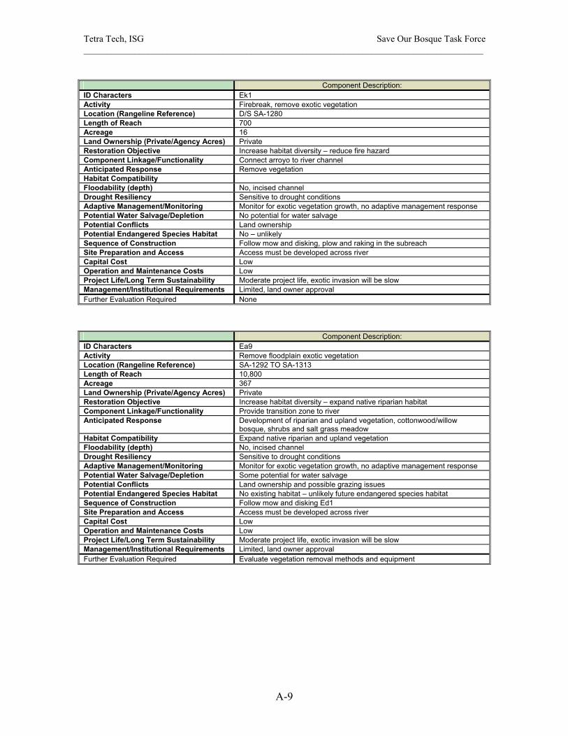
Tetra Tech, ISG Save Our Bosque Task Force ______________________________________________________________________________________
A-9
Component Description:
ID Characters Ek1 Activity Firebreak, remove exotic vegetation Location (Rangeline Reference) D/S SA-1280 Length of Reach 700 Acreage 16 Land Ownership (Private/Agency Acres) Private Restoration Objective Increase habitat diversity – reduce fire hazard Component Linkage/Functionality Connect arroyo to river channel Anticipated Response Remove vegetation Habitat Compatibility Floodability (depth) No, incised channel Drought Resiliency Sensitive to drought conditions Adaptive Management/Monitoring Monitor for exotic vegetation growth, no adaptive management response Potential Water Salvage/Depletion No potential for water salvage Potential Conflicts Land ownership Potential Endangered Species Habitat No – unlikely Sequence of Construction Follow mow and disking, plow and raking in the subreach Site Preparation and Access Access must be developed across river Capital Cost Low Operation and Maintenance Costs Low Project Life/Long Term Sustainability Moderate project life, exotic invasion will be slow Management/Institutional Requirements Limited, land owner approval Further Evaluation Required None
Component Description: ID Characters Ea9 Activity Remove floodplain exotic vegetation Location (Rangeline Reference) SA-1292 TO SA-1313 Length of Reach 10,800 Acreage 367 Land Ownership (Private/Agency Acres) Private Restoration Objective Increase habitat diversity – expand native riparian habitat Component Linkage/Functionality Provide transition zone to river Anticipated Response Development of riparian and upland vegetation, cottonwood/willow
bosque, shrubs and salt grass meadow Habitat Compatibility Expand native riparian and upland vegetation Floodability (depth) No, incised channel Drought Resiliency Sensitive to drought conditions Adaptive Management/Monitoring Monitor for exotic vegetation growth, no adaptive management response Potential Water Salvage/Depletion Some potential for water salvage Potential Conflicts Land ownership and possible grazing issues Potential Endangered Species Habitat No existing habitat – unlikely future endangered species habitat Sequence of Construction Follow mow and disking Ed1 Site Preparation and Access Access must be developed across river Capital Cost Low Operation and Maintenance Costs Low Project Life/Long Term Sustainability Moderate project life, exotic invasion will be slow Management/Institutional Requirements Limited, land owner approval Further Evaluation Required Evaluate vegetation removal methods and equipment

Tetra Tech, ISG Save Our Bosque Task Force ______________________________________________________________________________________
A-10
Component Description:
ID Characters Ej2 Activity Grade restoration facility Location (Rangeline Reference) SA-1299 Length of Reach 600 Acreage 6 Land Ownership (Private/Agency Acres) BOR project Restoration Objective Enhance river function – promote overbank flooding, increase
groundwater storage Component Linkage/Functionality Reduce slope, decrease channel incision Anticipated Response Raise bed and water surface elevation, slow velocities, increase bank
groundwater storage, Habitat Compatibility Provide more slow water velocity habitat Floodability (depth) 5 ft at 5660 cfs Drought Resiliency Improve groundwater storage Adaptive Management/Monitoring Potential Water Salvage/Depletion Net depletion, increase groundwater losses to LFCC Potential Conflicts Agency cooperation, fish passage Potential Endangered Species Habitat No existing habitat, potential to fragment aquatic habitat – adverse impact Sequence of Construction Follow mow and disking, plow and raking in the active channel Site Preparation and Access Access must be developed to river Capital Cost High Operation and Maintenance Costs High Project Life/Long Term Sustainability Long project life Management/Institutional Requirements Significant requirements, design, consultation, compliance and permitting Further Evaluation Required Extensive agency cooperation, site and cross sections surveys
Component Description: ID Characters Ek2 Activity Firebreak, remove exotic vegetation Location (Rangeline Reference) SA-1311 Length of Reach 350 Acreage 13 Land Ownership (Private/Agency Acres) Private Restoration Objective Increase habitat diversity – reduce fire hazard Component Linkage/Functionality Connect arroyo to river channel Anticipated Response Remove vegetation, open arroyo Habitat Compatibility Floodability (depth) No, incised channel Drought Resiliency Sensitive to drought conditions Adaptive Management/Monitoring Monitor for exotic vegetation growth, no adaptive management response Potential Water Salvage/Depletion No potential for water salvage Potential Conflicts Potential land ownership and grazing issues Potential Endangered Species Habitat No existing habitat – unlikely Sequence of Construction Follow mow and disking Ed1 in the subreach Site Preparation and Access Access from the east side road Capital Cost Low Operation and Maintenance Costs Low Project Life/Long Term Sustainability Moderate project life, exotic invasion will be slow Management/Institutional Requirements Limited, land owner approval Further Evaluation Required This project is in the vicinity of MRGCD’s Bosque Fuels Reduction Study
sites and would require evaluation to avoid impacts on the study.

Tetra Tech, ISG Save Our Bosque Task Force ______________________________________________________________________________________
A-11
Component Description:
ID Characters Ea10 Activity Remove exotic vegetation on floodplain Location (Rangeline Reference) SA-1299- SO-1327 Length of Reach 16,700 Acreage 109 Land Ownership (Private/Agency Acres) MRGCD Restoration Objective Increase habitat diversity – expand native riparian habitat Component Linkage/Functionality Provide transition zone to river, improve opportunity for river migration Anticipated Response Development of cottonwood/willow habitat Habitat Compatibility More native riparian vegetation Floodability (depth) No, incised channel Drought Resiliency Sensitive to drought conditions Adaptive Management/Monitoring Monitor for exotic vegetation growth, treat exotic vegetation regrowth Potential Water Salvage/Depletion Low potential for water salvage Potential Conflicts Agency ownership Potential Endangered Species Habitat No existing habitat – unlikely future endangered species habitat Sequence of Construction Follow mow and disking Ed1 in the subreach Site Preparation and Access Access from the levee road Capital Cost Low Operation and Maintenance Costs Low Project Life/Long Term Sustainability Moderate project life, exotic invasion will be slow Management/Institutional Requirements Limited, agency approval Further Evaluation Required Evaluate vegetation removal methods and equipment
Component Description: ID Characters Ea11 Activity Remove exotic vegetation on floodplain Location (Rangeline Reference) SA-1311 – SA-1327 Length of Reach 8,900 Acreage 150 Land Ownership (Private/Agency Acres) Private Restoration Objective Increase habitat diversity – expand native riparian habitat Component Linkage/Functionality Provide transition zone to river, improve opportunity for river migration Anticipated Response Development of riparian and upland vegetation mix, shrubs and salt grass Habitat Compatibility More native upland vegetation Floodability (depth) No, incised channel Drought Resiliency Sensitive to drought conditions Adaptive Management/Monitoring Monitor for exotic vegetation growth, no adaptive management response Potential Water Salvage/Depletion Low potential for water salvage Potential Conflicts Land ownership and possible grazing issues Potential Endangered Species Habitat No existing or future endangered species habitat Sequence of Construction Follow mow and disking, plow and raking in the active subreach Site Preparation and Access Access from east side road Capital Cost Low Operation and Maintenance Costs Low Project Life/Long Term Sustainability Moderate project life, exotic invasion will be slow Management/Institutional Requirements Limited, land owner approval Further Evaluation Required Evaluate vegetation removal methods and equipment

Tetra Tech, ISG Save Our Bosque Task Force ______________________________________________________________________________________
A-12
San Antonio Subreach
Component Description: ID Characters Sd1 Activity Mow and disc active channel vegetation Location (Rangeline Reference) SA-1327 – SO-1462 Length of Reach 66,300 Acreage 860 Land Ownership (Private/Agency Acres) River Channel Restoration Objective Enhance river function – river dynamics, improve aquatic habitat Component Linkage/Functionality Keep channel active, sustain high width/depth ratio Anticipated Response Wider channel with exposed sandbars, sandbar mobility Habitat Compatibility Increase backwater and slow habitat areas for silvery minnow Floodability (depth) 4 to 7 ft at 5660 cfs Drought Resiliency Vegetation encroachment with 3 years without high flows Adaptive Management/Monitoring Monitored for vegetation encroachment and sedimentation, may require
future mowing, disking and plowing Potential Water Salvage/Depletion Some potential for water salvage due to large area Potential Conflicts Limited, agency approval Potential Endangered Species Habitat No existing habitat – aquatic habitat improvement Sequence of Construction Should be the first restoration activity implemented in the subreach Site Preparation and Access Access at North Socorro Diversion Channel or from the levee road Capital Cost Low Operation and Maintenance Costs Moderate without frequent high flows Project Life/Long Term Sustainability Moderate project life, exotic vegetation encroachment and sedimentation
could occur in three years with the right conditions Management/Institutional Requirements Limited agency cooperation Further Evaluation Required Evaluate vegetation removal methods and equipment
Component Description: ID Characters Sg1 Activity Sg1 Location (Rangeline Reference) Secondary channel Length of Reach U/S SO-1339 Acreage 3,800 Land Ownership (Private/Agency Acres) 23 Restoration Objective MRGCD Component Linkage/Functionality Enhance river function – river dynamics, improve aquatic habitat Anticipated Response Increase channel width in incised reach, inundate inset floodplain Habitat Compatibility Convey high flows, increase river mobility Floodability (depth) Increase backwater habitat areas for silvery minnow Drought Resiliency None Adaptive Management/Monitoring Secondary channel will close without high flushing flows Potential Water Salvage/Depletion Monitored for vegetation encroachment and sedimentation, may require
future mowing, disking and plowing Potential Conflicts Low potential for water salvage, limited vegetation removal Potential Endangered Species Habitat None Sequence of Construction No existing habitat – aquatic habitat improvement Site Preparation and Access Follow mow and disking in subreach Sd1 Capital Cost Access from levee road or from North Socorro Diversion Channel, mow
and disc first Operation and Maintenance Costs High Project Life/Long Term Sustainability Moderate Management/Institutional Requirements Possible low project life, exotic vegetation encroachment and
sedimentation could occur in one year with the right conditions Further Evaluation Required Significant requirements, design, consultation, compliance, permitting Survey for the secondary channel, evaluate vegetation removal

Tetra Tech, ISG Save Our Bosque Task Force ______________________________________________________________________________________
A-13
Component Description:
ID Characters Sa1 Activity Remove exotic vegetation on floodplain Location (Rangeline Reference) U/S SO-1339 Length of Reach 5,500 Acreage 100 Land Ownership (Private/Agency Acres) MRGCD Restoration Objective Increase habitat diversity – expand native riparian habitat Component Linkage/Functionality Provide transition zone to river, improve opportunity for river migration Anticipated Response Development of riparian vegetation, cottonwood/willow bosque Habitat Compatibility More native riparian vegetation Floodability (depth) None at 5,660 cfs Drought Resiliency Sensitive to drought conditions with lower water table Adaptive Management/Monitoring Monitor for exotic vegetation growth, treat exotic vegetation regrowth Potential Water Salvage/Depletion Some potential for water salvage Potential Conflicts None Potential Endangered Species Habitat No existing or potential habitat Sequence of Construction Follow mow and disking Sd1 in the subreach Site Preparation and Access Access from levee road or from North Socorro Diversion Channel Capital Cost Low Operation and Maintenance Costs Low Project Life/Long Term Sustainability Moderate project life, exotic invasion will be slow Management/Institutional Requirements Limited, agency consultation Further Evaluation Required None
Component Description: ID Characters Si1, Si2, Si3, Si4, Si5, Si6, Si7 Activity Firebreak, remove exotic vegetation in arroyos throughout subreach Location (Rangeline Reference) Si1 SO-1339, Si2 SO-1346, Si3 SO-1346, Si4 SO-1360, Si5 SO-1380, Si6
U/S SO-1384, Si7 D/S SO-1384 Length of Reach 300 - 500 Acreage Si1 5, Si2 6, Si3 5, Si4 13, Si5 14, Si6 3, Si7 14 Land Ownership (Private/Agency Acres) Private Restoration Objective Increase habitat diversity – reduce fire hazard Component Linkage/Functionality Connect arroyo to river channel Anticipated Response Remove vegetation Habitat Compatibility Floodability (depth) No, arroyo channel Drought Resiliency Sensitive to drought conditions Adaptive Management/Monitoring Monitor for exotic vegetation growth, no adaptive management response Potential Water Salvage/Depletion No significant potential for water salvage Potential Conflicts Land ownership Potential Endangered Species Habitat No existing or potential habitat Sequence of Construction Follow mow and disking Sd1 Site Preparation and Access Access down arroyo from east side road Capital Cost Low Operation and Maintenance Costs Low Project Life/Long Term Sustainability Moderate project life, exotic invasion will be slow Management/Institutional Requirements Limited, land owner approval Further Evaluation Required Evaluate vegetation removal methods and equipment

Tetra Tech, ISG Save Our Bosque Task Force ______________________________________________________________________________________
A-14
Component Description:
ID Characters Sa2 Activity Remove exotic vegetation on floodplain Location (Rangeline Reference) SO-1339 Length of Reach 5,700 Acreage 85 Land Ownership (Private/Agency Acres) Private and State Restoration Objective Increase habitat diversity – expand native riparian habitat Component Linkage/Functionality Provide transition zone to river, improve opportunity for river migration Anticipated Response Development of upland vegetation, shrubs and salt grass Habitat Compatibility More native upland vegetation Floodability (depth) None at 5,660 cfs Drought Resiliency Sensitive to drought conditions if water table lowers Adaptive Management/Monitoring Monitor for exotic vegetation growth, no adaptive management response Potential Water Salvage/Depletion Some potential for water salvage Potential Conflicts Land ownership and grazing issues Potential Endangered Species Habitat No existing habitat – unlikely potential habitat Sequence of Construction Follow mow and disking Sd1 in the subreach Site Preparation and Access Access from east side road Capital Cost Low Operation and Maintenance Costs Low Project Life/Long Term Sustainability Moderate project life, exotic invasion will be slow Management/Institutional Requirements Land owner approval Further Evaluation Required Evaluate vegetation removal methods and equipment
Component Description: ID Characters Sc1 Activity Lower floodplain terrace Location (Rangeline Reference) SO-1339 Length of Reach 2,500 Acreage 33 Land Ownership (Private/Agency Acres) Private Restoration Objective Increase habitat diversity – expand native riparian habitat, promote
cottonwood/willow regeneration Component Linkage/Functionality Provide hydrologic connectivity to river, improve opportunity for river
migration Anticipated Response Create new active floodplain for 5,660 cfs Habitat Compatibility More native riparian habitat Floodability (depth) 5 ft at 5660 cfs Drought Resiliency Some desiccation of new seedlings Adaptive Management/Monitoring Monitor for exotic vegetation growth, treat new exotic vegetation growth,
disk and mow for maintenance Potential Water Salvage/Depletion Moderate potential for water salvage Potential Conflicts Land ownership Potential Endangered Species Habitat No existing habitat – unlikely new potential habitat Sequence of Construction Follow mow and disk Sd1 Site Preparation and Access Access from east side road Capital Cost High Operation and Maintenance Costs Moderate with new exotic vegetation establishment Project Life/Long Term Sustainability Moderate project life Management/Institutional Requirements Significant requirements, design, consultation, compliance, permitting,
need to have a spoils site Further Evaluation Required Survey for the new floodplain elevation and spoils

Tetra Tech, ISG Save Our Bosque Task Force ______________________________________________________________________________________
A-15
Component Description:
ID Characters Sa3 Activity Remove exotic vegetation on floodplain Location (Rangeline Reference) SO-1346 Length of Reach 6,000 Acreage 83 Land Ownership (Private/Agency Acres) MRGCD Restoration Objective Increase habitat diversity – expand native riparian habitat Component Linkage/Functionality Provide transition zone to river, improve opportunity for river migration Anticipated Response Development of riparian vegetation, cottonwood/willow bosque Habitat Compatibility More native riparian vegetation Floodability (depth) None at 5,660 cfs Drought Resiliency Sensitive to drought conditions with lower water table Adaptive Management/Monitoring Monitor for exotic vegetation growth, treat exotic vegetation regrowth Potential Water Salvage/Depletion Moderate potential for water salvage Potential Conflicts None Potential Endangered Species Habitat No existing or potential habitat Sequence of Construction Follow mow and disking Sd1 in the subreach Site Preparation and Access Access from levee road Capital Cost Low Operation and Maintenance Costs Low Project Life/Long Term Sustainability Moderate project life, exotic invasion will be slow Management/Institutional Requirements Limited, agency consultation Further Evaluation Required None
Component Description: ID Characters Sa4 Activity Remove exotic vegetation on floodplain Location (Rangeline Reference) SO-1346 – SO-1360 Length of Reach 8,500 Acreage 175 Land Ownership (Private/Agency Acres) NM Tech Restoration Objective Increase habitat diversity – expand native riparian and upland habitat Component Linkage/Functionality Provide transition zone to river, improve opportunity for river migration Anticipated Response Development of riparian and upland vegetation, shrubs and salt grass Habitat Compatibility More native upland vegetation Floodability (depth) None at 5,660 cfs Drought Resiliency Sensitive to drought conditions if water table lowers Adaptive Management/Monitoring Monitor for exotic vegetation growth, no adaptive management response Potential Water Salvage/Depletion Some potential for water salvage Potential Conflicts Landownership and grazing Potential Endangered Species Habitat No existing or potential habitat Sequence of Construction Follow mow and disking Sd1 in the subreach Site Preparation and Access Access from east side road Capital Cost Low Operation and Maintenance Costs Low Project Life/Long Term Sustainability Moderate project life, exotic invasion will be slow Management/Institutional Requirements Limited, land owner approval Further Evaluation Required Evaluate vegetation removal methods and equipment

Tetra Tech, ISG Save Our Bosque Task Force ______________________________________________________________________________________
A-16
Component Description:
ID Characters Se1 Activity Evaluate plow and rake new floodplain vegetation Location (Rangeline Reference) D/S SO-1346 Length of Reach 1,500 Acreage 24 Land Ownership (Private/Agency Acres) NM Tech Restoration Objective Enhance river function – river dynamics, improve aquatic habitat Component Linkage/Functionality Keep channel active, sustain width/depth ratio, combine with Sd1 Anticipated Response Wider channel with exposed sandbars, sandbar mobility Habitat Compatibility Increase backwater and slow habitat areas for silvery minnow Floodability (depth) 5 ft at 5660 cfs Drought Resiliency Vegetation encroachment if 3 years without high flows Adaptive Management/Monitoring Monitored for vegetation encroachment and sedimentation, may require
future mowing, disking and plowing Potential Water Salvage/Depletion Moderate potential for water salvage Potential Conflicts Landownership and grazing Potential Endangered Species Habitat No existing or potential habitat – aquatic habitat improvement Sequence of Construction Implement with Sd1active channel reworking Site Preparation and Access Access from east side road, maybe require access across private land Capital Cost Low Operation and Maintenance Costs Low with frequent high flows Project Life/Long Term Sustainability Moderate project life, exotic vegetation encroachment and sedimentation
could occur in three years with the right conditions Management/Institutional Requirements Limited, agency cooperation and possibly private owner approval. Further Evaluation Required Evaluate vegetation removal methods and equipment
Component Description: ID Characters Sb1 Activity Bank destabilization, remove vegetation, plow bank Location (Rangeline Reference) SO-1360 - SO-1371 Length of Reach 11,473 Acreage 84 Land Ownership (Private/Agency Acres) Private/River Bank Restoration Objective Enhance river function – river dynamics Component Linkage/Functionality Increase channel width in incised reach, inundate inset floodplain Anticipated Response Increase river mobility and migration Habitat Compatibility Increase channel width-to-depth ratio, provide more aquatic habitat Floodability (depth) 4.5 ft at 5,660 cfs Drought Resiliency Channel narrowing during drought may negate river widening Adaptive Management/Monitoring Monitor cross sections for channel narrowing, increase frequency of
overbank flooding Potential Water Salvage/Depletion Moderate potential for water salvage by removing bank vegetation Potential Conflicts None Potential Endangered Species Habitat No existing or potential habitat Sequence of Construction Follow mow and disking Sd1, implement with upstream plow and rake
area Se1 Site Preparation and Access Access from east side road, maybe require access across private land Capital Cost Moderate Operation and Maintenance Costs Moderate Project Life/Long Term Sustainability Moderate, exotic vegetation encroachment could occur over several years Management/Institutional Requirements Agency consultation, compliance and permitting Further Evaluation Required Agency cooperation
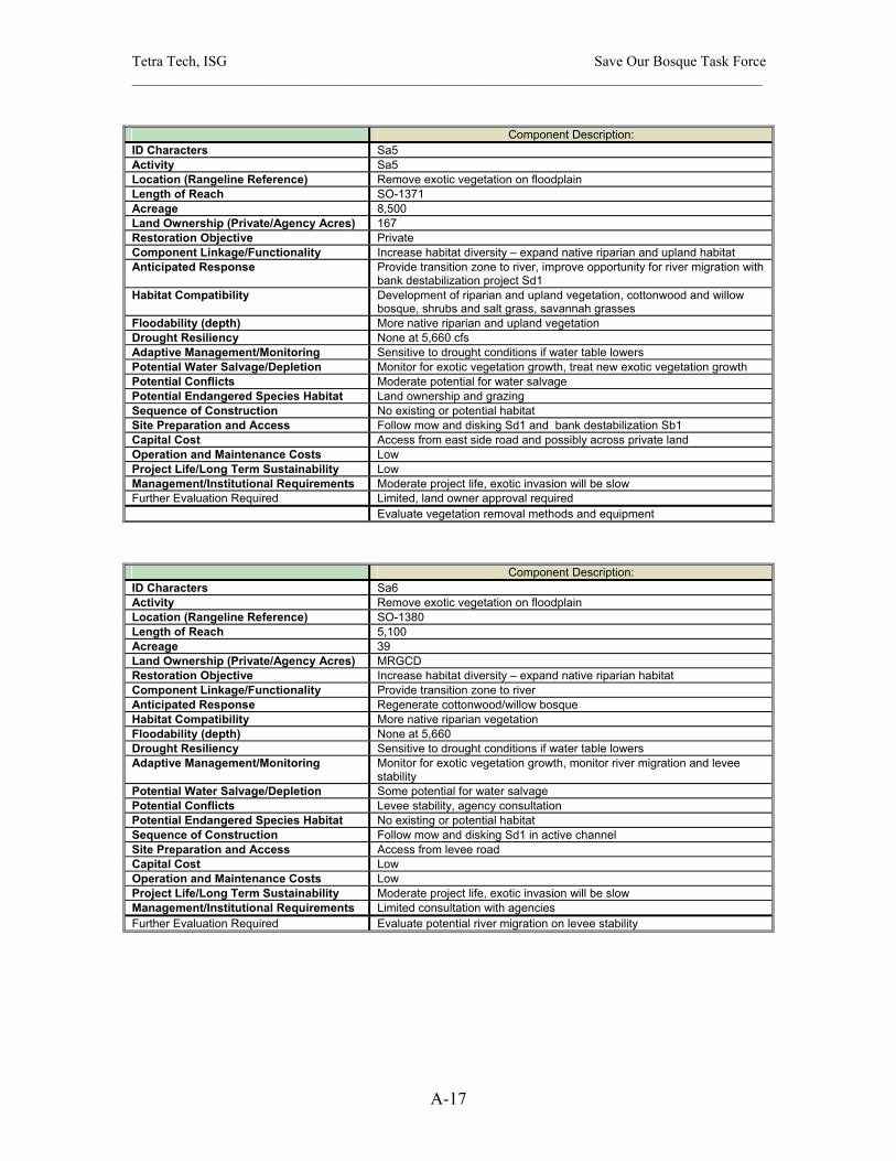
Tetra Tech, ISG Save Our Bosque Task Force ______________________________________________________________________________________
A-17
Component Description:
ID Characters Sa5 Activity Sa5 Location (Rangeline Reference) Remove exotic vegetation on floodplain Length of Reach SO-1371 Acreage 8,500 Land Ownership (Private/Agency Acres) 167 Restoration Objective Private Component Linkage/Functionality Increase habitat diversity – expand native riparian and upland habitat Anticipated Response Provide transition zone to river, improve opportunity for river migration with
bank destabilization project Sd1 Habitat Compatibility Development of riparian and upland vegetation, cottonwood and willow
bosque, shrubs and salt grass, savannah grasses Floodability (depth) More native riparian and upland vegetation Drought Resiliency None at 5,660 cfs Adaptive Management/Monitoring Sensitive to drought conditions if water table lowers Potential Water Salvage/Depletion Monitor for exotic vegetation growth, treat new exotic vegetation growth Potential Conflicts Moderate potential for water salvage Potential Endangered Species Habitat Land ownership and grazing Sequence of Construction No existing or potential habitat Site Preparation and Access Follow mow and disking Sd1 and bank destabilization Sb1 Capital Cost Access from east side road and possibly across private land Operation and Maintenance Costs Low Project Life/Long Term Sustainability Low Management/Institutional Requirements Moderate project life, exotic invasion will be slow Further Evaluation Required Limited, land owner approval required Evaluate vegetation removal methods and equipment
Component Description: ID Characters Sa6 Activity Remove exotic vegetation on floodplain Location (Rangeline Reference) SO-1380 Length of Reach 5,100 Acreage 39 Land Ownership (Private/Agency Acres) MRGCD Restoration Objective Increase habitat diversity – expand native riparian habitat Component Linkage/Functionality Provide transition zone to river Anticipated Response Regenerate cottonwood/willow bosque Habitat Compatibility More native riparian vegetation Floodability (depth) None at 5,660 Drought Resiliency Sensitive to drought conditions if water table lowers Adaptive Management/Monitoring Monitor for exotic vegetation growth, monitor river migration and levee
stability Potential Water Salvage/Depletion Some potential for water salvage Potential Conflicts Levee stability, agency consultation Potential Endangered Species Habitat No existing or potential habitat Sequence of Construction Follow mow and disking Sd1 in active channel Site Preparation and Access Access from levee road Capital Cost Low Operation and Maintenance Costs Low Project Life/Long Term Sustainability Moderate project life, exotic invasion will be slow Management/Institutional Requirements Limited consultation with agencies Further Evaluation Required Evaluate potential river migration on levee stability
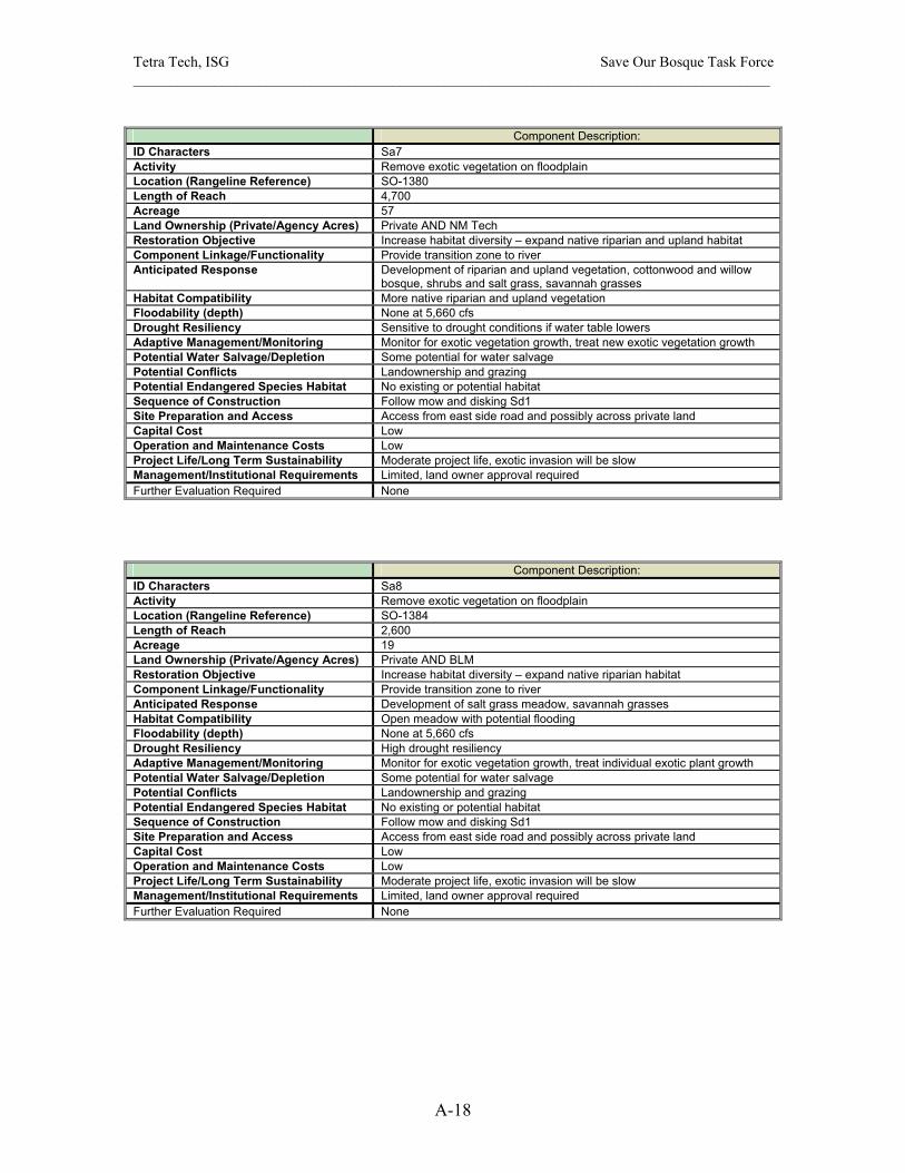
Tetra Tech, ISG Save Our Bosque Task Force ______________________________________________________________________________________
A-18
Component Description:
ID Characters Sa7 Activity Remove exotic vegetation on floodplain Location (Rangeline Reference) SO-1380 Length of Reach 4,700 Acreage 57 Land Ownership (Private/Agency Acres) Private AND NM Tech Restoration Objective Increase habitat diversity – expand native riparian and upland habitat Component Linkage/Functionality Provide transition zone to river Anticipated Response Development of riparian and upland vegetation, cottonwood and willow
bosque, shrubs and salt grass, savannah grasses Habitat Compatibility More native riparian and upland vegetation Floodability (depth) None at 5,660 cfs Drought Resiliency Sensitive to drought conditions if water table lowers Adaptive Management/Monitoring Monitor for exotic vegetation growth, treat new exotic vegetation growth Potential Water Salvage/Depletion Some potential for water salvage Potential Conflicts Landownership and grazing Potential Endangered Species Habitat No existing or potential habitat Sequence of Construction Follow mow and disking Sd1 Site Preparation and Access Access from east side road and possibly across private land Capital Cost Low Operation and Maintenance Costs Low Project Life/Long Term Sustainability Moderate project life, exotic invasion will be slow Management/Institutional Requirements Limited, land owner approval required Further Evaluation Required None
Component Description: ID Characters Sa8 Activity Remove exotic vegetation on floodplain Location (Rangeline Reference) SO-1384 Length of Reach 2,600 Acreage 19 Land Ownership (Private/Agency Acres) Private AND BLM Restoration Objective Increase habitat diversity – expand native riparian habitat Component Linkage/Functionality Provide transition zone to river Anticipated Response Development of salt grass meadow, savannah grasses Habitat Compatibility Open meadow with potential flooding Floodability (depth) None at 5,660 cfs Drought Resiliency High drought resiliency Adaptive Management/Monitoring Monitor for exotic vegetation growth, treat individual exotic plant growth Potential Water Salvage/Depletion Some potential for water salvage Potential Conflicts Landownership and grazing Potential Endangered Species Habitat No existing or potential habitat Sequence of Construction Follow mow and disking Sd1 Site Preparation and Access Access from east side road and possibly across private land Capital Cost Low Operation and Maintenance Costs Low Project Life/Long Term Sustainability Moderate project life, exotic invasion will be slow Management/Institutional Requirements Limited, land owner approval required Further Evaluation Required None

Tetra Tech, ISG Save Our Bosque Task Force ______________________________________________________________________________________
A-19
Component Description:
ID Characters Sa9 Activity Sa9 Location (Rangeline Reference) Selected removal exotics on floodplain Length of Reach SO-1401 Acreage 5,400 Land Ownership (Private/Agency Acres) 47 Restoration Objective MRGCD Component Linkage/Functionality Increase habitat diversity – expand native riparian habitat Anticipated Response Provide transition zone to river Habitat Compatibility Development of cottonwood/willow bosque Floodability (depth) More native bosque vegetation Drought Resiliency None at 5,660 cfs Adaptive Management/Monitoring High drought resiliency with flooding Potential Water Salvage/Depletion Monitor for exotic vegetation growth, treat individual exotic plant growth Potential Conflicts Some potential for water salvage Potential Endangered Species Habitat None Sequence of Construction No existing or potential habitat Site Preparation and Access Follow mow and disking Sf1 Capital Cost Access from levee road Operation and Maintenance Costs Low Project Life/Long Term Sustainability Low Management/Institutional Requirements Moderate project life, exotic invasion will be slow Further Evaluation Required Limited, land owner approval required Evaluate vegetation removal methods and equipment
Component Description: ID Characters Sa10 Activity Sa10 Location (Rangeline Reference) Remove exotic vegetation on floodplain, create salt grass meadow Length of Reach SO-1401 Acreage 1,300 Land Ownership (Private/Agency Acres) 9 Restoration Objective Private Component Linkage/Functionality Increase habitat diversity – expand native riparian habitat Anticipated Response Provide transition zone to river Habitat Compatibility Development of salt grass meadow Floodability (depth) Open meadow with potential flooding Drought Resiliency None at 5,660 cfs Adaptive Management/Monitoring High drought resiliency with flooding Potential Water Salvage/Depletion Monitor for exotic vegetation growth, treat individual exotic plant growth Potential Conflicts Some potential for water salvage Potential Endangered Species Habitat Land ownership and grazing issues Sequence of Construction No existing or potential habitat Site Preparation and Access Follow mow and disking Sf1 and implement with creation of fire break Sk7 Capital Cost Access from east side road and possibly across private land Operation and Maintenance Costs Low Project Life/Long Term Sustainability Low Management/Institutional Requirements Moderate project life, exotic invasion will be slow Further Evaluation Required Limited, land owner approval required None

Tetra Tech, ISG Save Our Bosque Task Force ______________________________________________________________________________________
A-20
Component Description:
ID Characters Sb2 Activity Bank destabilization, remove vegetation, plow bank Location (Rangeline Reference) SO-1401 – SO-1456 Length of Reach 23,000 Acreage 175 Land Ownership (Private/Agency Acres) Private/River Bank Restoration Objective Enhance river function – river dynamics Component Linkage/Functionality Increase channel width in incised reach, inundate reworked floodplain Anticipated Response Increase river mobility and migration, improve channel/floodplain
hydrologic connectivity Habitat Compatibility Increase channel width to depth ratio, provide more aquatic habitat Floodability (depth) 4 to 6 ft at 5,660 cfs Drought Resiliency Channel narrowing during drought may negate river widening Adaptive Management/Monitoring Monitored cross sections for channel narrowing, increase frequency of
high flows Potential Water Salvage/Depletion Moderate potential for water salvage by removing vegetation along bank Potential Conflicts Landownership and grazing issues Potential Endangered Species Habitat No existing or potential habitat Sequence of Construction Follow mow and disking Sd1 Site Preparation and Access Develop access across river or obtain access from east side road, may
require access across private land Capital Cost Moderate Operation and Maintenance Costs Moderate Project Life/Long Term Sustainability Moderate, exotic vegetation encroachment could occur over several years Management/Institutional Requirements Agency consultation, compliance and permitting Further Evaluation Required Agency cooperation
Component Description: ID Characters Sa11 Activity Sa11 Location (Rangeline Reference) Remove exotics vegetation on floodplain Length of Reach SO-1410 Acreage 2,500 Land Ownership (Private/Agency Acres) 18 Restoration Objective MRGCD Component Linkage/Functionality Increase habitat diversity – expand native riparian habitat Anticipated Response Provide transition zone to river Habitat Compatibility Development of cottonwood/willow habitat Floodability (depth) More native riparian area Drought Resiliency None at 5,660 cfs Adaptive Management/Monitoring Moderate drought resiliency with flooding Potential Water Salvage/Depletion Monitor for exotic vegetation growth, treat exotic plants Potential Conflicts Moderate potential for water salvage Potential Endangered Species Habitat None Sequence of Construction No existing or potential habitat Site Preparation and Access Follow mow and disking Sd1, bank destabilization Sb2 Capital Cost Access from levee road Operation and Maintenance Costs Low Project Life/Long Term Sustainability Low Management/Institutional Requirements Moderate project life, exotic invasion will be slow Further Evaluation Required Agency consultation Evaluate vegetation removal methods and equipment
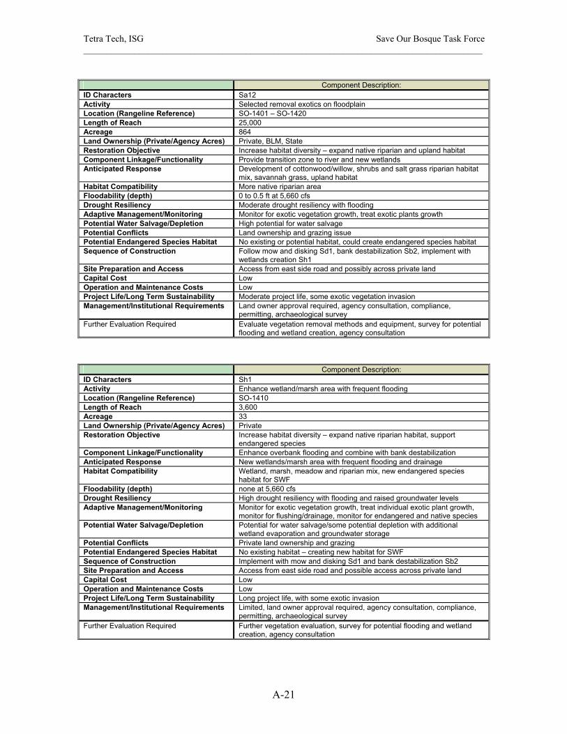
Tetra Tech, ISG Save Our Bosque Task Force ______________________________________________________________________________________
A-21
Component Description:
ID Characters Sa12 Activity Selected removal exotics on floodplain Location (Rangeline Reference) SO-1401 – SO-1420 Length of Reach 25,000 Acreage 864 Land Ownership (Private/Agency Acres) Private, BLM, State Restoration Objective Increase habitat diversity – expand native riparian and upland habitat Component Linkage/Functionality Provide transition zone to river and new wetlands Anticipated Response Development of cottonwood/willow, shrubs and salt grass riparian habitat
mix, savannah grass, upland habitat Habitat Compatibility More native riparian area Floodability (depth) 0 to 0.5 ft at 5,660 cfs Drought Resiliency Moderate drought resiliency with flooding Adaptive Management/Monitoring Monitor for exotic vegetation growth, treat exotic plants growth Potential Water Salvage/Depletion High potential for water salvage Potential Conflicts Land ownership and grazing issue Potential Endangered Species Habitat No existing or potential habitat, could create endangered species habitat Sequence of Construction Follow mow and disking Sd1, bank destabilization Sb2, implement with
wetlands creation Sh1 Site Preparation and Access Access from east side road and possibly across private land Capital Cost Low Operation and Maintenance Costs Low Project Life/Long Term Sustainability Moderate project life, some exotic vegetation invasion Management/Institutional Requirements Land owner approval required, agency consultation, compliance,
permitting, archaeological survey Further Evaluation Required Evaluate vegetation removal methods and equipment, survey for potential
flooding and wetland creation, agency consultation
Component Description: ID Characters Sh1 Activity Enhance wetland/marsh area with frequent flooding Location (Rangeline Reference) SO-1410 Length of Reach 3,600 Acreage 33 Land Ownership (Private/Agency Acres) Private Restoration Objective Increase habitat diversity – expand native riparian habitat, support
endangered species Component Linkage/Functionality Enhance overbank flooding and combine with bank destabilization Anticipated Response New wetlands/marsh area with frequent flooding and drainage Habitat Compatibility Wetland, marsh, meadow and riparian mix, new endangered species
habitat for SWF Floodability (depth) none at 5,660 cfs Drought Resiliency High drought resiliency with flooding and raised groundwater levels Adaptive Management/Monitoring Monitor for exotic vegetation growth, treat individual exotic plant growth,
monitor for flushing/drainage, monitor for endangered and native species Potential Water Salvage/Depletion Potential for water salvage/some potential depletion with additional
wetland evaporation and groundwater storage Potential Conflicts Private land ownership and grazing Potential Endangered Species Habitat No existing habitat – creating new habitat for SWF Sequence of Construction Implement with mow and disking Sd1 and bank destabilization Sb2 Site Preparation and Access Access from east side road and possible access across private land Capital Cost Low Operation and Maintenance Costs Low Project Life/Long Term Sustainability Long project life, with some exotic invasion Management/Institutional Requirements Limited, land owner approval required, agency consultation, compliance,
permitting, archaeological survey Further Evaluation Required Further vegetation evaluation, survey for potential flooding and wetland
creation, agency consultation

Tetra Tech, ISG Save Our Bosque Task Force ______________________________________________________________________________________
A-22
Component Description:
ID Characters Sa13 Activity Remove exotic vegetation on floodplain Location (Rangeline Reference) SO-1462 to SO-1470.5 Length of Reach 4,100 Acreage 36 Land Ownership (Private/Agency Acres) MRGCD Restoration Objective Increase habitat diversity – expand native riparian habitat Component Linkage/Functionality Provide transition zone to river Anticipated Response Develop new riparian habitat, cottonwood/willow bosque Habitat Compatibility More native riparian area Floodability (depth) None at 5,660 cfs Drought Resiliency Drought sensitivity Adaptive Management/Monitoring Monitor for exotic vegetation growth, treat new exotic plants Potential Water Salvage/Depletion Some potential for water salvage Potential Conflicts None Potential Endangered Species Habitat No existing or potential habitat Sequence of Construction Follow mow and disking Sd1, bank destabilization Sb2 Site Preparation and Access Access from levee road Capital Cost Low Operation and Maintenance Costs Low Project Life/Long Term Sustainability Moderate project life, exotic invasion will be slow Management/Institutional Requirements Agency consultation Further Evaluation Required None
Component Description: ID Characters Sa14 Activity Remove exotic vegetation on floodplain Location (Rangeline Reference) SO-1456 to SO-1470.5 Length of Reach 11,200 Acreage 980 Land Ownership (Private/Agency Acres) Private Restoration Objective Increase habitat diversity – expand native riparian and upland habitat Component Linkage/Functionality Provide transition zone to river Anticipated Response Development of cottonwood/willow, shrub and salt grass riparian habitat,
savannah grass upland habitat Habitat Compatibility More native riparian and upland habitat Floodability (depth) None at 5,660 cfs Drought Resiliency Some drought sensitivity Adaptive Management/Monitoring Monitor for exotic vegetation growth, treat new exotic plants Potential Water Salvage/Depletion High potential for water salvage Potential Conflicts Landownership and grazing Potential Endangered Species Habitat No existing or some potential for new SWF habitat Sequence of Construction Follow mow and disking Sd1, bank destabilization Sb3 Site Preparation and Access Access from east side road and possibly across private land Capital Cost Low Operation and Maintenance Costs Low Project Life/Long Term Sustainability Moderate project life, exotic invasion will be slow Management/Institutional Requirements Limited, land owner approval required Further Evaluation Required Evaluate vegetation removal methods and equipment

Tetra Tech, ISG Save Our Bosque Task Force ______________________________________________________________________________________
A-23
Component Description:
ID Characters Sb3 Activity Bank destabilization, remove vegetation, plow bank Location (Rangeline Reference) SO-1462 Length of Reach 3,900 Acreage 22 Land Ownership (Private/Agency Acres) Private/River Bank Restoration Objective Enhance river function – river dynamics Component Linkage/Functionality Increase channel width in incised reach, inundate inset floodplain Anticipated Response Increase river mobility and migration, enhance channel/floodplain
hydrologic connectivity Habitat Compatibility Increase channel width-to-depth ratio, provide more aquatic habitat Floodability (depth) 6 ft at 5,660 cfs Drought Resiliency Channel narrowing during drought may negate river widening Adaptive Management/Monitoring Monitored cross sections for channel narrowing, increase frequency of
high flows Potential Water Salvage/Depletion Some potential for water salvage by removing vegetation along bank Potential Conflicts Landownership and grazing, impacts on bridge approach Potential Endangered Species Habitat No existing or potential habitat Sequence of Construction Follow mow and disking Sd1, compliment vegetation removal in Sa14 Site Preparation and Access Develop access across river or up river from Hwy 380 bridge or obtain
access from east side road, maybe require access across private land Capital Cost Moderate Operation and Maintenance Costs Moderate Project Life/Long Term Sustainability Moderate, exotic vegetation encroachment could occur over several years Management/Institutional Requirements Land owner approval, agency consultation on bridge approach Further Evaluation Required Agency cooperation
Component Description: ID Characters Sa15 Activity Remove exotic vegetation on floodplain Location (Rangeline Reference) SO-1462 to SO-1470.5 Length of Reach 3,400 Acreage 24 Land Ownership (Private/Agency Acres) MRGCD Restoration Objective Increase habitat diversity – expand native riparian habitat Component Linkage/Functionality Provide transition zone to river Anticipated Response Development of riparian habitat, cottonwood/willow bosque Habitat Compatibility More native riparian area Floodability (depth) None at 5,660cfs Drought Resiliency Drought sensitivity with low groundwater levels Adaptive Management/Monitoring Monitor for exotic vegetation growth, treat new exotic plants Potential Water Salvage/Depletion Some potential for water salvage Potential Conflicts None Potential Endangered Species Habitat No existing or potential habitat Sequence of Construction Follow mow and disking Sd1 Site Preparation and Access Access from levee road Capital Cost Low Operation and Maintenance Costs Low Project Life/Long Term Sustainability Moderate project life, exotic invasion will be slow Management/Institutional Requirements Agency consultation Further Evaluation Required None

Tetra Tech, ISG Save Our Bosque Task Force ______________________________________________________________________________________
A-24
Component Description:
ID Characters Sf1 Activity Pilot channel for flooding and drainage of Sa14 area Location (Rangeline Reference) SO-1470.5 Length of Reach 1,200 Acreage 9 Land Ownership (Private/Agency Acres) Private Restoration Objective Enhance river function – expand marshes and wet meadows, promote
overbank flooding, increase groundwater storage Component Linkage/Functionality Inundate and drain floodplain area Sa14 Anticipated Response Flood Sa14 in spring and drain during late summer fall Habitat Compatibility Increase backwater habitat areas for silvery minnow, increase potential
SWF habitat Floodability (depth) 6 ft at 5660 cfs Drought Resiliency Pilot channel may close without frequent flushing flows, diverse flows on
annual basis will keep channel open Adaptive Management/Monitoring Monitored for vegetation encroachment and sedimentation, may require
future excavation Potential Water Salvage/Depletion Some potential for water evaporation and groundwater storage Potential Conflicts Landownership, agency approval, depletion losses, bridge approach
impacts Potential Endangered Species Habitat No existing habitat Sequence of Construction Follow mow and disking in subreach Sd1 and vegetation removal from
Sa14 Site Preparation and Access Access from Hwy 380 bridge Capital Cost High Operation and Maintenance Costs High Project Life/Long Term Sustainability Low project life, exotic vegetation encroachment and sedimentation could
occur in one year with the right conditions closing the channel Management/Institutional Requirements Significant requirements, design, consultation, compliance, permitting Further Evaluation Required Survey for the pilot channel
Component Description: ID Characters Sa16 Activity Remove exotic vegetation on floodplain Location (Rangeline Reference) D/S SO-1470.5 Length of Reach 4,300 Acreage 58 Land Ownership (Private/Agency Acres) MRGCD Restoration Objective Increase habitat diversity – expand native riparian habitat Component Linkage/Functionality Increase flood conveyance of Hwy 380 bridge Anticipated Response Development of salt grass meadow, some cottonwood/willow mix Habitat Compatibility Salt grass meadow with frequent flooding Floodability (depth) 0 to 1 ft at 5,660 cfs Drought Resiliency High drought resiliency with flooding Adaptive Management/Monitoring Monitor for exotic vegetation growth, treat new exotic plant growth Potential Water Salvage/Depletion Potential for water salvage/some potential depletion with additional
wetland evaporation and groundwater storage Potential Conflicts Impact bridge approach for flooding Potential Endangered Species Habitat No existing or potential habitat Sequence of Construction Follow bank destabilization Sb4 Site Preparation and Access Access from Hwy 380 bridge Capital Cost Low Operation and Maintenance Costs Low Project Life/Long Term Sustainability Moderate project life, with some exotic invasion Management/Institutional Requirements Limited, agency consultation, compliance, assess flooding at bridge Further Evaluation Required Bridge hydraulics analysis required

Tetra Tech, ISG Save Our Bosque Task Force ______________________________________________________________________________________
A-25
Component Description:
ID Characters Sb4 Activity Bank destabilization, remove vegetation, plow bank Location (Rangeline Reference) SO-1482.6 Length of Reach 9,000 Acreage 52 Land Ownership (Private/Agency Acres) Private/River Bank Restoration Objective Enhance river function – river dynamics Component Linkage/Functionality Increase channel width, improve hydrologic connectivity of
channel/floodplain Anticipated Response Increase river mobility and migration Habitat Compatibility Increase channel width to depth ratio, provide more aquatic habitat Floodability (depth) 3 to 5 ft at 5,660 cfs Drought Resiliency Channel narrowing during drought may negate river widening Adaptive Management/Monitoring Monitored cross sections for channel narrowing, increase frequency of
high flows Potential Water Salvage/Depletion Some potential for water salvage by removing vegetation along bank Potential Conflicts Landownership and grazing, impacts on bridge approach Potential Endangered Species Habitat No existing or potential habitat Sequence of Construction Compliment vegetation removal in Sa17 Site Preparation and Access Access from Hwy 380 bridge or obtain access from east side road, maybe
require access across private land Capital Cost Moderate Operation and Maintenance Costs Moderate Project Life/Long Term Sustainability Moderate, exotic vegetation encroachment could occur over several years Management/Institutional Requirements Land owner approval, agency consultation on bridge approach Further Evaluation Required Agency cooperation
Component Description: ID Characters Sa17 Activity Remove exotic vegetation on floodplain Location (Rangeline Reference) SO-1482.6 to SO-1508.8 Length of Reach 15,500 Acreage 1,120 Land Ownership (Private/Agency Acres) Private Restoration Objective Increase habitat diversity – expand native riparian habitat Component Linkage/Functionality Provide transition zone to river Anticipated Response Development of riparian habitat, cottonwood/willow bosque, shrub and salt
grass mix Habitat Compatibility More native riparian area Floodability (depth) 0 to 5.5 ft at 5,660 cfs Drought Resiliency Relatively drought insensitive Adaptive Management/Monitoring Monitor for exotic vegetation growth, treat new exotic plants Potential Water Salvage/Depletion High potential for water salvage Potential Conflicts Land ownership and grazing issues Potential Endangered Species Habitat No existing habitat, potential SWF habitat Sequence of Construction Follow mow and disking of channel Sd2 Site Preparation and Access Access from east side road and possibly across private land Capital Cost Low Operation and Maintenance Costs Low Project Life/Long Term Sustainability Moderate project life, exotic invasion will be slow Management/Institutional Requirements Limited, land owner approval required Further Evaluation Required Evaluate vegetation removal methods and equipment
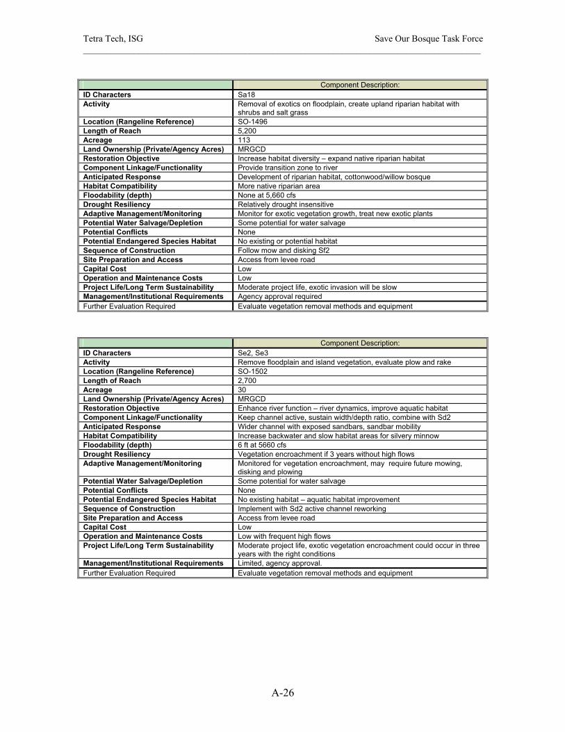
Tetra Tech, ISG Save Our Bosque Task Force ______________________________________________________________________________________
A-26
Component Description:
ID Characters Sa18 Activity Removal of exotics on floodplain, create upland riparian habitat with
shrubs and salt grass Location (Rangeline Reference) SO-1496 Length of Reach 5,200 Acreage 113 Land Ownership (Private/Agency Acres) MRGCD Restoration Objective Increase habitat diversity – expand native riparian habitat Component Linkage/Functionality Provide transition zone to river Anticipated Response Development of riparian habitat, cottonwood/willow bosque Habitat Compatibility More native riparian area Floodability (depth) None at 5,660 cfs Drought Resiliency Relatively drought insensitive Adaptive Management/Monitoring Monitor for exotic vegetation growth, treat new exotic plants Potential Water Salvage/Depletion Some potential for water salvage Potential Conflicts None Potential Endangered Species Habitat No existing or potential habitat Sequence of Construction Follow mow and disking Sf2 Site Preparation and Access Access from levee road Capital Cost Low Operation and Maintenance Costs Low Project Life/Long Term Sustainability Moderate project life, exotic invasion will be slow Management/Institutional Requirements Agency approval required Further Evaluation Required Evaluate vegetation removal methods and equipment
Component Description: ID Characters Se2, Se3 Activity Remove floodplain and island vegetation, evaluate plow and rake Location (Rangeline Reference) SO-1502 Length of Reach 2,700 Acreage 30 Land Ownership (Private/Agency Acres) MRGCD Restoration Objective Enhance river function – river dynamics, improve aquatic habitat Component Linkage/Functionality Keep channel active, sustain width/depth ratio, combine with Sd2 Anticipated Response Wider channel with exposed sandbars, sandbar mobility Habitat Compatibility Increase backwater and slow habitat areas for silvery minnow Floodability (depth) 6 ft at 5660 cfs Drought Resiliency Vegetation encroachment if 3 years without high flows Adaptive Management/Monitoring Monitored for vegetation encroachment, may require future mowing,
disking and plowing Potential Water Salvage/Depletion Some potential for water salvage Potential Conflicts None Potential Endangered Species Habitat No existing habitat – aquatic habitat improvement Sequence of Construction Implement with Sd2 active channel reworking Site Preparation and Access Access from levee road Capital Cost Low Operation and Maintenance Costs Low with frequent high flows Project Life/Long Term Sustainability Moderate project life, exotic vegetation encroachment could occur in three
years with the right conditions Management/Institutional Requirements Limited, agency approval. Further Evaluation Required Evaluate vegetation removal methods and equipment
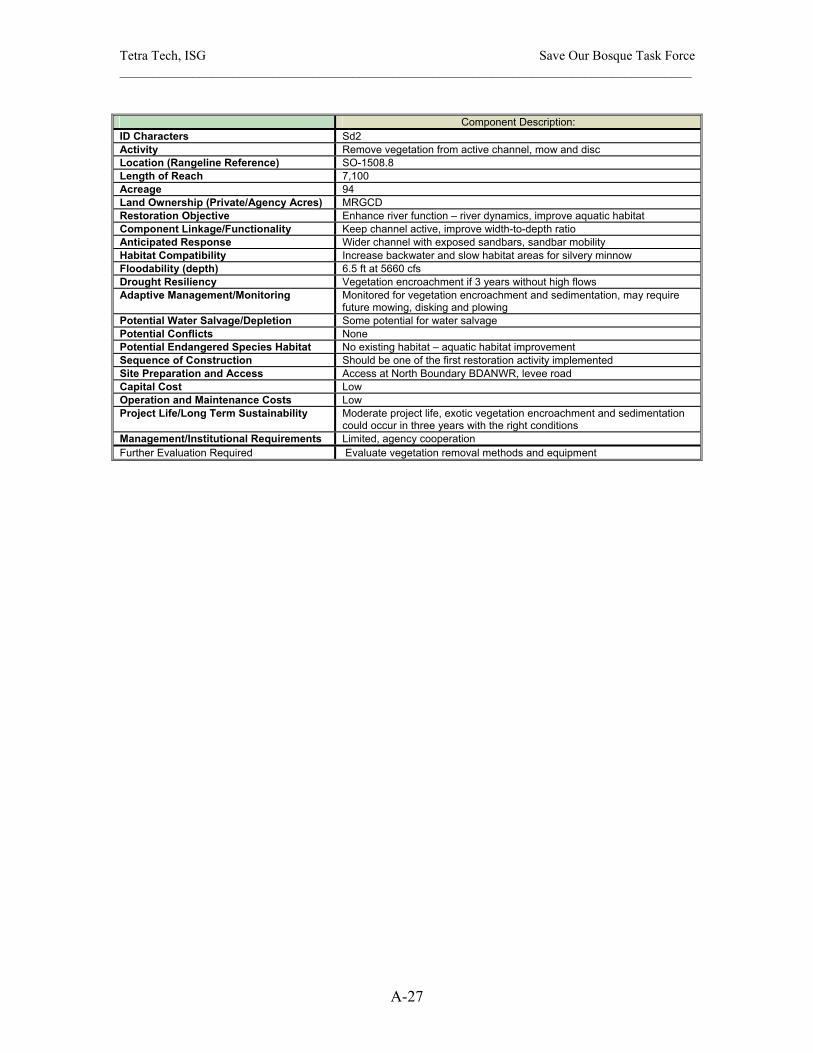
Tetra Tech, ISG Save Our Bosque Task Force ______________________________________________________________________________________
A-27
Component Description:
ID Characters Sd2 Activity Remove vegetation from active channel, mow and disc Location (Rangeline Reference) SO-1508.8 Length of Reach 7,100 Acreage 94 Land Ownership (Private/Agency Acres) MRGCD Restoration Objective Enhance river function – river dynamics, improve aquatic habitat Component Linkage/Functionality Keep channel active, improve width-to-depth ratio Anticipated Response Wider channel with exposed sandbars, sandbar mobility Habitat Compatibility Increase backwater and slow habitat areas for silvery minnow Floodability (depth) 6.5 ft at 5660 cfs Drought Resiliency Vegetation encroachment if 3 years without high flows Adaptive Management/Monitoring Monitored for vegetation encroachment and sedimentation, may require
future mowing, disking and plowing Potential Water Salvage/Depletion Some potential for water salvage Potential Conflicts None Potential Endangered Species Habitat No existing habitat – aquatic habitat improvement Sequence of Construction Should be one of the first restoration activity implemented Site Preparation and Access Access at North Boundary BDANWR, levee road Capital Cost Low Operation and Maintenance Costs Low Project Life/Long Term Sustainability Moderate project life, exotic vegetation encroachment and sedimentation
could occur in three years with the right conditions Management/Institutional Requirements Limited, agency cooperation Further Evaluation Required Evaluate vegetation removal methods and equipment
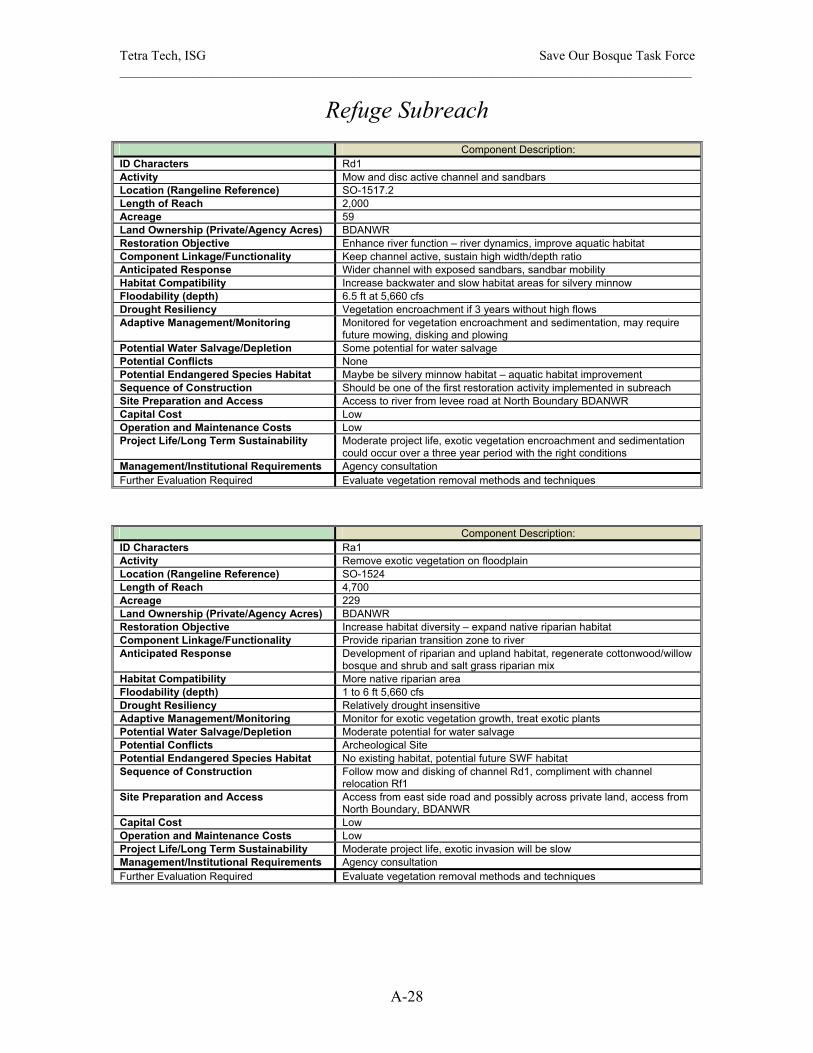
Tetra Tech, ISG Save Our Bosque Task Force ______________________________________________________________________________________
A-28
Refuge Subreach
Component Description: ID Characters Rd1 Activity Mow and disc active channel and sandbars Location (Rangeline Reference) SO-1517.2 Length of Reach 2,000 Acreage 59 Land Ownership (Private/Agency Acres) BDANWR Restoration Objective Enhance river function – river dynamics, improve aquatic habitat Component Linkage/Functionality Keep channel active, sustain high width/depth ratio Anticipated Response Wider channel with exposed sandbars, sandbar mobility Habitat Compatibility Increase backwater and slow habitat areas for silvery minnow Floodability (depth) 6.5 ft at 5,660 cfs Drought Resiliency Vegetation encroachment if 3 years without high flows Adaptive Management/Monitoring Monitored for vegetation encroachment and sedimentation, may require
future mowing, disking and plowing Potential Water Salvage/Depletion Some potential for water salvage Potential Conflicts None Potential Endangered Species Habitat Maybe be silvery minnow habitat – aquatic habitat improvement Sequence of Construction Should be one of the first restoration activity implemented in subreach Site Preparation and Access Access to river from levee road at North Boundary BDANWR Capital Cost Low Operation and Maintenance Costs Low Project Life/Long Term Sustainability Moderate project life, exotic vegetation encroachment and sedimentation
could occur over a three year period with the right conditions Management/Institutional Requirements Agency consultation Further Evaluation Required Evaluate vegetation removal methods and techniques
Component Description: ID Characters Ra1 Activity Remove exotic vegetation on floodplain Location (Rangeline Reference) SO-1524 Length of Reach 4,700 Acreage 229 Land Ownership (Private/Agency Acres) BDANWR Restoration Objective Increase habitat diversity – expand native riparian habitat Component Linkage/Functionality Provide riparian transition zone to river Anticipated Response Development of riparian and upland habitat, regenerate cottonwood/willow
bosque and shrub and salt grass riparian mix Habitat Compatibility More native riparian area Floodability (depth) 1 to 6 ft 5,660 cfs Drought Resiliency Relatively drought insensitive Adaptive Management/Monitoring Monitor for exotic vegetation growth, treat exotic plants Potential Water Salvage/Depletion Moderate potential for water salvage Potential Conflicts Archeological Site Potential Endangered Species Habitat No existing habitat, potential future SWF habitat Sequence of Construction Follow mow and disking of channel Rd1, compliment with channel
relocation Rf1 Site Preparation and Access Access from east side road and possibly across private land, access from
North Boundary, BDANWR Capital Cost Low Operation and Maintenance Costs Low Project Life/Long Term Sustainability Moderate project life, exotic invasion will be slow Management/Institutional Requirements Agency consultation Further Evaluation Required Evaluate vegetation removal methods and techniques

Tetra Tech, ISG Save Our Bosque Task Force ______________________________________________________________________________________
A-29
Component Description: ID Characters Rf1 Activity Channel relocation to the east Location (Rangeline Reference) SO-1524 Length of Reach 7,200 Acreage 727 Land Ownership (Private/Agency Acres) BDANWR Restoration Objective Enhance river function – increase width-to-depth ratio Component Linkage/Functionality promote bank flooding, increase groundwater storage, move river away
from LFCC, enhance channel/floodplain connectivity Anticipated Response More active, wider channel Habitat Compatibility Improve aquatic habitat for silvery minnow Floodability (depth) 7 ft at 5,660 cfs Drought Resiliency Channel narrowing with successive dry years and vegetation
encroachment Adaptive Management/Monitoring Monitored for vegetation encroachment and sedimentation, channel
flushing and future mow and disking Potential Water Salvage/Depletion High potential for water salvage by moving river away from LFCC Potential Conflicts None Potential Endangered Species Habitat Maybe existing silvery minnow habitat, enhance silvery minnow habitat Sequence of Construction No specific sequence, perform upstream mow and disking of active
channel Rd1 Site Preparation and Access Access from river channel at North Boundary BDANWR and levee road,
access also from east side road Capital Cost High Operation and Maintenance Costs High Project Life/Long Term Sustainability Moderate project life, exotic vegetation encroachment and sedimentation
could occur over several years Management/Institutional Requirements Significant requirements, design, consultation, compliance, permitting Further Evaluation Required Survey for the channel relocation design
Component Description: ID Characters Rg1 Activity Secondary channel, use original river channel Location (Rangeline Reference) SO-1524 Length of Reach 4,800 Acreage 34 Land Ownership (Private/Agency Acres) BDANWR Restoration Objective Enhance river function – improve aquatic habitat Component Linkage/Functionality Create backwater and slow water aquatic habitat Anticipated Response Fill old channel with high flows, drain with low flows Habitat Compatibility Increase backwater habitat areas for silvery minnow Floodability (depth) 3 ft at 5,660 cfs Drought Resiliency Drought resistant Adaptive Management/Monitoring Monitor for vegetation encroachment and sedimentation, may require
future mowing, disking and plowing, may fill with sediment Potential Water Salvage/Depletion Some water depletion with evaporation, will cut off flows from river to
LFCC Potential Conflicts None Potential Endangered Species Habitat No existing habitat – aquatic habitat improvement Sequence of Construction Combine with river relocation Rf1 Site Preparation and Access Access from river channel at North Boundary BDANWR and levee road,
access also from east side road Capital Cost High, berm creation, hauling material Operation and Maintenance Costs Maybe high Project Life/Long Term Sustainability High project life, exotic vegetation encroachment and sedimentation could
occur over the long term Management/Institutional Requirements Significant requirements, design, consultation, compliance, permitting Further Evaluation Required Survey for the secondary channel
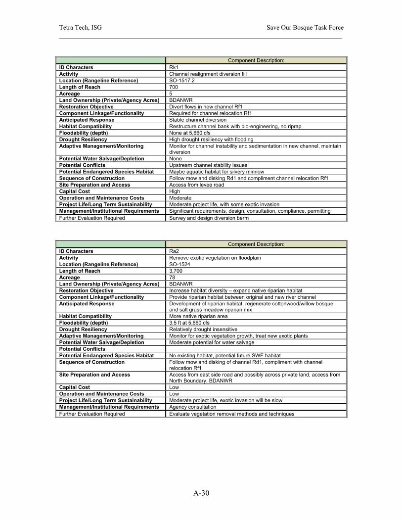
Tetra Tech, ISG Save Our Bosque Task Force ______________________________________________________________________________________
A-30
Component Description:
ID Characters Rk1 Activity Channel realignment diversion fill Location (Rangeline Reference) SO-1517.2 Length of Reach 700 Acreage 5 Land Ownership (Private/Agency Acres) BDANWR Restoration Objective Divert flows in new channel Rf1 Component Linkage/Functionality Required for channel relocation Rf1 Anticipated Response Stable channel diversion Habitat Compatibility Restructure channel bank with bio-engineering, no riprap Floodability (depth) None at 5,660 cfs Drought Resiliency High drought resiliency with flooding Adaptive Management/Monitoring Monitor for channel instability and sedimentation in new channel, maintain
diversion Potential Water Salvage/Depletion None Potential Conflicts Upstream channel stability issues Potential Endangered Species Habitat Maybe aquatic habitat for silvery minnow Sequence of Construction Follow mow and disking Rd1 and compliment channel relocation Rf1 Site Preparation and Access Access from levee road Capital Cost High Operation and Maintenance Costs Moderate Project Life/Long Term Sustainability Moderate project life, with some exotic invasion Management/Institutional Requirements Significant requirements, design, consultation, compliance, permitting Further Evaluation Required Survey and design diversion berm
Component Description: ID Characters Ra2 Activity Remove exotic vegetation on floodplain Location (Rangeline Reference) SO-1524 Length of Reach 3,700 Acreage 78 Land Ownership (Private/Agency Acres) BDANWR Restoration Objective Increase habitat diversity – expand native riparian habitat Component Linkage/Functionality Provide riparian habitat between original and new river channel Anticipated Response Development of riparian habitat, regenerate cottonwood/willow bosque
and salt grass meadow riparian mix Habitat Compatibility More native riparian area Floodability (depth) 3.5 ft at 5,660 cfs Drought Resiliency Relatively drought insensitive Adaptive Management/Monitoring Monitor for exotic vegetation growth, treat new exotic plants Potential Water Salvage/Depletion Moderate potential for water salvage Potential Conflicts Potential Endangered Species Habitat No existing habitat, potential future SWF habitat Sequence of Construction Follow mow and disking of channel Rd1, compliment with channel
relocation Rf1 Site Preparation and Access Access from east side road and possibly across private land, access from
North Boundary, BDANWR Capital Cost Low Operation and Maintenance Costs Low Project Life/Long Term Sustainability Moderate project life, exotic invasion will be slow Management/Institutional Requirements Agency consultation Further Evaluation Required Evaluate vegetation removal methods and techniques
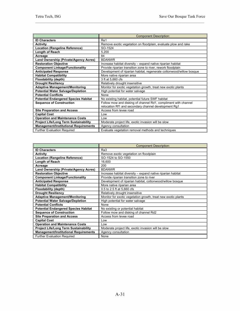
Tetra Tech, ISG Save Our Bosque Task Force ______________________________________________________________________________________
A-31
Component Description:
ID Characters Re1 Activity Remove exotic vegetation on floodplain, evaluate plow and rake Location (Rangeline Reference) SO-1524 Length of Reach 5,200 Acreage 84 Land Ownership (Private/Agency Acres) BDANWR Restoration Objective Increase habitat diversity – expand native riparian habitat Component Linkage/Functionality Provide riparian transition zone to river, rework floodplain Anticipated Response Development of riparian habitat, regenerate cottonwood/willow bosque Habitat Compatibility More native riparian area Floodability (depth) 3 ft at 5,660 cfs Drought Resiliency Relatively drought insensitive Adaptive Management/Monitoring Monitor for exotic vegetation growth, treat new exotic plants Potential Water Salvage/Depletion High potential for water salvage Potential Conflicts None Potential Endangered Species Habitat No existing habitat, potential future SWF habitat Sequence of Construction Follow mow and disking of channel Rd1, compliment with channel
relocation Rf1 and secondary channel development Rg1 Site Preparation and Access Access from levee road Capital Cost Low Operation and Maintenance Costs Low Project Life/Long Term Sustainability Moderate project life, exotic invasion will be slow Management/Institutional Requirements Agency consultation Further Evaluation Required Evaluate vegetation removal methods and techniques
Component Description: ID Characters Ra3 Activity Remove exotic vegetation on floodplain Location (Rangeline Reference) SO-1524 to SO-1550 Length of Reach 16,600 Acreage 200 Land Ownership (Private/Agency Acres) BDANWR Restoration Objective Increase habitat diversity – expand native riparian habitat Component Linkage/Functionality Provide riparian transition zone to river Anticipated Response Development of riparian habitat, cottonwood/willow bosque Habitat Compatibility More native riparian area Floodability (depth) 0.5 to 2.5 ft at 5,660 cfs Drought Resiliency Relatively drought insensitive Adaptive Management/Monitoring Monitor for exotic vegetation growth, treat new exotic plants Potential Water Salvage/Depletion High potential for water salvage Potential Conflicts None Potential Endangered Species Habitat No existing or potential habitat Sequence of Construction Follow mow and disking of channel Rd2 Site Preparation and Access Access from levee road Capital Cost Low Operation and Maintenance Costs Low Project Life/Long Term Sustainability Moderate project life, exotic invasion will be slow Management/Institutional Requirements Agency consultation Further Evaluation Required None
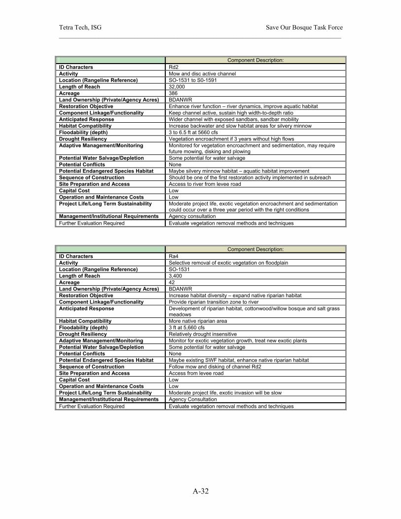
Tetra Tech, ISG Save Our Bosque Task Force ______________________________________________________________________________________
A-32
Component Description:
ID Characters Rd2 Activity Mow and disc active channel Location (Rangeline Reference) SO-1531 to S0-1591 Length of Reach 32,000 Acreage 386 Land Ownership (Private/Agency Acres) BDANWR Restoration Objective Enhance river function – river dynamics, improve aquatic habitat Component Linkage/Functionality Keep channel active, sustain high width-to-depth ratio Anticipated Response Wider channel with exposed sandbars, sandbar mobility Habitat Compatibility Increase backwater and slow habitat areas for silvery minnow Floodability (depth) 3 to 6.5 ft at 5660 cfs Drought Resiliency Vegetation encroachment if 3 years without high flows Adaptive Management/Monitoring Monitored for vegetation encroachment and sedimentation, may require
future mowing, disking and plowing Potential Water Salvage/Depletion Some potential for water salvage Potential Conflicts None Potential Endangered Species Habitat Maybe silvery minnow habitat – aquatic habitat improvement Sequence of Construction Should be one of the first restoration activity implemented in subreach Site Preparation and Access Access to river from levee road Capital Cost Low Operation and Maintenance Costs Low Project Life/Long Term Sustainability Moderate project life, exotic vegetation encroachment and sedimentation
could occur over a three year period with the right conditions Management/Institutional Requirements Agency consultation Further Evaluation Required Evaluate vegetation removal methods and techniques
Component Description: ID Characters Ra4 Activity Selective removal of exotic vegetation on floodplain Location (Rangeline Reference) SO-1531 Length of Reach 3,400 Acreage 42 Land Ownership (Private/Agency Acres) BDANWR Restoration Objective Increase habitat diversity – expand native riparian habitat Component Linkage/Functionality Provide riparian transition zone to river Anticipated Response Development of riparian habitat, cottonwood/willow bosque and salt grass
meadows Habitat Compatibility More native riparian area Floodability (depth) 3 ft at 5,660 cfs Drought Resiliency Relatively drought insensitive Adaptive Management/Monitoring Monitor for exotic vegetation growth, treat new exotic plants Potential Water Salvage/Depletion Some potential for water salvage Potential Conflicts None Potential Endangered Species Habitat Maybe existing SWF habitat, enhance native riparian habitat Sequence of Construction Follow mow and disking of channel Rd2 Site Preparation and Access Access from levee road Capital Cost Low Operation and Maintenance Costs Low Project Life/Long Term Sustainability Moderate project life, exotic invasion will be slow Management/Institutional Requirements Agency Consultation Further Evaluation Required Evaluate vegetation removal methods and techniques

Tetra Tech, ISG Save Our Bosque Task Force ______________________________________________________________________________________
A-33
Component Description:
ID Characters Rh1 Activity Enhance wetland/marsh area with frequent flooding Location (Rangeline Reference) SO-1531 Length of Reach 2,800 Acreage 80 Land Ownership (Private/Agency Acres) BDANWR Restoration Objective Increase habitat diversity – expand native riparian habitat, support
endangered species Component Linkage/Functionality Enhance overbank flooding and combine with channel relocation Rf1 Anticipated Response New wetlands/marsh area with frequent flooding and drainage Habitat Compatibility Wetland, marsh, meadow and riparian mix, new endangered species
habitat for SWF Floodability (depth) 5 ft at 5,660 cfs Drought Resiliency High drought resiliency with flooding and raised groundwater levels Adaptive Management/Monitoring Monitor for exotic vegetation growth, treat individual exotic plant growth,
monitor for flushing/drainage, monitor for endangered and native species, monitor for sedimentation
Potential Water Salvage/Depletion Potential for water salvage/some potential depletion with additional wetland evaporation and groundwater storage
Potential Conflicts None Potential Endangered Species Habitat Maybe existing SWF habitat – creating new habitat for SWFC Sequence of Construction Implement with mow and disking Rd1 and channel relocation Rf1 Site Preparation and Access Access from east side road Capital Cost Moderate Operation and Maintenance Costs Moderate Project Life/Long Term Sustainability Long project life, with some exotic invasion Management/Institutional Requirements Limited, agency consultation, compliance, permitting, archaeological
survey Further Evaluation Required Further vegetation evaluation, survey for potential flooding and wetland
creation, agency consultation
Component Description: ID Characters Re2 Activity Remove exotic vegetation from floodplain, evaluate plow and rake Location (Rangeline Reference) SO-1536 Length of Reach 4,000 Acreage 59 Land Ownership (Private/Agency Acres) BDANWR Restoration Objective Increase habitat diversity – expand native riparian habitat Component Linkage/Functionality Provide riparian transition zone to river, rework floodplain Anticipated Response Development of riparian habitat, regenerate cottonwood/willow bosque,
salt grass meadows mix Habitat Compatibility More native riparian area Floodability (depth) 6 ft at 5,660 cfs Drought Resiliency Relatively drought insensitive Adaptive Management/Monitoring Monitor for exotic vegetation growth, treat new exotic plants Potential Water Salvage/Depletion High potential for water salvage Potential Conflicts None Potential Endangered Species Habitat No existing habitat, potential future SWF habitat Sequence of Construction Follow mow and disking of channel Rd2 Site Preparation and Access Access from east side road Capital Cost Low Operation and Maintenance Costs Low Project Life/Long Term Sustainability Moderate project life, exotic invasion will be slow Management/Institutional Requirements Agency Consultation Further Evaluation Required Evaluate vegetation removal methods and techniques

Tetra Tech, ISG Save Our Bosque Task Force ______________________________________________________________________________________
A-34
Component Description:
ID Characters Rc1 Activity Lower floodplain terrace Location (Rangeline Reference) SO-1539 Length of Reach 1,200 Acreage 6 Land Ownership (Private/Agency Acres) BDANWR Restoration Objective Increase habitat diversity – expand native riparian habitat, promote
cottonwood/willow regeneration Component Linkage/Functionality Provide hydrologic connectivity to river, improve opportunity for river
migration Anticipated Response Create new active floodplain for 5,660 cfs Habitat Compatibility More native riparian habitat Floodability (depth) 6 ft at 5,660 cfs Drought Resiliency Will be relative drought resistant Adaptive Management/Monitoring Monitor for exotic vegetation growth Potential Water Salvage/Depletion Limited potential for water salvage Potential Conflicts None Potential Endangered Species Habitat No existing or potential endangered species habitat Sequence of Construction Follow mow and disk Sd2 Site Preparation and Access Access from east side road Capital Cost High Operation and Maintenance Costs Moderate with exotic vegetation establishment Project Life/Long Term Sustainability Moderate project life Management/Institutional Requirements Significant requirements, design, consultation, compliance, permitting,
need to have a spoils site Further Evaluation Required Survey for the new floodplain elevation and spoils
Component Description: ID Characters Rb1 Activity Bank destabilization, remove vegetation, plow bank Location (Rangeline Reference) SO-1550 to SO-1591 Length of Reach 23,000 Acreage 144 Land Ownership (Private/Agency Acres) BDANWR Restoration Objective Enhance river function – river dynamics Component Linkage/Functionality Increase channel width, improve hydrologic connectivity of
channel/floodplain, combine with secondary channel Rg1 and wetlands creation Rh2 , enhance opportunity to move river to east
Anticipated Response Increase river mobility and migration Habitat Compatibility Increase channel width-to-depth ratio, provide more aquatic habitat Floodability (depth) 3 to 6.5 ft at 5660 cfs Drought Resiliency Channel narrowing during drought may negate river widening Adaptive Management/Monitoring Monitored cross sections for channel narrowing, increase frequency of
high flows Potential Water Salvage/Depletion Some potential for water salvage by removing vegetation along bank,
reduce seepage losses to LFCC by moving river to east Potential Conflicts None Potential Endangered Species Habitat No existing habitat Sequence of Construction Follows mow and disking Rd2, combine with secondary channel Rg2 Site Preparation and Access Access from east side road Capital Cost Moderate Operation and Maintenance Costs Moderate Project Life/Long Term Sustainability Moderate, exotic vegetation encroachment could occur over several years
and reduce channel width Management/Institutional Requirements Agency consultation, compliance and permitting Further Evaluation Required Evaluate vegetation removal methods and techniques
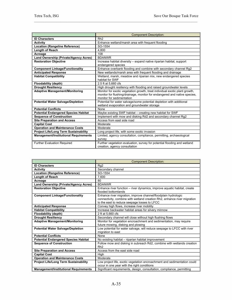
Tetra Tech, ISG Save Our Bosque Task Force ______________________________________________________________________________________
A-35
Component Description:
ID Characters Rh2 Activity Enhance wetland/marsh area with frequent flooding Location (Rangeline Reference) SO-1554 Length of Reach 4,800 Acreage 108 Land Ownership (Private/Agency Acres) BDANWR Restoration Objective Increase habitat diversity – expand native riparian habitat, support
endangered species Component Linkage/Functionality Enhance overbank flooding and combine with secondary channel Rg2 Anticipated Response New wetlands/marsh area with frequent flooding and drainage Habitat Compatibility Wetland, marsh, meadow and riparian mix, new endangered species
habitat for SWF Floodability (depth) 2.5 ft at 5,660 cfs Drought Resiliency High drought resiliency with flooding and raised groundwater levels Adaptive Management/Monitoring Monitor for exotic vegetation growth, treat individual exotic plant growth,
monitor for flushing/drainage, monitor for endangered and native species, monitor for sedimentation
Potential Water Salvage/Depletion Potential for water salvage/some potential depletion with additional wetland evaporation and groundwater storage
Potential Conflicts None Potential Endangered Species Habitat Maybe existing SWF habitat – creating new habitat for SWF Sequence of Construction Implement with mow and disking Rd2 and secondary channel Rg2 Site Preparation and Access Access from east side road Capital Cost Moderate Operation and Maintenance Costs Moderate Project Life/Long Term Sustainability Long project life, with some exotic invasion Management/Institutional Requirements Limited, agency consultation, compliance, permitting, archaeological
survey Further Evaluation Required Further vegetation evaluation, survey for potential flooding and wetland
creation, agency consultation
Component Description: ID Characters Rg2 Activity Secondary channel Location (Rangeline Reference) SO-1554 Length of Reach 7,600 Acreage 80 Land Ownership (Private/Agency Acres) BDANWR Restoration Objective Enhance river function – river dynamics, improve aquatic habitat, create
flooded bottomlands Component Linkage/Functionality Enhance river migration, improve channel/floodplain hydrologic
connectivity, combine with wetland creation Rh2, enhance river migration to the east to reduce seepage losses to LFCC
Anticipated Response Convey high flows, increase river mobility Habitat Compatibility Increase backwater habitat areas for silvery minnow Floodability (depth) 2 ft at 5,660 cfs Drought Resiliency Secondary channel will close without high flushing flows Adaptive Management/Monitoring Monitor for vegetation encroachment and sedimentation, may require
future mowing, disking and plowing Potential Water Salvage/Depletion Low potential for water salvage, will reduce seepage to LFCC with river
migration to east Potential Conflicts None Potential Endangered Species Habitat No existing habitat – riparian habitat improvement Sequence of Construction Follow mow and disking in subreach Rd2, combine with wetlands creation
Rh2 Site Preparation and Access Access from the east side road Capital Cost High Operation and Maintenance Costs Moderate Project Life/Long Term Sustainability Low project life, exotic vegetation encroachment and sedimentation could
occur in one year with the right conditions Management/Institutional Requirements Significant requirements, design, consultation, compliance, permitting

Tetra Tech, ISG Save Our Bosque Task Force ______________________________________________________________________________________
A-36
Further Evaluation Required Survey for the secondary channel and wetlands water surface elevation, perform more detailed flood analysis
Component Description: ID Characters Ra5 Activity Remove exotic vegetation on floodplain Location (Rangeline Reference) SO-1554 Length of Reach 6,800 Acreage 189 Land Ownership (Private/Agency Acres) BDANWR Restoration Objective Increase habitat diversity – expand native riparian habitat Component Linkage/Functionality Create floodable riparian habitat, combine with mow and disc channel
Rd2 Anticipated Response Cottonwood/willow regeneration, frequent overbank flooding, salt grass
meadow development Habitat Compatibility More native riparian habitat with frequent flooding Floodability (depth) 2 ft at 5,660 cfs Drought Resiliency High drought resiliency with flooding Adaptive Management/Monitoring Monitor for exotic vegetation growth, treat new exotic plant growth Potential Water Salvage/Depletion Moderate potential for water salvage Potential Conflicts None Potential Endangered Species Habitat No existing habitat, improve habitat for SWF Sequence of Construction Follow mow and disking Rd2 Site Preparation and Access Access from east side road Capital Cost Low Operation and Maintenance Costs Low Project Life/Long Term Sustainability Moderate project life, with some exotic invasion Management/Institutional Requirements Agency consultation Further Evaluation Required Evaluate vegetation removal methods
Component Description: ID Characters Rc2, Rc3 Activity Lower island surface or terrace Location (Rangeline Reference) SO-1554 and SO-1560.5 Length of Reach 2,200 Acreage 15 Land Ownership (Private/Agency Acres) BDANWR Restoration Objective Increase habitat diversity – promote wider channel Component Linkage/Functionality Rework vegetated island, improve width-to-depth ratio Anticipated Response Wider channel work in concert with secondary channel Rd2 Habitat Compatibility Slower velocity habitat for silvery minnow Floodability (depth) 3 ft and 5 ft at 5,660 cfs Drought Resiliency Will be relative drought resistant Adaptive Management/Monitoring Monitor for exotic renewed vegetation growth Potential Water Salvage/Depletion None Potential Conflicts None Potential Endangered Species Habitat No existing or potential endangered species habitat Sequence of Construction Follow mow and disk Rd2 Site Preparation and Access Access from levee road Capital Cost Low Operation and Maintenance Costs Low Project Life/Long Term Sustainability Moderate project life Management/Institutional Requirements None Further Evaluation Required Evaluate vegetation removal methods and equipment

Tetra Tech, ISG Save Our Bosque Task Force ______________________________________________________________________________________
A-37
Component Description:
ID Characters Rg3 Activity Secondary or side channels Location (Rangeline Reference) SO-1560.5 Length of Reach 6,700 Acreage 50 Land Ownership (Private/Agency Acres) BDANWR Restoration Objective Enhance river function – river dynamics, improve aquatic habitat, create
flooded bottomlands Component Linkage/Functionality Improve channel/floodplain hydrologic connectivity, enhance river
migration to the east to reduce seepage losses to LFCC, increase groundwater storage on east side
Anticipated Response Convey high flows, increase river mobility Habitat Compatibility Increase backwater habitat areas for silvery minnow Floodability (depth) 1.5 ft at 5,660 cfs Drought Resiliency Secondary channel will close without high flushing flows Adaptive Management/Monitoring Monitor for vegetation encroachment and sedimentation, may require
future mowing, disking and plowing Potential Water Salvage/Depletion Low potential for water salvage, will reduce seepage to LFCC with river
migration to east Potential Conflicts Potential Endangered Species Habitat No existing endangered species habitat – aquatic habitat improvement Sequence of Construction Follow mow and disking in subreach Rd2 Site Preparation and Access Access from the east side road Capital Cost High Operation and Maintenance Costs High Project Life/Long Term Sustainability Low project life, exotic vegetation encroachment and sedimentation could
occur in one year with the right conditions Management/Institutional Requirements Significant requirements, design, consultation, compliance, permitting Further Evaluation Required Survey for the secondary channel and wetlands water surface elevation,
perform more detailed flood analysis
Component Description: ID Characters Ra6 Activity Remove exotic vegetation on floodplain Location (Rangeline Reference) SO-1560.5 Length of Reach 6,400 Acreage 224 Land Ownership (Private/Agency Acres) BDANWR Restoration Objective Increase habitat diversity – expand native riparian habitat Component Linkage/Functionality Provide riparian transition zone to river, integrate with secondary and side
channels Rg3 Anticipated Response Regeneration of cottonwood/willow and salt grass riparian habitat Habitat Compatibility More native riparian area Floodability (depth) 2 ft at 5,660 cfs Drought Resiliency Relatively drought insensitive Adaptive Management/Monitoring Monitor for exotic vegetation growth, treat new exotic plants Potential Water Salvage/Depletion Moderate potential for water salvage Potential Conflicts Potential Endangered Species Habitat Maybe existing SWF habitat, enhance native riparian habitat Sequence of Construction Follow mow and disking of channel Rd2 Site Preparation and Access Access from levee road Capital Cost Low Operation and Maintenance Costs Low Project Life/Long Term Sustainability Moderate project life, exotic invasion will be slow Management/Institutional Requirements Agency Consultation Further Evaluation Required Evaluate vegetation removal methods and equipment
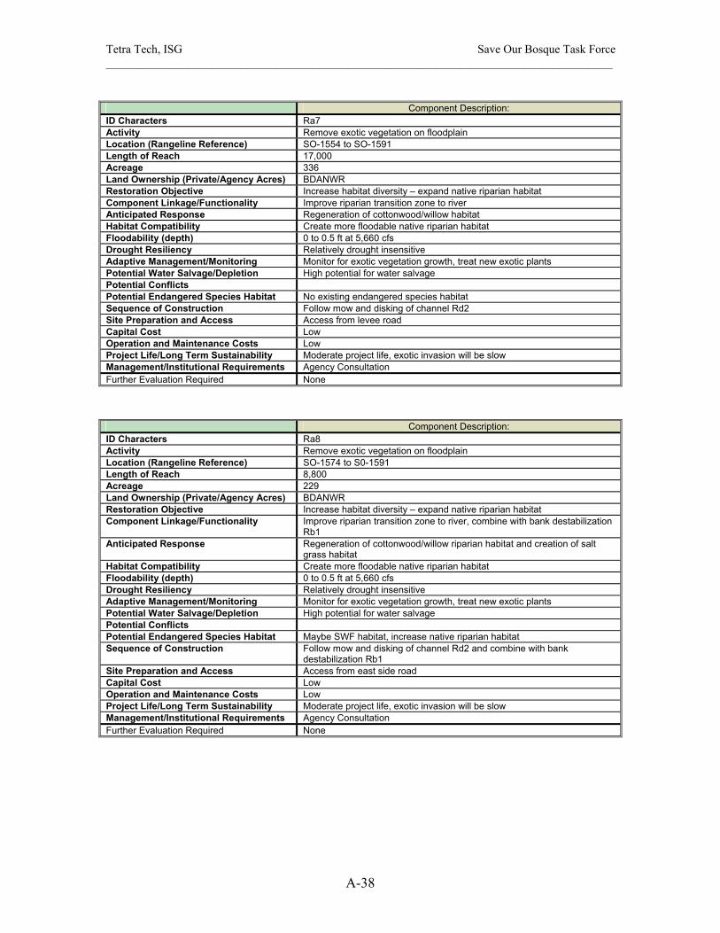
Tetra Tech, ISG Save Our Bosque Task Force ______________________________________________________________________________________
A-38
Component Description:
ID Characters Ra7 Activity Remove exotic vegetation on floodplain Location (Rangeline Reference) SO-1554 to SO-1591 Length of Reach 17,000 Acreage 336 Land Ownership (Private/Agency Acres) BDANWR Restoration Objective Increase habitat diversity – expand native riparian habitat Component Linkage/Functionality Improve riparian transition zone to river Anticipated Response Regeneration of cottonwood/willow habitat Habitat Compatibility Create more floodable native riparian habitat Floodability (depth) 0 to 0.5 ft at 5,660 cfs Drought Resiliency Relatively drought insensitive Adaptive Management/Monitoring Monitor for exotic vegetation growth, treat new exotic plants Potential Water Salvage/Depletion High potential for water salvage Potential Conflicts Potential Endangered Species Habitat No existing endangered species habitat Sequence of Construction Follow mow and disking of channel Rd2 Site Preparation and Access Access from levee road Capital Cost Low Operation and Maintenance Costs Low Project Life/Long Term Sustainability Moderate project life, exotic invasion will be slow Management/Institutional Requirements Agency Consultation Further Evaluation Required None
Component Description: ID Characters Ra8 Activity Remove exotic vegetation on floodplain Location (Rangeline Reference) SO-1574 to S0-1591 Length of Reach 8,800 Acreage 229 Land Ownership (Private/Agency Acres) BDANWR Restoration Objective Increase habitat diversity – expand native riparian habitat Component Linkage/Functionality Improve riparian transition zone to river, combine with bank destabilization
Rb1 Anticipated Response Regeneration of cottonwood/willow riparian habitat and creation of salt
grass habitat Habitat Compatibility Create more floodable native riparian habitat Floodability (depth) 0 to 0.5 ft at 5,660 cfs Drought Resiliency Relatively drought insensitive Adaptive Management/Monitoring Monitor for exotic vegetation growth, treat new exotic plants Potential Water Salvage/Depletion High potential for water salvage Potential Conflicts Potential Endangered Species Habitat Maybe SWF habitat, increase native riparian habitat Sequence of Construction Follow mow and disking of channel Rd2 and combine with bank
destabilization Rb1 Site Preparation and Access Access from east side road Capital Cost Low Operation and Maintenance Costs Low Project Life/Long Term Sustainability Moderate project life, exotic invasion will be slow Management/Institutional Requirements Agency Consultation Further Evaluation Required None

Tetra Tech, ISG Save Our Bosque Task Force ______________________________________________________________________________________
A-39
Component Description:
ID Characters Rd3 Activity Mow and disk, evaluate plow and rake floodplain with new BOR channel Location (Rangeline Reference) SO-1591 to SO-1603.7 Length of Reach 7000 Acreage 149 Land Ownership (Private/Agency Acres) BDANWR Restoration Objective Increase habitat diversity – habitat maintenance Component Linkage/Functionality Sustain open floodplain, monitor exotic vegetation encroachment Anticipated Response Frequent flooding, cottonwood/willow regeneration Habitat Compatibility Slower velocity habitat for silvery minnow Floodability (depth) 6 ft at 5660 cfs Drought Resiliency Some drought resistance with frequent overbank flooding Adaptive Management/Monitoring Monitor new floodplain with BOR pilot channel for vegetation
encroachment, may require future mowing, disking and plowing Potential Water Salvage/Depletion Floodplain has already been cleared and lowered Potential Conflicts Potential Endangered Species Habitat No existing or potential endangered species habitat Sequence of Construction No integration necessary with other projects Site Preparation and Access Existing access from levee road Capital Cost Low Operation and Maintenance Costs Low with frequent high flows Project Life/Long Term Sustainability Moderate project life, gradual exotic vegetation encroachment Management/Institutional Requirements Agency consultation Further Evaluation Required Evaluate methods for vegetation removal
Component Description: ID Characters Re3 Activity Remove exotic vegetation, evaluate plow and rake floodplain Location (Rangeline Reference) SO-1591 to SO-1603.7 Length of Reach 8,100 Acreage 127 Land Ownership (Private/Agency Acres) BDANWR Restoration Objective Increase habitat diversity – expand native riparian habitat Component Linkage/Functionality Provide riparian transition zone to river, rework floodplain Anticipated Response Development of riparian habitat, regenerate cottonwood/willow bosque
and salt grass riparian habitat Habitat Compatibility More native riparian area Floodability (depth) 6 ft at 5,660 cfs Drought Resiliency Relatively drought insensitive Adaptive Management/Monitoring Monitor for exotic vegetation growth, treat new exotic plants Potential Water Salvage/Depletion High potential for water salvage Potential Conflicts Potential Endangered Species Habitat No existing habitat, potential future SWF habitat Sequence of Construction No integration necessary with other projects Site Preparation and Access Access from east side road Capital Cost Low Operation and Maintenance Costs Low Project Life/Long Term Sustainability Moderate project life, exotic invasion will be slow Management/Institutional Requirements Agency consultation Further Evaluation Required Evaluate vegetation removal methods and techniques

Tetra Tech, ISG Save Our Bosque Task Force ______________________________________________________________________________________
A-40
Component Description:
ID Characters Ra9 Activity Remove exotic vegetation on floodplain Location (Rangeline Reference) SO-1603.7 Length of Reach 3,200 Acreage 27 Land Ownership (Private/Agency Acres) BDANWR Restoration Objective Increase habitat diversity – expand native riparian habitat Component Linkage/Functionality Improve riparian transition zone to river Anticipated Response Regeneration of cottonwood/willow habitat Habitat Compatibility Create more floodable native riparian habitat Floodability (depth) None at 5,660 cfs Drought Resiliency Relatively drought insensitive Adaptive Management/Monitoring Monitor for exotic vegetation growth, treat new exotic plants Potential Water Salvage/Depletion Some potential for water salvage Potential Conflicts Potential Endangered Species Habitat No existing endangered species habitat, increase potential SWF habitat Sequence of Construction No integration necessary with other projects Site Preparation and Access Access from levee road Capital Cost Low Operation and Maintenance Costs Low Project Life/Long Term Sustainability Moderate project life, exotic invasion will be slow Management/Institutional Requirements Agency Consultation Further Evaluation Required None
Component Description: ID Characters Re4 Activity Remove exotic vegetation from floodplain, evaluate plow and rake Location (Rangeline Reference) SO-1603.7 to SO-SO-1641 Length of Reach 14,800 Acreage 153 Land Ownership (Private/Agency Acres) BDANWR Restoration Objective Increase habitat diversity – create floodable habitat Component Linkage/Functionality Improve riparian habitat along channel Anticipated Response Frequent flooding, cottonwood/willow regeneration Habitat Compatibility Increase opportunity for channel migration on floodplain Floodability (depth) 4 at 5660 cfs Drought Resiliency Some drought resistance with frequent overbank flooding Adaptive Management/Monitoring Monitor for exotic vegetation growth, treat new exotic vegetation growth,
may require future mowing, disking and plowing Potential Water Salvage/Depletion High potential for water salvage Potential Conflicts Potential Endangered Species Habitat No existing endangered species habitat, increase potential SWF habitat Sequence of Construction No integration necessary with other projects Site Preparation and Access Access from levee road Capital Cost Low Operation and Maintenance Costs Low with frequent high flows Project Life/Long Term Sustainability Moderate project life, gradual exotic vegetation encroachment Management/Institutional Requirements Agency consultation Further Evaluation Required Evaluate methods for vegetation removal
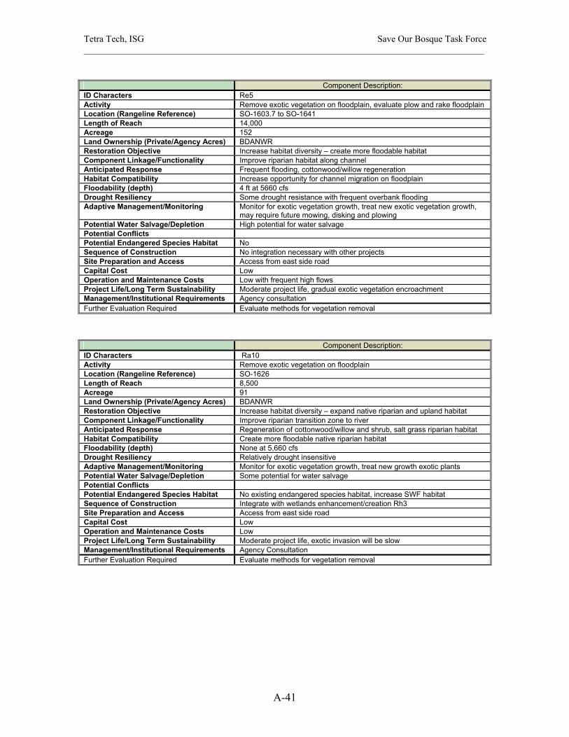
Tetra Tech, ISG Save Our Bosque Task Force ______________________________________________________________________________________
A-41
Component Description:
ID Characters Re5 Activity Remove exotic vegetation on floodplain, evaluate plow and rake floodplain Location (Rangeline Reference) SO-1603.7 to SO-1641 Length of Reach 14,000 Acreage 152 Land Ownership (Private/Agency Acres) BDANWR Restoration Objective Increase habitat diversity – create more floodable habitat Component Linkage/Functionality Improve riparian habitat along channel Anticipated Response Frequent flooding, cottonwood/willow regeneration Habitat Compatibility Increase opportunity for channel migration on floodplain Floodability (depth) 4 ft at 5660 cfs Drought Resiliency Some drought resistance with frequent overbank flooding Adaptive Management/Monitoring Monitor for exotic vegetation growth, treat new exotic vegetation growth,
may require future mowing, disking and plowing Potential Water Salvage/Depletion High potential for water salvage Potential Conflicts Potential Endangered Species Habitat No Sequence of Construction No integration necessary with other projects Site Preparation and Access Access from east side road Capital Cost Low Operation and Maintenance Costs Low with frequent high flows Project Life/Long Term Sustainability Moderate project life, gradual exotic vegetation encroachment Management/Institutional Requirements Agency consultation Further Evaluation Required Evaluate methods for vegetation removal
Component Description: ID Characters Ra10 Activity Remove exotic vegetation on floodplain Location (Rangeline Reference) SO-1626 Length of Reach 8,500 Acreage 91 Land Ownership (Private/Agency Acres) BDANWR Restoration Objective Increase habitat diversity – expand native riparian and upland habitat Component Linkage/Functionality Improve riparian transition zone to river Anticipated Response Regeneration of cottonwood/willow and shrub, salt grass riparian habitat Habitat Compatibility Create more floodable native riparian habitat Floodability (depth) None at 5,660 cfs Drought Resiliency Relatively drought insensitive Adaptive Management/Monitoring Monitor for exotic vegetation growth, treat new growth exotic plants Potential Water Salvage/Depletion Some potential for water salvage Potential Conflicts Potential Endangered Species Habitat No existing endangered species habitat, increase SWF habitat Sequence of Construction Integrate with wetlands enhancement/creation Rh3 Site Preparation and Access Access from east side road Capital Cost Low Operation and Maintenance Costs Low Project Life/Long Term Sustainability Moderate project life, exotic invasion will be slow Management/Institutional Requirements Agency Consultation Further Evaluation Required Evaluate methods for vegetation removal
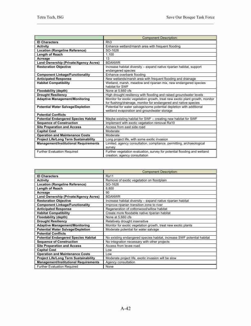
Tetra Tech, ISG Save Our Bosque Task Force ______________________________________________________________________________________
A-42
Component Description:
ID Characters Rh3 Activity Enhance wetland/marsh area with frequent flooding Location (Rangeline Reference) SO-1626 Length of Reach 1,100 Acreage 13 Land Ownership (Private/Agency Acres) BDANWR Restoration Objective Increase habitat diversity – expand native riparian habitat, support
endangered species Component Linkage/Functionality Enhance overbank flooding Anticipated Response New wetlands/marsh area with frequent flooding and drainage Habitat Compatibility Wetland, marsh, meadow and riparian mix, new endangered species
habitat for SWF Floodability (depth) None at 5,660 cfs Drought Resiliency High drought resiliency with flooding and raised groundwater levels Adaptive Management/Monitoring Monitor for exotic vegetation growth, treat new exotic plant growth, monitor
for flushing/drainage, monitor for endangered and native species Potential Water Salvage/Depletion Potential for water salvage/some potential depletion with additional
wetland evaporation and groundwater storage Potential Conflicts Potential Endangered Species Habitat Maybe existing habitat for SWF – creating new habitat for SWF Sequence of Construction Implement with exotic vegetation removal Ra10 Site Preparation and Access Access from east side road Capital Cost Moderate Operation and Maintenance Costs Moderate Project Life/Long Term Sustainability Long project life, with some exotic invasion Management/Institutional Requirements Limited, agency consultation, compliance, permitting, archaeological
survey Further Evaluation Required Further vegetation evaluation, survey for potential flooding and wetland
creation, agency consultation
Component Description: ID Characters Ra11 Activity Remove of exotic vegetation on floodplain Location (Rangeline Reference) SO-1626 Length of Reach 8,800 Acreage 90 Land Ownership (Private/Agency Acres) BDANWR Restoration Objective Increase habitat diversity – expand native riparian habitat Component Linkage/Functionality Improve riparian transition zone to river Anticipated Response Regeneration of cottonwood/willow habitat Habitat Compatibility Create more floodable native riparian habitat Floodability (depth) None at 5,660 cfs Drought Resiliency Relatively drought insensitive Adaptive Management/Monitoring Monitor for exotic vegetation growth, treat new exotic plants Potential Water Salvage/Depletion Moderate potential for water salvage Potential Conflicts Potential Endangered Species Habitat No existing endangered species habitat, increase SWF potential habitat Sequence of Construction No integration necessary with other projects Site Preparation and Access Access from levee road Capital Cost Low Operation and Maintenance Costs Low Project Life/Long Term Sustainability Moderate project life, exotic invasion will be slow Management/Institutional Requirements Agency consultation Further Evaluation Required None

Tetra Tech, ISG Save Our Bosque Task Force ______________________________________________________________________________________
A-43
Component Description:
ID Characters Ra12 Activity Removal exotic vegetation on floodplain Location (Rangeline Reference) D/S SO-1626 Length of Reach 2,700 Acreage 20 Land Ownership (Private/Agency Acres) BDANWR Restoration Objective Increase habitat diversity – expand native riparian habitat Component Linkage/Functionality Improve riparian transition zone to river Anticipated Response Regeneration of cottonwood/willow habitat and potential shrubs and salt
grass habitat, some upland vegetation Habitat Compatibility Create more floodable native riparian habitat Floodability (depth) None at 5,660 cfs Drought Resiliency Relatively drought insensitive Adaptive Management/Monitoring Monitor for exotic vegetation growth, treat new growth exotic plants Potential Water Salvage/Depletion Some potential for water salvage Potential Conflicts Potential Endangered Species Habitat No existing endangered species habitat, increase SWF potential habitat Sequence of Construction No integration necessary with other projects Site Preparation and Access Access from South Boundary BDANWR Capital Cost Low Operation and Maintenance Costs Low Project Life/Long Term Sustainability Moderate project life, exotic invasion will be slow Management/Institutional Requirements Agency consultation Further Evaluation Required Evaluate vegetation removal methods and equipment
Component Description: ID Characters Ra13 Activity Removal of exotic vegetation on floodplain Location (Rangeline Reference) U/S SO-1641 Length of Reach 2,100 Acreage 18 Land Ownership (Private/Agency Acres) BDANWR Restoration Objective Increase habitat diversity – expand native riparian habitat Component Linkage/Functionality Improve riparian transition zone to river Anticipated Response Regeneration of cottonwood/willow habitat and potential shrubs and salt
grass habitat, some upland vegetation Habitat Compatibility Create more floodable native riparian habitat Floodability (depth) None at 5,660 cfs Drought Resiliency Relatively drought insensitive Adaptive Management/Monitoring Monitor for exotic vegetation growth, treat new growth exotic plants Potential Water Salvage/Depletion Some potential for water salvage Potential Conflicts Potential Endangered Species Habitat No existing endangered species habitat, increase SWF potential habitat Sequence of Construction No integration necessary with other projects Site Preparation and Access Access from South Boundary BDANWR Capital Cost Low Operation and Maintenance Costs Low Project Life/Long Term Sustainability Moderate project life, exotic invasion will be slow Management/Institutional Requirements Agency consultation Further Evaluation Required Evaluate vegetation removal methods and equipment
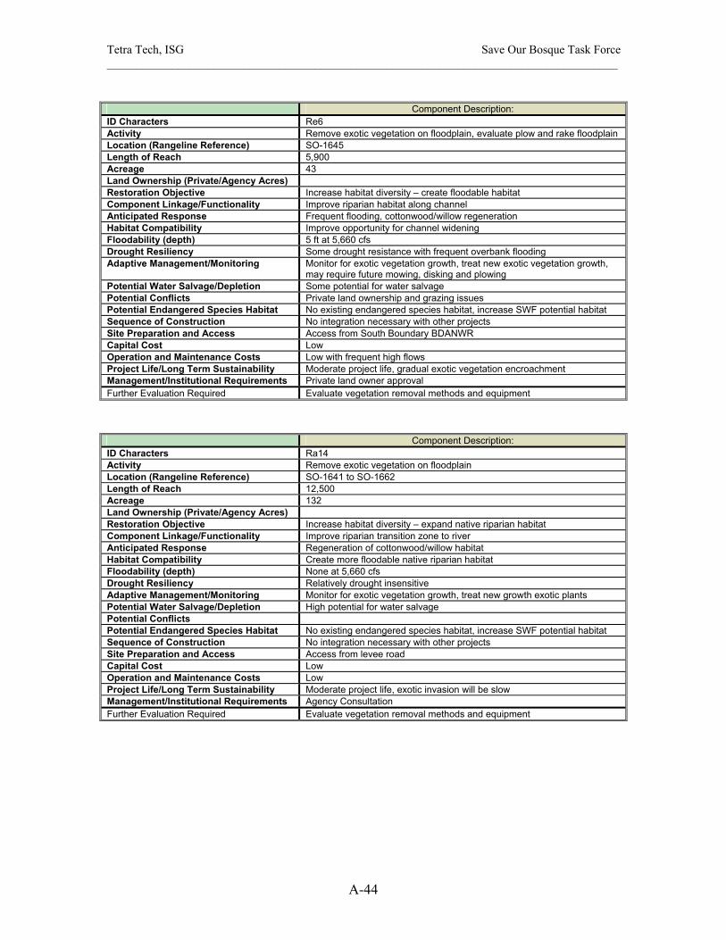
Tetra Tech, ISG Save Our Bosque Task Force ______________________________________________________________________________________
A-44
Component Description:
ID Characters Re6 Activity Remove exotic vegetation on floodplain, evaluate plow and rake floodplain Location (Rangeline Reference) SO-1645 Length of Reach 5,900 Acreage 43 Land Ownership (Private/Agency Acres) Restoration Objective Increase habitat diversity – create floodable habitat Component Linkage/Functionality Improve riparian habitat along channel Anticipated Response Frequent flooding, cottonwood/willow regeneration Habitat Compatibility Improve opportunity for channel widening Floodability (depth) 5 ft at 5,660 cfs Drought Resiliency Some drought resistance with frequent overbank flooding Adaptive Management/Monitoring Monitor for exotic vegetation growth, treat new exotic vegetation growth,
may require future mowing, disking and plowing Potential Water Salvage/Depletion Some potential for water salvage Potential Conflicts Private land ownership and grazing issues Potential Endangered Species Habitat No existing endangered species habitat, increase SWF potential habitat Sequence of Construction No integration necessary with other projects Site Preparation and Access Access from South Boundary BDANWR Capital Cost Low Operation and Maintenance Costs Low with frequent high flows Project Life/Long Term Sustainability Moderate project life, gradual exotic vegetation encroachment Management/Institutional Requirements Private land owner approval Further Evaluation Required Evaluate vegetation removal methods and equipment
Component Description: ID Characters Ra14 Activity Remove exotic vegetation on floodplain Location (Rangeline Reference) SO-1641 to SO-1662 Length of Reach 12,500 Acreage 132 Land Ownership (Private/Agency Acres) Restoration Objective Increase habitat diversity – expand native riparian habitat Component Linkage/Functionality Improve riparian transition zone to river Anticipated Response Regeneration of cottonwood/willow habitat Habitat Compatibility Create more floodable native riparian habitat Floodability (depth) None at 5,660 cfs Drought Resiliency Relatively drought insensitive Adaptive Management/Monitoring Monitor for exotic vegetation growth, treat new growth exotic plants Potential Water Salvage/Depletion High potential for water salvage Potential Conflicts Potential Endangered Species Habitat No existing endangered species habitat, increase SWF potential habitat Sequence of Construction No integration necessary with other projects Site Preparation and Access Access from levee road Capital Cost Low Operation and Maintenance Costs Low Project Life/Long Term Sustainability Moderate project life, exotic invasion will be slow Management/Institutional Requirements Agency Consultation Further Evaluation Required Evaluate vegetation removal methods and equipment
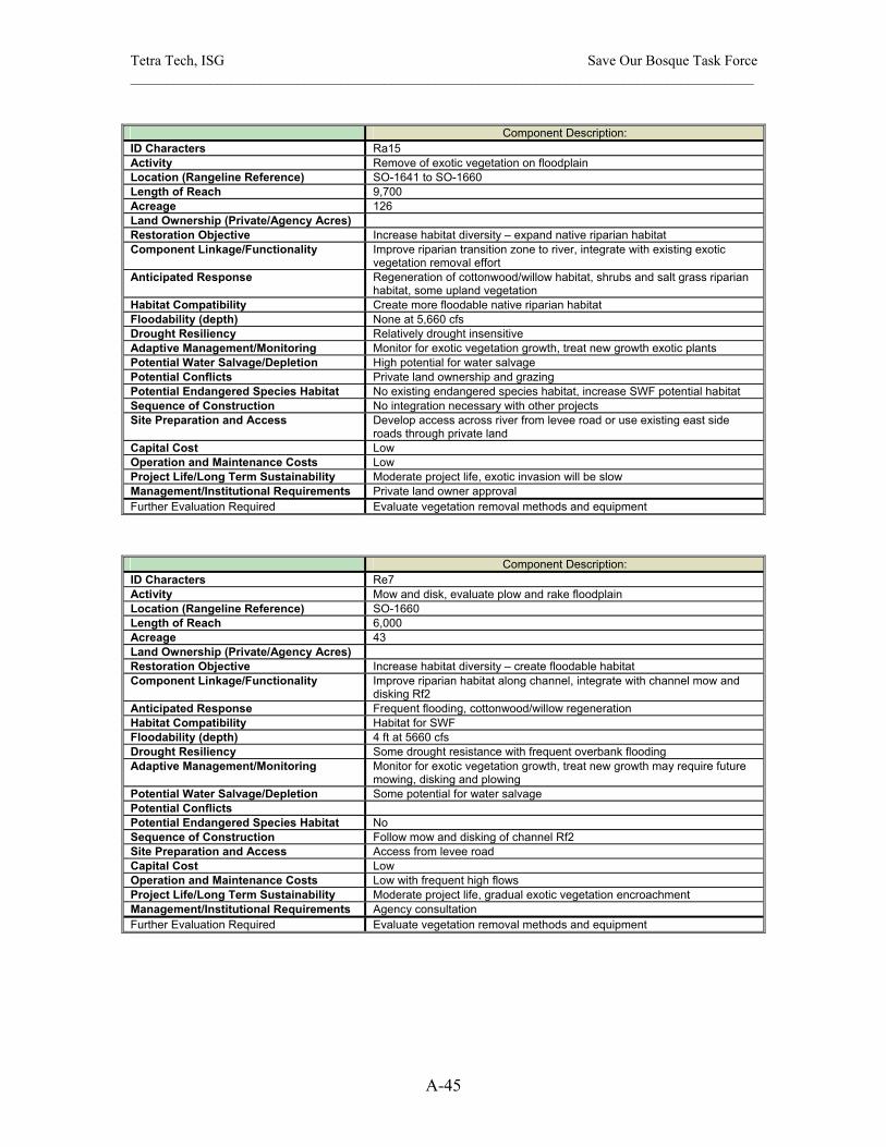
Tetra Tech, ISG Save Our Bosque Task Force ______________________________________________________________________________________
A-45
Component Description:
ID Characters Ra15 Activity Remove of exotic vegetation on floodplain Location (Rangeline Reference) SO-1641 to SO-1660 Length of Reach 9,700 Acreage 126 Land Ownership (Private/Agency Acres) Restoration Objective Increase habitat diversity – expand native riparian habitat Component Linkage/Functionality Improve riparian transition zone to river, integrate with existing exotic
vegetation removal effort Anticipated Response Regeneration of cottonwood/willow habitat, shrubs and salt grass riparian
habitat, some upland vegetation Habitat Compatibility Create more floodable native riparian habitat Floodability (depth) None at 5,660 cfs Drought Resiliency Relatively drought insensitive Adaptive Management/Monitoring Monitor for exotic vegetation growth, treat new growth exotic plants Potential Water Salvage/Depletion High potential for water salvage Potential Conflicts Private land ownership and grazing Potential Endangered Species Habitat No existing endangered species habitat, increase SWF potential habitat Sequence of Construction No integration necessary with other projects Site Preparation and Access Develop access across river from levee road or use existing east side
roads through private land Capital Cost Low Operation and Maintenance Costs Low Project Life/Long Term Sustainability Moderate project life, exotic invasion will be slow Management/Institutional Requirements Private land owner approval Further Evaluation Required Evaluate vegetation removal methods and equipment
Component Description: ID Characters Re7 Activity Mow and disk, evaluate plow and rake floodplain Location (Rangeline Reference) SO-1660 Length of Reach 6,000 Acreage 43 Land Ownership (Private/Agency Acres) Restoration Objective Increase habitat diversity – create floodable habitat Component Linkage/Functionality Improve riparian habitat along channel, integrate with channel mow and
disking Rf2 Anticipated Response Frequent flooding, cottonwood/willow regeneration Habitat Compatibility Habitat for SWF Floodability (depth) 4 ft at 5660 cfs Drought Resiliency Some drought resistance with frequent overbank flooding Adaptive Management/Monitoring Monitor for exotic vegetation growth, treat new growth may require future
mowing, disking and plowing Potential Water Salvage/Depletion Some potential for water salvage Potential Conflicts Potential Endangered Species Habitat No Sequence of Construction Follow mow and disking of channel Rf2 Site Preparation and Access Access from levee road Capital Cost Low Operation and Maintenance Costs Low with frequent high flows Project Life/Long Term Sustainability Moderate project life, gradual exotic vegetation encroachment Management/Institutional Requirements Agency consultation Further Evaluation Required Evaluate vegetation removal methods and equipment

Tetra Tech, ISG Save Our Bosque Task Force ______________________________________________________________________________________
A-46
Component Description:
ID Characters Rd4 Activity Mow and disc active channel Location (Rangeline Reference) SO-1660 Length of Reach 6,500 Acreage 45 Land Ownership (Private/Agency Acres) Restoration Objective Enhance river function and river dynamics, improve aquatic habitat Component Linkage/Functionality Keep channel active, increase width-to-depth ratio Anticipated Response Wider channel with exposed sandbars, sandbar mobility Habitat Compatibility Increase backwater and slow habitat areas for silvery minnow Floodability (depth) 4 ft at 5660 cfs Drought Resiliency Vegetation encroachment if 3 years without high flows Adaptive Management/Monitoring Monitor for vegetation encroachment and sedimentation, may require
future mowing, disking and plowing Potential Water Salvage/Depletion Some potential for water salvage Potential Conflicts Potential Endangered Species Habitat Existing habitat for silvery minnow – aquatic habitat improvement Sequence of Construction Should be one of the first restoration activity implemented in subreach Site Preparation and Access Access to river from levee road Capital Cost Low Operation and Maintenance Costs Low Project Life/Long Term Sustainability Moderate project life, exotic vegetation encroachment and sedimentation
could occur over a three year period with the right conditions Management/Institutional Requirements Agency consultation Further Evaluation Required Evaluate vegetation removal methods and equipment
Component Description: ID Characters Rg4 Activity Secondary/pilot channel in Tiffany Junction Location (Rangeline Reference) Tiffany Junction Length of Reach 17,500 Acreage 337 Land Ownership (Private/Agency Acres) Restoration Objective Increase habitat diversity – create wetlands Component Linkage/Functionality Flood with frequent high flows Anticipated Response Restore Tiffany Junction with high flows from river Habitat Compatibility Increase backwater habitat areas for silvery minnow Floodability (depth) Drought Resiliency High drought resistance with frequent flooding Adaptive Management/Monitoring Monitor for vegetation encroachment and sedimentation, may require
channel dredging to maintain connectivity Potential Water Salvage/Depletion Increased losses with open surface water evaporation, groundwater
seepage to LFCC Potential Conflicts None Potential Endangered Species Habitat Possible SWF habitat Sequence of Construction Combine with wetlands creation in Tiffany Junction Site Preparation and Access Access from levee road Capital Cost High Operation and Maintenance Costs High Project Life/Long Term Sustainability Low project life, exotic vegetation encroachment and sedimentation could
occur in one year with the right conditions Management/Institutional Requirements Significant requirements, design, consultation, compliance, permitting Further Evaluation Required Survey for the secondary/pilot channel and wetlands water surface
elevation, perform more detailed flood analysis

Tetra Tech, ISG Save Our Bosque Task Force ______________________________________________________________________________________
A-47
Component Description:
ID Characters Re8 Activity Remove exotic vegetation on floodplain, evaluate plow and rake floodplain Location (Rangeline Reference) SO-1663 to S0-1673 Length of Reach 3,900 Acreage 32 Land Ownership (Private/Agency Acres) Restoration Objective Increase habitat diversity – create floodable habitat Component Linkage/Functionality Improve riparian habitat along channel, integrate with channel mow and
disking Rf2 Anticipated Response Frequent flooding, cottonwood/willow regeneration Habitat Compatibility Habitat for SWF Floodability (depth) 6 ft at 5,660 cfs Drought Resiliency Some drought resistance with frequent overbank flooding Adaptive Management/Monitoring Monitor for exotic vegetation growth, treat new growth may require future
mowing, disking and plowing Potential Water Salvage/Depletion Some potential for water salvage Potential Conflicts Private land ownership and grazing Potential Endangered Species Habitat Potential habitat for SWF Sequence of Construction Follow mow and disking of channel Rd3 Site Preparation and Access Develop access across river from levee road or use east side road through
private land Capital Cost Low Operation and Maintenance Costs Low Project Life/Long Term Sustainability Moderate project life, gradual exotic vegetation encroachment Management/Institutional Requirements Private land owner approval Further Evaluation Required Evaluate vegetation removal methods and equipment
Component Description: ID Characters Ra16 Activity Remove exotic vegetation on floodplain Location (Rangeline Reference) SO-1660 to S0-1673 Length of Reach 5,800 Acreage 125 Land Ownership (Private/Agency Acres) Restoration Objective Increase habitat diversity – expand native riparian habitat Component Linkage/Functionality Improve riparian transition zone to river, some exotic vegetation removal
has occurred Anticipated Response Regeneration of cottonwood/willow and shrub and salt grass riparian
habitat Habitat Compatibility Create more floodable native riparian habitat Floodability (depth) None at 5,660 cfs Drought Resiliency Relatively drought insensitive Adaptive Management/Monitoring Monitor for exotic vegetation growth, treat new growth exotic plants Potential Water Salvage/Depletion High potential for water salvage Potential Conflicts Private land ownership Potential Endangered Species Habitat Maybe existing SWF habitat - enhance riparian habitat for SWF Sequence of Construction Follow mow and disking of channel Rd3, combine with floodplain Evaluate
plow and rake Re8 Site Preparation and Access Access from east side roads across private land Capital Cost Low Operation and Maintenance Costs Low Project Life/Long Term Sustainability Moderate project life, exotic invasion will be slow Management/Institutional Requirements Private land owner approval Further Evaluation Required Evaluate vegetation removal methods and equipment

Tetra Tech, ISG Save Our Bosque Task Force ______________________________________________________________________________________
A-48
Component Description:
ID Characters Re9 Activity Remove exotic vegetation on floodplain, Evaluate plow and rake floodplain Location (Rangeline Reference) SO-1683 to S0-1692 Length of Reach 9,500 Acreage 156 Land Ownership (Private/Agency Acres) Restoration Objective Increase habitat diversity – create floodable habitat Component Linkage/Functionality Improve riparian habitat along channel Anticipated Response Frequent flooding, cottonwood/willow regeneration Habitat Compatibility Create more overbank flooding and flooded bottomlands Floodability (depth) 5 ft at 5,660 cfs Drought Resiliency Some drought resistance with frequent overbank flooding Adaptive Management/Monitoring Monitor for exotic vegetation growth, treat new growth may require future
mowing, disking and plowing Potential Water Salvage/Depletion Moderate potential for water salvage Potential Conflicts Private land ownership and grazing Potential Endangered Species Habitat Maybe existing habitat for SWF, enhance the native riparian habitat Sequence of Construction Integrate with wetlands development Rh4 Site Preparation and Access Develop access across river from levee road or use east side road through
private land Capital Cost Low Operation and Maintenance Costs Low Project Life/Long Term Sustainability Moderate project life, gradual exotic vegetation encroachment Management/Institutional Requirements Private land owner approval Further Evaluation Required Evaluate vegetation removal methods and equipment
Component Description: ID Characters Ra18 Activity Removal of exotic vegetation on floodplain Location (Rangeline Reference) SO-1683 Length of Reach 7,900 Acreage 196 Land Ownership (Private/Agency Acres) Restoration Objective Increase habitat diversity – expand native riparian habitat Component Linkage/Functionality Improve SWF habitat in existing exotic vegetation stands Anticipated Response Regeneration of cottonwood/willow habitat and salt grass meadows Habitat Compatibility Create more desirable and floodable native riparian habitat Floodability (depth) 0 to 1.5 at 5,660 cfs Drought Resiliency Relatively drought insensitive Adaptive Management/Monitoring Monitor for exotic vegetation growth, treat new growth exotic plants Potential Water Salvage/Depletion High potential for water salvage Potential Conflicts Private land ownership and grazing Potential Endangered Species Habitat Existing SWF habitat Sequence of Construction Combine with floodplain evaluate plow and rake Rg10 and wetlands
creation Rh4 Site Preparation and Access Develop access across river from levee road Capital Cost Low Operation and Maintenance Costs Low Project Life/Long Term Sustainability Moderate project life, exotic invasion may be fast with frequent flooding Management/Institutional Requirements Private land owner approval Further Evaluation Required Evaluate vegetation removal methods and equipment
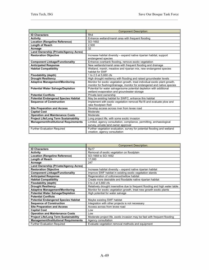
Tetra Tech, ISG Save Our Bosque Task Force ______________________________________________________________________________________
A-49
Component Description:
ID Characters Rh4 Activity Enhance wetland/marsh area with frequent flooding Location (Rangeline Reference) SO-1692 Length of Reach 2,500 Acreage 32 Land Ownership (Private/Agency Acres) Restoration Objective Increase habitat diversity – expand native riparian habitat, support
endangered species Component Linkage/Functionality Enhance overbank flooding, remove exotic vegetation Anticipated Response New wetlands/marsh area with frequent flooding and drainage Habitat Compatibility Wetland, marsh, meadow and riparian mix, new endangered species
habitat for SWF Floodability (depth) 1 to 2.5 at 5,660 cfs Drought Resiliency High drought resiliency with flooding and raised groundwater levels Adaptive Management/Monitoring Monitor for exotic vegetation growth, treat individual exotic plant growth,
monitor for flushing/drainage, monitor for endangered and native species Potential Water Salvage/Depletion Potential for water salvage/some potential depletion with additional
wetland evaporation and groundwater storage Potential Conflicts Private land ownership Potential Endangered Species Habitat May be existing habitat for SWFC, enhance this habitat Sequence of Construction Implement with exotic vegetation removal Ra18 and evaluate plow and
rake floodplain Re9 Site Preparation and Access Develop access across river from levee road Capital Cost Moderate Operation and Maintenance Costs Moderate Project Life/Long Term Sustainability Long project life, with some exotic invasion Management/Institutional Requirements Limited, agency consultation, compliance, permitting, archaeological
survey, private land owner approval Further Evaluation Required Further vegetation evaluation, survey for potential flooding and wetland
creation, agency consultation
Component Description: ID Characters Ra17 Activity Removal of exotic vegetation on floodplain Location (Rangeline Reference) SO-1668 to SO-1692 Length of Reach 17,000 Acreage 247 Land Ownership (Private/Agency Acres) Restoration Objective Increase habitat diversity – expand native riparian habitat Component Linkage/Functionality Improve SWF habitat in existing exotic vegetation stands Anticipated Response Regeneration of cottonwood/willow habitat Habitat Compatibility Create more desirable and floodable native riparian habitat Floodability (depth) 0 to 2 at 5,660 cfs Drought Resiliency Relatively drought insensitive due to frequent flooding and high water table Adaptive Management/Monitoring Monitor for exotic vegetation growth, treat new growth exotic plants Potential Water Salvage/Depletion High potential for water salvage Potential Conflicts Potential Endangered Species Habitat Maybe existing SWF habitat Sequence of Construction Integration with other projects is not necessary Site Preparation and Access Access across from levee road Capital Cost Low Operation and Maintenance Costs Low Project Life/Long Term Sustainability Moderate project life, exotic invasion may be fast with frequent flooding Management/Institutional Requirements Agency consultation Further Evaluation Required Evaluate vegetation removal methods and equipment

Tetra Tech, ISG Save Our Bosque Task Force ______________________________________________________________________________________
A-50
Component Description:
ID Characters Ra19 Activity Removal of exotic vegetation on floodplain Location (Rangeline Reference) Tiffany Junction Length of Reach 17,000 Acreage 222 Land Ownership (Private/Agency Acres) Restoration Objective Increase habitat diversity – expand native riparian habitat Component Linkage/Functionality Improve SWF habitat in existing exotic vegetation stands Anticipated Response Regeneration of cottonwood/willow habitat Habitat Compatibility Create more desirable and floodable native riparian habitat Floodability (depth) Unknown Drought Resiliency Relatively drought insensitive due to frequent flooding and high water table Adaptive Management/Monitoring Monitor for exotic vegetation growth, treat new growth exotic plants Potential Water Salvage/Depletion High potential for water salvage Potential Conflicts Potential Endangered Species Habitat Maybe existing SWF habitat Sequence of Construction Combine with wetlands and secondary channel creation in Tiffany Junction Site Preparation and Access Access across from levee road Capital Cost Low Operation and Maintenance Costs Low Project Life/Long Term Sustainability Moderate project life, exotic invasion may be fast with frequent flooding Management/Institutional Requirements Agency consultation Further Evaluation Required Evaluate vegetation removal methods and equipment
Component Description: ID Characters Ra20 Activity Removal of exotic vegetation on floodplain Location (Rangeline Reference) Tiffany Junction Length of Reach 10,500 Acreage 1,250 Land Ownership (Private/Agency Acres) Restoration Objective Increase habitat diversity – expand native riparian habitat Component Linkage/Functionality Improve SWF habitat in existing exotic vegetation stands Anticipated Response Regeneration of cottonwood/willow habitat Habitat Compatibility Create more desirable and floodable native riparian habitat Floodability (depth) Unknown Drought Resiliency Relatively drought insensitive due to frequent flooding and high water table Adaptive Management/Monitoring Monitor for exotic vegetation growth, treat new growth exotic plants Potential Water Salvage/Depletion High potential for water salvage Potential Conflicts Potential Endangered Species Habitat Maybe existing SWF habitat Sequence of Construction Combine with wetlands and secondary channel creation in Tiffany Junction Site Preparation and Access Access across from levee road Capital Cost Low Operation and Maintenance Costs Low Project Life/Long Term Sustainability Moderate project life, exotic invasion may be fast with frequent flooding Management/Institutional Requirements Agency consultation Further Evaluation Required Evaluate vegetation removal methods and equipment
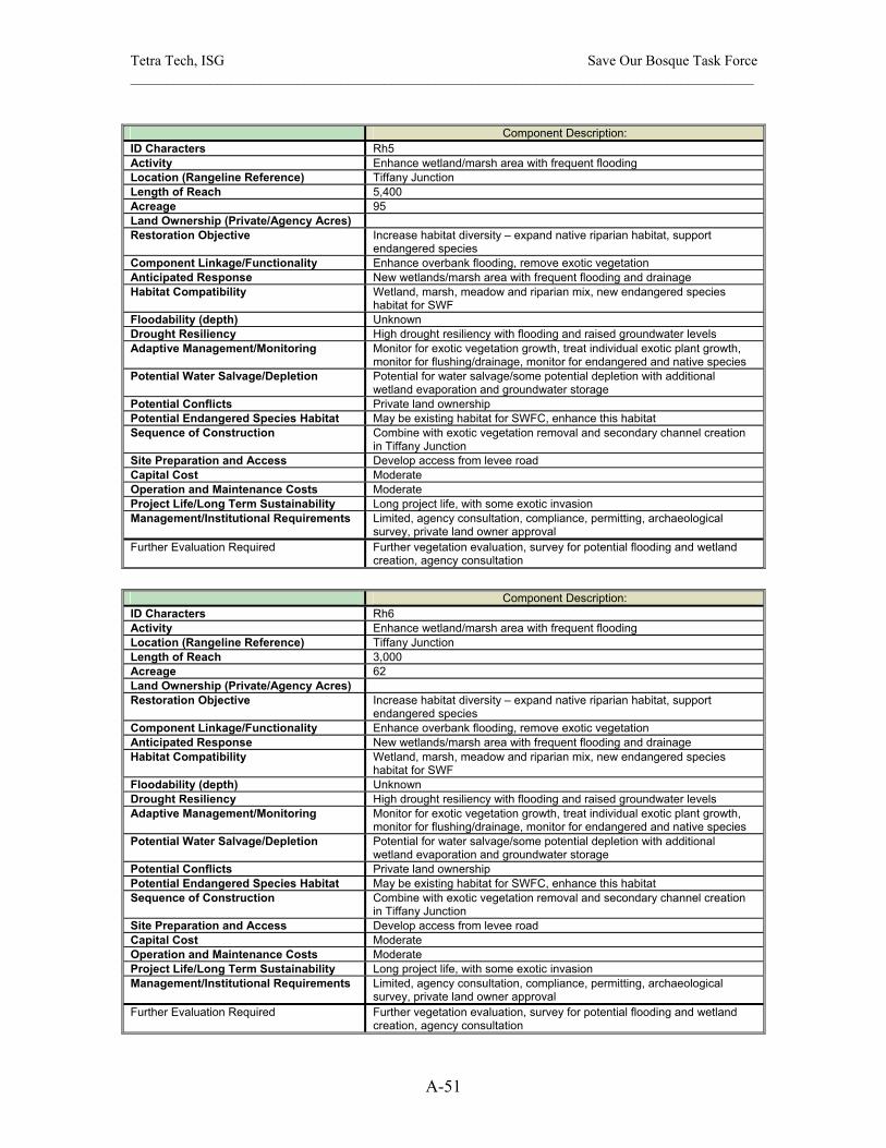
Tetra Tech, ISG Save Our Bosque Task Force ______________________________________________________________________________________
A-51
Component Description:
ID Characters Rh5 Activity Enhance wetland/marsh area with frequent flooding Location (Rangeline Reference) Tiffany Junction Length of Reach 5,400 Acreage 95 Land Ownership (Private/Agency Acres) Restoration Objective Increase habitat diversity – expand native riparian habitat, support
endangered species Component Linkage/Functionality Enhance overbank flooding, remove exotic vegetation Anticipated Response New wetlands/marsh area with frequent flooding and drainage Habitat Compatibility Wetland, marsh, meadow and riparian mix, new endangered species
habitat for SWF Floodability (depth) Unknown Drought Resiliency High drought resiliency with flooding and raised groundwater levels Adaptive Management/Monitoring Monitor for exotic vegetation growth, treat individual exotic plant growth,
monitor for flushing/drainage, monitor for endangered and native species Potential Water Salvage/Depletion Potential for water salvage/some potential depletion with additional
wetland evaporation and groundwater storage Potential Conflicts Private land ownership Potential Endangered Species Habitat May be existing habitat for SWFC, enhance this habitat Sequence of Construction Combine with exotic vegetation removal and secondary channel creation
in Tiffany Junction Site Preparation and Access Develop access from levee road Capital Cost Moderate Operation and Maintenance Costs Moderate Project Life/Long Term Sustainability Long project life, with some exotic invasion Management/Institutional Requirements Limited, agency consultation, compliance, permitting, archaeological
survey, private land owner approval Further Evaluation Required Further vegetation evaluation, survey for potential flooding and wetland
creation, agency consultation
Component Description:
ID Characters Rh6 Activity Enhance wetland/marsh area with frequent flooding Location (Rangeline Reference) Tiffany Junction Length of Reach 3,000 Acreage 62 Land Ownership (Private/Agency Acres) Restoration Objective Increase habitat diversity – expand native riparian habitat, support
endangered species Component Linkage/Functionality Enhance overbank flooding, remove exotic vegetation Anticipated Response New wetlands/marsh area with frequent flooding and drainage Habitat Compatibility Wetland, marsh, meadow and riparian mix, new endangered species
habitat for SWF Floodability (depth) Unknown Drought Resiliency High drought resiliency with flooding and raised groundwater levels Adaptive Management/Monitoring Monitor for exotic vegetation growth, treat individual exotic plant growth,
monitor for flushing/drainage, monitor for endangered and native species Potential Water Salvage/Depletion Potential for water salvage/some potential depletion with additional
wetland evaporation and groundwater storage Potential Conflicts Private land ownership Potential Endangered Species Habitat May be existing habitat for SWFC, enhance this habitat Sequence of Construction Combine with exotic vegetation removal and secondary channel creation
in Tiffany Junction Site Preparation and Access Develop access from levee road Capital Cost Moderate Operation and Maintenance Costs Moderate Project Life/Long Term Sustainability Long project life, with some exotic invasion Management/Institutional Requirements Limited, agency consultation, compliance, permitting, archaeological
survey, private land owner approval Further Evaluation Required Further vegetation evaluation, survey for potential flooding and wetland
creation, agency consultation
