week 2 lecture notes 2/6/20 -...
TRANSCRIPT

Week 2 Lecture Notes 2/6/20
Topics Discussed:
- Weather review - Weather impacts and disasters - Latitude and longitude - Weather basics - Storms - Remote sensing – satellite images, weather radar - Watches and warnings
• Weather impacts and disasters - A natural disaster is an event in which the forces of claim human lives or destroy the
fruits of human labor on a large scale (Zebrowski pg. 19) - Weather related events cause an estimated 10 billion in property damage annually in the
US - Approx. 1/3 of the US economy is weather sensitive - Virtually no part of the globe is free of the threat of extreme weather
- During the last 3 years (2017-2019) there have been more than 10 billion-dollar disasters • Latitude and longitude - Any point of the earth can be defined either latitude or longitude - Latitude (up and down), Longitude (horizontal) - Lines of longitude go around the earth zero-degree longitude goes through London - SF – 122.4 degrees west.

- When latitude is positive is eastern hemisphere: 37.6b degrees - Negative in the southern hemisphere - Western hemisphere is negative sign! -122.4 degrees - Latitude tells us north or south - Longitude tells us west or east
- You can find the latitude and longitude for different places by going to:
https://getlatlong.net/ For example, type in: San Francisco International Airport

• Weather basics ** - Air is a fluid (gas, liquid, solid) - Warm air always rises - Air always flows from High to Low pressure - Differential (different) heating drives the weather …Tropic areas get more heat compared
to polar region (hot air rises at, cold air sinks) - Rising air cools by expansion… and cooling causes condensation to occur - Sinking air warms by compression…and warming causes evaporation to occurs
Atmospheric Properties - Weather elements:
o Air temperature o Air pressure o Wind o Humidity o Clouds o Precipitation o Visibility
• Temperature - Average speed of the atoms and molecules
o Hot = fast
o Cold = slow (absolute zero) - Temperate scales
o Celsius (C) o Kelvin (K) o Fahrenheit (F)
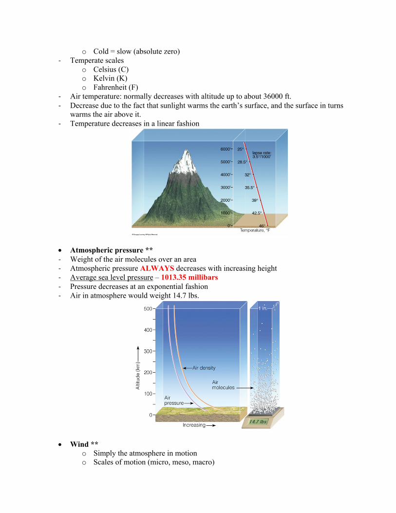
- Air temperature: normally decreases with altitude up to about 36000 ft. - Decrease due to the fact that sunlight warms the earth’s surface, and the surface in turns
warms the air above it. - Temperature decreases in a linear fashion
• Atmospheric pressure ** - Weight of the air molecules over an area - Atmospheric pressure ALWAYS decreases with increasing height - Average sea level pressure – 1013.35 millibars - Pressure decreases at an exponential fashion - Air in atmosphere would weight 14.7 lbs.
• Wind ** o Simply the atmosphere in motion o Scales of motion (micro, meso, macro)

o Measurement: speed and direction o Blow from higher pressure toward lower o Northern hemisphere
§ Blow clockwise and outward around high pressure § Counterclockwise and inward around low pressure
- Wind directions – always want to label the wind from where it blows - Wind flows toward low pressure. Note: rising air above low pressure - As wind rises à condensation occurs à clouds forms (clouds associated with low
pressure
Atmosphere basics
• Moisture * - Clouds and precipitation
o Associated with surface low pressure o Rising air
- Clear skies o With surface high pressure o Sinking air
- Relative humidity o Not amount of water vapor o How close air is to being saturated
- Dew point temperature o Temperature to which air have to be cooled in order for saturation (i.e.
condensation/clouds) to occur - Three states of matter: gas, liquid, ice
• Rising air causes clouds/ precipitation *
o Beings with a parcel of air o Air rises expands and cools o Cools to “dew point” temperature then… o Condensation occurs
- Opposite with sinking air o Compresses and warms
- Types of precipitation

o Rain o Snow o Hail o Sleet/ice pellets o Graupel
• Storms - Any organized disturbed state (implying a departure from a quiescent state) of
the atmosphere, especially as affecting the earth's surface and strongly implying destructive or otherwise unpleasant weather.
- In meteorology, a storm is a complete, organized individual, three dimensional disturbance identified on synoptic charts as an organized complex of pressure, wind, clouds, precipitation, etc...
- Thus, storms range in scale from tornadoes and thunderstorms, through tropical cyclones, to widespread extratropical wave cyclones
• Tropical cyclones - Organization of different weather. - Generic term for a "severe" nonfrontal synoptic-scale cyclone orginating over tropical or
subtropical waters. Such storms are differentiated from extratropical cyclones by having warm cores (as opposed to warm and cold sectors).
- They are also associated with organized convection having definite counterclockwise surface wind circulation, often observable in cloud motions and features. In early stages, tropical cyclones move from east to west in the broad zone of the prevailing easterlies.
- Additional classification of tropical cyclones is made depending upon organization and wind speed.
- (A hurricane is an intense tropical cyclone with maximum 1-minute sustained surface wind greater than 64 knots [74 mph]). All tropical storms are comprised of clusters of thunderstorms, many or most are severe
- Typically move from east to west.
• Tornados - A small mass of air (whirlwind) that spins rapidly about an almost vertical axis and forms
a funnel cloud that contacts the ground; appears as a pendant from a cumulonimbus cloud and is potentially the most destructive of all weather systems. All tornadoes are associated with thunderstorms (which, by definition, are severe).

Tornado Near Miami TX May 28, 1994 Remote weather sensing
• Remote sensing - Weather stations
o Surface conditions - Radiosondes
o Vertical weather conditions - Radar = basically where the rain or precipitation is in the atmosphere!
o Reflectively of rain drops - Profilers
o Vertical profile of wind and temp - Satellite imaginary = Clouds
o Downward looking imagery - Lighting detection
• Visualizing storms - In order to view weather over the oceans we rely on satellites images sent to us by
weather satellites. These satellites are positioned above the equator at a constant distance from earth and orbit at the same rate of speed that the Earth rotates. They remain over the same location constantly and are termed “geo-stationary” satellites.
Two types of satellite images include: - Visible images:
o The satellites are capable of sensing visible radiation (light) from the sun which reflected by clouds). In the day time clouds reflect visible solar radiation to space. At night time he sun’s solar radiation is absent and visible imagery shows nothing.
- Less ice = less refection to space.
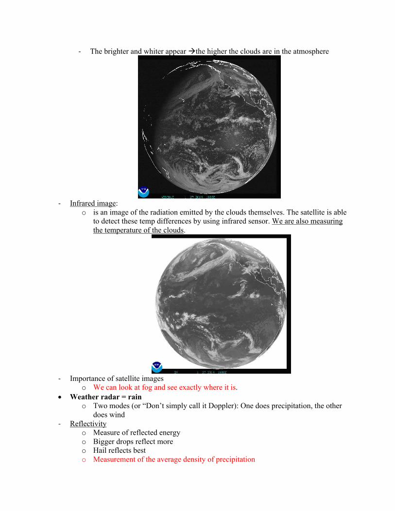
- The brighter and whiter appear àthe higher the clouds are in the atmosphere
- Infrared image:
o is an image of the radiation emitted by the clouds themselves. The satellite is able to detect these temp differences by using infrared sensor. We are also measuring the temperature of the clouds.
- Importance of satellite images
o We can look at fog and see exactly where it is. • Weather radar = rain
o Two modes (or “Don’t simply call it Doppler): One does precipitation, the other does wind
- Reflectivity o Measure of reflected energy o Bigger drops reflect more o Hail reflects best o Measurement of the average density of precipitation

- Velocity (Doppler) o Change in frequency due to relative motion o A sound wave frequency change is noticed as a pitch change o We can pinpoint where the tornado is
• NWS Watches and warnings - The “watch” is issued if conditions in a general area are expected to be favorable for the
given hazardous weather to occur about 12 hours in advance - The “warning” is issued is the given hazardous weather is occurring, has been observed
and cover should be taken immensely. HAPPENING NOW. Reading Assignments For weeks 3 & 4: THU, FEB. 13th & 20th
1. Pielke and Pielke; Up through Chp 1 (Point of view: societal impacts should partially dictate the direction of scientific research and governmental response)
2. Simmons and Sutter: Foreward and Chp 1(Point of view: societal impacts should partially dictate the direction of scientific research and governmental response)
3. Williams: Chp 2; Chapter 3 (up through p. 36); Chapter 5, 63-72; Chapter 9 (Hurricanes) 4. Zebrowski: Chapter 2 (Point of view; how the scientists do research--the scientific
method)