waves of destruction in the east indies: the wichmann...
TRANSCRIPT

Waves of destruction in the East Indies: the Wichmann
catalogue of earthquakes and tsunami in the
Indonesian region from 1538 to 1877
RON HARRIS1* & JONATHAN MAJOR1,2
1Department of Geological Sciences, Brigham Young University, Provo,
UT 84602–4606, USA2Present address: Bureau of Economic Geology, The University of Texas at Austin,
Austin, TX 78758, USA
*Corresponding author (e-mail: [email protected])
Abstract: The two volumes of Arthur Wichmann’s Die Erdbeben Des Indischen Archipels [TheEarthquakes of the Indian Archipelago] (1918 and 1922) document 61 regional earthquakes and 36tsunamis between 1538 and 1877 in the Indonesian region. The largest and best documented are theevents of 1770 and 1859 in the Molucca Sea region, of 1629, 1774 and 1852 in the Banda Searegion, the 1820 event in Makassar, the 1857 event in Dili, Timor, the 1815 event in Bali and Lom-bok, the events of 1699, 1771, 1780, 1815, 1848 and 1852 in Java, and the events of 1797, 1818,1833 and 1861 in Sumatra. Most of these events caused damage over a broad region, and are asso-ciated with years of temporal and spatial clustering of earthquakes. The earthquakes left many cit-ies in ‘rubble heaps’. Some events spawned tsunamis with run-up heights .15 m that swept manycoastal villages away.
2004 marked the recurrence of some of these events in western Indonesia. However, there hasnot been a major shallow earthquake (M ≥ 8) in Java and eastern Indonesia for the past 160 years.During this time of relative quiescence, enough tectonic strain energy has accumulated across sev-eral active faults to cause major earthquake and tsunami events, such as those documented in thehistorical records presented here. The disaster potential of these events is much greater now than inthe past due to exponential growth in population and urbanization in areas destroyed by past events.
Supplementary material: Translation of the catalogues into English, scanned PDFs of the originalcatalogues and geographical locations of most place names found in the catalogue (as a KMZ file)are available at https://dx.doi.org/10.6084/m9.figshare.c.2860405.v1
Recent earthquake catastrophes in Japan (2011),Haiti (2010) and Chengdu, China (2008) all occurredin regions mapped as relatively ‘low’ seismic hazard(Stein et al. 2012). One factor contributing tothis forecasting failure is the over-reliance on therelatively short (50 year) instrumental earthquakerecord. Although historical records of centuriesof seismic events exist in these regions, they wererarely used in hazard assessments. Reliable datafrom historical accounts of earthquake and tsunamievents can help constrain long-term seismic poten-tial in areas with little to no earthquakes duringthe past 50 years (Musson & Jimenez 2008).
An example of earthquake and tsunami fore-casting success using historical records is the recon-struction by Newcomb & McCann (1987) ofmega-thrust events along the Sumatran subductionzone. They primarily used Die Erdbeben Des Indis-chen Archipels [The Earthquakes of the IndianArchipelago] by Arthur Wichmann (1918, 1922) to
demonstrate that a series of megathrust earthquakesoccurred during the nineteenth century along vari-ous segments of the subduction zone. Some of theseevents have now reoccurred, such as the 2005 north-ern Sumatra earthquake near Nias Island, which wasnearly of the same magnitude and ruptured close tothe same area as that estimated by Newcomb &McCann (1987) from descriptions in the Wichmanncatalogue of an 1861 earthquake and tsunami (seeSupplementary material).
Arthur Wichmann was a German geologist andprofessor in geology at Utrecht University in theNetherlands. Much of Wichmann’s professionalcareer was spent studying the geology of Indonesia,including several expeditions to eastern Indonesia.He wrote the catalogue in old German, but includedpassages in Dutch, English, French and Latin. It isevident that Wichmann tried to preserve and use theoriginal accounts as much as possible. However, hewas careful to note conflicting reports, errors in dates
From: Cummins, P. R. & Meilano, I. (eds) Geohazards in Indonesia: Earth Science for Disaster Risk Reduction.Geological Society, London, Special Publications, 441, http://doi.org/10.1144/SP441.2# 2016 The Author(s). Published by The Geological Society of London. All rights reserved.For permissions: http://www.geolsoc.org.uk/permissions. Publishing disclaimer: www.geolsoc.org.uk/pub_ethics
by guest on May 24, 2016http://sp.lyellcollection.org/Downloaded from

and other inconsistencies. The catalogue includes350 years of observations of earthquakes and tsuna-mis, and some volcanic eruptions for the entireIndonesian region (see Supplementary material).
The observations were mostly compiled fromDutch records kept by the Dutch East India Com-pany of Indonesia (Vereenigde Oost-Indische Com-pagnie: VOC). Seismic events are included thatreach west to east from the Cocos Islands to NewGuinea, and north to south from Bangladesh toTimor. Although the catalogue is cited in sometsunami and earthquake databases (i.e. Soloviev &Go 1974), it remains largely unknown to the scien-tific community (i.e. Hamzah et al. 2000; Rastogi &Jaiswal 2006). For this reason, we have translatedthe catalogue into English and supplied scannedPDFs of the original; these are included in the Sup-plementary material to this paper.
For ease of comparison and consistency, theEnglish translation is formatted and paginated in thesame way as the original document. Footnotes withabbreviations used and works commonly cited areincluded with the translation. The Index, containingmostly locations, was not translated and so readersshould refer to the original catalogue. Volume IIalso contains a list of additions and corrections forthe previous volume. We have also included geo-graphical locations of nearly all the place namesfound in the catalogue as a KMZ file (see Supple-mentary material).
The number of entries in the catalogue increasestowards the end (1877), which reflects, to someextent, the increasing number of observation posts.However, many of the events in the later part ofthe catalogue are also the result of temporal and spa-tial clustering from a few extreme events, such asmegathrust earthquakes in Sumatra, Java and east-ern Indonesia. Other clusters may be associatedwith eruptions of Tambora and precursor events tothe eruption of Krakatoa, which happened shortlyafter the end date of the catalogue. Events associ-ated with the collapse of buildings, tsunamis (floodwaves) and fatalities are highlighted by bold text inthe catalogue.
Most of the locations listed in the cataloguewhere major earthquakes or tsunamis occurredhave experienced a dramatic increase in populationand urbanization (see the maps of Padang in Nata-widjaja et al. 2006). To make the catalogue accessi-ble to those actually in harm’s way, we haveworked with Indonesian geoscientists to translatelarge parts of it into Indonesian. For example, thesections of the catalogue for the Maluku and NusaTenggara regions have already been translated intoIndonesian, and updated to include earthquakesand tsunamis to 2010. In November 2013, the Indo-nesian version of the catalogue was distributedthroughout some of the most vulnerable areas of
eastern Indonesia by ‘In Harm’s Way’, a non-profitorganization for natural disaster prevention(inharmswayhelp.org).
During the time covered by the catalogue(1538–1877), the population of Indonesia doubledfrom 15 million to 30 million. Since 1877, the pop-ulation has increased by nearly an order of magni-tude and is projected to reach 300 million by2030. At least 94% of the population of Indonesialives in active seismic and volcanic regions, or intsunami inundation zones. However, from our expe-rience of conducting informal surveys throughoutJava and eastern Indonesia over the past 25 years,for most Indonesians, their sense of history, espe-cially regarding natural disasters, is limited to theliving memory of the oldest residents of each area.One factor that is likely to contribute to the lack ofawareness is a distinct lull in seismic and tsunamiactivity in the region between 1883, when Krakatoaerupted, and the recent past (Ghose & Oike 1988).Another problem is that historical records of pastevents in Indonesia are not available to those inharm’s way (Harris et al. 1997; Harris & Prasetyadi2002). These problems contributed to the disasterpotential of recent earthquakes such as the BandaAceh event and other earthquakes during the past10 years.
Many of the events documented in the Wich-mann catalogue have reoccurred in western Indone-sia during the past decade and account for around200 000 fatalities. However, in eastern Indonesia,seismic quiescence continues to mask the fact thatsignificant amounts of elastic strain energy is accu-mulating on many active faults dangerously close toburgeoning urban centres. As in the past, the strainwill eventually be unleashed and may result in acluster of large events like those documentedthroughout eastern Indonesia in the Wichmann cat-alogue during 1629–99, 1754–80 and 1814–77, andlike the cluster of events that initiated in 2004 inwestern Indonesia.
The recurrence of temporal and spatially clus-tered seismic events in Sumatra and Java alsodemonstrate a significant increase in the disasterpotential of Indonesia. More death and destructionis occurring from events that caused few losses inthe past. The reasons behind the greater losses tonature are multifaceted, but the one main contrib-uting factor is non-resilient urbanization in hazard-ous regions. For example, some of the mostseismically active regions of Indonesia, from a his-torical perspective, are transitioning from traditionalwoody building materials to unreinforced masonrystructures built in hazardous areas. With limitedresources to address these issues, it is imperativethat mitigation efforts focus on the regions at hig-hest risk, which are proximal to active faults. Ourhope is that this paper can help better identify these
R. HARRIS & J. MAJOR
by guest on May 24, 2016http://sp.lyellcollection.org/Downloaded from

regions by extending the earthquake records backfar enough to reveal likely areas of high seismicpotential and to better constrain the locations ofactive fault zones in Indonesia.
Summary of significant events and possible
source regions
The purpose of this section is to augment what weknow about earthquake source regions in Indonesia(Fig. 1) with data from the Wichmann catalogue.We first summarize as many characteristics as pos-sible about each significant event in the cataloguein Tables 1–7. By ‘significant event’ we mean thosethat caused damage or a tsunami. A summary of allof the events felt regionally is provided in Table 1.Summaries of significant events for various regionsof similar tectonic setting are listed in Tables 2–7.Besides the obvious characteristics of place andtime, the catalogue also notes direction of groundmotion and documents possible foreshocks or after-shocks. Other characteristics of note include fatali-ties (F), regional extent (R), tsunami (T) with theheight in metres and volcanic activity (V). Distin-guishing between volcanic and tectonic earthquakescan be problematic in the catalogue. Many timesvolcanic eruptions are noted in association withstrong ground shaking, but it is not clear whetherthe eruption or its precursors caused the earthquakesor a tectonic earthquake caused the eruption.
One way of addressing this problem is todetermine the regional extent of each earthquake.
Columns in the tables to the right of ‘Other’ list sev-eral of the observation stations in each region andhow many reported each event. We have dividedIndonesia into six regions based mainly on tectonicsetting (Table 1). In the tables for each region(Tables 2–7), the locations of individual report-ing stations are listed. An upper case ‘X’ refers tostrongly felt (.Mercalli scale 5), while a lowercase ‘x’ refers to weakly felt (,Mercalli scale 5).‘Mercalli’ always refers to the Modified MercalliIntensity (MMI). In many cases, earthquakes werefelt over several sub-regions, but records document-ing the event in the sub-regions are lacking. Otherlocations where the earthquake was felt that arenot listed in columns are provided in the last columnon the right of each table.
The majority of the earthquakes listed in the cat-alogue are probably aftershocks from major events.For example, in Volume I, a detailed list of after-shocks from each of the Uliasser Islands is reportedafter the 1754 earthquake in Ambon. In Volume II,most of the events are low-intensity earthquakesfollowing larger events in Sumatra (1861), Java(1865), northern Timor (1857) and in the easternBanda Arc (1852). The number of reliable reportingstations increased dramatically during the late nine-teenth century, which provides a better estimate ofthe location and parameters of earthquake sources.
Since more is now known about the structure andtectonics of earthquake and tsunami source regionsin Indonesia than when Wichmann compiled thecatalogue, we include here a summary of activefaults for each region.
Fig. 1. Location map of active faults through Java and eastern Indonesia.
WAVES OF DESTRUCTION IN THE EAST INDIES
by guest on May 24, 2016http://sp.lyellcollection.org/Downloaded from

Table 1. Significant earthquakes and tsunamis throughout Indonesia, 1584–1877
Primary reportinglocation
Year Date(month/day)
Time Intensity(MMI)
Aftershocksreported
Other MoluccaSea
BandaArc
LesserSunda
Java Sumatra NewGuinea
Otherlocations
Java 1584–86 VIII T? xTernate 1608 7/18 Night VIII V XBanda Islands 1629 8/1 9:30 p.m. XI 9 years T (15 m) XAmboina (Ambon) 1644 5/12 Morning VIII–IX 2 weeks XMolukken
(Makjan) Island1646 7/19 VIII–IX F, V, T
(1.5 m)X
Fort Henricus,Solor
1648 2/2 IX–X 3.5 months F X
Saparua (Ambon) 1671 10/17 Evening X–XI 2 months XAmbon 1672 ? X XTernate 1673 8/12 10:00 p.m. IX 1 month T XAmbon 1675 2/17 7:30 p.m. XI 3 months F, T
(2.5 m)X
Banda Islands 1683 10/16 8:00 a.m. IX 1 year V XBatavia (Jakarta) 1699 1/5 1:30 a.m. X 13 months F X XAmbon 1705 10/? IX 1 month XBanda Islands 1710 3/6 IX 4 weeks T XBatavia (Jakarta) 1722 10/? 8:00 a.m. IX T XBanda Islands 1743 ? X XAmbon 1754 8/18 3:30 p.m. X 1.5 months F, T XBengkulen
(west Sumatra)1756 11/3 X 1 month X
Assam (India) 1762 4/3 5:00 a.m. Burma,Bangladesh
Banda Islands 1763 9/12 5:00 p.m. IX 4 years XTernate 1770 7/26 IX 5 years V XBengkulen
(west Sumatra)1770 ? X V, T X
Ambon 1777 3/30 9:00 a.m. VIII 3 months XBanda Islands 1778 4/2 IX T? XBatavia (Jakarta) 1780 1/22 2:39 p.m. IX 12 months X XKupang (Timor) 1793–95 ? IX XPadang
(west Sumatra)1797 2/10 10:00 p.m. IX 1 week T X
Palembang(west Sumatra)
1799 ? IX T (15 m) X
Ambon 1802 8/25 X T XKupang (Timor) 1814 ? IX T X X
R.
HA
RR
IS&
J.M
AJO
R by guest on May 24, 2016
http://sp.lyellcollection.org/D
ownloaded from

Sumbawa(Tambora)
1815 4/1 10:00 p.m. 1 year T (4 m), V X X x 1 year
Ambon 1815 4/11 VIII–IX V, T XBanda Islands 1816 10/8 7:00 a.m. IX 3 months F XBima (Sumbawa) 1818 ? X T (4 m) XBenkulen
(SW Sumatra)1818 3/18 IX 2 months T X
Makassar(west Sulawesi)
1820 12/29 10:00 a.m. X 3 months F, T (29 m) X
Ambon 1830 3/28 10:00 a.m. IX 4 months XWest Sumatra 1833 11/24 8:30 p.m. X 1.5 years T x X SingaporeBatavia (Jakarta) 1834 10/10 5:30 a.m. X x XAmbon 1835 11/1 3:00 a.m. X 2–3 years F XPajitan (central
Java)1840 1/4 1:15 p.m. VIII 1 month T X
Ternate 1840 2/14 10:00 a.m. X 3 months V XBarus
(NW Sumatra)1843 1/5 11:30 p.m. XI 3 months T X
Menado,(north Sulawesi)
1845 2/8 3:30 p.m. XIII 2 weeks T X
Nicobar minor 1847 10/31 3:30 a.m. X 3 weeks T XCheribon (Java) 1847 11/16 12:55 p.m. X 2 weeks X XSaparua (Ambon) 1849 5/30 VIII 1 week XBanda Islands,
Ambon1852 11/26 7:50 a.m. XI 3 + years F, R, T
(8 m)x X x x x
Solok (Sumatra) 1853 2/8 Night VIII XTernate 1855 4/25 Morning IX 1 year F XTernate 1855 6/14 11:00 a.m. IX XTernate 1855 7/14 4:00 p.m. IX 1 year XGorontolo
(north Sulawesi)1856 8/6 VIII 16 months X
Astrolabe Bay(New Guinea)
1856 ? Night IX F, T X
Rook Island(New Guinea)
1857 4/17 Evening VIII X
Dilli (Timor) 1857 5/13 10:30 a.m. IX–X 1 month F, T (3 m) x XMinahassa
(north Sulawesi)1858 11/13 4:00 p.m. IX Years T X x
Ternate 1859 7/29 3:15 p.m. IX Years T (1 m) X x?Kau Territory
(Halmahera)1859 10/8 2:00 p.m. VIII X
(Continued)
WA
VE
SO
FD
ES
TR
UC
TIO
NIN
TH
EE
AS
TIN
DIE
S
by guest on May 24, 2016
http://sp.lyellcollection.org/D
ownloaded from

Table 1. Significant earthquakes and tsunamis throughout Indonesia, 1584–1877 (Continued )
Primary reportinglocation
Year Date(month/day)
Time Intensity(MMI)
Aftershocksreported
Other MoluccaSea
BandaArc
LesserSunda
Java Sumatra NewGuinea
Otherlocations
West Sumatra 1861 2/16 6:30 p.m. X 4 + years F, T (7 m) x X Malaysia,Singapore
Geelvink Bayk(P.N.G.)
1864 5/23 12:30 a.m. IX 1 week F, T (3 m) X
Ambarawa(central Java)
1865 7/17 2:27 a.m. VIII 15 months X
Djogjakarta(central Java)
1867 6/10 4:30 a.m. IX 1 year F X
Bengkulen(SW Sumatra)
1871 8/18 8:16 p.m. VIII x X
Astrolabe Bay(Papua NewGuinea)
1873 ? IX T X
Singkel(NW Sumatra)
1873 8/19 3:15 p.m. IX 1 month X
Cheribon(West Java)
1875 10/25 5:50 a.m. X 3 months F X
63 total significant events (MMI .VII)
F, fatalities reported; V, during or followed by volcanism; T, tsunami (maximum run-up); X, strongly affected; x, weakly affected.
R.
HA
RR
IS&
J.M
AJO
R by guest on May 24, 2016
http://sp.lyellcollection.org/D
ownloaded from

Table 2. Molucca Sea (Maluku North) events
Primary reportinglocation
Date Intensity(MMI)
Aftershocksreported
Affected locations
Year Month/day Time Other Ternate Halmahera Menado Makjan Minahassa Gorontalo Otherlocations
Ternate 1538 4 XTernate 1538 9 XTernate 1546 9/29 XNorth Halmahera 1550 11 or 12 V X XNW Halmahera 1564 V X XMolukken (Makjan) 1608 7/1 T XMolukken (Makjan) 1646 7/20 IX F, T, V XNorth Halmahera 1673 5/20 VI T, V x XTernate 1673 8/12 10:00 p.m. IX 1 month T XTernate 1686 10/26 11:00 a.m. VI XTernate 1770 7/27 X 5 years T, V XTernate 1770 8/2 9:00 a.m. VIIITernate 1773 2/21,
10/21VIII V X
Ternate 1775 7/4 8:00 a.m. VI XTernate 1840 2/15 10:00 a.m. X 3 months V XMenado,
(north Sulawesi)1845 2/9 3:30 p.m. XIII 2 weeks T X X
Ternate 1854 11/24 1:30 p.m. VIIITernate (east–west) 1855 4/25 Morning IX 1 year F XTernate 1855 6/14 11:00 a.m. IX 1 year TTernate 1855 7/14 4:00 p.m. IX 1 year F, TGorontolo (north
Sulawesi)1856 8/7 VIII 16 months X
Ternate 1858 6/4 7:00 a.m. VII XMinahassa
(north Sulawesi)1858 12/13 4:00 p.m. IX Years F, T X X X X
Ternate (NW–SE) 1859 6/28 8:07 p.m. IX R, T (2 m) X T (9 m) x T, (east–west)Ternate 1859 7/29 3:15 p.m. IX R, T (.1 m) X X X x T (2 m) X T, BanggaiNE Halmahera 1859 10/8 2:00 p.m. VIII X XMinahassa
(north Sulawesi)1859 12/17 8:00 p.m. VII Aftershock? T x X X
Menado(north Sulawesi)
1859 12/26 Earlymorning
? Aftershock? T T (.2 m)
Halmahera 1860 10/6 12:00 a.m. VIII T X
F, fatalities reported; V, during or followed by volcanism; T, tsunami (maximum run-up); X, strongly affected; x, weakly affected.
WA
VE
SO
FD
ES
TR
UC
TIO
NIN
TH
EE
AS
TIN
DIE
S
by guest on May 24, 2016
http://sp.lyellcollection.org/D
ownloaded from
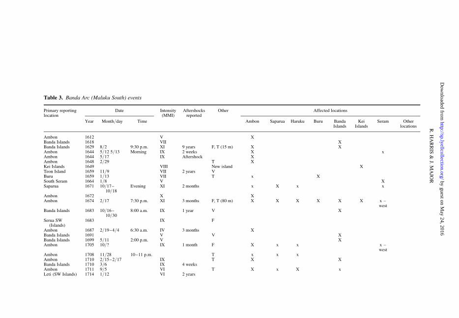
Table 3. Banda Arc (Maluku South) events
Primary reportinglocation
Date Intensity(MMI)
Aftershocksreported
Other Affected locations
Year Month/day Time Ambon Saparua Haruku Buru BandaIslands
KeiIslands
Seram Otherlocations
Ambon 1612 V XBanda Islands 1618 VII XBanda Islands 1629 8/2 9:30 p.m. XI 9 years F, T (15 m) X XAmbon 1644 5/12 5/13 Morning IX 2 weeks X xAmbon 1644 5/17 IX Aftershock XAmbon 1648 2/29 T XKei Islands 1649 VIII New island XTeon Island 1659 11/9 VII 2 years VBuru 1659 1/13 VII T x XSouth Seram 1664 1/8 V XSaparua 1671 10/17–
10/18Evening XI 2 months x X x x
Ambon 1672 X XAmbon 1674 2/17 7:30 p.m. XI 3 months F, T (80 m) X X X X X X x –
westBanda Islands 1683 10/16–
10/308:00 a.m. IX 1 year V X
Serua SW(Islands)
1683 IX F
Ambon 1687 2/19–4/4 6:30 a.m. IV 3 months XBanda Islands 1691 V V XBanda Islands 1699 5/11 2:00 p.m. V XAmbon 1705 10/? IX 1 month F X x x x –
westAmbon 1708 11/28 10–11 p.m. T x x xAmbon 1710 2/15–2/17 IX T X XBanda Islands 1710 3/6 IX 4 weeksAmbon 1711 9/5 VI T X x X xLeti (SW Islands) 1714 1/12 VI 2 years
R.
HA
RR
IS&
J.M
AJO
R by guest on May 24, 2016
http://sp.lyellcollection.org/D
ownloaded from

Leti (SW Islands)(south–north)
1716 12/20 VII
Banda Islands 1743 IX XBanda Islands 1750 VI XAmboina 1754 8/19 3:30 p.m. X 1.5 months F, T X X X X Felt in Java?Banda Islands 1763 9/13 5:00 p.m. IX 4 years XAmbon (SW–NE) 1775 4/19 1:00 a.m. VII XAmbon (NW–SE) 1777 3/31 9:00 a.m. VIII 3 months XAmbon 1777 4/28 VIII Aftershock XAmbon 1781 VIII XAmboina
(south–north)1802 8/26 X R, T X X X x x x x East Sunda
Banda Islands 1811 IX 6 years XSumbawa
(Tambora)1815 4/1 10:00 p.m. 1 year T (4 m), V x x Java,
Ambon,Ternate
Amboina 1815 4/11–4/12 VIII–IX T X X SE BorneoBanda Neira 1816 10/8–10/11 7:00 a.m. IX 3 months F XSaparua, Ambon 1817 11/11 3:00 a.m. VI X xBanda Neira
(east–west)1824 5/26 VII T, V X
Ambon 1830 3/28 10:00 a.m. IX 4 months XAmbon 1835 11/2 3:00 a.m. X 2–3 years F X X X xAmbon 1836 9/16 VI XSaparua, Ambon 1837 1/21 9:00 p.m. VIII 1 month x X XAmbon 1841 12/16 2:00 a.m. VI 2 years T (1.7 m) x T(.2m)Buru 1848 8/7 VI 12 days XSaparua, Ambon 1849 5/30 VIII 1 week x XAmbon 1851 11/20 11:55 p.m. VIII X x xBanda Islands
(NW–SE)1852 11/26 7:50 a.m. VII 10 years F, R, T
(8 m)X X X X X X X Java,
TernateAmbon 1852 11/26 7:30 a.m. VIII 10 years T (1.8 m) T (5 m) T THaruku and
Saparua1854 1/2 VIII Aftershock T x X X
Banda Islands(SW–NE)
1857 4/6 1:30 a.m. VII Aftershock
Banda Islands 1858 11/9 5:30 a.m. VIII AftershockBanda Islands 1859 9/25 Evening VII Aftershock T X
F, fatalities reported; V, during or followed by volcanism; T, tsunami (maximum run-up); X, strongly affected; x, weakly affected.
WA
VE
SO
FD
ES
TR
UC
TIO
NIN
TH
EE
AS
TIN
DIE
S
by guest on May 24, 2016
http://sp.lyellcollection.org/D
ownloaded from

Table 4. Lesser Sunda Island events
Primary reprtinglocation
Date Intensity(MMI)
Aftershocksreported
Other Affected locations
Year Month/day Time Sumbawa Flores Makassar Timor Solor Kisar Otherlocations
Timor 1638? IX V? XSolor Island 1648 2/3 X 4 months XMakassar 1690 12/1 VI XKupang
(West Timor)1793–95 VIII X
Mampawa(west Borneo)
1803 VI
Kupang (WestTimor)
1814 IX T, newisland
X X
Tambora(Sumbawa)
1815 4/10 10:00 p.m. VIII 4 days V, T (4 m) X x x x Java, Banda,Ternate?
Bima (Sumbawa) 1818 X T (4 m) XMakassar 1820 12/30 10:00 a.m. X 3 months F, R, V, T
(29 m)X X X Java
Kisar 1823 6/1 V XWest Timor 1829 2 VIII X XBima (Sumbawa) 1836 3/5 VIII T XKisar 1836 10 VIII 3 monthsBima (Sumbawa) 1836 11/28 10:30 a.m. IX 1 month TTimor 1854 8/21 XFlores 1855 5/14 09:00 p.m. T TOcussi
(NW Timor)1857 4/26 05:30 p.m. VII X
Dilli(Timor Leste)(south–north)
1857 5/14 10:30 a.m. IX–X 1 month F, T (3 m) X Ambon
Atapupu(NE–SW,north–south)
1858–69 VI Nineaftershocks
X
West Timor(east–west,north–south)
1866 VI Twoaftershocks
X Savu
Roti Island(west–east)
1866 VI Aftershock X
Sumba (NE–SW) 1869 8–9 VI Threeaftershocks
F, fatalities reported; V, during or followed by volcanism; T, tsunami (maximum run-up); X, strongly affected; x, weakly affected.
R.
HA
RR
IS&
J.M
AJO
R by guest on May 24, 2016
http://sp.lyellcollection.org/D
ownloaded from

Table 5. Java and Bali events
Primary reportinglocation
Date Intensity(MMI)
Aftershocksreported
Other Affected locations
Year Month/day
Time Jakarta Buitenzorg Cheribon WestJava
CentralJava
EastJava
Otherlocations
Java 1500 VJava 1584 VII RJava 1638 VIII x X xBatavia (Jakarta) 1681 11/2 V XBatavia 1699 1/6 1:30 a.m. X 13 months F X X X South SumatraBatavia 1722 10/? 8:00 a.m. IX T XBatavia 1737 V XBatavia 1739 7/22 VII XBatavia 1757 8/24 2:00 a.m. VII 9 months XBatavia 1765 1/10 VIII XJava 1771 X x x x x x xBatavia 1772 5/10 V? XSemarang
(central Java)1773 4/21 12:00 a.m. VII X
Batavia 1780 1/23 2:39 p.m. IX 12 months X X X X x South SumatraBatavia 1807 XBali 1808 VII X BaliBatavia 1810 12/5 7:30 p.m. VII XBuitenzorg 1812 10/14 11:00 p.m. VII X XBatavia 1814 3/24 12:00 a.m. VIII X XBali 1815 11/22 10:00 p.m. IX F, T X Lombok,
SumbawaSurabaya (Java) 1815 11/22 11:00 p.m. VII Aftershock XJakarta 1818 3/29 2:30 p.m. VII X NW–SEBuitenzorg 1818 10/2 1:30 p.m. VI x XPasuaran, East
Java1818 11/8 11:15 p.m. VIII x x x x X NNW–SSE
Galunggung,Java
1822 10/8 1:30 p.m. VIII F, V X
Buitenzorg 1823 9/9 8:00 a.m. VIII 4 months T X XBatavia (Jakarta) 1833 1/28 12:00 p.m. VII XBatavia (Jakarta) 1834 10/11 5:30 a.m. X X X X South SumatraJakarta 1836 3/22 3:30 a.m. VIII South–
northX X x
Pajitan,(central Java)
1840 1/5 1:15 p.m. 1 month T X
Cheribon (Java) 1847 11/16 10:18 a.m. X 2 weeks R ESE–WNW
X SE–NW X X Sumatra
(Continued)
WA
VE
SO
FD
ES
TR
UC
TIO
NIN
TH
EE
AS
TIN
DIE
S
by guest on May 24, 2016
http://sp.lyellcollection.org/D
ownloaded from

Table 5. Java and Bali events (Continued )
Primary reportinglocation
Date Intensity(MMI)
Aftershocksreported
Other Affected locations
Year Month/day
Time Jakarta Buitenzorg Cheribon WestJava
CentralJava
EastJava
Otherlocations
Java 1848 1/7 4:00 a.m. X 1 month R x North–south
North–south
North–south
East Java,north Bali
1848 2/17 10:00 a.m. VII 8 years R, V X Bali
Sunda Strait 1848 6/4 11:00 a.m. V 12 years V x x x x SouthSumatra,Krakatoa?
Sunda Strait 1851 5/4 3:00 p.m. VI V?, T(1.2 m)
x SouthSumatra,Krakatoa?
Batavia andSunda Strait
1852 1/9 6:00 p.m. VI T North–south
SSW–NNE East–west X x South Sumatra
Central Java 1856 1/19 6:00 a.m. x N–S xPatjitan
(central Java)1859 10/20 5:30 p.m. VII F, T
Central and EastJava
1865 5/17 7:00 p.m. VIII 15 months x x x X X Madura, Bali
Ambarawa(central Java)
1865 7/18 2:27 a.m. VII Aftershock X
Ambarawa(C Java)
1866 4/22 6:30 p.m. VII Aftershock X
Central and EastJava
1866 9/30 9:18 a.m. VI Aftershock X X Madura,Borneo
Djogjakarta(central Java)
1867 6/11 4:30 a.m. IX 1 year F x X x
Cheribon(West Java)
1875 10/26 5:50 a.m. X 3 months F x X X
F, fatalities reported; V, during or followed by volcanism; T, tsunami (maximum run-up); X, strongly affected; x, weakly affected.
R.
HA
RR
IS&
J.M
AJO
R by guest on May 24, 2016
http://sp.lyellcollection.org/D
ownloaded from

Table 6. Sumatra events
Primary reportinglocation
Date Intensity(MMI)
Aftershocks Other Affected locations
Year Month/day Time SouthSumatra
CentralSumatra
NorthSumatra
AndamanIslands
NicobarIslands
Other locations
Ache (northSumatra)
1621 3/7 1:00 a.m. 3 years V? X Sumatra Fault?
West Sumatra 1681 12/11 VI x x xBengkulen,
(west Sumatra)1755 11/3 X 1 month V X x? x?
Nias (westSumatra)
1763 X F X
Bengkulen(west Sumatra)
1770 X F, T, V
Padang (westSumatra)
1795 2/11 10 p.m. IX 1 week T x X x 1797?
Palembang(west Sumatra)
1799 IX T (15 m) Newland
x
Benkulen 1818 3/18 IX 2 months T XBengkulen 1818 5 VII AftershockPadang (west
Sumatra)1824 4 VI
Bengkulen, Padang 1833 11/25 8:30 p.m. XI 24 years F, R, T, V X X x SSW–NNE,Java,Singapore
Padang(west Sumatra)
1835 8/26 9:00 p.m. VIII Aftershock R North–south
Singapore,Java,Malaysia
Ache (northSumatra)
1837 9/30 VIII T, V
Barus (NWSumatra)
1843 1/5 to 1/6 11:30 p.m. XI 3 months T x West–east,north–south
Singapore,Malaysia
Nicobar Minor 1847 11/1 3:30 a.m. X 3 weeks T XPadang Mountains 1852 V 1 year F, V? X Sumatra Fault?Solok, Sumatra 1853 2/9 Night VIII F XSumatra 1861 2/16 6:30 p.m. X 4 + years F, T (7 m) SE–NW North–
southX X Malaysia,
Singapore,Java
NW Sumatra 1861 4/26 6:30 a.m. VII Aftershock T (.2 m) XBengkulen 1871 8/19 8:16 p.m. VIII X West JavaSingkel (NW
Sumatra)1873 8/19 3:15 p.m. IX 1 month x X
F, fatalities reported; V, during or followed by volcanism; T, tsunami (maximum run-up); X, strongly affected; x, weakly affected.
WA
VE
SO
FD
ES
TR
UC
TIO
NIN
TH
EE
AS
TIN
DIE
S
by guest on May 24, 2016
http://sp.lyellcollection.org/D
ownloaded from

The Molucca Sea region (north Maluku:
Table 2), including Ternate, Makjan,
Minahassa (north Sulawesi) and Halmahera
The first authenticated earthquake in the Wichmanncatalogue is from 1538 in Ternate (Fig. 2, Supple-mentary material). At that time, the volcanic islandof Ternate was one of the world’s major producersof cloves. Ternate is part of the Halmahera intra-oceanic arc, which forms above the eastwards-subducting Molucca Sea oceanic slab (Hamilton1979; Hall 2011). The same slab is also subducting
westwards beneath the Sangihe Arc. The accretion-ary wedges of these opposing subduction zones arecolliding near the middle of the Molucca Sea toform one of the youngest submarine collisionalmountain belts in the world (Fig. 2).
Earthquakes and tsunamis in this region couldhave several different sources. In the northern partof the region, the major active faults include thesouthern Philippine Trench and the Cotabato Fault,which overlap with the Molucca collision complex(Fig. 1). Benioff zones beneath the Sangihe Arc tothe west and the Halmahera Arc to the east dip in
Table 7. New Guinea events
Primaryreportinglocation
Date Intensity(MMI)
Aftershocksreported
Other Affected locations
Year Month/day
Time GeelvinkBay
AstrolabeBay
RookIsland
Astrolabe Bay(New Guinea)
1856–58 No date Night IX F, T X
Rook Island(New Guinea)
1857 4/18 Evening VIII F, T North–south
Geelvink Bayk(New Guinea)
1864 5/24 12:30 a.m. IX 1 week F, T(2.6 m)
X
Astrolabe Bay 1873 No date IX T X
F, fatalities reported; V, during or followed by volcanism; T, tsunami (maximum run-up); X, strongly affected; x, weakly affected.
Fig. 2. Location map and active faults of the Molucca Sea region. Fault colours: blue, convergence; red,transvergence; yellow, divergence; grey, uncertain motion. Fault abbreviations: CF, Catabato Fault; GF, GorontaloFault; NST, North Sulawesi Trench; PKF, Palu-Koro Fault; SF, Sorong Fault. For the locations of earthquake eventsin the catalogue use the KMZ file in the Supplementary material.
R. HARRIS & J. MAJOR
by guest on May 24, 2016http://sp.lyellcollection.org/Downloaded from

opposite directions, which indicates that the Mo-lucca Sea Plate in the middle is almost completelyconsumed by the opposing subduction zones. Mostearthquakes occur along the subduction interfacesof these colliding arcs, from internal deformationwithin the opposing accretionary wedges, withinthe Molucca Sea Plate and from explosive volcaniceruptions. However, most of the active faults in theregion, like nearly all of Indonesia, are submarine.Marine geophysical studies (Silver & Moore 1978;Bader & Pubellier 2000; Watkinson et al. 2011)document surface ruptures in several places through-out the Moluccas, but many areas where earthquakesare common remain unexplored. Local explosivevolcanic events may also account for a few of theearthquakes included in the catalogue, such asthose in 1646, 1673, 1770 and 1840.
Active thrust faults are found within the accre-tionary wedge collision complex near the TalaudIslands, rising up in the middle of the Molucca Sea(Silver & Moore 1978; Bader & Pubellier 2000).Other major thrust faults involve backthrustingof the accretionary wedges over associated forearcbasins (Hamilton 1979). Along the East SangiheFault, the accretionary wedge collision complex isthrust westwards over the Sangihe Forearc (Fig. 2).A similar relationship is inferred on the east sideof the accretionary wedge collision complex, withtop-to-the-east thrusting over the Halmahera Fore-arc (Fig. 2). To the west of the Molucca collisioncomplex, the Minahassa Trench forms from SSEsubduction of the Celebes seafloor. The volcanicarc above this subduction complex forms the easternpart of the northern arm of Sulawesi. The GorontaloFault slices through the middle of the northern armof Sulawesi (Fig. 2).
The southern part of the Molucca Sea regionhosts many active faults associated with the west-wards translation of the Caroline–Pacific Plateagainst continental crust of the northern AustralianPlate (Silver et al. 1983a, b; Garrard et al. 1988;Smith & Silver 1991). The Sorong fault systemforms the southern boundary of the Molucca SeaPlate, which may reach as far west as the GorontaloBasin (Watkinson et al. 2011). The Sula and Matanofaults form the southern-most strike-slip faults ofthe Sorong fault system, with associated pop-upand pull-apart structures (Watkinson et al. 2011).
Relative to the Sunda Craton, GPS measure-ments indicate 89 mm a21 of westwards conver-gence across the Sangihe arc–arc collision, 22–46 mm a21 of NNW convergence across theMinahassa Trench and as much as 53 mm a21 ofleft-lateral oblique WNW convergence along theSula–Sorong fault system (Rangin et al. 1999).Models combining these GPS data with patternsof seismicity over the past 50 years yield very highshear and dilatational strain rates in the Molucca Sea
region (Kreemer et al. 2000). Yet, several earth-quakes documented in the Wichmann catalogueare larger than anything recorded instrumentally.For example, between 1855 and 1860, there wereseveral significant earthquakes and at least six tsu-nami that caused damage on both sides of theMolucca Sea, including Ternate, Tidore, Makjanand Halmahera on the west, and Minahassa, Goron-tolo and Kema (north Sulawesi) on the east (Supple-mentary material). One tsunami, 9 m high, crashedinto the west coast of Halmahera and was alsonoted on other islands (Table 2). The largest earth-quake in the Harvard catalogue for the region(post-1976) is a Mw 7.9 subduction interface eventin 1996. However, this event caused few casualtiesand only a local tsunami (Pelinovsky et al. 1997).
The regional nature of the events documented inthe Wichmann catalogue, and the years of after-shocks that followed, indicate they were probablymegathrust earthquakes. In a recent paper on possi-ble megathrust earthquake sources (Heuret et al.2011), the Moluccas and the Banda Arc (see below)are not included. This omission highlights theimportance of examining historical records to vali-date models based on the relatively short instrumen-tal catalogue and other geophysical criteria.
The Banda Sea region (south Maluku:
Table 3), including Seram Island, Ambon,
Buru, Amblau, Saparua, Haruku, Nusalaut
(the Uliassers), Banda Neira, Lonthor and
Ai (Banda Islands)
The majority of earthquakes and tsunami docu-mented in the Wichmann catalogue are from thesouthern Maluku region (Fig. 3). However, just theopposite is true for the earthquake and tsunamirate during the past 100 years. Even though thepost-1970 seismic rate in Maluku is the secondhighest in the Indonesia (United States GeologicalSurvey: USGS), it is much lower than the rate ofmajor earthquake and tsunami events between 1629and 1876 (Tables 3). For example, from 1612 to1859, the earthquake rate was one major event(.MMI 6) every 3 years (this catalogue) comparedwith a rate of one major event every 7 years since1859 (Hamzah et al. 2000).
The abundance of observations in the region ispartly attributed to the many Dutch settlements inthe ‘Spice Islands’ found there (Hanna 1978; Milton1999). Most of the observations in the cataloguefrom the Maluku region are from Ambon (Figs 4& 5), the neighbouring islands to the Uliassers,and the Banda Islands 200 km to the SW (Fig. 3,Supplementary material). These island groups arepart of the northern section of the Banda Arc. The
WAVES OF DESTRUCTION IN THE EAST INDIES
by guest on May 24, 2016http://sp.lyellcollection.org/Downloaded from

Banda Arc formed in the Late Miocene above anintra-oceanic subduction system. At around16 Ma, the arc began to collide with the NW conti-nental margin of Australia in the Seram region(Berry & McDougall 1986; Linthout et al. 1996;Pownall et al. 2014). The current arc–continent collision zone makes a 1808 bend fromthe Southwest Islands east of Timor to Ambon(Fig. 1). The collision is more advanced in theUliasser Islands, where the volcanic arc is extinctand forearc basement is exposed.
Volcanism still persists in the Banda Islandsand other volcanoes of the Banda Arc, although
they are contaminated by subducted continentalcrust. Notwithstanding the active volcanism, onlyone of the earthquakes cited in the Wichmann cata-logue, the disputed eruption of Banda Api in 1824, islikely to have been associated with a local volcaniceruption.
On multiple occasions, earthquakes and tsunamidestroyed most of the buildings in Ambon or BandaNeira, including the regional earthquakes of 1648,1754 and 1802. The colonial-era Fort Victoria,built in the early seventeenth century, is the onlystructure from this time that remains standing inAmbon. The Wichmann catalogue documents that
Fig. 3. Location map and active faults of the southern Maluku region. Fault colours: blue, convergence; red,transvergence; grey, uncertain motion.
Fig. 4. Map of Ambon and the Lease Islands showing locations of many of the events mentioned in the text.
R. HARRIS & J. MAJOR
by guest on May 24, 2016http://sp.lyellcollection.org/Downloaded from

the walls of the fort were damaged by earthquakes in1644, 1673 and 1705, and inundated by a tsunami in1648 (Fig. 6).
Around 1.5 million people now live in thesouthern Maluku region, with more than a third ofa million crowded into the low-lying coastal plainthat has been inundated with past tsunamis. Thecity has now burgeoned up onto landslide-pronehills (Fig. 4). There are several accounts of major
landslides in and around Ambon City throughoutthe Wichmann catalogue that are similar to thefatal slides that occurred in 2012 and 2013. Devel-opment is also increasing in coastal areas through-out the region that were probably inundated by the15 regional tsunamis that occurred between 1629and 1877.
The active fault sources for the earthquakes andtsunami in the Maluku region are poorly constrained
Fig. 5. Ambon City was destroyed by earthquakes in 1644, 1675, 1754, 1781, 1835 and 1841. Multiple tsunamis arealso documented, inundating what is now the major urban centre of the Maluku region.
Fig. 6. Conjugate fractures in the walls of Fort Victoria from earthquake damage. The fort was damaged fourdifferent times by earthquakes and inundated by a tsunami. Surrounding the fort now is the urban centre ofAmbon City.
WAVES OF DESTRUCTION IN THE EAST INDIES
by guest on May 24, 2016http://sp.lyellcollection.org/Downloaded from

owing to a lack of marine geophysical surveys. Oneof the most dangerous aspects of this active arc–continent collision is the distribution of strainaway from the deformation front in the Tanimbarand Seram troughs into other parts of the upperplate, such as the populated backarc region ofAmbon and the surrounding islands (Harris 1991,2011). It is likely that there are active faults nearAmbon, such as in Ambon Bay, (Hamilton 1979)and offshore to the north and south associated withaccretion of the Banda Arc onto Australian conti-nental margin. Earthquakes felt in Ambon mayalso be sourced from the Sorong strike-slip fault sys-tem to the north (Fig. 3).
Intermediate to deep earthquakes in the Benioffzones surrounding this region on three sides arebroadly felt, but have weak intensities and causelittle to no damage. The largest instrumentallyrecorded event (Mw 8.5) occurred in 1938. The epi-centre was located at the rear of the accretionarywedge south of the Watubela Island of Tioor(Okal & Reymond 2003). The depth is estimatedat 60 km, which is consistent with the lack of dam-age reported (MMI 6) and the small tsunami run-up(1.5 m). This event was felt as far south as Darwin,Australia and in eastern New Guinea. The focalmechanism is an east–west-striking thrust withsome left-lateral oblique slip. A similar focal mech-anism is also found for the Mw 8.3 earthquakein 1963 in a similar tectonic position north ofBabar Island (Welc & Lay 1987). These events arethe largest along a NNE–SSW line of mostlyintermediate-depth earthquakes of Ms 6.5–7.1beneath the southern Weber Basin. They are inter-preted as deformation of the subducting slab, withslip in the NNE–SSW direction of plate conver-gence (Okal & Reymond 2003).
One of the most damaging historical earthquakesoccurred in 1675. It flattened the entire Chinese dis-trict and many other stone buildings in Ambon.Landslides also caused at least 2500 fatalities. A
coastal landslide on the north shore of Ambon gen-erated a tsunami with a run-up height of up to100 m, based on the coastal vegetation trim linethat it left (Soloviev & Go 1974). The wave flowedover the walls of Fort Amsterdam (Fig. 7) anddestroyed most of the homes inside the fort, causingmany fatalities.
The most damaging instrumentally recordedearthquake was in 1899, a Ms 7.8 event in Seram.It generated a 10 m tsunami that was probaby assis-ted by a landslide. The tsunami killed around 3500people (Brune et al. 2010). No earthquake of thismagnitude has occurred since this event. With elas-tic strain energy accumulating across the SeramTrough at rates of up to 7 m/century (Bock et al.2003), it is likely that earthquake recurrence inter-vals are relatively short (c. 100 years).
Banda Neira, which is nestled in the BandaIslands (Fig. 8), has been destroyed several timesby earthquakes and inundated by some of the mostmassive waves recorded in Indonesia. Two earth-quakes in particular, one in 1629 and the other in1852, showed clear characteristics of megathrustseismic activity. Both of these events were feltover a large region, generated large tsunamis of atleast 15 and 8 m, respectively, at Banda Neira(Fig. 9), and are associated with at least a decadeof aftershock-like seismic activity. The accountsof both events provide key details, such as the dura-tion of shaking and the travel time of the tsunamiafter the shaking stopped:
1629, August 1 9:30 p.m. Banda-Islands. A half hourafter the termination of a violent seismic shock thereformed in the sound . . . a high mountain of water.The. . .wave rolled westward . . . against Fort Nassau. . . where it achieved a height of 9 fathoms [15.3 m]above the springtide stand . . . Houses lying on thebeach were swept away, while others were laid to rub-ble . . . Eastwards the tidal wave crashed on the westbeach of the island Lonthor, where . . . it achieved . . .a height of 13 feet [4 m].
Fig. 7. (a) Fort Amsterdam on the north coast of Ambon., which was built in the fifteenth century and is describedin the catalogue as completely inundated by the 1675 tsunami. The central part of the fort has been reconstructed.(b) The 1675 tsunami poured over this wall and killed most of the inhabitants who went to the fort for shelter.
R. HARRIS & J. MAJOR
by guest on May 24, 2016http://sp.lyellcollection.org/Downloaded from

These particulars make it possible to inverselymodel the tsunami, and to test likely source areasand earthquake magnitudes. Models of the 1629 tsu-nami by Liu & Harris (2013) required a megathrustearthquake (Mw 8.2–8.8) along the Seram Trough.The Seram Trough accumulates strain from NNWconvergence relative to the Sunda Craton at a rateof around 40 mm a21 (Socquet et al. 2006). Atthese strain rates, enough elastic strain energy hasalready accumulated along the Seram Trough tocause an earthquake of similar magnitude to whatoccurred in 1629.
Archaeological excavations in Banda Neira(Lape 2000) found evidence of several destructiveevents throughout the colonial era. We excavateda trench adjacent to site BN4 of Lape (2000) andfound three likely tsunami deposits, which we arecurrently analysing. The stratigraphic ages of thetwo largest deposits, based on the archaeological
ages, correspond to the 1629 and 1852 tsunamis(Fig. 10).
The 1852 event was recorded at 20 differentlocations from Sumatra to Ternate. From theseaccounts and from modelling of the tsunami thatwas recorded in several locations, the source regionis most likely to have been in the Tanimbar Trough(Fisher & Harris, in press). This collisional plateboundary accumulates strain from highly obliqueNNE convergence of the Australian continentalmargin beneath the Banda Arc at a rate of around70 mm a21. The event, like another one previouslynoted in the catalogue in 1649, caused the rise of newmud volcano islands in the Kei archipelago (Fig. 3).
We are concerned about the hazard potentialof this very active tectonic region. During the pastcentury, population and urbanization in the regionhas increased 10-fold, particularly in coastal areasusceptible to tsunami inundation. The tsunami
Fig. 8. Panorama of Banda Islands. Photograph looking NE from Gunung Api. Banda Neira is the island in themiddle. Lonthor is the crescent-shaped island behind it. The Lonthor Strait, to the left of Lonthor Island (near therainbow), is where the tsunamis of 1629 and 1852 approached Banda Neira.
Fig. 7. Continued.
WAVES OF DESTRUCTION IN THE EAST INDIES
by guest on May 24, 2016http://sp.lyellcollection.org/Downloaded from

potential also threatens large cities outside theregion. For example, modelling of the 1629 earth-quake and tsunami on the southern Seram Trough(Liu & Harris 2013) predicts run-up heights of5.3 m along the north coast of Tanimbar, .3 m inDili and .1 m in Darwin, Australia.
The Nusa Tenggara and South Sulawesi region
(Table 4), including Lombok, Sumbawa,
Flores, Sumba, Timor and Wetar
Nusa Tenggara and Sulawesi form a transition zonebetween the Greater Sunda Islands of Java and Bali,
Fig. 9. Detail of Figure 8 showing the city of Banda Neira. The Wichmann catalogue documents four tsunamis thatinundated Fort Nassau. The dashed lines are the approximate run-up heights of the 1629, 1841 and 1852 tsunamis.
Fig. 10. Trench near Fort Nassau of Banda Neira exposing tsunami deposits from earthquakes most likely in 1629(lower white layer) and 1852 (upper white layer). The darkest black layers are volcanic ash. The trench sitecorresponds to archeological site BN4 of Lape (2000). See Figure 9 for the location of trench site.
R. HARRIS & J. MAJOR
by guest on May 24, 2016http://sp.lyellcollection.org/Downloaded from

which are part of the Sunda Craton, and the BandaSea marginal basin. Sulawesi and various continen-tal fragments in the Banda Sea basin were riftedfrom the Sunda Craton by intra-arc extension (Har-ris 2006). The intra-oceanic Banda Arc forms alongthe outer edge of the young oceanic crust of theBanda Sea basin.
The western boundary of Nusa Tenggara is thefamous Wallace Line through the deep straightbetween Bali and the Lombok Islands (Fig. 11).The eastern boundary is disputed, but here is definedas the eastern edges of Wetar and the Timor Islands.The Timor region, which is similar to the Seramand the Ambon portion of the Banda Arc to theeast, represents an evolving arc–continent collisionthat propagates westwards from central Timor ataround 110 km myr21 (Harris 1991). The collisioninitiation point is south of the island of Sumba,with progressively more mature parts of the colli-sion represented to the east on the island of Timor(Harris 2011).
Also included in the Nusa Tenggara region isthe Makassar Strait, which has one of the highestrates of tsunami in Indonesia since 1900 (Prasetyaet al. 2001). However, only a few events arerecorded in the Wichmann catalogue during theprevious three centuries. How much of this relativequiescence is from a lack of reporting or a lack
of seismic events is unknown. Between 1600 and1900, only three earthquakes are recorded and onetsunami. Since 1820, there have been at least 18 tsu-namis (Baeda 2011).
The most active faults in the Makassar Strait(Fig. 11) are found by geophysical investigation(e.g. Guntoro 1999; Hall et al. 2009), which includes:(1) thrust faults along the east and west edges ofthe northern Makassar Basin, with the eastern edgeforming the Makassar Trench and Majene fold–thrust belt (Bergman et al. 1996); (2) the PaluKoro Fault (Katili 1978) that forms the northernboundary of the northern Makassar Basin; (3) theMentano Fault of central Sulawesi; (4) the Paternos-ter Fault (Guntoro 1999) that forms the southernboundary of the northern Makassar Basin; and (5)the Walanae Fault (van Leeuwen 1981), formingthe Salajar Trough offshore and the western edge ofthe Bone Mountains onshore, which is 85 km westof Makassar City. Makassar City is one of the larg-est urban areas in eastern Indonesia, with a popula-tion of 1.4 million (Fig. 11). The region surroundingthe city is identified as a seismic gap (Baeda 2011)owing to the fact that it has a history of earthquakes,but very little seismicity, over the past 50 years.
The GPS velocity field in Sulawesi (Socquetet al. 2006) shows between 8 and 21 mm a21 ofstrain accumulation across the Makassar Thrust.
Fig. 11. Location map and active faults of the Nusa Tenggara and south Sulawesi region. FT, Flores Thrust; MF,Matano Fault; PKF, Palu-Koro Fault; PF, Pasternoster Fault; SF, Semau Fault; SoF, Sorong Fault; ST, Savu Thrust,WF, Walanae Fault; WST/KS, Wetar Strait Fault/Kisar Thrust; WT, Wetar Thrust. The locations of Figures 12 and13 are shown.
WAVES OF DESTRUCTION IN THE EAST INDIES
by guest on May 24, 2016http://sp.lyellcollection.org/Downloaded from

Earthquakes near the convergent boundary havefault-plane solutions consistent with low-angle,east-dipping thrust faults beneath the western coastof Sulawesi, where most of the population isconcentrated.
Five significant tsunamigenic earthquakescaused major damage in Nusa Tenggara in 1814,1818, 1820, 1836 and 1856. A tsunami was alsogenerated in 1815 from the colossal eruption ofTambora (Fig. 11).
The Tambora eruption (Volcanic ExplosivityIndex (VEI) 7) is the largest of recorded history. Itis also one of the most notable extreme global geo-hazards of the Holocene (Wood 2014). The colossaleruption caused at least 100 000 deaths locally andyears of global climate upheaval that accountedfor, perhaps, as many as 6 million deaths worldwide(Oppenheimer 2011). Months prior to the eruption,there was an earthquake near Kupang, West Timorthat created a new island and caused a tsunami.Shortly after the Tambora eruption, there were sig-nificant regional earthquakes in Maluku in 1815,1816 and 1817, and a major event in the southernMakassar Basin in 1820. The spatial and temporalclustering of these events is a common featurethroughout the Indonesian region and many otherplate boundaries (Jagla & Kolton 2010).
Accounts of the 1820 Makassar (Belekomba)earthquake in the Wichmann catalogue are consis-tent with a Walanae Fault source. For example,the strongest ground motion (.1g, cannons hop-ping) and the longest time of shaking (4–5 min)are recorded from Bulukomba, which is only20 km from the fault. The Dutch Fort there wasalso inundated by an 18–26 m-high tsunami. It ispossible, from the account, that the tsunami wasfrom an earthquake-induced submarine landslidenear, but west of, Bulukomba:
Fort Bulekomba fluctuated to and fro. The six-pounders . . . hopped from their mountings. After the4–5 minute long quake, shots were believed to beheard in the west, coming from the sea. Barely hadthe sent envoy returned with the news that ships werenowhere to be seen, than did the sea, under both a whis-tling and thunder-like rumble, come in, formed as a60–80 foot high wall, and flooded everything. The bar-racks in the fort were destroyed, likewise, as a result ofthe flood wave that penetrated 400–500 feet inland . . .400–500 persons drown.
The earthquake ‘violently’ shook Flores and Sum-bawa for 2 min, and was felt as far west as Madura(800 km from Belekomba). Each of these locationsalso experienced tsunamis. In Sumbawa, the tsu-nami, ‘flung anchored ships far inland’.
Investigations of the GPS velocity field in NusaTenggara reveals a pattern of increased couplingwith the NNE-subducting Australian Plate towardsthe eastern edge of the province (Genrich et al.
1996; Nugroho et al. 2009). It is likely that this pat-tern of strain is associated with increased amounts ofsubducted continental crust towards East Timor(Harris 1991). Between Sumba Island, where thearc–continent collision initiates, and the island ofRote (Fig. 11), 70–80% of the convergence istaken up at the deformation front (Timor Trough),with the bulk of the remainder occurring along theFlores backarc thrust (Nugroho et al. 2009). Thischanges to only 35% east of the 1218 shear zoneoff the coast of West Timor (Harris et al. 2009). Eastof the shear zone, an additional 30% of the NNEmotion of the Australian Plate is transferred to theWetar backarc thrust system (Nugroho et al. 2009).
Recent earthquakes along the Flores and Wetarthrust systems demonstrate just how vulnerable thisrapidly growing region is to even moderate-sizedseismic hazards (McCaffrey & Nabelek 1984). In1992, a Mw 7.8 earthquake on the Flores Thruststruck the area around Maumere and generated atsunami with submarine landslide-assisted waveheights of up to 26 m (Budiono et al. 1995). Theearthquake destroyed 90% of the buildings in theregion, including around 800 schools. Half of thedeaths were caused by the tsunami.
The Wetar thrust system, which is further to theeast and along strike of the Flores Thrust, is alsovery seismically active and caused a Mw 7.5 earth-quake and tsunami in November 2004. Around800 homes were destroyed on Alor Island (USGS).Damage from the earthquake and tsunami alsoreached Dili, the capital of East Timor (with a pop-ulation of c. 200 000).
Little onshore historical seismicity is recordedfor Timor Leste. However, several thrust eventshave occurred offshore, with hypocentres on or closeto the decollement at depths of 18–30 km below thenorthern flank of the Timor Trough. Immediatelynorth of the Timor Leste capital city of Dili, a thrustevent was recorded at approximately 30 km, alongwith extensional earthquakes at 16–20 km.
The Wichmann catalogue documents that,between 1793 and 1836, several tsunamigenic earth-quakes struck the Nusa Tenggara region and werefelt more widely than both the 1992 and 2004 events.One of the most notable earthquakes occurred alongthe north coast of East Timor in 1857. The earth-quake caused a tsunami consisting of four waves,the highest of which was .3 m. The tsunami inun-dated the north coast around Dili, and completelyflooded the villages of Liquica and Hera.
It is likely that the source of this earthquake/tsu-nami event was the Wetar Strait Thrust first inferredby Carter et al. (1976), and later documented asan active fault by Breen et al. (1989). This south-dipping thrust system accommodates the north-wards motion of the Timor orogenic wedge overthe forearc basin of the Banda Arc (Fig. 11). The
R. HARRIS & J. MAJOR
by guest on May 24, 2016http://sp.lyellcollection.org/Downloaded from

thrust system can be traced just offshore the northcoast of Timor eastwards to the islands of Kisarand Leti, where it was imaged breaching the seafloorby the BIRPS seismic reflection profile (Snyderet al. 1996). Mapping and age analysis of upliftedand warped coral terraces on the north coast ofTimor (Fig. 12) and Kisar document co-seismicuplift, tsunami deposits and continued shorteningalong the Wetar Strait and the Kisar Thrust (Cox2009; Major et al. 2013).
Tsunamigenic earthquakes have also struck thearea around Kupang, West Timor (Fig. 13). Kupangis one of the main commercial centres of NusaTenggara, with a population of around 0.5 million.There are four known active faults in the regionthat may have sourced these events. The most sig-nificant is the Timor Trough to the south. RecentGPS measurements determined a strain rate acrossthe Timor Trough of 22 mm a21 (Nugroho et al.2009). As noted earlier, there are several earth-quakes with low-angle thrust fault-plane solutionsalong the projection of the Timor Trough beneathTimor. It is possible that there may have been amajor earthquake along the Timor Trough sometime between 1793 and 1814, which immediatelypreceeded the 1815 eruption of Tambora.
Another possible source of major earthquakesmuch closer to Kupang is the Semau Fault(Fig. 13) or 1218 discontinuity shear zone (Harriset al. 2009). This left-lateral transpressional faultsystem is mapped on Rote Island (Roosmawati &Harris 2009) and expressed along the west coast of
Timor as a linear zone of mud volcano islands (Bar-ber et al. 1986). The fault is identified in seismicreflection profiles just offshore of Kupang (Kariget al. 1987) and is associated with uplift of severalflights of coral terraces (Merritts et al. 1998). GPSmeasurements show 11 mm a21 of strain accumula-tion across the fault (Nugroho et al. 2009).
Known active faults onshore in West Timor areindicated by earthquakes with generally trans-tensional fault-plane solutions, and include strike-slip and normal earthquakes with T-axes orientatedeast–west (McCaffrey 1988, 1989). A surface-rupturing Mw 5.7 strike-slip earthquake in western-most Timor in 1975 (Fig. 13) showed both dextraland sinistral slip along vertical faults striking mostlyNW–SE (Tjia 1983; Duffy et al. 2013).
The other active fault found in the Savu Sea isthe Savu thrust system (Fig. 11). This north-vergingthrust forms the rear of the Sumba–Savu accretion-ary wedge (Harris et al. 2009), much like the WetarStrait Fault north of Timor. Thrust faults areimaged breaking the seafloor on seismic reflec-tion profiles (Harris et al. 2009). It is likely thatthe March 1866 earthquake felt in Kupang, butstrongly felt in Savu, was along the Savu Thrust.GPS measurements indicate 6–8 mm a21 of strainacross this plate boundary segment (Nugrohoet al. 2009). At this rate of strain, at least 1 m ofstrain may have accumulated along the Savu Thrustsince 1866. Uplifted coral terraces along the northcoast of Savu attest to the long-term activity of thethrust fault.
Fig. 12. Photograph looking south from the Wetar Strait at flights of uplifted coral terraces along the north coast ofTimor Leste. The uplift is mostly attributed to movement along the Wetar Strait Thrust (Cox 2009).
WAVES OF DESTRUCTION IN THE EAST INDIES
by guest on May 24, 2016http://sp.lyellcollection.org/Downloaded from

The earthquake and tsunami disaster risk of theNusa Tenggara region has increased almost expo-nentially since the events documented in the Wich-mann catalogue occurred. The only major eventalong the subduction zone to the south of the regionis the 1977 Mw 8.0 Sumba earthquake, which gener-ated a 15 m-high tsunami. However, this event wascaused by normal faulting on the downgoing oce-anic slab. There is no evidence of major earthquakesalong the subduction interface from Java to Timorin over 400 years, notwithstanding the 70 mm a21
of convergence along this section of the easternSunda subduction zone. It is possible that up to28 m of strain has accumulated along the subduc-tion interface.
The population of Nusa Tenggara region (NusaTenggara) is currently around 10 million. Another2 million people live along the coast of the MakassarStrait. Most of the people now live in cities, mostof the buildings in the cities are of unreinforcedmasonry construction and many of the cities arewithin historical tsunami inundation zones. Thewestern shores of the Makassar Strait are near activefaults and coastal cities, such as Balikpapan andBontang, are vulnerable to tsunami hazards fromevents such as the one in 1820. Other parts of
Kalimantan, which account for ,6% of Indonesia’spopulation, are considered highly unlikely to expe-rience earthquakes. No entries of significant damagedue to earthquakes in Kalimantan are found in theWichmann catalogue.
Java and Bali (Table 5)
The islands of Java and Bali mostly consist of prod-ucts of the Sunda Arc, which is mounted on thesouthern edge of the relatively young Sunda Craton(Hamilton 1979). Jurassic-age seafloor with .1 kmof sediment cover is subducting beneath the edge ofthe craton at the Java Trench. Between the trenchand the southern coast of Java and Bali is a well-developed accretionary ridge and forearc basin.Orthogonal convergence is estimated at a rate ofaround 75 mm a21 (Nugroho et al. 2009). GPS mea-surements indicate little or no internal shorteningacross Java (Bock et al. 2003), which is interpretedas evidence for loose coupling across the subductioninterface. However, there is a broad seismic zoneacross Java that is mostly the result of intermediate-depth events in the Benioff zone and more localizedevents associated with deformation of the volcanicarc (Ghose & Oike 1988). The Benioff zone
Fig. 13. Active faults of the Kupang region of West Timor. The Semau Fault is inferred from lines of mudvolcanoes (white stars). The mud volcanoes and Kupang Fault are taken from Rosidi et al. (1979). The CamplongFault ruptured on 30 July 1975 at 09:17 GMT. The dates and times of the associated earthquake cluster are shown.The urban centre of Kupang is shaded.
R. HARRIS & J. MAJOR
by guest on May 24, 2016http://sp.lyellcollection.org/Downloaded from

continues to a depth of 650 km and produces deepearthquakes that are felt over long distances, butcause little or no damage.
Some of the most widely felt and damagingevents in this region were in 1586, 1699, 1722,1757, 1780, 1815, 1834, 1840, 1847, 1859, 1862,1865, 1867 and 1875. It is difficult from the histor-ical records to constrain which of these events arefrom inter- v. intra-plate earthquakes or large inter-mediate to deep Benioff zone earthquakes. Most ofthe known deep events are characterized by broadzones of small intensity, such as the 2007 Mw 7.5event at a depth of 290 km that was felt throughoutJava and as far away as Malaysia, but did little orno damage. Descriptions in the Wichmann cata-logue of the event of 2 January 1780 fit the charac-teristics of a strong, but deep event.
It is also possible that some earthquakes, wherelittle damage is observed (MMI ,5) but a tsu-nami was generated, may have been slow-ruptureevents, such as the Mw 7.8 and 7.7 inter-plate earth-quakes on the Java Trench in 1994 and 2006,
respectively. These earthquakes were hardly felton shore, but produced larger than expected tsuna-mis that claimed hundreds of lives (Kerr 2006;Kato et al. 2007).
The most damaging events in the historical cata-logue, and therefore the ones that are likely not tobe slow slip or deep earthquakes, were those in1699, 1780, 1834, 1840, 1847, 1865, 1867 and 1875.Some of these events were likely to have beensourced from onshore faults accommodating defor-mation in and around the Sunda Arc (Fig. 14). How-ever, inferring source regions is hampered by a lackof data for active faults in Java.
Active faults in Java have been described byVan Bemmelen (1949) and Tjia (1977). Theseinclude: (1) the left-lateral Lembang Fault, north ofthe densely populated urban centre of Bandung; (2)the Cimandiri normal fault that has sourced sev-eral destructive earthquakes within the NE-strikingCimandiri River Valley; (3) the Bency normal fault,which sourced the surface-rupturing Sukabumiearthquake, 1982 (Kertapati & Koesoemadinata
Fig. 14. Active faults and volcanoes of the Java and Bali region. Blue, thrust; red, normal; yellow, strike slip; grey,oblique slip; red triangles, volcanoes. The Lembang Fault is the small red line south of the Bandis Fault. The OpakFault is the red line near the south central coast. Marine geophysical mapping off the SW coast of Java (Kopp et al.2001) provides a glimpse of the structural complexity in the forearc ridge south of Java. Map modified from Irsyamet al. (2008).
WAVES OF DESTRUCTION IN THE EAST INDIES
by guest on May 24, 2016http://sp.lyellcollection.org/Downloaded from

1983); (4) the left-lateral Opak Fault, south ofdensely populated Yogyakarta; and (5) fault zonesin the Citanduy Valley near Banjarsari, which hassourced many destructive earthquakes (Simandjun-tak 1993).
The general trend for Indonesia of increasingcasualties per event is clearly demonstrated in theWichmann catalogue as well as in more recentevents in Java. In 2006, a shallow Mw 5.9 earth-quake on a previously unknown fault near Yogya-karta caused around 6000 casualties and damagedaround 451 000 homes (Tsuji et al. 2009). Muchof the damage from the earthquake resulted fromthe poor soil conditions upon which much of thebuilt environment rests. The relatively small extentover which this event was felt and caused damagewas not significant enough to have made the abovelist of most damaging earthquakes. Five millionpeople now live within 100 km of this fault andthe nearby Opak Fault, which is expressed geo-morphically (Fig. 15).
The question of whether a megathrust earth-quake event can occur on the Java Trench is stilldebated (McCaffrey 2007; Stein & Okal 2007).The well-developed forearc basin and accretionarywedge, and subduction of a relatively thick (.1 km)package of sediment, are characteristic of subduc-tion zones that produce megathrust earthquakes.Mw 8.5 (Ruff & Kanamori 1980).
There is circumstantial evidence from multiplesources that a megathrust event may have happened
during the period of 1584–87, when the wholeisland shook and several volcanoes erupted thatwere previously, and have since been, dormant.During this time, the two largest temple complexesin central Java (Prambanan and Borobudur) werealso severely damaged by an earthquake (Fig. 15).A tsunami deposit along the south coast of Java(Fig. 16) also dates to around this time (EkoYulianto pers. comm.). If the Java Trench is capableof causing a megathrust earthquake and the lastone was 428 years ago, then up to 30 m of poten-tial slip could have accumulated along the trenchsince the last megathrust event. The densely popu-lated areas that would be affected by the strongground motions of this event are mostly constructedof unreinforced masonry buildings that wouldmost probably experience a high rate of structuralfailure. Tsunami hazards are also high along muchof the southern Java coast, where higher thanexpected run-up heights (Fig. 17) were observedfrom the July 2006 Tsunami (Fritz et al. 2007).
Sumatra (Table 6)
Much attention has been currently focused on theSumatra region since the megathrust event occurredon 26 December 2004, and the spatial and tem-poral clustering of events in the region since 2004.Publications describing the history and potentialof megathrust earthquakes along the Sunda Trenchoffshore Sumatra relied heavily on the Wichmann
Fig. 15. The Opak Fault scarp (ridge on the horizon) as seen from the Prambanan Temple site. The PrambananTemple was severely damaged in the ?1584–86 regional earthquake and again in 2006 by a local Mw 5.9earthquake on a previously unknown fault associated with the Opak Fault.
R. HARRIS & J. MAJOR
by guest on May 24, 2016http://sp.lyellcollection.org/Downloaded from

catalogue (e.g. Newcomb & McCann 1987). Someof the earthquakes reconstructed from the cataloguehave reoccurred. For example, the 2005 northernSumatra earthquake near Nias Island was nearlyof the same magnitude and ruptured close to thesame area as that which was proposed by Newcomb& McCann (1987) from descriptions in the Wich-mann catalogue of an earthquake in 1861.
The catalogue documents tsunamis that mayhave been generated by megathrust earthquakes in1797, 1799, 1818, 1833 and 1861. Investigationsof microatolls of the forearc islands offshore ofSumatra extend the record of abrupt land-levelchanges that are likely from co-seismic events back
to over 1 kyr (Natawidjaja et al. 2004; Meltzneret al. 2010).
Besides the inter-plate seismic events alongthe Sunda Trench, there are three other sources ofintra-plate earthquakes in Sumatra. These includethrusting within the accretionary wedge, and strike-slip faulting within the arc and forearc. The strike-slip faults are known as the Sumatran and Mentawaifaults, respectively.
The Sumatran Fault is a dextral-slip shear zonethat accommodates the oblique convergence of thesubducting Australian Plate. The fault is markedby a linear topographical depression filled with off-set river valley segments that extend over the entire
Fig. 16. Tsunami deposit near Pangandaran. It is most likely from a 1584–86? earthquake that damaged thePrambanan and Borobudur temples of central Java. The tsunami deposit is the 10 cm-thick dark layer of coarsesand, near the top of the shovel handle. The tsunami deposit (light grey layer by shovel handle) overlies a palaeosol,which overlies peat (dark grey). A tsunami deposit from the 2006 Mw 7.7 event overlies the surface.
WAVES OF DESTRUCTION IN THE EAST INDIES
by guest on May 24, 2016http://sp.lyellcollection.org/Downloaded from

length of the island (Sieh & Natawidjaja 2000). Atleast 25 km of offset of granitic intrusions hasbeen documented since the Late Miocene. SomeJurassic units may be offset by as much as 180 km(Tjia 1977). At least 18 different fault segmentshave been identified that have caused more than20 destructive earthquakes over the past century.Some of the earthquakes in the Wichmann catalogueshare characteristics with these events.
The Papua region (Table 7)
Several large earthquake events were recorded inthe 1800s in the Papua region, which included twodestructive tsunamis. However, the rate of seismic-ity in this region has been much higher over the past50 years than in the sparse accounts found in theWichmann catalogue. This discrepancy is likely tobe due to a lack of reporting. The source of mostlarge earthquakes in this region is thrusting alongthe New Guinea Trench and oblique-slip deforma-tion associated with the Sorong fault system, andother strike-slip structures accommodating themostly westwards motion of the Pacific Plate rela-tive to the Australian Plate (Fig. 1).
Significant earthquake and Tsunami
events in Indonesia from 1600 to 1877
The following summaries are taken from the Wich-mann catalogue. We have speculated on the likelysource of each event from known active faults.
The complete account of each event and manyothers is found in the translation of the catalogue(Supplementary material). Summaries of the eventsfor each region are provided in Tables 2–7.
1584–86, Java: An earthquake spread over theentire island and caused damage to both thePrambanan and Borobudur Temple complexes[Fig. 15]. Tsunami deposit in Pangandaran maydocument that this event was a megathrust earth-quake along the Java Trench [Fig. 16].
1608, 1 July, Makjan (Makian): A large wavewrecked ships. No earthquake was felt, suggest-ing a different source, but there was also nostorm at the time.
Likely source: Volcanic eruption or distantearthquake.
1608, 18 July, Ternate: Earthquake at night during‘the first watch’ 1 year after the Dutch took con-trol of the island. The earthquake shook 9 or 10cannons loose from their mountings and wasaccompanied by a volcanic eruption that emittedsmoke and steam. No tsunami was noted.
Likely source: Nearby volcanic eruption possiblytriggered by a seismic event that generated thetsunami on 1 July.
1629, 1 August, Banda Islands: At 9:30 p.m., aviolent shock struck the Banda Islands, followedin half an hour by a large tsunami. The earth-quake was also felt in Ambon, but no tsunami
Fig. 17. Damage in Pangandaran from the 2006 earthquake and tsunami. The wave destroyed most of the buildingsalong the beach and reached the second floor of the lone surviving home in the distance.
R. HARRIS & J. MAJOR
by guest on May 24, 2016http://sp.lyellcollection.org/Downloaded from

is mentioned. In the Banda Islands, the tsunamientered the sound between Lonthor and BandaNiera from the NE. It swept the village ofBanda Neira away and damaged many stonestructures. The tsunami inundated Fort Nassauand reached a height of 15.3 m above springtide[Fig. 9]. The quake was also felt on Ambon, butno tsunami is mentioned. At least 9 years of after-shocks followed the event.
Likely source: Megathrust earthquake .Mw
8.2–8.8 on the Seram Trough (Liu & Harris2013).
1644, 12–13 May, Ambon Island: The Portuguesehad first arrived on the island in 1513, and theDutch had occupied it for over 50 years when‘a terrible earthquake never before seen in thisprovince’ struck. Fort Victoria’s walls wereheavily cracked [Fig. 6] and some collapsed.Many buildings were damaged such that theircollapse was feared. Fissures formed in theground in Leitimor (peninsula), but no loss oflife was mentioned. The ground remained inmotion for many days. A strong aftershock struckon 17 May, causing the near-total collapse ofthe governor’s residence, and was especiallydamaging on the island of Haruku.
Likely source: Unknown active fault near Haruku.
1646, 19–21 July, Makjan (Makian): A very vio-lent earthquake accompanied a powerful eruptionof the volcano. The earthquake was so terriblethat residents thought the area would have to beabandoned. Several locals were killed by fire(or lava?).
Likely source: Nearby volcanic eruption.
1648, 2 February, Solor (Lesser Sunda): Earth-quake caused wall collapse in Fort Henricus onthe north side of Solor. Gaping fissures formedin the mountains and in Larantuka on theeast coast of Flores. A probable aftershockcracked walls again in May of the same year.
Likely source: Flores Thrust.
1648, 29 February, Ambon Island: A flood waveformed and crashed against Fort Victoria [Fig. 6],but not causing notable damage.
Likely source: Distant earthquake or volcaniceruption.
1659, 11 November, Ambon Island: Earthquakesfollowed by a volcanic eruption of Teon in thesouthwest Banda Arc sent locals to neighbouringislands. The eruption was heard on Ambon andthe Banda Islands a few hundred kilometresaway. A 1–1.5 m-high tsunami was observed inthe Bay of Ambon.
Likely source: Eruption on Teon Island.
1671, 17–18 October, Saparua Island: Earth-quake causing destruction of the entrenchmentVelsen and heavy damage of Fort Hollandia.The beach at Hatuwana sank by 0.3 m and thereef before Paparu village even more. Groundfissures were so deep that coco palms sankto the crown. The earthquake was also felton Haruku, Ambon and the south coast ofSeram. Aftershocks kept the ground in motionfor a month and isolated shocks were felt fora year.
Likely source: Haruka–Saparua Fault
1672, date unknown, Ambon Island: Very strongearthquake that triggered landslides. Villageswere buried under the rubble, and fissures 35–55 m deep formed.
Likely source: Ambon Fault Zone.
1673, 20 May, Halmahera: An eruption of Gamka-nora on the NW coast of Halmahera was accom-panied by an earthquake that was felt in Ternate60 km away. A tsunami followed that floodedvillages.
Likely source: Unknown.
1673, 12 August, Ternate: A violent earth-quake that caused Mount Gamalama to splitopen on the south side from bottom to top, butno eruption was reported. Rocks sank away andhouses collapsed. A tsunami crashed against thebeach with such force that shipwrecks werefeared.
Likely source: Unknown, but perhaps related to theevent on 20 May of the same year.
1675, 17 February, Ambon and the UliasserIslands; Buru; Ceram; Banda Islands; NusaTello Islands: The most violent earthquake expe-rienced in living memory in the Ambon region.The quake was felt, and a tsunami was observedon Ambon, Haruku, Buru, Amblau, Manipa,Keland, Buano, the Banda Islands and the west-ern peninsula of Ceram.
Many buildings collapsed and claimed victims. Fis-sures opened belching bluish sludge 6–7 mupwards. Landslides buried villages and dammedstreams.
On the north coast of Ambon, whole villages slidinto the sea causing a major tsunami that engulfedthe entire region. The smallest of the three NusaTello islands off the NW coast of Ambon wasfully flooded over by the wave. Trees werewashed away as high as 90–100 m on someslopes near Cyst. At least 2243 persons perishedfrom the tsunami. At Fort Amsterdam, it spilledover the walls and killed most of those who fledto the fort for shelter [Fig. 7].
Likely source: Ambon Bay Fault.
WAVES OF DESTRUCTION IN THE EAST INDIES
by guest on May 24, 2016http://sp.lyellcollection.org/Downloaded from

1681, 11 and 17 December, west coast, Sumatra:Sky-high mountains were shaken and shifted.Seaquakes reported by several ships.
Likely source: Subduction interface near MentawaiIslands (perhaps the same event as the c. 1685one documented by Sieh et al. 2008).
1683, 16–30 October, Banda Islands: A violentearthquake with 2 weeks of strong aftershocks.Cracks and fissures appeared on the mountains.Most of the houses became heaps of rubble andthe walls of Fort Revengie were damaged.
Likely source: Banda Api or intermediate-depthevent on Banda Trench.
1699, 5 January, Jakarta: Powerful earthquakein West Java and southern Sumatra. Severalhomes collapsed and landslides dammed rivers.An increase in earthquake frequency, includingtwo strong events in the next 10 years, likely torepresent aftershocks or stress contagion ontoother faults.
Likely source: Source unknown.
1705, October, Ambon Island: Earthquakes werefelt over the entire month, especially on Hitu pen-insula and west Ceram. A particular 2 day quakeopened fissures, some which damaged houses.Fort Victoria’s walls were rent asunder in severalplaces and many were surprised that all thehouses did not collapse.
Likely source: Aftershock from the likely stress con-tagion from the 1674 event.
1708, 28 November, Ambon Island: A tsunamipenetrated the Bay of Ambon up to BatuMerah, three waves struck in total, and theywere also observed on other coasts.
Likely source: Unknown.
1711, 5 September, Ambon and Uliasser Islands:A similar event to the 1708 tsunami, but threewaves went up the Bay of Ambon within anhour. A violent earthquake was felt in Haruku anda weak shock was felt on Nusalaut and Saparua,13 or 14 flood waves were observed on thebeaches of these islands. The earthquake alsofelt in Banda Islands.
Likely source: Haruka–Saparua Fault.
1754, 18 August, Ambon and the UliasserIslands: Earthquake caused the market hall sit-ting on 60 stone piers to collapse, several otherbuildings were destroyed, and houses werecracked. Fissures a few centimetres wide formedwith one of them in Batu Merah ejecting bluishsludge with water and sand like a fountain. Atsunami struck the south coast of Ambon atHutumuri.
Likely source: South of Ambon.
1755, 3 November, Mana, Bengkulu, SW Suma-tra: Powerful shock with 12 aftershocks feltuntil 3 December. The walls of the CumberlandHouse, the administration building in Fort Marl-borough in Bengkulen, and other buildings, suf-fered heavy damage. The same was the casewith houses in Lais, Mana, as well as on asugar plantation located 5–6 miles away fromBengkulu. In the area of Mana several villageswere also destroyed. On the Bengkulu River[Ajer Bangkulu] or, more precisely, at the deltaand also further upriver, the ground opened anda great amount of water gushed forth with ‘sul-phureous earth that spread an unbearable stench’.At the same time on Pablo Point [Cape of SiAbung], numerous cracks and fissures formed.
Likely source: Sumatra Fault.
1763, (no date), Nias Island, west Sumatra: Earth-quake, by which a village was buried.
Likely source: Sunda Trench or accretionary wedgefault.
1763, 12 November, Banda Islands: Violent earth-quake was followed by 16 shocks in the eveningand night. 75% of the houses on Banda Neirawere reduced to rubble. Great boulders crasheddown from the mountains.
Likely source: Volcanic quake (Banda Api) ornearby fault zone.
1770, no date, District of Mana, Bengkulu, westSumatra: Very violent earthquake that destroyeda village as the ground rose up and a fissure400 m in length, 4 m wide and 8 m deep formed.Bituminous material gushed from the fissure. Atthe same time, near the delta of the PadangGutji, likewise located in Mana, a piece of landwas laid dry. Finally, a flood wave occurredsimultaneously with this quake.
Likely source: Forearc thrust fault.
1793–95, date unknown, Kupang, Timor: Thechurch and several buildings were destroyed ina violent earthquake.
Likely source: Timor Trough or Semau Fault.
1797 (1795 in Wichmann catalogue), 10 February,west coast of Sumatra: The first vibration lasteda minute, following which a flood wave immedi-ately arose, which penetrated into the River ofPadang with great force, such that the city wasflooded. Afterwards, the water ran back out sofar that even the riverbed was left dry. The pro-cess repeated itself three times. The village onthe beach, Ajer Manis, was flooded and at thesame time many huts were washed away. InPadang, proper fissures of 7–8 cm in breadthformed and closed again. Most buildings weredamaged. During the entire night, and the next
R. HARRIS & J. MAJOR
by guest on May 24, 2016http://sp.lyellcollection.org/Downloaded from
day the ground was in movement. Every 15–20 minutes a powerful vibration occurred, whichpersisted for a week, with the pauses betweenevents gradually became longer.
The earthquake spread over two degrees north andsouth of the equator. Moreover, the flood waveit produced had also struck the Batu Islands.[See Natawidjaja et al. 2006 for more details.]
Likely source: Sunda megathrust.
1799, (no date), Sumatra: Earthquake and sea-quake associated with a flood wave that achieveda height of 15 m above the usual water level. Areef was uplifted, such that it became a dangerfor sea navigation. The shock caused significantdamage at Palembang.
Likely source: Aftershock or stress contagion toanother segment of the Sunda Trench after 1795event.
1818, 18 March, Bengkulu, SW Sumatra: Earth-quake observed at Fort Marlborough where peo-ple were thrown out of bed and walls collapsed.The sea withdrew before a tsunami drove every-thing with great force back on shore. On the shipsNorthumberland and Sunbury, the shock was sostrong that the sailors were thrown from theirberths. The water flooded up over the bridge in-land. Aftershocks were noted until at least 8 April.
Likely source: Sunda megathrust or accretionarywedge fault.
1833, 24 November, Bengkulu, Sumatra: Violentearthquake that was felt as far away as Singa-pore and Java. The shaking in Singapore wasfelt for 1 minute, 5 minutes after it was notedin Bengkulu. The report also notes that it wasthe first earthquake since Singapore has beenin English possession [1819]. Ships also felta seaquake.
In Bengkulu, the earthquake lasted for 5 minutesand caused building collapse. A tsunami stormedthe coast destroying the port dams and houses inthe vicinity, two schooners and several smallervessels were thrown onto land.
In Padang the earthquake lasted for 3 minuteswith several days of aftershocks. Direction SSW–NNE. Buildings were damaged, and water andsulphurous steam rose from cracks. A tsunamicaused considerable damage.
In Indrapura and Pulu Tjingko, the tsunami causedconsiderable damage and killed many people.Two local volcanoes in this area were alsoaffected. Gunung Singalang cracked and GunungMerapi erupted.
In Pariaman, an extremely powerful shock causedground fissures up to 1 m in width. The searetreated and then returned in the form of a mas-sive flood wave that tore all of the ships from their
anchors. The vibrations continued for multipledays on end.
On the volcano Bukit Kaba, Ajer Lang a landslidedammed a river that was subsequently destroyedby an aftershock. The flooding destroyed manyvillages downstream. [See Natawidjaja et al.2006 for more details.]
Likely source: Sunda megathrust.
1840, 14 February, Ternate: A violent erup-tion of Gamalama started on 2 February, fol-lowed by powerful earthquakes several dayslater that ‘nearly transformed the city into a rub-ble heap’. The strongest quake on 14 Februarycaused 500 houses to collapse along with heavydamage to Fort Oranje. Shocks continuedthrough March.
1841, 16 November, Banda Islands: A weak shockwas felt, followed by a wave 15 minutes later thatstruck the south coast at a height of 2.5–3 m.Water reached the door of Fort Nassau, eventhough it was low tide at the time [Fig. 9].
Likely source: Active fault zone south of BandaIslands.
1841, 16 December, Ambon, Amblau and BuruIslands: A not particularly strong earthquakewas felt on Ambon, which was followed 15 min-utes later by a wave c. 1.5 m above the highestwater level that crashed against the beach inAmbon Bay. Several huts were washed awaywest of Ambon City [Figs 4 & 5]. The quakewas much stronger on Buru and Amblau Islands.On Amblau, the wave washed away huts andmosques of beach villages.
Likely source: Sula or Matano strike-slip faults.
1843, 5 January, Nias Island and Baros, NWSumatra: Violent quake causing damage tobuildings and numerous cracks to form inSumatra.
On the Island of Nias, shocks came from the westthen continued to the north. The shaking was ini-tially weak, but increased in intensity graduallyfor 9 minutes. Part of Mount Horifa fell into thechasm, and part of the ramparts of the fort atGunungsitoli sank. With the exception of the bar-racks and the apartment of the commandant, allthe houses collapsed. After the passage of 9 min-utes, a ‘sky-high’ flood wave coming from theSE crashed against the NE beach and floodedaway Kampong Mego, an hour south of Gunung-sitoli. The flood phenomena lasted for 5 hours,after which a yet more violent earthquakeoccurred that lasted about 6 minutes. The shockwaves came ‘from the west and roamed towardsthe north’. Many days later, the vibrations werestill perceptible, though to a weaker degree.
WAVES OF DESTRUCTION IN THE EAST INDIES
by guest on May 24, 2016http://sp.lyellcollection.org/Downloaded from

In Barus a flood wave stormed against the coast at12.30 am and cast boats 600 m on land.
The earthquake was felt in Penang and Singapore.Likely source: Sunda megathrust or accretionary
wedge fault.
1845, 8 February, Menado, north Sulawesi: Aviolent earthquake spread over all of Minahassapeninsula, north Celebes. At Menado, it wasbarely possible to stand upright and objects werethrown about in houses. The walls of FortAmsterdam formed gaping cracks. Many housescollapsed resulting in 56 fatalities and moreinjured. Many of the walls of the fort in Amurangcollapsed. Many fissures formed in the groundand landslides occurred. The water in the road-stead (harbour) emptied, leaving fish to gatherfrom the seafloor.
Likely source: Northern Sulawesi Trench
1846, 15 January, Ternate and neighbouringcoasts; Menado, north Sulawesi: A non-violent,but long-duration earthquake was followed by a1 m flood wave at Ternate. The water level rosein wells. The wave was also observed on thecoasts of neighbouring islands and as far awayas Menado, north Celebes.
Likely source: Molucca Sea subduction zones.
1847, 31 October, Nicobar Minor: A series ofearthquakes and tsunami waves are documentedfor 19 days. On the small islands located in theSt George Channel, the shocks were most power-ful and caused large boulders to fall, collapse ofhouses and formation of fissures that spewedcold and salty water, and flooding of coastalareas tsunami waves.
Likely source: Sunda Megatrench.
1852, 26 November, Banda Islands; Ambon andUliasser Islands: At 7:50 a.m., perhaps the larg-est earthquake ever documented in the BandaSea region, similar to the 1629 event. It was feltfrom S. Sumatra to Australia to Ternate. Newislands fitting the description of mud volcanoesappeared in the Kei Islands region [Fig. 3]. InBanda Neira ‘the majority of the residences . . .were transformed to a rubble heap . . . and thosethat remained standing were uninhabitable’.15 minutes after the shaking stopped the bayemptied to a narrow river. Three waves followedthat came through Lonthor Sound and ‘reachedthe hill on which Fort Belgica is built’ [Fig. 9]and the foot of the mountains on Lonthor. Thedifference between the high and low of thewaves was 8.2 m. The tsunami was not observedon the north coast of Bandaneira or on the southcoast of Lonthor. The islands of Rosengain andAi were also affected by the earthquake and the
tsunami, which reached around 1 m above theusual sea level on Ai. Gunung Api did not showvolcanic activity.
Violent shaking was experienced in and aroundAmbon where a wave .1 m was observed. After-shocks were noted for at least a decade.
Likely source: Megathrust on the eastern Seram andnorthern Tanimbar troughs (Fisher & Harris, inpress).
1854, 2 January, Haruku and Saparua Islands(Uliassers): Powerful shocks were followed bya ‘not particularly strong flood wave’ also noticedon Ambon.
Likely source: Haruka–Saparua Fault.
1855, 25 April, Ternate; Halmahera: Shocks werefelt from the morning until 2 p.m.. Multiplebuildings were damaged and the shocks werefelt aboard ships. The quake was also felt on Hal-mahera and the fort on Dodingga ‘was damagedso badly that it had to be abandoned’.
Likely source: Volcano or Molucca collision.
1855, 4 May, Nanga Rama, south Flores: A seriesof waves struck the south coast. The first pene-trated into a schooner, the second broke theanchor chain and set it on the beach, and the fol-lowing wave turned it into wreckage.
Likely source: Java Trench, Timor Trough, SavuThrust or thrust in Savu Sea.
1855, 14 July, Ternate and Tidore Islands; Hal-mahera: A very violent quake struck at 4 p.m.and lasted 2 minutes, badly damaging all build-ings. The earthquake was stronger on TidoreIsland and caused 25 houses to collapse, killing24. 32 more died from rockfalls from Mt Dojado.The quake was felt with equal force at Dodingga,Halmahera. Mount Gamalama on Ternateshowed no activity at the time.
Likely source: Halmahera Trench.
1856, 2 March, Sangihe Island (north ofSulawesi): An eruption of Mount Awa, north ofCelebes on Sangihe Island, was accompaniedby a powerful shock. A tsunami penetrated farinland.
1856, 25 July, Ampenan, Lombok: A quake wasfelt and a ‘heavy surge’ noticed on the beach atAmpenan.
Likely source: Fault between Lombok and Bali,West Flores Thrust or Java Trench.
1856, 6–7 August, Gorontolo, Minahassa penin-sula, north Sulawesi: Powerful shocks heavilydamaged the walls of the fort.
Likely source: Gorontolo Fault or North SulawesiSubduction Zone.
R. HARRIS & J. MAJOR
by guest on May 24, 2016http://sp.lyellcollection.org/Downloaded from

1857, 13 May, northern East Timor: A violentearthquake threw people to the ground. Part ofthe walls of the fort collapsed and ground subsi-dence was observed. A tsunami with four wavesstruck the bay and reached 3.1 m high. Fissureswere created on the beach. The quake was also‘very strong’ in Hera, Laclo, Lautem, Lale andBatugade. A mud volcano erupted near Vique-que. At Liquica village, a tsunami flooded almostthe entire village. A hill sank on Palau Kambing(north of Dili) killing more than 36 persons. Thequake was felt in Kupang (285 km SW of Dili)and Ambon (600 km to NE). Aftershocks werefelt through June when the record stops.
Likely source: Wetar Strait Thrust or Wetar Thrust.
1857, 17 October, Kema and Manado, Minahassapeninsula, north Sulawesi; Ternate: At 4:30a.m., a shock was felt in Kema and Menado fol-lowed by a tsunami that washed away multiplehuts and trees near Kema. Other shocks occurredat 6 and 9 a.m., and another tsunami accompaniedthe second shock at Kema. Shocks were still feltin Menado in March and later.
At Ternate, on the other side of the Molucca Sea, aweak shock was also felt at around 4:30 a.m. andthe following groundswell (tsunami?) reached aheight that was unknown even to the oldest resi-dents and caused devastations.
Likely source: Sangihe megathrust.
1858, 13 November, Minahassa, north Sulawesi;Ternate: ‘An extraordinarily strong and longlasting earthquake’ in all of Celebes. Effects inTondano were strongest with 15 huts collapsingand landslides. According to ships in the area, atsunami appeared along the entire east coast ofCelebes to the Banggai Islands, destroying vil-lages and causing other damage.
A powerful quake was also felt in Ternate at ‘noon’,but no volcanic eruption occurred. It was alsostrongly felt on Batjan Island (Bacan) to thesouth. A tsunami also may have appeared.
Likely source: Sangihe megathrust.
1859, 28 May, Sidangola Bay, Ternate; east Sula-wesi: At around 8:30 p.m. and midnight shockswere accompanied by waves that threw a govern-ment schooner onto the beach at Kema, northCelebes.
In Ternate also, a strong quake was felt and shipsbegan to roll in the roadstead. Two small boatswere thrown on the beach. At the Bay of Sidan-goli on the west coast of Halmahera the tsunamireached over 10 m.
Likely source: Sangihe megathrust.
1859, 29 July, Minahassa, Kema, Gorontalo,Sulawesi; Banggai Islands; Ternate, Tidore
and Makjan Islands: At Minhassa at 1:30 p.m.powerful shocks lasted 5 minutes ‘which threat-ened to knock everything down’. Shocksrepeated at 4:30, and through the evening andnight. A tsunami stuck Kema and washed awaya shed. The quake was also felt in Gorontalo,Mondono and Banggai Island. A tsunami alsooccurred on Banggai Island.
At 3:15 p.m. on Ternate, a quake struck creatingfissures that opened and closed. Directly after, aflood wave came in 1 m above flood level, eventhough it was at low tide. The earthquake wasalso observed on Tidore, Makjan and otherislands.
Likely source: Sangihe megathrust.
1859, 25 September, Banda Islands: A powerfulshock occurred in the evening accompanied bya flood wave ‘with great force’ that struck thesouthern coast.
Likely source: Banda Sea Fault like the 1975 event.
1859, 17 December, Belang, Minahassa penin-sula, north Sulawesi: A shock was felt accompa-nied by a tsunami.
Likely source: Sangihe megathrust (aftershock ofearlier events)
1859, 25 December, Kema, north Sulawesi: A tsu-nami reached the roof of a coal shed and partlybeat away palisades (protective fence) alongthe gangway.
Likely source: Sangihe megathrust (perhaps after-shock of earlier events).
1860, 6 October, south Halmahera: A tsunamiwas observed not far from the south tip of theisland but cause no damage. 10–12 more wavescame in before ‘the sea became again smoothas glass’.
Likely source: Sangihe megathrust (aftershock ofearlier events).
1861, 16 February, 6.30 pm, Nias Island and westSumatra: Thought at the time to be the mostwidespread quake that ever struck Sumatra,which was also felt on the Malay peninsula andin Java. The earthquake was most strongly man-ifest in Nias Island, and the area between the BatuIslands to the north and Bengkulu to the south.The shaking lasted for 4 minutes around NiasIsland and the immediately adjacent parts of theSumatran coastline, as noted in Sibolga, Nataland Tapanuli where numerous buildings col-lapsed. The duration of shaking and damagefrom shaking was less to the north and south ofthis region. Shaking lasted for 1 minute in Beng-kulu. The shaking in Singapore lasted for about2 minutes and was in a SW–NE direction. Onthe west coast of Nias, coral reefs were uplifted
WAVES OF DESTRUCTION IN THE EAST INDIES
by guest on May 24, 2016http://sp.lyellcollection.org/Downloaded from

that changed the coastline. Within 15 minutes ofthe earthquake, a 7 m tsunami arrived at Lan-gundi on the south coast of Nias where itdestroyed most of the buildings and claimed 50lives. In Gunungsitoli on the NE coast of Nias,the sea retreated 32 m, then inundated multiplebeach villages bringing ships onto the beachdestroying nearly everything. On Simuk Island,which is south of Nias, most of the villageswere destroyed by the tsunami, which claimed675 lives. Tsunami waves also struck the westcoast of Sumatra where the sea withdrew forsome time then flooded shorelines from Singkilto the north to Bengkulu to the south, a distanceof around 5 degrees of latitude. Even on thenorth coast of Java, 1.5 hours after the earth-quake, a 1.6 m tsunami was noted in the TjiRiver, which tossed watercraft around and torethem from their anchors. Several ships alsoreported a seaquake.
Likely source: Sunda megathrust similar to the Mw
8.6 Nias earthquake in 2005.
1864, 23 May, Cenderawasih Bay, Papua: Astrong earthquake struck in Dore territory,which collapsed buildings and generated a 2.5–3 m tsunami. The tsunami washed away thehuts and claimed 250 lives.
Likely source: New Guinea Trench or Yapen FaultZone.
1871, 2 March, Tagulandang Island (north ofSulawesi): An eruption of Ruang volcano causeda landslide that triggered a large tsunami. Thewave hit the west beach, penetrating 188 minland with a run-up height of 26 m in the villageof Buhias. The village was entirely destroyed and277 people perished. Other villages on the westand SW sides of the island also sustained similardamage.
1873, date unknown, Astrolabe Bay, NewGuinea: An earthquake caused the collapse ofmany huts, especially in the mountain villages.Around sunrise, a tsunami struck that destroyedforests and threw debris onland, blocking themouths of river estuaries. Rivers changed theircourses, fissures were observed, and sinkholesand lagoons were formed.
Likely source: New Britain Trench.
1873, 19 August, Tapanuli Province, west Suma-tra: Strong earthquake that lasted for 2 minutesin Padang, Sidimpuan and throughout the Tapa-nuli Province. In Natal, the fort, other buildingsand most bridges were destroyed. Landslideswere widespread.
Likely source: Sumatran Fault or downgoing platesimilar to the 2009 Padang earthquake.
1875, date unknown, Luf Island, New Guinea: Atsunami struck the small islands north of NewGuinea. Several of the low islands were inun-dated, causing ‘great sickness and mortality onthe Island Lub (or Hermit Island)’.
Likely source: Orphan tsunami (New Caledonia, 28March 1875, Monterey Bay 18 March 1875) orManus Trench.
1876, 28 May, Kajeli Bay, Buru Island: Strongshocks damaged buildings on the SW part ofthe island and caused a 0.3 m tsunami in theBay of Kajeli.
Likely source: Sorong Fault system.
Reconstructing the earthquakes
Many of the events described in the Wichmanncatalogue provide key observations that can beused to locate more accurately possible sourceregions for the events and the magnitudes of theearthquakes in these regions. The power of thisapproach is demonstrated in the reconstruction ofthe 1629 earthquake and tsunami in the southernMaluku region (Liu & Harris 2013). The earthquakewas felt over a broad area and lasted for 5 min,which are characteristics of a major tectonic event.The tsunami was observed in the Banda Islands30 min after shaking stopped. It came from theeast. Acknowledging that there is the possibilitythat tsunamis are generated by earthquake-inducedslides, the possibilities of large earthquakes shouldalso be investigated.
If the ground shaking felt in the Banda Islandsdid, indeed, cause the tsunami that arrived 30 minlater, then the distance of the epicentre from theBanda Islands can be reconstructed by modellingwave propagation across the Banda Sea. The bathy-metry around the Banda Islands is the determiningfactor in how fast a tsunami can reach there. Numer-ical modelling of the wave propagation demon-strates that the only known fault zone of sufficientsize to cause a 15 m tsunami that arrives in theBanda Islands from the east 30 min after the earth-quake is the Seram Trough (Liu & Harris 2013).
In order to determine the size of the event, Liu &Harris (2013) had to estimate the geometry of theSeram Trough subduction interface that producedit. The strike and dip of the fault was estimatedfrom the existing database of fault-plane solutions,which includes several small earthquakes alongthe subduction interface over the past 30 years.The size of the earthquake scales with fault-planedimensions and the amount of slip, which can beconstrained by the size of the tsunami. The lengthand width of the rupture zone and amounts of slipon the fault are scaled to produce a tsunami thatmatches what was observed.
R. HARRIS & J. MAJOR
by guest on May 24, 2016http://sp.lyellcollection.org/Downloaded from

In the case of the 1629 event, the earthquakewould have to be Mw 8.2–8.8, depending on whichparameters are favoured (Liu & Harris 2013). A sen-sitivity analysis of the reconstruction shows thatchanges in the dip angle of the fault influence tsu-nami height most, by a factor of 2 between 108and 458. Variations in hypocentral depth from 5 to30 km have very little influence (10%) on tsunamiheight.
Reconstruction of the 1852 earthquake andtsunami, which was more widely felt than the2011 Mw 9.0 Sendai earthquake, and the tsunamiobserved at many sites, points to a megathrust earth-quake along the Tanimbar Trough (Fisher & Harris,in press). Many other events in the Wichmann cata-logue have enough details to constrain likely sourceareas and magnitudes with much more accuracythan we speculated for each event.
We are in the process of translating the catalogueinto Indonesian so it can be made available to thosewho are actually in harm’s way. In November 2013,we completed and distributed the Indonesian ver-sion of earthquakes and tsunamis from 1600 to2010 in the southern Maluku region.
Communicating the hazard
One of the most difficult, but important, lessonslearned from the 2004 Banda Aceh earthquake andtsunami is the vital need for earthquake and tsunamihazard education. Although several papers werepublished warning of the likelihood of the recur-rence of megathrust earthquakes in Sumatra, mostof the people in harm’s way did not know therewas a threat or that they should evacuate low-lyingcoastal regions after prolonged ground shaking.
Since the 2004 event, a tsunami warning systemhas been installed for the Indian Ocean region. Fourtsunamis have occurred since the warning systemwas installed, but the warnings are still not reachingthe beaches before the waves. One of the problemswith having a tsunami warning system is that peoplein harm’s way wait until they receive word fromofficial channels before responding to the groundshaking. Efforts to educate communities at thelocal level about earthquake and tsunami hazards,and to conduct evacuation drills, is proving muchmore effective in raising awareness at a fraction ofthe cost of high-tech solutions.
Key factors in persuading local communities totake the threat of earthquakes and tsunami seriously,and actively prepare for it, is to provide historicalaccounts of what has happened in these areas inthe past. The sections of this paper on Maluku andNusa Tengarra have already been translated intoIndonesian and distributed throughout these regionsby the non-profit organization ‘In Harm’s Way’(inharmswayhelp.org).
Conclusion
It is our hope that the English translation of theWichmann catalogue, which we provide here, willassist in seismic and tsunami disaster prevention,reversing the mounting losses to nature in the Indo-nesian region. The catalogue significantly extendsthe temporal range of earthquake and tsunamievents in Indonesia back in time by more than400 years.
With strain rates as high as 70–110 mm a21, it islikely that some active faults have reoccurring earth-quakes during the time covered by the catalogue.Although, it is more likely that the catalogue hasonly captured single events along active faults withrecurrence intervals longer than the time since thelast event. However, these data provide a way inwhich to predict where many active faults in theregion are in their earthquake cycle. With newGPS constraints on loading rates for most of thesefaults, the amount of elastic strain energy that hasaccumulated since the last major earthquake canbe determined, which provides a way to estimateexpected earthquake magnitudes in various regionsacross Indonesia. With these estimates, it is possibleto construct numerical models of tsunamis thatmay be generated by future earthquake events.However, these records are of limited worth if theinformation does not result in education and imple-mentation of disaster mitigation strategies for thosewho are actually in harm’s way.
This research was partially funded by NSF EAR 0337221,grants from the BYU College of Physical and Mathe-matical Sciences, and the BYU Office of Research andCreative Activities. We thank those who helped with thetranslation of the Wichmann catalogue: Aden Williamsen,Tanner Duncan, Marti Major, Carolyn Dedari, Sarah Reed,Douwe van Hinsbergen and Tobias Weisenberger. JamieRobinson, Bradley Bishop and Stina Nyhus helped withcompiling active fault data. Universitas PembangunanNasional (UPN) Yogyakarta sponsored our research inIndonesia. We thank Carolus Prasetyadi and Arif Rianto,and others at UPN for field support and cultural insights.Others members of the research team who helpedimmensely are Nova Roosmawati, Hendro Nugroho,Hanif Ibadurrahman and Stenley Loupatty. We also thankEko Yulianto of LIPI and Juilian Fretha of the BadanNasional Penanggulangan Bencana (BNPB) for invaluablesupport in the field.
References
Bader, A.G. & Pubellier, M. 2000. Forearc deformationand tectonic significance of the ultramafic Moluccacentral ridge, Talaud islands (Indonesia). The IslandArc, 9, 653–663.
Baeda, A.Y. 2011. Seismic and tsunami hazard potentialin Sulawesi, Indonesia. Journal of International Devel-opment and Cooperation, 17, 17–30.
WAVES OF DESTRUCTION IN THE EAST INDIES
by guest on May 24, 2016http://sp.lyellcollection.org/Downloaded from

Barber, A.J., Tjokrosapoetro, S. & Charlton, T.R.1986. Mud volcanoes, shale diapirs, wrench faultsand melanges in accretionary complexes, Eastern Indo-nesia. American Association of Petroleum GeologistsBulletin, 70, 1729–1741.
Bergman, S.C., Coffield, D.Q., Talbot, J.P. &Garrard, R.A. 1996. Tertiary tectonic and magmaticevolution of western Sulawesi and the MakassarStrait, Indonesia; evidence for a Miocene continent–continent collision. In: Hall, R. & Blundell, D.(eds) Tectonic Evolution of Southeast Asia. Geo-logical Society, London, Special Publications, 106,391–429, http://doi.org/10.1144/GSL.SP.1996.106.01.25
Berry, R.F. & McDougall, I. 1986. Interpretation of40Ar/39Ar and K/Ar dating evidence from the AileuFormation, East Timor, Indonesia. Chemical Geologyand Isotope Geoscience, 59, 43–58.
Bock, Y., Prawirodirdjo, L. et al. 2003. Crustal motionin Indonesia from Global Positioning System measure-ments. Journal of Geophysical Research, 108, 2367,http://doi.org/10.1029/2001JB000324
Breen, N.A., Silver, E.A. & Roof, S. 1989. The Wetarbackthrust belt, eastern Indonesia: the effects of accre-tion against an irregularly shaped arc. Tectonics, 8,85–98.
Brune, S., Ladage, S., Babeyko, A.Y., Mueller, C.,Kopp, H. & Sobolev, S. 2010. Submarine slope fail-ures at the eastern Sunda Arc; bathymetry analysisand tsunami modeling. Deutsche GeophysikalischeGesellschaft, 2, 15–18.
Budiono, K., Astjario, P., Kusnida, D. & Lubis, S.1995. Coastal and marine geological survey after theearthquake of 12 December 1992 at Maumere Bay,Flores. Bulletin of the Marine Geological Institute ofIndonesia, 10, (1), 13–31.
Carter, D.J., Audley-Charles, M.G. & Barber,A.J. 1976. Stratigraphical analysis of island arc–continental margin collision in eastern Indonesia. Jour-nal of the Geological Society, London, 132, 179–198,http://doi.org/10.1144/gsjgs.132.2.0179
Cox, N.L. 2009. Variable uplift from Quaternary foldingalong the northern coast of East Timor, based onU-series age determinations of coral terraces. Unpub-lished MSc, Brigham Young University.
Duffy, B., Quigley, M., Harris, R.A. & Ring, U. 2013.Arc-parallel extrusion of the Timor sector of theBanda arc-continent collision. Tectonics, 32, 641–660,http://doi.org/10.1002/tect.20048
Fisher, T.M. & Harris, R.A. In press. Reconstructionof the 1852 Banda Arc megathrust earthquake andtsunami. Natural Hazards, https://doi.org/10.1007/s11069-016-2345-6
Fritz, H., Widjo, K. et al. 2007. Extreme runup from the17 July 2006 Java tsunami. Geophysical Research Let-ters, 34, L12602, http://doi.org/10.1029/2007GL029404
Garrard, R., Supandjono, J. & Surono. 1988. Thegeology of the Banggai-Sula microcontinent, easternIndonesia. Proceedings of the Indonesian PetroleumAssociation 17th Annual Convention, 23–52.
Genrich, J.F., Beck, Y., McCaffrey, R., Calais, E.,Stevens, C.W. & Subarya, C. 1996. Accretion ofthe southern Banda arc to the Australian plate margin
determined by Global Positioning System measure-ments. Tectonics, 15, 288–295.
Ghose, R. & Oike, K. 1988. Characteristics of seismicitydistribution along the Sunda Arc: some new observa-tions. Bulletin of Disaster Prevention Research Insti-tute, 38, 29–48.
Guntoro, A. 1999. The formation of the Makassar Straitand the separation between SE Kalimantan andSW Sulawesi. Journal of Asian Earth Sciences, 17,79–98.
Hall, R. 2011. Australia–SE Asia collision: plate tecton-ics and crustal flow. In: Hall, R., Cottam, M.A. &Wilson, M.E.J. (eds) The SE Asian Gateway: Historyand Tectonics of the Australia–Asia Collision. Geo-logical Society, London, Special Publications, 355,75–109, http://doi.org/10.1144/SP355.5
Hall, R., Cloke, I.R., Nur’aini, S., Puspita, S.D.&,Calvert, S.J. 2009. The North Makassar Straits;what lies beneath? Petroleum Geoscience, 15, 47–158,http://doi.org/10.1144/1354-079309-829
Hamilton, W. 1979. Tectonics of the Indonesian Region.United States Geological Survey, Professional Papers,1078.
Hamzah, L., Puspito, N.T. & Imamura, F. 2000. Tsu-nami catalogue and zones in Indonesia. Journal of Nat-ural Disaster Science, 2, 25–43.
Harris, R.A. 1991. Temporal distribution of strain in theactive Banda orogen: a reconciliation of rival hypothe-ses. Journal of Asian Earth Sciences, 6, 373–386.
Harris, R.A. 2006. Rise and fall of the eastern GreatIndonesian Arc recorded by the assembly, dispersionand accretion of the Banda Terrane, Timor. GondwanaResearch, 10, 207–231.
Harris, R.A. 2011. The nature of the Banda Arc–conti-nent collision in the Timor region. In: D.Brown, &P.D. Ryan (eds) Arc–Continent Collision. Frontiersin Earth Sciences. Springer, Berlin, 163–211, http://doi.org/10.1007/978-3-540-88558-0_7
Harris, R.A. & Prasetyadi, C. 2002. Who’s Next?Assessing vulnerability to geophysical hazards indensely populated region of Indonesia. Bridges,2002, 14–17.
Harris, R.A., Donaldson, K. & Prasetyadi, C. 1997.Geophysical disaster mitigation in Indonesia usingGIS. Bulletin Teknologi Mineral, 5, 2–10.
Harris, R.A., Vorkink, M.W., Prasetyadi, C., Roosma-
wati, N., Zobell, E. & Apthorpe, M. 2009. Transi-tion from subduction to arc–continent collision:geological and neotectonic evolution of Savu, Indone-sia. Geosphere, 5, 152–171, http://doi.org/10.1130/GES00209.1
Hanna, W.A. 1978. Indonesian Banda: Colonialismand its Aftermath in the Nutmeg Islands, Philadel-phia. Institute for the Study of Human Issues, Phila-delphia, PA.
Heuret, A., Lallemand, S., Funiciello, F., Piro-
mallo, C. & Faccenna, C. 2011. Physical character-istics of subduction interface type seismogenic zonesrevisited. Geochemistry, Geophysics, Geosystems, 12,Q01004, http://doi.org/10.1029/2010GC003230
Irsyam, M., Dangkua, D. et al. 2008. Proposed seismichazard maps of Sumatra and Java islands and microzo-nation study of Jakarta city, Indonesia. Earth SystemScience, 117, 865–878.
R. HARRIS & J. MAJOR
by guest on May 24, 2016http://sp.lyellcollection.org/Downloaded from

Jagla, E.A. & Kolton, A. 2010. A mechanism for spatialand temporal earthquake clustering. Journal of Geo-physical Research, 115, B05312.
Karig, D.E., Barber, A.J., Charlton, T.R., Klemperer,S. & Hussong, D.M. 1987. Nature and distribution ofdeformation across the Banda Arc Australian collisionzone at Timor. Geological Society of America Bulletin,98, 18–32.
Katili, J.A. 1978. Past and present geotectonic positionof Sulawesi, Indonesia. Tectonophysics, 45, 289–322.
Kato, T., Ito, T., Abidin, H.Z. & Agustan, 2007.Preliminary report on crustal deformation surveysand tsunami measurements caused by the July 17,2006 South off Java Island Earthquake and Tsunami,Indonesia. Earth, Planets and Space, 59, 1055–1059.
Kerr, R. 2006. Stealth tsunami surprises Indonesiancoastal residents. Science, 313, 742–743.
Kertapati, E. & Koesoemadinata, R.P. 1983. After-shock studies of the February 10, 1982, Sukabumiearthquake, West Java, Indonesia. Bulletin of theInternational Institute of Seismology and EarthquakeEngineering, 20, 91–101.
Kopp, H., Flueh, E.R., Klaeschen, D., Bialas, J. &Reichert, C. 2001. Crustal structure of the centralSunda margin at the onset of oblique subduction. Geo-physical Journal International, 147, 449–474.
Kreemer, C., Holt, W.E., Goes, S. & Govers, R. 2000.Active deformation in eastern Indonesia and thePhilippines from GPS and seismicity data. Journal ofGeophysical Research, 105, 663–680.
Lape, P.V. 2000. Political dynamics and religious changein the late pre-Colonial Banda islands, eastern Indone-sia. World Archaeology, 32, 138–155.
Linthout, K., Helmers, H., Wijbrans, J.R. & Van
Wees, J.D.A.M. 1996. 40Ar/39Ar constraints on obduc-tion of the Seram ultramafic complex: consequencesfor the evolution of the southern Banda Sea. In:Hall, R. & Blundell, D. (eds) Tectonic Evolutionof Southeast Asia. Geological Society, London, SpecialPublications, 106, 455–464, http://doi.org/10.1144/GSL.SP.1996.106.01.28
Liu, Y.C. & Harris, R.A. 2013. Discovery of possiblemega-thrust earthquake along the Seram Trough fromnumerical modeling of 1629 tsunami in the easternIndonesian region. Natural Hazards, 72, 1311–1328,http://doi.org/10.1007/s11069-013-0597-y
Major, J., Harris, R.A. et al. 2013. Pleistocene hinter-land evolution of the active Banda Arc: surface upliftand neotectonic deformation recorded by coral terracesat Kisar, Indonesia. Journal of Asian Earth Sciences,73, 149–161.
McCaffrey, R. 1988. Active tectonics of the easternSunda and Banda arcs. Journal of GeophysicalResearch, 93, 15163–15182.
McCaffrey, R. 1989. Seismological constraints and spec-ulations on Banda arc tectonics. Netherlands Journalof Sea Research, 24, 141–152, http://doi.org/10.1016/0077-7579(89)90145-2
McCaffrey, R. 2007. The next great earthquake. Science,315, 1675–1676.
McCaffrey, R. & Nabelek, J. 1984. The geometry ofback arc thrusting along the Eastern Sunda Arc, Indo-nesia – constraints from earthquake and gravity-data.Journal of Geophysical Research, 89, 6171–6179.
Meltzner, A.J., Sieh, K. et al. 2010. Coral evidence forearthquake recurrence and an A.D. 1390–1455 clusterat the south end of the 2004 Aceh–Andaman rupture.Journal of Geophysical Research, 115, B10402,http://doi.org/10.1029/2010JB007499
Merritts, D., Eby, R., Harris, R., Edwards, R.L. &Cheng, H. 1998. Variable rates of Late Quaternarysurface uplift along the Banda Arc–Australian platecollision zone, eastern Indonesia, In: Stewart, I.S. &Vita-Finzi, C. (eds) Coastal Tectonics. GeologicalSociety, London, Special Publications, 146, 213–224,http://doi.org/10.1144/GSL.SP.1999.146.01.12
Milton, G. 1999. Nathaniel’s Nutmeg: How One Man’sCourage Changed the Course of History. Hodder &Stoughton, London.
Musson, R.M.W. & Jimenez, M.J. 2008. Procedures forMacroseismic Estimation of Earthquake Parameters.Deliverable D3. Network of Research Infrastructurefor European Seismology (NERIES), Sixth FrameworkProgramme, EC Project number 026130.
Natawidjaja, D.H., Sieh, K., Ward, S.N., Cheng, H.,Edwards, R.L., Galetzka, J. & Suwargadi, B.W.2004. Paleogeodetic records of seismic and aseismicsubduction from central Sumatran microatolls, Indone-sia. Journal of Geophysical Research, 109, B04306,http://doi.org/10.1029/2003JB002398
Natawidjaja, D.H., Sieh, K. et al. 2006. Source param-eters of the great Sumatran mega-thrust earthquakes of1797 and 1833 inferred from coral microatolls. Journalof Geophysical Research, 111, B06403, http://doi.org/10.1029/2005JB004025
Newcomb, K.R. & McCann, W.R. 1987. Seismic historyand seismotectonics of the Sunda Arc. Journal of Geo-physical Research, 92B, 421–439.
Nugroho, H., Harris, R.A., Amin, W.L. & Bilal, M.2009. Active plate boundary reorganization in theBanda arc–continent collision: insights from new GPSmeasurements. Tectonophysics, 479, 52–65, http://doi.org/10.1016/j.tecto.2009.01.026
Okal, E.A. & Reymond, D. 2003. The mechanism ofgreat Banda Sea earthquake of 1 February 1938: apply-ing the method of preliminary determination of focalmechanism to a historical event. Earth and PlanetaryScience Letters, 216, 1–15.
Oppenheimer, C. 2011. Eruptions that Shook the World.Oxford University Press, New York.
Pelinovsky, E., Yuliadi, D., Prasetya, G. & Hidayat,R. 1997. The 1996 Sulawesi Tsuanmi. Natural Haz-ards, 16, 29–38.
Pownall, J., Hall, R., Armstrong, R.A. & Forster,M.A. 2014. Earth’s youngest known ultrahigh-temperature granulites discovered on Seram, easternIndonesia. Geology, 42, 279–282.
Prasetya, G.S., De Lange, W.P. & Healy, T.R. 2001.The Makassar Strait tsunamigenic region, Indonesia.Natural Hazards, 24, 295–307.
Rangin, C., Le Pichon, X. et al. 1999. Plate conver-gence measured by GPS across the Sundaland/Philip-pine Sea Plate deformed boundary: the Philippines andeastern Indonesia. Geophysical Journal International,139, 296–316.
Rastogi, B.K. & Jaiswal, R.K. 2006. A catalogue oftsunamis in the Indian Ocean. Science of TsunamiHazards, 25, 128–143.
WAVES OF DESTRUCTION IN THE EAST INDIES
by guest on May 24, 2016http://sp.lyellcollection.org/Downloaded from

Roosmawati, N. & Harris, R.A. 2009. Surface uplifthistory of the incipient Banda arc–continent collision:geology and synorogenic foraminifera of Rote andSavu Islands, Indonesia. Tectonophysics, 479,95–110, http://doi.org/10.1016/j.tecto.2009.04.009
Rosidi, H.M.D., Tjokosapoetro, S., Gafoer, S. & Suwi-
todirdjo, K. 1979. Geologic Map of the Kupang–Atambua Quadrangles, Timor, 1: 250,000. GeologicalResearch Development Centre, Bandung, Indonesia.
Ruff, L. & Kanamori, H. 1980. Seismicity and the sub-duction process. Physics of the Earth and PlanetaryInteriors, 23, 240–252.
Sieh, K. & Natawidjaja, D. 2000. Neotectonics ofthe Sumatran fault, Indonesia. Journal of Geophysi-cal Research, 105, 28,295–28,326, http://doi.org/10.1029/2000JB900120
Sieh, K., Natawidjaja, D.H., Meltzner, A.J. & Shen,C.-C. 2008. Earthquake supercycles inferred from sea-level changes recorded in the corals of west Sumatra,Science, 322, 1674–1678.
Silver, E.A. & Moore, J.C. 1978. The Molucca Seacollision zone, Indonesia. Journal of GeophysicalResearch, 83, 1681–1691.
Silver, E.A., McCaffrey, R., Joyodiwiryo, Y. & Ste-
vens, S. 1983a. Ophiolite emplacement and collisionbetween the Sula Platform and the Sulawesi islandarc, Indonesia. Journal of Geophysical Research, 88,9419–9435.
Silver, E.A., Reed, R., McCaffrey, R. & Joyodiwiryo,Y. 1983b. Back arc thrusting in the eastern Sunda arc,Indonesia: a consequence of arc continent collision.Journal of Geophysical Research, 88, 7429–7448,http://doi.org/10.1029/JB088iB09p07429
Simandjuntak, T.O. 1993. Neogene tectonics and oro-genesis of Indonesia. In: Teh, G.H. (ed.) Proceedingsof the Symposium on Tectonic Framework and EnergyResources of the Western Margin of the Pacific Basin.Geological Society of Malaysia Bulletin, GeologicalSociety of Malaysia, Kuala Lumpar, 33, 43–64.
Smith, R.B. & Silver, E.A. 1991. Geology of a Miocenecollision complex, Buton, eastern Indonesia. Geo-logical Society of America Bulletin, 103, 660–678,http://doi.org/10.1130/0016-7606(1991)103,0660:goamcc.2.3.co;2
Snyder, D.B., Prasetyo, H., Blundell, D.J., Pigram,C.J., Barber, A.J., Richardson, A. & Tjokrosapoe-
tro, S. 1996. A dual doubly vergent orogen in theBanda arc continent collision zone as observed ondeep seismic reflection profiles. Tectonics, 15, 34–53.
Socquet, A., Simons, W. et al. 2006. Microblock rota-tions and fault coupling in SE Asia triple junction(Sulawesi, Indonesia) from GPS and earthquake slipvector data. Journal of Geophysical Research, 111,B08409, http://doi.org/10.1029/2005JB003963
Soloviev, S.L. & Go, Ch.N. 1974. A Catalogue of Tsuna-mis on the Western Shore of the Pacific Ocean(173-1968). Nauka Publishing House, Moscow (Can-ada Institute for Scientific and Technical Information.1984. Canadian Translation of Fish and Aquatic Sci-ences, 5077).
Stein, S. & Okal, E.A. 2007. Ultra-long period seismicstudy of the December 2004 Indian Ocean earthquakeand implications for regional tectonics and the subduc-tion process. Bulletin of the Seismological Society ofAmerica, 97, S279–S295.
Stein, S., Geller, R.J. & Liu, M. 2012. Why earthquakehazard maps often fail and what to do about it. Tecto-nophysics, 562–563, 1–25.
Tjia, H.D. 1977. Tectonic depressions along the transcur-rent Sumatra fault zone. Geology of Indonesia, 4,13–27.
Tjia, H.D. 1983. Earthquake stress directions in the Indo-nesian Archipelago. In: Hilde, T.W.C. & Uyeda, S.,(eds) Geodynamics of the Western Pacific–IndonesianRegion. American Geophysical Union, GeodynamicsSeries, 11, 413–422.
Tsuji, T., Yamamoto, K. et al. 2009. Earthquake fault ofthe 26 May 2006 Yogyakarta earthquake observed bySAR interferometry. Earth, Planets and Space, 61,29–32.
Van Bemmelen, R.W. 1949. The geology of Indonesia;vol. IA, General geology of Indonesia and adjacentarchipelagos. Martinus Nijnhoff, Government PrintingOffice sole Agent, The Hague.
Van Leeuwen, T.M. 1981. The geology of southwestSulawesi with special reference to the Biru area. In:Barber, A. & Wiryosujono, S. (eds) The Geologyand Tectonics of Eastern Indonesia. GeologicalResearch and Development Centre, Special Publica-tions, 2, 277–304.
Watkinson, I., Hall, R. & Ferdian, F. 2011. Tectonicre-interpretation of the Banggai-Sula–Molucca Seamargin, Indonesia. In: Hall, R., Cottam, M.A. &Wilson, M.E.J. (eds) The SE Asian Gateway: Historyand Tectonics of the Australia–Asia Collision. Geo-logical Society, London, Special Publications, 355,197–218 http://doi.org/10.1144/SP355.10
Welc, J.L. & Lay, T. 1987. The source rupture process ofthe Great Banda Sea earthquake of November 4, 1963.Physics of the Earth and Planetary Interiors, 45,242–254.
Wichmann, C.E.A. 1918. Die Erdbeben des indischenArchipels bis zum Jahre 1857. Muller, Amsterdam.
Wichmann, C.E.A. 1922. Die Erdbeben des IndischenArchipels von 1858 bis 1877. Koninklijke Akademievan Wetenschappen, Amsterdam.
Wood, G.D. 2014. Tambora. University Press, Princeton,NJ.
R. HARRIS & J. MAJOR
by guest on May 24, 2016http://sp.lyellcollection.org/Downloaded from