voue 13/ n. 25 eceer 2020 tra . 18285961 illyani ibrahim
TRANSCRIPT

http://disegnarecon.univaq. i t
volume 13/ n. 25 - December 2020
ISSN 1828-5961
DISEGNARECON TRAVELING FROM THE ORIENT TO THE WEST AND RETURN.
DOI: http://doi.org/10.20365/disegnarecon.25.2020.21
I l lyani IbrahimDr I l lyani Ibrahim is an Assis-tant Professor in International Islamic University Malaysia. She is a registered corporate member of Institution of Ge-ospatial and Remote Sensing Society ( IFGRSM) and an asso-ciate member in Malaysia In-stitute of Planners. Her recent research interest focuses on the application of Geograph-ical Information System (GIS) and remote sensing in environ-mental analysis and cultural conservation of heritage.
Patterns of physical form of a Malay-rooted Urbanism in historical Melaka
This study discusses urbanism in pre-colonial Melaka city, focusing on pre-colonial Melaka city during the Malay Sultanate of Melaka. This study aims to i) explore the urbanism of the pre-colo-nial Melaka, and ii) study the matrix analysis of pre-colonial Melaka. Data was gathered through secondary data content analysis drawn from pre-vious works such as documented textual analyses and lithographs. The results demonstrate that pre-colonial Melaka urbanism is characterised by sustainable traditional urban forms such as palatial fort, mosques, market, settlements, and padang. Furthermore, the close proximity from the palace to the estuary and bridge reflects the idea that a palace serves as a defence building, centre of administration, and royal residence. Observations of pre-colonial Melaka urbanism shows a degree of city planning, reflecting that sustainable and natural growth is embedded in the Melaka Sultanate era.
Keywords:pre-colonial Melaka; Malay Peninsula; urbanism; physical form; planning.
Puteri Shireen Jahn KassimAn Associate Professor based at the Kull iyyah of Architec-ture and Environmental Design (KAED), International Islamic University Malaysia, and cur-rently based at the Applied Arts and Design programme. She is the main author of two recent books “The Resil ience of Tradit ion” and “Modernity, Nation and Urban architectural form”. She headed the archi-tecture and arts research clus-ter under the transdiscipl inary grant (TRGS) by MOHE.
Alias AbdullahHe is a Professor of Urban and Regional Planning at the International Islamic Universi-ty Malaysia ( I IUM). He is also the Immediate Past President, Malaysian Institute of Planners and a Registered Town Plan-ner with the Malaysian Board of Town Planners. His spe-cial ization l ies in the f ield of Urban and Regional Planning, Urban Design, Heritage and Conservation, Municipal Man-agement as well as GIS, CAD and SPDSS.

21.2volume 13/ n. 25 - December 2020
ISSN 1828-5961
DISEGNARECON IBRAHIM - KASSIM - ABDULLAH
http://disegnarecon.univaq. i t
Patterns of physical form of a Malay-rooted Urbanism in historical Melaka
TRAVELING FROM THE ORIENT TO THE WEST AND RETURN.
DOI: http://doi.org/10.20365/disegnarecon.25.2020.21
1. INTRODUCTION
Urbanism is defined as “the characteristic way of life of city dwellers” or “the study of the physical needs of urban societies’ (Wirth, 1938). With re-gard to the definitions, this study observed from the perspective of physical structure such as pop-ulation base, technology, and ecological order. There are several urbanism theories by earlier scholars. Aristotle’s Politics described the num-ber of inhabitants beyond a specific limit will af-fect the relationships between the inhabitants and the character of the town. A situation as such will encourage individuals with different personalities and background to interact with each other, caus-ing a probable gap between cultures, background, and local. Meanwhile, the theory of Durkheim by Young (1962) suggested that an increase in density tends to cause differentiation and specialisation within the population. Density has forced men to di-versify their activities and increased the complexi-ties social structure. Wirth (1938), an urban ecolo-gist, claimed that urbanism is a response towards urban condition, either economic or functional. He explained that a functional city affected the density of a population; a more densely populat-ed and heterogeneous community will emphasise the characteristics of urbanism in the community.Scholars have different views on the theory of urbanism. Urban form is defined by three funda-mental physical elements; buildings, open spaces, plots or lots and streets, which can be understood at different level of resolution (Moudon, 1997). With regards to the determinants of man-made urban form, the focus is on a human intervention that had influenced the shape of the urban form. There are a number of human-made determi-nants, such as the economy (trade), politics, reli-gions, defence, mobility, social power, and ethical issues (Morris, 1994). Decades before the Melaka Sultanate period, urbanism in the South East Asia territories has focused on the ‘nagara-based’ (country-based) civilisations. This particular focus links urban planning, form, and cultural landscapes with the temple and ceremonial-based centres, such as
the surviving Angkor and Majapahit, which are broadly known as the vestiges of a temple-based civilisation. Yet, less is known of the ‘negri’ (state) or maritime-based cities such as Melaka; of their urban forms or patterns, cultural lifestyles, and landscapes. Malay urban form constitutes several elements of conventional urban form such as fort and stock-ade. During the era of Malay Kingdom, it was the centre of administration for the Malay rulers (Ha-run & Jalil, 2014). The administrative centre is an area with administrative offices, residences of the noblemen, and palaces of the ruler. Harun and Jalil (2014) underlined the characteristics of Ma-lay urban form; i) the locations of the Malay forts were close to rivers and hills; ii) mosques were essential landmarks in the city centres, iii) pal-aces were built overlooking wide open spaces or squares. In the past, town similarly referred to fort (Harun & Jalil, 2014). The term fort has numerous mean-ings depending on the sentence and the context of use (Nasir, 1993). In those days, a fort was a city or state (Harun & Jalil, 2014). ‘Fort’ was also the centre of administration, as it was in Melaka and Terengganu. Apart from that, fort also referred to the centre of defence, which was usually sur-rounded with cannons and tombs as it was in Per-ak and Johor. According to Reid (2015a), there are three types of fort; i) walled cities with a palace in the centre, many temples and streets, the market is outside the walls, for example, Buddhism cit-ies, ii) walled only for royal palace, in Archipela-go area, and iii) the market is central with large squares, palace is to the south, mosque is to the west, particularly in Islamic cities such as Aceh and Bentan. In Melaka Sultanate, it was a combi-nation of (ii) and (iii).In the Malay Peninsula, urbanism is the process of cultural integration towards a multicultural socie-ty, mixing lifestyle, tradition, and other character-istics (Wiryomartono, 2011). For example, in Mel-aka, the diversity of multiculturalism began since the earlier stage of Melaka Sultanate, as many cultures met at the same geographical point for trading purposes. A cultural collision occurred.
Fig. 1 - Territories of the Melaka Empire Sultanate
To maintain a harmonious town, respects were of paramount importance. Such a multicultural community provided a colourful and unique legacy of buildings that represented different traditions.Wiryomartono (2011) accounted that the tradi-tional urban core in the Malay world to be geo-graphically featured with two settings; Negara Kota (State City) –a feudal agricultural monarchy located in an inland area surrounded by agricul-tural communities, and Bandar (City)– a maritime city with international trade as its core activities. These are centres that grew from the necessi-ties and efficiencies of trade, yet they still reflect erased urbanism. The characteristics of urban-ism were lost due to the successive layering of colonial-linked patterns, leaving only a palimp-sest of the vernacular. The Malay urbanism pat-tern remains one of the lesser-discussed urban forms and landscapes. This particular urbanism is rooted in maritime route patterns and econom-ic growth, which grew and evolved from the re-gions’ geographical, cultural, and political roots. The type and meaning of urbanism in a Southeast Asian cultural context must arise from within in-digenous influence, rather than external intro-duction. There is also a contention that the cities

21.3volume 13/ n. 25 - December 2020
ISSN 1828-5961
DISEGNARECON IBRAHIM - KASSIM - ABDULLAH
http://disegnarecon.univaq. i t
Patterns of physical form of a Malay-rooted Urbanism in historical Melaka
TRAVELING FROM THE ORIENT TO THE WEST AND RETURN.
DOI: http://doi.org/10.20365/disegnarecon.25.2020.21
of Asia undergo urbanisation without urbanism. Evers & Korf (2000) highlighted that current local developments should refer to the patterns of the past for their urban policy and decisions.A city is comprised of urban tissue (Oliveira, Bar-bosa & Pinho, 2011). In other words, it is organic; it corresponds to different levels of resolutions and various elements of urban form (Korff, 2009). A good resolution level will show better morpholog-ical detail. For example, a low-level urban tissue will only include streets and street block while a higher level will describe features, including the material of buildings. With regard to this study, it will only include low-level urban tissue and four elements of urban form: building, land use, street, and open space, due to limited sources. Furthermore, this paper also discussed the cul-tures that existed during the Melaka Sultanate. In-tangible cultural values include language and cus-tom, while the tangible aspects include buildings or any physical artefacts. The United Nations Edu-cational, Scientific and Cultural Organization (UN-ESCO) defined cultural heritage as the legacy of physical artefacts and intangible values inherited from past generations and maintained in the pres-ent for the benefit of future generations. Dinardi (2015) explained that culture is the language spo-ken in a particular region, expressing the distinc-tion among the fine arts, and social bonds, and is constitutive of the national identity. Cultural values
The Malay Peninsula encompasses the whole ar-eas from Johor up to Kedah. Figure 1 shows the territories of Melaka Empire Sultanate during their Golden Age between the years of 1405 to 1511. This map shows the territories under the control of Melaka Sultanate, including the Straits of Melaka that separates Malay Peninsular from the Indonesian island of Sumatera. It should be explained that the use of ‘urban’ refers to Mela-ka town in the coastal area only, which does not include the hinterland areas. During Melaka Sul-tanate, Melaka town includes Kuala Linggi to the hinterland and Kuala Kesang, which are also the limits of the city of Melaka (Pires, 1944). According to Zheng He, the population of Mela-ka in 1403 was around 2000. This was supported by Pires (1944). During the installation of Megat Iskandar at Melaka in 1414, the population was at 6000. A statement from d’Albuquerque stated that in 1511, there were one hundred thousand people living in the “city and the suburbs”. The statement shows that in 1511, there were five thousand and thirteen thousand individuals per square kilometre in Melaka urban area, which had a total area of between seven to eleven square kilometres (Mcroberts, 1991). As well-measured by Reid (2015), there were about 6.5 people per household, thus 307 houses in 1403, approximate-ly 900 houses in 1414, and approximately 15,000 houses in 1511.According to Pires, “people began to come from the Aru side and from other places, men such as Celates robbers and also fishermen, in such num-bers that three years after his coming Malacca was a place with two thousand inhabitants”. The Melaka Sultanate was a powerful institution in Southeast Asia. Several states became its vassals, such as Riau-Lingga, Sumatra, Pahang, Sungai Ujung, Jer-am, Langat, Inderagiri, Palembang, Jambi, Ungga, Tungkal, Siantan, Brunei, Beruas, Bentan, Kampar, and Siak. The Melaka Sultanate was responsible for the security of these vassals. For example, Melaka sent an army to help Pahang and Beruas when they were attacked by Ligor and Manjung (Hadi, 1992). Figure 2 shows the town plan of Melaka in 1500. Melaka was divided by the main river, namely Sun-
are crucial for tourism promotion and urban devel-opment, in addition to being a part of one’s history. There is yet to be a variety of research done on historical urban form in Melaka. The urban histor-ical field in Malaysia is primarily fragmented; only several historical periods are studied while the rest are ignored. Such a fragmented approach led to an array of inconclusive information. This pa-per intends to clarify that there were patterns and conscious attempt to plan and reorder the mari-time city. In addition, the pattern of culture such as markets is also described based on historical sources such as hikayat (folklore). All in all, this paper discuss Melaka urbanism during Melaka Sultanate -from 12th CE to 15th CE. The objectives of this study are twofold: (i) to explore the urban-ism and cultural of the pre-colonial Melaka, and ii) to prepare on the matrix analysis of pre-colonial Melaka. Documented local and non-local texts of historical studies related to the structure of Mela-ka were described in this study.
2. STUDY AREA
Of the various Malay indigenous cities that strad-dle the land and sea of the region, Melaka remains a model and source to investigate indigenous pat-terns. Melaka is located in the southwest coast of the Malay Peninsula and is formed by a narrow choke-point at the Straits of Melaka. Tomé Pires (1944) described how Melaka was an important trading city during the particular time: “Malacca is a city that is made for merchandise, better than all other [cities] on earth, the end of some mon-soons and the beginning of others. It is surround-ed and lies in the middle, and the trade and com-merce between the various nations for a thousand leagues on either side must come to Malacca”. Ac-cording to Fernand Braudel, “[…] geography was certainly responsible for a good deal of Melaka’s story”. Melaka lay on the maritime channel con-necting the waters of the Indian Ocean to those of the China seas, protecting ships from monsoons. It is also situated between the seaways from India and China, and also connects the Penarikan to the Muar-Pahang waterways.
Fig. 2 - Map configuration of Melaka in 1500s (Copyright: Kamariah Kamaruddin, 2018).
21.4volume 13/ n. 25 - December 2020
ISSN 1828-5961
DISEGNARECON IBRAHIM - KASSIM - ABDULLAH
http://disegnarecon.univaq. i t
Patterns of physical form of a Malay-rooted Urbanism in historical Melaka
TRAVELING FROM THE ORIENT TO THE WEST AND RETURN.
DOI: http://doi.org/10.20365/disegnarecon.25.2020.21
gai Melaka, into two important parts; the right di-vision was the administration areas - the palace of Melaka and mosque - while the left division was a mixed-use area. These areas were connected by a bridge. The two main districts were recognised as Upeh and Banda Hilir. Upeh was mainly for com-mercial and residential areas, while Banda Hilir was mainly for administration. The hinterland ar-eas are orchards or ‘dusun’ in the Malay language.
3. BACKGROUND OF MELAKA
The original inhabitants in Melaka were fisher-man, also known as ‘Orang Laut’ (Sea People). A historical Javanese poem mentioned Melaka in 1324, and it was mentioned again within a list of Siamese dependencies in 1360 (Widodo, 2008). Melaka was founded by Parameswara, a Srivijaya prince from Temasek in 1402. He urged the villag-ers to trade products and other goods and plant crops (Hoyt, 1993). He was finally known as Sultan Iskandar Shah after embracing Islam in 1414. As Melaka was located in the coastal areas, it be-came prominent as an international trading port and as the centre for Islamic learning and dis-semination. The population increased to two thou-sand and Melaka began its transformation into the most important port. It achieved its status as an extremely impor-tant entrepot in Southeast Asia due to its Islam-ic system and its diplomatic ties with China. The prosperity of Melaka was based mainly on trade. Melaka had developed excellent facilities for the traders, including warehouses, lodging, and offi-cials that provided fair and efficient administra-tion. The rulers of Melaka established a well-or-dered commercial centre with all the necessary facilities for international trade. Apart from that, Melaka was the central meeting ground where Indian, Chinese, and Indonesian merchants met to exchange wares. Though Melaka had virtually no products of its own to sell, it was a practical meeting ground for the Arab, Indian, Chinese, and Indonesian merchants. The internal factor lied in its excellent geograph-ical position, and the external factor was the ex-
pansion of Chinese trade under the Ming emper-ors and Muslim patronage from Parameswara conversion into Islam. Ming dynasties aimed to place Southeast Asia under its tributary system due to Southeast Asia’s entrepot fast develop-ment. Following this idea, great expeditions under Admiral Zheng He was employed in the early fif-teenth century. Zheng He arrived and conducted business in Melaka, such as bringing in roof tiles from China to be used on the roof of Melaka’s roy-al palace (Sandhu, 1961). As Melaka felt unsafe after being hit by Siamese several times, the Sultan asked for China pro-tection. The earliest date of Ming Annals, on the deployment of a Chinese envoy to Melaka, was 1403 and corresponded with the rise of the polity in Melaka. Zheng He, between 1405 and 1433, ac-tively travelled to spread Islam and was involved in the politics of Java and Maritime (Sen, 2009). In exchange for protection, the Sultan offered a warehouse to China to store their goods in Mela-ka entreport. Consequently, Melaka was the first foreign nation to receive the emperor’s inscrip-tion (Suryadinata, 2005), indicating that Melaka was under Ming’s tributary protection. The Sultan of Melaka had travelled several times to China to visit the Emperor, demonstrating a close relation-ship between Melaka and China during that time. Nonetheless, after 1435, Zheng He no longer con-tinued his voyages as the later reign underwent a 400 year long shutting down period. In 1509, the Portuguese Admiral Diego Lopes de Sequeira visited Melaka to make a trade com-pact. The visit was warmly welcomed by Sul-tan Mahmud, but over time, several Portuguese people were killed and jailed. The Portuguese returned to Goa, and then back to Melaka with a massive army in 1511, requesting permission to
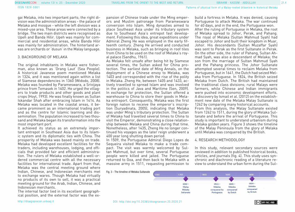
build a fortress in Melaka. It was denied, causing Portuguese to attack Melaka. The war continued for 40 days, and in the end, the Portuguese won. After the ruling of Portuguese in Melaka, the root of Melaka spread to Johor, Perak, and Pahang. The royal of Melaka (Sultan Mahmud Syah) had escaped to Johor and built their kingdom in Muar, Johor. His descendants (Sultan Muzaffar Syah) was sent to Perak as the first Sultanate in Perak. On the other side, the ruler of Pahang, Sultan Ah-mad Syah, was also a descendant of Melaka; the son from the marriage of Sultan Mahmud Syah and the Pahang princess. The Johor Sultanate attempted several times to reclaim Melaka from Portuguese, but in 1641, the Dutch had seized Mel-aka from Portuguese. In 1824, the British seized Melaka from Dutch. The British had maintained the traditional class divisions; rural Malays were farmers, while Chinese and Indian immigrants were pushed into economic development efforts. A discovery by Ismail et al. (2012) on the establish-ment new date of the Melaka Malay Sultanate is 1262 by comparing many historical accounts.From this analysis, the Malay Sultanate existed from 1262 to 1511, during the glory of Melaka Sul-tanate and before the arrival of Portuguese. This study is important to understand urbanism during Melaka golden years. Figure 3 shows the timeline of the Malay Peninsula from the glory of Melaka until Melaka was conquered by the British.
4. RESEARCH METHODOLOGY
In this study, relevant secondary sources were reviewed in addition to published historical books, articles, and journals (fig. 4). This study uses syn-chronic and diachronic reading of a literature re-view to understand the urban form during the Sul-
Fig. 3 - The timeline of Melaka Sultanate

21.5volume 13/ n. 25 - December 2020
ISSN 1828-5961
DISEGNARECON IBRAHIM - KASSIM - ABDULLAH
http://disegnarecon.univaq. i t
Patterns of physical form of a Malay-rooted Urbanism in historical Melaka
TRAVELING FROM THE ORIENT TO THE WEST AND RETURN.
DOI: http://doi.org/10.20365/disegnarecon.25.2020.21
tanate era. A cross-disciplinary reviews of social, culture, polity and urban areas was done to gather a comprehensive understanding this city. Lithog-raphy that were drawn by Portuguese accounts were collected and used in this research.The historical method using textual analysis was used in this research consisted of historical docu-mented texts from local, Portuguese, and Chinese authors. For Portuguese and Chinese in particu-lar, the documented texts were written after the occurrence of the events; in other words, the texts were reports of events. Note that past compre-hensive works are scarcely available. Literature narratives were also used as a source, as in the Malay narratives, many events are described in classical sentences and ‘pantun’ (Malay poem). Most of the works describe the culture of the past or arts that belong to a historical tradition, with some were written based on the oral story from the people who lived in a particular village. Fol-lowing these observations, a content analysis of documented texts from urban planning perspec-tive was carried out to evaluate the urban form and urbanism of a historical event.
5. DOCUMENTATION OF MELAKA BEFORE 1511
Based on a documented text from the Portuguese experience during Melaka Sultanate, Duarte Bar-bosa explained that Melaka was a well-known port during those days: “[…] the richest trading port and possesses the most valuable merchandise, and the most numerous shipping and extensive traffic that is known in all the world”. Since Melaka was a strategic place for strong monsoon protection, traders usually waited at the port for the end of the monsoon season. The communities then es-tablished ports for traders to exchange goods, find local products, and repair ships (Andaya, 2008). Mansel Longworth Dames (1921) explained Bar-bosa, a sailor had arrived at Melaka which had recently been conquered by the Portuguese when he wrote. Barbosa in Mansel Longworth Dames (1921) described Melaka as a prosperous, wealthy, and well-known port. Melaka also described to have many golds and was the richest nation in the
6. BEFORE AND AFTER ISLAM IN MELAKA
Although Melaka grew from decentralizing ‘negeri’ (state) and maritime-based polity, the aspects of its pre-Islamic traditional patterns in its urban cores remain. Amongst others were borderlines and gates. The core of the city was initially seen as the seat of cosmological power, the navel of the world. Of symbolic importance, the seat of the ruler rep-resents the source of spiritual power. Manifested and architecturally articulate with the most sacred place of the whole area of Negara, the palace as the seat of the ruler was not always represented by the most monumental and elaborated building in the state, but by the most of sacred and myste-rious domain of the city. The city wall defined the transition between the in and outside of Negara.The gateway denoted the point of entry with specif-ic treatment for practical and symbolic purpose. In Melaka, the gateway was the bridge, in which Syah-bandar were placed for tax payment. It was also Melaka’s first point of entry. The Negara was seen as a symbolic centre of the cosmos built upon the cosmological mandala model that was located in the hinterland. It was also located at an ample ge-ographical setting, either at the symmetrical order of the Hindu cosmological ideas or at a visual ori-entation. The Negara was also placed at the plain areas between great valleys and river confluence. After the arrival of Islam, Reid (2015b) described that Melaka rose as a maritime city and an Islam-ic centre. Certain character and remnants of the ‘nagara’ remain despite maritime centres were often projected without a clear pattern, were or-ganic and random. The urban Melaka urban form began to take place during the transition from Buddhism to Islamic culture. The Southeast Asian polities before the 14th CE were generally credited
Fig. 4 - Methodology of the research
world. Another author, Emanual Godinho (1613), was a Melaka-born Portuguese cartographer writ-ing in the 16th Century, had recorded the existence of a well-ordered law, which was based on Islamic law. Castanheda (n.d.) described the merchants in Melaka as very rich, and the richness can be measured by gold. Similarly, D’Albuquerque had noted that the custom, commerce, and develop-ment of Melaka were prosperous and luxurious, and it was a powerful empire and the centre of Is-lamic development in Southeast Asia. Pires (1944) wrote: “[…] and true it is that this part of the world is richer and more prized than the world of the Indies, because the smallest merchandise here is gold, which is least prized, and in Melaka they consider it merchandise [...] in Melaka they prize garlic and onions more than musk, bepzoin and other precious things”.It should also be mentioned that the locals in Melaka were of Malay ethnicity, and were the stimulus for the formation of the new ethnic categories of ‘Orang Laut’ and aboriginals (An-daya, 2008). The continuous stream of trad-ers coming in Melaka created different cul-ture from many areas; a multiculturism, the result of many cultures living at a trading port. The only available data is lithography and the doc-umented text on the description of Melaka explo-ration was written by Portuguese and Chinese. The documentation from a Chinese writer, Ma Huan, who travelled to Melaka between 1413 and 1415 was also used in this research. Several local documents were also found, but they have a very limited explanation of the urbanism in Melaka. Figures 5 and 6 shows a lithography drawn by Por-tuguese during the visit of Lopez de Sequire in Mel-aka in 1509. A minaret towers, masjid and two and three tier buildings can be seen from this piece.

21.6volume 13/ n. 25 - December 2020
ISSN 1828-5961
DISEGNARECON IBRAHIM - KASSIM - ABDULLAH
http://disegnarecon.univaq. i t
Patterns of physical form of a Malay-rooted Urbanism in historical Melaka
TRAVELING FROM THE ORIENT TO THE WEST AND RETURN.
DOI: http://doi.org/10.20365/disegnarecon.25.2020.21
lam was the idea of equality in Islam (Ishak & Ab-dullah, 2012), which claims that all individuals are equal in the eyes of Allah, the One God in Islam. Islamic institutions such as ‘surau’, mosque, and madrasah have strengthened and enhanced ex-isting customs and traditions with more intensive gatherings and collaborations that built a strong community in Pre-colonial Melaka (Wiryomar-tono, 2011). Moreover, Ma Huan had explained the way of life of people in Melaka; the religion of people in Melaka was Islam, worshipped god, and recited the Quran with a simple tradition. As early as the 1440s, Melaka had adopted the ‘jawi’ script; Malay language written in Arabic charac-ters (Lowey-ball, 2015).
as a ‘negara’ (country) form in which there were a sacred centre and mandala (Earth) or cardinal layout. Tarling (2008) stated: “Majapahit and Bubat is a market city located on a wide plain. The Ne-garakertagama mentioned a cosmopolitan city of many quarters with a square market, surrounded on three sides by tall buildings, with a character of a ritual capital due to a relationship with monar-chy with prominence as sacred centre and place of festival celebration[…]”. Such architecture was similar to the patterns in Angkor: “temples aligned East-West and North-South purposely to project the image of heaven on Earth”.According to Alwi (2001), the cultural system ex-isted since the pre-Islamic era, and the whole Ma-
lay realm, irrespective of their religion, traditions or sub-ethnicities, had embraced the traditions and rites in their culture. Mahkota Iskandar Syah conversion to Islam was one of the reasons for the rapid spread of the religion, and it occurred around 1414. Before embracing Islam, they lived based on the Hindu caste system, which was lat-er assimilated into Malay traditional life (Suryani et al., 2012). The acceptance of Islam in Melaka had significantly influenced the Malay lifestyle and culture in Malay towns. The main factor that enabled the Sultanate of Melaka to increase the prestige and influence of Malay culture was the Islamic teachings itself (Andaya & Andaya, 1982). Another factor that encouraged the spread of Is-
Fig. 6 - Lithography (see Fig 5) zoomed to show the masjid (mosque), mina-ret towers and several tall buildings opposite to the shore (n.d)
Fig. 5 - Melaka 1509 - from Portuguese sources, lithograph the arrival of Diego Lopes de Sequeira (n.d)

21.7volume 13/ n. 25 - December 2020
ISSN 1828-5961
DISEGNARECON IBRAHIM - KASSIM - ABDULLAH
http://disegnarecon.univaq. i t
Patterns of physical form of a Malay-rooted Urbanism in historical Melaka
TRAVELING FROM THE ORIENT TO THE WEST AND RETURN.
DOI: http://doi.org/10.20365/disegnarecon.25.2020.21
7. THE URBAN FORM OF MELAKA
Fort was one of the essential elements of urban form. The construction of a fort was vital because the facility served as an administration and de-fence centre. Megat Iskandar Shah built a palace on top of St. Paul Hills. It is important to know if there was any fence or fort built around the palace complex in Malacca, in the Sejarah Melayu men-tioned that “[…]then Sultan Ahmad stay in Ben-tayan, Peringgi (Portuguese) stay in Melaka, and they made pagar ruyung of the palace as a fort[…]” – the Portuguese rebuilt the remains of the pagar ruyung wall palace as the fort. The pagar ruyung are the walls that surround the main complex of the palace in Melaka. Pagar ruyung were of stone materials because the Portuguese town was built from these materials, including mosques as well as tombstones in the complex of royal tombs (Na-sir, 1990). The pagar ruyung of Melaka, or fort of Melaka, which was guarded by armed warriors at the time, was comprised of administrative, pala-tial, mosque, sentry towers, and royal residences complexes. One study found the existence of ad-ministrative area, mosque, shops, settlement, riv-ers and streets, agricultural area, and graveyards in Melaka (Ibrahim et al., 2018).As Megat Iskandar Shah embraced Islam in 1414, another significant mosque called Masjid Jamek was built close to the palace. Report by Castan-heda “From the mouth of the Sungai Melaka and facing east (inland), a sailor would see the sul-tan’s palace complex extending down the right-hand side. This was the southern quarter, where nobility lived. Behind it loomed a large hill with vistas over the river and harbour […] Looking left, an early visitor would have seen the walled Chi-nese settlement established for sailors attached to the Zheng He’s missions[…]Further down the Sungai Melaka, one reached Malacca’s second market quarter, on the right-hand side of the riv-er behind the royal complex (as things would be viewed from the harbour). Further on, after the river took a sharp curve to the left, the bazaar gave way to large numbers of Malay houses built to face the water. These houses “are of wood, and
Fig. 7 - Lithography depicted a group of people with elephants at the open spaces in front of the palace that surrounded with stonewall, during the arrival of Diego Lopes de Sequeira (n.d).
principally by the sea-side […] Bukit Sina (Cina), a hill with a smaller, less wealthy secondary Chi-nese settlement atop it, was behind the strip of houses on the riverbank. Meanwhile, to the north - that is, on our imaginary sailor’s left-hand side - the main Chinese community eventually gave way to a Javanese quarter, and then to random suburbs occupied chiefly by Malays. This, in turn gave way to the jungle. Beyond that, our boatman would come to villages of fisherman and, very far down the river, to the various garden estates kept as an escape by many of Malacca’s most impor-tant noblemen”.
The quote shows an extensive text document that demonstrates the urban form of the city along the river of Melaka. Widodo (2008) described that ‘rumah panggung’(vernacular stilt houses) was clustered at the base of the hill, and on the oth-er side of Melaka River, another settlement was developed. Hamka (2016) also mentioned that the houses were aligned with the coast of Melaka. In 1403, Ma Huan explained that the houses were like rooftop houses about four yards high, on which there was no board and roofed with thatch. The houses in Melaka have been described in de-tail in Portuguese sources.

21.8volume 13/ n. 25 - December 2020
ISSN 1828-5961
DISEGNARECON IBRAHIM - KASSIM - ABDULLAH
http://disegnarecon.univaq. i t
Patterns of physical form of a Malay-rooted Urbanism in historical Melaka
TRAVELING FROM THE ORIENT TO THE WEST AND RETURN.
DOI: http://doi.org/10.20365/disegnarecon.25.2020.21
In addition, the Portuguese sources (Mansel Longworth Dames, 1921) explained that Upeh was also a commercial area. There were also hous-es and subterranean storehouses, or room built partly on the ground and under the ground (Birch, 1774). From these statements, we can understand that Upeh was an area with shops and houses or mixed-used areas. This area was a residential area and was a part of the defence area, as it was located in the coastal area. The Malay populations lived in various villages and settlement surround-ing the royal palace and palace. The elites lived on the hill whereas the commoners occupied the lowlands. Ibrahim et al. (2020) identified the en-trepot, commercial centre, the royal city centre and the neighbourhood, which are indicative of a clustered linear layout strung along both sides of the river bank.As a further precaution, Parameswara had built his residence upstream from Melaka, at Bertam. He did so that he could receive ample warning of any impending attack and could then flee to the safety of the interior (Andaya, 2008). Although Par-ameswara’s successors maintained a residence on Melaka Hill, they lived for the most part in Bertam, going to Melaka only to settle disputes or dispense justice (Andaya, 2008). Iskandar Syah asked his fa-ther’s (Parameswara) permission to settle in Mel-aka Hillm, and he built his house on top of the hill where the Kings of Melaka had their dwelling. The palace of Sultan Mansur Syah was built in 1460, and the spaces inside the palace –‘Penanggahan’ (kitchen), ‘Istana besar’ (palace proper), ‘surau’ (mosque), ‘pemandian’ (bathing and ablution area), ‘balairong’ (throne room), ‘nobat’ (royal musical ensemble hall), ‘balai apit pintu’ (audience hall), ‘balai mendapa’ (outer hall of audience) and ‘balai’ (hall)– were located on the top of the hill. Several questions were raised from this; i) what was the form of Melaka Sultanate fort? and ii) what was the orientation of the Melaka Sultanate palace?Several authors had discussed on the form of the fort. The Book of Duerte Barbosa by Dames (1921) has explained “forthwith a very fine fortress was built there, which with the city and all the trade thereof and its navigation remained subject to the
they followed the south-east direction. This obser-vation was consistent with the finding by Sulaiman et al. (2007) and JahnKassim, Ibrahim, Harun, & Kamaruddin (2018). Meanwhile, Harun and Jalil (2014) explained that Parameswara built his pal-ace on a hill overlooking the Bertam River estuary, which was in the south-east direction. These authors provided a consistent orientation of the palace of Melaka but with a different angle. For this argument, we should refer to the Portuguese sources. Castanheda (1582) and De Barros (1706) explained in the report that the Portuguese had
Portuguese[…]”. Sulaiman, Shamsuddin, Norbi-enna, & Anwar (2007) explained that the fort of Melaka was square-shaped. The orientation of the palace of Melaka was highly debated among earlier researchers. Noor (2013) claimed that the orientation of the palace was at the north-east, in the direction of Melaka Town, and argued that the palace should be orientated to the city of Melaka. Noor also added that the hilly topography facing the coastal area was too steep, making it difficult to reach the palace. Nevertheless, the earlier ver-sion of Sulalatus Salatin (1979) mentioned that
Fig. 8 - Lithography depicted activities at the open spaces in front of the fort. A walled fort was elevated from the lower to hilly areas (n.d).

21.9volume 13/ n. 25 - December 2020
ISSN 1828-5961
DISEGNARECON IBRAHIM - KASSIM - ABDULLAH
http://disegnarecon.univaq. i t
Patterns of physical form of a Malay-rooted Urbanism in historical Melaka
TRAVELING FROM THE ORIENT TO THE WEST AND RETURN.
DOI: http://doi.org/10.20365/disegnarecon.25.2020.21
positioned his ship right from the bridge and shot the cannon directly to the mosque many times. Text by Albuquerque “[…]to set fire to the king’s houses which stood at the side of the mosque”. Since the palace was located on the hill and the mosque was at the foothill, the palace was orien-tated directly to the mosque and the bridge. As mosque was located opposite to the palace, these two buildings were diminished due to the continu-ous attack from the enemy. Adil explained […] The bridge which joined the southern part, where the palace and the administration centre were locat-ed, to the northern part, the commercial centre, was the first target of the Portuguese”. Thus, from the sources of the textual documents and maps provided from authors, we conclude that the pal-ace should be located on the Melaka Hill, at the south-east direction, directly to the bridge.Another important element of an ancient Malay town was a mosque. This mosque was built at the riverbank of the Melaka River. The mosque was located opposite to the palace, indicating the importance of Islam to the ruler. Another source (Castanheda, 1582) claimed that the mosque site was located inside A Famosa areas, while Tomé Pires in Suma Oriental mentioned that the Portu-guese constructed their fortress (Fortaleza) with a 5 stories tower on the site of a mosque. The mosque was also called Masjid Raya, and was the main focal point of Islamic social activities. Both traders and locals visited this mosque to pray. The mosque and several other buildings were made of stone; some of them were wooden houses with a roof made of thatch (Yusof, 2017); and some of the houses were made of stone and ‘kapur’. The identification of the palace and mosque material during Sultanate era also can be referred to the text “The Portuguese fort was built by pulling down the houses of the people and the mosques and the other existing buildings during the period” (Loureiro, 2008).The bridge was located in the middle of Kota Mel-aka, specifically at the foothill of Bukit Melaka. Castanheda (1582) explained that the bridge was close to the mosque. During that time, the bridge played an important role in Melaka. It was a cov-
ered bridge, and market-place of twenty pavilions where commodities of all goods were sold. It con-nected these two areas which were on opposite sides of the river and were located near the har-bour in the estuary. People were also conducting businesses along the roads, and some of them conducted business in front of their houses. The market was clustered along the streets and the river (Emanual Godinho, 1930). There was one event, written by Tun Sri Lanang, when they tried to align the shops to be straight by using the rope. The arrangement of the shops was not organic, but it was planned by the authority.As to the market in Melaka, quoted from Ma Huan “Oxen, goats, fowls and ducks, although they have them, are not plentiful: prices are very dear; (and) one of their water-buffaloes costs more than one chin of silver. No donkeys and horses are seen”. This statement shows that many of the goods were livestock. For commercial wise, Melaka was one of the port city specifically used by the trad-ers. The Muslim and Chinese traders met at city ports such as Melaka, Ayudha, and Gresik to ex-change items (Alatas, 1997). Markets were located along or at the mouth of the river, at the beach, and along the roads. Several laws in Melaka were also documented; for example, The Melaka Law and The Port Law (Liaw & Sarumpaet, 2011). In addition, the markets in cities became the centre of movements, easy access to land and waterways. The market was also a meeting point of different identities/ethnicities for conducting business. Ma Huan also stated that the warehouses were locat-ed at the left side of the bridge. The warehouse was wooden palisade like a castle, with four gates and watchtowers, or warehouses near the harbour. It was built to safe-guard the goods of the traders. Open space or ‘Padang’ was important in Melaka Sultanate. The main ‘padang’ was located just next to the mosque. It was also located in front of the Malay Sultanate palace (Harun & Said, 2008). ‘Pa-dang’ was the area for the people to have a meeting with the Sultan. The best location of the mosque that needs open area (‘padang’) for a large outdoor congregation, state ceremonies, rituals, and annu-al celebrations for Raya Ied, and Raya Adha (Wiry-
omartono, 2014). ‘Padang’ was also used to play games such as ‘sepak raga’, making it an impor-tant recreational and meeting sites for the people, thus an important element of a cultural and social landscape. The hinterland area consisted mostly of agricultural area which was found to be dispersed. Agricultural areas were located at the suburban area 12 to 16 km ahead, mostly covered with large orchards, beautiful meadows, or pastures for live-stock and rice fields under cultivation (Pinto, 2011). A river system can be identified as the main form of transportation in old Malay cities because all of the historical forts were located near the river. Melaka as an important port used the sea and riv-er as the main transportation route for trading, for moving from one to another, and for living. It was also recorded that there was a principal street leading to the bridge (Barros, n.d.) and the coast-al area (Gaspar Correia, 1496). The Malay Annals also recorded that there was a four-junction road located in the middle of the city (Tun Sri Lanang, n.d.). A planned road network and well-arranged bridges were built in the Melaka city to connect the roads, which were separated by the river (Yu-sof, 2017). These documented texts show that Melaka had a planned road network, especially at the town areas.
Fig. 9 - Designation of Melaka as UNESCO World Heritage, inserted the Replica Melaka Sultanate Palace (UNESCO, 2007).

21.10volume 13/ n. 25 - December 2020
ISSN 1828-5961
DISEGNARECON IBRAHIM - KASSIM - ABDULLAH
http://disegnarecon.univaq. i t
Patterns of physical form of a Malay-rooted Urbanism in historical Melaka
TRAVELING FROM THE ORIENT TO THE WEST AND RETURN.
DOI: http://doi.org/10.20365/disegnarecon.25.2020.21
The land transportation mainly used elephants (Hashim, 1989), and most literature of Melaka narrate the use of the river as their main trans-portation. The main transportation for the people and Sultan was by the river or sea, at which trad-ers’ activities also took place. The street trans-portation such as Melaka, elephants were used to carry belongings from the rural to the banks of the river, which the goods were then transported through barges and boats on the river or the sea. River systems according to Gullick were the ear-ly nascent states; based on a dendritic system, the Sultan controlled all trade up-stream at the mouth of the river. Melaka town is also complete with trenches (Zainuddin, 1961).
8. MELAKA IN PRESENT
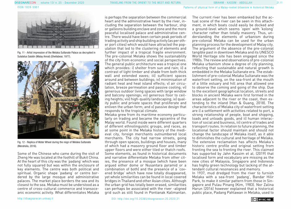
Melaka and George Town has been developed as a historic city that received a status as World Her-itage Site in July 2008 by UNESCO, becoming Ma-laysia’s first cultural World Heritage Site (WHS) property. Below is the map of the inscribed prop-erty and buffer zone of the historic city of Melaka. One particular approach by institution to recreat-ing a nostalgic version of the Melaka urban fabric which has been erased throughout the centuries was the development of replica of the Melaka Sul-tanate Palace and Malay Sultanate Water Wheel at the side of Melaka river. The replica of Melaka Sultanate Palace was built according to the his-torical relics of the Melaka Sultanate Palace have been rebuilt from the viewpoint of the literature “Sulalatus Salatin”, in order to reminisce on the greatness of Melaka and the uniqueness of the Malay traditional culture in the 15th century, using traditional construction techniques and materials (Siti Nurmasturah Harun et al., 2020). The palace originally located on top of St. Paul Hills. According to the annals, Sultan Mansur Shah’s seven-tiered palace was built entirely without nails and sup-ported with carved, wooden pillars and featured a copper and zinc roof. The most elaborate roy-al palace ever constructed in the world in 1459. The annals also stated that it was destroyed the year after the sultan ascended the throne when
it was struck by lightning. The Malay Sultanate Water Wheel was built near to Melaka river that describe about the successful of Malay Sultanate as an international port in the world. During those times, the water wheel was functioned to set the water level as it was visited around two thousands of ships from over the world (Yusof, 2017).
9. MATRIX ANALYSIS AND DISCUSSION OF UR-BANISM OF MELAKA SULTANATE
A matrix analysis was extracted from the reviews of urbanism in Melaka Sultanate (Refer to Ta-ble 2). The analysis is divided into several urban spaces or buildings; palace, masjid, fort, harbour, bridge, transportation system, ‘padang’/open spaces, market/commercial area and settlement.In summary, the following points emerge from the
matrix of urbanism analysis during the Melaka Sultanate era. Firstly, the urbanism structure dur-ing the glory of Melaka Sultanate was planned for a certain extent. For example, the roads located at the market areas were planned using the rope system, making the road linear. The second point is that the Malay Sultanate of Melaka town was made of four basic elements; the palace, mosque, market, and ‘padang’. These elements were surrounded by the settlements of the town and were linked with the roads. These elements also obeyed the Islamic principles of urban areas - that mosques are the centre of the Islamic city. Thirdly, Melaka town was divided according to races. The traders or immigrants, those from Arabs, Per-sian and Chinese, were located in one area called Upeh. Malays were located at Banda Hilir, Jawa at Kampung Jawa; Gujerati lived near the ports.
Fig. 10 - Replica of Melaka Sultanate Palace as decrypted in Sulalatus Salatin (Majlis Bandaraya Melaka Bersejarah, 2020)
21.11volume 13/ n. 25 - December 2020
ISSN 1828-5961
DISEGNARECON IBRAHIM - KASSIM - ABDULLAH
http://disegnarecon.univaq. i t
Patterns of physical form of a Malay-rooted Urbanism in historical Melaka
TRAVELING FROM THE ORIENT TO THE WEST AND RETURN.
DOI: http://doi.org/10.20365/disegnarecon.25.2020.21
Some of the Chinese who came during the visit of Zheng He was located at the foothill of Bukit China. At the heart of this city was the ‘padang’ which was not fully squared but was within the enclosure of key elements. The centre was both political and spiritual. Organic shape ‘padang’ or centre bor-dered by the large mosque and administrative palaces. The market place borders the sea and its closest to the sea. Melaka must be understood as a centre of cross-cultural commerce and transoce-anic economic activity. What differentiates Melaka
is perhaps the separation between the commercial heart and the administrative heart by the river, in-cluding the separation between the harbour, ship or galleons building enclave and zone and the more peaceful localised palace and administrative cen-tre. There would have been certain peak periods of trading activity and ship building activity (as per oth-er port cities) which would have attracted the pop-ulation that led to the clustering of elements and further impact of a tropical fragile environment. The pre-colonial Melaka shows the sustainability of the city from economic and social perspectives. The general public architecture was a tropical one which provides: i) shelter from sun and rain; ii) a contrast of light timber and shade from both thick wall and extended eaves; iii) sufficient spaces around and between buildings; iv) minimisation of radiant heat and heat island effects; v) air circu-lation, breeze permeation and passive cooling; vi) generous outdoor living spaces with large window and balcony openings; vii) generous floor to ceil-ing heights; viii) high-quality landscaping; ix) qual-ity public and private spaces that proliferate and enliven the urban form; and x) passive design that responds to the tropical climate. Melaka grew from its maritime economy particu-larly on trading and became the epicentre of the Malay world. Found inside were different quarters of different ethnolinguistic groups, and races, as at some point in the Melaka history of the medi-eval city, foreign merchants outnumbered local merchants. The city had narrow streets, going through open spaces, buildings and houses, many of which had a masonry ground floor and timber upper floors and were either tiled or thatch roofs.Some elements, as found in historical documents and narrative differentiate Melaka from other cit-ies, the presence of a mosque (which have been argued either dome or Nusantara pyramid or a combination of both) and the presence of a ‘cov-ered bridge’ which have now totally disappeared, yet whole similarities can be found in local covered bridges in Thailand and other Asian cities. Although the urban grid has totally been erased, similarities can perhaps be associated with the river -aligned grid such as still found in Pontianak Kalimantan.
The current river has been embanked but the ac-tual scene of the river can be seen in this attach-ment, in which boats could easily be docked and a ground-level which seems ‘open’ with ‘kolong’ character rather than totally masonry. Thus, un-derstanding the elements of urbanism during pre-colonial Melaka can be used for the urban planning process for the development of Malay city. The argument of the absence of the pre-colonial tangible past in downtown Melaka and its UNESCO World Heritage site has been engaged since the 1980s. The review and observations of pre-colonial Melaka urbanism show a degree of city planning, reflecting that sustainable and natural growth is embedded in the Melaka Sultanate era. The estab-lishment of pre-colonial Melaka Sultanate was the waterfront setting, on the sea-front at the mouth of a little estuary and hill area that allowed one to observe the coming and going of the ship. Due to the excellent geographical location, streets and blocks in ancient Melaka were first formed in the areas adjacent to the river or the coast, then ex-tending to the inland (Han & Guang, 2018). The characteristics of Melaka city of waterfront setting are i) a settlement with activities related to port, a strong relationship of people, boat and shipping, loads and unloads goods, and ii) human interac-tion of social and business, iii) centre of trades and transport routes. In relation to future planning, the locational factor should maintain and should not change the landscape of Melaka itself, as it able to diminishes the cultural and heritage of Melaka. The extensive reclamation has affects Melaka’s historic centre profile and original setting from fronting the sea to fronting the river. This claimed has supported by Jahn Kassim et al. (2019) that localised form and vocabulary are missing as the new cities of Malaysia, Singapore and Indonesia has highly green technology but lacking of the at-tendant cultural resonances and memory.In 1937, mud dredged from the river to furnish Melaka with a sea-front ‘padang’, Bandar Hilir Park, to make it similar pattern from those in Sin-gapore and Pulau Pinang (Kim, 1983). Nor Zalina Harun (2016) however explained that a historical public place, Padang Pahlawan in Melaka, used to
Fig. 11 - Artist impression of the Melaka Sultanate Palace as decrypted in Sulalatus Salatin (Malay Annal) (Shellabear, 1977).
Fig. 12 - Replica of Water Wheel during the reign of Melaka Sultanate (Merahsilu, 2016).

21.12volume 13/ n. 25 - December 2020
ISSN 1828-5961
DISEGNARECON IBRAHIM - KASSIM - ABDULLAH
http://disegnarecon.univaq. i t
Patterns of physical form of a Malay-rooted Urbanism in historical Melaka
TRAVELING FROM THE ORIENT TO THE WEST AND RETURN.
DOI: http://doi.org/10.20365/disegnarecon.25.2020.21
be the ground for the first proclamation of inde-pendence in 1957 was demolished for commercial development, and the former function of the ‘pa-dang’ as a historic public space has deteriorated. Land reclamation has erased the special link that
Melaka had with the sea. With extensive reclama-tion at the harbour in the center of Melaka, it no longer maintain the heritage values of Melaka as historical site. The similar situation of develop-ment of residential in the present state of the har-bour and the waterfront has also has diminished the original form and function. The reflection that can be learnt from pre-colonial Melaka Sultanate for the future planning can be arise from sustainable principles. This including alignment with water bodies, the degree of open spaces, degree of greenery and symbolic charges which can be linked to the past of the notion as an ideal rule and basis to develop sustainable plan-ning. Any city or township in Asia, must rebrand its own identity, through geographical, climate, cul-tural and “historical layering of planning” which will distinguish this particular brand of city from any other (Jahnkassim et al., 2020). Such study also added that such planning, especially in Mela-ka, should identify its original beginnings to hybrid expression which then evolved side by side with its colonialised history.
10. CONCLUSION
Melaka in the 15th CE was a city situated against the sea as with other port cities of the same era. This paper examined the aspects of urbanism and culture of the historical city of Melaka, highlight-ing the urbanism of the pre-colonial Melaka. The pre-colonial Melaka has emerged from the river-ine system from trading activities that influence the settlement formation. It started from villages, then grew rapidly after it has attracted traders to conduct business. In the traditional Melaka Sultan-ate, important elements such as the palace, fort, mosque, ‘padang’ were located at the riverine sys-tem, which described the essence of sustainable urbanism, that sustains the relationship of people and built environment from the customs, lifestyle, culture and traditions. The contribution of this pa-per enhanced the understanding of the traditional urbanism in Malay town, particularly in Melaka Sul-tanate. Thus, this study benefited planners and de-velopers with regards to Malay city of urban design.
ACKNOWLEDGMENT
Many thanks go to our TRGS re-search groups for supporting this paper. Thanks you also to the Inter-national Islamic University of Ma-laysia and the Ministry of Higher Education (MOHE) for the research grant “Trans-Disciplinary Research Grant Scheme” (TRGS16-03-002-00002). Authors also would like to sincerely thank all referees for their suggestions to improve the manuscript.
REFERENCES
Alatas, S. M. (1997). Cultural sym-bolism and legitimization in the context of change: Early Malay state formation. Colombia University.
Alwi, A. (2001). Adat Melayu Mengikut Perspektif Orang Islam di Malaysia. In Adat Melayu Serum-pun. University Malaya.
Andaya, B. W., & Andaya, L. Y. (1982). A History of Malaysia. Mac-millan Asian Histories Series.
Andaya, L. Y. (2008). Leaves of the same tree: Trade and Ethnicity in the Straits f Melaka. University of Hawai’i Press.
Barros, J. De. (n.d.). On the deeds & discoveries & conquests made by Portuguese in the seas and Eastern Lands. In Portuguese Documents on Malacca Volume 1.
Barros, J. De. (1706). Held-dadige Scheeps-togt van Alfonso de Albu-querque na de Roode-Zee In het Jaar 1506, en ervolgens gedaan: behel sende de geleegendheyd, opkomst en voortgang van de Kon-ingrijken Ormuz, Goa, Malacca, etc. Leiden: Pieter van der Aa.
Birch, W. de G. (1774). The com-mentaries of the great Afonso Dalboquerque: Second Viceroy of India. Hakluyt Society, London.
Castanheda, F. L. De. (1582). Histo-ry of the Exploration & Conquest of the Indies By the Portuguese.
Dames, Mansel Longworth. (1921). The Book of Duarte Barbosa Vol. 2 (M. Longworth Dames (ed.)). The Asiatic Society. https://archive.org/details/in.ernet.dli.2015.47303/page/n1/mode/2up
Emanual Godinho, de E. (1613). De-scription of Malaca and Meridional India and Cathay in three treatries.
Emanual Godinho, de E. (1930). Eredia’s Description of Malacca (J. V. Mills (ed.)). KMBRAS.
Evers, H.-D., & Korff, R. (2000). Southeast Asian Urbanism: The Meaning and Power of Social Space (L. V. Münster (ed.)).
Gaspar Correia. (1496). Lendas da India.
Hadi, A. (1992). Aceh and the por-tuguese (Issue April). McGill Uni-versity.
Hamka. (2016). Sejarah Umat Is-lam. Gema Insani Press.
Han, W., & Guang, C. (2018). Tradi-tional Urban Form and Evolution-ary Mechanisms-Quanzhou and Malacca. 8(2), 508-513.
Harun, N. Z., & Said, I. (2008). Pa-per presented at : Morphology of Padang : A case study of Dataran Merdeka , Kuala Lumpur. 1-3.
Harun, S. N., & Jalil, R. A. (2014). The History and Characteristics of Malay Early Towns in Peninsular Malaysia. Asian Journal of Hu-manities and Social Studies, 2(3), 403-409.
Harun, Siti Nurmasturah, Shaharu-din, H., & Ahmad, M. A. (2020). Tra-ditional Cultural Heritage Artefacts
Table 1 - Matrix Analysis on the Urban Configuration and Function in Historical Melaka City.

21.13volume 13/ n. 25 - December 2020
ISSN 1828-5961
DISEGNARECON IBRAHIM - KASSIM - ABDULLAH
http://disegnarecon.univaq. i t
Patterns of physical form of a Malay-rooted Urbanism in historical Melaka
TRAVELING FROM THE ORIENT TO THE WEST AND RETURN.
DOI: http://doi.org/10.20365/disegnarecon.25.2020.21
in the Sultanate Palace of Melaka: The Benefits of Sustaining Cultural Values Through the Furniture De-sign and Development Process in Related Fields in Malaysia. Voice Academia, 16(1), 15-25.
Hashim, M. Y. (1989). Kesultanan Melayu Melaka. Dewan Bahasa dan Pustaka.
Hoyt, S. H. (1993). Old Malacca. Oxford University Press.
Ibrahim, I., Abdullah, A., Ibrahim, M., & Murtaza, F. F. N. (2018). His-torical Urban Form: A case study of Melaka. Journal of Malaysian Ins-tritute of Planners, 16(2), 153-163.
Ibrahim, I., Jahn Kassim, P. S., Ha-run, N. Z., Abdul Latip, N. S., Mohd Noor, N., & Abdullah, A. (2020). Historical Intimacy in Malay Urban Core Configurations: A Compar-ative Analysis. Culture & History Digital Journal, 9(2).
Ishak, M. S., & Abdullah, O. C. (2012). Islam and the Malay World : An Insight into the Assimilation of Islamic Values. World Journal of Islamic History and Civilization, 2(2), 58-65.
Ismail, A. R., Ghazali, A. Z., & Zu-lkarnain Abdul Rahman. (2012). Penemuan tarikh baru pengasasan empayar kerajaan Melayu Melaka (Cetakan Pe). Institut Kajian Seja-rah dan Patriotisme Malaysia.
Jahn Kassim, P. S., Kamaruddin, K., Ibrahim, I., & Harun, N. Z. (2019). A Tropicalized Urban Design Frame-work from Morphological Patterns of Pre-Colonial Maritime Centers of the Malay World. GEOINFORMATICA POLONICA, 18, 7-30.
Jahn Kassim, P. S., Ibrahim, I., Har-un, N. Z., & Kamaruddin, K. (2018). Ecological Urbanism in the Tropics
Studies on the Sustainable Dimen-sions of Malay Traditional Urban Centers. International Journal of Engineering & Technology.
Jahn Kassim, P. S., Kamaruddin, K., Syala, N., Latip, A., & Nawawi, N. M. (2020). The Serendipitious City in South East Asia — Urban Archetypal Design Principles from the Morphological ‘ Vernacular .’ 2(2), 21-41.
Kim, K. K. (1983). Melaka’s Malay Society in Modern Times. In K. S. Sandhu & P. Wheatley (Eds.), Mel-aka: The Transformation of a Malay Capital c. 1400-1980 (pp. 70-92). Kuala Lumpur: Oxford University Press.
Liaw, Y. F., & Sarumpaet, R. K. (2011). Sejarah kesusastraan Me-layu klasik. Yayasan Pustaka Obor Indonesia.
Loureiro, R. M. (2008). Historical Notes on the Portuguese Fortress of Malacca (1511-1641). Revista de Cultura - International Edition, 27.
Lowey-ball, S. B. (2015). Liquid Market, Solid State: The rise and demise of the great global empo-rium at Malacca, 1400 - 1641. Yale Univeristy.
Majlis Bandaraya Melaka Berse-jarah. (2020). Istana Kesultanan Melaka. http://www.mbmb.gov.my/ms/pelancongan/istana-kesul-tanan-melaka
Mcroberts, R. W. (1991). A study in growth: An economic history of Melaka 1400 - 1510. Journal of the Malaysian Branch of the Royal Asi-atic Society, 64(2), 47-78.
Merahsilu. (2016). Daulah Me-layu di Melaka - Dunia Melayu Dunia Islam dan gambaran Kota Melaka 500 tahun lalu. http://
merahsilu.blogspot.com/2016/01/daulah-melayu-di-melaka-dun-ia-melayu_10.html
Morris, A. E. J. (1994). History of the urban form before the Industri-al Revolutions. New York: Longman Scientific & Technical.
Moudon, A. V. (1997). Urban mor-phology as an emerging interdis-ciplinary field, Urban Morphology, Vol. 1, pp. 3-10.
Noor, S. Z. S. M. (2013). Pentad-biran Kesultanan Melayu Melaka Kemunculan dan Kegemilangan. Arkib Negara Malaysia.
Nor Zalina, H. (2016). Role and fate of Padang in Malaysian historical cities. December 2008.
Pinto, P. J. S. (2011). Os casados de Malaca, 1511-1641: estratégias de adaptação e de sobrevivência. 141-156.
Pires, T. (1944). The suma oriental of Tomé Pires. An account of the east, from the Red Sea to Japan, written in Malacca and India in 1512-1515 and the Book of Fran-cisco Rodrigues rutter of a voyage in the Red Sea, nautical rules, almanac and maps, written and drawn in the. Hakluyt Society, I.
Reid, A. (2015a). A History of Southeast Asia: Critical Cross-roads. Wiley Blackwell.
Reid, A. (2015b). Historical Thought and Historiography : Southeast Asia. In International Encyclopedia of Social & Behavioral Sciences (Second Edi, Vol. 11). Elsevier.
Sandhu, K. S. (1961). Chinese Col-onization of Melaka – A Study in Population Change, 1500 to 1957 CE. The Journal of Tropical Geog-raphy, 15.
Sen, T. T. (2009). Cheng Ho and Is-lam in Southeast Asia. Institute of Southeast Asian Studies.
Shellabear, W. (1977). Sejarah Me-layu (3rd ed.). Penerbit Fajar Bakti Sdn Bhd.Adil.
Sulaiman, A. B., Shamsuddin, S., Norbienna, S. L., & Anwar, M. (2007). Konsep Baru Model Bandaraya/Bandar Berasaskan kepada Rupa Bentuk Bandar Tra-disional (Conceptual New Model of City/Town based on the Traditional Urban Form.
Suryadinata, L. (2005). Admiral Zheng He and Southeast Asia. In-stitute of Siutheast Asian Studies.
Suryani, I., Resad, M., Rozali, E. A., & Fahimi, A. (2012). The impor-tance of learning islamic history and civilization of Malaysia in the building of human capital and identity of the muslim society in Malaysia. 59, 550-557.
Tarling, N. (2008). The Cambridge History of Southeast Asia. Cam-bridge University Press.
Tun Sri Lanang. (n.d.). Malay Annals.
UNESCO. (2007). Melaka and George Town, The inscribed prop-erty and the buffer zone of the Historic city of Melaka and George Town.
Widodo, J. (2008). Zheng He’s visits and the shaping of cosmopolitan cities in Southeast Asia - Melaka case : facts and fiction 1. Novem-ber, 18-19.
Wirth, L. (1938). Urbanism as a Way of Life. The American Journal of Sociology, 44(1), 1-24.
Wiryomartono, B. (2011). Urbanism in the Malay World: The Origin and
Evolution of the Idea, Function, and Institution of Pre-colonial Ban-dar Melaka. The 5th International Conference of the International Forum on Urbanism (IFoU) 2011 National University of Singapore, Department of Architecture Global Visions: Risks and Opportunities for the Urban Planet.
Wiryomartono, B. (2014). City, Cul-ture and Society Urbanism, place and culture in the Malay world: The politics of domain from pre-coloni-al to post colonial era. City, Culture and Society, 4(4), 217-227.
Yusof, H. (2017). Teknologi Kesul-tanan Melaka. Cintai Publication.
Zainuddin, H. M. (1961). Tarich Atjeh dan Nusantara (Cetakan 1). Pustaka Iskandar Muda Medan.