van gogh infill installation ep summary tv-35-re … · tv-35-re-100001.03 van gogh infill...
TRANSCRIPT
Level 9 100 St Georges Terrace
Perth Western Australia 6000 T +61 8 6218 7100 Quadrant Energy Australia Limited
PO Box 5624 St Georges Tce Perth WA 6831 F +61 8 6218 7200 ABN 39 009 301 964 quadrantenergy.com.au
Van Gogh Infill Installation EP Summary
TV-35-RE-100001.03
PROJECT / FACILITY Van Gogh Infill
REVIEW INTERVAL (MONTHS) N/A
SAFETY CRITICAL DOCUMENT YES NO
TV-35-RE-100001.03
Van Gogh Infill Installation EP Summary 3 of 94
ACRONYMS
Abbreviation Description
°C Degrees Celsius
AFMA Australian Fisheries Management Authority
AFZ Australian Fishing Zone
AHO Australian Hydrographic Office
ALARP As Low as Reasonably Practicable
AMOSC Australian Marine Oil Spill Centre
AMSA Australian Maritime Safety Authority
APASA Asia-Pacific Applied Sciences Association
BIAs Biologically Important Areas
CFA Commonwealth Fisheries Association
CVC Cameron vertical Connector
DAWR Department of Agriculture and Water Resources
DoD Department of Defence
DoT Department of Transport (WA)
DPaW Department of Parks and Wildlife (WA)
EF&LS Exmouth Freight & Logistics Services
EHFL Electric Hydraulic Flying Lead
EMBA Environment that May Be Affected
EP Environment Plan
EPA Environmental Protection Authority
EPBC Environment Protection and Biodiversity Conservation
EPO Environmental Performance Objective
EPSs Environmental Performance Standards
ESD Emergency shutdown
GHG Greenhouse gas
HSE Health Safety Environment
IAPP International Air Pollution Prevention
IMCRA Integrated Marine and Coastal Regionalisation of Australia
IMDG International Maritime Dangerous Goods
IMS Invasive Marine Species
IMT Incident Management Team
IUCN International Union for Conservation of Nature
TV-35-RE-100001.03
Van Gogh Infill Installation EP Summary 4 of 94
Abbreviation Description
JWM Jetwave Marine
KEF Key Ecological Feature
km Kilometre
km2 Square Kilometres
L Litre
m Metres
m3 Cubic Metres
MARPOL International Convention for the Prevention of Pollution from Ships
MGO Marine Gas Oil
mm Millimetres
MOC Management of Change
NEBA Net Environmental Benefit Analysis
NMSC National Marine Safety Committee
NOPSEMA National Offshore Petroleum Safety and Environmental Management Authority
NOx Oxides of Nitrogen
NWMR North West Marine Region
NWS North West Shelf
ODS Ozone Depleting Substance
OPEP Oil Pollution Emergency Plan
OPGGS (E) R Offshore Petroleum and Greenhouse Gas Storage (Environment) Regulations 2009
OSCP Oil Spill Contingency Plan
OSRL Oil Spill Response Limited
OWA Oiled Wildlife Advisors
OWRP Oiled Wildlife Response Plan
PAH Polycyclic aromatic hydrocarbon
PLEM Pipeline End Manifold
ppm Parts Per Million
ROV Remote Operated Vehicle
SMPEP Shipboard Marine Pollution Emergency Plan
SOPEP Shipboard Oil Pollution Emergency Plan
SOx Oxides of Sulphur
VRASS Vessel Risk Assessment
WA Western Australia

TV-35-RE-100001.03
Van Gogh Infill Installation EP Summary 5 of 94
Abbreviation Description
WAFIC Western Australian Fishing Industry Council
WAOWRP WA Oiled Wildlife Response Plan
WDCS Whale and Dolphin Conservation Society
WDTF Western Deepwater Trawl Fishery
XT Xmas Tree

TV-35-RE-100001.03
Van Gogh Infill Installation EP Summary 6 of 94
CONTENTS
1. INTRODUCTION ................................................................................................................................. 9
1.1 Compliance....................................................................................................................................... 9
1.2 Activity Durations and Timing ........................................................................................................... 9
2. ACTIVITY LOCATION ........................................................................................................................... 9
3. DESCRIPTION OF THE ACTIVITY ........................................................................................................ 12
3.1 Overview ........................................................................................................................................ 12
3.2 Installation Activities ...................................................................................................................... 12
3.2.1 Spools, Flying Lead and Gas Lift Jumper Installation ........................................................................... 12
3.2.2 Metrology ............................................................................................................................................ 12
3.2.3 Cement Bag Installation ...................................................................................................................... 12
3.2.4 Pre-Commissioning .............................................................................................................................. 13
3.2.5 Cold Commissioning ............................................................................................................................ 13
3.2.6 Surveys ................................................................................................................................................ 13
3.3 Simultaneous Operations ............................................................................................................... 13
4. DESCRIPTION OF ENVIRONMENT ..................................................................................................... 13
4.1 Environment That May Be Affected (EMBA) ................................................................................... 13
4.2 Physical Environment and Habitat .................................................................................................. 13
4.2.1 Physical environment .......................................................................................................................... 13
4.2.2 Habitats ............................................................................................................................................... 14
4.3 Protected/ Significant Areas ........................................................................................................... 17
4.4 Threatened and Migratory Marine Fauna ....................................................................................... 20
4.4.1 Marine Mammals ................................................................................................................................ 20
4.4.2 Fish and Sharks .................................................................................................................................... 20
4.4.3 Marine Reptiles ................................................................................................................................... 20
4.4.4 Marine Seabirds ................................................................................................................................... 20
4.5 Socio-Economic Receptors .............................................................................................................. 28
4.6 Windows of Sensitivity ................................................................................................................... 28
5. STAKEHOLDER CONSULTATION ........................................................................................................ 38
5.1 Summary ........................................................................................................................................ 38
5.2 Ongoing Consultation ..................................................................................................................... 44
5.2.1 Stakeholder Notifications .................................................................................................................... 44
5.2.2 Quarterly Consultation Update ........................................................................................................... 44
5.3 OPEP Consultation .......................................................................................................................... 45
6. ENVIRONMENTAL HAZARDS AND CONTROLS ................................................................................... 46
6.1 ALARP Evaluation ........................................................................................................................... 48
TV-35-RE-100001.03
Van Gogh Infill Installation EP Summary 7 of 94
6.2 Acceptability Evaluation ................................................................................................................. 49
6.3 Environmental Risk Treatment Summary for Planned Events .......................................................... 50
6.3.1 Interaction with Other Marine Users .................................................................................................. 50
6.3.2 Seabed Disturbance ............................................................................................................................. 51
6.3.3 Light Emissions .................................................................................................................................... 53
6.3.4 Noise Emissions ................................................................................................................................... 55
6.3.5 Planned Operational Discharges ......................................................................................................... 56
6.3.6 Atmospheric Emissions ........................................................................................................................ 58
6.3.7 Spill Response Operations ................................................................................................................... 59
6.4 Environmental Risk Treatment Summary – Unplanned Events ........................................................ 67
6.4.1 Marine Gas Oil Release from Vessel Collision (Surface) ...................................................................... 68
6.4.2 Crude Release Due to Damaged Subsea Infrastructure ...................................................................... 76
6.4.3 Minor Hydrocarbon Release ................................................................................................................ 79
6.4.4 Non-Hydrocarbon and Chemicals Release - Liquids ............................................................................ 81
6.4.5 Non-Hydrocarbon Release (Surface) – Solid ....................................................................................... 83
6.4.6 Marine Fauna Collisions ...................................................................................................................... 85
6.4.7 Introduction of invasive marine species (IMS) .................................................................................... 87
7. MANAGEMENT APPROACH ............................................................................................................. 89
7.1 Management of Change ................................................................................................................. 90
8. HYDROCARBON SPILL RESPONSE ARRANGEMENTS .......................................................................... 90
8.1 Preparedness and Implementation of Response Arrangements ...................................................... 91
8.2 Net Environmental Analysis Benefits (NEBA) .................................................................................. 91
8.3 Oil Spill Response Resources ........................................................................................................... 91
9. CONTACT DETAILS ........................................................................................................................... 92
10. REFERENCES .................................................................................................................................... 93

TV-35-RE-100001.03
Van Gogh Infill Installation EP Summary 8 of 94
LIST OF FIGURES Figure 2-1: Existing Van Gogh / Coniston infrastructure .......................................................................... 10 Figure 2-2: Location of the Van Gogh infill installation operational area ................................................ 11 Figure 4-1: Protected areas within and near the EMBA ........................................................................... 18 Figure 4-2: Key ecological features within and near the EMBA .................................................................. 19 Figure 6-1: Environmental impact and risk assessment process ............................................................. 47 Figure 6-2: Quadrant Energy risk matrix .................................................................................................. 48
LIST OF TABLES Table 2-1: Coordinates of DC2 ....................................................................................................................... 9 Table 4-1: Habitats within the EMBA listed according to presence within the operational area and IMCRA Provincial Bioregions of Australia ................................................................................................................ 15 Table 4-2: Distance from operational area boundary to values and sensitivities within the EMBA ........... 17 Table 4-3: Management Zones for the Australian Marine Parks found within the EMBA and the associated objectives ..................................................................................................................................................... 17 Table 4-4: Threatened and migratory species and communities in the operational area and EMBA ......... 21 Table 4-5: State and Commonwealth fisheries within the EMBA ................................................................ 29 Table 4-6: Socio-economic receptors within the EMBA .............................................................................. 33 Table 4-7: Environmental values and sensitivities within the EMBA – windows of sensitivity ................... 35 Table 5-1: Summary of stakeholders consulted ........................................................................................... 39 Table 5-2: Consultation summary for activity .............................................................................................. 40 Table 5-3: OPEP consultation summary ....................................................................................................... 45 Table 6-1: Consequence level description ................................................................................................... 47 Table 6-2: Likelihood description ................................................................................................................. 48 Table 6-3: Impacts of MGO on sensitive receptors found within the EMBA ............................................... 70
TV-35-RE-100001.03
Van Gogh Infill Installation EP Summary 9 of 94
1. INTRODUCTION
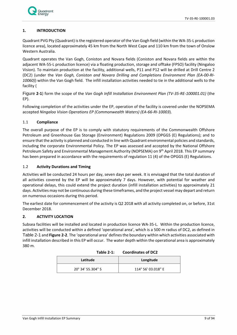
Quadrant PVG Pty (Quadrant) is the registered operator of the Van Gogh field (within the WA-35-L production licence area), located approximately 45 km from the North West Cape and 110 km from the town of Onslow Western Australia.
Quadrant operates the Van Gogh, Coniston and Novara fields (Coniston and Novara fields are within the adjacent WA-55-L production licence) via a floating production, storage and offtake (FPSO) facility (Ningaloo Vision). To maintain production at the facility, additional wells, P11 and P12 will be drilled at Drill Centre 2 (DC2) (under the Van Gogh, Coniston and Novara Drilling and Completions Environment Plan (EA-00-RI-10060)) within the Van Gogh field. The infill installation activities needed to tie in the additional wells to the facility (
Figure 2-1) form the scope of the Van Gogh Infill Installation Environment Plan (TV-35-RE-100001.01) (the EP).
Following completion of the activities under the EP, operation of the facility is covered under the NOPSEMA accepted Ningaloo Vision Operations EP (Commonwealth Waters) (EA-66-RI-10003).
1.1 Compliance
The overall purpose of the EP is to comply with statutory requirements of the Commonwealth Offshore Petroleum and Greenhouse Gas Storage (Environment) Regulations 2009 (OPGGS (E) Regulations); and to ensure that the activity is planned and conducted in line with Quadrant environmental policies and standards, including the corporate Environmental Policy. The EP was assessed and accepted by the National Offshore Petroleum Safety and Environmental Management Authority (NOPSEMA) on 9th April 2018. This EP summary has been prepared in accordance with the requirements of regulation 11 (4) of the OPGGS (E) Regulations.
1.2 Activity Durations and Timing
Activities will be conducted 24 hours per day, seven days per week. It is envisaged that the total duration of all activities covered by the EP will be approximately 7 days. However, with potential for weather and operational delays, this could extend the project duration (infill installation activities) to approximately 21 days. Activities may not be continuous during these timeframes, and the project vessel may depart and return on numerous occasions during this period.
The earliest date for commencement of the activity is Q2 2018 with all activity completed on, or before, 31st December 2018.
2. ACTIVITY LOCATION
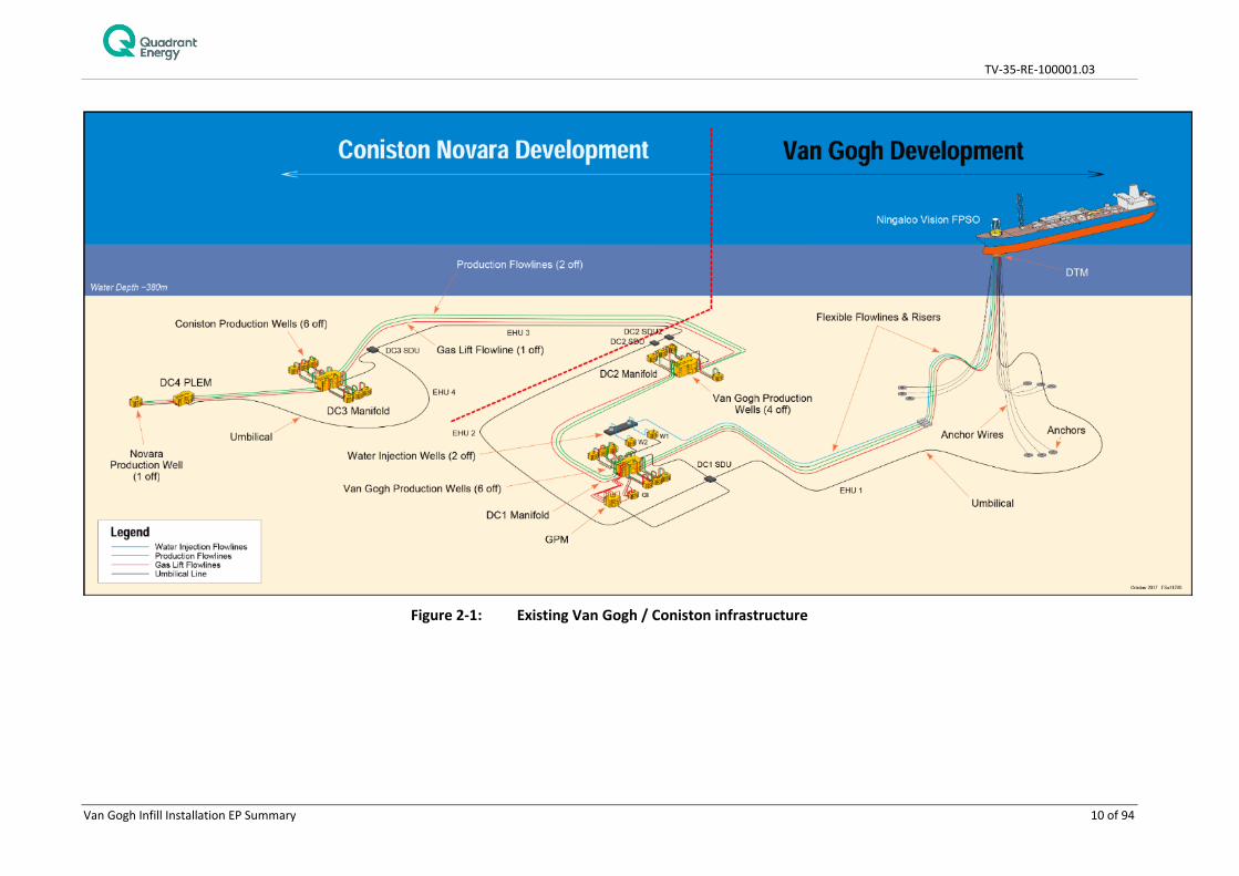
Subsea facilities will be installed and located in production licence WA-35-L. Within the production licence, activities will be conducted within a defined ‘operational area’, which is a 500 m radius of DC2, as defined in Table 2-1 and Figure 2-2. The ‘operational area’ defines the boundary within which activities associated with infill installation described in this EP will occur. The water depth within the operational area is approximately 380 m.
Table 2-1: Coordinates of DC2
Latitude Longitude
20° 34' 55.304" S 114° 56' 03.018" E
TV-35-RE-100001.03
Van Gogh Infill Installation EP Summary 10 of 94
Figure 2-1: Existing Van Gogh / Coniston infrastructure
TV-35-RE-100001.03
Van Gogh Infill Installation EP Summary 11 of 94
Figure 2-2: Location of the Van Gogh infill installation operational area

TV-35-RE-100001.03
Van Gogh Infill Installation EP Summary 12 of 94
3. DESCRIPTION OF THE ACTIVITY
3.1 Overview
Quadrant proposes to conduct infill installation activities on the P11 and P12 wells drilled at DC2 within the Van Gogh field. These activities include:
• Connecting the DC2 manifold and the P11 and P12 Christmas trees (XTs) via the respective rigid tie-in spool;
• Connecting the gas lift jumpers (GLJ) and the Electro-Hydraulic Flying Lead (EHFL) from the P11 and P12 XTs to the manifold;
• Testing; and • Commissioning.
A manned installation support vessel (ISV) will be used to carry out the activity. The ISV will be a dynamic positioning (DP) Class 2 or 3 vessel with a heavy lift built-in crane and two (2) work class ROVs (WROV). Support vessels are not planned for use during the activity. The exact ISV is yet to be confirmed.
No anchoring will be required during the activity.
ISV refuelling at sea will not occur during the activity. Helicopters may be used to transfer crew and equipment, and assist in Health Safety Environment (HSE) or operational emergencies, as required.
3.2 Installation Activities
3.2.1 Spools, Flying Lead and Gas Lift Jumper Installation
The activity will involve the installation of two rigid spools to connect the manifold to the P11 and P12 XTs. The ISV will transport the two 6” x 25 m rigid spools (prefabricated and tested), jumpers and Electro- Hydraulic Flying Lead (EHFL) to the operational area. The ISV and ROVs will then install the spools between the XTs and the DC2 manifold. Note that the rigid spools are installed between each well and the DC2 manifold i.e. they are not installed on the seabed.
The two EHFLs will be pre-installed on a deployment frame and then overboarded with the ISV’s crane. The EHFLs will be installed between the P11 and the P12 XTs, along the seabed, using both WROVs.
The two 60m GLJ will be similarly pre-installed on a second deployment frame and overboarded. The deployment frames will be recovered at the end of the activity by the ISV crane assisted by the WROVs.
The DC2 manifold and the P11 and P12 XTs will be connected via the rigid tie-in spools. The P11 and P12 XTs will each operate with direct flowline, GLJ and EHFL connections to the manifold.
3.2.2 Metrology
Subsea metrology (measurements made between subsea equipment) will be undertaken in preparation for installation activities. Metrology will involve the use of an ROV and LBL (long baseline) acoustic transponders deployed to the seabed, aided by a crane and/or ROV. Ultra-short baseline (USBL) transponders positioned on vessel hulls near the sea surface will also be used for crane and ROV positioning.
3.2.3 Cement Bag Installation
Cement filled bags will be deployed on the GLJs and EHFLs after installation to ensure on-bottom stability. Six 1m x 1m cement bags will be installed on each GLJ and EHFL respectively (24 in total). All cement bags will be lowered to the seabed in a metal basket (2m x 2m) and the WROVs will fly each cement bag from the basket onto each GLJ and EHFL. The basket will be recovered after cement bag installation.

TV-35-RE-100001.03
Van Gogh Infill Installation EP Summary 13 of 94
3.2.4 Pre-Commissioning
Leak testing will be completed between production wing valves on the P11 and P12 XTs and the isolation valves on the DC2 manifold. Pressure testing and electrical testing of the control system and the gas lift circuit will be effected from the ISV by specialist personnel on-board.
3.2.5 Cold Commissioning
Communication testing with the XTs, DC2 manifold and the Ningaloo Vision control room and function testing of the subsea hydraulically actuated valves will be conducted. The valves will be tested using the subsea control system with a WROV observing the operations.
3.2.6 Surveys
A pre-installation seabed survey will be executed to ensure the seabed is suitable for installation. A detailed biological seabed survey has already been completed for the Van Gogh Field; however, surveys prior to installation of subsea infrastructure will be conducted to check for debris and natural features (i.e. rocks or spans). If required, the WROV may use water jetting to remove marine growth and/or cuttings on the existing subsea infrastructure. On completion of the installation of the spools, GLJs/EHFLs and pre-commissioning/cold-commissioning, an as-built survey will be conducted using a WROV.
3.3 Simultaneous Operations
The DC2 manifold will be producing via the existing P7, P8, P9 and P10 wells whilst installation of the two spools, GLJs and EHFLs is executed.
Following completion of the installation and cold-commissioning works, the P11 and P12 wells will be brought online sequentially. This will be covered under the Ningaloo Vision Operations EP (Commonwealth Waters) (EA-66-RI-10003).
4. DESCRIPTION OF ENVIRONMENT
4.1 Environment That May Be Affected (EMBA)
Stochastic hydrocarbon dispersion and fate modelling undertaken for the credible ‘worst-case’ hydrocarbon spill scenarios indicated that the largest spatial extent of potential impact to fauna and/or habitat would result from a vessel collision rupturing a fuel tank and releasing marine gas oil (MGO). However, the spill trajectory of the mixed crude subsea release, due to damaged subsea infrastructure, extended further north than the MGO spill and therefore has assisted in defining the EMBA.
The spill trajectory area for these two scenarios were therefore considered to represent the greatest extent of the EMBA and was used to identify the environmental values and sensitivities within the existing environment that may be at risk, including by searches of the EPBC Act Protected Matters Database.
The existing environment within the operational area and EMBA is summarised in the following sections.
4.2 Physical Environment and Habitat
4.2.1 Physical environment
The operational area is situated within Commonwealth waters of the North-west Marine Region which is further divided into eight provincial bioregions (DSEWPaC 2008). The EMBA overlaps five provincial bioregions: • Northwest Province (overlaps operational area); • Northwest Shelf Province; • Central Western Transition;

TV-35-RE-100001.03
Van Gogh Infill Installation EP Summary 14 of 94
• Central Western Shelf Transition; and • Central Western Shelf Province.
4.2.2 Habitats
4.2.2.1 Operational Area
Quadrant commissioned Tri-Surv (Tri-Surv 2007) to undertake geophysical seabed mapping of the Van Gogh development area (24 km2 covering both DC1 and DC2 drill centre/manifold locations). The survey showed the seabed in the study area to be comprised of silty clay with some fine sand and shell fragments of less than 1 mm dimensions, with a gentle sloping gradient in a west-northwest direction.
ROV surveys of the benthic habitat were also undertaken in the vicinity of the DC1 and DC2 drill centre/manifold locations, along the flowline route and at the FPSO turret mooring (Enesar 2007). The combined results from these surveys demonstrate that the seabed is comprised of soft sedimentary habitats only and does not contain any outcrops or deep-water reefs indicative of areas with high epibenthic diversity. The fauna observed was typically sparse, deep-sea soft sedimentary and demersal fauna, of the expected types of organisms to be found at these depths and location (Enesar 2007).
Infauna assemblages have been sampled at the Van Gogh development area (Enesar 2007). Infauna sampled in this area was found to be low in abundance but with high diversity; polychaetes comprised 68% of the diversity and crustacean 29% of the diversity (Enesar 2007). These studies concluded that the infauna abundance and community composition was typical of deep water benthic habitats of the NWS (Enesar 2007; Gardline Marine Services 2009).
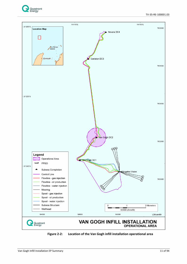
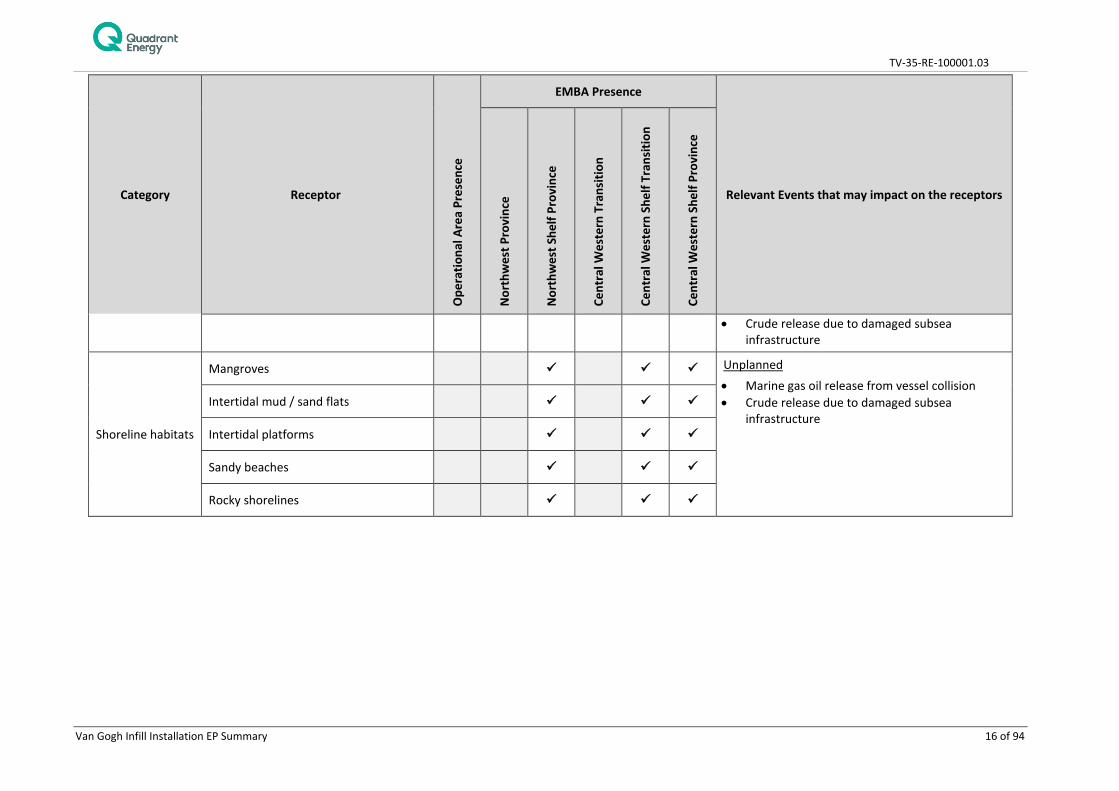
4.2.2.2 EMBA The presence of marine and coastal habitats within the EMBA is summarised in Table 4-1.
TV-35-RE-100001.03
Van Gogh Infill Installation EP Summary 15 of 94
Table 4-1: Habitats within the EMBA listed according to presence within the operational area and IMCRA Provincial Bioregions of Australia
Category Receptor
Ope
ratio
nal A
rea
Pres
ence
EMBA Presence
Relevant Events that may impact on the receptors
Nor
thw
est P
rovi
nce
Nor
thw
est S
helf
Prov
ince
Cent
ral W
este
rn T
rans
ition
Cent
ral W
este
rn S
helf
Tran
sitio
n
Cent
ral W
este
rn S
helf
Prov
ince
Benthic Habitats Coral reefs
Unplanned • Marine gas oil release from vessel collision • Crude release due to damaged subsea
infrastructure
Seagrass
Unplanned • Marine gas oil release from vessel collision • Crude release due to damaged subsea
infrastructure
Macroalgae
Unplanned • Marine gas oil release from vessel collision • Crude release due to damaged subsea
infrastructure
Non-coral benthic invertebrates
Planned
• Seabed disturbance • Planned operational discharges Unplanned • Non-hydrocarbon release (surface) - solid • Marine gas oil release from vessel collision
TV-35-RE-100001.03
Van Gogh Infill Installation EP Summary 16 of 94
Category Receptor
Ope
ratio
nal A
rea
Pres
ence
EMBA Presence
Relevant Events that may impact on the receptors
Nor
thw
est P
rovi
nce
Nor
thw
est S
helf
Prov
ince
Cent
ral W
este
rn T
rans
ition
Cent
ral W
este
rn S
helf
Tran
sitio
n
Cent
ral W
este
rn S
helf
Prov
ince
• Crude release due to damaged subsea infrastructure
Shoreline habitats
Mangroves Unplanned • Marine gas oil release from vessel collision • Crude release due to damaged subsea
infrastructure Intertidal mud / sand flats
Intertidal platforms
Sandy beaches
Rocky shorelines
TV-35-RE-100001.03
Van Gogh Infill Installation EP Summary 17 of 94
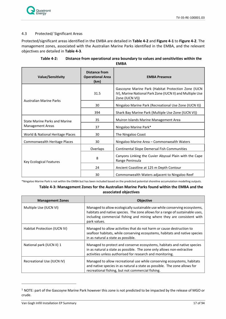
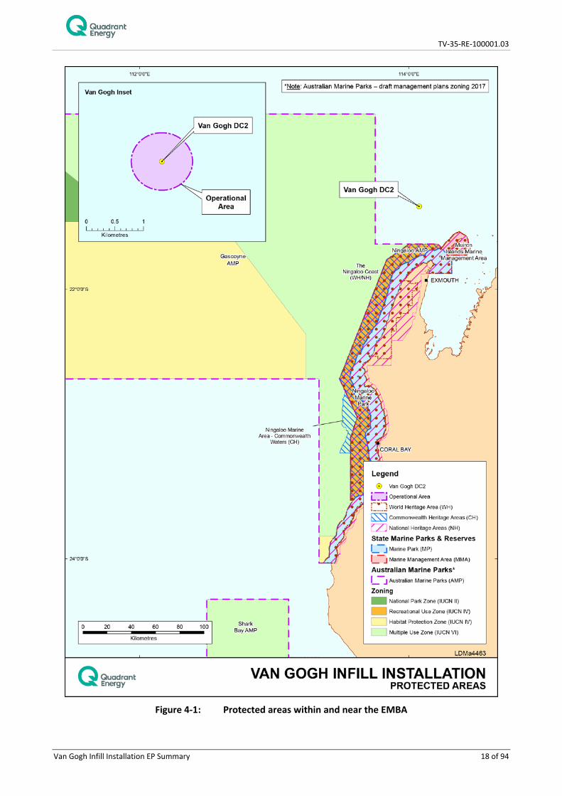
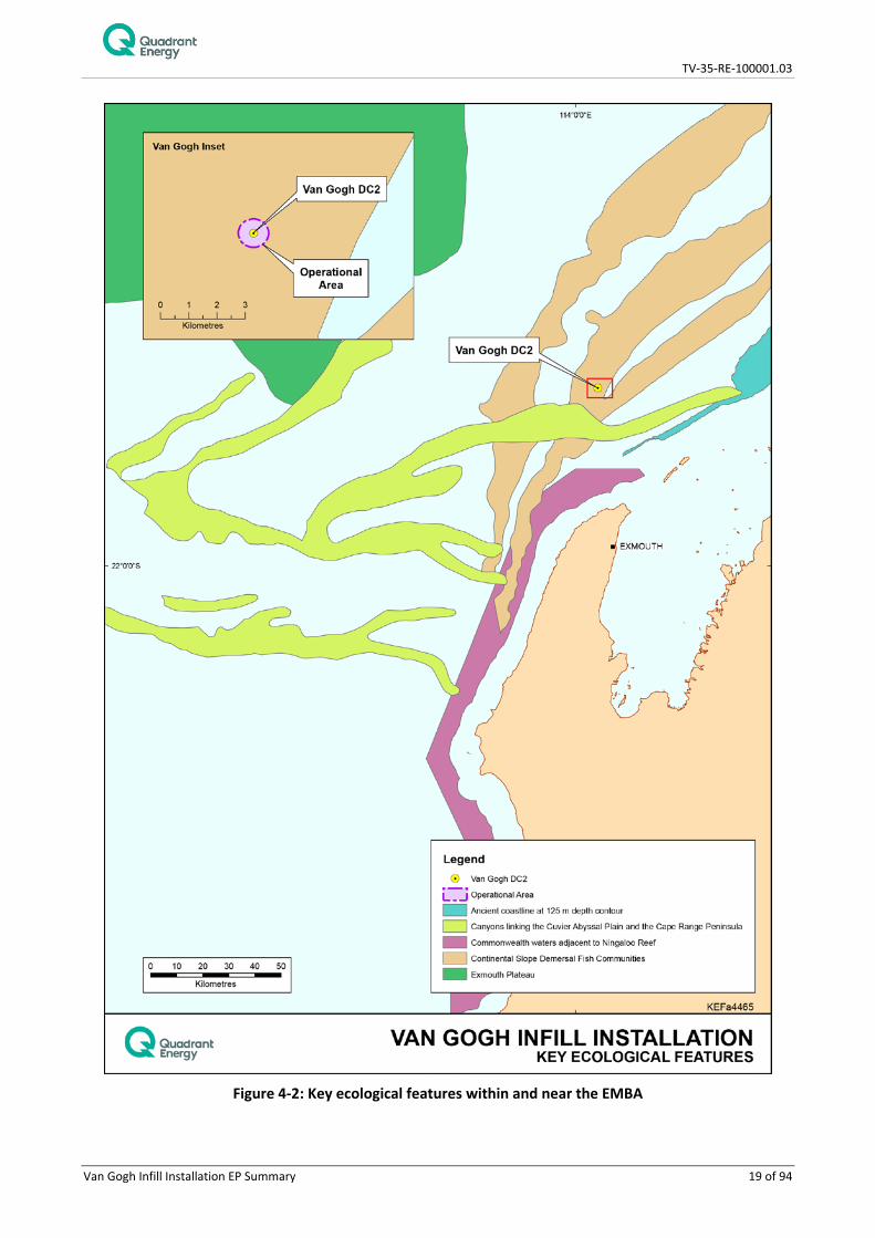
4.3 Protected/ Significant Areas
Protected/significant areas identified in the EMBA are detailed in Table 4-2 and Figure 4-1 to Figure 4-2. The management zones, associated with the Australian Marine Parks identified in the EMBA, and the relevant objectives are detailed in Table 4-3.
Table 4-2: Distance from operational area boundary to values and sensitivities within the EMBA
Value/Sensitivity Distance from
Operational Area (km)
EMBA Presence
Australian Marine Parks
31.5 Gascoyne Marine Park (Habitat Protection Zone (IUCN IV), Marine National Park Zone (IUCN II) and Multiple Use Zone (IUCN VI))
30 Ningaloo Marine Park (Recreational Use Zone (IUCN II))
394 Shark Bay Marine Park (Multiple Use Zone (IUCN VI))
State Marine Parks and Marine Management Areas
35 Muiron Islands Marine Management Area
37 Ningaloo Marine Park*
World & National Heritage Places 30 The Ningaloo Coast
Commonwealth Heritage Places 30 Ningaloo Marine Area – Commonwealth Waters
Key Ecological Features
Overlaps Continental Slope Demersal Fish Communities
8 Canyons Linking the Cuvier Abyssal Plain with the Cape Range Peninsula
24 Ancient Coastline at 125 m Depth Contour
30 Commonwealth Waters adjacent to Ningaloo Reef
*Ningaloo Marine Park is not within the EMBA but has been included based on the predicted potential shoreline accumulation modelling outputs.
Table 4-3: Management Zones for the Australian Marine Parks found within the EMBA and the associated objectives
Management Zones Objective
Multiple Use (IUCN VI) Managed to allow ecologically sustainable use while conserving ecosystems, habitats and native species. The zone allows for a range of sustainable uses, including commercial fishing and mining where they are consistent with park values.
Habitat Protection (IUCN IV) Managed to allow activities that do not harm or cause destruction to seafloor habitats, while conserving ecosystems, habitats and native species in as natural a state as possible.
National park (IUCN II) 1 Managed to protect and conserve ecosystems, habitats and native species in as natural a state as possible. The zone only allows non-extractive activities unless authorised for research and monitoring.
Recreational Use (IUCN IV) Managed to allow recreational use while conserving ecosystems, habitats and native species in as natural a state as possible. The zone allows for recreational fishing, but not commercial fishing.
1 NOTE: part of the Gascoyne Marine Park however this zone is not predicted to be impacted by the release of MGO or crude.
TV-35-RE-100001.03
Van Gogh Infill Installation EP Summary 18 of 94
Figure 4-1: Protected areas within and near the EMBA
TV-35-RE-100001.03
Van Gogh Infill Installation EP Summary 19 of 94
Figure 4-2: Key ecological features within and near the EMBA
TV-35-RE-100001.03
Van Gogh Infill Installation EP Summary 20 of 94
4.4 Threatened and Migratory Marine Fauna
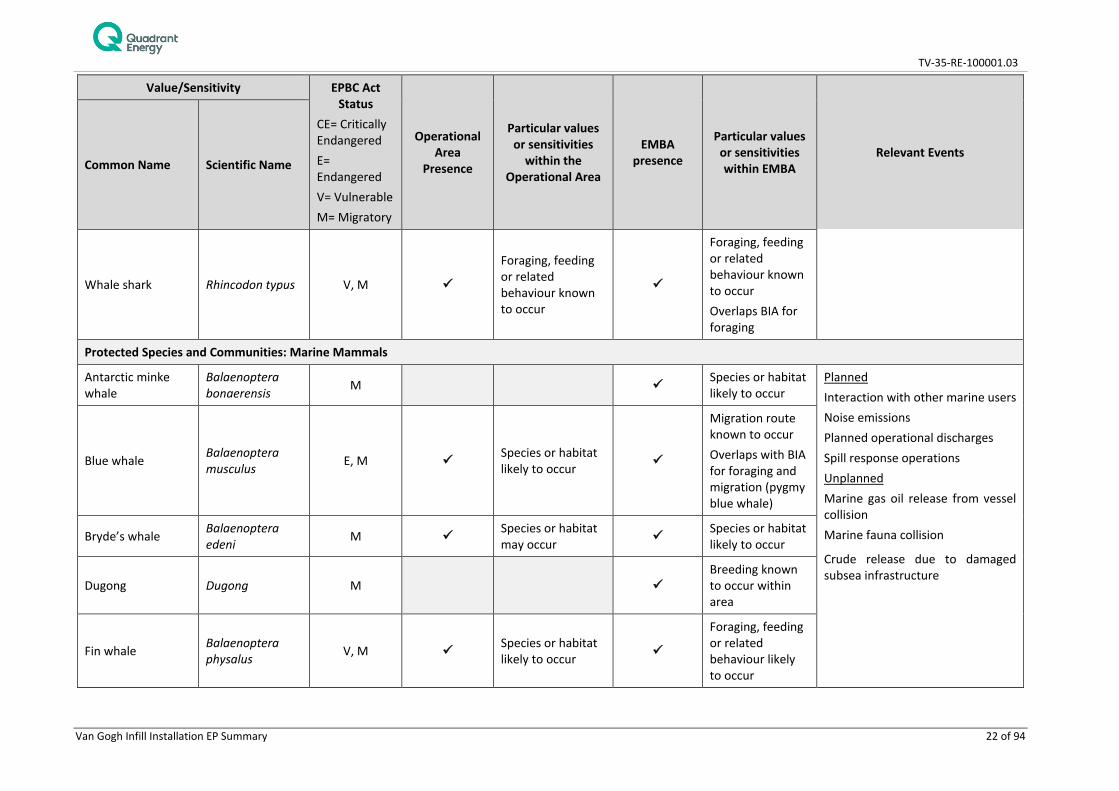
EPBC protected matters searches were conducted on the 21st November 2017 and 20th December 2017 for the operational area and EMBA. The searches identified 26 ˋthreatened’ species of marine fauna within the operational area, 17 of which are also listed as ˋmigratory’ species (Table 4-4). The listed threatened marine fauna that may occur within the EMBA and their migratory characteristics are also given in Table 4-4. For each species identified, the nature of likely presence is provided, including any overlap with designated Biologically Important Areas (BIAs).
4.4.1 Marine Mammals
A search of the EPBC Act Protected Matters Database identified 31 cetacean species that may occur within the operational area and EMBA. Of these, 12 are listed as migratory and five are listed as threatened under the EPBC Act.
4.4.2 Fish and Sharks
A search of the EPBC Act Protected Matters Database identified five threatened fish species within the operational area and EMBA. Of these, four are listed also listed as migratory. The search also identified 37 listed marine fish (pipefish and seahorses).
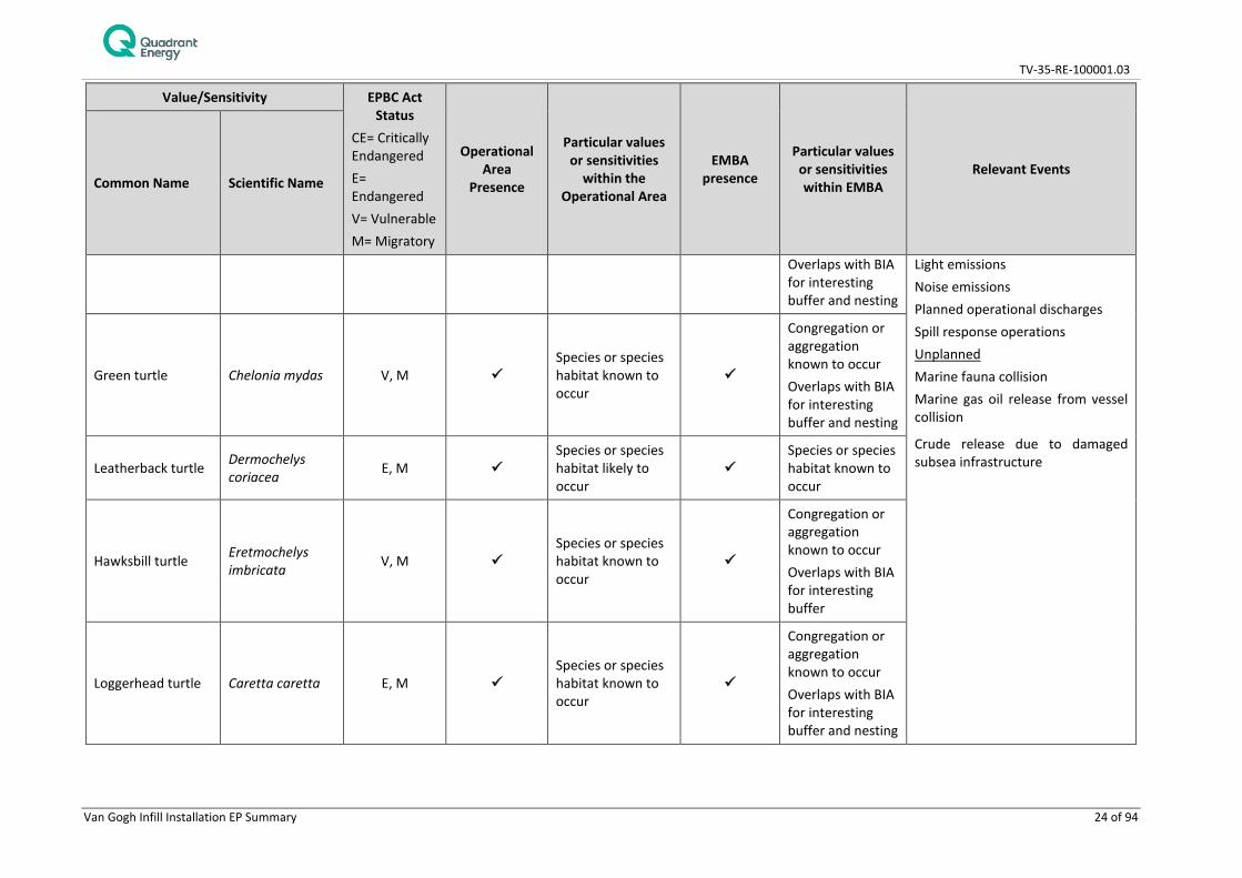
4.4.3 Marine Reptiles
A search of the EPBC Act Protected Matters Database identified five marine turtle species listed as threatened and migratory, and one seasnake listed as threatened, which may occur within the operational area and/or EMBA.
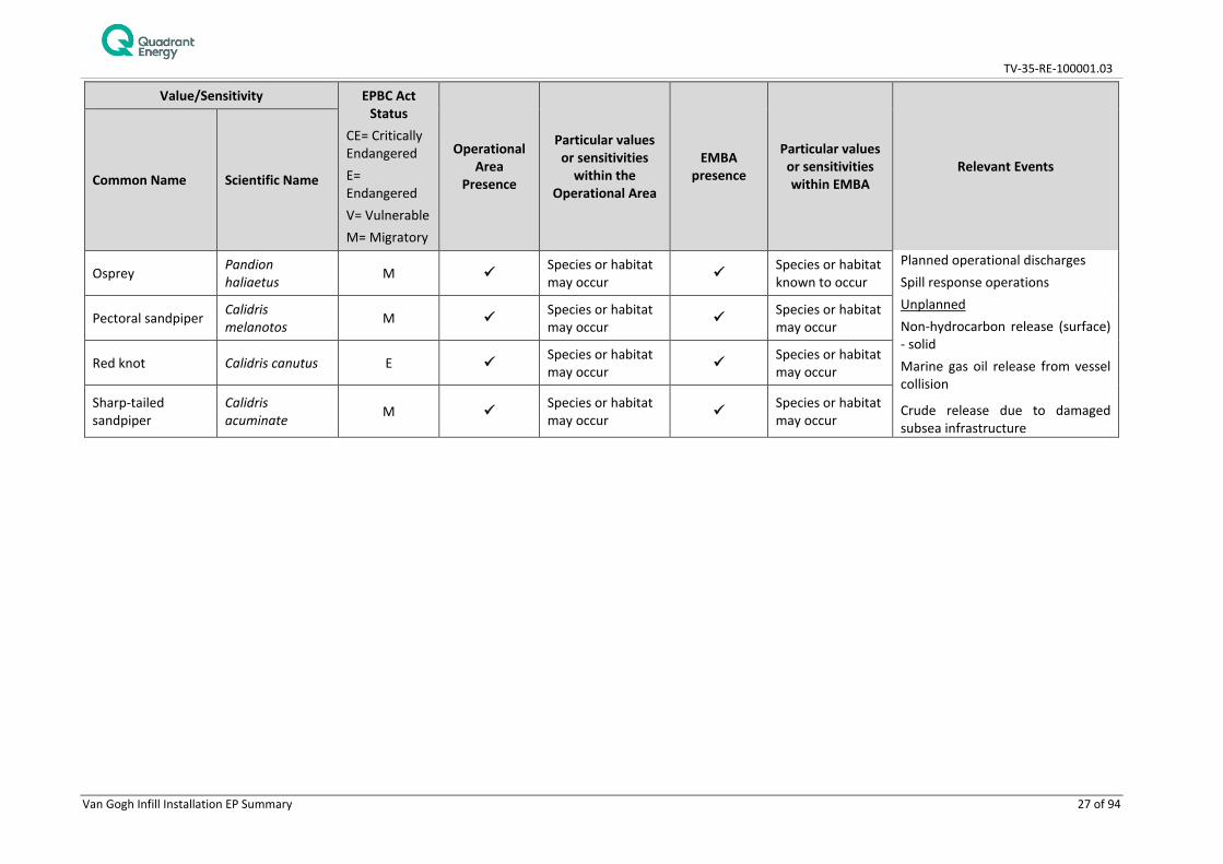
4.4.4 Marine Seabirds
A search of the EPBC Act Protected Matters Database identified 10 threatened marine bird species (three of which are also migratory) which have a recognised range that overlaps the operational area and/or EMBA.

TV-35-RE-100001.03
Van Gogh Infill Installation EP Summary 21 of 94
Table 4-4: Threatened and migratory species and communities in the operational area and EMBA
Value/Sensitivity EPBC Act Status
CE= Critically Endangered E= Endangered V= Vulnerable M= Migratory
Operational Area
Presence
Particular values or sensitivities
within the Operational Area
EMBA presence
Particular values or sensitivities within EMBA
Relevant Events Common Name Scientific Name
Protected Species and Communities: Fish, Sharks and Rays
Dwarf sawfish Pristis clavata V, M Species or habitat known to occur
Planned Interaction with other marine users Light emissions Noise emissions Planned operational discharges Spill response operations Unplanned Marine fauna collision Non-hydrocarbon and chemicals release – liquid Non-hydrocarbon release (surface) - solid Minor hydrocarbon release Crude release due to damaged subsea infrastructure Marine gas oil release from vessel collision
Giant manta ray Manta birostris M Species or habitat likely to occur Species or habitat
known to occur
Great white shark Carcharodon carcharias V, M Species or habitat
may occur Species or habitat known to occur
Green sawfish Pristis zijsron V, M Species or habitat known to occur Species or habitat
known to occur
Grey nurse shark Carcharias taurus V Species or habitat may occur Species or habitat
known to occur
Longfin mako Isurus paucus M Species or habitat likely to occur Species or habitat
likely to occur
Narrow sawfish Anoxypristis cuspidata M Species or habitat
may occur Species or habitat likely to occur
Porbeagle Lamna nasus M Species or habitat may occur
Reef manta ray Manta alfredi M Species or habitat may occur Species or habitat
known to occur
Shortfin mako Isurus oxyrinchus M Species or habitat likely to occur Species or habitat
likely to occur
TV-35-RE-100001.03
Van Gogh Infill Installation EP Summary 22 of 94
Value/Sensitivity EPBC Act Status
CE= Critically Endangered E= Endangered V= Vulnerable M= Migratory
Operational Area
Presence
Particular values or sensitivities
within the Operational Area
EMBA presence
Particular values or sensitivities within EMBA
Relevant Events Common Name Scientific Name
Whale shark Rhincodon typus V, M
Foraging, feeding or related behaviour known to occur
Foraging, feeding or related behaviour known to occur Overlaps BIA for foraging
Protected Species and Communities: Marine Mammals
Antarctic minke whale
Balaenoptera bonaerensis M Species or habitat
likely to occur Planned Interaction with other marine users Noise emissions Planned operational discharges Spill response operations Unplanned Marine gas oil release from vessel collision Marine fauna collision
Crude release due to damaged subsea infrastructure
Blue whale Balaenoptera musculus E, M Species or habitat
likely to occur
Migration route known to occur Overlaps with BIA for foraging and migration (pygmy blue whale)
Bryde’s whale Balaenoptera edeni M Species or habitat
may occur Species or habitat likely to occur
Dugong Dugong M Breeding known to occur within area
Fin whale Balaenoptera physalus V, M Species or habitat
likely to occur
Foraging, feeding or related behaviour likely to occur

TV-35-RE-100001.03
Van Gogh Infill Installation EP Summary 23 of 94
Value/Sensitivity EPBC Act Status
CE= Critically Endangered E= Endangered V= Vulnerable M= Migratory
Operational Area
Presence
Particular values or sensitivities
within the Operational Area
EMBA presence
Particular values or sensitivities within EMBA
Relevant Events Common Name Scientific Name
Humpback whale Megaptera novaeangliae V, M
Species or habitat known to occur Overlaps with BIA for migration
Species or habitat known to occur Overlaps with BIA for migration
Indo-pacific humpback dolphin
Sousa chinensis M Species or habitat may occur
Killer whale Orcinus orca M Species or habitat may occur Species or habitat
may occur
Sei whale Balaenoptera borealis V, M Species or habitat
likely to occur
Foraging, feeding or related behaviour likely to occur
Southern right whale
Eubalaena australis E, M Species or habitat
likely to occur
Sperm whale Physeter macrocephalus M Species or habitat
may occur
Spotted bottlenose dolphin Turdiops aduncus M Species or habitat
may occur Species or habitat known to occur
Protected Species and Communities: Marine Reptiles
Flatback turtle Natator depressus V, M
Congregation or aggregation known to occur
Congregation or aggregation known to occur
Planned Interaction with other marine users
TV-35-RE-100001.03
Van Gogh Infill Installation EP Summary 24 of 94
Value/Sensitivity EPBC Act Status
CE= Critically Endangered E= Endangered V= Vulnerable M= Migratory
Operational Area
Presence
Particular values or sensitivities
within the Operational Area
EMBA presence
Particular values or sensitivities within EMBA
Relevant Events Common Name Scientific Name
Overlaps with BIA for interesting buffer and nesting
Light emissions Noise emissions Planned operational discharges Spill response operations Unplanned Marine fauna collision Marine gas oil release from vessel collision
Crude release due to damaged subsea infrastructure
Green turtle Chelonia mydas V, M Species or species habitat known to occur
Congregation or aggregation known to occur Overlaps with BIA for interesting buffer and nesting
Leatherback turtle Dermochelys coriacea E, M
Species or species habitat likely to occur
Species or species habitat known to occur
Hawksbill turtle Eretmochelys imbricata V, M
Species or species habitat known to occur
Congregation or aggregation known to occur Overlaps with BIA for interesting buffer
Loggerhead turtle Caretta caretta E, M Species or species habitat known to occur
Congregation or aggregation known to occur Overlaps with BIA for interesting buffer and nesting

TV-35-RE-100001.03
Van Gogh Infill Installation EP Summary 25 of 94
Value/Sensitivity EPBC Act Status
CE= Critically Endangered E= Endangered V= Vulnerable M= Migratory
Operational Area
Presence
Particular values or sensitivities
within the Operational Area
EMBA presence
Particular values or sensitivities within EMBA
Relevant Events Common Name Scientific Name
Short-nosed seasnake
Aipysurus apraefrontalis CE
Species or species habitat likely to occur within area
Protected Species and Communities: Birds (Seabirds)
Australian fairy tern Sternula nereis V
Foraging, feeding or related behaviour likely to occur
Breeding known to occur Overlaps BIA for breeding
Planned Interaction with other marine users Light emissions Noise emissions Atmospheric emissions Planned operational discharges Spill response operations Unplanned Non-hydrocarbon release (surface) - solid Marine gas oil release from vessel collision
Crude release due to damaged subsea infrastructure
Black-browed albatross
Thalassarche melanophris V, M Species or habitat
may occur
Campbell albatross Thalassarche impavida V Species or habitat
may occur
Common noddy Anous stolidus M Species or habitat may occur Species or habitat
may occur
Flesh-footed shearwater
Ardenna carneipes M Species or habitat
likely to occur
Fork-tailed swift Apus pacificus M Species or habitat
likely to occur
Lesser frigatebird Fregata ariel M Species or habitat may occur Species or habitat
likely to occur
Roseate tern Sterna dougallii M
Breeding likely to occur Overlaps BIA for breeding

TV-35-RE-100001.03
Van Gogh Infill Installation EP Summary 26 of 94
Value/Sensitivity EPBC Act Status
CE= Critically Endangered E= Endangered V= Vulnerable M= Migratory
Operational Area
Presence
Particular values or sensitivities
within the Operational Area
EMBA presence
Particular values or sensitivities within EMBA
Relevant Events Common Name Scientific Name
Shy albatross Thalassarche cauta cauta V, M Species or habitat
may occur
Soft-plumaged petrel
Pterodroma mollis V
Foraging, feeding or related behaviour likely to occur
Southern giant-petrel
Macronectes giganteus E, M Species or habitat
may occur Species or habitat may occur
Streaked shearwater
Calonectris leucomelas M Species or habitat
likely to occur Species or habitat likely to occur
Wedge-tailed shearwater2 Ardenna pacifica M Overlaps with BIA
for breeding Overlaps with BIA for breeding
White-capped albatross
Thalassarche cauta steadi V Species or habitat
may occur
Protected Species and Communities: Birds (Shorebirds)
Common sandpiper Actitis hypoleucos M Species or habitat
may occur Species or habitat may occur
Planned Interaction with other marine users Light emissions Noise emissions Atmospheric emissions
Curlew sandpiper Calidris ferruginea CE Species or habitat
may occur Species or habitat may occur
Eastern curlew Numenius madagascariensis CE Species or habitat
may occur Species or habitat may occur
2 Wedge-tailed shearwater not identified in PMST, however, BIA overlaps with Operational Area and EMBA
TV-35-RE-100001.03
Van Gogh Infill Installation EP Summary 27 of 94
Value/Sensitivity EPBC Act Status
CE= Critically Endangered E= Endangered V= Vulnerable M= Migratory
Operational Area
Presence
Particular values or sensitivities
within the Operational Area
EMBA presence
Particular values or sensitivities within EMBA
Relevant Events Common Name Scientific Name
Osprey Pandion haliaetus M Species or habitat
may occur Species or habitat known to occur
Planned operational discharges Spill response operations Unplanned Non-hydrocarbon release (surface) - solid Marine gas oil release from vessel collision
Crude release due to damaged subsea infrastructure
Pectoral sandpiper Calidris melanotos M Species or habitat
may occur Species or habitat may occur
Red knot Calidris canutus E Species or habitat may occur Species or habitat
may occur
Sharp-tailed sandpiper
Calidris acuminate M Species or habitat
may occur Species or habitat may occur

TV-35-RE-100001.03
Van Gogh Infill Installation EP Summary 28 of 94
4.5 Socio-Economic Receptors
Table 4-5 identifies the relevant State and Commonwealth fisheries that overlap the operational area and EMBA. Active fisheries were identified in consultation with the Department of Primary Industries and Regional Development (DPIRD). Other socio-economic considerations such as shipping, recreational fishing, oil and gas industry, tourism and cultural heritage in relation to the operational area and EMBA are summarised in Table 4-6.
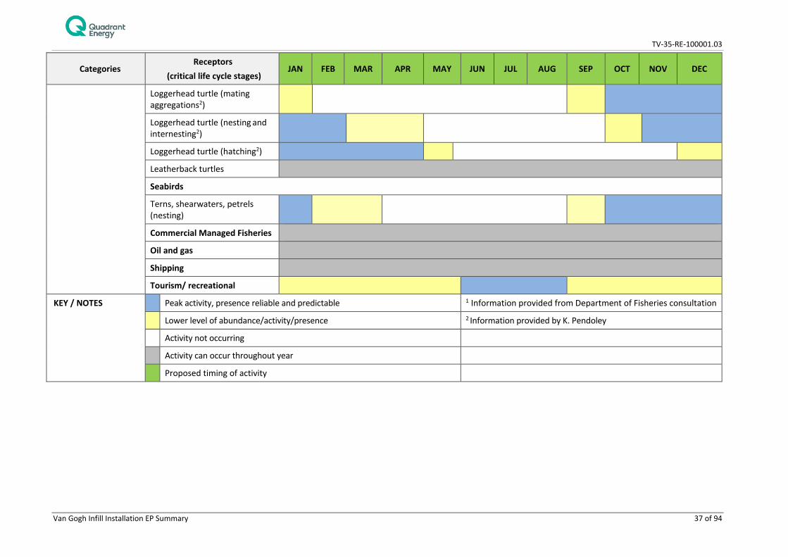
4.6 Windows of Sensitivity
Timing of peak activity for threatened species and other relevant, significant sensitivities is given in Table 4-7.

TV-35-RE-100001.03
Van Gogh Infill Installation EP Summary 29 of 94
Table 4-5: State and Commonwealth fisheries within the EMBA
Fishery Description Operational Area Presence
Relevant events within the Operational Area
Relevant events within the EMBA
Commonwealth Fisheries
North West Slope Trawl Fishery
A deepwater trawl fishery extending from 114° E to approximately 125° E off the WA coast between the 200 m isobaths and the outer limit of the Australian Fishing Zone (AFZ). Targets Australian scampi and prawns.
Planned Interaction with other marine user However, fishery interaction unlikely to occur, since there has been no recent commercial fishing within the operational area
Planned Spill response operations Unplanned Marine gas oil release from vessel collision Crude release due to damaged subsea infrastructure
Western Tuna and Billfish Fishery
A longline and minor line fishery for striped marlin, broadbill swordfish, bigeye tuna and yellowfin tuna. The fishery extends westward from Cape York Peninsula (142°30’ E) off Queensland to 34° S off the WA west coast. It also extends eastward from 34° S off the west coast of WA across the Great Australian Bight to 141° E at the South Australian–Victorian border.
Skipjack Tuna Fishery (Western)
Predominantly purse seine fishery skipjack tuna. The fishery covers the entire sea around Western Australia, out to the 200 nm. The fishery is not currently active with management arrangements under review.
Management under review.
Southern Bluefin Tuna Fishery
The fishery extends to the high seas for Australian flagged vessels and targets southern bluefin tuna. This fishery is incorporated into the Western Tuna and Billfish Fishery
No current effort on NWS
Western Deepwater Trawl Fishery
A deepwater trawl fishery (>200 m) historically dominated by finfish. The Western Deepwater Trawl Fishery (WDTF) operates in Western Australia between the western boundary of the Great Australian Bight Trawl Sector of the Southern and Eastern Scalefish and Shark Fishery in the south (115°08’E) and the western boundary of the North West Slope Trawl Fishery in the north (114°E). Fishing zone does not overlap operational area.
State Fisheries

TV-35-RE-100001.03
Van Gogh Infill Installation EP Summary 30 of 94
Fishery Description Operational Area Presence
Relevant events within the Operational Area
Relevant events within the EMBA
Marine Aquarium Fish Fishery
The Marine Aquarium Fish Fishery is primarily a dive based fishery targeting fish species which operates in Western Australia’s State waters spanning the coastline from the Northern Territory border in the north to the South Australian border in the south
These fisheries collect specimens by diving or wading which cannot occur in the operational area due to the depth in excess of 350 m.
Planned Spill response operations Unplanned Marine gas oil release from vessel collision Crude release due to damaged subsea infrastructure
Specimen Shell Managed Fishery
The Specimen Shell Managed Fishery targets shells primarily by diving or wading shallow waters and is permitted in Western Australian waters between the high water mark and the 200 m isobaths.
Beche-de-mer Fishery (Western Australian Sea Cucumber Fishery)
The Western Australian beche-de-mer fishery is primarily based in the northern half of the State, from Exmouth Gulf to the Northern Territory border, however fishers do have access to all Western Australian waters. It is a hand-harvest fishery, with animals caught principally by diving, and a smaller amount by wading
Mackerel Managed Fishery (Area 2 and 3)
The fishery uses near-surface trolling lines from boats and extends from the West Coast Bioregion to the WA/NT border, with most effort and catches recorded north of Geraldton, especially from the Kimberley and Pilbara coasts. Catches are reported separately for three Areas: Area 1, 2 and 3.
Planned Interaction with other marine users Spill response operations However, interaction with fishery is unlikely to occur since the fishery targets coastal waters around reefs, shoals and headlands.
Developing Octopus Interim Managed Fishery
Fishery in development phase. Octopus are primarily caught in the Developing Octopus Interim Managed Fishery (largest fishery) are limited to the boundaries of the developmental fishery, which is an area bounded by the Kalbarri Cliffs (26°30’S) in the north and Esperance in the south.
Interaction with the fishery is unlikely to occur given the fishery south of Kalbarri

TV-35-RE-100001.03
Van Gogh Infill Installation EP Summary 31 of 94
Fishery Description Operational Area Presence
Relevant events within the Operational Area
Relevant events within the EMBA
West Coast Deep Sea Crab (Interim) Managed Fishery
Baited pots in waters >150 m for crystal (snow) crabs. Permitted in all waters lying north of latitude 34° 24' S (Cape Leeuwin) and west of the Northern Territory border on the seaward side of the 150m isobaths out to the extent of the Australian Fishing Zone
Planned Interaction with other marine users Spill response operations However, interaction with the fishery is unlikely to occur given the fishery mostly operates in depths of 500-800 which is deeper than the operational area (How and Nardi 2014).
Interaction with the fishery is unlikely to occur given the fishery mostly operates in depths of 500-800 which is deeper than the operational area (How and Nardi 2014).
West Coast Rock Lobster Managed Fishery
Baited pot fishery for western rock lobster fished all year round. The fishery is situated along the west coast of Australia between Latitudes 21°44´ to 34°24´ S. The fishery is managed in three zones: Zone A – Abrolhos Islands, north of latitude 30° S excluding the Abrolhos Islands (Zone B) and south of latitude 30° S (Zone C).
Roe’s Abalone Fishery
Dive fishery covering all WA waters. The Area 8 commercial fishery (north of Moore River) has been closed indefinitely for the 2011/12 season and beyond.
Shark Bay Scallop Managed Fishery & Shark Bay Prawn Managed Fishery
The boundaries of the Shark Bay Prawn Managed Fishery and the Shark Bay Scallop Managed Fishery are located in and near the waters of Shark Bay. Generally, they are closed between November and April but depend on pre-season surveys and environmental conditions each year
Planned Spill response operations Unplanned Marine gas oil release from vessel collision Crude release due to damaged subsea infrastructure
Gascoyne Demersal Scalefish Managed Fishery
The Gascoyne Demersal Scalefish Managed Fishery operates in the waters of the Indian Ocean and Shark Bay between latitudes 23°07’30” S and 26°30’S. Vessels are not permitted to fish in inner Shark Bay. The fishery licensed vessels fish throughout the year with mechanised handlines.

TV-35-RE-100001.03
Van Gogh Infill Installation EP Summary 32 of 94
Fishery Description Operational Area Presence
Relevant events within the Operational Area
Relevant events within the EMBA
Pearl Oyster Managed Fishery (Western Australia)
Dive fishery, operating in shallow coastal waters along the North-West Shelf. The fishery is separated into four zones.
Pilbara Fish Trawl (Interim) Managed Fishery
The Pilbara Fish Trawl Interim Managed Fishery targets scalefish by trawling. The fishery is situated in the Pilbara region in the north west of Australia. It occupies the waters north of latitude 21°35’S and between longitudes 114°9’36” E and 120°E. The fishery is seaward of the 50 m isobaths and landward of the 200 m isobaths The fishery consists of two zones; Zone 1 in the south west of the Fishery (which is closed to trawling) and Zone 2 in the North, which consists of six management areas.
Planned Spill response operations Unplanned Marine gas oil release from vessel collision Crude release due to damaged subsea infrastructure
Pilbara Trap Managed Fishery & Pilbara Line Fishery
The Pilbara Trap Managed Fishery targets scalefish by fish trap and drop line. The fishery is permitted to operate within waters bounded by a line commencing at the intersection of 21°56´ S latitude and the high water mark on the western side of the North West Cape
TV-35-RE-100001.03
Van Gogh Infill Installation EP Summary 33 of 94
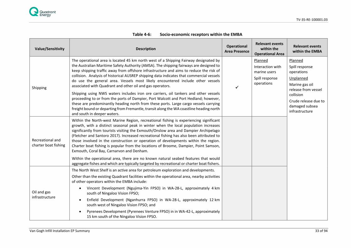
Table 4-6: Socio-economic receptors within the EMBA
Value/Sensitivity Description Operational Area Presence
Relevant events within the
Operational Area
Relevant events within the EMBA
Shipping
The operational area is located 45 km north west of a Shipping Fairway designated by the Australian Maritime Safety Authority (AMSA). The shipping fairways are designed to keep shipping traffic away from offshore infrastructure and aims to reduce the risk of collision. Analysis of historical AUSREP shipping data indicates that commercial vessels do use the general area. Vessels most likely encountered include other vessels associated with Quadrant and other oil and gas operators.
Shipping using NWS waters includes iron ore carriers, oil tankers and other vessels proceeding to or from the ports of Dampier, Port Walcott and Port Hedland; however, these are predominantly heading north from these ports. Large cargo vessels carrying freight bound or departing from Fremantle, transit along the WA coastline heading north and south in deeper waters.
Planned Interaction with marine users Spill response operations
Planned Spill response operations Unplanned Marine gas oil release from vessel collision Crude release due to damaged subsea infrastructure
Recreational and charter boat fishing
Within the North-west Marine Region, recreational fishing is experiencing significant growth, with a distinct seasonal peak in winter when the local population increases significantly from tourists visiting the Exmouth/Onslow area and Dampier Archipelago (Fletcher and Santoro 2017). Increased recreational fishing has also been attributed to those involved in the construction or operation of developments within the region. Charter boat fishing is popular from the locations of Broome, Dampier, Point Samson, Exmouth, Coral Bay, Carnarvon and Denham.
Within the operational area, there are no known natural seabed features that would aggregate fishes and which are typically targeted by recreational or charter boat fishers.
Oil and gas infrastructure
The North West Shelf is an active area for petroleum exploration and developments. Other than the existing Quadrant facilities within the operational area, nearby activities of other operators within the EMBA include:
• Vincent Development (Ngujima-Yin FPSO) in WA-28-L, approximately 4 km south of Ningaloo Vision FPSO;
• Enfield Development (Nganhurra FPSO) in WA-28-L, approximately 12 km south west of Ningaloo Vision FPSO; and
• Pyrenees Development (Pyrenees Venture FPSO) in in WA-42-L, approximately 15 km south of the Ningaloo Vision FPSO.

TV-35-RE-100001.03
Van Gogh Infill Installation EP Summary 34 of 94
Value/Sensitivity Description Operational Area Presence
Relevant events within the
Operational Area
Relevant events within the EMBA
• Macedon PLEM subsea completion and gas pipeline
Tourism
There are many sources of marine-based tourism within the environment that may be affected. Aquatic recreational activities such as boating, diving and fishing occur near the coast and islands off of the Pilbara and Ningaloo coasts. These activities are concentrated in the vicinity of the population centers such as Coral Bay, Exmouth, Dampier and Onslow.
In the waters immediately surrounding the operational area, tourism activities are limited due to its distance from the coast.
Cultural Heritage
No known sites of Cultural Heritage significance or National Heritage places on the basis of Maritime Heritage exist within the EMBA. Areas protected as National Heritage places on the basis of Indigenous Heritage within the EMBA are:
• The Ningaloo Coast Shorelines within the vicinity of the EMBA (e.g. Exmouth) also have a long history of occupancy by Indigenous communities. In addition, the following historic shipwrecks (older than 75 years) are located within the EMBA:
• Lady Ann (1982) • Gem (1893)
Events relevant to historic shipwrecks are: Planned Spill response operations Unplanned Hydrocarbon Release – vessel collision Hydrocarbon release – loss of well control Hydrocarbon release – damage to subsea infrastructure

TV-35-RE-100001.03
Van Gogh Infill Installation EP Summary 35 of 94
Table 4-7: Environmental values and sensitivities within the EMBA – windows of sensitivity
Categories Receptors
(critical life cycle stages) JAN FEB MAR APR MAY JUN JUL AUG SEP OCT NOV DEC
Physical environment and habitats
All shoreline habitats
Coral (spawning periods)
Macroalgae growing shedding fronds growing
Other benthic habitats
Marine Fauna (incl. threatened/ migratory species)
Fish/ Sharks and fisheries species
Whale sharks Aggregations at Ningaloo Coast
Fisheries species spawning/aggregation times 1
Baldchin groper
Blacktip shark
Crystal crab
Goldband snapper
King George whiting
Pink snapper
Rankin cod
Red Emperor
Spangled Emperor
Sandbar shark
Spanish mackerel
Marine Mammals
Dugong (breeding) breeding
breeding
Humpback whale (migration)
northern
southern

TV-35-RE-100001.03
Van Gogh Infill Installation EP Summary 36 of 94
Categories Receptors
(critical life cycle stages) JAN FEB MAR APR MAY JUN JUL AUG SEP OCT NOV DEC
Blue whale (migration)
northern
southern
Marine Reptiles
Hawksbill turtle’s resident adult and juveniles2
Widespread throughout NW Shelf waters, highest density of adults and juveniles over hard bottom habitat (coral reef, rocky reef, pipelines etc.)
Hawksbill turtle (mating aggregations2)
Hawksbill turtle (nesting and internesting2)
Hawksbill turtle (hatching1)
Flatback turtles (resident adult and juveniles2)
Widespread throughout NW Shelf waters, increased density over soft bottom habitat 10 – 60m deep, post hatchling age classes and juveniles spread across shelf waters
Flatback turtle (mating aggregations2)
Flatback turtle (nesting and internesting2)
Flatback turtle (hatching2)
Flatback turtle (nesting2)
Green turtles (resident adult and juveniles2)
Widespread throughout the NW Shelf waters, highest density associated with seagrass beds and macro algae communities, high density juveniles in shallow waters off beaches, amongst mangroves and in creeks
Green turtle (mating aggregations2)
Green turtle nesting and internesting2)
Green turtle (hatching2)
Loggerhead turtles (resident adult and juveniles2)
Widespread throughout the NW Shelf waters, increased density associated with soft bottom habitat supporting their bivalve food source, juveniles associated with nearshore reef habitat
TV-35-RE-100001.03
Van Gogh Infill Installation EP Summary 37 of 94
Categories Receptors
(critical life cycle stages) JAN FEB MAR APR MAY JUN JUL AUG SEP OCT NOV DEC
Loggerhead turtle (mating aggregations2)
Loggerhead turtle (nesting and internesting2)
Loggerhead turtle (hatching2)
Leatherback turtles
Seabirds
Terns, shearwaters, petrels (nesting)
Commercial Managed Fisheries
Oil and gas
Shipping
Tourism/ recreational
KEY / NOTES
Peak activity, presence reliable and predictable 1 Information provided from Department of Fisheries consultation Lower level of abundance/activity/presence 2 Information provided by K. Pendoley Activity not occurring Activity can occur throughout year Proposed timing of activity

TV-35-RE-100001.03
Van Gogh Infill Installation EP Summary 38 of 94
5. STAKEHOLDER CONSULTATION
Quadrant understands retaining a broad licence to operate depends on the development and maintenance of positive and constructive relationships with a comprehensive set of stakeholders across the community, Government and business sectors.
Quadrant has established long-term and meaningful dialogue with those stakeholders who have demonstrated an interest in its present and planned future activities in Australia.
For the activities to be undertaken under the EP, a standardised approach was applied to identify key stakeholders for the activity, beginning with a review of the stakeholder database, and of the stakeholders consulted over other recent activities in the area. In particular, the operational area for the activity was used to identify relevant persons on an activity-by-activity basis, and will be used throughout the duration of the EP. The key stakeholders identified for the activity are based on the operational area and EMBA and are provided in Table 5-1.
5.1 Summary
Stakeholders (refer Table 5-1) were informed of activities covered by the EP via an activity specific consultation package distributed by email in January 2018. A wider stakeholder group was informed of the proposed activity in Quadrant’s Quarterly Consultation Update edition distributed on December 22, 2017. Quadrant’s Ningaloo Vision FPSO has produced from the Van Gogh, Coniston and Novara field since 2010, and therefore it is reasonable to expect that stakeholders are familiar with Quadrant’s presence in the region. This includes consultation for the Ningaloo Vision Operations EP (TV-00-RI-003), Coniston Novara Development EP (phase one drilling) (EA-00-RI-208), Coniston Novara Phase II Drilling EP (EA-00-RI-268/1), the Coniston Novara Construction and Installation EP (EA-00-RI-232/1) and more recently the Van Gogh, Coniston and Novara Drilling and Completions EP (EA-00-RI-10060), a five year drilling EP which covers the 2018 infill drilling campaign. Quadrant considers that consultation with regulators and key stakeholders has been adequate for activities covered under this EP (further detailed in Table 5-2). No stakeholder has objected to the activity covered under this EP nor claimed that the environmental impacts or risks are unacceptable. Given the short duration, the nature of this activity and Quadrant’s ongoing presence in the Exmouth community, Quadrant anticipates minimal interaction with mariners for this activity. Despite this Quadrant will provide relevant marine notices detailed in Table 5-2. All correspondence with external stakeholders is recorded and Quadrant will remain available before, during and after the activity. Consultation material and feedback received will be provided to the appropriate internal Quadrant personnel when relevant.
Many stakeholders have stated that they will contact Quadrant by exception, that is, if upon receiving the stakeholder information package they feel the activity is of interest or concern to them, they will contact Quadrant. Consultation, agreements or contracts that support Quadrant’s oil spill response strategies and tactics have been put into place with agencies and organisations throughout the development of the OPEP so that roles and responsibilities are understood and accepted. These are outlined in Table 5-3. Quadrant maintains a comprehensive stakeholder database with stakeholders identified through the following mechanisms:
• Regular review of all legislation applicable to petroleum and marine activities; • Identification of marine user groups and interest groups active in the area (e.g., recreational and
commercial fisheries, other oil and gas producers, merchant shipping, etc.); • DPIRD fishing license holder database will be sourced annually; • Active participation in industry bodies (e.g. APPEA and AMOSC); and • Records from previous consultation activities in the area.

TV-35-RE-100001.03
Van Gogh Infill Installation EP Summary 39 of 94
Table 5-1: Summary of stakeholders consulted
Group Stakeholder
Fishers and representative bodies • A Raptis and Sons • Austral Fisheries • Australian Fisheries Management Authority (AFMA) • Australian Southern Bluefin Tuna Association (ASBTIA) • Commonwealth Fisheries Association (CFA) • Fat Marine • Marine Tourism WA • MG Kailis • Pearl Producers Association • Recfishwest • Shark Bay Seafoods • Western Australian Fishing Industry Council (WAFIC) • Westmore Seafoods
Marine conservation • Department of Primary Industries and Regional Development (DPIRD) • Department of Biodiversity, Conservation and Attractions (DBCA)
Shipping safety and security • Australian Maritime Safety Authority (AMSA) • Department of Defence (DoD) • Department of Transport (DoT)
Exmouth Community
Reference Group (CRG)
• BHP • Cape Conservation Group • DBCA (Regional) • DoT (Regional) • Exmouth Chamber of Commerce and Industry • Exmouth District High School • Exmouth Game Fishing Club • Federal Member of Parliament • Gascoyne Development Commission • Member of the Legislative Assembly • North West Cape Exmouth Aboriginal Corporation • Ningaloo Station • Ningaloo Coast World Heritage Advisory Council • Shire of Exmouth Administration • Shire of Exmouth Council • Toll Exmouth • Woodside Pty Ltd
Adjacent regulator • Department of Mines, Industry Regulation and Safety (DMIRS)
Commonwealth
Government departments
• Department of Agriculture and Water Resources – Biosecurity • Department of Agriculture and Water Resources – Fisheries • Director of National Parks
TV-35-RE-100001.03
Van Gogh Infill Installation EP Summary 40 of 94
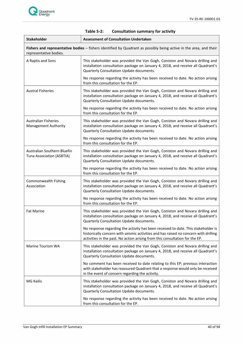
Table 5-2: Consultation summary for activity
Stakeholder Assessment of Consultation Undertaken
Fishers and representative bodies – fishers identified by Quadrant as possibly being active in the area, and their representative bodies.
A Raptis and Sons This stakeholder was provided the Van Gogh, Coniston and Novara drilling and installation consultation package on January 4, 2018, and receive all Quadrant’s Quarterly Consultation Update documents.
No response regarding the activity has been received to date. No action arising from this consultation for the EP.
Austral Fisheries This stakeholder was provided the Van Gogh, Coniston and Novara drilling and installation consultation package on January 4, 2018, and receive all Quadrant’s Quarterly Consultation Update documents.
No response regarding the activity has been received to date. No action arising from this consultation for the EP.
Australian Fisheries Management Authority
This stakeholder was provided the Van Gogh, Coniston and Novara drilling and installation consultation package on January 4, 2018, and receive all Quadrant’s Quarterly Consultation Update documents.
No response regarding the activity has been received to date. No action arising from this consultation for the EP.
Australian Southern Bluefin Tuna Association (ASBTIA)
This stakeholder was provided the Van Gogh, Coniston and Novara drilling and installation consultation package on January 4, 2018, and receive all Quadrant’s Quarterly Consultation Update documents.
No response regarding the activity has been received to date. No action arising from this consultation for the EP.
Commonwealth Fishing Association
This stakeholder was provided the Van Gogh, Coniston and Novara drilling and installation consultation package on January 4, 2018, and receive all Quadrant’s Quarterly Consultation Update documents.
No response regarding the activity has been received to date. No action arising from this consultation for the EP.
Fat Marine This stakeholder was provided the Van Gogh, Coniston and Novara drilling and installation consultation package on January 4, 2018, and receive all Quadrant’s Quarterly Consultation Update documents.
No response regarding the activity has been received to date. This stakeholder is historically concern with seismic activities and has raised no concern with drilling activities in the past. No action arising from this consultation for the EP.
Marine Tourism WA This stakeholder was provided the Van Gogh, Coniston and Novara drilling and installation consultation package on January 4, 2018, and receive all Quadrant’s Quarterly Consultation Update documents.
No comment has been received to date relating to this EP; previous interaction with stakeholder has reassured Quadrant that a response would only be received in the event of concern regarding the activity.
MG Kailis This stakeholder was provided the Van Gogh, Coniston and Novara drilling and installation consultation package on January 4, 2018, and receive all Quadrant’s Quarterly Consultation Update documents.
No response regarding the activity has been received to date. No action arising from this consultation for the EP.

TV-35-RE-100001.03
Van Gogh Infill Installation EP Summary 41 of 94
Stakeholder Assessment of Consultation Undertaken
Pearl Producers Association This stakeholder was provided the Van Gogh, Coniston and Novara drilling and installation consultation package on January 4, 2018, and receive all Quadrant’s Quarterly Consultation Update documents.
No response regarding the activity has been received to date. No action arising from this consultation for the EP.
Recfishwest This stakeholder was provided the Van Gogh, Coniston and Novara drilling and installation consultation package on January 4, 2018, and receive all Quadrant’s Quarterly Consultation Update documents.
No response regarding the activity has been received to date. No action arising from this consultation for the EP.
Shark Bay Seafoods This stakeholder was provided the Van Gogh, Coniston and Novara drilling and installation consultation package on January 4, 2018, and receive all Quadrant’s Quarterly Consultation Update documents.
No response regarding the activity has been received to date. No action arising from this consultation for the EP.
Western Australian Fishing Industry Council
This stakeholder was provided the Van Gogh, Coniston and Novara drilling and installation consultation package on January 11, 2018, and receive all Quadrant’s Quarterly Consultation Update documents. No response regarding the activity has been received to date.
Historically WAFIC have been concerned with seismic activities and issues arising from petroleum exclusion zones. Given exclusion zones around the project vessel will be temporary and short in nature, Quadrant anticipates no action arising from this consultation for the EP.
Westmore Seafoods This stakeholder was provided the Van Gogh, Coniston and Novara drilling and installation consultation package on January 4, 2018, and receive all Quadrant’s Quarterly Consultation Update documents.
No response regarding the activity has been received to date. No action arising from this consultation for the EP.
Exmouth Consultation Reference Group (CRG)
BHP BHP are a neighbouring operator to this activity and received consultation material by email on January 4, 2018. No further action required for the EP. A BHP representative was in attendance at the November CRG meeting in Exmouth, and received a detailed briefing on the activity.
Cape Conservation Group This stakeholder was provided the Van Gogh, Coniston and Novara drilling and installation consultation package on January 4, 2018, and receive all Quadrant’s Quarterly Consultation Update documents. A CCG representative was in attendance at the November CRG meeting in Exmouth, and received a detailed briefing on the activity.
No response regarding the activity has been received to date. No action arising from this consultation for the EP.
DBCA (Regional) This stakeholder was provided the Van Gogh, Coniston and Novara drilling and installation consultation package on January 4, 2018, and receive all Quadrant’s Quarterly Consultation Update documents. An Exmouth DBCA representative was in attendance at the November CRG meeting in Exmouth, and received a detailed briefing on the activity.
DoT (Regional) No response regarding the activity has been received to date. No action arising from this consultation for the EP. An Exmouth DoT representative was in

TV-35-RE-100001.03
Van Gogh Infill Installation EP Summary 42 of 94
Stakeholder Assessment of Consultation Undertaken attendance at the November CRG meeting in Exmouth, and received a detailed briefing on the activity.
Exmouth Chamber of Commerce and Industry
This stakeholder was provided the Van Gogh, Coniston and Novara drilling and installation consultation package on January 4, 2018, and receive all Quadrant’s Quarterly Consultation Update documents. The Exmouth CCI president was in attendance at the November CRG meeting in Exmouth, and received a detailed briefing on the activity.
Exmouth District High School The Exmouth DHS Principal was in attendance at the November CRG meeting in Exmouth, and received a detailed briefing on the activity and this stakeholder receives all Quadrant’s Quarterly Consultation Update documents.
Exmouth Game Fishing Club No response regarding the activity has been received to date. No action arising from this consultation for the EP.
Federal Member of Parliament This stakeholder was provided the Van Gogh, Coniston and Novara drilling and installation consultation package on January 4, 2018, and receive all Quadrant’s Quarterly Consultation Update documents.
Gascoyne Development Commission
No response regarding the activity has been received to date. No action arising from this consultation for the EP. A GDC representative was in attendance at the November CRG meeting in Exmouth, and received a detailed briefing on the activity.
Member of the Legislative Assembly
This stakeholder was provided the Van Gogh, Coniston and Novara drilling and installation consultation package on January 4, 2018, and receive all Quadrant’s Quarterly Consultation Update documents.
North West Cape Exmouth Aboriginal Corporation
No response regarding the activity has been received to date. No action arising from this consultation for the EP.
Ningaloo Station This stakeholder was provided the Van Gogh, Coniston and Novara drilling and installation consultation package on January 4, 2018, and receive all Quadrant’s Quarterly Consultation Update documents.
Ningaloo Coast World Heritage Advisory Council
No response regarding the activity has been received to date. No action arising from this consultation for the EP. The NCWHAC executor and representative was in attendance at the November CRG meeting in Exmouth, and received a detailed briefing on the activity.
Shire of Exmouth Administration
This stakeholder was provided the Van Gogh, Coniston and Novara drilling and installation consultation package on January 4, 2018, and responded querying supplying the vessel through Exmouth and potential increases to airport transfers. Quadrant has provided this information in response on January 11, 2018. Quadrant continues conversations with the Shire of Exmouth, outside of EP preparations, regarding the community’s local economy.
An Exmouth Shire staff member was in attendance at the November CRG meeting in Exmouth, and received a detailed briefing on the activity.
Shire of Exmouth Council This stakeholder was provided the Van Gogh, Coniston and Novara drilling and installation consultation package on January 4, 2018. No action arising from this consultation for the EP. An Exmouth Shire incoming councillor was in attendance at the November CRG meeting in Exmouth, and received a detailed briefing on the activity.
Toll Exmouth This stakeholder was provided the Van Gogh, Coniston and Novara drilling and installation consultation package on January 4, 2018, and receive all Quadrant’s Quarterly Consultation Update documents. A Toll Exmouth business owner was in attendance at the November CRG meeting in Exmouth, and received a detailed briefing on the activity.
TV-35-RE-100001.03
Van Gogh Infill Installation EP Summary 43 of 94
Stakeholder Assessment of Consultation Undertaken
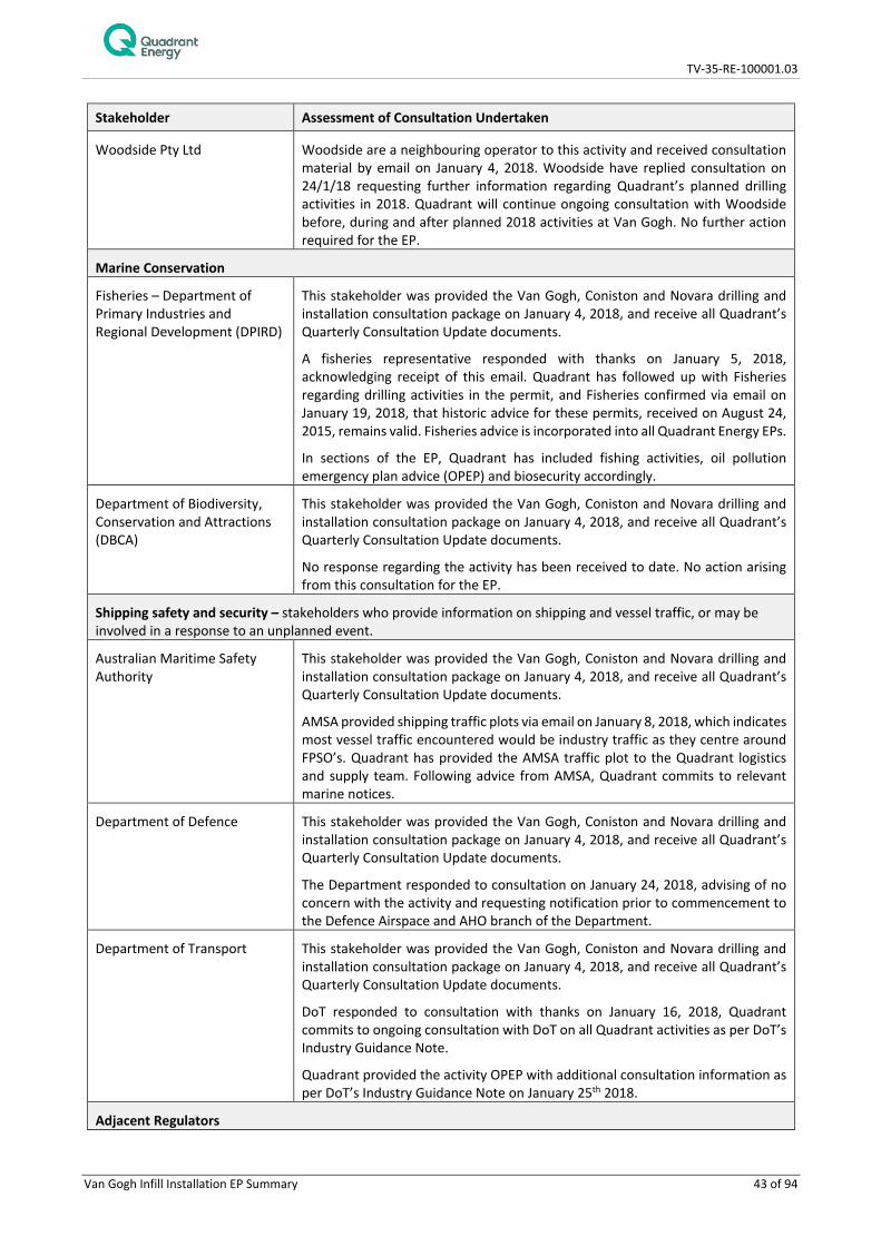
Woodside Pty Ltd Woodside are a neighbouring operator to this activity and received consultation material by email on January 4, 2018. Woodside have replied consultation on 24/1/18 requesting further information regarding Quadrant’s planned drilling activities in 2018. Quadrant will continue ongoing consultation with Woodside before, during and after planned 2018 activities at Van Gogh. No further action required for the EP.
Marine Conservation
Fisheries – Department of Primary Industries and Regional Development (DPIRD)
This stakeholder was provided the Van Gogh, Coniston and Novara drilling and installation consultation package on January 4, 2018, and receive all Quadrant’s Quarterly Consultation Update documents.
A fisheries representative responded with thanks on January 5, 2018, acknowledging receipt of this email. Quadrant has followed up with Fisheries regarding drilling activities in the permit, and Fisheries confirmed via email on January 19, 2018, that historic advice for these permits, received on August 24, 2015, remains valid. Fisheries advice is incorporated into all Quadrant Energy EPs.
In sections of the EP, Quadrant has included fishing activities, oil pollution emergency plan advice (OPEP) and biosecurity accordingly.
Department of Biodiversity, Conservation and Attractions (DBCA)
This stakeholder was provided the Van Gogh, Coniston and Novara drilling and installation consultation package on January 4, 2018, and receive all Quadrant’s Quarterly Consultation Update documents.
No response regarding the activity has been received to date. No action arising from this consultation for the EP.
Shipping safety and security – stakeholders who provide information on shipping and vessel traffic, or may be involved in a response to an unplanned event.
Australian Maritime Safety Authority
This stakeholder was provided the Van Gogh, Coniston and Novara drilling and installation consultation package on January 4, 2018, and receive all Quadrant’s Quarterly Consultation Update documents.
AMSA provided shipping traffic plots via email on January 8, 2018, which indicates most vessel traffic encountered would be industry traffic as they centre around FPSO’s. Quadrant has provided the AMSA traffic plot to the Quadrant logistics and supply team. Following advice from AMSA, Quadrant commits to relevant marine notices.
Department of Defence This stakeholder was provided the Van Gogh, Coniston and Novara drilling and installation consultation package on January 4, 2018, and receive all Quadrant’s Quarterly Consultation Update documents.
The Department responded to consultation on January 24, 2018, advising of no concern with the activity and requesting notification prior to commencement to the Defence Airspace and AHO branch of the Department.
Department of Transport This stakeholder was provided the Van Gogh, Coniston and Novara drilling and installation consultation package on January 4, 2018, and receive all Quadrant’s Quarterly Consultation Update documents.
DoT responded to consultation with thanks on January 16, 2018, Quadrant commits to ongoing consultation with DoT on all Quadrant activities as per DoT’s Industry Guidance Note.
Quadrant provided the activity OPEP with additional consultation information as per DoT’s Industry Guidance Note on January 25th 2018.
Adjacent Regulators
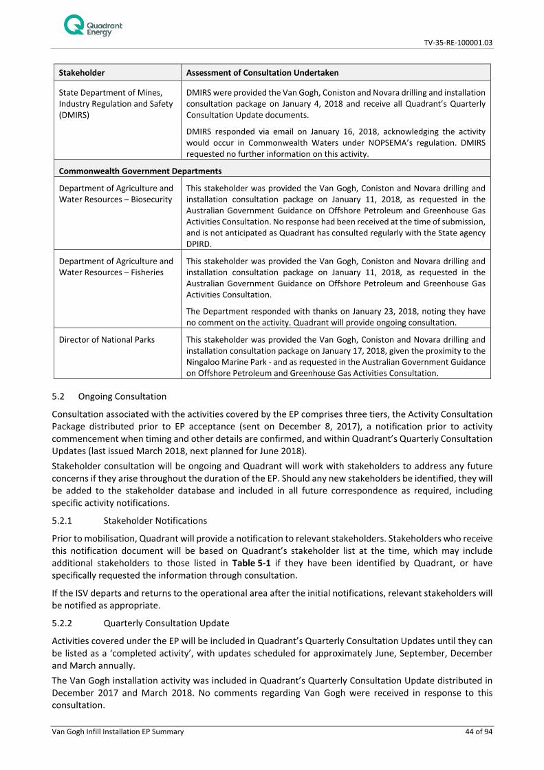
TV-35-RE-100001.03
Van Gogh Infill Installation EP Summary 44 of 94
Stakeholder Assessment of Consultation Undertaken
State Department of Mines, Industry Regulation and Safety (DMIRS)
DMIRS were provided the Van Gogh, Coniston and Novara drilling and installation consultation package on January 4, 2018 and receive all Quadrant’s Quarterly Consultation Update documents.
DMIRS responded via email on January 16, 2018, acknowledging the activity would occur in Commonwealth Waters under NOPSEMA’s regulation. DMIRS requested no further information on this activity.
Commonwealth Government Departments
Department of Agriculture and Water Resources – Biosecurity
This stakeholder was provided the Van Gogh, Coniston and Novara drilling and installation consultation package on January 11, 2018, as requested in the Australian Government Guidance on Offshore Petroleum and Greenhouse Gas Activities Consultation. No response had been received at the time of submission, and is not anticipated as Quadrant has consulted regularly with the State agency DPIRD.
Department of Agriculture and Water Resources – Fisheries
This stakeholder was provided the Van Gogh, Coniston and Novara drilling and installation consultation package on January 11, 2018, as requested in the Australian Government Guidance on Offshore Petroleum and Greenhouse Gas Activities Consultation.
The Department responded with thanks on January 23, 2018, noting they have no comment on the activity. Quadrant will provide ongoing consultation.
Director of National Parks This stakeholder was provided the Van Gogh, Coniston and Novara drilling and installation consultation package on January 17, 2018, given the proximity to the Ningaloo Marine Park - and as requested in the Australian Government Guidance on Offshore Petroleum and Greenhouse Gas Activities Consultation.
5.2 Ongoing Consultation
Consultation associated with the activities covered by the EP comprises three tiers, the Activity Consultation Package distributed prior to EP acceptance (sent on December 8, 2017), a notification prior to activity commencement when timing and other details are confirmed, and within Quadrant’s Quarterly Consultation Updates (last issued March 2018, next planned for June 2018). Stakeholder consultation will be ongoing and Quadrant will work with stakeholders to address any future concerns if they arise throughout the duration of the EP. Should any new stakeholders be identified, they will be added to the stakeholder database and included in all future correspondence as required, including specific activity notifications.
5.2.1 Stakeholder Notifications
Prior to mobilisation, Quadrant will provide a notification to relevant stakeholders. Stakeholders who receive this notification document will be based on Quadrant’s stakeholder list at the time, which may include additional stakeholders to those listed in Table 5-1 if they have been identified by Quadrant, or have specifically requested the information through consultation.
If the ISV departs and returns to the operational area after the initial notifications, relevant stakeholders will be notified as appropriate.
5.2.2 Quarterly Consultation Update
Activities covered under the EP will be included in Quadrant’s Quarterly Consultation Updates until they can be listed as a ‘completed activity’, with updates scheduled for approximately June, September, December and March annually. The Van Gogh installation activity was included in Quadrant’s Quarterly Consultation Update distributed in December 2017 and March 2018. No comments regarding Van Gogh were received in response to this consultation.

TV-35-RE-100001.03
Van Gogh Infill Installation EP Summary 45 of 94
5.3 OPEP Consultation
In preparing oil pollution emergency plans (OPEP), a number of parties are identified to provide spill response services and actions to support the implementation of the OPEP. These OPEP stakeholders are identified through evaluation of the activity and spill potential for all Quadrant OPEPs, including the Van Gogh Infill Installation OPEP (TV-35-RE-100001.02). Consultation, agreements or contracts have been put into place with agencies and organisations throughout the development of Quadrant oil spill response strategies and tactics so that roles and responsibilities are understood and accepted as outlined in Table 5-3.
Table 5-3: OPEP consultation summary
Engaged with Assessment of Consultation Undertaken
Function Stakeholder
Australian Marine Oil Spill Centre (AMOSC)
Historically AMOSC reviewed Oil Spill Contingency Plans (OSCPs) and OPEPs and are satisfied with the description of their support. AMOSC now request to only view OPEPs once they are accepted by the regulator and before the activity commences. Roles and responsibilities defined in the OPEP reflect the arrangements established under contract conditions as a Participating Member of AMOSC under the AMOSCPlan.
Australian Marine Safety Authority (AMSA)
Historically AMSA reviewed OPEPs and are satisfied with the description of their support. AMSA now request to only view OPEPs once they are accepted by the regulator and before the activity commences. Roles and responsibilities defined in the OPEP reflect the arrangements established within a Memorandum of Understanding (MOU) between AMSA and Quadrant. Quadrant continue to undertake an annual workshop with AMSA as required under Sections 22 and 24 of the Quadrant/AMSA MOU. This enables the open flow of information relevant to the oil spill response arrangements: Ongoing consultation and cooperation AMSA and the titleholder will nominate contact points for the ongoing management of this MOU. AMSA and the Titleholder agree to maintain a cooperative approach to preparing and responding to marine pollution incidents, including the open exchange of information and technical advice. AMSA will facilitate an annual workshop to provide an open forum to exchange information on best practice and review and update operational procedure.
Logistics provider CH Robinson CH Robinson provide a global freight forwarding service under contract conditions to Quadrant. All arrangements defined in the OPEP reflecting freight forwarding services reflect contracted services.
Toll Logistics Toll Logistics operate under contract conditions with Quadrant. All arrangements defined in the OPEP nominating Toll Logistics reflect contracted services.
Field support organisation
Exmouth Freight & Logistics Services (EF&LS)
EF&LS operate under contract conditions with Quadrant. All arrangements defined in the OPEP nominating EF&LS reflect contracted services.
Department of Environmental Regulation (DER) (Waste Management Branch)
The DER Waste Management Branch have reviewed and have had input in defining the Waste Management Plan contained in Quadrant OSCP/OPEPs.

TV-35-RE-100001.03
Van Gogh Infill Installation EP Summary 46 of 94
Engaged with Assessment of Consultation Undertaken
Function Stakeholder The waste management processes do not change between OPEPs, so the original consultation is sufficient for the OPEP.
Department of Biodiversity, Conservation and Attractions (DBCA)
DBCA were contributors to development of the WA Oiled Wildlife Response Plan (OWRP) defined in the OPEP. Descriptions of the Quadrant interface with the WAOWRP contained within the OPEP are consistent with the intent of DBCA (and AMOSC) for oiled wildlife response. No further consultation is required.
Department of Transport (Hazard Management Authority)
All roles and responsibilities defined within the OPEP for DoT reflect the arrangements for the Westplan MOP as further defined by the DoT Offshore Petroleum Industry Guidance Note, Marine Oil Pollution: Response and Consultation Arrangements. Quadrant commits to ongoing consultation with DoT on all Quadrant activities as per DoT’s Industry Guidance Note.
Subsea response service provider
Oceaneering Oceaneering operate under contract conditions with Quadrant. All arrangements defined in the OPEP nominating Oceaneering reflect contracted services.
Oil Spill Response Limited (OSRL) OSRL operate under contract conditions with Quadrant. All arrangements defined in the OPEP nominating OSRL reflect contracted services.
Vessel providers Go Marine Go Marine operate under contract conditions with Quadrant. All arrangements defined in the OPEP nominating Go Marine reflect contracted services.
Jet Wave Marine (JWM)
JWM operate under contract conditions with Quadrant. All arrangements defined in the OPEP nominating JWM reflect contracted services.
Bhagwan Marine Bhagwan Marine operate under contract conditions with Quadrant. All arrangements defined in the OPEP nominating Bhagwan Marine reflect contracted services.
Aircraft providers Aircraft providers operate under contract conditions with Quadrant. All arrangements defined in this OPEP nominating aircraft providers reflect contracted services.
Spill modelling provider
RPS APASA APASA operate under contract conditions with Quadrant. All arrangements defined in the OPEP nominating APASA reflect contracted services.
Waste contractor North West Alliance (NWA)
NWA operate under contract conditions with Quadrant. All arrangements defined in the OPEP nominating NWA reflect contracted services.
6. ENVIRONMENTAL HAZARDS AND CONTROLS
The impact and risk assessment approach is consistent with the requirements of AS/NZS ISO 31000:2009 Risk Management – Principles and guidelines and ISO/IEC 31010 Risk management – Risk management techniques. The approach can be mapped to the requirements of the OPGGS (E) Regulations for an EP, as described by NOPSEMA (N4700-GN1074 Rev 1 2013). The key steps are illustrated in Figure 6-1 below.

TV-35-RE-100001.03
Van Gogh Infill Installation EP Summary 47 of 94
Figure 6-1: Environmental impact and risk assessment process
An assessment against the activity was undertaken and the environmental hazards or aspects were then identified. The risk assessment identified seven potential planned and unplanned events. The extent of actual or potential impacts from each planned or unplanned event is assessed using the description of the activity and known information on impacts (published industry reports and scientific studies) and in some circumstances, where required, predictive information such as modelling (e.g. hydrocarbon spills). Impact mechanisms and thresholds for impacts where relevant are determined and described, using scientific literature and modelling where required. The consequence level of the impact is then determined for each planned and unplanned event based on the severity of the impact to relevant receptor. This process determines a consequence level based on set criteria for each receptor category and takes into consideration the duration and extent of the impact, receptor recovery time and the effect of the impact at a population, ecosystem or industry level. The consequence definitions are outlined in Table 6-1 below.
Table 6-1: Consequence level description
Consequence Level
Consequence Level Description
A Negligible No impact or negligible impact.
B Minor Detectable but insignificant change to local population, industry or ecosystem factors. Localised effect with rapid recovery.
C Moderate Significant impact to local population, industry or ecosystem factors. Medium term recovery.
D Major Major long-term effect on local population, industry or ecosystem factors. Slow recovery over decades.
E Critical Complete loss of local population, industry or ecosystem factors AND/ OR major wide-spread regional impacts with slow recovery.
For unplanned events, a risk ranking is also determined using an assessment of the likelihood (likelihood ranking) of the event as well as the consequence level of the potential impact should that event occur. A description of likelihood as per Quadrant’s Risk Matrix as shown in Table 6-2 below.

TV-35-RE-100001.03
Van Gogh Infill Installation EP Summary 48 of 94
Table 6-2: Likelihood description
No. Matrix Description
5 Probable 1. Event has occurred frequently within the Company. 2. Between 1 and 10 incidents every 10 years (i.e. up to frequency 1/year).
4 Likely 1. Event has occurred frequently within the Industry. 2. Between 1 and 10 incidents every 100 years (i.e. up to frequency 10-1/year).
3 Unlikely 1. Event has occurred occasionally within the Company. 2. Between 1 and 10 incidents every 1000 years (i.e. up to frequency 10-2/year).
2 Very Unlikely 1. Has occasionally occurred within the Industry. 2. Between 1 and 10 incidents every 10,000 years (i.e. up to frequency 10-3/ year).
1 Rare 1. Could happen under exceptional circumstances only. 2. Between 1 and 10 incidents every 100,000 years (i.e. up to frequency 10-4/ year).
Risk rankings (consequence x likelihood) are assigned in accordance with Quadrant Energy’s Risk Matrix as shown in Figure 6-2 below.
SEVERITY
1. Negligible 2. Minor 3. Moderate 4. Major 5. Critical
LIKE
LIHO
OD
5. Probable
4. Likely
3. Unlikely
2. Very Unlikely
1. Rare
Figure 6-2: Quadrant Energy risk matrix
For each planned and unplanned event, a set of Environmental Performance Outcome(s) (EPO’s), Environmental Performance Standards (EPS) and Measurement Criteria (MC) are identified. The definitions of the performance outcomes, standards and measurement criteria are consistent with the OPGGS (E) Regulations. For planned and unplanned events, an ALARP and Acceptability assessment is also undertaken.
6.1 ALARP Evaluation
The ALARP principle is that the residual impacts and risk shall be ‘as low as reasonably practicable’. It has particular connotations as a route to reduce risks when considering law, regulation and standards. For an impact or risk to be ALARP it must be possible to demonstrate that the cost involved in reducing the impact or risk further would be grossly disproportionate to the benefit gained. The ALARP principle arises from the fact that infinite time, effort and money could be spent on the attempt of reducing a risk to zero. It
High Risk - reduction of risk required
Medium Risk - reduction of risk required based on ALARP principle
Low Risk - deemed acceptable based on standard risk controls in place

TV-35-RE-100001.03
Van Gogh Infill Installation EP Summary 49 of 94
should not be understood as simply a quantitative measure of benefit against detriment. It is more a best common practice of judgement of the balance of impact or risk and societal benefit. For planned and unplanned events, an ALARP assessment is undertaken to demonstrate that the standard control measures adopted reduce the impact (consequence level) or risk to ALARP. This process relies on demonstrating that further potential control measures would require a disproportionate level of cost/effort in order to reduce the level of impact or risk. If this cannot be demonstrated, then further controls are adopted. The level of detail included within the ALARP assessment is based upon the nature and scale of the potential impact or risk.
6.2 Acceptability Evaluation
Quadrant considers an impact or risk associated with the proposed activity to be acceptable if the following criteria are met:
• The consequence from a planned event is ranked as A or B; or a risk of impact from an unplanned event is ranked low to medium;
• An assessment has been completed to determine if further information/studies are required to support or validate the consequence assessment;
• Performance standards are consistent with legal and regulatory requirements; • Performance standards are consistent with Quadrant Environmental Management Policy; • Performance standards are consistent with industry standards and best practice guidance (e.g.
National Biofouling Guidance for the Petroleum Industry); • Performance standards are consistent with stakeholder expectations; and • Performance standards have been demonstrated to reduce the impact or risk to ALARP
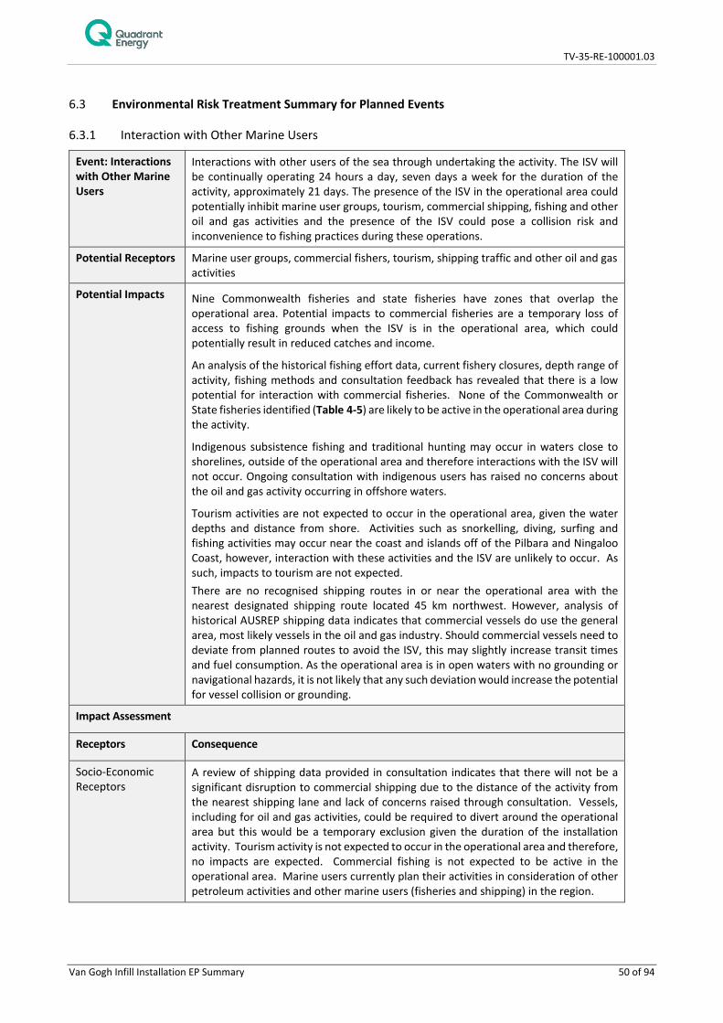
TV-35-RE-100001.03
Van Gogh Infill Installation EP Summary 50 of 94
6.3 Environmental Risk Treatment Summary for Planned Events
6.3.1 Interaction with Other Marine Users
Event: Interactions with Other Marine Users
Interactions with other users of the sea through undertaking the activity. The ISV will be continually operating 24 hours a day, seven days a week for the duration of the activity, approximately 21 days. The presence of the ISV in the operational area could potentially inhibit marine user groups, tourism, commercial shipping, fishing and other oil and gas activities and the presence of the ISV could pose a collision risk and inconvenience to fishing practices during these operations.
Potential Receptors Marine user groups, commercial fishers, tourism, shipping traffic and other oil and gas activities
Potential Impacts Nine Commonwealth fisheries and state fisheries have zones that overlap the operational area. Potential impacts to commercial fisheries are a temporary loss of access to fishing grounds when the ISV is in the operational area, which could potentially result in reduced catches and income.
An analysis of the historical fishing effort data, current fishery closures, depth range of activity, fishing methods and consultation feedback has revealed that there is a low potential for interaction with commercial fisheries. None of the Commonwealth or State fisheries identified (Table 4-5) are likely to be active in the operational area during the activity.
Indigenous subsistence fishing and traditional hunting may occur in waters close to shorelines, outside of the operational area and therefore interactions with the ISV will not occur. Ongoing consultation with indigenous users has raised no concerns about the oil and gas activity occurring in offshore waters.
Tourism activities are not expected to occur in the operational area, given the water depths and distance from shore. Activities such as snorkelling, diving, surfing and fishing activities may occur near the coast and islands off of the Pilbara and Ningaloo Coast, however, interaction with these activities and the ISV are unlikely to occur. As such, impacts to tourism are not expected. There are no recognised shipping routes in or near the operational area with the nearest designated shipping route located 45 km northwest. However, analysis of historical AUSREP shipping data indicates that commercial vessels do use the general area, most likely vessels in the oil and gas industry. Should commercial vessels need to deviate from planned routes to avoid the ISV, this may slightly increase transit times and fuel consumption. As the operational area is in open waters with no grounding or navigational hazards, it is not likely that any such deviation would increase the potential for vessel collision or grounding.
Impact Assessment
Receptors Consequence
Socio-Economic Receptors
A review of shipping data provided in consultation indicates that there will not be a significant disruption to commercial shipping due to the distance of the activity from the nearest shipping lane and lack of concerns raised through consultation. Vessels, including for oil and gas activities, could be required to divert around the operational area but this would be a temporary exclusion given the duration of the installation activity. Tourism activity is not expected to occur in the operational area and therefore, no impacts are expected. Commercial fishing is not expected to be active in the operational area. Marine users currently plan their activities in consideration of other petroleum activities and other marine users (fisheries and shipping) in the region.

TV-35-RE-100001.03
Van Gogh Infill Installation EP Summary 51 of 94
Overall Consequence Ranking
A – Negligible
Management Control
Effectiveness of Control
Maritime notices Ensure other marine users are aware of the presence of the ISV and are provided with information on timings of the activity including ISV arrival and departure, so that the maritime industry is aware of the petroleum activities (including how the site is left). Stakeholder
Consultation
Exclusion zone Exclusion zones around the ISV prevents other vessels from getting too close and causing damage to equipment of either party.
Navigation equipment and procedures
Reduces risk of environmental impact from vessel collisions due to ensuring safety requirements are fulfilled.
6.3.2 Seabed Disturbance
Event: Seabed Disturbance
Installation and movement of the subsea infrastructure will disturb the seabed and associated benthic habitat.
During the installation of Van Gogh infrastructure, additional potential seabed disturbance (temporary) may also occur (but is not limited to) in the operational area due to:
• Sedimentation as infrastructure is placed on the seabed; • WROV operations and WROV propeller wash; • Placement of WROV baskets, including with cement bags, on the seabed; • Placement of deployment frames on the seabed; • Marine growth and cuttings removal using the WROV; • Dropped objects (e.g. subsea infrastructure); and • Placement of survey and positioning beacons and support frames onto the seabed.
Sedimentation and water quality impacts (i.e. increased turbidity) could be caused by the initial placement of solid structures, deployment/retrieval/movement of equipment and WROV operations. However, sediment loads are not expected to be significant. Each placement onto and lift from the seabed will cause a single brief disturbance resulting in a transient plume of sediment.
Installation of equipment
The proposed Van Gogh activities which have the potential to disturb the seabed are installation of the two EHFL, two GLJ. Temporary disturbance will occur due to the use of their deployment frames (6 m x 2.5 m x 3m) which will be retrieved following completion of deployment.
Stabilisation materials recovery and placement
Van Gogh installation activities include the laying of cement filled bags (1m x 1m cement bag) on the GLJs and EHFLs. Each GLJ and EHFL will have up to six cement bags installed (24 bags in total). The cement bags will be lowered to the seabed in a metal basket (2 m x 2 m). These activities may result in seabed disturbance due to movement and placement of materials on the seabed; however, the area of seabed affected will be small and localised and unlikely to extend beyond the area originally impacted during the laying of the GLJs and EHFLs.

TV-35-RE-100001.03
Van Gogh Infill Installation EP Summary 52 of 94
The overall footprint for disturbance for all of the Van Gogh project installation activities is approximately 200 m2.
Potential Receptors Threatened / Migratory Fauna; Physical Environment/ Habitat; Socio-economic
Potential Impacts Installation of the subsea infrastructure can cause the following impacts:
• Direct physical disturbance of approximately 200 m2 of benthic and seabed habitat from installation of infrastructure;
• Indirect disturbance to benthic habitats and associated marine fauna by sedimentation;
• Increased turbidity of the near-seabed water column; and
• Introduction of artificial habitat for benthic fauna colonization.
Impact Assessment
Receptor Consequence
Threatened / Migratory Fauna
The areas of seabed that are expected to be impacted included soft sediments with little epifauna and would result in localised loss of widespread habitat. Disturbance to the seabed may have indirect impacts to protected fauna if the disturbance leads to a reduction on habitat quality or food availability.
However, the area potentially impacted is not expected to be significant foraging habitat for protected fauna. No decrease in local population size, area of occupancy of species, loss or disruption of habitat critical or disruption to the breeding cycle of any of these protected matters is expected.
Physical Environment/ Habitat
The physical environment and habitat will be disturbed during the Van Gogh infill installation activities. However, the area potentially impacted has previously been disturbed, is small compared to the wider environment and in the majority of cases, the disturbed area is expected to recolonise. As such, long term disturbance and negative impacts to the wider ecosystem are not expected. The Continental Slope Demersal Fish Communities KEF is found within the operational area, however the area of the KEF disturbed is negligible compared to area available the demersal fish communities. There are no seabed features (e.g., reefs, canyons, shipwrecks) present within the operational area that would be expected to aggregate demersal fishes. Any localised disturbance to benthic habitat is not expected to have an impact to any fishes attracted to the subsea infrastructure although, localised and temporary avoidance or attraction could occur during installation activities.
Socio-Economic Receptors
Disturbance of the seabed is unlikely to impact socio-economic receptors such as shipping. Seabed disturbance may temporarily alter scampi habitat, however, the area impacted is insignificant compared to the available fishing area and trawling is unlikely to occur in the vicinity of subsea infrastructure due to snagging hazards on the subsea infrastructure and proximity to the FPSO. Therefore, impacts to commercial fisheries are not expected. No stakeholder concerns have been raised regarding this aspect.
Overall Consequence Ranking
A – Negligible
Management Control
Effectiveness of Control
Pre- and post- installation seabed surveys
To understand the seabed conditions and minimise any potential risks caused by subsea hazards (e.g. infrastructure) and inform final location of infrastructure (e.g. avoiding areas of hard substrate). This would also prevent damage to any sensitive features.
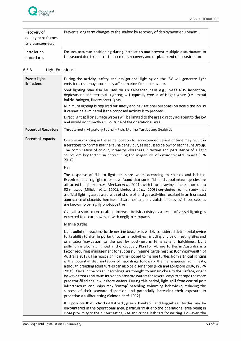
TV-35-RE-100001.03
Van Gogh Infill Installation EP Summary 53 of 94
Recovery of deployment frames and transponders
Prevents long term changes to the seabed by recovery of deployment equipment.
Installation procedures
Ensures accurate positioning during installation and prevent multiple disturbances to the seabed due to incorrect placement, recovery and re-placement of infrastructure
6.3.3 Light Emissions
Event: Light Emissions
During the activity, safety and navigational lighting on the ISV will generate light emissions that may potentially affect marine fauna behaviour. Spot lighting may also be used on an as-needed basis e.g., in-sea ROV inspection, deployment and retrieval. Lighting will typically consist of bright white (i.e., metal halide, halogen, fluorescent) lights. Minimum lighting is required for safety and navigational purposes on board the ISV so it cannot be eliminated if the proposed activity is to proceed. Direct light spill on surface waters will be limited to the area directly adjacent to the ISV and would not directly spill outside of the operational area.
Potential Receptors Threatened / Migratory Fauna – Fish, Marine Turtles and Seabirds
Potential Impacts Continuous lighting in the same location for an extended period of time may result in alterations to normal marine fauna behaviour, as discussed below for each fauna group. The combination of colour, intensity, closeness, direction and persistence of a light source are key factors in determining the magnitude of environmental impact (EPA 2010).
Fish
The response of fish to light emissions varies according to species and habitat. Experiments using light traps have found that some fish and zooplankton species are attracted to light sources (Meekan et al. 2001), with traps drawing catches from up to 90 m away (Milicich et al. 1992). Lindquist et al. (2005) concluded from a study that artificial lighting associated with offshore oil and gas activities resulted in an increased abundance of clupeids (herring and sardines) and engraulids (anchovies); these species are known to be highly photopositive.
Overall, a short-term localised increase in fish activity as a result of vessel lighting is expected to occur, however, with negligible impacts.
Marine turtles
Light pollution reaching turtle nesting beaches is widely considered detrimental owing to its ability to alter important nocturnal activities including choice of nesting sites and orientation/navigation to the sea by post-nesting females and hatchlings. Light pollution is also highlighted in the Recovery Plan for Marine Turtles in Australia as a factor requiring management for successful marine turtle nesting (Commonwealth of Australia 2017). The most significant risk posed to marine turtles from artificial lighting is the potential disorientation of hatchlings following their emergence from nests, although breeding adult turtles can also be disoriented (Rich and Longcore 2006, in EPA 2010). Once in the ocean, hatchlings are thought to remain close to the surface, orient by wave fronts and swim into deep offshore waters for several days to escape the more predator-filled shallow inshore waters. During this period, light spill from coastal port infrastructure and ships may ‘entrap’ hatchling swimming behaviour, reducing the success of their seaward dispersion and potentially increasing their exposure to predation via silhouetting (Salmon et al. 1992).
It is possible that individual flatback, green, hawksbill and loggerhead turtles may be encountered in the operational area, particularly due to the operational area being in close proximity to their internesting BIAs and critical habitats for nesting. However, the

TV-35-RE-100001.03
Van Gogh Infill Installation EP Summary 54 of 94
potential impacts of light emissions to these turtle species from the activity is expected to be restricted to localised attraction and temporary disorientation but with no long term or residual impact due to the activity’s short duration (approximately 21 days); and the unlikely presence of hatchlings due to the distance from the nearest shorelines (over 40 km).
The WA Environmental Protection Authority (EPA) conservatively estimates there is only a light influence on marine turtles if the light source is within 1.5 km of the nesting beach (EPA 2010). Given the operational area is located over 40 km away from the nearest nesting beach, impacts to turtles from activity lighting are considered negligible.
Seabirds
Studies conducted between 1992 and 2002 in the North Sea confirmed that artificial light was the reason that birds were attracted to and accumulated around illuminated offshore infrastructure (Marquenie et al. 2008). The light sources associated with the ISVs may also provide enhanced capability for seabirds to forage at night. The ISV will not be in the operational area for a long period of time (approximately 21 days), and so will unlikely attract large numbers of seabirds.
Other marine fauna There is no evidence to suggest that artificial light sources adversely affect the migratory, feeding or breeding behaviours of cetaceans. Cetaceans predominantly utilise acoustic senses to monitor their environment rather than visual cues (Simmonds et al. 2004), therefore, impacts are thought to be unlikely.
Impact Assessment
Receptors Consequence
Threatened / Migratory Fauna
Continuous lighting in the same location for an extended period of time may result in alterations to normal marine fauna behaviour. Sensitive receptors that may be impacted include fish at surface, marine turtles and mammals, and seabirds. Given the operational area is located in close proximity to flatback, green, hawksbill and loggerhead turtle internesting habitats, individuals may occur in the operational area, although large numbers are not expected. The nearest coastline is located over 40 km from the operational area, therefore, turtle nesting and hatchlings are not expected to be impacted by light emissions from the activities. Cetaceans, adult turtles and marine mammals are not known to be significantly attracted to light sources at sea and therefore, disturbances to behaviour are unlikely to occur. Fish and birds have been shown to be attracted to artificial light sources, however, the low level of light emitted from the ISV is unlikely to lead to large scale changes in species abundance or distribution. Impacts to transient fish and seabirds will therefore, be limited to short-term behavioural effects with no decrease in local population size, area of occupancy of species or loss or disruption of habitat critical / disruption to the breeding cycle.
Overall Consequence Ranking
A – Negligible
Management Control
Effectiveness of Control
None - inherently ALARP
Evaluation of the potential impacts of light emissions determined that no control measures were required as the inherent consequence of light emissions is expected to be negligible.

TV-35-RE-100001.03
Van Gogh Infill Installation EP Summary 55 of 94
6.3.4 Noise Emissions
Event: Noise Emissions
Noise generated by the ISV propagating through the water column, and from subsea positioning systems used during the activity may result in physiological or behavioural impacts to marine fauna, especially to cetacean species who use sound for navigation and communication. Helicopters will be used during the activity for crew change requirements and noise impacts generated from helicopter will also be assessed in this section.
Potential Receptors Threatened / Migratory Fauna – Cetaceans, Marine Turtles and Fish
Potential Impacts It is reasonable that fauna (cetaceans) may exhibit avoidance or attraction behaviour. The operational area overlaps with the humpback whale and pygmy blue whale migration route/BIA. Depending on the exact timing of the activity, individual humpback and pygmy blue whales may pass through the area and may exhibit avoidance behaviour however it is expected to be temporary (the duration of the activity). Similarly, other marine fauna associated with the operational area, such as pelagic fish and sharks (including whale sharks) may exhibit avoidance behaviour however it is expected to be temporary (the duration of the activity). Noise emitted by the ISV, ROVs or from subsea positioning systems during the activity will be short in duration and is likely to be reduced to background levels within kilometres to tens of kilometres. As such, any potential related marine fauna behavioural impacts are expected to be temporary and short ranged and is not expected to lead to long term changes in individual behaviour (e.g. migration) or lead to changes at the population level. Impacts to fish may result in indirect impacts to fisheries in the operational area. However, impacts to fisheries are considered negligible, given the short duration of the activity, the available area for commercial fishermen to catch plus, the area over which commercial species spawn. Noise levels are not expected to impact other socio-economic receptors (e.g. tourism) due to their low activity level within the vicinity of the operational area.
Impact Assessment
Receptors Consequence
Threatened / Migratory Fauna
Noise generated from ISV, subsea positioning systems and ROVs may result in physiological or behavioural impacts to marine fauna, especially to cetacean species who use sound for navigation and communication. Sensitive receptors that may be impacted include fish, marine turtles and mammals. Given that the activity will be a once off, for a very short duration, marine fauna potentially affected by acoustic noise are expected to exhibit avoidance and/or attraction behaviour to noise. Avoidance behaviour is likely to be localised within the area of the activity (due to small spatial extent of proposed activities) and temporary, i.e. for the duration of the activity only. Acoustic disturbances to marine fauna due to subsea positioning equipment are expected to be minimal as the sound levels generated are at a very high frequency and decay rapidly with distance travelled from the source and will only occur for short periods throughout the activity duration. Given the low level of noise expected from the ISV, ROVS and subsea positioning systems, and the short and temporary duration of noise emissions, significant impact to threatened or migratory species are not expected. Some behavioural response may be expected from the noise levels emitted, but not at levels that could cause mortality or injury to marine fauna, or significant changes to migration and foraging behaviour.
Socio-Economic Noise levels are not expected to impact on socio-economic receptors due to their low activity level within the vicinity of the operational area. Noise emissions may result in temporary avoidance of commercially important species however it is expected to be

TV-35-RE-100001.03
Van Gogh Infill Installation EP Summary 56 of 94
temporary and only for the duration of the activity. Therefore, impacts to commercial fisheries is expected to be negligible.
Overall Consequence Ranking
A – Negligible
Management Control
Effectiveness of Control
Procedure for interacting with marine fauna
Reduces risk of physical and behavioural impacts to marine fauna from vessels and helicopters.
6.3.5 Planned Operational Discharges
Event: Planned Discharges
In order to operate the ISV and undertake the infill installation activities, a number of planned routine discharges to the marine environment will be required, as outlined below. Sewage The volume of sewage is directly proportional to the number of persons on-board the ISV. Up to 30 -40 L of sewage/greywater will be generated per person per day. Treated sewage will be disposed in accordance with MARPOL Annex IV. Food waste Putrescible waste will consist of approximately 1 L of food waste per person per day. The ISV will not discharge food waste in the operational area. Brine Brine generated from the water supply systems on-board the ISV will be discharged to the ocean at a salinity of approximately 10% higher than seawater. The volume of the discharge is dependent on the requirement for fresh (or potable) water and would vary between vessels and the number of people on-board. Cooling water Seawater is used as a heat exchange medium for the cooling of machinery engines. Seawater is drawn from the ocean and flows counter-current through closed-circuit heat exchangers, transferring heat from the ISV engines and machinery to the seawater. The seawater is then discharged to the ocean (i.e. it is a once-through system). Cooling water temperatures vary depending upon the ISV’s engine work load and activity. Deck drainage Deck drainage from rainfall or wash-down operations would discharge to the marine environment. The deck drainage would contain particulate matter and residual chemicals such as cleaning chemicals, oil and grease. Assessment of the spillage of hydrocarbons and other environmentally hazardous chemicals and liquid waste are discussed in Section 6.4. Oily water (i.e. bilge water) discharges from ISV While in the operational area, the ISV may discharge oily water after treatment to an oil in water content of 15 ppm in a MARPOL approved oily water filter system. Hydraulic fluid and treated seawater Small amounts of hydraulic fluids, corrosion inhibitor, biocides, oxygen scavenger (treated seawater) are likely to enter the subsea marine environment from Van Gogh infill installation activities. During valve actuation of the subsea infrastructure and the use of ROVs, small volumes of hydraulic fluid (typically the water based hydraulic fluid Transaqua HT2) will be released (approximately 80L). Hydraulic fluids are medium oils of light to moderate viscosity and have a relatively rapid spreading rate and, like MGO, will dissipate quickly,

TV-35-RE-100001.03
Van Gogh Infill Installation EP Summary 57 of 94
particularly in high sea states. Leak testing during testing of the subsea system may also occur in which case, a small volume (estimated at ~10 L) of treated water and non-toxic dye will be used to detect leaks in a subsea system. The two rigid spools (~620 litres each) will be pre-flooded with treated seawater containing low concentrations of corrosion inhibitor (approximately 300 ppm). There is the potential for this to be released to the marine environment, when installing the spools, however, it is considered more likely that seawater will ingress into the spools during installation.
Equipment/infrastructure may also be dosed with biocide (e.g. biocide sticks) prior to hook up to the existing infrastructure.
Potential Receptors Threatened / Migratory Fauna – Fish (pelagic) & Sharks, Marine Mammals, Marine Turtles and Seabirds; Physical Environment / Habitat – Water Quality
Potential Impacts Planned non-hazardous discharges will be small and intermittent, with volumes dependent on a range of variables. The discharge of non-hazardous wastes to the marine environment may result in a localised reduction in water quality in the vicinity of the release location. This would be expected to be temporary (minutes to hours) and localised. The discharges are expected to be dispersed and diluted rapidly, with concentrations of discharges significantly dropping with distance from the discharge point. Changes to ambient water quality outside of the operational area are considered unlikely to occur.
Impact assessment
Receptors Consequence
Threatened / Migratory Physical Environment/ Habitat
Operational discharges in the same release location may result in temporary water quality perturbations and alteration to marine fauna behaviour. Sensitive receptors that may be impacted include fish at surface, marine turtles and mammals, and seabirds. Given that the activity will be for a limited duration, and is located over 40 km from the nearest shoreline, impacts will be limited to short-term water quality impacts and temporary behavioural effects observed in fish and seabirds. Impacts to water quality will be experienced in the discharge mixing zone which will be localised and will occur only as long as the discharges occur (i.e. no sustained impacts), therefore, recovery will be measured in hours to days. Only short term behavioural impacts are expected with no decrease in local population size / area of occupancy of species / loss or disruption of habitat critical / disruption to the breeding cycle / introduction of disease. The Continental Slope Demersal Fish Communities KEF is found within the operational area. Any localised disturbance to benthic habitat is not expected to have an impact to demersal fishes although, localised and temporary displacement could occur during installation activities.
Overall Consequence Ranking
A - Negligible
Management Control
Effectiveness of Control
General chemical management procedures
Potential impacts to the environment are reduced through following correct procedures for the safe handling and storage of chemicals
Hazardous chemical management procedures
Reduces the risk of spills and leaks (discharges)of hazardous chemicals to the sea by controlling the storage, handling and clean up

TV-35-RE-100001.03
Van Gogh Infill Installation EP Summary 58 of 94
Chemical selection procedure
Reduced toxicity to marine environment
Only environmentally acceptable chemicals would be released to sea from flushing and testing
Equipment pressure tested
Reduces hydrocarbon or chemical leaks during commissioning and operation
Sewage treatment system
Reduces potential impacts of inappropriate discharge of sewage.
Ensure compliance with MARPOL requirements
Waste (garbage) management procedure
Reduces probability of garbage being discharged to sea, reducing potential impacts to marine fauna. Stipulates putrescible waste disposal conditions and limitations
Ensure compliance with MARPOL requirements Oily water treatment system
Reduces potential impacts of planned discharge of oily water to the environment Ensure compliance with MARPOL requirements
Deck cleaning product selection procedure
Reduced toxicity to marine environment
Only environmentally acceptable chemicals would be released overboard
No discharge of food waste within the operational area
Eliminates localised nutrient enrichment, organic and particulate loading from food wastes
6.3.6 Atmospheric Emissions
Event: Atmospheric Emissions
The use of fuel (specifically MGO) to power vessel engines, generators, mobile and fixed plant and equipment will result in emissions of greenhouse gases (GHG) such as carbon dioxide (CO2), methane (CH4) and nitrous oxide (N2O), along with non-GHG such as sulphur oxides (SOx) and nitrous oxides (NOx). ISV may also use an incinerator for waste during the activity.
ISV may utilise ozone-depleting substances (ODS) in closed-system rechargeable refrigeration systems.
Potential Receptors Seabirds and humans
Potential Impacts Hydrocarbon combustion may result in a temporary, localised reduction of air quality in the environment immediately surrounding the discharge point during the activity.
Non-GHG emissions, such as NOX and SOX, and GHG emissions can lead to a reduction in local air quality which can impact humans and seabirds in the immediate vicinity and add to the national GHG loadings.
The Van Gogh infill installation activities will occur in offshore waters, the combustion of fuels and incineration in such remote locations will not impact on air quality in coastal towns, the nearest being Exmouth (60 km). The quantities of gaseous emissions are relatively small and will quickly dissipate into the surrounding atmosphere. Accidental release and fugitive emissions of ODS has the potential to contribute to ozone layer depletion. Air emissions will be similar to other vessels operating in the region for both petroleum and non-petroleum activities. ODS may be used on board the ISV for refrigeration systems, the release of ODS contributing to the damage of the ozone layer, allowing ultra-violet radiation from the sun to pass through, which can result in human health impacts (e.g. skin cancers). Maintenance of refrigeration systems containing ODS is on a routine, but infrequent basis, and with controls implemented, the likelihood of an accidental ODS release of material volume is considered rare.
Impact Assessment

TV-35-RE-100001.03
Van Gogh Infill Installation EP Summary 59 of 94
Receptors Consequence
Threatened / Migratory Fauna
No or negligible reduction to seabirds would be expected.
Physical Environment / Habitat
No or negligible reduction in physical environment/ habitat area/ function.
Overall Consequence Ranking
A – Negligible
Management Control
Effectiveness of Control
Waste incineration managed in accordance MARPOL
Eliminate the potential for emissions due to waste incineration to impact air quality
Air pollution prevention certification
Reduces probability of potential impacts to air quality due to ODS emissions, high NOx, SOx emissions.
Ozone-depleting substance handling procedures
Reduces probability of potential impacts to air quality due to ODS emissions.
6.3.7 Spill Response Operations
Event: Spill Response Operations
In the event of a hydrocarbon spill, response strategies will be implemented where possible to reduce environmental impacts to ALARP. The selection of strategies will be undertaken through the Net Environmental Benefit Analysis (NEBA) process, outlined in the Van Gogh Infill Installation Oil Pollution Emergency Plan (OPEP) (TV-35-RE-100001.02). Spill response will be under the direction of the relevant Controlling Agency, as defined within the OPEP, which may be Quadrant and/or another agency. In all instances, Quadrant will undertake a ‘first-strike’ spill response and will act as the Controlling Agency until the designated Controlling Agency assumes control. The response strategies deemed appropriate for the worst case oil spill scenarios identified for the activity are detailed in the OPEP and comprise: • Source control; • Monitor and evaluate (operational monitoring); • Mechanical dispersion (MGO only); • Chemical dispersion (Crude oil only) • Containment and Recovery (Crude oil only) • Protection and Deflection; • Shoreline Clean-up; • Oiled Wildlife Response; • Scientific Monitoring; and • Waste Management. While response strategies are intended to reduce the environmental consequences of a hydrocarbon spill, poorly planned and coordinated response activities can result in a lack of, or inadequate information being available, upon which poor decisions can be made, exacerbating or causing further environmental harm. An inadequate level of training and guidance during the implementation of spill response strategies can also result in environmental harm over and above that already caused by the spill.

TV-35-RE-100001.03
Van Gogh Infill Installation EP Summary 60 of 94
The greatest potential for impacts additional to those described for routine operations is from chemical dispersant on subsea receptors, shoreline clean-up and oiled wildlife response operations, where coastal and shoreline habitat damage and fauna disturbance may occur.
Potential Receptors Threatened / Migratory Fauna - Fish, Marine Mammals, Marine Turtles and Seabirds; Physical Environment / Habitat; Protected Areas; Socio-Economic Receptors
Potential Impacts Light emissions Lighting may cause behavioural changes to fish, birds and marine turtles which can have a heightened consequence during key life-cycle activities, for example turtle nesting and hatching. Turtles and birds, which includes threatened and migratory fauna, have been identified as key fauna susceptible to lighting impacts Section 6.3.3 provides further detail on the nature of impacts to fish, birds and marine turtles. Spill response activities which require lighting may take place in protected areas important to turtles and birds, for example, shoreline locations of Ningaloo Reef and Muiron Islands are seasonally important for turtles, including BIAs and critical habitats. This could result in, indirect impacts on the values of the protected areas. As a consequence of impacts to fauna, lighting has the potential to impact supported industries such as tourism. Noise emissions Underwater noise from the use of vessels may impact marine fauna, such as fish (including commercial species), marine reptiles and marine mammals in the worst instance causing physical injury to hearing organs, but more likely causing short term behavioural changes, e.g. temporary avoidance of the area, which may impact key life-cycle process (e.g. spawning, breeding, calving). Underwater noise can also mask communication or echolocation used by cetaceans. Cetaceans have been identified as the key concern for vessel noise within the EMBA. The humpback migration BIA, pygmy blue whale migration and pygmy blue whale foraging BIAs are all within the EMBA. Spill response activities using vessels have the potential to impact fauna in protected areas, this includes the Ningaloo World Heritage Area. Noise and vibration from terrestrial activities on shorelines has the potential to cause behavioural disturbance to coastal fauna including protected seabirds and turtles. Shoreline activities involving the use of noise generating equipment may take place in important nesting areas for turtles and/or roosting/feeding areas for shorebirds. As a consequence of impacts to fauna (including shorebirds, marine mammals and fish), noise has the potential to impact supported industries such as tourism and commercial fishing. Atmospheric emissions Atmospheric emissions from spill response equipment will be localised and while there is potential for fauna and flora impacts, the use of mobile equipment, vessels and vehicles is not considered to create emissions on a scale where noticeable impacts would be predicted. Emissions may occur in protected areas, however, the scale of the impact relative to potential oil spill impacts is not considered great. Operational discharges and waste Operational discharges from vessels may create a localised and temporary reduction in marine water quality. Effects include nutrient enrichment, toxicity, turbidity, temperature and salinity increases. These may impact a different set of receptors than previously described in that section given vessel use may occur in shallower coastal waters during spill response activities. Discharge could potentially occur adjacent to marine habitats such as corals, seagrass, macroalgae, and in protected areas (i.e. receptors anywhere within the EMBA), which support a more diverse faunal community, however, discharges will be very localised and temporary.
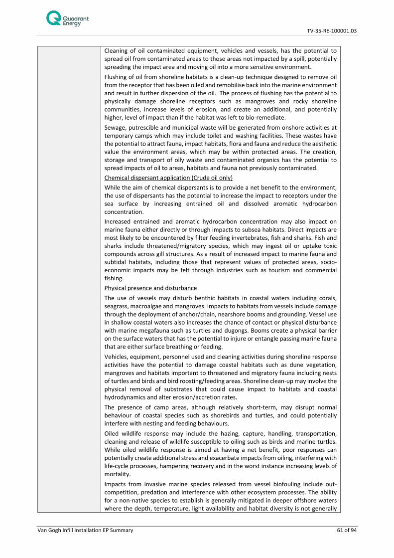
TV-35-RE-100001.03
Van Gogh Infill Installation EP Summary 61 of 94
Cleaning of oil contaminated equipment, vehicles and vessels, has the potential to spread oil from contaminated areas to those areas not impacted by a spill, potentially spreading the impact area and moving oil into a more sensitive environment. Flushing of oil from shoreline habitats is a clean-up technique designed to remove oil from the receptor that has been oiled and remobilise back into the marine environment and result in further dispersion of the oil. The process of flushing has the potential to physically damage shoreline receptors such as mangroves and rocky shoreline communities, increase levels of erosion, and create an additional, and potentially higher, level of impact than if the habitat was left to bio-remediate. Sewage, putrescible and municipal waste will be generated from onshore activities at temporary camps which may include toilet and washing facilities. These wastes have the potential to attract fauna, impact habitats, flora and fauna and reduce the aesthetic value the environment areas, which may be within protected areas. The creation, storage and transport of oily waste and contaminated organics has the potential to spread impacts of oil to areas, habitats and fauna not previously contaminated. Chemical dispersant application (Crude oil only) While the aim of chemical dispersants is to provide a net benefit to the environment, the use of dispersants has the potential to increase the impact to receptors under the sea surface by increasing entrained oil and dissolved aromatic hydrocarbon concentration. Increased entrained and aromatic hydrocarbon concentration may also impact on marine fauna either directly or through impacts to subsea habitats. Direct impacts are most likely to be encountered by filter feeding invertebrates, fish and sharks. Fish and sharks include threatened/migratory species, which may ingest oil or uptake toxic compounds across gill structures. As a result of increased impact to marine fauna and subtidal habitats, including those that represent values of protected areas, socio-economic impacts may be felt through industries such as tourism and commercial fishing. Physical presence and disturbance The use of vessels may disturb benthic habitats in coastal waters including corals, seagrass, macroalgae and mangroves. Impacts to habitats from vessels include damage through the deployment of anchor/chain, nearshore booms and grounding. Vessel use in shallow coastal waters also increases the chance of contact or physical disturbance with marine megafauna such as turtles and dugongs. Booms create a physical barrier on the surface waters that has the potential to injure or entangle passing marine fauna that are either surface breathing or feeding. Vehicles, equipment, personnel used and cleaning activities during shoreline response activities have the potential to damage coastal habitats such as dune vegetation, mangroves and habitats important to threatened and migratory fauna including nests of turtles and birds and bird roosting/feeding areas. Shoreline clean-up may involve the physical removal of substrates that could cause impact to habitats and coastal hydrodynamics and alter erosion/accretion rates. The presence of camp areas, although relatively short-term, may disrupt normal behaviour of coastal species such as shorebirds and turtles, and could potentially interfere with nesting and feeding behaviours. Oiled wildlife response may include the hazing, capture, handling, transportation, cleaning and release of wildlife susceptible to oiling such as birds and marine turtles. While oiled wildlife response is aimed at having a net benefit, poor responses can potentially create additional stress and exacerbate impacts from oiling, interfering with life-cycle processes, hampering recovery and in the worst instance increasing levels of mortality. Impacts from invasive marine species released from vessel biofouling include out-competition, predation and interference with other ecosystem processes. The ability for a non-native species to establish is generally mitigated in deeper offshore waters where the depth, temperature, light availability and habitat diversity is not generally

TV-35-RE-100001.03
Van Gogh Infill Installation EP Summary 62 of 94
conducive to supporting reproduction and persistence of the invasive species. However, in shallow coastal areas, such as areas where vessel based spill response activities may take place, conditions are likely to be more favourable. Impacts from invasive terrestrial species are similar in that the invasive species can out-compete local species (e.g. weeds) and interfere with ecosystem processes. Non-native species may be transported attached to equipment, vehicles and clothing. Such an introduction would be especially detrimental to wilderness areas or protected terrestrial reserves which may have a relatively undisturbed flora and fauna community. The disturbance to marine and coastal natural habitat, as well as the potential for disruption to culturally sensitive areas, which may occur in specially protected areas, may have flow on impacts to socio-economic values and industry (e.g. tourism, fisheries). Disruption to other users of marine and coastal areas and townships The use of vessels in the nearshore and offshore environment and the undertaking of spill response activities at shoreline locations may exclude the general public and industry use of the affected environment. As well as impacting leisure activities of the general public, this may impact on revenue with respect to industries such as tourism and commercial fishing. The mobilisation of personnel to small communities has the potential to affect the local community through demands on local accommodation and business, reducing the availability of services to members of the public.
Impact Assessment
Receptors Consequence
Threatened / Migratory Fauna Physical Environment / Habitat Protected Areas Socio-Economic Receptors
Light emissions The receptors considered most sensitive to lighting from vessel and shoreline operations are seabirds and marine turtles, particularly over spring/summer months with respect to marine turtles where emerging hatchlings are sensitive to light spill onto beaches. Following restrictions on night time operations by spill response vessels, which will demobilise to mooring areas offshore with safety lighting only, impacts from vessels are considered to be negligible. The positioning of temporary camps will be done at the direction of DoT/ DBCA and following control measures on lighting colour and direction the consequence of shoreline lighting is considered negligible. These species are likely to be values of the protected area they occur in (e.g. Ningaloo Reef), and the impact to the protected area from light is also considered negligible. As a consequence of impacts to fauna, lighting has the potential to impact supported industries such as tourism however as impacts to fauna are considered negligible any indirect impacts on tourism will also be negligible. Noise emissions The receptor considered most sensitive to vessel noise disturbance are populations of humpback whales and pygmy blue whales during migration season. A temporary behavioural disturbance is expected only with a consequence of negligible. With respect to noise from onshore operations (mobile equipment and vehicles), nesting, roosting or feeding birds are considered to be the most sensitive to noise. The equipment used is not considered to have excessive sound levels and following direction by DoT and DBCA on the location of temporary camp areas, the consequence to birds from noise is expected to be negligible. As a consequence of impacts to fauna, noise has the potential to impact supported industries such as tourism and commercial fishing however as impacts to fauna are considered negligible any indirect impacts on socio-economic receptors will also be negligible. Atmospheric emissions
TV-35-RE-100001.03
Van Gogh Infill Installation EP Summary 63 of 94
Atmospheric emissions from spill response equipment will be localised and impacts to even the most sensitive fauna, such as birds, are expected to be negligible. Because of the localised and low level of emissions impacts to protected area values and the physical environment are predicted to be negligible. Operational discharges Operational discharges from vessels may create a localised and temporary reduction in marine water quality, which has the potential to impact shallow coastal habitats in particular, however, following the adoption of regulatory requirements for vessel discharges, which prevent discharges close to shorelines, discharges will have a negligible impact to habitats, fauna or protected area values. Furthermore, washing of vessels and equipment will take place only in defined offshore hot zones preventing impacts to shallow coastal habitats. As a consequence of impacts to fauna, operational discharges from vessels has the potential to impact supported industries such as tourism and commercial fishing however as impacts to fauna are considered negligible any indirect impacts on socio-economic receptors will also be negligible. Onshore, the use of flushing water has the potential to damage sensitive shoreline and intertidal habitats, e.g. mangroves, however, low pressure flushing only will be used, preventing further damage to habitats or erosion of sediments. For sensitive habitats the deployment of booms will be considered to retain flushed hydrocarbons, if this presents a net benefit. Following these control measures the use of flushing to clean shorelines and intertidal habitats is seen to have a negligible additional impact to habitats, fauna or protected area values. The cleaning of contaminated vehicles and equipment onshore has the potential to spread oily waste and damage habitats if not contained. Decontamination units will be in use during the spill response thus containing waste and preventing any secondary contamination. The consequence of cleaning discharges is therefore ranked as negligible in terms of impacts to habitats, fauna or protected area values. Sewage, putrescible and municipal waste generated onshore will be stored disposed of at approved locations. Chemical dispersant application (Crude oil only) The use of chemical dispersants has the potential to increase the concentration of entrained oil within the water column. Based on the expected distribution of entrained oil and dissolved aromatic hydrocarbons from a worst case crude oil spill, this increase would be expected to be located to primarily offshore waters. This increase in concentration could also impact fish and invertebrates which support fisheries and aquaculture in the region. The primary controls for reducing impacts to these receptors is in the selection of approved or environmentally risk assessed chemical dispersants and through the careful assessment of application areas such that sensitive receptor impacts are reduced to ALARP. It is important to note that dispersants will only be applied if the response is seen as having a net environmental benefit as per the overarching NEBA analysis of spill response strategies. In the event dispersants are used there is the potential for a minor additional impact, noting that even in the absence of dispersant use, a greater volume of oil may load onto shorelines adding to the level of impact on shoreline receptors. Physical presence and disturbance The use of vessels and nearshore booms has the potential to disturb benthic habitats including sensitive habitats in coastal waters such as corals, seagrass, macroalgae and mangroves. A review of shoreline and shallow water habitats, and bathymetry, and the establishment of demarcated areas for access and anchoring (along with other control measures) will reduce the level of impact to negligible. The use and movement of vehicles, equipment and personnel during shoreline response activities has the potential to disturb coastal habitats such as dune vegetation, samphire and mangroves, and important habitats of threatened and migratory fauna including nests of turtles and birds and bird roosting areas.

TV-35-RE-100001.03
Van Gogh Infill Installation EP Summary 64 of 94
Furthermore, clean-up can involve physical removal of substrates that could cause impact habitats, fauna and alter coastal hydrodynamics. As with vessel use, an assessment of appropriate vehicles and equipment to reduce habitat damage, along with the establishment of access routes/demarcation zones, and operational restrictions on equipment/vehicles use will limit sensitive habitat damage and damage to important fauna areas. The establishment of temporary camp areas will be done under direction of DoT and DBCA with suitable advice sought if access is needed to culturally significant areas. Following these and other control measures the resultant consequence to the physical environment and habitat is assessed as minor, indicating that there may be a detectable reduction in habitat area from response activities (as separate from spill impacts), but recovery will be relatively rapid, once spill response activities cease. As with all spill response activities, this disturbance will only occur if there is a net benefit to accessing and cleaning shoreline areas. The main direct disturbance to fauna would be the hazing, capture, handling, transportation, cleaning and release of wildlife susceptible to oiling impacts, such as birds and marine turtles. This would only be done if this intervention were to deliver a net benefit to the species, but may result in a minor consequence following compliance with the WA Oiled Wildlife Response Plan and the Pilbara Region Oiled Wildlife Response Plan. These habitats/environments are likely to be values of the protected area they occur in, and the impact to the protected area from physical disturbance is also considered minor. The disturbance to marine and coastal natural habitat, as well as the potential for disruption to culturally sensitive areas, which may occur in specially protected areas, may have flow on impacts to socio-economic values and industry (e.g. tourism, fisheries). This impact is considered minor. Disruption to other users of marine and coastal areas and townships The use of vessels in the nearshore and offshore environment and spill response activities at shoreline locations/close to townships, may exclude general public and industry use. It should be noted that this is distinct from the socio-economic impact of a spill itself which would have a far greater detrimental impact to industry and recreation. Following the application of control measures it is considered that the additional impact of spill response activities on affected industries would be minor.
Overall Consequence Ranking
A – Negligible (Light, noise and atmospheric emissions; operational discharges and wastes)
B – Minor (Physical presence and disturbance; chemical dispersant application (Crude oil only); disruption to other users of marine and coastal areas and townships)
Management Control
Effectiveness of Control
Competent IMT and Oil Spill Responder personnel
Ensures that spill response strategy selection and operational activities consider the potential for additional environmental impacts.
Use of competent vessel crew/personnel
Reduces potential for environmental impacts from vessel usage.
Spill response activities selected on basis of a Net Environmental Benefit Analysis (NEBA)
Provides a systematic and repeatable process for evaluating strategies with net least environmental impact.

TV-35-RE-100001.03
Van Gogh Infill Installation EP Summary 65 of 94
Noise and atmospheric emissions
Support vessel and aircraft compliance with EPBC Act Regulation 8 (cetacean interactions)
Reduces potential for behavioural disturbance to cetaceans.
If required under MARPOL, vessels will maintain a current International Air Pollution Prevention (IAPP) Certificate.
Reduces level of air quality impacts.
Operational discharges and waste
Vessels meet applicable MARPOL sewage disposal requirements
Reduces potential for water quality impacts.
Vessel meet applicable MARPOL requirements for oily water (bilge) discharges
Reduces potential for water quality impacts.
Ballast water management plan for international vessels
Improve water quality discharge to marine environment to ALARP. Reduce risk of introduced marine species.
Compliance with controlled waste, unauthorised discharge and landfill regulations
Ensures correct handling and disposal of oily wastes.
Chemical dispersant application (Crude oil only)
Chemical dispersant selected from AMSA approved list or risk assessed through Quadrant Energy Chemical Selection, Evaluation and Approval Procedure (EA-91-II-10001).
Impacts on fauna / flora from toxicity of the dispersant
Dispersant Application Plan
Reduces potential impacts from dispersant and dispersed oil (entrained and dissolved) to sensitive shallow water habitats
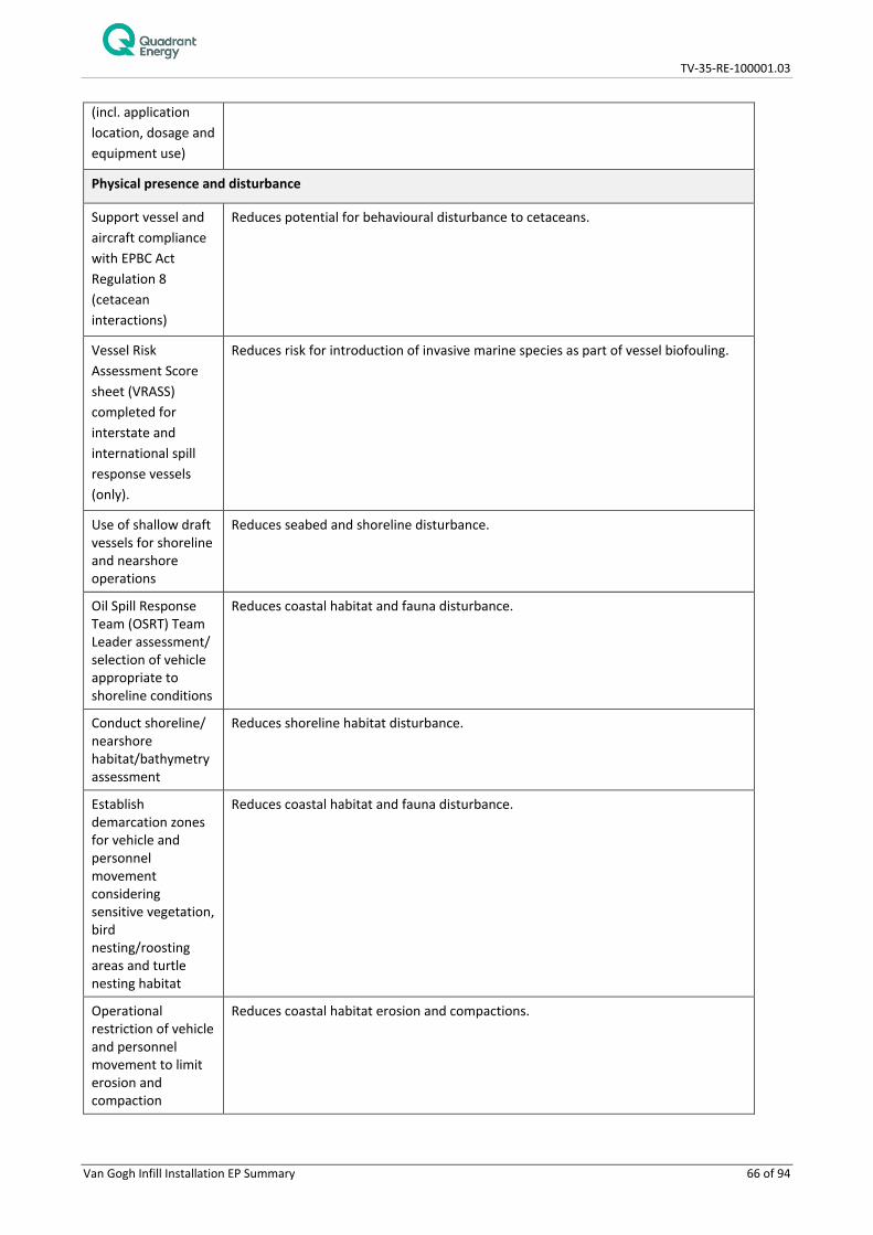
TV-35-RE-100001.03
Van Gogh Infill Installation EP Summary 66 of 94
(incl. application location, dosage and equipment use)
Physical presence and disturbance
Support vessel and aircraft compliance with EPBC Act Regulation 8 (cetacean interactions)
Reduces potential for behavioural disturbance to cetaceans.
Vessel Risk Assessment Score sheet (VRASS) completed for interstate and international spill response vessels (only).
Reduces risk for introduction of invasive marine species as part of vessel biofouling.
Use of shallow draft vessels for shoreline and nearshore operations
Reduces seabed and shoreline disturbance.
Oil Spill Response Team (OSRT) Team Leader assessment/ selection of vehicle appropriate to shoreline conditions
Reduces coastal habitat and fauna disturbance.
Conduct shoreline/ nearshore habitat/bathymetry assessment
Reduces shoreline habitat disturbance.
Establish demarcation zones for vehicle and personnel movement considering sensitive vegetation, bird nesting/roosting areas and turtle nesting habitat
Reduces coastal habitat and fauna disturbance.
Operational restriction of vehicle and personnel movement to limit erosion and compaction
Reduces coastal habitat erosion and compactions.

TV-35-RE-100001.03
Van Gogh Infill Installation EP Summary 67 of 94
Prioritise use of existing roads and tracts
Reduces coastal habitat and fauna disturbance.
Soil profile assessment prior to earthworks
Reduces habitat disruption and erosion.
Pre-cleaning and inspection of equipment (quarantine)
Prevents introduction of invasive species.
Use of Heritage Advisor if spill response activities overlap with potential areas of cultural significance
Reduces disturbance to culturally significant sites.
Adhere to WA Oiled Wildlife Response Plan and Pilbara Regional Oiled Wildlife Response Plan
Oiled wildlife hazing, capture, handling and rehabilitation meet minimum standards as outlined within the WA Oiled Wildlife Response Plan.
Disruption to other users of marine and coastal area and townships
Stakeholder consultation
Early awareness of spill response activities which reduces potential disruption.
Accommodation assessment
Reduces strain on accommodation.
Security Management Plan
Reduces potential for security treat causing disruptions in the response activities.
Transport Management Plan
Reduces potential for traffic disruptions.
6.4 Environmental Risk Treatment Summary – Unplanned Events
Quadrant’s environmental risk identification procedure identified seven potential sources of environmental impacts associated with the unplanned events.

TV-35-RE-100001.03
Van Gogh Infill Installation EP Summary 68 of 94
6.4.1 Marine Gas Oil Release from Vessel Collision (Surface)
Event: Hydrocarbon spill from a ruptured vessel fuel tank as result of a collision
There is a possibility of a vessel collision occurring between vessels (ISV and a 3rd party vessel) within the operational area. The worst-case environmental incident resulting from a vessel collision is the rupturing of a vessel fuel tank resulting in the release of MGO to the environment. Vessel collision could occur due to factors such as human error, poor navigation, vessel equipment failure or poor weather. A maximum credible spill volume has been determined based on technical guidance provided by AMSA (AMSA 2015). This guidance states that for a vessel other than an oil tanker, the maximum credible spill from a collision can be determined from the volume of the largest single fuel tank.
In reviewing the general arrangements and fuel tank capacities of a typical ISV likely to be utilised for the Van Gogh infill installation activities, the largest single fuel tank capacity identified was no greater than ~300 m3 of MGO.
Potential Receptors Plankton, fish, sharks, marine mammals, marine reptiles, seabirds, shorebirds shoreline (intertidal habitats) and socio-economic receptors.
Potential Impacts Hydrocarbon spills will cause a decline in water quality and can cause chemical (e.g. toxic) and physical (e.g. coating of emergent habitats, oiling of wildlife at sea surface) and impacts to marine species. The severity of the impact of a hydrocarbon spill depends on the magnitude of the hydrocarbon spill (i.e. extent, duration) and sensitivity of the receptor. A loss of MGO to the marine environment would result in a localised reduction in water quality in the upper surface waters of the water column. There will be no shoreline contact above the defined thresholds as a result of the conservative 600 m3 spill of MGO, however, there may be accumulated hydrocarbons along the Ningaloo shoreline. Transient fauna may traverse the area and may also be potentially impacted by a spill. The potential pathways and impacts of surface and entrained MGO to transient receptors are summarised in Table 6-3.
Impact Assessment
Receptors Consequence
Threatened / Migratory Fauna; Physical Environment / Habitats Protected Areas; Socio-Economic Receptors
In the event of a vessel collision, the volume of hydrocarbons released would be a finite amount, limited to the maximum credible spill of a full tank inventory release. Given the nature of the MGO and the distance from shorelines, dilution and dispersion from natural weathering processes such as ocean currents indicate that the extent of exposure will be limited in area and duration. The susceptibility of marine fauna (including fish and plankton) to hydrocarbons is dependent on hydrocarbon type and exposure duration, however, given that exposures would be limited in extent and duration impacts are expected to be minor (detectable but localised impacts). Habitat modification/degradation/disruption/loss, deteriorating water quality and marine pollution are identified as potential threats to a number of marine fauna species in relevant Recovery Plans and Conservation Advice. With the controls in place, in line with the relevant actions prescribed in Recovery Plans, the activity will be conducted in a manner that reduces potential impacts to ALARP and of acceptable level. In the unlikely event that a collision did occur within the operational area, the potential impacts to the environment would be greatest several kilometres from the spill when the toxic aromatic components of the fuel will be at their highest concentration and when the hydrocarbon is at its thickest on the surface of the receiving waters. The MGO will also rapidly lose toxicity with time and spread thinner as evaporation continues. The potential sensitive receptors in the surrounding areas of the spill will include fish, marine mammals, marine reptiles, seabirds at the sea surface and shorebirds as well as shoreline and intertidal habitats as discussed in Table 6-3. Marine and shoreline

TV-35-RE-100001.03
Van Gogh Infill Installation EP Summary 69 of 94
habitats may also be impacted as a result of shoreline accumulation as discussed in Table 6-3. Indigenous users may be impacted in the event that a land based response is required, however consultation will ensure potential impacts are reduced to acceptable levels. The low shipping and fishing activity expected in the direct area of the activity, and while there is likely to be oil & gas vessels, the control measures in place are considered to result in a low risk of a collision occurring. Given that a vessel collision hydrocarbon spill would not result in a decreased population size at a local or regional scale, it is expected that a spill of this nature would result in a minor consequence.
Likelihood A hydrocarbon release resulting from a vessel collision is unlikely to have widespread ecological effects given the nature of the hydrocarbons on-board, the finite volumes that could be released, the water depth in the operational area and transient nature of marine fauna in this area. The potential hydrocarbon releases as a result of vessel collision are not expected to significantly impact the receiving environment with control measures proposed. Additionally, long term impacts resulting in complete habitat loss or degradation are not considered likely given the controls proposed to prevent releases and therefore the activity will be conducted in a manner that is considered acceptable. The likelihood of a vessel collision releasing hydrocarbons to the environment which results in a minor consequence is considered to be rare.
Likelihood Ranking 1- Rare Consequence ranking Minor
Residual risk Low
Management Control
Effectiveness of Control
Maritime notices Ensure other marine users are aware of the presence of the ISV and the relative low mobility of ISV to suddenly change course or avoid other vessels.
Stakeholder Consultation
Exclusion zone Exclusion zones around the ISV prevents other vessels from getting too close and causing damage to equipment of either party.
Navigation equipment and procedures
Reduces risk of environmental impact from vessel collisions due to ensuring safety requirements are fulfilled.
Dynamic positioning system
Prevents unintentional movements by ISV decreasing risk of collision, reducing the risk of hydrocarbons being discharged to the marine environment
Oil pollution emergency plan (OPEP)
Implements response plan for the effective management of an accidental hydrocarbon spill (discharge to sea) in order to reduce impacts to the marine environment.
ISV spill response plans
Fuel type used Reduces the potential impacts to marine environment in the event of a vessel collision
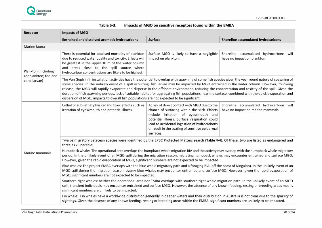
TV-35-RE-100001.03
Van Gogh Infill Installation EP Summary 70 of 94
Table 6-3: Impacts of MGO on sensitive receptors found within the EMBA
Receptor Impacts of MGO
Entrained and dissolved aromatic hydrocarbons Surface Shoreline accumulated hydrocarbons
Marine fauna
Plankton (including zooplankton; fish and coral larvae)
There is potential for localised mortality of plankton due to reduced water quality and toxicity. Effects will be greatest in the upper 10 m of the water column and areas close to the spill source where hydrocarbon concentrations are likely to be highest.
Surface MGO is likely to have a negligible impact on plankton.
Shoreline accumulated hydrocarbons will have no impact on plankton
The Van Gogh infill installation activities have the potential to overlap with spawning of some fish species given the year round nature of spawning of some species. In the unlikely event of a spill occurring, fish larvae may be impacted by MGO entrained in the water column. However, following release, the MGO will rapidly evaporate and disperse in the offshore environment, reducing the concentration and toxicity of the spill. Given the duration of fish spawning periods, lack of suitable habitat for aggregating fish populations near the surface, combined with the quick evaporation and dispersion of MGO, impacts to overall fish populations are not expected to be significant.
Marine mammals
Lethal or sub-lethal physical and toxic effects such as irritation of eyes/mouth and potential illness.
At risk of direct contact with MGO due to the chance of surfacing within the slick. Effects include irritation of eyes/mouth and potential illness. Surface respiration could lead to accidental ingestion of hydrocarbons or result in the coating of sensitive epidermal surfaces.
Shoreline accumulated hydrocarbons will have no impact on marine mammals
Twelve migratory cetacean species were identified by the EPBC Protected Matters search (Table 4-4). Of these, two are listed as endangered and three as vulnerable: Humpback whale: The operational area overlaps the humpback whale migration BIA and the activity may overlap with the humpback whale migratory period. In the unlikely event of an MGO spill during the migration season, migrating humpback whales may encounter entrained and surface MGO. However, given the rapid evaporation of MGO, significant numbers are not expected to be impacted. Blue whales: The project EMBA overlaps with the blue whale migratory path and a foraging BIA (off the coast of Ningaloo). In the unlikely event of an MGO spill during the migration season, pygmy blue whales may encounter entrained and surface MGO. However, given the rapid evaporation of MGO, significant numbers are not expected to be impacted. Southern right whales: neither the operational area nor EMBA overlaps with southern right whale migration path. In the unlikely event of an MGO spill, transient individuals may encounter entrained and surface MGO. However, the absence of any known feeding, resting or breeding areas means significant numbers are unlikely to be impacted. Fin whale: Fin whales have a worldwide distribution generally in deeper waters and their distribution in Australia is not clear due to the sparsity of sightings. Given the absence of any known feeding, resting or breeding areas within the EMBA, significant numbers are unlikely to be impacted.

TV-35-RE-100001.03
Van Gogh Infill Installation EP Summary 71 of 94
Sei whale: Sei whales move between Australian waters and Antarctic feeding areas, however, they are only infrequently recorded in Australian waters (Bannister et al. 1996) and their movements and distribution in Australian waters is not well known. Given the absence of any known feeding, resting or breeding areas, significant numbers are unlikely to be impacted. Other migratory cetaceans may encounter either surface or entrained MGO, however, the absence of any known feeding, resting or breeding areas within the EMAB means significant numbers are unlikely to be impacted.
Marine reptiles
Lethal or sub-lethal physical and toxic effects such as irritation of eyes/mouth and potential illness.
At risk of direct contact with MGO due to chance of surfacing within slick. Effects include irritation of eyes/mouth and potential illness. Surface respiration could lead to accidental ingestion of hydrocarbons or result in the coating of sensitive epidermal surfaces
At risk of direct contact with MGO if nesting along beaches with accumulated hydrocarbons. Effects include irritation of eyes/mouth and potential illness.
Five species of threatened marine reptile were identified as possibly being impacted by a spill. Flatback, hawksbill, leatherback, green and loggerhead turtles are widely dispersed at low densities across the NWMR and in the unlikely event of a MGO spill occurring, individuals traversing open water may come into contact with entrained or surface MGO. The operational area does not overlap with any marine turtle BIA or critical habitat. The EMBA, however, overlaps with the flatback, green, hawksbill and loggerhead turtles internesting BIAs, as well critical habitats for the flatback, green and loggerhead turtles. Transient adults may encounter surface MGO slicks and entrained hydrocarbons resulting in hydrocarbon adherence to body surfaces (Gagnon and Rawson 2010) causing irritation of mucous membranes in the nose, throat and eyes leading to inflammation and infection (NOAA 2010). However, adult turtles are broadly distributed throughout the NWMR and therefore, impacts to individuals are unlikely to impact on population size. There is the potential for relatively small volumes of MGO to accumulate on shorelines at Ningaloo Coast. This could impact marine fauna that utilise beaches such as shorebirds and turtles, dependent upon the timing of a spill. Beaches on the Ningaloo Coast are important for green turtles, and to a lesser extent hawksbill turtles. Impacts would be most likely to nesting females as they move up and down nesting beaches or to turtle hatchlings as they emerge from nests 6-8 weeks following nesting. Metabolized oil and related products can pass to female eggs, thereby potentially exposing developing embryos and impairing the development and survival of embryos (Deepwater Horizon Natural Resource Damage Assessment Trustees 2016). Potential impacts may occur on nesting female turtles and hatchlings, however, it would unlikely to result in population changes.
Seabirds
Lethal or sub-lethal physical and toxic effects such as irritation of eyes/mouth and potential illness. May encounter entrained MGO while diving and foraging.
Particularly vulnerable to surface MGO. As most fish, prey for seabirds, survive beneath floating slicks, they will continue to attract foraging seabirds, which typically do not exhibit avoidance behaviour. Smothering can lead to reduced water proofing of feathers and ingestion while preening. In addition, MGO can erode feathers causing chemical damage to the feather structure that subsequently affects the ability to thermoregulate and maintain buoyancy on
May encounter MGO if breeding along affected shorelines. Impacts will be similar to those for ‘Surface’

TV-35-RE-100001.03
Van Gogh Infill Installation EP Summary 72 of 94
water.
Seven threatened seabird species, as identified by the EPBC Protected Matters database search, may be encountered during the Van Gogh infill installation activities and may have foraging or feeding habitat in the vicinity of the EMBA. The Australian fairy tern, wedge-tailed shearwater and roseate tern have breeding BIAs within the EMBA and so may be impacted by surface and entrained MGO while foraging (dive and skim feeding). Higher numbers would be expected during the breeding period of October to January. Due to the quick evaporation and dispersion of MGO, significant impacts are not anticipated. While other listed seabirds may occur in the EMBA, no BIAs designated for breeding or foraging were identified within the EMBA so significant numbers are not expected and any impacts would be limited to transient individuals. Therefore, the risk of surface and entrained MGO to seabirds is considered low.
Shorebirds
Entrained/dissolved hydrocarbons not expected to impact on shorebirds
Floating slicks are not expected to impact on shorebirds
Smothering can lead to reduced water proofing of feathers and ingestion while preening. In addition, MGO can erode feathers causing chemical damage to the feather structure that subsequently affects ability to thermoregulate and maintain buoyancy on water. Exposure can also result in a decline in reproductive success and malformed eggs.
Three threatened shorebird species, as identified by the EPBC Protected Matters database search may have foraging or feeding habitat in the vicinity of the EMBA. The risk to shorebird species would depend upon where surface oil accumulated; accumulation near nesting colonies or areas supporting feeding aggregations (i.e. sand/mud flats) would be the worst case scenario. Coating of feathers could occur for birds wading/roosting on oiled shorelines, although the low inherent stickiness and persistence of MGO makes this less likely than for crude oils or heavy bunker fuels. Oil-coated birds can suffer hypothermia, dehydration, drowning and starvation, and become easy prey. Ingestion of MGO, could occur either through oil-coated birds preening feathers of birds feeding on MGO contaminated prey such as benthic invertebrates within mud/sand flats. Toxicity from ingested MGO could occur as a result of toxic hydrocarbons such as PAHs present within weathered MGO.
Fish and sharks
Hydrocarbon droplets can physically affect fish and sharks exposed for an extended duration (weeks to months). Smothering through coating of gills can lead to the lethal and sub-lethal effects of reduced oxygen exchange, and coating of body surfaces may lead to increased incidence of irritation and infection. Fish may also ingest hydrocarbon droplets or contaminated food leading to reduced growth. The EMBA overlaps with the whale shark foraging BIA. However, given the distance to whale shark aggregation location (Ningaloo Marine Park, 37 km
While fish and sharks do not generally break the sea surface, individuals may feed at the surface, particularly whale sharks. However, since the MGO is expected to quickly disperse and evaporate (modelling results indicate approximately 40-50% by mass is predicted to evaporate over the first two days), and the low frequency of breaches at the surface, the probability of prolonged exposure to a surface slick by fish and shark species is low.
Shoreline accumulated hydrocarbons are not expected to impact on fish and sharks
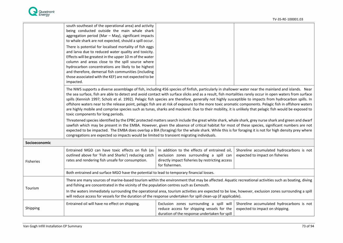
TV-35-RE-100001.03
Van Gogh Infill Installation EP Summary 73 of 94
south southeast of the operational area) and activity being conducted outside the main whale shark aggregation period (Mar – May), significant impacts to whale shark are not expected, should a spill occur. There is potential for localised mortality of fish eggs and larva due to reduced water quality and toxicity. Effects will be greatest in the upper 10 m of the water column and areas close to the spill source where hydrocarbon concentrations are likely to be highest and therefore, demersal fish communities (including those associated with the KEF) are not expected to be impacted.
The NWS supports a diverse assemblage of fish, including 456 species of finfish, particularly in shallower water near the mainland and islands. Near the sea surface, fish are able to detect and avoid contact with surface slicks and as a result, fish mortalities rarely occur in open waters from surface spills (Kennish 1997; Scholz et al. 1992). Pelagic fish species are therefore, generally not highly susceptible to impacts from hydrocarbon spills. In offshore waters near to the release point, pelagic fish are at risk of exposure to the more toxic aromatic components. Pelagic fish in offshore waters are highly mobile and comprise species such as tunas, sharks and mackerel. Due to their mobility, it is unlikely that pelagic fish would be exposed to toxic components for long periods. Threatened species identified by the EPBC protected matters search include the great white shark, whale shark, grey nurse shark and green and dwarf sawfish which may be present in the EMBA. However, given the absence of critical habitat for most of these species, significant numbers are not expected to be impacted. The EMBA does overlap a BIA (foraging) for the whale shark. While this is for foraging it is not for high density prey where congregations are expected so impacts would be limited to transient migrating individuals.
Socioeconomic
Fisheries
Entrained MGO can have toxic effects on fish (as outlined above for ‘Fish and Sharks’) reducing catch rates and rendering fish unsafe for consumption.
In addition to the effects of entrained oil, exclusion zones surrounding a spill can directly impact fisheries by restricting access for fishermen.
Shoreline accumulated hydrocarbons is not expected to impact on fisheries
Both entrained and surface MGO have the potential to lead to temporary financial losses.
Tourism
There are many sources of marine-based tourism within the environment that may be affected. Aquatic recreational activities such as boating, diving and fishing are concentrated in the vicinity of the population centres such as Exmouth. In the waters immediately surrounding the operational area, tourism activities are expected to be low, however, exclusion zones surrounding a spill will reduce access for vessels for the duration of the response undertaken for spill clean-up (if applicable).
Shipping Entrained oil will have no effect on shipping. Exclusion zones surrounding a spill will
reduce access for shipping vessels for the duration of the response undertaken for spill
Shoreline accumulated hydrocarbons is not expected to impact on shipping.
TV-35-RE-100001.03
Van Gogh Infill Installation EP Summary 74 of 94
clean-up (if applicable); vessel may have to take large detours leading to potential delays and increased costs.
Defence The level of defence activities carried out in the vicinity of operational area is low, if any, and therefore, interference of defence activities due to a MGO spill are likely to be minimal.
Shipwrecks Surface oil will have no impact on shipwrecks. Entrained oil from a vessel collision will remain in the surface waters and is therefore, unlikely to have an impact on shipwrecks.
Indigenous The level of activities undertaken by indigenous users is expected to be low, if any, therefore interference due to an MGO spill are likely to be minimal, however, in event there is a requirement for land based response activities/ disturbance relevant representatives (identified in Section 6.3.7) will be contacted as outlined in the OPEP.
Existing oil and gas activity
Exclusion zones surrounding spills may reduce access to existing facilities/infrastructure, potentially leading to delays to work schedules with subsequent financial implications. Both Woodside and BHP have FPSOs within 4 to 15 km of the operational area and therefore, may be impacted in the event of an unplanned spill event through exclusion from undertaking activities.
Protected areas
Protected areas and their associated values are summarised below: Ningaloo Marine Park (including the WHA)– foraging area for whale sharks, foraging area and adjacent to important sites for marine turtles, important part of the migratory pathway for the humpback whale, provides protection for shelf and slope habitats Gascoyne Marine Park – important foraging area for migratory seabirds, hawksbill and flatback turtles and whale sharks, provides protection for may seafloor features Shark Bay Marine Park – important breeding areas for several species of migratory seabirds, part of the migratory pathway of humpback whales, adjacent to the largest nesting area for loggerhead turtles in Australia, provides protection for shelf and slope habitats Muiron Islands Marine Management Area - Adjacent to Ningaloo Marine Park around Muiron Island. Regionally significant loggerhead turtle nesting beaches. Contains coral reef and macroalgae habitat.
In the unlikely event of an MGO spill entrained, surface and accumulated hydrocarbons may result in the contamination of these protected areas and impact on the values identified. Impacts to the identified values are identified above. For example, marine mammals, seabirds, sharks and reptiles are at risk of direct contact with MGO due to chance of surfacing within slick. Effects include irritation of eyes/mouth and potential illness. Surface respiration could lead to accidental ingestion of hydrocarbons or result in the coating of sensitive epidermal surfaces.
KEFs
KEFs are summarised below: Commonwealth waters adjacent to Ningaloo Reef – Supports high productivity and aggregation of marine life, including both benthic and pelagic habitats Canyons linking the Cuvier Abyssal Plain and the Cape Range Peninsula - Supports the productivity and species richness of Ningaloo Reef Continental Slope Demersal Fish Communities - Provides important habitat for demersal fish communities, characterised by high endemism and species diversity Ancient Coastline at 125 m depth contour - Contributes to higher diversity and enhanced species richness relative to soft sediment habitat and

TV-35-RE-100001.03
Van Gogh Infill Installation EP Summary 75 of 94
attracts opportunistic feeding by larger marine life including humpback whales, whale sharks and large pelagic fish
A loss of MGO to the marine environment would result in a localised reduction in water quality in the upper surface waters of the water column. Therefore, any impact on KEFS will be limited to the values of KEFs where there is increased biological productivity (e.g. Ningaloo Reef). However, any impact is expected to be localised with rapid recovery.
TV-35-RE-100001.03
Van Gogh Infill Installation EP Summary 76 of 94
6.4.2 Crude Release Due to Damaged Subsea Infrastructure
Event: Crude release due to damaged subsea infrastructure
Accidental dropped objects could occur from operations including lifting/moving of objects and equipment needed to complete infill installation activities. Equipment and other items lost at sea could be caused by crane failure, adverse weather, human error, rigging failure, unsecured equipment on deck and vessel motions, see Section 6.3.2 (Seabed disturbance – installation of subsea infrastructure) for description and control measures for seabed disturbance and impacts to benthic communities. During the infill installation activities, a hydrocarbon release of Van Gogh/Coniston/Novara crude, due to damage to the 10” or 12” production flowline, could occur through a dropped object incident – namely the subsea structures (5 Tonne (Te) GLJ/EHFL deployment frames and 35 Te rigid spools) dropped during installation onto the production flowline. The maximum credible spill from a damaged (ruptured) production flowline has been determined based on spill volume guidance produced by AMSA (AMSA 2015). AMSA stipulates a worst case offshore pipeline rupture as 1 hour of maximum flow + the entire pipeline inventory. A loss of containment from a production flowline would escalate to a loss that would be detected and result in an almost instantaneous emergency shutdown (ESD) due to the pressure drop in the flowline and the presence of an automated ESD system. However, failures of multiple barriers have been assumed for conservatism in which case 1hr has been allowed before manual detection and isolation. Single flowline flow rate prior to isolation has been calculated. There are crossover lines connecting the two production flowlines and current operations have the valves between flowlines at one manifold open (the remaining manifold crossover valves are closed); therefore, once isolated the inventories in both flowlines could be released. This calculation provides a worst case Van Gogh/Coniston/Novara crude volume of 327 m3. A loss of well control from P11 and P12 XTs are not considered credible.
Potential Receptors
Marine fauna – plankton, fish, cetaceans, marine mammals, marine reptiles, seabirds/shorebirds; Protected Areas; Socio-Economic Receptors
Potential Impacts
Hydrocarbon spills can cause chemical (e.g. toxic) and physical (e.g. coating of emergent habitats, oiling of wildlife at sea surface) impacts to marine species and a decline in water quality. The severity of the impact of a hydrocarbon spill depends on the magnitude of the hydrocarbon spill (i.e. extent, duration) and sensitivity of the receptor.
The magnitude of potential environmental impact from a crude release is dependent on multiple factors including hydrocarbon type, release volume and rate, and ocean and weather conditions.
An assessment of the sensitive environmental receptors at risk from a Van Gogh, Coniston, Novara crude blend release has been determined based on a literature review and trajectory and fate modelling. Section 4 includes a description of the biological environment present in the operational and/EMBA. Fundamentally, such receptors are likely to be the same or similar to those described in Section 6.4.1 and include:
• Plankton;
• Invertebrates (pelagic);
• Pelagic fish (including those targeted by commercial and recreational fishers);
• Marine mammals;
• Whale sharks;
• Marine turtles;
• Seabirds;
• Shorelines and associated habitats; and

TV-35-RE-100001.03
Van Gogh Infill Installation EP Summary 77 of 94
• Commercial fisheries.
The spatial extent of impacts from entrained oil and dissolved aromatic hydrocarbons around the release site is predicted to be within a scale of ~80 km. Ecosystem recovery would be expected within weeks to months of return to normal water quality conditions.
It is reasonable to conclude that the greatest ecological response will occur in the highest concentration zones of non-degraded hydrocarbons. Based on APASA (2013) modelling results and an understanding of environmental receptors that could be affected the following assessment is provided for a potential crude release:
• Its limited propensity to affect deeper habitats reduces the scope of potential effects to environmental receptors (particularly subtidal benthic habitats);
• Benthic habitats are predominately soft sediments with associated benthic fauna; with the epifauna and infauna unlikely to be restricted on a regional scale (Section 4.2.2);
• No emergent, shoreline or shallow water habitats are predicted to be contacted by hydrocarbons at the defined impact thresholds;
• Shoreline contact may occur below the predicted thresholds and may result in shoreline accumulation which could impact on nesting adult turtles and hatchling, seabirds and shorebirds and on shoreline and intertidal habitats. Any impacts will be limited and localised due to the small volumes predicted;
• Shoreline accumulation along Ningaloo Coast and Shark Bay may also impact on tourism activities, these locations offer fishing, swimming and beach utilisation. If a spill occurred there could be restricted access at beaches until the hydrocarbons have been removed, either through natural process or spill response operations;
• The operational area overlaps humpback whale, blue whale migration BIA and the blue whale foraging BIA. The EMBA also includes several marine turtle species’ internesting BIAs and critical habitats for nesting, as well as whale shark foraging BIA. However, large numbers of encounters are not expected due to distance to whale shark aggregation locations and turtle nesting beaches (37 km and 41 km away respectively);
• Other EPBC Act-listed threatened and migratory species (e.g. whales and seabirds) are known or likely to transit the modelled hydrocarbon-affected water mass. Notwithstanding this, the potentially affected area is not known to contain habitat or be an aggregation area of critical importance to these species;
• Recovery of marine fauna or benthic habitats exposed to hydrocarbons and experiencing sub-lethal impacts would be expected within weeks to months of return to normal water quality conditions;
• Marine fauna that surface to breathe and seabirds potentially at risk from surface hydrocarbons have widespread distributions and, given the relatively localised impacts, long-term consequences to populations are unlikely; and
• Impacts to fish can have a subsequent impact on commercial fisheries and also a disruption to fishery activity during the release event and clean-up activities.
Impact Assessment
Receptors Consequence
Marine fauna – plankton, fish, cetaceans, marine mammals,
In the event of a hydrocarbon release due to a flowline rupture, the volume of hydrocarbons released would be a finite amount limited to the maximum credible spill of a full content of the ruptured flowline.

TV-35-RE-100001.03
Van Gogh Infill Installation EP Summary 78 of 94
marine reptiles, seabirds/shorebirds Protected Areas Socio-Economic Receptors
The susceptibility of marine fauna (including fish and plankton) to hydrocarbons is dependent on hydrocarbon type and exposure duration however given that exposures would be limited in extent and duration. Habitat modification/degradation/disruption/loss, deteriorating water quality and marine pollution are identified as potential threats to a number of marine fauna species in relevant Recovery Plans and Conservation Advice. With controls in place, the activity will be conducted in a manner that reduces potential impacts to ALARP and of acceptable level. The potential sensitive receptors in the surrounding areas of the spill will include fish, marine mammals, marine reptiles and seabirds at the sea surface as well as shoreline and intertidal habitats. Given that a hydrocarbon spill due to flowline rupture would not result in a decreased population size at a local or regional scale, it is expected that a spill of this nature would result in a minor consequence.
Likelihood A hydrocarbon release resulting from a flowline rupture caused by dropped objects is unlikely to have widespread ecological effects given the safety design of the production system, the finite volumes that could be released, the depth and transient nature of marine fauna in this area. The likelihood of a hydrocarbon release occurring due to flowline rupture caused by dropped object is limited given the set of control measures in place for this program. Subsequently the likelihood of a flowline rupture releasing hydrocarbons to the environment which results in a minor consequence is considered to be rare.
Likelihood Ranking
1- Rare Consequence ranking Minor
Residual risk Low
Management Control
Effectiveness of Control
Pre-installation seabed survey
Ensures any subsea hazards that may cause pipeline/ flowline rupture during installation resulting in hydrocarbon release are identified
Installation procedures
Adhering to installation procedures (e.g. setting a pre-determined distance clear of subsea infrastructure), using acoustic positioning devices (metrology equipment) and approval of critical lifts helps prevent damaging of subsea infrastructures which resulting in hydrocarbon release
Dynamic positioning
Prevents unintentional movements by vessel, decreasing risk of dropped object reducing the risk of hydrocarbons being discharged to the marine environment
Oil pollution emergency plan (OPEP)
Implements response plans to deal with an unplanned hydrocarbon release quickly and efficiently in order to reduce impacts to the marine environment.
Dropped object prevention
Minimises drop risk during lifting operations that may cause pipeline/ flowline rupture resulting in hydrocarbon release
Lifting equipment Maintenance
Ensures that lifting equipment is maintained and certified, and that lifting procedures are followed reducing probability of dropped objects occurring with the potential to result in hydrocarbon spills.
Van Gogh P11and P12 XTs will be function tested once installed, prior to infill installation activities
Reduces likelihood of hydrocarbon release and in the event of a spill will limit the release of hydrocarbons

TV-35-RE-100001.03
Van Gogh Infill Installation EP Summary 79 of 94
Field ESD testing In the event of low pressure resultant from a pipeline rupture, production will be automatically shut in, therefore limiting the release of hydrocarbons
6.4.3 Minor Hydrocarbon Release
Event: Minor Hydrocarbon Release at Sea Surface
The main engines and equipment such as pumps, cranes, winches, power packs and generators require MGO for fuel and a variety of hydraulic fluids and lubricating oils for efficient operation and maintenance of moving parts. These products are present within the equipment and also held in storage containers and tanks on the ISV. Minor accidental loss of hydrocarbon based liquids (e.g. used lubricating oils, cooking oil, and hydraulic oil) to the marine environment could occur via tank pipework failure or rupture, hydraulic hose failure, inadequate bunding and/or storage, insufficient fastening or inadequate handling which could result in impacts to water quality and hence sensitive environmental receptors. ROV operations can result in unplanned discharges (of hydraulic fluids) directly to the marine environment due to equipment failure, ROV interactions with the vessel thrusters and/or accidental contact with sub-sea infrastructure. The largest credible hydrocarbon spill from ROV operations would be an accidental release of approximately 50 L of hydraulic fluid from the deployed ROV.
Potential Receptors
Marine fauna – Fish, cetaceans, marine mammals, marine reptiles, plankton
Potential Impacts
Accidental disposal of hydrocarbons into the marine environment will result in pollution and contamination of the marine environment, localised decline in water quality and toxic effects to marine fauna.
Hydrocarbons released into the marine environment through onboard spills and leaks directed through deck drainage or from a release of hydraulic oil from an ROV umbilical would disperse quickly in waters within the vicinity of the operational area.
Lubricating and hydraulic oils will behave similarly to MGO if spilt to the marine environment, although lubricating oils are more viscous and so the spreading rate of a slick of these oils would be slightly slower. Hydraulic oils are medium oils of light to moderate viscosity and have a relatively rapid spreading rate and dissipate quickly in higher sea states.
A release could potentially impact plankton, pelagic invertebrates, pelagic fish, marine mammals, marine reptiles and seabirds although given the highly dispersive waters within the operational area, the extent of the water column and the relatively small potential volumes associated with such a release, rapid dilution is expected and concentrations are unlikely to persist for periods of time where impacts would likely be felt. The greatest potential for impact would likely be for passive or low mobility fauna such as plankton, including both invertebrates and fish larvae which may be exposed for the greatest periods of time and likely have a permanent presence within the operational area. Pelagic fish in offshore waters are highly mobile and comprise species such as tunas, sharks and mackerel. Due to their mobility, it is unlikely that pelagic fish would be exposed to toxic components for long periods.
Large, more mobile fauna (including protected species such as cetaceans, marine turtles, seabirds and whale sharks) are likely to be transient within the operational area and toxic impacts are unlikely to occur to these species in the event of a small liquid hazardous hydrocarbon.
With respect to demersal fishes (and to the KEF ‘Continental Slope Demersal Fish Communities’) which overlaps the operational area, it is possible that some impact may occur through the release of hydraulic oil from an ROV near the seabed. However, given the small volume of any credible ROV release (~50 L), the lack of any natural seabed features that would indicate a high abundance or diversity of demersal fishes and the large
TV-35-RE-100001.03
Van Gogh Infill Installation EP Summary 80 of 94
area of this KEF in relation to the operational area, it is considered that such a release would have a negligible impact on the demersal fish populations and this KEF.
Impact assessment
Receptors Consequence
Marine fauna – Fish, cetaceans, marine mammals, marine reptiles, plankton
In the event of a minor hydrocarbon spill, the quantities would be limited to approximately < 1 m3
to the marine environment. The small volumes and dilution and dispersion from natural weathering processes such as ocean currents indicate that the extent of exposure will be limited in area and duration. The more toxic components would also rapidly evaporate and concentrations would significantly diminish with distance from the spill site, limiting the potential area of impact. Deteriorating water quality and marine pollution are identified as potential threats to a number of marine fauna species in relevant Recovery Plans and Conservation Advice. The number of receptors, including marine turtles present at the operational area are expected to be limited to a small number of transient individuals The susceptibility of marine fauna (including fish and plankton) to hydrocarbons is dependent on hydrocarbon type and exposure duration however given that exposures would be limited in extent and duration, exposure to marine fauna from this hazard is considered to be low. Rapid dilution at depth would also result in the impacts to receptors declining rapidly with time and distance. For marine mammals and marine turtles that may be exposed to the more toxic aromatic components, chemical effects are considered unlikely since these species are mobile and therefore, will not be constantly exposed for extended durations that would be required to cause any major toxic effects. Although humpback and blue whales may be exposed if the spill were to occur in the migration season, this event is not expected to interfere with their migration activity. Deteriorating water quality is identified as a potential threat to turtles in the marine turtle recovery plan, and some bird and shark species. However, the potential minor hydrocarbon releases are not expected to significantly impact the receiving environment with control measures proposed to prevent releases and therefore, the activity will be conducted in a manner that is consistent with the plans. Given that a small hydrocarbon spill would not result in a decreased population size at a local or regional scale, it is expected that a spill of this nature would result in a negligible consequence.
Likelihood The likelihood of a small hydrocarbon release occurring is limited given the set of control measures in place for this activity and is considered to be unlikely.
Likelihood Ranking
3- Unlikely Consequence ranking Negligible
Residual risk Low
Management Control
Effectiveness of Control
General chemical management procedures
Potential impacts to the environment are reduced through following correct procedures for the safe handling and storage of chemicals
Hazardous chemical management procedures
Reduces the risk of spills and leaks (discharges)of hazardous chemicals to the sea by controlling the storage, handling and clean up

TV-35-RE-100001.03
Van Gogh Infill Installation EP Summary 81 of 94
Oil pollution emergency plan (OPEP)
Implements response plans to deal with an unplanned hydrocarbon release quickly and efficiently in order to reduce impacts to the marine environment.
ISV spill response plans
Maritime dangerous goods code
Dangerous goods managed in accordance with International Maritime Dangerous Goods Code (IMDG Code) to reduce the risk of an environmental incident, such as an accidental release to sea or unintended chemical reaction
ROV inspection and maintenance procedures
Minimises the risk of hydraulic fluid release to sea
Deck drainage Reduces potential for hydrocarbon release to the marine environment during refuelling
6.4.4 Non-Hydrocarbon and Chemicals Release - Liquids
Event: Non-hydrocarbon and chemicals release to the marine environment
Hazardous liquids including miscellaneous chemicals (cleaning and cooling agents, stored or spent chemicals and leftover paint materials) used or stored on board the ISV during the activity. The presence of preservation chemicals (corrosion inhibitor, biocides etc.) and chemical dye used in treated water represents a potential spill risk during chemical storage and handling e.g. due to tank damage, or human error or during leak testing. Accidental loss of liquid wastes to the marine environment could occur via tank pipework failure or rupture, inadequate bunding and/or storage, insufficient fastening or inadequate handling may result in impacts to water quality and hence, sensitive environmental receptors.
Potential Receptors
Marine fauna – Fish, sharks, marine mammals, marine reptiles, seabirds, benthic habitat
Potential Impacts Environmentally hazardous chemicals (liquids) lost to the marine environment may lead to contamination of the water column in the vicinity of the ISV. The potential impacts would most likely be highly localised and restricted to the immediate area surrounding the spill, with rapid dispersal to concentrations below impact thresholds likely to occur in the open area of ocean. The changes to water quality that may result could potentially lead to short-term impacts on marine fauna (e.g. plankton, pelagic/benthic fish, epifauna, cetaceans, marine reptiles and seabirds), with chronic impacts not expected owing to the short exposure times.
The area that may be affected by this risk would most likely be restricted to a small area within the operational area.
There is no emergent or inter-tidal habitat that could be impacted by a surface spill and the benthic habitat is predominately silty clay, with a sparse assemblage of deep-sea soft sedimentary and demersal fauna (Enesar 2007), any spilled material is unlikely to reach any of the demersal species or benthic habitats at the seabed. Sub-lethal or lethal effects from toxic chemicals, is considered unlikely given the expected low concentrations and short exposure times.
Discharge of non-hydrocarbon liquids or chemicals from spills is unlikely to have widespread ecological effects given the nature of the chemicals on-board, the small volumes that could be released, and the depth and exposure of the location.
Impact Assessment

TV-35-RE-100001.03
Van Gogh Infill Installation EP Summary 82 of 94
Receptors Consequence
Marine fauna – Fish, sharks, marine mammals, marine reptiles, seabirds, benthic habitat
The small volumes, dilution and dispersion from natural weathering processes such as ocean currents indicate that the extent of exposure will be limited in area and duration. The susceptibility of marine fauna (including plankton and fish) to chemicals is dependent on the type and exposure duration however given that exposures would be limited in extent and duration, exposure to marine fauna from this hazard is not expected to result in a fatality. Impacts from small volumes (1 m3) discharged to the marine environment to water quality would be short-term and localised, due to the nature and behaviour of the chemicals / liquid wastes identified as being at risk of spilling; only pelagic fauna (e.g. plankton) present in the immediate vicinity of the spill would likely be at risk of impact. Habitat degradation, deteriorating water quality and marine pollution are identified as potential threats to a number of marine fauna species in relevant Recovery Plans and Conservation Advice. However, the potential non-hydrocarbon releases of liquids are not expected to significantly impact to the receiving environment with control measures proposed to prevent releases. The lack of key aggregations areas within the operational area indicates that only a small number of marine fauna has the potential to be exposed to a small chemical spill given the transient nature of fauna in this area. Given that a small non-hydrocarbon or chemical spill would not result in a decreased population size at a local or regional scale, it is expected that a spill of this nature would result in a negligible consequence.
Likelihood A small non-hydrocarbon liquid release is unlikely to have widespread ecological effects given the nature of the chemicals on-board, the small volumes that could be released, the depth and transient nature of marine fauna in this area and the prevention and management procedures in place to clean up a spill. Quadrant reviewed non-hydrocarbon spills and leaks from equipment and machinery in recent history (due to split hoses, small leaks, or handling errors). Most of the spills and leaks reported occurred within bunded areas, were less than 100 L, did not reach the marine environment and were cleaned up immediately.
The likelihood of releasing non-hydrocarbon liquids to the environment which results in a negligible consequence is considered to be very unlikely. The likelihood of a small non-hydrocarbon release occurring is limited given the set of control measures in place for this program.
Likelihood Ranking
2- Very unlikely Consequence ranking Negligible
Residual Risk Low
Management Control
Effectiveness of Control
General chemical management procedures
Potential impacts to the environment are reduced through following correct procedures for the safe handling and storage of chemicals
Hazardous chemical management procedures
Reduces the risk of spills and leaks (discharges) to the sea by controlling the storage, handling and clean-up of hazardous chemicals
Chemical selection procedure
Reduced toxicity to marine environment Only environmentally acceptable flushing and testing chemicals would be released in the event of an accidental discharge to sea

TV-35-RE-100001.03
Van Gogh Infill Installation EP Summary 83 of 94
Deck cleaning product selection procedure
Improve water quality discharge (reduce toxicity) to the marine environment
ISV spill response plans
Implements response plans to deal with an unplanned hydrocarbon release quickly and efficiently in order to reduce impacts to the marine environment.
Dropped object prevention
Minimises dropped object risk during vessel lifting operations that may cause secondary spill (discharges) resulting in reduction in water quality
Lifting equipment maintenance
Ensures that lifting equipment is maintained and certified, and that lifting procedures are followed reducing probability of dropped objects occurring with the potential to result in hydrocarbon spills.
Maritime Dangerous Goods Code
Dangerous goods managed in accordance with International Maritime Dangerous Goods Code (IMDG Code) to reduce the risk of an environmental incident, such as an accidental release to sea or unintended chemical reaction
6.4.5 Non-Hydrocarbon Release (Surface) – Solid
Event: Non-Hydrocarbon Surface Release – Solid
Non-hazardous solid wastes including paper, plastics and packaging, and hazardous solid wastes such as batteries, fluorescent tubes, medical wastes, and aerosol cans may be dropped unintentionally to the marine environment, potentially impacting on sensitive receptors. Release of these waste streams may occur as a result of overfull and/or uncovered bins, incorrectly disposed items or spills during transfers of waste. Dropped objects Accidental dropped objects to the seabed could occur during vessel and ROV activities such as operations including lifting of objects and equipment needed to complete installation activities. Equipment and other items lost at sea could be caused by crane failure, adverse weather, human error, rigging failure and vessel motions and potentially lead to loss of or changes to benthic habitats
Potential Receptors
Benthic habitats, Fish, Sharks, Marine Mammals, Marine Reptiles and Seabirds
Potential Impacts
Non-hazardous solids, such as plastics, have the potential to smother benthic environments and harm marine fauna through entanglement or ingestion. Marine turtles and seabirds are particularly at risk from entanglement. Marine turtles may mistake plastics for food; once ingested, plastics can damage internal tissues and inhibit physiological processes, which can both potentially result in fatality. Marine debris has been highlighted as threat to marine turtles, humpback whales and whale sharks in the Marine Turtle Recovery Plan (2017), Approved Conservation Advice for Megaptera novaeangliae (humpback whale) (2015) and Approved Conservation Advice for Rhincodon typus (whale shark) (2015) respectively. The Recovery plan and Approved Conservation Advice have specified a number of recovery actions to help combat this threat. Of relevance to this activity is the legislation for the prevention of garbage disposal from vessels.
Release of hazardous solids (e.g. wastes such as batteries) may result in the pollution of the immediate receiving environment, leading to detrimental health impacts to marine flora and fauna. Physiological damage can occur through ingestion or absorption and may occur to individual fish, cetaceans, marine reptiles or seabirds.
The area of potential disturbance due to a non-buoyant dropped object would be restricted to the operational area. The seabed within the operational area is primarily soft sediments with little epifauna; this habitat type is widely distributed and well represented in the NWS region. While soft sediment benthic habits will not be lost, disturbance of the communities on and within them (i.e. the epifauna) will occur in the event of a dropped object and depressions may remain on the seabed for some time after removal of the
TV-35-RE-100001.03
Van Gogh Infill Installation EP Summary 84 of 94
dropped object, as it gradually infills over time. Surveys of previous seabed disturbances from drilling activities indicate that recovery of benthic fauna in soft sediment substrates occurs between 6-12 months after the activity ceases (URS 2001). Subsequently any impacts are short term in duration. Any localised disturbance to benthic habitat is not expected to have an impact to any fishes attracted to the subsea infrastructure although, localised and temporary avoidance or attraction could occur during installation activities. Therefore, no impacts are expected on the Continental Slope Demersal Fish Communities KEF.
Impact Assessment
Receptors Consequence
Marine fauna- cetaceans, marine turtles, seabirds and fish
In the event of a non-hazardous or hazardous solid waste loss, the quantities would be limited. This waste stream could cause localised impacts to water quality and the benthic environment if the solid can degrade, leading to impacts on localised flora and fauna species. Ingestion of solid wastes could occur in small quantities. Only small volumes of this waste stream would be generated during the activity due to the duration of the activity, as a result, any accidental loss to the environment would be small in size. Any impacts would be restricted to a small number of individuals in the close proximity to the release, if any. As such, there is the potential for short term behavioural impacts only to a small proportion of a local population and not during critical lifecycle activity for cetaceans, marine turtles or fish. Marine debris is identified as a potential threat to a number of marine fauna species in relevant Recovery Plans and Conservation Advice. The above information demonstrates that the activity will be conducted in a manner that reduces potential impacts to ALARP and of acceptable level. The limited quantities associated with this event indicate that even in a worst case release of solid waste, fatalities would be limited to individuals and is not expected to result in a decrease of the local population size and the consequence level is therefore, negligible.
Physical Environment – Seabed disturbance
In the event of a lost equipment/dropped object, it is expected to result in localised damage to the seabed. Any localised disturbance to benthic habitat is not expected to have an impact to any fishes attracted to the subsea infrastructure although, localised and temporary avoidance or attraction could occur during installation activities. Therefore, no impacts are expected on the Continental Slope Demersal Fish Communities KEF. The extent of the seabed damage will be limited to the size of the dropped object and given the size of standard materials lifted overboard, any impact is expected to be very small. Any impact to seabed through dropped objects would result in a negligible reduction in habitat area/function impacted.
Likelihood A set of control measures and checks have been proposed to ensure that the risks of dropped objects, lost equipment or release of solid waste to the environment has been minimised. The likelihood of transient marine fauna occurring in the operational area is limited and given the controls in place, the likelihood of releasing non-hydrocarbon solids to the environment resulting in a negligible consequence is considered very likely (assumes potential for a single loss of solid waste incident during the activity).
Likelihood Ranking
2 – Very Unlikely Consequence Ranking Negligible
Residual Risk Low
Management Control
Effectiveness of Control
Waste (garbage) management procedure
Reduces probability of waste being discharged to sea, reducing potential impacts to marine fauna.

TV-35-RE-100001.03
Van Gogh Infill Installation EP Summary 85 of 94
Ensure compliance with MARPOL requirements
Dropped object prevention
Impacts to environment are reduced by preventing dropped objects and by retrieving dropped objects where possible
Lifting equipment maintenance
Ensures that lifting equipment is maintained and certified, and that lifting procedures are followed reducing probability of dropped objects occurring.
Maritime Dangerous Goods Code
Dangerous goods managed in accordance with International Maritime Dangerous Goods Code (IMDG Code) to reduce the risk of an environmental incident, such as an accidental release to sea or unintended chemical reaction
Dropped object analysis
To minimise risk of infrastructure damage due to dropped objects
6.4.6 Marine Fauna Collisions
Event: Vessels/equipment colliding with marine fauna
There is the potential for vessel/equipment from the ISV involved in the activity to collide with marine fauna including cetaceans, fish, marine reptiles and seabirds. The main collision risk associated with the activity is through vessel collision or equipment collision with large, slow moving cetaceans; potentially resulting in severe injury or mortality.
Potential Receptors
Fish, Sharks, Marine Mammals, Marine Reptiles and Seabirds
Potential Impacts Cetaceans are naturally inquisitive marine mammals that are often attracted to vessels underway; for example, dolphins commonly ‘bow ride’ with vessels. Marine fauna in surface waters that would be most at risk from vessel collision include marine mammals, marine turtles and whale sharks. The operational area overlaps with a humpback whale and blue whale migration BIA. The operational area is, however, in close proximity to several marine turtle internesting buffer BIAs, marine turtle critical habitats for nesting and a whale shark foraging BIA. Approved Conservation Advice for Megaptera novaeangliae (humpback whale) (2015) indicates that humpback whales are one of the most frequently reported whale species involved in vessel strikes worldwide (Laist et al. 2001; Jensen and Silber 2003). The increase in vessel numbers (Silber et al. 2012) is not only a threat to humpback whales in relation to vessel strikes but also in disturbance and displacement from key habitats. Similarly, boat strike is also recognised by the Approved Conservation Advice for Rhincodon typus (whale shark) (2015) as one of the threats to the recovery of whale sharks and to marine turtles by the Recovery Plan for Marine Turtles in Australia (2017). The worst potential impact from vessel collision would be mortality or serious injury of an individual. Collisions between vessels and cetaceans are most frequent on continental shelf areas where high vessel traffic and cetacean habitat occur simultaneously (WDCS 2006). There have been recorded instances of cetacean deaths as a result of vessel collisions in Australian waters (e.g. a Bryde’s whale in Bass Strait in 1992) (WDCS 2006), though the data indicates this is likely to be associated with container ships and fast ferries. Whale and Dolphin Conservation Society (WDCS) (2006) also indicates that some cetacean species, such as humpback whales, can detect and change course in order to avoid a vessel. The humpback whale migrates between calving grounds in the Kimberley region off WA to feeding grounds in Antarctica; with the northbound migration from early June to early August (BHPB 2005), and the peak of the northbound migration between Exmouth Gulf and the Dampier Archipelago occurring around July, concentrated inshore of the 200 m depth contour (Jenner et al. 2001). The southern migration, which peaks around early September, with pods travelling in shallower waters, typically at 30 - 100 m.

TV-35-RE-100001.03
Van Gogh Infill Installation EP Summary 86 of 94
Based on the water depths and migration pathways, encounters in the operational area during humpback migration may occur, however significant number is not expected given the water depths at the operational area approximately 380 m. Nearly all blue whales sighted in the NWS region are likely to be pygmy blue whales. The pygmy blue whales may also transit through the operational area during their migrations which may result in interactions with pygmy blue whales during the activity. The reaction of whales to the approach of a ship is quite variable. Some species remain motionless when in the vicinity of a ship while others are known to be curious and often approach ships that have stopped or are slow moving, although they generally do not approach, and sometimes avoid, faster moving ships (Richardson et al. 1995). Whale sharks are at a risk when feeding or foraging at the surface however the operational area does not overlap with whale shark foraging BIA. The operational area does overlaps the whale shark migration BIA, and transient individuals may be encountered during the activity. It is possible that individual flatback, green, hawksbill and loggerhead turtles may be encountered in the operational area, particularly due to its close proximity to their interesting buffer BIAs and critical habitats for nesting. However, given the depth of water, lack of suitable habitat and distance to the closest nesting beaches (Muiron Islands are approximately 41 km from the operational area), large numbers of turtle encounters are not expected. Marine turtle mortality due to boat strike has been identified as an issue in Queensland waters in the Marine Turtle Recovery Plan (2017). However, turtles appear to be more vulnerable to boat strike in areas of high urban population where incidents of pleasure crafts are higher. WA turtle populations have not been highlighted as those most affected by boat strike, possibly due to the relatively low human population density of the WA coast line.
Given that the ISV will be predominantly stationary within the operational area, the risk of collision with marine fauna is low.
Impact Assessment
Receptors Consequence
Marine fauna – Fish, cetaceans, marine reptiles
In the event of a collision with marine fauna, there is the potential for injury or death to an individual. The number of receptors present in the operational area are expected to be limited to a small number of transient individuals. Boat strike and vessel disturbance are identified as potential threats to a number of marine fauna species in relevant Recovery Plan and Conservation Advice. The above information demonstrates that the activity will be conducted in a manner that reduces potential impacts to ALARP and of acceptable level. In addition, all vessel strikes will be reported by Quadrant in the National Ship Strike Database. With controls in place ensuring the ISV is compliant with EPBC Regulations and Ministerial condition 1 (EPBC 2007/3213), the risk of migrating marine fauna collision is reduced. As such, there is the potential for death or injury of EPBC listed individual species, however as they would represent a small proportion of the local population it is not expected that it would result in a decreased population size over what would usually occur due to natural variation, at a local or regional scale. In addition, given the ISV will be predominantly stationary during the activity, it is expected that a collision with an individual would result in a minor injury. Overall, the consequences of a striking an individual is not expected to decrease the local population size and therefore is assessed as negligible.
Likelihood The Australian National Marine Safety Committee (NMSC) reports that during 2009, there was one report of a vessel collision with a marine animal (species not defined) (NMSC 2010).
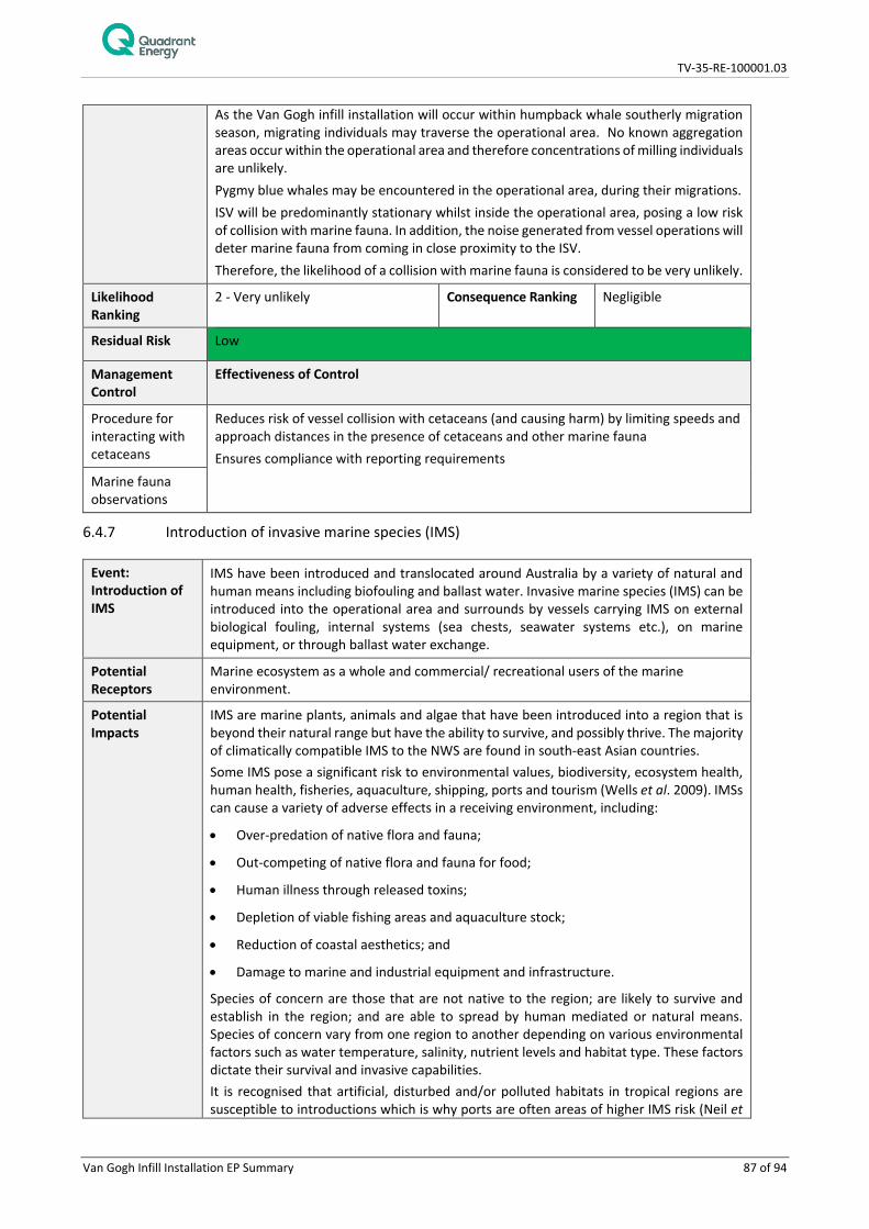
TV-35-RE-100001.03
Van Gogh Infill Installation EP Summary 87 of 94
As the Van Gogh infill installation will occur within humpback whale southerly migration season, migrating individuals may traverse the operational area. No known aggregation areas occur within the operational area and therefore concentrations of milling individuals are unlikely. Pygmy blue whales may be encountered in the operational area, during their migrations. ISV will be predominantly stationary whilst inside the operational area, posing a low risk of collision with marine fauna. In addition, the noise generated from vessel operations will deter marine fauna from coming in close proximity to the ISV. Therefore, the likelihood of a collision with marine fauna is considered to be very unlikely.
Likelihood Ranking
2 - Very unlikely Consequence Ranking Negligible
Residual Risk Low
Management Control
Effectiveness of Control
Procedure for interacting with cetaceans
Reduces risk of vessel collision with cetaceans (and causing harm) by limiting speeds and approach distances in the presence of cetaceans and other marine fauna Ensures compliance with reporting requirements
Marine fauna observations
6.4.7 Introduction of invasive marine species (IMS)
Event: Introduction of IMS
IMS have been introduced and translocated around Australia by a variety of natural and human means including biofouling and ballast water. Invasive marine species (IMS) can be introduced into the operational area and surrounds by vessels carrying IMS on external biological fouling, internal systems (sea chests, seawater systems etc.), on marine equipment, or through ballast water exchange.
Potential Receptors
Marine ecosystem as a whole and commercial/ recreational users of the marine environment.
Potential Impacts
IMS are marine plants, animals and algae that have been introduced into a region that is beyond their natural range but have the ability to survive, and possibly thrive. The majority of climatically compatible IMS to the NWS are found in south-east Asian countries. Some IMS pose a significant risk to environmental values, biodiversity, ecosystem health, human health, fisheries, aquaculture, shipping, ports and tourism (Wells et al. 2009). IMSs can cause a variety of adverse effects in a receiving environment, including:
• Over-predation of native flora and fauna;
• Out-competing of native flora and fauna for food;
• Human illness through released toxins;
• Depletion of viable fishing areas and aquaculture stock;
• Reduction of coastal aesthetics; and
• Damage to marine and industrial equipment and infrastructure.
Species of concern are those that are not native to the region; are likely to survive and establish in the region; and are able to spread by human mediated or natural means. Species of concern vary from one region to another depending on various environmental factors such as water temperature, salinity, nutrient levels and habitat type. These factors dictate their survival and invasive capabilities. It is recognised that artificial, disturbed and/or polluted habitats in tropical regions are susceptible to introductions which is why ports are often areas of higher IMS risk (Neil et

TV-35-RE-100001.03
Van Gogh Infill Installation EP Summary 88 of 94
al. 2005). However, in Australia, there are limited records of detrimental impact from IMS compared to other tropical regions (such as the Caribbean). Following their establishment, eradication of IMS populations is difficult, limiting management options to ongoing control or impact minimisation. Case studies in Australia indicate that from detection to eradication can take approximately 4 weeks (Bax 1999). However, this is dependent on the environmental conditions and species. For this reason, increased management requirements have been implemented in recent years by Commonwealth and State regulatory agencies.
Biofouling on vessel hulls and other external niche areas, biofouling on internal niches, biofouling on equipment routinely immersed in water and ballast water exchange all pose a potential risk of introducing IMS into Australia. The potential biofouling risk presented by the ISV will relate to the length of time that the vessel has already been operating in Australian waters or, if they have been operating outside Australian waters, the location/s of the operations it has been undertaking, the length of time spent at these location/s, and whether the vessel has undergone hull inspections, cleaning and application of new anti-foulant coating prior to returning to operate in Australia.
Impact Assessment
Receptors Consequence
Marine fauna – Fish Benthic habitats Socio-Economic Receptors
Ballast water is responsible for up to 30% of all IMS incursions into Australian waters, however, research indicates that biofouling (the accumulation of aquatic micro-organisms, algae, plants and animals on vessel hulls and submerged surfaces) has been responsible for more foreign marine introductions than ballast water (DAWR 2017). IMS, if they successfully establish, can out-compete native species for food or space, preying on native species or changing the nature of the environment and can subsequently impact on fisheries or aquaculture. If an IMS is introduced, they have been known to colonise areas outside of the areas they are introduced to. In the event that an IMS is introduced into the operational area, given the lack of diversity and extensiveness of similar benthic habitat in the region, there would only be a minor reduction in the physical environment. The overall consequence level was assessed as moderate.
Likelihood The pathways for IMS introduction are well known, and subsequently standard preventative measures are proposed. The ability for invasive marine species to colonise a habitat is dependent on a number of environmental conditions. It has been found that highly disturbed environments (such as marinas) are more susceptible to colonisation than open water environments where the number of dilutions and the degree of dispersal are high (Paulay et al. 2002). Given the depth of the operational area (380 m), it is unlikely that an IMS would be able to successfully translocate from the operational area to surrounding shallower habitats. With controls in place to reduce the risk of introduction of IMS the likelihood of introducing an IMS is considered rare.
Likelihood Ranking
1 - Rare Consequence Ranking Moderate
Residual Risk Low
Management Control
Effectiveness of Control
Biofouling vessel risk assessment (VRASS)
The risk of introducing IMS are reduced due to assessment procedure.
Anti-foulant system
The risk of introducing IMS are reduced due to anti-foulant systems

TV-35-RE-100001.03
Van Gogh Infill Installation EP Summary 89 of 94
Ballast water management plan
Reduces the risk of introducing IMS through procedures managing ballast water exchange and identifying high risk ballast water.
7. MANAGEMENT APPROACH
The Van Gogh infill installation activity will be managed in compliance with all measures and controls detailed within the EP accepted by NOPSEMA under the OPGGS (E) Regulations, other environmental legislation and Quadrant’s Management System (e.g. Environmental Management Policy).
The objective of the EP is to ensure that potential adverse environmental impacts from planned and unplanned events associated with the activity are identified and assessed, and to stipulate mitigation measures to avoid and/or reduce any adverse impacts to the environment to ALARP and acceptable levels.
The EP details specific performance outcomes, standards and procedures, and identifies the range of controls to be implemented (consistent with the standards) to achieve the performance outcomes. The EP also identifies the specific measurement criteria and records to be kept to demonstrate the achievement of each performance outcomes.
As described in the EP, the implementation strategy includes the relevant details of the following:
1. Environmental Management System;
2. Environmental Management Policy;
3. Leadership, accountability and responsibility;
4. Workforce training and competency;
5. Hazard identification, risk and impact assessment and controls;
6. Environmental performance outcomes, control measures and performance standards;
7. Workforce involvement and stakeholder communications;
8. Information management and document control; and
9. Operations management.
During the period that activities described in the EP are undertaken, Quadrant will ensure environmental performance is monitored and managed through an inspection and monitoring regime undertaken by Quadrant representatives or delegates based on the ISV.
Environmental compliance of an activity with the EP (and the EPO’s) is measured using planned and systematic audits or inspections to identify weaknesses and non-conformances in the system and processes so that they can be identified. Continuous improvement opportunities identified through monitoring, audits and incident investigations are implemented in a controlled manner and communicated to all relevant workforce, contractors and relevant third parties. Audits and inspections are in place to identify possible incidents and actions taken to prevent them from happening.
Non-conformances found are addressed and resolved by a systematic corrective action process and are reported to NOPSEMA where relevant.
Senior Quadrant and vessel contractor personnel will be accountable for ensuring conformance with environmental performance outcomes and standards and all personnel will be empowered to ‘stop-the-job’ to ensure the activity is being implemented in an environmentally responsible manner. The EP identifies specific responsibilities for each role during the activity.
Incident notification and reporting to NOPSEMA and other regulators will be conducted as per the OPGGS (E) Regulations, as detailed within the EP. Reported HSE incidents and hazards will be communicated to personnel during daily operational meetings, and HSE incidents and hazards will be documented in the
TV-35-RE-100001.03
Van Gogh Infill Installation EP Summary 90 of 94
incident management systems as appropriate. Significant HSE incidents will be investigated using root cause analysis.
7.1 Management of Change
Quadrant’s Environmental Management of Change Procedure (EA-91-IQ-10001) (MOC) process provides a systematic approach to initiate, assess, document, approve, communicate and implement changes to EPs and OPEPs (currently in force) whilst meeting the requirements of the OPGGS (E) Regulations.
The MOC process considers Regulation 7, 8 and 17 of the OPGGS (E) Regulations, and determines if a proposed change can proceed and the manner in which it can proceed, or if a revision of the EP and OPEP needs to be submitted to NOPSEMA. For a change to proceed, the associated environmental impacts and risks must be demonstrated to be acceptable and ALARP. Additional stakeholder consultation may be required depending on the nature and scale of the change. The MOC procedure also allows for the assessment of new information that may become available post EP acceptance, e.g., new Management Plans for marine reserves, Recovery Plans or Conservation Advice for species and changes to the EPBC Act Protected Matters Search results. If review identifies new information, this is treated as “Change that has an impact on Environment Plan” and the MOC process is followed accordingly.
Accepted MOCs become part of the in force EP or OPEP, will be tracked on a register and made available on Quadrant’s intranet. Where appropriate, Quadrant’s environmental compliance register will be updated to ensure control measure or environmental performance standard changes are communicated to the workforce and implemented.
8. HYDROCARBON SPILL RESPONSE ARRANGEMENTS
In the event of a hydrocarbon spill, oil spill response strategies will be implemented where possible to reduce environmental impacts to ALARP and acceptable levels. The selection of strategies will be undertaken through the Net Environmental Benefit Analysis (NEBA) process, outlined in the OPEP. The following response strategies may be applicable to the identified credible spill scenarios:
• Source control;
• Monitor and evaluate / surveillance;
o Vessel surveillance
o Aerial surveillance
o Tracking buoys
o Spill fate modelling
o Satellite imagery
o Initial oil characterisation
o Operational water quality monitoring
o Shoreline coastal and habitat assessment
• Chemical dispersion (Crude only);
• Mechanical dispersion (MGO only);
• Containment and recovery (Crude only);
• Nearshore and shoreline protection and deflection;
• Shoreline clean-up;
• Oiled wildlife response;

TV-35-RE-100001.03
Van Gogh Infill Installation EP Summary 91 of 94
• Scientific monitoring.
8.1 Preparedness and Implementation of Response Arrangements
The ISV is required to have and implement incident response plans, such as an emergency response plan and SMPEP/ SOPEP. Regular incident response drills and exercises (e.g. as defined in emergency response plan, SMPEP/ SOPEP, etc.) will be carried out on the ISV to refresh the crew in using equipment and implementing incident response procedures. Quadrant will implement the Van Gogh Installation and Commissioning Oil Pollution Emergency Plan (TV-35-RE-100001.02) in the event of a significant hydrocarbon spill (Tier 2 or 3). To maintain a state of oil spill preparedness, personnel with OPEP responsibilities will be made aware of their obligations, oil spill response equipment will be maintained, contracts with critical equipment and personnel suppliers will be managed, and agreements will be in place with national regulatory agencies for support in oil spill response. Quadrant will also implement its oil spill response exercise and training schedule. Further information on oil spill response is provided in the OPEP. A communications test for the activity is completed prior to commencement of the activity.
8.2 Net Environmental Analysis Benefits (NEBA)
During any response incident, there is a documented decision making process to ensure that response strategies are identified and evaluated prior to implementation via the Incident Action Plan (IAP). The Controlling Agency Incident Management Team (IMT) will use a Net Environmental Benefit Analysis (NEBA) process to inform the development and refinement of the IAPs, so the most effective response strategies with the least detrimental environmental impacts are identified, documented and executed. Within Quadrant’s IMT, the Environmental Team Lead is responsible for reviewing the priority receptors identified within the EP and the OPEP, and apply NEBA to identify which response options are preferred for the situation, oil type and behaviour, environmental conditions, direction of plume and priorities for protection. The application of the NEBA is to: • Identify sensitivities within the area potentially affected by a spill at that time of the year; • Assist in prioritising and allocating resources to sensitivities with a higher ranking; and • Assist in determining appropriate response strategies with support of real time metocean conditions, oil
spill tracking and fate modelling.
8.3 Oil Spill Response Resources
Oil spill response equipment and resources are a combination of Quadrant, AMOSC (Australian Marine Oil Spill Centre Pty Ltd), AMSA, DoT, National Plan (NatPlan), OSRL (Oil Spill Response Limited), and other operator resources available through the AMOSPlan mutual aid arrangements. Under the Memorandum of Understanding (MOU) between AMSA and Quadrant, AMSA will provide all resources available through NatPlan to support a Quadrant spill response. In the event of an oiled wildlife response, Quadrant will activate the West Australian Oiled Wildlife Response Plan (WAOWRP) and work with DBCA in determining resources and capability requirements. DBCA and Industry (AMOSC) Oiled Wildlife Advisors (OWAs) ensure minimum standards for oiled wildlife response, as outlined within the WAOWRP, are met and ensure timely mobilisation of appropriate resources (equipment and personnel) through communication with the wildlife logistics team. Quadrant are able to access: • AMOSC core group responders; • DBCA staff and approved volunteers/subject matter experts; • Additional local resources under current contracts and suppliers; and • Access international support through Wildlife Response Services.

TV-35-RE-100001.03
Van Gogh Infill Installation EP Summary 92 of 94
During and post-spill scientific response monitoring activities require resources external to Quadrant and include specialist technical capabilities. If additional support is required, Quadrant has Master Service Agreements with other service providers to support scientific response monitoring activities.
9. CONTACT DETAILS
Further information about the Van Gogh Infill and Installation activity can be obtained from:
Ashlee Crabbe
Consultation Coordinator
Quadrant Energy
100 St Georges Terrace, Perth, 6000
Telephone number: (08) 6218 4972
TV-35-RE-100001.03
Van Gogh Infill Installation EP Summary 93 of 94
10. REFERENCES
AMSA 2015. Technical Guideline for the Preparation of Marine Pollution Contingency Plans for Marine and Coastal Facilities. January 2015. APASA 2013. Ningaloo Vision Remodelling – Quantitative Oil Spill Risk Assessment. Prepared for Apache Energy Ltd. Rev 0 Bannister, J.L., Kemper, C.M. and Warneke, R.M. 1996. The Action Plan for Australian Cetaceans. [Online]. Canberra: Australian Nature Conservation Agency. Available from: http://www.environment.gov.au/resource/action-plan-australian-cetaceans. [Accessed 4/12/2017]. Bax, N. 1999. Eradicating a dreissenid from Australia. Dreissenia! Vol. 10(3), pp. 1-4. BHPB 2005. Pyrenees Development. Draft EIS. BHP Billiton Petroleum. Perth. Commonwealth of Australia 2017. Recovery Plan for Marine Turtles in Australia 2017 – 2027. Deepwater Horizon Natural Resource Damage Assessment Trustees 2016. Deepwater Horizon oil spill: Final Programmatic Damage Assessment and Restoration Plan and Final Programmatic Environmental Impact Statement. Available from: http://www.gulfspillrestoration.noaa.gov/restoration-planning/gulf-plan. [Accessed 17/1/2018]. Department of Agriculture and Water Resources (DAWR) 2017. Marine Pests. Available from: http://www.agriculture.gov.au/pests-diseases-weeds/marine-pests [Accessed 1/12/2017]. Enesar 2007. Van Gogh Development WA-1555-P (1) (Defined Area): Seabed Characterisation (draft). Environmental Protection Authority (EPA) 2010. Environmental Assessment Guideline No. 5 for Protecting Marine Turtles from Light Impacts. Available from: http://www.epa.wa.gov.au/sites/default/files/Policies_and_Guidance/EAG%205%20Lights%20Turtle%2011110.pdf [Accessed 30/11/2017] Fletcher, W.J. and Santoro, K. (Eds). 2017. Status Reports of the Fisheries and Aquatic Resources of Western Australia 2012/13: The State of the Fisheries. Department of Fisheries, Western Australia Gagnon, M.M. and Rawson, C. 2010. Montara Well Release: Report on Necropsies from a Timor Sea Green Turtle. Department of Sustainability, Environment, Water, Population and Communities, Curtin University, Department of Environmental Biology. Gardline Marine Services 2009. Browse LNG Development. Browse Woodside Environmental Baseline Report June–July 2009. Prepared for Woodside Energy Limited, Perth. How, J. and Nardi, K. 2014. West Coast Deep Sea Crustacean Managed Fishery Status Report. In: Status Reports of the Fisheries and Aquatic Resources of Western Australia 2013/14: The State of the Fisheries eds. W.J Fletcher and K. Santoro, Department of Fisheries, Western Australia, pp. 41-51. Jenner, K.C.S, Jenner, M-N.M. and McCabe, K.A. 2001. Geographical and temporal movements of humpback whales in Western Australian waters. The APPEA Journal. Vol. 41(1), pp. 749-765. Jensen, A.S. and Silber, G.K. 2003. Large whale ship strike database. U.S. Department of Commerce. National Oceanic and Atmospheric Administration. Technical Memorandum NMFS-OPR-25. 37 pp. Kennish, M.J. 1997. Practical handbook of Estuarine and Marine Pollution. Boca Raton, FL: CRC Press Laist, D.W., Knowlton, A.R., Mead, J.G., Collet, A.S. and Podesta, M. 2001. Collision between ships and whales. Marine Mammal Science, 17: 35-75. Lindquist, D.C. and Shaw, R.F. 2005. Effects of current speed and turbidity on stationary light-trap catches of larval and juvenile fishes. Fishery Bulletin, 103(2), pp. 438-444. Marquenie, J., Donners, M., Poot, H., Steckel, W. and de Wit, B. 2008. Adapting the spectral composition of artificial lighting to safeguard the environment. Petroleum and Chemical Industry Conference Europe -Electrical and Instrumentation Applications, pp 1-6 Meekan, M.G., Wilson, S.G., Halford, A. and Retzel, A. 2001. A comparison of catches of fishes and invertebrates by two light trap designs, in tropical NW Australia. Marine Biology, 139: 373–381.
TV-35-RE-100001.03
Van Gogh Infill Installation EP Summary 94 of 94
Milicich, M.J., Meekan, M.G. and Doherty, P.J. 1992. Larval supply: a good predictor of recruitment of three species of reef fish (Pomacentridae). Marine Ecology Progress Series. Vol. 86: 153-166. Neil, K.M., Hilliard, R.W., Clark, P., Russell, B., Clark, R. and Polglaze, J. 2005. Situation and Gaps Analysis of Introduced Marine Species, Vectors, Nodes and Management Arrangements for the Northern Planning Area, Report published by the National Oceans Office (Marine Division, Department of Environment and Heritage), Canberra. NOAA 2010. Oil and sea turtles: Biology, planning and response. National Oceanic and Atmospheric Administration, Washington. NMSC (The Australian National Marine Safety Committee) 2010. Marine Incidents during 2009. Preliminary Data Analysis. A WWW database accessed during July 2012 at http://www.nmsc.gov.au Paulay, G., Kirkendale, L., Lambert, G. and Meyer, C. 2002. Anthropogenic biotic interchange in a coral reef ecosystem: a case study from Guam. Pacific Science 56: 403-422. Richardson, W.J., Greene, C.R., Malme, C.I. and Thomson, D.H. 1995. Marine Mammals and Noise. Academic Press, San Diego, 576p Salmon, M., Wyneken, J., Fritz, E. and Lucas, M. 1992 Seafinding by hatchling sea turtles: role of brightness, silhouette and beach slope as orientation cues. Behaviour. 122 (1) 56-77 Scholz, D., Michel, J., Shigenaka, G. and Hoff, R. 1992. Biological resources. In: Hayes, M., Hoff, R., Michel, J., Scholz, D. and Shigenaka, G. Introduction to coastal habitats and biological resources for spill response, report HMRAD 92-4. National Oceanic and Atmospheric Administration, Seattle. Silber, G.K., Adams, J.D. and Bettridge, S. 2012. Vessel operator response to a voluntary vessel/whale collision reduction measure. Endangered Species Research 17:245–254. Tri-Surv 2007. Van Gogh Development Geophysical Survey Report. Prepared for Apache Energy Limited. Document number 6A106-RR-001-PRELIMINARY.doc Issue date:4 January 2007 URS 2001. Review of Environmental Impacts of Petroleum Exploration and Appraisal Activities in Commonwealth Waters, Report prepared for the Department of Science & Resources WDCS 2006. Vessel collisions and cetaceans: What happens when they don’t miss the boat. Whale and Dolphin Conservation Society. United Kingdom Wells, F.E., McDonald, J.I. and Huisman, J.M. 2009. Introduced marine species in WA. Published by the Department of Fisheries, Perth, WA