unvegetated large-scale channel erosion testing … is verified to be 90% (± 3%) of proctor...
TRANSCRIPT

Unvegetated Large-Scale Channel Erosion Testing
(ASTM D 6460)
of
Western Excelsior’s
PP5-10, Double Net Poly Fiber Matting
over
Loam
May 2014
Submitted to:
AASHTO/NTPEP
444 North Capitol Street, NW, Suite 249
Washington, D.C. 20001
Attn: Russell Dabbs, NTPEP
Submitted by:
TRI/Environmental, Inc.
9063 Bee Caves Road
Austin, TX 78733
C. Joel Sprague
Project Manager

May 31, 2014
Mr. Russell Dabbs AASHTO/NTPEP
444 North Capitol Street, NW, Suite 249
Washington, D.C. 20001
E-mail: [email protected]
Subject: Large-scale Slope Testing over Loam of PP5-10, Double Net Poly Fiber Matting,
manufactured in Macon, GA
Dear Mr. Dabbs:
This letter report presents the results for large-scale channel erosion tests performed on PP5-10,
Double Net Poly Fiber Matting, over Loam. Included are data developed for target hydraulic
shears ranging from 0.5 to 3+ psf (0.02 to 0.15+ kPa). All testing work was performed in
general accordance with the ASTM D 6460, Standard Test Method for Determination of Rolled
Erosion Control Product (RECP) Performance in Protecting Earthen Channels from
Stormwater-Induced Erosion. Generated results were used to develop the following permissible
or limiting shear (τlimit) and limiting velocity (Vlimit) for the tested material:
τlimit PP5-10, Double Net Poly Fiber Matting & 3.8 staples/sy = 2.85 psf;
Vlimit PP5-10, Double Net Poly Fiber Matting & 3.8 staples/sy = 11.5 ft/sec
TRI is pleased to present this final report. Please feel free to call if we can answer any questions
or provide any additional information.
Sincerely,
C. Joel Sprague, P.E.
Senior Engineer
Geosynthetics Services Division
Cc: Jarrett Nelson, Jay Sprague - TRI

PP5-10, Double Net Poly Fiber Matting, over Loam
Channel Erosion Testing
May 31, 2014
Page 3
CHANNEL TESTING REPORT
PP5-10, Double Net Poly Fiber Matting, over Loam TESTING EQUIPMENT AND PROCEDURES
Overview of Test and Apparatus
TRI/Environmental, Inc.'s (TRI's) large-scale channel erosion testing facility is located at the
Denver Downs Research Farm in Anderson, SC. Testing oversight is provided by C. Joel
Sprague, P.E. The large-scale testing is performed in a rectangular flume having a 10% slope
using a loamy soil test section. The concentrated flow is produced by raising gates to allow
gravity flow from an adjacent pond. At least four sequential, increasing flows are applied to
each test section for 30 minutes each to achieve a range of hydraulic shear stresses in order to
define the permissible, or limiting, shear stress, τlimit, which is the shear stress necessary to cause
an average of 0.5 inch of soil loss over the entire channel bottom. Testing is performed in
accordance with ASTM D 6460 protocol. Tables and graphs of shear versus soil loss are
generated from the accumulated data.
Rolled Erosion Control Product (RECP)
The following information and index properties were determined from the supplied product.
Table 1. Tested Product Information & Index Properties
Product Information and Index Property / Test Units Sampled Product
Product Identification - PP5-10
Manufacturer - Western Excelsior
Manufacturing Plant Location - Macon, GA
Lot number of sample - -
Fiber - 100% Synthetic
Netting Openings in 0.6 x 0.6 (approx)
Stitching Spacing in 2.0 (approx)
Tensile Strength MD x XD (ASTM D 6818)* lb/in 28.7 x 15.1
Tensile Elongation MD x XD (ASTM D 6818)* % 24.9 x 38.4
Thickness (ASTM D 6525)* mils 396
Light Penetration (ASTM D 6567)* % cover 75.7
Density – Net Only (ASTM D 792, Method A)* g/cm3 0.908
Mass / Unit Area (ASTM D 6475)* oz/sy 10.49 * Values from Independent Testing of Randomly Sampled Product

PP5-10, Double Net Poly Fiber Matting, over Loam
Channel Erosion Testing
May 31, 2014
Page 4
Test Soil
The test soil used in the test plots had the following characteristics.
Table 2. TRI-Loam Characteristics
Soil Characteristic Test Method Value
% Gravel
ASTM D 422
0
% Sand 45
% Silt 35
% Clay 20
Liquid Limit, % ASTM D 4318
41
Plasticity Index, % 8
Soil Classification USDA Loam
Soil Classification USCS Sandy silty clay (ML-CL)
Preparation of the Test Channels
The initial channel soil veneer (12-inch thick minimum) is placed and compacted. Compaction is
verified to be 90% (± 3%) of Proctor Standard density using ASTM D 2937 (drive-cylinder
method). The test channels undergo a “standard” preparation procedure prior to each test. First,
any rills or depressions resulting from previous testing are filled in with test soil. The soil
surface is replaced to a depth of 1 inch and groomed to create a channel bottom that is level side-
to-side and at a smooth 10% slope top-to-bottom. Finally, a vibrating plate compactor is run
over the renewed channel surface. The submitted erosion control product is then installed using
the anchors and anchorage pattern directed by the client.
Installation of Erosion Control Product in Test Channel
As noted, the submitted erosion control product is installed as directed by the client. For the
tests reported herein, the erosion control product was anchored using a “diamond” anchorage
pattern consisting of 2”x 8” steel staples to create an anchorage density of approximately 3.8
anchors per square yard.
Specific Test Procedure
Immediately prior to testing, the initial soil surface elevation readings are made at predetermined
cross-sections. The channel is then exposed to sequential 30-minute flows having typical target
hydraulic shear stresses ranging from 0.5 to 3+ psf. During the testing, flow depth and
corresponding flow velocity measurements are taken at the predetermined cross-section
locations. Between flow events, the flow is stopped and soil surface elevation measurements are
made to facilitate calculation of soil loss. Flows are then increased to achieve the subsequent
shear target in an attempt to create more than 0.5 inches of soil loss. Pictures of channel flows
and resulting soil loss are shown in Figures 6 thru 12.

PP5-10, Double Net Poly Fiber Matting, over Loam
Channel Erosion Testing
May 31, 2014
Page 5
Figure 1. Flumes Setup (typical)
Figure 2. Flow Velocity Measurement in
Channel (typical)
Figure 3. Channel Flow Depth
Measurement (typical)
Figure 4. RECP Installed (typical)
Figure 5. Typical Low Flow in Channels
Figure 6. Typical Low to Medium
Flow in Channel

PP5-10, Double Net Poly Fiber Matting, over Loam
Channel Erosion Testing
May 31, 2014
Page 6
Figure 7. Typical Medium Flow in Channel
Figure 8. Typical High Flow in Channel
Figure 9. Ending Condition –
Before Mattings Removed
Figure 10. Channel 1 After RECP Removed
Figure 11. Channel 2 After RECP Removed
Figure 12. Channel 3 After RECP Removed

PP5-10, Double Net Poly Fiber Matting, over Loam
Channel Erosion Testing
May 31, 2014
Page 7
TEST RESULTS
Average soil loss and the associated hydraulic shear calculated from flow and depth
measurements made during the testing are the principle data used to determine the performance
of the product tested. This data is entered into a spreadsheet that transforms the flow depth and
velocity into an hydraulic shear stress and the soil loss measurements into an average Clopper
Soil Loss Index (CSLI). A graph of shear versus soil loss for the protected condition is shown in
Figure 13. The associated velocities and roughness are plotted in Figures 14 and 15,
respectively. The graphs include the best regression line fit to the test data to facilitate a
determination of the limiting shear stress, τlimit,, and limiting velocity, Vlimit,. Linear (R2=0.71),
power (R2=0.83), and polynomial (R
2=0.91) fits were evaluated.
Table 3. Summary Data Table – Protected Test Reach
Test #
(Channel # - Shear
Level)
Flow
depth
(in)
Flow
velocity
(fps)
Flow
(cfs)
Manning’s
roughness, n
Max Bed
Shear
Stress (psf)
Cumm.
CSLI (in)
C1-S1 1.10 2.82 0.51 0.034 0.56 0.03
C1-S2 1.84 4.54 1.39 0.031 0.95 0.09
C1-S3 3.28 7.39 4.05 0.026 1.75 0.16
C1-S4 4.71 9.33 7.34 0.025 2.42 0.29
C1-S5 6.31 10.82 11.37 0.025 3.04 0.45
C2-S1 1.48 3.51 0.87 0.033 0.77 0.01
C2-S2 2.23 5.62 2.08 0.027 1.13 0.03
C2-S3 3.62 7.92 4.76 0.026 1.72 0.15
C2-S4 6.01 10.19 10.19 0.025 2.77 0.41
C2-S5 7.92 13.25 17.46 0.025 3.08 0.59
C3-S1 1.39 3.40 0.79 0.033 0.71 0.03
C3-S2 2.29 5.85 2.23 0.026 1.20 0.13
C3-S3 4.53 9.64 7.28 0.025 2.23 0.31
C3-S4 7.08 11.66 13.74 0.026 3.16 0.89
Using the test procedure and data evaluation technique described herein, the limiting shear stress
shown in Table 4 was determined using the following equation:
τ0 = γ/2(y1 + y2)sinΘB + 1/L[γ/2(y12 - y2
2)cosΘB – ρq
2(1/y2 – 1/y1)]
Where:
τ0 = shear stress (Pa),
γ = unit weight of water (N/m3),
y1 = upstream flow depth* (m),
y2 = downstream flow depth* (m),
ΘB = angle of bed slope (degrees),
ρ = density of water (kg/m),
q = unit discharge (cms/m), and
L = length of control volume (m).
*Flow depths measured near the end of the 30 minute test period are used in the calculations.
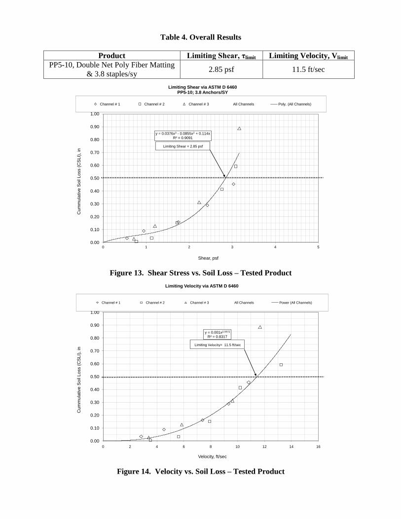
Table 4. Overall Results
Product Limiting Shear, τlimit Limiting Velocity, Vlimit
PP5-10, Double Net Poly Fiber Matting
& 3.8 staples/sy 2.85 psf 11.5 ft/sec
y = 0.0376x3 - 0.0855x2 + 0.114xR² = 0.9091
0.00
0.10
0.20
0.30
0.40
0.50
0.60
0.70
0.80
0.90
1.00
0 1 2 3 4 5
Cu
mm
ula
tive
So
il L
oss (
CS
LI)
, in
Shear, psf
Limiting Shear via ASTM D 6460 PP5-10; 3.8 Anchors/SY
Channel # 1 Channel # 2 Channel # 3 All Channels Poly. (All Channels)
Limiting Shear = 2.85 psf
Figure 13. Shear Stress vs. Soil Loss – Tested Product
y = 0.001x2.5572
R² = 0.8317
0.00
0.10
0.20
0.30
0.40
0.50
0.60
0.70
0.80
0.90
1.00
0 2 4 6 8 10 12 14 16
Cu
mm
ula
tive
So
il L
oss (
CS
LI)
, in
Velocity, ft/sec
Limiting Velocity via ASTM D 6460
TPP5-10; 3.8 Anchors/S
Channel # 1 Channel # 2 Channel # 3 All Channels Power (All Channels)
Limiting Velocity= 11.5 ft/sec
Figure 14. Velocity vs. Soil Loss – Tested Product

y = 0.0333x-0.165
R² = 0.8188
0.010
0.015
0.020
0.025
0.030
0.035
0.040
0.045
0.050
0.00 1.00 2.00 3.00 4.00 5.00 6.00 7.00 8.00 9.00 10.00
Mannin
g's
n
Water Depth, in
Manning's n vs. Water DepthPP5-10; 3.8 Anchors/SY
Channel # 1 Channel # 2 Channel # 3 All Channels Power (All Channels)
Figure 15. Flow Depth vs. Manning’s “n” – Tested Product
y = -0.1006x + 196.83 y = -0.1011x + 196.9 y = -0.1003x + 196.84
y = -0.1068x + 197.15 y = -0.0999x + 197.25 y = -0.0985x + 197.24
y = -0.0959x + 197.66 y = -0.0968x + 197.8 y = -0.094x + 198.28
y = -0.0879x + 198.21 y = -0.0749x + 198.4 y = -0.082x + 198.98
y = -0.067x + 198.74 y = -0.0834x + 199.74
190
191
192
193
194
195
196
197
198
199
200
0 2 4 6 8 10 12 14 16 18 20
Ele
va
tio
n R
ela
tive
to
Be
nch
ma
rk, ft
X-Section (ft along test reach)
Energy Grade Lines - All Shear LevelsPP5-10; 3.8 Anchors/SY
Shear Level 4
Shear Level 3
Shear Level 2
Shear Level 1
Shear Level 5
Channel 1 Channel 2 Channel 3
Figure 16. Energy Grade Lines – All Channels, All Shears – Tested Product

y = 16.269x2 + 5.4657xR² = 0.9953
0.00
0.10
0.20
0.30
0.40
0.50
0.60
0.70
0.80
0.90
1.00
0.00 0.05 0.10 0.15 0.20 0.25
Cum
mu
lative
So
il L
oss (
CS
LI)
, in
Shear, psf
Limiting Shear via ASTM D 6460Soil-only Control Test
Control Test - 1% Flume Poly. (Control Test - 1% Flume)
Limiting Shear = 0.075 psf
Figure 17. Shear Stress vs. Soil Loss – Soil Only
CONCLUSIONS
Rectangular channel (flume) tests were performed in accordance with ASTM D 6460 using
Loam soil protected with an RECP. Testing in a rectangular (vertical wall) channel was
conducted to achieve increasing shear levels in an attempt to cause at least 0.5-inch of soil loss.
Figure 13 shows the maximum bottom shear stress and associated soil loss from each flow event.
Figure 14 presents the velocity versus soil loss. Figure 15 relates channel liner roughness
(Manning’s “n”) to flow depth. Together, this data provides a quantitative estimate of the
performance characteristics of the tested RECP.
The data in Figure 16 and 17, the calculated energy grade lines for each channel and shear level
and the soil-only shear stress vs. soil loss relationship, are included to provide a reference for the
reported test results.

PP5-10, Double Net Poly Fiber Matting, over Loam
Channel Erosion Testing
May 31, 2014
Appendix
APPENDIX A – RECORDED DATA
Test Record Sheets

Date: 5/30/14 RECP: Lot #:
Slope: 10% Start Time: 8:46 AM Channel # Shear # Start Time: 9:44 AM Channel # Shear # Start Time: 10:40 AM Channel # Shear # Start Time: 1:18 PM Channel # Shear # Start Time: 2:43 PM Channel # Shear #
Width: 2 End Time: 9:16 AM 1 1 End Time: 10:14 AM 1 2 End Time: 11:10 AM 1 3 End Time: 1:48 PM 1 4 End Time: 3:13 PM 1 5
#DIV/0! #DIV/0! #DIV/0! #DIV/0! #DIV/0!
To original Surface Elev, cm 72.6 72.6 72.5 Avg. Avg. Avg. Avg. Avg.
To eroded Surface Elev, cm 72.7 72.7 72.5 72.6 72.8 72.8 72.5 72.7 73.0 72.8 72.5 72.8 73.0 73.0 73.0 73.0 73.0 73.5 73.7 73.4
Loss/Gain, sq.in./in. width -0.04 -0.04 0.00 -0.02 -0.08 -0.08 0.00 -0.04 -0.16 -0.08 0.00 -0.07 -0.16 -0.16 -0.20 -0.14 -0.16 -0.35 -0.47 -0.27
CSLI, sq.in./in. width -0.04 -0.04 0.00 -0.02 -0.08 -0.08 0.00 -0.04 -0.16 -0.08 0.00 -0.07 -0.16 -0.16 -0.20 -0.14 -0.16 -0.35 -0.47 -0.27
Velocity, ft/s 2.6 2.6 4.4 4.4 7.0 7.0 8.8 8.8 10.0 10.0
Distance to Water Surface, cm 69.5 69.5 68.0 68.0 64.5 64.5 61.0 61.0 56.0 56.0
Flow, cfs Depth, in Flow, cfs Depth, in Flow, cfs Depth, in Flow, cfs Depth, in Flow, cfs Depth, in
0.53 1.23 1.36 1.85 3.80 3.25 6.93 4.72 11.42 6.85
To original Surface Elev, cm 72.5 72.3 71.4 Avg. Avg. Avg. Avg. Avg.
To eroded Surface Elev, cm 72.6 72.4 71.6 72.2 72.6 72.5 71.7 72.3 72.6 72.7 71.8 72.4 72.7 72.9 72.0 72.5 73.0 73.2 72.3 72.8
Loss/Gain, sq.in./in. width -0.04 -0.04 -0.08 -0.05 -0.04 -0.08 -0.12 -0.07 -0.04 -0.16 -0.16 -0.09 -0.08 -0.24 -0.24 -0.14 -0.20 -0.35 -0.35 -0.24
CSLI, sq.in./in. width -0.04 -0.04 -0.08 -0.05 -0.04 -0.08 -0.12 -0.07 -0.04 -0.16 -0.16 -0.09 -0.08 -0.24 -0.24 -0.14 -0.20 -0.35 -0.35 -0.24
Velocity, ft/s 2.6 2.6 4.9 4.9 7.2 7.2 9.0 9.0 10.2 10.2
Distance to Water Surface, cm 69.0 69.0 67.5 67.5 64.0 64.0 60.7 60.7 57.0 57.0
Flow, cfs Depth, in Flow, cfs Depth, in Flow, cfs Depth, in Flow, cfs Depth, in Flow, cfs Depth, in
0.55 1.26 1.53 1.88 3.95 3.29 6.99 4.66 10.60 6.23
To original Surface Elev, cm 72.5 72.6 72.2 Avg. Avg. Avg. Avg. Avg.
To eroded Surface Elev, cm 72.5 72.9 72.3 72.6 72.6 73.0 72.4 72.7 72.8 73.2 72.5 72.8 72.9 73.7 72.6 73.1 73.2 74.5 73.0 73.6
Loss/Gain, sq.in./in. width 0.00 -0.12 -0.04 -0.03 -0.04 -0.16 -0.08 -0.07 -0.12 -0.24 -0.12 -0.12 -0.16 -0.43 -0.16 -0.18 -0.28 -0.75 -0.31 -0.32
CSLI, sq.in./in. width 0.00 -0.12 -0.04 -0.03 -0.04 -0.16 -0.08 -0.07 -0.12 -0.24 -0.12 -0.12 -0.16 -0.43 -0.16 -0.18 -0.28 -0.75 -0.31 -0.32
Velocity, ft/s 2.8 2.8 5.1 5.1 7.2 7.2 9.0 9.0 10.3 10.3
Distance to Water Surface, cm 69.5 69.5 68.0 68.0 64.5 64.5 61.0 61.0 57.5 57.5
Flow, cfs Depth, in Flow, cfs Depth, in Flow, cfs Depth, in Flow, cfs Depth, in Flow, cfs Depth, in
0.56 1.21 1.56 1.84 3.94 3.28 7.13 4.75 10.86 6.33
To original Surface Elev, cm 72.2 72.7 72.6 Avg. Avg. Avg. Avg. Avg.
To eroded Surface Elev, cm 72.3 72.8 72.8 72.3 72.4 73.0 72.9 72.8 72.5 73.2 73.2 73.8 73.0 73.6 73.8 73.5 73.6 74.0 74.0 73.9
Loss/Gain, sq.in./in. width -0.04 -0.04 -0.08 -0.05 -0.08 -0.12 -0.12 -0.09 -0.12 -0.20 -0.24 -0.15 -0.31 -0.35 -0.47 -0.32 -0.55 -0.51 -0.55 -0.45
CSLI, sq.in./in. width -0.04 -0.04 -0.08 -0.05 -0.08 -0.12 -0.12 -0.09 -0.12 -0.20 -0.24 -0.15 -0.31 -0.35 -0.47 -0.32 -0.55 -0.51 -0.55 -0.45
Velocity, ft/s 2.8 2.8 4.7 4.7 7.3 7.3 9.2 9.2 10.6 10.6
Distance to Water Surface, cm 69.5 69.5 68.0 68.0 65.2 65.2 61.5 61.5 58.0 58.0
Flow, cfs Depth, in Flow, cfs Depth, in Flow, cfs Depth, in Flow, cfs Depth, in Flow, cfs Depth, in
0.51 1.10 1.47 1.88 4.12 3.39 7.22 4.71 11.04 6.25
To original Surface Elev, cm 73.5 73.5 73.0 Avg. Avg. Avg. Avg. Avg.
To eroded Surface Elev, cm 73.7 73.5 73.0 73.4 73.8 73.8 73.3 73.6 73.9 74.0 73.6 73.8 74.3 74.5 73.9 74.2 74.5 75.0 74.6 74.7
Loss/Gain, sq.in./in. width -0.08 0.00 0.00 -0.03 -0.12 -0.12 -0.12 -0.10 -0.16 -0.20 -0.24 -0.16 -0.31 -0.39 -0.35 -0.29 -0.39 -0.59 -0.63 -0.44
CSLI, sq.in./in. width -0.08 0.00 0.00 -0.03 -0.12 -0.12 -0.12 -0.10 -0.16 -0.20 -0.24 -0.16 -0.31 -0.39 -0.35 -0.29 -0.39 -0.59 -0.63 -0.44
Velocity, ft/s 3.2 3.2 4.9 4.9 7.4 7.4 9.3 9.3 10.7 10.7
Distance to Water Surface, cm 70.4 70.4 68.6 68.6 65.5 65.5 62.0 62.0 58.5 58.5
Flow, cfs Depth, in Flow, cfs Depth, in Flow, cfs Depth, in Flow, cfs Depth, in Flow, cfs Depth, in
0.63 1.18 1.62 1.98 4.05 3.28 7.47 4.82 11.37 6.38
To original Surface Elev, cm 74.0 74.0 73.5 Avg. Avg. Avg. Avg. Avg.
To eroded Surface Elev, cm 74.2 74.1 73.5 73.9 74.3 74.3 73.7 74.1 74.5 74.7 73.8 74.3 74.7 75.0 74.3 74.7 75.6 75.0 75.0 75.2
Loss/Gain, sq.in./in. width -0.08 -0.04 0.00 -0.03 -0.12 -0.12 -0.08 -0.09 -0.20 -0.28 -0.12 -0.15 -0.28 -0.39 -0.31 -0.26 -0.63 -0.39 -0.59 -0.47
CSLI, sq.in./in. width -0.08 -0.04 0.00 -0.03 -0.12 -0.12 -0.08 -0.09 -0.20 -0.28 -0.12 -0.15 -0.28 -0.39 -0.31 -0.26 -0.63 -0.39 -0.59 -0.47
Velocity, ft/s 2.8 2.8 4.4 4.4 7.3 7.3 9.2 9.2 11.0 11.0
Distance to Water Surface, cm 71.1 71.1 69.5 69.5 65.7 65.7 62.5 62.5 59.0 59.0
Flow, cfs Depth, in Flow, cfs Depth, in Flow, cfs Depth, in Flow, cfs Depth, in Flow, cfs Depth, in
0.52 1.12 1.33 1.81 4.14 3.40 7.34 4.79 11.69 6.38
To original Surface Elev, cm 73.6 73.6 73.7 Avg. Avg. Avg. Avg. Avg.
To eroded Surface Elev, cm 73.6 73.9 73.9 73.8 73.6 74.2 74.0 73.9 73.6 74.2 74.5 74.1 74.0 75.0 74.5 74.5 74.6 75.6 75.0 75.1
Loss/Gain, sq.in./in. width 0.00 -0.12 -0.08 -0.05 0.00 -0.24 -0.12 -0.08 0.00 -0.24 -0.31 -0.14 -0.16 -0.55 -0.31 -0.25 -0.39 -0.79 -0.51 -0.43
CSLI, sq.in./in. width 0.00 -0.12 -0.08 -0.05 0.00 -0.24 -0.12 -0.08 0.00 -0.24 -0.31 -0.14 -0.16 -0.55 -0.31 -0.25 -0.39 -0.79 -0.51 -0.43
Velocity, ft/s 2.5 2.5 4.7 4.7 7.4 7.4 9.4 9.4 11.2 11.2
Distance to Water Surface, cm 71.3 71.3 69.4 69.4 65.9 65.9 62.5 62.5 59.5 59.5
Flow, cfs Depth, in Flow, cfs Depth, in Flow, cfs Depth, in Flow, cfs Depth, in Flow, cfs Depth, in
0.41 0.98 1.40 1.78 3.98 3.23 7.40 4.72 11.44 6.13
To original Surface Elev, cm 73.9 73.9 73.6 Avg. Avg. Avg. Avg. Avg.
To eroded Surface Elev, cm 73.9 74.1 73.6 73.9 74.0 74.5 73.9 74.1 74.4 75.0 74.3 74.6 75.0 75.5 75.0 75.2 75.5 76.0 75.0 75.5
Loss/Gain, sq.in./in. width 0.00 -0.08 0.00 -0.01 -0.04 -0.24 -0.12 -0.09 -0.20 -0.43 -0.28 -0.23 -0.43 -0.63 -0.55 -0.43 -0.63 -0.83 -0.55 -0.53
CSLI, sq.in./in. width 0.00 -0.08 0.00 -0.01 -0.04 -0.24 -0.12 -0.09 -0.20 -0.43 -0.28 -0.23 -0.43 -0.63 -0.55 -0.43 -0.63 -0.83 -0.55 -0.53
Velocity, ft/s 2.6 2.6 4.9 4.9 7.3 7.3 9.6 9.6 11.0 11.0
Distance to Water Surface, cm 71.3 71.3 69.3 69.3 66.0 66.0 63.0 63.0 59.5 59.5
Flow, cfs Depth, in Flow, cfs Depth, in Flow, cfs Depth, in Flow, cfs Depth, in Flow, cfs Depth, in
0.44 1.01 1.55 1.90 4.10 3.37 7.66 4.79 11.55 6.30
To original Surface Elev, cm 73.0 73.4 73.4 Avg. Avg. Avg. Avg. Avg.
To eroded Surface Elev, cm 73.0 73.5 73.5 73.3 73.3 73.5 74.0 73.6 73.5 73.8 74.2 73.8 73.9 74.0 74.7 74.2 74.3 74.8 75.0 74.7
Loss/Gain, sq.in./in. width 0.00 -0.04 -0.04 -0.02 -0.12 -0.04 -0.24 -0.12 -0.20 -0.16 -0.31 -0.20 -0.35 -0.24 -0.51 -0.33 -0.51 -0.55 -0.63 -0.47
CSLI, sq.in./in. width 0.00 -0.04 -0.04 -0.02 -0.12 -0.04 -0.24 -0.12 -0.20 -0.16 -0.31 -0.20 -0.35 -0.24 -0.51 -0.33 -0.51 -0.55 -0.63 -0.47
Velocity, ft/s 3.4 3.4 3.8 3.8 7.5 7.5 9.7 9.7 11.2 11.2
Distance to Water Surface, cm 70.8 70.8 69.0 69.0 65.3 65.3 62.2 62.2 59.0 59.0
Flow, cfs Depth, in Flow, cfs Depth, in Flow, cfs Depth, in Flow, cfs Depth, in Flow, cfs Depth, in
0.57 1.00 1.15 1.81 4.20 3.36 7.64 4.72 11.54 6.18
To original Surface Elev, cm 72.5 72.8 73.3 Avg. Avg. Avg. Avg. Avg.
To eroded Surface Elev, cm 72.5 73.0 73.5 73.0 72.7 73.2 73.8 73.2 73.0 73.5 74.0 73.5 73.3 74.2 74.4 74.0 73.8 75.0 75.5 74.8
Loss/Gain, sq.in./in. width 0.00 -0.08 -0.08 -0.04 -0.08 -0.16 -0.20 -0.12 -0.20 -0.28 -0.28 -0.20 -0.31 -0.55 -0.43 -0.34 -0.51 -0.87 -0.87 -0.60
CSLI, sq.in./in. width 0.00 -0.08 -0.08 -0.04 -0.08 -0.16 -0.20 -0.12 -0.20 -0.28 -0.28 -0.20 -0.31 -0.55 -0.43 -0.34 -0.51 -0.87 -0.87 -0.60
Velocity, ft/s 3.0 3.0 3.8 3.8 7.4 7.4 9.7 9.7 11.4 11.4
Distance to Water Surface, cm 70.5 70.5 68.7 68.7 65.0 65.0 62.1 62.1 59.0 59.0
Flow, cfs Depth, in Flow, cfs Depth, in Flow, cfs Depth, in Flow, cfs Depth, in Flow, cfs Depth, in
0.49 0.98 1.13 1.78 4.13 3.35 7.55 4.67 11.79 6.21
To original Surface Elev, cm 73.0 73.3 73.3 Avg. Avg. Avg. Avg. Avg.
To eroded Surface Elev, cm 73.0 73.4 73.5 73.3 73.2 73.5 73.7 73.5 73.5 73.8 74.0 73.8 73.8 74.1 75.4 74.4 75.1 75.2 76.5 75.6
Loss/Gain, sq.in./in. width 0.00 -0.04 -0.08 -0.03 -0.08 -0.08 -0.16 -0.09 -0.20 -0.20 -0.28 -0.19 -0.31 -0.31 -0.83 -0.43 -0.83 -0.75 -1.26 -0.82
CSLI, sq.in./in. width 0.00 -0.04 -0.08 -0.03 -0.08 -0.08 -0.16 -0.09 -0.20 -0.20 -0.28 -0.19 -0.31 -0.31 -0.83 -0.43 -0.83 -0.75 -1.26 -0.82
Velocity, ft/s 2.8 2.8 4.2 4.2 7.6 7.6 9.8 9.8 11.5 11.5
Distance to Water Surface, cm 71.0 71.0 69.0 69.0 65.5 65.5 63.0 63.0 60.0 60.0
Flow, cfs Depth, in Flow, cfs Depth, in Flow, cfs Depth, in Flow, cfs Depth, in Flow, cfs Depth, in
0.42 0.91 1.23 1.76 4.12 3.25 7.35 4.50 11.77 6.14Calculations
10
Calculations
11
7
Calculations
8
Calculations
9
Calculations
Calculations
4
Calculations
5
Calculations
6
Calculations
Unvegetated
2
Calculations
3
1
Calculations
Cross-Section Measurements Measured Volumetric Flow, cfs: Measured Volumetric Flow, cfs: Measured Volumetric Flow, cfs: Measured Volumetric Flow, cfs: Measured Volumetric Flow, cfs:
PP5-10 NTPEP #0001043 Anchorage: 3.8 pins / sy

Date: 5/30/14 RECP: Lot #:
Slope: 10% Start Time: 8:46 AM Channel # Shear # Start Time: 9:44 AM Channel # Shear # Start Time: 10:40 AM Channel # Shear # Start Time: 1:18 PM Channel # Shear # Start Time: 2:43 PM Channel # Shear #
Width: 2 End Time: 9:16 AM 2 1 End Time: 10:14 AM 2 2 End Time: 11:10 AM 2 3 End Time: 1:48 PM 2 4 End Time: 3:13 PM 2 5
1.35 1.35 1.35 1.35 1.35
To original Surface Elev, cm 73.5 73.6 73.9 Avg. Avg. Avg. Avg. Avg.
To eroded Surface Elev, cm 73.5 73.6 73.9 73.7 73.5 73.6 73.9 73.7 73.5 73.6 74.9 74.0 73.8 74.0 75.0 74.3 74.0 74.5 75.5 74.7
Soil Loss / Gain, in 0.00 0.00 0.00 0.00 0.00 0.00 0.00 0.00 0.00 0.00 -0.39 -0.13 -0.12 -0.16 -0.43 -0.21 -0.20 -0.35 -0.63 -0.33
CSLI, in 0.00 0.00 0.00 0.00 0.00 0.00 0.00 0.00 0.00 0.00 -0.39 -0.13 -0.12 -0.16 -0.43 -0.21 -0.20 -0.35 -0.63 -0.33
Velocity, ft/s 3.6 3.6 5.6 5.6 7.5 7.5 9.5 9.5 12.5 12.5
Distance to Water Surface, cm 70.0 70.0 68.2 68.2 64.4 64.4 58.0 58.0 53.0 53.0
Flow, cfs Depth, in Flow, cfs Depth, in Flow, cfs Depth, in Flow, cfs Depth, in Flow, cfs Depth, in
0.87 1.44 2.01 2.15 4.72 3.78 10.14 6.40 17.77 8.53
To original Surface Elev, cm 71.5 72.2 71.8 Avg. Avg. Avg. Avg. Avg.
To eroded Surface Elev, cm 71.5 72.2 71.8 71.8 71.5 72.5 72.0 72.0 71.6 73.0 72.5 72.4 72.2 74.0 75.0 73.7 72.6 74.8 76.0 74.5
Soil Loss / Gain, in 0.00 0.00 0.00 0.00 0.00 -0.12 -0.08 -0.05 -0.04 -0.31 -0.28 -0.16 -0.28 -0.71 -1.26 -0.63 -0.43 -1.02 -1.65 -0.87
CSLI, in 0.00 0.00 0.00 0.00 0.00 -0.12 -0.08 -0.05 -0.04 -0.31 -0.28 -0.16 -0.28 -0.71 -1.26 -0.63 -0.43 -1.02 -1.65 -0.87
Velocity, ft/s 3.6 3.6 5.6 5.6 7.7 7.7 9.5 9.5 12.7 12.7
Distance to Water Surface, cm 68.2 68.2 66.3 66.3 63.0 63.0 57.5 57.5 53.0 53.0
Flow, cfs Depth, in Flow, cfs Depth, in Flow, cfs Depth, in Flow, cfs Depth, in Flow, cfs Depth, in
0.86 1.43 2.09 2.24 4.73 3.69 10.12 6.39 17.89 8.45
To original Surface Elev, cm 72.0 71.9 71.6 Avg. Avg. Avg. Avg. Avg.
To eroded Surface Elev, cm 72.0 72.0 71.6 71.9 72.2 72.5 72.0 72.2 71.5 74.5 73.0 73.0 73.5 75.0 74.2 74.2 73.5 75.6 75.0 74.7
Soil Loss / Gain, in 0.00 -0.04 0.00 -0.01 -0.08 -0.24 -0.16 -0.12 0.20 -1.02 -0.55 -0.29 -0.59 -1.22 -1.02 -0.74 -0.59 -1.46 -1.34 -0.89
CSLI, in 0.00 -0.04 0.00 -0.01 -0.08 -0.24 -0.16 -0.12 0.00 -1.02 -0.55 -0.35 -0.59 -1.22 -1.02 -0.74 -0.59 -1.46 -1.34 -0.89
Velocity, ft/s 3.4 3.4 5.3 5.3 8.0 8.0 9.7 9.7 12.9 12.9
Distance to Water Surface, cm 68.0 68.0 66.0 66.0 63.5 63.5 58.5 58.5 54.0 54.0
Flow, cfs Depth, in Flow, cfs Depth, in Flow, cfs Depth, in Flow, cfs Depth, in Flow, cfs Depth, in
0.86 1.52 2.17 2.45 4.99 3.74 10.01 6.19 17.52 8.15
To original Surface Elev, cm 71.3 71.5 70.9 Avg. Avg. Avg. Avg. Avg.
To eroded Surface Elev, cm 71.3 71.5 70.9 71.2 71.3 71.5 71.0 71.3 71.3 72.0 71.5 71.6 72.0 72.5 73.0 72.5 72.6 73.0 73.0 72.9
Soil Loss / Gain, in 0.00 0.00 0.00 0.00 0.00 0.00 -0.04 -0.01 0.00 -0.20 -0.24 -0.11 -0.28 -0.39 -0.83 -0.43 -0.51 -0.59 -0.83 -0.54
CSLI, in 0.00 0.00 0.00 0.00 0.00 0.00 -0.04 -0.01 0.00 -0.20 -0.24 -0.11 -0.28 -0.39 -0.83 -0.43 -0.51 -0.59 -0.83 -0.54
Velocity, ft/s 3.6 3.6 5.7 5.7 8.0 8.0 9.9 9.9 13.2 13.2
Distance to Water Surface, cm 67.5 67.5 65.5 65.5 62.0 62.0 57.0 57.0 52.5 52.5
Flow, cfs Depth, in Flow, cfs Depth, in Flow, cfs Depth, in Flow, cfs Depth, in Flow, cfs Depth, in
0.88 1.47 2.16 2.27 5.04 3.78 10.07 6.10 17.64 8.02
To original Surface Elev, cm 71.0 71.2 70.5 Avg. Avg. Avg. Avg. Avg.
To eroded Surface Elev, cm 71.0 71.2 70.5 70.9 71.0 71.2 70.5 70.9 71.5 72.0 71.5 71.7 72.5 73.0 74.0 73.2 73.0 74.0 74.5 73.8
Soil Loss / Gain, in 0.00 0.00 0.00 0.00 0.00 0.00 0.00 0.00 -0.20 -0.31 -0.39 -0.25 -0.59 -0.71 -1.38 -0.77 -0.79 -1.10 -1.57 -0.97
CSLI, in 0.00 0.00 0.00 0.00 0.00 0.00 0.00 0.00 -0.20 -0.31 -0.39 -0.25 -0.59 -0.71 -1.38 -0.77 -0.79 -1.10 -1.57 -0.97
Velocity, ft/s 3.4 3.4 5.6 5.6 7.9 7.9 10.0 10.0 13.2 13.2
Distance to Water Surface, cm 67.3 67.3 65.5 65.5 62.5 62.5 57.5 57.5 53.5 53.5
Flow, cfs Depth, in Flow, cfs Depth, in Flow, cfs Depth, in Flow, cfs Depth, in Flow, cfs Depth, in
0.80 1.42 1.98 2.13 4.75 3.61 10.28 6.17 17.61 8.01
To original Surface Elev, cm 72.5 72.5 72.0 Avg. Avg. Avg. Avg. Avg.
To eroded Surface Elev, cm 72.6 72.5 72.0 72.4 72.6 72.7 72.1 72.5 73.0 72.8 72.5 72.8 73.5 73.5 73.3 73.4 73.8 74.0 73.6 73.8
Soil Loss / Gain, in -0.04 0.00 0.00 -0.01 -0.04 -0.08 -0.04 -0.04 -0.20 -0.12 -0.20 -0.15 -0.39 -0.39 -0.51 -0.37 -0.51 -0.59 -0.63 -0.48
CSLI, in -0.04 0.00 0.00 -0.01 -0.04 -0.08 -0.04 -0.04 -0.20 -0.12 -0.20 -0.15 -0.39 -0.39 -0.51 -0.37 -0.51 -0.59 -0.63 -0.48
Velocity, ft/s 3.4 3.4 5.7 5.7 8.0 8.0 10.0 10.0 13.6 13.6
Distance to Water Surface, cm 68.5 68.5 67.0 67.0 63.0 63.0 58.5 58.5 54.0 54.0
Flow, cfs Depth, in Flow, cfs Depth, in Flow, cfs Depth, in Flow, cfs Depth, in Flow, cfs Depth, in
0.86 1.52 2.04 2.15 5.13 3.85 9.80 5.88 17.67 7.80
To original Surface Elev, cm 72.0 72.3 72.0 Avg. Avg. Avg. Avg. Avg.
To eroded Surface Elev, cm 72.0 72.5 72.0 72.2 72.0 72.5 72.0 72.2 72.3 73.0 72.2 72.5 73.1 73.2 72.5 72.9 74.0 74.0 73.6 73.9
Soil Loss / Gain, in 0.00 -0.08 0.00 -0.01 0.00 -0.08 0.00 -0.01 -0.12 -0.28 -0.08 -0.11 -0.43 -0.35 -0.20 -0.27 -0.79 -0.67 -0.63 -0.58
CSLI, in 0.00 -0.08 0.00 -0.01 0.00 -0.08 0.00 -0.01 -0.12 -0.28 -0.08 -0.11 -0.43 -0.35 -0.20 -0.27 -0.79 -0.67 -0.63 -0.58
Velocity, ft/s 3.8 3.8 5.7 5.7 7.8 7.8 10.2 10.2 13.6 13.6
Distance to Water Surface, cm 68.0 68.0 66.0 66.0 63.5 63.5 58.0 58.0 54.5 54.5
Flow, cfs Depth, in Flow, cfs Depth, in Flow, cfs Depth, in Flow, cfs Depth, in Flow, cfs Depth, in
1.04 1.64 2.31 2.43 4.61 3.54 9.99 5.88 17.28 7.62
To original Surface Elev, cm 71.8 72.0 71.8 Avg. Avg. Avg. Avg. Avg.
To eroded Surface Elev, cm 71.8 72.0 71.8 71.9 72.0 72.0 71.8 71.9 73.0 72.2 72.0 72.4 73.5 72.5 72.5 72.8 75.0 73.5 72.6 73.7
Soil Loss / Gain, in 0.00 0.00 0.00 0.00 -0.08 0.00 0.00 -0.03 -0.47 -0.08 -0.08 -0.20 -0.67 -0.20 -0.28 -0.35 -1.26 -0.59 -0.31 -0.62
CSLI, in 0.00 0.00 0.00 0.00 -0.08 0.00 0.00 -0.03 -0.47 -0.08 -0.08 -0.20 -0.67 -0.20 -0.28 -0.35 -1.26 -0.59 -0.31 -0.62
Velocity, ft/s 3.2 3.2 5.7 5.7 7.9 7.9 10.5 10.5 13.8 13.8
Distance to Water Surface, cm 68.0 68.0 66.1 66.1 63.5 63.5 58.0 58.0 54.0 54.0
Flow, cfs Depth, in Flow, cfs Depth, in Flow, cfs Depth, in Flow, cfs Depth, in Flow, cfs Depth, in
0.81 1.52 2.18 2.30 4.61 3.50 10.22 5.84 17.84 7.76
To original Surface Elev, cm 71.8 71.5 71.1 Avg. Avg. Avg. Avg. Avg.
To eroded Surface Elev, cm 71.8 71.6 71.1 71.5 71.8 71.7 71.1 71.5 72.0 72.0 71.5 71.8 72.5 73.1 72.0 72.5 73.0 74.5 72.8 73.4
Soil Loss / Gain, in 0.00 -0.04 0.00 -0.01 0.00 -0.08 0.00 -0.01 -0.08 -0.20 -0.16 -0.11 -0.28 -0.63 -0.35 -0.31 -0.47 -1.18 -0.67 -0.58
CSLI, in 0.00 -0.04 0.00 -0.01 0.00 -0.08 0.00 -0.01 -0.08 -0.20 -0.16 -0.11 -0.28 -0.63 -0.35 -0.31 -0.47 -1.18 -0.67 -0.58
Velocity, ft/s 3.8 3.8 5.5 5.5 7.9 7.9 10.6 10.6 13.4 13.4
Distance to Water Surface, cm 67.7 67.7 65.8 65.8 63.0 63.0 58.0 58.0 54.5 54.5
Flow, cfs Depth, in Flow, cfs Depth, in Flow, cfs Depth, in Flow, cfs Depth, in Flow, cfs Depth, in
0.95 1.50 2.07 2.26 4.58 3.48 10.11 5.72 16.65 7.45
To original Surface Elev, cm 72.5 72.5 72.5 Avg. Avg. Avg. Avg. Avg.
To eroded Surface Elev, cm 72.5 72.5 72.5 72.5 72.6 72.6 72.5 72.6 72.6 72.6 72.5 72.6 72.9 73.0 73.0 73.0 73.0 73.2 73.5 73.2
Soil Loss / Gain, in 0.00 0.00 0.00 0.00 -0.04 -0.04 0.00 -0.02 -0.04 -0.04 0.00 -0.02 -0.16 -0.20 -0.20 -0.15 -0.20 -0.28 -0.39 -0.24
CSLI, in 0.00 0.00 0.00 0.00 -0.04 -0.04 0.00 -0.02 -0.04 -0.04 0.00 -0.02 -0.16 -0.20 -0.20 -0.15 -0.20 -0.28 -0.39 -0.24
Velocity, ft/s 3.4 3.4 5.7 5.7 8.1 8.1 11.0 11.0 13.2 13.2
Distance to Water Surface, cm 68.5 68.5 67.0 67.0 64.0 64.0 58.5 58.5 53.8 53.8
Flow, cfs Depth, in Flow, cfs Depth, in Flow, cfs Depth, in Flow, cfs Depth, in Flow, cfs Depth, in
0.89 1.57 2.08 2.19 4.55 3.37 10.44 5.70 16.83 7.65
To original Surface Elev, cm 73.5 73.7 73.4 Avg. Avg. Avg. Avg. Avg.
To eroded Surface Elev, cm 73.6 73.8 73.9 73.8 73.7 74.0 74.0 73.9 74.5 74.0 74.2 74.2 74.6 74.2 74.3 74.4 74.6 75.0 74.5 74.7
Soil Loss / Gain, in -0.04 -0.04 -0.20 -0.09 -0.08 -0.12 -0.24 -0.12 -0.39 -0.12 -0.31 -0.26 -0.43 -0.20 -0.35 -0.30 -0.43 -0.51 -0.43 -0.37
CSLI, in -0.04 -0.04 -0.20 -0.09 -0.08 -0.12 -0.24 -0.12 -0.39 -0.12 -0.31 -0.26 -0.43 -0.20 -0.35 -0.30 -0.43 -0.51 -0.43 -0.37
Velocity, ft/s 3.4 3.4 5.7 5.7 8.2 8.2 11.2 11.2 13.6 13.6
Distance to Water Surface, cm 70.5 70.5 69.0 69.0 65.5 65.5 59.5 59.5 55.3 55.3
Flow, cfs Depth, in Flow, cfs Depth, in Flow, cfs Depth, in Flow, cfs Depth, in Flow, cfs Depth, in
0.73 1.29 1.83 1.93 4.70 3.44 10.93 5.85 17.31 7.64
PP5-10 NTPEP #0001044 Anchorage: 3.8 pins / sy Unvegetated
1
Calculations
Cross-Section Measurements Measured Volumetric Flow, cfs: Measured Volumetric Flow, cfs: Measured Volumetric Flow, cfs: Measured Volumetric Flow, cfs: Measured Volumetric Flow, cfs:
11
7
Calculations
8
Calculations
9
Calculations
Calculations
3
Calculations
2
4
Calculations
5
Calculations
6
Calculations
Calculations
10
Calculations

Date: 5/30/14 RECP: Lot #:
Slope: 10% Start Time: 8:46 AM Channel # Shear # Start Time: 9:44 AM Channel # Shear # Start Time: 10:40 AM Channel # Shear # Start Time: 1:18 PM Channel # Shear # Start Time: 2:43 PM Channel # Shear #
Width: 2 End Time: 9:16 AM 3 1 End Time: 10:14 AM 3 2 End Time: 11:10 AM 3 3 End Time: 1:48 PM 3 4 End Time: 3:13 PM 3 5
1.35 1.35 1.35 1.35 1.35
To original Surface Elev, cm 73.5 75.0 75.4 Avg. Avg. Avg. Avg. Avg.
To eroded Surface Elev, cm 73.5 75.0 75.5 74.7 73.5 75.5 76.0 75.0 74.0 75.5 78.0 75.8 74.5 77.0 79.0 76.8 #DIV/0!
Soil Loss / Gain, in 0.00 0.00 -0.04 -0.01 0.00 -0.20 -0.24 -0.11 -0.20 -0.20 -1.02 -0.44 -0.39 -0.79 -1.42 -0.73 28.94 29.53 29.69 24.46
CSLI, in 0.00 0.00 -0.04 -0.01 0.00 -0.20 -0.24 -0.11 -0.20 -0.20 -1.02 -0.44 -0.39 -0.79 -1.42 -0.73 0.00 0.00 0.00 0.00
Velocity, ft/s 3.2 3.2 5.6 5.6 9.4 9.4 11.0 11.0 #DIV/0!
Distance to Water Surface, cm 71.0 71.0 69.0 69.0 64.5 64.5 58.0 58.0 #DIV/0!
Flow, cfs Depth, in Flow, cfs Depth, in Flow, cfs Depth, in Flow, cfs Depth, in Flow, cfs Depth, in
0.77 1.44 2.20 2.36 6.99 4.46 13.59 7.41 #DIV/0! #DIV/0!
To original Surface Elev, cm 73.6 73.8 73.7 Avg. Avg. Avg. Avg. Avg.
To eroded Surface Elev, cm 73.6 74.0 73.8 73.8 73.8 75.0 74.5 74.4 73.8 75.0 76.2 75.0 74.0 77.0 80.0 77.0 #DIV/0!
Soil Loss / Gain, in 0.00 -0.08 -0.04 -0.03 -0.08 -0.47 -0.31 -0.21 -0.08 -0.47 -0.98 -0.43 -0.16 -1.26 -2.48 -1.09 28.98 29.06 29.02 24.17
CSLI, in 0.00 -0.08 -0.04 -0.03 -0.08 -0.47 -0.31 -0.21 -0.08 -0.47 -0.98 -0.43 -0.16 -1.26 -2.48 -1.09 0.00 0.00 0.00 0.00
Velocity, ft/s 3.3 3.3 5.8 5.8 9.5 9.5 11.9 11.9 #DIV/0!
Distance to Water Surface, cm 70.0 70.0 68.5 68.5 63.5 63.5 58.5 58.5 #DIV/0!
Flow, cfs Depth, in Flow, cfs Depth, in Flow, cfs Depth, in Flow, cfs Depth, in Flow, cfs Depth, in
0.82 1.50 2.26 2.34 7.17 4.53 14.45 7.28 #DIV/0! #DIV/0!
To original Surface Elev, cm 73.5 73.7 73.5 Avg. Avg. Avg. Avg. Avg.
To eroded Surface Elev, cm 73.5 73.7 73.5 73.6 73.5 73.9 75.0 74.1 73.8 76.0 76.8 75.5 74.0 78.0 82.0 78.0 #DIV/0!
Soil Loss / Gain, in 0.00 0.00 0.00 0.00 0.00 -0.08 -0.59 -0.21 -0.12 -0.91 -1.30 -0.62 -0.20 -1.69 -3.35 -1.46 28.94 29.02 28.94 24.13
CSLI, in 0.00 0.00 0.00 0.00 0.00 -0.08 -0.59 -0.21 -0.12 -0.91 -1.30 -0.62 -0.20 -1.69 -3.35 -1.46 0.00 0.00 0.00 0.00
Velocity, ft/s 3.3 3.3 5.9 5.9 9.6 9.6 11.4 11.4 #DIV/0!
Distance to Water Surface, cm 69.8 69.8 68.0 68.0 63.6 63.6 58.5 58.5 #DIV/0!
Flow, cfs Depth, in Flow, cfs Depth, in Flow, cfs Depth, in Flow, cfs Depth, in Flow, cfs Depth, in
0.82 1.48 2.37 2.41 7.52 4.70 14.59 7.68 #DIV/0! #DIV/0!
To original Surface Elev, cm 73.0 73.8 74.0 Avg. Avg. Avg. Avg. Avg.
To eroded Surface Elev, cm 73.0 73.8 74.0 73.6 73.0 74.0 74.1 73.7 73.0 74.8 74.5 74.1 74.0 78.5 75.5 76.0 #DIV/0!
Soil Loss / Gain, in 0.00 0.00 0.00 0.00 0.00 -0.08 -0.04 -0.03 0.00 -0.39 -0.20 -0.13 -0.39 -1.85 -0.59 -0.64 28.74 29.06 29.13 24.13
CSLI, in 0.00 0.00 0.00 0.00 0.00 -0.08 -0.04 -0.03 0.00 -0.39 -0.20 -0.13 -0.39 -1.85 -0.59 -0.64 0.00 0.00 0.00 0.00
Velocity, ft/s 3.4 3.4 5.8 5.8 9.7 9.7 11.2 11.2 #DIV/0!
Distance to Water Surface, cm 70.0 70.0 68.0 68.0 62.5 62.5 58.0 58.0 #DIV/0!
Flow, cfs Depth, in Flow, cfs Depth, in Flow, cfs Depth, in Flow, cfs Depth, in Flow, cfs Depth, in
0.80 1.42 2.17 2.24 7.38 4.57 13.23 7.09 #DIV/0! #DIV/0!
To original Surface Elev, cm 73.3 73.8 73.8 Avg. Avg. Avg. Avg. Avg.
To eroded Surface Elev, cm 73.3 73.8 73.8 73.6 73.5 74.1 74.2 73.9 73.5 75.0 76.6 75.0 75.0 77.0 78.8 76.9 #DIV/0!
Soil Loss / Gain, in 0.00 0.00 0.00 0.00 -0.08 -0.12 -0.16 -0.10 -0.08 -0.47 -1.10 -0.47 -0.67 -1.26 -1.97 -1.09 28.86 29.06 29.06 24.15
CSLI, in 0.00 0.00 0.00 0.00 -0.08 -0.12 -0.16 -0.10 -0.08 -0.47 -1.10 -0.47 -0.67 -1.26 -1.97 -1.09 0.00 0.00 0.00 0.00
Velocity, ft/s 3.5 3.5 5.7 5.7 9.8 9.8 11.5 11.5 #DIV/0!
Distance to Water Surface, cm 70.0 70.0 68.0 68.0 63.2 63.2 59.0 59.0 #DIV/0!
Flow, cfs Depth, in Flow, cfs Depth, in Flow, cfs Depth, in Flow, cfs Depth, in Flow, cfs Depth, in
0.83 1.43 2.22 2.34 7.61 4.66 13.53 7.06 #DIV/0! #DIV/0!
To original Surface Elev, cm 73.6 74.0 74.4 Avg. Avg. Avg. Avg. Avg.
To eroded Surface Elev, cm 73.6 74.0 74.0 73.9 73.7 72.0 74.2 73.3 73.5 70.0 75.1 72.9 76.0 77.5 77.2 76.9 #DIV/0!
Soil Loss / Gain, in 0.00 0.00 0.16 0.05 -0.04 0.79 0.08 0.14 0.04 1.57 -0.28 0.18 -0.94 -1.38 -1.10 -0.91 28.98 29.13 29.29 24.28
CSLI, in 0.00 0.00 0.00 0.00 -0.04 0.00 0.00 -0.01 0.00 0.00 -0.28 -0.09 -0.94 -1.38 -1.10 -0.91 0.00 0.00 0.00 0.00
Velocity, ft/s 3.4 3.4 6.1 6.1 9.3 9.3 11.0 11.0 #DIV/0!
Distance to Water Surface, cm 70.3 70.3 67.5 67.5 61.6 61.6 58.5 58.5 #DIV/0!
Flow, cfs Depth, in Flow, cfs Depth, in Flow, cfs Depth, in Flow, cfs Depth, in Flow, cfs Depth, in
0.80 1.40 2.32 2.28 6.88 4.44 13.28 7.24 #DIV/0! #DIV/0!
To original Surface Elev, cm 72.7 73.9 74.0 Avg. Avg. Avg. Avg. Avg.
To eroded Surface Elev, cm 72.7 73.9 74.0 73.5 72.7 74.0 74.2 73.6 72.7 74.5 75.0 74.1 73.0 76.2 77.5 75.6 #DIV/0!
Soil Loss / Gain, in 0.00 0.00 0.00 0.00 0.00 -0.04 -0.08 -0.03 0.00 -0.24 -0.39 -0.17 -0.12 -0.91 -1.38 -0.65 28.62 29.09 29.13 24.10
CSLI, in 0.00 0.00 0.00 0.00 0.00 -0.04 -0.08 -0.03 0.00 -0.24 -0.39 -0.17 -0.12 -0.91 -1.38 -0.65 0.00 0.00 0.00 0.00
Velocity, ft/s 3.3 3.3 5.7 5.7 9.5 9.5 11.7 11.7 #DIV/0!
Distance to Water Surface, cm 70.0 70.0 68.0 68.0 62.3 62.3 58.0 58.0 #DIV/0!
Flow, cfs Depth, in Flow, cfs Depth, in Flow, cfs Depth, in Flow, cfs Depth, in Flow, cfs Depth, in
0.77 1.39 2.11 2.22 7.33 4.63 13.49 6.92 #DIV/0! #DIV/0!
To original Surface Elev, cm 73.2 73.1 73.0 Avg. Avg. Avg. Avg. Avg.
To eroded Surface Elev, cm 73.2 73.2 73.4 73.3 73.5 73.4 74.2 73.7 73.5 73.5 75.5 74.2 74.0 75.9 77.5 75.8 #DIV/0!
Soil Loss / Gain, in 0.00 -0.04 -0.16 -0.06 -0.12 -0.12 -0.47 -0.22 -0.12 -0.16 -0.98 -0.39 -0.31 -1.10 -1.77 -0.88 28.82 28.78 28.74 23.98
CSLI, in 0.00 -0.04 -0.16 -0.06 -0.12 -0.12 -0.47 -0.22 -0.12 -0.16 -0.98 -0.39 -0.31 -1.10 -1.77 -0.88 0.00 0.00 0.00 0.00
Velocity, ft/s 3.4 3.4 5.7 5.7 9.7 9.7 11.7 11.7 #DIV/0!
Distance to Water Surface, cm 70.0 70.0 68.0 68.0 62.5 62.5 58.5 58.5 #DIV/0!
Flow, cfs Depth, in Flow, cfs Depth, in Flow, cfs Depth, in Flow, cfs Depth, in Flow, cfs Depth, in
0.73 1.29 2.13 2.24 7.43 4.59 13.28 6.81 #DIV/0! #DIV/0!
To original Surface Elev, cm 72.7 73.7 74.5 Avg. Avg. Avg. Avg. Avg.
To eroded Surface Elev, cm 72.7 73.8 74.5 73.7 72.7 74.0 74.5 73.7 73.0 74.6 75.0 74.2 73.2 75.2 77.3 75.2 #DIV/0!
Soil Loss / Gain, in 0.00 -0.04 0.00 -0.01 0.00 -0.12 0.00 -0.02 -0.12 -0.35 -0.20 -0.16 -0.20 -0.59 -1.10 -0.53 28.62 29.02 29.33 24.15
CSLI, in 0.00 -0.04 0.00 -0.01 0.00 -0.12 0.00 -0.02 -0.12 -0.35 -0.20 -0.16 -0.20 -0.59 -1.10 -0.53 0.00 0.00 0.00 0.00
Velocity, ft/s 3.6 3.6 6.2 6.2 9.5 9.5 11.9 11.9 #DIV/0!
Distance to Water Surface, cm 70.2 70.2 68.3 68.3 62.5 62.5 58.0 58.0 #DIV/0!
Flow, cfs Depth, in Flow, cfs Depth, in Flow, cfs Depth, in Flow, cfs Depth, in Flow, cfs Depth, in
0.82 1.36 2.21 2.14 7.29 4.61 13.46 6.78 #DIV/0! #DIV/0!
To original Surface Elev, cm 73.5 74.5 75.1 Avg. Avg. Avg. Avg. Avg.
To eroded Surface Elev, cm 73.5 74.5 75.9 74.6 73.5 74.5 77.0 75.0 73.5 75.0 77.8 75.4 73.5 76.0 80.2 76.6 #DIV/0!
Soil Loss / Gain, in 0.00 0.00 -0.31 -0.10 0.00 0.00 -0.75 -0.25 0.00 -0.20 -1.06 -0.39 0.00 -0.59 -2.01 -0.77 28.94 29.33 29.57 24.39
CSLI, in 0.00 0.00 -0.31 -0.10 0.00 0.00 -0.75 -0.25 0.00 -0.20 -1.06 -0.39 0.00 -0.59 -2.01 -0.77 0.00 0.00 0.00 0.00
Velocity, ft/s 3.5 3.5 5.9 5.9 10.0 10.0 12.7 12.7 #DIV/0!
Distance to Water Surface, cm 71.0 71.0 69.3 69.3 64.0 64.0 59.5 59.5 #DIV/0!
Flow, cfs Depth, in Flow, cfs Depth, in Flow, cfs Depth, in Flow, cfs Depth, in Flow, cfs Depth, in
0.83 1.43 2.21 2.24 7.50 4.50 14.22 6.72 #DIV/0! #DIV/0!
To original Surface Elev, cm 72.6 73.8 73.9 Avg. Avg. Avg. Avg. Avg.
To eroded Surface Elev, cm 72.6 73.8 74.1 73.5 72.5 73.0 74.7 73.4 73.5 73.5 75.5 74.2 74.5 75.3 81.0 76.9 #DIV/0!
Soil Loss / Gain, in 0.00 0.00 -0.08 -0.03 0.04 0.31 -0.31 -0.04 -0.35 0.12 -0.63 -0.31 -0.75 -0.59 -2.80 -1.28 28.58 29.06 29.09 24.07
CSLI, in 0.00 0.00 -0.08 -0.03 0.00 0.00 -0.31 -0.10 -0.35 0.00 -0.63 -0.33 -0.75 -0.59 -2.80 -1.28 0.00 0.00 0.00 0.00
Velocity, ft/s 3.4 3.4 5.9 5.9 10.0 10.0 12.3 12.3 #DIV/0!
Distance to Water Surface, cm 70.5 70.5 67.5 67.5 63.5 63.5 59.5 59.5 #DIV/0!
Flow, cfs Depth, in Flow, cfs Depth, in Flow, cfs Depth, in Flow, cfs Depth, in Flow, cfs Depth, in
0.67 1.18 2.28 2.32 7.00 4.20 14.07 6.86 #DIV/0! #DIV/0!
PP5-10 NTPEP #0001045 Anchorage: 3.8 pins / sy Unvegetated
Cross-Section Measurements Measured Volumetric Flow, cfs: Measured Volumetric Flow, cfs: Measured Volumetric Flow, cfs: Measured Volumetric Flow, cfs: Measured Volumetric Flow, cfs:
1
Calculations
5
Calculations
6
Calculations
4
Calculations
2
Calculations
3
Calculations
7
Calculations
8
Calculations
9
Calculations
Calculations
10
Calculations
11

PP5-10, Double Net Poly Fiber Matting, over Loam
Channel Erosion Testing
May 31, 2014
Appendix
APPENDIX B – TEST SOIL
Test Soil Grain Size Distribution Curve
Compaction Curves
Veneer Soil Compaction Verification

November 8, 2013
Corporate Laboratory: 9063 Bee Caves Road, Austin, TX 78733 / 800-880-TEST / 512-263-2101 / [email protected] Downs Research Facility: 4915 Clemson Blvd., Anderson, SC 29621 / 864-242-2220 / [email protected]
0
10
20
30
40
50
60
70
80
90
100
0.00010.0010.010.1110100
Perc
en
tF
iner
Particle Size (mm)
DDRF ASTM D 6460 Blended Test Soil
ASTM D 6460 Target Loam Range
Plasticity (ASTM D 4318)Liquid Limit: 31Plastic Limit: 24Plastic Index: 7
Soil classifies as a clayey sand (SC)in accordance with ASTM D 2487

The testing herein is based upon accepted industry practice as well as the test method listed. Test results reported herein do not apply
to samples other than those tested. TRI neither accepts responsibility for nor makes claim as to the final use and purpose of the material.
TRI observes and maintains client confidentiality. TRI limits reproduction of this report, except in full, without prior approval of TRI.
9063 Bee Caves Road Austin, TX 78733-6201 (512) 263-2101 (512) 263-2558 1-800-880-TEST
James Sprague, 11/08/13
Tested by: J.E.Sprague
80
85
90
95
100
105
110
115
120
10 15 20 25 30 35 40 45 50
Dry
Den
sity
(pcf
)
Moisture Content (%)
Proctor Compaction Test
2.80
2.60
2.70
Project: DDRF
Sample No.: SLOPE COMPOSITE
Test Date: NOVEMBER 8, 2013
Test Method: ASTM D 698 - Method A
Maximum Dry Density (pcf): 99.2
Optimum Moisture Content (%): 19.5

Location: Date: 11/8/2013
Drive Cylinder: Dia., mm = 98 Length, mm = 127 Volume, ft3= 0.034
Tube # 1 2 3 4 5 6
Wt. of Wet Soil + Mold (g) 2285.0 2262.0 2257.0 2249.0 2267.0 2270.0
Wt. of Mold (g) 615.0 615.0 615.0 615.0 615.0 615.0
Wt. of Wet Soil (g) 1670.0 1647.0 1642.0 1634.0 1652.0 1655.0
Tare Number B T M
Wt. of Tare (g) 14.2 14.2 14.2 14.2 14.2 14.2
Wt. of Wet Soil + Tare (g) 24.5 24.3 26.5 25.3 22.5 23.9
Wt. of Dry Soil + Tare (g) 22.8 22.7 24.6 23.5 21.1 22.5
Water Content, w (%) 19.396 18.588 18.252 19.334 20.260 16.847
Wet density, ɣwet = W' / Vh (lb/ft3) = 108.73 107.24 106.91 106.39 107.56 107.76
Dry density, ɣdry = ɣwet / [1 + w] (lb/ft3) = 91.07 90.43 90.41 89.15 89.44 92.22
Max Std. Proctor Dry density (lb/ft3) = 98.60 98.60 98.60 98.60 98.60 98.60
Opt. Moisture (%) = 19.80 19.80 19.80 19.80 19.80 19.80
Compaction as % of Std. Proctor = 92.4% 91.7% 91.7% 90.4% 90.7% 93.5%
Avg Compaction as % of Std. Proctor =
The testing herein is based upon accepted industry practice as well as the test method listed. Test results reported herein do not apply
to samples other than those tested. TRI neither accepts responsibility for nor makes claim as to the final use and purpose of the material.
TRI observes and maintains client confidentiality. TRI limits reproduction of this report, except in full, without prior approval of TRI.
9063 Bee Caves Road Austin, TX 78733-6201 (512) 263-2101 (512) 263-2558 1-800-880-TEST
James Sprague, 11/8/13
Quality Review/Date
Tested by: J.E. Sprague
Compaction Worksheet
ASTM D 2937
DDRF CHANNELS
Compaction
Moisture Content
91.7%

PP5-10, Double Net Poly Fiber Matting, over Loam
Channel Erosion Testing
May 31, 2014
Appendix
APPENDIX C – ANCHOR PATTERN