tunbridge tier quarry upgrade - epa tasmaniaepa.tas.gov.au/documents/hazell bros. group pty ltd,...
TRANSCRIPT
Environmental Assessment Report Hazell Bros. – Tunbridge Tier Quarry Upgrade, Tunbridge
I
ENVIRONMENTAL ASSESSMENT REPORT
Tunbridge Tier Quarry Upgrade
78 Tunbridge Tier Rd, Tunbridge
Hazell Bros. Group Pty Ltd Board of the Environment Protection Authority
March 2016

Environmental Assessment Report Hazell Bros. – Tunbridge Tier Quarry Upgrade, Tunbridge
II
Environmental Assessment Report
Proponent Hazell Bros. Group Pty Ltd
Proposal Tunbridge Tier Quarry Upgrade
Location 78 Tunbridge Tier Rd, Tunbridge
NELMS no. 9294
Permit application no.
P15-358 (Northern Midlands Council)
Doc1 folder EN-EM-EV-DE-244871
Doc1 no. H500144
Class of Assessment
2B
Assessment process milestones
7 July 2015 Notice of Intent submitted
25 August 2015 EER Guidelines issued
4 December 2015 Permit application submitted to Council
4 December 2015 Referral received by Board
9 December 2015 Start of public consultation period
17 January 2016 End of public consultation period
Environmental Assessment Report Hazell Bros. – Tunbridge Tier Quarry Upgrade, Tunbridge
III
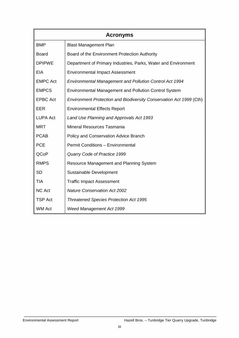
Acronyms
BMP Blast Management Plan
Board Board of the Environment Protection Authority
DPIPWE Department of Primary Industries, Parks, Water and Environment
EIA Environmental Impact Assessment
EMPC Act Environmental Management and Pollution Control Act 1994
EMPCS Environmental Management and Pollution Control System
EPBC Act Environment Protection and Biodiversity Conservation Act 1999 (Cth)
EER Environmental Effects Report
LUPA Act Land Use Planning and Approvals Act 1993
MRT Mineral Resources Tasmania
PCAB Policy and Conservation Advice Branch
PCE Permit Conditions – Environmental
QCoP Quarry Code of Practice 1999
RMPS Resource Management and Planning System
SD Sustainable Development
TIA Traffic Impact Assessment
NC Act Nature Conservation Act 2002
TSP Act Threatened Species Protection Act 1995
WM Act Weed Management Act 1999
Environmental Assessment Report Hazell Bros. – Tunbridge Tier Quarry Upgrade, Tunbridge
IV
Report summary
This report provides an environmental assessment of Hazell Bros. Group Pty Ltd’s proposed Tunbridge Tier Quarry upgrade. The proposal involves an upgrade of an existing dolerite quarry located 3.8 km west of the township of Tunbridge off Tunbridge Tier Road. The proponent is seeking approval to increase the maximum permitted production from 5,000m3 to 70,000m3 of dolerite-derived products per annum. The proposal includes blasting, crushing and screening of materials. This report has been prepared based on information provided by the proponent in the Environmental Effects Report (EER). Relevant government agencies and the public have been consulted and their submissions and comments considered as part of this assessment. Further details of the assessment process are presented in section 1 of this report. Section 2 describes the statutory objectives and principles underpinning the assessment. Details of the proposal are provided in section 3. Section 4 reviews the need for the proposal and considers the proposal, site and design alternatives. Section 5 summarises the public and agency consultation process. The detailed evaluation of key issues is in section 6, and other issues are evaluated in section 7 and Appendix 1. The report conclusions are contained in section 8. Appendix 2 contains details of comments made and issues raised in the consultation process. Attachment 2 of the permit conditions contains the table of commitments from the EER. The environmental permit conditions in Appendix 3 are a new set of operating conditions for the entire, intensified activity that will supersede the existing permit conditions.
Environmental Assessment Report Hazell Bros. – Tunbridge Tier Quarry Upgrade, Tunbridge
V
Table of Contents
1 Approvals process .................................................................................... 1
2 SD objectives and EIA principles .............................................................. 2
3 The proposal ............................................................................................ 3
4 Need for proposal and alternatives ......................................................... 14
5 Public and agency consultation .............................................................. 15
6 Evaluation of key issues ......................................................................... 16
6.1 Threatened Flora & Fauna .............................................................................................. 16 6.2 Noise emissions .............................................................................................................. 20
7 Other issues ........................................................................................... 23
8 Report conclusions ................................................................................. 24
9 References ............................................................................................. 26
10 Appendices ......................................................................................... 27
Appendix 1 Assessment of other issues .............................................................................. 28 Appendix 2 Summary of public and agency submissions .................................................... 40 Appendix 3 Permit Conditions – Environmental No. 9294 .................................................... 41

Environmental Assessment Report Hazell Bros. – Tunbridge Tier Quarry Upgrade, Tunbridge
1
1 Approvals process
A Notice of Intent in relation to the proposal was received by the Board of the Environment Protection Authority (the Board) on 7 July 2015. An application for a permit under the Land Use Planning and Approvals Act 1993 (LUPA Act) in relation to the proposal was submitted to Northern Midlands Council on 4 December 2015. The proposal is defined as a ‘level 2 activity’ under clauses 5(a) and 6(a)(ii), Schedule 2 of the Environmental Management and Pollution Control Act 1994 (EMPC Act), being production of more than 5,000 cubic metres of rock or gravel per year; and materials handling (crushing / screening) of rocks, ores or minerals in excess of 1,000 cubic metres per year. Section 25(1) of the EMPC Act required Council to refer the application to the Board of the Environment Protection Authority (the Board) for assessment under the Act. The application was received by the Board on 4 December 2015. The assessment has been undertaken by the Director, Environment Protection Authority under delegation from the Board. The Board required that information to support the proposal be provided in the form of an Environmental Effects Report (EER) prepared in accordance with guidelines issued by the Board on 25 August 2015. Several drafts of the EER were submitted to the EPA for comment prior to its finalisation and acceptance on behalf of the Board. The final EER was submitted to Council with the permit application. The EER was released for public inspection for a 28-day period commencing on 9 December 2015. An advertisement was placed in The Examiner and on the EPA website. The EER was also referred at that time to relevant government agencies for comment. No public submissions were received.
Environmental Assessment Report Hazell Bros. – Tunbridge Tier Quarry Upgrade, Tunbridge
2
2 SD objectives and EIA principles
The proposal must be considered by the Delegate in the context of the objectives of the Resource Management and Planning System of Tasmania (RMPS), and in the context of the objectives of the Environmental Management and Pollution Control System (EMPCS) (both sets of objectives are specified in Schedule 1 the EMPC Act). The functions of the Board are to administer and enforce the provisions of the Act, and in particular to use its best endeavours to further the RMPS and EMPCS objectives.
The Delegate must undertake the assessment of the proposal in accordance with the Environmental Impact Assessment Principles defined in Section 74 of the EMPC Act.

Environmental Assessment Report Hazell Bros. – Tunbridge Tier Quarry Upgrade, Tunbridge
3
3 The proposal
The main characteristics of the proposal are summarised in Table 1. A detailed description of the proposal is provided in Section 1 of the EER. Table 1: Summary of the proposal’s main characteristics
Activity
Extraction, crushing and screening of a maximum of 70,000 cubic metres of dolerite-derived products per annum.
Location and planning context
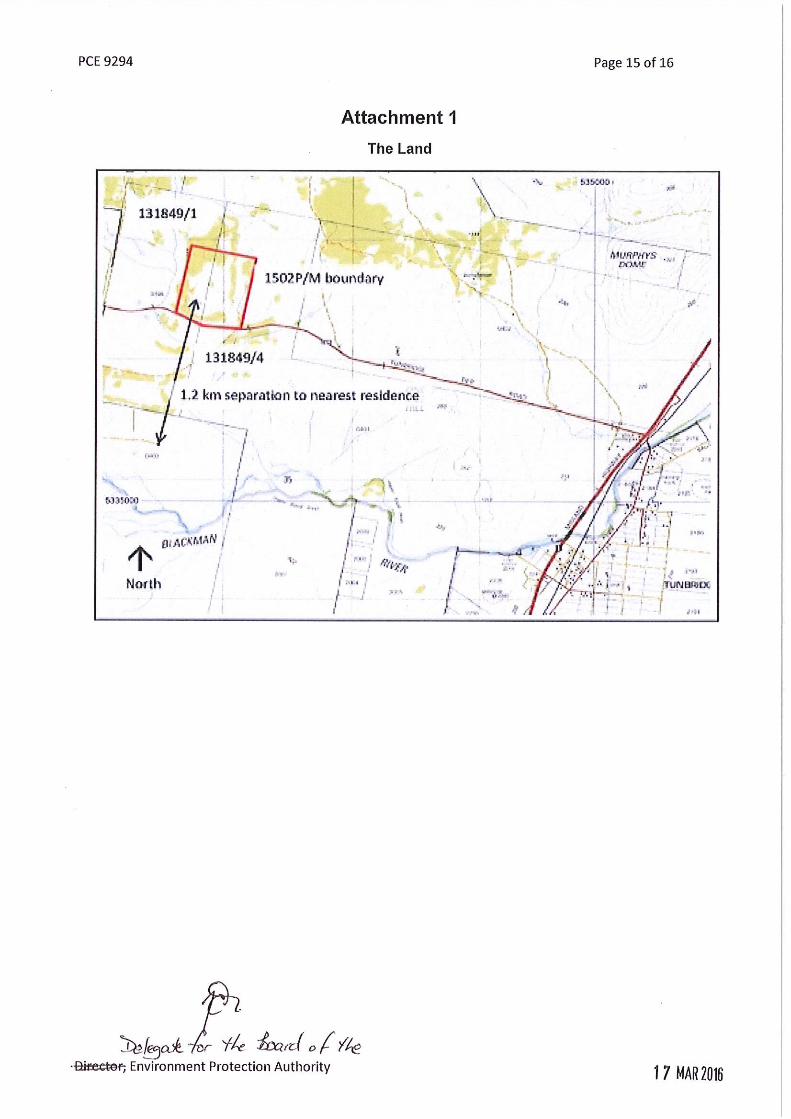
Location 78 Tunbridge Tier Road, Tunbridge.
The Land is defined as that area within the boundary of mining lease 1502P/M (Figure 1).
Land zoning Rural resource (Northern Midlands Interim Planning Scheme 2013).
Land tenure Private, located within PID 6832983 and CTs 131849/1 and 131849/4.
Mining lease 1502P/M
Lease area 32 hectares
Bond Mineral Resources Tasmania (MRT) advised that this proposal will result in a significant increase to the area of disturbance on the mining lease and that the security deposit was revised to $45,000 based on an area of 4.5 ha disturbed for mining lease 1502P/M. However, on 9 March 2016 the proponent informed MRT that the required area to be disturbed was 6 ha. MRT subsequently advised on 9 March 2016 that the required security deposit will be revised to $60,000 based on 6 ha disturbed.
Existing site
Land Use Formerly grazing land. There is a current level 2 quarry operating at the site. A historic quarry pit that has been abandoned also exists within the mining lease.
Topography The quarry is situated on a low hummock in a landscape with generally low relief. A watercourse, a tributary to the Blackman River, runs approximately 50m to the west of the mining lease.
Geology Dolerite (tholeiitic) with locally developed granophyre. The western edge of the mining lease also contains sand gravel and mud of alluvial, lacustrine and littoral origin.
Soils Dolerite derived red-brown medium clay.
Hydrology The quarry is located within the Macquarie River catchment. A tributary to the Blackman River (which eventually reports to the Macquarie River), runs approximately 50m to the west of the mining lease. This natural watercourse is located within a flat and waterlogged area containing swampy wetlands (Figure 7).
Fauna There are no records on the mining lease of threatened fauna species. However, potential habitat for EPBC Act listed fauna species exists within the mining lease.
Environmental Assessment Report Hazell Bros. – Tunbridge Tier Quarry Upgrade, Tunbridge
4
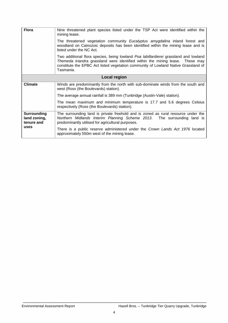
Flora Nine threatened plant species listed under the TSP Act were identified within the mining lease.
The threatened vegetation community Eucalyptus amygdalina inland forest and woodland on Cainozoic deposits has been identified within the mining lease and is listed under the NC Act.
Two additional flora species, being lowland Poa labillardierei grassland and lowland Themeda triandra grassland were identified within the mining lease. These may constitute the EPBC Act listed vegetation community of Lowland Native Grassland of Tasmania.
Local region
Climate Winds are predominantly from the north with sub-dominate winds from the south and west (Ross (the Boulevards) station).
The average annual rainfall is 389 mm (Tunbridge (Austin-Vale) station).
The mean maximum and minimum temperature is 17.7 and 5.6 degrees Celsius respectively (Ross (the Boulevards) station).
Surrounding land zoning, tenure and uses
The surrounding land is private freehold and is zoned as rural resource under the Northern Midlands Interim Planning Scheme 2013. The surrounding land is predominantly utilised for agricultural purposes.
There is a public reserve administered under the Crown Lands Act 1976 located approximately 550m west of the mining lease.

Environmental Assessment Report Hazell Bros. – Tunbridge Tier Quarry Upgrade, Tunbridge
5
Species of conservation significance
The following threatened flora species / community have been recorded within the mining lease area (refer to the Ecological Assessment Report in Appendix 1 of the EER):
Chocolate Lily (Arthropodium strictum);
Knotty Speargrass (Austrostipa nodosa);
Sickle Speargrass (Austrostipa scabra subsp. falcata);
Pretty Pearlflower (Cryptandra amara);
Tufted Knawel (Scleranthus diander);
Grassland Candles (Stackhousia subterranea);
Smooth New-Holland-Daisy (Vittadinia burbidgeae);
Fuzzy New-Holland-Daisy (Vittadinia cuneata var. cuneata);
Woolly New-Holland-Daisy (Vittadinia gracilis);
Lowland Poa labillardierei Grassland;
Lowland Themeda triandra Grassland; and
Eucalyptus amygdalina inland forest and woodland on Cainozoic deposits.
Grassland Riceflower (Pimelea sp. Tunbridge) was also recorded within the mining lease, this species is currently not listed but has been approved for listing under the TSP Act.
Additionally the natural watercourse and wetland area located adjacent to the western side of the mining lease supports Saline aquatic herbland which is listed under the NC Act.
No threatened fauna was detected by on-ground surveys within the mining lease, however, potential habitat for the following species has been identified (Appendix 1 of the EER):
Tasmanian Devil (Sarcophilus harrisii);
Spotted-tailed Quoll (Dasyurus maculatus subsp. maculatus);
Tasmanian Masked Owl (Tyto novaehollandiae subsp. castanops)
Tussock Skink (Pseudemoia pagenstecheri); and
Eastern Barred Bandicoot (Perameles gunnii subsp. gunnii).
Proposed infrastructure
Major equipment
Wheel loader (Cat 966);
Jaw Crusher (Sandvick UJ 440);
Cone Crusher (45” Eljay);
Screen (Extec E7);
Auspactor VSI;
6 light combination trucks (approx. 32 tonne loads);
Drill rig (Sandvick 900); and
Excavator (Komatsu PC300).
Other infrastructure
Conveyer(s);
Site drainage (intercept drains and a culvert);
Sediment retention basin;
Access road and gate; and
Relocatable toilets (e.g. porta-loos);
Service / refuelling vehicles;

Environmental Assessment Report Hazell Bros. – Tunbridge Tier Quarry Upgrade, Tunbridge
6
Product and overburden / top soil stockpiles / windrows.
Inputs
Water Water for dust suppression (for wetting of loads or use of water jets on the conveyor).
Energy Fuel and lubricants for the equipment noted above will be brought onto the site in utility vehicles.
Other raw materials
Explosives brought onto the site as required.
Wastes and emissions
Liquid Stormwater runoff from extraction / stockpile areas. Relocatable toilet holding tanks.
Atmospheric Dust from internal and external traffic, materials handling, blow-off from stockpiles, screening/crushing and blasting.
Solid General refuse including food scraps, paper, packaging and any wastes associated with machine repairs / routine servicing of equipment.
Controlled wastes
Nil.
Noise Noise from crushing and screening, excavating, vehicle movements on site and going to and from the site, drilling and blasting.
Greenhouse gases
Use of machinery and vehicles will consume fossil fuels and produce greenhouse gas emissions.
Construction and operations
Proposal timetable
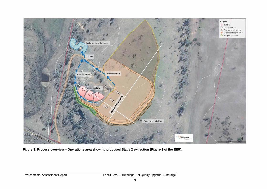
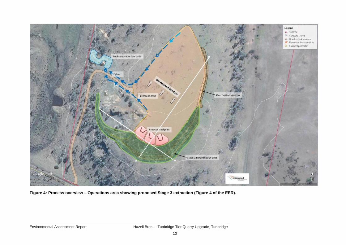
According to the EER it will be possible to develop three faces approximately 12 metres high (with a catch area of 5 metres) and up to 270 metres wide extending first to the east and then to the north. It is expected that from early 2016 stripping of previously undisturbed areas will commence as required by various road contract works.
Figures 2, 3 and 4 outline the proposed staged approach to the development of the quarry. Stage 1 of the quarry development commenced, under the existing Level 2 permit, in the later part of 2015.
Operating hours (ongoing)
0700 to 1900 hours, Monday to Friday.
0800 to 1600 hours Saturday.
No work on Sunday or Public Holidays.
Environmental Assessment Report Hazell Bros. – Tunbridge Tier Quarry Upgrade, Tunbridge
7
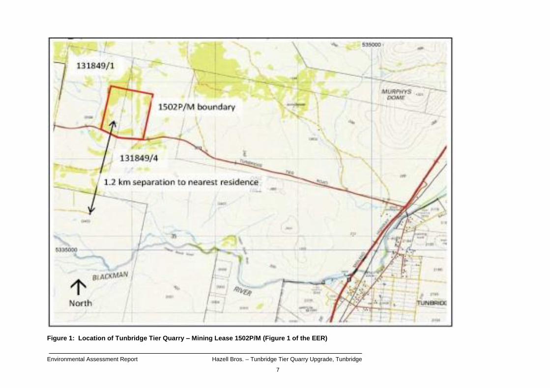
Figure 1: Location of Tunbridge Tier Quarry – Mining Lease 1502P/M (Figure 1 of the EER)

Environmental Assessment Report Hazell Bros. – Tunbridge Tier Quarry Upgrade, Tunbridge
8
Figure 2: Site plan showing mining lease 1502P/M and the ultimate footprint of the quarry (Figure 2 of the EER).
Environmental Assessment Report Hazell Bros. – Tunbridge Tier Quarry Upgrade, Tunbridge
9
Figure 3: Process overview – Operations area showing proposed Stage 2 extraction (Figure 3 of the EER).
Environmental Assessment Report Hazell Bros. – Tunbridge Tier Quarry Upgrade, Tunbridge
10
Figure 4: Process overview – Operations area showing proposed Stage 3 extraction (Figure 4 of the EER).
Environmental Assessment Report Hazell Bros. – Tunbridge Tier Quarry Upgrade, Tunbridge
11
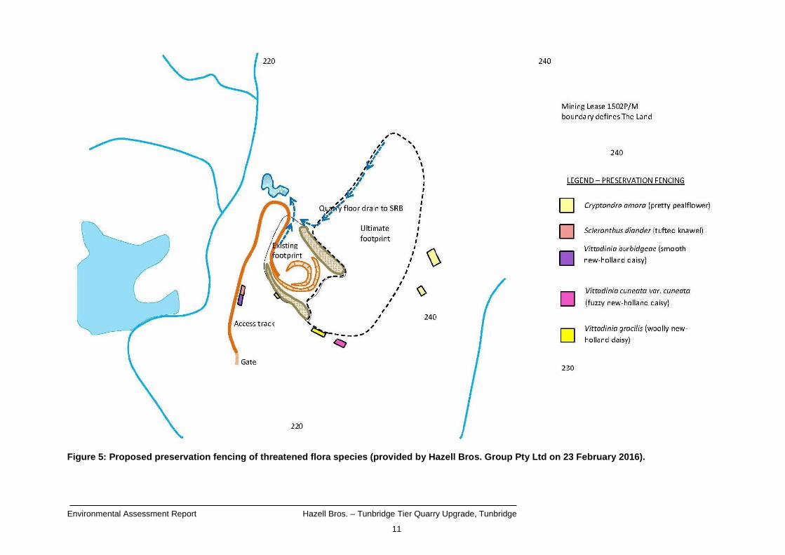
Figure 5: Proposed preservation fencing of threatened flora species (provided by Hazell Bros. Group Pty Ltd on 23 February 2016).

Environmental Assessment Report Hazell Bros. – Tunbridge Tier Quarry Upgrade, Tunbridge
12
TasVeg Code
Community Name TasVeg Code
Community Name
DAD Eucalyptus amygdalina forest and woodland on dolerite
GPL Lowland Poa labillardierei grassland
DAZ Eucalyptus amygdalina inland forest
and woodland on Cainozoic deposits GRP Rockplate grassland
FAG Agricultural land GTL Lowland Themeda triandra grassland
FUM Extra-urban miscellaneous NBA Bursaria - Acacia woodland and scrub
GCL Lowland grassland complex
Figure 6: Revised vegetation community mapping (Figure 6 of the Ecological Assessment Report).

Environmental Assessment Report Hazell Bros. – Tunbridge Tier Quarry Upgrade, Tunbridge
13
Figure 7: Mining lease 1502P/M showing the tributary to the west of the mining lease and Blackman River (LISTmap, February 2016).

Environmental Assessment Report Hazell Bros. – Tunbridge Tier Quarry Upgrade, Tunbridge
14
4 Need for proposal and alternatives
According to the EER, the Tunbridge Quarry was originally established to supply aggregates and gravels for road construction projects in the Tunbridge region. The EER notes that the State Government has recently announced an extensive program of Midland Highway upgrade works that are intended to be delivered over the next 10 years. The EER indicates that there are few quality high production limit dolerite quarries located in the central portion of the Midland Highway and that the upgraded Tunbridge Tier Quarry will be ideally located to service road construction projects on the Midland Highway without extensive cartage distances and costs. The EER states that the alternative would be to supply the road construction projects on the Midland Highway by carting product from major quarries located in the south or north of the state and that the extra cartage required would add to the cost of the materials which would be reflected in the contract prices paid by the taxpayers of Tasmania. The EER also notes that this alternative would add more heavy vehicles to the already significant freight load carried by the Midland Highway which would add to congestion and frustration experienced by road users.
Environmental Assessment Report Hazell Bros. – Tunbridge Tier Quarry Upgrade, Tunbridge
15
5 Public and agency consultation
A summary of the government agency/body submissions is contained in Appendix 2 of this report. No public representations were received. The EER was referred to a number of government agencies / bodies with an interest in the proposal. Responses were received from the following:
State Growth; and
Mineral Resources Tasmania.
The following Divisions / areas of the Department of Primary Industries, Parks, Water and Environment also provided submissions on the EER:
Heritage Tasmania; and
Policy and Conservation Advice Branch.

Environmental Assessment Report Hazell Bros. – Tunbridge Tier Quarry Upgrade, Tunbridge
16
6 Evaluation of key issues
The key environmental issues relevant to the proposal that were identified for detailed evaluation in this report were:
Threatened flora and fauna; and
Noise emissions (drilling, blasting, crushing, screening, mobile equipment and truck movements).
Each of these issues is discussed in the following subsections.
6.1 Threatened Flora & Fauna
Description
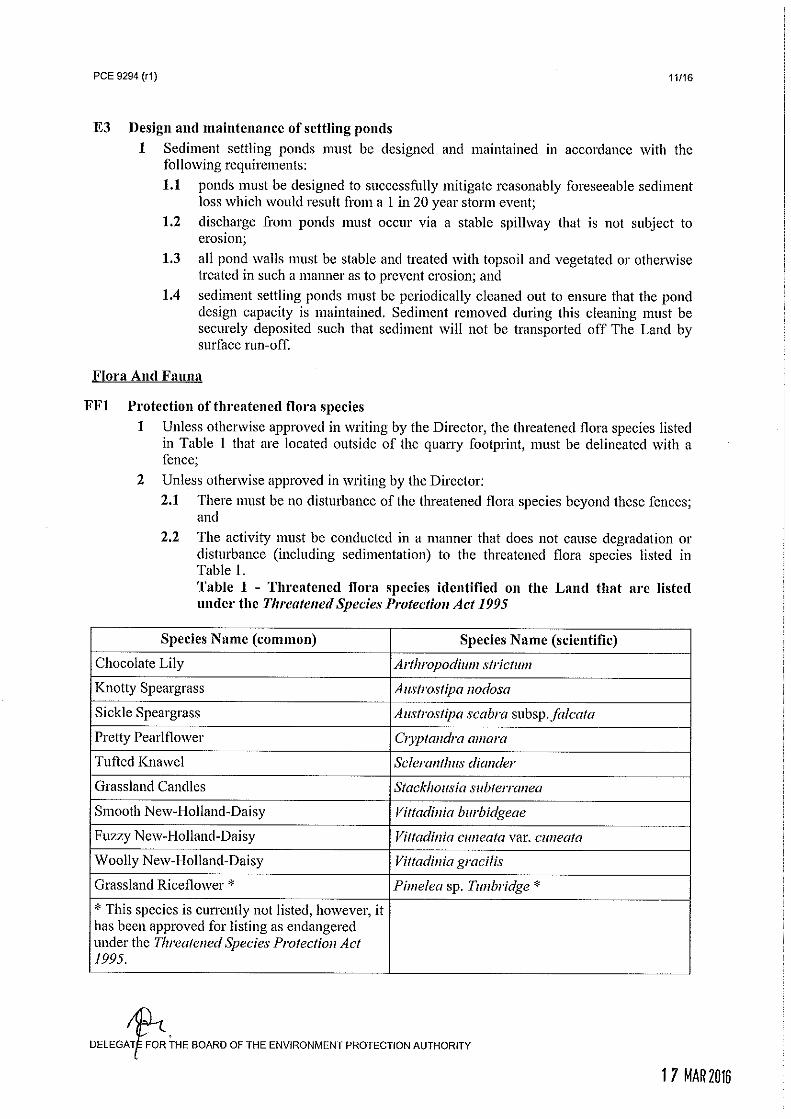
According to the EER the ultimate footprint of the quarry will disturb an area that is mapped predominantly as agricultural land with a small copse of Eucalyptus rodwayi woodland. The EER goes on to state that there are numerous records of threatened flora species listed under both Commonwealth and State legislation in the vicinity of the quarry. The EER outlines the finding of the preliminary (winter) and follow-up (spring) botanical surveys that were conducted at the site. The report entitled ‘Ecological Assessment of Tunbridge Tier Road Dolerite Quarry, Tunbridge, Tasmania’ (the Ecological Assessment Report) dated 15 November 2015 and written by Environmental Consulting Options Tasmania (ECOtas) was included as Appendix 1 of the EER and details the surveys undertaken. According to the EER the preliminary study identified threatened flora species that had colonised previously disturbed areas (e.g. overburden stockpiles; quarry benches, faces and floor) that had resulted from previous quarry operations and a permit to take threatened species listed under the Threatened Species Protection Act 1995 (Permit to Take) was required to allow the operator to undertake extractive operations in accordance with the existing Permit to Take conditions as the listed species would be disturbed. The Ecological Assessment Report listed the following Threatened Species Protection Act 1995 (TSP Act) listed threatened flora species as having been detected within the mining lease area:
Chocolate Lily (Arthropodium strictum);
Knotty Speargrass (Austrostipa nodosa);
Sickle Speargrass (Austrostipa scabra subsp. falcata);
Pretty Pearlflower (Cryptandra amara);
Tufted Knawel (Scleranthus diander);
Grassland Candles (Stackhousia subterranea);
Smooth New-Holland-Daisy (Vittadinia burbidgeae);
Fuzzy New-Holland-Daisy (Vittadinia cuneata var. cuneata); and
Woolly New-Holland-Daisy (Vittadinia gracilis); There were database records of an additional four species listed under the TSP Act that could not be located by the on-ground surveys, including:
Environmental Assessment Report Hazell Bros. – Tunbridge Tier Quarry Upgrade, Tunbridge
17
Grassland Cupflower (Colobanthus curtisiae);
Moss Sunray (Hyalosperma demissum);
Grass Cushion (Isoetopsis graminifolia); and
Grassland Paperdaisy (Leucochrysum albicans var. tricolor). Grassland Riceflower (Pimelea sp. Tunbridge) was also detected. While it is currently not a listed species, it has been approved for listing as endangered under the TSP Act. The surveys undertaken, as outlined in The Ecological Assessment Report provided an updated vegetation map of the site after the surveys had been undertaken, a number of vegetation communities were mapped within the mining lease (refer to Figure 6), including Eucalyptus amygdalina inland forest and woodland on Cainozoic deposits, which is a threatened vegetation community listed under the Nature Conservation Act 2002 (NC Act). The Ecological Assessment Report notes that areas mapped as lowland Poa labillardierei grassland and lowland Themeda triandra grassland were identified just within the mining lease (but well outside the area of proposed expansion), and may constitute the Environment Protection and Biodiversity Conservation Act 1999 (EPBC Act) listed vegetation community Lowland Native Grassland of Tasmania. Additionally, the Ecological Assessment Report states that the natural watercourse and wetland area located adjacent to the western side of the mining lease supports Saline Aquatic Herbland which is listed under the NC Act. The Conservation of Freshwater Ecosystem Values (CFEV) program lists the Conservation Management Priority as being very high (Part C – Section 2 of the EER). Of the species listed above, Austrostipa scabra subsp. falcate, Vittadinia cuneata var. cuneate and Austrostipa nodosa are the only species that will be directly disturbed from the quarry expansion, all other species lie outside of the proposed expansion footprint. While only three of the threatened flora species identified above are expected to be directly impacted by the quarry expansion, there is potential for accidental disturbance should heavy machinery move into these areas without being aware of the threatened flora. There is also the potential for threatened flora, both on and off-site, to be impacted by sediment erosion on-site. The Ecological Assessment Report indicated that no threatened fauna was detected by on-ground surveys within the mining lease, however, did note that the site supports potential habitat for the following species:
Tasmanian Devil (Sarcophilus harrisii);
Spotted-tailed Quoll (Dasyurus maculatus subsp. maculatus);
Tasmanian Masked Owl (Tyto novaehollandiae subsp. castanops);
Tussock Skink (Pseudemoia pagenstecheri); and
Eastern Barred Bandicoot (Perameles gunnii subsp. gunnii).
Management measures
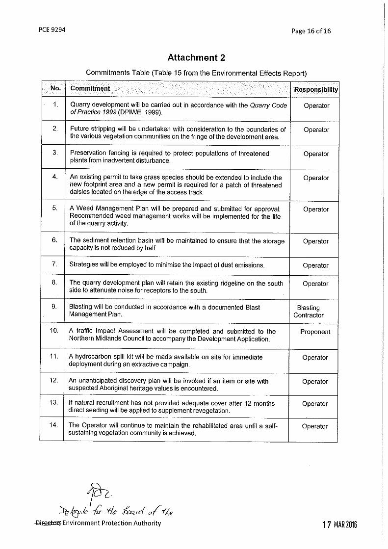
The following management commitments were proposed in the EER:
EER Commitment 2 – Future stripping will be undertaken with consideration to the boundaries of the various vegetation communities on the fringe of the development area.
Environmental Assessment Report Hazell Bros. – Tunbridge Tier Quarry Upgrade, Tunbridge
18
EER Commitment 3 – Preservation fencing is required to protect populations of threatened plants from inadvertent disturbance.
EER Commitment 4 – An existing permit to take grass species will be extended to include the new footprint area and an application for a new permit for a patch of threatened daisies located on the edge of the access track will be lodged.
Other mitigation measures outlined in the EER included:
The proponent intends to install infrastructure that will ensure any run-off at the site is collected in a sediment retention basin to ensure that sediment has settled out before being discharged to the receiving aquatic environment.
Public and agency comment and responses
The Policy and Conservation Advice Branch (PCAB) noted that a commitment has been made to amend a current Permit to Take and seek a new Permit to Take from PCAB for the species, as applicable. This was in reference to Austrostipa scabra subsp. falcate, Vittadinia cuneate var. cuneate and Austrostipa nodosa which are expected to be impacted upon by the works. PCAB also noted that a Permit to Take will also be required for using Austrostipa scabra and Austrostipa nodosa in rehabilitation works. While PCAB did suggest minor wording changes to the two commitments (2 and 3), they were supportive of the approach outlined by the proponent.
Evaluation
It is clear that there are a number of threatened flora species present within the mining lease and that areas of some of these species will be disturbed as part of the quarry expansion, however, the proponent has committed to extending a current Permit to Take (for Austrostipa nodosa and Austrostipa scabra subsp. falcata) to include the new proposed footprint and to obtain a Permit to Take for an area of Vittadinia cuneata var. cuneata located within the proposed quarry footprint. PCAB supported this commitment. In addition the proponent has committed (commitment 3) to fencing off threatened flora species that are not intended to be disturbed as part of the quarry expansion and to take into consideration the location of threatened vegetation communities (commitment 2 – as identified in Figure 6) when undertaking future stripping works. Figure 5 identifies the areas that are proposed to be fenced off to prevent inadvertent disturbance of threatened flora species. It is noted that all threatened flora locations are not proposed to be fenced off, only those in close proximity to the quarry footprint, and this is considered appropriate as disturbance from machinery is considered unlikely for the remaining areas. Nevertheless, condition FF1 requires the activity to be conducted in such a manner that degradation or disturbance of these threatened flora species does not occur. While PCAB did suggest minor wording changes to the two commitments (2 and 3), they were supportive of the approach outlined by the proponent. As these commitments are required through conditions FF1 and FF2 it was determined that a supplement to the EER, including an update to commitments, was not required. The proponent was made aware of PCAB’s comments. The areas which may potentially constitute EPBC Act listed Lowland Native Grassland of Tasmania (see Figure 6 (GTL and GPL)) were noted to be located well outside the area of the proposed quarry expansion footprint and unlikely to be directly impacted, therefore referral under

Environmental Assessment Report Hazell Bros. – Tunbridge Tier Quarry Upgrade, Tunbridge
19
the EPBC Act was not considered necessary by the proponent. Additionally, condition FF2 requires the activity to be conducted in such a manner that degradation or disturbance of the threatened vegetation communities does not occur. While it is noted that Saline Aquatic Herbland (listed under the NC Act) is located to the western side of the mining lease, the installation of stormwater management infrastructure will be required under conditions E1, E2 and E3 to ensure that any water discharged from the Land will not cause environmental harm or nuisance (stormwater and sediment management is discussed further in the other issues section (issue 3)). Potential habitat for several threatened fauna species was located within the mining lease. The Ecological Assessment Report indicated that much of the habitat is not present within the quarry works area or is of marginal quality. PCAB provided advice on earlier versions of the EER suggesting that there is unlikely to be an impact on the listed threatened fauna species with potential habitat located within the mining lease. Therefore, conditions in relation to threatened fauna are not considered necessary.
Conclusions
The proponent will be required to comply with the following site specific conditions:
FF1 Protection of threatened flora species
FF2 Protection of threatened vegetation communities The proponent will also be required to comply with the following standard (generic) conditions:
E1 Perimeter drains
E2 Stormwater
E3 Design and maintenance of settling ponds The person responsible has a general environmental duty to conduct the activity in accordance with the commitments contained in Attachment 2 of the permit conditions (OI3).

Environmental Assessment Report Hazell Bros. – Tunbridge Tier Quarry Upgrade, Tunbridge
20
6.2 Noise emissions
Description
The quarry upgrade will be operated on a campaign style basis; the expected duration of campaigns was not detailed in the EER. The EER states that through the course of a campaign various items of mobile equipment will be mobilised on site and utilised for various operations (see Section 3 for a complete list) and that once the machine has completed its task, and should it not be required for subsequent operations, that it will then be demobilised. Noise emissions during campaigns will result from the use of:
The drill rig and blasting;
The crusher / screener plant; and
On-site mobile ancillary equipment (e.g. excavator, loader, trucks and other vehicles). The quarry is located on an exposed ridgeline approximately 4km northwest of the township of Tunbridge on a low hummock in a landscape with generally low relief. According to the EER, the proposed quarry faces will be situated so that they are orientated to the west (see Figures 3 and 4) with the southern portion of the ridgeline being retained. It notes that by retaining this southern ridgeline along with the low overburden windrows placed above it will create a substantial topographical barrier attenuating noise from receptors located to the south and east of the site. Quarry development will initially proceed east and later to the north from the existing pit (see Figures 3 and 4 for the stages of expansions). Ultimately it is proposed to develop three faces approximately 12m high (with a catch area of 5m) and up to 270m wide. The nearest sensitive receptor is located approximately 1.2km south of the site (see Figure 1). The EER did not provide an estimate of the noise levels predicted to be produced by the various pieces of equipment to be utilised during campaigns, nor did it include consideration of noise impacts from transport. Blasting will occur as part of the quarry development. The existing quarry had not operated for a number of years until recently resuming extraction under the existing licence. One blast has been undertaken. The EER states that each blast will liberate around 10,000 cubic metres of product and that a total of 7 blasts per year are anticipated. According to the EER blasting will be conducted by a fully qualified and experienced blasting contractor that will employ techniques to minimise air blast overpressure, ground vibration and fly rock impacts as detailed in the Blast Management Plan contained in Appendix 2 of the EER.
Management measures
The following management measures were proposed in the EER:
EER Commitment 1 – Quarry development will be carried out in accordance with the Quarry Code of Practice 1999;
EER Commitment 8 – The quarry development plan will retain the existing ridgeline on the south side to attenuate noise for receptors to the south; and
Environmental Assessment Report Hazell Bros. – Tunbridge Tier Quarry Upgrade, Tunbridge
21
EER Commitment 9 – Blasting will be conducted in accordance with a documented Blast Management Plan.
Measures to be applied during the preparation of a blast, as outlined in the Blast Management Plan for HBMI Tunbidge Quarry (see Appendix 2 of the EER for the plan), include:
Blasts will only be undertaken between 1000 and 1600 hours Monday to Friday. No blasts will be undertaken on weekends or public holidays unless prior approval from the relevant authority has been obtained.
The blast contractor will notify the Tasmanian Police Radio Room and the Northern Midlands Council on the day of the planned blast, while Hazell Bros. will notify the local residences / businesses.
Use of a staggered drilling pattern (2.1m x 2.2m) with the average hole depth of 10m and diameter of 89mm, along with a minimum stemming height of 1.8 m will be used. Stemmings will be between 8mm and 14mm.
The EER notes that the use of software to generate the blast design including the above mentioned parameters will be used to keep air blast overpressure below 120dB (Lin Peak) and reduce any vibration issues.
The EER states that while ground vibration is not a concern (due to the distance to the nearest dwelling) vibration will be monitored to ascertain and record vibration levels.
Public and agency comment and responses
No public or agency comments were received in relation to noise emissions.
Evaluation
The nearest sensitive use (a rural residence) is located approximately 1.2km south of the proposed quarry site and lies outside the standard recommended attenuation distances for crushing/screening (750m) and blasting (1,000m) as recommended in the Quarry Code of Practice 1999. The orientation of the quarry faces to the west and north, and the retention of the southern ridgeline of the hummock means that there is no clear line of sight between the quarry floor working area and the residences to the south and east, which will assist in attenuating noise emissions from the quarry activities. The EER states that quarry development will be carried out in accordance with the Quarry Code of Practice 1999 (QCoP), including the hours of operation, which are proposed as 0700 to 1900hrs Monday to Friday, 0800 to 1600hrs on Saturdays with no operations occurring on Sundays and public holidays. Operational hours are explicitly stated in standard condition N1. In addition, condition G7 requires that the activity must be undertaken in accordance with the QCoP. The orientation of the quarry faces and the blast design outlined in the Blast Management Plan (refer to Appendix 2 of the EER) will help reduce the impacts from blasting towards the south and east. Blasting hours will be restricted in condition B1 from 1000 to 1600hrs Monday to Friday with no blasting to occur on Saturdays, Sundays or public holidays without the written approval of the Director, EPA.

Environmental Assessment Report Hazell Bros. – Tunbridge Tier Quarry Upgrade, Tunbridge
22
Environmental nuisance arising from quarry noise as a result of an increase in production is considered unlikely. The conditions detailed below will help ensure that noise emissions are appropriately managed. Given the distance to the nearest sensitive receptor (1.2km south of the site) and the topography of the site, noise and / or vibration from drilling and blasting is considered unlikely to cause a significant impact. The Blast Management Plan indicates that ground vibration will be monitored to ascertain and record vibration levels, which is supported. No specific blast monitoring or reporting condition has been included, as it is not considered necessary given the distance to the nearest sensitive receptor and the topography. It is nevertheless considered appropriate to include condition B2, to detail the appropriate limits for noise and vibration that should be met when undertaking blasting activities, and against which compliance can be audited if necessary. The Blast Management Plan indicates that a risk assessment will be undertaken (in relation to fly rock) prior to blasting to determine whether Interlaken Road (aka Tunbridge Tier Road) necessitates closure during the blast. It is also considered appropriate to require the proponent to maintain a complaints register through condition G6. Noise emissions from trucks travelling to and from the site along Tunbridge Tier Road have not been considered in the EER, however, there are no residences identified along Tunbridge Tier Road until the township of Tunbridge itself which has the Midland Highway in close vicinity and already carries a significant heavy vehicle load with considerable noise impacts.
Conclusions
The proponent will be required to comply with the following standard (generic) conditions:
N1 Operating hours
B1 Blasting times
B2 Blasting – noise and vibration limits
G6 Complaints register
G7 Quarry Code of Practice The person responsible has a general environmental duty to conduct the activity in accordance with the commitments contained in Attachment 2 of the permit conditions (OI3).

Environmental Assessment Report Hazell Bros. – Tunbridge Tier Quarry Upgrade, Tunbridge
23
7 Other issues
In addition to the key issues, the following environmental issues are considered relevant to the proposal and have been evaluated in Appendix 1.
1. Air emissions
2. Weed and disease management
3. Stormwater and sediment management
4. Cultural Heritage
5. Waste management
6. Dangerous goods and environmentally hazardous materials
7. Traffic
8. Rehabilitation
Environmental Assessment Report Hazell Bros. – Tunbridge Tier Quarry Upgrade, Tunbridge
24
8 Report conclusions
This assessment has been based upon the information provided by the proponent in the EER and in correspondence and discussion between the EPA Division and the proponent and the proponent’s representatives. This assessment has incorporated specialist advice provided by EPA Division scientific specialists and regulatory staff, other Divisions of DPIPWE and other government agencies. It is concluded that:
1. the RMPS and EMPCS objectives have been duly and properly pursued in the assessment of the proposal; and
2. the assessment of the proposal has been undertaken in accordance with the Environmental Impact Assessment Principles.
It is concluded that the proposal is capable of being managed in an environmentally acceptable manner such that it is unlikely that the RMPS and EMPCS objectives would be compromised, provided that the Permit Conditions - Environmental No. 9294 appended to this report are imposed and duly complied with, including commitments made by the proponent in the EER. The environmental conditions appended to this report are a new set of operating conditions for the entire, intensified activity that will supersede the existing Licence to Operate Scheduled Premises No. 5885.
Environmental Assessment Report Hazell Bros. – Tunbridge Tier Quarry Upgrade, Tunbridge
26
9 References
Forze Explosive Services (2015); Blast Management Plan for HBMI Tunbridge Quarry; dated 1 October 2015 (the Blast Management Plan).
Environmental Consulting Options Tasmania (ECOtas) (2015); Ecological Assessment of Tunbridge Tier Road Dolerite Quarry, Tunbridge, Tasmania; dated 15 November 2015 (the Ecological Assessment Report).
Integrated Land Management & Planning (2015); Tunbridge Quarry – Upgrade, Environmental Effects Report; dated 25 November 2015 (the EER).
Terry Eaton, Traffic Engineer (2015); Tunbridge Tier Road Quarry, Traffic Impact Assessment for Hazell Bros Group Pty Ltd; dated 7 December 2015 (the Traffic Impact Assessment).
The Department of Primary Industries, Parks, Water and Environment (DPIPWE) (2015); Weed and Disease Planning and Hygiene Guidelines - Preventing the spread of weeds and diseases in Tasmania; dated March 2015 (the Washdown Guidelines).

Environmental Assessment Report Hazell Bros. – Tunbridge Tier Quarry Upgrade, Tunbridge
27
10 Appendices
Appendix 1 Assessment of other issues Appendix 2 Summary of public and agency submissions Appendix 3 Permit Conditions – Environmental No. 9294
Appendix 1
Environmental Assessment Report Hazell Bros. – Tunbridge Tier Quarry Upgrade, Tunbridge
28
Appendix 1 Assessment of other issues
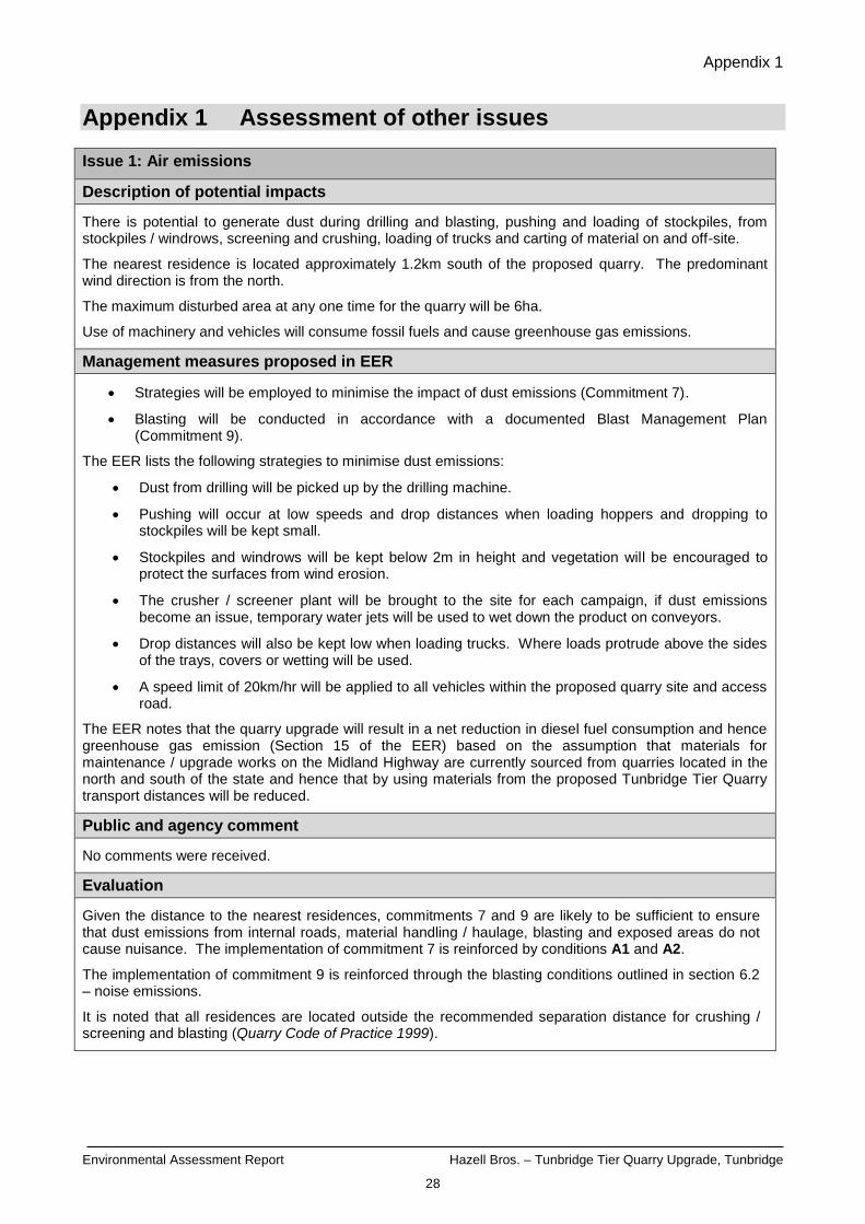
Issue 1: Air emissions
Description of potential impacts
There is potential to generate dust during drilling and blasting, pushing and loading of stockpiles, from stockpiles / windrows, screening and crushing, loading of trucks and carting of material on and off-site.
The nearest residence is located approximately 1.2km south of the proposed quarry. The predominant wind direction is from the north.
The maximum disturbed area at any one time for the quarry will be 6ha.
Use of machinery and vehicles will consume fossil fuels and cause greenhouse gas emissions.
Management measures proposed in EER
Strategies will be employed to minimise the impact of dust emissions (Commitment 7).
Blasting will be conducted in accordance with a documented Blast Management Plan (Commitment 9).
The EER lists the following strategies to minimise dust emissions:
Dust from drilling will be picked up by the drilling machine.
Pushing will occur at low speeds and drop distances when loading hoppers and dropping to stockpiles will be kept small.
Stockpiles and windrows will be kept below 2m in height and vegetation will be encouraged to protect the surfaces from wind erosion.
The crusher / screener plant will be brought to the site for each campaign, if dust emissions become an issue, temporary water jets will be used to wet down the product on conveyors.
Drop distances will also be kept low when loading trucks. Where loads protrude above the sides of the trays, covers or wetting will be used.
A speed limit of 20km/hr will be applied to all vehicles within the proposed quarry site and access road.
The EER notes that the quarry upgrade will result in a net reduction in diesel fuel consumption and hence greenhouse gas emission (Section 15 of the EER) based on the assumption that materials for maintenance / upgrade works on the Midland Highway are currently sourced from quarries located in the north and south of the state and hence that by using materials from the proposed Tunbridge Tier Quarry transport distances will be reduced.
Public and agency comment
No comments were received.
Evaluation
Given the distance to the nearest residences, commitments 7 and 9 are likely to be sufficient to ensure that dust emissions from internal roads, material handling / haulage, blasting and exposed areas do not cause nuisance. The implementation of commitment 7 is reinforced by conditions A1 and A2.
The implementation of commitment 9 is reinforced through the blasting conditions outlined in section 6.2 – noise emissions.
It is noted that all residences are located outside the recommended separation distance for crushing / screening and blasting (Quarry Code of Practice 1999).
Appendix 1
Environmental Assessment Report Hazell Bros. – Tunbridge Tier Quarry Upgrade, Tunbridge
29
Conclusion
The proponent will be required to comply with the following standard (generic) conditions:
A1 Covering of vehicles
A2 Control of dust emissions
The person responsible has a general environmental duty to conduct the activity in accordance with the commitments contained in Attachment 2 of the permit conditions (OI3).
Appendix 1
Environmental Assessment Report Hazell Bros. – Tunbridge Tier Quarry Upgrade, Tunbridge
30
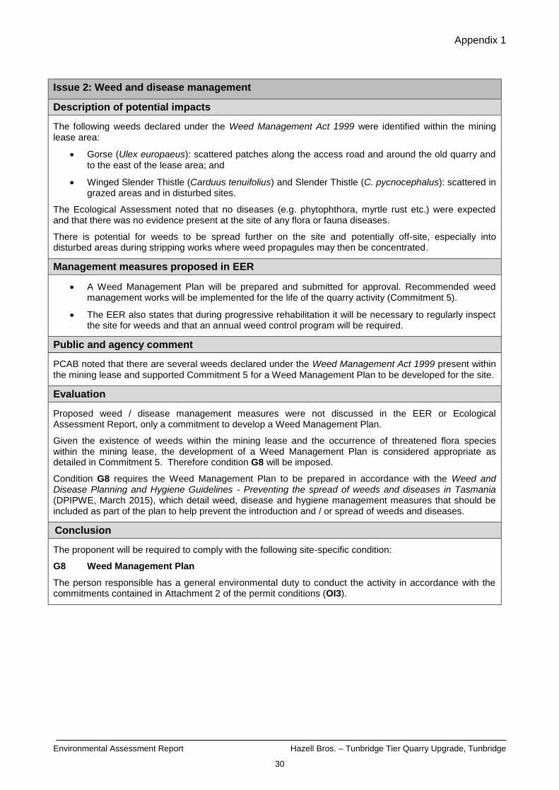
Issue 2: Weed and disease management
Description of potential impacts
The following weeds declared under the Weed Management Act 1999 were identified within the mining lease area:
Gorse (Ulex europaeus): scattered patches along the access road and around the old quarry and to the east of the lease area; and
Winged Slender Thistle (Carduus tenuifolius) and Slender Thistle (C. pycnocephalus): scattered in grazed areas and in disturbed sites.
The Ecological Assessment noted that no diseases (e.g. phytophthora, myrtle rust etc.) were expected and that there was no evidence present at the site of any flora or fauna diseases.
There is potential for weeds to be spread further on the site and potentially off-site, especially into disturbed areas during stripping works where weed propagules may then be concentrated.
Management measures proposed in EER
A Weed Management Plan will be prepared and submitted for approval. Recommended weed management works will be implemented for the life of the quarry activity (Commitment 5).
The EER also states that during progressive rehabilitation it will be necessary to regularly inspect the site for weeds and that an annual weed control program will be required.
Public and agency comment
PCAB noted that there are several weeds declared under the Weed Management Act 1999 present within the mining lease and supported Commitment 5 for a Weed Management Plan to be developed for the site.
Evaluation
Proposed weed / disease management measures were not discussed in the EER or Ecological Assessment Report, only a commitment to develop a Weed Management Plan.
Given the existence of weeds within the mining lease and the occurrence of threatened flora species within the mining lease, the development of a Weed Management Plan is considered appropriate as detailed in Commitment 5. Therefore condition G8 will be imposed.
Condition G8 requires the Weed Management Plan to be prepared in accordance with the Weed and Disease Planning and Hygiene Guidelines - Preventing the spread of weeds and diseases in Tasmania (DPIPWE, March 2015), which detail weed, disease and hygiene management measures that should be included as part of the plan to help prevent the introduction and / or spread of weeds and diseases.
Conclusion
The proponent will be required to comply with the following site-specific condition:
G8 Weed Management Plan
The person responsible has a general environmental duty to conduct the activity in accordance with the commitments contained in Attachment 2 of the permit conditions (OI3).
Appendix 1
Environmental Assessment Report Hazell Bros. – Tunbridge Tier Quarry Upgrade, Tunbridge
31
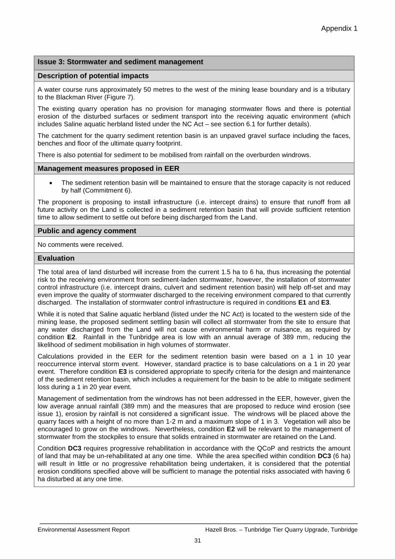
Issue 3: Stormwater and sediment management
Description of potential impacts
A water course runs approximately 50 metres to the west of the mining lease boundary and is a tributary to the Blackman River (Figure 7).
The existing quarry operation has no provision for managing stormwater flows and there is potential erosion of the disturbed surfaces or sediment transport into the receiving aquatic environment (which includes Saline aquatic herbland listed under the NC Act – see section 6.1 for further details).
The catchment for the quarry sediment retention basin is an unpaved gravel surface including the faces, benches and floor of the ultimate quarry footprint.
There is also potential for sediment to be mobilised from rainfall on the overburden windrows.
Management measures proposed in EER
The sediment retention basin will be maintained to ensure that the storage capacity is not reduced by half (Commitment 6).
The proponent is proposing to install infrastructure (i.e. intercept drains) to ensure that runoff from all future activity on the Land is collected in a sediment retention basin that will provide sufficient retention time to allow sediment to settle out before being discharged from the Land.
Public and agency comment
No comments were received.
Evaluation
The total area of land disturbed will increase from the current 1.5 ha to 6 ha, thus increasing the potential risk to the receiving environment from sediment-laden stormwater, however, the installation of stormwater control infrastructure (i.e. intercept drains, culvert and sediment retention basin) will help off-set and may even improve the quality of stormwater discharged to the receiving environment compared to that currently discharged. The installation of stormwater control infrastructure is required in conditions E1 and E3.
While it is noted that Saline aquatic herbland (listed under the NC Act) is located to the western side of the mining lease, the proposed sediment settling basin will collect all stormwater from the site to ensure that any water discharged from the Land will not cause environmental harm or nuisance, as required by condition E2. Rainfall in the Tunbridge area is low with an annual average of 389 mm, reducing the likelihood of sediment mobilisation in high volumes of stormwater.
Calculations provided in the EER for the sediment retention basin were based on a 1 in 10 year reoccurrence interval storm event. However, standard practice is to base calculations on a 1 in 20 year event. Therefore condition E3 is considered appropriate to specify criteria for the design and maintenance of the sediment retention basin, which includes a requirement for the basin to be able to mitigate sediment loss during a 1 in 20 year event.
Management of sedimentation from the windrows has not been addressed in the EER, however, given the low average annual rainfall (389 mm) and the measures that are proposed to reduce wind erosion (see issue 1), erosion by rainfall is not considered a significant issue. The windrows will be placed above the quarry faces with a height of no more than 1-2 m and a maximum slope of 1 in 3. Vegetation will also be encouraged to grow on the windrows. Nevertheless, condition E2 will be relevant to the management of stormwater from the stockpiles to ensure that solids entrained in stormwater are retained on the Land.
Condition DC3 requires progressive rehabilitation in accordance with the QCoP and restricts the amount of land that may be un-rehabilitated at any one time. While the area specified within condition DC3 (6 ha) will result in little or no progressive rehabilitation being undertaken, it is considered that the potential erosion conditions specified above will be sufficient to manage the potential risks associated with having 6 ha disturbed at any one time.
Appendix 1
Environmental Assessment Report Hazell Bros. – Tunbridge Tier Quarry Upgrade, Tunbridge
32
Conclusion
The proponent will be required to comply with the following standard (generic) conditions:
E1 Perimeter drains
E2 Stormwater
E3 Design and maintenance of settling ponds
DC3 Progressive rehabilitation
The person responsible has a general environmental duty to conduct the activity in accordance with the commitments contained in Attachment 2 of the permit conditions (OI3).

Appendix 1
Environmental Assessment Report Hazell Bros. – Tunbridge Tier Quarry Upgrade, Tunbridge
33
Issue 4: Cultural heritage
Description of potential impacts
The proposed quarry is unlikely to impact on any Aboriginal heritage. The Aboriginal Heritage Register was searched by Aboriginal Heritage Tasmania who determined that the likelihood of disturbing any Aboriginal heritage was low from the proposed quarry upgrade.
The Western Tiers Convict Road Party Site is registered on the Tasmanian Heritage Register as being located on Tunbridge Tier Road approximately 2 km west of the proposed quarry site.
Management measures proposed in EER
An unanticipated discovery plan will be invoked if an item or site with suspected Aboriginal heritage values is encountered (Commitment 12).
Public and agency comment
Heritage Tasmania noted that it had no objection to the proposed project proceeding. They did however recommend that an additional management commitment be made around the protocol for unanticipated discovery of historic cultural heritage values, as per page 2 of Heritage Tasmania’s Pre-Development Assessment Guidelines.
No public comments were received.
Evaluation
The vast majority of traffic movements will be east from the quarry to the Midland Highway and any movements to the west are considered unlikely to impact on the Western Tiers Convict Road Party Site.
Commitment 12 is supported and Heritage Tasmania’s comment regarding an additional commitment around the protocol for unanticipated discovery of historic cultural heritage values has been provided to the proponent.
The proponent is made aware of the Aboriginal Relics Act 1975 via the legal obligation clause LO3.
Conclusion
The following legal information is included in the permit:
LO3 Aboriginal relics requirements
The person responsible has a general environmental duty to conduct the activity in accordance with the commitments contained in Attachment 2 of the permit conditions (OI3).
Appendix 1
Environmental Assessment Report Hazell Bros. – Tunbridge Tier Quarry Upgrade, Tunbridge
34
Issue 5: Waste management
Description of potential impacts
All equipment and infrastructure will be cleared from the site at the end of each campaign. Wastes generated at the site will be minimal (including wastes from machinery repairs and routine maintenance and lunch items).
Management measures proposed in EER
Litter arising from lunches and routine servicing of equipment will be removed at the end of each working day.
Public and agency comment
No comments were received.
Evaluation
No specific management commitments were made in relation to waste management at the site, however it appears that minimal wastes will be produced from the activity and any wastes that are produced will be removed on a daily basis or at the end of each campaign (in the case of machine repair wastes).
Given the nature of the activity and wastes generated, specific conditions in regard to waste management are not considered necessary.
Condition G7 is included which requires that the activity undertaken must comply with the acceptable standards provisions of the Quarry Code of Practice 1999 (which includes waste management). In addition, OI1 outlines the appropriate manner in which to manage wastes (i.e. reduce wastes or re-use/recycle wastes where possible).
Conclusion
The proponent will be required to comply with the following standard (generic) conditions:
G7 Quarry Code of Practice
The following information is included in the permit:
OI1 Waste management hierarchy
Appendix 1
Environmental Assessment Report Hazell Bros. – Tunbridge Tier Quarry Upgrade, Tunbridge
35
Issue 6: Dangerous goods and environmentally hazardous material
Description of potential impacts
Mobile equipment will require a small quantity of lubricating fluids and refuelling on a daily basis during campaigns. These materials will be stored and transported in utilities. Spills may occur when machinery is being refuelled or serviced and could potentially pollute soils and waterways.
Professional blasting contractors will be used when undertaking blasting, the contractor will be appropriately licenced to handle, store and transport explosives. No explosives will be stored at the site.
Management measures proposed in EER
A hydrocarbon spill kit will be made available on site for immediate deployment during each extractive campaign (Commitment 11).
Public and agency comment
No comments were received.
Evaluation
The EER has not detailed the quantities involved nor any containment measures to be employed (e.g. lined trays on the utilities carrying fuel)
To ensure fuel, lubricating fluids and any other environmentally hazardous materials are stored and handled appropriately when on-site, condition H2 is included in the permit.
Commitment 11, to have a spill kit on-site during campaigns is considered appropriate and is required by condition H1.
LO2 is included in the permit, which provides information on the proponent’s responsibilities under other relevant legislation.
Conclusion
The proponent will be required to comply with the following standard (generic) conditions:
H1 Spill kits
H2 Storage and handling of hazardous materials
The following legal information is included in the permit:
LO2 Storage and handling of Dangerous Goods, Explosives and dangerous substances
The person responsible has a general environmental duty to conduct the activity in accordance with the commitments contained in Attachment 2 of the permit conditions (OI3).

Appendix 1
Environmental Assessment Report Hazell Bros. – Tunbridge Tier Quarry Upgrade, Tunbridge
36
Issue 7: Traffic
Description of potential impacts
The proposed quarry is located approximately 3.8km along Tunbridge Tier Road (a sealed road) from its junction with the Midland Highway at the Tunbridge township. There are no residences located along Tunbridge Tier Road between the site and the Midland Highway junction, however, there are residences located at the junction. Access to the site is via a gravel driveway some 350m long and 4m wide.
The Traffic Impact Assessment (TIA) (Appendix 3 of the EER) indicates that currently (based on 5,000 cubic metres production) there are 250 loads per annum over an approximate 10 day campaign period per annum (i.e. up to approximately 30 loads per day).
The TIA proposes to use six 32 tonne light combination trucks carting an anticipated 112,000 tonnes with up to 40 loads per day (80 two way movements per day) based on a 1.5 hr turn-around time. This would equate to approximately 1,280 tonnes per day being carted over 87.5 days per annum.
The TIA also notes that other traffic associated with the activity (e.g. staff coming and going) is estimated at up to 20 two way movements per day.
The TIA estimates current traffic volume along Tunbridge Tier Road at up to 180 vehicles per day.
There is potential for dust and noise emissions from the use of the gravel access driveway.
Management measures proposed in EER
A Traffic Impact Assessment will be completed and submitted to the Northern Midlands Council to accompany the Development Application (Commitment 10).
[The Traffic Impact Assessment was included as Appendix 3 of the EER].
Public and agency comment
The Department of State Growth indicated that as the existing Midlands Highway / Tunbridge Tier Road junction is already provided with fully channelised right and left turn facilities. State Roads had no comment to make on the proposal.
No other comments were received.
Evaluation
Advice provided by the proponent on 23 February 2016 notes that the parameters used for truck movements / days of operation etc. in the EER were very conservative and calculated prior to the TIA being completed, as the TIA was provided after the EER was finalised (due to the traffic engineer being unavailable) and the parameters were not updated in the EER. The proponent has advised that the parameters listed in the TIA supersede those presented in the EER.
While the proposal will only result in an additional 10 loads per day, the number of days of operation will be 10 fold to that currently experienced.
The potential dust emissions from truck movements along the gravel access road off Tunbridge Tier Road have not been addressed in great depth in the EER. It is considered that conditions A1 and A2 are appropriate given the nearest sensitive receptor is located 1.2km south of the site and approximately 1km south of Tunbridge Tier Road.
There are no other residences located along Tunbridge Tier Road between the site and the Midlands Highway junction, until the Midlands Highway is reached which is subject to significant heavy vehicle movements already. The proposed hours of operation are as per those recommended in the QCoP and the proponent is required to comply with those hours of operation as detailed in condition N1.
Appendix 1
Environmental Assessment Report Hazell Bros. – Tunbridge Tier Quarry Upgrade, Tunbridge
37
Conclusion
No conditions specifically relating to traffic impacts are considered necessary. Conditions A1, A2 and N1 are relevant to traffic from the quarry and are discussed under the air (Issue 1) and noise (Section 6.2) issue sections to deal with emission that may arise from traffic movements on-site.
The person responsible has a general environmental duty to conduct the activity in accordance with the commitments contained in Attachment 2 of the permit conditions (OI3).
Appendix 1
Environmental Assessment Report Hazell Bros. – Tunbridge Tier Quarry Upgrade, Tunbridge
38
Issue 8: Rehabilitation
Description of potential impacts
The increase in the area of land disturbed at any one time has the potential to increase the risks from air and stormwater / sediment emission from the Land during operations. The EER sets out a staged approach to quarrying, with stage 1 confined to the area of the quarry where vegetation has previously been cleared and stages 2 and 3 requiring additional land to be cleared. The EER indicates that up to a maximum of 6ha of land will be disturbed in total.
Should progressive rehabilitation not be conducted appropriately the risk of dust and stormwater / sediment emissions will be increased due to a larger area disturbed at any one time. There is also potential for legacy issues should the quarry close without being able to conduct post closure rehabilitation. Progressive rehabilitation ensures that the area disturbed at any one time will be minimised to the extent practicable.
Management measures proposed in EER
If natural recruitment has not provided adequate cover after 12 months direct seeding will be applied to supplement revegetation (Commitment 13).
The Operator will continue to maintain the rehabilitated area until a self-sustaining vegetation community is achieved (Commitment 14).
The proponent intends to expand the cleared area (up to a combined maximum of 6 ha disturbed in total), in two additional stages (see Figures 2, 3 & 4). Topsoil / overburden will be placed in windrows for use during rehabilitation works. Windrows will be kept small (1-2m high) and with low sloped sides (1 in 3 maximum). Natural regeneration will be used where possible (i.e. from existing material in the windrowed top soil), if after 12 months regeneration is not sufficient, direct seeding will occur.
Sediment control infrastructure (drains, culverts and sediment retention basin – see issue 3) will be monitored until such time that the site has been decommissioned to prevent erosion of sediments.
Final use of the site will be sheep grazing pasture. Overburden will be placed at the foot of the benches to reduce their height and final drill holes will be angled to reduce the slope of the final quarry faces.
Section 18 of the EER outlines the principles and basic process for rehabilitating areas that are no longer being quarried or in active use and upon decommissioning of the site.
Table 12 of the EER outlines the proposed planting schedule for quarry bench rehabilitation, including canopy, mid-storey and understorey species.
Public and agency comment
PCAB noted that a Permit to Take will be required for using Austrostipa scabra (Sickle Speargrass) and Austrostipa nodosa (Knotty Speargrass) in rehabilitation works.
Evaluation
The EER outlines the basic principal and process that is proposed for rehabilitation, including progressive and final rehabilitation measures. The rehabilitation measures outlined are broadly in line with those recommended by the QCoP.
Surface soils will be removed and stockpiled in low windrows above the quarry faces (see Figures 2, 3 & 4) where it is unlikely to be disturbed until required for re-use in rehabilitation. Condition DC2 requires the top soil to be stockpiled.
The current activity has 1.5ha disturbed; the additional 4.5ha will result in a fourfold increase in the area disturbed at any one time. The standard permit condition normally allows for a maximum of 1ha being disturbed at any one time. This matter was raised with the proponent and on 1 March 2016 the proponent provided additional advice on their justification for requiring a maximum of 6ha disturbed at any one time.
The proponent indicated that they require space for mobile crushers, manoeuvring areas for wheel loaders and trucks and stockpiling of product. The proponent also noted that it is conceivable the entire 70,000 cubic metres could be required for one project and that stockpiling of product is an important part of the

Appendix 1
Environmental Assessment Report Hazell Bros. – Tunbridge Tier Quarry Upgrade, Tunbridge
39
proposal to ensure that it can be tested appropriately and then delivered on time. The proponent indicated that they are required to stockpile in 600 tonne lots (which would result in a stockpile size of approximately 10m high and covering 100 square metres) as per Department of State Growth requirements for quality testing and that up to approximately 200 lots may be required depending on the type of product required.
The proponent states that the minimum area required for stockpiles, stores, employee facilities and manoeuvring is in excess of 3ha, which exceeds the floor area for stages 1 and 2 combined. The proponent also noted that the quarry floor will be of a fractured nature from the blasting which will help capture any run-off, thus reducing the amount of sediment that may make its way to the sediment retention basin.
The requirement for such an area to stockpile means that rehabilitation of the quarry faces on the southern and south eastern sides is impractical.
On 7 March 2016, the proponent was informed by the EPA Division that MRT required a request that the security deposit be based on 6ha, not the 4.5ha disturbed on which the previous assessment had been based. On 9 March 2016, the proponent made this request to MRT who advised that they would revise the security deposit to allow 6ha to be disturbed at any one time.
The EER states that as extractive areas become worked out they will be progressively rehabilitated to reduce the total area of the site disturbed. This is supported by the inclusion of condition DC3 requiring the proponent to carry out progressive rehabilitation in accordance with the relevant provision of the QCoP. However, this condition specifies that the maximum area of land which may remain, at any time, without rehabilitation as 6ha. While allowing 6ha to be disturbed at any one time will result in little or no progressive rehabilitation being undertaken, it is considered that the potential dust and erosion conditions specified in issues 1 and 3, along with the revised MRT security deposit, and the relatively isolated location of the site will be sufficient to manage the potential risks associated with having 6ha disturbed at any one time.
A basic list outlining the final rehabilitation process for the site is outlined in section 18.3 of the EER. The approach outlined by the proponent is supported and condition DC4 is included which requires the proponent to, upon permanent cessation of the activity, rehabilitate the site in accordance with the relevant provision of the QCoP. This condition also requires rehabilitation earthworks to be substantially completed within 12 months of permanent cessation and that the site must be monitored for a period of at least three years after rehabilitation works have been substantially completed.
The proponent is required to notify the Director, EPA of permanent cessation of the activity (condition DC1) or where a temporary suspension of activity (condition DC5) is likely to occur.
Conclusion
The proponent will be required to comply with the following standard (generic) conditions:
DC1 Notification of cessation
DC2 Stockpiling of surface soil
DC3 Progressive rehabilitation
DC4 Rehabilitation on cessation
DC5 Temporary suspension of activity
The person responsible has a general environmental duty to conduct the activity in accordance with the commitments contained in Attachment 2 of the permit conditions (OI3).
Appendix 2
Environmental Assessment Report Hazell Bros. – Tunbridge Tier Quarry Upgrade, Tunbridge
40
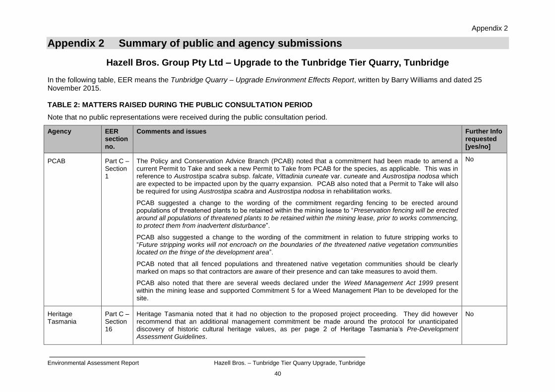
Appendix 2 Summary of public and agency submissions
Hazell Bros. Group Pty Ltd – Upgrade to the Tunbridge Tier Quarry, Tunbridge
In the following table, EER means the Tunbridge Quarry – Upgrade Environment Effects Report, written by Barry Williams and dated 25 November 2015. TABLE 2: MATTERS RAISED DURING THE PUBLIC CONSULTATION PERIOD
Note that no public representations were received during the public consultation period.
Agency EER section no.
Comments and issues Further Info requested [yes/no]
PCAB Part C – Section 1
The Policy and Conservation Advice Branch (PCAB) noted that a commitment had been made to amend a current Permit to Take and seek a new Permit to Take from PCAB for the species, as applicable. This was in reference to Austrostipa scabra subsp. falcate, Vittadinia cuneate var. cuneate and Austrostipa nodosa which are expected to be impacted upon by the quarry expansion. PCAB also noted that a Permit to Take will also be required for using Austrostipa scabra and Austrostipa nodosa in rehabilitation works.
PCAB suggested a change to the wording of the commitment regarding fencing to be erected around populations of threatened plants to be retained within the mining lease to “Preservation fencing will be erected around all populations of threatened plants to be retained within the mining lease, prior to works commencing, to protect them from inadvertent disturbance”.
PCAB also suggested a change to the wording of the commitment in relation to future stripping works to “Future stripping works will not encroach on the boundaries of the threatened native vegetation communities located on the fringe of the development area”.
PCAB noted that all fenced populations and threatened native vegetation communities should be clearly marked on maps so that contractors are aware of their presence and can take measures to avoid them.
PCAB also noted that there are several weeds declared under the Weed Management Act 1999 present within the mining lease and supported Commitment 5 for a Weed Management Plan to be developed for the site.
No
Heritage Tasmania
Part C – Section 16
Heritage Tasmania noted that it had no objection to the proposed project proceeding. They did however recommend that an additional management commitment be made around the protocol for unanticipated discovery of historic cultural heritage values, as per page 2 of Heritage Tasmania’s Pre-Development Assessment Guidelines.
No

Appendix 3
Environmental Assessment Report Hazell Bros. – Tunbridge Tier Quarry Upgrade, Tunbridge
41
Appendix 3 Permit Conditions – Environmental No. 9294