trimble match-t dsm - · pdf filetrimble geospatial sw package for: dtm and dsm generation...
TRANSCRIPT

Trimble MATCH-T DSM
Vienna, February 17th 2012
Tobias Heuchel, Trimble GeoSpatial Stuttgart

MATCH-T DSM
Trimble GeoSpatial SW package for:
DTM and DSM generation from aerial images (frame
and pushbroom sensors), and from various types of
satellite imagery (Ikonos, Quickbird, WorldView,
Spot, Landsat, IRS C/D, Aster, CartoSAT and ALOS)

MATCH-T DSM
MATCH-T DSM 5.4
Satellite (RPC)
Aerial/Frame Pushbroom (ADS)
Point Cloud in LAS format

Photogrammetric Workflow
Image Capture
UltraScan 5000
Data Capture
Summit Evolution
Orthophoto Processing
OrthoMaster OrthoVista
Imagery from digital sensors GPS & IMU data
Image Capture
Scanned imagery
Aerial Triangulation
MATCH - AT
Aerial Triangulation
MATCH-AT
Data Capture
Summit Evolution
Orthophoto Processing
OrthoMaster OrthoVista
Imagery from digital sensors GPS & IMU data
Terrain Modeling
DTMaster
MATCH - T
Terrain Modelling
DTMaster
MATCH - T


Dense matching - why not until now?
Performance test for dense matching
Handling large data sets
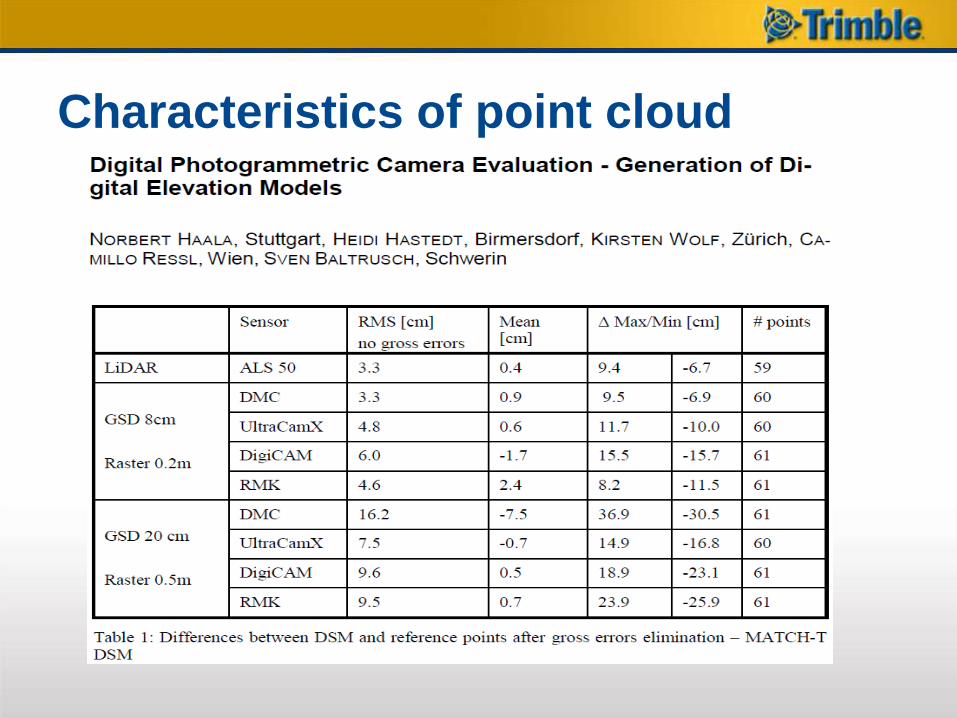
Characteristics of point cloud
Use of dense point clouds for
automatic feature extraction in
Trimble eCognition
Content
Dense Matching why not until now?
Digital camera development
New customer demands for orthophoto
processing
New stereo matching algorithms
Point cloud processing tools available today
to handle large data, ready for millions of
points
Progress in standard HW and SW:

PC

Source: wikipedia.org 08/2011

Source: wikipedia 08/2011


Features MATCH-T DSM 5.4
• Resulting DSM needs less manual editing
• Significant reduction of noise in final point cloud
• More points in less processing time
• Improved results In poorly textured areas
• Better modeling of small details

Quality
MATCH-T DSM 5.3
New:
MATCH-T DSM 5.4

Data coverage MATCH-T DSM 5.3

Data Coverage New: MATCH-T DSM 5.4

MATCH-T DSM Performance test
Test of MATCH-T DSM 5.4 version on
dedicated HW platform and Windows Server
2008 R2 HPC
Data set of the city area of Montpellier
provided by company InterAtlas France
– 1562 UltraCam images (total 1.14 TB)
– 9 cm GSD, 80 / 80 overlap

Distributed computing MATCH-T
Windows Server 2008 R2 HPC job scheduler
MATCH-T
DSM
on HEAD
Node 1
MATCH-T
DSM
on node 2
MATCH-T
DSM
on node 4
MATCH-T
DSM
on node 3
One data volume with all images of Block
Area Area Area Area Area Area
Area Area Area Area Area Area
Area Area Area
Area Area Area
Area Area Area
Area Area Area Area Area Area

Image Footprints
• 1562 images
• 22 N-S lines
• 8.6 x 9 km
• 1.44 TB
• 80 / 80 overlap

Configuration for HPC Cluster
WWW
VPN Ethernet 100Mb/s
Cisco Infiniband 36 ports
Gb Ethernet Switch 48 ports
Infiniband
Gb Ethernet
Total data storage of 64 TB connected to all nodes by an IBM
GPFS (General Parallel File System)
16 x Compute Nodes dx360m2
Each compute node running Windows2008R2 HPC, with :
* 2 quad-core Intel Nehalem [email protected] CPUs
* 24GB DDR2 RAM
* 250 GB internal drive

Data processing benchmark
Point cloud 997 Million in LAS file(s)
(internally 14.3 Billion points)
1562 images
Case A) Running block on 1 node
– Time to finish: 40 hours 28 min (=> 93 sec / images)
Case B) Running block on 16 nodes
– Time to finish : 2 hours 32 min (=> 6 sec/ images)
Factor: 15.9 (Case A / Case B)

0
50
100
150
200
250
300
350
400
450
500
1 2 3 4 5 6 7 8 9 10 11 12 13 14 15 16
Pro
cessin
g T
ime p
er
No
de
(m
in)
Total Time: Different Caching
total Cache 1
total Cache 2
total Cache 3

0
2
4
6
8
10
12
14
1 2 3 4 5 6 7 8 9 10 11 12 13 14 15 16
Rate
in
kH
z
Final Matching Rate (Points / Sec) in kHz
total Cache 1
total Cache 2
total Cache 3

1 2 3
Series1 47,4 98,3 76,9
0,0
20,0
40,0
60,0
80,0
100,0
120,0
Matc
hin
g r
ate
in
kH
z
Sum of Matching Rate of All Compute Nodes

Handling of large data sets

Basic concept
Flat file based storage solution
TPIX: Tiled Point IndeX 4 files:
– *.tpix.dbf (status and attributed)
– *.tpix.shx, *.tpix.shp (geometry polygons)
– *.dtm (overview digital terrain model )
DTM Toolkit: operations on TPIX (create, split,
merge, convert)


TPIX:
– Effective concept
– No special data base engine needed
– Fast access (read 1 tile ca. 10 sec. for 10 Mio
points)
– Editing data storage for intermediate product
generation
– Data format for local editing and data control
Characteristics of point cloud


Map Update Workflow
Change
Detection
Data
Processin
g
Aerial
Survey
Ge
oS
pa
tia
l M
ap
Up
da
te W
ork
flo
w
Surveying
Highlights of Change
Detection with
eCognition Fully automated
processing
Optional post-
adjustment

Solar Suitability Map Solution
– Automatic generation of a solar suitability map
Customer – Netzbetreibergesellschaft Berlin-
Brandenburg (NBB), Germany
Data – RGB (0.04 m)
– CIR (0.04 m)
– LiDAR (> 4 pts/m²)
– Building footprints (Vector)
Results – Roof types
– Roof part suitability (slope, orientation)
Area – 469 ha, Berlin, Germany

Automatic Land Cover Mapping Solution
– Automatic land cover mapping
Customer – AAM Group, Australia
Data – RGB + NIR (0.1 m)
– Rasterized LiDAR (1 m) Last pulse
First pulse
Results – Roof Tops
– Roof Cover Types
– Vegetation Heights
– Road Surface Types
Accuracy – 85 % (50 km²)

Automated Land Cover Mapping Solution
– Automated land cover mapping
– Manual QA/QC
Customer – Fairfield City Council, Australia
Data – RGB
– CIR
– LiDAR
Results – 10 land cover classes

MATCH-T DSM
– High performing DSM processing on 64 bit
Windows (XP, Vista, Win 7 and Win Server)
– Optimized utilization of hardware capacity
– Batch processing capabilities
– Easy integration into any third-party workflow
Version Elapsed Time
[h]
Estimated
Height
Accuracy [m]
# 3D Points
5.3 9 0.158
18053543
5.4 1 0.123
79159299