transportation analysis guidelines for vmt and lta
TRANSCRIPT

City of Sunnyvale
Transportation Analysis Guideline
for
Vehicle Miles Traveled
and
Local Transportation Analysis
Department of Public Works
October 2021

2
Table of Contents Introduction .................................................................................................................................................. 4
Significance Criteria‐ CEQA Checklist ............................................................................................................ 4
Sunnyvale Adopted Plans and Policies .............................................................................................. 4
Sunnyvale Transportation Demand Management Program ........................................................... 5
Council Policy 1.1.15 Residential Transportation Demand Management ..................................... 5
City of Sunnyvale 2020 Active Transportation Plan ......................................................................... 6
Vehicle Miles Traveled (VMT) ....................................................................................................................... 7
CEQA Project Screening Criteria ......................................................................................................... 7
Land Use Projects .................................................................................................................................. 7
Transportation Projects ........................................................................................................................ 8
Transportation Impact Level of Significance ..................................................................................... 8
Determining when VMT analysis is required .................................................................................... 9
Methodology ......................................................................................................................................... 10
Sunnyvale CEQA Baseline and Threshold ....................................................................................... 11
Project VMT Analysis .......................................................................................................................... 11
Santa Clara Countywide VMT Evaluation Tool .............................................................................. 12
Using the Tool ..................................................................................................................................... 12
VMT Mitigation ................................................................................................................................... 12
2020 Sunnyvale Active Transportation Plan .................................................................................... 13
TDM Programs for VMT Mitigation ................................................................................................. 14
Travel Demand Model ........................................................................................................................ 14
Other VMT Calculation Methodology .............................................................................................. 14
Local Transportation Analysis (LTA) ............................................................................................................ 15
Determining when a LTA is required ............................................................................................... 15
Land Use Projects that Generate More Than 100 Net New Peak Hour Trips ..................................... 15
Land Use Projects that Generate between 50‐99 Net New Peak Hour Trips ..................................... 16
What is included in a LTA .................................................................................................................. 16
Trip Generation ................................................................................................................................... 16
Trip Distribution .................................................................................................................................. 17
Trip Assignment .................................................................................................................................. 17
Study Scenarios ................................................................................................................................... 18

3
Study Intersections ............................................................................................................................. 19
Data Collection .................................................................................................................................... 19
Intersection Operations Analysis Methodologies ............................................................................... 20
LOS Thresholds for Adverse Intersection Operation Effects .............................................................. 20
Addressing Adverse Effects on Intersection Operations .................................................................... 22
TDM Programs to address Adverse Effects ......................................................................................... 23
Congestion Management Program (CMP) .......................................................................................... 24
Intersection Phasing and Queuing Analysis ........................................................................................ 25
Freeway and Rural Highway Facilities ................................................................................................. 26
Site Access and Circulation ................................................................................................................. 26
Alternative Transportation Analysis ................................................................................................... 26
Pedestrian Evaluation ......................................................................................................................... 27
Bicycle Evaluation ............................................................................................................................... 29
Transit Evaluation ............................................................................................................................... 30
Parking ................................................................................................................................................ 31
Truck Traffic ........................................................................................................................................ 32
Other Relevant Analyses ..................................................................................................................... 32
Neighborhood Issues and Traffic Calming .......................................................................................... 32
Other Relevant Documents ................................................................................................................. 33
Appendix A: VMT Analysis Exemption Screening Checklist ........................................................................ 34
Appendix B: Residential VMT Map ............................................................................................................. 37
Appendix C: Employment VMT Map ........................................................................................................... 38
Appendix D: High Quality Transit Corridors ................................................................................................ 39
Appendix E: VMT Mitigation Strategies ...................................................................................................... 40

4
Introduction California Environmental Quality Act (CEQA) 1 transportation analysis requires an evaluation of a project’s potential impacts related to Vehicle Miles Traveled (VMT) and other significance criteria. This section provides the significance criteria, exemption screening criteria, thresholds of significance, and methodologies of the analysis for VMT; it also includes the operation analyses required and methodologies in a Local Transportation Analysis (LTA) for development projects.
Significance Criteria- CEQA Checklist With the adoption of Senate Bill 7432, the updates to the CEQA statute3 and publishing of the Technical Advisory on Evaluating Transportation Impacts in CEQA4, the CEQA checklist has also been updated to reflect the changes. In accordance with the Office of Planning and Research (OPR) updates to the CEQA Guidelines, a project could have a significant transportation impact on the environment if it:
a) Conflicts with a plan, ordinance, or policy addressing the circulation system, including transit, roadways, bicycle lanes, and pedestrian paths;
b) Conflicts or is inconsistent with CEQA guidelines section 15064.2 (subdivision (b)(1);
c) Substantially increases hazards due to a geometric design feature (e.g. sharp curves or dangerous intersections) or incompatible uses (e.g. farm equipment);
d) Results in inadequate emergency access.
Sunnyvale Adopted Plans and Policies The following Sunnyvale Adopted Plans and Policies shall be used to determine a project’s CEQA conformance:
Table 1: Sunnyvale Adopted Plans and Policies
Sunnyvale Guiding Policies Sunnyvale Land Use Plans Sunnyvale General Plan Downtown Specific Plan Sunnyvale Climate Action Playbook Lawrence Station Area Plan Sunnyvale Vision Zero El Camino Real Specific Plan Santa Clara Valley Transportation Authority (VTA) Transportation Impact Analysis (TIA) Guidelines
East Sunnyvale Sense of Place Plan
VTA Congestion Management Program Lakeside Specific Plan Roadway Safety Plan Moffett Park Specific Plan
1 California Natural Resources Agency, http://files.resources.ca.gov/ceqa/ 2 Senate Bill No. 743, California Legislative Information, Approved September 27, 2013, https://leginfo.legislature.ca.gov/faces/billNavClient.xhtml?bill_id=201320140SB743 3 Public Resources Code Section 21000, California Legislative Information, https://leginfo.legislature.ca.gov/faces/codes_displaySection.xhtml?lawCode=PRC§ionNum=21000 4 Technical Advisory on Evaluating Transportation Impacts on CEQA, Governor’s Office of Planning and Research, State of California, December 2018, https://opr.ca.gov/docs/20190122‐743_Technical_Advisory.pdf

5
2020 Active Transportation Plan Peery Park Specific Plan Complete Streets Policy Sunnyvale Traffic Calming Handbook
Sunnyvale Transportation Demand Management Program There are two Transportation Demand Management (TDM) policy documents that are applicable to development projects and can be applied to satisfy the VMT analysis mitigation or to address adverse effects on multimodal transportation network. Sunnyvale Municipal Code (SMC) Chapters 10.60 and 19.45 Transportation Demand Management outlines the TDM requirements for Sunnyvale developments.
Council Policy 1.1.15 Residential Transportation Demand Management This policy establishes that new development and redevelopment in High Density and Very High-Density zoning districts in targeted areas are required to implement TDM techniques. Further, it is strongly encouraged that practicable TDM techniques (strategies) be incorporated in all High and Very High-Density residential development throughout the city. In addition, all types of attached housing development within a 1/3 mile of major transit stops shall implement TDM design techniques and are also applicable to condominium conversion projects and mixed-use development as well.
The policy establishes Targeted TDM Areas as Downtown, El Camino Real Corridor, Tasman/Fair Oaks Light Rail Corridor and Industrial to Residential designations (ITR) 7 and 8. It is likely that residential projects located near transit at higher densities would not have VMT impacts requiring TDM program mitigation; however, adverse effects on intersection operations may use TDM measures to satisfy both requirements.
To aid in implementing TDM programs for residential development, the City has developed a Transportation Demand Management Toolkit for Multi-family Residential Development (2016). It is important to note, however, the VMT TDM mitigation strategies are very specific to the VMT evaluation and other TDM measures, includes some identified in the above document may not align with the VMT TDM reduction strategies.
To implement TDM programs, Council Policy 1.1.15 and SMC contain requirements for High-intensity industrial and office development and Residential TDM program guidelines.

6
Figure 1: Sunnyvale Caltrain Station
City of Sunnyvale 2020 Active Transportation Plan On August 25, 2020, Sunnyvale City Council adopted the 2020 Active Transportation Plan (ATP) to assist the City in creating a safe, connected, and efficient citywide walking and bicycling network. The plan lays out goals, strategies, suggested infrastructure projects, and supporting programs, as well as identifies grant funding opportunities and implementation priorities.
The plan updates and supersedes Sunnyvale’s previously adopted 2006 Bicycle Plan, 2007 Pedestrian Safety and Opportunity Study, and 2012 Comprehensive School Traffic Study and identifies the future needs of Sunnyvale’s walking and bicycling environment. In addition, the plan addresses “Safe Routes to School” prioritizing biking and walking to schools serving Sunnyvale students.
The plan includes potential improvements to the City’s multimodal transportation facilities, maps showing potential new bicycle facilities, areas with missing sidewalks, intersection improvements and upgrades intended to improve safety for cyclists and pedestrians (spot improvements), secured bike parking facilities, and comprehensive pedestrian improvements to improve travel routes identified as part of the “Safe Routes to School” program.
The ATP aligns with the City’s updated transportation analysis policy by providing multimodal improvements that have studied, evaluated and proven to reduce VMT. Many of the improvements suggested in the plan can be evaluated in the VMT evaluation for its effectiveness in reducing VMT based on the location and project parameters. This document will discuss how to use these improvements in VMT evaluation and to address operational deficiencies.

7
Vehicle Miles Traveled (VMT) On June 30, 2020, the City of Sunnyvale adopted a new Council Policy 1.2.8 Transportation Analysis Policy establishing Vehicle Miles Traveled as the methodology for evaluating potential transportation impacts of new development and transportation projects to comply with CEQA, and a requirement for a local transportation analysis (LTA) intended to evaluate operational deficiency. In addition, the policy also establishes other exemption criteria as follows:
CEQA Project Screening Criteria Projects shall be presumed to have a less-than-significant transportation impact and be exempted from a VMT Analysis if they meet any of the following screening criteria, set forth by Council Policy 1.2.8 Section 2 Exemptions:
Land Use Projects Size-based Exemption Screening
Small Project Screening: All projects that generate 110 daily trips or less. Neighborhood-serving Retail/Service Development uses (maximum 100,000 square feet
total for entire commercial development), similar to uses permitted by right or with a Miscellaneous Planning Permit (MPP) in the C-1 (Neighborhood Business Zoning District) subject to evaluation by the Director of Community Development.
Specific Land Use Exemption Screening
City facilities such as fire stations, parks, community centers, branch libraries. Restricted Affordable Housing Projects that meet the following:
o For rental developments: At least 25% of the proposed residential units dedicated as affordable to households up to 80% Area Median Income (AMI). The developer shall meet the requirements for the City’s Rental Inclusionary (SMC Ch. 19.77), and then may provide the remainder of the required units at low income.
o For ownership developments: At least 25% of the proposed residential units dedicated as affordable to households up to 120% AMI. The developer shall meet the requirements for the City’s Below Market Rate Ownership Inclusionary (SMC Ch 19.67). For either type of development: The development may utilize the State Density Bonus, however, 25% of the total constructed units on site must be deed restricted. Prior to the issuance of any building permit for the project, an Affordable Housing Regulatory Agreement shall be recorded against the parcel(s) which sets rent and occupancy restrictions for fifty-five years and shall run with the land through any change of ownership.
Location-based Exemption Screening:
Transit Supportive Projects (Office/Research & Development (R&D) projects with a floor area ratio of more than 75% or a residential project of at least 35 dwelling
8
units/acre) within ½ mile of an existing major bus stop or existing stop along a high quality transit corridor that meets all of the following requirements:
o Supports the multimodal transportation network by facilitating access to multimodal transportation with improved pedestrian facilities, bicycle lanes, transit stops; does not harm or hinder access to multimodal transportation;
o Does not exceed maximum parking requirements or propose higher than what is allowed per the development standards;
o Is transit oriented in design: Has a walkable design that prioritizes pedestrians Is sustainable and compact; Facilitates ease of bicycle use; Is focused or centered around transit; and
o Redevelopment of a site which provides at least as many affordable units as previously existed.
Transportation Projects Transportation Projects that reduce or do not increase VMT including, but not limited to:
Roadway maintenance, rehabilitation and safety improvements; Installation or reconfigured traffic lanes to provide left-turns, right-turns, etc.; Conversion of existing lanes to managed or transit lanes; Multimodal improvements that promote walking, bicycling and transit; Technology projects that optimize intersection operations, and traffic metering systems,
detection, cameras and other electronics designed to optimize traffic flow; Installation of traffic control devices and roundabouts; Relocation or removal of parking; and Installation of publicly available alternative fuel/charging infrastructure.
Appendix A includes a VMT Exemption Screening Checklist.
Transportation Impact Level of Significance In addition, the policy establishes:
The Countywide reference average VMT baseline and a 15% threshold of significance for both residential and office projects.
Retail projects which result in a net increase in total VMT is a significant VMT impact; however, retail projects determined by the City to be local serving are exempt from VMT analysis. In all cases, retail projects larger than 100,000 square feet may be considered regional-serving and would be subject to the retail threshold of significance.
Mixed-Use and all other project types: o Each land use within a mixed-use project, and all other project types, shall be
evaluated independently by applying the most appropriate threshold of significance to each land use type being proposed.

9
Regardless of whether a project is exempted from VMT analysis, it may still be required to conduct a Local Transportation Analysis.
Figure 2: West Iowa Avenue Class IIB Buffered Bicycle Lane
Determining when VMT analysis is required Generally, VMT analysis is required for all projects that are not screened out per Council Policy 1.2.8 Section 2 Exemptions; however, the State Technical Advisory provides the following “Where a project replaces existing VMT-generating land uses, if the replacement leads to a net overall decrease in VMT, the project would lead to a less-than-significant transportation impact. If the project leads to a net overall increase in VMT, then the thresholds should apply.”
This would imply that full VMT analysis may not be required if a quick review can determine if the propose project generates less VMT than the existing use. Additionally VMT measurements focus on daily trip making rather than peak hour trip generation, so it is important to remember that if it is determined the proposed use generates less VMT than the existing use; or that the difference between the proposed use VMT and the existing use VMT is based on daily trip generation.

10
Methodology Development Projects
The primary focus of the OPR’s Technical Advisory on Evaluating Transportation Impacts in CEQA is on single occupancy vehicles generated from residential and office/R&D development. These land uses have great potential to reduce VMT by placement within a city, county or region and to create interactions between land uses, and existing or new transportation facilities. The State also recognizes other land uses and their ability to further reduce VMT. For example, when evaluating a potential development that is neither residential nor office (employment), land uses such as retail generate vehicular trips to support residential neighborhood and/or office developments. Therefore, if a project does not specifically fall into the residential, office or retail category, assessing the land use for its ability to reduce VMT by convenient location (i.e. does the project reduce VMT by generating walking or biking trips or linking to already existing commutes or day-to-day activities), will help define the appropriate classification for VMT analysis. In other words, if a land use can be classified as an errand or daily activity, it may be classified as retail for the purpose of VMT analysis.
The VMT exemption screening and impact evaluation may be conducted for the following types of development projects:
Residential projects. Office projects. General office, medical office, R&D office Industrial projects. Light industrial, manufacturing, warehousing/self-storage. Hotels/Motels. Trips generated by hotel/motel employees shall be analyzed as
employment projects Retail projects. Neighborhood serving retail (e.g. pharmacy/drugstore, supermarket,
bank, restaurant).
The VMT exemption screening and impact evaluation should be conducted for the following types of developments projects per the thresholds of significance listed:
Schools not regulated by a Public School District (e.g. Charter Schools, Private Schools) or that require permits from a local jurisdiction and Religious Uses. VMT impacts of schools not regulated by a Public School District or that require permits from a local jurisdiction and religious uses will be determined on a case by case basis. These schools and religious uses that are small in scale and are shown to primarily serve the immediate community can be considered local serving uses, and therefore can be potentially screened out from further VMT analysis. Schools and religious uses that are large in scale and are expected to attract people from a broader area, impacts would need to be further evaluated. The project would result in significant VMT impact if the project results in a net increase in daily VMT.
Event Centers and Regional Entertainment Venues, Sports Complexes. Trips associated with these land uses are typically discretionary trips made by individuals, which may be substitute or new trips. For these land uses, a detailed customized VMT
11
analysis would likely be required to determine if the project attracts regional trips. For these land uses, the project would result in significant VMT impact if the project results in a net increase in daily VMT.
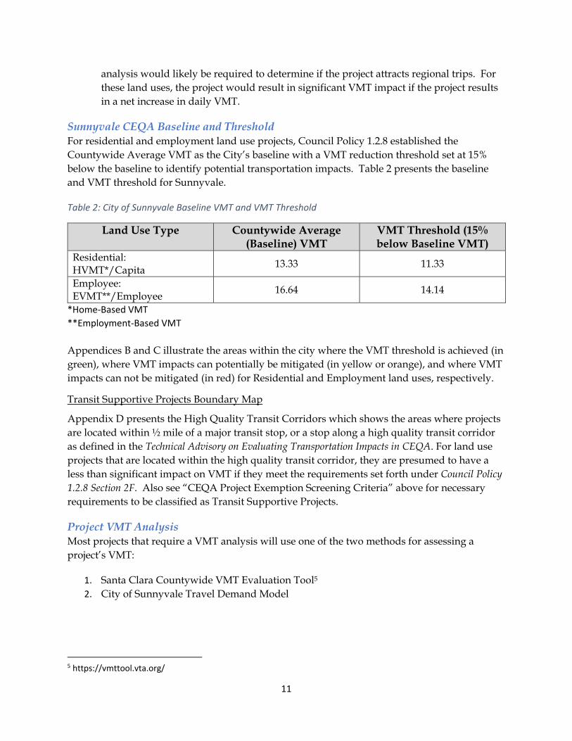
Sunnyvale CEQA Baseline and Threshold For residential and employment land use projects, Council Policy 1.2.8 established the Countywide Average VMT as the City’s baseline with a VMT reduction threshold set at 15% below the baseline to identify potential transportation impacts. Table 2 presents the baseline and VMT threshold for Sunnyvale.
Table 2: City of Sunnyvale Baseline VMT and VMT Threshold
Land Use Type Countywide Average (Baseline) VMT
VMT Threshold (15% below Baseline VMT)
Residential: HVMT*/Capita
13.33 11.33
Employee: EVMT**/Employee
16.64 14.14
*Home‐Based VMT
**Employment‐Based VMT
Appendices B and C illustrate the areas within the city where the VMT threshold is achieved (in green), where VMT impacts can potentially be mitigated (in yellow or orange), and where VMT impacts can not be mitigated (in red) for Residential and Employment land uses, respectively.
Transit Supportive Projects Boundary Map
Appendix D presents the High Quality Transit Corridors which shows the areas where projects are located within ½ mile of a major transit stop, or a stop along a high quality transit corridor as defined in the Technical Advisory on Evaluating Transportation Impacts in CEQA. For land use projects that are located within the high quality transit corridor, they are presumed to have a less than significant impact on VMT if they meet the requirements set forth under Council Policy 1.2.8 Section 2F. Also see “CEQA Project Exemption Screening Criteria” above for necessary requirements to be classified as Transit Supportive Projects.
Project VMT Analysis Most projects that require a VMT analysis will use one of the two methods for assessing a project’s VMT:
1. Santa Clara Countywide VMT Evaluation Tool5
2. City of Sunnyvale Travel Demand Model
5 https://vmttool.vta.org/

12
Santa Clara Countywide VMT Evaluation Tool The VMT evaluation tool (tool) assesses a project’s potential VMT based on the project’s description, location, and attributes. For most residential and employment projects, the tool is the approved method to calculate VMT. However, it is recommended that projects with an area larger than 0.25 square miles (or approximately 7,000,000 sq. feet) should use the Travel Demand Model to calculate project VMT.
Using the Tool The steps for evaluating VMT are straightforward. The tool asks for the inputs and provides three VMT measurements – existing area VMT, VMT with Project and no TDM measures, and VMT with Project and TDM measures. The tool will also identify when projects are exempted within the high quality transit area. If a project needs mitigation to meet the City’s threshold, the tool contains potential VMT mitigation and its relative effectiveness on VMT reduction. The tool will also produce a summary report which includes the project description, all the inputs, the three VMT levels, and any mitigation identified. This summary report should be included in a Transportation VMT Analysis Report for any development project requiring a VMT analysis.
VMT Mitigation A list of potential mitigation to reduce VMT is available within the tool. Appendix E provides a summary of potential VMT mitigations in the tool, a short explanation for each VMT mitigation strategy, and whether the mitigation strategy is approved by City of Sunnyvale as a mitigation for the project. Not all mitigation strategies listed in the tool can be used as a mitigation for a project; City of Sunnyvale makes the final determination on whether a mitigation strategy can be used as a mitigation for a project.
The mitigation strategies are organized in four tiers:
Tier 1 – Project Characteristics. Although it may be difficult to revise a project during environmental review, Tier 1 strategies allow the user to increase project density, alter the diversity of land uses, and add affordable and/or below market rate housing to the residential and employment projects to reduce VMT.
Tier 2 – Multimodal Network Improvements. These improvements include implementing bicycle network improvements and/or pedestrian network improvements, implementing traffic calming measures, increasing transit accessibility, and improving network connectivity. These improvements require coordination with city staff and may require additional studies (i.e. signal warrant studies, traffic calming studies, etc.) to determine feasibility. Consultants shall use the identified proposed transportation improvements to the bicycle, pedestrian and roadway networks in the City’s adopted plans and policies (refer to Table 1) as VMT impact mitigation.
Tier 3 – Parking. Parking strategies can be effective in reducing VMT, however, the residential areas surrounding an employment project with reduced parking supply should have a Residential Parking Permit program funded by the employment project.

13
Tier 4 – Transportation Demand Management (TDM). There is a multitude of TDM measures to reduce VMT. The tool includes potential TDM measures and their relative effectiveness. Based on the percentage participation selected by the user, the tool calculates the resulting VMT reduction. The various TDM measures in the tool include school carpool programs, bike-sharing programs, car-sharing programs, trip reduction marketing/educational campaign, parking cash-out, subsidized transit, telecommuting, alternative work schedules, shuttles, pay to park, ride-sharing, unbundled parking, and subsidized vanpool.
Figure 3: Moffett Park VTA Light Rail Station
2020 Sunnyvale Active Transportation Plan The Santa Clara Countywide VMT Evaluation Tool includes a list of potential VMT reduction strategy and mitigation for projects to implement. The 2020 Sunnyvale Active Transportation Plan includes various proposed bicycle and pedestrian improvements that may be used to reduce VMT. To qualify as a mitigation, the improvement must:
Install or upgrade a bicycle lane that reduces the project’s biking distance or provides a dedicated bicycle connection to transit.
Eliminate sidewalk gaps or upgrade existing sidewalks; however, replacing or installing new sidewalk along the project frontage would not qualify as mitigation.
14
Install new crosswalks and/or traffic signals to increase the number of pedestrian crossings to/from a project.
Improve access to transit such as moving or adding a transit stop closer to the project. Installing a shelter or upgrading an existing transit stop would not qualify as VMT mitigation.
Install traffic calming measures to reduce speed on local streets, making walking or bicycling safer and more attractive.
The above VMT mitigations may require further study and will require coordination with city staff to determine feasibility.
TDM Programs for VMT Mitigation TDM Programs that mitigate VMT impacts should be included in the Mitigation Monitoring Report (MMRP), other CEQA documents, or Conditions of Approval. TDM mitigation measures must be selected from the city approved list in Appendix E. Since the application of VMT analysis for CEQA transportation impact analysis is new, as VMT modeling improves and more VMT studies are produced, new VMT mitigation may be added to the tool or as mitigation within the Travel Demand Model.
Projects are required to demonstrate through an annual TDM monitoring report that it is meeting the TDM targets or conditions for the life of the project. TDM monitoring reports should be submitted annually or as required to the Department of Public Works for review and approval.
Travel Demand Model For large land use plans, very large projects, projects that are not residential nor office, projects that can potentially shift travel patterns, and projects located in areas where the average VMT has not been established in Sunnyvale, the VMT evaluation tool would not be adequate or capable of evaluating VMT. For these projects, the use of the Sunnyvale Travel Demand Model, at the developer’s costs, may be required to evaluate VMT based on a preliminary review of the project. City will provide the scope of a VMT analysis directly to a City-selected consultant and the City will administer the VMT analysis. Developer is responsible to fund and implement all mitigation requirements as identified in the VMT analysis.
Other VMT Calculation Methodology In addition to the above methodologies, VMT may be calculated using other methods. VMT is calculated by multiplying the amount of daily traffic on a roadway segment by the length of the segment, then summing all the segments’ VMT to give you a total for the geographical area of concern. The vehicular traffic amounts are either estimates (current or past data) or they are projections (future data). Other proposed methodologies shall require review and approval prior to implementation.

15
Local Transportation Analysis (LTA) The LTA evaluates the effects of a development project on transportation, traffic operations, access, circulation, and related safety elements in the project vicinity. The LTA will also establish consistency with the General Plan goals and policies and supports the following objectives:
Ensures the transportation network is designed and built to serve the type, characteristic and intensity of the surrounding land uses;
Encourages projects to reduce single occupancy vehicle use and increase mode share of other transportation options like walking, biking, carpooling and transit; and
Ensures transportation effects caused or exacerbated by the proposed project are identified, addressed and documented in the LTA.
Many factors shall be considered when determining the scope of the analysis for an LTA. Project description, location, adjacent land use, and existing transportation network are considered when evaluating surrounding transportation conditions and the potential effects a proposed project may have on the transportation network.
Determining when a LTA is required The following types of projects will require a LTA:
Land use projects that generate o 100 or more net new trips in either the a.m. or p.m. peak hour on adjacent street
traffic* o 50-99 net new trips in either the a.m. or p.m. peak hour on adjacent street traffic*
Projects that propose land use change. Projects as determined by Public Works Director or designee. Any areas that have specific requirements (i.e. Downtown projects, Precise Plans). All medium, large projects that generate 500 or more net new daily trips. Land use entitlements requiring discretionary approval by the City of Sunnyvale, which
include but are not limited to annexations, general plan amendments, specific plans, zoning changes, conditional use permits, and tentative maps; and
Transportation projects, as determined by city staff.
* For existing occupied sites, a.m. and p.m. peak hour trip credit can be applied to the proposed project estimated a.m. or p.m. peak hour trip generation, to determine the net new trips the project generates. The estimation of existing site trip generation must include reasonable documentation that supports this assumption.
Land use projects that generate less than 50 net new trips in both a.m. or p.m. peak hours on adjacent street traffic will not be required to conduct a LTA.
Land Use Projects that Generate More Than 100 Net New Peak Hour Trips A LTA will be performed by one of the city selected on-call traffic consultants, at the developer’s cost, and it shall follow the methodology as outlined in the VTA Transportation Impact Analysis Guidelines6, VTA Congestion Management Program (CMP) requirement, as well
6 Transportation Impact Analysis Guidelines, Santa Clara Valley Transportation Authority, Congestion Management Program, October 2014.

16
as City of Sunnyvale’s intersection operations level of service (LOS) adverse operation effect guidelines. The LTA shall access impacts of the project on regional and local transportation facilities, and shall include:
Trip generation and Trip Distribution of the project Intersection operation analysis Freeway and ramp operations Intersection phasing and queuing analysis Alternative transportation facilities (bike, pedestrian, transit) On-site circulation and parking Driveway operations, driveway locations, and adequate number of driveways
Land Use Projects that Generate between 50-99 Net New Peak Hour Trips A LTA will be performed by one of the city selected on-call traffic consultants at the developer’s costs, and if required, it will assess impacts of the project on local transportation facilities and a review of site circulation, which may include:
Trip generation and Trip Distribution of the project Intersection operation analysis Intersection phasing and queuing analysis Evaluation of alternative transportation facilities (bike, pedestrian, transit) On-site circulation and parking assessment Driveway operations, driveway locations, and adequate number of driveways
What is included in a LTA Projects are required to conduct operations analysis per the guidelines set forth in this document and confirmed by city staff. City staff will provide any available data for use in the analysis. Updated data may be required if the data is more than two years old and will be requested in the project work scope.
The type of analysis required will depend on the land use type, the project size, and how many peak hour vehicle trips the proposed project would generate.
Trip Generation Trip generation is an estimate of the number of vehicle trips generated by a project. Trip generation estimates should be based on the latest Institute of Transportation Engineers (ITE) Trip Generation Handbook and proposed trip reductions should conform to the VTA TIA Guidelines. However, per approval by City staff, trip generation estimates can also be generated by conducting trip generation studies, if necessary. This may be required for unusual, or specific land uses where ITE trip generation estimates do not apply.
Pass-by and Diverted Link Trips
Primary vehicle-trips are trips attracted to a project where the project is the (primary) destination. Pass-by trips are intermediate stops on the way to a primary destination without diverting to another street to access a project. Diverted link trips are intermediate stops on the way to a primary destination that require diversion from one roadway to another to get to the site. Refer

17
to the VTA TIA Guidelines for estimates of pass-by, primary and diverted vehicle-trips for most retail use.
The percentage of pass-by and diverted link trips should be estimated based on data provided by ITE or surveys of similar land uses. San Diego Association of Governments (SANDAG) also has published information on trip generation, primary and diverted link trip estimates that may apply. The net new vehicle-trip generation estimates should be used to assign project trips to the roadway network and the appropriate pass-by and diverted link trips should be added or subtracted from the affected intersection turning movements but always included in the driveway trip estimates for a project.
Pass-by and diverted trips shall not be used as credits to determine the project size and scope unless uses are specifically exempted in the VTA TIA Guidelines.
Existing Uses
Vehicle-trip credits associated with existing use at the project site may be acceptable. Applying vehicle trip credits provides a more accurate estimate of net new vehicle traffic to be added to the existing roadway network. Coordinate with City staff for approval on any proposed existing site vehicle-trip credits.
Trip Generation Table
Trip Generation Table should always contain the following information:
Project description – land use and size Trip Generation estimate and Trip generation source Any trip reductions including, pass-by or diverted link trips, VTA mixed use reductions
or transit reductions, credit for existing site traffic. Gross and net trip generation estimate
Trip Distribution
A trip distribution is a forecast of the travel pattern of vehicles generated by a project. Trip distribution percentages should be included in the transportation analysis in a figure on an area map showing the location of the project and the surrounding transportation network. The trip distribution figure should show trip percentages at gateways, on nearby freeway segments, and along major arterials that provide direct access to the project.
Trip distribution can be determined from zip code data, census data, market research, travel demand models, existing travel patterns, and/or locations of complementary land uses, and professional engineering judgement. Trip distribution assumptions should be consistent with similar land uses in the same areas in the City. The trip distribution figure should be submitted for review and approval prior to use.
Trip Assignment
Trip Assignment consists of assigning vehicle-trips to certain routes on the roadway system based on the trip distribution. Assignment of vehicle-trips should be based on existing and expected traffic volumes and patterns. Trip assignment forecasts from a travel demand model is

18
recommended for long-term land use plans and large development projects where the implementation of the project is expected to occur over time (beyond 5 years).
Trip assignment figures should contain the project’s vehicle traffic turning movement volumes at each study intersection and all other signalized intersections in the project vicinity. The figures must be submitted to the City for review and approval prior to use.
Study Scenarios
Existing conditions
Existing intersection operations or level of service (LOS) of all study intersections should be included in the LTA to establish the transportation conditions prior to project implementation. Guidelines for data collection are later in this section.
Existing plus Project conditions
The project vehicle trips are added to the existing traffic counts to establish the level of service of the study intersections with the project traffic. An adverse effect at the study intersection can be based on the comparison between existing LOS and project LOS.
Background conditions
Background conditions LOS are typically described as existing intersection traffic volumes with any approved but not yet built projects added to establish the LOS at the study intersections with pending development. The background conditions provide a LOS assessment of conditions where multiple projects are being proposed. Since measuring intersection LOS is no longer a CEQA measure, this requirement may only apply to projects generating more than 100 net new a.m. or p.m. peak hour trips.
In addition to approved projects, any funded improvements should also be included in this scenario if applicable.
Background plus Project conditions
The project vehicle trips are added to the background trip volumes to establish the level of service of the study intersections with the project traffic. An adverse effect at the study intersection can be based on the comparison between background LOS and project LOS. This requirement may only apply to projects generating more than 100 net new a.m. or p.m. peak hour trips.
Cumulative conditions
Cumulative conditions include all the anticipated traffic volumes from projects as included in the adopted General Plan.
Cumulative plus Project conditions
The project vehicle trips are added to the cumulative trip volumes to establish the level of service of the study intersections with the project traffic. An adverse effect at the study intersection can be based on the comparison between cumulative LOS and project LOS.

19
Study Intersections
For land use projects that generate more than 100 net new peak hour trips
The consultant shall identify study intersections based on the following criterion:
The proposed development project is expected to add 10 or more peak hour vehicles per lane to any intersection movement on designated Congestion Management Program (CMP) facility (see VTA Transportation Impact Analysis Guidelines); or
The intersection is adjacent to the project; or Based on engineering judgement
Not all intersections within the 2-mile radius need to be studied. Intersections where project traffic does not meet the VTA Transportation Impact Analysis Guidelines are not required to be studied. Additionally, intersections operating at LOS A, B or C may not need to be studied. The final list of study intersections shall be approved by city staff.
For land use projects that generate more between 50-99 net new peak hour trips
The consultant shall identify study intersections based on the following criterion:
Intersections adjacent to the project; or Base on engineering judgement and knowledge of the traffic patterns in the project
study area
Data Collection
New traffic count data may be requested by city staff if current data is not available. Count data should not be older than 2 years. New count data should be collected and processed by a traffic consultant as follows:
Obtain new a.m. and p.m. peak period (7-10 a.m. and 4-7 p.m.) vehicle count data for three consecutive hours during peak travel. Vehicle and bicycle count by turning movement, pedestrian counts by crosswalk leg at all selected study intersections.
Data collection should occur Tuesday through Thursday during non-holiday weeks and not during the summer when schools are not in session. Proposed data collection dates shall be approved by city staff.
Weather conditions may affect the count data so data should be collected during dry weather conditions. Additionally, construction sites, traffic detours or diversions can also affect the count data so these conditions should be avoided as much as possible.
Certain land uses may require data collection during nonstandard peak periods such as stadium, movie theatres, projects that have peak weekend traffic.
The four highest consecutive 15-minute count intervals are used to determine the peak hour.
New count data should be submitted to City staff for review and approval.

20
Intersection Operations Analysis Methodologies
Intersection operations analysis measures traffic operations and delay at signalized intersections and is usually expressed in LOS. Intersection operations analysis should be completed for all study intersections using the Highway Capacity Manual (HCM) methodologies and the VTA Traffic Level of Service Analysis Guidelines (2003) or subsequent adopted updated standards. The analysis should include all study scenarios specified in the scope of work.
LOS Thresholds for Adverse Intersection Operation Effects
An adverse effect on intersection operations occurs when the analysis demonstrates that a project would cause the operations standard at a study intersection to fall below the LOS standards as defined by City of Sunnyvale General Plan & Sunnyvale Municipal Code.
In the 2011 Sunnyvale General Plan, there were two policies related to intersection level of service:
Policy LT-1.3
Achieve an operation Level of Service (LOS) “E” or better for all regional roadways and intersections, as defined by the city Functional Classification of the street system.
Policy LT-5.1
Achieve an operating level-of-service (LOS) of “D” or better on city-wide roadways and intersections, as defined by the Functional Classification of the street system.
In the current Sunnyvale Land Use and Transportation Element (LUTE) adopted in April 2017, Policy LT-3.11 was adopted as follow:
As they become available, use multimodal measures of effectiveness to assess the transportation system in order to minimize the adverse effect of congestion. Continue to use level of service (LOS) to describe congestion levels. Use vehicle miles traveled (VMT) analysis to describe potential environmental effects and impacts to the regional transportation system.
Under the City of Sunnyvale Municipal Code 3.50.030 (a) Transportation Impact Fee,
“The Level of Service (LOS) standards set forth in the Land Use and Transportation Element of the General Plan shall be the standards used for determining necessary street and intersection improvements.”
All intersection traffic analysis shall follow the following Intersection LOS Adverse Intersection Operation Effects Guidelines:
Signalized Intersections – CMP Intersections
Consistent with the significance impact criteria documented in the VTA TIA Guidelines, VTA accepts a minimum level of service of LOS E for a CMP intersection. The City utilizes the VTA LOS standards for all intersections on the CMP roadway system.

21
Therefore, the following conditions would result in an adverse intersection operation effect at a CMP intersection:
1. If the intersection operates at an acceptable LOS (i.e. LOS A, B, C, D, or E) without the project and degrades to an unacceptable LOS (i.e. LOS F) with the project, then it is an adverse intersection operation effect.
2. If the intersection operates at an unacceptable LOS (i.e. LOS F) without the project and the project increases the average control delay for the critical movements by four (4) or more seconds and increases the critical volume to capacity (v/c) by 0.01 or more, then it is an adverse intersection operation effect.
a. Even if the addition of project traffic reduces the amount of average control delay for a critical movement (i.e. negative change in delay) but the project increases the critical v/c by 0.01 or more, then it is an adverse intersection operation effect.
Signalized Intersections – on Regionally Significantly Roads
Figure 6 of the LUTE 2017 presents the General Plan Roadway Classification Map, which shows the spectrum of roadway classifications that dictate the appropriate uses including access and mobility. On the figure, regionally significantly roadways were identified, which include Mathilda Avenue, Sunnyvale-Saratoga Road, Caribbean Drive, El Camino Real etc.
For Sunnyvale intersections on roadways that are designated as regionally significant, the minimum level of service is LOS E. Therefore, the following conditions would result in an adverse intersection operation effect:
1. If the intersection operates at an acceptable LOS (i.e. LOS A, B, C, D or E) without the project and degrades to an unacceptable LOS (i.e. LOS F) with the project, then it is an adverse intersection operation effect.
2. If the intersection operates at an unacceptable LOS (i.e. LOS F) without the project and the project increases the critical movement delay of four (4) or more seconds and increased the critical volume to capacity (v/c) by 0.01 or more, then it is a an adverse intersection operation effect.
Signalized Intersections – Not on Regionally Significantly Roads
For Sunnyvale intersections on roadways that are not designated as regionally significant, the minimum level of service is LOS D. Therefore, the following conditions would result in an adverse intersection operation effect:
1. If the intersection operates at an acceptable LOS (i.e. LOS A, B, C, or D) without the project and degrades to an unacceptable LOS (i.e. LOS E, or F) with the project, then it is an adverse intersection operation effect.
2. If the intersection operates at an unacceptable LOS (i.e. LOS E, or F) without the project and the project increases the critical movement delay of four (4) or more seconds and increased the critical volume to capacity (v/c) by 0.01 or more, then it is an adverse intersection operation effect.

22
Sunnyvale Unsignalized Intersections
Unsignalized intersection analysis may be required where intersections provide direct/indirect project access or as determined by city staff. There are various evaluation methods for studying unsignalized intersections including:
Unsignalized LOS Traffic Signal Warrant Studies Intersection Stop Warrants Traffic Circle LOS Overall intersection operations Collision Data
Unsignalized intersection analysis indicates if improvements such as a new traffic signal, stop controls, median island modifications, traffic circle, pedestrian and bicycle improvements, etc., would be needed. Methodology and proposed traffic control devices for intersection operations and traffic control should conform to Highway Capacity Manual (HCM) and California Manual on Uniform Traffic Control Devices (CA-MUTCD).
For determining the level of service for unsignalized intersections within Sunnyvale, the average intersection delay is used for all-way stop controlled intersections, and the worse movement delay is used for side-street stop-controlled intersections. Project impacts at City’s unsignalized intersections would be considered an adverse intersection operation effect if Criteria 1 or 2 are met in conjunction with Criteria 3:
1. If an unsignalized intersection operates at an acceptable LOS (i.e. D or better) without the project and degrades to an unacceptable LOS (i.e. LOS E or F) with the addition of project traffic, then it is an adverse intersection operation effect.
2. If an unsignalized intersection operates at an unacceptable LOS (i.e. LOS E or F) without the project and the addition of project traffic increases the average intersection delay by four (4) seconds or more, and the volume-to-capacity (v/c) value by 0.01 or more for all-way stop controlled intersections.
3. Intersection meets the warrant(s) for installation of a traffic signal as per the latest edition of CA-MUTCD.
Intersections in other Jurisdictions
For intersections operated and maintained by other jurisdictions (i.e. Caltrans, County or other cities), the intersection operation evaluation criteria for the corresponding jurisdiction shall be used to determine the project’s adverse intersection operation effect.
Addressing Adverse Effects on Intersection Operations Signalized Intersections – CMP Intersections
For any adverse intersection operation effects identified, feasible improvements shall be developed, and an analysis with the proposed improvements shall be conducted.
For each analysis scenario, if the intersection operates at an acceptable LOS without the project and degrades to an unacceptable LOS with the project, the proposed improvements shall improve

23
the LOS back to acceptable LOS. If no feasible improvements are identified, the intersection operation would remain as an adverse effect.
For each analysis scenario, if the intersection operates at an unacceptable LOS without the project and the project causes an adverse intersection operation effect at the intersection, the proposed improvements shall improve the LOS back to without Project conditions or better. If no feasible improvements are identified, the adverse intersection operation effect would remain.
Signalized Intersections – All non‐CMP Intersections
Below are possible approaches to address adverse effects at signalized intersections:
Reduce the overall project vehicle-trips by implementing potential measures as listed in the Appendix E, such as constructing bicycle/pedestrian improvements or improving access to transit.
Construct improvements to the affected intersection or other roadway segments of the citywide transportation system to increase overall capacity.
A project should prioritize improvements related to multimodal transportation, particularly active transportation, and/or TDM measures; however, there are adverse effects where intersection operations may need additional left-turn or right-turn capacity or traffic signal phasing upgrades to accommodate vehicle traffic. In all cases, improvements that increase vehicle capacity should comply with the following:
Be consistent with the General Plan and/or other adopted plans and polices (See list of guiding documents in Table 1).
Reduction of any physical dimension of a transportation facility below the minimum design standard per Complete Street Design Standards and other engineering design standards.
Deterioration in the quality of existing or planned transportation facilities, including vehicular, pedestrian, bicycle and transit systems and facilities as determined by Director of Public Works.
Unsignalized Intersections
To address adverse effects at unsignalized intersections:
• If traffic signal warrants are met, install traffic signal. • If traffic signal warrants are not met, reduce the overall project vehicle-trips by
implementing potential measures as listed in Appendix E, such as construction multimodal improvements to increase transportation capacity for pedestrian, bicycle travel and/or improve access to transit.
TDM Programs to address Adverse Effects
TDM program is one of the recommended options to reduce project vehicle trips. There are a multitude of TDM measures the City supports to reduce vehicle trips, increase pedestrian, bicycle and transit use, and improve the environment surrounding the project. All TDM Plans shall include annual monitoring, reporting, compliance, and funding for the life of the project and will become part of the conditions of approval. Some of the TDM measures may overlap with CEQA

24
transportation mitigation measures. Annual trip monitoring reports shall be submitted to Department of Public Works for approval.
As previously stated, TDM programs can be used for the following transportation related impacts or adverse effects:
1. VMT mitigation 2. Adverse intersection operations 3. Ensure parking reduction compliance
Successful TDM programs can reduce traffic congestion, improve air quality, conserve energy, improve community health and fitness levels, promote urban livability, solve parking problems, enhance community safety, provide affordable transportation, and provide transportation options in all areas of a city.
The most effective and successful approaches to transportation demand management draw on the combined power of a range of strategies to achieve the objectives. Common strategies include:
Transportation management associations: leverage public and private funds to increase the use of ridesharing and other commuting options that reduce traffic congestion and improve air quality.
Including or improving pedestrian-oriented design elements, such as shortened pedestrian crossings, wide sidewalks, and street trees.
Including and improving public transportation infrastructure, such as light rail, Caltrain entrances, bus stops and routes.
Subsidizing transit costs for employees or residents. Bicycle-friendly facilities and environments, including secure bike storage areas and
showers. Providing active transportation facilities including bicycle lanes and multi-use trails. Providing traveler information tools, including intelligent transportation system
improvements, mobile and social applications, wayfinding tools, and other methods for promoting alternatives to single occupancy vehicle (SOV) modes.
Flex-time work schedules with employers to reduce congestion. Active traffic management. Employer sponsored TDM programs aimed at reducing overall vehicle trips by
incentivizing mode shift. Residential TDM programs focusing on reducing overall vehicle trips with programs
such as bikeshare, carshare, cargo bikes, carpooling, etc.
Refer to Appendix E for a list of City approved TDM strategies.
Congestion Management Program (CMP) In accordance with California Statute, Government Code 65088, Santa Clara County has established a Congestion Management Program. The intent of the CMP legislation is to develop a comprehensive transportation improvement program among local jurisdictions that will

25
reduce traffic congestion and improve land use decision-making and air quality. The VTA serves as the Congestion Management Agency (CMA) for Santa Clara County’s CMP.
As a CMA, VTA is required by California Statute to monitor roadway vehicle congestion and the impact of land use and transportation decisions on a Countywide level, at least every two years. VTA conducts CMP monitoring and produces the CMP Monitoring and Conformance Report annually.
Sunnyvale, as a member agency, is required to conform to the CMP requirements for evaluating the transportation effects of land use decision on the designated CMP roadway system. The program is established to address regional transportation issues across City boundaries. The LTA is intended to meet the CMP requirements by conducting intersection level of service analysis at designated CMP intersection and conform to the CMP requirements for bringing intersections into compliance. Projects should continue to assess their effects on the designated CMP roadway system using the VTA Transportation Impact Analysis Guidelines, the VTA Traffic Level of Service Analysis Guidelines, and this guideline.
Intersection Phasing and Queuing Analysis
At intersection phasing and queuing analysis may be required for the following instances:
At signalized intersections where the intersection operations analysis indicates there will be an adverse effect;
At other intersections or freeway ramps, based on proximity of the development project to a freeway interchange, existing queuing spillback conditions, or localized conditions along a project’s frontage.
Intersection Phasing Analysis
An intersection phasing analysis evaluates the added project vehicle trips to an existing traffic signal to determine if the existing phasing needs to be upgraded.
Left-turn or Right-turn Storage Analysis
Left-turn or right-turn storage analysis measures how many vehicle-trips a project would add to an existing left-turn or right-turn pocket. The determination for improving intersection operations or lengthening an existing pocket is based on a comparison between the existing pocket conditions with and without the project trips added. If a previously approved project also studied the same pocket, then those project trips and/or improvements should be included in the analysis.
Adverse effects on queuing should be identified by comparing the calculated design queue to the available queue and pocket length. An adverse effect on queuing maybe identified when the addition of project traffic causes or exacerbates existing conditions such that:
Spillback queues from left-turn lanes at intersections block through traffic Queues from an intersection that extend back and affects the upstream intersection Queues from bottleneck locations such as lane drops that affect intersection operations Queues at intersections proximate to freeway ramps Queues on right-turn lanes

26
Spillback queues from freeway ramps that affect local street or freeway ramp operations
Freeway and Rural Highway Facilities Study freeway and highway facilities shall be selected following the VTA TIA Guidelines; and they shall be analyzed using the VTA TIA threshold criteria. A queuing analysis shall be included in the LTA at freeway on-ramp and off-ramp intersections, where appropriate.
Site Access and Circulation The goal of evaluating site access and circulation is to establish safe and efficient site access and circulation to and from a project by identifying potential conflicts and proposed solutions. This section evaluates the interface of a project to the public right-of-way and any adverse effect on the public right-of-way due to poor onsite circulation. The evaluation of the site access and circulation focuses on the site layout and should consider the following:
Review and evaluate site pedestrian access and circulation including street-oriented entrances, direct pathways to transit stops, active, transparent ground floor uses, human-scale elements, pedestrian vistas, paseos, crossing and driveway treatments.
Review and evaluate site bicycle access and circulation including bike access locations, direct routes to bike parking, high-visibility secure bike parking near building entrances, and other amenities.
Review and evaluate site motor vehicle access locations, driveway widths, quantity and location, size of major circulation features with respect to operations and safety, turning movement volumes at site access points, queuing at site access driveways, project shuttle stops, dimensions of truck loading areas, solid waste and emergency access.
Review and evaluate passenger, freight, and delivery loading zones and circulation to ensure that all activity can be accommodated on-site.
Evaluate compliance with City Standard Provisions for corner vision triangle and driveway vision triangle per Sunnyvale Municipal Code 19.34.060.
Alternative Transportation Analysis The alternative transportation analysis is intended to expand the transportation evaluation to include all travel needs and demands. Historically, transportation analysis prioritized vehicle travel. This analysis is intended to focus on the multimodal environment surrounding a project and identify any existing deficiencies or project effects on pedestrian, bicycle and transit. This analysis aligns with the VMT goals of developing a multimodal transportation network.

27
Figure 4: Midblock Crossing along West McKinley Avenue
Most cities conform to the standard for pedestrian, bicycle and transit evaluation in the VTA Guideline. However, with the adoption of SB743, OPR Technical Advisory on Evaluating Transportation Impacts in CEQA suggests that a city could consider pedestrian, bicycle and transit impacts as CEQA transportation impacts, in addition to VMT impacts. Regardless, the methodology for evaluating and assessing a project’s impact on the multimodal transportation network should be consistent with adopted city policies and should include the following:
Pedestrian Evaluation Existing Pedestrian Conditions
Include an evaluation of the existing pedestrian network that would likely serve the project. Include any planned pedestrian facilities from adopted plans.
Project Pedestrian Conditions
Include an evaluation of the pedestrian network with implementation of the project.

28
Summary of Pedestrian Assessment
The pedestrian assessment shall consider the following:
Consistency with adopted plans and policies. Compliance with the ADA standards. Whether the location of fire hydrants, streetlight poles, traffic signal cabinets and boxes,
and other facilities affect the pedestrian pathway
Project effects on pedestrian network:
What are the effects on pedestrians of any proposed addition, relocation or reconstruction of sidewalks, curb ramps, street lighting, street trees, etc.?
Are any improvements to existing pedestrian facilities proposed by the project? Do the proposed pedestrian conditions address any adverse conditions in relation to the
City’s Vision Zero Plan? What actions are proposed to improve pedestrian access, or to address adverse effects
on pedestrian access that result from the project?

29
Figure 5: Class II Bicycle Lane with Green Pavement Treatment on Fifth Avenue
Bicycle Evaluation Existing Bicycle Conditions
Include an evaluation of the existing bicycle facilities that would likely serve the project. Include any planned bicycle facilities from adopted plans.
Project Bicycle Conditions
Include an evaluation of the bicycle facilities with implementation of the project.
Summary of Bicycle Assessment
The bicycle assessment shall consider the following questions:
Consistency with adopted plans:
Are proposed bicycle conditions consistent with all adopted plans and policies?

30
Is the proposed supply short- and long-term bike parking sufficient, consistent with VTA Bicycle Technical Guidelines, well-lit and positioned near entrances?
Project’s effect on bicycles:
What are the effects on the existing bicycle facilities? What are the effects on bicyclists of any proposed addition, relocation or reconstruction
of bikeways, curb ramps, etc.? Are any improvements to existing bicycle facilities proposed by the project? Do the proposed bicycle conditions address any adverse conditions in relation to the
City’s Vision Zero Plan? What actions are proposed to improve bicycle facilities?
Transit Evaluation Existing Transit Conditions
Include an evaluation of the existing transit facilities that would likely serve the project.
Project Transit Conditions
Include an evaluation of the transit facilities with implementation of the project.
Summary of Transit Operations Analysis, Transit Facility and Service Assessment
This assessment shall identify existing transit services with stops within the 2-mile study area from a project, include route character (local, limited stop, rapid), service areas, service span (hours of service), peak period headways, and types of vehicles (bus, light rail, shuttles, Caltrain). In addition, the assessment should also disclose:
Conform to the VTA TIA Guidelines for methodology on evaluating transit delay. If the project is found to have an adverse effect on transit operations based on transit
delay, the project should work with the City and VTA to identify feasible transit priority measures (e.g. transit signal priority, queue jump lanes, transit bulb-outs, or dedicated bus lanes, etc.) near the affected facilities and propose fair share contribution to any applicable projects that improve transit operations.
Any temporary or permanent reduction of transit availability or interface with existing transit users (e.g. relocation/reconstruction/closure of a transit stop or vacation of a roadway utilized by transit);
For projects located more than ½ mile from existing or planned transit services: • Assess the potential of generating a demand for services. • Large projects are encouraged to promote public transit (provide transit passes,
etc.). • If there is an adopted plan on a transit priority corridor, a project may construct
or contribute to the buildout of the plan. If an existing or planned transit stop is located along the project frontage, transit stop
improvements may be required as part of the project’s frontage improvements.

31
Projects may propose enhancements or improvements to transit services, transit facilities (transit stop improvements) as part of frontage improvements or to address adverse effects on existing transit systems or facilities.
Figure 6: Sunnyvale Transit Center on S. Frances Street
Development density near transit stations
If a project is not transit supportive, it should be assessed for adverse effects on transit. Transit supportive projects provide improved access to transit, or site designs that improve access to transit, and encourage ridership.
Parking The evaluation of on-site parking may be required to identify the number of parking spaces provided by a project and whether the proposed parking supply is consistent with Chapter 19 of the Sunnyvale Municipal Code. If the project does not meet the parking requirements, TDM measures may be required to reduce the number of vehicles generated by the project.
Projects may be required to evaluate nearby neighborhoods for potential parking intrusion by doing the following:
Conduct parking study on identified streets prior to implementing the project.

32
Conduct parking study on identified streets approximately six (6) to twelve (12) months after the project is occupied.
Implement a parking plan as recommended by the City based on the parking study results. The parking plan may include establishing a Residential Parking Permit Program (RPP), installation of parking restriction signs, and other parking management actions.
Truck Traffic Projects that generate truck traffic such as manufacturing, warehousing, delivery, etc. may require further evaluation of the truck traffic to ensure that the roadway network is designed to accommodate truck traffic. Additionally, except for delivery, repair (plumbing, etc.) or garbage, industrial use truck operations should not impact residential neighborhoods by traveling on arterial roadways designed to accommodate truck traffic. Truck routes used by a project would be evaluated for the following:
Truck turning Driveway widths/street widths On-site circulation Parking Intersection geometry
Other Relevant Analyses Other types of analyses that may be requested in the LTA include:
Evaluation of existing median island, modifications to an existing median island, or evaluation of the need of a proposed median island with project traffic
Acceleration or deceleration lanes Average Daily Traffic (ADT) volumes and speeds For Drive-thru land use – adequate stacking, sight distance at driveways, etc Emergency vehicle access (on private property)
Neighborhood Issues and Traffic Calming Projects may be conditioned to proactively install traffic calming measures or traffic control devices if existing conditions warrant, or if they are included in an adopted plan or policy, or if a project has the potential to generate conflicting traffic with adjacent neighborhoods or result in excessive speeds and/or cut-through volumes on neighborhood streets. Traffic calming measures may include bulb-outs, median refuge island, speed bumps, electronic speed limit signs or other measures.
If the project is conditioned to evaluate nearby neighborhoods for potential intrusion, the project will be required to:
Conduct speed and volume study on identified streets prior to project implementation. Conduct speed and volume study on identified streets approximately six (6) to twelve
(12) months after the project is occupied.

33
Implement approved traffic calming measures or traffic control as warranted by the analysis.
The evaluation of potential intrusion to nearby neighborhoods would not be included in the LTA.
Other Relevant Documents OPR Technical Advisory https://opr.ca.gov/docs/20190122-743_Technical_Advisory.pdf Sunnyvale General Plan https://sunnyvale.ca.gov/government/codes/plan.htm Climate Action Playbook https://sunnyvale.ca.gov/civicax/filebank/blobdload.aspx?BlobID=26529 City Charter, Council Policy, General Plan, Municipal Code https://sunnyvale.ca.gov/government/codes/default.htm Council Policy 1.2.8 Transportation Analysis Policy https://sunnyvale.ca.gov/civicax/filebank/blobdload.aspx?BlobID=27291 2020 Sunnyvale Active Transportation Plan https://sunnyvale.ca.gov/civicax/filebank/blobdload.aspx?BlobID=27371 VTA Website https://www.vta.org/programs/congestion-management-program/technical-resources Santa Clara Countywide VMT Evaluation Tool https://vmttool.vta.org/

34
Appendix A: VMT Analysis Exemption Screening Checklist7 Project Description (proposed square footage, number of residential units, any existing uses:
_____________________________________________________________________________________
_____________________________________________________________________________________
Project Location: _______________________________________________________________________
VMT Analysis Requirement Checklist: Project does not require a VMT analysis if it meets one of the
following exemption screening criteria:
Exemption Screening Category Criteria Land Use #1 Land Use #2 Land Use #3
Yes No Yes No Yes No
A. Small Projects (defined as generating 110 or less daily trips): Land Use generating 110 daily trips or less?
B. Local Serving Retail: Commercial Retail 100K or less? Commercial/retail defined by zoning code?
C. City facilities: Fire station, parks, community centers, branch libraries
D. Restricted Affordable Housing Projects that meet the following:
For rental developments: At least 25% of the proposed residential units dedicated as affordable to households up to 80% AMI.
For ownership developments: At least 25% of the proposed residential units dedicated as affordable to households up to 120% AMI.
For either type of development: The development may utilize the State Density Bonus, however 25% of the total constructed units on site must be deed restricted.
E. Transportation Projects that reduce or do not increase VMT F. Transit Supportive Projects ‐ Meet all of the following
requirements:
Distance to Transit: Within ½ mile of an existing major bus stop or existing stop along a high‐quality transit corridor?
Land use: Office/R&D project with a floor area ratio of more than 75% or Residential project of at least 35 dwelling units/acre
(I) Support the multimodal transportation network by facilitating access to multimodal transportation with improved pedestrian facilities, bike lanes, transit stops; does not harm or hinder access to multimodal transportation (must satisfy at least 4):
a. Limit the number and width of curb cuts b. Install sidewalks widen than minimum requirement
along the project frontage
c. Trash pickup not within bike lanes d. Improves transit accessibility or facilities
7 Refer to Sunnyvale Council Policy 1.2.8 Transportation Policy Section 2 Exemptions

35
Exemption Screening Category Criteria Land Use #1 Land Use #2 Land Use #3
Yes No Yes No Yes No
e. Implement new bike lanes or pedestrian facilities (not along the project frontage)
(II) Does not exceed maximum parking requirements or propose higher than what is allowed per the development standards: b≤a?
a. Number of parking spaces required by Specific Plan/Area Plan (if in a Plan Area) or zoning code
b. Number of parking spaces proposed by project (III) Is transit oriented in design?
a. Has a walkable design that prioritizes pedestrians (must satisfy at least 3):
i. Incorporates comfort and safety elements such as street trees, benches, lighting, etc.
ii. Create pedestrian‐oriented building frontage(s) iii. Allow zero or minimal building setbacks from the
sidewalk to create intimate, pedestrian‐scaled environments
iv. Comprehensive onsite pedestrian circulation system b. Is sustainable, and compact (must satisfy at least 4):
i. Support higher commercial and residential development intensities (FAR exceeds 75% for Office/R&D project or exceeds 35 dwelling units/acre for Residential project)
ii. Zero or minimal building setbacks from the sidewalk to create intimate, pedestrian‐scaled environments
iii. Place buildings at or close to the property line iv. Mix complimentary land uses v. Active ground‐floor uses vi. Support commercial and retail service diversity vii. Support community uses such as childcare, health
services
viii. Mix housing types, including senior and affordable housing
ix. Create public gathering places and open spaces x. Balance jobs and housing xi. Greater building height and bulk
c. Facilitates ease of bicycle use (must satisfy at least 3): i. Creates a comprehensive bicycle circulation system ii. Enhances connections to transit street/station iii. Improves signage and information to highlight key
destinations/transit
iv. Provide convenient and secure bicycle parking/storage facilities
v. Provide lockers, showers, and changing facilities vi. Bikeshare services (or system)
d. Is focused or centered around transit (must satisfy at least 1):
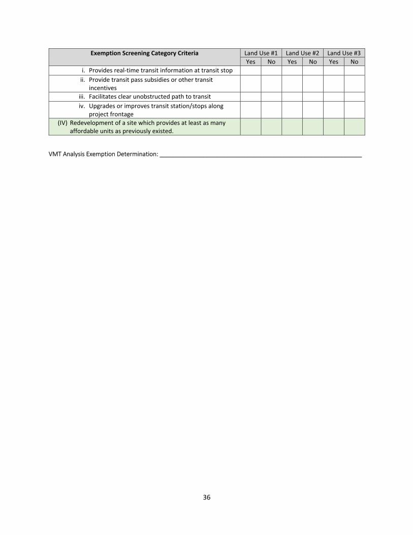
36
Exemption Screening Category Criteria Land Use #1 Land Use #2 Land Use #3
Yes No Yes No Yes No
i. Provides real‐time transit information at transit stop ii. Provide transit pass subsidies or other transit
incentives
iii. Facilitates clear unobstructed path to transit iv. Upgrades or improves transit station/stops along
project frontage
(IV) Redevelopment of a site which provides at least as many affordable units as previously existed.
VMT Analysis Exemption Determination: ____________________________________________________________

37
Appendix B: Residential VMT Map

38
Appendix C: Employment VMT Map

39
Appendix D: High Quality Transit Corridors

40
Appendix E: VMT Mitigation Strategies VMT Mitigation Strategy Description Required inputs Comments Sunnyvale
Approved Mitigation Measure
Tier 1 Project Characteristics
PC01 Increase residential density
Where allowed (by zoning and GP) design the project with increased residential densities compared to existing conditions.
Check box only Tool automatically compares existing density with proposed density. Applies to residential projects only.
Yes
PC02 Increase development diversity
Where allowed (by zoning and GP) increase the space dedicated to mixed employment and high density residential compared to existing conditions, particularly vertical intensification.
Check box only Tool automatically compares existing density with proposed density. Applies to both residential and employment projects.
Yes
PC03 Affordable Housing Provide on‐site deed restricted affordable, below market rate housing.
Requires input of % extremely low income BMR units, % very low income BMR units based on 3 specific income levels.
Assumes households at 80% at or below regional median income level. Applies to residential projects only.
Yes
PC04 Increase Employment Density
Where allowed (by zoning and GP) design the project with increased employment densities compared to existing conditions.
Check box only Tool automatically compares existing density with proposed density. Measures jobs per commercial/industrial acre. Applies to employment projects only.
Yes
Tier 2 Multimodal Infrastructure
M101 Increase Bicycle Access Implement bicycle facilities that close the gaps in the bicycle network and/or improve the existing bicycle network by upgrading the bicycle facility (constructing barriers or buffers to existing lanes).
Input distance from bike facility to project before and after bike facility improvements
Only applies to dedicated bike lanes. Requires approval by City Staff. Applies to both residential and employment projects
Yes

41
VMT Mitigation Strategy Description Required inputs Comments Sunnyvale Approved Mitigation Measure
MI02 Improve Connectivity Build new street connections and/or cul‐de‐sacs to provide new pedestrian and bicycle access
Input includes measurements of intersection/square mile with and without the project.
Requires approval by City Staff. Measures intersection densities within 1/4 mile of project. Recommends using GIS. Applies to both residential and employment projects
Yes
MI03 Increase Transit Accessibility
Develop the project within 1/2 mile of high‐quality transit stop
Input includes measurements of distance to closest transit stop with and without the project.
This mitigation requires adding new transit stop or moving transit stop closer to project. Requires approval by City Staff. However, the description implies that developing within 1/2 mile of transit stop would be the mitigation. Applies to both residential and employment projects
Yes
MI04 Traffic Calming Traffic Calming Added Beyond Development Frontage. Implement pedestrian and bicycle safety and traffic calming in the surrounding neighborhood of the project.
Are improvements provided beyond the development frontage? Input is simply yes or no
This mitigation may include median refuges, bulb‐outs, and/or other pedestrian crossing enhancements beyond the project frontage. Speed bumps require further analysis. All improvements require approval by City staff. Applies to both residential and employment projects
Yes
MI05 Pedestrian Network Implement pedestrian improvements both onsite and in the
Are pedestrian improvements provided beyond the development
Pedestrian improvements include but are not limited to
Yes

42
VMT Mitigation Strategy Description Required inputs Comments Sunnyvale Approved Mitigation Measure
surrounding neighborhood
frontage? Input is simply yes or no
sidewalks, marked or signalized pedestrian crossings, lighting and curb‐ramps. Applies to both residential and employment projects. All improvements require approval by City staff. Applies to both residential and employment projects
Tier 3 Parking (Applies to employment projects only)
PK01 Limit Parking Supply Minimize proposed parking per zoning code or Specific Plan/Area Plan requirements.
Minimum parking required by code or Specific Plan/Area Plan requirements, project's proposed parking.
Requires the surrounding street parking have Residential Permit Program (RPP) or time limits. The project will need to pay for the implementation of the Residential Permit Program in perpetuity. Applies to employment land uses only.
Yes
PK02 Provide Bike Facilities Provide and maintain on‐site bicycle facilities for active transportation beyond the minimum requirements per zoning code or Specific Plan/Area Plan.
Assumes on‐site bike parking already required. Input is simply yes or no.
VMT reduction based on the provision of on‐site secured bike parking or on‐site secured bike parking and additional facilities (repair shop, showers, etc.). Applies to employment projects only.
Yes
Tier 4 Transportation Demand Management Program

43
VMT Mitigation Strategy Description Required inputs Comments Sunnyvale Approved Mitigation Measure
TP01 School Pool Programs Program that reduces VMT for an established carpool program
Expected number of households that participate, expressed in percent
Organize a program for families in carpools to drop‐off and pick‐up. Applies to residential projects only.
No
TP02 Citywide Bike/Scooter Share Programs
Dedicate land and fund bike/scooter sharing infrastructures on project site
Check box only (6% flat reduction)
6% conversion of vehicle trips to bicycle/scooter trips. Applies to multi‐family residential and employment projects.
Yes
TP03 Car Share Programs Reduces VMT by providing a vehicle for on demand access on an as‐needed basis
Expected number of participants, expressed in percent
Provide dedicated parking as well as funding for car‐share program. Applies to residential and employment projects.
Yes
TP04 Commute Trip Reduction (CTR) Marketing and Education
Implement marketing campaign to target employees and visitors that encourages the use of alternative transportation
Expected number of participants, expressed in percent
Campaign may include employee orientations, promotions or publications to encourage transit, active transportation, and car‐pooling, etc. Applies to employment projects only.
No
TP05 Implementing CTR Program
Provide a program to reduce the number of drive‐alone trips
Expected number of participants, expressed in percent
Program includes encouraging employee participation by car‐pooling program, flexible work schedules, vanpool assistance, bicycle end‐of‐trips facilities. Applies to employment projects only.
Yes

44
VMT Mitigation Strategy Description Required inputs Comments Sunnyvale Approved Mitigation Measure
TP06 Employee Parking Cash‐out
Provide a program allowing employees to cash‐out, choice to forgo parking space in lieu of cash payment
Expected number of eligible employees
Applies to employment projects.
Yes
TP07 Subsidized Transit Program
Transit Subsidy Percentage of transit subsidy
Provide partially or fully subsidized transit passes offered to all employees or residents. Applies to rental residential and employment projects.
Yes
TP08 Telecommuting and Alternative Work Schedule
Allows and encourages employees to telecommute from home, or reduce in‐office workdays
Select Type of reduce in‐office work schedule (Telecommute 1.5 week, 4‐40 or 9‐80 and percentage alternative work schedule participants
Applies to employment projects only.
Yes
TP09 Free Door‐to‐door Transit Fleet
Free direct shuttle service
Percentage of participants
Provides shuttle to project site from areas with high concentration of employees such as transit stations, etc. Applies to employment projects only.
Yes
TP10 Price Workplace Parking
Requires commuters to pay for onsite parking
Percentage of employees eligible and various pricing options
Provides a disincentive to driving and encourages other transportation modes. Surroundings streets must have parking restrictions in place, such as time limits restricting overnight parking or Residential
Yes

45
VMT Mitigation Strategy Description Required inputs Comments Sunnyvale Approved Mitigation Measure
Parking Permit Programs which project is not eligible to join. The project is required to fund for the Residential Parking Permit Program for the surrounding neighborhoods.
TP11 Alternative Transportation Benefits
Provides employee commuter benefits to encourage alternative transportation
Percentage of employees eligible
Provide general commute benefits which may include subsidies or pretax benefits for transit, carpooling or vanpooling. Applies to employment projects only.
Yes
TP12 Neighborhood Schools Project contributes to the development of a neighborhood school
Type of school (citywide or neighborhood) and estimated percentage of households within project with school aged children
Neighborhood school reduces the number of vehicle trips by providing a convenient walkable location. Applies to residential projects only.
No
TP13 Ride Sharing Programs Organize a program for individuals interested in carpooling
Percentage of ride sharing participants
Applies to employment projects only.
Yes
TP14 Transit Service Expansion
Project subsidizes public transit service through fees and contributions
Percent increase in frequency and percent of routes serving the project affected
VMT reduction based on the contributions effect on transit frequency and impact on transit routes that positively affect the projects access to transit. Applies to both residential and employment projects.
Yes
TP15 Behavioral Intervention Provide one‐on‐one counseling and encouragement, along with subsidies, to
Percent of eligible participants
Applies to employment projects.
No
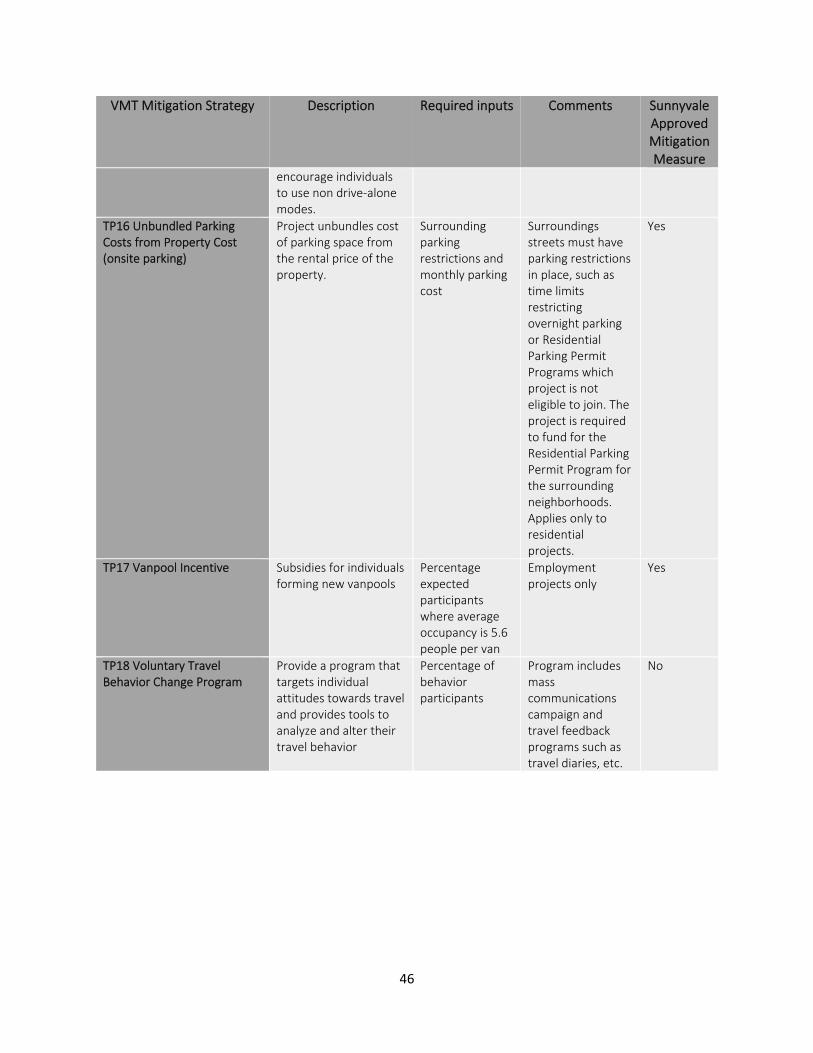
46
VMT Mitigation Strategy Description Required inputs Comments Sunnyvale Approved Mitigation Measure
encourage individuals to use non drive‐alone modes.
TP16 Unbundled Parking Costs from Property Cost (onsite parking)
Project unbundles cost of parking space from the rental price of the property.
Surrounding parking restrictions and monthly parking cost
Surroundings streets must have parking restrictions in place, such as time limits restricting overnight parking or Residential Parking Permit Programs which project is not eligible to join. The project is required to fund for the Residential Parking Permit Program for the surrounding neighborhoods. Applies only to residential projects.
Yes
TP17 Vanpool Incentive Subsidies for individuals forming new vanpools
Percentage expected participants where average occupancy is 5.6 people per van
Employment projects only
Yes
TP18 Voluntary Travel Behavior Change Program
Provide a program that targets individual attitudes towards travel and provides tools to analyze and alter their travel behavior
Percentage of behavior participants
Program includes mass communications campaign and travel feedback programs such as travel diaries, etc.
No