trail inventory and condition assessment with recommendations
TRANSCRIPT
3
Point Reyes National Seashore and the
North District of Golden Gate National Recreation Area National Park Service
November 2003
A Natural Sanctuary, A Human Haven
Trail Inventory and Condition Assessment with Recommendations

Trail Inventory and Condition Assessment with Recommendations
Trail Inventory and Condition Assessment with Recommendations
Point Reyes National Seashore
and the North District of Golden Gate National Recreation Area
National Park Service November 2003
A Natural Sanctuary, A Human Haven
Approved: Superintendent, Point Reyes National Seashore Date

TRAIL INVENTORY AND CONDITION ASSESSMENT
WITH RECOMMENDATIONS
Table of Contents
INTRODUCTION............................................................................................................................4 Purpose ........................................................................................................................................ 4 Background of Point Reyes National Seashore ........................................................................... 4 Background on the National Park Service ................................................................................... 5 Background of Park Trails........................................................................................................... 5 Preparers/Contributors ................................................................................................................. 7 Trail Condition and Assessment .................................................................................................. 7 Types of Trails ............................................................................................................................. 8 Trails as Cultural Resources ........................................................................................................ 8
BEAR VALLEY TO PALOMARIN AREA....................................................................................9
Primary Trails .............................................................................................................................. 9 Secondary Trails ........................................................................................................................ 12
BEAR VALLEY TO LIMANTOUR ROAD.................................................................................15
Primary Trails ............................................................................................................................ 15 Secondary Trails ........................................................................................................................ 20
LIMANTOUR ROAD TO TOMALES POINT.............................................................................21
Primary Trails ............................................................................................................................ 21 Secondary Trails ........................................................................................................................ 24
GOLDEN GATE NORTH DISTRICT ..........................................................................................27
RECOMMENDATIONS: PROPOSED NEW TRAILS...............................................................29
Point Reyes National Seashore .................................................................................................. 29 Golden Gate NRA North District .............................................................................................. 30 Connections with Regional Trail System .................................................................................. 32 The Marin Countywide Trails Plan and the Bicycle and Pedestrian Master Plan ..................... 32 The Marin Municipal Water District (MMWD)........................................................................ 35 California State Parks--Marin District ....................................................................................... 35 The Bay Area Ridge Trail.......................................................................................................... 36
RECOMMENDED FUNDING PRIORITIES ...............................................................................38
Appendix A: Standards, Guidelines, Ratings .................................................................................40 Appendix B: Maps of Proposed Trail Routes................................................................................43 Appendix C: Summary of Trail Condition....................................................................................50 Appendix D: Definitions ................................................................................................................53 Appendix E: Current Park Trails Maps ..........................................................................................55 Appendix F: Marin Municipal Water District MOU......................................................................57

Trail Inventory and Assessment Point Reyes National Seashore
4
INTRODUCTION Purpose This report is intended to inform the long-range planning process for the trail system within Point Reyes National Seashore (PRNS) and the North District of Golden Gate National Recreation Area (GGNRA). The document provides information on existing trail conditions, conceptual proposals for new trail alignments, and funding proposal for trail improvements. These recommendations should not be considered prescriptions that can be used to direct implementation of the trail systems. Specifically, this document will be used to guide trail improvements and how the park’s trail system can be tied to the over 575 miles of trails on other public lands in Marin County. With the 147 miles of trails in PRNS, Marin County has approximately 725 miles of trails for public enjoyment. As planning progresses, specific routes and design specifications would be prepared in full compliance with applicable standards and policies, utilizing geographic information system (GIS) computer technology to manipulate natural and cultural resource data currently being assembled, and with the benefit of public involvement. Background of Point Reyes National Seashore Point Reyes National Seashore (PRNS) is located in Marin County, California approximately 40 miles northwest of San Francisco, within the sixth Congressional District. Congress established the Seashore on September 13, 1962 “to save and preserve, for the purpose of public recreation, benefit, and inspiration, a portion of the diminishing seashore of the United States that remains undeveloped (PL 87-657).” The Point Reyes National Seashore is a vital part of America’s national system of parks, monuments, battlefields, recreation areas, and other natural and cultural resources. The park administers over 90,000 acres, and preserves 80 miles of coastline in perpetuity. The Seashore makes this valuable part of America’s heritage available to over 2.5 million visitors each year for their enjoyment, understanding, and appreciation. This geologically unique peninsula encompasses beaches, coastal cliffs and headlands, marine terraces, coastal uplands and forests. Migrating northward along the San Andreas Fault, the Seashore has appropriately been called an “Island in Time.”
In 1976, Congress established the 32,000-acre Point Reyes Wilderness (PL 94-544 and PL 94-567). Located near the San Francisco metropolitan area, this wilderness area is one of the most accessible within the United States wilderness system. In 1985, Congress changed the name of the wilderness area to the Phillip Burton Wilderness (PL 99-68). Marine boundaries are shared with the Gulf of the Farallones National Marine Sanctuary, Golden Gate National Recreation Area, and Tomales Bay State Park. In 1988, UNESCO Man in the Biosphere program designated the Central California Coast Biosphere Reserve (CCCBR) under the International Biosphere Program; CCCBR includes the entire Seashore, the Golden Gate National Recreation Area and other public lands in the region. Additionally, the state of California designated four "Areas of Special Biological Significance" within the Seashore; Tomales Point, Point Reyes Headlands, Double Point and Duxbury Reef.

Trail Inventory and Assessment Point Reyes National Seashore 5
PRNS supports a unique and varied landscape that has been subject to a broad range of human and natural events. Saved from development by its inclusion within the National Park Service System, Point Reyes is unique not only in its assemblage of natural and cultural features, but also in its proximity to a major urban population. This juxtaposition makes the Seashore’s resources and recreational opportunities readily accessible to a large number of people, and enhances the importance of the special qualities for which it was set aside. This diversity, complexity, rarity and proximity to the San Francisco Bay Area make balancing the National Park Service mandates of use and preservation difficult. Background on the National Park Service The National Park Service (NPS), established in 1916, preserves outstanding examples of the best of America’s natural, cultural, and recreational resources for the enjoyment, education, and inspiration by this and future generations. These resources are of national significance and constitute a significant part of America’s heritage, character, and future. The National Park System consists of 388 park units located in nearly every state and territory of the nation. The NPS not only directly preserves these treasures, it also makes them available to 280 million visitors from throughout the country and the world every year. The NPS also has legislated responsibilities for natural and cultural resource conservation outside national parks in partnership with state and local governments, tribes, and non-profit organizations. These programs provide a variety of technical and/or financial assistance. Background of Park Trails For more than a hundred years prior to its establishment as a unit of the National Park system in 1962, the Point Reyes peninsula was used extensively for agricultural and other purposes. Coast Miwok Indians, cattle ranchers, loggers and soldiers liberally laced the area’s varied landscape with trails and roads--mostly unpaved. As a rule, early efforts depended on hand tools and animal powered equipment, and were more sensitive to the constraints of topography and other natural features, while the advent of the bulldozer encouraged roadways that were more damaging and difficult to maintain over long periods of time. Although this comprehensive access system conveniently provided ready-made trails (147 miles) to accommodate public use in a national park, it has also challenged National Park Service managers with a legacy of roads and trails that had not been constructed or maintained in the most environmentally sensitive manner. New technologies, as well as new laws, have changed the way roads and trails are now designed and maintained from these earlier times. (See Appendix E for map of existing Point Reyes National Seashore trails) A properly designed and constructed trail is of limited gradient, requires minimal earth movement and allows water to be carried off its surfaces primarily in sheets rather than in channels. This design is ideally accomplished by sloping the trail surface in cross section outward and down-slope rather than, as in road design, inward to a ditch that then requires culverts, water bars or dips to collect the flow and carry it across the road. On roads this collected flow commonly is concentrated and accelerated to the extent that it causes soil erosion. Frequent maintenance of ditches, culverts, water bars and dips is necessary to keep them clear and failure of these devices is not uncommon. On the other hand, good trail design

Trail Inventory and Assessment Point Reyes National Seashore 6
requires a minimum of maintenance and causes little erosion. Further explanations of technical terms have been included in Appendix D of this report. Prior to the designation of much of the seashore as wilderness, nearly all of the trails were maintained with motorized heavy equipment- a process for which many were originally designed. However, wilderness designation requires every effort to the extent feasible to eliminate motorized equipment and specifies the use of “minimal tools” to accomplish maintenance and construction. To meet these requirements, most of the trails have been maintained since 1982 with limited use of such motorized equipment. This requirement presents an additional challenge to the limited resources of the Seashore’s trail crew, work once completed quickly with motorized heavy equipment transported by vehicles must now be done with hand tools and by hiking to the worksites. In addition to wilderness requirements, resource management staff has identified the presence of rare species whose nesting and other habitat protection requirement limit when work can be performed. In an effort to balance the need for wilderness protection/habitat protection and maintaining trails for recreational use, the crew has made substantial progress in rerouting and reconfiguring problem trails. In 2002, the park signed an MOU with other land management agencies establishing guidelines on the proper maintenance of unpaved roads used as trails. The MOU with North Marin Water District can be found in Appendix F. The standards established in the MOU will minimize the threat of sedimentation loading in critical fish habitat.
Standard rustic bridge used for creek crossings.

Trail Inventory and Assessment Point Reyes National Seashore 7
Preparers/Contributors This report was prepared from a variety of sources, primarily on-site inspection and logbooks. The park trail crew prepared a binder containing a trail log for each segment of the trail within the park. The logs outline the essential characteristics of each trail and the challenges associated with maintaining and upgrading each trail. Along with this trail log, descriptions of the trail segments and recommendations for future action, park staff rated the general condition of each trail (fair, poor, or replace – see Appendix C) as well as their relative level of importance from a visitor use standpoint (primary and secondary). The information was collected and collated by Parsons/Brinkerhoff, through a task order managed by the Denver Service Center. Parsons/Brinkerhoff assigned Doug Nadeau as the project manager. Park Management and the Trails Branch reviewed each contractor’s submittal and made necessary changes. Trail Condition and Assessment The trail condition ratings presented in this document in the following sections are a combination of existing trail conditions against the standards of a properly designed trail. The three categories—fair, poor, and replace—represent the current physical characteristics of the trail that cause the trail to erode, cause sedimentation that harms habitat of aquatic species such as coho salmon and steelhead trout, and fail in storm events even when regular cyclic maintenance is completed. The following ratings were developed after careful consideration of current NPS policy and the rating systems of other agencies in Marin County (See Appendix A for more information). The ratings are being used to develop funding packages for upgrading and replacing the trail system. For an overall summary of trail conditions, see Appendix C. Fair Trail Grade: Greater than 50% of the trail is at a 5-10% grade Alignment or type of construction: Greater than 50% of trail is side-hill construction and has an alignment that is parallel to contour lines of landscape. Trail constructed to avoid wet areas. Erosion: Trail contains erosion trenches less than 6 inches deep. Trail width: Erosion surface area is 8 feet or less. Water crossings: Bridges or rocked water crossings are installed for habitat protection. Poor Trail grade: 50% of the trail is at 5-10% grade, 50% is at a 10% grade and above Alignment or type of construction: 50% of trail is side-hill construction and trail alignment is parallel to contour lines, 50% of trail is through-cut construction where trail alignment is perpendicular to contour lines. Erosion: Trail contains trenches 6-12 inches deep. Trail width: Erosion surface area: 8-16 feet Water crossings: Trail contains culverts or non-hardened edges resulting in eroding unimproved streambeds

Trail Inventory and Assessment Point Reyes National Seashore 8
Replace Trail grade: Less than 50% of trail is at a 5-10% grade, 50% of trail is greater than 10% Alignment of construction: Less than 50% of a trail is side-hill construction, trail alignment is parallel to contour lines, greater than 50% through-cut construction where trail alignment is perpendicular to contour lines. Erosion: Trail trenches are greater than 12 inches deep. Trail width: Erosion surface area: Greater than 16 feet. Water crossings: Trail has older culverts or non-hardened banks that are eroding; unimproved streambeds are found on the trail. (Note: Condition ratings reflect physical assessments of the trails and not actual dollar costs for replacement or repair) Types of Trails Primary trails are considered to be essential to facilitate a particular visitor experience or to provide access to a desirable feature or destination. Secondary trails are considered important but not essential. These are nearly always next in line to primary routes for maintenance and improvement, unless overruled by resource protection or safety issues. Trails as Cultural Resources Many of the trail routes in the park are aligned on old roads that served the needs of historically significant ranches and other early uses of the area. Therefore it is possible that some of them may possess cultural landscape values that need to be preserved. Because a cultural landscape evaluation of the park has not been completed, any of the following proposals that recommends or implies obliteration of an existing roadway should be held in abeyance until cultural values have been determined. In the near future, the park’s cultural resource management staff will identify specific portions of historic roads that possess integrity, based on the Secretary of Interior’s Guidelines for the Treatment of Historic Landscapes. Segments so identified that have been incorporated into the park’s trail system may then be modified to mitigate erosion or other drainage problems as long as their historic alignment is retained. In cases where serious erosion problems attributed to the configuration of an historic road segment cannot be satisfactorily mitigated in conjunction with its preservation, a Section 106 process should be initiated to facilitate appropriate corrective action.

Trail Inventory and Assessment Point Reyes National Seashore 9
BEAR VALLEY TO PALOMARIN AREA This heavily wooded area of the park features a rugged coastline paralleled by a ridge extending to heights of more than 1300 feet and a cluster of scenic lakes formed by seismic activity. It also offers the highest concentration of trails in the park and contains two of the park’s four popular primitive hike-in campgrounds. Primary Trails Bear Valley Trail (4.1 mi.)- Both park’s road maintenance and trail crews maintain this trail cooperatively, it is a pivotal point from which many of the trails originate. Its high popularity was established in the early years after park establishment; historically it was used as a road to various cabins and clubs. It offers an easy, relatively level route through Inverness Ridge to the ocean. Because of its popularity and multiple uses (horses, bicycles as well as NPS maintenance and emergency vehicles) the first 3.3 miles is maintained by the road crew with heavy equipment. The final 0.9-mile of the trail enters wilderness and is maintained by the trail crew. Rating: The road section is rated in fair condition and the trail section is rated in fair condition. The staff notes the presence of eroding areas requiring rock fill, failing culverts and areas where new culverts are needed. The final 0.8-mile segment of the trail, which is also an old roadbed, requires road to trail conversion. Poorly designed and failing culverts throughout this trail should be replaced with natural bottom culverts or bridges to permit the spawning migration of anadramous fish and for the benefit of other aquatic species. Coast Trail (8.5 mi.)- This trail intersects with the Bear Valley Trail and traces along the bluffs overlooking the ocean from Limantour Beach to Palomarin Beach. It provides an ideal way to find the essence of a seashore experience. Extending south to provide access to Glen and Wildcat Camps and the Lake Ranch Trail, it traverses coastal scrub at the edge of the Douglas fir forest. The trail terminates in the south at the Palomarin trailhead, which provides the most popular start for a hike to Bass Lake and Lake Ranch. Rating: It is rated in fair condition, with the presence of rutting, wet crossings, failing culverts and has both excessively steep and wide sections. Corrective actions recommended include rerouting of steep sections, reconstruction of wide sections, out-sloping, and removal of culverts and berms (i.e., road to trail conversion). In addition a bridge replacement is needed at Wildcat Camp and removal of pavement south of Wildcat needs to be considered. Ridge Trail (6.4 mi.)- Parallel to Coast Trail, Ridge Trail follows the crest of Inverness Ridge--the “spine” of the seashore--through the Douglas fir forest. The route offers occasional opportunities for distant ocean views as well as glimpses of the Olema Valley and Bolinas Ridge to the east. Rating: It is rated in fair condition. The northern extremity is in need of some reconstruction and a 500’ reroute. The southern end as it descends to lower elevations near Palomarin also contains some excessively steep sections that should be rerouted. Although its midsection is

Trail Inventory and Assessment Point Reyes National Seashore 10
relatively flat, it is up to 25’ in width and is recommended for reconstruction and out-sloping. (I.e., road to trail conversion) Olema Valley Trail (4.5 mi.)- This trail, extending from the seashore’s southern boundary to the Five Brooks trailhead, parallels Highway 1 and generally traces the course of the San Andreas Fault. Its popularity is due to the fact that it is one of the few trails in the park that allows bicycle use, it provides a primary connection between the Seashore and Golden Gate National Recreation Area, and it is relatively flat. This latter quality also translates into drainage problems that are exacerbated by heavy equestrian use out of the Five Brooks stables. Rating: It is rated in poor condition for 70% of its length and the remaining 30% are rated as “replace.” Problems include multiple ineffective creek crossings, standing water, through-cut sections and excessively steep sections (only about 5% of its length). Rutting and persistent muddy conditions are common. Deep trenching occurs to the extent that bicyclists are unable to negotiate some sections, forcing them to deviate from the designated route. Recommended solutions include minor reroutes, and road to trail conversion, rock fill, conversion of culverts to bridges or wet crossings (fordes) and construction of a long turnpike. If recommended maintenance cannot be accomplished, park staff may wish to consider closure of this trail to equestrian use during the wet season. Rift Zone Trail (4.3 mi.)- This trail is essentially a northern continuation of the Olema Valley Trail (without bicycle access) connecting the Five Brooks Trailhead with Bear Valley; this trail is another popular route for equestrians riding out of the Stewart Horse Camp as well as Five Brooks. Rating: The 1.7 mile section maintained by the park is rated in poor condition, although overall the trail gains little elevation, it improperly traverses enough irregular topography and heavy horse traffic which contributes to this rating. One through-cut trench just out of Five Brooks is eight feet wide and ten feet deep. Numerous short steep sections producing persistent rutting need to be rerouted. Because much of the trail, 2.6 miles, runs through an easement on the private property of the Vedanta Society, rerouting options are limited. The route also needs rock fill and road to trail conversion in places, and additional bridges in two locations. Serious constraints to recommended improvements in this area include serpentine soils, sensitive endemic plant species, vernal pools and wetlands. Stewart Trail (6.7 mi.)- This trail is maintained by the road crew to road standards and is considered an important management road for fire safety and maintenance of Glen and Wildcat camps. Because of its generous width, it is also one of the few park trails serving bicyclists as well as hikers, equestrians and emergency vehicles. It is the principal trail served by the Five Brooks trailhead and receives heavy use by equestrians. Rating: It is considered to be in poor condition and its current needs include culvert replacements and rock fill. Teixeira Trail (1.9 mi.)- This short segment commences at the southern end of the Olema Valley Trail and ascends Inverness Ridge as a vital link connecting the valley with the Ridge Trail.

Trail Inventory and Assessment Point Reyes National Seashore 11
Rating: Its condition is fair with nearly ¾ of its length over 10% gradients and it also receives heavy use by horses. Its lower end needs a turnpike to remedy standing water and its switchbacks need reconstruction. Rerouting, out-sloping and berm removal and road to trail conversion are also recommended. Lake Ranch Trail (3.0 mi.)- This trail connects the Ridge Trail with the Coast Trail in the Lake Ranch area; this trail has been used occasionally by management for rescues at Bass Lake as well as by hikers and equestrians. Rating: It is rated in fair condition. It will continue to be brushed to a width of 6-8 feet to accommodate emergency vehicles. Short steep sections are recommended for rerouting and the remainder for reconstruction and out-sloping (i.e., road to trail conversion). Wet areas where the trail passes Mud Lake and near its intersection with Coast Trail may require turnpikes or rerouting to totally avoid wet areas. Glen Trail (1.9 mi.)- This trail runs south from the Bear Valley Trail and roughly parallels the Coast Trail. The route provides backpackers the most direct access from the Bear Valley trailhead to Glen Camp and hikers with a connection to the Stewart Trail, which leads to the Five Brooks trailhead or to Wildcat Camp/Beach. The trail crew maintains most of this trail with .5 miles maintained by the road crew (see below). Rating: It is rated as fair condition and is recommended for road to trail conversion, a 500’ reroute in its mid-section, and two bridges replacing culverts. Glen Trail (service road) (.5 mi.) This segment is used to provide maintenance and emergency vehicle access to Glen Camp and is the designated extension of the Glen Trail to its southern terminus at Stewart Trail and is maintained to road standards. Rating: It is rated in poor condition. Its requirements include approximately 100 tons crushed rock fill to repair eroded sections and replacement of 8-10 culverts. Bolema Trail (1.1 mi.)- This route is a relatively steep climb out of the Olema Valley to the Ridge Trail on Inverness Ridge. With the Stewart Trail and Olema Valley Trail these segments form a popular loop for equestrian use out of Five Brooks. Twenty percent of the trail’s length ascends gradients of 15% or more and much of it is through-cut. Rating: It is rated in poor condition. Rerouting of steep sections and road to trail conversion are recommended. Greenpicker Trail (3.7 mi.)- This trail is a popular alternative out of the Five Brooks trailhead to avoid the road-like qualities and crowding on the Stewart Trail. Rating: It is rated in poor condition with eighty five percent of the route 10% gradient and over. Much of its length from the trailhead to the top of the ridge is through-cut and should be rerouted and road to trail converted. Because it closely borders the private property of the Vedanta Society, options for this recommendation are limited. In a 0.7 mile section from Fir Top to its junction with the Stewart Trail the trail follows the bottom of drainage, rendering it a rainy season creek with deep ruts. This section should be rerouted. In its final mile to the

Trail Inventory and Assessment Point Reyes National Seashore 12
Glen Trail the route again encounters excessively steep, through-cut sections that should be rerouted and converted from road to trail. Glen Loop (0.9 mi.)- This short trail segment is an additional access to Glen Camp. Rating: It is rated in fair condition. It needs reconstruction with out-sloping and berm removal (i.e., road to trail conversion), and a steep section north of the campground should be rerouted. Palomarin Beach Trail (0.6 mi.)- Providing the only beach access in the south district of the park, this trail has recently seen reconstruction work and was rerouted after the 1998 winter storms. Rating: It is rated in fair condition, but may still need two turnpikes in wet areas.
Crews repairing bridge walkway. Secondary Trails Alamea Trail (1.5 mi.)- This trail parallels the Stewart Trail, offering an alternative to equestrians and hikers who may wish to avoid park vehicles or bicycles. Rating: It is rated in fair condition. From the top where it intersects with the Ridge Trail a steep section needs rerouting and road to trail conversion. Another reroute is recommended in its mid-section where a 15% gradient has generated a trench 2.5 feet deep. Through-cut sections following ridge lines also need rerouting and road to trail conversion, and two additional reroutes and road to trail conversion are required at its lower end, one a steep section the other a low area where water collects. Old Out Road (1.4 mi.)- This old roadway serves as a continuation of Alamea Trail to connect to the Coast Trail. Rating: It is rated in fair condition. The route is a classic in-sloped roadbed and needs to be out-sloped throughout its length and converted from road to trail. The bottom section, with

Trail Inventory and Assessment Point Reyes National Seashore 13
gradients up to 15%, requires berm removal (i.e., road to trail conversion) and reroutes to eliminate erosion prone steep sections and through-cuts. Ocean Lake Trail (1.1 mi.)- Paralleling Coast Trail just south of Wildcat Camp, this route brings the hiker closer to the coastline offering excellent views of the ocean. Rating: It is rated in poor condition. To correct steep and rutted sections staff recommends exploring the possibility of reroutes & road to trail conversion. Construction of drainage dips is also required. Coast/Glen Spur- North (0.3 mi.)- This short link provides a connection between Coast Trail and Glen Trail. Rating: It is rated in fair condition. It includes a steep through-cut section that should be rerouted and sections requiring out-sloping and berm removal road to trail conversion. (Note: Because this link is somewhat duplicative of Coast/Glen Spur South it might be considered for abandonment if funds do not exist for upgrading) Coast/Glen Spur- South (0.3 mi.)- This segment connects Coast Trail with Stewart Trail, via Glen service road, and runs through a low area that remains wet in winter. Rating: It is rated in fair condition. This section requires installation of a turnpike or a minor reroute. Other sections require berm removal and road to trail conversion. Crystal Lake Trail (3.3 mi.)- This trail, running parallel with Lake Ranch Trail, has been closed for 10 years. Rating: It is rated in “Replace” condition and has been removed from park trail maps. It would require major reconstruction to open. It is recommended that a short section providing access to the lake should be considered for re-opening and that the remainder of the trail should be obliterated and returned too natural conditions. Currently, some park visitors attempt to use the trail though it is posted ‘closed’ and accidents have occurred here in recent years. Pablo Point Trail (1.0 mi.)- This old ranch road provided access to a spectacular panoramic viewpoint overlooking Bolinas Mesa, Bolinas Lagoon and Bolinas Ridge above Stinson Beach when the area was first opened to the public by the park. Today the view is almost entirely obscured by a dense growth of young Douglas fir trees. Presumably because the view attraction has diminished and the trail is a dead-end spur, it appears little used. Rating: It is rated in fair condition. The route is relatively level with no evidence of drainage problems. Encroachment of trees, brush and poison oak and several large downed trees obscure the original view. The trail is marked as “unmaintained” on park trail maps. Routine trail maintenance is recommended and if there is additional funding-- regular brushing.

Trail Inventory and Assessment Point Reyes National Seashore 14
Photo illustrates annual vegetation growth that must be maintained.

Trail Inventory and Assessment Point Reyes National Seashore 15
BEAR VALLEY TO LIMANTOUR ROAD
This mid-section of the seashore is also heavily-wooded, featuring the so-called “Black Forest” of Inverness Ridge and Mt. Wittenberg- the park’s highest elevation, topping 1400 feet. Near its summit, Sky Camp offers spectacular views. To the west, Coast Camp is located within earshot of the sound of the ocean. Primary Trails Coast Trail (4.2 mi.)- This important route continues north from the termination of the Bear Valley Trail and ends at Coast Camp. Traversing a marine terrace, overall the trail is exceptionally level and is one of the most popular trails in the system. Rating: It is rated in fair condition. To facilitate proper drainage and to reduce its excessive width, it is recommended that the entire segment be converted from road to trail. Despite its overall level gradient, the trail crosses a number of creeks and drainages creating the usual problems associated with steep conditions. In the segment between Arch Rock and Sky Trail several low-lying segments with poor drainage need to be converted from road to trail. Just before the junction with Sky Trail an inappropriately placed culvert needs to be removed and the site treated appropriately after additional analysis. Between Sky Trail and Kelham Beach a culvert requires conversion to a wet crossing. In the section between Kelham Beach and Sculptured Beach some through-cut sections need rerouting. The A section just before Sculptured Beach is rutted through-cut to a depth of seven feet. A section crossing a creek and a washout requires a reroute and either a major bridge or a wet crossing. An existing bridge also needs replacing just south of Sculptured Beach. A badly eroded through-cut section just south of the campground needs rerouting and several failing culverts require repair or replacement. Coast Trail (service road) 2.8 mi.- This segment is used to provide maintenance and emergency vehicle access to Coast Camp and is the designated extension of the Coast Trail to its northern terminus at the hostel just off the Limantour Road. The route is maintained with heavy equipment by the roads division. Rating: It is rated in poor condition. Its requirements include replacement of 12-15 failing culverts and crushed rock fill to repair eroded sections. Resource management have surveyed the trail and recommended culverts or bridges be replaced, in order to protect aquatic species and allow fish passage. Sky Trail (4.4 mi.)- This trail traces the descent of Inverness Ridge south from its high point on Mt Wittenberg to near the end of the Bear Valley Trail, and north to the point where Limantour Road crosses the ridge. It serves as a critical link in a series of loop hikes out of Bear Valley, passing through the scenic “Black Forest.”
Trail Inventory and Assessment Point Reyes National Seashore 16
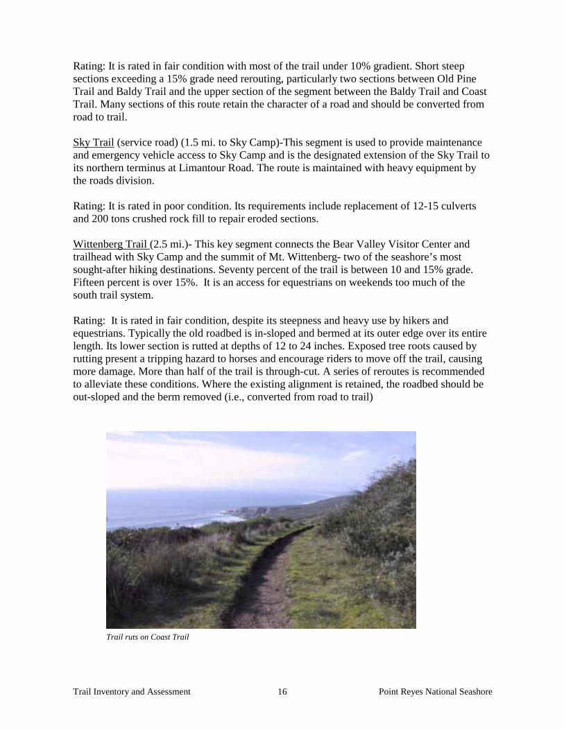
Rating: It is rated in fair condition with most of the trail under 10% gradient. Short steep sections exceeding a 15% grade need rerouting, particularly two sections between Old Pine Trail and Baldy Trail and the upper section of the segment between the Baldy Trail and Coast Trail. Many sections of this route retain the character of a road and should be converted from road to trail. Sky Trail (service road) (1.5 mi. to Sky Camp)-This segment is used to provide maintenance and emergency vehicle access to Sky Camp and is the designated extension of the Sky Trail to its northern terminus at Limantour Road. The route is maintained with heavy equipment by the roads division. Rating: It is rated in poor condition. Its requirements include replacement of 12-15 culverts and 200 tons crushed rock fill to repair eroded sections. Wittenberg Trail (2.5 mi.)- This key segment connects the Bear Valley Visitor Center and trailhead with Sky Camp and the summit of Mt. Wittenberg- two of the seashore’s most sought-after hiking destinations. Seventy percent of the trail is between 10 and 15% grade. Fifteen percent is over 15%. It is an access for equestrians on weekends too much of the south trail system. Rating: It is rated in fair condition, despite its steepness and heavy use by hikers and equestrians. Typically the old roadbed is in-sloped and bermed at its outer edge over its entire length. Its lower section is rutted at depths of 12 to 24 inches. Exposed tree roots caused by rutting present a tripping hazard to horses and encourage riders to move off the trail, causing more damage. More than half of the trail is through-cut. A series of reroutes is recommended to alleviate these conditions. Where the existing alignment is retained, the roadbed should be out-sloped and the berm removed (i.e., converted from road to trail) Trail ruts on Coast Trail

Trail Inventory and Assessment Point Reyes National Seashore 17
Baldy Trail (1.1 mi.)- Like the Wittenberg Trail this route is one of several popular segments that link the Sky Trail with Bear Valley Trail and facilitate a one-way loop experience. This is especially popular with equestrians on weekends and holidays due to the closure of the Bear Valley Trail. Rating: It is rated in replace condition. Because most of the trail is excessively steep (60% at 10-15% gradients and 30% at more than 15% grades) and through-cut, more than half of its length is incised with ruts up to 24 inches in depth. It is recommended that steep sections should be rerouted, particularly at its upper end. The remainder of the trail should be out-sloped and converted from road to trail Laguna Trail (0.8 mi.)- This short segment is a key connection, linking the trailhead parking lot near the education center to the one-mile segment of Fire Lane Trail that leads to Coast Camp. Although it roughly parallels the northern reach of Coast Trail, it is a more direct route to the campground and is free of maintenance and emergency vehicles. Rating: It is rated as poor condition, although the route is quite level (mostly less than 10% grade), over 50% of its length is through-cut, producing substantial areas of standing water and mud. It was closed after the winter storms of 1994 due to erosion gullies. Recommended minimum improvements include rerouting of some through-cut sections, out-sloping and possible addition of a turnpike or a raised tread. The long-term recommendation would be to reroute the trail to the hillside above the valley floor. Earthquake Trail (0.5 mi.)- This short loop, starting and ending near the Bear Valley visitor center, is an essential element of a first-time visit to the seashore. As its name implies, it provides access to impressive features of the San Andreas Fault and wayside exhibits interpreting them. The trail offers handicap accessibility with an asphalt-paved surface. Rating: It is rated in fair condition, requiring repair of cracks and holes in the asphalt, installation of a culvert and possible rerouting of two sections that exceed 5% gradient. The two existing bridges, which were constructed in 1983 without concrete foundations, should be replaced. Consideration may be made to building one of these bridges to accommodate creek interpretive programs. Kule Loklo Trail (1.0 mi.)- Another star feature of the Bear Valley area, Kule Loklo is an authentic recreation of a Coast Miwok village, attracting visitors of all kinds, but enjoying special popularity with school programs. Rating: It is rated in fair condition. No particular problems demand attention, however staff members note that the trail looks like a road and could be modified to better fit with the interpretive goals of the village. One recommendation is for the trailhead to be moved from the parking lot to the visitor center. The reroute would remove the only steep section of this trail and allow better access for the handicapped, as well as move the trail to side hill for better drainage. Horse Trail- (3.2 mi.)- Essentially paralleling Wittenberg and Meadow trails, this route from the Bear Valley area to the summit of Mt. Wittenberg is especially popular with equestrians

Trail Inventory and Assessment Point Reyes National Seashore 18
on the weekends. The trail is a steep ascent, with 70% of its length climbing between 10 and 15%, and one third of a mile exceeding 15%. Rating: It is rated in replace condition. The route is heavily eroded with ruts up to four feet in depth and numerous exposed tree roots. This condition is particularly prevalent in the route’s ¾- mile mid-section that is entirely through-cut. Level through-cut sections at the top create standing water problems. Recommendations include “major” rerouting of steep and through-cut sections, out-sloping and conversion from road to trail. Meadow Trail (1.6 mi.)- This segment is another popular leg of Mt. Wittenberg loops for hikers and equestrians. Although more than a half-mile of the route is 10% gradient and under, the remainder is steep and often through-cut and rutted. Sections at the bottom of the trail rising up to 20% grades and roots have produced “stairs”- some presenting drop-offs up to 24” in height. Through the meadow itself, in the mid-section of the trail, parallel social trails have developed as hikers and equestrians have moved off the established trail.
Rating: It is rated in poor condition. It is recommended that steep and rutted sections should be rerouted, (the top section should be reconstructed to trail standards and out-sloped) and conversion from road to trail should be performed wherever feasible. Old Pine Trail (1.8 mi.)- This trail connects Sky Trail with the Bear Valley Trail at Divide Meadow- a popular destination for the casual hiker who seeks a mid-day stop for a picnic lunch. It facilitates an easy loop, including the meadow, out of the Bear Valley trailhead. Rating: It is rated in fair condition, but consistent with similar routes ascending the ridge, much of it is steep, including through-cut sections and segments drained with berms and in-board ditches. Large sections are rutted. Steep and through-cut sections should be rerouted and converted from road to trail Z Ranch Trail (0.7 mi.)- Located at the top of Inverness Ridge near the summit of Mt. Wittenberg, this trail connects the upper ends of Wittenberg and Horse trails. The majority of the trail is relatively level. Rating: It is rated in fair condition. Because it is an in-sloped roadbed up to 20 feet in width, it is recommended that it be converted from road to trail with a minor reroute at its northern end Laguna Trail- (1.6 mi.-from the parking area near the Education Center to the Bayview Trail) This segment is used primarily to support activities out of the Education Center. This old roadway follows a sloping ridgeline throughout its length and consequently is entirely through-cut. Rating: It is rated in poor condition. More than a mile of the route climbs gradients of 10-15%, and a quarter mile exceeds 15%. To prevent erosion following the Mt. Vision fire, a series of deep dips were constructed, which are so large as to encourage hikers and equestrians to bypass them. Major reroutes should be investigated in these steep sections and out-sloping road to trail conversion should be accomplished wherever possible.

Trail Inventory and Assessment Point Reyes National Seashore 19
Fire Lane Trail (3.3 mi.)- This well-used route provides a direct link between Sky Camp and Coast Camp. The route follows descending ridgelines, more than half its length at grades of 10-15% and nearly a mile over 15%. Its 20-foot wide through-cut design has resulted in sections where the trail tread is depressed as much as 8 feet. Rating: It is rated in poor condition. It is recommended that approximately that 70-80% of the trail should be considered for minor reroutes and the remainder converted from road to trail Woodpecker Trail (0.6 mi.)- This interpretive trail with wayside exhibits near the Bear Valley visitor center offers another convenient experience to the first-time seashore visitor. Unlike so many seashore trails, this one was constructed as a trail and is generally well drained and problem-free. Rating: It is rated in fair condition. A short section near the Morgan Horse farm is considered steep and should be rerouted, and a set of stairs should be rebuilt to proper tread/riser standards. Morgan Horse Trail (0.6 mi.)- Connecting the Morgan Horse farm with the Bear Valley Trail, this segment offers a pleasant, level short loop ride or hike. Rating: It is rated in fair condition, needing only rock fill to correct irregularities in the tread and some berm removal. Sculptured Beach Trail (0.2 mi.)- This short pathway provides the only beach access off of the Coast Trail between the terminus of the Bear Valley Trail and Coast Camp. It is a relatively steep, through-cut, poorly defined trail. Rating: It is rated in poor condition. It follows the bottom of drainage. It is recommended that it should be rerouted to the hillsides a few meters away and that rock fill should be added at the stairway. Hidden Valley Trail (0.5 mi.)- This loop trail is considered to be a critical resource to the Clem Miller Environmental Education Center in facilitating field programs. Although the majority of the route is under 10% gradient, it contains two steep sections that require rerouting. Rating: It is rated in poor condition. It also traverses several poorly drained wet areas that should be corrected with turnpikes or boardwalks. Stairs damaged in the Mt. Vision fire are also in need of replacement. Ed Center Trail (0.6 mi.)- This trail connects the education center with its amphitheater and bus parking lot. Rating: It is rated in fair condition and should be retained as a roadway to continue to serve its original purpose as an alternate route in case of Limantour Road failures. It needs only minor drainage adjustments and rock fill of rutted sections.
Trail Inventory and Assessment Point Reyes National Seashore 20
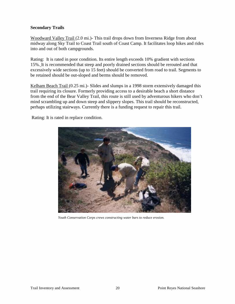
Secondary Trails Woodward Valley Trail (2.0 mi.)- This trail drops down from Inverness Ridge from about midway along Sky Trail to Coast Trail south of Coast Camp. It facilitates loop hikes and rides into and out of both campgrounds. Rating: It is rated in poor condition. Its entire length exceeds 10% gradient with sections 15%. It is recommended that steep and poorly drained sections should be rerouted and that excessively wide sections (up to 15 feet) should be converted from road to trail. Segments to be retained should be out-sloped and berms should be removed. Kelham Beach Trail (0.25 mi.)- Slides and slumps in a 1998 storm extensively damaged this trail requiring its closure. Formerly providing access to a desirable beach a short distance from the end of the Bear Valley Trail, this route is still used by adventurous hikers who don’t mind scrambling up and down steep and slippery slopes. This trail should be reconstructed, perhaps utilizing stairways. Currently there is a funding request to repair this trail. Rating: It is rated in replace condition.
Youth Conservation Corps crews constructing water bars to reduce erosion.

Trail Inventory and Assessment Point Reyes National Seashore 21
LIMANTOUR ROAD TO TOMALES POINT
This northern segment of the park features seemingly endless sandy beaches, some of the most important tidal estuaries in California, vast expanses of grasslands and coastal scrub, historic dairy ranches and the northern terminus of Inverness Ridge which maintains an elevation of over 1300 feet near Mt. Vision and Point Reyes Hill. Even though this area is the largest piece of the seashore accessible by car, it also offers an extensive trail system. Primary Trails Bayview Trail (3.2 mi.)- This trail serves as a northern extension of Sky Trail, linking it with the Inverness Ridge Trail, then dropping down to Muddy Hollow and facilitating access to Limantour Beach. Rating: Its condition is rated as poor. Its deficiencies stem from its design as a road, including excessive width, in-sloping, and through-cuts. Forty percent of the route traverses gradients ranging between 10 and 15%. Segments between Sky Trail and Limantour Road need rerouting and road to trail conversion. Between Inverness Ridge and Muddy Hollow a through-cut section needs rerouting and another section that is properly aligned should be converted from road to trail. A flat, through-cut section at the bottom of the hill that stays wet all winter should be rerouted. An inadequate bridge that is frequently overtopped by stream flow needs replacement and re-siting, a nearby low wet area in the trail needs correction with a turnpike and an adjacent section needs reconstruction. Roadway segments that are retained require out-sloping and berm removal (i.e., road to trail conversion.). Muddy Hollow Trail (1.4 mi.- from the trailhead to Limantour Beach) This route provides direct access to the beach from the education center, the hostel and trails descending from Inverness Ridge. It was constructed at the bottom of a valley, paralleling a creek, a pond and the shoreline of a tidal estuary, which continually caused damage to the trail. The first 0.42 miles are maintained with equipment as a road to provide access to the pump house. Rating: It is rated as replace and is posted “closed” as well as removed from park trail maps. Creek levels actually top the trail tread at times. A segment of it has been appropriately rerouted to the hillside and funding requests have been submitted to complete the job. Muddy Hollow Road Trail (2.1 mi. - from the trailhead to the White Gate Trail) This trail was originally a segment of the historic access route to the lighthouse and probably has historic values that could affect the following recommendations. Today it is an important connecting link in a series of trails that offer access to the seashore’s unusual system of scenically and scientifically important tidal estuaries. It also connects the lower ends of the Bucklin and Bayview trails. Although quite level throughout its length, the route has been constructed on highly erosive soil and is subject to rutting. Rating: It is rated in poor condition and requires conversion from road to trail some minor rerouting, reconstruction and a boardwalk or a possible bridge constructed. The trail also crosses Glenbrook crossing that should be evaluated for possible removal and a corresponding reroute of the trail.

Trail Inventory and Assessment Point Reyes National Seashore 22
Inverness Ridge (2.6 mi.)- A northern extension of the Sky/Bayview Trail route on the crest of Inverness Ridge, this segment offers great views and facilitates a series of loop hikes & rides into and out of Muddy Hollow. The trail is a 20-foot wide in-sloped roadbed with 0.4 mile over 15% gradient and a mile of grades between 10 and 15%. Rating: It is rated in poor condition. Poor design characteristics are exacerbated by soil regimes particularly prone to erosion. Steep and through-cut sections require rerouting, excessively wide sections should be reconstructed and remaining sections need to be converted from road to trail with out-sloping and berm removal. Kehoe Beach Trail (0.6 mi.)- This route provides access from a trailhead on Pierce Point Road to one of the seashore’s most attractive small beaches. The trail currently accommodates all kinds of users including cows, bicyclists, and dogs with their owners. Rating: It is rated in poor condition. Following the relatively flat course of a small creek, sections of the trail are poorly drained and laced with short cuts. Low sections should be rerouted and out-sloping is needed throughout the route. Where the trail is particularly susceptible to damage from uncontrolled livestock, turnpikes or rock fill is recommended. With better definition of the designated trail, short cuts should be eliminated. Tomales Point Trail (4.6 mi.)- This trail facilitates a unique seashore experience, following the crest of the Point Reyes peninsula to its tip and offering spectacular views of the ocean to the west and Tomales Bay to the east. Traversing wide-open grassland and coastal scrub plant communities, the trail experience here features whales, raptors and tule elk. Most of the trail follows the alignment of an historic ranch road and is either in-sloped or through-cut. Rating: It is rated in replace to poor condition. It is inappropriate to designate the entire trail as needing replacement since 40% of it is considered to be in a replace condition and the rest is rated as poor. Deep drainage dips (an inconvenience and hazard to hikers) have been constructed to facilitate runoff and the erosive soil that comprises the trail tread has submitted to extensive rutting. Wherever possible the trail should be relocated off of the ridge crest to allow out-sloping. Steep sections at Windy Gap and just south of the Lower Ranch site should also be rerouted considering ¾ of the route’s gradient is 10% or less. The segment between the Lower Ranch and the trail’s end passes through loose sandy soils and is frequented by elk, making the trail extremely difficult to maintain. A detailed evaluation of this problem is recommended. Staff recommends that this trail be the subject of a pilot case study for GIS analysis. Estero Trail (8.3 mi.)- This trail is a primary element of the system of trails providing access to the seashore’s unique array of estuaries (esteros). Another former historic ranch road, its flat gradient rates it an easy hike and its first half-mile from its northern trailhead is actually considered to be handicap accessible. A segment of the trail is also one of the few in the seashore designated for bicycle use (north trail head to White Gate trail.) Rating: It is rated in poor condition. With an average roadbed width of 25 feet, much of the route should be converted from road to trail. The bridge near Estero Trailhead rests on an old breached dam that needs to be removed to restore habitat. The dam represents a fish passage

Trail Inventory and Assessment Point Reyes National Seashore 23
impediment. This requirement will necessitate a thorough evaluation of the trail’s alignment in this area. A number of short steep sections and through-cut segments should be rerouted. The stretch between the Glenbrook Bridge and Muddy Hollow is of particular concern in this regard and also needs turnpikes to correct unavoidable wet areas. A section between White Gate and Glenbrook trails needs retaining walls to stabilize landslides. Several bridges traversed by this trail need replacement. McClure’s Beach Trail (0.4 mi.)- This beach is one of several landmark beaches at Point Reyes and has the special distinction of being located in tule elk habitat. The trail connects a parking area with the beach and traverses sandy soils especially prone to erosion. Numerous active springs in the area magnify its inherent instability, and nearly half of its length exceeds a 10% gradient. Rating: It is rated in fair condition, slides and down cutting are common occurrences. A design analysis is recommended to correct these deficiencies, with consideration given to structural solutions including stairs, retaining walls, bridges and rock fill. Chimney Rock Trail (0.9 mi.)- A key access route at another landmark site, this short trail offers exceptional seashore views. It is located on the brink of Point Reyes Headlands where the peninsula stretches out into the Pacific. Special ocean views include whales and sea lions. Rating: It is rated in fair condition with most of the trail under 10% gradient. It is another old roadbed, half of the trail is through-cut and 30% of it is in-sloped. It is recommended that the entire route should be converted road to trail and that one steep section should be rerouted. (Note: This trail is the park maintained and designated trail, there are two other heavily used “social trails” on the peninsula that may be included in future planning)
Park volunteers at Abbott’s Lagoon Trailhead.

Trail Inventory and Assessment Point Reyes National Seashore 24
Abbotts Lagoon Trail (1.1 mi.)- This rare handicap accessible trail leads from a parking area on the Pierce Point Road to a scenic brackish water lagoon with sandy beaches and dunes. The area is popular with birders and picnickers. The trail has sustained damage from cattle incursions. Rating: It is rated poor condition. Recommended long-range improvements include removal or realignment of a turnpike that is prone to seasonal flooding and in proximity to endangered plants. It could be replaced with a boardwalk or the trail should be rerouted at this point. One bridge needs replacement and the handicapped portion of the trail needs to be extended because it currently ends a substantial distance short of the lagoon. Special status plant species in this area will require that this work be carefully planned. The handicapped portion of the trail needs resurfacing as it has become eroded. Limantour Beach Trail (North) (0.25 mi.)- These two paved short segments connect the Limantour Beach parking area with one of the seashore’s most popular beaches. The main route runs straight to the beach while a short southern spur borders a pond before turning to the beach. Because the southern spur terminates in dunes, the possibility of extending it to the beach with a handicap accessible elevated boardwalk and viewing deck should be evaluated. Rating: Both trails are rated in fair condition. Limantour Beach Trail (South) (0.25 mi.)- This short segment connects the small southern parking area with Limantour Beach. Rating: It is rated in fair condition and is quite level. Because the trail tread is flat, crowning is recommended to correct its tendency to collect standing water. The trail crosses a channel, requiring a culvert to accommodate flow. This structure is designated for replacement with a bridge as part of a coastal watershed restoration project. Because the trail terminates in dunes, the possibility of extending it to the beach with a handicap accessible elevated boardwalk and viewing deck should be evaluated. Marshall Beach Trail (service road) (1.2 mi.)- This segment is used to provide maintenance and emergency vehicle access to Marshall Beach. It is maintained with heavy equipment by the roads division. Rating: It is rated in poor condition requiring 150 tons of crushed rock. Secondary Trails Drake’s View Trail (2.0 mi.)- One of the loop options down from Inverness Ridge into Muddy Hollow, this steep former road stubbornly follows a ridgeline and is consequently though-cut over its most of its length. Rating: It is rated in poor condition and has traditionally had a low maintenance priority. To correct the erosion induced by its inappropriate design it is recommended that most of trail be rerouted to proper trail standards with out-sloping and gradients under 10% and remaining sections need to be converted from road to trail

Trail Inventory and Assessment Point Reyes National Seashore 25
Bucklin Trail (2.3 mi.)- Another Muddy Hollow loop segment on the ridgeline just north of Drake’s View Trail, this trail is also largely through-cut and plagued with deep rutting. Deep drainage dips constructed to divert the flow persistently fail. Rating: It is rated in poor condition. Sixty percent of it exceeds a 10% gradient and 20% is over 15%. Excessively steep sections should be rerouted and remaining sections should be converted from road to trail with appropriate out-sloping. Consideration should be given to abandoning this route and the Drake’s View Trail but replacing them with a properly designed single trail that serves the same destinations. Glenbrook Trail (0.7 mi.)- This short link connects the Muddy Hollow Trail with the Estero Trail. Rating: It is rated in poor condition. Although it is relatively level throughout, the first hill out of Muddy Hollow is excessively steep and rutted, and should be rerouted. The remainder is through-cut and should be reconstructed to trail standards and elevated with rock fill. White Gate Trail (.9 mi.)- This old ranch road following the shoreline of one of the arms of Limantour Estero is 100% in-sloped. Rating: It is rated in poor condition. It is in particular need of gully repairs but also requires repair of drainage structures, and re-grading of the route to appropriate trail widths and an out-sloped configuration (i.e., conversion from road to trail). The area where the trail intersects with the Estero Trail has been disrupted by grading work from dam construction and needs rehabilitation as well as quarry restoration. It was also an old quarry. The bridge over the dam spillway was built in 1984 without a concrete foundation, lacks handrails, and needs replacement. Bull Point Trail (1.8 mi.)- Another old ranch road, extending between two of the fingers of Drake’s Estero from the east side of Drake Highway, this trail is little used and has a low priority for routine maintenance. Rating: It is rated in poor condition, 100% in-sloped and up to 20 feet in width. The trail should be reconstructed to appropriate standards. Elephant Seal Overlook Trail (.2 mi.)- This short trail terminates at an overlook of the Drakes Beach elephant seal colony. This is a social trail that has been formalized. During the December to March pupping and breeding season, docents noted up to 500 visitors a day, though the maximum days in a year that this use could be experienced is 36. Rating: It is rated in poor condition and requires winter maintenance due to active grazing by cattle. A barrier fence to protect the resource is planned for construction in 2004 Lighthouse Trail (0.1 mi.)- A rarely used or maintained short route through sandy soil and coastal scrub, offering excellent views of Ten Mile Beach, this trail has two versions. A determination needs to be made whether this trail is actually a designated trail. If so, a clear

Trail Inventory and Assessment Point Reyes National Seashore 26
route should be constructed and maintained. (Note: Two “social trails” that lead from the parking lot are heavily used and should be included in the planning process.) Rating: It is rated in poor condition. Sunset Beach Trail (1.4 mi.)- A southern extension of the Estero Trail leading to a small beach near the mouth of Drake’s Estero, this trail provides access to one of the few opportunities to be close to this interesting and important body of water. It is also one of only a few trail options available to cyclists. It primarily follows an in-sloped rutted roadbed up to 20 feet in width with both steep and through-cut sections. Some sections are poorly defined, displaying meandering social trails. Some rerouting is needed but most of the route should be reconstructed to trail standards with appropriate out-sloping (i.e., converted from road to trail). Rating: It is rated in replace condition due to extensive erosion in sections. Drake’s Head Trail (1.3 mi.)- Another rare option for bikes off the Estero Trail, this route terminates at the edge of Limantour Estero. The trail follows the top of a ridge and is through-cut over most of its length, resulting in considerable rutting. Rating: It is rated in replace condition. It is recommended that the route should be converted from road to trail and rerouted in through-cut areas.

Trail Inventory and Assessment Point Reyes National Seashore 27
GOLDEN GATE NORTH DISTRICT
Since the establishment of Golden Gate National Recreation Area in 1972, trail planning and design efforts have not been comprehensive. Prior to the completion of the 1980 General Management Plan, the Citizen’s Ad Hoc Trail Committee (a group of hikers and equestrians interested in supporting the park and developing visitor use opportunities), worked with the trail committee of the park’s Citizen’s Advisory Commission to prepare a trail plan that was endorsed by park staff. The plan simply designated routes within the existing system of ranch and military roads that would be appropriate for equestrian use. Responding to competing demands generated by the increasing use of mountain bikes in the 1980’s, the staff prepared an updated trail use designation plan for the southern Marin areas of the park, clearly defining appropriate routes for hikers, equestrians and bicyclists. As in the case of Point Reyes, significant improvements have been made on a trail-by-trail basis, but no comprehensive trail planning effort has been accomplished. The extensive areas of Golden Gate north of the Bolinas-Fairfax Road at the head of Bolinas Lagoon are all under the day-to-day management responsibility of the Seashore (including trail maintenance). Nearly all of the existing designated trails in the area are former ranch roads that have been designated for multiple uses because of their generous width. Most of these trails are not within wilderness areas and have been maintained by the road crew with heavy equipment. Bolinas Ridge Trail (9.7 mi.)- As its name indicates, this key north-south route straddles the ridge defining the eastern boundary of the Olema Valley and adjoins the substantial park-like holdings of the Marin Municipal Water District (MMWD). The route is accessible from trailheads at either end at the Bolinas-Fairfax Road in the south and at Sir Francis Drake Blvd. in the north. It is also served by an MMWD trail that extends from a trailhead at its junction with the Cross Marin Trail. Although the trail contains a substantial number of short sections that clearly exceed acceptable standards for trail gradients, the route is also an important access road used and managed cooperatively by both the NPS and MMWD. It is also a PG&E (Pacific Gas and Electric) right of way and is not considered for major rerouting. Some sections in its less heavily vegetated northern reaches where the ridge is broader may be considered for short reroutes. The trail is also part of the dedicated alignment of the Bay Area Ridge Trail, designated for multiple uses. Rating: It is rated in poor condition (mainly attributed to the northern sections), requiring an estimated 600 tons of rock fill to repair and control erosion. Randall Trail (1.7 mi.)- This trail provides an important link between Golden Gate and Point Reyes, connecting the Bolinas Ridge Trail with Highway 1 and the Olema Valley Trail. Its ridge top alignment renders it predominantly through-cut, and its gradient is in excess of 10% over most of its length, many segments exceeding 15%. Rating: It is rated in poor condition. Persistent rutting has generated considerable discussion in the past about the need for reroutes. If its current use by emergency vehicles could be discontinued, reroutes designed according to appropriate trail standards should be explored
Trail Inventory and Assessment Point Reyes National Seashore 28
using GIS technology. Maintenance staff estimates that eroded areas currently require 250 tons of crushed rock. McCurdy Trail (1.9 mi.)– This trail has been very popular with equestrian users, providing one of the few connections between the Olema Valley Trail and the Bolinas Ridge Trail. Its features and shortcomings are identical to the Randall Trail described above and it should be considered for rerouting or elimination. Rating: It is rated in poor condition. Jewell Trail (0.9 mi.)- This trail branches from the north end of the Bolinas Ridge Trail and drops down the east side of the ridge to connect with the Cross Marin Trail. The trail is a fairly well designed former ranch road with easy gradients and no significant drainage problems. Rating: It is rated in fair condition by the road crew. Improvements would require 150 tons of rock or road base. Tomales Bay Trail (approximately 1.25 mi.)- This short and easy route on the Martinelli Ranch is not a designed and maintained trail, but rather a combination of cow path and ranch road loosely defined by public use. Its destination is a striking viewpoint at the edge of a sheer bluff nearly 100 feet above the Giacomini Ranch/marsh, acquired by NPS in 2000. This spot affords panoramic views along the San Andreas Fault, north through Tomales Bay and south through the Olema Valley. Rating: It is rated in poor condition. The trail is ill defined; hikers are indiscriminate in choosing a route through this open grassland. It is not well drained and hikers make their way around large muddy areas. It is recommended that a full evaluation of this alignment be performed using a multidisciplinary approach.

Trail Inventory and Assessment Point Reyes National Seashore 29
RECOMMENDATIONS: PROPOSED NEW TRAILS
Proposals for new routes in the Seashore and the North District of Golden Gate NRA have been discussed with some reluctance as the backlog of funding existing repairs and maintenance is so extensive. However, in order to portray a complete picture of trail options, the following opportunities are offered as long-range proposals. Most of the following are located within the “North District” of Golden Gate NRA. (Note: Potential location maps are attached in Appendix B). The maps in Appendix B show proposed locations for the sole purpose of planning. Resource conditions may significantly change the routes, if implemented. Major boundary expansion legislation for Golden Gate NRA was enacted just prior to the General Management Plan of 1980. The legislation extended the park north to Point Reyes Station, east to Samuel P. Taylor State Park and significant areas north. These additions are known as the Lagunitas Loop and Devil’s Gulch. With the exception of the State Park, none of these lands have received either trail improvements or trail designations for existing ranch roads. Since acquisition these routes have remained essentially unused by the public. We have included them in the report in order to offer a complete picture of the existing trail system and future options. Point Reyes National Seashore Duck Cove/Marshall Beach Road – This proposed trail follows an existing service road northward about ¾ mile along its original ranch road alignment could provide an attractive loop ride for bicyclists when used in conjunction with Pierce Point Road. It is not within designated wilderness and may be maintained by the road crew with heavy equipment. Miwok Culture Trail – Park cultural resource management staff have suggested that a new trail is needed to interpret the viewsheds associated with the cultural landscape of the prehistoric and historic occupation of the area by the Coast Miwok. The trail would connect the habitation and subsistence areas on the shores of Tomales Bay with the subsistence and ceremonial areas of Drakes Estero. Further development of this proposal should be done within the context of an interpretive prospectus through a multidisciplinary team using GIS technology. The trail would probably exceed 7 miles in length and could be incorporated into recommendations for rerouting the Bucklin and Drakes View trails. No existing ranch roads or trails have been suggested for this proposal. Drakes Beach – Chimney Rock Trail This trail exists as a social trail leaving from the Peter Behr Overlook and heading west to the Chimney Rock Road. Its use continues to rise primarily in the wintertime, when visitors use it to access the elephant seal colony and overlook the Chimney Rock area. This proposal offers an attractive option to reduce congestion in the Chimney Rock area. The park has not established a particular route and will analyze options in the future. The eastern portion is very level while the approach to the seal colony and Chimney Rock Road cuts through a ravine, visitors are mostly picking their way through open pastures and walking over barbed wires fences.

Trail Inventory and Assessment Point Reyes National Seashore 30
Golden Gate NRA North District All trails to follow are roads and have some poor alignments in sections. They should all be considered for reroutes and road to trail conversion as defined in Appendix D. Olema Valley- McCurdy Trailhead to Wilkins Ranch Trail – This trail was apparently established by former tenants of the Wilkins Ranch and was used by running clubs. It allows access to the Bolinas Ridge Trail via the McCurdy Trail and parallels Highway 1. With a few exceptions, it appears to be a serviceable alignment. A steep section at its northern end could be rerouted and the park’s resource management staff should evaluate stream crossings and other potential natural resource issues. Wilkins Ranch Trail – (between Lewis Gulch and Copper Mine Gulch). This route was informally established by former tenants and visitors of the Wilkins Ranch. This trail should be considered for addition to the park, with realignment at its upper end. Unfortunately the alignment of this trail has much in common with its neighbors--the McCurdy and Randall. They are extremely steep and through-cut. If funding develops, a multi-disciplinary team should conduct a comparative evaluation of this trail. Five Brooks to Bolinas Ridge- There are currently no opportunities to descend from the Bolinas Ridge Trail into the Olema Valley for the more than six-mile stretch between the Randall Trail and Sir Francis Drake Boulevard. Roughly halfway along this stretch an existing ranch road drops down the ridge through the Lupton Ranch and terminates at Highway One near the Five Brooks trailhead. This route traverses less steep terrain and appears to offer no serious erosion problems, which makes it a more desirable option than the trails listed above. Its open grassland setting also makes rerouting considerations easier than the southern routes. This trail connecting to the Five Brooks trailhead would offer additional opportunities for equestrian use. However, safely routing trail traffic across Highway One would be an important consideration. The map in Appendix B proposes a 5-km zone for potential locations of the trail. The exact location would be determined after careful site analysis and planning. Bolinas Ridge Trail Extension--The popular multiple use trail that extends northward along the top of Bolinas Ridge now ends at Sir Francis Drake Boulevard. But the ridge itself continues for two more miles to its termination at Point Reyes Station. The existing trailhead on Sir Francis Drake Blvd. has always presented a problem with insufficient space for safe parking and poor sight distance. If an appropriate location for a new trailhead can be identified with community input and support, the northward extension of this trail seems to offer a perfect opportunity to expand an important visitor experience as well as to solve an existing safety and crowding problem. Although an existing ranch road on the ridge could be used for this purpose, a multidisciplinary team using GIS inferential analysis should determine an alignment. An inventory of the area’s natural and cultural resources must also be conducted. Railroad Grade to Point Reyes Station – The roadbed of the Northwestern Pacific Railroad that once extended through Marin County from Sausalito north to the eastern shoreline of Tomales Bay, enters the park at Samuel P. Taylor State Park. Running along the banks of
Trail Inventory and Assessment Point Reyes National Seashore 31
Lagunitas Creek, it enters Point Reyes Station and remnants of it continue along the bay. The western end of what was originally designated as the Cross Marin Trail capitalizes on the easy gradient of the roadbed, with a paved path running through the State Park and ending at the intersection of Sir Francis Drake Blvd. and Platform Bridge Road. Because the logical termination of the trail is the town of Point Reyes Station, this has been a standing proposal for decades. The National Park Service now owns all but one of the ranches through which the old right-of-way runs. (Negotiations for acquisition of the Gallagher Ranch have been an ongoing process for several years.) Although substantial natural re-vegetation has occurred on much of the right-of-way, the roadbed is largely intact. Particular attention will need to be devoted to the appropriate treatment of several minor stream crossings, and a major bridge will be required to cross Lagunitas Creek when the trail reaches Point Reyes Station. This trail and the proposed Bolinas Ridge Trail extension should terminate at the same trailhead facility in or near the town of Point Reyes Station, requiring thorough site evaluations and discussions with the community. Assuming that the Gallagher family will choose to retain a right of use and occupancy when their property is acquired, the close proximity of the three residences to the railroad right-of –way will represent another concern that needs to be addressed. Portions of this trail are used for an annual biking event and there is substantial interest in this route as a multi-use trail. Cheda/McIsaac/Zanardi Ranches – The lands east of Lagunitas Creek from the northern boundary of Samuel P. Taylor State Park to the intersection of Platform Bridge Road with the Point Reyes- Petaluma Road represent some of the most scenic and ecologically important resources in Golden Gate. Although no systematic survey of natural resources has been performed in this area, rare endemic plants are known to exist on the ridge tops and the lichen-covered rock outcroppings and wind-contorted trees in the area create scenes reminiscent of Japanese landscape paintings. The public (to the benefit of natural resources) has not generally used the area; however, some level of trail access seems appropriate to consider. Existing ranch roads could provide an interim solution to the need for trail access but are not suitably designed for trail use and maintenance, and do not present the kind of aesthetic experience that this extraordinary landscape has the potential to reveal. It does not appear that there is a need for any through-trail routes in this area either to link national park destinations or to tie in with regional trail systems. Therefore any future trail here should be designed to maximize an aesthetic and interpretive experience rather than as an efficient and/or safe way to get from one point to another. Because most of this land falls within the “pastoral landscape management” zone of the management zoning designations in the park’s General Management Plan, livestock grazing will continue to be a consideration in public use planning. It is proposed that a multidisciplinary team should evaluate this area for the potential development of one or more hiking trails with the benefit of a comprehensive survey and analysis of cultural and natural resources and full consultation with ranchers. Giacomini Ranch – The National Park Service has acquired this dairy ranch at the headwaters of Tomales Bay for the purpose of restoring its key ecological role as major wetlands and

Trail Inventory and Assessment Point Reyes National Seashore 32
floodplain for the Bay. A component of the planning for this project will be to determine appropriate levels of public access for interpretive and educational uses. Consideration could be given to such facilities as pedestrian trails, overlooks, boardwalks, bird blinds and other means to sensitively reveal the natural and scenic resources of the site. Because the bulk of the property will be devoted to marsh restoration, it appears unlikely that major through-trail routes will be feasible (with the possible exception of a portion of the Tomales Bay west shore trail as described in the Marin Countywide Trails Plan). No particular route has been determined Miller Park Boat Ramp to Hamlet – This 0.4-mile section of the historic railroad grade along the eastern shoreline of Tomales Bay is currently used as a trail by the public. However, it does not appear to be a feasible route for formally constructing and maintaining a trail. Substantial portions of the old roadbed remain at either end of the proposed trail but a significant stretch of the midsection has been eroded by tidal action. Bordered by a steep bluff in this area, a new trail would either have to be created by placing substantial fill on the beach or by cutting into the bluff and destroying native vegetation. Both options appear infeasible. This informal access opportunity could present an attractive way to experience the bay shoreline, if constructed. The old railroad grade may provide a possible trail opportunity. Connections with Regional Trail System Marin County is widely considered to be a paradise of public open space. Forty-two percent of its area is comprised of National Park land, state and county parks, open space preserves and public watershed lands. The principal uses of this extraordinary expanse of wildland relate directly to its expanding system of trails. The Marin Municipal Water District (MMWD) watershed and Samuel P. Taylor and Tomales Bay State Parks are situated directly adjacent to Point Reyes and Golden Gate and have comprised a major interconnected system of hiking, riding and cycling trails in West Marin for decades. A growing system of open space preserves throughout the county and associated trail development is promising to further link these important resources together and could someday provide multiple trail routes from the populated eastern corridor to the more remote expanses of the national parklands. This section evaluates the potential of improving the trail interface between Point Reyes-managed parklands and those of adjacent jurisdictions. However, clear agreements need to be reached about who maintains these interfaced trails and to what agency standards and practices. The Marin Countywide Trails Plan and the Bicycle and Pedestrian Master Plan The Marin Countywide Trail Plan was first approved by the Board of Supervisors in 1984 and is considered an element of the county’s General Plan (revised and approved in 1994). The trail network discussed in the plan is intended to connect the individual units of the more than 150,000 acres of open space preserved in Marin County to each other and to adjacent communities. The document articulates trail system objectives, policies and implementation programs as well as trail proposals, general design guidelines and use designations. The Marin County Open Space District principally carries out the programs and activities generated by the plan.

Trail Inventory and Assessment Point Reyes National Seashore 33
The Marin County Unincorporated Area Bicycle and Pedestrian Master Plan was prepared in 2001 for the Marin County Department of Public Works to help address the area’s growing traffic congestion problems and to qualify the county to receive state and federal funding for bicycle and pedestrian access improvements. Originally the responsibility and concern of the Department of Parks and Open Space, this important function is usually associated with roadway improvements and is now logically under the direction of Department of Public Works. Paved pathways are the chief focus of this document and its major focus is on the developed areas of the eastern portions of the county. Existing and proposed trails within Golden Gate and Point Reyes are integrated into the Countywide Trail Plan. For the most part, trails outlined in the plan within or adjacent to federal parklands are existing and open to the public. There are three notable exceptions. Tomales Bay Trails – In the 1970’s, following the establishment of the Seashore and a burgeoning sense of the recreation potential of West Marin, the idea of developing a trail on the east shore of Tomales Bay using the historic Northwestern Pacific Railroad (NWPRR) right-of-way was a popular proposal. Since the 1970s, people have been informed about the value of riparian corridors and the negative impacts that would occur if bridges, causeways and landfills were replaced and repaired to restore the roadbed. Furthermore although the Golden Gate NRA boundary encompasses a significant portion of the shoreline, much of it is developed for residential and commercial uses and major sections of the roadbed have disappeared due to wave erosion. The section through Golden Gate NRA land between the Miller Park boat ramp and Hamlet is a prime example of this kind of erosion. The Countywide Trails Plan defines a “paved path” along the highway corridors of Sir Francis Drake Boulevard on the west shoreline of the bay (a portion of which could be located on the Giacomini Ranch/marsh) as well as on the east shore. Apparently sensitive to the conditions described above, the plan states that the trail “may be located along improved road shoulders or may be located off-road as a separate path when terrain allows and right-of-way can be secured.” It further states, “the abandoned railroad alignment along the shoreline may be used where appropriate.” Noting that “West Marin is in need of improved routes linking its communities for safe pedestrian and bicycle travel”, the Bicycle and Pedestrian Master Plan suggests the consideration of new routes from Point Reyes Station to Inverness and Marshall. In response to these proposals the county has acquired a number of easements and rights-of-way along these routes, and grant funding for development has been solicited. Consideration of the west shore proposal should be folded into upcoming NPS planning and design efforts for the Giacomini Ranch and NPS staff should cooperate fully with the county to evaluate the limited opportunities on parkland to route the corridor away from the roadway along the east shore. Currently the Martinelli Ranch, the Dunn Ranch and the former Jensen property (Hamlet) are the principal NPS holdings in this area. Cross Marin Trail Extension – Although neighborhood opposition has forced the county to drop the grand concept of a continuous paved trail route along the NWPRR right-of-way from East Marin to West Marin, significant sections of it do exist and some current maps still refer to it by its original name. Both the Marin Countywide Trails Plan and the Bicycle and

Trail Inventory and Assessment Point Reyes National Seashore 34
Pedestrian Master Plan show it through Samuel P. Taylor State Park and Golden Gate NRA up to the intersection of Sir Francis Drake Boulevard and Platform Bridge Road, and proposed as a “paved path” on to Point Reyes Station. Bicycle advocacy groups are currently demonstrating strong interest in assisting in the implementation of this proposal. As noted above in the section on proposed new trails, this proposal should be implemented either when the NPS acquires the Gallagher Ranch or a trail easement through it. Devil’s Gulch – A significant trail route proposed in the Marin Countywide Trail Plan converges from two directions on the Devil’s Gulch area of Golden Gate NRA and Samuel P. Taylor State Park and is currently the subject of active work by the county to acquire rights of way. From the east, an existing ranch road extends along the ridge on the north side of San Geronimo Valley from Nicasio Valley Road in Roy’s Redwoods Preserve to the eastern tip of the State Park. At this point the roadway enters Golden Gate land, turning north toward Nicasio and continuing on a ridgeline to exit the park above the town. The route then continues into the town and up Halleck Creek to connect with existing trails at Indian Tree Preserve near Stafford Lake in Novato. Two options are shown in the plan to enter Devil’s Gulch from this route and connect with the Cross-Marin Trail. One is an existing road descending on a spur ridgeline through NPS lands (former Percy property). The other is through an existing road at the upper end of Devil’s Gulch. Most of the latter is owned by the NPS, but the northern end passes through a 65-acre parcel within the park boundary that is not yet acquired (the Pasternak property). Both options are sensible routes taking advantage of existing roadways and should remain as standing proposals. Both would facilitate a proposed alternate route for the Bay Area Ridge Trail. When the property was acquired in 1979, the owner opted for a life estate. At that time negotiations to establish a public trail corridor on the northern portion of the ridge road failed because the owner’s residence is in close proximity to it. No exploration of ways to mitigate this concern was carried out. It is recommended that this issue should be reopened with the tenant with the concept of screening or rerouting that portion of the route that passes by the residence. This segment would then bring both the Halleck Creek Trail and the San Geronimo Valley North Ridge Trail through Devil’s Gulch. Discussions have been held with the owner of the 65-acre parcel regarding a trail easement and he has expressed concerns similar to the former owner of the Percy property. However in his case the concerns would be more difficult to mitigate because both the roadway and the residence and related buildings are in a canyon hemmed in by steep terrain. Some thought has been given to routing a new trail alignment north and west of this property, but this idea should not be actively pursued until the route through the Percy tract is fully evaluated. Other routes – The Bicycle and Pedestrian Master Plan contains two additional ideas for consideration that could have a substantial impact on NPS lands. It states, “the Rift Zone Trail should be identified as a possible bicycle and pedestrian corridor for safe travel between Olema and Bolinas.” It also proposes to “explore the possibility of a path from Tocaloma to Olema.” No further detail is presented for either proposal. The principal question that arises in regard to the first proposal is what happens between the southern end of the Rift Zone Trail and the south boundary of the Seashore.

Trail Inventory and Assessment Point Reyes National Seashore 35
The Marin Municipal Water District (MMWD) Containing 20,000 acres of redwood groves, oak woodlands, chaparral, lakes, streams and abundant wildlife, the watershed lands of this local agency offer scenery and recreational opportunities of a quality similar to the area’s state and national parks. The state’s oldest municipal water district, MMWD’s primary purpose is to provide a water supply for the people of southern and central Marin County. Nevertheless, public use is allowed principally through a 130-mile system of trails and unpaved service roads, accommodating significant numbers of hikers, cyclists and equestrians. The majority of these trails are located south of the Fairfax-Bolinas Road, a route that bisects the watershed into roughly two equal portions. The western boundary of the northern portion abuts the eastern boundary of Golden Gate on Bolinas Ridge. The Bolinas Ridge Trail, jointly owned and managed by the NPS and the MMWD, threads its way along this boundary. Kent Lake, the largest reservoir in the system, parallels the boundary with only about a mile of undisturbed, steep and heavily vegetated lands separating the ridgeline from the shoreline. This important buffer zone has high natural resource values, including one of the most productive habitats in the country for osprey. The only trail connecting watershed lands with NPS lands in this area is a service road (multi-use trail) extending from a trailhead parking area at the southern end of the Cross Marin Trail (downstream of Peters Dam) up to the Bolinas Ridge Trail. Because of the watershed management requirements and natural resource constraints of the remainder of this area south to the Fairfax-Bolinas Road, there is no opportunity or desire to develop new trail connections. Even though direct trail connections between Seashore managed lands and the watershed are minimal, maintaining a cooperative relationship between the two agencies is important. The history and methods of development of the trail systems for the Seashore and the watershed are very similar, and management, maintenance and rehabilitation issues are nearly identical. Watershed managers are currently gearing up for a comprehensive evaluation of their trail system, utilizing GIS technology and a public involvement program. NPS managers will surely benefit from the experience of tracking and participating in this program. California State Parks--Marin District The California State Park System is believed to contain “the largest and most diverse natural and cultural heritage holdings of any state agency in the nation.” Marin residents consider the State Parks in Marin County to be the “best of the best.” Mt. Tamalpais State Park, located in southern Marin has been called “the Yellowstone of the State Park system.” The State manages more than 260 park units; two of them are adjacent to lands managed by Point Reyes National Seashore. Samuel P. Taylor State Park is a 2700-acre tract of wooded, rugged countryside wedged between the northern reaches of the Marin Municipal Water District watershed and the Bolinas Ridge/Lagunitas Loop area of Golden Gate National Recreation Area. The park features coast redwood groves and a campground and picnic facility in the cool riparian corridor of Papermill Creek. Trails in the park include the paved hiking and cycling path

Trail Inventory and Assessment Point Reyes National Seashore 36
along Papermill Creek known as the Cross-Marin Trail and a four-mile route to the summit of the 1466-foot high Mt. Barnabe. If the National Park Service acquires a trail easement over the existing roads on the former Percy property, a connection from the Cross-Marin Trail through Devil’s Gulch in the State Park to the county’s San Geronimo Valley North Ridge and Halleck Creek trails will be facilitated. Also an existing ranch road connecting Devil’s Gulch with the adjoining Cheda Ranch should be evaluated for public use when the NPS explores trail routes for the Cheda/McIsaac/Zanardi Ranch area. The Jewell Trail and the Shafter Bridge Trail both descend from the Bolinas Ridge Trail down to the Cross-Marin Trail provide excellent trail access between NPS lands and Samuel P. Taylor State Park. Currently, further improvements are needed. Tomales Bay State Park is a 2,000-acre preserve on the shores of a treasured and scenic estuary. Comprised of multiple units on both sides of the bay, the main unit of the park is on the west shore adjacent to Seashore lands. The principal attractions of the park are quiet water beaches and picnic facilities nestled within a lush Bishop Pine forest. Portions of Tomales Bay State Park also exist on the Inverness Ridge and trails through these areas provide access to Seashore trails. Local residents to gain access to Seashore hiking trails heavily use these ridge state park trails. The Bay Area Ridge Trail The former NPS Director, William Penn Mott Jr. conceived the Bay Area Ridge Trail, when he was General Manager of the East Bay Regional Park District in the 1960s. The idea took flight when Mott set up the Bay Area Trails Council in 1987 with GGNRA Superintendent Brian O’Neill as chairman. The 400-mile multi-use ridgeline trail is intended to connect public parklands and watersheds of the greenbelt that encircles San Francisco Bay. Utilizing many existing trail routes, by 1995, 200 miles of the trail had been completed. Nearly 70% of the portions of the trail that remain to be completed are on private property and will take years to accomplish. In Marin County the completed portions of the trail are comprised mainly of the route traversing the Golden Gate National Recreation Area from the Marin Headlands through Mt. Tamalpais State Park to the Bolinas Ridge Trail on the Northern District of GGNRA. From the Bolinas Ridge Trail, two corridors are proposed to lead to north Marin, converging at Indian Tree Open Space Preserve. The northern route, currently regarded by the Council as a “back burner” priority, would follow the Jewell Trail to the Cross-Marin Trail. It would then proceed south a short distance, turning east through Devil’s Gulch in Samuel P. Taylor State Park and on through the town of Nicasio and up Halleck Creek on Marin County Open Space District (MCOSD) existing and proposed trails. NPS facilitation of this route is discussed the section on proposed trails above. The southern corridor drops down the Shafter Bridge Trail in the MMWD watershed to the Cross-Marin Trail, connecting with other existing and proposed trails of the MCOSD.
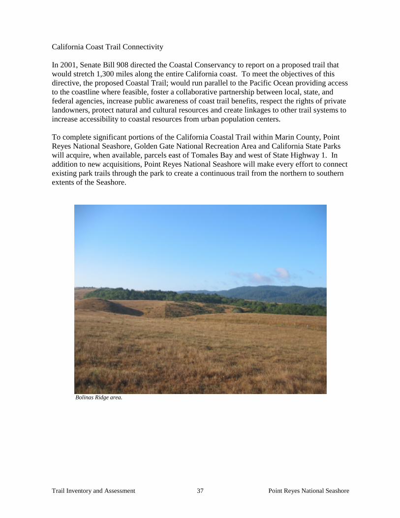
Trail Inventory and Assessment Point Reyes National Seashore 37
California Coast Trail Connectivity In 2001, Senate Bill 908 directed the Coastal Conservancy to report on a proposed trail that would stretch 1,300 miles along the entire California coast. To meet the objectives of this directive, the proposed Coastal Trail; would run parallel to the Pacific Ocean providing access to the coastline where feasible, foster a collaborative partnership between local, state, and federal agencies, increase public awareness of coast trail benefits, respect the rights of private landowners, protect natural and cultural resources and create linkages to other trail systems to increase accessibility to coastal resources from urban population centers. To complete significant portions of the California Coastal Trail within Marin County, Point Reyes National Seashore, Golden Gate National Recreation Area and California State Parks will acquire, when available, parcels east of Tomales Bay and west of State Highway 1. In addition to new acquisitions, Point Reyes National Seashore will make every effort to connect existing park trails through the park to create a continuous trail from the northern to southern extents of the Seashore.
Bolinas Ridge area.

Trail Inventory and Assessment Point Reyes National Seashore 38
RECOMMENDED FUNDING PRIORITIES
Based on this Trail Inventory and Condition Assessment, Point Reyes National Seashore has developed the following funding requests for trail upgrading and new trails proposals. These requests will be used to solicit public and private funding for the trail system. The Performance Management Information System (PMIS) has been used to develop the request for federal funding. The criteria used for development of the priorities are:
• trail contains hazardous conditions; • trail is a primary trail that needs to be replaced; • trail is a secondary trail that needs be replaced; • trail is a primary trail that needs rehabilitation; • trail is a secondary trail that needs rehabilitation; or • trail provides critical link to trail system including regional trail system in Marin.
The park has developed a tiered estimating guide to determine the cost of constructing a new trail using NPS Trail Standards and major rehabilitation using historic cost data. The Denver Class “C” estimating guide is a good source for determining the construction cost for developing new four-foot wide trails. The dollar value recommended by the Class “C” estimating guide is approximately $53,000 per mile. The park’s estimated cost for performing major rehabilitation on existing old ranch roads adaptively converted to park trails is approximately $200,000 per mile. The major rehabilitation elements considered in the park’s estimate include reducing trail width, scarifying the old road bed, improving drainage structures, removing existing shoulder embankments, re-vegetation and mitigating causes that would accelerate erosion. In an effort to secure adequate funding for the existing park trails needing to be replaced, the eminent failures, and the trails needing rehabilitation, the park plans to diversify its options for funding sources. The trails that have been assessed as failing and needing replacement will be combined in one Line Item Construction package, while the trails needing a major rehabilitation will be addressed on an individual, trail specific basis. The appropriate funding sources targeted for rehabilitation projects are the Regional Repair/ Rehabilitation Program or Fee Demonstration Program. The Line Item Construction package will address the following trails needing replacement: Trail Name Miles Estimated Cost Crystal Lake Trail 2.95 miles $590,000 Baldy trail 1.10 miles $220,000 Alamere Falls Trail 0.40 miles $80,000 Double Point Trail 0.50 miles $100,000 Kelham Beach Trail 0.25 miles $50,000 Sunset Beach Trail 1.40 miles $280,000 Tomales Point Trail (last Mile) 1.00 miles $200,000 Muddy Hollow Trail (1) 1.40 miles $280,000
Muddy Hollow Trail (2) 2.00 miles $400,000

Trail Inventory and Assessment Point Reyes National Seashore 39
Drakes Head Trail 1.60 miles $320,000 The two additional trails that have been identified as needing replacement but are not considered in the list above are Horse Trail and Elephant Seal Overlook Trail. These two trails have been approved for funding in the Fee Demonstration Program with possible construction starting as early as the summer of 2003. The 10 trails that are being considered for the Line Item Construction package have an estimated construction cost of approximately $2,520,000. Line Item Construction Packages have been reviewed by Congress will have approved construction dates, so any new packages like the one mentioned above, will not be considered for construction before fiscal year 2010. Realizing that many of these trails need more immediate attention, the park will proactively explore other funding opportunities. Trail projects that have been considered and placed in the National Park Service’s Project Management Information System (PMIS) are: PMIS # Title Funding source
79788 Rehabilitate Estero Trail PLC 80681 Reroute Muddy Hollow Trail P2 PLC 69073 Rehabilitate Horse Trail Fee Demonstration 7142 Rehab Backcountry Trails Repair/Rehab 82098 Trail Brushing, Drainage Maintenance Regular Cyclic 82120 Upgrade Elephant Seal Overlook Trail Fee Demonstration 21190 Rehab Failing Trail Culverts/Bridges Repair/Rehab 84656 Earthquake Trail Rehabilitation Exhibit Cyclic 79742 Replace Failing Footbridge on Coast Trail Repair/Rehab 79742 Replace Estero Trl Bridge at Limantour DamRepair/Rehab 82773 Repair or Replace Trail Bridges Regular Cyclic 80622 Brush Inverness Ridge Trail PLC 80953 Deferred Trail Maintenance YCC YCC, Regular Cyclic 80601 Brush Bayview Trail, Post Mt Vision Fire Regular Cyclic 77301 Rehab 1.2 miles of Olema Valley Trail Repair/Rehab 81315 Baldy Trail Rehabilitation Repair/Rehab 80579 Reconstruct Kelham Beach Trail Repair/Rehab 82705 Repair Drakes Beach Boardwalk Regular Cyclic 84675 Replace Old Wayside Panels along L.H. Exhibit Cyclic 86997 Trail Maintenance at Point Reyes FY03 PLC 87037 Trail Maintenance at Point Reyes FY04 PLC 87235 Brush Bucklin Trail FY03 PLC 87283 Brush Drakes View Trail FY04 PLC 87309 Trail Drainage Device Maintenance FY03 PLC 87402 Enhance Existing YCC Program FY03 PLC 87391 Trail Drainage Device Maintenance FY04 PLC 87408 Enhance Existing YCC Program FY04 PLC

Trail Inventory and Assessment Point Reyes National Seashore 40
Appendix A: Standards, Guidelines, Ratings The recommendations of this trail summary and inventory draw upon the following listed guidelines. These are provided as background references and are provided to assist in understanding the information presented and how ratings were determined. Trail condition ratings vary from park to park and from agency to agency. Point Reyes NS staff uses this handbook and guidelines but also draws upon state park guidelines and wilderness legislation and provisions and other environmental legislation. National Park Service – The most recent NPS document providing guidance for trail construction and maintenance is the NPS Trails Management Handbook, published in 1983 by the Denver Service Center. Noting that each park area needs to develop its own specific standards, the 53-page handbook offers good general guidelines for trail design and selection of trail alignments. It also suggests guidelines for trail maintenance and design and construction of trail features such as turnpikes, drainage structures and signs. The following is a sampling of some of the more relevant guidelines in the handbook: • Existing trails should be integrated with new construction as much as possible providing
old trails were properly laid out and have good drainage. • For interpretive purposes, the trail should meander to take advantage of scenic panoramas
and historic, cultural and natural resources. • The alignment should follow the contours of the land and be generally curved. Sharp
angular turns over 50 degrees and long straight stretches should be avoided. • Hillside alignments should, wherever possible, angle across the natural slope and take
advantage of natural drainage to minimize the need for major drainage modifications. • As a general rule, a grade should not be steeper than 10%. Grades of less than 7% are
ideal. • Trail dimensions should be based on the type and volume of use anticipated, on the
stability of native materials, and on the type of terrain along the route. Generally a trail tread width should not be less than 18 inches for foot trails and 24 inches for horse trails. Additional width could be required to reduce impacts from heavy traffic.
• Avoid sensitive habitat and species. Maintenance guidelines in the report include direction on how to develop trail logs and a suggested hierarchy of maintenance levels. The handbook defines 5 types of trails as follows:
• Type A- Major Trails- Marked routes that are improved and maintained for foot and horseback traffic. Minimum tread width is usually 24 inches, and overall grade is less than 10 percent. For distances less than 150 feet, grade should not exceed 15 percent. Type A trails are to have first priority for maintenance.
• Type B- Minor Trails- Also improved and maintained for foot and horseback traffic, but reflect an overall lower construction standard than Type A trails. The tread does not have to meet the maximum width standard and may be limited to the space required to form a single-file trail. Overall grade should be less than 15%. For distances less than 150 feet, grade should not exceed 18 percent.
• Type C- Wilderness Trails- These are marked trails but are generally unimproved except for clearing. Minimum tread width is 18 inches, with an overall grade of less than 15

Trail Inventory and Assessment Point Reyes National Seashore 41
percent. For distances of less than 150 feet, grade should not exceed 20 percent. These trails have the lowest maintenance priority except where safety is concerned.
• Type D- Walks- Surfaced for foot and wheelchair travel and built to high standards. • Type E- Other- Specialized trails including bicycle and snowmobile routes.
Point Reyes National Seashore - These ratings are a combination of existing trail conditions against what a properly designed trail should be. Definitions should note the physical characteristics that allow the trail to erode and fail in storm events even with cyclic maintenance completed. Fair Trail Grade: Greater than 50% of a trail at a 5-10% grade Alignment or type of construction: Greater than 50% of trail side-hill construction, trail alignment parallel to contour lines. Trail constructed above wet areas. Erosion: Developed trench in trail 0-6 inches deep. Trail width: Erosion surface area: 8 feet or less. Water crossings: Bridges or rocked water crossings. Poor Trail grade: 50% of a trail at 5-10% grade, 50% at a 10% grade and above Alignment or type of construction: 50% of trail side-hill construction, trail alignment parallel to contour lines, 50% through-cut construction, trail alignment perpendicular to contour lines. Erosion: Developed trench in trail 6-12 inches deep. Trail width, erosion surface area: 8-16 feet Water crossings: Culverts or non-hardened, eroding unimproved streambeds Replace Trail grade: Less that 50% of trail at a 5-10% grade, greater than 50% at a 10% above Alignment of construction: less than 50% of a trail side-hill construction, trail alignment parallel to contour lines, greater than 50% thorough cut construction, trail alignment perpendicular to contour lines. Erosion: Developed trench in trail greater than 12 inches deep. Trail width, erosion surface area: Greater than 16 feet. Water crossings: Older culverts or non-hardened, eroding unimproved streambeds. Marin County- The trails element of the Marin Countywide Plan recognizes three types of trails: single track trails- unpaved, varying in width and too narrow for service vehicles; double-track trails- unpaved and wide enough to accommodate fire protection and service vehicles; and Class I bicycle paths. These trail types support four use designations: • Hiking-only- These trails are intended to provide opportunities to enjoy the interpretive
experience and aesthetic qualities in open space areas without distractions from other users. Improvements may vary, but a minimum tread width of two to three feet is normally required. On some steep slopes, the tread width may diminish to 12 to 18 inches, but only for short distances. Grades may vary, but 10% or less is desirable and 15-20% is acceptable for short distances. Trails with grades in excess exist in the County. These trails are not appropriate for equestrian or bicycle use, due to concerns about quality of

Trail Inventory and Assessment Point Reyes National Seashore 42
experience, safety, susceptibility to erosion and physical constraints such as steep gradients, narrow tread, overhead clearance and obstructions.
• Equestrian/Hiking- These trails provide a leisurely horseback riding or hiking experience. They are unpaved and the developed width may vary from three to six feet. Gradients are similar to those for hiking-only trails. These trails are not appropriate for bicycle use because of potential safety problems and diminished quality of experience.
• Combined Use- These trails provide an opportunity for combined use by cyclists, hikers and equestrians. They require substantial overhead clearance, generally a width of 10 to 12 feet, and do not exceed moderately steep gradients. They often serve as fire protection routes.
• Paved Paths- Generally intended for bicycle and foot traffic, these trails typically offer a paved surface 8 to 10 feet wide, with an 18 inch unpaved pedestrian/jogging path on one or both sides. Equestrian use of these paths is generally not considered to be compatible.
Marin Municipal Water District - As part of the District’s Trails Management Program approved by the Board of Directors in 1985, staff prepared a set of trail standards that include the following:
• For newly constructed trails, grades of 8% or less are desirable; grades exceeding 15% are not recommended. Where grade exceeds 15%, use of steps and switchbacks should be examined.
• Generally trail tread widths should be about 30 inches; however, width may vary according to use, grade, slope and soil type. In no instance shall the trail tread be less than 18 inches or more than 36 inches for hiking trails and 48 inches for equestrian trails.

Trail Inventory and Assessment Point Reyes National Seashore 43
Appendix B: Maps of Proposed Trail Routes

Trail Inventory and Assessment Point Reyes National Seashore 44

Trail Inventory and Assessment Point Reyes National Seashore 45

Trail Inventory and Assessment Point Reyes National Seashore 46
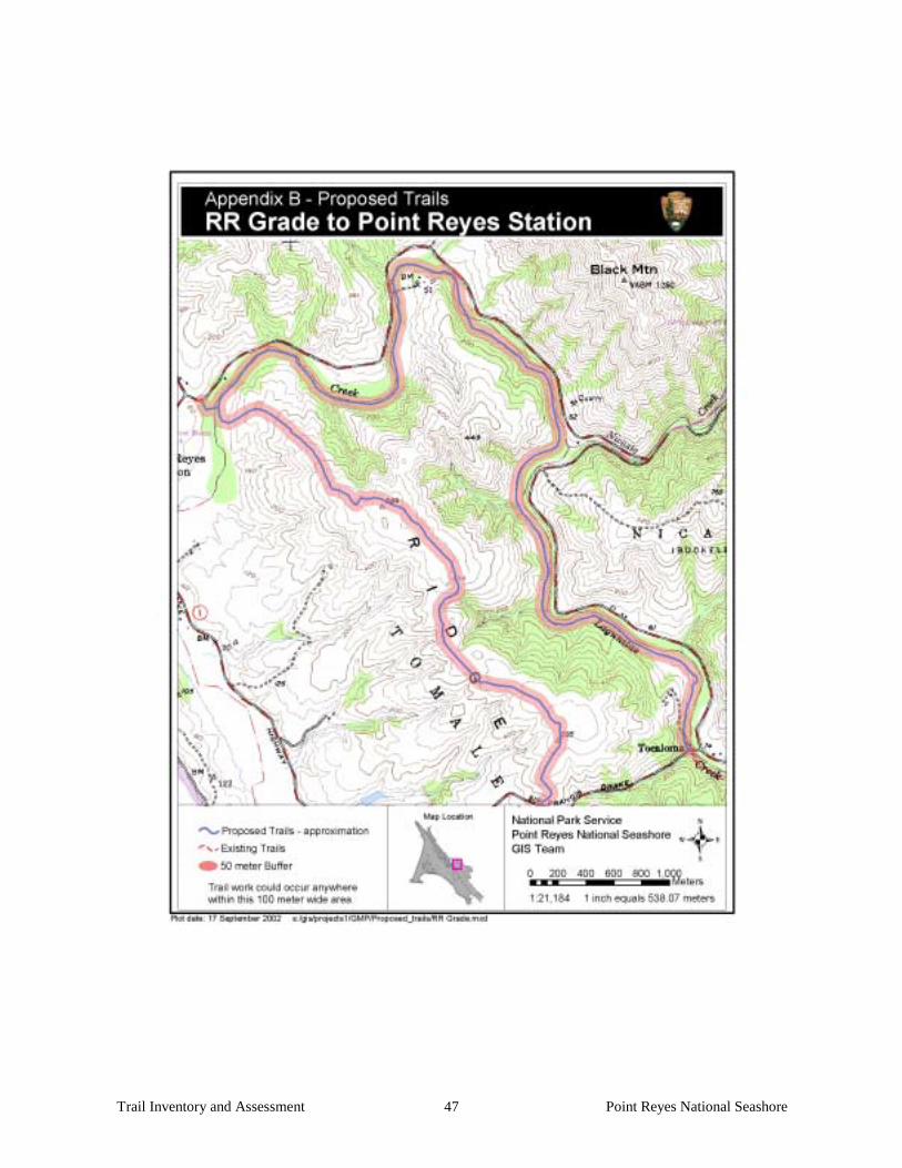
Trail Inventory and Assessment Point Reyes National Seashore 47

Trail Inventory and Assessment Point Reyes National Seashore 48

Trail Inventory and Assessment Point Reyes National Seashore 49

Trail Inventory and Assessment Point Reyes National Seashore 50
Appendix C: Summary of Trail Condition
DESCRIPTION Miles Assessment Education Center Trail 0.63 Fair Elephant Seal Overlook Trail 0.2 Replace Out Road Trail 1.4 Fair Alamea Trail 1.5 Fair Ridge Trail 6.4 Fair Coast Trail – South 8.5 Fair Coast Trail – North 4.2 Fair Glen Trail 1.4 Fair Mt. Wittenberg Trail 2.5 Fair Sky Trail 4.4 Fair Fire Lane Trail 3.27 Poor Pablo Point Trail 1.0 Fair Teixeira Trail 1.91 Fair Olema Valley Trail 4.5 Poor Bolema Trail 1.07 Poor Lake Ranch Trail 2.99 Fair Crystal Lake Trail 2.95 Replace Greenpicker Trail 3.7 Poor Glen Loop Trail 0.9 Fair Baldy Trail 1.1 Replace Old Pine Trail 1.8 Fair Meadow Trail 1.6 Poor Horse Trail 3.21 Replace Inverness Ridge Trail 1.6 Fair Bayview Trail 3.2 Poor Bucklin Trail 2.32 Poor Limantour Beach Trail N. 0.26 Fair Limantour Beach Trail S. 0.25 Fair Rift Zone Trail 1.73 Poor Tomales Point Trail 4.6 Poor Palomarin Beach Trail 0.62 Fair Woodpecker Trail 0.5 Fair Earthquake Trail 0.5 Fair Woodward Valley Trail 2.0 Poor LH - Sea Lion Overlook 0.01 Replace Estero Trail 8.3 Poor Chimney Rock Trail 0.9 Fair Abbotts Lagoon Trail 1.1 Poor Lighthouse Trail 0.1 Poor Morgan Trail 0.6 Fair McClures Beach Trail 0.4 Fair Laguna Trail 2.2 Poor Drakes View Trail 2.0 Poor Hidden Valley Trail 0.48 Poor

Trail Inventory and Assessment Point Reyes National Seashore 51
DESCRIPTION Miles Assessment Z Ranch Trail 0.7 Fair Alamere Falls Trail 0.39 Replace Double Point Trail 0.44 Replace Bear Valley Trail 0.9 Fair McCurdy Trail 2.0 Poor Kehoe Beach Trail 0.6 Poor Ocean Lake Trail 1.1 Poor Coast/Glen Spur Trail (South) 0.4 Fair Kelham Beach Trail 0.1 Replace Sculptured Beach Trail 0.2 Poor Glenbrook Trail 0.7 Poor Sunset Beach Trail 1.4 Replace Drakes Head Trail 1.6 Replace Muddy Hollow Trail 1.4 Replace Muddy Hollow Trail 2.0 Replace Sunset Overlook Trail 0.19 Poor Tomales Bay Trail 1.7 Poor Pierce Ranch Trail 0.22 Poor Kule Loklo Trail 0.51 Fair White Gate Trail 0.9 Poor Bull Point Trail 1.77 Poor Coast/Glen Spur Trail (North) 0.3 Fair Bolinas Ridge Trail (maintained as a road) 11.10 Poor Randall Trail (maintained as a road) 1.6 Poor Stewart Trail (maintained as a road) 5.4 Poor Jewell Trail (maintained as a road) 0.9 Fair Fair- Trail Grade: Greater than 50% of a trail at a 5-10% grade Alignment or type of construction: Greater than 50% of trail side-hill construction (i.e. trail alignment parallel to
contour lines.) Trail constructed above wet areas. Erosion: Developed trench in trail 0-6 inches deep. Trail width, erosion surface area: 8 feet or less. Water crossings: Bridges or rocked water crossings. Poor- Trail grade: 50% of a trail at 5-10% grade, 50% at a 10% grade and above. Alignment or type of construction: Less than 50% of trail side-hill construction (i.e. trail alignment parallel to
contour lines) 50% through–cut construction (i.e. trail alignment perpendicular to contour lines.) Erosion: Developed trench in trail 6-12 inches deep. Trail width, erosion surface area: 8-16 feet Water crossings: Culverts or non-hardened, eroding unimproved streambeds Replace Trail grade: Less than 50% of trail at a 5-10% grade, greater than 50% at 10% above Alignment of construction: Less than 50% of a trail side-hill construction (i.e. trail alignment parallel to contour
lines.) Greater than 50% thorough cut construction (trail alignment perpendicular to contour lines. Erosion: Developed trench in greater in trail greater than 12 inches deep. Trail width, erosion surface area: Greater than 16 feet. Water crossings: Older culverts or non-hardened, eroding unimproved streambeds.

Trail Inventory and Assessment Point Reyes National Seashore 52
Asset Condition # of Trails % Trails Miles of Trail % of Trail Mileage Fair 29 41.4% 48.87 36.70% Poor 29 41.4% 69.65 52.20% Replace 12 17.2% 14.80 11.10%

Trail Inventory and Assessment Point Reyes National Seashore 53
Appendix D: Definitions Road to trail conversion “Many trails within parks are developed on legacy roads that were constructed before the area became public land. Early park managers found it was much easier to let a road close in with vegetation and become a trail, than to construct a new trail. Where roads did not connect, short trail segments were often built to link the roads into a trail network. Unfortunately, poorly constructed roads make poor trails. Grades are often excessive and many of these roads continue to be sources of sediment and erosion problems. Roads that are unsuitable as trails are removed by full recontouring or decommissioning. Where roads do provide a stable alignment, the road can be converted to a trail. Conversion greatly reduces erosion problems and provides park visitors with a more pleasant hiking experience. A road-to-trail conversion transforms an existing road into recreational trail using heavy equipment. The process begins by removing encroaching vegetation from the road way and stock piling it nearby. Then the bulldozer rips the inboard ditch and inboard road surface to reduce ditch memory and increase the permeability of the roadbed. Once the roadbed is prepared, embankment fill is excavated from the outboard edge of the road and placed against the cutbank. Between the excavated fill and the cutbank fill a 5-foot wide portion of the original road is preserved and will serve as the trail tread. The trail should be located on the cut bench of the road, not on the embankment fill. This ensures the trail is on stable well-compacted material. The trail can be constructed with gentle meanders to soften the appearance of a straight road section.” Ditch memory is when the water flowing under ground is diverted down a covered ditch because of it compaction this prevents the water from moving naturally down slope. (Note: This description comes from “ Field Techniques for forest and range road removal California State Parks North Coast Redwoods District Roads, Trails and Resources Maintenance”) Out-slope- On trails routed generally parallel to the contour lines of a slope where the cross section is tipped inward, this term describes the process of reversing that direction, usually accomplished by moving soil from the outside edge of the trail to the inside. This technique is recommended only with road to trail conversion. Through-cut trail- Generally considered the most negative type of construction; it is used in cases where the trail is routed perpendicular to the contour lines. In such cases out-sloping is impossible and the trail carries water throughout its through-cut length. Depending on the steepness of the slope, this deficiency can produce extraordinary erosion impossible to fully control. It is frequently the reason for rerouting or obliterating trails. Reroute- This term is usually proposed to alleviate steep gradients and through-cut situations and to avoid wet areas or natural resources of particular concern. In the context of this report, a recommendation to reroute a trail segment also implies the need to restore the abandoned route to natural conditions, including grading to original contours and re-vegetation (except in the case of historically significant routes). All reroutes should employ a multidisciplinary

Trail Inventory and Assessment Point Reyes National Seashore 54
approach to determine alignments. Major reroutes should employ GIS technology to assist planners in selecting the most desirable alignments. Remove culverts- This is frequently done in concert with other measures and is always intended to help dissipate and slow surface flow of water. Bridges and wet crossings often offer more desirable alternatives where concentrations of water must be carried across the trail. This is a particularly important prescription for the requirements of anadramous fish and other aquatic species. Remove berms- Berms are embankments along the outside edges of roads intended, like ditches, to channel water in the direction of the route to be eventually intercepted by culverts, water bars or dips. Again this action is intended to disperse the flow of water, allowing it to move off the trail surface in sheets. This recommendation is only appropriate under the terms defined above “Road To Trail” conversion. Add structures- Establishing and maintaining a trail often requires the introduction of structures to compensate for steep gradients or to keep trail surfaces and users dry. The following are most commonly used: Drainage dips Stairs Retaining walls Boardwalks Bridges
Rock fill Turnpikes- (a trail elevated in a wet area by an embankment of stable but porous material that allows some water movement while keeping the trail surface dry)

Trail Inventory and Assessment Point Reyes National Seashore 55
Appendix E: Current Park Trails Maps

Trail Inventory and Assessment Point Reyes National Seashore 56

Trail Inventory and Assessment Point Reyes National Seashore 57
Appendix F: Marin Municipal Water District MOU
MEMORANDUM OF UNDERSTANDING Among the
MARIN MUNICIPAL WATER DISTRICT, COUNTY OF MARIN,
MARIN COUNTY OPEN SPACE DISTRICT, CALIFORNIA DEPARTMENT OF PARKS AND RECREATION,
NATIONAL PARK SERVICE, and MARIN COUNTY RESOURCE CONSERVATION DISTRICT
For MAINTENANCE AND MANAGEMENT OF UNPAVED ROADS
IN THE LAGUNITAS CREEK WATERSHED This Memorandum of Understanding, dated October 29, 2001, is by and between the Marin Municipal Water District (MMWD); the County of Marin (County), acting through the Marin County Board of Supervisors (Supervisors), Marin County Fire Department (MCFD), Marin County Department of Public Works (DPW), and Marin County Community Development Agency (MCCDA); the Marin County Open Space District; the California Department of Parks and Recreation (State Parks); the National Park Service (NPS); and the Marin County Resource Conservation District (MCRCD). RECITALS WHEREAS the parties to this Memorandum of Understanding (hereafter “Agreement”) own, manage, or have an interest in the management of lands and waters within the 103-square mile Lagunitas Creek watershed, the largest watershed in Marin County; and WHEREAS Lagunitas Creek and some of its tributaries support populations of threatened and endangered species per the federal and state Endangered Species Acts, including coho salmon, steelhead trout, California freshwater shrimp, and California red-legged frog; and WHEREAS streambed sedimentation is one of the main factors constraining habitat values for coho salmon and steelhead trout using Lagunitas Creek and its tributaries for spawning, rearing, and migration; and WHEREAS the supply of fine sediments has been linked to erosion throughout the watershed with unpaved roads having been identified as one of the most significant causes of erosion and a direct source of fine sediment; and WHEREAS all parties to this Agreement recognize that proper maintenance and management of unpaved roads under their ownership, jurisdiction, or influence within the Lagunitas Creek watershed can reduce streambed sedimentation and thereby enhance habitat for coho salmon, steelhead trout, and California freshwater shrimp; and WHEREAS it is the goal of all parties to this Agreement to enhance coho salmon, steelhead trout and California freshwater shrimp habitat within the Lagunitas Creek watershed,

Trail Inventory and Assessment Point Reyes National Seashore 58
particularly, but not exclusively, those portions of the watershed downstream of Kent Lake and Nicasio Reservoir, by maintaining and managing unpaved roads, or encouraging the maintenance and management of unpaved roads, to minimize soil loss, reduce erosion potential, and reduce the amount of sediments entering Lagunitas Creek, while accommodating the appropriate uses designated for these roads; and WHEREAS it is the goal of all parties to this Agreement to manage and maintain unpaved roads in a condition that will allow for use of these roads during emergency situations with minimal damage or wear that could increase erosion; and WHEREAS it is the intent of all parties to this Agreement to encourage a cooperative relationship among the parties to implement a consistent approach to the maintenance and management of unpaved roads in the Lagunitas Creek watershed; and WHEREAS all parties to this Agreement acknowledge that funding constraints could affect implementation of the desires expressed in this Agreement and that implementation of this Agreement’s terms could be altered, delayed, limited or even prevented if funding sources are not identified or made available.
AGREEMENT NOW, THEREFORE the parties to this Agreement agree to: 1. Model road maintenance and management activities as set forth in the document
entitled: Guidelines for the Maintenance and Management of Unpaved Roads in the Lagunitas Creek Watershed (Attachment A), including the manuals referenced in that document, and as may be amended from time to time. In addition, the parties may adopt other manuals or handbooks by consensus to augment or replace the above guidelines and/or manuals as deemed necessary.
2. Implement the actions in this Agreement in compliance with all applicable federal,
state, and local environmental laws and regulations. 3. Acknowledge the fact that nothing in this Agreement negates any laws, regulations, or
policies. 4. Act consistently with this Agreement when developing policies, plans, or projects;
when exercising regulatory authority, or conducting environmental review; or when otherwise conducting work related to unpaved roads in the Lagunitas Creek watershed; and to encourage others to do so.
5. Provide the other parties to this Agreement with information relevant to unpaved road
management in the Lagunitas Creek watershed. This may include maps and data about individual roads, internal policies for road maintenance and/or management, and training or other educational information.
6. Strive to inspect, on an annual basis, all actively used, unpaved roads on public lands,
and encourage or assist, when requested, with inspections on private lands, for the

Trail Inventory and Assessment Point Reyes National Seashore 59
purpose of identifying where routine maintenance or repairs are needed; and undertake routine maintenance in a timely manner as resources permit.
7. Meet, at least annually, to discuss the status of each agency’s efforts, singly and
cooperatively to reduce road-related sedimentation in the Lagunitas Creek watershed; to review existing, or consider new sediment reduction techniques; to coordinate grant-funding requests; and to discuss other matters pertinent to fulfilling the purpose of this Agreement.
8. Identify and map the entire system of unpaved roads subject to this Agreement,
designating each road according to its categories of use and whether the road is actively used, unneeded, or abandoned. The mapping and designation of roads on private property will only be accomplished with the voluntary cooperation of the landowner. This mapping will be updated annually as necessary.
9. Identify non-routine repairs and long-term sediment reduction projects on each
agency’s actively used unpaved roads that are not funded within each agency’s annual maintenance budget.
10. Identify unneeded and abandoned roads and consider such roads for closure or
conversion to recreational trails; and coordinate the closure or conversion of such roads in those situations where roads cross property boundaries and pass from one ownership to another, or provide access to another agencies facilities.
11. Develop strategies, and identify funding mechanisms, to accomplish specific non-
routine repairs or long-term sediment reduction projects on actively used unpaved roads, by means of phasing, sharing staff or equipment, and cooperative grant-seeking.
12. Develop strategies, and identify funding, to accomplish specific road closures or
conversions, by means of phasing, sharing staff or equipment, and cooperative grant-seeking.
13. Make a good faith effort to implement long-term repairs and closures or conversions,
recognizing each agency’s budget constraints and other land management responsibilities and priorities.
14. Strive to meet the schedule of milestones for road maintenance and management in the
Lagunitas Creek watershed as indicated in Table 1 (attached) of this Agreement. 15. Recognize that the terms of this Agreement are subject to the availability of funding,
personnel and other essential resources, and that each party has the sole authority and responsibility regarding decisions and matters in its own jurisdiction.
16. This Agreement has no termination date and may be revised as necessary. Each party
to this Agreement may withdraw from this Agreement upon written notice to all other parties.

Trail Inventory and Assessment Point Reyes National Seashore 60
The parties agree that this Agreement does not constitute any legal admission or opinion as to the subject matter, nor does it confer any additional legal rights, liabilities or obligations between the parties or to third parties that do not already exist in law. Marin Municipal Water District County of Marin Signed Signed President, Board of Directors President, Board of Supervisors Attest: Attest: California Department of Parks and Recreation National Park Service Signed Signed Superintendent, Marin District Parks Superintendent, Point Reyes NS Attest: Attest: Marin County Resource Conservation District Marin County Open Space District Signed Signed President, Board of Directors President, Board of Directors Attest: Attest: