traces of the past along the german green belt - bund e.v
TRANSCRIPT

Traces of the Pastalong the German Green Belt
The Green Belt in its entire length is not a well developed and signposted hike and bicycle path. It is not always easy
to tell where the former border strip was, as most of the border fortifications have been dismantled. Moreover, in
some places the Green Belt is not recognisable because parts of it are now used as intensive grassland, arable land
or woodland.

2
“Western tourists” at the Iron Curtain
“Those who cannot remember their past
are condemned to repeat it.”
(George Santayana)
Opening of the border at MödlareuthEast German border guard on patrol
The Green Belt in its entire length is not a well developed and signposted hike and bicycle path. It is not always easy
to tell where the former border strip was, as most of the border fortifications have been dismantled. Moreover, in
some places the Green Belt is not recognisable because parts of it are now used as intensive grassland, arable land
or woodland.

INHALT
3
FOREWORDDear visitors of the Green Belt and the borderland museums,
For more than 25 years, the Green Belt, the stretch of unspoilt nature that has arisen as a result of the inhumane inner-German
border, has been a constant reminder of our once divided nation. Nature has been left to its own devices here, not because we
want to forget, but because we want to remember. Scores of people visit the Green Belt in an attempt to come to terms with
history: the history of their country, their mothers and fathers, relatives, friends or even their own personal fate. And more and
more people come here to enjoy the treasures of nature spanning our country like a string of pearls over a remarkable distance
of almost 1,400 kilometres. Only living reminders enable us to learn lessons from the past and act on them in the future.
We would urge every visitor to the Green Belt to take the opportunity of visiting one of the many borderland museums. And we
would urge anybody visiting one of the many borderland museums to step outside for a walk into “Germany's longest open-air
museum” and reflect on what he/she has learned from the museums in the tranquility of nature. This experience will inevitably
make you more keenly aware of how fortunate we are today to be able to move freely through Germany along the former “death
strip”.
Historical research has shown that this border cost at least 900 human lives. Today it is a peaceful trace in the landscape. How-
ever, without the former border fortifications, the fences and watchtowers, this trace of the past is often difficult to detect at first
glance. Certain questions immediately spring to mind when visiting the Green Belt: Where exactly was the border? Why is there
a row of trees here? Where was the fence? Where were the landmines laid? This brochure is intended to assist you in your
search for traces of the past in one of Germany's most moving commemorative landscapes!
3
Prof. Dr. Hubert Weiger(Chairman of the BUND)
Dr. Kai Frobel (BUND, Initiator of the Green Belt)
Horst Dornieden(Chairman of the Borderland Museum Eichsfeld)
Wolfgang Nolte (Chairman of the Borderland Museum Eichsfeld)
The Green Belt in its entire length is not a well developed and signposted hike and bicycle path. It is not always easy
to tell where the former border strip was, as most of the border fortifications have been dismantled. Moreover, in
some places the Green Belt is not recognisable because parts of it are now used as intensive grassland, arable land
or woodland.

4
What is meant by the “Green Belt”?
As early as December 1989, shortly after the fall of the Berlin Wall, nature con-servationists from East and West met in the North Bavarian town of Hof to for-mulate their vision for the former “death strip” on the initiative of the Bund für Umwelt und Naturschutz Deutschland e.V. (BUND) – Friends of the Earth Ger-many. It was agreed that “the biodiversity of the border zone should be pre-served in the form of a green belt”. During the decades of German division, the
border strip on the East German side was left largely untouched. The East Ger-man border troops merely cleared it of vegetation every few years in the interest
of maintaining an unobstructed view of the border zone.
This presented a unique opportunity for nature to thrive. The result was an idyllic refuge for countless rare animals and plants – a belt measuring between 50 and 200
metres in width and 1,393 kilometres in length, making it the largest habitat network in Germany. What makes it so special and explains the remarkable abundance of species is
the fact that the various different types of habitats are closely interlinked with each other.
In 2007, the German Federal Government adopted the National Strategy for Biodiversity. Conservation of the Green Belt is a flagship project forming part of this biodiversity strat-egy. Since 2009, the protection of the Green Belt has also been enshrined in Article 21 of the German Federal Nature Conservation Act (Bundesnaturschutzgesetz).
Hence, the Federal Environment Ministry (Bundesumweltministerium) is funding the project “Closing Gaps in the Green Belt Germany” (Lückenschluss Grünes Band) along with this brochure under the Federal Programme for Biodiversity. The BUND is utilising this project to pursue its goal of closing the gaps that have appeared in the habitat network of the Green Belt since 1989 – and thus preserve a memorial landscape as a reminder of the painful era of German division.
The facts:
1,393 km in length
covers an area of 17,712 ha - 146 different
types of habitats - over 1,200 species on Germany's
Red Lists - 64 % of the area consists of endangered
types of habitats included in Germany's Red List - 29 %
nature reserves - 64 % EU protected areas (Natura2000)
21 % inland waters - 21 % extensive grassland - 7 % unused
fallow land & 29 % woodland - 87 % of the area still in a
near-natural state - 13 % damaged or destroyed,
mainly due to cultivation or intensive
grassland
The Green Belt between Mitwitz
and Neustadt
The Green Belt in its entire length is not a well developed and signposted hike and bicycle path. It is not always easy
to tell where the former border strip was, as most of the border fortifications have been dismantled. Moreover, in
some places the Green Belt is not recognisable because parts of it are now used as intensive grassland, arable land
or woodland.

INHALT
3 5
What did the border fortifications consist ofand what remains of them today?As from 1952, the GDR (German Democratic Republic/East Germany) secured the border
between the two German states in a variety of ways. These included “military engineering
measures” such as border fences, anti-vehicle ditches and minefields. In addition, “administrative
border security measures” were implemented, i.e. restricted zones (Sperrzonen) and protective
strips (Schutzstreifen), where restraints were imposed on accessing and cultivating the land. Guard-
ing the border was the responsibility of the East German border troops, who numbered 55,000 men
and women in the latter days of the regime.
All these measures left an remaining “ecological foot-
print” on the landscape – one that this brochure
aims to help trace and explain.
The East German government continually expanded
its border fortifications. After German reunification,
there was an understandable urge to eliminate all re-
minders of the much-hated border as swiftly as
possible. Within a short period of time, the fences
had been removed, the observation towers torn
down and virtually everything else completely dis-
mantled. Only in a few isolated spots were relics pre-
served thanks to private initiatives and the emer-
gence of border museums.
This brochure only explores relics of the border forti-
fications that are not always obvious to the casual
observer but can still be seen today.
The facts:
1,265 km of metal mesh fencing
829 km of anti-vehicle ditches
1,339 km of patrol tracks
232 km of illuminated control
strips
473 observation bunkers
(Erdbunker)
578 observation towers
Erection of the border fence
The Green Belt in its entire length is not a well developed and signposted hike and bicycle path. It is not always easy
to tell where the former border strip was, as most of the border fortifications have been dismantled. Moreover, in
some places the Green Belt is not recognisable because parts of it are now used as intensive grassland, arable land
or woodland.

6
The Green Belt in its entire length is not a well developed and signposted hike and bicycle path. It is not always easy
to tell where the former border strip was, as most of the border fortifications have been dismantled. Moreover, in
some places the Green Belt is not recognisable because parts of it are now used as intensive grassland, arable land
or woodland.

The patrol track (Kolonnenweg)The patrol track ran parallel to the border along
its entire length (1,393 km) from the Baltic
Sea to Vogtland. Following the opening
of the border, it was possible for a
brief period to travel the full length of
the patrol track by bicycle, for exam-
ple. Today, however, it is over-
grown and even interrupted in
many places.
The East German border troops used it
for patrolling on foot or by vehicle as well
as for transporting personnel and materials
when changing shifts or carrying out construction
work. It could hence be described as the “lifeline” of the
border fortifications.
Owing to the way in which it was built, the patrol track is the most commonly preserved relic of the bor-
der fortifications. It mainly consists of perforated concrete road slabs measuring 300 x 100 x 19 cm
(L x W x H). The initial sections were built as early as the late 1950s. The slabs were set in the
ground in two parallel rows spaced at a distance of 80 cm, creating a 280-cm-wide track. The
track is very robustly built. For this reason, dismantling has generally only been done in
places where the land has been ploughed or roads cut through the Green Belt.
From time to time, telephone cables unearthed by ploughing can be seen along the patrol
track. They were part of the border telecommunications network that converged in the watch-
towers. However, today there is little sign of the concrete posts that once served as
connection points along the track.
7
Patrol track
Patrol track and single-row metal mesh fence
Cyclists riding along the patrol track
The Green Belt in its entire length is not a well developed and signposted hike and bicycle path. It is not always easy
to tell where the former border strip was, as most of the border fortifications have been dismantled. Moreover, in
some places the Green Belt is not recognisable because parts of it are now used as intensive grassland, arable land
or woodland.

8
The control strip (Spurensicherungsstreifen)The control strip was a six-metre-wide strip of land between the patrol track and the
anti-vehicle ditch. Generally speaking, it was directly adjacent to the patrol track.
The abbreviation “K 6” stood for “Kontrollstreifen (control strip), six metres wide”. It
was machine-harrowed, raked by hand or treated with herbicides to keep it free of
vegetation. Whenever patrol guards discovered footprints on the control strip, they
triggered an alarm.
However, contrary to claims made in certain sensationalist press reports, it is not true
that the control strip was one of the areas in Germany with the highest level of herbi-
cide contamination. The herbicides used were of the standard type applied to crop
fields in East Germany. The crop protection departments of the East German agrochemi-
cal centres were responsible for administering the herbicides. If a section of the border lay
within their territory, they received a “herbicide quota for the state border with the West”, which
was only intended for use on the inner-German border. The specialists from the agrochemical cen-
tres administered the herbicides under the watchful eye of the East German border guards.
These herbicides were only produced in limited “target quantities” specified in the national plan and sometimes even had to be purchased from abroad (against foreign currency), which made them very expensive. As a result, the East German government and the agricultural production cooperatives did not even have sufficient stocks for farming purposes. As the word “quota” sug-gests, there were only limited quantities available, and placing repeat orders was out of the question. Like so many other com-modities, herbicides were in short supply in the socialist state of East Germany. Hence, there was veritable competition between the agricultural production cooperatives and the border troops as far as the distribution of herbicides was concerned. This signifi-cantly reduced the extent to which they were used – unlike in the West, where there were almost no limits on the deployment of herbicides. Initially, experts in the Federal Republic of Germany grossly overestimated the quantities administered. In actual fact, the dosage was consistent with the regulations governing the use of herbicides on roads and squares. Owing to the lack of vege-tation cover, it was impossible for the substances to reach higher concentrations. Instead, they were either washed away by the rain or seeped into the ground.
The control strip
The Green Belt in its entire length is not a well developed and signposted hike and bicycle path. It is not always easy
to tell where the former border strip was, as most of the border fortifications have been dismantled. Moreover, in
some places the Green Belt is not recognisable because parts of it are now used as intensive grassland, arable land
or woodland.

9
In 1994, the Federal Environment Agency (Umweltbundesamt) commissioned a study on herbicide concentrations in the ground belonging to the border strip. The results of the study did not reveal any values exceeding the general level of contamination found on comparable arable land. During the same period, more herbicides were used on the neighbouring West German crop fields, railway lines, paths and squares than at any time in the border strip.
In 1990, despite the former control strip supposedly being highly contaminated, it produced an exceptional abundance and vari-ety of wild meadow flora that was recognised as being of high ecological value. In the years that followed, it became displaced by grass. To this day, there is still no evidence of the vegetation in the control strip being any different than in other untreated parts of the border zone.
This open strip of land that was partly kept clear by harrowing was a popular feeding area for rare, insectivorous species of bird such as the whinchat. The fact that vegetation cover was totally lacking or kept low also allowed large numbers of small animal species that thrive in a warm environment and on open land to use the border strip as a means of expanding their habitat (e.g. the wasp spider, which spread as far as the Harz Mountains). Today, the control strip is barely recognisable. It is only on ridges and steep south or southwest-facing slopes that rare semi-arid grassland or raw-soil habitats have been able to develop. The lack of vegetation led to the nutrient-rich fine soil being washed away by the rain or blown away by the wind.
The soil left behind was then too poor and dry for most plants. It nevertheless offered a habitat for certain spe-cies of plant that are well adapted to such conditions and otherwise rarely seen in our part of the world. How-ever, in today's “Green Belt”, many open-land habitats need to be looked after by man or grazed by cows and sheep on a regular basis to prevent them from becom-ing overgrown with shrubs.
A Robur LO 1800A patrolling the control strip
The Green Belt in its entire length is not a well developed and signposted hike and bicycle path. It is not always easy
to tell where the former border strip was, as most of the border fortifications have been dismantled. Moreover, in
some places the Green Belt is not recognisable because parts of it are now used as intensive grassland, arable land
or woodland.

10
The anti-vehicle ditch (Kfz-Sperrgraben)
Generally speaking, the control strip adjoined the anti-vehicle ditch
towards the “enemy side” – i.e. the side closest to the inner-German bor-
der. On the enemy side, the anti-vehicle ditch took the form of a steep
trench of varying proportions depending on the terrain, while on the
“friendly side” it was flatter. The steep side was clad with thin concrete
slabs known as “cassette slabs” that resembled flat troughs. Owing to
the limited thickness of the cladding, any vehicle approaching from the
East would have crashed through the concrete and got stuck. Had the
border really been intended as an “anti-fascist protective wall”, the con-
crete slabs would have had to be laid facing the opposite direction to
achieve the same effect. Along sections of the border with steep
upward or downward inclines facing the border and/or loose soil unsuit-
able for digging out a ditch, a terrace was built into the terrain instead.
This was also covered with cassette slabs.
The anti-vehicle ditches were filled in after 1989, especially if the land
was used for farming or grassland. However, owing to the fact that the
soil was not compacted subsequently, erosion has led to “secondary
ditches” forming on the sites of some of the original ones. In some pla-
ces, the original ditches are still visible; many of them have collected
water and formed little wetland habitats. The terraces – with or without
cassette slabs – are also still visible in a few isolated places. The sur-
viving ditches or terraces are to be found in sections of the border
deemed unsuitable for cultivation or construction owing to their topogra-
phy; many of these sites are now classed as conservation areas. Nowa-
days, they are mostly ecologically valuable raw-soil habitats.
Anti-vehicle ditch
Anti-vehicle ditch filled with water
The Green Belt in its entire length is not a well developed and signposted hike and bicycle path. It is not always easy
to tell where the former border strip was, as most of the border fortifications have been dismantled. Moreover, in
some places the Green Belt is not recognisable because parts of it are now used as intensive grassland, arable land
or woodland.

11
In the rare instances where sections of fence have been pre-served outside museums, this has been done in a conscious
effort to create a memorial. Where the border strip is designated as a conservation area and/or extensively cultivated, a row of bushes or trees can often be found where the fence once stood. The patrol track
running parallel to it provides the final clue to the posi-tion of the fence. In towns and villages close to the for-
mer border, you can still sometimes see enclosures made from expanded metal fencing that has been dismantled.
The fence and posts proved to be an unin-tended attraction for rare species of
bird in the border zone: whinchats, red-backed shrikes and yellow-
hammers used it as an ele-vated perch from which
to sing and observe potential prey.
“Expanded metal” owed its name to the way it was pro-duced: slits were punched vertically into steel sheets, whichwere then stretched lengthwise while cold. This process resulted in the slits being shaped like diamonds. At the same time, the material twisted itself around the slits, lending the panels a certain spatial depth. This made them sturdy and ensured that it was only possible to look through the fence when viewing it from an angle of 90 degrees. The inner edges of the diamonds were so sharp that anyone attempting to climb over the fence would have severed their fingertips. Concrete slabs were set vertically into the ground beneath the fence to prevent tunnelling.
The distance between the anti-vehicle ditch and the fence was generally five to ten metres, depending on the terrain. When the double-row fence was dismantled, the minefields between the two rows of fencing were also cleared. It was less common for the single-row metal mesh fence to be combined with landmines, but where this was the case, the mines were installed in the area between the ditch and the fence. However, automated firing devices were mounted along all 450 kilometres of the fence.
Our image of the inner-German border is pri-marily dominated by fences. New types of fencing were introduced at regular intervals to replace the existing ones. As from around 1979, a single-row 3.20-metre-high metal mesh fence made from expanded metal panels posed the final obstacle to crossing the border. This type of fencing superseded the double-row 2.10-metre-high metal mesh fence that was combined with land-mines laid in the dividing space.
The tight mesh offered no fingerhold
The metal mesh fence
The Green Belt in its entire length is not a well developed and signposted hike and bicycle path. It is not always easy
to tell where the former border strip was, as most of the border fortifications have been dismantled. Moreover, in
some places the Green Belt is not recognisable because parts of it are now used as intensive grassland, arable land
or woodland.

12
Landmines
At the time of building the Berlin Wall in 1961, the
East German border troops also reinforced the border
fortifications. Minefields were installed between the
anti-vehicle ditch and the border fence. Between 1961
and the end of 1979, mines were laid along the border
over a distance of up to 850 kilometres. A total of
1.3 million anti-personnel mines were deployed, though
not all at the same time.
Instead, old landmines were repeatedly replaced with more
up-to-date versions. While the original landmines were triggered
by tripwires, subsequent versions had pressure-sensitive fuses
which were activated when trodden on.
The position of the minefields also changed in the course of modifications to the border fences
(changeover from barbed wire to double-row metal mesh fences with minefields between the two
rows of fencing). In addition, cluster mines were installed as well as automated firing devices that
were mounted directly on the metal mesh fence over a total distance of 450 kilometres. The “up-
stream territory”, i.e. the strip between the fence and the actual border, was always kept free of
mines.
Landmining reached its peak around the mid1970s. At the time of the changeover from double-
row to single-row metal mesh fencing, which started from around 1978, a large number of mine-
fields were cleared; as from 1979, hardly any new landmines were laid. In order to secure a loan
worth a total of 4.6 billion Deutschmarks from the Federal Republic of Germany, as from 1983,
the East German government ordered all minefields to be cleared and the automated firing
devices to be dismantled. From 1985 onwards, the inner-German border was officially free of
mines.
An exploding mine (1977)
Empty case of an anti-personnel mine
12
The Green Belt in its entire length is not a well developed and signposted hike and bicycle path. It is not always easy
to tell where the former border strip was, as most of the border fortifications have been dismantled. Moreover, in
some places the Green Belt is not recognisable because parts of it are now used as intensive grassland, arable land
or woodland.

13
Mines were nevertheless discovered while dismantling the border fortifications in the summer of 1990. As it was then obvious that there was no relying upon the old documents drawn up by the East German border troops, a renewed mine-clearing operation had to be carried out along the entire border strip. This led to the discovery of a further 1,064 mines of various types. A comparison of the number of mines laid and the number cleared or detonated revealed a shortfall of 33,000 devices whose whereabouts are still unknown to this day.
Given the possible risks, warnings are displayed on information boards in areas of the Green Belt such as Thuringia, where there is reason to believe that land-mines may still exist. However, cases have been confirmed of animals – presum-ably mainly foxes – carrying off mines and depositing them elsewhere. On steep slopes and floodplains bordering inland waters, there is also an increased risk owing to soil displacement caused by erosion.
Beware of mines!
The barbaric border between East and West
Germany was equipped with so-called anti-
personnel mines. Although the likelihood of finding
a left-over mine still in working order is very low, a
residual risk remains and is somewhat higher in cer-
tain areas of the Green Belt. It is therefore impera-
tive that you keep to the paths at all times
when visiting the Green Belt!
1. Please keep to the paved paths or the patrol track. As in all nature reserves, it is strictly prohibited to stray from the paths.
2. Should you come across a suspicious object, do not touch it!
Please mark the spot where you found it by means of a paper
handkerchief attached to a stick, for example, notify the police and,
if possible, stay nearby to warn anyone else who may be passing.
Please note that mines may not be instantly recognisable as such
after lying in the ground for 30 years or more.
The chances of coming across such a left-over mine are neverthe-less extremely remote. In order to exclude all possible risks, the fol-lowing rules of conduct should be observed:
The Green Belt in its entire length is not a well developed and signposted hike and bicycle path. It is not always easy
to tell where the former border strip was, as most of the border fortifications have been dismantled. Moreover, in
some places the Green Belt is not recognisable because parts of it are now used as intensive grassland, arable land
or woodland.

14
“Upstream territory” was East Germany's official term for the terrain between the border fence and the actual border. It was marked by
boundary stones and the distinctive border pillars; the latter were posi-tioned a few metres behind the border on East German territory. Nowhere did the border fence stand directly on the border. The dis-tance between the fence and the border could be anything from 10 to 100 metres depending on the topography of the terrain.
It became customaryto refer to this strip colloquially as “no-man's land”, although this was not an accu-rate description and was apt to cause danger-ous misunderstandings: the upstream territory was by no means a “free-for-all” area, but in fact East German territory that was guarded accordingly! Surveillance of the area was the responsibility of the border reconnaissance troops (Grenzaufklärer), a special unit within the East German border troops made up of long-serving or professional soldiers. They patrolled this area on foot – always in twos.
Anyone stepping over the border from the West – which was easily possible – and run-ning into a patrol, risked being arrested as a “border violator”, and anyone attempting to escape was in danger of being shot.
The upstream territory
Upstream territory
ArnicaCopper butterfly
Red-backed shrike
The Green Belt in its entire length is not a well developed and signposted hike and bicycle path. It is not always easy
to tell where the former border strip was, as most of the border fortifications have been dismantled. Moreover, in
some places the Green Belt is not recognisable because parts of it are now used as intensive grassland, arable land
or woodland.

15
Vorsicht Minen (Foto: Dr. Kai Frobel)
The upstream territory was managed in a variety of ways. Some of it was left fallow and only cleared of shrubs every few years to improve visibility for the border troops.
Other less accessible areas developed into forests or wetlands that remained untouched for decades. Some parts were mown once or twice a year. In any event, this territory was predomi-nantly an open-land habitat and hence, from a nature conserva-tion perspective, particularly valuable for open-land species driven out of the surrounding agricultural landscape due to intensified land usage.
It is for this reason and because of its width that the upstream territory is the most impor-tant part of the Green Belt.
Today you can still see where the for-mer border strip is under conservation or at least being extensively cultivated or kept open. These areas typically consist of wasteland covered in dead grass with a few areas of scrub. Where the Green Belt runs through woodland, it is often completely overgrown with trees – in many cases 25-year-old spruce or pine monocultures.
Otter
Today, sheep graze on the former upstream territory
Whinchat on a border post
The Green Belt in its entire length is not a well developed and signposted hike and bicycle path. It is not always easy
to tell where the former border strip was, as most of the border fortifications have been dismantled. Moreover, in
some places the Green Belt is not recognisable because parts of it are now used as intensive grassland, arable land
or woodland.

16
Observation towers (Beobachtungstürme)The border zone was observed from towers positioned at intervals of approximately three kilometres. From 1969 onwards, the border troops replaced the original wooden towers with new, round observation tow-ers made from pre-cast concrete elements (see photo to the left). These consisted of tube-shaped concrete sections (1.5 metres in dia-meter and 1.0 metres high). Depending on the number of elements, these structures were classed as BT-6, BT-9 or BT-11 towers. At the top of each tower there was an octagonal lookout turret. The round observation towers were later found to be susceptible to wind and in danger of falling down – generally due to being built on inadequate foundations and in unfavourable positions. Following the collapse of one observation tower in a storm, the border guards were no longer permitted to enter them in gusty weather. Today, it is generally only possible to view these towers on museum grounds.
In the 1970s, the border troops began supplementing the round towers with square ones (observation tower “BTv 2x2”, see photo on p. 17). These measured two by two metres and were built on firm founda-tions.
The total height of each tower including the integrated lookout turret was nine metres. The windows were made of mirrored glass, making it impossible to tell from the outside whether the towers were manned.
Observation tower BTv 4x4BT11 at Lindenberg near Duderstadt (1990)
The Green Belt in its entire length is not a well developed and signposted hike and bicycle path. It is not always easy
to tell where the former border strip was, as most of the border fortifications have been dismantled. Moreover, in
some places the Green Belt is not recognisable because parts of it are now used as intensive grassland, arable land
or woodland.

17
Very few of these towers have been preserved. Most of them are no longer open to the public.
The foundations are the most likely relics to be found, and in some cases you may still come
across severed power cables.
In the mid1980s, new commando centres were installed in pre-cast concrete towers with a
ground plan measuring approximately 4.2 x 4.2 metres and a height of nine metres (square
observation tower “BTv 4x4”, see photo on the right of p. 16). Each tower was assembled from
concrete elements and had three floors plus a basement. They were accessed via metal step
ladders. Each commando tower had its own parking area surrounded by a concrete wall. This
was where the various vehicles used by the border guards were parked.
Railings ran around the entire perimeter of the roof. Originally, a series of aerials, a wind gauge
and a searchlight (1000 watt) were installed next to the railings. The searchlight could be
rotated from the lookout turret.
Today, little remains of these
rather more elaborately
equipped towers apart from
the foundations or remnants
of the various fixtures (cellar,
septic tank, parking area).
Only a few have been pre-
served, of which even fewer
are open to the public.
Observation tower BTv 2x2
Two-man patrol in the upstream territory
The Green Belt in its entire length is not a well developed and signposted hike and bicycle path. It is not always easy
to tell where the former border strip was, as most of the border fortifications have been dismantled. Moreover, in
some places the Green Belt is not recognisable because parts of it are now used as intensive grassland, arable land
or woodland.
18
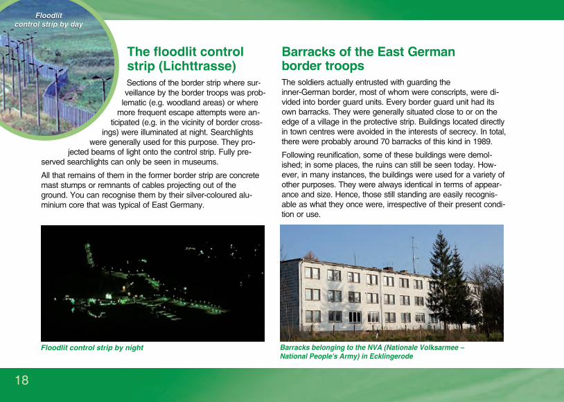
The floodlit control strip (Lichttrasse)Sections of the border strip where sur-veillance by the border troops was prob-
lematic (e.g. woodland areas) or where more frequent escape attempts were an-
ticipated (e.g. in the vicinity of border cross-ings) were illuminated at night. Searchlights
were generally used for this purpose. They pro-jected beams of light onto the control strip. Fully pre-
served searchlights can only be seen in museums.
All that remains of them in the former border strip are concrete mast stumps or remnants of cables projecting out of the ground. You can recognise them by their silver-coloured alu-minium core that was typical of East Germany.
Barracks of the East German border troopsThe soldiers actually entrusted with guarding the inner-German border, most of whom were conscripts, were di-vided into border guard units. Every border guard unit had its own barracks. They were generally situated close to or on the edge of a village in the protective strip. Buildings located directly in town centres were avoided in the interests of secrecy. In total, there were probably around 70 barracks of this kind in 1989.
Following reunification, some of these buildings were demol-ished; in some places, the ruins can still be seen today. How-ever, in many instances, the buildings were used for a variety of other purposes. They were always identical in terms of appear-ance and size. Hence, those still standing are easily recognis-able as what they once were, irrespective of their present condi-tion or use.
Floodlit control strip by day
Barracks belonging to the NVA (Nationale Volksarmee – National People's Army) in Ecklingerode
Floodlit control strip by night
The Green Belt in its entire length is not a well developed and signposted hike and bicycle path. It is not always easy
to tell where the former border strip was, as most of the border fortifications have been dismantled. Moreover, in
some places the Green Belt is not recognisable because parts of it are now used as intensive grassland, arable land
or woodland.

19
Restricted zone (Sperrzone) and protective strip (Schutzstreifen)In 1952, a “police directive for establishing special security arrangements in the border zone” led to the last five kilometres of land before the border being declared a “restricted zone” and the last 500 metres a “protective strip”. In the course of “Operation Vermin” (Aktion Ungeziefer) in 1952 and “Operation Fortification” (Aktion Festigung) in 1961, 12,000 undesir-able persons from the restricted zone were forcibly resettled to the country's interior. The remaining inhabitants were given a stamp in their ID papers; entry to this zone was otherwise only possible with a special pass. Other measures implemented in the protective strip included curfews and forcible evacuation. Control posts were set up on the access roads and corresponding warning signs erected in the area. In addition, observation towers were erected on the boundary with the restricted zone, although these were made of brick as opposed to pre-cast concrete elements and had no interior fittings or glazing. They were only manned when there was an alarm.
In 1973, the protective strip was sealed off on the inward-facing side by means of the so-called “border security signal fence” (Grenzsicherheitssignalzaun), a 2.4-metre-high expanded metal fence with wires attached to it. The latter carried a weak electric cur-rent. When touched, the electric circuit was grounded and an alarm was triggered at the fence itself as well as in the commando cen-tres; subsequently there was only a “silent alarm” in the commando centres. As from 1979, any sizeable streams or small rivers inter-secting the border were blocked off at the entry to the protective strip by means of barrier gates that could be raised. From then on, the people of the villages in the protective strip lived in an area that was enclosed by two fences and had only one access road. Access to areas used for agricultural and forestry purposes was via gates specially installed in the fence and controlled by two East German border guards. These measures ultimately resulted in all the inhabitants of some villages in the protective strip moving away. These villages were completely razed.
In today's landscape, there are barely any signs of the profound effects this had on people's lives along the border. Where the signal fence once stood, you can sometimes see a cutting with young trees and bushes in the woods, well set back from the border, or a nar-row strip of meadow adjoining open fields. A few brick observation towers have also been preserved. Today, various memorials com-memorate the places where villages in the protective strip were razed. Forests in the protective strip were only cultivated extensively, with the result that they now feature greater structural diversity, including numerous beech trees and shrub-like undergrowth. On the embankments of waterways that used to intersect the border, you can sometimes still see where the barrier gates were installed at the entry to the protective strip.
Signal and protective strip fence with access point
The Green Belt in its entire length is not a well developed and signposted hike and bicycle path. It is not always easy
to tell where the former border strip was, as most of the border fortifications have been dismantled. Moreover, in
some places the Green Belt is not recognisable because parts of it are now used as intensive grassland, arable land
or woodland.

1989
The Green Belt in its entire length is not a well developed and signposted hike and bicycle path. It is not always easy
to tell where the former border strip was, as most of the border fortifications have been dismantled. Moreover, in
some places the Green Belt is not recognisable because parts of it are now used as intensive grassland, arable land
or woodland.

current state
The Green Belt in its entire length is not a well developed and signposted hike and bicycle path. It is not always easy
to tell where the former border strip was, as most of the border fortifications have been dismantled. Moreover, in
some places the Green Belt is not recognisable because parts of it are now used as intensive grassland, arable land
or woodland.

22
19
89
20
15
Comparative pictures - The Green Belt near Bad Rodach (Thuringia/Bavaria)
The Green Belt in its entire length is not a well developed and signposted hike and bicycle path. It is not always easy
to tell where the former border strip was, as most of the border fortifications have been dismantled. Moreover, in
some places the Green Belt is not recognisable because parts of it are now used as intensive grassland, arable land
or woodland.

23
19
89
20
15
Comparative pictures - The Green Belt at the Priwall (Mecklenburg-West Pomerania/Schleswig-Holstein)
The Green Belt in its entire length is not a well developed and signposted hike and bicycle path. It is not always easy
to tell where the former border strip was, as most of the border fortifications have been dismantled. Moreover, in
some places the Green Belt is not recognisable because parts of it are now used as intensive grassland, arable land
or woodland.

24
4 x 9,1 x 5,4 cm
All too frequently, the Green Belt along with the surviving relics of the former East
German border fortifications have been breached or entirely destroyed, although
they ought to be treated as a joint entity and protected accordingly. Wherever they
disappear, it is not only natural species and their habitats disappearing with them,
but a piece of German history too. And ultimately, once the last witnesses to this
area being a border zone have passed away, we will lose all recollection of its exis-
tence. As a historic monument, the Green Belt testifies to history. As an ecological
monument, it is a living treasure trove of biodiversity. That is why it is static yet dynamic
and forms a link between the past and the future. The national significance we attach to the
Green Belt and the
way we handle it are in-
dicative of our culture of remem-
brance and our ability to master our future. Were we to
lose or destroy it, we would be partially destroying our
roots and hence the foundations of our future, which is
why the regional state of Thuringia and the BUND ad-
vocate designating the Green Belt a “national natural
monument”.
At European level, the Green Belt may one day also
be acknowledged by UNESCO as one of the world's
natural and cultural heritage sites. It is imperative that
the remains of the border fortifications, in particular the
patrol track, be preserved – in the interests of protect-
ing our historic monuments and conserving nature!
1990: the metal mesh fence is reduced to a heap of scrap metal
Destruction of the patrol track – a sacrilege against nature and history
Protection of historical monuments in the Green Belt
The Green Belt in its entire length is not a well developed and signposted hike and bicycle path. It is not always easy
to tell where the former border strip was, as most of the border fortifications have been dismantled. Moreover, in
some places the Green Belt is not recognisable because parts of it are now used as intensive grassland, arable land
or woodland.

25
The Green Belt is a refuge for animals and plants in need of peace and quiet. Please show consideration for wildlife.
Tread quietly – especially in less-frequented areas – and avoid places likely to be used as breeding sites.
Please do not pick rare or protected plants.
Keep to the patrol track: stay away from thickets, waterway embankments and steep slopes
– not just for the sake of the animals and plants, but because of the landmine problem.
An excellent overview of can be found in the BUND books by Reiner Cornelius walking and cycling routes
and the cycling guide by Michael Cramer (ISBN: 978-3-85000-672-9).
The Green Belt in its entire length is not a well developed and signposted hike and bicycle path. It is not always easy to
tell where the former border strip was, as most of the border fortifications have been dismantled. Moreover, in some
places the Green Belt is not recognisable because parts of it are now used as intensive grassland, arable land or
woodland.
The best “guide” along the Green Belt is the patrol track because, unlike the other border fortifications, it is largely still
intact.
Walking and cycling in the Green Belt
The Green Belt book series for cyclists and walkers, available only in German (For further information or to place an order, go to: www.grünes-band-wandern.de)
The Green Belt in its entire length is not a well developed and signposted hike and bicycle path. It is not always easy
to tell where the former border strip was, as most of the border fortifications have been dismantled. Moreover, in
some places the Green Belt is not recognisable because parts of it are now used as intensive grassland, arable land
or woodland.

26
The border museums in the Green Belt 1 Baltic Sea watchtower, Kühlungsborn
2 Federal police academy, Lübeck
3 Border documentation site, Lübeck-Schlutup
4 Border house (Grenzhus), Schlagsdorf
5 Memorial site, Elbberg Boizenburg-Elbe
6 Marsh village (Marschhufendorf), Konau
7 The old customs house museum, Hitzacker (Elbe)
8 Borderland museum, Schnackenburg
9 Borderland museum »Swinmark«, Schnega
10 Federal border force and information rooms, Bad Bodenteich
11 Historical museum, Böckwitz-Zicherie
12 Castle and local history museum, Oebisfelde
13 Zonal border museum, Helmstedt
14 Memorial to the division of Germany, Marienborn
15 Border memorial, Hötensleben
16 Border memorial site, Mattierzoll
17 Local history museum, Homburg
18 Open-air border museum, Sorge
19 Borderland museum, Bad Sachsa
20 Borderland museum, Eichsfeld
21 Border museum, Schifflersgrund
22 Documentation centre, Wanfried
23 Wildecker museum of border and local history
24 Border museum, Philippsthal (Werra)
25 Memorial site Point Alpha
26 Local history museum in the former district court of Geisa
27 borderinformation centre, Tann
28 Open-air museum of the inner-German border, Behrungen
29 Border memorial, Gompertshausen
30 Museum of cross-border commuters, Bad Königshofen
31 Memorial site, Billmuthausen
32 Information centre, Neustadt near Coburg
33 Border and peace chapel, Burggrub
34 Border and local history museum Georg Stift, Gräfenthal
35 Town history museum, Nordhalben
36 Museum of the inner-German border, Mödlareuth
37 Berlin Wall memorial site
38 Refugee camp memorial site, Marienfelde
39 Wall Museum at Checkpoint Charlie
40 »Parliament of Trees« monument, Schiffbauerdamm, Berlin
41 Border watchtower, Nieder Neuendorf
42 Border watchtower, Schlesischer Busch
43 Former border crossing point, Drewitz-Dreilinden
44 Information archive, Oldenburg
45 Educational border trail, Idafehn
46 Memorial site, Heinersdorf-Welitsch
47 Memorial site, Eisfeld-Rottenbach
48 Open air museum at The Black Bog , Fladungen» «A
B
C
D
Further Green Belt information centres
A Ecological education facility Upper Franconia, Mitwitz
B »House of the People« (Haus des Volkes), Probstzella
C National park visitor centre TorfHaus (BUND)
D Visitor centre, Lenzen Castle (BUND)
The Green Belt in its entire length is not a well developed and signposted hike and bicycle path. It is not always easy
to tell where the former border strip was, as most of the border fortifications have been dismantled. Moreover, in
some places the Green Belt is not recognisable because parts of it are now used as intensive grassland, arable land
or woodland.

27
Observation tower open to the public
The Borderland Museum EichsfeldThe Borderland Museum Eichsfeld in Teistungen/Thuringia was opened on 11/11/1995 on the site of the former border crossing point Duderstadt/Worbis. In 2010, it was completely refurbished and is now one of the four most im-portant border museums. With an exhibition area of 1,100 squaremetres, the museum houses exhibits, installations and documents relating to East German border security, “life at and with the border”, travel and the reunifi-cation of Germany. Special temporary exhibitions provide a deep and inter-esting insight into East German politics and society. In addition, the outdoor grounds feature a number of original and reconstructed East German border
fortifications together with a watchtower housing an exhibi-tion; guided tours of the watchtower are available. A 6.5-km-long circular edu-cational trail featuring an electronic visitor infor-mation system cuts through the grounds. A separate exhibition room in a former mill located within the grounds is dedicated to the Green Belt.
Furthermore, a pavilion specially erected in 2013 provides visitors with information about the European Green Belt. The inhumane border situa-tion along the entire former Iron Curtain has resulted in the emergence of a refuge for a multitude of highly endangered animal and plant spe-cies over a distance of more than 12,500 kilometres.
There is now a living memorial to the past division of Europe and a transcontinental habitat network spanning eight biogeographical regions and 24 countries from the Arctic Ocean to the Black Sea: the European Green Belt, the largest pan-European nature conservation project initiated by the BUND in 2002.
*in accordance with UNSCR 1244 and oppinion of ICJ© European Green Belt Initiative/Coordination Group
FENNOSCANDIAN GREEN BELT coordinated by Assosiation of Zapovedniks and Nationalparks of North-West Russia
BALTIC GREEN
BELT coordinated by BUND-Mecklenburg-Vorpommern
CENTRAL
EUROPEAN
GREEN BELT
coordinated by BUND-ProjectOffice Green Belt
BALKAN GREEN BELT
coordinated by EuroNatur
The Green Belt in its entire length is not a well developed and signposted hike and bicycle path. It is not always easy
to tell where the former border strip was, as most of the border fortifications have been dismantled. Moreover, in
some places the Green Belt is not recognisable because parts of it are now used as intensive grassland, arable land
or woodland.

28
Conservation activities undertaken by organisations and public authorities
April 1990: Kai Frobel at a border post on the BUND's first press excursion to the Green Belt
Despite widespread consensus among politicians and the general public about the unique importance of the Green Belt for our natu-ral and cultural heritage, there is no guarantee that it will be protected. This is because around one third of the Green Belt has still no legal protection status. In many regions, the Green Belt has been destroyed over a length of several kilometres. Although the BUND formulated its vision for the “Green Belt” in collaboration with nature conservationists from East and West back in December 1989 and demanded that it be preserved, reality looked very different, particularly in the early years following the open-ing of the border: ownership status was often still unclear at that time and nature conservation authorities were in their infancy. Dur-ing this period, almost 2,000 hectares of the Green Belt habitat were converted into arable land or intensive grassland. However, there were a few gratifying exceptions: thanks to the efforts of the local nature conservation authority in Saxony, for instance, al-most the entire Green Belt there was granted conservation status.
As early as the 1970s, the BUND began mapping the nu-merous endangered species of bird in the Green Belt along 10 % of its length. As from 1989, the organisation worked tirelessly to promote the protection of the Green Belt. One important question facing the BUND was how to deal with the plots of land that had been confiscated by the East Ger-man government but not reclaimed by their former owners. The BUND called for these areas, which accounted for al-most half of the Green Belt, to be dedicated to nature con-servation. It was another 15 years before this demand was met and the land was transferred to the nature conservation trusts as part of the “nation's natural heritage”.
The political activities aimed at preserving the Green Belt are being accompanied by land purchases funded by dona-tions. There are already 800 hectares of select land in the possession of the BUND and its regional branches.
The Green Belt in its entire length is not a well developed and signposted hike and bicycle path. It is not always easy
to tell where the former border strip was, as most of the border fortifications have been dismantled. Moreover, in
some places the Green Belt is not recognisable because parts of it are now used as intensive grassland, arable land
or woodland.

29
A youth excursion to the Green Belt
organised by the BUND
Since the turn of the millennium, the protection efforts have gained considerable momentum thanks to the dedication of the German Federal Agency for Nature Conservation (Bundesamt für Naturschutz). It funded the habitat mapping along the entire Green Belt, a process that was repeated 11 years later. The data gathered from this mapping exercise provided a basis for planning mea-sures and underlined the huge importance of the Green Belt as a habitat network spanning the whole of Germany.
The second mapping operation in 2012 revealed that 13 % of the 1,393-km-long Green Belt was no longer discernible in the landscape. Therefore, the BUND initiated a project under the heading “Closing the Gaps in the Green Belt” (Lückenschluss Grünes Band), funded by the Fed-eral Agency for Nature Conservation as part of the “Federal Programme for Biological Diversity” (Bundesprogramm Biologische Vielfalt) with financial re-sources from the Federal Ministry for the Environment, Nature Conservation, Building and Nuclear Safety. This project involves switching from intensive to ex-tensive farming in select model regions, creating biotopes for endangered species, and keeping areas of land open in the interests of preserving rare habitats.
A further element of the Green Belt conservation strategy consists in promoting it as a tourist destination of natural, cultural and historic interest. The offerings developed under the “Experience Green Belt” project include a whole host of options for learning about the division and reunification of Germany with the help of clearly presented on-site information. For further details, go to: www.experiencegreenbelt.de
The European Green Belt (see map on page 27) is divided into four regions. The BUND acts as the coordinator for Central Europe and the Baltic. It cooperates with the regional coordinators for Fennoscandia and the Balkans as well as national con-tacts and further representatives from public agencies and non-government organisations to form a pan-European initiative spanning 24 states. One of the topics the initiative addresses is the potential of a nomination of the European Green Belt as World Heritage site. The European Union and the Federal Agency for Nature Conservation play a major role in funding the initiative's activities. In 2013, almost all the neighbouring countries signed a “joint declaration of intent” to preserve and develop the European Green Belt as an ecological corridor for the protection of animal and plant populations. The year 2014 saw the founding of the European Green Belt Association e.V., which represents the initiative and ensures the exchange of information among the various bodies belonging to the European Green Belt community. The BUND is one of the 23 found-ing members and is represented on the board of directors. For further information, go to: www.europeangreenbelt.org
The Green Belt in its entire length is not a well developed and signposted hike and bicycle path. It is not always easy
to tell where the former border strip was, as most of the border fortifications have been dismantled. Moreover, in
some places the Green Belt is not recognisable because parts of it are now used as intensive grassland, arable land
or woodland.
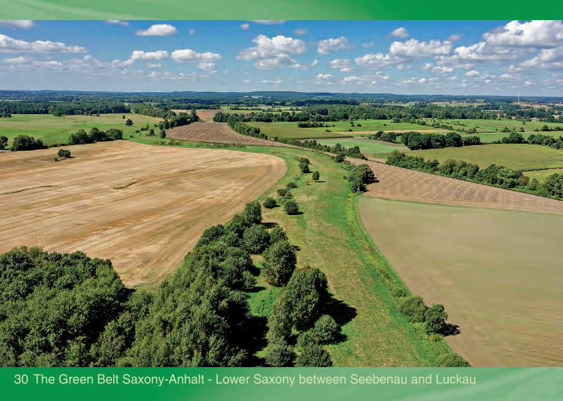
30 The Green Belt Saxony-Anhalt - Lower Saxony between Seebenau and Luckau
The Green Belt in its entire length is not a well developed and signposted hike and bicycle path. It is not always easy
to tell where the former border strip was, as most of the border fortifications have been dismantled. Moreover, in
some places the Green Belt is not recognisable because parts of it are now used as intensive grassland, arable land
or woodland.

31
Legal noticeEditor: BUND für Umwelt und Naturschutz Deutschland e.V. (Friends of the Earth Germany) - BUND Project Office Green Belt, Hesse-strasse 4, 90443 Nuremberg, Germany, Phone: +49 911-575294-0, [email protected], www.gruenesband.info, www.experiencegreenbelt.de; bank account for donations: GLS Gemeinschaftsbank eG, IBAN: DE43 4306 0967 8016 0847 00; BIC: GENODEM1GLS; reason for payment “Green Belt”
Concept and editing: Dr. Kai Frobel, Uwe Friedel, Dr. Liana Geidezis, Melanie Kreutz, Daniela Leitzbach
Text: Georg Baumert, Dr. Kai Frobel, Uwe Friedel
Photos and illustrations: BUND (p.14), Federal Border Force (p.12), B. Felinks (p.29), M. Fischer (p.20, p.21), U. Friedel (p.11), K. Frobel (p.6, p.10, p.12, p.24), O. Fugmann (p.4, p.30), Borderland Museum Eichsfeld (p.16, p.17, p.18, p.19, p.27), Border Police Academy Lübeck (p.14), K. Leidorf (p.3, p.33), D. Leupold (p.7), K. Matwijow (p.5), T. Rebhan (p.14), J. Ritter (cover photos, p.22, p.23), Schaffner (p.2), H. Schlumprecht (p.14), K. Schmidt (p.7, p.8, p.11, p.13, p.15, p.16), T. Stephan (p.2, p.9, p.15, p.17, p.18), P. Streck (p.28), W. Willner (p.15)
Layout, text and image formatting plus image editing: Thomas Rebhan, Ökologische Bildungsstätte Oberfranken (ecological education facility Upper Franconia), Naturschutzzentrum Wasserschloß Mitwitz e.V.
Translation: DialogTicket, www.dialogticket.com
st1 edition – printed on 100 % recycling paper by brühlsche Universitätsdruckerei, www.bruehlgiessen.de
The word/image marks Grünes Band® and Das Grüne Band® are protected trademarks owned by the BUND.Any further use of this publication - either in full or in part - is subject to the editor's written consent.
© BUND Project Office Green Belt – 2017
www.gruenesband.info
The Green Belt in its entire length is not a well developed and signposted hike and bicycle path. It is not always easy
to tell where the former border strip was, as most of the border fortifications have been dismantled. Moreover, in
some places the Green Belt is not recognisable because parts of it are now used as intensive grassland, arable land
or woodland.
32
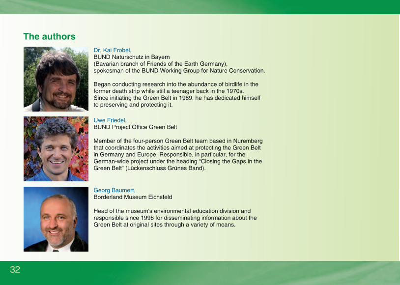
Dr. Kai Frobel, BUND Naturschutz in Bayern (Bavarian branch of Friends of the Earth Germany),spokesman of the BUND Working Group for Nature Conservation.
Uwe Friedel, BUND Project Office Green Belt
Georg Baumert, Borderland Museum Eichsfeld
The authors
Began conducting research into the abundance of birdlife in the former death strip while still a teenager back in the 1970s. Since initiating the Green Belt in 1989, he has dedicated himself to preserving and protecting it.
Member of the four-person Green Belt team based in Nuremberg that coordinates the activities aimed at protecting the Green Belt in Germany and Europe. Responsible, in particular, for the German-wide project under the heading “Closing the Gaps in the Green Belt” (Lückenschluss Grünes Band).
Head of the museum's environmental education division and responsible since 1998 for disseminating information about the Green Belt at original sites through a variety of means.
The Green Belt in its entire length is not a well developed and signposted hike and bicycle path. It is not always easy
to tell where the former border strip was, as most of the border fortifications have been dismantled. Moreover, in
some places the Green Belt is not recognisable because parts of it are now used as intensive grassland, arable land
or woodland.

The Green Belt along the Thuringia - Hesse border between Obersuhl and Berka
The Green Belt in its entire length is not a well developed and signposted hike and bicycle path. It is not always easy
to tell where the former border strip was, as most of the border fortifications have been dismantled. Moreover, in
some places the Green Belt is not recognisable because parts of it are now used as intensive grassland, arable land
or woodland.

As part of the Federal Programme for Biological Diversity, this brochure has been funded by the German Federal Agency for Nature Conservation with financial resources from the German Federal Ministry for the Environment, Nature Conservation, Building and Nuclear Safety.
The Green Belt in its entire length is not a well developed and signposted hike and bicycle path. It is not always easy
to tell where the former border strip was, as most of the border fortifications have been dismantled. Moreover, in
some places the Green Belt is not recognisable because parts of it are now used as intensive grassland, arable land
or woodland.