tonto national forest - resolution copper · resolution copper project and land exchange...
TRANSCRIPT

Resolution Copper Project and Land Exchange Environmental Impact StatementDRAFT Alternatives Evaluation ReportTonto National Forest
United States Department of Agriculture
Forest Service
November 2017


DRAFT ALTERNATIVES EVALUATION REPORT
RESOLUTION COPPER PROJECT AND LAND EXCHANGE EIS
Prepared for
U.S. Forest Service Tonto National Forest
2324 East McDowell Road Phoenix, Arizona 85006
Prepared by
SWCA Environmental Consultants 3033 North Central Avenue, Suite 145
Phoenix, Arizona 85012 (602) 274-3831 www.swca.com
November 2017


i
CONTENTS
1.0 INTRODUCTION ................................................................................................................................ 1 1.1 Background ...................................................................................................................................... 1 1.2 Purpose and Need ............................................................................................................................ 1 1.3 Proposed Action ............................................................................................................................... 2 1.4 Alternatives Development ............................................................................................................... 3
1.4.1 No Action Alternative ......................................................................................................... 3 1.4.2 Proposed Action .................................................................................................................. 4 1.4.3 Alternatives to the Proposed Action ................................................................................... 5
2.0 MINING TECHNIQUE ....................................................................................................................... 9 2.1 Introduction ...................................................................................................................................... 9 2.2 Alternative Mining Techniques ..................................................................................................... 10
2.2.1 Surface Mining Techniques .............................................................................................. 10 2.2.1.1 Open-Pit Mining ..................................................................................................... 10
2.2.2 Underground Mining Techniques ..................................................................................... 10 2.2.2.1 Naturally Supported Stopes..................................................................................... 10 2.2.2.2 Artificially Supported Stopes .................................................................................. 11 2.2.2.3 Caved Stopes ........................................................................................................... 11 2.2.2.4 Other Stoping Methods ........................................................................................... 11
2.3 Alternative Mining Technique Investigation Results .................................................................... 12 2.3.1 Technical Feasibility Screening ........................................................................................ 12 2.3.2 Tradeoffs and Reasonableness Screening (Economic Feasibility) ................................... 13
2.3.2.1 Operational Costs and Relationship to Cutoff Grades ............................................ 13 2.3.2.2 Resolution Ore Deposit Tonnage at Various Cutoff Grades ................................... 14 2.3.2.3 Other Logistical Considerations – Connectivity ..................................................... 15 2.3.2.4 Other Logistical Considerations – Safety ............................................................... 16 2.3.2.5 Reasonableness of Alternative Mining Techniques (Economic) ............................ 16
2.3.3 Overall Reasonableness of Alternative Mining Techniques ............................................. 16 2.3.4 Additional Legal Considerations ...................................................................................... 17
3.0 TAILINGS STORAGE FACILITY ALTERNATIVES ................................................................. 17 3.1 Introduction .................................................................................................................................... 17 3.2 Public Alternative Tailings Facility Workshops ............................................................................ 18 3.3 Tailings Processing and Storage Facility Techniques .................................................................... 20
3.3.1 Tailings Processing and Disposal ..................................................................................... 20 3.3.2 Tailings Storage Construction (Dams) .............................................................................. 22
3.3.2.1 Upstream Dam ........................................................................................................ 22 3.3.2.2 Downstream Dam ................................................................................................... 23 3.3.2.3 Centerline Dam ....................................................................................................... 23
3.4 Brownfield Tailings Locations ...................................................................................................... 25 3.4.1 Brownfield Site Review .................................................................................................... 28
3.4.1.1 Ajo ........................................................................................................................... 28 3.4.1.2 Carlota ..................................................................................................................... 28 3.4.1.3 Casa Grande ............................................................................................................ 28 3.4.1.4 Copper Queen (Bisbee, Arizona) ............................................................................ 28 3.4.1.5 Copperstone ............................................................................................................ 28

ii
3.4.1.6 Green Valley / Sierrita ............................................................................................ 29 3.4.1.7 Johnson Camp ......................................................................................................... 29 3.4.1.8 Miami and Inspiration / Miami Unit and Copper City ............................................ 29 3.4.1.9 Pinto valley Mine .................................................................................................... 29 3.4.1.10 Ray Mine ................................................................................................................. 29 3.4.1.11 Resolution Copper East Plant Site Subsidence CrateR (potential future
brownfield site) ....................................................................................................... 29 3.4.1.12 San Manuel ............................................................................................................. 30 3.4.1.13 Tohono Cyprus ........................................................................................................ 30 3.4.1.14 Twin Butte............................................................................................................... 30 3.4.1.15 United Verde ........................................................................................................... 30
3.4.2 Technical Input by Resolution Copper ............................................................................. 30 3.4.3 Brownfield Site Dismissal ................................................................................................ 32
3.5 Initial Tailings Facility Alternative Locations ............................................................................... 32 3.5.1 Identify Initial Tailings Facility Alternative Locations .................................................... 32
3.5.1.1 GPO alternative locations ....................................................................................... 32 3.5.1.2 Other Alternative Locations .................................................................................... 33
3.5.2 Evaluate Initial Tailings Alternative Locations ................................................................ 35 3.5.3 Initial Tailings Facility Alternative Locations evaluation details and dismissal
rationale ............................................................................................................................ 36 3.6 Preliminary Tailings Facility Alternative Locations ...................................................................... 39
3.6.1 Screen Preliminary Tailings Facility Alternative Locations ............................................. 41 3.6.2 Technical feasibility review by Resolution Copper .......................................................... 46 3.6.3 Preliminary Tailings Facility Alternative Locations and Designs Dismissed .................. 47
3.7 Final Tailings Facility Alternatives ............................................................................................... 48 3.7.1 Final Tailings Facility Alternative Description and Issues Addressed ............................. 50
3.7.1.1 Modified Proposed Action ...................................................................................... 50 3.7.1.2 Silver King Filtered ................................................................................................. 51 3.7.1.3 Peg Leg Lined ......................................................................................................... 52 3.7.1.4 Peg Leg Unlined ...................................................................................................... 53
4.0 EIS RANGE OF ALTERNATIVES ................................................................................................. 54 4.1 Other GPO Alternative Components ............................................................................................. 56
4.1.1 Relocation of Filter Plant and Loadout Facility ................................................................ 56 4.1.2 Relocation of Process Water Pond within West Plant Site ............................................... 57 4.1.3 Redesign and/or Improvement of Vehicle Access to and from the West Plant Site ......... 57
4.2 Briefing of Forest Supervisor on Proposed Range of Alternatives ................................................ 57 4.3 Cooperating Agency Review of Proposed Range of Alternatives ................................................. 57 4.4 Tribal Consultation Review of Proposed Range of Alternatives ................................................... 58
5.0 NEXT STEPS IN EIS PROCESS ..................................................................................................... 58

iii
Appendices Appendix A – Summary of Issues Identified During Scoping Process Appendix B – Council on Environmental Quality and Forest Service NEPA Guidance on Alternatives
Development Appendix C – Technical Memorandum for Alternative Mining Methods Appendix D – Alternative Tailings Public Workshop Summary Report Appendix E – Tailings Disposal Alternatives Technical Memorandum
Figures Figure 1.4-1. Resolution Copper “General Plan of Operations” (proposed action) facility locations. ........ 6 Figure 1.4-2. Resolution Copper Project and Land Exchange EIS alternatives development process
diagram and section outlines. ................................................................................................. 8 Figure 2.3-1. Underground mining operating costs. .................................................................................. 14 Figure 3.3-1. Upstream tailings dam construction method (from the EPA technical report). ................... 23 Figure 3.3-2. Downstream tailings dam construction method (from the EPA technical report)............... 24 Figure 3.3-3. Centerline tailings dam construction method (from the EPA technical report). .................. 24 Figure 3.4-1. Brownfields sites investigated for potential tailings storage. ............................................... 27 Figure 3.5-1. Initial tailings facility alternative locations. ......................................................................... 34 Figure 3.6-1. Preliminary tailings facility alternative locations. ................................................................ 40 Figure 3.7-1. Final tailings facility alternative locations ........................................................................... 49
Tables Table 2.3-1. Summary of Available Underground Stoping Methods and Applicability to Resolution
Copper Ore Deposit ............................................................................................................... 12 Table 2.3-2. Estimated Tonnage of Ore of Resolution Deposit at Various Cutoff Grades ........................ 15 Table 3.2-1. Workshop Response to Importance of Tailings Location Assessment Criteria (average) ..... 18 Table 3.2-2. Workshop Response to Paired Comparison Questions .......................................................... 19 Table 3.3-1. Tailings Processing and Storage Facility Techniques ............................................................ 21 Table 3.4-1. Brownfields Sites Investigated for Potential Tailings Storage .............................................. 26 Table 3.4-2. Summary of the Resolution Copper Response to Forest Service Brownfield Inquiry
(Resolution Copper, August 25, 2017) .................................................................................. 31 Table 3.5-1. Initial Tailings Alternative Locations Evaluation Criteria ..................................................... 35 Table 3.5-2. Initial Tailings Alternative Locations Evaluation Criteria and Results from April 2017
Project Team Meeting ............................................................................................................ 36 Table 3.5-3. Initial Tailings Facility Alternative Locations Review and Dismissed Information ............. 37
iv
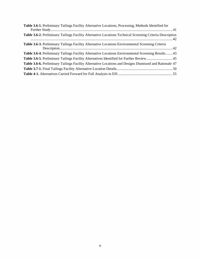
Table 3.6-1. Preliminary Tailings Facility Alternative Locations, Processing, Methods Identified for Further Study ....................................................................................................................................... 41
Table 3.6-2. Preliminary Tailings Facility Alternative Locations Technical Screening Criteria Description ............................................................................................................................................................. 42
Table 3.6-3. Preliminary Tailings Facility Alternative Locations Environmental Screening Criteria Description ............................................................................................................................. 42
Table 3.6-4. Preliminary Tailings Facility Alternative Locations Environmental Screening Results ....... 43 Table 3.6-5. Preliminary Tailings Facility Alternatives Identified for Further Review ............................. 45 Table 3.6-6. Preliminary Tailings Facility Alternative Locations and Designs Dismissed and Rationale 47 Table 3.7-1. Final Tailings Facility Alternative Location Details .............................................................. 50 Table 4-1. Alternatives Carried Forward for Full Analysis in EIS ............................................................ 55

v
This page intentionally left blank

1
1.0 INTRODUCTION This document summarizes the Resolution Copper Project and Land Exchange Environmental Impact Statement (EIS) alternatives development process. The five sections contained in the document are described below.
Section 1.0 – Introduction: This section introduces the Resolution Copper Project, including a brief background on the project, the project purpose and need and a description of the proposed action. This section also introduces the EIS alternatives development process and evaluation criteria that were used by the U.S. Forest Service (Forest Service) to develop a range of reasonable alternatives to the proposed action.
Section 2.0 – Mining Technique: The mining technique section describes the process and results of evaluating alternative surface and underground mining techniques, including technical feasibility and reasonableness of alternative mine techniques.
Section 3.0 – Tailings Storage Facility Alternatives: This section describes the process and outcomes of evaluating alternatives tailings processing and disposal methods, alternative tailings storage construction (dam) types, and alternative tailings locations, including brownfields, other National Forest System (NFS) lands, and non-NFS lands.
Section 4.0 – EIS Range of Alternatives: This section describes the range of alternatives that will be carried forward for full analysis in the draft EIS. Included in this section is a description of the Forest Supervisor briefing on the range of alternatives and cooperating agency and tribal review of the range of alternatives.
Section 5.0 – Next Steps in the EIS Process: This section provides general information on the next procedural steps in the Resolution Copper Project and Land Exchange EIS process.
1.1.Background
The Tonto National Forest (Tonto), an administrative unit of the Forest Service, is completing an EIS to evaluate the Resolution Copper Project and Land Exchange proposal. The project is located in the Globe and Mesa Ranger Districts, Tonto National Forest, Arizona. The Tonto is evaluating the proposed action at this time to comply with its statutory and regulatory obligations to respond to a proposed plan of operations submitted by Resolution Copper Mining, LLC (Resolution Copper), and to comply with Section 3003 of the Carl Levin and Howard P. ‘Buck’ McKeon National Defense Authorization Act for Fiscal Year 2015 (NDAA).
1.2 Purpose and Need The need for this project is to comply with the regulations of the Forest Service that govern the use of surface resources in conjunction with mining operations on NFS lands as set forth under 36 Code of Federal Regulations (CFR) 228; and to comply with Section 3003 of the NDAA.
The purpose of this project is to analyze the proposed action as required by the regulations at 36 CFR 228.5(a) and Section 3003 of the NDAA, including to
• facilitate the orderly exploration, development, and production of mineral resources on NFS landsopen to these activities;
2
• respond to the “General Plan of Operations” (GPO) submitted by Resolution Copper, which would govern surface disturbance on NFS lands from mining operations that are reasonably incident to extraction, transportation, and processing of copper and molybdenum;
• exchange lands between Resolution Copper and the United States as directed by Section 3003 of the NDAA;
• ensure that the selected alternative would comply with other applicable Federal and State laws and regulations;
• ensure that the selected alternative, where feasible, would minimize adverse environmental impacts on NFS surface resources; and
• ensure that measures would be included that provide for reclamation of the surface disturbance.
The Tonto is evaluating the proposed action at this time in order to comply with its statutory obligations to respond to Resolution Copper’s preliminary GPO in a timely manner. An amendment to the “Tonto National Forest Land and Resource Management Plan” (forest plan) (1985, as amended)1 may be required.
1.3 Proposed Action The proposed action is to approve the GPO as submitted by Resolution Copper and to complete the land exchange as directed by Congress under Section 3003 of the NDAA. As proposed in the GPO, the Resolution Copper mine would affect Federal, State, and private lands. The Forest Service would only approve mining operations on NFS lands associated with the proposed action, because the Forest Service does not have jurisdiction to regulate mining operations that occur on private or State land. However, the EIS will consider and disclose environmental effects that would occur on Federal, private, and State lands associated with the GPO and the land exchange. Connected actions related to the GPO and amendment of the forest plan will also be analyzed. Impacts of past, present, and reasonably foreseeable actions in the project area will be considered in combination with the impacts of the project to estimate the potential cumulative impacts of project implementation.
Substantial mining activities described in the GPO would affect a 2,422-acre parcel of land known as the Oak Flat Federal Parcel (Oak Flat Parcel). Section 3003 of the NDAA directs the conveyance of the Oak Flat Parcel to Resolution Copper. In exchange for the Oak Flat Parcel, Resolution Copper will transfer eight parcels located throughout Arizona, totaling 5,344 acres, to the United States. The Forest Service will not have jurisdiction to regulate mining activities on the Oak Flat Parcel, which is to be conveyed to Resolution Copper, because by law (i.e., the NDAA) it will become private land. The Forest Service will need to approve a GPO only for related operations that are proposed on NFS land outside the Oak Flat Parcel.
1 U.S. Forest Service. 1985. Tonto National Forest Plan Land and Resource Management Plan. Southwestern Region. October.

3
1.4 Alternatives Development As part of the EIS process, the Forest Service is required to investigate alternatives to the various aspects of the proposed action as described above. Analysis of alternatives in the EIS process is used to “inform decisionmakers and the public of the reasonable alternatives which would avoid or minimize adverse impacts or enhance the quality of the human environment” (40 CFR 1502.1). Alternatives consist of a mix of strategies that meet the purpose of and need for the proposed action, resolve or address key issues identified during scoping (see appendix A), and are consistent with the basic policy objectives for management of the area. Alternatives for this EIS include the proposed action and no action alternative, along with a range of reasonable action alternatives.
1.4.1 No Action Alternative
Council on Environmental Quality (CEQ) regulations require the Forest Service to include in the EIS analysis the alternative of taking no action (40 CFR 1502(e)). The Notice of Intent for the project, published in the Federal Register in March 2016, described the no action alternative as follows:
The EIS will analyze the no action alternative, which would neither approve the proposed GPO nor complete the land exchange. However, the responsible official does not have discretion to select the no action alternative, because it would not be consistent with the requirements of 36 CFR 228.5, nor would it comply with the NDAA.
In subsequent months, however, as the Forest Service completed the public scoping and issues development processes and then began a focused assessment of potential project alternatives, it became evident that the no action alternative might not be as simple as analyzing a scenario of “no mine and no land exchange.” That is, the team came to the realization that a no action variation involving approval of the proposed GPO but no implementation of the land exchange was, though very unlikely, still a realistic possibility. The NDAA had been structured in such a way that it allows Resolution Copper to withdraw from the land exchange under authority of Section 206(d) of the Federal Land Policy and Management Act of 1976, as amended, if the company determined that concluding the exchange was no longer in the company’s overall business interests (see NDAA Section 3003(i)(1)(B)(ii)). Furthermore, the Forest Service determined there also existed an extremely
Alternatives Development – What Was the Process? 1. Review Resolution Copper
GPO, scoping comments and report (Scoping Report, March 2017, available on the project website), and Issues Report (appendix A, November 2017, available on the project website), and National Environmental Policy Act guidance (appendix B)
2. Identify alternatives to project components potentially responsive to issues (Project Record #0001481-1483)
3. Conduct Alternatives Tailings Public Workshops (appendix D) • March 21, 2017,
in Superior, Arizona • March 22, 2017,
in Gilbert, Arizona • Online Public Workshop,
March 23 through April 5, 2017
4. Convene Project Team Alternatives Development Workshops • April 11 and 12, 2017
(Project Record #0001359) • July 5 and 6, 2017 (Project
Record #0001841)
5. Investigate alternative components (mining technique and tailings storage), described below in sections 2.0 and 3.0
6. Investigate alternative tailings locations (section 3.0)
7. Review alternatives by Forest Supervisor, cooperating agencies, and tribes (section 4.0)
8. Finalize EIS range of alternatives (section 4.0)
4
remote possibility that the land exchange would be consummated but the GPO ultimately would not be approved, or that its approval might subsequently be rescinded by court decision, thus resulting in a scenario of “land exchange but no mine.”
The Forest Service therefore determined that all three possible no action alternative variations (i.e., “no mine and no land exchange,” “approved mine but no land exchange,” and “land exchange but no mine”) must be analyzed in the EIS to document how these different “no action outcomes” might alter environmental and human conditions in the immediate vicinity of the town of Superior and beyond.
1.4.2 Proposed Action
Resolution Copper proposes to conduct underground mining of a copper-molybdenum deposit located 5,000 to 7,000 feet below the ground surface. Resolution Copper estimates that the mine would take approximately 10 years to construct, would have an operational life of approximately 40 years, and would be followed by 5 to 10 years of reclamation activities. The mining operation would include, but is not limited to, the following facilities and activities, which would be conducted on a mixture of NFS, private, and State lands (see figure 1.4-1):
• The mining itself would take place under the Oak Flat Parcel. • An area known as the East Plant Site would be developed adjacent to the Oak Flat Parcel.
This area would include mine shafts and a variety of surface facilities to support mining operations. This area currently contains two operating mine shafts, a mine administration building, and other mining infrastructure. Portions of the East Plant Site would be located on NFS lands and would be subject to Forest Service regulatory jurisdiction.
• The ore would be mined using a panel caving technique (a form of block caving) in which the ore is fractured using blasting and then drawn from underneath the ore body. The use of panel caving would result in land surface subsidence with a maximum depth of approximately 1,100 feet and a subsidence area of approximately 1,750 acres.
• Mined ore would be crushed underground and then transported underground approximately 2.5 miles west to an area known as the West Plant Site, where ore would be processed to produce copper and molybdenum concentrates. Portions of the West Plant Site would be located on NFS lands, and would be subject to Forest Service regulatory jurisdiction.
• The copper concentrate would be pumped as a slurry through a 22-mile pipeline to a filter plant and loadout facility located south of Florence Junction, Arizona, where copper concentrate would be filtered and then sent to off-site smelters via rail cars or trucks. The molybdenum concentrate would be filtered, dried, and sent to market via truck directly from the West Plant Site.
• The copper concentrate slurry pipeline would be located along an existing, previously disturbed right-of-way known as the Magma Arizona Railroad Company (MARRCO) corridor. The MARRCO corridor would also host other mine infrastructure, including, but not limited to, water pipelines, power lines, pump stations, and groundwater wells for recovery of banked Central Arizona Project water or pumping under a mineral extraction permit issued by the Arizona Department of Water Resources. A portion of the MARRCO corridor is located on NFS lands and would be subject to Forest Service regulatory jurisdiction.
• Tailings (the processed non-economic material remaining after copper extraction) produced at the West Plant Site would be pumped as a slurry through several pipelines for 4.7 miles to the proposed Lower West tailings storage facility location. The tailings storage facility would gradually expand over time, eventually reaching about 4,400 acres in size. The proposed tailings storage facility is located on NFS lands and would be subject to Forest Service regulatory jurisdiction. The proposed tailings facility characteristics include the following:

5
o Topography characterized by a sequence of ridges and valleys with a majority Gila Conglomerate geology type.
o Approximately 1.5 billion tons or 1.3 billion cubic yards of tailings produced. o Tailings delivered from the concentrator as thickened slurry. Two tailings streams
separated as part of the flotation process into scavenger tailings (85 percent, non-potentially acid generating [NPAG] and cleaner tailings (15 percent, potentially acid generating [PAG]). Tailings pipelines would generally be located above ground and in a containment canal within the tailings corridor, providing secondary containment.
o Upstream embankment construction. o Unlined facility. o Water would be recycled and reused in operations. A floating barge would pump tailings
water at the center of the tailings storage facility and return to west plant site for use. Water that is collected in seepage ponds would be pumped up the tailings embankment and back into the tailings storage facility.
o At closure, the facility would consist of a four-sided perimeter embankment dam with a maximum dam height of approximately 574 feet and a 5:1 exterior slope angle.
• All power to the mine would be supplied by the Salt River Project. Portions of the proposed electrical infrastructure would be located on NFS land and would be subject to Forest Service regulatory jurisdiction. A Forest Service special use permit would be required to approve construction and operation of new power lines on NFS lands by the Salt River Project.
• Reclamation would be conducted to achieve postclosure land use objectives, including closing and sealing the mine shafts, removing surface facilities and infrastructure, and establishing self-sustaining vegetative communities using local plant species. The proposed tailings storage facility would be reclaimed in place, providing for permanent storage of mine tailings.
1.4.3 Alternatives to the Proposed Action
Upon the completion of scoping and development of the key issues, the Forest Service began the process of developing a range of reasonable and feasible alternatives to the proposed action that resolve, minimize, or reduce impacts to identified issues while meeting the purpose of and need for the proposed action. The Forest Service established a project team that worked on alternatives development from approximately January through October 2017. The alternatives development project team (project team) consists of Forest Service interdisciplinary team members and supporting consultants, both of which provided environmental and technical expertise to address the complex alternative development process. Technical expertise included mining and tailings engineers. Environmental expertise included environmental planning and regulatory specialists, hydrologists, geochemists, and biologists, among others.
The project team used the following criteria to develop and evaluate a range of reasonable alternatives to the proposed action (regulatory guidance follows in parentheses):
• Does the alternative meet the project purpose and need for action? (36 CFR 220.5; Forest Service Handbook [FSH] 1909.152)
• Does the alternative resolve environmental or resource conflicts, from which issues were identified? (36 CFR 220.5; FSH 1909.15)
2 U.S. Forest Service. 2012. FSH 1909.15 – National Environmental Policy Act Handbook. Amendment No.: 1909.15-2012-3. Washington, D.C.: U.S. Forest Service National Headquarters.

6
Figure 1.4-1. Resolution Copper “General Plan of Operations” (proposed action) facility locations.

7
• Is the alternative technically feasible? (CEQ 40 Most Asked Questions3 – Answer 2A; FSH 1909.15_14.4)
• Is the alternative economically feasible? (CEQ 40 Most Asked Questions – Answer 2A)
• Is the alternative illegal? (FSH 1909.15)
• Does the alternative cause “unreasonable environmental harm”? (FSH 1909.15)
• Is the alternative reasonable using “common sense”? (CEQ 40 Most Asked Questions – Answer 2A)
The process for development and consideration of alternatives is defined by regulation and published CEQ guidance. Appendix B includes specific regulations citations that guided development of the alternatives selected for analysis in the draft EIS.
The first step in alternatives development consisted of the project team’s review of the proposed GPO to identify possible components in the plan that are available for alternative development and would address identified issues. The preliminary components identified included alternative mining techniques; alternative tailings storage facility locations, processing and storage techniques; and alternative transportation corridors and ancillary facility locations. Figure 1.4-2 illustrates the alternatives development process and directs readers to sections of this report for specific process steps and details.
3 Council on Environmental Quality. 1986. Forty Most Asked Questions Concerning CEQ’s National Environmental Policy Act Regulations. Washington D.C.: Executive Office of the President. March,

8
Figure 1.4-2. Resolution Copper Project and Land Exchange EIS alternatives development process diagram and section outlines.

9
2.0 MINING TECHNIQUE Based on scoping comments and public input, the Forest Service investigated the potential for using alternative mining techniques. The resulting document, “Technical Memorandum for Alternative Mining Methods”4 (technical memorandum), is provided in appendix C and summarized here in section 2.0. Dr. Charles Kliche, retired professor from the South Dakota School of Mines and Technology, was engaged as part of the project team to investigate alternative mining techniques.
2.1 Introduction Substantial public comments were received concerning the panel caving mining technique proposed to be used by Resolution Copper (panel caving is a form of block caving), in particular requesting that alternative mining techniques be considered or required.5 Public comments asked for alternatives that considered the following items:
• Use of traditional mining methods, including less mechanized forms of mining
• Investigation of alternatives that would result in minimal surface disturbance
• Use of alternative mining methods to reduce the volume of tailings produced
The proposed panel caving mining method is seen as having two major drawbacks. First, panel caving results in the creation of a subsidence zone at the surface, which impacts a variety of resources. Second, because panel caving does not leave any opening or cavity below ground, there is no opportunity to backfill tailings as a potential disposal alternative. The Forest Service agreed that if an alternative mining method were found to be reasonable, it could reduce certain resource impacts. The Forest Service therefore undertook an investigation into the technical and economic feasibility of using alternative mining techniques.
One benchmark for including any alternative is whether it is reasonable,6 and more specifically, whether the alternative is practical or feasible from the technical and economic standpoint. The technical memorandum focuses on these salient points:
4 Kliche, C.A. 2017. Technical Memorandum for Alternative Mining Methods. Resolution Copper Mining, LLC, Superior, Arizona. November 1. Prepared by Dr. Charles A. Kliche, P.E., Ph.D. (Project Record #0002041). 5 See specifically March 2017 “Resolution Copper Project and Land Exchange Environmental Impact Statement Scoping Report,” sections 3.5.2.1 and 3.7.12.1, and May 2017 “Resolution Copper Project and Land Exchange Environmental Impact Statement Public Concern Statements,” SZ-1 and ALT-3.3. These documents are available on the project website at www.ResolutionMineEIS.us. 6 See appendix B for guidance used in alternatives development. 40 CFR 1502.14 (emphasis added). “In this section agencies shall: (a) Rigorously explore and objectively evaluate all reasonable alternatives, and for alternatives which were eliminated from detailed study, briefly discuss the reasons for their having been eliminated.” The concept of reasonable alternatives was further expanded in Question 2A of the CEQ’s “Forty Most Asked Questions Concerning CEQ’s National Environmental Policy Act
Mining Technique – Process Documentation • Project Team Alternatives
Evaluation Workshops ◦ April 11 and 12, 2017,
mining techniques presentation (Project Record #0001359)
• Meeting between Resolution Copper and Dr. Kliche to discuss mining techniques and modeling, March 23 and 24, 2017 (Project Record #0002063)
• Resolution Copper data request responses (Project Record #0001314; 0001316; 0001318–0001321; 0001422; 0001734)
• Dr. Kliche “Technical Memorandum for Alternative Mining Methods” (appendix C, Project Record #0002041)

10
• What range of underground mining techniques are available for consideration?
• Given the physical and mineralogical characteristics of the Resolution Copper ore deposit, which mining techniques are technically feasible?
• What is the current industry standard for mining similar deposits?
• If a technically feasible alternative mining technique were used, what would be the general economic tradeoffs?
The technical memorandum presents an independent investigation of these questions. Specific data inputs were requested from Resolution Copper in order to conduct the analysis, but in line with CEQ guidance, Resolution Copper input was limited to providing technical information, instead of their overall opinions on their preferred mining technique.
2.2 Alternative Mining Techniques
2.2.1 Surface Mining Techniques
2.2.1.1 OPEN-PIT MINING
This alternative mining technique was not strongly considered because it would result in surface disturbances greater than those in the proposed action (panel caving). Nevertheless, Resolution Copper explored the option in the past, and quantification of the expected surface disturbance was provided.
• The footprint of the open pit would need to be approximately 10,000 acres, which is eight times larger than the projected maximum disturbance from subsidence (approximately 1,200 acres).
• The resulting pit would result in the removal of all of Oak Flat, all of Apache Leap, approximately 4 miles of U.S Route (U.S.) 60, approximately 3 miles of Queen Creek, and approximately 3 miles of Devil’s Canyon.
• The pit would have a stripping ratio (waste rock to ore) of 35:1, which would generate approximately 205 billion tons of waste rock. This represents more than 100 times more volume than the projected volume of tailings under the GPO. The waste rock generated from mining would need to be disposed of at some surface location, and a tailings impoundment would still be required.
2.2.2 Underground Mining Techniques
2.2.2.1 NATURALLY SUPPORTED STOPES
The term “stope” used in mining simply indicates an underground excavation or room, and the term “stoping” refers to any underground mining technique that removes ore from these areas. Naturally supported stoping methods are ones in which the stope can be developed with no regular artificial support (“open stoping”) or with pillars of ore left in place (“open stopes with pillar supports”). This technique is best suited to situations in which the surrounding rock is strong and can stand unsupported, and the ore deposit is limited in breadth and width. Regulations” (emphasis added): “Answer 2a. Section 1502.14 requires the EIS to examine all reasonable alternatives to the proposal. In determining the scope of alternatives to be considered, the emphasis is on what is “reasonable” rather than on whether the proponent or applicant likes or is itself capable of carrying out a particular alternative. Reasonable alternatives include those that are practical or feasible from the technical and economic standpoint and using common sense, rather than simply desirable from the standpoint of the applicant.” Forest Service guidance provides some additional guidance: “Alternatives not considered in detail may include, but are not limited to, those that fail to meet the purpose and need, are technologically infeasible or illegal, or would result in unreasonable environmental harm” (FSH 1909.15,chapter 10, section 14.4).
11
Once ore is removed, the resulting stopes would be available for backfilling with tailings. Naturally supported stopes do not typically cause subsidence, but they can if the stopes are shallow and are not backfilled.
2.2.2.2 ARTIFICIALLY SUPPORTED STOPES
As the name implies, artificially supported stopes need additional support either from backfilled tailings or waste rock, timber or steel cribbing, or left-in-place ore, to avoid collapse. With “shrinkage stoping,” the artificial support comes from the fractured ore itself, which is left in the stope during mining. Starting at the bottom of the deposit, miners blast the ore in slices to fracture it. While the workers gradually work upward through the deposit, some of the ore is drawn from the bottom of the stope (about 35 percent) to maintain sufficient working space for the miners to reach the in-place ore located above. When the miners reach the top of the planned stope, all of the ore is then drawn off from the bottom, and the stope is complete. This method can be used with or without pillars.
With “cut-and-fill stoping” the artificial support comes from the progressive backfill of tailings of waste rock into the stope. In “overhand cut-and-fill,” miners start at the bottom of the deposit and mine a horizontal slice of ore; they then bring tailings to backfill the horizontal slice. Miners work their way upwards through the deposit in a series of slices. “Underhand cut-and-fill” is similar, but miners start at the top of the deposit and work their way down.
Several other artificially supported stoping techniques also exist that make use of timbers or steel as the artificial support.
Artificially supported stopes do not generally cause subsidence and once ore is removed the resulting mined voids would be available for backfilling with tailings or waste rock. These techniques are ideally suited for situations where the surrounding host rock is sufficiently weak that the stopes require artificial support in order to mine. It is also best suited for situations where mineralization is clearly delineated between ore and waste, and where the ore deposit is steeply dipping and limited in breadth and width.
2.2.2.3 CAVED STOPES
Caved stopes include panel caving (proposed in the GPO) and sub-level caving. In both cases, ore is fractured by blasting and then drawn from underneath the deposit. Panel caving as proposed in the GPO uses a single level below the entire ore body from which ore is withdrawn. This “floor” level remains the draw point for the life of the mine. Sublevel caving is mined similarly, but in slices from top to bottom, with the ore being withdrawn at different levels (“sublevels”) as the mine progresses downward. As mining advances, broken ore falls into the excavated cavity, and the overlying cap rock and surface slowly subside into the void.
Both of these methods result in surface subsidence, and neither method allows for backfilling, as no open stope is left after mining. While considered in the technical memorandum analysis, the other caved stoping techniques offer no reduction in resource impacts, compared with the proposed panel caving. Therefore, the other caved stoping techniques were not considered further by the project team.
2.2.2.4 OTHER STOPING METHODS
One additional stoping method considered that does not fall into the above categories is “vertical crater retreat stoping.” In this method, ore is fractured by blasting in slices and withdrawn from the bottom of the stope. Ore slices advance in an upward direction toward the top of the stope. When the last ore slice is removed, an open stope is left that can be backfilled. This method requires both strong ore and strong cap rock. Otherwise, the stope would collapse, and subsidence could occur.

12
2.3 Alternative Mining Technique Investigation Results
2.3.1 Technical Feasibility Screening
First, the Forest Service has eliminated a surface mining alternative from consideration due to the magnitude of the surface disturbance that would ensue. This leaves underground mining techniques as the only potential mining option for the Resolution Copper project. The technical memorandum found that panel caving is a reasonable and technically feasible mining method, given the physical characteristics of the Resolution Copper deposit. Moreover, panel caving is a widely used mining technique for large-tonnage, low-grade deposits such as Resolution Copper. A major drawback is that panel caving results in subsidence.
To decrease the likelihood and degree of subsidence, an alternative mining technique to panel-caving would require (1) leaving minable ore in the ground to act as structural support, or (2) backfilling excavated mine cavities with tailings, waste rock, or some other material. The technical memorandum also found that the following underground stoping methods, some more amenable to backfilling than others, could physically or technically be used with the Resolution Copper deposit:
• Cut-and-fill stoping
• Open stoping
• Open stoping with pillar support
• Shrinkage stoping
• Vertical crater retreat stoping
Each of these methods is suited to certain characteristics of an ore body, including ore and host rock strength, the depth and type of overburden or cap rock, and the size and shape of the ore body. All of these characteristics typically would be considered when selecting the ideal and most efficient mining method. For alternatives evaluation, however, the question asked is not whether each of these methods represents the ideal mining technique, but rather whether the method could physically be implemented instead of panel caving. As shown in table 2.3-1, very few of these underground stoping methods have characteristics that are well suited to the Resolution Copper deposit, even though technically these methods could be used.
Table 2.3-1. Summary of Available Underground Stoping Methods and Applicability to Resolution Copper Ore Deposit
Underground Stoping Method Ideal Ore Body Characteristics Ideal Ore
Strength Ideal Host Rock Strength Backfill
Resolution Copper Deposit Low grade, massive, thick Weak to Moderate Weak to Moderate No
Cut and fill High grade, irregular, narrow to wide
Strong Weak* Yes
Open stoping Small Strong Strong Possible
Open stoping with pillar support
Low grade, horizontal or flat dipping Strong Strong Possible
Shrinkage stoping Fairly high grade, narrow to wide (4 to 100 feet) thick
Strong Moderate* Possible
Vertical crater retreat stoping
>40 feet thick Strong Strong Possible
* Indicates a match to the characteristics of the Resolution Copper ore deposit.

13
2.3.2 Tradeoffs and Reasonableness Screening (Economic Feasibility)
Given that there are other underground stoping techniques that could physically be applied to the Resolution Copper deposit, as suggested during scoping, even if not these are not ideal techniques, it is necessary to next evaluate the economic tradeoffs of using these methods.
2.3.2.1 OPERATIONAL COSTS AND RELATIONSHIP TO CUTOFF GRADES
All of the underground stoping methods listed above have higher operational costs than panel caving (which costs approximately $1/ton to $10/ton). Representative costs presented in the technical memorandum7,8 include the following:
• Cut and fill—approximate operating cost of $68/ton, although that cost depends on the type of tailings used to backfill
• Open stoping—approximate operating cost of $7/ton to $25/ton
• Open stoping with pillar support—approximate operating cost of $21/ton
• Shrinkage stoping—approximate operating cost of $51/ton
• Vertical crater retreat stoping—approximate operating cost of $40/ton
The above operational costs are based on published industry standards. A greater range of representative costs of mining is presented in figure 2.3-1 (from the technical memorandum). The figure illustrates the low, high, and middle cost in U.S. dollars for mining a short ton of ore for the various underground mining techniques.
The concept of “cutoff grade” (COG) is a key means to assess the economic tradeoffs associated with using a method with higher operational costs. The COG (given as a percentage of copper) is the lowest grade of copper for a ton of ore that just equals the cost of stripping, drilling, blasting, mining, hauling, crushing, and processing the ore (as well as administrative costs, taxes, and other overhead costs), given the current price and mill recovery.
The most important part of the concept of COG is that as the cost of a mining technique increases, if the price of copper and mill recovery remain the same, then the COG also has to increase. In other words, if per-ton operational costs are higher, the mine must focus on the higher grade material in order to break even on the mining. It does not make sense for a ton of ore be mined at an economic loss, and COG is a tool used to help define that economic limit.
7 These costs do not include backfilling costs (except for the cut-and-fill scenario). 8 CostMine. 2017. Industry Standard for Mining Cost Estimating, Mining Cost Service. Available at: http://costs.infomine.com/miningcostservice/. Accessed July 7, 2017.

14
Figure 2.3-1. Underground mining operating costs.9
2.3.2.2 RESOLUTION ORE DEPOSIT TONNAGE AT VARIOUS CUTOFF GRADES
It is not possible to directly identify a typical COG associated with each of the above underground stopping methods. The calculation of COG is highly specific to an individual mine. However, it is possible to estimate the expected volume of ore from the Resolution Copper ore deposit that might be available to be mined at different COGs.
The first piece of information regarding COG is publicly available, as Resolution Copper has already identified the tonnage of ore within the greater-than-1-percent shell (the copper containing ore body), as shown in table 2.3-2. The greater-than-1-percent shell COG was defined by Resolution Copper as part of its business plan for this mineral deposit. Note that the average grade of the ore within the greater-than-1-percent shell is greater than 1 percent (1.54 percent), because within this shell are areas of higher grade ore. In fact, it is these areas of higher grade ore that would have to be targeted by more expensive underground mining techniques requiring a higher COG. In general, a ton of ore occurring within the greater-than-1-percent shell will have a copper grade of at least 1 percent or more, and a ton of ore occurring outside the greater-than-1-percent shell will have less than 1 percent copper. 9 Dundee Capital Markets. 2012. An Introduction to Underground Mining. Hustrulid, W.A. (ed.). 1982. Underground Mining Methods Handbook. New York: Society of Mining Engineers of the American Institute of Mining, Metallurgical, and Petroleum Engineers, Inc. Infomine. 2017. Costs. Available at: http://costs.infomine.com/miningcostservice/. Accessed July 7, 2017. Macquarie Research. 2016. Metals and Mining: A Chip Off the New Block; Evaluating the Risks and Rewards of the Future Block Cave. November. Moss, A. 2011. An Introduction to Block and Panel Caving. BMO Capital Markets 2011 Global Metals and Mining Conference. Available at: https://www.scribd.com/document/217853788/Introduction-to-Panel-Caving. Accessed July 7, 2017.
BlockCaving
Room &Pillar
SublevelCaving
VerticalCrater
Retreat
Mechanized Cut &
Fill
ShrinkageStoping Cut & Fill
Cost (high) ($US/st) $20.87 $27.22 $181.49 $181.49Cost (low) $US/st $4.53 $9.07 $6.35 $13.72 $18.14 $18.14Cost (mid) $US/st $8.26 $18.90 $19.95 $36.62 $47.62 $46.72 $61.73
$8.26 $18.90 $19.95$36.62
$47.62 $46.72$61.73
$0.00$20.00$40.00$60.00$80.00
$100.00$120.00$140.00$160.00$180.00$200.00
$US
per
st
Underground Mining Operating Costs

15
In order to establish a second data point, the author of the technical memorandum reviewed graphical information provided by Resolution Copper describing the geometry and grade of the ore body; the author also conducted an independent assessment of the tonnage of ore within the greater-than-2-percent shell. Note that the information available to conduct this assessment was sufficient to establish the greater-than-2-percent shell, but was not sufficient to estimate the average grade within that shell.
Table 2.3-2. Estimated Tonnage of Ore of Resolution Deposit at Various Cutoff Grades
COG Estimated Tonnage of Ore
Percentage of Original Tonnage Source Average Grade of
Ore above the COG
1% 1,969,000,000 100% Resolution Copper 1.54%
2% 386,437,500 19.6% Independent estimate from Resolution data Unknown
3% 7,545,919 0.4% Extrapolation from first two data points Unknown
4% 1,478,469 0.08% Extrapolation from first two data points Unknown
5% 289,676 0.02% Extrapolation from first two data points Unknown
To clarify table 2.3-2, an alternative mining technique resulting in an increase of COG from 1 percent to 2 percent would mean that only 19.6 percent of the material currently proposed to be mined could be mined using the alternative mining technique.
As an example of the concept of COG, several commenters pointed to the historic work on the Magma Mine as indicating that cut-and-fill techniques can be applied to the current Resolution Copper deposit. The average grade of ore removed from the Magma Mine has been reported to be 5 percent or greater, depending on the year mined. This higher grade of ore was able to support a cut-and-fill mining technique.
2.3.2.3 OTHER LOGISTICAL CONSIDERATIONS – CONNECTIVITY
The first phase of the investigation into alternative mining techniques did not consider the true appropriateness of the underground stoping techniques, but only considered whether they were physically and technically able to be implemented. The nature of the Resolution Copper deposit would further limit the amount of ore that would be recoverable if these techniques were used. The information provided by Resolution Copper about the geometry and grade of the ore deposit indicates that the pockets of higher grade ore are distributed throughout the greater-than-1-percent shell and are not generally contiguous or continuous. The greater-than-2-percent shell includes all of these discrete pockets, and together they constitute 386 million tons of material. In reality, some of these areas may not be mined if using an underground stoping mining method because they are too far away from other areas of more contiguous high-grade ore, making the cost of access and development uneconomical even at a higher grade. However, these areas are readily mined, regardless of their discontinuity, by using a bulk mining technique such as panel caving. As a result, the greater-than-2-percent shell is understood to represent an overestimation of the amount of material reasonably available at this grade.
This represents another example of how the Resolution Copper deposit differs from the historic Magma Mine. The Magma Mine workings followed largely continuous veins of mineralization with good connectivity, unlike the highly disseminated and disconnected high-grade areas within the Resolution Copper deposit.

16
2.3.2.4 OTHER LOGISTICAL CONSIDERATIONS – SAFETY
Resolution Copper raised safety concerns associated with underground stoping techniques, compared with panel caving techniques. These safety concerns were not further investigated and did not form part of this analysis.
2.3.2.5 REASONABLENESS OF ALTERNATIVE MINING TECHNIQUES (ECONOMIC)
It cannot easily be known what COG would be required to break even on mining a ton of ore if the cut-and-fill technique were hypothetically mandated for the Resolution Copper Project. Given that the per-ton mining costs are as much as seven times greater for cut and fill vs. panel caving, it is not unreasonable to estimate that the COG might increase from 1 percent to 2 or 3 percent.
The technical memorandum analysis shows that the economic tradeoff with just an increase from 1 percent to 2 percent COG represents more than a marginal decrease in available ore. At 2 percent COG, the total tonnage of ore available under an alternative mining method is less than 20 percent of that proposed in the GPO, and 3 percent COG represents less than 1 percent of the tonnage of ore proposed to be mined in the GPO. From a common sense perspective, an up to 80 percent reduction in available ore in order to accommodate an alternative mining technique does not represent a reasonable economic tradeoff.
2.3.3 Overall Reasonableness of Alternative Mining Techniques
The Forest Service recognizes and agrees with scoping comments that use of mining techniques other than panel caving could substantially reduce impacts to surface resources, both by reducing or eliminating subsidence and by allowing the potential to backfill tailings underground. For this reason, the potential for using alternative mining techniques was investigated explicitly during the alternatives development process.
In the end, alternative mining techniques as applied specifically to the Resolution Copper deposit were not found to be reasonable, for the following reasons:
1. Panel caving is a standard mining method used in industry and is commonly used for deposits with the grade, size, depth, and geological characteristics of the Resolution Copper deposit.
2. Although several underground stoping techniques could physically and technically be applied to the deposit, the ore and host rock characteristics typically favorable for these techniques differ from the characteristics of the Resolution Copper deposit. While physically feasible, it is unlikely that any of these techniques would be chosen as a reasonable technique for a similar deposit.
3. Use of any of these alternative underground stoping techniques would result in higher per-ton mining costs, and as a result, the COG for the deposit would need to be higher to be economically feasible. An increase in COG from 1 percent to 2 percent removes an estimated 80 percent of the tonnage of the deposit from consideration for development. The tonnage is likely to be even lower at 2 percent COG, as many of these areas of high-grade ore are not contiguous or continuous. Accepting this level of reduction to accommodate an alternative mining technique is not economically feasible and would not be reasonable.
This threshold of reasonableness is consistent with guidance contained in the Minerals and Geology Forest Service Manual (FSM 280010):
10 U.S. Forest Service. 2007. FSM 2800 – Minerals and Geology. Washington D.C.: U.S. Forest Service National Headquarters.

17
The claimant has the right to see or otherwise dispose of all locatable minerals, including uncommon varieties of mineral materials, on which the claimant has a valid claim. (FSM 2813.12, emphasis added)
In managing the use of the surface and surface resources, the Forest Service should attempt to minimize or prevent, mitigate, and repair adverse environmental impacts on National Forest System surface and cultural resources as a result of lawful prospecting, exploration, mining, and mineral processing operations, as well as activities reasonably incident to such uses. This should be accomplished by imposition of reasonable conditions which do not materially interfere with such operations. (FSM 2817.02, emphasis added)
The Forest Service found the substantial decreases in ore development that would be a necessary result of requiring an alternative mining technique would not meet the definition of reasonable, would not allow Resolution Copper to dispose of all locatable minerals on which they have valid claims, and would materially interfere with Resolution Copper’s operations. For the above reasons, alternative mining techniques were considered but eliminated from detailed analysis.
2.3.4 Additional Legal Considerations
One tenet of robust alternatives development is to not be constrained unnecessarily by the jurisdiction of the agency that will decide on the alternative. Legal or jurisdictional considerations are still part of the information available to the Forest Supervisor when considering the range of alternatives for detailed analysis, but they are not a driving factor in the development of alternatives.
In the case of the Resolution Copper Project, it is recognized that the land exchange fundamentally changes the jurisdiction of the agency with respect to the mining operations. The land exchange is mandated by Congress to happen, provided that Resolution Copper requests it, 60 days after publication of the final EIS. At the time the mine would be built and operated, the land it occupies would be in private ownership, not Federal ownership. The Forest Service has no authority to regulate mining or mandate alternative mining techniques on private land.
This legal opinion is one consideration of the Forest Supervisor, but it did not guide or affect the analysis given above regarding the technical and economic feasibility associated with alternative mining techniques.
3.0 TAILINGS STORAGE FACILITY ALTERNATIVES
3.1 Introduction This section of the report describes the project team’s process for identifying and evaluating tailings storage facility alternatives, which included the following process steps (see figure 1.4-2 for an illustration of the process steps). The Forest Service did the following:
1. Hosted in-person and online workshops to identify public values related to developing and locating the tailings storage facility (section 3.2);
2. Identified and evaluated alternative tailings processing and storage techniques (section 3.3);
3. Identified and evaluated brownfield alternative tailings storage locations (section 3.4);
4. Identified and evaluated initial and preliminary alternative tailings storage facility locations (section 3.5 and section 3.6, respectively); and

18
5. Identified final tailings facility alternatives for analysis in the draft EIS (section 3.7).
It should be noted that the process as described in this Alternatives Evaluation Report is relatively linear. In practice, alternatives development is an iterative process, as new possible combinations are explored for their ability to respond to resource issues. Some alternatives originally dismissed early in the process may have been discussed further during subsequent meetings, if warranted.
3.2 Public Alternative Tailings Facility Workshops At the outset of investigating alternative tailings facility locations, the Forest Service hosted two workshops in order to better understand the public’s preferences and concerns and solicit input on the relative importance of a variety of environmental and social criteria that they would use to evaluate alternative tailings facility locations. Interactive polling technology was used to solicit preferences from the workshop participants.
The Forest Service hosted two interactive workshops, one in Superior, Arizona, on March 21, 2017, and a second in Gilbert, Arizona, on March 22, 2017. The purpose of the workshops was to
• update the public on the status of the EIS process;
• describe the alternatives development process; and
• solicit input on the criteria being used to evaluate alternative tailings storage facility locations.
The Forest Service also provided an online workshop with similar polling questions in order for people who could not attend the “live” workshops to participate in the process and submit their opinions regarding the importance of the environmental and social criteria to be used to identify alternative tailings facility locations. The online workshop was available from March 23 through April 5, 2017. The details and reporting results for the workshops are presented in appendix D.
Responses to the workshop question (in person and online) regarding the rating of importance for key issue criteria on a scale of 1 to 9 is presented in table 3.2-1. This illustrates that all issues range from important (7) to very important (9) to respondents, with Streams and Springs and Wildlife Habitat components rating the highest importance.
Table 3.2-1. Workshop Response to Importance of Tailings Location Assessment Criteria (average)
Key Issue Criteria Importance (scale of 1–9, average)
Streams and Springs 8.5
Wildlife Habitat 8.25
Scenery 7.75
Proximity to Existing Communities 7.7
Recreation 7.65
Cultural Resources 7.55
Tailings Facility Workshops – Process Documentation • Alternatives Tailings Public
Workshops (appendix D, Project Record #0002066) ◦ March 21, 2017, in Superior,
Arizona ◦ March 22, 2017, in Gilbert,
Arizona
• Alternatives Tailings Public Workshop Summary Report (appendix D, Project Record #0002066)

19
Workshop participants were then asked to respond to a “paired comparison” process to gain further insight into the relative importance of the key issue criteria. Participants were asked make a relative comparison between each criteria. For example: It is more important for the Forest Service to select a tailings facility location that best… Protects area recreational opportunities (Recreation) or Protects perennial and intermittent streams and area springs (Streams & Springs)? The results of the paired comparison questions (in-person and online) are presented below in table 3.2-2. Streams and Springs were chosen 76 percent of the time and Wildlife Habitat 62 percent of the time when compared with other components.
Table 3.2-2. Workshop Response to Paired Comparison Questions
Key Issue Criteria Paired Comparison Results (percent)
Streams and Springs 76
Wildlife Habitat 62
Proximity to Existing Communities 44
Cultural Resources 43
Scenery 31
Recreation 30
The project team used the information gathered in the workshops to develop the evaluation and screening criteria for reviewing tailings alternatives development scenarios. These criteria are described in the sections below. In particular, the team noted that Streams and Springs and Wildlife Habitat are of very high importance with respect to developing alternatives for the tailings storage facility. Public health and safety was also a key issue in alternatives development as related to the criteria Proximity to Existing Communities.

20
3.3 Tailings Processing and Storage Facility Techniques
A variety of tailings processing and storage facility constructions techniques are used in tailings management in the United States and internationally. The project team investigated several alternative processing and storage techniques for potential use in the Resolution Copper Project.
3.3.1 Tailings Processing and Disposal
The GPO Proposed Action describes the Resolution Copper Project as a copper-molybdenum ore mining operation that will yield economic quantities of both elements. The non-economic product of ore processing is tailings. The composition of tailings depends on the composition of the ore and the process of mineral extraction used on the ore. Table 3.3-1 describes the different types of tailings, processing, and containment options considered.
Tailings Processing and Storage Facility Techniques – Process Documentation • Resolution Copper, Information
on Tailings Alternatives, dated March 9, 2017 (Project Record #0001296)
• Project Team Alternatives Evaluation Workshops ◦ April 11 and 12, 2017 (Project
Record #0001359) ◦ July 5 and 6, 2017 (Project
Record #0001841)
• Resolution Copper, Independent Technical Review Board Report No. 1, Rev. 1 (Project Record #0001301)
• BGC Engineering PAG Tailings Management and Liner Technical Memorandum (Project Record #0002039)
• BGC Engineering Scalability of Tailings Filtration Technical Memorandum (Project Record #0002038)
• BGC Engineering Dam Types Review Technical Memorandum (Project Record #0002045)
• Technical Alternatives Discussion with Resolution Copper, July 12, 2017 (Project Record #0001693)
• Forest Service Filtered Tailings Inquiry to Resolution Copper, dated July 19, 2017 (Project Record #0001849)
• Resolution Copper Response to Forest Service Alternatives Data Request #3, Information on Potential Tailings Alternatives, dated August 25, 2017 (Project Record #0001855, #0001857, and #0001879)
• BGC Engineering Tailings Disposal Alternatives Technical Memorandum (appendix E; Project Record #0002040)

21
Table 3.3-1. Tailings Processing and Storage Facility Techniques
Tailings Type – Composition of Tailings
PAG (potentially acid generating)
Mine processing tailings that have a high sulfide content and low neutralization potential are termed PAG tailings. These tailings have the potential to react with oxygen in the air and water and can generate acid drainage, thereby leaching metals into the environment. The GPO states that approximately 15% of the tailings produced would be PAG material. The GPO tailings design is to store these tailings in a “subaqueous” environment (under water) to keep the PAG material from contacting and reacting to oxygen, thereby limiting the generation of the acidic conditions that could leach metals into the environment. The project team considered the anticipated quantity of PAG in the development of the tailings alternatives.
NPAG (non-potentially acid generating)
Tailings that contain a low sulfide content and have a high neutralization potential are termed NPAG tailings. NPAG tailings have a low potential to react with oxygen and cause the generation of acid. However, some metal leaching could still occur under neutral non-acidic conditions. The GPO states that approximately 85% of the tailings produced would be NPAG material. The GPO tailings design is to cover and enclose the PAG tailings material with the NPAG material and a subaqueous cover. The project team considered the anticipated quantity of NPAG in the development of the tailings alternatives.
Whole Tailings The GPO mineral processing design is to separate the PAG and NPAG tailings streams and keep them separated in the tailings storage facility. It is possible to store tailings as “whole tailings” and not separated. Some mining operations do not separate the PAG and NPAG tailings stream and produce whole tailings. The project team considered the use of a whole tailings process in the development of the tailings alternatives.
Slurry – Conventional Unthickened Mineral processing can result in tailings with a range of solids to water content classified from “wet” to “dry,” based on solids content. Conventional slurry tailings can have a solids content (solids density or solids by weight) ranging anywhere from 25% to 65%, depending upon whether any thickening is carried out prior to deposition. For this report, conventional unthickened slurry tailings are considered to have a solids content range of 25% to 35%. Conventional slurry tailings are piped to the tailings storage facility and, because of the water content, require storage within a dam embankment. The project team did not consider use of conventional slurry tailings in development of the tailings alternatives, as its use does not solve any issues or provide improvements over the GPO proposed action.
Slurry – Thickened The GPO mineral processing design would result in “thickened” slurry tailings. Thickening tailings involves the mechanical process of dewatering low solids concentrated slurry. Thickened tailings can have a solid density ranging from 35% to 65%, depending on the degree of thickening. Thickened tailings can still be piped to a tailings storage facility and, because of the water content, require storage within a dam embankment. The GPO indicates that tailings would be thickened to a solids content of 55% to 65%. Thickened tailings is proposed in the GPO and was not considered in other alternatives to the proposed action.
Paste Paste tailings are essentially thickened tailings, thickened with high-density thickeners, cement, and other additives. Paste tailings are pumpable but, due to a very high solids density of 70% to 85%, require positive displacement pumps. Paste tailings are appropriate for use as backfill in underground workings, where transport and placement of the paste is aided by gravity. Paste tailings are typically not disposed of in surface facilities. The project team did not consider use of paste tailings in development of the tailings alternatives because the pumping of paste to a surface facility is not considered practical, and dry filtered tailings are considered below.
Filtered Filtering tailings removes water using mechanical filters and results in tailings with approximately 85% solids. At this moisture content, the tailings are referred to as a “dry cake” and must be transported by conveyor or truck to a “dry stack” tailings storage facility. Dry stack storage facilities do not require dam embankments. The project team considered the use of a dry filtered tailings in the development of the tailings alternatives.

22
Table 3.3-1. Tailings Processing and Storage Facility Techniques (Continued)
Tailings Type – Composition of Tailings
Tailings – Containment
Unlined Facility The GPO proposed action tailings design is for an unlined facility. The facility design relies upon geological containment and water controls to manage facility water containment. The project team considered the use of an unlined tailings facility in the development of the tailings alternatives.
Lined Facility Tailings facility containment and water seepage control can be accomplished through liner systems that contain all or portions of the tailings facility with an impermeable membrane liner. The project team considered the use of a partially and fully lined tailings facility in the development of the tailings alternatives.
3.3.2 Tailings Storage Construction (Dams)
The project team investigated three different raised embankment tailings dam construction techniques: upstream (as proposed in the GPO), downstream, and centerline. In general, tailings dams are constructed incrementally with successive lift embankments increasing the size of the dam as needed over the life of the facility. Tailings dams are typically constructed with natural soil, tailings, and waste rock in any combination, as stated in the U.S. Environmental Protection Agency’s (EPA’s) “Technical Report: Design and Evaluation of Tailings Dams” (technical report).11 A description and discussion of these construction techniques are presented below.
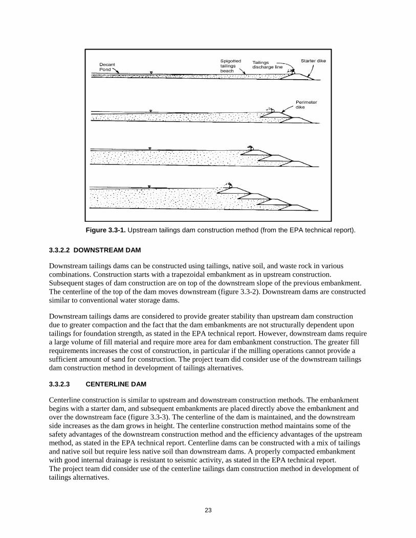
3.3.2.1 UPSTREAM DAM
Upstream tailings dams are typically constructed using tailings as the primary construction material, and the tailings needs to contain at least 40 to 60 percent sand. Trapezoidal embankments are constructed on top of each other at an offset toe to crest design, moving the crest and centerline of the dam farther upstream (figure 3.3-1). This creates a less sloped downstream side and an upstream side, which is supported underneath by tailings in the impoundment. Upstream tailings dams are the oldest and most economical to construct, compared with other tailings dam designs, as stated in the EPA technical report. This specific question was also addressed by the Independent Tailings Review Board instituted by Resolution Copper, with a recommendation that a centerline construction is the most desirable option of those considered as an alternative to the upstream dam.12 This method has high water saturation, which can result in liquefaction of the tailings embankment in the event of seismic activity; it therefore is not recommended in areas with a high potential for seismic activity, as noted in the EPA technical report.
The upstream tailings dam is the construction method proposed in the GPO, and its effects will be analyzed in the proposed action of the draft EIS. The advantages of upstream dam construction are that minimal borrow fill is required for construction, as the primary components of the dam are constructed with tailings material. The project team did not include use of the upstream dam construction technique in any of the proposed alternatives.
11 U.S. Environmental Protection Agency (EPA). 1994. Technical Report: Design and Evaluation of Tailings Dams. U.S. EPA Office of Solid Waste, EPA/530-R-94-038, NTIS/PB94-201845. August. 12 Resolution Copper. 2017. Independent Technical Review Board Report No. 1, Rev. 1. March 1. Project Record #0001301.
23
Figure 3.3-1. Upstream tailings dam construction method (from the EPA technical report).
3.3.2.2 DOWNSTREAM DAM
Downstream tailings dams can be constructed using tailings, native soil, and waste rock in various combinations. Construction starts with a trapezoidal embankment as in upstream construction. Subsequent stages of dam construction are on top of the downstream slope of the previous embankment. The centerline of the top of the dam moves downstream (figure 3.3-2). Downstream dams are constructed similar to conventional water storage dams.
Downstream tailings dams are considered to provide greater stability than upstream dam construction due to greater compaction and the fact that the dam embankments are not structurally dependent upon tailings for foundation strength, as stated in the EPA technical report. However, downstream dams require a large volume of fill material and require more area for dam embankment construction. The greater fill requirements increases the cost of construction, in particular if the milling operations cannot provide a sufficient amount of sand for construction. The project team did consider use of the downstream tailings dam construction method in development of tailings alternatives.
3.3.2.3 CENTERLINE DAM
Centerline construction is similar to upstream and downstream construction methods. The embankment begins with a starter dam, and subsequent embankments are placed directly above the embankment and over the downstream face (figure 3.3-3). The centerline of the dam is maintained, and the downstream side increases as the dam grows in height. The centerline construction method maintains some of the safety advantages of the downstream construction method and the efficiency advantages of the upstream method, as stated in the EPA technical report. Centerline dams can be constructed with a mix of tailings and native soil but require less native soil than downstream dams. A properly compacted embankment with good internal drainage is resistant to seismic activity, as stated in the EPA technical report. The project team did consider use of the centerline tailings dam construction method in development of tailings alternatives.

24
Figure 3.3-2. Downstream tailings dam construction method (from the EPA technical report).
Figure 3.3-3. Centerline tailings dam construction method (from the EPA technical report).

25
3.4 Brownfield Tailings Locations During scoping, the public comments requested that the Forest Service identify a “brownfield” location (a site that is largely disturbed by previous mining activity) to store the tailings waste generated in the mining process. The project team investigated potential brownfield sites through an iterative review and data collection process between January and October 2017. The brownfield sites investigated through this process and the associated details are listed in table 3.4-1 and illustrated in figure 3.4-1. This list was developed by reviewing possible mining brownfield sites in Arizona that could potentially hold all or a portion of the tailings anticipated to be produced through mining operations described in the GPO.
Review and discussion of the brownfields sites included two workshops attended by key members of the project team (April 2017 and July 2017), follow-up investigation and research, and input by Resolution Copper on select sites. Primary brownfield site review criteria used by the project team included the following questions:
1. Does the site have an active mining or potential for future mining operations? 13
2. Are there ongoing activities at the site that preclude use for tailings storage (e.g., superfund site)?
3. Does the site have the capacity for the total amount of tailings?
4. Does the site have the capacity for the PAG tailings?
5. Is the site within a reasonable distance for pumping slurry tailings?
6. Will use of the site solve anticipated resource issues?
A discussion of and results for the brownfield site review are presented below.
13 Documentation of the active or future active status of various mines, rendering them unavailable, is further described in “Mines in Arizona ‘Unavailable’ for Consideration as Viable for Tailings Disposal,” a process memorandum located in the project record (Project Record #002043).
Brownfield Tailings Locations – Process Documentation • Project Team Alternatives Evaluation
Workshops ◦ April 11 and 12, 2017 (Project Record
#0001359) ◦ July 5 and 6, 2017 (Project Record
#0001841)
• Technical Alternatives Discussion with Resolution Copper, July 12, 2017 (Project Record #0001693)
• Forest Service Brownfields Inquiry to Resolution Copper, Alternatives Data Request #3, July 19, 2017 (Project Record #0001849)
• Resolution Copper Response to Forest Service Alternatives Data Request #3, Information on Potential Tailings Alternatives (Items A–E, G), dated August 25, 2017 (Project Record #0001855, 0001857, 0002049, 0002050)
• SWCA: “Mines in Arizona Unavailable for Consideration as Viable for Tailings Disposal Process Memorandum” (Project Record #002043)
• SWCA: San Manuel Mine Tailings Disposal Issues Briefing Paper (Project Record #0002042)
• BGC Engineering Tailings Disposal Alternatives Technical Memorandum (appendix E; Project Record #0002040)
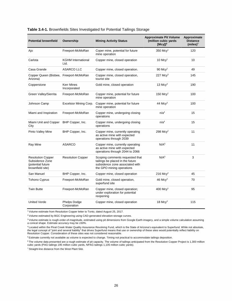
26
Table 3.4-1. Brownfields Sites Investigated for Potential Tailings Storage
Potential brownfield Ownership Mining Activity Status Approximate Pit Volume
(million cubic yards [Mcy])6
Approximate Distance (miles)7
Ajo Freeport-McMoRan Coper mine, potential for future mine operation
350 Mcy1 120
Carlota KGHM International Ltd.
Copper mine, closed operation 10 Mcy1 10
Casa Grande ASARCO LLC Copper mine, closed operation. 90 Mcy2 49
Copper Queen (Bisbee, Arizona)
Freeport-McMoRan Copper mine, closed operation, tourist site
227 Mcy3 145
Copperstone Kerr Mines Incorporated
Gold mine, closed operation 13 Mcy3 190
Green Valley/Sierrita Freeport-McMoRan Copper mine, potential for future mine operation
150 Mcy1 100
Johnson Camp Excelsior Mining Corp. Copper mine, potential for future mine operation
44 Mcy3 100
Miami and Inspiration Freeport-McMoRan Copper mine, undergoing closing operations
n/a4 15
Miami Unit and Copper City
BHP Copper, Inc. Copper mine, undergoing closing operations
n/a4 15
Pinto Valley Mine BHP Copper, Inc. Copper mine, currently operating as active mine with expected operations through 2039
298 Mcy2 11
Ray Mine ASARCO Copper mine, currently operating as active mine with expected operations through 2044 to 2066
N/A5 11
Resolution Copper Subsidence Zone (potential future brownfield site)
Resolution Copper Scoping comments requested that tailings be placed in the future subsidence zone associated with the GPO mining operations
N/A5 3
San Manuel BHP Copper, Inc. Copper mine, closed operation 216 Mcy2 45
Tohono Cyprus Freeport-McMoRan Gold mine, closed operation, superfund site
46 Mcy3 70
Twin Butte Freeport-McMoRan Copper mine, closed operation; under exploration for potential reopening
400 Mcy1 95
United Verde Phelps Dodge Corporation
Copper mine, closed operation 18 Mcy3 115
1 Volume estimate from Resolution Copper letter to Tonto, dated August 25, 2017. 2 Volume estimated by BGC Engineering using CAD-generated elevation-storage curves. 3 Volume estimate is rough-order-of-magnitude, estimated using pit dimensions from Google Earth imagery, and a simple volume calculation assuming a conical shape. Estimate accuracy may be ±50%. 4 Located within the Pinal Creek Water Quality Assurance Revolving Fund, which is the State of Arizona’s equivalent to Superfund. While not absolute, the legal concept of “joint and several liability” that drives Superfund means that use or ownership of these sites would potentially reflect liability on Resolution Copper. Consideration of these sites was not considered reasonable. 5 Estimate currently not available as volume is expected to change. Timing not practical to accommodate tailings deposition. 6 The volume data presented are a rough estimate of pit capacity. The volume of tailings anticipated from the Resolution Copper Project is 1,300 million cubic yards (PAG tailings 195 million cubic yards, NPAG tailings 1,105 million cubic yards). 7 Straight-line distance from the West Plant Site.

27
Figure 3.4-1. Brownfields sites investigated for potential tailings storage.

28
3.4.1 Brownfield Site Review
In reviewing the brownfields sites, the project team determined that use of a brownfield site for tailings has the potential to address most, if not all, issues identified during scoping (see appendix A). One of the primary benefits of disposing of tailings in a brownfield site is the potential to significantly reduce impacts to water resources.
It became clear during even the initial brownfield evaluation that almost none of the sites were sufficient in volume to accommodate all of the tailings material. Forest Service guidance cautioned the project team to “ensure that the range of alternatives does not prematurely foreclose options that might protect, restore, and enhance the environment” (FSH 1909.15). In order to not prematurely foreclose brownfield options, further review was conducted with the thought that even if the full tailings amount could not be disposed of in one location, it was still possible to resolve resource issues (particularly water quality) by disposing of cleaner or pyrite tailings in a brownfields location.
3.4.1.1 AJO
The expected pumping distance to the Ajo pit is estimated to be more than 120 miles and would cross numerous public and private jurisdictions. The costs associated with long-distance transport would be substantial. Further, this location offers only a partial disposal option and does not prevent the placement of a large tailings facility on Federal land. For these reasons, use of the Ajo pit was considered to be unreasonable and was dismissed from further consideration.
3.4.1.2 CARLOTA
The Carlota site is over an existing heap leach pad and has minimal to no pit capacity for containing all of the PAG material; tailings storage would require an embankment and expansion of the heap leach pad area. The site is located on a complex geological area that results in high geological and hydrogeological constraints. Tailings located here have the potential to impair water quality in Pinto Creek and would require creek diversions. Location of the tailings storage facility in this location would not address the water quality issues, and it was therefore dismissed from further consideration.
3.4.1.3 CASA GRANDE
An initial estimate by the project team showed that the Casa Grande pit potentially had the capacity to hold the PAG tailings material. Upon further investigation, it was determined that it does not have the capacity to store the PAG tailings material. It is therefore not an available option for future tailings storage. This and other pits were also considered further as possible components of an alternative disposing of all tailings in multiple brownfield locations, but there was insufficient capacity to store all tailings, even with multiple locations.
3.4.1.4 COPPER QUEEN (BISBEE, ARIZONA)
Copper Queen Mine is a popular tourist attraction in Bisbee, Arizona. The mine hosts tours, includes a museum, and is visited by many tourists every year. For this reason, it was removed from further consideration for tailings storage.
3.4.1.5 COPPERSTONE
The Copperstone site does not have the capacity to store all or the PAG portion of the tailings. It was thus removed from consideration for tailings storage.

29
3.4.1.6 GREEN VALLEY / SIERRITA
The Green Valley / Sierrita Mine has an ongoing mining operation and for that reason was dismissed from further investigation.
3.4.1.7 JOHNSON CAMP
The Johnson Camp mine has the potential for future mining operations and does not have the capacity to store all or the PAG portion of the tailings. For these reasons, the site was removed from further consideration for tailings storage.
3.4.1.8 MIAMI AND INSPIRATION / MIAMI UNIT AND COPPER CITY
The Miami and Inspiration / Miami Unit and Copper City mines are located within the Pinal Creek Water Quality Assurance Revolving Fund (WQARF), which is the State of Arizona’s equivalent to Superfund. While not absolute, the legal concept of “joint and several liability” that drives Superfund means that use or ownership of these sites would potentially reflect liability on Resolution Copper. Consideration of these sites was not considered reasonable; therefore, they were dismissed.
3.4.1.9 PINTO VALLEY MINE
The project team reviewed the anticipated Pinto Valley Mine operation and the planned closure timing. The team determined that the mine could still be operational at the time when tailings storage is required for the Resolution Copper Project. Because current mine life is projected through 2039, the project team dismissed this location from further investigation.
3.4.1.10 RAY MINE
The Ray Mine has an expected reserve life of between 2044 (ASARCO statement) and 2066 (estimate by the U.S. Army Corps of Engineers [USACE]) and is in the process of further expansion of a new tailings facility at Ripsey Wash as well as a land exchange with the U.S. Bureau of Land Management (BLM). The project team dismissed the Ray Mine from further consideration because it is in operation and not available for tailings storage in the necessary project time frame.
3.4.1.11 RESOLUTION COPPER EAST PLANT SITE SUBSIDENCE CRATER (POTENTIAL FUTURE BROWNFIELD SITE)
In addition to reviewing existing brownfields, scoping commenters recommended that the tailings be stored in the proposed Resolution Copper Project East Plant Site subsidence crater area. The project team reviewed the feasibility of placement of tailings in the subsidence area, either as slurry or dry stack tailings, at the April 2017 meeting. In this scenario, the tailings would be placed initially on undisturbed land above the mining panels, in the area that would gradually become a subsidence pit. The subsidence pit would then be filled with tailings as it expands over time. This option was dismissed for safety concerns, both aboveground and belowground. In use of panel caving, it is paramount to control the rate of panel caving and prevent air gaps from developing above the caved zone, which can lead to potentially catastrophic air blasts. Loading of tailings above the panel cave operation could change the rock dynamics in unexpected and unknown ways. If slurry tailings were placed in the subsidence crater, the added aspect of tailings drainage into the mine from above further complicates mining operations. Safety hazards exist for personnel placing tailings aboveground as well, given the active subsidence and earth movement. Overall, the project team determined that this option represented unreasonable safety hazards and did not conform to industry norms.

30
3.4.1.12 SAN MANUEL
The expected pumping distance to the San Manuel pit is estimated to be approximately 50 miles (straight-line distance). A review of the site’s geology shows a high-angle fault in the area; hydrogeological conditions are unknown at this time but could present a high constraint. San Manuel was originally considered by the project team to represent a reasonable option; however, concerns were raised by Resolution Copper about the ability to control water quality after placement of pyrite tailings in the existing pit, given the proximity to the San Pedro River. These concerns were further investigated by the project team, including review of Arizona Department of Environmental Quality documents related to the closure of San Manuel.14 The best available information at this time suggests that use of the San Manuel pit would not successfully address the single driving issue of water quality. Specifically, the disposal methodology would not prevent oxidation of PAG material and would deliver acid drainage directly to the aquifer. Further, movement of seepage into groundwater and movement of groundwater away from the pit would not be controlled, as the current hydraulic sink would be expected to disappear without a pit lake present. The groundwater gradient would potentially deliver poor quality groundwater directly to the San Pedro River. For these reasons, the San Manuel pit was eliminated from detailed analysis in the draft EIS.
3.4.1.13 TOHONO CYPRUS
The Tohono Cyprus site does not have the capacity to store all or the PAG portion of the tailings. It was therefore eliminated from further consideration.
3.4.1.14 TWIN BUTTE
Twin Butte has either ongoing operations or future operations plans that make it infeasible for future tailings storage.15
3.4.1.15 UNITED VERDE
The United Verde site does not have the capacity to store all or the PAG portion of the tailings.
3.4.2 Technical Input by Resolution Copper
At the July meeting, the project team determined that it would be beneficial for Resolution Copper to provide input on the potential, feasibility, and reasonability for use of brownfields sites for tailings storage alternatives. The Forest Service met with Resolution Copper on July 12, 2017, and sent a letter requesting that Resolution Copper review and provide technical and logistical information on brownfields tailings storage options. The request asked Resolution Copper to provide input on the following items:
1. Input about the use of the following brownfields sites (or others) to store the PAG tailings material:
o San Manuel
o Casa Grande
o Green Valley / Sierrita
o Twin Butte
14 “San Manuel Mine Tailings Disposal Issues Briefing Paper” (Project Record #0002042). 15 “Mines in Arizona ‘Unavailable’ for Consideration as Viable for Tailings Disposal Process Memorandum” (Project Record #002043).

31
2. Input about the use of the following brownfields sites (or others) to store the entire volume of proposed tailings:
o Carlota
o Ajo mine pit
The response (Resolution Copper, August 25, 2017, Project Record #0001855) regarding the brownfields locations is presented in table 3.4-2. Resolution Copper also assessed two brownfield sites in the Miami / Globe district.
Table 3.4-2. Summary of the Resolution Copper Response to Forest Service Brownfield Inquiry (Resolution Copper, August 25, 2017)
Brownfield Location Resolution Copper Response
San Manuel Resolution Copper does not own this property; therefore, it is not available. Even if the location were to become available, due to topography, the pipeline corridor would be approximately 100 miles, which is not practicable for a number of reasons, including the ownership of the likely route (which would cross Federal, military, State, and private lands). In addition, the existing pit would not contain the volume of total tailings, and although it could likely contain the volume of pyrite tailings, it is unlikely that placement of these tailings in the pit could be done while meeting water quality requirements due to the potential for acid rock drainage and resulting groundwater seepage.
Twin Butte The owner (which is not Resolution Copper) has a multitude of future development plans; the property is therefore not available. Even if the property were to become available, the pipeline corridor would be approximately 170 miles through Federal, military, Native American, State, and private land ownership, making it infeasible and impracticable.
Casa Grande Resolution Copper does not own this property, and it is not available. Even if the property were to become available, the pipeline corridor would be approximately 60 miles through Federal, Native American, State, and private land ownership, making it infeasible and impracticable. In addition, the pit would not contain the volume of total tailings or the pyrite tailings (only about one-fifth to one-third of the total pyrite volume), making this location impracticable.
Green Valley / Sierrita
The site has substantially proven and probable reserves of copper and a stated mine life through 2085. Also, Resolution Copper does not own this property, so it is not available. Even if the property were to become available, the pipeline corridor would be approximately 170 miles through Federal, military, Native American, State, and private land ownership, making it infeasible and impracticable.
Carlota Resolution Copper does not own this property. Even if the property were to become available, the existing pit and the entirety of the mine site would not contain the volume of total tailings. The pit would not contain the volume of pyrite tailings (only about 8% of the total pyrite volume), making it impracticable and infeasible. Moreover, the placement of tailings would require substantial diversion of upstream catchments comprising 9,000 to 11,000 acres on NFS lands that feed Pinto Creek, as well as diversion of Pinto Creek.
Ajo Resolution Copper does not own this property. The owner has publicly stated future foreseeable site development plans for this pit; thus, it is not available. Even if the property were to become available, the pipeline corridor would be approximately 150 to 170 miles through Federal, military, Native American, State, and private land ownership, making it impracticable and infeasible.
Miami and Inspiration
Freeport-McMoRan (FMI) acquired the Miami and Inspiration mining operations through a series of ownership changes and consolidation of mining assets. The Miami and Inspiration open pits would not be able to contain all of the Resolution Copper tailings. Tailings would need to spread out beyond the open pits and over the top of the historic and current leaching operations (stockpiles). It is possible that the open pits could contain all or a portion of the pyrite tailings. In addition, the entire mine sites comprising the Miami Mine and Inspiration Mine are within the boundary of the Pinal Creek WQARF site (http://legacy.azdeq.gov/environ/waste/sps/download/state/pinalcreek_map.pdf). According to the Arizona Department of Environmental Quality’s website (http://legacy.azdeq.gov/environ/waste/sps/Pinal_Creek.html), source control actions began in 1986 under order from the EPA for violations of the Clean Water Act, and between 1986 and 1990, remedial investigations and remedial actions began. Extensive remedial investigations and remedial actions, including private well testing and replacement, continues to this day. Were these properties to become available and used for Resolution Copper’s tailings impoundment, it would be not be possible to differentiate, separate, and capture seepage/runoff from all or a portion of Resolution Copper’s tailings from existing facilities, likely resulting in Resolution Copper’s being made a potentially responsible party subject to the WQARF. Asking Resolution Copper to assume liability for historic mining activity unrelated to Resolution Copper’s activities is unreasonable and impracticable. For these reasons, the Miami and Inspiration sites are infeasible and impracticable.

32
Table 3.4-2. Summary of the Resolution Copper Response to Forest Service Brownfield Inquiry (Resolution Copper, August 25, 2017) (Continued)
Brownfield Location Resolution Copper Response
Miami Unit and Copper City
BHP Copper, Inc., is a Delaware corporation based in Arizona that is controlled by BHP Billiton. BHP Copper acquired the Miami and Copper Cities mining operations through a series of acquisitions and consolidation of mining assets (https://www.fs.usda.gov/Internet/FSE_DOCUMENTS/stelprdb5293361.pdf). The Pinal Creek WQARF described above also includes the Miami Unit and Copper Cities pits and related Properties, including tailings (http://legacy.azdeq.gov/environ/waste/sps/download/state/pinalcreek_map.pdf). Even if the Miami Unit and Copper Cities were to become available, the Miami Unit open pit would not be able o store all of the Resolution Copper tailings, nor would it be able to store all of the pyrite tailings, making it infeasible. Nor is there space in the Copper Cities existing pits, which have already been used to store tailings as well as support Pinal Creek WQARF remediation efforts. And as described above, asking Resolution Copper to assume liability for historic mining activity unrelated to Resolution Copper’s activities is unreasonable and impracticable. For these reasons, the Miami Unit and Copper Cities pits are infeasible and impracticable.
3.4.3 Brownfield Site Dismissal
Based upon the project team investigation results presented above, the resulting decision is that there are no brownfield areas in the region that are feasible or reasonable for storing tailings associated with the proposed Resolution Copper Project.
3.5 Initial Tailings Facility Alternative Locations The project team identified a set of “initial” alternative tailings locations and evaluated these locations to determine which locations should be dismissed and which locations should be further evaluated for inclusion in the draft EIS.
As noted, the overall alternatives process was iterative and not perfectly linear. However, in general, the process involved identification of “initial” alternative tailings locations (section 3.5), which were screened to “preliminary” alternative tailings locations for further detailed review (section 3.6). These were then further screened to “final” alternative tailings locations (section 3.7).
3.5.1 Identify Initial Tailings Facility Alternative Locations
The project team evaluated the regional landscape surrounding the proposed Resolution Copper Project to identify initial tailings facility alternative locations. The site selection criteria and alternative locations are presented below.
3.5.1.1 GPO ALTERNATIVE LOCATIONS
Resolution Copper conducted an alternative tailings facility location process as presented in the GPO (section 3.3.10.1). Resolution Copper identified locations within an approximately 20-mile radius of the proposed mine site with favorable topography and sufficient storage capacity. The company formed a Community Working Group consisting of local community and interest group representatives to review and evaluate the alternative sites. The evaluation also included Lower West, the tailings site proposed in
Initial Tailings Facility Alternative Locations – Process Documentation • Review of Community Working Group
process (Project Record #0001483)
• Project Team Alternatives Evaluation Workshop ◦ April 11 and 12, 2017 (Project
Record #0001359)
• BGC Engineering Tailings Disposal Alternatives Technical Memorandum (appendix E; Project Record #0002040)

33
the GPO. The group’s top choice was Far West, located primarily on Arizona State Land Department (ASLD) lands. The second choice was Lower West, the tailings site proposed in the GPO.
The project team determined that it would be useful to reevaluate the alternative sites presented in the GPO in the team’s alternative analysis process. The GPO alternative locations include the following (figure 3.5-1):
• Whitford
• Hewitt
• Silver King
• Telegraph
• Lower East
• Far West
3.5.1.2 OTHER ALTERNATIVE LOCATIONS
The project team reviewed the regional landscape to identify other initial tailings storage facility locations that could solve issues. The team generally used the following criteria below to identify other alternative locations; the criteria were not applied to every location:
1. Sites within approximately 20 miles of West Plant Site.
2. Sites avoiding natural landscape barriers (mountains, rivers).
3. Sites near existing or historic mine operations to consolidate mining impacts in the landscape.
4. Sites in flatter alluvial landscapes outside rough and rugged terrain.
5. Sites potentially hidden from views and generally far from people.
The processes described above resulted in identification of 15 initial tailings facility alternative locations (see figure 3.5-1). Other locations identified by the project team include the following:16
• BGC A
• BGC B
• BGC C (Peg Leg)17
• BGC D
• SWCA 1
• SWCA 2
• SWCA 3
• SWCA 4
• Upper Arnett
16 In some cases, the initial alternative location names include the team members or organizations that put forth the location. 17 The initial location name of BGC C was changed to Peg Leg later in the alternatives development process.
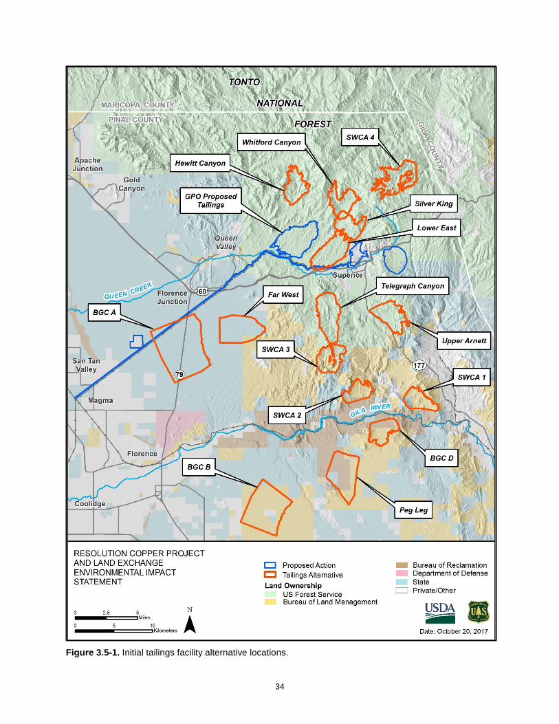
34
Figure 3.5-1. Initial tailings facility alternative locations.

35
3.5.2 Evaluate Initial Tailings Alternative Locations
After identification of the 15 initial tailings alternative locations, members of the project team participated in a review process to evaluate the locations to determine either dismissal or moving forward for further review. Key members of the project team, representing a range of technical expertise, held a 2-day workshop in April 2017 to begin evaluation of the alternative locations. The general results of that workshop are presented below.
A qualitative discussion and review was conducted to evaluate the initial tailings alternative locations using criteria developed through information in the scoping comments, issues report, and alternative tailings facility public workshop. Using these key issues, the project team developed a geographic information system (GIS) data set that displayed the various evaluation criteria presented in table 3.5-1. The team conducted a qualitative evaluation for the different locations using the GIS displayed on maps and made relative comparisons for the alternative locations and the proposed GPO tailings location.
Table 3.5-1. Initial Tailings Alternative Locations Evaluation Criteria
Key Issue Evaluation Criteria – GIS Mapping Data
Water Resources Potential receptors (nearby or downstream residential) Groundwater Surface Water – National Hydrography Dataset (NHD) Comprehensive Springs Inventory Floodplains
perennial streams, ephemeral waters
Biological Resources Arizona Game and Fish Department (AGFD) – unfragmented areas Normalized Difference Vegetation Index (NDVI) – measures and illustrates "greenness" and healthy vegetation Surface Water – perennial streams, ephemeral waters Comprehensive Springs Inventory AGFD Wildlife Movement Area – riparian / wash Important Bird Areas (IBAs) Southwest Regional Gap Analysis Project (SWReGAP) – riparian vegetation
Recreation Resources
Trails – Arizona Trail, LOST Trail, NFS Roads – off-highway-vehicle Designated recreation sites
other trails (OHV) use areas
Public Health and Safety
Proximity to people/communities – 1-, 2-, and 3-mile buffer of existing residences, inholdings Communities/developed areas downstream of facility
communities, and
There are other important key issues that were not used as evaluation criteria because of a lack of data with which to make relative comparisons between the GPO tailings location and alternative locations. For example, impact to cultural resources is a key issue that was brought forward by the public during scoping. The majority of the alternative locations do not have cultural resource inventories or surveys available; therefore, the project team was unable to make relative comparisons and evaluate differences between alternative locations. Similarly, tribal concerns over traditional cultural properties and sacred sites were unable to be quantified or incorporated at this stage in the alternatives development process. Potential impacts to scenery were considered, but generally insufficient data made relative comparisons between alternative locations inconsistent and therefore not useful as an overall screening criteria.
The project team evaluated each alternative location by reviewing the GIS data and using other information, including professional knowledge, and answering the questions below. For relative comparison, the screening evaluation was based on the assumption that the alternative tailings facility would be constructed in the same way as the GPO location (slurry tailings, upstream dam construction). Evaluation criteria included the following:
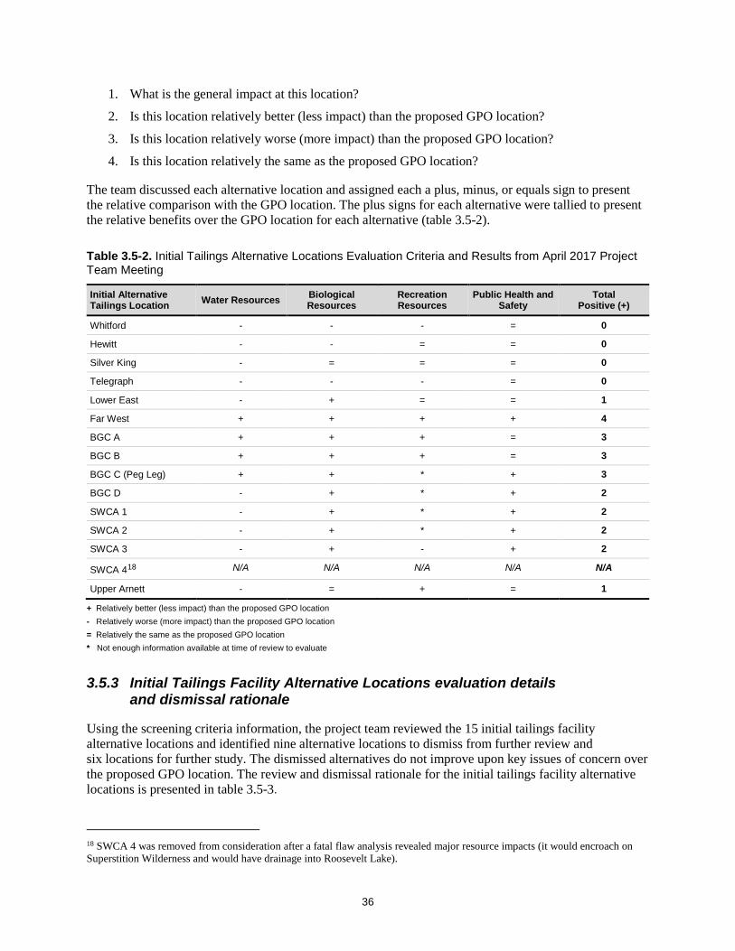
36
1. What is the general impact at this location?
2. Is this location relatively better (less impact) than the proposed GPO location?
3. Is this location relatively worse (more impact) than the proposed GPO location?
4. Is this location relatively the same as the proposed GPO location?
The team discussed each alternative location and assigned each a plus, minus, or equals sign to present the relative comparison with the GPO location. The plus signs for each alternative were tallied to present the relative benefits over the GPO location for each alternative (table 3.5-2).
Table 3.5-2. Initial Tailings Alternative Locations Evaluation Criteria and Results from April 2017 Project Team Meeting
Initial Alternative Tailings Location Water Resources Biological
Resources Recreation Resources
Public Health and Safety
Total Positive (+)
Whitford - - - = 0
Hewitt - - = = 0
Silver King - = = = 0
Telegraph - - - = 0
Lower East - + = = 1
Far West + + + + 4
BGC A + + + = 3
BGC B + + + = 3
BGC C (Peg Leg) + + * + 3
BGC D - + * + 2
SWCA 1 - + * + 2
SWCA 2 - + * + 2
SWCA 3 - + - + 2
SWCA 418 N/A N/A N/A N/A N/A
Upper Arnett - = + = 1
+ Relatively better (less impact) than the proposed GPO location - Relatively worse (more impact) than the proposed GPO location = Relatively the same as the proposed GPO location * Not enough information available at time of review to evaluate
3.5.3 Initial Tailings Facility Alternative Locations evaluation details and dismissal rationale
Using the screening criteria information, the project team reviewed the 15 initial tailings facility alternative locations and identified nine alternative locations to dismiss from further review and six locations for further study. The dismissed alternatives do not improve upon key issues of concern over the proposed GPO location. The review and dismissal rationale for the initial tailings facility alternative locations is presented in table 3.5-3.
18 SWCA 4 was removed from consideration after a fatal flaw analysis revealed major resource impacts (it would encroach on Superstition Wilderness and would have drainage into Roosevelt Lake).

37
Table 3.5-3. Initial Tailings Facility Alternative Locations Review and Dismissed Information
Alternative Location
Factors that Are Worse than the GPO
Factors that Improve upon GPO Dismissed Rationale
Whitford High energy demands for controlling stormwater; appears equal to GPO for springs/receptors/streams.
Farther from residential areas. No The project team determined that further investigation of the site for locating tailings processed as dry stack could result in an improvement over the GPO location. In general, dry stack could have a smaller footprint and reduced water resource and public safety issues.
Hewitt Closer to wilderness area. High energy demands for controlling stormwater; contains more unfragmented wildlife habitat and riparian areas.
Farther from residential areas. No The project team determined that further investigation of the site for locating tailings processed as dry stack could result in an improvement over the GPO location. In general, dry stack could have a smaller footprint and reduced water resource and public safety issues.
Silver King High energy demands for controlling stormwater. Contains more unfragmented wildlife habitat and streams. Has recreation impacts to Silver King Road and the Arizona Trail. Contains underground mine workings.
Smaller area benefits seepage control for recovery of water; good topography for water recovery.
No The project team determined that further investigation of the site for locating tailings processed as dry stack could result in an improvement over the GPO location. In general, dry stack could have a smaller footprint and reduced water resource and public safety issues.
Telegraph Biological impacts to Important Bird Areas and riparian areas. Hydrology drainage impacts. Recreation impacts; roads and trails, covers the Arizona Trail.
Contains more fragmented wildlife habitat.
Yes The location does not provide an overall improvement over the GPO location for key resource issues (water resources, biological resources, recreation resources).
Lower East Has water resource impacts. Closer to the receptor Boyce Thompson Arboretum. Closer to U.S. 60 and Superior.
Fewer riparian areas and biological impacts.
Yes The location does not provide an overall improvement over the GPO location for key resource issues (water resources).
Far West None. The Far West location improved on several factors, compared with the GPO, including water resources (fewer springs, farther from major drainages, farther from receptors), biology, recreation, and public health and safety.
Yes The Forest Service sent an inquiry to the ASLD, the landowner, regarding the potential availability for a tailings facility. ASLD responded that the agency has plans for future residential development for the area; therefore, it is not at this time, or in the future, available for locating a tailings facility. For this reason, the location is dismissed from further investigation.
BGC A Higher number of wells nearby, closer to receptors (residential areas), and potentially encroaches on area infrastructure (roads).
Stormwater management benefits (easier to control), wildlife habitat is more fragmented, and less riparian and NDVI healthy vegetation.
Yes The location provides a similar overall improvement over the GPO location as BGC B and C, but retains factors that make it less desirable than these locations. For these reasons, the location was dismissed.

38
Table 3.5-3. Initial Tailings Facility Alternative Locations Review and Dismissed Information (Continued)
Alternative Location
Factors that Are Worse than the GPO
Factors that Improve upon GPO Dismissed Rationale
BGC B Proximity to Gila River (potentially already degraded water quality). Proximity to Florence and nearby residences.
Stormwater management benefits, located in more fragmented wildlife habitat, less riparian and NDVI healthy vegetation, closer to mining district, flatter alluvial landscape, and increased public safety.
No This location shows a potential improvement over the GPO location and responds to multiple key issues, including water, biological, and recreation resources.
BGC C (Peg Leg) None identified (near Gila River, but potentially already degraded water quality).
No springs in footprint, located in more fragmented wildlife habitat, less riparian and NDVI healthy vegetation, closer to mining district, flatter alluvial landscape, and increased public safety (proximity to residences and downstream impacts).
No This location shows a potential improvement over the GPO location and responds to multiple key issues, including water, biological, and recreation resources.
BGC D Stormwater management more difficult based on terrain and proximity to the Gila River and Arizona Trail.
No springs in footprint, wildlife habitat more fragmented, less riparian and NDVI healthy vegetation, and distance from residences.
Yes The location does not provide an overall improvement upon the GPO location for key resource issues (water resources).
SWCA 1 Stormwater management more difficult based upon terrain, proximity to the Gila River and Arizona Trail.
No springs in footprint, limited wildlife habitat and sensitive vegetation, and distance from residences.
Yes The location does not provide an overall improvement over the GPO location for key resource issues (water resources).
SWCA 2 Stormwater management more difficult based on terrain and proximity to the Gila River.
No springs in footprint, limited wildlife habitat and sensitive vegetation, and distance from residences.
Yes The location does not provide an overall improvement over the GPO location for key resource issues (water resources).
SWCA 3 Landscape constraints (very steep terrain, occupy two watersheds, high probability of faults for landslides). Proximity to Arizona Trail.
Would be easier to contain stormwater at top of headwaters; distance from residences.
Yes The location does not provide an overall improvement over the GPO location for key resource issues (water resources, recreation resources).
SWCA 4 Proximity to Endangered Species habitat (yellow-billed cuckoo), encroachment upon Superstition Wilderness (Class II airshed), wilderness access, drainage to Pinto Creek and Roosevelt Lake, impact to intermittent and ephemeral waters, Haunted Canyon, recreation and trails, wildlife habitat. Potentially visible from U.S. 60.
Water recharge water in basin (but with potentially high sulfate levels), dam failure impacts water supply (not residences). Farther from roads and trails.
Yes This location was removed from consideration for major resource impacts (encroaches on Superstition Wilderness, Class II airshed, drainage into Roosevelt Lake).
Upper Arnett Impacts Arnett Creek, higher upstream in the watershed, contains more unfragmented wildlife habitat.
Less riparian and NDVI healthy vegetation, no important bird areas, and limited OHV use.
No The project team determined that further investigation of the site for locating tailings processed as dry stack could result in an improvement over the GPO location. In general, dry stack could have a smaller footprint and reduced water resource and public safety issues.

39
3.6 Preliminary Tailings Facility Alternative Locations After screening and evaluating the initial tailings facility alternative locations (see section 3.5), the project team identified six preliminary tailings facility alternative locations for further investigation (Figure 3.6-1). At this point in the process, the project team combined tailings locations with other aspects of tailings design (dam types, thickening/filtering), and conceptual engineering designs were prepared to create a more complete picture of each option. These preliminary alternative locations investigated included a mix of thickened slurry and filtered (dry stack) tailings processing types, along with different dam types and lining options (as discussed in section 3.3). The project team also identified alternatives that included different processing, tailings dam type, and lining options at the GPO location. This resulted in seven preliminary tailings facility alterative locations (including the GPO proposed action location) and multiple processing and dam options for some locations. The project team developed 19 conceptual tailings facility designs scenarios for the seven locations (table 3.6-1) (see appendix E, Tailings Disposal Alternatives Technical Memorandum – Section 2.0, for complete scenario description and design information).
These scenarios were evaluated to determine the feasibility and reasonableness of these locations in order to determine whether they merit a full environmental analysis in the draft EIS.
Preliminary Tailings Facility Alternative Locations – Process Documentation • Project Team Alternatives Evaluation
Workshop ◦ July 5 and 6, 2017 (Project Record
#0001841)
• Tailings Disposal Alternatives Technical Memorandum (appendix E; Project Record #0002040)
• Resolution Copper, Mine Plan of Operations and Land Exchange, Forest Service Alternatives Data Request #3, Information on Potential Tailings Alternatives (Items A–E, G), August 25–26, 2017 (Project Record #0001855, 0001857, 0002049, 0002050)
• Resolution Copper, Mine Plan of Operations and Land Exchange, Forest Service Alternatives Data Request #3-F, Information on Potential Tailings Alternatives, dated August 30, 2017 (Project Record #0001879)
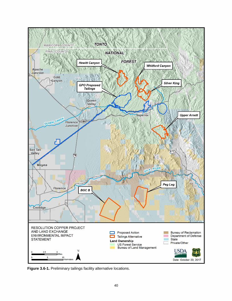
40
Figure 3.6-1. Preliminary tailings facility alternative locations.

41
Table 3.6-1. Preliminary Tailings Facility Alternative Locations, Processing, Methods Identified for Further Study
Preliminary Location Tailings Process Type Tailings Dam Type Lining Pyrite Tailings Disposal
GPO (Proposed Action)* Thickened slurry Tailings upstream No liner Wet split 85% NPAG 15% PAG
GPO Modified (5 scenarios)
Thickened slurry Filtered (dry stack)
Earthfill downstream Tailings downstream Tailings centerline No dam (dry stack)
Partial liner (under PAG only) Full liner No liner (dry stack)
Wet split 85% NPAG 15% PAG Filtered whole (dry stack)
BGC B (5 scenarios)
Thickened slurry Earthfill downstream Tailings downstream Tailings upstream
No liner Partial liner (under PAG only) Full liner
Wet whole (NPAG PAG mixed) Wet split 85% NPAG 15% PAG
BGC C (Peg Leg) (5 scenarios)
Thickened slurry Earthfill downstream Tailings downstream Tailings upstream
No liner Partial liner (under PAG only) Full liner
Wet whole (NPAG PAG mixed) Wet split 85% NPAG 15% PAG
Whitford (1 scenario)
Filtered (dry stack) No dam (dry stack) No liner (dry stack) Filtered whole
Hewitt (1 scenario)
Filtered (dry stack) No dam (dry stack) No liner (dry stack) Filtered whole
Silver King (1 scenario)
Filtered (dry stack) No dam (dry stack) No liner (dry stack) Filtered whole
Upper Arnett (1 scenario)
Filtered (dry stack) No dam (dry stack) No liner (dry stack) Filtered whole
* GPO design presented for relative comparison between proposed action and preliminary alternatives.
3.6.1 Screen Preliminary Tailings Facility Alternative Locations
The project team screened the preliminary tailings facility alternative locations using a variety of technical and environmental criteria that represent key issues developed during scoping. Key members of the project team, representing a range of technical expertise, held a 2-day workshop in July 2017 to further evaluate alternative tailings facility locations. At that meeting the alternative locations and alternative design components (scenarios), listed in table 3.6-1, were discussed and reviewed for their potential to provide reasonable and feasible alternative tailings storage that are beneficial when compared to the GPO proposed action. Unlike the April 2017 meeting, rather than relative ranking against the GPO, the focus in July was on quantification of potential resource impacts to focus on and identify the most desirable scenarios and locations.
The technical screening criteria are described in table 3.6-2. Quantities were produced for each of the technical screening criteria. Most of the criteria were quantified with a relative precision, such as tailings corridor length, elevation gain and loss, tributary area, embankment volumes, tailings storage facility footprint areas, and lined areas. Some criteria were impractical to directly quantify at this level of design (cost, dam breach, embankment stability and reclamation), and were assigned a relative value, on a scale of 0 to 10. Each of the quantities were then compared with the other scenarios. The results of the technical screening criteria for the design scenarios are provided in appendix E (see appendix E, table 2-3).

42
Table 3.6-2. Preliminary Tailings Facility Alternative Locations Technical Screening Criteria Description
Screening Criteria Description
Tailings Corridors Potential pathway for tailings delivery systems such as pipelines for thickened tailings and access roads for filtered tailings, from the West Plant Site to tailings storage facility (overall length, elevation gain, elevation loss).
Stormwater Management Considers approximate tributary watershed area impacted as criterion for stormwater management.
Cost Costs for starting a tailings storage facility, operation (capital), operating the tailings storage facility during tailings production (operating), and closing of the facility once the tailings storage facility is no longer being used by the mine (closure). (Relative comparison scale of 1–10).
Dam Breach Analysis Considers the possible runout area and a rough order magnitude estimate of the potential number of people and structures potentially affected by a dam breach event. These estimates are very preliminary and not based on an actual dam breach analysis. (Relative comparison scale of 1–10).
Geotechnical Stability Considers historic performance of similar dam designs construction methods (downstream, centerline, upstream methods) and estimates the maximum height of embankment.
Dam Fill Volumes Estimation of the starter embankment and dam construction (raises) volumes, footprint areas, and lined areas that would be required for each alternative.
Reclamation Volumes Estimation of the area footprint requiring recontouring and time required for reclamation to take place.
The project team also evaluated the preliminary tailings facility alternative locations at the July 2017 workshop using the environmental screening criteria described in table 3.6-3. These criteria represent how the different locations and design processes perform relative to key scoping issues and compare with the GPO proposed action. Table 3.6-4 presents the general information discussed at the workshop and the evaluation results. Some factors are easily measured using specific indicators; others are described and measured in a qualitative manner.
Table 3.6-3. Preliminary Tailings Facility Alternative Locations Environmental Screening Criteria Description
Screening Criteria Description
Land Ownership (acres) Land ownership within the alternative tailings footprint.
Distance to Special Designations Air quality – 2015 ozone non-attainment area. Designated Wilderness (Class II airshed). The San Carlos Apache Indian Reservation (San Carlos Reservation).
Springs Named and unnamed springs within the alternative tailings footprint.
Washes / Waterways Waterways (ephemeral and intermittent) based on U.S. Geological Survey National Hydrology Dataset flowlines.
Registered Wells Registered water wells within the alternative tailings footprint.
Viewshed / Visuals General visibility description of the alternatives tailings facility from area viewpoints.
Recreation General impacts to recreation resources, including trails, forest roads, and other roads.
Vegetation Vegetation community type impacted (based upon Southwest Regional Gap Analysis Program) within the alternative tailings footprint.
NDVI Normalized Difference Vegetation Index (NDVI), measures and illustrates "greenness" and healthy vegetation.
Stock Tanks, Wells, Mines Named water, tank, or mine development, historic or current, within the alternative tailings footprint.

43
Table 3.6-4. Preliminary Tailings Facility Alternative Locations Environmental Screening Results
Screening Criteria GPO Proposed GPO Thickened Slurry with Liner Different Dam Type
GPO (filtered dry stack)
Hewitt Canyon (filtered dry stack)
Whitford Canyon (filtered dry stack)
Silver King (filtered dry stack)
Upper Arnett (filtered dry stack) BGC B BGC C (Peg Leg)
Land Ownership (acres) 4043 - National Forest Similar to GPO proposed.
3127 - National Forest 2508 - National Forest 2578 - National Forest 2095 - National Forest 94- Private
2215 - National Forest 5649 - BLM 292 - State Trust 327 - Private
1459 – BLM 2482 – U.S. Bureau of Reclamation 593 - State Trust
Distance to Class I and II Special Areas (AQ, wilderness, reservation, etc.) (miles)
2.3 - 2015 Ozone non-attainment area (NAA) 3.9 - Superstition Wild 8.2 - White Canyon Wild 25.3 - San Carlos Reservation
Similar to GPO proposed.
2.8 - 2015 Ozone NAA 4.0 - Superstition Wild 8.4 - White Canyon Wild 25.4 - San Carlos Reservation
3.4 - 2015 Ozone NAA 0.1 - Superstition Wild 12.6 - White Canyon Wild 26.3 - San Carlos Reservation
5.1 - 2015 Ozone NAA 0.0 - Superstition Wild 10.4 - White Canyon Wild 22.2 - San Carlos Reservation
8.2 - 2015 Ozone NAA 1.8 - Superstition Wild 8.3 - White Canyon Wild 20.5 - San Carlos Reservation
11.2 - 2015 Ozone NAA 9.0 - Superstition Wild 1.4 - White Canyon Wild 17.1 - San Carlos Reservation
16.7 - 2015 Ozone NAA 23.4 - Superstition Wild 9.7 - White Canyon Wild 28.4 - San Carlos Reservation
16.2 - 2015 Ozone NAA 20.9 - Superstition Wild 5.3 - White Canyon Wild 22.1 - San Carlos Reservation
Springs impacted (number/name)
4 Bear Tank Canyon Spring Benson Spring Perlite Spring (2)
Similar to GPO proposed.
1 Bear Tank Canyon Spring
3 Canyon Spring-2 Hackberry Spring-1 Mesquite Spring
3 Mud Spring-2 Reeves Trail Spring Rock Horz Spring
4 Bitter Spring Fig Spring I Berry Spring Silver King Shaft
1 Unnamed Spring-5
Ephemeral and intermittent washes (based on U.S. Geological Survey NHD flowlines) (miles)
19.3 – ephemeral Similar to GPO proposed.
15.2 - ephemeral 8.1 - ephemeral 11.5 - ephemeral 1.3 – ephemeral 8.6 - intermittent
11.2 – ephemeral 1.1 - intermittent
39.6 - ephemeral 34.2 - ephemeral
Registered Wells (number)
25 Similar to GPO proposed.
22 6 5 7 2 1 0
Viewshed Visible from portions of Queen Valley, Superior, Arizona Trail, U.S. 60, and Boyce Thompson.
Similar to GPO proposed.
Overall less density of viewpoints, compared with GPO Proposed slurry. But, still potentially visible from the same locations.
Located in a canyon area and visible in the immediate canyon area and vicinity. Not visible from Queen Valley and Superior. Very minimally visible from Boyce Thompson and Arizona Trail U.S. 60 and State Route (SR) 177. Potentially visible from Arizona Trail in immediate vicinity.
Located in a canyon area and visible in the immediate canyon area and vicinity. Not visible from Queen Valley and Superior. Minimally visible from Boyce Thompson and Highway 60 and SR 177. Highly visible from North and South approaches of the Arizona Trail.
Eastern portion located in a canyon area with views primarily from local canyon vicinity. Views of the western face and upper portions of facility likely visible from Superior and Boyce Thompson. Located between 1 and 2 miles from Superior, it puts the facility within the foreground/middle ground viewshed of the town; it is the closest preliminary dry stack location to the town. Visible from U.S. 60 and portions for SR 177. Minimally visible from Queen Valley from lack of expected viewpoints and distance.
Not visible from Queen Valley and Boyce Thompson. Upper portions visible from Superior. Highly visible from the portion of U.S. 60 between Boyce Thompson and Superior. Highly visible from SR 177 in immediate vicinity. Unlikely visible from Superior or Arizona Trail.
The relatively flat landscape allows a high density of views in the immediate vicinity and within several miles. Visible from Florence in the background at approximately 6 miles away. Highly visible from residential development near southwest corner and Cactus Forest residential development approximately 3.25 miles southwest. Highly visible from persons traveling on SR 79 and Florence-Kelvin Highway. Unlikely visible from Arizona Trail due to distance and minimal viewpoints.
The relatively flat landscape allows a high density of views in the immediate vicinity. Less visible than BGC B in Florence, residential communities and highways. Less visible due to greater distances from populated areas and travel ways and reduced density of viewpoints. Likely visible from Arizona Trail as it approaches the Gila River from the north at a distance of approximately 3 miles.
Recreation NFS (Forest) Roads impacted (miles) Other Roads
Impacts network of Forest roads that connect to loop travel routes. Miles = 12.6
Similar to GPO proposed.
Miles = 10.6 Woodbury Trailhead and Millsite Trail adjacent to northwest corner of polygon. Trail follows west side within 0.1 to 0.75 miles. OHV use = Covers segment of FR 172 that connects to FR 650 and makes a loop around to the U.S. 60. Impacts other small spur roads. Miles = 6.0
Very high impact to Arizona Trail (5 miles directly covered). OHV use = impacts segment of FR 650 and part of FR 342. Disrupts a loop route /connection between these two roads that ends on U.S. 60 near Oak Flat. Impacts other small spur roads. Miles = 8.1
OHV use; impacts segment of FR 229 (a dead end road that ends within the Silver King polygon) and other smaller spur roads. Impacts other small spur roads. Miles = 2.3
Covers segment of FR 315 that connects SR 177 to U.S. 60 near Oak Flat. Impacts other small spur roads. Miles = 4.0
Old Florence Kelvin Highway = Approximately 3 Miles Network of ranching roads= Whitlow Ranch Road Lazy R Road
Minimal road development 2 unnamed ranch roads

44
Table 3.6-4. Preliminary Tailings Facility Alternative Locations Environmental Screening Results (Continued)
Screening Criteria GPO Proposed GPO Thickened Slurry with Liner Different Dam Type
GPO (filtered dry stack)
Hewitt Canyon (filtered dry stack)
Whitford Canyon (filtered dry stack)
Silver King (filtered dry stack)
Upper Arnett (filtered dry stack) BGC B BGC C (Peg Leg)
Vegetation Type Impacted SWReGAP (acres)
4033.1=Sonoran Paloverde-Mixed Cacti Desert Scrub 6.9=Sonoran Mid-Elevation Desert Scrub 2.6=Apacherian-Chihuahuan Mesquite Upland Scrub
Similar to GPO proposed. 3122.0=Sonoran Paloverde-Mixed Cacti Desert Scrub 3.5=Sonoran Mid-Elevation Desert Scrub 1.7=Apacherian-Chihuahuan Mesquite Upland Scrub
1556.1=Sonoran Paloverde-Mixed Cacti Desert Scrub 461.4=Sonoran Mid-Elevation Desert Scrub 437.1=Apacherian-Chihuahuan Mesquite Upland Scrub 39.4=Madrean Pinyon-Juniper Woodland 7.6=Sonora-Mojave Creosotebush-White Bursage Desert Scrub 5.0=Mogollon Chaparral 1.3=North American Warm Desert Riparian Woodland and Shrubland 0.3=Madrean Pine-Oak Forest and Woodland
1379.3=Apacherian-Chihuahuan Mesquite Upland Scrub Chihuahuan Creosotebush, 636.9=Sonoran Mid-Elevation Desert Scrub 399.1=Sonoran Paloverde-Mixed Cacti Desert Scrub 82.9=Mogollon Chaparral 56.9=Madrean Pinyon-Juniper Woodland 9.0=North American Warm Desert Riparian Woodland and Shrubland 8.7=North American Warm Desert Lower Montane Riparian Woodland and Shrubland 4.4=Madrean Juniper Savanna0.6=Madrean Pine-Oak Forest and Woodland 0.5=Mixed Desert and Thorn Scrub
1141.3=Sonoran Mid-Elevation Desert Scrub 620.9=Sonoran Paloverde-Mixed Cacti Desert Scrub 308.2=Mogollon Chaparral 107.3=Apacherian-Chihuahuan Mesquite Upland Scrub 7.5=Sonora-Mojave Creosotebush-White Bursage Desert Scrub 3.8=Madrean Pinyon-Juniper Woodland
1015.8=Sonoran Mid-Elevation Desert Scrub 843.0=Sonoran Paloverde-Mixed Cacti Desert Scrub 223.0=Apacherian-Chihuahuan Mesquite Upland Scrub 82.1=Mogollon Chaparral 49.2=Madrean Pinyon-Juniper Woodland 1.7=Sonora-Mojave Creosotebush-White Bursage Desert Scrub
6138.4=Sonoran Paloverde-Mixed Cacti Desert Scrub 96.0=Sonora-Mojave Creosotebush-White Bursage Desert Scrub 20.2=Sonoran Mid-Elevation Desert Scrub 10.0=Developed, Open Space - Low Intensity 1.6=Apacherian-Chihuahuan Mesquite Upland Scrub 2.0=Barren Lands, Non-specific
4294.2=Sonoran Paloverde-Mixed Cacti Desert Scrub 164.6=Sonoran Mid-Elevation Desert Scrub 73.7=Sonora-Mojave Creosotebush-White Bursage Desert Scrub 1.3=Apacherian-Chihuahuan Mesquite Upland Scrub
High Value Vegetation NDVI (acres)
14.0 Similar to GPO proposed. 9.2 535.8 805.5 377.0 190.6 0.0 2.9
Stock Tanks, Wells, Mines (name)
Rebel Tank Nobel Well Bomboy Mine
Similar to GPO proposed. Rebel Tank Nobel Well Bomboy Mine
Cottonwood Well Valles Well Number Two
Cedar Tank Dugan Tank Javelina Tank
Silver King Windmill Well Apache Mine Silver King Mine
Arnett Well Cat Hills Tank Rincon Tank Sand/gravel operation east side (google earth)
1 unnamed tank (Google Earth)

45
Upon completion of the review and evaluation of the seven locations and 19 scenarios presented above, the project team identified eight scenarios to further study and 11 scenarios to dismiss from further evaluation. Table 3.6-5 provides the eight preliminary tailings facility alternative design scenarios that further reviewed and the rationale for retaining these. Details regarding the technical evaluation criteria and results are described in appendix E (see appendix E, see section 3.0). The project team worked to identify the locations that performed best on the screening criteria and also presented the better location for use of a specific tailings storage or processing method. For example, the Silver King and Upper Arnett locations appeared to be better locations for placement of filtered dry stack locations over Hewitt, Whitford, and the GPO location. Table 3.6-6 presents information regarding rationale for dismissal of the remaining preliminary tailings facility alternative locations and scenarios.
Table 3.6-5. Preliminary Tailings Facility Alternatives Identified for Further Review
Preliminary Location
Tailings Process Type
Tailings Dam Type Lining Pyrite Tailings
Disposal Rationale for Further Review
GPO (Proposed Action)
Thickened slurry
Tailings upstream (constructed with cyclone tailings)
No liner Wet Split 85% NPAG 15% PAG, segregated subaqueous disposal of PAG
Not applicable.
Modified GPO Thickened slurry (additional thickening of PAG tailings)
Earth-fill downstream dam
Lined PAG cell
Wet Split 85% NPAG 15% PAG, segregated subaqueous disposal of PAG
Responds to several issues and shows improvement over proposed action. Need to conduct further study on feasibility of downstream dam type at this location.
Modified GPO Thickened slurry (additional thickening of PAG tailings)
Tailings centerline dam
Lined PAG cell
Wet Split 85% NPAG 15% PAG, segregated subaqueous disposal of PAG
Responds to several issues and shows improvement over proposed action.
BGC C (Peg Leg) Thickened slurry
Earth-fill downstream dam
Fully lined facility
Whole tailings disposal (mixed PAG and NPAG)
Responds to several issues and shows improvement over proposed action. Need to conduct further study and refinement of various design parameters for comparison.
BGC C (Peg Leg) Thickened slurry
Earth-fill downstream dam
Lined PAG cell
Wet split 85% NPAG 15% PAG, segregated subaqueous disposal of PAG
Responds to several issues and shows improvement over proposed action. Need to conduct further study and refinement of various design parameters for comparison.
BGC C (Peg Leg) Thickened slurry
Earth-fill centerline dam
Fully lined facility
Whole tailings disposal (mixed PAG and NPAG)
Responds to several issues and shows improvement over proposed action. Need to conduct further study and refinement of various design parameters for comparison.
BGC C (Peg Leg) Thickened slurry
Tailings centerline dam
No liner Wet split 85% NPAG 15% PAG, segregated subaqueous disposal of PAG
Responds to several issues and shows improvement over proposed action. Need to conduct further study and refinement of various design parameters for comparison.
Silver King Filtered tailings (dry stack)
No dam required Unlined Whole tailings disposal (mixed PAG and NPAG)
Responds to several issues and shows improvement over proposed action. Need to conduct further study and refinement of various design parameters for comparison with Upper Arnett filtered tailings location.

46
Table 3.6-5. Preliminary Tailings Facility Alternatives Identified for Further Review (Continued)
Preliminary Location
Tailings Process Type
Tailings Dam Type Lining Pyrite Tailings
Disposal Rationale for Further Review
Upper Arnett Filtered tailings (dry stack)
No dam required Unlined Whole tailings disposal (mixed PAG and NPAG)
Responds to several issues and shows improvement over proposed action. Need to conduct further study and refinement of various design parameters for comparison with Silver King filtered tailings location.
3.6.2 Technical feasibility review by Resolution Copper
The Forest Service sent Resolution Copper a letter (described in section 3.4.2) requesting that the company review the preliminary alternative tailings locations and design processes and provide technical and logistical input that could be used to evaluate the alternatives for reasonability and feasibility.
The Forest Service asked the following:
The Forest may consider tailings alternatives that would involve filtered tailings, more commonly known as “dry-stack” tailings. The Forest requests that Resolution provide input on technical or logistical concerns of using filtered tailings. We request that these specific topics be considered:
1. What technical or logistical limitations does Resolution foresee regarding the ultimate height or footprint of a filtered tailings facility, or regarding the proposed disposal rate (tonnage per day)?
2. What technical or logistical limitations does Resolution foresee regarding the distance that filtered tailings could be reasonably conveyed? Alternatively if tailings were instead pumped via pipeline as a slurry to a tailings disposal facility and then filtered at that location prior to stacking, what is the potential acreage or infrastructure that would be needed for the filter equipment?
3. What potential concerns does Resolution foresee with respect to controlling acid rock drainage if scavenger and pyrite/cleaner tailings are disposed in a filtered tailings facility?
Resolution Copper responded (Resolution Copper, August 30, 2017, Project Record #0001879) that it does not consider “dry stack” tailings processing a reasonable or practicable method for tailings management for the following reasons:
• The process of using dry stack tailings methods has not been done at the scale of the proposed GPO production scale (130,000 tons per day). The industry maximum of successful dry stack production is 20,000 tons per day.
• Dry stack has not previously been stacked at the height that would be required by using this process at the GPO location. To date the maximum height achieved is approximately 200 feet; a dry stack at the GPO location would be approximately 560 feet.
• Achieving target moisture content is historically difficult, in particular at startup.
• The filter plant would need to be relocated from the West Plant Site to near the GPO tailings facility to avoid conveying filtered tailings across the rugged landscape. This would increase impacts on NFS lands.
• Multiple backup storage facilities in the filter plant area would be required in the event of equipment malfunction. This would increase impacts on NFS lands.

47
• Water management would require larger dams around the facility, thus increasing impacts on NFS lands.
• Large areas of the facility could require dust mitigation measures.
• Placing filtered tailings in the rugged landscape of the GPO location would be difficult and likely require a walking stacker conveyer and substantial heavy equipment.
• Filtered tailings does not allow for subaqueous placement of PAG tailings during operations. Filtered tailings therefore could result in oxidization of PAG material and generation of acid rock drainage.
The Forest Service also asked Resolution Copper about the potential of using a tailings processing method that is “drier” than that proposed in the GPO:
…the Forest understands that there may be other tailings techniques that are “drier” than a slurry tailings facility as proposed in the GPO, but fundamentally different from a dry-stack facility. The Forest requests that Resolution provide input on other alternative tailings techniques that could be used aside from flurry and filtered options, including descriptions of the likely dewatering process, transportation of tailings, stacking considerations or water management concerns.
Resolution Copper responded (Resolution Copper, August 26, 2017) that there is potential to use a “thickened thin lift” tailings processing method. The method produces more unsaturated tailings and has been successfully implemented at similar production rates to those proposed in the GPO.
3.6.3 Preliminary Tailings Facility Alternative Locations and Designs Dismissed
After reviewing and evaluating the preliminary tailings facility alternative locations and design (storage and processing) alternatives presented above, the project team dismissed several of these scenarios from further study. Table 3.6-6 below presents location and design alternatives dismissed and the dismissal rationale.
Table 3.6-6. Preliminary Tailings Facility Alternative Locations and Designs Dismissed and Rationale
Alternative Dismissed Design Dismissal Rationale
BGC B All designs
BGC B is similar to Peg Leg in terms of general location but presents greater impact on some issues and factors. The project team retained Peg Leg as the preferred location when considering the two options. The greater impacts for BGC B vs. Peg Leg include the following: • Closer to people and residences • Higher public health and safety risks • High density of visual impact to Florence area and nearby residential areas • Impact to Old Florence Kelvin Highway • Higher density of ranching roads
Whitford Filtered tailings (dry stack)
• Very close to Superstition Wilderness designated Class II airshed; too close for permitting (Project Record #0001919)
• High recreation impacts, directly covers approximately 5 miles of the Arizona Trail, disrupts popular OHV loop route connections
• High sensitive NDVI vegetation relative to other alternative locations (805 acres) • Higher variety of vegetation communities and vegetation impacts • Higher tributary area relative to other filtered dry stack alternative locations

48
Table 3.6-6. Preliminary Tailings Facility Alternative Locations and Designs Dismissed and Rationale (Continued)
Alternative Dismissed Design Dismissal Rationale
Hewitt Filtered tailings (dry stack)
• Very close to Superstition Wilderness designated Class II airshed; too close for permitting (Project Record #0001919)
• High sensitive NDVI vegetation relative other alternative locations (536 acres). • Higher variety of vegetation communities and vegetation impacts • Recreation impacts to trails and disrupts popular OHV loop route connections • Longer tailings pipeline/transfer corridor relative to other dry stack alternative
locations • Higher tributary area relative to other filtered dry stack alternative locations
Upper Arnett Filtered tailings (dry stack)
• Proximity to SR 177 • Design confined by highway and landscape features provides less design
flexibility and less room for required auxiliary facilities • Longer tailings pipeline/transfer corridor relative to other filtered dry stack
alternative location (Silver King)
BGC C (Peg Leg)
1. Whole tailings 2. Earth-fill center
line dam 3. PAG only liner (note: other design options are carried forward for this location)
1. Based upon the GPO plan to split the tailings PAG and NPAG into two streams during processing, the project team determined that there are no benefits or issues addressed by mixing the streams back together into “whole” tailings at the tailings facility.
2. The earth-fill centerline dam construction method was not carried forward into the final alternatives because the GPO plan for tailings processing would create cyclone sand (a typical centerline dam construction material), and using this material, rather than 100% earth-fill material, would result in a reduced need for borrow material and less landscape disturbance.
3. The PAG-only liner is included in the modified GPO alternative.
3.7 Final Tailings Facility Alternatives Based upon the initial and preliminary evaluations presented in previous sections of this report, the project team identified four tailings facility alternatives to the proposed GPO tailings facility. The alternatives include a mix of alternative tailings locations and alternatives tailings processing techniques (see figure 3.7-1 and table 3.7-1; includes GPO description for comparison purposes). These final tailings facility alternatives will be fully analyzed in the draft EIS to disclose impacts to the natural and social environment. Chapter 2 of the draft EIS will contain refined and detailed descriptions of the tailings facility designs.

49
Figure 3.7-1. Final tailings facility alternative locations
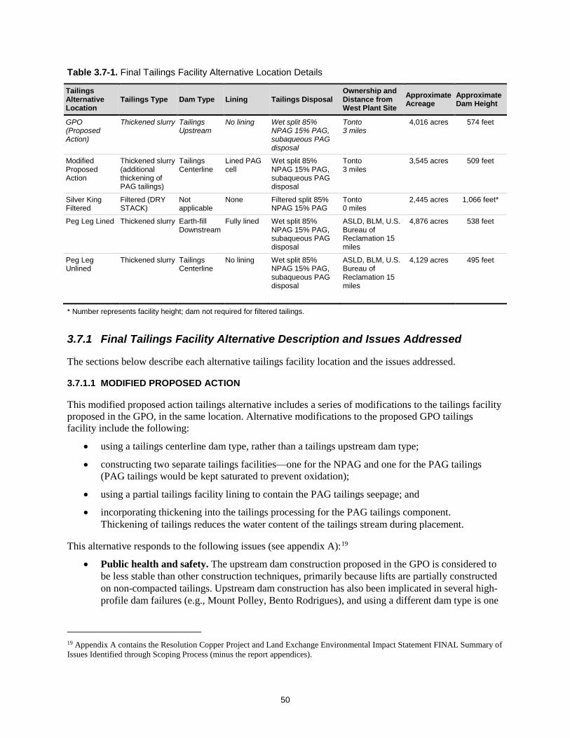
50
Table 3.7-1. Final Tailings Facility Alternative Location Details
Tailings Alternative Location
Tailings Type Dam Type Lining Tailings Disposal Ownership and Distance from West Plant Site
Approximate Acreage
Approximate Dam Height
GPO (Proposed Action)
Thickened slurry Tailings Upstream
No lining Wet split 85% NPAG 15% PAG, subaqueous PAG disposal
Tonto 3 miles
4,016 acres 574 feet
Modified Proposed Action
Thickened slurry (additional thickening of PAG tailings)
Tailings Centerline
Lined PAG cell
Wet split 85% NPAG 15% PAG, subaqueous PAG disposal
Tonto 3 miles
3,545 acres 509 feet
Silver King Filtered
Filtered (DRY STACK)
Not applicable
None Filtered split 85% NPAG 15% PAG
Tonto 0 miles
2,445 acres 1,066 feet*
Peg Leg Lined Thickened slurry Earth-fill Downstream
Fully lined Wet split 85% NPAG 15% PAG, subaqueous PAG disposal
ASLD, BLM, U.S. Bureau of Reclamation 15 miles
4,876 acres 538 feet
Peg Leg Unlined
Thickened slurry Tailings Centerline
No lining Wet split 85% NPAG 15% PAG, subaqueous PAG disposal
ASLD, BLM, U.S. Bureau of Reclamation 15 miles
4,129 acres 495 feet
* Number represents facility height; dam not required for filtered tailings.
3.7.1 Final Tailings Facility Alternative Description and Issues Addressed
The sections below describe each alternative tailings facility location and the issues addressed.
3.7.1.1 MODIFIED PROPOSED ACTION
This modified proposed action tailings alternative includes a series of modifications to the tailings facility proposed in the GPO, in the same location. Alternative modifications to the proposed GPO tailings facility include the following:
• using a tailings centerline dam type, rather than a tailings upstream dam type;
• constructing two separate tailings facilities—one for the NPAG and one for the PAG tailings (PAG tailings would be kept saturated to prevent oxidation);
• using a partial tailings facility lining to contain the PAG tailings seepage; and
• incorporating thickening into the tailings processing for the PAG tailings component. Thickening of tailings reduces the water content of the tailings stream during placement.
This alternative responds to the following issues (see appendix A):19
• Public health and safety. The upstream dam construction proposed in the GPO is considered to be less stable than other construction techniques, primarily because lifts are partially constructed on non-compacted tailings. Upstream dam construction has also been implicated in several high-profile dam failures (e.g., Mount Polley, Bento Rodrigues), and using a different dam type is one
19 Appendix A contains the Resolution Copper Project and Land Exchange Environmental Impact Statement FINAL Summary of Issues Identified through Scoping Process (minus the report appendices).

51
of the specific recommendations raised by a technical advisory panel for Resolution Copper.20 Specific concerns raised with the GPO include potential impacts to Queen Valley residents as well as surface waters. Thickened tailings could potentially also improve stability of the tailings facility.
• Groundwater quality. Some water quality concerns are present with all slurry tailings, but a specific concern is that the segregated pyrite tailings would produce seepage with high levels of metals and other contaminants, which could then impact groundwater quality, downstream well users, riparian areas and surface waters, and wildlife. Use of thickened tailings would further reduce seepage.
This alternative is useful in the proposed range of alternatives because, compared with the proposed action, it will allow a direct comparison of the resource impacts resulting from changing the dam type, incorporating thickening technology, and lining the PAG tailings.
3.7.1.2 SILVER KING FILTERED
The Silver King Filtered tailings storage alternative includes use of filtered dry stack tailings instead of thickened slurry tailings (as proposed in the GPO) at the Silver King location. Filtered tailings remove water from the slurry prior to placement, increasing percent solids generally to about 85 percent (vs. approximately 50 percent for a slurry). Filtered tailings are generally transported and managed as solids, rather than liquids, and do not require a dam for tailings containment.
The project team investigations described above led to the determination that processing “whole” filtered tailings did not add any benefit to the alternatives. The team determined that using the “split” tailings method (85 percent NPAG and 15 percent PAG) as a filtered (dry stack) tailings method would be beneficial at the Silver King location. The NPAG and PAG filtered tailings would be stacked separately in adjacent facilities.
This tailings facility would occupy the lower end of Silver King Canyon, immediately adjacent to the West Plant Site north of Superior, Arizona. The tailings footprint was optimized to avoid existing mining operations at the Silver King Mine. Although the conceptual design of this facility is quite tall (1,066 feet), the facility is placed into the canyon landscape to follow and mimic existing topography. Using filtered tailings removes some concerns with water quality and public safety, but air quality and visibility concerns may still remain because of the proximity to residents. Filtering of tailings would either occur at the West Plant Site and be delivered to the tailings facility by conveyor, or would be delivered as a slurry to the tailings facility, filtered at that location, and then conveyed into place.
This tailings facility alternative was developed to respond to the following issues:
• Water use. Recycling of water is already envisioned in the water balance for all components of the project, as is capture and recycling of seepage from the tailings facility. However, evaporation from the slurry tailings facility represents the largest single source of water loss requiring makeup water.21 Use of filtered or dry stack tailings would reduce the amount of water lost to evaporation, as no tailings surface pond would exist.
• Size. Use of filtered tailings reduces the volume of tailings, but also allows for higher stacking, reducing overall footprint. This impacts a number of resources.
20 Discussion of current international best practices for siting and design of large tailings storage facilities is described in the “Independent Technical Review Board Report No.1, Rev.1,” dated March 2017 (Project Record #0001301). 21 See process memorandum dated June 5, 2017, titled “Summary of Mine Water Balance and Sources” (Project Record #0001389).

52
• Air quality. Use of filtered tailings may reduce impacts to air quality by preventing the differential settling, drying, and exposure of fine-grained materials that are easily moved by wind.
• Public health and safety. Filtered tailings do not require dam structures to contain the tailings, are more stable, and a failure would not impact as far a distance downstream. Specific concerns raised include potential impacts to Queen Valley residents as well as surface waters.
• Groundwater quality. Use of filtered tailings reduces the amount of seepage, which could then impact groundwater quality, potentially downstream well users, riparian areas and surface waters, and wildlife.
This alternative is useful in the proposed range of alternatives because, compared with the proposed action, it allows a comparison of the impacts of thickened slurry tailings versus filtered dry stack tailings, and allows a comparison of whether the specific location selected for tailings in the GPO is preferable to other locations in the same general vicinity of Superior.
The project team recognizes that filtered tailings have not been used on a facility with a production rate as high as that proposed by Resolution Copper. We have drawn a distinction between use of a technology being unprecedented vs. technically infeasible. The project team believes that filtering technology is scalable to the expected production rate and that other technical concerns can be addressed through the facility design, notably the need for auxiliary infrastructure such as stormwater management structures, emergency backup storage, and filtering equipment.22
3.7.1.3 PEG LEG LINED
The Peg Leg Lined tailings storage alternative includes use of a thickened slurry tailings processing (same as GPO) at an alternative location that is farther from populated areas. Details about this alternative include the following:
• It would be located on ASLD and BLM land south of the Gila River.23
• A thickened slurry in split stream (15 percent PAG and 85 percent NPAG) would be pumped via pipeline (approximately 15 miles) to the site.
• The PAG tailings would be kept saturated to prevent oxidation.
• It would use an “earth-fill downstream” dam type.
• It would be a fully lined facility.
This Peg Leg Lined tailings alternative responds to the following issues:
• Public health and safety. The upstream dam construction proposed in the GPO is considered to be less stable than other construction techniques, primarily because lifts are partially constructed on non-compacted tailings. Upstream dam construction has also been implicated in several high-profile dam failures (e.g., Mount Polley, Bento Rodrigues), and using a different dam type is one of the specific recommendations raised by a technical advisory panel for Resolution Copper.24 Specific concerns raised with the GPO include potential impacts to Queen Valley residents as
22 See process memorandum dated September 12, 2017, titled “Scalability of Tailings Filtration – DRAFT” (Project Record #0002038). 23 The U.S. Bureau of Reclamation also has a property interest in these lands associated with the Buttes Dam and Reservoir withdrawal of 1965 (Public Land Order 3835). 24 Discussion of current international best practices for siting and design of large tailings storage facilities is described in the “Independent Technical Review Board Report No.1, Rev.1,” dated March 2017 (Project Record #0001301).

53
well as surface waters. The “earth-fill downstream” dam type is considered the safest dam construction method and therefore responds to public health and safety concerns.
• Location. The distance from population can address multiple issues. The Peg Leg location was selected for distance from residential areas and other infrastructure. The site has characteristics similar to the ASLD Far West site chosen by the Resolution Community Working Group, including a greater distance from Superior, Queen Creek, and other communities, and a relatively level topographic setting on predominantly alluvial soils. In addition, it would present substantially fewer visual impacts than most other alternative tailing sites simply by virtue of its distance from population centers and major thoroughfares. This proposed area south of the Gila River also appears to attract markedly less recreational interest and recreational use than the GPO and other alternative locations on NFS land. Lastly, the site’s relative isolation from residential areas also means it would have fewer effects on personal property values, unlike the GPO and potentially other locations.
• Groundwater quality. Use of a fully lined facility would reduce discharge of seepage from the tailings facility and would therefore eliminate potential water quality impacts, which could then impact groundwater quality, downstream well users, riparian areas and surface waters, and wildlife.
This alternative is useful in the proposed range of alternatives because, compared with the Peg Leg Unlined alternative, it allows a direct comparison of the impacts of using a liner on a slurry tailings facility. It also allow for analysis of the downstream dam type to illustrate the environmental and social differences it presents.
3.7.1.4 PEG LEG UNLINED
The Peg Leg Unlined tailings storage alternative includes use of thickened slurry tailings processing and no facility lining (same as GPO) at an alternative location that is further from populated areas. Details about this alternative include the following:
• It would be located on ASLD and BLM land south of the Gila River.25
• A thickened slurry in split stream (15 percent PAG and 85 percent NPAG) would be pumped via pipeline (approximately 15 miles) to the site.
• The PAG tailings would be kept saturated to prevent oxidation;
• I would use tailings contained by a “tailings centerline dam” construction method. It would be an unlined facility.
This alternative is similarly responsive to the public health and safety and location issues described above for Peg Leg Lined. The Peg Leg Unlined alternative is useful in the proposed range of alternatives because, compared with the proposed action, it allows a comparison of the impacts of slurry tailings if they were placed in a flatter alluvial setting instead of the rougher topography near Superior. This location also allows a comparison of storing tailings at a location farther from people and with less recreation.
25 The U.S. Bureau of Reclamation also has a property interest in these lands associated with the Buttes Dam and Reservoir withdrawal of 1965 (Public Land Order 3835).

54
4.0 EIS RANGE OF ALTERNATIVES Using the information presented in the report sections above, the project team developed a range of alternatives for full analysis in the draft EIS (see table 4-1). The alternatives represent a range of alternatives that fulfill the purpose and need and address issues and unresolved conflicts posed by the proposed action. The full range of “reasonable” alternatives includes the alternatives studied in detail and also includes all alternatives eliminated from detailed study. The alternatives presented below represent a reasonable range of alternatives for further study, based on Forest Service and CEQ guidance.
The project team’s intent when developing the range of alternatives for tailings disposal was not to replicate every technology at every location. The team identified a range of alternative locations and design options and determined the optimal scenarios for analysis. Once separate alternative impacts are analyzed in the draft EIS, a new alternative may be developed combining those aspects of other alternatives that are most beneficial. Similarly, as long as the analysis of impacts has been conducted, the Forest Supervisor will be able to select components of different alternatives and apply them to the Selected Alternative in the Record of Decision (ROD).
EIS Range of Alternatives – Process Documentation • Briefing of Forest Supervisor on
Proposed Range of Alternatives, September 14, 2017 (Project Record #0002053) ◦ Briefing Paper Proposed Range of
Alternatives for Detailed Analysis Resolution Copper Project and Land Exchange EIS, dated September 5, 2017 (Project Record #0001922)
• Tribal Consultation Meeting, October 5 and 6, 2017 (Project Record #0002064; #0002065)
• Forest Service Alternatives Briefing Paper to Cooperating Agencies for Review, September 6, 2017 (Project Record #0001922)
• Forest Service Response to Cooperating Agency Comments (Project Record #0001922)
• Resolution Responses to Forest Service Alternatives Data Request #2 – July 28 and August 22 (Project Record #0002061–0002062)
• Forest Service Request for Tribal Alternatives Input, October 23, 2017 (Project Record #0002016–0002037)

55
Table 4-1. Alternatives Carried Forward for Full Analysis in EIS
Alternative Name General Description Issues Addressed26
Alternative 1 – No Action
Required by NEPA regulations. Provides a baseline for comparison of impacts of the action alternatives.
Alternative 2 – Proposed Action
Proposed GPO as described in section 1.4.2.
Alternative 3 – Modified Proposed Action
Same as Proposed Action except for modifications to tailings facility at GPO location. Changes include upstream tailings dam, liner for PAG tailings, and thickening tailings.
Issue 5A – Health Impacts Issue 5B – Safety Concerns Related to Tailings Impoundment Issue 6B – Groundwater Quality Issue 6D – Surface Water Quality Issue 6E – Seeps, Springs, Riparian Areas, and Groundwater-Dependent Ecosystems Issue 9B – Impact to Existing Landscape Productivity, Stability, and Function
Alternative 4 – Silver King Filtered
Same as proposed action described in section 1.4.2 except for:
1. Tailings location and tailings processing located at Silver King area north of Superior near the West Plant Site. Tailings filter processed and dry stacked, and 2. Relocation of Filter Plant and Loadout Facility (see section 4.4.1 for description).
Note that after receiving comments on the range of alternatives from the Forest Supervisor (see section 4.2) and cooperating agencies (see section 4.3), this alternative was modified to keep the PAG and NPAG tailings separated, rather than combined. Both PAG and NPAG tailings remain filtered
Issue 2C – Impacts to Groundwater Availability/Usability Issue 4 – Impacts to Cultural Resources Issue 5A – Health Impacts Issue 5B – Safety Concerns Related to Tailings Impoundment Issue 6A – Groundwater Availability Issue 6B – Groundwater Quality Issue 6C – Surface Water Availability Issue 6D – Surface Water Quality Issue 6E – Seeps, Springs, Riparian Areas, and Groundwater-Dependent Ecosystems Issue 7B – Loss or Harassment of Individual Plants and Animals, Issue 7C – Habitat Fragmentation and Loss Issue 8 – Impacts to Air Quality Issue 9B – Impact to Existing Landscape Productivity, Stability, and Function Issue 10 – Impacts to Recreation Resources Issue 11 – Impacts to Scenic Resources Issue 12 – Impacts to Transportation/Access Issue 14 – Impacts to Land Ownership and Boundary Management
Alternative 5 – Peg Leg Lined
Same as Proposed Action described in section 1.4.2 except for tailings location and design. Tailings is in same location as Peg Leg Unlined with similar designs. Differences from Peg Leg Unlined include earth-fill downstream dam type, and fully lined facility. Note that after receiving comments on the range of alternatives both from the Forest Supervisor (see section 4.2) and cooperating agencies (see section 4.3), this alternative was modified to use a downstream dam, with excavation for adequate material occurring from within the facility footprint, and to maintain separate cells for NPAG and PAG tailings, both lined.
Issue 2B – Impacts to Property Values Issue 5A – Health Impacts Issue 5B – Safety Concerns Related to Tailings Impoundment Issue 6B – Groundwater Quality Issue 6D – Surface Water Quality Issue 6E – Seeps, Springs, Riparian Areas, and Groundwater-Dependent Ecosystems Issue 8 – Impacts to Air Quality Issue 9B – Impact to Existing Landscape Productivity, Stability, and Function Issue 10 – Impacts to Recreation Resources Issue 11 – Impacts to Scenic Resources
26 Appendix A – Summary of Issues Identified Through Scoping Process Contains the Resolution Copper Project and Land Exchange Environmental Impact Statement FINAL Summary of Issues Identified Through Scoping Process (minus the report appendices).

56
Table 4-1. Alternatives Carried Forward for Full Analysis in EIS (Continued)
Alternative Name General Description Issues Addressed27
Alternative 6 – Peg Leg Unlined
Same as proposed action described in section 1.4.2 except for tailings location and design. Tailings located south of the Gila River in a remote area with nearby mining activity. Tailings slurry piped approximately 15 miles to tailings facility. Tailings constructed with centerline dam with no facility lining.
Issue 2B – Impacts to Property Values Issue 5A – Health Impacts Issue 5B – Safety Concerns Related to Tailings Impoundment Issue 6B – Groundwater Quality Issue 6D – Surface Water Quality Issue 6E – Seeps, Springs, Riparian Areas, and Groundwater-Dependent Ecosystems Issue 8 – Impacts to Air Quality Issue 9B – Impact to Existing Landscape Productivity, Stability, and Function Issue 10 – Impacts to Recreation Resources Issue 11 – Impacts to Scenic Resources
4.1 Other GPO Alternative Components In addition to the alternative mining technique and alternative tailings storage locations and techniques described in sections 2.0 and 3.0 above, respectively, Resolution Copper voluntarily brought other potential alternative project designs to the Forest Service’s attention as possible means to address issues raised during the public scoping period or during subsequent project management meetings or discussions. Specifically, these alternative components would involve the following:
• relocating concentrate filtering/loadout operations to the West Plant Site from the GPO proposed location near San Tan Valley;
• redesigning facilities at the West Plant Site to move the process water storage pond completely off NFS lands; and
• relocating or substantially improving equipment haul routes and other vehicular access to and from the West Plant Site.
These three proposed or requested project facility redesigns would not be dependent on mining technique or on tailings storage facility location, but could be implemented regardless of how ore was extracted or where tailings were ultimately disposed. Each is described in greater detail in sections 4.1 through 4.3 below. These GPO alternative components will be analyzed in the draft EIS either as items “common to all” action alternatives or incorporated into a specific alternative described above.
4.1.1 Relocation of Filter Plant and Loadout Facility
This alternative component would relocate the filter plant and loadout facility from the proposed location near Magma Junction onto the West Plant Site, just below the concentrator on the existing railhead north of U.S. 60. The facility would continue to pressure-filter the concentrate similar to the proposed process described in the GPO. Pipelines for concentrate and copper filtrate water would be located within the West Plant Site and not within the MARRCO corridor, therefore eliminating 21 miles of concentrate pipelines. Two 50-railcar trains would instead use the MARRCO corridor twice a day to transport copper concentrate to market (concentrate loads would be transferred at Magma Junction to container cars of the Union Pacific Railroad for transport to an off-site smelter). The MARRCO corridor track would require upgrades along the entire length, bridge replacement at Queen Creek Bridge, and significant upgrades for
27 Appendix A – Summary of Issues Identified Through Scoping Process Contains the Resolution Copper Project and Land Exchange Environmental Impact Statement FINAL Summary of Issues Identified Through Scoping Process (minus the report appendices).
57
crossing at Queen Creek, U.S. 60, State Route (SR) 79, the Arizona Trail, Hewitt Station Road, and other NFS roads.
The dimensions and uses of water pipelines, groundwater wells, pump stations, and a 12-kilovolt (kV) power line within the MARRCO corridor would remain unchanged from how these facilities are described in the GPO.
This GPO alternative component will be incorporated into the Silver King Filtered Alternative as described above in table 4-1.
4.1.2 Relocation of Process Water Pond within West Plant Site
This alternative component would move the process water pond, as proposed in the GPO, off approximately 11.4 acres of NFS land immediately north of and adjacent to the West Plant Site and relocate the pond and associated facilities (e.g., fencing, stormwater control systems) fully within Resolution Copper private property boundaries at the West Plant Site.
As noted above, this potential amendment to the GPO was voluntarily brought to the attention of Tonto staff by representatives of Resolution Copper, who suggested this particular modification as a relatively low-cost change the company could make to reduce overall project impacts to NFS surface resources.
4.1.3 Redesign and/or Improvement of Vehicle Access to and from the West Plant Site
Resolution Copper is also proposing an alternative routing of Silver King Road (FR 229), which would be used to transport mine personnel, equipment, supplies, as well as molybdenum and other mine products, to and/or from the West Plant Site. This rerouting is anticipated to reduce typical use of FR 229 by mine personnel from 2.3 miles, as described in the GPO, to just 0.4 mile.
4.2 Briefing of Forest Supervisor on Proposed Range of Alternatives The proposed range of alternatives for detailed analysis was captured in a briefing paper dated September 5, 2017, for circulation and review (Project Record ##0001922).
The project team met with Tonto National Forest Supervisor Neil Bosworth on September 14, 2017, to brief him on their efforts toward developing alternatives to date. The meeting included reporting and discussion on alternative mining techniques, alternative tailings storage facility investigation and results, and other GPO components recommended for incorporation into the alternatives. The team presented the preliminary “final” range of alternatives. Input from the Forest Supervisor included a request that the project team investigate the feasibility of using the downstream dam construction method at the GPO and Peg Leg locations. This is in consideration of the issues surrounding public health and safety and concerns regarding safety of the upstream dam construction, and because downstream dam construction is assumed to be the safest construction method.
4.3 Cooperating Agency Review of Proposed Range of Alternatives Cooperating agencies were also provided the September 2017 briefing paper for review. Comments were received from four cooperating agencies: the USACE (Project Record #0002057); Arizona Game and Fish Department (Project Record #0002059); ASLD (Project Record #0002058); and EPA (Project Record #0002060). The Forest Service reviewed the comments and developed responses (Project Record

58
##0001922). Based on input from cooperating agencies, the following modifications were made to the final tailings alternatives:
• The modified proposed action was clarified to include construction of an internal tailings dam, which would provide a framework for installation of the tailings dam liner. The liner would follow each raised extension of tailings facility and to provide separation of the pyrite and scavenger tailings.
• The management of PAG and NPAG tailings was reviewed further and modifications were made to the Silver King and Peg Leg alternatives to maintain segregation rather than use whole tailings.
• To allow for a more robust analysis of alternative tailings dam types, a downstream dam type was added to the Peg Leg Lined alternative.
Through their cooperating agency review of the alternatives briefing paper, the USACE pointed out a potential issue associated with the Peg Leg alternatives location. The USACE responded that under its regulatory framework (Clean Water Act Section 404(b)(1) Alternatives Analysis), it would be difficult to issue a permit for the Peg Leg site because of the requirement that it choose the Least Environmental Damaging Practicable Alternative (LEDPA) for the aquatic ecosystem. Based upon previous work with Resolution Copper, the USACE has determined that the GPO tailings area watershed contains no jurisdictional waters under current USACE guidelines. The Peg Leg alternative is in a different watershed and the alternative location likely contains jurisdictional waters. The USACE stated that because of the LEDPA requirement, they would likely be unable to permit the Peg Leg location over the GPO proposed action location. The project team has met with the USACE to discuss this issue and determined that eliminating the Peg Leg location at this time is not necessary and that it could be “pre-decisional.” The analysis in the draft EIS will discuss impacts to jurisdictional waters.
4.4 Tribal Consultation Review of Proposed Range of Alternatives The Forest Service attended a tribal consultation meeting and field visit with consulting tribes on October 5 and 6, 2017, to update the tribes on the status of the EIS process and present the Forest Service’s final tailings alternatives discussed in this report. The consulting tribes will further review the report’s final tailings alternatives and provide feedback. Based upon this feedback from consulting tribes, the Forest Service may revise the final tailings alternatives at a later date.
5.0 NEXT STEPS IN EIS PROCESS The next steps in the EIS process include the effects analysis and drafting the EIS. A complete description of the full range of EIS alternatives, including the no action, proposed action, and alternatives considered in detail, will be provided in EIS Chapter 2, Alternatives, Including the Proposed Action. The EIS range of alternatives will be presented in comparative form, sharply defining the differences between each alternative and providing a clear basis for comparison in the effects analysis and choice among options by the decision maker and the public. Prior to conducting the effects analysis, baseline data for the range of alternatives will be collected and validated. The Forest Service will engage experts to assess the validity of baseline information and models provided by Resolution Copper, identify data gaps, and conduct additional data collection if necessary.
The next step in the EIS process is the effects analysis, which will be presented in EIS Chapter 3, Affected Environment and Environmental Consequences. The resources described in the affected

59
environment represent baseline environmental conditions, incorporating past and present actions, for determining potential impacts of the range of alternatives. The following is a preliminary list of the resources areas considered in the effects analysis:
• Tribal Values • Geology
• Socioeconomics • Soils
• Environmental Justice • Recreation
• Cultural Resources • Scenery
• Public Health and Safety/Hazardous Materials
•
•
Transportation
Noise and Vibration • Water Resources – Groundwater and
Surface Water • Land and Boundary
• Geochemical • Wildfire Risk
• Biological Resources • Range
• Air Quality
The effects analysis will compare and contrast the environmental consequences of each alternative on the affected environment for the resources analyzed. Guided by the issues identified during scoping, the Forest Service will analyze the environmental effects for each alternative, as well as cumulative effects from past, present, and reasonably foreseeable actions. The issues report (see appendix A) presents a summary of specific factors, such as readily quantifiable metrics or other indicators of change, which may be used to compare anticipated effects under different alternatives and management scenarios. Indicators or factors may be quantitative or qualitative, but each provides a specific point of comparison either between different alternatives, or with established regulatory thresholds. The effects analysis contained in the EIS for each resource will focus on the specific factors or indicators and will allow for a concise comparison of impacts.
Following the effects analysis, the Forest Service will present the draft EIS for public review and comment. The availability of the draft EIS will be announced in the Federal Register and advertised in the local and regional media. Public meetings or hearings will be held to receive comments on the adequacy of the analysis and effects presented in the draft EIS. The Forest Service will then review and consider the public comments received, conduct any necessary additional analysis, and prepare the final EIS. The availability of the final EIS and draft ROD will be announced in the Federal Register and advertised in local and regional media. The Forest Service project-level objection process (36 CFR Part 218) will follow the publication of the final EIS and draft ROD. A ROD selecting the alternative to be implemented will be made by the Forest Service once responses to objections have been issued. The final ROD will be published in the Federal Register. Section 3003 of the NDAA authorizes and directs the Secretary of Agriculture to administer the Resolution Copper Land Exchange 60 days following publication of the final EIS.

APPENDIX A
Summary of Issues Identified Through Scoping Process
(Resolution Copper Project and Land Exchange Environmental Impact Statement FINAL Summary of Issues Identified Through Scoping Process, without Appendices)

APPENDIX B
Council on Environmental Quality and Forest Service NEPA Guidance on Alternatives Development
APPENDIX C
Technical Memorandum for Alternative Mining Methods

APPENDIX D
Alternative Tailings Public Workshop Summary Report

APPENDIX E
Tailings Disposal Alternatives Technical Memorandum

D-1