the raft - resilience adaptation feasibility tool
TRANSCRIPT

PRESENTATION TO NORTHAMPTON COUNTY PLANNING COMMISSION
JANUARY 16, 2019
THE RAFTResilience Adaptation Feasibility Tool
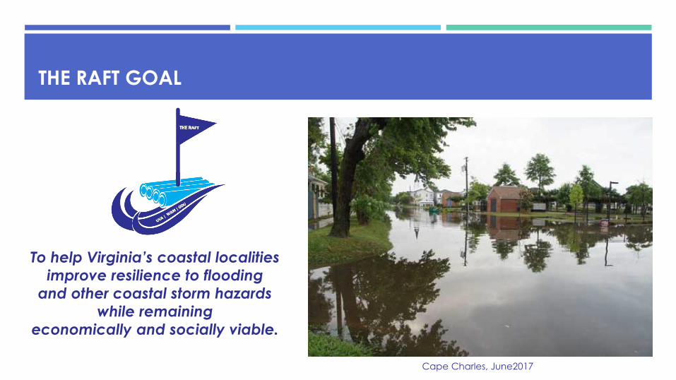
To help Virginia’s coastal localities
improve resilience to flooding
and other coastal storm hazards
while remaining
economically and socially viable.
THE RAFT GOAL
Cape Charles, June2017

THE RAFT FUNDING
National Fish and Wildlife Foundation (NFWF)
Virginia Environmental Endowment (VEE)
Virginia Department of Environmental Quality (DEQ) Coastal Zone Management Program (CZM)
Anonymous
Virginia Sea Grant
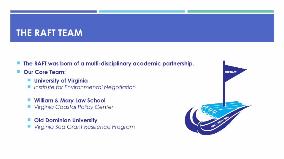
THE RAFT TEAM
The RAFT was born of a multi-disciplinary academic partnership.
Our Core Team:
University of Virginia Institute for Environmental Negotiation
William & Mary Law School Virginia Coastal Policy Center
Old Dominion University Virginia Sea Grant Resilience Program

THE RAFT PROCESS
1. Scorecard
Resilience Assessment
2. Community Workshop
Resilience Action Checklist
3. Implementation
Ongoing Assistance
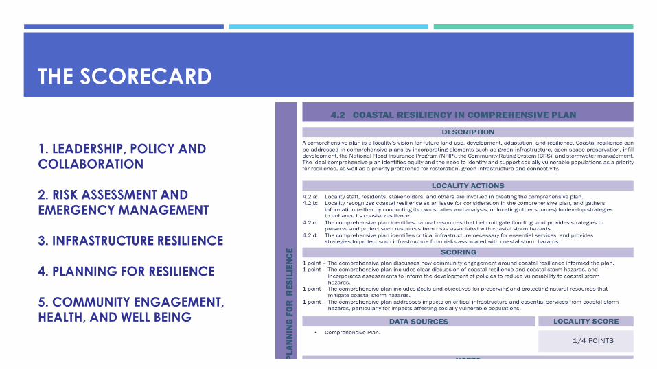
THE SCORECARD
1. LEADERSHIP, POLICY AND COLLABORATION
2. RISK ASSESSMENT AND EMERGENCY MANAGEMENT
3. INFRASTRUCTURE RESILIENCE
4. PLANNING FOR RESILIENCE
5. COMMUNITY ENGAGEMENT, HEALTH, AND WELL BEING

WHAT IS HAPPENING NOW?
Photo Credit: NASA Larry Atkinson, CCPO, Old Dominion University

NORTHAMPTON: MODERATE
STORM SURGE –
CURRENT
CONDITIONS
Source: TNC Virginia Eastern Coastal Resilience ToolSource: The Nature Conservancy Tool

NORTHAMPTON:
MODERATE
STORM SURGE –
2065
Source: Virginia Dept. of Emergency Management

NORTHAMPTON
INUNDATION VULNERABILITY
Source: Institute of Environmental Negotiation, UVA
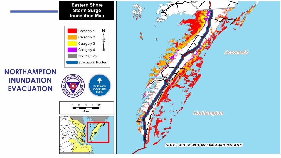
NORTHAMPTON
INUNDATION
EVACUATION

WHAT TO EXPECT OF COASTAL INUNDATION (SEA LEVEL RISE)BY 2040 BY 2065 BY 2100
1ft. (lowest) to 1.9 ft. (highest) 1.9 ft. (lowest) to 4ft. (highest) 3.2 ft. (lowest) to 7.4 ft. (highest)
The southern end of Bay Ave and
Randolph Ave to Harbor Street is
at a high risk due to low elevation
Most of the western portion from
Jefferson Avenue to Mason Avenue
as far east as Strawberry Street is at
risk of flooding to due low elevation
Most of the historic district will be
submerged, including: Bay Avenue,
Randolph Avenue, Monroe Avenueand Harbor St., Plum St.
The area around Plum and Madison
Ave and the southern portion of
Plum Street to Tazewell Avenue is
also at risk
Madison Avenue experiencing the
highest amount of flooding
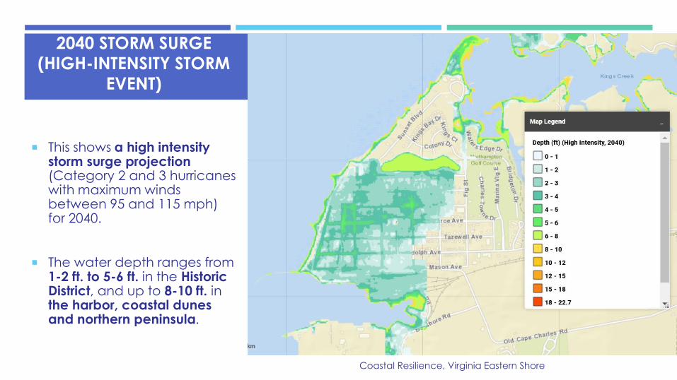
2040 STORM SURGE
(HIGH-INTENSITY STORM
EVENT)
This shows a high intensity storm surge projection (Category 2 and 3 hurricanes with maximum winds between 95 and 115 mph) for 2040.
The water depth ranges from 1-2 ft. to 5-6 ft. in the Historic District, and up to 8-10 ft. in the harbor, coastal dunes and northern peninsula.
Coastal Resilience, Virginia Eastern Shore

SMITH BEACH
SMITH BEACH:
MODERATE STORM
SURGE – 2065
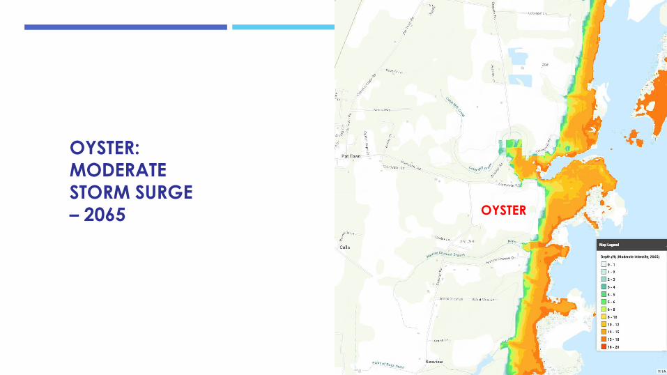
OYSTER
OYSTER: MODERATE
STORM SURGE
– 2065

WILLIS WHARFWILLIS WHARF:
MODERATE STORM SURGE – 2065
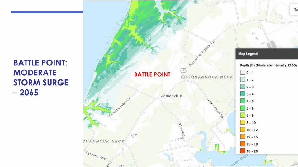
BATTLE POINT:
MODERATE
STORM SURGE – 2065
BATTLE POINT

NORTHAMPTON SCORECARD : TOP 5 STRENGTHS
SECTION SCORE
Locality Leadership and Planning for Resilience 4/4
Hazard Mitigation 4/4
Critical Transportation Infrastructure 4/4
Budget, Funding, and State & Federal Assistance 4/4
Providing Coastal Resilience Information to the Public 4/4
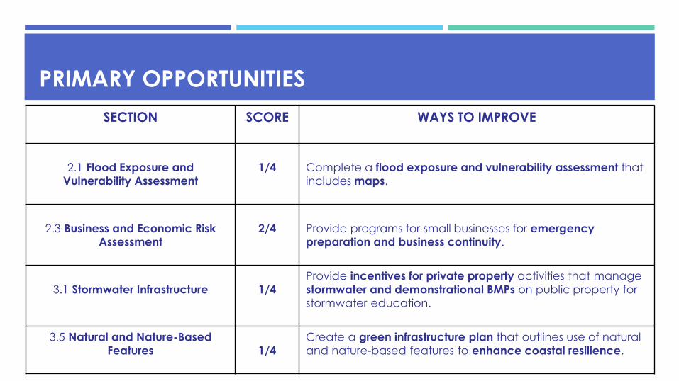
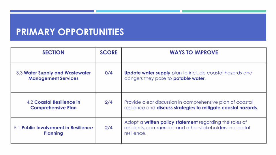
PRIMARY OPPORTUNITIES
SECTION SCORE WAYS TO IMPROVE
2.1 Flood Exposure and
Vulnerability Assessment
1/4 Complete a flood exposure and vulnerability assessment that
includes maps.
2.3 Business and Economic Risk
Assessment
2/4 Provide programs for small businesses for emergency
preparation and business continuity.
3.1 Stormwater Infrastructure 1/4
Provide incentives for private property activities that manage
stormwater and demonstrational BMPs on public property for
stormwater education.
3.5 Natural and Nature-Based
Features 1/4
Create a green infrastructure plan that outlines use of natural
and nature-based features to enhance coastal resilience.
PRIMARY OPPORTUNITIES
SECTION SCORE WAYS TO IMPROVE
3.3 Water Supply and Wastewater
Management Services
0/4 Update water supply plan to include coastal hazards and
dangers they pose to potable water.
4.2 Coastal Resilience in
Comprehensive Plan
2/4 Provide clear discussion in comprehensive plan of coastal
resilience and discuss strategies to mitigate coastal hazards.
5.1 Public Involvement in Resilience
Planning
2/4
Adopt a written policy statement regarding the roles of
residents, commercial, and other stakeholders in coastal
resilience.
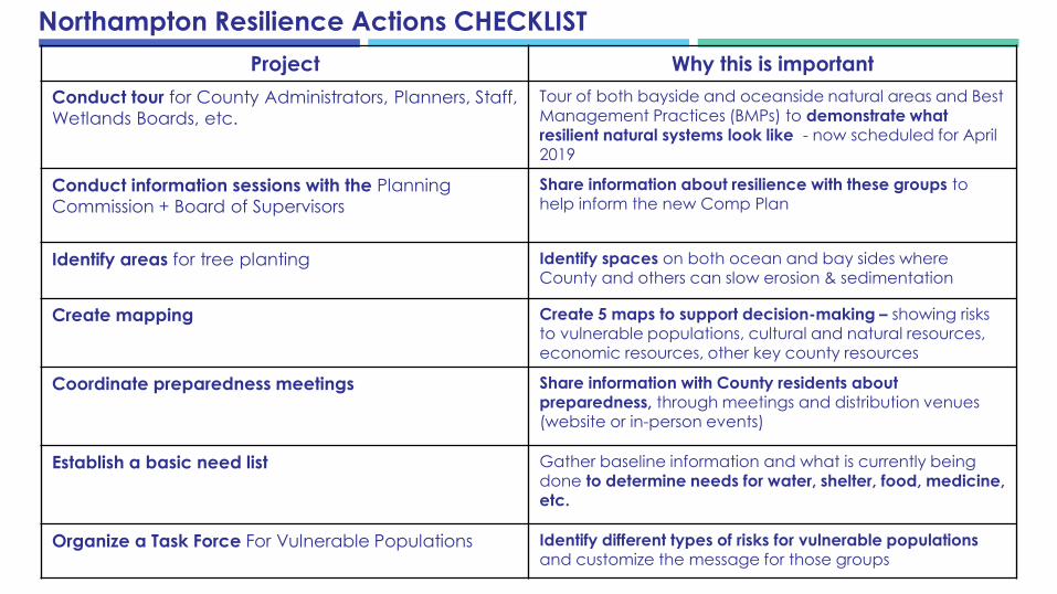
Project Why this is important
Conduct tour for County Administrators, Planners, Staff,
Wetlands Boards, etc.
Tour of both bayside and oceanside natural areas and Best Management Practices (BMPs) to demonstrate what resilient natural systems look like - now scheduled for April 2019
Conduct information sessions with the Planning
Commission + Board of Supervisors
Share information about resilience with these groups to help inform the new Comp Plan
Identify areas for tree planting Identify spaces on both ocean and bay sides where County and others can slow erosion & sedimentation
Create mapping Create 5 maps to support decision-making – showing risks to vulnerable populations, cultural and natural resources, economic resources, other key county resources
Coordinate preparedness meetings Share information with County residents about preparedness, through meetings and distribution venues (website or in-person events)
Establish a basic need list Gather baseline information and what is currently being done to determine needs for water, shelter, food, medicine, etc.
Organize a Task Force For Vulnerable Populations Identify different types of risks for vulnerable populations and customize the message for those groups
Northampton Resilience Actions CHECKLIST
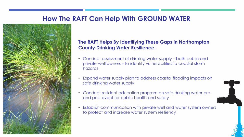
How The RAFT Can Help With GROUND WATER
The RAFT Helps By Identifying These Gaps in Northampton County Drinking Water Resilience:
• Conduct assessment of drinking water supply – both public and
private well owners – to identify vulnerabilities to coastal storm
hazards
• Expand water supply plan to address coastal flooding impacts on
safe drinking water supply
• Conduct resident education program on safe drinking water pre-
and post-event for public health and safety
• Establish communication with private well and water system owners
to protect and increase water system resiliency

How The RAFT Can Help With Protecting Natural Resources
The RAFT Helps By Identifying These Gaps in Northampton County Natural Resources Resilience
• Identify natural and nature-based features (NNBF) that are protective and can assist with coastal resilience
• Develop plans and policies that use NNBF to enhance coastal resilience
• Conduct a flood vulnerability assessment every 5 years and use it in developing policy and programs
• Identify sources of flooding (tidal, and precipitation driven) and update every 5 years
• Identify and map flooding probability
• Fund actions that implement the NR Preservation Plan
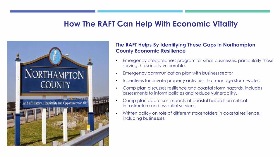
How The RAFT Can Help With Economic Vitality
The RAFT Helps By Identifying These Gaps in Northampton
County Economic Resilience
• Emergency preparedness program for small businesses, particularly those serving the socially vulnerable.
• Emergency communication plan with business sector
• Incentives for private property activities that manage storm-water.
• Comp plan discusses resilience and coastal storm hazards, includes assessments to inform policies and reduce vulnerability.
• Comp plan addresses impacts of coastal hazards on critical infrastructure and essential services.
• Written policy on role of different stakeholders in coastal resilience, including businesses.
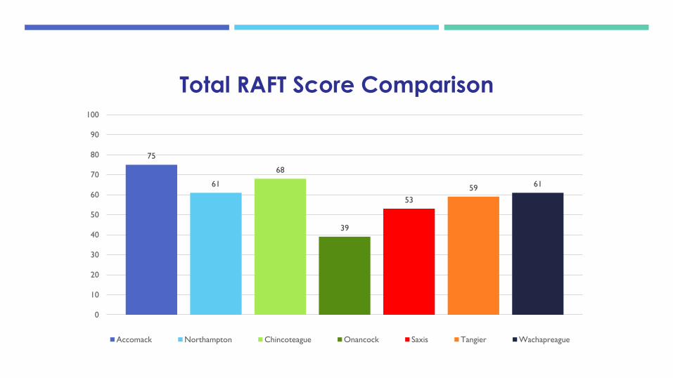
75
61
68
39
53
5961
0
10
20
30
40
50
60
70
80
90
100
Total RAFT Score Comparison
Accomack Northampton Chincoteague Onancock Saxis Tangier Wachapreague
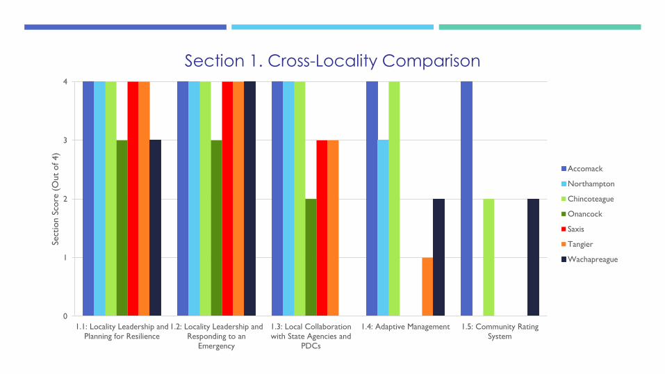
0
1
2
3
4
1.1: Locality Leadership and
Planning for Resilience
1.2: Locality Leadership and
Responding to an
Emergency
1.3: Local Collaboration
with State Agencies and
PDCs
1.4: Adaptive Management 1.5: Community Rating
System
Sect
ion S
core
(O
ut
of 4)
Section 1. Cross-Locality Comparison
Accomack
Northampton
Chincoteague
Onancock
Saxis
Tangier
Wachapreague

0
1
2
3
4
2.1: Flood Exposure and
Vulnerability Assessment
2.2: Risk Assessment for
Vulnerable Populations
2.3: Business and Economic
Risk Assessment
2.4: Hazard Mitigation 2.5 Resident Emergency
Preparedness
Sect
ion S
core
(O
ut
of 4)
Section 2. Cross-Locality Comparison
Accomack
Northampton
Chincoteague
Onancock
Saxis
Tangier
Wachapreague

0
1
2
3
4
3.1: Stormwater
Infrustructure
3.2: Critical
Transportation
Infrastructure
3.3: Water Supply and
Wastewater Management
Services
3.4: Critical Infrastructure
for Emergency Services
3.5: Natural and Nature-
Based Features
Sect
ion S
core
(O
ut
of 4)
Section 3. Cross-Locality Comparison
Accomack
Northampton
Chincoteague
Onancock
Saxis
Tangier
Wachapreague

0
1
2
3
4
4.1: Budget, Funding,
State, and Federal
Assistance
4.2: Coastal Resiliency in
Comprehensive Plan
4.3: Land Use Ordinances 4.4: Incentives for Coastal
Resilience
4.5: Natural Resource
Preservation
Sect
ion S
core
(O
ut
of 4)
Section 4. Cross-Locality Comparison
Accomack
Northampton
Chincoteague
Onancock
Saxis
Tangier
Wachapreague

0
1
2
3
4
5.1: Public Involvement in
Resilience Planning
5.2: Providing Coastal
Resilience Information to
the Public
5.3: Citizen Leadership
and Volunteer Networks
for Coastal Resilience
5.4: Resilient Systems to
Provide Food, Health,
and Medicine
5.5: Physical and Mental
Health For Social Equity
in Community Resilience
Sect
ion S
core
(O
ut
of 4)
Section 5. Cross-Locality Comparison
Accomack
Northampton
Chincoteague
Onancock
Saxis
Tangier
Wachapreague

NEXT STEPS
Implement the
Resilience Action Checklist

PROJECT IDEA Next Steps
Conduct Tour for County Administrators, Planners, etc. Tour scheduled for April, coordinator Dot Field/DCR.
Conduct information sessions with the Planning
Commission + Board of Supervisors Tonight! Presentation to BOS date still TBD.
Identify areas for tree planting Staff working with Public Works to do this.
Create mapping Mapping underway by UVA grad students.
Coordinate preparedness meetings Implementation Team identifying best community
events for distribution.
Establish a basic need list Implementation Team working to determine best path
forward.
Organize a Task Force For Vulnerable Populations Implementation Team working with Community
Partners of the Eastern Shore (CPES) to identify
vulnerable populations and distribute messages.
Northampton Resilience Actions - NEXT STEPS
THE RAFT CORE TEAM
Northampton Support Team:
Tanya Denckla Cobb: [email protected]
Kelly Altizer: [email protected]
Elizabeth Andrews: [email protected]
Angela King: [email protected]
Michelle Covi: [email protected]
Grace Walker: [email protected]

QUESTIONS ?