the peaks of the balkans trail - amazon web services
TRANSCRIPT

THE PEAKS OF THE BALKANS TRAIL
MONTENEGRO, ALBANIA AND KOSOVO
770 Peaks of the Balkans.indd 1 10/08/2017 11:52

About the AuthorRudolf Abraham (www.rudolfabraham.co.uk) is an award-winning travel writer and photographer specialising in Central and Southeast Europe. He is the author of over 10 books, including the first comprehensive English-language hiking guidebooks to Montenegro and Croatia, and his work is published widely in magazines. He first visited the mountainous bor-derlands of Montenegro and Albania in 2004, having already lived and worked in neighbouring Croatia in the late 1990s – and has been a fre-quent visitor to this little-known corner of Europe ever since.
Other Cicerone guides by the authorThe Islands of CroatiaWalking in CroatiaThe Mountains of MontenegroTorres del PaineSt Oswald’s Way and St Cuthbert’s Way
770 Peaks of the Balkans.indd 2 10/08/2017 11:52

THE PEAKS OF THE BALKANS TRAIL
MONTENEGRO, ALBANIA AND KOSOVO
by Rudolf Abraham
JUNIPER HOUSE, MURLEY MOSS, OXENHOLME ROAD, KENDAL, CUMBRIA LA9 7RL
www.cicerone.co.uk
770 Peaks of the Balkans.indd 3 10/08/2017 11:52

© Rudolf Abraham 2017First edition 2017ISBN: 978 1 85284 770 8
Printed by KHL Printing, SingaporeAll photographs are by the author unless otherwise stated.A catalogue record for this book is available from the British Library.
Route mapping by Lovell Johns www.lovelljohns.comContains OpenStreetMap.org data © OpenStreetMap contributors, CC-BY-SA. NASA relief data courtesy of ESRI
For Tamara and Ivana
Front cover: Maja Kolata from the 4WD road above Çeremi, Albania (Stage 3)
Updates to this guideWhile every effort is made by our authors to ensure the accuracy of guide-books as they go to print, changes can occur during the lifetime of an edi-tion. Any updates that we know of for this guide will be on the Cicerone website (www.cicerone.co.uk/770/updates), so please check before plan-ning your trip. We also advise that you check information about such things as transport, accommodation and shops locally. Even rights of way can be altered over time.
The route maps in this guide are derived from publicly ]available data, databases and crowd-sourced data. As such they have not been through the detailed checking procedures that would generally be applied to a pub-lished map from an official mapping agency, although naturally we have reviewed them closely in the light of local knowledge as part of the prepa-ration of this guide.
We are always grateful for information about any discrepancies between a guidebook and the facts on the ground, sent by email to [email protected] or by post to Cicerone, Juniper House, Murley Moss, Oxenholme Road, Kendal LA9 7RL, United Kingdom.
Register your book: To sign up to receive free updates, special offers and GPX files where available, register your book at www.cicerone.co.uk.
770 Peaks of the Balkans.indd 4 10/08/2017 11:52

CONTENTS
Map key . . . . . . . . . . . . . . . . . . . . . . . . . . . . . . . . . . . . . . . . . . . . . . . . . . . . . . 7Overview maps . . . . . . . . . . . . . . . . . . . . . . . . . . . . . . . . . . . . . . . . . . . . . . 8–9Route summary table . . . . . . . . . . . . . . . . . . . . . . . . . . . . . . . . . . . . . . . . . . . 11
INTRODUCTION . . . . . . . . . . . . . . . . . . . . . . . . . . . . . . . . . . . . . . . . . . . . . 13Geography and geology . . . . . . . . . . . . . . . . . . . . . . . . . . . . . . . . . . . . . . . . . 17Historical summary . . . . . . . . . . . . . . . . . . . . . . . . . . . . . . . . . . . . . . . . . . . . 18National parks and nature reserves . . . . . . . . . . . . . . . . . . . . . . . . . . . . . . . . . 22Wildlife and plants . . . . . . . . . . . . . . . . . . . . . . . . . . . . . . . . . . . . . . . . . . . . . 23Climate . . . . . . . . . . . . . . . . . . . . . . . . . . . . . . . . . . . . . . . . . . . . . . . . . . . . . . 28When to hike . . . . . . . . . . . . . . . . . . . . . . . . . . . . . . . . . . . . . . . . . . . . . . . . . 29Getting there and around . . . . . . . . . . . . . . . . . . . . . . . . . . . . . . . . . . . . . . . . 30Accommodation and food . . . . . . . . . . . . . . . . . . . . . . . . . . . . . . . . . . . . . . . 35Public holidays . . . . . . . . . . . . . . . . . . . . . . . . . . . . . . . . . . . . . . . . . . . . . . . . 36Language . . . . . . . . . . . . . . . . . . . . . . . . . . . . . . . . . . . . . . . . . . . . . . . . . . . . 37Money . . . . . . . . . . . . . . . . . . . . . . . . . . . . . . . . . . . . . . . . . . . . . . . . . . . . . . 39Phones, internet and electricity . . . . . . . . . . . . . . . . . . . . . . . . . . . . . . . . . . . . 40Cross-border permits . . . . . . . . . . . . . . . . . . . . . . . . . . . . . . . . . . . . . . . . . . . 41Local tour operators . . . . . . . . . . . . . . . . . . . . . . . . . . . . . . . . . . . . . . . . . . . . 43Where to start/finish . . . . . . . . . . . . . . . . . . . . . . . . . . . . . . . . . . . . . . . . . . . . 44Variations, transfers and highlights . . . . . . . . . . . . . . . . . . . . . . . . . . . . . . . . . 46Trail markings . . . . . . . . . . . . . . . . . . . . . . . . . . . . . . . . . . . . . . . . . . . . . . . . . 49Maps . . . . . . . . . . . . . . . . . . . . . . . . . . . . . . . . . . . . . . . . . . . . . . . . . . . . . . . 50Equipment . . . . . . . . . . . . . . . . . . . . . . . . . . . . . . . . . . . . . . . . . . . . . . . . . . . 51Water . . . . . . . . . . . . . . . . . . . . . . . . . . . . . . . . . . . . . . . . . . . . . . . . . . . . . . . 52Safety in the mountains and what to do in an emergency . . . . . . . . . . . . . . . . 54Using this guide . . . . . . . . . . . . . . . . . . . . . . . . . . . . . . . . . . . . . . . . . . . . . . . 59
THE PEAKS OF THE BALKANS TRAIL . . . . . . . . . . . . . . . . . . . . . . . . . . . . . . . 61Stage 1 Theth (Albania) – Valbona (Albania) . . . . . . . . . . . . . . . . . . . . . . . 62Stage 2 Valbona (Albania) – Çeremi (Albania) via the Prosllopit Pass . . . . . 69Stage 3 Çeremi (Albania) – Dobërdol (Albania) . . . . . . . . . . . . . . . . . . . . . 77Stage 4 Dobërdol (Albania) – Milishevc (Kosovo) . . . . . . . . . . . . . . . . . . . 83Stage 5 Milishevc (Kosovo) – Rekë e Allagës (Kosovo) . . . . . . . . . . . . . . . . 89Stage 6 Rekë e Allagës (Kosovo) – Drelaj or Restaurant Te Liqeni (Kosovo) . 94Stage 7 Restaurant Te Liqeni (Kosovo) – Babino polje (Montenegro) . . . . . 101
770 Peaks of the Balkans.indd 5 10/08/2017 11:52

Stage 8 Babino polje (Montenegro) – Plav (Montenegro) . . . . . . . . . . . . . 107Stage 9 Plav (Montenegro) – Vusanje (Montenegro) . . . . . . . . . . . . . . . . . 114Stage 10 Vusanje (Montenegro) – Theth (Albania) . . . . . . . . . . . . . . . . . . . 120
Appendix A Useful contacts . . . . . . . . . . . . . . . . . . . . . . . . . . . . . . . . . . . 129Appendix B Accommodation . . . . . . . . . . . . . . . . . . . . . . . . . . . . . . . . . . 132Appendix C Further reading . . . . . . . . . . . . . . . . . . . . . . . . . . . . . . . . . . . 135Appendix D Language and glossary . . . . . . . . . . . . . . . . . . . . . . . . . . . . . 137Appendix E History timeline . . . . . . . . . . . . . . . . . . . . . . . . . . . . . . . . . . 148
AcknowledgementsFirst and foremost I would like to thank Endrit Shima and Ricardo Fahrig at Zbulo and Vlatko Bulatović at Zalaz for all their help, support and enthu-siasm during the time I researched and wrote this guide, for which I am extremely grateful. It’s people like you who help make this such an amaz-ing part of the world to visit, so a very sincere faleminderit shumë and mnogo vam hvala to all three of you. Thanks are also due to Ahmet Reković in Plav, Pavlin Polia and family in Theth, Vucija Martić in Plav, Armend Alija and family in Babino polje, Montor Bojku in Pejë, Emma and Ben Heywood in Virpazar, Hayley Wright in Herceg Novi, and Nicky Brown at Black Sheep and Germania for generously providing flights to Pristina on my last trip to Prokletije. And to my wife Ivana, with whom I first fell in love with Prokletije in the early noughties.
770 Peaks of the Balkans.indd 6 10/08/2017 11:52

7
Map key
0–200
200–400
400–600
600–800
800–1000
1000–1200
1200–1400
1400–1600
1600–1800
1800–2000
2000–2200
2200–2400
2400–2600
2600–2800
2800–3000
3000–3200
3200–3400
3400–3600
3600–3800
3800–4000
4000–4200
4200–4400
4400–4600
4600–4800
4800–5000
5000 and above
SCALE: 1:50,0000 kilometres 0.5 1
0.50 miles
Contour lines are drawn at 25m intervals and highlighted at 100m intervals.
Symbols used on route maps
route
alternative route
connecting route
start point/finish point
track
4x4 vehicle track
tarmac road
woodland
urban areas
international border
disputed border
peak
katun (shepherd’s hut/summer settlement)
restuarant
café/bar (drinks only)
hotel/guesthouse
building
church/cemetery/mosque
cave
pass
water feature/spring
bus stop
campsite
Reliefin metres
C
770 Peaks of the Balkans.indd 7 10/08/2017 11:52

8
The peaks of The Balkans Trail
Regi
onal
map Po
dgorica
MO
NTE
NEG
ROPristin
a
Shko
dra
to T
irana
and
airp
ort
to T
ivat
, Dub
rovn
ikan
d ai
rpor
ts
Regi
onal
map Po
dgorica
MO
NTE
NEG
RO
ALB
AN
IA
KOSO
VO
MA
CED
ON
IA
SERB
IA
Pristin
a
Kola
šin
Plav
Pejë
(Peć
)
Valb
ona
Thet
h
Bajra
m C
urri
Gja
kova
Bera
ne
Are
a of
the
Peak
s of
the
Balk
ans
Shko
dra
Lake
Skad
arADRIA
TIC
Bar
Virp
azar
to T
irana
and
airp
ort
to T
ivat
, Dub
rovn
ikan
d ai
rpor
ts
ItalyAdriat
ic Sea
Albania
Gre
ece
Koso
vo
Serb
ia
Mon
tene
gro
N 2040
0km
Valb
ona
770 Peaks of the Balkans.indd 8 10/08/2017 11:52

9
overview Map
Peak
s of
the
Balk
ans
MO
NTE
NEG
RO
ALB
AN
IA
KOSO
VO
N
Thet
h
Valb
ona
Vusa
nje
Plav
Babi
noPo
lje
Çer
emi
Rekë
e A
llagë
s
Mili
shev
c
Dre
laj
Rest
aura
ntTe
Liq
eni
Dob
ërdo
l
rout
e
alte
rnat
ive
rout
e
stag
e st
art
peak
bord
er
disp
uted
bor
der
Maj
a e
Har
apit
Maj
a e
Jeze
rces
Maj
a e
Rosi
tM
aja
Kola
ta
1
1
2
3
4
5
6
7
89
au
vrh
Bora
Gje
ravi
ca
770 Peaks of the Balkans.indd 9 10/08/2017 11:52

10
The peaks of The Balkans Trail
On the saddle above Liqeni i Kuçishtës, Kosovo (Stage 7)
770 Peaks of the Balkans.indd 10 10/08/2017 11:52

11
ROUTE SUMMARY TABLE
Stage Start Finish Distance Ascent/Descent
Time
1 Theth (Albania) Valbona (Albania)
19.5km 1070m/850m 8hrs
2 Valbona (Albania)
Çeremi (Albania)
14km or 11km
1200m/950m or 540m/380m
7hrs 30mins or 4hrs 30mins
3 Çeremi (Albania)
Dobërdol (Albania)
15.5km 1030m/440m 7hrs
4 Dobërdol (Albania)
Milishevc (Kosovo)
23km 1440m/1500m 8hrs
5 Milishevc (Kosovo)
Rekë e Allagës (Kosovo)
16km 860m/1270m 6hrs
6 Rekë e Allagës (Kosovo)
Drelaj or Restaurant Te Liqeni (Kosovo)
10km or 23km
530m/710m or 1260m/1140m
3hrs 45mins or 7hrs 30mins
7 Restaurant Te Liqeni (Kosovo)
Babino polje (Montenegro)
16km 1150m/1110m 7hrs 30mins
8 Babino polje (Montenegro)
Plav (Montenegro)
20km 720m/1250m 6hrs 30mins
9 Plav (Montenegro)
Vusanje (Montenegro)
27.5km 1140m/1080m 8hrs
10 Vusanje (Montenegro)
Theth (Albania) 21.3km 1110m/1440m 7hrs 30mins
Total Theth (Albania) Theth (Albania) 182.8km 10250m 69hrs 45mins
770 Peaks of the Balkans.indd 11 10/08/2017 11:52

12
The peaks of The Balkans Trail
Maja e Boshit (Maja Bošit), a prominent 2416m peak southeast of the Valbona Pass (Stage 1)
770 Peaks of the Balkans.indd 12 10/08/2017 11:52

13
The Peaks of the Balkans is a recently developed cross-border long-dis-tance trail through the spectacu-larly wild and rugged borderlands of Montenegro, Albania and Kosovo. A circular route of around 192km in length, it takes in remote valleys, lakes and mountain passes, winding its way through some stupendous mountain scenery and passing through tradi-tional mountain villages which often feel like somewhere time forgot. It’s a corner of Europe few people are familiar with, let alone visit. Food and accommodation are offered in tradi-tional village home stays, so there’s no need to carry camping gear, with delicious regional cuisine and genu-ine hospitality that is frankly a million
miles away from some of the more lacklustre tourist resorts on the coast. The route can be hiked in around 10 days or stretched out over a couple of weeks, with about a third of the whole trek lying in each country.
The bulk of the mountain scenery on the Peaks of the Balkans Trail is provided by the Prokletije mountains (Bjeshkët e Nemuna in Albanian), whose name translates rather charm-ingly as ‘the accursed mountains’ – created, according to local folklore, by the devil himself, unleashed from hell for a single day of mischief. The biodiversity of the region is extraor-dinary. The Montenegrin side of Prokletije was recently designated a national park – the newest and still
Descending to Vusanje and the Ropojana Valley (Stage 9)
INTRODUCTION
770 Peaks of the Balkans.indd 13 10/08/2017 11:52

14
The peaks of The Balkans Trail
the least visited of Montenegro’s five national parks, a great glacier-scoured area (the glaciers themselves are long gone) bristling with spiky mountain peaks boasting suitably evocative names like Očnjak (‘Fang’) and Koplje (‘Spear’). There are two more national parks on the Albanian side, and another in Kosovo.
The trail was developed by the German development corporation GIZ in conjunction with national and local tourism organisations and hiking clubs, in order to create a sustainable income for the local population in these mountainous areas of Albania, Kosovo and Montenegro, to encour-age sustainable local tourism and to bring these parts of the region closer
together across political borders. Despite increasing visitor numbers – largely due to the growing popularity of the Peaks of the Balkans trail – the area remains incredibly underdevel-oped and unspoilt, much of it hav-ing been off limits to foreigners until comparatively recently. This is the first English-language guidebook to hiking the Peaks of the Balkans.
Since it’s a circular route, there are several points at which you can choose to start and finish hiking the Trail (the various merits of which are described in ‘Where to start/finish’) – and there are two points where the ‘circuit’ meets, like a figure of eight. Starting from the village of Theth in Albania, the route crosses a pass to
Katun Treskavička, on a hillside between Babino polje and Plav in Montenegro (Stage 8)
770 Peaks of the Balkans.indd 14 10/08/2017 11:52

15
inTroducTion
reach the Valbona Valley, and climbs to the Montenegrin border below Maja Kolata, one of the highest peaks in the area, before descending to the tiny settlement of Çeremi. Later it passes through the remote sum-mer settlement of Dobërdol before crossing the border into Kosovo, and descends to the Rugova Gorge. Crossing into Montenegro it passes through Babino polje then climbs to Lake Hrid, before descending to the town of Plav and, after crossing Vrh Bora, to the village of Vusanje, before following the Ropojana valley up into Albania again, crossing the Pëjë Pass and descending to Theth.
The trail is well marked for much of its length, a reasonably good map is available covering the whole route, and access is relatively straightfor-ward – sometimes extremely straight-forward – to several points along the way by local buses. Good, knowl-edgeable local guides are available to accompany groups or individuals along the route. Hiking is along exist-ing paths and 4WD tracks and is not technically difficult – however the surrounding mountains are high and the weather can change suddenly and dramatically, and for the most part the route is very remote. Exit points, should you need to break your trek short in an emergency, may be sev-eral days apart, and may not be in the country you arrived in.
It’s possible to start and finish the Peaks of the Balkans in any of the three countries through which it
passes, however whichever starting point you decide on, you’ll need to obtain a cross-border permit from the relevant authorities in Montenegro, Albania or Kosovo before setting off and actually walking the trail. Judging by the helpful and informative Peaks of the Balkans website (www.peak softhebalkans.com), you would be for-given for thinking this should be easy enough to do yourself, but in fact it’s not quite as straightforward as you might expect, and it is worth simply getting a local agency to sort out the permit. See ‘Cross-border permits’ below for further guidance.
I first visited the Prokletije moun-tains back in 2004, staying a few days in a mountain hut in the Grbaja Valley in Montenegro. One day I walked along the Ropojana Valley – a broad ribbon of green framed by limestone peaks, their tops festooned with clouds – towards a lonely lake on the border with Albania. The Peaks of the Balkans wasn’t yet born at that time, the Montenegrin part of Prokletije had not yet been declared a national park, and the only peo-ple we encountered on these well-marked trails through some of the most beautiful mountain scenery anywhere in Europe were a handful of Albanian children gathering wild strawberries. It all seemed fantasti-cally, almost unbelievably remote and unspoilt. Returning to Prokletije in 2016 to research and write this guide, I was pleased to find that feel-ing of isolation little changed.
770 Peaks of the Balkans.indd 15 10/08/2017 11:52

61
Looking south from the trail above Milishevc. The prominent peak is Marijash (Stage 5)
THE PEAKS OF THE BALKANS TRAIL
770 Peaks of the Balkans.indd 61 10/08/2017 11:52

62
The peaks of The Balkans Trail
STAGE 1Theth (Albania) – Valbona (Albania)
Start Theth (728m, Albania)Finish Valbona (935m, Albania)Distance 19.5kmAscent/descent 1070m/850mTime 8hrsTerrain Some 4WD walking between Theth and the start of the
trail, and a 4km stretch on asphalt in the Valbona Valley; otherwise good, clear paths.
Highest point 1759m (Valbona Pass)Maps Valbona is also written Valbonë; Theth is also written
ThethiAccess Valbona can be reached by minibus or taxi from Bajram
Curri, from where there are bus/ferry connections to Shkodër.
Food and lodging Guesthouses and campsites in ValbonaIntermediate stops Guesthouse at Rragrami
A beautiful stage, crossing the Valbona pass with spectacular views over the Valbona and Theth valleys. If possible, arrange a transfer back to the bridge at Okoli and start from there, to save hiking back along that section of 4WD from Theth. Valbona village is scattered over around 10km along the floor of the Valbona Valley, so the actual distance of this stage depends somewhat on where you choose to stay in Valbona.
THETH
For more information on Theth, see the end of Stage 10Food and lodging
Bujtina Polia (tel +355 (0)67 526 7526 or +355 (0)66 666 9944; food served). Wonderful guesthouse with lovely, welcoming hosts and heavenly food. The owner, Pavlin Polia, was involved in marking out trails in the area and spearhead-ing sustainable tourism in Theth when the Peaks of the Balkans Trail was first
770 Peaks of the Balkans.indd 62 10/08/2017 11:52

63
sTaGe 1 – TheTh (alBania) – valBona (alBania)
Lumi i Thet
hit
Përr
oi R
rash
ka e
Dolit
Përroi Shehu i Shllin
ave
Përroi Çel
aveTh
eth
Thet
h
Rra
gram
iR
ragr
ami
Oko
li
Stag
e 10
Gje
laj
Valb
ona
Pass
Maj
aA
lijes
Maj
aA
lijes
2471
m24
71m
Maj
a e
Bosh
it M
aja
eBo
shit
Lumi i Thet
hit
Përr
oi R
rash
ka e
Dolit
Përroi Shehu i Shllin
ave
Përroi Çel
aveTh
eth
Rra
gram
i
Oko
li
Stag
e 10
Gje
laj
Valb
ona
Pass
Maj
a e
Bosh
it
Maj
aA
lijes
2471
m
770 Peaks of the Balkans.indd 63 10/08/2017 11:52

64
The peaks of The Balkans Trail
ValbonëValbonë
Llom
iLl
omi
Valb
ona
Valb
ona
Rra
gram
iR
ragr
ami
Fush
a e
Gje
s
1691
m16
91m
2299
m22
99m 25
01m
2501
m
1751
m17
51m
1850
m18
50m
Gry
kat
E H
apet
aG
ryka
tE
Hap
eta
Maj
a e
Raga
mit
Maj
a e
Raga
mit
to R
ilind
jaG
uest
hous
eK
elm
end
Selim
ajG
uest
hous
e
Valbonë
Llom
i
Valb
ona
Rra
gram
i
Fush
a e
Gje
s
Kelm
end
Selim
ajG
uest
hous
e
1691
m22
99m 25
01m
1751
m
1850
m
Gry
kat
E H
apet
a
Maj
a e
Raga
mit
to R
ilind
jaG
uest
hous
e
770 Peaks of the Balkans.indd 64 10/08/2017 11:52

sTaGe 1 – TheTh (alBania) – valBona (alBania)
65
From the church and Bujtina Polia in Theth, go N along the 4WD road towards Okoli, (on the R bank of the river), then after going uphill opposite the bridge turn R where the 4WD road splits.
0 5 10 15 19.5km
Theth
(Bujt
ina Po
lia/ch
urch
)
café/
sprin
g
Valbon
a Pas
s
Fush
a e G
jes H
otel
Rragram
i
Valbon
a (Kelm
end
Seli
maj Gue
sthou
se)
1000m1200m
400m600m800m
2000m
1400m1600m1800m
being developed, and is extremely knowledgeable about the surrounding region. Excellent English spoken, as well as Italian and German. The family house is around 300 years old and, tragically, was burnt to the ground in 2015, but the Polia family had quite amazingly managed to completely rebuild it by the sum-mer of 2016. Quite simply one of the nicest village guesthouses the author has ever stayed at, anywhere.
Shpella Guesthouse (tel +355 (0)69 377 4851; www.booking.com/544379f048e939; food served).
Info
For more information on Theth and its surroundings, see thethi-guide.com.
Transport
During summer there’s a minibus from Theth to Shkodër. A taxi to Tirana costs around €120.
770 Peaks of the Balkans.indd 65 10/08/2017 11:52
66
The peaks of The Balkans Trail
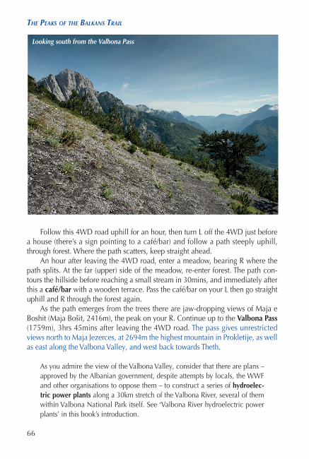
Follow this 4WD road uphill for an hour, then turn L off the 4WD just before a house (there’s a sign pointing to a café/bar) and follow a path steeply uphill, through forest. Where the path scatters, keep straight ahead.
An hour after leaving the 4WD road, enter a meadow, bearing R where the path splits. At the far (upper) side of the meadow, re-enter forest. The path con-tours the hillside before reaching a small stream in 30mins, and immediately after this a café/bar with a wooden terrace. Pass the café/bar on your L then go straight uphill and R through the forest again.
As the path emerges from the trees there are jaw-dropping views of Maja e Boshit (Maja Bošit, 2416m), the peak on your R. Continue up to the Valbona Pass (1759m), 3hrs 45mins after leaving the 4WD road. The pass gives unrestricted views north to Maja Jezerces, at 2694m the highest mountain in Prokletije, as well as east along the Valbona Valley, and west back towards Theth.
As you admire the view of the Valbona Valley, consider that there are plans – approved by the Albanian government, despite attempts by locals, the WWF and other organisations to oppose them – to construct a series of hydroelec-tric power plants along a 30km stretch of the Valbona River, several of them within Valbona National Park itself. See ‘Valbona River hydroelectric power plants’ in this book’s introduction.
Looking south from the Valbona Pass
770 Peaks of the Balkans.indd 66 10/08/2017 11:52

sTaGe 1 – TheTh (alBania) – valBona (alBania)
67
Turn L from the pass and descend gradually NW, below crumbling cliffs (watch out for falling rocks) the base of which are carpeted with flowers. Follow the trail as it zigzags steeply downhill, passing a huge boulder then crossing a boulder-strewn dry stream bed, the trail marked by an occasional cairn.
Go along a clear trail through forest, then an hour from the Valbona Pass bear R to reach a small stream and a café/bar which also offers camping spots. Bear L above the café/bar, go steeply downhill (slippery) to reach another café and campsite by a stream, near Rragrami, 90mins from the Valbona Pass.
Follow a 4WD track downhill for a further 10mins to reach the broad, grav-elly valley floor, by a signpost pointing back to Theth. Continue along the valley floor on a 4WD, initially faint then clearer, to arrive at the end of an asphalt road beside the large Fusha e Gjes Hotel in 45mins.
Go straight ahead along the asphalt road to reach the scattered houses of Valbona – the village is spread along the valley floor for around 10km. It takes 45mins from the start of the asphalt road to the Jezerca Guesthouse, which is on your R soon after a large ruined building, shortly before the trail to the Prosllopit Pass (this central part of Valbona is called Valbona Qender); and a further 20mins to the Rilindja Guesthouse (an area of Valbona called Ququ i Valbonës).
Peaks above the Valbona Valley, from the Valbona Pass
770 Peaks of the Balkans.indd 67 10/08/2017 11:52

68
The peaks of The Balkans Trail
VALBONA
Valbona village stretches around 10km along the valley floor and is on an asphalt road to Bajram Curri. Valbona National Park covers an area of 8000ha in the surrounding valley, walled in by peaks such as Maja Jezerces, Maja Rosit and Maja Kolata. For information on the current, potentially dis-astrous proposals to build 30 hydroelectric power plants on the Valbona River, eight of them in the national park itself, see ‘National parks and nature reserves’.Food and lodging
Rilindja Guesthouse (tel +355 (0)67 3014 637; www.journeytovalbona.com; food served). Beautiful guesthouse run by an American/Albanian couple who have been at the forefront of establishing local, sustainable tourism in the area.
Kelmend Selimaj Guesthouse & Jezerces Restaurant (tel +355 (0)67 3093 406; food served). Large rooms with several beds in an old stone house, conveniently located almost opposite the start of the route up to the Prosllopit Pass.
For further accommodation options see www.journeytovalbona.com (select ‘Where to Stay’)
Info
The best source of tourist information in Valbona is the Rilindja Guesthouse.
Transport
A minibus leaves Valbona early in the morning for Bajram Curri.
770 Peaks of the Balkans.indd 68 10/08/2017 11:52