the marriage of astronomy and culture ... this is a study of the early bronze age cairns at...
TRANSCRIPT

THE MARRIAGE OF ASTRONOMY AND CULTURE: THEORY AND METHOD IN THE STUDY OF
CULTURAL ASTRONOMY
A special issue of Culture and Cosmos Vol. 21 no. 1
Spring/Summer 2017
Copyright © 2017 Culture and Cosmos All rights reserved
Published by Culture and Cosmos & Sophia Centre Press
England
www.cultureandcosmos.org
In association with the Sophia Centre for the Study of Cosmology in Culture,
University of Wales Trinity Saint David, Faculty of Humanities and the Performing Arts Lampeter, Ceredigion, Wales, SA48 7ED, UK
British Library Cataloguing in Publication Data A catalogue card for this book is available from the British Library
All rights reserved. No part of this book may be reproduced or utilized in any form or by any means, electronic or mechanical, including photocopying, recording or by any information storage and retrieval system, without permission in writing from the Publishers.
ISSN 1368-6534
Printed in Great Britain by Lightning Source

_________________________________________________________________ J. Anna Estaroth, ‘Clava Cairns, Midwinter Sunset and the Minor Lunar Limit’, The Marriage of Astronomy and Culture, a special issue of Culture and Cosmos, Vol. 21, nos. 1 and 2, 2017, pp. 51–71. www.CultureAndCosmos.org
Clava Cairns, Midwinter Sunset and the Minor Lunar Limit
J. Anna Estaroth Abstract: This is a study of the Early Bronze Age cairns at Balnuaran of Clava, near Inverness, Scottish Central Highlands, from the perspective of skyscape archaeology. The site’s solar orientations link it with Maeshowe in Orkney. The role of lunar limits is discussed with special reference to Balnuaran of Clava Central and its rays, which link the site to Stonehenge in Wessex. New alignments are investigated, in order to verify skyscape phenomena and integrate them with previous academic research. The importance of seasonal alterations in light and darkness leads to a suggestion that Clava monument-types may be qualitatively different. Passage-graves appear to be associated with midwinter sunset, the nearest new Moon, minor lunar limits and darkness, although light is still significant. Conversely ring-cairns seem to be associated with sunrise, the midsummer full Moon, major lunar limits and light, yet they have dark connotations, leading to conclusions that the role of light and darkness is paramount in understanding these monuments. Introduction This paper explores three Clava cairn monuments (one ring-cairn and two passage-graves) from a skyscape archaeology perspective, touching on their geographical, cultural, environmental and chronological context. The cairns at Balnuaran of Clava (henceforth Balnuaran) are the best preserved Early Bronze Age (EBA) monuments of the Clava tradition with two exhibiting a midwinter sunset alignment. Antiquarian interest is noted and archaeological research considered, so that their social significance can be comprehended. Skyscape archaeology methodology is outlined and fieldwork started with winter solstice measurements, when the setting Sun shone into the two passage-graves. Clava cairns are described, using Balnuaran Northeast as an example, to clarify the integration of cairn and standing stone circle, and the importance of their southwest orientations is discussed. The study set out to explore the rays, apparently unique to Balnuaran Central ring-cairn, which are low rubble causeways connecting the cairn peristalith to four of the surrounding circle orthostats. These rays have several

Culture and Cosmos
52 Clava Cairns, Midwinter Sunset and the Minor Lunar Limit
alignments, and comparisons were made with Stonehenge, which exhibits orientation to midwinter sunset and the minor lunar limit. The double alignment (midwinter and minor limit) has implications for the wider context of Orkney and Wessex, which were locations of cultural dominance in prehistory. Richard Bradley noted that the three EBA monuments at Balnuaran are not in a straight line; the central ring-cairn appears offset, which he realised permitted midsummer sunrise to light up the back of Balnuaran Northeast, Balnuaran Central and Mains of Clava Northwest (the last is in the neighbouring field).1 Considering this layout generated the main research question as to whether two theoretical groupings could be relevant for this site: the longest darkest night of the year (midwinter), minor lunar limits, new Moons and ceremonies of darkness as opposed to the longest day of the year (midsummer), major lunar limits, full Moons and ceremonies of light. The unique nature of Balnuaran generated further research questions regarding the significance of all Clava ring-cairns and whether they have greater meaning as life-affirming structures, rather than being purely burial monuments. Finally the significance of seasonal dark and light will be considered, asking whether passage-graves and ring-cairns may have had either binary or separate functions, based on their unique relationship with the Sun and Moon. Clava cairns in their environment The Clava area had intermittent use, primarily burial, over more than four thousand years. Bradley’s radiocarbon dates (calibrated to two sigma confidence level) proved there was evidence of Mesolithic activities between 5474–5242 BCE at Balnuaran Northeast and Central.2 Bradley suggested that the monuments were constructed during the EBA, when people were largely pastoralists.3 There was extensive reuse during the Late Bronze Age 1100–800 BCE.4 Moving into the early medieval period there was a Pictish cremation (653–856 CE) and the onsite notice at Milton of Clava South, less than 800 metres away, said it was converted into a Chapel with graveyard around 1100 CE.5 This may have lasted until the 1 Richard Bradley, The Good Stones: A New Investigation of the Clava Cairns (Edinburgh and Kings Stanley: Society of Antiquaries of Scotland Monograph Series No. 17, 2000), p. 126. 2 Bradley, Good Stones, p. 115. 3 Bradley, Good Stones, p. 157. 4 Bradley, Good Stones, p. 119. 5 Bradley, Good Stones, pp. 115, 114–19; Historic Scotland onsite notice board.
J. Anna Estaroth
Culture and Cosmos
53
Reformation during the Early Modern Period. George and Peter Anderson reported that unbaptized children were ‘still buried’ at this disused chapel and Cosmo Innes reported finding a secret burial of ‘unchristianed children’, in a ruined chapel, in the mid 1800’s, suggesting this practice was reasonably widespread, as unbaptized children could not be buried in normal graveyards.6 While this would be for Christian reasons, it indicates the long-term use of the valley for burial/religious purposes. Bradley found recent depositions of crystals and coins during his 1990’s excavations.7 The name Clava refers to a district along the valley of the river Nairn near Inverness which has eleven monuments within 0.2 square kilometres. Five are at Balnuaran, (two of which are late Bronze Age additions); one at Culdoich, three at Mains of Clava and two further monuments are at Milton of Clava.8 Milton of Clava North is an accepted cairn, while Milton of Clava South is disputed, although Niall Sharples discussed a nearby mound as yet another possible Clava cairn.9 The cairns this paper explores are the three main EBA cairns at Balnuaran. Clava cairns are a distinct group of EBA monuments found in the Central Highlands of Scotland of which there are two styles: ring-cairns and passage-graves. They are particular to the Central Highlands, mainly concentrated around the Inverness area, which functions as a trading hub today, much as it may have done in prehistory. This region has good water-transport links: V. Gordon Childe noted that ‘you could see Orkney’ on a clear day from the Moray Firth, and Stuart Needham reasoned the location was ‘pivotal’ in early Bronze Age trade links with Ireland via Loch Ness.10
6 George Anderson and Peter Anderson, Guide to the Highland and Islands of Scotland, Including Orkney and Zetland, description of their scenery, statistics, antiquities and natural history with numerous historical notes and a complete map 3rd edition (Edinburgh: G. Parker, 1851), p. 370; Cosmo Innes, ‘Notice of a tomb on the hill of Roseisle, Morayshire recently opened; also of the chambered cairns and stone circles of Clava, in Nairnshire’, Proceedings of the Society of Antiquaries Scotland 3 (1857–60): pp. 47–50, p.48. 7 Bradley, Good Stones, p. 231. 8 Bradley, Good Stones, p. 15. 9 Niall M Sharples, ‘Excavations at Milton of Clava, Inverness-shire’, Glasgow Archaeological Journal 8 (1995): pp. 1–9, p. 2. 10 V. Gordon Childe, Scotland Before the Scots being the Rhind Lectures for 1944 (London: Methuen, 1946), p. 20; Stuart Needham, ‘Migdale-Marnoch: Sunburst of Scottish Metallurgy’, in Ian Shepherd and Gordon J. Barclay, eds., Scotland in Ancient Europe: The Neolithic and Early Bronze Age of Scotland in their European Context (Edinburgh: Society of Antiquaries of Scotland, 2004), pp. 217–45, p. 241.
Culture and Cosmos
54 Clava Cairns, Midwinter Sunset and the Minor Lunar Limit
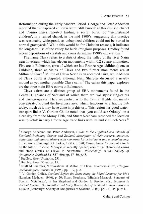
Alan McKirdy stated the hills were ‘deeply scarred’ by ice-age erosion, which flowed NE until approximately ‘11.700 years ago’, but the overall topography is largely unchanged for the past 5,000 years.11 Childe’s 1946 map is adapted to show the cairns in their cultural context, with the Clava cairns largely grouped at the head of Loch Ness and the entrance to the Moray Firth (Fig.1). It also helps to put the cairns in their archaeological context. The circles represent Clava cairns and the triangles represent recumbent stone circles (RSCs) a neighbouring cultural group, for which Richard Bradley identified various similarities, such as lunar orientation, though he found many distinctive differences, such as their ‘landscape setting’.12 More Clava cairns have been identified since Childe’s day; Bradley lists fifty.13
Fig. 1 Scottish Central Highlands. Clava cairns (circles) largely cluster around the mouth of river Ness at Inverness (indicated). The RSCs (triangles) are to the east. The Finglenny Hill Axe Hoard is located between the two groups. Map adapted from Gordon Childe.14
Without radiocarbon dating Childe was unaware that Clava cairns were
contemporaneous with the later stages of both RSCs and Stonehenge. The most recent archaeological survey of Clava cairns was undertaken by Bradley in the 1990’s and he firmly placed these monuments in the EBA, with construction dates between ‘2340 to 2030 BCE’.15 Liz Henty, who researched Tomnaverie RSC, provided construction dates between ‘2580
11 Alan McKirdy, Set in Stone: The Geology and Landscapes of Scotland (Edinburgh: Birlinn, 2015), pp. 36, 67. 12 Richard Bradley, The Moon and the Bonfire: An Investigation of Three Stone Circles in North-east Scotland (Edinburgh: Society of Antiquaries of Scotland, 2005), p. 114. 13 Bradley, Good Stones, p. 172. 14 Childe, Scotland Before the Scots, p. 104. 15 Bradley, Good Stones, p. 157.

J. Anna Estaroth
Culture and Cosmos
55
BCE to 2220 BCE’ based on Bradley’s excavation data.16 Martyn Barber noted that one of the earliest bronze axes manufactured in Britain comes from a hoard buried on the boundary between these two cultural groups at Finglenny Hill (marked with an arrow in Fig.1).17 The location of Clava cairns was considered significant by Needham, in his study of early metallurgy, because they lay at the head of Loch Ness, a position which controlled trade routes for both raw materials from southern Ireland and prestige finished goods, the manufacture of which ‘centered around Buchan’.18 Other Neolithic cultural monuments such as the Orkney-Cromarty-Hebridean chambered tombs lie to the northwest and the Clyde cairns are to the south. Antiquarians have shown interest in these monuments; Mrs. Campbell’s initial excavations in 1820 uncovered some remains now lost at Balnuaran Southwest and George Bain described the lack of an ‘authentic account’ for the 1850 opening of Balnuaran Northeast.19 James Fraser’s 1884 ‘ground plan’ indicated which stones were restored, enabling a degree of assurance about using certain stones for measuring alignments today, although poor site maintenance irritated George Browne and images of his visit (around 1920) can be seen online at the Canmore website, which stores thousands of records for Historic Environment Scotland, the government body responsible for maintaining these monuments.20 At these latitudes (north of 57°) and with the curvature of the earth, light and dark are diurnal, but more significantly they are seasonal. In summer the Sun never fully sets, it lies just beneath the horizon creating twilight; for which the Scottish term is the gloaming. After sunset a thin layer of lighter blue sky highlights the northern horizon, dimming stars to an altitude of five to ten degrees, but the rest of the night sky is visible as
16 Liz Henty, ‘The Archaeoastronomy of Tomnaverie Recumbent Stone Circle: A Comparison of Methodologies’, Papers from the Institute of Archaeology 24, no. 1 (2014): pp. 1–15, p. 3. 17 Martyn Barber, Bronze and the Bronze Age Metalwork and Society in Britain c2500–800 BC (Stroud: Tempus Publ., 2003), p. 50. 18 Needham, ‘Migdale-Marnoch: Sunburst of Scottish Metallurgy’, p. 236. 19 George Bain, History of Nairnshire (1893; Nairn: Telegraph Office, 1928), p. 6. 20 James Fraser, ‘Descriptive Notes of the Stone Circles of Strathnairn and Neighbourhood of Inverness’, Proceedings of the Society of Antiquaries of Scotland 18 (1884): pp. 328–62, p. 342; George Forrest Browne, On Some Antiquities in the Neighbourhood Of Dunecht House Aberdeenshire (Cambridge: Cambridge Press, 1921), Pl XXXVI, p.192; https://canmore.org.uk/collection/121933 [accessed 10 Feb. 2015].
Culture and Cosmos
56 Clava Cairns, Midwinter Sunset and the Minor Lunar Limit
normal. John Lister-Kaye, who lives near Clava, commented that ‘night recedes to only ninety minutes in twenty-four hours at midsummer’ compared to eighteen hours of darkness at midwinter.21 Conversely Margaret and Gerald Ponting stated the winter full Moon during major limit years lights up the night sky for ‘twenty two hours’ at Calanais.22 Scotland is a place for extremes of light and dark. Methodology Using a clinometer, a GPS locator and good quality compass the methodology used was that advocated by Fabio Silva, in his study of Portuguese tombs, where he defined a ‘window of visibility’ as the ‘region of the horizon, given the structure’s corridor and entrance geometry, which can be seen from within the chamber’.23 Although passages at Balnuaran are sufficiently straight as to merit theodolite measurement, this was part of a larger study, where the bulk of cairns were considerably more ruinous. No straight line existed and many were in inconvenient locations, hence this selection of measuring devices. Measurements were taken from the edge of the right-sided orthostat at the chamber end of the passage diagonally opposite to the left-sided orthostat at the passage entrance and from the left-sided chamber stone to the right-sided entrance stone, generating a range of azimuths and declinations, rather than just one figure. Similarly when measuring from the kerb-stone edges to the most substantial circle orthostat, two measurements were taken outlining the area of sky emphasised by that stone’s location; always from the right side of one stone to the left side of the other and again from the left side of one stone to the right side of the other. Measurements were also taken in reverse to check for magnetic anomalies. The largest SW circle orthostat was selected because the largest kerb-stones and their stone circle counterparts were matched by the builders. This was to identify an area of sky, which might be regarded as significant to the builders of the monument. Stellarium planetarium software was used to ascertain solar/lunar positions in 2000 BCE and Photoscape software was used to annotate diagrams.24 21 John Lister-Kaye, Song of the Rolling Earth (London: Abacus, 2004), p. 148. 22 Gerald and Margaret Ponting, Clach an Tursa, Carloway Isle of Lewis (Stornoway: Ponting, 1981), p. 4. 23 Fabio Silva, ‘“A Tomb with a View”: New Methods for bridging the gap between land and sky in megalithic archaeology’, Advances in Archaeological Practice 2, no. 1 (2014): pp. 24–37, p. 27. 24 http://www.stellarium.org [accessed on 4 Jan. 2017];

J. Anna Estaroth
Culture and Cosmos
57
Skyscape archaeology – the Balnuaran Enclosure A common feature of all Clava cairns is their SW focus: passages are SW orientated and the largest orthostat for each of the cairns is always positioned towards the SW. Thus the monuments’ potential relationship with the SW horizon was considered most important. Bradley’s contour map of the Balnuaran enclosure area, shown from above, indicates the three main cairns, and is adapted to illustrate alignments (Fig. 2).
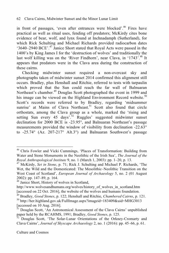
Fig. 2 Balnuaran Enclosure: The grey areas represent the cairns’ platforms and the darker marks are the orthostats which constitute the chamber boundaries, the central ring, the peristaliths and the standing stones encircling each cairn. The grey contour lines indicate bedrock. The red line indicates midwinter sunset showing how it connects the passage-graves with two of Central’s circle-stones. The two blue lines show kerb and circle-orthostats which align with the southern minor moonset. Numbers indicate the tallest circle-orthostats. Diagram adapted from Richard Bradley.25
The right-hand cairn is Balnuaran Northeast, (57° N 28’ 24.25” 004° W 04’ 23.63” elevation 98 m), the middle cairn is Balnuaran Central (57° N 20’ 22.76” 004° W 04’ 26.79” elevation 99 m) and the left cairn is Balnuaran Southwest (57° N 28’ 21.01” 004° W 04’ 28.25” elevation 96 m). The largest circle-orthostat for each cairn is in the SW, indicated by the numbers 1, 2 and 3. The midwinter Sun sets along Balnuaran Southwest’s passage (3) connects with the two stones which are part of Balnuaran Central’s circle http://www.photoscape.org., [Accessed on 13th January 2015]. 25 Bradley, Good Stones, p.16.

Culture and Cosmos
58 Clava Cairns, Midwinter Sunset and the Minor Lunar Limit
(2) and along Balnuaran Northeast’s passage (1) to the back wall; indicated by the red line in Fig. 2. Balnuaran Central ring-cairn’s rays appear to deliberately integrate its circle with the two passage-graves. This midwinter sunset alignment was first discovered by Boyle Somerville in 1910 and Alexander Thom expanded upon how the ray-marked stones of Balnuaran Central were picked out by the midwinter sunset.26 Clive Ruggles commented that many Clava cairns are ‘orientated with respect to the Moon’ particularly the major limit midsummer full Moon.27 Additionally Ruggles noted that the Balnuaran group encapsulated ‘symbolism not found elsewhere’ such as solar alignments, and incorporated ‘coloured stonework’, making this group exceptional.28 Bradley looked at lunar alignments along the passages of Balnuaran Southwest and Northeast noting they were ‘less precise’ than solar, which is the case, although he did not explore Somerville’s historical orientations regarding the largest circle-orthostat.29 This research found that the largest circle orthostats (the stones corresponding to numbers 1, 2 and 3 in Fig. 2) align with the southern minor limit moonset, for which Ruggles suggested a declination of -19.6° for 2000 BCE, as indicated by two blue lines in Fig. 2.30 Ruggles explained that declinations ‘gradually change’ over time, so any declination needs to be checked against its estimated prehistorical date.31 Balnuaran Southwest’s significant orthostat, (opposite the largest peristalith stone), is broken and much smaller than the other two. The declinations and corresponding Azimuths are as follows:
Balnuaran Northeast -19.33° to -22.75° (Az. 224°-232°, Alt. 0°), Balnuaran Central -17.49° to -22.75° (Az. 224°-236°, Alt 0°), Balnuaran Southwest -12.12 to -22.75° (Az. 224°-247°, Alt 0°).
This alignment occurs when measured from their kerb counterparts and in the case of Balnuaran Central and Balnuaran Northeast they also align with 26 H. B. Somerville, ‘Instances of Orientations in Prehistoric Monuments in the British Isles.’ Archaeologia 73 (Second Series) (Jan. 1923): pp. 193–224, p. 200; Alexander Thom, ‘Megalithic Astronomy: Indications in Standing Stones’, Vistas in Astronomy 7 (1966): pp. 1–57, p. 19. 27 Clive Ruggles, Astronomy in Prehistoric Britain and Ireland (New Haven: Yale University Press, 1999), p. 246. 28 Ruggles, Prehistoric Britain, pp.157, 246. 29 Bradley, Good Stones, p. 26; Personal Communication. 30 Ruggles, Prehistoric Britain, p. 57. 31 Ruggles, Prehistoric Britain, p. 57.

J. Anna Estaroth
Culture and Cosmos
59
each other and the centre of Balnuaran Northeast’s chamber, making five separate points of connecting rays. Fraser informed us that all three significant circle-orthostats had been ‘shifted’ in antiquity, which may explain why the NE orthostat is only close to -19.6°(-19.33 to -22.75), although the largest kerb-orthostats remain unaltered.32 According to Henshall and Ritchie the fallen largest SW orthostat for Balnuaran Northeast was reset about 6 feet (1.8m) further ‘southwest from the kerb’ prior to Fraser’s visit, roughly in line with its original position.33 The greatest problem is posed by how far it was misplaced sideways of the original position, within the circle. Henshall and Ritchie estimated the neighbouring circle stones (which were also reset in antiquity) were ‘close to the original position’; as the largest circle-orthostat appears half way between these stones, it is probably near its original position, but this location is inaccurate.34 These alignments hint at intentionality for lunar orientation from the unaltered kerb-orthostat positions but, given the repositioning in antiquity of the largest circle-stone at Balnuaran Northeast, it is insecure. Somerville, who measured every circle stone for the three monuments, provided diagrams which show the ‘winter solstitial sunset’ alignment along Balnuaran Northeast’s passage.35 This indicates a similarity to Maeshowe in Orkney, where Aubrey Burl described the midwinter sunset glow could ‘reach the central chamber’, although Maeshowe is Neolithic and retains its roof, which these EBA monuments do not.36 Bradley described the sunset alignments as linking Clava, Maeshowe, ‘Cornish entrance-graves’ and Irish Wedge-shaped tombs.37 Orkney’s Maeshowe was utilised, according to Gordon Noble, from ‘2,800 to 2,200 BCE’, which suggests that the monument fell into disuse just as Clava cairns
32 Fraser, ‘Descriptive Notes of the Stone Circles’, p. 342. 33 Audrey Shore Henshall and James Neil Graham Ritchie, The Chambered Cairns of the Central Highlands: An inventory of the Structures and their Contents (Bath: Edinburgh University Press, 1988), p. 204. 34 Henshall and Ritchie, Chambered Cairns, p. 205. 35 H. B. Somerville, Royal Anthropological Institute MS 267, f. 159. 36 Aubrey Burl, Prehistoric Astronomy and Ritual (1983; repr. Aylesbury: Shire Archaeology, 1997), p. 26. 37 Richard Bradley, ‘After the Great Stone Circles’ in Richard Bradley and Nimura Courtney, eds., The Use and Reuse of Stone Circles: Fieldwork at Five Scottish Monuments and its Implications (Oxford: Oxbow Books, 2016), pp. 112–21, p.113.

Culture and Cosmos
60 Clava Cairns, Midwinter Sunset and the Minor Lunar Limit
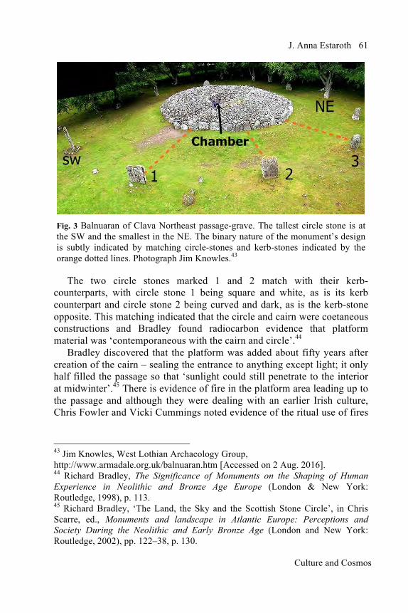
began to be built.38 The visual proximity of the Moray coast and convenience of Clava as a trading centre could have made it attractive to sky-conscious Orcadians. As both monuments align with midwinter sunset, this suggests significant social links, or a common cosmology, hinting at a cosmology of considerable antiquity. Henshall noted that only Maeshowe and Clava are decorated with stone markings.39 If Clava cairns had a secure combination of midwinter sunset and minor lunar limit, it would indicate strong links with Stonehenge (for which Mike Parker-Pearson suggested the ‘last phase of stone construction’ dated to ‘2300–1900’ BCE, with the structure being abandoned approximately ‘1640–1520’ BCE), suggesting the possibility that sky knowledge was either shared between Wessex, Orkney and Clava or that they accessed a common cosmology from another source.40 This would reinforce Bradley’s argument that ‘political dominance’ was transferred from ‘Northern Britain back to Wessex’.41 Skyscape archaeology – Balnuaran’s two Passage-graves Jim Knowles’ photograph is adapted to show Balnuaran Northeast which is a good example of a passage-grave, containing a central chamber with a passage, (Fig. 3). The kerb-stones of the cairn’s peristalith are much larger than the abundant cairn material. The cairn itself is surrounded by a grass-covered rubble platform, which is then surrounded by a free-standing stone circle. The defining Clava feature is that all orthostats in both the kerb and circle are smallest at the NE and gradually increase in height, with the tallest in the SW. The overall size of the monuments is such that an extended family group could easily build them. Henshall provided these measurements for Balnuaran Northeast circle: the NE stone was 1.6m high while the SW stone was 2.74 m.42 Significantly, many circle orthostats were matched with their opposing kerb-stones, either by shape, colour, size or type of stone, as can be seen in Fig. 3. 38 Gordon Noble, Neolithic Scotland Timber, Stone, Earth and Fire (Edinburgh: Edinburgh University Press, 2006), p. 107. 39 Audrey Shore Henshall, The Chambered Tombs of Scotland Vol. 2 (Aberdeen: Edinburgh University Press, 1972), p. 284, [Hereafter Henshall, Vol. 2]. 40 Michael Parker-Pearson, Bronze Age Britain (London: B. T. Batsford, 1993), p. 93. 41 Richard Bradley, The Social Foundations of Prehistoric Britain: Themes and Variations in the Archaeology of Power, Longman Archaeology Series (London and New York: Longman Group, 1984), p. 65. 42 Audrey Shore Henshall, The Chambered Tombs of Scotland Vol. 1 (Aberdeen: Edinburgh University Press, 1963), p. 364, [Hereafter, Henshall Vol. 1].
J. Anna Estaroth
Culture and Cosmos
61
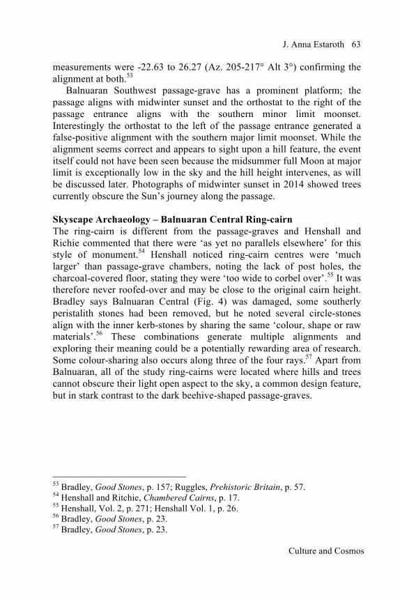
Fig. 3 Balnuaran of Clava Northeast passage-grave. The tallest circle stone is at the SW and the smallest in the NE. The binary nature of the monument’s design is subtly indicated by matching circle-stones and kerb-stones indicated by the orange dotted lines. Photograph Jim Knowles.43
The two circle stones marked 1 and 2 match with their kerb-counterparts, with circle stone 1 being square and white, as is its kerb counterpart and circle stone 2 being curved and dark, as is the kerb-stone opposite. This matching indicated that the circle and cairn were coetaneous constructions and Bradley found radiocarbon evidence that platform material was ‘contemporaneous with the cairn and circle’.44 Bradley discovered that the platform was added about fifty years after creation of the cairn – sealing the entrance to anything except light; it only half filled the passage so that ‘sunlight could still penetrate to the interior at midwinter’.45 There is evidence of fire in the platform area leading up to the passage and although they were dealing with an earlier Irish culture, Chris Fowler and Vicki Cummings noted evidence of the ritual use of fires
43 Jim Knowles, West Lothian Archaeology Group, http://www.armadale.org.uk/balnuaran.htm [Accessed on 2 Aug. 2016]. 44 Richard Bradley, The Significance of Monuments on the Shaping of Human Experience in Neolithic and Bronze Age Europe (London & New York: Routledge, 1998), p. 113. 45 Richard Bradley, ‘The Land, the Sky and the Scottish Stone Circle’, in Chris Scarre, ed., Monuments and landscape in Atlantic Europe: Perceptions and Society During the Neolithic and Early Bronze Age (London and New York: Routledge, 2002), pp. 122–38, p. 130.
Culture and Cosmos
62 Clava Cairns, Midwinter Sunset and the Minor Lunar Limit
in front of passages, ‘even after entrances were blocked’.46 Fires have practical as well as ritual uses, fending off predators; McKirdy cites bone evidence of bear, wolf, and lynx found at Inchnadamph (Sutherland), for which Rick Schulting and Michael Richards provided radiocarbon dates ‘3640–2940 BCE’.47 Janice Short stated that Royal Acts were passed in the 1400’s by King James I for the ‘destruction of wolves’ and traditionally the last wolf killing was on the ‘River Findhorn’, near Clava, in ‘1743’.48 It appears that predators were in the Clava area during the construction of these cairns. Checking midwinter sunset required a non-overcast sky and photographs taken of midwinter sunset 2014 confirmed this alignment still occurs. Bradley, plus Henshall and Ritchie, referred to tests with tarpaulin which proved that the Sun could reach the far wall of Balnuaran Northeast’s chamber.49 Douglas Scott photographed the event in 1999 and his image can be viewed on the Highland Environment Record website.50 Scott’s records were referred to by Bradley, regarding ‘midsummer sunrise’ at Mains of Clava Northeast.51 Scott also found that circle orthostats, among the Clava group as a whole, marked the ‘rising and setting Sun every 45 days’.52 Ruggles’ suggested midwinter sunset declination for 2000 BCE is -23.95°, and Balnuaran Northeast’s passage measurements provided the window of visibility from declination -22.63° to -25.74° (Az. 207-217° Alt.3°) and Balnuaran Southwest’s passage
46 Chris Fowler and Vicki Cummings, ‘Places of Transformation: Building from Water and Stone Monuments in the Neolithic of the Irish Sea’, The Journal of the Royal Anthropological Institute 9, no. 1 (March 1, 2003): pp. 1–20, p. 13. 47 McKirdy, Set in Stone, p. 71; Rick J. Schulting and Michael P. Richards, ‘The Wet, the Wild and the Domesticated: The Mesolithic–Neolithic Transition on the West Coast of Scotland’, European Journal of Archaeology 5, no. 2 (01 August 2002): pp. 147–89, p. 164. 48 Janice Short, History of wolves in Scotland, http://www.wolvesandhumans.org/wolves/history_of_wolves_in_scotland.htm [accessed on 22 Oct. 2016], the website of the wolves and humans foundation. 49 Bradley, Good Stones, p. 122; Henshall and Ritchie, Chambered Cairns, p. 121. 50 http://her.highland.gov.uk/FullImage.aspx?imageid=183409&uid=MHG3013 [accessed on 10 Aug. 2016]. 51 Douglas Scott, ‘An Astronomical Assessment of the Clava Cairns’ unpublished paper held by the RCAHMS, 1991; Bradley, Good Stones, p. 125. 52 Douglas Scott, ‘The Solar-Lunar Orientations of the Orkney-Cromarty and Clava Cairns’, Journal of Skyscape Archaeology 2, no. 1 (2016): pp. 45–66, p. 61.
J. Anna Estaroth
Culture and Cosmos
63
measurements were -22.63 to 26.27 (Az. 205-217° Alt 3°) confirming the alignment at both.53 Balnuaran Southwest passage-grave has a prominent platform; the passage aligns with midwinter sunset and the orthostat to the right of the passage entrance aligns with the southern minor limit moonset. Interestingly the orthostat to the left of the passage entrance generated a false-positive alignment with the southern major limit moonset. While the alignment seems correct and appears to sight upon a hill feature, the event itself could not have been seen because the midsummer full Moon at major limit is exceptionally low in the sky and the hill height intervenes, as will be discussed later. Photographs of midwinter sunset in 2014 showed trees currently obscure the Sun’s journey along the passage. Skyscape Archaeology – Balnuaran Central Ring-cairn The ring-cairn is different from the passage-graves and Henshall and Richie commented that there were ‘as yet no parallels elsewhere’ for this style of monument.54 Henshall noticed ring-cairn centres were ‘much larger’ than passage-grave chambers, noting the lack of post holes, the charcoal-covered floor, stating they were ‘too wide to corbel over’.55 It was therefore never roofed-over and may be close to the original cairn height. Bradley says Balnuaran Central (Fig. 4) was damaged, some southerly peristalith stones had been removed, but he noted several circle-stones align with the inner kerb-stones by sharing the same ‘colour, shape or raw materials’.56 These combinations generate multiple alignments and exploring their meaning could be a potentially rewarding area of research. Some colour-sharing also occurs along three of the four rays.57 Apart from Balnuaran, all of the study ring-cairns were located where hills and trees cannot obscure their light open aspect to the sky, a common design feature, but in stark contrast to the dark beehive-shaped passage-graves.
53 Bradley, Good Stones, p. 157; Ruggles, Prehistoric Britain, p. 57. 54 Henshall and Ritchie, Chambered Cairns, p. 17. 55 Henshall, Vol. 2, p. 271; Henshall Vol. 1, p. 26. 56 Bradley, Good Stones, p. 23. 57 Bradley, Good Stones, p. 23.
Culture and Cosmos
64 Clava Cairns, Midwinter Sunset and the Minor Lunar Limit
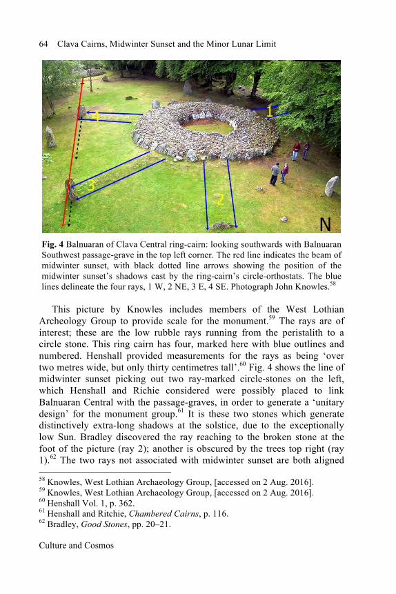
Fig. 4 Balnuaran of Clava Central ring-cairn: looking southwards with Balnuaran Southwest passage-grave in the top left corner. The red line indicates the beam of midwinter sunset, with black dotted line arrows showing the position of the midwinter sunset’s shadows cast by the ring-cairn’s circle-orthostats. The blue lines delineate the four rays, 1 W, 2 NE, 3 E, 4 SE. Photograph John Knowles.58
This picture by Knowles includes members of the West Lothian Archeology Group to provide scale for the monument.59 The rays are of interest; these are the low rubble rays running from the peristalith to a circle stone. This ring cairn has four, marked here with blue outlines and numbered. Henshall provided measurements for the rays as being ‘over two metres wide, but only thirty centimetres tall’.60 Fig. 4 shows the line of midwinter sunset picking out two ray-marked circle-stones on the left, which Henshall and Richie considered were possibly placed to link Balnuaran Central with the passage-graves, in order to generate a ‘unitary design’ for the monument group.61 It is these two stones which generate distinctively extra-long shadows at the solstice, due to the exceptionally low Sun. Bradley discovered the ray reaching to the broken stone at the foot of the picture (ray 2); another is obscured by the trees top right (ray 1).62 The two rays not associated with midwinter sunset are both aligned 58 Knowles, West Lothian Archaeology Group, [accessed on 2 Aug. 2016]. 59 Knowles, West Lothian Archaeology Group, [accessed on 2 Aug. 2016]. 60 Henshall Vol. 1, p. 362. 61 Henshall and Ritchie, Chambered Cairns, p. 116. 62 Bradley, Good Stones, pp. 20–21.

J. Anna Estaroth
Culture and Cosmos
65
with the northern minor limit – moonrise and moonset. Ruggles provided this equation for the lunar centre + (ɛ - 1) - P, and for 2000 BCE his suggested declination figure was +17.95°.63 My figures are declinations +8.96° to + 21.08° (Az. 282°-306°Alt. 3°) for the westerly ray (Fig. 4, ray 1) and declinations +8.11° to +22.45° (Az. 49°-78°Alt. 2°) for the damaged orthostat ray (Fig. 4, ray 2). Because the rays have never been interfered with, this is a safe alignment and definitely suggests that this monument is connected to the minor lunar limit.
Fig. 5 Balnuaran of Clava Central ring-cairn alignments: looking northwards a reverse image of Fig. 4. The red line shows the midwinter sunset beam of light, touching two circle-orthostats connected to the cairn by rays, with grey dotted lines showing the direction of shadows. The purple lines indicate measurements of these rays: E (3) aligns with equinoctial sunrise and SE (4) with midwinter sunrise. The blue lines indicate measurements taken of the other two rays: W (1) aligns with northern minor moonset and NE (2) with northern minor moonrise. The light blue lines indicate measurements taken of the largest SW circle-orthostat which aligns with southern minor moonset. Diagram is adapted from Richard Bradley.64
63 Ruggles, Prehistoric Britain, pp. 37–57. 64 Bradley, Good Stones, p.20.

Culture and Cosmos
66 Clava Cairns, Midwinter Sunset and the Minor Lunar Limit
To avoid bias all ray orthostats were measured from the peristalith of Balnuaran Central. The other two rays are not aligned to lunar horizonal activity, but to solar: one is orientated on equinoctial sunrise declinations -3.54° to +8.20° (Az. 81°-103° Alt. 4°) (Fig. 4, ray 3), and the other orientated on midwinter sunrise declinations -23.01° to -27.00° (Az. 147°-163° Alt 4°) (Fig. 4, ray 4). They link the cairn with the pair of circle-stones which are connected by the shadows cast by midwinter sunset. This resembles, the stone pairs that Olwen Pritchard described as being deliberately ‘arranged to create shadow phenomena’ at the solstices.65 The above shadows would have been visible for participants outside the passage-graves. Essentially this monument is complex in nature having both multiple solar and lunar alignments, unlike any other Clava cairn; it is also the only known ring-cairn to have rays. Bradley’s diagram was adapted to clarify this monument’s alignments (Fig. 5). Discussion The main focus of this study was horizonal events along the southwest. Lionel Sims gave this definition of a lunar standstill or limit: they are the ‘declination measure of the Moon’s geocentric extremes’, allowing for parallax and refraction.66 Because all Clava Cairns are orientated towards the southwest, my focus was on the triple phenomena of the southern moonset at its most southerly extreme of the 18.61 year nodal cycle (southern major limit moonset), the midwinter sunset (an annual event occurring on the horizon halfway between the two lunar events) and the southern moonset at its least southerly extreme of the nodal cycle (southern minor limit moonset). The minor limit peak occurs 9.3 years after the major limit, which in turn follows 9.3 years after the previous minor limit in an unending cyclical basis. Sims cogently explained how the new Moon closest to midwinter during minor limit years, generated the ‘longest and darkest’ period of time for the whole nodal cycle, making it suitable for rituals of darkness.67 Sims used the term ‘phase-locked’ to describe how 65 Olwen Pritchard, ‘Shadows, Stones and Solstices’, Journal of Skyscape Archaeology 2, no. 2 (2016): pp. 145–64, p. 160. 66 Lionel D. Sims, ‘What is a Lunar Standstill? Problems of Accuracy and Validity in ‘The Thom paradigm’, Mediterranean Archaeology & Archaeometry 6, no. 3 (2006): pp. 157–63, p.157. 67 Lionel Duke Sims, ‘The “Solarization’ of the Moon: Manipulated Knowledge at Stonehenge’, Cambridge Archaeological Journal 16, no. 2 (Jun. 2006): pp. 191–207, p. 203.

J. Anna Estaroth
Culture and Cosmos
67
the builders of Stonehenge deliberately integrated both solar and lunar alignments, as the builders of these monuments appear to have done.68 J. McKim Malville refuted Sims’ arguments regarding dark Moon, minor lunar limits and midwinter sunset darkness ceremonies but, citing ethnographic evidence, argued instead for a ‘three-day death/rebirth’ festival at midwinter, with the purpose of regenerating the waning Moon, rather than focusing on darkness.69 Sims responded to this by arguing that ‘rituals follow a time-resistant syntax’ allowing for multiple adjustments from hunter-gathering and then pastoralism to agricultural economies and that the dark Moon was essential to these transformations.70 Whichever meaning was attached to the lunar limit and midwinter combinations, they appear to have been important for the Clava cairn builders. Bradley has recently contrasted night and human remains with ‘sunrise and the domestic world’ and this theme of darkness and light is reflected in the seasonal changes Scotland experiences.71 Significantly, the full Moon, falling closest to midsummer on major limit years, generally provides light for twenty-four hours. There are other combinations, such as minor limit dark moon and midsummer, or major limit full Moon and midwinter. However the combinations considered in this paper are the new Moon nearest midwinter on minor limit years connected with darkness, and the full Moon nearest midsummer on major limit years connected with light, because these lunar limits are associated with the most extensive periods of darkness and light, which is particularly relevant for these latitudes. Looking at the combined three cairns (Fig. 2) it is noticeable that they were not built in a straight line. The central cairn had no great height and it would not have blocked midwinter sunset arriving at both passage-graves. Something prevented the builders placing them in one line. Sims provided an excellent diagram of solar and lunar risings along the entire horizon for Stonehenge, which has midwinter sunset largely opposite midsummer
68 Sims, ‘What is a Lunar Standstill?’, p.160. 69 J. McKim Malville, ‘The Enigma of Lunar Standstills’, Journal of Skyscape Archaeology 2, no. 1 (2016): pp. 85–94, p. 93. 70 Lionel Sims, ‘Forum Reply’, Journal of Skyscape Archaeology 2, no. 1 (2016): pp. 96–99, p. 97. 71 Richard Bradley, ‘The Dark Side of the Sky: The Orientations of Earlier Prehistoric Monuments in Britain and Ireland’, in Marion Dowd and Robert Hensey, eds., The Archaeology of Darkness (Oxford: Oxbow books, 2016), pp. 51–61, p. 59.

Culture and Cosmos
68 Clava Cairns, Midwinter Sunset and the Minor Lunar Limit
sunrise, because it is appreciably flatter than in the Nairn valley.72 John North commented that even small changes in altitude have a ‘very marked effect’: elevating the horizon by a quarter of a degree may move the rising point by a ‘complete solar diameter’.73 Unlike Stonehenge, at Clava the hills cause the visible midsummer sunrise to occur further to the east; midsummer sunrise is therefore not opposite midwinter sunset. Bradley produced a diagram which illustrated these solar alignments showing the two passage-graves align with midwinter sunset, while midsummer sunrise picks out the back of Balnuaran Northeast, Balnuaran Central and Mains of Clava Northeast.74 This is not an alignment based on Balnuaran Central’s individual circle-stones and Scott’s 2014 survey indicated that the cairn aligns with sunrise on ‘20th May and 20th August’.75 Conversely my survey of the rays indicates equinoctial sunrise and midwinter sunrise for Balnuaran Central, all of which suggests it is a sunrise cairn. Bradley also noted how red sandstone was used to face the setting Sun at Balnuaran Northeast, but those stones facing the rising Sun ‘contain inclusions of quartz’.76 Frank Prendergast explained in this year’s SEAC public lecture, that quartz was usually employed at the front of prehistoric buildings, but this exceptional position made sense, if the quartz was there to reflect the midsummer sunrise.77 Ruggles however connects quartz with ceremonies associated with ‘movements of the moon’.78 If the builders had wanted a largely opposite midsummer/midwinter aligned monument, they could have done so at nearby Newtown of Petty which is only 4.7 kilometres north of this site, has an open outlook over the Moray Firth and ‘radiocarbon dates’ indicate it was constructed contemporaneously.79 This suggests that the central cairn could have been
72 Lionel D. Sims, ‘What is a Minor Standstill of the Moon’, Journal of Skyscape Archaeology 2, no. 1 (2016): pp. 67–76, p. 68. 73 J.D. North, Stonehenge: Neolithic Man and the Cosmos (London: HarperCollins, 1996), p. 227. 74 Bradley, Good Stones, p. 126. 75 Scott, ‘Solar-Lunar Orientations’, p. 52. 76 Bradley, Good Stones, p. 126; Bradley, ‘Dark Side of the Sky’, p. 54. 77 Frank Prendergast, Exploring the Monuments and the Cosmology of the Boyne Valley, https://www.youtube.com/watch?v=Jpqvno7kDqU [accessed 26 Sept. 2016]. 78 Ruggles, Prehistoric Britain, p.124. 79 Richard Bradley and Margaret Mathews, ‘The Clava Ring-cairn at Newton of Petty, Excavations by John Thawley 1975–77’, in Richard Bradley (ed.) The Good Stones a New Investigation of the Clava Cairns (Edinburgh and Kings Stanley: Society of Antiquaries of Scotland Monograph Series No. 17, 2000), pp. 131–59, p. 158.

J. Anna Estaroth
Culture and Cosmos
69
intentionally offset in order to catch midsummer sunrise. Balnuaran Central combines midwinter sunset and the southern minor lunar limit, plus midsummer sunrise and the northern minor lunar limit, both of which have dark Moon connotations. Potentially the passage-graves were associated with midwinter sunset, dark and the transformation of the dead, while the ring-cairn was a cairn of midsummer sunrise, light and the transformation of the living. On major lunar limit years the Sun is just below the northern horizon and the full Moon nearest midsummer is just above the southerly horizon. The full Moon is effectively blocked by the southerly hills which at Balnuaran have an altitude of five degrees. It varies, but Stellarium planetarium software shows that the midsummer full Moon usually achieves a maximum altitude around 2°50’.80 The Moon is so low that, not only does it not appear above the hills on major limit years, but it has insufficient height to raise above them on years either side of the major limit. Occasionally the Moon sits on the hilltop, briefly slides or skims along the hill then sets, which could be visually dramatic. For up to five years of the 18.61 lunar nodal cycles, the midsummer full Moon at Clava does not visibly rise and set normally; where normal means the upper lunar rim rises first, the moon gains some height and then the upper rim sets last. On major lunar limit years the Clava valley is cast in shadow when the rest of the district is bathed in moonlight. The Moon could be thought of as connecting with the underworld or hiding in the earth. It is significant that at Balnuaran no orthostat actually orientates to the major lunar limit, the orientations are towards minor lunar limits and solar orientations, primarily midwinter, but midsummer and equinox as well. Conclusions This paper considered the three main cairns at Balnuaran, describing them in their geographical and cultural context as well as considering the relevant academic research. They were examined from a skyscape archaeology perspective as part of a larger study comparing hilltop with riverside cairns. The results confirmed solar passage-grave alignments, but also established new lunar and solar alignments. The study found that Balnuaran Central has rays aligned with northern moonrise and moonset during minor limit years and an orthostat which potentially aligns with the southern minor limit moonset. In addition two other rays align with equinoctial sunrise and midwinter sunrise, while marking out two circle-
80 http://www.stellarium.org [accessed on 4 Jan. 2017].

Culture and Cosmos
70 Clava Cairns, Midwinter Sunset and the Minor Lunar Limit
orthostats which generate shadows during midwinter sunset. The danger of antiquarian re-structuring was recognised, which activated other methods of ascertaining whether lunar alignments existed. The methodology enabled confirmation of Somerville’s and Thom’s work, while incorporating some of Bradley’s archaeological discoveries.
The specific topography at Balnuaran is why, on major lunar limit years, these cairns are in darkness while everywhere else is bathed in moonlight. This posed a number of questions about this location, leading to further comparative research across the Clava region relating to the major lunar limit. The size of many ring-cairns visited by the author suggests an inclusive summer event was possible. The builders might have also gathered, nine or ten years later, for new Moon nearest midwinter during minor limit years; the passage-graves being off-limits. For at least thirteen years of the lunar nodal cycle the midsummer full Moon would bathe the central ring-cairn in light, making it suitable for gatherings. From this it could be concluded that ring-cairns might have functioned as social gathering-centres and potentially as star-schools, particularly during major limit years, when the Moon was invisible and its light did not mask starlight. These unusual circumstances may have led them to build so many monuments at this location. Achieving dark during cosmic light was quite exceptional. To add weight to this conclusion further research at the next non-overcast, major limit midsummer full Moon would be desirable. Both solar and lunar alignments were significant for the builders of Clava cairns and it is possible that they learnt their sky-observation skills from Orkney practitioners. The shared archaeoastronomical evidence suggests that sky-watching skills were evident at Maeshowe in Orkney, at Stonehenge in Wessex and at Balnuaran and these could have been dispersed by trade and interchange or been seeded from an earlier common cultural heritage. Balnuaran and the Clava region’s pivotal position regarding prestigious early bronze axe manufacture and the exceptionally low midsummer full Moon, which was hidden by the hill on major lunar limit years, may have made it a magnet for celestial expertise. This conclusion indicates the need for integrating Clava cairns into any exploration of the wider archaeoastronomical, socio-political environment in EBA Britain, particularly with Maeshowe, Stonehenge and Aberdeenshire’s RSCs. The Balnuaran complex exhibits the winter solstice sunset alignment, which might be considered sufficient to explain their purpose. However the ring-cairn’s alignments are with the southern minor moonset and, through the rays, with the northern minor moonrise and set, with equinoctial

J. Anna Estaroth
Culture and Cosmos
71
sunrise, midwinter sunrise and by shadow with midwinter sunset. It would have been lit up by summer solstice sunrise. It is open to the sky and appears to have been designed as an open air, day lit monument, only being dark during new Moons and during the period when the midsummer full Moon on major limit years was invisible, a factor which may have been significant. Given the theme of darkness and light it appears the first half of the theoretical balance has been met, the role of the dark new Moon nearest midwinter solstice appears associated with the minor lunar limit, the womb-like passage-graves and the transformation of the ancestral dead. However the field data does not support a combination of midsummer, major lunar limit and light, due to the southern hill hiding the midsummer full Moon. The open ring-cairn is normally well lit and may have functioned as a centre for the living community. However the disappearance of the normally bright full Moon nearest midsummer solstice brings darkness when there would usually be twenty-four hours of light. The full Moon appears to visit the underworld. It suggests a different kind of combination to those posited above: just as the midwinter sunset casts light within the passage-grave’s dark chamber, during the darkest part of the year; the midsummer full Moon, being hidden by the hill generates darkness within the normally light ring-cairn’s centre, during the lightest part of the year.
