the marriage of astronomy and culture: theory …
TRANSCRIPT

THE MARRIAGE OF ASTRONOMY AND CULTURE: THEORY AND METHOD IN THE STUDY OF
CULTURAL ASTRONOMY
A special issue of Culture and Cosmos Vol. 21 no. 1
Spring/Summer 2017
Copyright © 2017 Culture and Cosmos All rights reserved
Published by Culture and Cosmos & Sophia Centre Press
England
www.cultureandcosmos.org
In association with the Sophia Centre for the Study of Cosmology in Culture,
University of Wales Trinity Saint David, Faculty of Humanities and the Performing Arts Lampeter, Ceredigion, Wales, SA48 7ED, UK
British Library Cataloguing in Publication Data A catalogue card for this book is available from the British Library
All rights reserved. No part of this book may be reproduced or utilized in any form or by any means, electronic or mechanical, including photocopying, recording or by any information storage and retrieval system, without permission in writing from the Publishers.
ISSN 1368-6534
Printed in Great Britain by Lightning Source

_________________________________________________________________ Roslyn M. Frank, ‘Metrology, Memory and Long-Term Landscape Inhabitation: Evidence for the Septarian Package on the Atlantic Façade’, The Marriage of Astronomy and Culture, a special issue of Culture and Cosmos, Vol. 21, nos. 1 and 2, 2017, pp. 249–67. www.CultureAndCosmos.org
Metrology, Memory and Long-Term Landscape Inhabitation: Evidence for the Septarian
Package on the Atlantic Façade Roslyn M. Frank Abstract: All along the Atlantic façade there is evidence that distinctive septarian units of measurement were employed, suggesting a continuity of metrological practice and more particularly the association of the Septarian Package with agro-pastoral practices. The goal of this paper is to show how this metrological Sprachbund with its geographical diffusion and memory traces can be brought into play to examine cultural conceptualisations and practices that might have been associated with megalithic structures found along the Atlantic façade. Methodology The findings presented in this paper are the result of nearly forty years of research, based on a mix of three approaches to data collection.1 Initially, I spent many years conducting fieldwork in the Basque Country, including interviewing elderly native informants in rural settings. At the same time, I was inspecting archives, digging out old documents that had not been examined previously. All of this was complemented by access to the extensive ethnographic work published previously by others. The process of data collection was greatly facilitated by the fact that I had learned Basque. This gave me a real advantage in carrying out my fieldwork, talking to native informants and gaining access to materials written only in Basque. In addition, over the years I have benefited greatly from the many conversations I have had with Basque colleagues, such as Luis Mari Zaldua Etxabe and others, who are pursuing similar research objectives.
1 See, Roslyn M. Frank, ‘Basque Stone Circles and Geometry’, Archaeoastronomy: Bulletin of the Center for Archaeoastronomy 3, no. 1 (Winter 1980): pp. 28–31; ‘The Basque Nautical League and Terrestrial Geometry’, Archaeoastronomy: Bulletin for the Center for Archaeoastronomy 5, no. 1 (Winter 1982): pp. 24–29.

Culture and Cosmos
250 Metrology, Memory and Long-Term Landscape Inhabitation: Evidence for the Septarian Package on the Atlantic Façade
The Septarian Package The term Septarian Package refers to a pre-decimal metric metrological system characterised by septarian units of measure, as well as to the material and immaterial instantiations of these units in the way they were manipulated and integrated into social practice. As such, memory traces of these units point to a type of long-term landscape inhabitation, guided by cognitive supports and affordances intrinsic to the Septarian Package.2 More specifically, we are talking about a cultural complex that assigned numerical importance to septarian units of measurement; units consisting of seven subunits or multiples of seven, and consequently to the use of measuring devices such as a 7 ft. staff or rod, a 21 ft. pole and a 49 ft. unit known as a ‘knot’.3 Taken collectively, these units were conceptual devices which allowed users to configure the landscape in a distinctive fashion.
While the use of septarian units of measurement is particularly well documented in Euskal Herria (the Basque Country), there is evidence that similar septarian units were employed along the Atlantic façade, suggesting a continuity of metrological practice and more particularly the association of the Septarian Package with agro-pastoral practices. In Euskal Herria, these septarian units of measure form an integral part of pastoral sociocultural practices that include the Basque sarobe, known as a ‘stone octagon’ in English: an irregular octagonal structure laid out, using septarian units around a centre stone with eight uprights on the perimeter, aligned to the cardinal and intercardinal directions.4 As will be demonstrated, units based on seven and its multiples also structured the laying out of land holdings along the Atlantic façade, pointing to the potential longevity of metrological practices in this zone and their role in social memory. As Bloch observed, using Durkeim’s terminology, the
2 See, Adrian Chadwick and Catriona D. Gibson, ‘“Do you remember the first time?” A Preamble through Memory, Myth and Place’, in Adrian Chadwick and Catriona D. Gibson, eds., Memory, Myth and Long-term Landscape Inhabitation (Oxford: Oxbow, 2013), pp. 1–31. 3 See Roslyn M. Frank, ‘An essay in European Ethnomathematics: The Basque septuagesimal system. Part I,’ in Arnold Lebeuf and Mariusz S. Ziólkowski, eds., Actes de la Vème Conférence Annuelle de la SEAC (Gdansk: Département d'Anthropologie Historique, Institut d'Archéologie de l'Université de Varsovie-Musée Maritime Central, 1999), pp. 119–42. 4 Roslyn M. Frank and Jon D. Patrick, ‘The Geometry of Pastoral Stone Octagons: The Basque Sarobe’, in C.L.N. Ruggles, ed., Archaeoastronomy in the 1990s (Loughborough: Group D. Publications, 1993), pp. 77–91.
Roslyn M. Frank
Culture and Cosmos
251
persistence of measures is closely bound up with the questions of communal memory (mémoire collectif).5
That elements from the Septarian Package have survived in this zone raises the question whether they are an indication that the Septarian Package might have a much deeper time depth and, as is the case of the Basque Country, that it might be a survival from even earlier efforts to cognitively configure the landscape. When highly distinctive units belonging to a well-structured metrological system are encountered in contiguous geographical locations, this often implies the existence of a type of metrological Sprachbund, a zone in which social collectives are dependent on a particular system of communication which permits the recording, storing and sharing of information in a consistent and meaningful fashion. In short, the employment of a unified system of metrology involves a tacit agreement on the part of its users, much in the same way that a common language does, and hence confers significant communicative advantages and benefits to the social groups involved.6
In sum, the term Septarian Package brings together intangible and tangible artefacts into a single distributed cognitive system. In this sense, it is an approach that subscribes to a broad socioculturally situated view of the component parts of the cultural complex in question. Furthermore, the approach affords a means of studying the evolution of discrete elements across time, tracing given lineages of cognitive and material artefacts, for example, specific septarian units of measurement, that make up the Septarian Package, how they relate to each other, and the permutations that they have undergone across time.
Survival of the 7 ft. unit of measurement along the Atlantic façade In order to bring into clearer focus the time-depth that might be assigned to the Septarian Package as well as the way in which units from it have evolved, we will begin by charting the use and geographical diffusion of a key septarian unit of measurement, that of 7 ft. In Euskal Herria this 7 ft. unit was and is called a gizabete which translates as ‘full-man’ or ‘whole-man’. It consisted of a pre-measured rod or staff, often carried by shepherds while tending their flocks as well as by officials. In the rest of the Iberian Peninsula a unit set at the same 7 ft. length went by the
5 Marc Bloch, ‘Le témoignage des anciennes mesures agraires,’ Annales d’Histoire économique et sociale 6, no. 27 (1934) : p. 280. 6 See Witold Kula, Measures and Men (Princeton, NJ: Princeton University Press, 1986).

Culture and Cosmos
252 Metrology, Memory and Long-Term Landscape Inhabitation: Evidence for the Septarian Package on the Atlantic Façade
following names: estado, brazada and braza.7 As for the ‘feet’ in question, they are defined as ‘common feet of Castile’ and measured .278 m, based on the feet of the ‘vara de Burgos’ standard which eventually came to be used in all of Spain. That bar standard is identical in length to the one used in Castile and the two Basque provinces of Gipuzkoa and Bizkaia.8
In France another standard unit of measure was employed which once formed part of the Septarian Package. The unit in question, known as a toise, corresponds to the gizabete, that is, it was equal to ‘7 common feet of Castile’.9 Although much has been written about the toise, this correspondence has gone relatively unnoticed and consequently its underlying septarian nature has not been taken into consideration. Whereas the toise bar standard is regularly defined as being composed of 6 pieds du roi or pieds de Paris, when examined through the lens of the Septarian Package we find a 7:6 ratio holding between the ‘feet’ of the Basque gizabete and those of the French toise. That is, both standards are defined as equivalent to 1.949 m. Moreover, the terms used to refer to the ‘feet’ of the toise standard, namely, pieds du-roi and pieds de Paris, suggest that a recalibration of their length took place in the early Middle Ages, possibly by means of a royal decree coming out of Paris.10
Whereas much has been written on the vicissitudes of the toise bar standard and its role in the development of the decimal metric system, the genealogy of the toise itself and its linkage to the Septarian Package has not caught the attention of researchers.11 Nevertheless, in the eighteenth
7 Vicente Martínez Gómez, Manual de comercio en que se halla la descripción de las monedas, pesas, y medidas que se usan en los reinos de España, 2nd ed. (1795; repr. Madrid: En la Imprenta de la Viuda de Barco, 1816). 8 See Roslyn M. Frank. ‘An Essay in European Ethnomathematics: The Social and Cultural Bases of the vara de Burgos and its Relationship to the Basque Septuagesimal System’, Zentralblatt für Didaktik der Mathematik 31, no. 2 (1999), pp. 59–65, http://emis.impa.br/EMIS/journals/ZDM/zdm992a.html [accessed 20 Dec. 2016]. 9 Fermín Leizaola, Euskalerriko Artzaiak (Donostia: Etor, 1977), p. 125; Ronald E. Zupko, French Weights and Measures before the Revolution: A Dictionary of Provincial and Local Units (Bloomington: Indiana University Press, 1978), pp. 175–76. 10 Bloch, ‘Le témoignage’, pp. 280–82. 11 See Georg Strasser, ‘The Toise, the Yard and the Metre: The Struggle for the Universal Unit of Length’, Surveying and Mapping 35 (1975): pp. 25–46.

Roslyn M. Frank
Culture and Cosmos
253
century the 7:6 ratio holding between the two standards was common knowledge and is well documented in the historical record.12
In short, the geographical extent of the 7 ft. unit is significant. We find that in Euskal Herria the unit known as a gizabete has its equivalent in the rest of the Iberian Peninsula, such as the estado, brazada and braza. At times the term toesa was used in Spanish to refer 7 ft. unit, that is, as a translation of the French word toise. The toise was the official pre-decimal metric standard of France, and by the middle of the eighteenth century it was functioning as the linear measure most commonly used by the royal armies and navies as well as in mathematical works in Spain, Italy, and a large part of the rest of Europe.13
In other words, because of its widespread usage, we may state that in practice the toise functioned as the pre-decimal metric standard for most of Europe. Moreover, in the eighteenth century when astronomers from various nations undertook surveys to determine the length of 1° of meridional arc at different latitudes, their astronomical calculations were carried out using the toise bar standard.14 Consequently, the French bar standard was a key component in the calculations carried out to establish the modern decimal metric system and the length of the new universal standard, the metre. Yet the toise unit itself appears to have evolved from an earlier septarian-based unit set at 7 ‘common feet’. As such the toise appears to be a deeply entrenched cognitive and material instrument found in metrological practices along the Atlantic façade and should be understood as forming an integral part of the Septarian Package.15
12 Pedro Bernardo Villarreal de Berriz, Máquinas hidráulicas de molinos y herrerías y gobierno de los árboles y montes de Vizcaya (1736; repr. San Sebastián: Sociedad Guipuzcoana, 1973), pp. 116–17. 13 Salvador García Franco, La legua náutica en la Edad Media (Madrid: Consejo Superior de Investigaciones Científicas, Instituto de la Marina, 1957), p. 76. 14 See Paul Guilhiermoz, ‘De l’équivalence des anciennes mesures: A propos d’une publication récente,’ Biblioteque de l’École des Chartes 74, no. 1 (1913): pp. 267–328, http://www.persee.fr/doc/bec_03736237_1913_num_74_1_448498 [accessed 27 Dec. 2016]. 15 Roslyn M. Frank, ‘Saroiak eta Euskal Sistema tradizional zazpitarra,’ in Fernando Bustillo, Roslyn M. Frank and Alfonso Mtz. Lizarduikoa, eds., Antzinako Euskal Matematikaz Zeinbait Burutazio (Donostia: Gaiak, 2008), pp. 169–235.

Culture and Cosmos
254 Metrology, Memory and Long-Term Landscape Inhabitation: Evidence for the Septarian Package on the Atlantic Façade
Survival of other septarian units of measurement along the Atlantic façade In Euskal Herria, the hamalauoin unit, a pole of 21 ‘common feet’ was regularly employed. The pértiga unit used for laying out land in the Iberian Peninsula was 21 ‘common feet’ in length. Then there is the perche unit used for laying out land in France, set originally at 21 ft. and later converted to 18 pieds du roi; the latter being feet of .325 m and hence somewhat larger than the ‘common feet of Castile’ of .278 m. As Grierson points out, in France after literally centuries of debate over the correct length of the perche for arable land, it was finally settled at 18 pieds du roi.16 And once again the 7:6 ratio was retained: 21 ‘common feet’ = 18 pieds du roi. In addition, there is evidence that earlier in the British Isles a 21 ft. pole was also used to lay out land holdings.
The use of 21 ft. poles along the Atlantic façade is a topic taken up by Garnier who investigated the antiquity of the commonplace use of a 160 sq. perche land division (70,560 sq. ft.) in Normandy. He concluded that ‘feet’ and poles of 21 ft. were the two base unit types of the Merovingian and Carolingian Gaul agrarian measures. Garnier believed that they dated back at least to the Gallo-Roman period. He suggested a Celtic origin for the 160 sq. perche land division, called acre in French.17
When Garnier suggested a Celtic origin for these continental units, he was unaware of the fact that a land division of 70,560 sq. ft. also shows up across the channel as the ‘old Irish acre’ and that there, too, poles of 21 ft. were used to lay out land holdings.18 Hence, we see evidence for the use of a land division of 70,560 sq. ft., an area equal to 160 sq. perche, documented both in Normandy and in Ireland.19 The fact that this land division was laid out using poles of 21 ft. suggests that at that point, at
16 Philip Grierson, English Linear Measures: An Essay in Origins (Reading, UK: University of Reading, 1972), p. 19. 17 Bernard Garnier, ‘Sur quelques recherches métrologiques françaises,’ in Harold H. Witthöft, Günter Binging, Franz Irsigler, Ivo Schneider and Albert Zimmermann, eds., Die historische Metrologie in den Wissenschaften (St. Katharinen: Scripta Mercaturae Verlag, 1986), p. 266. 18 Andrew McKerral, ‘Ancient Denominations of Agricultural Land: Ancient Denominations of Agricultural Land in Scotland: A Summary of Recorded Opinions, with Some Notes, Observations and References’, Proceedings of the Society of Antiquaries of Scotland 78 (1943–1944), p. 47. 19 See Andrew Jones, ‘Land Measurement in England, 1150–1350’, The Agricultural Historical Review 27 (1979): p. 13.

Roslyn M. Frank
Culture and Cosmos
255
least in Normandy, the ‘feet’ used in the perche unit utilised were still ‘common feet’, rather than pieds du roi or pieds de Paris.20 What is certain is that in both locations a septarian unit of measurement was a key component in laying out land holdings and that there is evidence for a continuity of metrological traditions stretching along the Atlantic façade. This geographical extension could imply a time-depth for the Septarian Package which reaches beyond the Gallo-Roman period. Basque stone octagons References to the Basque stone octagons are found in the earliest medieval records while radiocarbon dating of the sites takes us back to the Late Bronze Age. Given their employment by transhumant pastoral groups to set out clearings within common woodlands and pastures, the Basque stone octagons may date back to even earlier pastoral practices.
Fig. 1 Aerial view of stone octagon sites in Dima, Bizkaia. Source: Eusko Jaurlaritza / Gobierno Vasco. geoEuskadi.
20 See Gérard d'Arandel de Condé, ‘Les anciennes mesures agraires de Haute-Normandie,’ Annales de Normandie 18, no. 1 (1968): p. 6, http://www.persee.fr/doc/annor_0003-4134_1968_num_0018_0001_6277 [accessed 27 Dec. 2016].

Culture and Cosmos
256 Metrology, Memory and Long-Term Landscape Inhabitation: Evidence for the Septarian Package on the Atlantic Façade
Likewise, there is the numerical importance assigned to septarian units of measurement, such as the use of a 7 ft. staff, a 49 ft. ‘knot’ and a 21 ft pole to lay them out. Thus, the sociocultural emplacement of stone octagons along with the septarian units of measurement that characterise their design and construction, provides a kind of cognitive template that can be explored to extract, albeit tentatively, the knowledge base that informed social practices existing in this zone in times past.21
In the case of the Basque data, that such a metrological tradition has been preserved so effectively over such an extended period of time affirms the remarkable resilience of the Septarian Package. The continuity associated with Basque cultural assemblage is testimony of the staying power of metrological practices, including those grounded primarily in oral tradition. Undoubtedly one of the major factors contributing to the perpetuation of these septarian units of measurement in Euskal Herria has been the fact that until quite recently this type of traditional mathematical knowledge has been transmitted orally and, hence, through embedded mechanisms, ‘hidden’ or ‘frozen’ in the artefacts utilised.22 Another key factor contributing to the stability of the cultural complex in question is the linguistic continuity of the zone which has facilitated analyses of the interaction between cognitive and material residues left by past activities. In short, the octagons, their design and associated functions, serve as memory traces of actions carried out earlier by pastoral collectives from the same region.23
With respect to the Basque data we need to remember that rather than being codified explicitly in written treatises, Basque metrological traditions 21 See Luis Mari Zaldua Etxabe, Saroeak Urnietan / Seles en Urnieta / Stone Octagons in Urnieta (Urnieta, Gipuzkoa: Kulturnieta, S.A., 1996). http://j.tinyurl.com/stone-octagons-Urnietan [accessed 22 Dec. 2016]; Saroiak eta Kortak: Mendialdeko Antzinako Gizartearen Oinordeak. (Urnieta, 2006). http://www.euskomedia.org/PDFAnlt/mono/saroiak/saroiak001218.pdf [accessed 22 Dec. 2016]; Saroiak eta Kortak: Abeltzaintza-sareko lotuneak / Los seles: Nodos de la red pastoril (Donostia: Gipuzkoako Parketxe Sarea / Fundación Gipuzkoako Parketxe Sarea, 2010). 22 Paul Gerdes, ‘On Culture, Geometrical Thinking and Mathematics Education’, in Arthur B. Powell and Marilyn Frankenstein, eds., Ethnomathematics: Challenging Eurocentrism in Mathematics Education (Albany, NY: SUNY Press, 1997), pp. 223–47. 23 See Julio Caro Baroja, Estudios vascos (San Sebastián: Editorial Txertoa, 1973), p. 180; G. Adriano García-Lomas, Los pasiegos: Estudio crítico, etnográfico y pintoresco (Años 1011 a 1960) (Santander, 1960), pp. 273–88.

Roslyn M. Frank
Culture and Cosmos
257
represent a form of ‘distributed cognition’; collective knowledge manifested in this case in the architectural design of the stone octagons and in the cultural conceptualisations that supported them, as well as in the units of measurement and devices used to lay them out. This non-codified form of embodied metrological knowledge and practice can be recovered through the careful examination of the historically attested material artifacts and social practices that have acted to preserve these earlier mathematical understandings. The stone octagons themselves act as material anchors and represent examples of the off-loading of collective understandings held at the group level in times past whereas the units of measurement composing the Septarian Package are additional evidence of these earlier understandings.
Pastoral usages of the stone octagon sites According to custom and later written law codes, during the daylight hours the animals and their keepers had access to pastures belonging to the common lands; each night the shepherd group had to return with its flock to the confines of the group’s own stone octagon to bed down.24 The stone octagons were constructed originally within the limits of the common lands and represented a multipurpose space within which the shepherd collectives (olhak) were required to build their huts and corrals.25
Initially, the grazing lands were open and the stone octagon sites located on these lands were held in usufruct by each shepherd collective. Later many of the octagons passed into the hands of ecclesiastical authorities while many others evolved into privately held land holdings. Traditionally, each stone octagon has had its own distinctive name which aids in their identification in archival sources and locating them on maps.26
24 Gurutze Arregi, ‘Auzo,’ in Enrique Ayerbe, ed., La Etnia Vasca: Euskaldunak. Vol. 3 (Donostia: Etor, 1980), pp. 601–56. 25 Arantza Gogeascoechea Arrien, Joseba Juaristi Linacero and Iñaki Moro Deordal, ‘Las formas de propiedad de los seles en Bizkaia’, Lurralde: Investigación y Espacio 34 (2011): pp. 151–88. http://www.ingeba.org/lurralde/ [accessed 27 Dec. 2016]. 26 Arantza Gogeascoechea Arrien, Joseba Juaristi Linacero and Iñaki Moro Deordal, ‘Del uso común del monte a la propiedad privada: Introducción al estudio de los seles en Bizkaia’, Lurralde: Investigación y Espacio 32 (2009) 15–46. http://www.ingeba.org/lurralde/ [accessed 22 Dec. 2016]; Daniel Rementeria Arruza and Robert Quintana Peña, Los seles de Busturialdea-Urdaibai. Paisajes, cultura y etnografiía (Lorra Kultur Elkartea, 2010). http://www.urdaibai.org/eu/etnografia/seles.pdf [accessed 21 Dec. 2016].

Culture and Cosmos
258 Metrology, Memory and Long-Term Landscape Inhabitation: Evidence for the Septarian Package on the Atlantic Façade
Fig. 2 Stone octagons located inside the Parque Natural de Urkiola in Bizkaia. © Foru Aldundia Bizkaia.
At this point some 500 sites have been identified. Over time many stone octagons have evolved into farmsteads and become private property while others remain as part of common lands controlled by municipalities.27
Fig. 3 Farmstead occupying the stone octagon of Akola, near Hernani. © Luis Mari Zaldua Etxabe.
27 Ariznabarreta Zubero, Abel, Kepa Velasco Irazabal and Zefe Ziarrusta Artabe, ‘Kortabasoak: Lurraren jabetza eta erabilpenak mendialdean (Dima, Bizkaia)’, Zainak. Cuadernos de Anthropología-Etnografía. Mendia, Gizartea eta Kultura / Montaña, Sociedad y Cultura / Montagne, Société et Culture 17 (1998): pp. 33–43; Vicario De la Peña, ‘De los seles,’ in Vicario De la Peña, ed., Derecho consuetudinario de Vizcaya (Madrid: Asilo de los Huérfanos del Sagrado Corazón de Jesús, 1901), pp. 92–95.

Roslyn M. Frank
Culture and Cosmos
259
As a result, in many instances, the land enclosed by a stone octagon is recognised judicially today, a fact which has contributed to the mainte-nance of boundary markers and the survival of centre stones, although certainly many sites have lost one or more of their stones. In fact, the vast majority of the extant centre stones as well as the uprights on the periphery are markers that several centuries ago were carefully set in place to replace earlier ones. Meanwhile the names of the sites can often be traced back in the written record to the early Middle Ages. As will be discussed, in some cases they have been radiocarbon-dated to much earlier epochs. Design of the standard stone octagon At this point we can turn our attention to the design and symbolic architecture of sites. Rather than being conceptualised geometrically as a regular octagon, that is, in such a way that the distance between the centre stone and each of the eight stones on the perimeter was always the same, as is often popularly assumed, instructions found in Basque law codes indicate otherwise. In reality we are talking about a design that produced an irregular octagon, even though to the untrained eye the area would appear to be circular. The law codes are quite explicit concerning the way that the sites were to be laid out as well as the instruments used to calculate their dimensions.28 For example, distances were measured using a cord marked off with knots indicating units of 49 ft. called gorapila. In the case of the standard stone octagon, known as a ‘sel común’ in Spanish, the radius is set at 12 gorapila units which give a radius of 588 g. ft. or 164.64 m. To give the reader an idea of the size of the standard stone octagon, its radius of 164.64 m can be compared to that of the Avebury circle, estimated by Alexander Thom to be 165.8 m, although we need to keep in mind that it is not a perfect circle.29
The construction process, as laid out in the law codes, begins with the placement of four outer stones at the prescribed distance of 12 gorapila from the centre stone so that they marked the four cardinal directions. Next, four additional uprights were placed on the perimeter to mark the intercardinal positions so that the straight-line distance between each of them was 9 gorapila. The result was an irregular octagon with a ratio between the perimeter and the radius of 72:12. Since that 6:1 ratio is only
28 Frank and Patrick, ‘The Geometry of Pastoral Stone Octagons: The Basque sarobe’, pp. 77–91. 29 See Alexander Thom, Megalithic Sites in Britain (Oxford: Oxford University Press, 1967), pp. 89–91.

Culture and Cosmos
260 Metrology, Memory and Long-Term Landscape Inhabitation: Evidence for the Septarian Package on the Atlantic Façade
geometrically possible for a six-sided figure, a regular hexagon, the result is an irregular octagon. At the same time because of the attention paid to marking the cardinal and intercardinal directions, the overall design ends up resembling an eight-point compass-rose.
It was Dr. James Van Allen of the Department of Physics and Astronomy of the University of Iowa who brought these facts to my attention in the spring of 1991. Earlier I had given him a copy of a draft article I had written on the stone octagons which I had assumed were circular configurations laid out with eight uprights on their perimeter. We discussed my material and he explained the reason for his concern, namely, that the only figure whose perimeter has a 6:1 ratio with its radius is a six-sided one, a regular hexagon. Up to that point, no one had noticed this anomaly in the data.
Fig. 4. Design of the standard stone octagon.
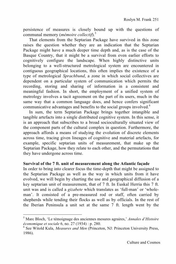
Dating the stone octagon sites Of the eight attempts to use Carbon-14 dating techniques to determine the time depth associated with the octagons, only three have been successful.30 Radiocarbon analysis of pieces of charcoal found at the base of the centre stones gave the following dates: fourth to sixth century CE (Mendabio); second to third century CE (Gorostarbe); and ninth century BCE (Pikuetaondarra).31 The Late Bronze Age date of Pikuetaondarra emphasises the stability of the architectural design over nearly 3000 years. 30 Juan José Agirre Mauleón and Alex Ibáñez Etxeberria, ‘Gorostarbeko saroea (Urnieta)’, Arkeoikuska (1995): pp. 211–14; Juan José Agirre Mauleón, María Flores and Sonia San José Santamarta, ‘Mendabioko saroea (Urnieta)’, Arkeoikuska (1996): pp. 142–44; Jaione Agirre García, Alfredo Moraza Barea, José Antonio Mujika Alustiza and Luis Mari Zaldua Etxabe, ‘Aralar mendialdea – Sierra de Aralar’, Arkeoikuska (2009): pp. 404–7. 31 See Luis Mari Zaldua Etxabe, ‘Basque saroiak’, trans. from Basque by Roslyn M. Frank, in C.L.N. Ruggles, ed., The Handbook of Archaeoastronomy and Ethnoastronomy (Berlin: Springer, 2014), pp. 1187–96.
Roslyn M. Frank
Culture and Cosmos
261
Fig. 5. Pikuetaondarra centre stone.
© Luis Mari Zaldua Etxabe.
The significance of the range of dates resulting from these excavations, from the Late Bronze Age to the Iron Age, will become clearer as we turn our attention to the cromlechs often located near the stone octagons. As for their composition, the circles formed by the cromlech enclosures tend to be quite small, most of them falling into the range of 3 m to 9 m in diameter although there are notable exceptions with diameters that reach up to 20 m. The stones themselves tend to be small when compared to the tall uprights of other zones along the Atlantic façade even though it is not unusual for a Pyrenean cromlech to include a tall standing stone, one that would be visible from a significant distance. The circles tend to be situated on or near crests and, therefore, along routes that would have formed an integral part of the communication networks associated with the transhumant practices of the time.32 Stated differently, the emplacement of cromlechs coincides closely with locations where we find stone octagons. In short, both phenomena appear to be related to earlier pastoral social practices.
The assumption is that the shepherd collectives who occupied the stone octagons might well have been involved in constructing the cromlech circles nearby. Hence, the activities carried out at the cromlech sites would have formed a regular part of pastoral sociocultural practices and responded in some way to the needs of this particular collective. At present, 853 extant cromlechs have been identified inside Euskal Herria itself. These include 32 Xabier Peñalver Iribarren, Mairubaratzak: Pirinioetako Harrespilak (Donostia: Aranzadi, 2004), p. 227, http://www.euskomedia.org/PDFAnlt/munibe/2004015271.pdf [accessed 22 Dec. 2016].

Culture and Cosmos
262 Metrology, Memory and Long-Term Landscape Inhabitation: Evidence for the Septarian Package on the Atlantic Façade
sites with and without uprights while the cromlechs themselves can be located alone or in groups. The range of architectural styles is quite varied, from minimalist to extravagant and, as has been noted, stone octagons are regularly found in the vicinity of such megalithic complexes.
In 2007 Zaldua studied the distance between 70 megalithic sites and the stone octagons located nearby. Bearing in mind the large size of the standard stone octagon itself – it has a diameter of 327 m – the results of his study are noteworthy: 30% of the megalithic sites are 0-300 m from a stone octagon; 60% of the megalithic sites are within 500 m or closer; and taken altogether, 81% of the megalithic sites are within 0-700 m from a stone octagon.33 Consequently, when examining Zaldua’s statistical results concerning the possible linkage between the stone octagon sites and the megalithic structures often encountered nearby, we need to keep in mind that in Euskal Herria cromlechs were still being built into the Late Iron Age while we have the Carbon-14 dating of the Pikuetaondarra site that takes us back to the Late Bronze Age. Hence, the time frame for the two types of structures appears to overlap.
In a listing of cromlech sites compiled by Peñalver as part of his exhaustive study of 1104 cromlechs from throughout the Pyrenean zone, we find only twenty that have been excavated and dated, specifically from the Late Bronze Age (1300 to 700 BCE) and Iron Age (800 BCE to 50 CE).34 And, of the twenty, nearly a third fall roughly within 500 years or less of the second to third century CE dating for Gorostarbe, while the rest date back further in time. Even more important is the fact that the Late Bronze Age cromlechs overlap closely in time with the results of the excavation of the centre stone of Pikuetaondarra, dated to the ninth century BCE. So it, too, goes back to the Late Bronze Age. This suggests that the two phenomena were co-terminus. Consequently, it is highly likely that groups who were involved in laying out stone octagons were also actively involved in the construction of the small stone circles located nearby. In other words, it is quite probable that the two entities were linked in some fashion, in terms of the functions they fulfilled for the population in question and furthermore, that these functions were closely tied to the sociocultural needs of a herding community. 33 Luis Mari Zaldua Etxabe, ‘Seles en Legazpi: Sobre la antigua organización de territorio’, Euskonews & Media 457 (2008). http://www.euskonews.com/0457zbk/gaia45702es.html [accessed 29 Dec. 2016]. 34 Peñalver Iribarren, Mairubaratzak: Pirinioetako Harrespilak.

Roslyn M. Frank
Culture and Cosmos
263
Chronological overlaps At this juncture we can appreciate that the cromlechs are structures that form part of a set of well-documented pastoral sociocultural practices which also include the Basque stone octagons. Whereas there is inferential evidence these small stone circles located in the immediate vicinity of Basque stone octagons might have been assembly sites with socio-economic and political significance, in Euskal Herria no large-scale ritual complexes have been identified, such as, for example, on the scale of Avebury. Nonetheless, the design of the stone octagons suggests they originally had a ritual component, in light of the concern shown with respect to the precise orientation of the stones and the marking of cardinality and intercardinality. In short, there is evidence that those who came up with the architectural design of the octagons were preoccupied with metrological precision unrelated to the pastoral activity at the site so that therefore the design had some symbolic meaning.
Although outside the scope of this study, analogies might be drawn between the design of the stone octagons and the cosmic geometry of built sites in other parts of the world. For example, Malville in his discussion of the sacred geography of temple building in India, states that in
every Hindu city the most accessible demonstration of the merging of the macrocosm and microcosm is the temple. The initial phase in its construction involves the ritual of measurement during the laying-out [of] the vastupurusha mandala. This ritual is understood to be a reenactment of cosmogony, i.e., a repetition of the primordial creative act of measurement of space.35
Likewise, given that acts of measurement can have a cosmological dimension, it is significant that the stone octagon has to be oriented to the true cardinal and intercardinal directions and as such it has characteristics that sets that space apart from the rest of the landscape. This interpretation would assign a powerful symbolic value to the precise measurements and accurate cardinality of its architectural design. At the same time, having these alignments built into the design of the sites could have responded to quite practical needs. They certainly acted to orient the users correctly in the landscape and consequently could have provided a helpful means of mapping features visible in the surrounding landscape and perhaps even celestial phenomena.
35 J. McKim Malville, ‘Astronomy at Vijayanagara: Sacred Geography Confronts the Cosmos’, National Geographical Journal of India 40 (1994): p. 172.
Culture and Cosmos
264 Metrology, Memory and Long-Term Landscape Inhabitation: Evidence for the Septarian Package on the Atlantic Façade
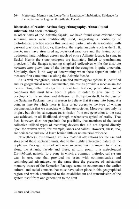
Discussion of results: Archaeology ethnography, ethnocultural substrate and social memory In other parts of the Atlantic façade, we have found clear evidence that septarian units were traditionally used, suggesting a continuity of metrological practice across this zone and particularly its association with pastoral practices. It follows, therefore, that septarian units, such as the 21 ft. perch, may have structured agro-pastoral practices and the laying out of traditional land holdings across much of entire Atlantic façade. In sum, in Euskal Herria the stone octagons are intimately linked to transhumant practices of the Basque-speaking shepherd collectives while the absolute terminus ante quem date of the design of the octagons is quite uncertain. Similarly, there is no way of determining when these septarian units of measure first came into use along the Atlantic façade.
As is well recognised, when a unified metrological system is identified and its geographical reach documented, the results provide a mechanism for reconstituting, albeit always in a tentative fashion, pre-existing social conditions that must have been in place in order to give rise to the development, instantiation and diffusion of the system itself. In the case of the Septarian Package, there is reason to believe that it came into being at a point in time for which there is little or no access to the type of written documentation that we associate with literate societies. Moreover, not only its origins, but also its subsequent transmission from one generation to the next was achieved, in all likelihood, through mechanisms typical of orality. That fact, however, does not preclude the possibility that members of the social collective utilised types of recording devices that did not depend directly upon the written word, for example, knots and tallies. However, these, too, are perishable and would leave behind little or no material evidence.
Nevertheless, even though we lack material attestations for the use and storage of these septarian units, due to the highly entrenched nature of the Septarian Package, units of septarian measure have managed to survive along the Atlantic façade and these, in turn, point to a metrological Sprachbund, namely, to a zone in which a common metrological system was in use, one that provided its users with communicative and technological advantages. At the same time the presence of substantial memory traces of the Septarian Package seems to countenance the earlier cultural and social contacts that must have taken place in this geographical region and which contributed to the establishment and transmission of the system itself from one generation to the next.

Roslyn M. Frank
Culture and Cosmos
265
However, the processes that led to the geographical diffusion of these septarian units are far from clear and equally obscure is the directionality of the propagation of the cultural complex. At this stage, what can be determined is that the densest network of extant data is concentrated in the Basque-speaking zone where cross-generational continuity is most apparent and where there is no evidence of linguistic rupture. In addition, it should be noted that this is the only zone in western Europe where a pre-Indo-European language has continued to be spoken. Unquestionably, linguistic rupture can contribute to the fracturing of cultural conceptualisations and complicate the integral transmission of the cultural heritage from one generation to the next.
As Bahn noted in his extensive palaeoeconomic study of Pyrenean transhumant pastoralism, throughout the study area it is evident that megalithic monuments are intimately associated with highland pastures and the practice of local transhumance, given that they cluster along well-travelled highland tracks.36 However, in the case of western European megalithic sites less attention has been paid to the analysis of palaeoeconomic data which can give crucial clues about the important constants and long-term factors governing human behaviour. Inherent in such investigations has been the assumption that for the rest of western Europe, because of cultural and linguistic rupture brought about by the incursions of Indo-European speakers into the zone, no traces of earlier indigenous pre-Indo-European cultural assemblages have survived in the present-day practices and knowledge base of populations inhabiting areas where megalithic monuments are found. This position was summarised by Ruggles:
In some countries, archaeological studies benefit from evidence other than just the present disposition of archaeological remains: in Mesoamerica, for instance ... there exists ethnohistoric evidence (accounts by Spanish invaders of practices current when the sites were in use), ethnographic material which is clearly relevant (present-day practices by descendants of the groups being studied) and first-hand accounts (Maya and Aztec codices). However, none of these other sources is available in British work.37
36 Paul G. Bahn, Pyrenean Prehistory: A Palaeoeconomic Survey of the French Sites (Warminster, Wiltshire: Aris & Phillips, Ltd., 1983). 37 C.L.N. Ruggles, Megalithic Astronomy: A New Archaeological and Statistical Study of 300 Western Scottish Sites (Oxford: British Archaeological Reports, 1984), p. 14.

Culture and Cosmos
266 Metrology, Memory and Long-Term Landscape Inhabitation: Evidence for the Septarian Package on the Atlantic Façade
The implications of the Basque stone octagons and septarian units of measure have not been ignored by researchers outside the Basque Country.38 For instance, a decade after declaring that no ethnohistorical evidence was available for British work, Ruggles had the opportunity to do fieldwork at various stone octagon sites in the Basque Country. In 1996, he came back to the question of whether we can use analogy with other cultures to gain insights into prehistoric astronomical practices, saying that an analogy of great potential interest has emerged recently, from far south in the Basque Country. Here there are many examples of what appear to be eight-stone rings.39
Ruggles goes on to note that in some instances these sarobe, constructed by transhumant shepherding collectives, continued to be utilised into the twenitieth century which means that we have both first-hand accounts and extensive documentary evidence relating to their purpose and function. Furthermore, their design, construction and celestial orientation suggest that they ‘functioned within a cosmological network of social practices and beliefs rather than merely at an instrumental level’.40
He concludes his discussion of the Basque stone octagons by pointing out their value as a heuristic, a means of rethinking the functions that might have been associated with similar configurations in other parts of Europe, such as Avebury. At this stage there is no proof of direct links between the cultural practices documented for the Basque Country and those in the Neolithic and Bronze Age of the British Isles; ‘they do, however, provide a strong motivation for studying the Basque Country further as a useful analogy for ancient cultural practice elsewhere in Europe, and such investigations are well under way’.41
While Ruggles’ commentary clearly emphasises the possible heuristic value of the Basque materials, it was published before much of the new evidence for the existence of the Septarian Package in Atlantic Europe, discussed above, was brought forward. At this stage, I am confident that investigations currently underway on this topic will new shed light on the time depth that should be assigned to the Septarian Package and provide additional evidence for socioculturally entrenched practices involving 38 Evan Hadingham, ‘Europe’s Mystery People,’ World Monitor 5, no. 9 (1992): pp. 34–42. 39 C.L.N. Ruggles, ‘Archaeoastronomy in Europe’, in Christopher Walker, ed., Astronomy before the Telescope (London: British Museum Press, 1996), p. 25. 40 Ruggles, ‘Archaeoastronomy in Europe’, p. 25. 41 Ruggles, ‘Archaeoastronomy in Europe’, p. 25.

Roslyn M. Frank
Culture and Cosmos
267
septarian units of measure not only in the British Isles but also in the Franco-Cantabrian zone itself. Conclusions To conclude, in the case of investigations that have been carried out on the stone octagons of the Basque Country, data collection has been facilitated by the wide range of resources available to the researcher, from the written evidence encountered in archives, interviews with informants, radiocarbon results from archaeological excavations, all supplemented by access to extensive ethnographic materials collected by other Basques researchers. Moreover, until quite recently, the shepherds of this Pyrenean zone were still transmitting their traditional repertoire of social practices primarily by means of mechanisms typical of oral cultures. And the transmission process, from one generation to the next, was done almost exclusively in Euskara, a language recognised as the only surviving pre-Indo-European linguistic system in western Europe. In other words, Euskara is considered the indigenous language of this part of Europe while there is increasing evidence that a Basque-like ethnocultural substrate may have existed in other parts of western Europe. What is still not known with certainty is the nature and diffusion of the languages spoken along the Atlantic Façade during the Late Bronze Age.
On the other hand, as has been demonstrated in this study, there is ample evidence that units of measurement from the Septarian Package survived along the Atlantic Façade and have left an indelible mark in the historical record. Further investigations into this topic might reveal whether, as appears to be the case in the Basque Country, units and conceptual frames of reference emanating from the Septarian Package were employed in the design and construction of megalithic sites in other parts of the Atlantic façade. In the Pyrenean zone, there is every reason to believe that the Septarian Package with its associated knowledge base and constructional technologies was recruited in laying out the stone octagons and probably played some role in the conceptualisation and laying out of megalithic sites located in close proximity to them. The question remaining is whether these survivals can be traced further back in the ethnocultural record for the rest of the Atlantic Façade.