the base of the upper keweenawan, michigan and wisconsin
TRANSCRIPT

The Base of the Upper Keweenawan, Michigan and Wisconsin
GEOLOGICAL SURVEY BULLETIN 1354-F

The Base of the Upper Keweenawan, Michigan and WisconsinBy WALTER S. WHITE
CONTRIBUTIONS TO STRATIGRAPHY
GEOLOGICAL SURVEY BULLETIN 1354-F
A proposal to adopt the top of the Copper Harbor Conglomerate as the base of the upper Keweenawan in the Lake Superior region
UNITED STATES GOVERNMENT PRINTING OFFICE, WASHINGTON : 1972

UNITED STATES DEPARTMENT OF THE INTERIOR
ROGERS C. B. MORTON, Secretary
GEOLOGICAL SURVEY
V. E. McKelvey, Director
Library of Congress catalog-card No. 72-75175
For sale by the Superintendent of Documents, U.S. Government Printing OfficeWashington, D.C. 20402 - Price 25 cents (paper cover)
Stock Number 24pl-2099

CONTENTS
PageAbstract _____________________ _..- FlIntroduction _______________ - - 1
Acknowledgments __ _____ __ 3Original definition and usage ______ _ 4Oronto Group _____________________-.____ _ 7Alternatives for stratigraphic placement of the base of the upper
Keweenawan __________________.___ _ _ 7Top and bottom of the Copper Harbor Conglomerate as uncon
formities ________________________.____________ 8Base of the Copper Harbor Conglomerate __________ _ 9Top of the Copper Harbor Conglomerate _____________ 11
Paleomagnetic data ______________________________ 14Seismic data ________________________..__________ 15Summary and recommendation ________________________ 16References _____________________.______._________ 20
ILLUSTRATIONS
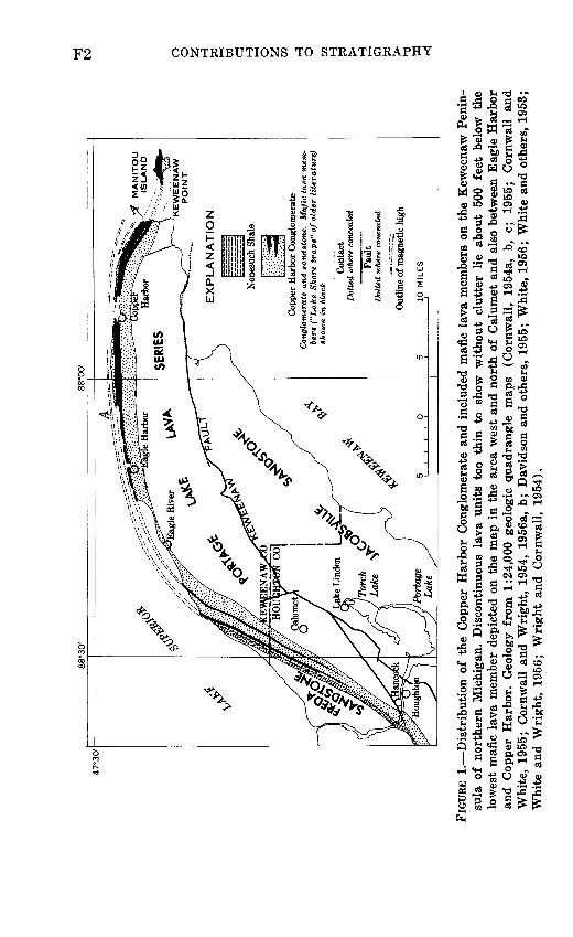
PageFIGURE 1. Distribution of the Copper Harbor Conglomerate and in
cluded mafic lava members _________________ F22. Stratigraphic section of the Copper Harbor Conglomerate _ 33. Longitudinal stratigraphic section of Keweenawan rocks
below the base of the Nonesuch Shale ________ _ 54. Mean directions of magnetization for some Keweenawan
rocks ________________________________ 135. Proposed nomenclature for middle and upper Keweenawan
rocks _^________________________^_______________ 19
TABLE
PageTABLE 1. Compressional wave velocities (km/sec) for selected Ke
weenawan stratigraphic units, Lake Superior region _ F16
ill


CONTRIBUTIONS TO STRATIGRAPHY
THE BASE OF THE UPPER KEWEENAWAN, MICHIGAN AND WISCONSIN
By WALTER S. WHITE
ABSTRACT
The top of the Copper Harbor Conglomerate (base of Nonesuch Shale) is a more satisfactory boundary between upper and middle Keweenawan rocks in northern Michigan and adjacent parts of Wisconsin than the various horizons that have been used hitherto without stratigraphic consistency from place to place. Irving's original boundary (1883) cannot be followed away from the Keweenaw Peninsula. The top of the Copper Harbor Conglomerate comes closer to marking the close of Keweenawan volcanism than other major boundaries and actually adheres more closely to Irving's original concept than the boundary that he himself chose. The top of the Copper Harbor Conglomerate is also more satisfactory from a practical standpoint because, thanks to exploration for copper at the base of the Nonesuch Shale, no other major stratigraphic boundary in the Keweenawan province is so precisely located over so large a fraction of its total outcrop trace. This paper proposes that the top of the Copper Harbor Conglomerate be adopted as the base of the upper Keweenawan and of the Oronto Group.
INTRODUCTION
The base of the "upper Keweenawan," a term applied to certain rocks of Precambrian Y ' age in the Lake Superior region, has not been placed at the same stratigraphic horizon by all who have had occasion to use the term. Any of the possible definitions or redefi nitions that might be adopted would be arbitrary, but light shed on the question by geologic and geophysical data gathered in recent decades now makes one of these choices seem more mean ingful and more practical than the others.
1 An interim scheme for the subdivision of Precambrian time, recently adopted by the U.S. Geological Survey:Precambrian Z = base of Cambrian to 800 m.y. Precambrian Y 800 m.y. to 1,600 m.y. Precambrian X = l,600 m.y. to 2,500 m.y. Precambrian W = older than 2,500 m.y.
Fl
88
°30
'
47
°30
'
«y
MA
NIT
OU
<
IS
LA
ND
KE
WE
EN
AW
P
OIN
T
EX
PL
AN
AT
ION
Cop
per
Har
bor
Con
glom
erat
eC
ongl
omer
ate
and
sand
ston
e.
Maf
ic l
ava
mem
be
rs (
"Lake
Sho
re t
raps"
of
olde
r li
tera
ture
) sh
own
in b
lack
Con
tact
D
otte
d w
here
con
ceal
ed
Fau
lt
Dot
ted
whe
re c
once
aled
Out
line
of m
agne
tic h
igh
10
MIL
ES
to o
o w
d H
i i
O 2 CQ H
O ui O
FIG
URE
1.
Dis
trib
uti
on
of
the
Cop
per
Har
bor
Con
glom
erat
e an
d in
clud
ed m
afic
lav
a m
embe
rs o
n th
e K
ewee
naw
Pen
in
sula
of
nort
hern
Mic
higa
n. D
isco
ntin
uous
lav
a un
its
too
thin
to
show
wit
hout
clu
tter
lie
ab
out
500
feet
bel
ow t
he
low
est
maf
ic l
ava
mem
ber
depi
cted
on
the
map
in
the
area
wes
t an
d no
rth
of C
alum
et a
nd a
lso
betw
een
Eag
le H
arbo
r an
d C
oppe
r H
arbo
r. G
eolo
gy f
rom
1:2
4,00
0 ge
olog
ic q
uadr
angl
e m
aps
(Cor
nwal
l, 19
54a,
b,
c;
19
55;
Cor
nwal
l an
d W
hite
, 19
55;
Cor
nwal
l an
d W
righ
t, 1
954,
195
6a,
b; D
avid
son
and
othe
rs,
1955
; W
hite
, 19
56;
Whi
te a
nd o
ther
s, 1
953;
W
hite
and
Wri
ght,
195
6;
Wri
ght
and
Cor
nwal
l, 19
54).

THE BASE OF THE UPPER KEWEENAWAN
ACKNOWLEDGMENTS
F3
I am very much indebted to N. K. Huber, who pointed out to me that when my colleagues and I (White and others, 1953) redefined
FEET
6000-
5000-
4000-
3000-
2000-
1000-
o-
ii^^!^^
_______
ryr.T.T.TO.T
1 : ° «: ' '.',' :I\I:.'.
l^fp^aHio^liiii/iS^',!.iv.*.*.'.". «'.'.'°.y ;
^ r-^T^.T1
/. yivVVv.V:::-ii^uninjuiuiiiiti in,111 SMs^B Siitiuj i1 ' 1""1' fl
^^»^^T|
&&Ul """[ '|I"""I"IIMIIIUII int ipntorM/B!,,,..,* HWHiTnstfWB" HimIIIM^IIillffili^giiTi
g-ig-K^
ffl^tepiv':'':; 'Sx'w^:a:^"'-!
. ' . ^ 'fiV.'-v-i'i'V
:." ':' ' * '*' !;.«'.' :''^
Jli.'t V ' "."«*' V°0 "
'.V.% .'\-''-'-' : °»:'v
' ':: :' .'. ! . ' '. KS^^sipjsfefe'jki^^^r^
IRVING (1883)
Outcrop of rocks above dashed line is covered by Lake Superior east of longitude 88°24'
OUTER CONGLOMERATE
A
LAKE SHORE TRAP
GREAT CONGLOMERATE
z0 (/)>Q
o:LJ Q_ Q_3
LOWER DIVISION
CURRENT USAGE
FREDA SANDSTONE
NONESUCH SHALE
] Mafic lava > member J(not named)
UJ. H-
<CC LJ
Mafic lava o member ^3 (not named) g
oo:
J § o: <X
ccLJ CL Q. O O
PORTAGE LAKE LAVA SERIES
FIGURE 2. Stratigraphic section of the Copper Harbor Conglomerate in the vicinity of Copper Harbor (from data of Cornwall, 1954b, c, 1955).
F4 CONTRIBUTIONS TO STRATIGRAPHY
the base of the upper Keweenawan on the Keweenaw Peninsula, we did not take formal notice of the departure from Irving's (1883) original definition, which was very explicit in his type area. Huber encouraged me to remedy this oversight, and this paper, though quite different from what I set out to write, is the result. I owe much to my colleagues Henry R. Cornwall and the late J. C. Wright for the years of joint endeavor that provided much of the background for this paper. And finally, the strati- graphic relations shown west of long. 89° 15' in figure 3, so impor tant a part of the argument in this paper, would have been most imperfectly reconstructed without the results from recent unpub lished mapping by E. R. Brooks, H. A. Hubbard, R. F. Johnson, and J. T. Wilband (White and others, 1971), as can be readily seen by comparison of figure 3 with an earlier attempt to draw a similar section (White and Wright, 1960, fig. 3.2).
A most constructive critical review of the original manuscript by N. K. Huber led to substantial revision of parts of the text.
ORIGINAL DEFINITION AND USAGE
The reason for the problem has its roots in Irving's (1883) definition of what he called the "Upper Division" of the Keweena wan. The type locality for his classification is on the north shore of the Keweenaw Peninsula, in a belt extending a few miles east and west from Copper Harbor (fig. 1). Figure 2 shows a strati- graphic section of the Copper Harbor Conglomerate in this area and the names that have been applied to the various units by Irving (left-hand column) and more recent investigators (right- hand column) (see, especially, Cornwall, 1954b, c; 1955).
Irving (1883, p. 152) placed the boundary between his "Upper Division" and "Lower Division" 2 of the "Keweenaw Series" at the, "base of the outer conglomerate of Keweenaw Point which [as he believed] corresponds to the top of the upper amygdaloid of the Porcupines, and to the base of the great conglomerate of the Montreal, and which is above any known occurrence of eruptive matter." This boundary was a very reasonable choice at the time and was later accepted by others (for example, Lane, 1911, p. 37-
- The rocks immediately below the base of upper Keweenawan have been called "lower Keweenawan" (lower division of the Keweenawan) by some authors and "middle Keweenawan" by others. For the purposes of this paper, it makes no difference which usage is followed, but it should be pointed out that a threefold division of the Keweenawan appears far more useful than a twofold in the light of what is now known about the stratigraphy throughout the Lake Superior region (Van Hise and Leith, 1911, p. 366-367; Halls, 1966, p. 5; Hubbard, 1968; Books, 1968).

Mon
trea
l R
iver
Ir
onw
ood
WIS
CONS
IN [
MIC
HIGA
N!
9P
. *7o
VP-
-5 C
on
glo
mer
ate
(No
. 13
1..
""" " e"
"a C
on
glo
mer
ate
(No
. 8)
. -
-""
Str
atig
rap
hic
hor
izon
^
-"^
-Ro
ck
s b
elow
th
is l
ine
are
cove
red
Of K
ewee
naw
fau
lt
,/'
by y
ou
ng
er r
ocks
, an
d th
eir
litho
logy
is
not
know
n
EX
PL
AN
AT
ION
Ind
ex
map
of
part
of
Lake
Su
per
ior
regi
on s
how
ing
app
roxi
mat
e lin
e of
lo
ng
itu
din
al
Str
atig
rap
hic
se
ctio
n (d
ash
ed l
ine)
Unn
amed
for
mat
ion
Maj
or f
elsi
c m
embe
rs
show
n by
"v"
pat
tern
Por
tage
Lak
e La
va S
erie
sSe
lect
ed k
ey h
oriz
ons
show
nby
das
hed
line
Bou
ndar
y lo
cate
d fr
om t
rend
of
aer
omag
netic
ano
mal
y (s
ee Z
ietz
and
Kirb
y, 1
971)
W M
FIG
UR
E 3
. L
on
git
ud
inal
S
trat
igra
ph
ic
sect
ion
of
Kew
eena
wan
roc
ks b
elow
th
e ba
se o
f th
e N
ones
uch
Sha
le f
rom
Kew
ee
naw
Poi
nt t
o th
e M
ontr
eal
Riv
er.
All
dat
a pr
ojec
ted
to a
n ea
st-w
est
line
. D
ashe
d li
nes
wit
hin
the
P
ort
age
Lak
e L
ava
Ser
ies
repre
sent
indi
vidu
al h
oriz
ons
that
can
be
trac
ed w
ith c
onfi
denc
e be
twee
n th
e in
dica
ted
poin
ts,
larg
ely b
y co
rre
la
tion
of
dril
l-ho
le s
ecti
ons.
T
hick
ness
eas
t of
lon
g.
89° 1
5'
from
sou
rces
li
sted
in
fi
gure
1
and
from
B
utl
er,
Burb
ank,
and
othe
rs
(192
9, p
i. 15
) ;
thic
knes
s w
est
of l
ong.
89
°15'
ca
lcul
ated
fr
om
unpu
blis
hed
map
s by
E
. R
. B
rook
s,
H.
A.
Hub
bard
, R
. F
. Jo
hnso
n, W
. S.
Whi
te,
J. T
. W
ilba
nd,
and
J. C
. W
rig
ht.

F6 CONTRIBUTIONS TO STRATIGRAPHY
39; Van Hise and Leith, 1911, p. 413; Thwaites, 1912, p. 48 and geol. map) primarily for its presumed importance as the surface marking the close of volcanism in the region. The stratigraphic position of this surface of demarcation in the type area is indi cated by the line labeled "A" in figures 1 and 2.
Figures 1 and 3 clearly show some of the problems that stem from Irving's choice. As Lane (1911, p. 39; see also Lane and Seaman, 1907, p. 690) clearly recognized from his own subsequent work, practical difficulties attend any effort to follow Irving's boundary away from Keweenaw Point. If the base of the upper Keweenawan is defined as the time-equivalent of Irving's bound ary on the Keweenaw Peninsula, it does not coincide with any recognized lithologic unit or break beyond the point where the highest so-called "Lake Shore trap" of the Keweenaw Peninsula pinches out north of Hancock (fig. 1). There is no theoretical or practical reason, today, to correlate the "Lake Shore traps" of the Porcupine Mountain region (Wright and Lane, 1909) or of the Black River (Gordon and Lane, 1907, p. 430) with those of Keweenaw Point, and there is no way, at present, to identify beds in westernmost Michigan or Wisconsin, for example, that might be contemporaneous with the top of the "Lake Shore traps" of Keweenaw Point.
If, on the other hand, the base of the upper Keweenawan is defined as the top of the highest lava flow, regardless of strati- graphic position (which is what authors attempting to follow Irving rigorously have actually done in practice), its stratigraphic position can change abruptly by as much as 2,000 feet at places where the highest lava flow pinches out (fig. 3). At the many places where no "Lake Shore trap" flows are recognized, authors have placed the boundary at the top of the Portage Lake Lava Series.
Other problems caused by acceptance of Irving's boundary have only become obvious in recent decades as a result of detailed geologic mapping and magnetic surveys. One is that the base of what Irving took as his "Outer Conglomerate" of Keweenaw Point is actually 1,500-2,000 feet below the top of the highest lava flow in that area, as can be shown by geologic projection and airborne magnetometer survey (fig. 1). Another is that the end of volcan ism was almost certainly later than the highest known lava flow; I have found water-laid tuff, probably representing ash falls, in drill core within 25 feet of the base of the Nonesuch Shale (sec. 33, T. 55 N., R. 34 W.)

THE BASE OF THE UPPER KEWEENAWAN F7
ORONTO GROUP
Thwaites (1912, p. 48) introduced the term Oronto Group for "a great thickness of arkose sandstones and shales" overlying the lavas and underlying more quartzose sandstone formations, to which he gave the name Bayfield Group. Following Irving's prece dent, he took the base of the Oronto Group as "the base of a thick conglomerate called the Outer Conglomerate, above which horizon no igneous rocks occur." His definition and the explanation for the map accompanying his report clearly equate the base of the Oronto Group and the base of the upper Keweenawan, and this identity seems to have been accepted by all those who have had occasion to use the term Oronto Group, even where there might be disagreement or inconsistency, from area to area, about where the boundary should be placed stratigraphically. It should be rec ognized, therefore, that any redefinition of the base of the upper Keweenawan should apply also to the base of the Oronto Group.
ALTERNATIVES FOR STRATIGRAPHIC PLACEMENT OF THE BASE OF THE UPPER KEWEENAWAN
The name "Outer Conglomerate," used rather informally by Irving, has unfortunately become formalized by subsequent usage, despite the fact that, from a practical standpoint, its base cannot be followed west from the Keweenaw Peninsula. Because the "Outer Conglomerate" has only local significance it seems inappro priate both as a formal stratigraphic name and as unit defining the base of the upper Keweenawan. Lane (1911, p. 37-39) clearly recognized that the discontinuity of the lavas known as the "Lake Shore traps" made it impractical to separate the "Outer" and "Great Conglomerates" outside the Keweenaw Peninsula, and he therefore collectively grouped all conglomerates above the Portage Lake Lava Series and below the Nonesuch Shale into the "Copper Harbor Conglomerates." Lane continued to accept the base of the "Outer Conglomerate" as the base of the upper Keweenawan, however, and thus the lumping of Irving's "Outer" and "Great Conglomerate" into a single formation has, as Lane (1911, p. 39) recognized, the disadvantage of placing the base of the upper Keweenwan within a formation.
From a hierarchical point of view, it seems most undesirable to have a boundary of major rank fall within a unit of lesser rank. Inasmuch as the base of the upper Keweenawan (and of the Oronto Group) does fall within a formation that cannot be sub divided on any theoretical or practical grounds that are valid and

F8 CONTRIBUTIONS TO STRATIGRAPHY
consistent on a regional basis, the most obvious alternatives are to place the base of the upper Keweenawan at either the top or base of the Copper Harbor Conglomerate.
TOP AND BOTTOM OF THE COPPER HARBOR CONGLOMERATE AS UNCONFORMITIES
If either the top or bottom of the Copper Harbor Conglomerate, but not both, were known to be a pronounced unconformity, the unconformable contact should, with little question, be adopted as the base of the upper Keweenawan. On this basis, unfortunately, there is little to choose between them.
Both boundaries are more or less gradational. The conglomer ate and sandstone beds between lava flows of the Portage Lake Lava Series differ little from those of the Copper Harbor Conglom erate, both on the Keweenaw Peninsula and on Isle Royale (Lane, 1898; Huber, 1971). Sedimentary beds are more abundant in the uppermost 1,000 feet or so of the Portage Lake Lava Series than below, and the choice of the top of the highest lava flow as the formation boundary, though logical and practical, is quite arbi trary. The transition between the formations reflects a gradual decrease in volcanic activity and growing dominance of a sedi mentary regime rather than an abrupt time or environmental break.
Similarly, sandstone and dark-gray siltstone to shale are inter- bedded and interlaminated in the lowermost 20 feet of the None such Shale, and the basal contact (top of the Copper Harbor Con glomerate) is arbitrarily placed at the base of the lowest thick (several feet) unit containing dark-gray siltstone and shale. This boundary does reflect a relatively abrupt change from a subaerial to a shallow subaqueous environment.
Both boundaries are only slightly transgressive. Maps of part of the Keweenaw Peninsula by Cornwall (1954b) and Cornwall and Wright (1954) suggest that the stratigraphic position of the base of the Copper Harbor Conglomerate may locally rise toward the west, but the rate of rise is very small. Even where the Copper Harbor Conglomerate laps up on the unnamed formation (fig. 3), the contact does not appear to be notably unconformable and may have much intertonguing. Gradual transgression of the base of the Nonesuch Shale is clearly shown in north-south sections of the base of that formation in the Porcupine Mountain region (White and Wright, 1966, fig. 2), but it is barely detectable without con siderable vertical exaggeration.
It is conceivable that the uppermost beds of the Copper Harbor Conglomerate represent sands reworked by the waters in which

THE BASE OF THE UPPER KEWEENAWAN F9
the Nonesuch Shale was deposited and that the apparent near- conformity of these beds masks or blurs a more profound angular unconformity between the Nonesuch Shale and the Copper Harbor Conglomerate as a whole. Stratigraphic relations within the Copper Harbor Conglomerate are not well known because of poor exposures and few drill holes, but meager information that is available suggests that there is no significant angular uncon formity between the two. The relations shown in figure 3, particu larly near Houghton, suggest that much of the local angular dis cordance between the Portage Lake Lava Series and the None such Shale is due to tectonic movements during rather than before or after Copper Harbor time.
Finally, neither boundary represents any profound change in the basic pattern of sediment dispersal, for as Hamblin and Horner (1961, p. 210) point out, the same pattern, implying high lands to the south or southeast of the western Lake Superior region, persisted from Portage Lake through Freda time. Hite (1968) reached a similar conclusion for the Copper Harbor Con glomerate and higher formations that he studied in northeastern Wisconsin.
In summary, therefore, the magnitude of the unconformities represented by the top and base, respectively, of the Copper Harbor Conglomerate provides little reason for considering one of the contacts more suitable than the other to be taken as the base of the upper Keweenawan. Some other basis must be sought.
BASE OF THE COPPER HARBOR CONGLOMERATE
The principal argument for placing the base of the upper Keweenawan at the base of the Copper Harbor Conglomerate is the weight of prior usage, even though this usage has commonly involved an unwitting departure from the original definition. In the many areas where no "Lake Shore traps" are recognized, authors have unfailingly placed the boundary at the base of the Copper Harbor Conglomerate (for example, Van Hise and Leith, 1911, pi. 1; Leith and others, 1935, pi. 1). Some authors, particu larly in Wisconsin (Thwaites, 1912; Aldrich, 1929; Tyler and others, 1940; Ostrom, 1967; Hite, 1968), have semantically re solved this departure from Irving's definition by simply using the name Outer Conglomerate for all the rocks between the Portage Lake Lava Series and the Nonesuch Shale. Although for Wiscon sin, in particular, this correlation is not inconceivable, the rela tions shown in figure 3 do not provide much support for it, and the correlation is certainly not valid in areas such as that shown in the southwestern part of figure 1.

F10 CONTRIBUTIONS TO STRATIGRAPHY
On the Keweenaw Peninsula, this usage adopted elsewhere can not be reconciled with Irving's usage, and a choice must be made between the two. White, Cornwall, and Swanson (1953) chose to follow the usage accepted for the region as a whole rather than Irving's definition when, on maps of the Keweenaw Peninsula, they placed the base of the upper Keweenawan at the base of Lane's (1911) "Copper Harbor Conglomerates." The more con ventional singular form was used by White (1952) and White, Cornwall, and Swanson (1953) when they adopted Lane's term as a formation name. Several more recent authors (Hamblin and Horner, 1961; Hamblin, 1961; Halls, 1966; Kelley, 1968) have followed suit, using the term Copper Harbor Conglomerate for the whole conglomerate sequence and accepting the top of the Portage Lake Lava Series as the base of the upper Keweenawan on the Keweenaw Peninsula as well as in the areas where this usage had become more or less established.
From the foregoing, it might appear simplest, therefore, to follow this revised usage that has gained general acceptance, and to place the base of the upper Keweenawan at the top of the main body of lavas, including within the upper Keweenawan those flows within the Copper Harbor Conglomerate that have been called "Lake Shore traps." Recent work in western Michigan, however, has greatly complicated this otherwise straightforward solution.
As shown by figure 3, the horizon that marks the top of the Portage Lake Lava Series can be located very closely by reference to the internal stratigraphy of that formation (Butler, Burbank, and others, 1929, pi. 15; White, 1968, fig. 3). As this horizon is followed southwestward from the Keweenaw Peninsula, it passes beneath an unnamed formation consisting of a thick series of felsic and generally nonophitic mafic flows (fig. 3). In the region south of the Porcupine Mountains, this overlying sequence of flows attains a thickness of at least 8,000 feet, whereas the Copper Harbor Conglomerate shows complementary thinning; in places, the total thickness of sandstone and conglomerates of the Copper Harbor is less than 200 feet. The sequence of flows between the top of the Portage Lake Lava Series and the overlying Copper Harbor Conglomerate appears to be a volcanic pile (White and Wright, 1960), and the rocks just below this pile are probably more or less contemporaneous with rocks just below the base of the Copper Harbor Conglomerate on Keweenaw Peninsula.
This new development materially affects the attractiveness of the base of the Copper Harbor Conglomerate as a location for the

THE BASE OF THE UPPER KEWEENAWAN Fll
base of the upper Keweenawan. On Keweenaw Peninsula and probably in northeastern Wisconsin, the base of the Copper Harbor Conglomerate and the top of the Portage Lake Lava Series are one and the same contact. In the Porcupine Mountain region, they are not, and there is a difference between adopting the base of the Copper Harbor Conglomerate, on the one hand, or the top of the Portage Lake Lava Series, on the other, as the base of the upper Keweenawan. Exposures are poor in this region, and the amount of interfingering between the Copper Harbor Conglomerate and the unnamed formation is not yet known. The question of whether or not the unnamed formation is contemporaneous with any or most of the Copper Harbor Conglomerate is, therefore, unre solved. The complementary changes in thickness shown in figure 3 strongly suggest at least some overlap in time. If the base of the upper Keweenawan is drawn to approximate a time line, there fore, as it probably should be, it should be drawn at the top of the Portage Lake Lava Series. The boundary between a predomi nantly extrusive sequence below and a predominantly sedimen tary sequence above, although convenient for mapping purposes, is seen to have little meaning as a time line. The same is true farther west in Wisconsin. The Portage Lake Lava Series, for example, cannot yet be correlated with the sequence of lavas immediately below the Copper Harbor Conglomerate southwest of Ashland, Wis., (fig. 3, index map). The boundary between the extrusive and overlying sedimentary sequence, now commonly accepted there as the base of the upper Keweenawan, therefore, cannot be assumed to be contemporaneous with the base of the Copper Harbor Conglomerate on the Keweenaw Peninsula.
Although the problem of approximating a time line can be resolved, at least for the Porcupine Mountain area, by drawing the boundary at the top of the Portage Lake Lava Series, beneath the unnamed formation (fig. 3), this solution has two major draw backs. First, a sequence of lava flows as much as 8,000 feet thick is included with the upper Keweenawan rocks, and any signifi cance the boundary might have as a reflection of change is lost. Secondly, as a practical matter, it may prove difficult to follow this boundary with any accuracy through areas of poor exposure west of long. 89°50' W. The boundary as drawn in figure 3 is based to a considerable extent on a projection parallel to the traces of aeromagnetic anomalies (Zietz and Kirby, 1971).
TOP OF THE COPPER HARBOR CONGLOMERATE
The top of the Copper Harbor Conglomerate has much to rec-

F12 CONTRIBUTIONS TO STRATIGRAPHY
ommend it as an alternative location for the base of the upper Keweenawan.
First, as a time line, this contact comes very close indeed to fulfilling Irving's concept that the base of the upper Keweenawan should mark the close of active volcanism in the Lake Superior region. Northwest of Calumet (fig. 1), the boundary that Irving (1883, pi. 17) did draw is only 300 feet stratigraphically below the Nonesuch Shale. Lava flows and tuff beds almost at the top of the Copper Harbor Conglomerate in the Keweenaw Peninsula area show that volcanism persisted through almost all of Copper Harbor time, even though this cannot be demonstrated in most areas because the flows themselves did not cover all parts of the sedimentary basin.
Second, the top of the Copper Harbor Conglomerate makes a better boundary than the base for practical reasons. Even though the Nonesuch Shale is not well exposed in most areas, the occur rence of copper at the base of that formation has encouraged a great deal of exploratory drillling in recent years, and the location of the intersection of the top of the Copper Harbor Conglomerate (base of Nonesuch Shale) with the bedrock surface is now known within a few feet to tens of feet over large areas and within 500 feet at most places. Drilling by the Bear Creek Mining Co. has even delineated the approximate trace of this boundary through out the area of deep drift cover south and west of Ashland, Wis., (Moerlein, 1963; White, 1966). Today, at least, no other major stratigraphic boundary in the entire Keweenawan province is so precisely located over so large a fraction of the total length of its outcrop (or suboutcrop).
The location of the base of the Copper Harbor Conglomerate, on the other hand, is much less precisely known. It can be located magnetically within a few tens or, at most, hundreds of feet in many areas of poor exposure because of the good magnetic con trast between many mafic lava flows and sedimentary rock. In areas of fairly deep overburden, however, magnetic methods give inconclusive results where the rocks near the base of the Copper Harbor Conglomerate consist of an alternation of thin lava flows and sandstones, as they do in many places. And where the rocks beneath the lowest thick conglomerate beds are felsic flows, as they are in much of western Ontonagon County, attempts to locate the boundary magnetically have proved fruitless.
Third, the top of the Copper Harbor Conglomerate represents a somewhat more pronounced lithologic change than the base, at
THE BASE OF THE UPPER KEWEENAWAN F13
least in some areas. The base, to be sure, represents a very large change in the ratio of effusive rocks to relatively coarse grained
EXPLANATION
Dubois (1962) and Books(1968)
Vincenz and Yaskawa (1968)
AK. G. Books (un-
oub. data, 1971)
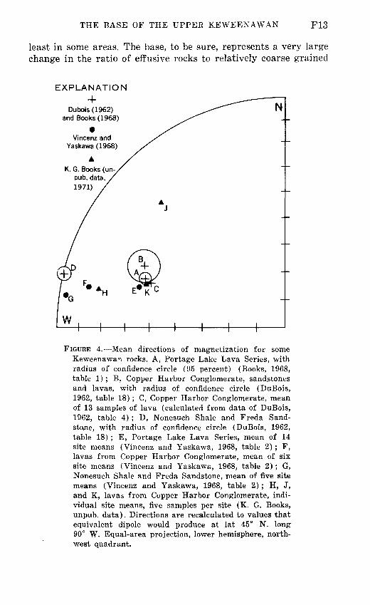
FIGURE 4. Mean directions of magnetization for some Keweenawan rocks. A, Portage Lake Lava Series, with radius of confidence circle (95 percent) (Books, 1968, table 1) ; B, Copper Harbor Conglomerate, sandstones and lavas, with radius of confidence circle (DuBois, 1962, table 18) ; C, Copper Harbor Conglomerate, mean of 13 samples of lava (calculated from data of DuBois, 1962, table 4) ; D, Nonesuch Shale and Freda Sand stone, with radius of confidence circle (DuBois, 1962, table 18) ; E, Portage Lake Lava Series, mean of 14 site means (Vincenz and Yaskawa, 1968, table 2) ; F, lavas from Copper Harbor Conglomerate, mean of six site means (Vincenz and Yaskawa, 1968, table 2) ; G, Nonesuch Shale and Freda Sandstone, mean of five site means (Vincenz and Yaskawa, 1968, table 2) ; H, J, and K, lavas from Copper Harbor Conglomerate, indi vidual site means, five samples per site (K. G. Books, unpub. data). Directions are recalculated to values that equivalent dipole would produce at lat 45° N. long 90° W. Equal-area projection, lower hemisphere, north west quadrant.

F14 CONTRIBUTIONS TO STRATIGRAPHY
sedimentary rocks, but both these constituents are found above and below the contact. The top, on the other hand, marks a bound ary above which no effusive rocks are known to occur and below which the amount of gray siltstone and shale (the predominant rock for several hundred feet above the contact) is vanishingly small. Qualitatively, therefore, the top is the boundary represent ing the greater lithologic change.
The main disadvantage of placing the base of the upper Keweenawan at the top of the Copper Harbor Conglomerate is that this is a significant departure from current usage, even though it comes much closer to fitting Irving's original boundary than does the current usage.
Before we proceed to a summary of pros and cons, a brief review of geophysical evidence relating to the choice is desirable.
PALEOMAGNETIC DATA
DuBois (1962) obtained paleomagnetic pole positions for the formations of concern to us here, and his results led him to con clude that the Copper Harbor Conglomerate is more closely related to the Portage Lake Lava Series than to the Nonesuch Shale and Freda Sandstone (fig. 2) ; his argument may be sum marized by the observation that points B and C of figure 4 lie close to point A and relatively distant from point D.
More recently, Vincenz and Yaskawa (1968) have found that both thermal and alternating-field demagnetization materially flatten the direction of remanent magnetism in samples of lava from the Copper Harbor Conglomerate but cause very little change in samples of Portage Lake lavas or the younger sedi mentary rocks. When the soft components of the magnetism are removed, the remanent direction that they obtained for lavas from the Copper Harbor Conglomerate (point F, fig. 4) lies closer to the directions for the Freda and Nonesuch (points G and D) than to those for the Portage Lake Lava Series (points E and A). They conclude from this relationship that, contrary to the view of DuBois, the Copper Harbor Conglomerate is closer paleomagnetically to the younger sedimentary rocks than to the Portage Lake Lava Series.
Kenneth Books has kindly provided data on paleomagnetic directions that he has determined for a few samples of lava from the Copper Harbor Conglomerate. The three sites represented by the data of figure 4 (points H, J, and K) are in the same general area as those sampled by DuBois (1962) and by Vincenz and Yaskawa (1968). The samples represented by H in figure 4 rep-
THE BASE OF THE UPPER KEWEENAWAN F15
resent the lower lava member of figures 1 and 2 and are from the same locality as DuBois' samples KH1-KH6 and Vincenz and Yaskawa's C1-C6. The samples represented by J and K in figure 4 are from the SE^NW^. sec. 26, T. 57 N., R. 33 W.; they rep resent the same group of flows (upper lava member of fig. 2) as DuBois' samples KP2-KP10 and Vincenz and Yaskawa's sites C9-C12, both of which suites were collected about a mile farther to the southwest along the strike.
Samples by K. G. Books (unpub. data, 1971) were magnetically "washed" in alternating fields in steps up to 200 oersteds, which is roughly the intensity at which Vincenz and Yaskawa found little further change of direction. Books' direction for samples represented by point H is very close to Vincenz and Yaskawa's mean for lavas of the Copper Harbor Conglomerate (point F), but point K is very close to the mean direction for the Portage Lake Lava Series. The third of Books' site means (J, fig. 4) is unlike any others. These data are presented primarily to illus trate the scatter remaining in data from these particular lavas after magnetic "washing" scatter that will make conclusions about stratigraphic affinities risky until far more measurements have been made.
Paleomagnetic data, therefore, are still too few and equivocal to provide much basis for saying which geologic boundary, the top or the bottom of the Copper Harbor Conglomerate, marks the greater stratigraphic break, even if there were some basis for assuming that the magnetic pole wandered at a constant rate. A secular flattening of the paleomagnetic direction between Portage Lake and Freda time seems fairly well established, however, and this may ultimately prove very useful in stratigraphic correla tions beyond the area treated here, wherever the base of the upper Keweenawan is placed.
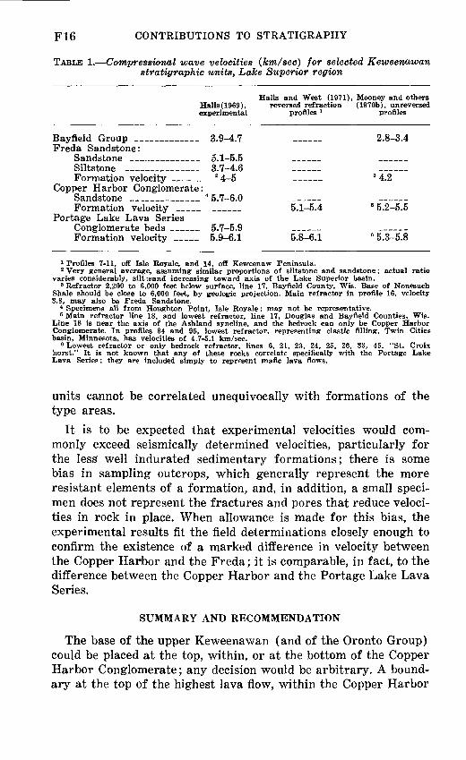
SEISMIC DATA
It may also prove possible to locate the boundary, as defined, over large areas in the subsurface by explosion seismology. Table 1 presents some of the results of recent work in this field that has been designed specifically to get the kind of information needed. The table does not summarize the results of that work but is an extract of the particular data that appear most reliable; that is, from the numerous velocity determinations in each study, I have selected only those few that appear to me to be most trust worthy and to represent the cited formation beyond any reason able doubt, and have excluded many determinations where the
F16 CONTRIBUTIONS TO STRATIGRAPHY
TABLE 1. Compressional wave velocities (km/sec) for selected Keweenawan stratigraphic units, Lake Superior region
Halls and West (1971), Mooney and others Halls(1969), reversed refraction (1970b), unreversed experimental profiles 1 profiles
Bayfield Group ________ 3.9-4.7 ___ 2.8-3.4Freda Sandstone:
Sandstone _..______ 5.1-5.5 ___ ____ Siltstone _________ 3.7-4.6 ___ ______Formation velocity ____ 2 4-5 _ 3 4.2
Copper Harbor Conglomerate:Sandstone _________ 4 5.7-6.0 ___ ______Formation velocity ___ ___ 5.1-5.4 B 5.2-5.5
Portage Lake Lava SeriesConglomerate beds ____ 5.7-5.9 ______Formation velocity ___ 5.9-6.1 5.8-6.1 6 5.3-5.8
1 Profiles 7-11, off Isle Royale, and 14, off Keweenaw Peninsula.2 Very general average, assuming similar proportions of siltstone and sandstone; actual ratio
varies considerably, silt:sand increasing toward axis of the Lake Superior basin.3 Refractor 2,200 to 6,000 feet below surface, line 17, Bayfield County, Wis. Base of Nonesuch
Shale should be close to 6,000 feet, by geologic projection. Main refractor in profile 16, velocity 3.8, may also be Freda Sandstone.
4 Specimens all from Houghton Point, Isle Royale; may not be representative.5 Main refractor line 18, and lowest refractor, line 17, Douglas and Bayfield Counties, Wis.
Line 18 is near the axis of the Ashland syncline, and the bedrock can only be Copper Harbor Conglomerate. In profiles 34 and 95, lowest refractor, representing clastic filling, Twin Cities basin, Minnesota, has velocities of 4.7-5.1 km/sec.
6 Lowest refractor or only bedrock refractor, lines 6, 21, 23, 24, 25, 26, 33, 45, "St. Croix horst." It is not known that any of these rocks correlate specifically with the Portage Lake Lava Series; they are included simply to represent mafic lava flows.
units cannot be correlated unequivocally with formations of the type areas.
It is to be expected that experimental velocities would com monly exceed seismically determined velocities, particularly for the less well indurated sedimentary formations; there is some bias in sampling outcrops, which generally represent the more resistant elements of a formation, and, in addition, a small speci men does not represent the fractures and pores that reduce veloci ties in rock in place. When allowance is made for this bias, the experimental results fit the field determinations closely enough to confirm the existence of a marked difference in velocity between the Copper Harbor and the Freda; it is comparable, in fact, to the difference between the Copper Harbor and the Portage Lake Lava Series.
SUMMARY AND RECOMMENDATION
The base of the upper Keweenawan (and of the Oronto Group) could be placed at the top, within, or at the bottom of the Copper Harbor Conglomerate; any decision would be arbitrary. A bound ary at the top of the highest lava flow, within the Copper Harbor

THE BASE OF THE UPPER KEWEENAWAN FIT
Conglomerate, has the advantage of following the original defini tion precisely, but this advantage is more apparent than real if one attempts to trace the boundary away from Irving's type area on Keweenaw Point. This choice has the serious disadvantage of placing a major stratigraphic boundary within a stratigraphic unit that regionally, at least, cannot be subdivided on any con sistent basis.
A boundary at the base of the Copper Harbor Conglomerate is generally satisfactory from the standpoint of regional correlations and geologic mapping and has been widely used in Michigan and Wisconsin. Its main advantage is that it separates a dominantly sedimentary group of rocks from one that is dominantly volcanic and is, therefore, readily located if exposures are good; under favorable circumstances, it may also be located magnetically or seismically. Its main disadvantages are as follows: (1) It does not even approximately mark the close of volcanism in the Lake Superior region. (2) In the area between long. 89° and 90°20' W. (fig. 3), one of the two virtues it has elsewhere must be sacri ficed to preserve the other: if it is regarded as an approximate time horizon, it should probably be carried beneath the unnamed formation, losing its distinctiveness as a lithologic break; if it is carried over the unnamed formation, it may separate lavas on one side from more or less contemporaneous sedimentary rocks on the other, losing its meaning as a time break. (3) The location of the base of the Copper Harbor Conglomerate is not known with any thing like the same precision as the location of the top at most places.
The top of the Copper Harbor Conglomerate seems to make the best boundary between the middle and upper Keweenawan for the following reasons: (1) It comes closest of any of the possible alternatives to marking the close of volcanism as a point in time; it is unaffected by such local factors as the pinching out of an individual lava flow that happens to be the highest one at a given locality. (2) It does not appear to be sufficiently transgressive to lose its value as a time break over a very large area. (3) Thanks to economic interest in the copper found in rocks adjoining this boundary, the position of this boundary is better known for a higher proportion of its total strike length than the position of any other boundary in the Keweenawan province.
If, then, the top of the Copper Harbor Conglomerate (base of the Nonesuch Shale) were adopted as the base of the upper Keweenawan in the region between Keweenaw Point and the vicinity of Ashland, Wis., what would be the effect on existing
F18 CONTRIBUTIONS TO STRATIGRAPHY
literature and usage, both within and beyond the limits of this region ?
Rocks described and mapped as Copper Harbor Conglomerate would be classed as middle rather than upper Keweenawan. The boundaries on existing large-scale maps, showing individual for mation boundaries, would be unaffected the only difference would be in their classification as defined by the map explanation. New small-scale maps, however, might differ significantly from existing maps where formations are lumped into large units like "upper Keweenawan" and Oronto Group. Locating the base of the upper Keweenawan (base of Oronto Group) for purposes of a new map would pose no problem in Michigan and Wisconsin, because the position of the Nonesuch Shale is well established throughout the region. The actual differences between new and old regional maps would be significant, however, because, except in the Keweenaw Peninsula and Porcupine Mountain region, so many existing regional maps, going back to Van Hise and Leith (1911, pi. 1), include the whole Copper Harbor Conglomerate in the upper Keweenawan over wide areas, rather than just the uppermost few hundred feet correlative with the true "Outer Conglomerate." For this reason, some of the areas affected are large, such as that underlain by the Copper Harbor Conglomerate on Isle Royale, and in the syncline southwest of Ashland, Wis., particularly west of long. 91°45' W.
Outside the region that is the main concern of this paper, the effect is more difficult to assess. Certain red sandstone and con glomerate formations of Minnesota, particularly in the subsurface within basins along the crest of the midcontinent gravity high, may be, in part, correlative with the Copper Harbor Conglomer ate. If the Nonesuch Shale does not extend that far west, as it probably does not, it may prove difficult to locate the base of the upper Keweenawan according to the definitions suggested here. It may ultimately be possible to make a good separation, however, by a combination of lithologic and paleomagnetic data from drill holes and seismic data.
Data presently available strongly suggest that the paleomag netic directions in the Freda Sandstone and Nonesuch Shale are much flatter than those in the Portage Lake Lava Series. These data offer hope that when more measurements have been made, the direction for rocks close to the top of the Copper Harbor Conglomerate will have an identifiable position on a curve for secular wandering of the virtual geomagnetic pole.

THE BASE OF THE UPPER KEWEENAWAN F19
The work of Mooney and others (1970a, b) indicates that veloc ity differences comparable with those listed in table 1 persist in the buried parts of the midcontinent gravity high in Minnesota. By means of such seismic investigations, it may ultimately be possible to trace the base of the upper Keweenawan, defined as suggested here, over large areas in the subsurface if it can be located at a relatively few places by lithologic or paleomagnetic criteria.
In the areas where the Copper Harbor Conglomerate is known to be present, it appears to have the form of clastic wedges that need not have extended far outside the elongate bowl of Portage Lake Lava Series that now contains them. There is no positive geo logic evidence, therefore, that sedimentary formations correlative
Formations of Bayfield Group,not differentiated here
Freda Sandstone
Nonesuch Shale
Q n i Q-LU ;3C O> o:< oDQ
Q_
Ooo1-2ooro
__^__^ Copper Harbor ^X Conglomerate
jX^tjncluding rnafic lava members)
Unnamed formation /*(volcanics) ->
/^~~~~~^^
Portage Lake Lava Series
z.
^> z.UJ UJ
UJ
o:UJQ_Q_
z.
1UJLJ
L̂J
LJ
Q9
FIGURE 5. Proposed nomenclature for middle and up per Keweenawan rocks of northern Michigan and adjacent parts of Wisconsin.

F20 CONTRIBUTIONS TO STRATIGRAPHY
with the Copper Harbor Conglomerate even exist in the areas that Mooney and others (1970a, b) call the eastern and western basins. If there are none, the definition proposed here may only create a problem in areas like the Twin Cities basin that are within the midcontinent gravity high.
For geophysical work in parts of the region covered by Lake Superior, it might at first appear desirable to place the boundary at the top of the main body of lavas rather than higher up, within a predominantly sedimentary group of rocks. This would, indeed, be true if there were any reason to believe that the Copper Harbor Conglomerate remains a predominantly sedimentary formation in the central parts of the Lake Superior Basin. Groups of flows within the Copper Harbor Conglomerate ("Lake Shore traps"), however, pinch out away from the basin axis and become thicker and more numerous toward it. This fact suggests that the top of the lavas determined seismically is likely to be nearer the top than the bottom of the Copper Harbor Conglomerate.
In conclusion, the top of the Copper Harbor Conglomerate (base of Nonesuch Shale) appears to be the best stratigraphic location for the base of the upper Keweenawan and the Oronto Group from both a theoretical and practical standpoint, and a purpose of this paper is to propose its adoption (fig. 5). This represents a far smaller departure from Irving's original concept than do most of the maps and classifications that have attempted to follow him more faithfully. Any change in usage such as that proposed here is bound to cause some confusion for a while, but substituting a contact that can be rigorously and simply defined and located over a very large area for one that cannot should, in the long run, be a gain.
REFERENCES
Aldrich, H. R., 1929, The geology of the Gogebic Iron Range of Wisconsin: Wisconsin Geol. and Nat. History Survey Bull. 71, 279 p.
Books, K. G., 1968, Magnetization of the lowermost Keweenawan lava flows in the Lake Superior area in Geological Survey research 1968: U.S. Geol. Survey Prof. Paper 600-D, p. D248-D254.
Butler, B. S., Burbank, W. S., and others, 1929, The copper deposits of Michigan: U.S. Geol. Survey Prof. Paper 144, 238 p.
Cornwall, H. R., 1954a, Bedrock geology of the Phoenix quadrangle, Michi gan: U.S. Geol. Survey Geol. Quad. Map GQ-34.
1954b, Bedrock geology of the Delaware quadrangle, Michigan: U.S. Geol. Survey Geol. Quad. Map GQ-51.
1954c, Bedrock geology of the Lake Medora quadrangle, Michigan: U.S. Geol. Survey Geol. Quad. Map GQ-52.
1955, Bedrock geology of the Fort Wilkins quadrangle, Michigan:U.S. Geol. Survey Geol. Quad. Map GQ-74.

THE BASE OF THE UPPER KEWEENAWAN F21
Cornwall, H. R., and White, W. S., 1955, Bedrock geology of the ManitouIsland quadrangle, Michigan: U.S. Geol. Survey Geol. Quad. MapGQ-73.
Cornwall, H. R., and Wright, J. C., 1954, Bedrock geology of the EagleHarbor quadrangle, Michigan: U.S. Geol. Survey Geol. Quad. MapGQ-36.
1956a, Geologic map of the Hancock quadrangle, Michigan: U.S.Geol. Survey Mineral Inv. Field Studies Map MF-46.
1956b, Geologic map of the Laurium quadrangle, Michigan: U.S. Geol.Survey Mineral Inv. Field Studies Map MF-47.
Davidson, E. S., Espenshade, G. H., White, W. S., and Wright, J. C., 1955,Bedrock geology of the Mohawk quadrangle, Michigan: U.S. Geol. SurveyGeol. Quad. Map GQ-54.
DuBois, P. M., 1962, Paleomagnetization and correlation of Keweenawanrocks: Canada Geol. Survey Bull. 71, 75 p.
Gordon, W. C. (assisted by Lane, A. C.), 1907, A geological section fromBessemer down Black River: Michigan Geol. Survey Rept. for 1906,p. 397-507.
Halls, H. C., 1966, A review of the Keweenawan geology of the Lake Superiorregion, in Steinhart, J. S., and Smith, T. J., eds., The earth beneath thecontinents: Am. Geophys. Union Geophys. Mon. 10 (Natl. Acad. Sci.-Natl. Research Council Pub. 1467), p. 3-27.
1969, Compressional wave velocities of Keweenawan rock specimens from the Lake Superior region: Canadian Jour. Earth Sci., v. 6, no. 4, pt. 1, p. 555-568.
Halls, H. C., and West, G. F., 1971, A seismic refraction survey in Lake Superior: Canadian Jour. Earth Sci., v. 8, p. 610-630.
Hamblin, W. K., 1961, Paleogeographic evolution of the Lake Superior region from Late Keweenawan to Late Cambrian time: Geol. Soc. America Bull., v. 72, no. 1, p. 1-18.
Hamblin, W. K., and Horner, W. J., 1961, Sources of the Keweenawan con glomerates of northern Michigan: Jour. Geology, v. 69, no. 2, p. 204-211.
Hite, D. M., 1968, Sedimentology of the upper Keweenawan sequence of northern Wisconsin and adjacent Michigan: Madison, Wis., Univ. Wis consin, unpub. Ph.D. thesis, 202 p.
Hubbard, H. A., 1968, Stratigraphic relationships of some Keweenawan rocks of Michigan and Wisconsin [abs.]: in Inst. Lake Superior Geology, 14th Ann., 1968, Tech. Sess. Abs.: Superior, Wis., Wisconsin State Univ., p. 35-37.
Huber, N. K., 1971, The Keweenawan geology of Isle Royale, Michigan: U.S. Geol. Survey open-file report, 9 p.
Irving, R. D., 1883, The copper-bearing rocks of Lake Superior: U.S. Geol. Survey Mon. 5, 464 p.
Kelley, R. W., comp., 1968, Bedrock of Michigan: Michigan Geol. Survey Small Scale Map 2, 1 sheet.
Lane, A. C., 1898, Geological report o,n Isle Royale, Michigan: Michigan Geol. Survey, v. 6, pt. 1, 281 p.
1911, The Keweenaw series of Michigan: Michigan Geol. and Biol.Survey Pub. 6 (Geol. ser. 4), 2 v.: 983 p.
Lane, A. C., and Seaman, A. E., 1907, Notes on the geological section ofMichigan; Part 1, The pre-Ordovician: Jour. Geology, v. 15, p. 680-695.
F22 CONTRIBUTIONS TO STRATIGRAPHY
Leith, C. K., Lund, R. J., and Leith, Andrew, 1935, Pre-Cambrian rocks of the Lake Superior region: U.S. Geol. Survey Prof. Paper 184, 34 p.
Moerlein, G. A., 1963, Structure and stratigraphy of the upper Keweenawan rocks in northwestern Wisconsin [abs.]; in Inst. Lake Superior Geology, 9th Ann., 1963: Duluth, Minn., Univ. Minnesota, Dept. Geology, p. 8.
Mooney, H. M., Craddock, Campbell, Farnham, P. R., Johnson, S. H., and Volz, Gary, 1970a, Refraction seismic investigations of the northern midcontinent gravity high: Jour. Geophys. Research, v. 75, no. 26, p. 5056-5086.
Mooney, H. M., Farnham, P. R., Johnson, S. H., Volz, Gary, and Craddock, Campbell, 1970b, Seismic studies over the midcontinent gravity high in Minnesota and northwestern Wisconsin: Minnesota Geol. Survey Rept. Inv. 11, 191 p.
Ostrom, M. E., 1967, Paleozoic stratigraphic nomenclature for Wisconsin: Wisconsin Geol. and Nat. History Survey Inf. Circ. 8, 1 sheet.
Thwaites, F. T., 1912, Sandstones of the Wisconsin coast of Lake Superior: Wisconsin Geol. and Nat. History Survey Bull. 25 (Sci. Ser. 8), 117 p.
Tyler, S. A., Marsden, R. W., Grout, F. F., and Thiel, G. A., 1940, Studies of the Lake Superior pre-Cambrian by accessory-mineral methods: Geol. Soc. America Bull., v. 51, no. 10, p. 1429-1537.
Van Hise, C. R., and Leith, C. K., 1911, The geology of the Lake Superior region: U.S. Geol. Survey Mon. 52, 641 p. [See particularly chap. 15, The Keweenawan Series, p. 366-426.]
Vincenz, S. A., and Yaskawa, K., 1968, Phenomenon of partial self-reversal in Keweenawan rocks. [Pt.] 2. Magnetization of upper Keweenawan lavas and sediments and of lower Keweenawan dikes: Jour. Geophys. Research, v. 73, no. 8, p. 2753-2767.
White, W. S., 1952, Imbrication and initial dip in a Keweenawan conglom erate bed [Michigan] : Jour. Sed. Petrology, v. 22, no. 4, p.. 189-199.
1956, Geologic map of the Chassell quadrangle, Michigan: U.S. Geol. Survey Mineral Inv. Field Studies Map MF-43.
1966, Tectonics of the Keweenawan basin, western Lake Superior region: U.S. Geol. Survey Prof. Paper 524-E, 23 p..
1968, The native-copper deposits of northern Michigan, in J. D. Ridge,ed., Ore deposits of the United States, 1933-1967 (Graton-Sales volume) : New York, Am. Inst. Mining, Metall., and Petroleum Eng., v. 1, p. 303- 325.
White, W. S., Brooks, E. R., Hubbard, H. A., Johnson, R. F., Wilband, J. T.,1971, Keweenawan stratigraphy of westernmost Michigan [abs.], inInst. on Lake Superior Geology, 17th Ann., 1971, Abs. and Field Guides:Duluth, Minn., p. 71-72.
White, W. S., Cornwall, H. R., and Swanson, R. W., 1953, Bedrock geologyof the Ahmeek quadrangle, Michigan: U.S. Geol. Survey Geol. Quad.Map GQ-27.
White, W. S., and Wright, J. C., 1956, Geologic map of the South Rangequadrangle, Michigan: U.S. Geol. Survey Mineral Inv. Field StudiesMap MF-48.
1960, Lithofacies of the Copper Harbor Conglomerate, .northern Michigan: U.S. Geol. Survey Prof. Paper 400-B, p. B5-B8.
1966, Sulfide-mineral zoning in the basal Nonesuch Shale, northernMichigan: Econ. Geology, v. 61, no. 7, p. 1171-1190.
THE BASE OF THE UPPER KEWEENAWAN F23
Wright, P. E., and Lane, A. C., 1909, Preliminary geological map of thePorcupine Mountains and vicinity: Michigan Geol. Survey Ann. Rept.for 1908, pi. 1 (facing p. 8).
Wright, J. C., and Cornwall, H. R., 1954, Bedrock geology of the BruneauCreek quadrangle, Michigan: U.S. Geol. Survey Geol. Quad. MapGQ-35.
Zietz, Isidore, and Kirby, J. R., 1971, Aeromagnetic map of the western partof the northern peninsula, Michigan, and part of northern Wisconsin:U.S. Geol.. Survey Geophys. Inv. Map GP-750.


Contributions toStratigraphy,1971
GEOLOGICAL SURVEY BULLETIN 1354
This volume was published as separate chapters A-F
UNITED STATES DEPARTMENT OF THE INTERIOR
ROGERS C. B. MORTON, Secretary
GEOLOGICAL SURVEY
V. E. McKelvey, Director

CONTENTS
[Letters designate the separately published chapters]
(A) Changes in stratigraphic nomenclature by the U.S. Geological Survey, 1970. by George V. Cohee, Robert G. Bates, and Wilna B. Wright.
(B) Members of the Borden Formation (Mississippian) in north-central Ken tucky, by Roy C. Kepferle.
(0) Big Sandy Formation near Wikieup, Mohave County, Arizona, by Richard A. Sheppard and Arthur ,T. Gude, 3d.
(D) Revision of stratigraphic names for some Eocene formations in Santa Barbara and Ventura Counties, California, by J. G. Vedder.
(E) Age and correlation of the Clinchfield Sand in Georgia, by S. M. Herrick.(F) The base of the upper Keweenawan, Michigan and Wisconsin, by Walter S.
White.
U. S. GOVERNMENT PRINTING OFFICE ; 1972 O - 458-352