tcdc operative district plan - thames-coromandel district ... · 6hfwlrq...
TRANSCRIPT

Section 4 Rules Applicable to All Activities Throughout District
Section 4 Index400 INTRODUCTION The rules in Section 4 (410 to 493 inclusive) apply to all activities throughout the District to the extent provided for in this section.410 EARTHWORKS AND LAND DISTURBANCE ACTIVITIES411A Definitions411B Exclusions412 Activity Status413 Standards414 Restricted Discretionary Activity Assessment Criteria and Protocols415 Discretionary Activity Assessment Criteria and Protocols416 Relevant Issues, Objectives and Policies Table 1 Activity Status for Underground and Surface Mining in all parts of the District Table 2 Standards for Permitted Activites in District Countryside Table 3 Standards for Permitted Activities in District Towns Mining Figures Northern Coromandel Restricted Area Figures 1A and 1B Mining Figures Coastal (Restricted) Area Figures 2A 2H 420 THE CLEARANCE OF INDIGENOUS VEGETATION, WETLAND AND DUNE VEGETATION421 Definitions422 Activity Status423 Standards424 Controlled Activity Matters425 Restricted Discretionary Activity Assessment Criteria and Protocols426 Discretionary Activity Assessment Criteria and Protocols427 NonComplying Activity Criteria and Protocols428 Relevant Objectives and Policies430 HERITAGE PROTECTION431 Definitions432 Activity Status433 Standards434 Controlled Activity Matters435 Restricted Discretionary Activity Assessment Criteria and Protocols436 Discretionary Activity Assessment Criteria and Protocols437 NonComplying Activity Criteria and Protocols438 Relevant Objectives and Policies Table 1Thames Heritage Building Schedule: 1Coromandel Heritage Building Schedule: 2440 TREE PROTECTION441 Definitions442 Activity Status443 Standards444 Controlled Activity Matters445 Restricted Discretionary Activity Assessment Criteria and Protocols446 Discretionary Activity Assessment Criteria and Protocols447 NonComplying Activity Criteria and Protocols448 Relevant Objectives and Policies Table 1Thames Tree Register Notable TreesCoromandel Tree Register Notable Trees450 NATURAL HAZARDS451 Definitions452 Activity Status453 Standards454 Controlled Activity Matters455 Restricted Discretionary Activity Assessment Criteria and Protocols456 Discretionary Activity Assessment Criteria and Protocols457 NonComplying Activity Criteria and Protocols458 Relevant Objectives and Policies460 HAZARDOUS SUBSTANCES461 Definitions462 Activity Status463 Standards464 Controlled Activity Matters465 Restricted Discretionary Activity Assessment Criteria and Protocols466 Discretionary Activity Assessment Criteria and Protocols467 NonComplying Activity Criteria and Protocols468 Relevant Objectives and Policies Tables 1 and 2470 ROADING, PARKING, LOADING AND ACCESS471 Definitions472 Activity Status473 Standards Terms and Conditions474 Controlled Activity Matters475 Restricted Discretionary Activity Assessment Criteria and Protocols
TCDC Operative District Plan
Printed: 26/09/2013 Page 1 of 96
476 Discretionary Activity Assessment Criteria and Protocols477 NonComplying Activity Criteria and Protocols478 Relevant Objectives and Policies Figure 1: Carpark Standards Figure 2: Carpark Standards480 FINANCIAL CONTRIBUTIONS481 Definitions482 Activity Status483 Application of DIF's484 DIF's for Existing or Proposed Facilities Works or Services: Types, Purpose and Formula485 DIF's for Provision of, or Contribution Towards Facilities, Works or Services Outside or in Advance of Approved Development Programmes486 DIF's to Off Set Localised Environmental Effects487 DIF's for Water Supply Wastewater and Stormwater Systems488 Special DIF's Accounts489 Relevant Resource Management Issues and Objectives490 AMENITY AND SAFETY RULES491 Noise Table 1 Table 2492 Signs493 Airfield Operational Efficiency and Safety
TCDC Operative District Plan
Printed: 26/09/2013 Page 2 of 96

410 Earthworks and Land Disturbance Activities
411A DefinitionsThe following terms and expressions are defined in Section 9:
EarthworksExplorationMineralMiningMining OperationsProspectingSurface miningUnderground Mining
411B ExclusionSection 410 shall not apply to earthworks, prospecting and exploration activities undertaken in the following zones of the Whitianga Central Area, unless thosezones specifically require earthworks controls:
gateway zonewaterfront zonepedestrian core zonegeneral activities zone
Section 410 does apply to surface and underground mining provisions within the above zones of the Whitianga Central Area.
412 Activity StatusEarthworks or land disturbance activities that are not associated with subdivision are Permitted, Restricted Discretionary, Discretionary, NonComplying orProhibited according to all the relevant rules in Sections 410 to 417 (inclusive) and the relevant rules in section 7 (inclusive).
Note For the avoidance of doubt, the more onerous provisions shall apply.
412.1 Permitted Activities
412.1.1
Earthworks which meet all the permitted activity earthworks standards in Tables 2 or 3.
412.1.2
Underground Mining and Surface Mining which meets all the permitted activity earthworks standards in Tables 2 or 3.
412.1.3
Temporary stream and river gravel extraction and crushing facilities. Note A Regional Council consent is probably required.
412.1.4
Earthworks associated with lawful production forestry established on or before 22 March 1997 and which meet the relevant standards in Section 413.
412.1.5
Prospecting and Exploration which meet all the permitted activity earthworks standards in either Tables 2 or 3. Equipment, structures and temporarybuildings associated with prospecting and exploration are also permitted activities and the bulk and location standards of the relevant zone do not apply.Note See Section 491 Noise.
TCDC Operative District Plan
Printed: 26/09/2013 Page 3 of 96

412.1.6
The removal of earth or placement of fill in a high flood hazard area for the following activities.(i) driveways and accessways ≤ 1:8 gradient (ii) planting of indigenous vegetation(iii) planting and removal of exotic vegetation and trees in the Rural Zone all parts except Village, Residential, Open Space, Recreation and
Conservation Policy Areas(iv) dune stabilisation planting(v) gardening for domestic purposes, horticulture and land cultivation(vi) work carried out to provide for effluent disposal systems, swimming pools, garden amenities and fences(vii) utility trenching carried out by Council or a network utilities operator(viii) emergency works to clear roads(ix) maintenance of operational roads or tracks (x) drilling for cores or waterbores, including the creation of drilling pads and associated stormwater management up to a maximum size of 200m2
per pad and rehabilitation of drilling pad sites, but excluding access to drilling pad sites (xi) irrigation or land drainage works below natural ground level(xii) the construction and maintenance of firebreaks.
412.2 Controlled Activities
Note No earthworks or land disturbance activities under this activity status.
412.3 Restricted Discretionary Activities
412.3.1
Earthworks where one of the permitted activity standards in Tables 2 or 3 is not met.
412.3.2
The removal of earth or placement of fill in a high flood hazard area other than for those activities listed as permitted in rule 412.1.6. All other earthworksrules shall apply if more restrictive than this rule.
412.3.3
Prospecting and Exploration (including associated equipment, structures and temporary buildings) where one of the permitted activity standards in eitherTables 2 or 3 is not met.
412.4 Discretionary Activities
412.4.1
Earthworks where two or more of the permitted activity standards in Tables 2 or 3 are not met.
412.4.2
Underground Mining and Surface Mining in those zones shown as discretionary in Table 1 and where any one or more of the permitted activity standardsfor earthworks is exceeded.
412.4.3
Prospecting and Exploration (including associated equipment, structures and temporary buildings) where two or more of the permitted activity standards ineither Tables 2 or 3 are not met.
412.4.4
Earthworks in the vicinity of an archaeological site, waahi tapu or waahi tapu area listed in a Heritage Register.
412.5 NonComplying Activities
.1 Surface and Underground Mining in those zones shown as noncomplying in Table 1 and where any one or more of the permitted activitystandards for earthworks is exceeded.
412.6 Prohibited Activities
.1 Surface and Underground Mining in those zones shown in Table 1 as prohibited activities.
413 Standards
413.1
All Permitted activities (except those associated with lawful production forestry established on or before 22 March 1997) shall comply with the relevantstandards in Tables 2 or 3.
413.2
Lawful production forestry established on or before 22 March 1997 shall comply with the following standards:.1 Where earthworks create areas without vegetation cover those areas shall be revegetated in the following spring or autumn to an 80% ground cover
within 24 months of the operation being completed..2 Batters and side castings are to be established to avoid slumping of upland slope and movement of soil..3 Roading and tracking shall be maintained at all times or revegetated when no longer in use..4 Earthworks shall not interfere with or destroy any waahi tapu, urupa or any other sites known to the local iwi which are of spiritual or cultural
significance to Maori, which have been identified to the District or Regional Council. Should archaelogical remains or features be uncovered, allearthworks in the immediate vicinity shall cease and not be recommenced without the authority of the New Zealand Historic Places Trust.
413 Note
Note This standard complements the duties and obligations imposed on all persons by the Historic Places Act 1993 in respect of archaeologicalsites. The historic Places Act 1993 (section 10) makes it an offence to destroy, damage or modify or cause to be destroyed, damaged ormodified the whole or part of an archaeological site, knowing or having reasonable cause to suspect that it is an archaeological site.
TCDC Operative District Plan
Printed: 26/09/2013 Page 4 of 96

Note The Department of Conservation is the holder of the records of the New Zealand Archaeological Association. The existing records aresubject to ongoing review and new records are continually being added. The Department of Conservation should be consulted to determinewhether there are any known archaeological sites in a particular area.
Note This standard does not abrogate the responsibility of people to satisfy themselves prior to commencement of work as to the location ofwaahi tapu etc, and their need to consult with tangata Whenua with interest in the area. The district or regional Council can provide lists oflocal Tangata Whenua contacts.
414 Restricted Discretionary Activity Assessment Criteria and ProtocolsEach restricted discretionary activity shall be assessed according to:.1 The relevant permitted activity standards in Tables 2 or 3. Where Council has restricted its discretion, only those matters relevant to the appropriate
standard shall be assessed..2 The relevant criteria in Section 8 (850). .3 The information requirements (840) and notification protocols (820) set out in Section 8..4 Without limiting the discretions in .1 to .3 above, where the maximum face height is exceeded in 410: Tables 2 or 3, a condition of any consent may
require reduction or mitigation of the visual effects of exposed faces, through: Hydroseeding,
landscape plantingmatting
and where appropriate terracing and retaining walls provided that where hard engineering options are necessary for reasons of stabilising cut faces, provision shall be made to soften the visual effects
through planting appropriate ground cover, shrubs and trees.
415 Discretionary Activity Assessment Criteria and ProtocolsEach discretionary activity shall be assessed according to: .1 The relevant assessment criteria for discretionary activities in Section 8 (850)..2 The information requirements (840) and notification protocols (820) set out in Section 8. .3 For earthworks, areas of discretion include but are not limited to the following:
(a) Geotechnical information and advice; (b) Mitigation measures; (c) Methods by which earthworks are to be undertaken; (d) Sequence of events, i.e. timing, staging; (e) Rate at which works can be undertaken; (f) Proposed site landscape rehabilitation; (g) Sediment control; (h) Stormwater management; (i) Traffic movements; (j) Hours of operation; (k) Offsite placement of fill, transportation and location; (l) Emergency Procedures; (m) Natural hazard avoidance or exacerbation; (n) Exposure of acid rock; (o) Archaeological survey; (p) Need for a comprehensive management plan to cover all of the above.
TCDC Operative District Plan
Printed: 26/09/2013 Page 5 of 96

416 Relevant Issues, Objectives and PoliciesThe following significant resource management issues, objectives and policies are particularly relevant to these rules:211 Biodiversity212 Landscape and Natural Character214 Heritage Resources215 Tangata Whenua Issues216 Transportation218 Community Water Supplies219 District Waterbodies221 Land Disturbance and Earthworks222 Natural Hazards223 Hazardous Substances224 Cross Boundary Issues
TCDC Operative District Plan
Printed: 26/09/2013 Page 6 of 96

Table 1
TABLE 1 ACTIVITY STATUS FOR UNDERGROUND AND SURFACE MINING IN ALL PARTS OF THE DISTRICT
ZONE UNDERGROUND MINING ACTIVITY STATUS SURFACE MINING ACTIVITY STATUS
RURAL
Outside all policy areas Discretionary# Discretionary#
Policy Areas:
Maori, Future Development Discretionary# Discretionary#
Airfield, Residential and Village Discretionary# Prohibited#
COASTAL
Outside all policy areas and Maori Policy Area Discretionary#1 Non complying #1
Coastal (Restricted) Area (refer Figures 2A2H at theend of Section 410)
Non complying # Prohibited #
Policy Areas:
Airfield, Future Development, Residential, Village andMarine Activities
Discretionary# Prohibited#
CONSERVATION
Policy Areas:
All parts Discretionary# Noncomplying#
INDUSTRIAL
Policy Areas:
All parts Discretionary* Prohibited*
HOUSING
Policy Areas:
All parts Discretionary Prohibited
TOWN CENTRE
Policy Areas:
All parts Discretionary Prohibited
RECREATION (ACTIVE), RECREATION (PASSIVE) AND OPEN SPACE
All previous Recreation and Open Space PolicyAreas in all zones other than the Rural Zone
Discretionary# Prohibited#
All previous Recreation and Open Space PolicyAreas in the Rural Zone
Discretionary Noncomplying
IWI KAINGA
All parts Discretionary Discretionary
INDUSTRIAL A
All parts Discretionary* Prohibited*
WHITIANGA CENTRAL AREAWaterfront ZoneGateway ZoneGeneral Activities ZonePedestrian Core Zone
All parts Discretionary Prohibited
NORTHERN COROMANDEL RESTRICTED AREA (See Figures 1A1B at the end of Section 410)
Mining Exclusion Area Prohibited Prohibited
Coastal Zone All Parts Noncomplying Prohibited
Rural, Conservation, Open Space and Recreation(Passive) Outside the Mining Exclusion Area
Discretionary Prohibited
* Mining Operations that meet the definition of "Industrial Activity" and are to be carried out in the Industrial Zone and its policy areas and the Industrial A Zone,are to have the activity status of industrial activities.
#All parts excluding Northern Coromandel Restricted Area (see Figures 1A 1B at the end of Section 410)1 All parts excluding Coastal (Restricted) Area (see Figures 2A 2H at the end of Section 410).
TCDC Operative District Plan
Printed: 26/09/2013 Page 7 of 96

Table 2
TABLE 2 STANDARDS FOR PERMITTED ACTIVITIES IN DISTRICT COUNTRYSIDE Key: * = maximum area standard does not applyto public roads
ZONE Rural RecreationZone
(Passive)
RecreationZone (Active)
Coastal ConservationZone & OpenSpace Zone
POLICY AREA Maori &Outside All,Airfield &Future
Development
Village Residential Residential,Village
Maori & OutsideAll, Airfield &
FutureDevelopment
Maximumvolume (m3)per site per 12month period
2500
(except inHigh flood hazard
areas = 0)
100 >1:8gradient
250 ≤1:8 gradient
(except inHigh flood hazard
areas = 0)
500 > 1:8gradient
1000 ≤ 1:8gradient
(except inHigh flood hazard
areas = 0)
100 > 1:8gradient
250 ≤ 1:8gradient
(except inHigh flood hazard
areas= 0)
1000
(except in Medium or
High flood hazardareas= 0)
50 > 1:8 gradient
100 ≤ 1:8gradient
(except in
High flood hazardareas = 0)
1000
(except inHigh flood hazard
areas = 0)
50 > 1:8 gradient
100 ≤ 1:8gradient
(except in
High flood hazardareas = 0)
Maximum faceheight (m) persite
5 1.5 3 1.5 1.5 1.5 3 1.5
Maximum areaper site (m2)*
10,000(1 ha)
100 1500 100 > 1:8gradient
250 ≤ 1:8gradient
1000 150 > 1:8gradient
250 ≤ 1:8gradient
2500 150 > 1:8gradient
250 ≤ 1:8gradient
Maximumduration ofwork withinany calendaryear
3 months 3 months 3 months 3 months 3 months 3 months 3 months 3 months
Note 1. Buildings, such as retaining walls, must meet the yard standards set for houses and accessory buildings in 510 except for equipment,structures and temporary buildings associated with prospecting and exploration (refer to Rule 412.1.5, 412.3.3 and 412.4.3).
2. Building Act requirements may be triggered for some earthworks, such as where work is needed because land instability threatens a buildingand retaining walls.
3. The volume of earthworks is to be measured prior to excavation.
4. Great Mercury Island Conservation Policy Area is not included here because all activities are provided for in the management plan (seeVolume 2 Appendix II)
5. If the site area in which earthworks are to be undertaken includes an area of gradient steeper than 1:8, the more onerous provisions shallapply to the whole site.
TCDC Operative District Plan
Printed: 26/09/2013 Page 8 of 96

Table 3
TABLE 3 – STANDARDS FOR PERMITTED ACTIVITIES IN DISTRICT TOWNS Key:# = Marine Activities & Low Density** = Heritage Policy Area* = Maximum area standard does not apply to public roads
ZONE HOUSING ZONE &RECREATION ZONE (Passive)
RECREATIONZONE (Active)
INDUSTRIAL ZONE &INDUSTRIAL A ZONE
TOWN CENTRE ZONE CONSERVATIONZONE & OPENSPACE ZONE
POLICY AREAS All partsexcept #
MarineActivities, &Low DensityPolicy Areas
All Partsexcept **
Heritage All Partsexcept **
Heritage
Maximumvolume (m3)per site per 12month period
100 > 1:8gradient
250 ≤ 1:8gradient
(except in Highflood hazardareas = 0)
100 > 1:8gradient
250 ≤ 1:8gradient
(except in Highflood hazardareas = 0)
1000
(except in Highflood hazardareas = 0)
1000
(except in Highflood hazardareas = 0)
100
(except in Highflood hazardareas = 0)
350
(except in Highflood hazardareas = 0)
100
(except in Highflood hazardareas = 0)
50 > 1:8 gradient
100 ≤ 1:8 gradient
(except in Highflood hazardareas = 0)
Maximum faceheight (m) persite
1.5 2.5 1.5 5 1.5 2.5 1.5 1.5
Maximum areaper site (m2)*
100 > 1:8gradient
250 ≤ 1:8gradient
500 1000 1000 100 300 100 150 > 1:8gradient
250 ≤ 1:8 gradient
Maximumduration ofwork withinany calendaryear
3 months 3 months 3 months No restriction 3 months 3 months 3 months 3 months
Note 1. Buildings, such as retaining walls, must meet the yard standards set for houses and accessory buildings in 510 except for equipment,structures and temporary buildings associated with prospecting and exploration (refer to Rule 412.1.5, 412.3.3 and 412.4.3)
2. Building Act requirements may be triggered for some earthworks, such as where work is needed because land instability threatens abuilding and retaining walls.
3. The volume of earthworks is to be measured prior to excavation.
TCDC Operative District Plan
Printed: 26/09/2013 Page 9 of 96

Mining Figures Northern Coromandel Restricted Area Figure 1A
TCDC Operative District Plan
Printed: 26/09/2013 Page 10 of 96

Mining Figures Northern Coromandel Restricted Area Figure 1B
TCDC Operative District Plan
Printed: 26/09/2013 Page 11 of 96

Mining Figures Coastal (Restricted) Area Figures 2A 2H
TCDC Operative District Plan
Printed: 26/09/2013 Page 12 of 96

TCDC Operative District Plan
Printed: 26/09/2013 Page 13 of 96

TCDC Operative District Plan
Printed: 26/09/2013 Page 14 of 96

TCDC Operative District Plan
Printed: 26/09/2013 Page 15 of 96

TCDC Operative District Plan
Printed: 26/09/2013 Page 16 of 96

TCDC Operative District Plan
Printed: 26/09/2013 Page 17 of 96

TCDC Operative District Plan
Printed: 26/09/2013 Page 18 of 96

TCDC Operative District Plan
Printed: 26/09/2013 Page 19 of 96

420 Clearance of Indigenous Vegetation, Wetland and Dune Vegetation
421 DefinitionsThe following expressions and terms are defined in Section 9:
Dune Indigenous VegetationIndigenous VegetationWetland Indigenous VegetationClearance or Clearing of Indigenous Vegetation, Wetland Indigenous Vegetation or Dune Indigenous Vegetation.
422 Activity StatusIndigenous vegetation wetland and dune vegetation clearance activities are permitted, restricted discretionary, discretionary, noncomplying or prohibitedaccording to all the rules in section 420 to 427 (inclusive). Note For the avoidance of doubt, the more onerous provisions shall apply.
422.1 Permitted Activities
The following activities are permitted unless located within the areas specified under noncomplying activities in 422.5 below:
422.1.1a
Clearing indigenous vegetation, or wetland indigenous vegetation or dune indigenous vegetation within a production forest which :(i) has grown up under (and may have overtopped) production species; or(ii) is within an area of failed planting (within the last rotation); or(iii) is within an area of regenerating cutover;
422.1.1b
Damage, modification or disturbance of indigenous vegetation, or wetland indigenous vegetation or dune indigenous vegetation as a result of productionforest harvesting provided that the best practicable option is taken to minimise any damage, modification or disturbance.
For the purpose of this Rule, the best practicable option is that which takes into account: (i) the best environmental outcome; and(ii) the relevant health and safety requirements; and(iii) the effectiveness and efficiency and the method.
422.1.2
Clearing rush (not including sub alpine or montane vegetation) that grows in pasture where pasture is the dominant vegetation
422.1.3
Clearing fern regrowth in pasture, where pasture is the dominant vegetation
422.1.4
Clearing manuka or kanuka that is less than 3 metres in height and is located over pasture that is grazed, provided that it is not:(i) An area greater then 5ha in the Rural Zone Outside All Policy Areas and Maori Policy Area(ii) An area greater than 2ha in the Coastal Zone Outside All Policy Areas and Maori Policy Area and the Open Space Zone. (iii) Within any Zone other than provided for in (i) and (ii) above (iv) Located within a riparian margin.
422.1.5
Clearing up to 5m3 of manuka or kanuka per 12 month period for firewood purposes that is not located over pasture only.
422.1.5 Note
Note: Clearing of manuka and kanuka located over pasture that is grazed is provided for in Rule 422.1.4
422.1.6
Clearance of indigenous vegetation which has been authorised by a Ministry of Forestry "personal use" permit and which is outside those areas listed ordescribed in Rules 426.3.1 and 426.3.4 (First and Second Stage Criteria).
422.1.7
Line or spot clearing of Indigenous Vegetation that is dominated by manuka, kanuka or fern in order to plant indigenous tree species
422.1.8
Clearing Indigenous Vegetation to form or maintain a track less than 2.0m wide, which does not remove indigenous tree overs 400mm in girth
422.1.9
Clearing indigenous dune vegetation to maintain tracks less than 1.2m wide, not including the removal of indigenous trees
422.1.10
Clearing indigenous dune vegetation if part of a "Beach Care" programme authorised by the District or Regional Council
422.1.11
Clearing indigenous vegetation to maintain the existing width of an existing operational legal road or operational farm or forestry road.
422.1.12
Clearing indigenous vegetation within 2m of a fence so that the fence may be maintained
422.1.13
TCDC Operative District Plan
Printed: 26/09/2013 Page 20 of 96

Clearing indigenous vegetation within the building footprint for a house and up to 5m away from any building on all sides and for an access way to a house
422.1.14
Clearing indigenous vegetation to protect existing power lines up to 5m away from the lines
422.1.15
Clearing indigenous vegetation, where such vegetation is under the control and direction of a registered surveyor, in order to:(i) establish site boundary pegs(ii) create traversing control marks; or (iii) create a line of sight into a trigonometric station
422.1.16
Clearing of Indigenous Vegetation, Wetland Indigenous Vegetation or Dune Indigenous Vegetation where it is necessary to avoid imminent risk to property,people or the natural environment.
422.1.17
Clearance of Indigenous Vegetation, Wetland Indigenous Vegetation or Dune Indigenous Vegetation planted after the date on which this plan becomesoperative provided that the vegetation was not planted pursuant to a condition of in a resource consent.
422.1.18
Clearing a single indigenous tree per site per calendar year except this shall not apply to the clearing, felling or removal of indigenous vegetation in thefollowing circumstances and areas:
Open Space ZoneWithin areas included in the non complying list
422.1.19
Clearing indigenous vegetation to form an access road less than 3.5m wide and no longer than 50 m, which does not remove indigenous vegetation over300mm breast height diameter.
422.1 Note
Note These permitted activity conditions are not designed to provide a performance basis for determining subdivision or the creation of new lots.Subdivision activities must be assessed in terms of the objectives and policies of the Plan.
422.2 Controlled Activities
Note No indigenous vegetation clearance activities under this activity status.
422.3 Restricted Discretionary Activities
.1 Clearance of Indigenous Vegetation or Wetland Indigenous Vegetation or Dune Indigenous Vegetation that is specified as discretionary butcomplies with 426.3(ii)
422.4 Discretionary Activities
.1 Clearance of indigenous vegetation beyond that provided for as a permitted activity above and not listed as a noncomplying activity below.
.2 Clearance of wetland indigenous vegetation, which is part of a wetland system.
.3 Clearance of indigenous dune vegetation beyond that provided for as a permitted activity.
.4 Clearance of indigenous vegetation within a riparian margin excluding damage, modification or disturbance of riparian vegetation provided it iscarried out in accordance with rule 422.1.1(B) and standard 553.2.
422.5 NonComplying Activities
.1 Clearance of indigenous vegetation, wetland indigenous vegetation or dune indigenous vegetation within a "Protected Natural Area" or an "AreaRecommended for Protection" or a "Site of Significant Wildlife Interest" identified in a report of the Department of Conservation, Landcare, NIWA orother similar institution or any of their predecessor organisations.
.2 Clearance of indigenous vegetation, wetland indigenous vegetation or dune indigenous vegetation within an area protected by a covenant which isintended to protect indigenous vegetation (eg QEII or TCDC).
Note Most of the above information may be found at Council. The rules applying to wetland vegetation are relevant to vegetation above MHWS only.
The Regional Council controls activities below MHWS.
422.6 Prohibited Activities
Note No indigenous vegetation clearance activities under this Activity Status.
423 StandardsAll clearance of indigenous vegetation, wetland and dune vegetation listed as a permitted activity shall meet the standards terms and conditions set out in 422.1above.
424 Controlled Activity Matters.1 Control is exercised over those of the following matters that are relevant to the proposal: None in this category..2 Control is also exercised over the criteria set out in Section 8..3 Each application shall meet the information requirements in Section 840 and the notification protocols set out in Section 820.
425 Restricted Discretionary Activity Assessment Criteria and ProtocolsEach restricted discretionary activities shall be assessed according to:.1 Site specific matters only or criteria 426.3.(i)(a) and 426.3.(i)(b) in the First Stage Criteria..2 The relevant criteria in Section 860 Amenity Values and Landscape Character: Guidelines. .3 The information requirements (840) and the notification protocols (820) set out in Section 8.
TCDC Operative District Plan
Printed: 26/09/2013 Page 21 of 96

426 Discretionary Activity Assessment Criteria and ProtocolsEach discretionary activity shall be assessed according to:.1 The relevant discretionary activity criteria set out in Section 8 (850)..2 The information requirements (840) and the notification protocols (820) set out in Section 8. .3 The criteria set out below:
(i) First Stage Criteria The assessment of discretionary activities for the clearance of all types of indigenous vegetation is to be carried out in two parts. The first
stage assessment helps establish the importance of the area of indigenous vegetation and determines whether an ecologist or otherexpert should assess the site. Generally, an applicant can undertake this first stage assessment without needing additional input from anexpert. (a) Is the area of indigenous vegetation adjacent to a settlement or is it visible from a settlement? (settlements include the District
towns and Coastal Village, Coastal Residential, Rural Village, Rural Residential and Maori Policy Areas); (b) Is the area of indigenous vegetation on a ridge or headland or in close proximity to any of the key landscape elements identified
in the Landscape Issue? (c) Is the area of indigenous vegetation contiguous with indigenous vegetation on adjoining sites including corridor linkages? (d) Is the area of indigenous vegetation adjoining any of the following types of land: Land administered by the Department of Conservation;
A protected natural area or an area recommended for protection or a wildlife habitat area identified by any of the agenciesreferred to under noncomplying activities;A reserve classified under the Reserves Act;An area of indigenous vegetation protected by a covenant.
(e) Is the area of indigenous vegetation within a Community water supply catchment? (f) Is the area of indigenous vegetation carrying out riparian margin management for streams, wetlands, rivers, estuaries, harbours
or the sea? (g) Does the area of indigenous vegetation cover an altitudinal sequence e.g. the coast to hills or the lowlands to mountains? (h) Is the vegetation montane or sub alpine? (i) Has the consent from any affected party been withheld or not given? (ii) If the answer is "no" to all of the criteria in rule 426.3(i) or "yes" to criteria (i)(a) and (i)(b) only (in 426.3) the application shall be assessed
as a restricted discretionary activity. (iii) If the answer is "yes" to any one of the remaining criteria the application shall be assessed in terms of the second stage criteria as a
discretionary activity. (iv) Second Stage Criteria
If an applicant completes this assessment by affirming one or more of the criteria, the second stage must be carried out. Depending onthe site, there may be other aspects that trigger a second stage assessment. This assessment should be carried out by an appropriateexpert. (a) The extent to which the area is typical or representative of the ecological character of the ecological region or district;
(b) The extent to which the indigenous vegetation or fauna habitat can maintain its ecological sustainability over time; (c) The extent to which the structure, composition and ecological processes are reflective of the original natural character and
quality; (d) Whether the vegetation or habitat is or contains an indigenous vegetation type or indigenous species which is rare or
threatened with extinction, or highly distinctive(e.g. locally endemic), or is a habitat for a species which is threatened withextinction;
(e) The extent to which the area of indigenous vegetation or habitat forms an uninterrupted ecological sequence; (f) The extent to which the area of indigenous vegetation or habitat protects a recognised significant site from adverse external
effects or the area provides linking corridors, buffering, shading of waterways, breeding or feeding areas; (g) The extent to which other criteria, specified in the Regional Policy Statement or Regional Plan, regarding biodiversity or
indigenous vegetation or fauna habitat are met.
427 NonComplying Activity Criteria and ProtocolsNote Noncomplying activities are assessed in accordance with Section 104 and 105 of the Resource Management Act.
TCDC Operative District Plan
Printed: 26/09/2013 Page 22 of 96

428 Relevant Issues Objectives and PoliciesThe following significant resource management issues, objectives and policies are particularly relevant to these rules:211 Biodiversity212 Landscape and Natural Character213 Settlements and Amenity Values214 Heritage Resources215 Tangata Whenua Issues218 Community Water Supplies219 District Waterbodies221 Land Disturbance and Earthworks222 Natural Hazards224 Cross Boundary Issues
TCDC Operative District Plan
Printed: 26/09/2013 Page 23 of 96

430 Heritage Protection
431 DefinitionsThe following expressions and terms are defined in Section 9:
Archaeological SiteHistoric PlaceHeritage
Cultural Heritage Value; Conservation Method; ICOMOS; Minor Work. Heritage registers of buildings, sites and trees and other heritage information are in Volumes 3 and 4 of the Plan.
432 Activity StatusActivities which affect buildings, sites or areas of cultural heritage value are permitted, restricted discretionary, discretionary, noncomplying or prohibitedaccording to the rules in Section 430 to 438 (inclusive)
Note See Table 1 for a summary of the Activity Status for activities which affect heritage buildings, sites or areas of cultural heritage value. Note Refer to schedules of heritage buildings, sites and areas for Thames and Coromandel following Section 438.Note Items on the District Plan Heritage Register are not exhaustive and there may be additional items on the New Zealand Historic Places
Trust Register.
432.1 Permitted Activities
432.1 Note
Note Housing Activity Rules and other Activity Rules apply.
432.1.1
Minor work on the interior or exterior of a building in a heritage Policy Area.
432.1.2
Minor work on the interior or exterior of a building on the Heritage Register, unless the interior is listed in the Heritage Register.
432.2 Controlled Activities
432.2.1
New or relocated buildings in a Heritage Policy Area, other than buildings on the Heritage Register.
432.2.2
External alterations to a building in a Heritage Policy Area other than buildings on the Heritage Register.
432.3 Note
Note Housing activity rules and other activity rules apply.
432.3 Restricted Discretionary Activities
Note No activities affecting items of heritage value under this activity status.
432.4 Discretionary Activities
432.4.1
Internal alterations to or the demolition, relocation, or the removal of part of or the entire interior of a building on the Heritage Register only where theRegister lists the interior of the building and requires consent to internal alterations.
432.4.2
The demolition, relocation, or removal of part of or the entire building on the Heritage Register.
432.4.3
External alterations to a building on the Heritage Register.
432.4.4
The demolition relocation or removal of part of or entire building in a Heritage Policy Area.
432.4.5
Modification of, damage to, or destruction of an archaeological site, listed in a Heritage Register.
432.4.6
Earthworks within the vicinity of an archaeological site, waahi tapu or waahi tapu area listed in a Heritage Register.
TCDC Operative District Plan
Printed: 26/09/2013 Page 24 of 96

432.4 Note
Note Housing activity rules and other activity rules apply.
432.5 NonComplying Activities
Note No activities affecting items of heritage value under this activity status.
432.6 Prohibited Activities
Note No activities affecting items of heritage value under this activity status.
433 StandardsNote No specific standards for minor work. Other standards in the District Plan may apply.
434 Controlled Activity Matters
434.1
Council may exercise control over those of the following matters that are relevant to the proposal:(a) Decorative features such as decorative glass, ornate sawn and turned timberwork, pressed steel and plaster work;(b) Design of verandahs and porches;(c) Window frame material;(d) Use of synthetic materials and pressed metal tiles;(e) Roof profile;(f) Layout or location of the building site;(g) Exterior cladding of the building;(h) Height and bulk of the building;(i) The location, design and placement of signs and the extent to which they are in accordance with the character of the town centre and the heritage
guidelines, if located within a Heritage Policy Area.
434.2
Control is also exercised over the criteria set out in Section 850 for Thames and Coromandel Heritage Design.
434.3
Each application shall meet the information requirements set out in Section 8 (840) and shall be assessed according to the notification protocols set out inSection 8 (820).
435 Restricted Discretionary Activity Assessment Criteria and ProtocolsEach restricted discretionary activity shall be assessed according to:.1 The exercise of discretion is restricted to the following criteria: None in this category..2 The relevant criteria in Section 8 (850): None in this category..3 The information requirements (840) and notification protocols (820) set out in Section 8.
436 Discretionary Activity Assessment Criteria and ProtocolsEach discretionary activity shall be assessed according to:.1 The relevant discretionary activity criteria in Section 850..2 The criteria set out in Section 8 (850) for Thames and Coromandel heritage design. .3 The information requirements (840) and notification protocols (820) set out in Section 8. .4 For Heritage Assessment areas of discretion include but are not limited to the following:
(a) The registration (if applicable) and the reasons for this registration of the historic resource under the Historic Places Act 1993; (b) The policies of any conservation plan and heritage inventory relating to the heritage resource; (c) The importance attributed to the heritage resource by the wider community; (d) The decisions made by the New Zealand Historic Places Trust and any other professionally recognised party in heritage conservation
issues; and (e) The significance of the place for tangata whenua;
(f) The extent to which the applicant has clearly demonstrated, to the satisfaction of Council, that the decision to demolish, remove orrelocate the building has been taken after thorough consideration of alternative means of achieving the objectives of the site redevelopment,including the retention of all or part of the existing structure(s);
(g) The extent to which demolition, removal or relocation of the building will have an adverse effect on the heritage values of nearbyproperties;
(h) The extent to which demolition, removal or relocation will have an adverse effect on the heritage significance of the area; (i) The contents of any peer review or audit sought by Council from any person, or body having specialist knowledge or interest relevant to the
proposal, except where the body or person has objected to the proposal; (j) The extent to which any concept plan contains a site redevelopment proposal which is in keeping with the heritage significance and built
character of the surrounding environment. (k) The historic, architectural, aesthetic, cultural or special heritage significance of the particular building(s) or site affected by the proposal.
Very significant sites should be kept as they are; (l) The effect the proposed works will have on the historic, architectural, aesthetic, cultural or special heritage significance of the building(s) or
area and their cultural landscape context; (m) The necessity of the work to be undertaken. A need should be demonstrated; (n) The extent to which the proposal is in accordance with the principles of the ICOMOS NZ Charter for the Conservation of Places of Cultural
Heritage Value. Proposals should be in accordance with this charter; (o) The extent to which the criteria in Section 8 (850) for Thames or Coromandel are followed.
437 NonComplying Activity Assement Criteria and ProtocolsNote The assessment of a noncomplying activity is carried out under the provisions of the Resource Management Act (Section 104 and 105).
438 Relevant Issues, Objectives and PoliciesThe following significant resource management issues, objectives and policies are relevant to these rules:
TCDC Operative District Plan
Printed: 26/09/2013 Page 25 of 96

212 Landscape and Natural Character213 Settlement and Amenity Values214 Heritage Resources215 Tangata Whenua Issues217 Public Works and Utilities225 Visitors and The Environment
TCDC Operative District Plan
Printed: 26/09/2013 Page 26 of 96

Table 1 Activities Status: Heritage Protection
TABLE 1 ACTIVITIES STATUS: HERITAGE PROTECTION
Key:P = PermittedC = ControlledD = DiscretionaryNA = Not Applicable
HERITAGE BUILDINGS, SITES & POLICY AREAS Heritage buildingslisted on a Heritage
Register
Heritage PolicyAreas except forbuildings or sites
listed on aHeritage Register
Archaeologicalsites** listed on aHeritage Register
HERITAGE PROTECTION ACTIVITIES
Minor work on the interior or exterior of a building, unless the interior is listed on a HeritageRegister
P P NA
New or relocated buildings, other than buildings on a Heritage Register. NA C NA
External alterations to a building D C NA
Internal alterations to or the demolition, relocation, or removal of part of or the entire interior ofa building on a Heritage Register only where the Register lists the interior of the building andrequires consent to internal alterations.
D NA NA
The demolition, relocation, or removal of part of or an entire building D D NA
Modification of, damage to, or destruction of an archaeological site. Refer Notes below NA NA D
Earthworks within the vicinity of an archaeological site, waahi tapu or waahi tapu area. ReferNotes below.
NA NA D
Note Additions to removal from the Heritage Registers of Buildings, Sites and Areas require a Plan Change. The Registers can be found in Volume 3
(Thames) and Volume 4 (Coromandel).Note ** Archaeological sites include waahi tapu and waahi tapu areas listed on a Heritage Register.
TCDC Operative District Plan
Printed: 26/09/2013 Page 27 of 96

Thames Heritage Building Schedule 1
TCDC Operative District Plan
Printed: 26/09/2013 Page 28 of 96

Items on the Heritage Register ThamesITEMS ON THE HERITAGE REGISTER
THAMES HERITAGE REGISTER HERITAGE BUILDINGS, SITES AND BUILDINGSWhere applicable the Historic Places Act (1993) catagories are listed and these are current as at July 1993. Refer to the Historic Places Trust for uptodateinformation.
Item No Film Type Legal Description Location Historic Places TrustRegistration Category
1. 8 Group of buildings Pt Lot 2 DP 4942 Pt DP 1732 & PtsKauaeranga 23 & Parareka Blks
1000 Queen Street, West side of Queen Street(SH25) and adjacent and east of Haven & OwenStreets
2. 8 Building Lots 13 DPS 735 Kauaeranga 24 Lots 17DPS 77596 Lot 1 DPS 36203 Lot 1 DP 37116Prices Foundary
100 Tararu Road, Situated on the west sideOwen Street & adjacent SH 25 & Burke Streetintersection
2
3. 8 Group of buildings Lots 13 DPS 735 Kauaeranga 24 Lots 17DPS 77596 Lot 1 DPS 36203 Lot 1 DP 37116 Prices Foundary
100 Tararu Road Blocks bounded by OwenBeach & Burke Streets & Burke BrownWilliamsons Streets & Beach Road
1
4. Photo Structure Burke Street Wharf Below mean high water spring & adjacent towestern end of Burke Street Moanataiari
2
5. 8 Building Pts Kauaeranga 14 17 Royal Hotel 103 Williamson Street Cnr Brown & WilliamsonStreet
2
6. 11 Monument Pt Sec 42 Blk IV Thames SD War MemorialReserve
111 Monument Road 2
7. 4 Group of buildings Lot 2 DPS 56936 Saxon Shaft Pump Station 409 Albert Street 2
8. 8 Building Lots 32 & 37 Kauaeranga No 15 Lady BowenHotel
504A Brown Street Sunkist Lodge 2
9. 4 Precinct Pt Kauaeranga No 13A Blk Lots 521524 Ptlots 519 520, Kauaeranga No 13A Blk All DP2379 PT DP 3024 Lot 2 DPS 12729 Lot 2 DPS22803
405B Brown Street Victoria Park Situated onthe west side of Brown Street the south side ofAlbert Street and the west side of Beach Road
10. 4 Structure Pt Kauaeranga No 13A Blk Lots 521524 PtLots 519 & 520 Kauaeranga No 13A Blk All Dp2379 Pt DP 3024 Lot 2 DPS 12729 Lot 2 DPS22803
405B Brown Street Bank Rotunda Victoria Park 2
11. 4 Building Lots 450, 451, 452, 453 & Pt Kauaeranga No16 Lady Bowen Hotel
501 Brown Street, Former Lady Bowen Hotel 2
12. 4 Monument Pt Kauaeranga No 13A Blk Lots 521524 PtLots 519, 520 Kauaeranga No 13A Blk All DP2379 PT DP 3024 Lot 2 DPS 12729 Lot 2 DPS22803
405B Brown Street Boer War Memorial VictoriaPark
2
13. 9 Building Sec 1 SO 58954 Old Police Station 730 Queen Street Former Police Station Eastside of Queen Street between Cochrane &Albert Streets
14. Photo Building Sec 103 Blk IV Thames SD, Old Court House 726 Queen Street 2
15. 9 Building Lots 83, 123 PT Lots 78, 79, 80, 122, 84Kauaeranga No 1 Blk
727 Queen Street West side of Queen Streetbetween Cochrane & Albert Streets
2
16. 9 Building Lots 691, 692, 693, 703 Kauaeranga 12 & 13 705 Queen Street West side of Queen Streetbetween Cochrane & Albert Streets
2
17 5 Group of Buildings Lot 1 DP 32748 101 Cochrane Street Thames School of MinesCnr Brown & Davy Streets
1
17a. 5 Other Lot 1 DP 32748 101 Cochrane Street Fire Bell Behind ThamesSchool of Mines East side of Brown Streetbetween Cochrane & Albert Streets
18 7 Building Lots 19, 20, 230, 231, 231A, 232234, 252262,262A, 263273 Kauaeranga Nos 2 4, 6, 7 PtKaraka No 3 Livery Stables
608 Queen Street South side of CochraneStreet between Queen & Pollen Streets
2
19. 7 Building Lots 148, 149, 150, 151, 148A kauaeranga 8Cornwall Arms Hotel
407 Cochrane Street Thames Working Men'sClub
2
20. 7 Building Lot 286A Kauaeranga No 7 Hall 126 Kirkwood Street East side of KirkwoodStreet between Queen & Pollen Streets
21. 3 Building Lots 1 & 2 DP 27281 Lot 333 Of KauaerangaNos 6 + 7
133 Martha Street West side of Martha Streetbetween Cochrane Street & Pahau Streets
22. 7 Group of buildings Row Of Historic Shops Eastern side of Pollen Street between Pahau &Cochrane Streets
22a Building Pt 4870/387Embassy Theatre 704 Pollen Street
22b. 7 Building Pt 4870/387Embassy Theatre Embassy Theatre
22c. 7 Building Lots 321, 348, Kauaeranga 1 710 Pollen Street
22d. 7 Building Lot 1 DPS 41663 714 Pollen Street
22e. 7 Building Lots 323, 346 PTS 324, 345 Kauaeranga 1 720 Pollen Street
22f. 7 Building Pt Lot 324 & 345 Kauaeranga 1, 3 724 Pollen Street
22g. 7 Building Pt Lots 325, 344 Kauaeranga 1, 3, 4 726 Pollen Street
22h. 7 Building Lot 1 DPS 31358 728 Pollen Street
22i. 7 Building Lots 327, 342 Kauaeranga 4 734 Pollen Street
TCDC Operative District Plan
Printed: 26/09/2013 Page 29 of 96

22j. 7 Building Lots 328, 341 Kauaeranga 4 738 Pollen Street
22k. 7 Building Lots 329, 340 Kauaeranga 4, 6 742 Pollen Street
22l. 7 Building Lots 330, 339 Kauaeranga 4, 6 750 Pollen Street
22m. 7 Building Lots 331, 338 Kauaeranga 4, 6 754 Pollen Street
22n. 7 Building Lot 1 DPS 45791 758 Pollen Street
22o. 7 Building Pt Lots 287, 334A Kauaeranga 7 Grahamstown 760 768 Polleen Street
22p. 7 Building Lots 228, 288A, 289 Pts 287, 334AKauaeranga 7 & 8
770 Pollen Street
23. 3 Building Lot 1 DPS 26040 212 Bella Street Corner of Waiokaraka Road &Bella Street
2
24. 3 Structure Pt Lot 2 DPS 26040 1 Waiokaraka Road Corner of WaiokarakaRoad & Bella Street
1
25. 2 Building Pt Lots 316320 Kauaeranga 1 BlkJunctionHotel
700 Pollen Street 2
26. 3 Building Pt Lots 387392 PT Lots D & E DP 821 202 Pahau Street Church corner Pollen &Pahau Streets
2
27. 2 Building Pt Lots 387392 Pt Lots D & E DP 821 202 Pahau Street Hall situated on the southside of Pahau Street between Mackay & PollenStreets & adjacent to the south end of MarthaStreet
2
28. 2 Structure Lot 2 DPS 29057 Pt Subj to ROW 613 Mackay Street
29. 2 Building Pt Lot 1 DP 26294 300 Pahau Street
30. 10 Building Lots 534, 535 Pt Lots 533, 536 WhakaupapaBlk
601 Mackay Street
31. 2 Building Lot 2 DPS 8811 & Lots 555, 558 Pts 556, 557,573 Whakaupapa Blk
602 Mackay Street Hall Corner of Mary &Mackay Street
1
32. 2 Building Lot 2 DPS 8811 & Lots 555, 558 Pts 556, 557,573 Whakaupap Blk
602 Mackay Street Hall Corner of Mary &Mackay Street
2
33. 2 Group of buildings Lot 1 DPS 14512 606 Mackay STreet North side of Mary street NB: This Buildinghas been removedfrom this site.
34. 14 Building Pt Lots 144, 145, 149 Lots 146148 Rangariri A& D Blks Hotel
200 Richmond Street (Corner of Pollen Street) 2
35. Photo Building All DP 19545 Lot 1 DPS 58360 457 Pollen Street
36. 14 Building Pt Lots 239, 240, Nokenoke B 433 Pollen Street
37. 11 Building Lots 389, 390 Hangaruru Blk Shortland No 6 515 Pollen Street
38. 6 Building Sec 78 Blk IV Thames SD RecreationResidential Tararu Cultural Centre
600 Tararu Road 1
39. 6 Building Pt Kauaeranga E 13 Blk 746 Tararu Road 2
40. 6 Building Pt Kauaeranga E 13 Blk 750 Tararu Road 2
41. 6 Building Lot 2 DPS 2566 727 Tararu Road 2
42. 6 Building Pt Kauaeranga E13 715 Tararu Road Church 2
43. Photo Other Pillar Boxes VR Type Situated opposite 711 Pollen Street; 713Queen Street and Corner of Pollen & MaryStreets
2
44. 23 Building Lot 2 DPS 10624 200 Queen Street 2
45. 23 Building 31411L 57791 Thames StationLO 3191 111 Queen Street, West side of Queen Streetopposite intersection of Willoughby & QueenStreet
2
46. Photo Building PT 04881/00200 301B Queen Street, West side of Queen Street& opposite the Queen Street & RichmondStreet intersection
47. 23 Building PR Lot 260 Nokenoke B 300 Queen Street.
48. 23 Building Commercial Portion Of 4881/05700 Lot 1 DPS664 Pt Lots 76, 77 Whakaruahi Blk ShortlandNo 26 Commercial Portion
218 Pollen Street
49. 20 Building Pt Lot D Deeds PlanH17 329 Parawai Road West side of Parawai Roadbetween Herewake Street & Grafton Road
2
50. 20 Building Lot 1 DPS 11864 210 Parawai Road 2
51. 20 Building Lot 1 DPS 10931 201 Heale Street
52. 20 Building Lot 3 DPS 10877 Lots 10, 1113 DP 8499 300 Banks Street
53. 20 Building Lot 643 Koromawhiti 316 Rolleston Street
54. 20 Building Pt Lots 2, 3 DP 20317 School Convent &Church
302 Willoughby Street South side ofWilloughby Street between Mackay & BaillieStreets
55. 16 Building Lots 2, 4 DPS 4475 402 Williamson Street
56. 20 Building Lot 227 PT 280 Nokenoke A 415 Mackay Street 2
57. 16 Building Lot 2 DPS 8174 R/W Over Lot 1 200 The Terrace
58. 20 Building Lots 602 605, 611, 625 633, 639 642 PtSec 9 DP 34904 Of Koromawhiti B
307a Rolleston Street West side of RollestonStreet Thames between Fenton & Grey Streets
TCDC Operative District Plan
Printed: 26/09/2013 Page 30 of 96

59. 23 Building Lots 308311 Pt 303 Rangiriri B Pt Lots 346,349, 350, 378, 379 Rangiriri C Lot 367Whakaharatau E Lots 312343, 362366Nokenoke A Lots 351361, 366377 NokenokeB Sec 5 Blk IV
300 Sealey Street Thames HIgh School StreetSouth side of Sealey Street between Rolleston& Mackay Streets
59a. 23 Structure Lots 308311 Pt 303 Rangiriri B Pt Lots 346,349, 350, 378, 379 Rangiriri C Lot 367Whakaharatau E LOTS 312343, 362366Nokenoke A Lots 351361, 366377 NokenokeB Sec 5 Blk IV
300 Sealey Street Thames High School BellTower from old High School building
59b. 20 Structure Lots 308311 Pt 303 Rangiriri B Pt Lots 346,349, 350, 378, 379 Rangiriri C Lot 367Whakaharatau E Lots 312343, 362366Nokenoke A Lots 351361 366377 Nokenoke BSec 5 Blk IV
300 Banks Street
60. Photo Structure Shortland Wharf South side of Jellicoe Crescent below meanhigh water spring & adjacent to JellicoeCrescent & the Thames branch railway line atthe western end of Grey Street in theKauaeranga river channel
2
61. Photo Building Lot 286 PTS 285, 287 Whakaharatau A 476 Pollen Street Hotel Corner Pollen & SealeyStreets
62. Photo Building Lots 485, 486 Whakaharatau & WhakaupapitiBlks Salutation Hotel
400 Mary Street
63. Photo Building Lot 1 DPS 19943 306 Richmond Street 2
64. Photo Building Lot/DP: 8No185A SO KAUAERAN 202 Kirkwood Street
Of Historical Interest but not listed in District Plan:
A Site of Charles Judd's Foundary
TCDC Operative District Plan
Printed: 26/09/2013 Page 31 of 96

Item no. 1
1. 8 Group ofBuildings
Pt Lot 2 DP 4942 Pt DP 1732& Pts Kauaeranga 23 &Parareka Blks
1000 Queen Street, West sideof Queen Street (SH25) andadjacent and east of Haven &Owen Streets
1. 8 Group ofBuildings
Pt Lot 2 DP 4942 Pt DP 1732& Pts Kauaeranga 23 &Parareka Blks
1000 Queen Street, West sideof Queen Street (SH25) andadjacent and east of Haven &Owen Streets
Item no. 2
2. 8 Building Lots 13 DPS 735 Kauaeranga24 Lots 17 DPS 77596 Lot 1DPS 36203 Lot 1 DP 37116Prices Foundary
100 Tararu Road, Situated onthe west side Owen Street &adjacent SH 25 & Burke Streetintersection
2
2. 8 Building Lots 13 DPS 735 Kauaeranga24 Lots 17 DPS 77596 Lot 1DPS 36203 Lot 1 DP 37116Prices Foundary
100 Tararu Road, Situated onthe west side Owen Street &adjacent SH 25 & Burke Streetintersection
2
Item no. 3
3. 8 Group ofbuildings
Lots 13 DPS 735 Kauaeranga24 Lots 17 DPS 77596 Lot 1DPS 36203 Lot 1 DP 37116 Prices Foundary
100 Tararu Road Blocksbounded by Owen Beach &Burke Streets & Burke BrownWilliamsons Streets & BeachRoad
1
3. 8 Group ofbuildings
Lots 13 DPS 735 Kauaeranga24 Lots 17 DPS 77596 Lot 1DPS 36203 Lot 1 DP 37116 Prices Foundary
100 Tararu Road Blocksbounded by Owen Beach &Burke Streets & Burke BrownWilliamsons Streets & BeachRoad
1
Item no. 4
4. Photo Structure Burke Street Wharf Below mean high water spring& adjacent to western end ofBurke Street Moanataiari
2
4. Photo Structure Burke Street Wharf Below mean high water spring& adjacent to western end ofBurke Street Moanataiari
2
Item no. 5
5. 8 Building Pts Kauaeranga 14 17 RoyalHotel
103 Williamson Street CnrBrown & Williamson Street
2
5. 8 Building Pts Kauaeranga 14 17 RoyalHotel
103 Williamson Street CnrBrown & Williamson Street
2
Item no. 6
6. 11 Monument Pt Sec 42 Blk IV Thames SD War Memorial Reserve
111 Monument Road 2
6. 11 Monument Pt Sec 42 Blk IV Thames SD War Memorial Reserve
111 Monument Road 2
Item no. 7
7. 4 Group ofbuildings
Lot 2 DPS 56936 Saxon ShaftPump Station
409 Albert Street 2
7. 4 Group ofbuildings
Lot 2 DPS 56936 Saxon ShaftPump Station
409 Albert Street 2
Item no. 8
8. 8 Building Lots 32 & 37 Kauaeranga No15 Lady Bowen Hotel
504A Brown Street SunkistLodge
2
8. 8 Building Lots 32 & 37 Kauaeranga No15 Lady Bowen Hotel
504A Brown Street SunkistLodge
2
Item no. 9
TCDC Operative District Plan
Printed: 26/09/2013 Page 32 of 96

9. 4 Precinct Pt Kauaeranga No 13A BlkLots 521524 Pt lots 519 520,Kauaeranga No 13A Blk All DP2379 PT DP 3024 Lot 2 DPS12729 Lot 2 DPS 22803
405B Brown Street VictoriaPark Situated on the west sideof Brown Street the south sideof Albert Street and the westside of Beach Road
9. 4 Precinct Pt Kauaeranga No 13A BlkLots 521524 Pt lots 519 520,Kauaeranga No 13A Blk All DP2379 PT DP 3024 Lot 2 DPS12729 Lot 2 DPS 22803
405B Brown Street VictoriaPark Situated on the west sideof Brown Street the south sideof Albert Street and the westside of Beach Road
Item no. 10
10 4 Structure Pt Kauaeranga No 13A BlkLots 521524 Pt Lots 519 &520 Kauaeranga No 13A BlkAll Dp 2379 Pt DP 3024 Lot 2DPS 12729 Lot 2 DPS 22803
405B Brown Street BankRotunda Victoria Park
2
10 4 Structure Pt Kauaeranga No 13A BlkLots 521524 Pt Lots 519 &520 Kauaeranga No 13A BlkAll Dp 2379 Pt DP 3024 Lot 2DPS 12729 Lot 2 DPS 22803
405B Brown Street BankRotunda Victoria Park
2
Item no. 11
11. 4 Building Lots 450, 451, 452, 453 & PtKauaeranga No 16 LadyBowen Hotel
501 Brown Street, FormerLady Bowen Hotel
2
11. 4 Building Lots 450, 451, 452, 453 & PtKauaeranga No 16 LadyBowen Hotel
501 Brown Street, FormerLady Bowen Hotel
2
Item no. 12
12. 4 Monument Pt Kauaeranga No 13A BlkLots 521524 Pt Lots 519, 520Kauaeranga No 13A Blk All DP2379 PT DP 3024 Lot 2 DPS12729 Lot 2 DPS 22803
405B Brown Street Boer WarMemorial Victoria Park
2
12. 4 Monument Pt Kauaeranga No 13A BlkLots 521524 Pt Lots 519, 520Kauaeranga No 13A Blk All DP2379 PT DP 3024 Lot 2 DPS12729 Lot 2 DPS 22803
405B Brown Street Boer WarMemorial Victoria Park
2
Item no. 13
13. 9 Building Sec 1 SO 58954 Old PoliceStation
730 Queen Street FormerPolice Station East side ofQueen Street betweenCochrane & Albert Streets
13. 9 Building Sec 1 SO 58954 Old PoliceStation
730 Queen Street FormerPolice Station East side ofQueen Street betweenCochrane & Albert Streets
Item no. 14
14. Photo Building Sec 103 Blk IV Thames SD,Old Court House
726 Queen Street 2
14. Photo Building Sec 103 Blk IV Thames SD,Old Court House
726 Queen Street 2
Item no. 15
15. 9 Building Lots 83, 123 PT Lots 78, 79,80, 122, 84 Kauaeranga No 1Blk
727 Queen Street West side ofQueen Street betweenCochrane & Albert Streets
2
15. 9 Building Lots 83, 123 PT Lots 78, 79,80, 122, 84 Kauaeranga No 1Blk
727 Queen Street West side ofQueen Street betweenCochrane & Albert Streets
2
Item no. 16
16. 9 Building Lots 691, 692, 693, 703Kauaeranga 12 & 13
705 Queen Street West side ofQueen Street betweenCochrane & Albert Streets
2
16. 9 Building Lots 691, 692, 693, 703Kauaeranga 12 & 13
705 Queen Street West side ofQueen Street betweenCochrane & Albert Streets
2
Item no. 17
TCDC Operative District Plan
Printed: 26/09/2013 Page 33 of 96

17 5 Group ofBuildings
Lot 1 DP 32748 101 Cochrane Street ThamesSchool of Mines Cnr Brown &Davy Streets
1
17 5 Group ofBuildings
Lot 1 DP 32748 101 Cochrane Street ThamesSchool of Mines Cnr Brown &Davy Streets
1
Item no. 17a
17a. 5 Other Lot 1 DP 32748 101 Cochrane Street Fire BellBehind Thames School ofMines East side of BrownStreet between Cochrane &Albert Streets
17a. 5 Other Lot 1 DP 32748 101 Cochrane Street Fire BellBehind Thames School ofMines East side of BrownStreet between Cochrane &Albert Streets
Item no. 18
18 7 Building Lots 19, 20, 230, 231, 231A,232234, 252262, 262A, 263273 Kauaeranga Nos 2 4, 6, 7Pt Karaka No 3 Livery Stables
608 Queen Street South sideof Cochrane Street betweenQueen & Pollen Streets
2
18 7 Building Lots 19, 20, 230, 231, 231A,232234, 252262, 262A, 263273 Kauaeranga Nos 2 4, 6, 7Pt Karaka No 3 Livery Stables
608 Queen Street South sideof Cochrane Street betweenQueen & Pollen Streets
2
Item no. 19
19. 7 Building Lots 148, 149, 150, 151, 148Akauaeranga 8 Cornwall ArmsHotel
407 Cochrane Street ThamesWorking Men's Club
2
19. 7 Building Lots 148, 149, 150, 151, 148Akauaeranga 8 Cornwall ArmsHotel
407 Cochrane Street ThamesWorking Men's Club
2
Item no. 20
20. 7 Building Lot 286A Kauaeranga No 7 Hall
126 Kirkwood Street East sideof Kirkwood Street betweenQueen & Pollen Streets
20. 7 Building Lot 286A Kauaeranga No 7 Hall
126 Kirkwood Street East sideof Kirkwood Street betweenQueen & Pollen Streets
Item no. 21
21. 3 Building Lots 1 & 2 DP 27281 Lot 333Of Kauaeranga Nos 6 + 7
133 Martha Street West sideof Martha Street betweenCochrane Street & PahauStreets
21. 3 Building Lots 1 & 2 DP 27281 Lot 333Of Kauaeranga Nos 6 + 7
133 Martha Street West sideof Martha Street betweenCochrane Street & PahauStreets
Item no. 22
22. 7 Group ofbuildings
Row Of Historic Shops Eastern side of Pollen Streetbetween Pahau & CochraneStreets
22. 7 Group ofbuildings
Row Of Historic Shops Eastern side of Pollen Streetbetween Pahau & CochraneStreets
Item no. 22a
22a Building Pt 4870/387Embassy Theatre 704 Pollen Street
22a Building Pt 4870/387Embassy Theatre 704 Pollen Street
Item no. 22b
22b. 7 Building Pt 4870/387Embassy Theatre Embassy Theatre
22b. 7 Building Pt 4870/387Embassy Theatre Embassy Theatre
Item no. 22c
22c. 7 Building Lots 321, 348, Kauaeranga 1 710 Pollen Street
22c. 7 Building Lots 321, 348, Kauaeranga 1 710 Pollen Street
Item no. 22d
TCDC Operative District Plan
Printed: 26/09/2013 Page 34 of 96
22d. 7 Building Lot 1 DPS 41663 714 Pollen Street
22d. 7 Building Lot 1 DPS 41663 714 Pollen Street
Item no. 22e
22e. 7 Building Lots 323, 346 PTS 324, 345Kauaeranga 1
720 Pollen Street
22e. 7 Building Lots 323, 346 PTS 324, 345Kauaeranga 1
720 Pollen Street
Item no. 22f
22f. 7 Building Pt Lot 324 & 345 Kauaeranga1, 3
724 Pollen Street
22f. 7 Building Pt Lot 324 & 345 Kauaeranga1, 3
724 Pollen Street
Item no. 22g
22g. 7 Building Pt Lots 325, 344 Kauaeranga1, 3, 4
726 Pollen Street
22g. 7 Building Pt Lots 325, 344 Kauaeranga1, 3, 4
726 Pollen Street
Item no. 22h
22h. 7 Building Lot 1 DPS 31358 728 Pollen Street
22h. 7 Building Lot 1 DPS 31358 728 Pollen Street
Item no. 22i
22i. 7 Building Lots 327, 342 Kauaeranga 4 734 Pollen Street
22i. 7 Building Lots 327, 342 Kauaeranga 4 734 Pollen Street
Item no. 22j
22j. 7 Building Lots 328, 341 Kauaeranga 4 738 Pollen Street
22j. 7 Building Lots 328, 341 Kauaeranga 4 738 Pollen Street
Item no. 22k
22k. 7 Building Lots 329, 340 Kauaeranga 4, 6 742 Pollen Street
22k. 7 Building Lots 329, 340 Kauaeranga 4, 6 742 Pollen Street
Item no. 22l
22l. 7 Building Lots 330, 339 Kauaeranga 4, 6 750 Pollen Street
22l. 7 Building Lots 330, 339 Kauaeranga 4, 6 750 Pollen Street
Item no. 22m
22m. 7 Building Lots 331, 338 Kauaeranga 4, 6 754 Pollen Street
22m. 7 Building Lots 331, 338 Kauaeranga 4, 6 754 Pollen Street
Item no. 22n
22n. 7 Building Lot 1 DPS 45791 758 Pollen Street
22n. 7 Building Lot 1 DPS 45791 758 Pollen Street
Item no. 22o
22o. 7 Building Pt Lots 287, 334A Kauaeranga7 Grahamstown
760 768 Polleen Street
22o. 7 Building Pt Lots 287, 334A Kauaeranga7 Grahamstown
760 768 Polleen Street
Item no. 22p
22p. 7 Building Lots 228, 288A, 289 Pts 287,334A Kauaeranga 7 & 8
770 Pollen Street
22p. 7 Building Lots 228, 288A, 289 Pts 287,334A Kauaeranga 7 & 8
770 Pollen Street
Item no. 23
23. 3 Building Lot 1 DPS 26040 212 Bella Street Corner ofWaiokaraka Road & BellaStreet
2
23. 3 Building Lot 1 DPS 26040 212 Bella Street Corner ofWaiokaraka Road & BellaStreet
2
Item no. 24
24. 3 Structure Pt Lot 2 DPS 26040 1 Waiokaraka Road Corner ofWaiokaraka Road & BellaStreet
1
TCDC Operative District Plan
Printed: 26/09/2013 Page 35 of 96

24. 3 Structure Pt Lot 2 DPS 26040 1 Waiokaraka Road Corner ofWaiokaraka Road & BellaStreet
1
Item no. 25
25. 2 Building Pt Lots 316320 Kauaeranga 1BlkJunction Hotel
700 Pollen Street 2
25. 2 Building Pt Lots 316320 Kauaeranga 1BlkJunction Hotel
700 Pollen Street 2
Item no. 26
26. 3 Building Pt Lots 387392 PT Lots D & EDP 821
202 Pahau Street Churchcorner Pollen & Pahau Streets
2
26. 3 Building Pt Lots 387392 PT Lots D & EDP 821
202 Pahau Street Churchcorner Pollen & Pahau Streets
2
Item no. 27
27. 2 Building Pt Lots 387392 Pt Lots D & EDP 821
202 Pahau Street Hall situatedon the south side of PahauStreet between Mackay &Pollen Streets & adjacent tothe south end of Martha Street
2
27. 2 Building Pt Lots 387392 Pt Lots D & EDP 821
202 Pahau Street Hall situatedon the south side of PahauStreet between Mackay &Pollen Streets & adjacent tothe south end of Martha Street
2
Item no. 28
28. 2 Structure Lot 2 DPS 29057 Pt Subj toROW
613 Mackay Street
28. 2 Structure Lot 2 DPS 29057 Pt Subj toROW
613 Mackay Street
Item no. 29
29. 2 Building Pt Lot 1 DP 26294 300 Pahau Street
29. 2 Building Pt Lot 1 DP 26294 300 Pahau Street
Item no. 30
30. 10 Building Lots 534, 535 Pt Lots 533, 536Whakaupapa Blk
601 Mackay Street
30. 10 Building Lots 534, 535 Pt Lots 533, 536Whakaupapa Blk
601 Mackay Street
Item no. 31
31. 2 Building Lot 2 DPS 8811 & Lots 555,558 Pts 556, 557, 573Whakaupapa Blk
602 Mackay Street Hall Cornerof Mary & Mackay Street
1
31. 2 Building Lot 2 DPS 8811 & Lots 555,558 Pts 556, 557, 573Whakaupapa Blk
602 Mackay Street Hall Cornerof Mary & Mackay Street
1
Item no. 32
32. 2 Building Lot 2 DPS 8811 & Lots 555,558 Pts 556, 557, 573Whakaupap Blk
602 Mackay Street Hall Cornerof Mary & Mackay Street
2
32. 2 Building Lot 2 DPS 8811 & Lots 555,558 Pts 556, 557, 573Whakaupap Blk
602 Mackay Street Hall Cornerof Mary & Mackay Street
2
Item no. 33
33. 2 Group ofbuildings
Lot 1 DPS 14512 606 Mackay STreet North sideof Mary street
NB: ThisBuildinghas beenremovedfrom thissite.
33. 2 Group ofbuildings
Lot 1 DPS 14512 606 Mackay STreet North sideof Mary street
NB: ThisBuildinghas beenremovedfrom thissite.
Item no. 34
TCDC Operative District Plan
Printed: 26/09/2013 Page 36 of 96

34. 14 Building Pt Lots 144, 145, 149 Lots146148 Rangariri A & D Blks Hotel
200 Richmond Street (Cornerof Pollen Street)
2
34. 14 Building Pt Lots 144, 145, 149 Lots146148 Rangariri A & D Blks Hotel
200 Richmond Street (Cornerof Pollen Street)
2
Item no. 35
35. Photo Building All DP 19545 Lot 1 DPS 58360 457 Pollen Street
35. Photo Building All DP 19545 Lot 1 DPS 58360 457 Pollen Street
Item no. 36
36. 14 Building Pt Lots 239, 240, Nokenoke B 433 Pollen Street
36. 14 Building Pt Lots 239, 240, Nokenoke B 433 Pollen Street
Item no. 37
37. 11 Building Lots 389, 390 Hangaruru BlkShortland No 6
515 Pollen Street
37. 11 Building Lots 389, 390 Hangaruru BlkShortland No 6
515 Pollen Street
Item no. 38
38. 6 Building Sec 78 Blk IV Thames SD Recreation Residential TararuCultural Centre
600 Tararu Road 1
38. 6 Building Sec 78 Blk IV Thames SD Recreation Residential TararuCultural Centre
600 Tararu Road 1
Item no. 39
39. 6 Building Pt Kauaeranga E 13 Blk 746 Tararu Road 2
39. 6 Building Pt Kauaeranga E 13 Blk 746 Tararu Road 2
Item no. 40
40. 6 Building Pt Kauaeranga E 13 Blk 750 Tararu Road 2
40. 6 Building Pt Kauaeranga E 13 Blk 750 Tararu Road 2
Item no. 41
41. 6 Building Lot 2 DPS 2566 727 Tararu Road 2
41. 6 Building Lot 2 DPS 2566 727 Tararu Road 2
Item no. 42
42. 6 Building Pt Kauaeranga E13 715 Tararu Road Church 2
42. 6 Building Pt Kauaeranga E13 715 Tararu Road Church 2
Item no. 43
43. Photo Other Pillar Boxes VR Type SItuated opposite 711 PollenStreet; 713 Queen Street andCorner of Pollen & MaryStreets
2
43. Photo Other Pillar Boxes VR Type SItuated opposite 711 PollenStreet; 713 Queen Street andCorner of Pollen & MaryStreets
2
Item no. 44
44. 23 Building Lot 2 DPS 10624 200 Queen Street 2
44. 23 Building Lot 2 DPS 10624 200 Queen Street 2
Item no. 45
45. 23 Building 31411L 57791 ThamesStationLO 3191
111 Queen Street, West sideof Queen Street oppositeintersection of Willoughby &Queen Street
2
45. 23 Building 31411L 57791 ThamesStationLO 3191
111 Queen Street, West sideof Queen Street oppositeintersection of Willoughby &Queen Street
2
Item no. 46
46. Photo Building PT 04881/00200 301B Queen Street, West sideof Queen Street & opposite theQueen Street & RichmondStreet intersection
TCDC Operative District Plan
Printed: 26/09/2013 Page 37 of 96

46. Photo Building PT 04881/00200 301B Queen Street, West sideof Queen Street & opposite theQueen Street & RichmondStreet intersection
Item no. 47
47. 23 Building PR Lot 260 Nokenoke B 300 Queen Street.
47. 23 Building PR Lot 260 Nokenoke B 300 Queen Street.
Item no. 48
48. 23 Building Commercial Portion Of4881/05700 Lot 1 DPS 664 PtLots 76, 77 Whakaruahi BlkShortland No 26 CommercialPortion
218 Pollen Street
48. 23 Building Commercial Portion Of4881/05700 Lot 1 DPS 664 PtLots 76, 77 Whakaruahi BlkShortland No 26 CommercialPortion
218 Pollen Street
Item no. 49
49. 20 Building Pt Lot D Deeds PlanH17 329 Parawai Road West sideof Parawai Road betweenHerewake Street & GraftonRoad
2
49. 20 Building Pt Lot D Deeds PlanH17 329 Parawai Road West sideof Parawai Road betweenHerewake Street & GraftonRoad
2
Item no. 50
50. 20 Building Lot 1 DPS 11864 210 Parawai Road 2
50. 20 Building Lot 1 DPS 11864 210 Parawai Road 2
Item no. 51
51. 20 Building Lot 1 DPS 10931 201 Heale Street
51. 20 Building Lot 1 DPS 10931 201 Heale Street
Item no. 52
52. 20 Building Lot 3 DPS 10877 Lots 10, 1113 DP 8499
300 Banks Street
52. 20 Building Lot 3 DPS 10877 Lots 10, 1113 DP 8499
300 Banks Street
Item no. 53
53. 20 Building Lot 643 Koromawhiti 316 Rolleston Street
53. 20 Building Lot 643 Koromawhiti 316 Rolleston Street
Item no. 54
54. 20 Building Pt Lots 2, 3 DP 20317 SchoolConvent & Church
302 Willoughby Street Southside of Willoughby Streetbetween Mackay & BaillieStreets
54. 20 Building Pt Lots 2, 3 DP 20317 SchoolConvent & Church
302 Willoughby Street Southside of Willoughby Streetbetween Mackay & BaillieStreets
Item no. 55
55. 16 Building Lots 2, 4 DPS 4475 402 Williamson Street
55. 16 Building Lots 2, 4 DPS 4475 402 Williamson Street
Item no. 56
56. 20 Building Lot 227 PT 280 Nokenoke A 415 Mackay Street 2
56. 20 Building Lot 227 PT 280 Nokenoke A 415 Mackay Street 2
Item no. 57
57. 16 Building Lot 2 DPS 8174 R/W Over Lot1
200 The Terrace
57. 16 Building Lot 2 DPS 8174 R/W Over Lot1
200 The Terrace
Item no. 58
TCDC Operative District Plan
Printed: 26/09/2013 Page 38 of 96
58. 20 Building Lots 602 605, 611, 625 633,639 642 Pt Sec 9 DP 34904Of Koromawhiti B
307a Rolleston Street Westside of Rolleston StreetThames between Fenton &Grey Streets
58. 20 Building Lots 602 605, 611, 625 633,639 642 Pt Sec 9 DP 34904Of Koromawhiti B
307a Rolleston Street Westside of Rolleston StreetThames between Fenton &Grey Streets
Item no. 59
59. 23 Building Lots 308311 Pt 303 RangiririB Pt Lots 346, 349, 350, 378,379 Rangiriri C Lot 367Whakaharatau E Lots 312343,362366 Nokenoke A Lots 351361, 366377 Nokenoke B Sec5 Blk IV
300 Sealey Street ThamesHIgh School Street South sideof Sealey Street betweenRolleston & Mackay Streets
59. 23 Building Lots 308311 Pt 303 RangiririB Pt Lots 346, 349, 350, 378,379 Rangiriri C Lot 367Whakaharatau E Lots 312343,362366 Nokenoke A Lots 351361, 366377 Nokenoke B Sec5 Blk IV
300 Sealey Street ThamesHIgh School Street South sideof Sealey Street betweenRolleston & Mackay Streets
Item no. 59a
59a. 23 Structure Lots 308311 Pt 303 RangiririB Pt Lots 346, 349, 350, 378,379 Rangiriri C Lot 367Whakaharatau E LOTS 312343, 362366 Nokenoke A Lots351361, 366377 Nokenoke BSec 5 Blk IV
300 Sealey Street ThamesHigh School Bell Tower fromold High School building
59a. 23 Structure Lots 308311 Pt 303 RangiririB Pt Lots 346, 349, 350, 378,379 Rangiriri C Lot 367Whakaharatau E LOTS 312343, 362366 Nokenoke A Lots351361, 366377 Nokenoke BSec 5 Blk IV
300 Sealey Street ThamesHigh School Bell Tower fromold High School building
Item no. 59b
59b. 20 Structure Lots 308311 Pt 303 RangiririB Pt Lots 346, 349, 350, 378,379 Rangiriri C Lot 367Whakaharatau E Lots 312343,362366 Nokenoke A Lots 351361 366377 Nokenoke B Sec5 Blk IV
300 Banks Street
59b. 20 Structure Lots 308311 Pt 303 RangiririB Pt Lots 346, 349, 350, 378,379 Rangiriri C Lot 367Whakaharatau E Lots 312343,362366 Nokenoke A Lots 351361 366377 Nokenoke B Sec5 Blk IV
300 Banks Street
Item no. 60
60. Photo Structure Shortland Wharf South side of Jellicoe Crescentbelow mean high water spring& adjacent to Jellicoe Crescent& the Thames branch railwayline at the western end of GreyStreet in the Kauaeranga riverchannel
2
60. Photo Structure Shortland Wharf South side of Jellicoe Crescentbelow mean high water spring& adjacent to Jellicoe Crescent& the Thames branch railwayline at the western end of GreyStreet in the Kauaeranga riverchannel
2
Item no. 61
61. Photo Building Lot 286 PTS 285, 287Whakaharatau A
476 Pollen Street Hotel CornerPollen & Sealey Streets
TCDC Operative District Plan
Printed: 26/09/2013 Page 39 of 96

61. Photo Building Lot 286 PTS 285, 287Whakaharatau A
476 Pollen Street Hotel CornerPollen & Sealey Streets
Item no. 62
62. Photo Building Lots 485, 486 Whakaharatau &Whakaupapiti Blks SalutationHotel
400 Mary Street
62. Photo Building Lots 485, 486 Whakaharatau &Whakaupapiti Blks SalutationHotel
400 Mary Street
Item no. 63
63. Photo Building Lot 1 DPS 19943 306 Richmond Street 2
63. Photo Building Lot 1 DPS 19943 306 Richmond Street 2
Item no. 64
64. Photo Building Lot/DP: 8No185A SOKAUAERAN
202 Kirkwood Street
64. Photo Building Lot/DP: 8No185A SOKAUAERAN
202 Kirkwood Street
Of Historical Interest but not listed in the District Plan
A Site of Charles Judd's Foundary A Site of Charles Judd's Foundary
TCDC Operative District Plan
Printed: 26/09/2013 Page 40 of 96

Coromandel Heritage Building Schedule 2
TCDC Operative District Plan
Printed: 26/09/2013 Page 41 of 96

Items on the Heritage Register CoromandelITEMS ON THE HERITAGE REGISTER
COROMANDEL HERITAGE REGISTER HERITAGE BUILDINGS, SITES AND BUILDINGSWhere applicable the Historic Places Act (1993) catagories are listed and these are current as at July 1993. Refer to the Historic Places Trust for uptodateinformation.
Item No Film Type Legal Description Location Historic Places TrustRegistration Category
1. 8 House Lot 10 11 DPS 59166 6 Taurua Place 2
2. 8 House Lot 1 DPS 22315 Blk VI Coromandel SD ROW Shown On DPS 54702
123 Kelso Lane, Kelso Cottage
3. 8 House Lot 1 DPS 20356 Blk VI Coromandel SD 1813 Rings Road
4. 8 House Lot 2 DPS 20356 Lot 2 DPS 28616 Blk VICoromandel SD
1737 Rings Road, Colonial Cottage Motel 2
5. 8 Building Lot 1 DPS 11731 Blk VI Coromandel SD Coromandel hospital
1740 Rings Road, Hospital 2
6. 8 House Lot 1 DPS 9180 Blk VI Coromandel SD 1699 Rings Road 2
7. 8 House All DP 3163 BLK VI Coromandel SD 1699 Rings Road 2
8. 8 Church Allot 103 Kapanga Psh Blk VI Coromandel SD Church
1426 Rings Road, St Andrews PresbyterianChurch
9. 8 House Allot 102 Kapanga Psh BLK VI Coromandel SD 1374 Rings Road
10. 8 House Allot 90 Kapanga Psh Blk VI Coromandel SD 1210 Rings Road
11. TCDC House Lot 2 DPS 31709 1205 Rings Road
12. 8 House Lot 1 DPS 70152 1200 Rings Road
13. 9 Building Allot 68 Kapanga Psh Blk VI Coromandel SD 841 Rings Road, School of Mines 2
14. 9 Building Lot 1 DPS 80608 776 Rings Road, Masonic Lodge
15. 9 House Lot 2 DPS 46554 756 Rings Road 2
16. 9 House Lot 20 DP 3399 Allot 63 Kapanga Psh Blk VICoromandel SD
729 Rings Road
17. 9 House Allots 62, 66, Kapanga Parish BLK VICoromandel SD
719 Rings Road
18. 9 House Lots 5 6 7 DP 3399 OF SEC 1 Blk VICoromandel SD 2666
692 Rings Road 2
19. 9 House Lots 14 2123 2530 DP 3399 OF Sec 1 Lots58 2329 DP 3399 Of Sec 11 Allots 125129Kapanga Psh Blk VI Coromandel SD
636 Rings Road, Coromandel Tourist Resort 2
20. TCDC House Allot 71 Kapanga Psh Blk VI Coromandel SD 865 Rings Road
21. 9 House Lot 1 DPS 75730 LOT 1 DPS 73148 Blk I II VVI Coromandel SD
2251 Rings Road, opposite end of Buffalo Road 2
22. TCDC House Lots 1 3 DPS 51432 2365 Rings Road 2
23. TCDC House Lot 1 DPS 51152 BLK VI Coromandel SD 290 Edward Road
24. 10 House Allot 85 Kapanga Psh Blk VI Coromandel SD 109 Pagitt Street
25. 10 House Allot 56 Kapanga Psh Blk VI Coromandel SD 130 Pagitt Street
26. 10 House Allot 55, Kapanga Psh Blk VI Coromandel SD 100 Paggitt Street
27. 10 House Allot 46 Kapanga Psh Blk VI Coromanel SD 2 Watt Street 2
28. 10 House Allot 59 Kapanga Psh Blk VI Coromanel SD 22 Watt Street
29. 10 House Lot 4 DPS 41539 141 Watt Street
30. 10 House Allot 69, Kapanga Psh BLK VI Coromandel SD 222 Watt Street 2
31. 10 House Flat 1 Grge 1 DPS 39993 On Lot 2 DPS 26910 Having 1/2 Inr In 1383 SQ Metre
245 Edward Street
32. 10 House Allot 73 Kapanga Psh Blk VI Coromandel SD 230 Watt Street 2
33. Photo House Lots 35 Deeds Plan H33 Blk VI CoromandelSDHaving undivided 1/7 Int In Lot 11 DPS39998 R/WAY
475 Albert Street
34. 10 House Pt Okuranui Block Blk VI Coromandel SD 335 Albert Street
35. Photo House Allot 109 Kapanga Psh Blk VI Coromandel SD 80 Oxford Terrace
36. 5 House Lot 2 DPS 28350 Lot 2 DPS 37682 575 Kapanga Road, Firlawn House 2
37. 5 Hotel Pt Kapanga No 2 & Pt Puharakeke Blks PtSubj to R/W Coromandel Hotel BLK VICoromandel SD
611 Kapanga Road
38. 5 Hall Pt Meharahi Blk Blk V Coromandel SD 455 Kapanga Road
39. 5 House Pt Meharahi Blk Blk VI Coromandel SD 465 Kapanga Road
40. 5 House All DP 33657 Lot 2 DP 29650 Blk VICoromandel SD Phoenix House Resthome
415 Kapanga Road 2
41. 2 Lodge Pt Kapanga No 4 Blk VI Coromandel SD 545 Kapanga Road 2
42. 2 House Lot 2 DPS 73305 Blk V Coromandel SD 448 Wharf RoadNB: Building no longer exists on this site.
43. 2 House Lot 2 DPS 66728Flat 1 DPS 62218 316 Wharf Road 2
44. House Gaz 81 / 1748 PT Kauri BLKBLK V Coromandel SD
145 Hauraki Road Coromandel
45. 2 House Pt Kauri Blk Blk V Coromandel SD 229 Hauraki Road 2
TCDC Operative District Plan
Printed: 26/09/2013 Page 42 of 96

46. 2 House Pt Kauri Blk Blk V Coromandel SD 205 Hauraki Road
47. 2 House Kapanga No 3 Blk V Coromandel S D 188 Wharf Road 2
48. 3 Building Lot 3 DPS 45087 PT Ohiwa Blk Blk VICoromandel SD
355 Kapanga Road 1
49. 2 Building Pts Kopuatoto No 1 & 4 BlksInt In &Subj ToR/W
5 kapanga Road 2
50. 8 Building Structure Pt Lot 8 DPS 20182 Blk VI Coromandel SD 410 Buffalo Road, East end of Buffalo RoadGovernment Battery
1
51. 15 Shop Pt Kopuatoto NO 2 Blk VI Coromandel SD 2 Kapanga Road, Old Assay House 2
52. Building Gaz 83/2499Sec 24 Blk VI Coromandel SDRecreation Residential
230 Kapanga Road, Hauraki House FormerPrimary School & Shelter Sheds
2
53. 4 Shop Lot 1 DPS 70781 Blk VI Coromandel SD 209 Kapanga RoadNB: This building has been removed fromthe site. Reference # k07.0394.00
54. 14 Shop Lots 1 2 DPS 2334 Blk VI Coromandel SD 225 Kapanga Road
55. 3 Shop Lot 4 DPS 2334 Blk VI Coromandel SD 265 Kapanga Road
56. 15 Shop Parts Parangu NO 4 Blk IV Coromadel SD 145 Wharf Road
57. 15 Shop Lots 1 & 3 Deeds Plan H 31 Blk VI CoromandelSD
18 Kapanga Road
58. 15 Shop Lot 2 Deeds Plan H 31 & PT Kopuatoto No 3Blk VI Coromandel SD
24 Kapanga Road
59. 15 Shop Pt Kopuatoto No 3 Blk VI Coromandel SDCoromandel Laundromat
36 Kapanga Road
60. 15 Shop Pt Kopuatoto No 3 Blk VI Coromandel SD 46 Kapanga Road
61. 15 Building Lot 2 Deeds Plan H 16 LOT 5 DPS 1976 Blk VICoromandel SD
80 Kapanga Road
62. TCDC Structure Lot 4 DPS 33902 Lot 3 DPS 55449 520 Hauraki Road, Kathleen Mine Foundations,East side of Hauraki Road adjacent to theCoromandel Treatment Ponds
2
63. F13 House Pt Pakirikiri No 2 Blk VI Coromandel S D 72 Whangapoua Road 2
64. TCDC Church Allot 64 Kapanga Psh Blk VI Coromandel SD 745 Rings Road, Former Methodist Church 2
65. TCDC House Pt Sec 11 Kapanga Psh Blks II VI CoromandelSD
90 Driving Creek road 2
66. TCDC Building Pt DP 1090 Blk VI Coromandel SD 1165 Tiki Road, Old Davies Homestead 2
67. TCDC House Lots 2 3 DP 1691 Blk VI Coromandel SD 270 Tiki Road 2
68. TCDC House Lot 1 DPS 67920 Blk VI Coromandel SD 234 Tiki Road, Former Vicarage 2
69. TCDC Monument Pt Ohiwa Blk Blk VI Coromandel SD 355 Kapanga Road, Outside former courthouse 2
70. TCDC House Lot 2 DPS 78700 Blk X Coromandel SD 1682 SH 25 Manaia, On the east side of StateHighway 25, situated between AwakanaeStream and 309 Road
2
71. TCDC House Lot 2 DP 33327 Blk VI Coromandel SD 1255 Tiki Road 2
72. F13 Building Lot 3 DPS 3299 Blk VI Coromandel SD 84 Whangapoua Road 2
73. TCDC House Pt Kutia Blk & Sec 18 Blk I Coromandel SD 21 Calloway Road, Calloway House
74. F11 Building Structure Lot 1 Deeds Plan H Blk VI Coromandel SD 74 Kapanga Road, Stone Arch & VacantBuilding
75. House Lot 1 DPS 8987 Blk VI Coromandel SD 1355 Rings Road
76. TCDC Monument Lot 3 DPS 45087 Pt Ohiwa Blk Blk VICoromandel SD
355 Kapanga Road, War Memorial
77. TCDC House All DP 1593 Blk VI Coromandel SD 32 Whangapoua Road
78. TCDC Structure Legal Road Drinking Trough, Corner Driving Creek Road &Rings Road, adjacent to Driving Creek Road &Rings Road intersection.
79. RA Structure Bed of Whangarahi Stream mouth adjacent toWharf Road Bridge abutment Wharf Roadadjacent to Lot 1 DPS 6289
Stone Wall, Below Bridge Wharf Road
80. TCDC House Pt Secs 29 30 Buffalo Village Blk VICoromandel S D
2076 Rings Road
81. TCDC House Pt Allot 11 Kapanga sh Blk VI Coromandel SD 2628 Rings Road
82. TCDC House Pt Ngahuihui Blk Blk VI Coromandel SD 1000 Tiki Road
83. TCDC House Lot 1 DPS 21283 Blk VI Coromandel SD 1070 Tiki Road NB: Building no longer exists on site.
84. TCDC House Pt Allotment 3 Kapanga Psh 1825 Tiki Road, East side of Tiki Road situatedbetween McQuoid Street & Kingston Streetsouth of Coromandel township
85. TCDC House Lot 2 DPS 28418 65 Kingston Road
86. TCDC House Lot 1 DPS 19750 Blk VI Coromandel SDROWDPS 78681
2330 Tiki Road, On West side of StateHighway 25 situated between Tiki Quarry Road& Preece's Point Road south of Coromandeltownship
87. TCDC House LOT 2 DPS 20063 Blk VI Coromandel SD 2590 Tiki Road
88. TCDC House All DP 2624BLK VI Coromandel SD
On the east side of State Highway 25, situatedbetween Tiki Quarry Road and Preece's PointRoad, south of Coromandel township
TCDC Operative District Plan
Printed: 26/09/2013 Page 43 of 96
89. House Lot 1 DPS6462BLK VI Coromandel SD
1040 Tiki Road Coromandel
90. TCDC House Lot 2 Deeds Plan 190 Blk IV Coromandel SD 1565 Tiki Road
91. House Pt Okuranui Blk Blks VI Coromandel S D 205 Albert Street
Historic Site
92. Site Tauranga Waka Site Native Landing Reserve Parangu. Site Between Wharf Road and Pita Street on the bank of theKapanga Stream near the jetty and slipway of the Wharf Road bridge.
TCDC Operative District Plan
Printed: 26/09/2013 Page 44 of 96

Item no. 1
1. 8 House Lot 10 11 DPS 59166 6 Taurua Place 2
1. 8 House Lot 10 11 DPS 59166 6 Taurua Place 2
Item no. 2
2. 8 House Lot 1 DPS 22315 Blk VICoromandel SD ROW ShownOn DPS 54702
123 Kelso Lane, Kelso Cottage
2. 8 House Lot 1 DPS 22315 Blk VICoromandel SD ROW ShownOn DPS 54702
123 Kelso Lane, Kelso Cottage
Item no. 3
3. 8 House Lot 1 DPS 20356 Blk VICoromandel SD
1813 Rings Road
3. 8 House Lot 1 DPS 20356 Blk VICoromandel SD
1813 Rings Road
Item no. 4
4. 8 House Lot 2 DPS 20356 Lot 2 DPS28616 Blk VI Coromandel SD
1737 Rings Road, ColonialCottage Motel
2
4. 8 House Lot 2 DPS 20356 Lot 2 DPS28616 Blk VI Coromandel SD
1737 Rings Road, ColonialCottage Motel
2
Item no. 5
5. 8 Building Lot 1 DPS 11731 Blk VICoromandel SD Coromandelhospital
1740 Rings Road, Hospital 2
5. 8 Building Lot 1 DPS 11731 Blk VICoromandel SD Coromandelhospital
1740 Rings Road, Hospital 2
Item no. 6
6. 8 House Lot 1 DPS 9180 Blk VICoromandel SD
1699 Rings Road 2
6. 8 House Lot 1 DPS 9180 Blk VICoromandel SD
1699 Rings Road 2
Item no. 7
7. 8 House All DP 3163 BLK VICoromandel SD
1440 Rings Road 2
7. 8 House All DP 3163 BLK VICoromandel SD
1440 Rings Road 2
Item no. 8
8. 8 Church Allot 103 Kapanga Psh Blk VICoromandel SD Church
1426 Rings Road, St AndrewsPresbyterian Church
8. 8 Church Allot 103 Kapanga Psh Blk VICoromandel SD Church
1426 Rings Road, St AndrewsPresbyterian Church
Item no. 9
9. 8 House Allot 102 Kapanga Psh BLK VICoromandel SD
1374 Rings Road
9. 8 House Allot 102 Kapanga Psh BLK VICoromandel SD
1374 Rings Road
Item no. 10
10. 8 House Allot 90 Kapanga Psh Blk VICoromandel SD
1210 Rings Road
10. 8 House Allot 90 Kapanga Psh Blk VICoromandel SD
1210 Rings Road
Item no. 11
11. TCDC House Lot 2 DPS 31709 1205 Rings Road
11. TCDC House Lot 2 DPS 31709 1205 Rings Road
Item no. 12
12. 8 House Lot 1 DPS 70152 1200 Rings Road
12. 8 House Lot 1 DPS 70152 1200 Rings Road
Item no. 13
13. 9 Building Allot 68 Kapanga Psh Blk VICoromandel SD
841 Rings Road, School ofMines
2
13. 9 Building Allot 68 Kapanga Psh Blk VICoromandel SD
841 Rings Road, School ofMines
2
TCDC Operative District Plan
Printed: 26/09/2013 Page 45 of 96

Item no. 14
14. 9 Building Lot 1 DPS 80608 776 Rings Road, MasonicLodge
14. 9 Building Lot 1 DPS 80608 776 Rings Road, MasonicLodge
Item no. 15
15. 9 House Lot 2 DPS 46554 756 Rings Road 2
15. 9 House Lot 2 DPS 46554 756 Rings Road 2
Item no. 16
16. 9 House Lot 20 DP 3399 Allot 63Kapanga Psh Blk VICoromandel SD
729 Rings Road
16. 9 House Lot 20 DP 3399 Allot 63Kapanga Psh Blk VICoromandel SD
729 Rings Road
Item no. 17
17. 9 House Allots 62, 66, Kapanga ParishBLK VI Coromandel SD
719 Rings Road
17. 9 House Allots 62, 66, Kapanga ParishBLK VI Coromandel SD
719 Rings Road
Item no. 18
18. 9 House Lots 5 6 7 DP 3399 OF SEC 1Blk VI Coromandel SD 2666
692 Rings Road 2
18. 9 House Lots 5 6 7 DP 3399 OF SEC 1Blk VI Coromandel SD 2666
692 Rings Road 2
Item no. 19
19. 9 House Lots 14 2123 2530 DP 3399OF Sec 1 Lots 58 2329 DP3399 Of Sec 11 Allots 125129Kapanga Psh Blk VICoromandel SD
636 Rings Road, CoromandelTourist Resort
2
19. 9 House Lots 14 2123 2530 DP 3399OF Sec 1 Lots 58 2329 DP3399 Of Sec 11 Allots 125129Kapanga Psh Blk VICoromandel SD
636 Rings Road, CoromandelTourist Resort
2
Item no. 20
20. TCDC House Allot 71 Kapanga Psh Blk VICoromandel SD
865 Rings Road
20. TCDC House Allot 71 Kapanga Psh Blk VICoromandel SD
865 Rings Road
Item no. 21
21. 9 House Lot 1 DPS 75730 LOT 1 DPS73148 Blk I II V VI CoromandelSD
2251 Rings Road, oppositeend of Buffalo Road
2
21. 9 House Lot 1 DPS 75730 LOT 1 DPS73148 Blk I II V VI CoromandelSD
2251 Rings Road, oppositeend of Buffalo Road
2
Item no. 22
22. TCDC House Lots 1 3 DPS 51432 2365 Rings Road 2
22. TCDC House Lots 1 3 DPS 51432 2365 Rings Road 2
Item no. 23
23. TCDC House Lot 1 DPS 51152 BLK VICoromandel SD
290 Edward Road
23. TCDC House Lot 1 DPS 51152 BLK VICoromandel SD
290 Edward Road
Item no. 24
24. 10 House Allot 85 Kapanga Psh Blk VICoromandel SD
109 Pagitt Street
24. 10 House Allot 85 Kapanga Psh Blk VICoromandel SD
109 Pagitt Street
Item no. 25
25. 10 House Allot 56 Kapanga Psh Blk VICoromandel SD
130 Pagitt Street
TCDC Operative District Plan
Printed: 26/09/2013 Page 46 of 96

25. 10 House Allot 56 Kapanga Psh Blk VICoromandel SD
130 Pagitt Street
Item no. 26
26. 10 House Allot 55, Kapanga Psh Blk VICoromandel SD
100 Paggitt Street
26. 10 House Allot 55, Kapanga Psh Blk VICoromandel SD
100 Paggitt Street
Item no. 27
27. 10 House Allot 46 Kapanga Psh Blk VICoromanel SD
2 Watt Street 2
27. 10 House Allot 46 Kapanga Psh Blk VICoromanel SD
2 Watt Street 2
Item no. 28
28. 10 House Allot 59 Kapanga Psh Blk VICoromanel SD
22 Watt Street
28. 10 House Allot 59 Kapanga Psh Blk VICoromanel SD
22 Watt Street
Item no. 29
29. 10 House Lot 4 DPS 41539 141 Watt Street
29. 10 House Lot 4 DPS 41539 141 Watt Street
Item no. 30
30. 10 House Allot 69, Kapanga Psh BLK VICoromandel SD
222 Watt Street 2
30. 10 House Allot 69, Kapanga Psh BLK VICoromandel SD
222 Watt Street 2
Item no. 31
31. 10 House Flat 1 Grge 1 DPS 39993 OnLot 2 DPS 26910 Having 1/2Inr In 1383 SQ Metre
245 Edward Street
31. 10 House Flat 1 Grge 1 DPS 39993 OnLot 2 DPS 26910 Having 1/2Inr In 1383 SQ Metre
245 Edward Street
Item no. 32
32. 10 House Allot 73 Kapanga Psh Blk VICoromandel SD
230 Watt Street 2
32. 10 House Allot 73 Kapanga Psh Blk VICoromandel SD
230 Watt Street 2
Item no. 33
33. Photo House Lots 35 Deeds Plan H33 BlkVI Coromandel SDHavingundivided 1/7 Int In Lot 11 DPS39998 R/WAY
475 Albert Street
33. Photo House Lots 35 Deeds Plan H33 BlkVI Coromandel SDHavingundivided 1/7 Int In Lot 11 DPS39998 R/WAY
475 Albert Street
Item no. 34
34. 10 House Pt Okuranui Block Blk VICoromandel SD
335 Albert Street
34. 10 House Pt Okuranui Block Blk VICoromandel SD
335 Albert Street
Item no. 35
35. Photo House Allot 109 Kapanga Psh Blk VICoromandel SD
80 Oxford Terrace
35. Photo House Allot 109 Kapanga Psh Blk VICoromandel SD
80 Oxford Terrace
Item no. 36
36. 5 House Lot 2 DPS 28350 Lot 2 DPS37682
575 Kapanga Road, FirlawnHouse
2
36. 5 House Lot 2 DPS 28350 Lot 2 DPS37682
575 Kapanga Road, FirlawnHouse
2
Item no. 37
TCDC Operative District Plan
Printed: 26/09/2013 Page 47 of 96

37. 5 Hotel Pt Kapanga No 2 & PtPuharakeke Blks Pt Subj toR/W Coromandel Hotel BLK VICoromandel SD
611 Kapanga Road
37. 5 Hotel Pt Kapanga No 2 & PtPuharakeke Blks Pt Subj toR/W Coromandel Hotel BLK VICoromandel SD
611 Kapanga Road
Item no. 38
38. 5 Hall Pt Meharahi Blk Blk VCoromandel SD
455 Kapanga Road
38. 5 Hall Pt Meharahi Blk Blk VCoromandel SD
455 Kapanga Road
Item no. 39
39. 5 House Pt Meharahi Blk Blk VICoromandel SD
465 Kapanga Road
39. 5 House Pt Meharahi Blk Blk VICoromandel SD
465 Kapanga Road
Item no. 40
40. 5 House All DP 33657 Lot 2 DP 29650Blk VI Coromandel SDPhoenix House Resthome
415 Kapanga Road 2
40. 5 House All DP 33657 Lot 2 DP 29650Blk VI Coromandel SDPhoenix House Resthome
415 Kapanga Road 2
Item no. 41
41. 2 Lodge Pt Kapanga No 4 Blk VICoromandel SD
545 Kapanga Road 2
41. 2 Lodge Pt Kapanga No 4 Blk VICoromandel SD
545 Kapanga Road 2
Item no. 42
42. 2 House Lot 2 DPS 73305 Blk VCoromandel SD
448 Wharf RoadNB: Building no longer existson this site.
42. 2 House Lot 2 DPS 73305 Blk VCoromandel SD
448 Wharf RoadNB: Building no longer existson this site.
Item no. 43
43. 2 House Lot 2 DPS 66728Flat 1 DPS62218
316 Wharf Road 2
43. 2 House Lot 2 DPS 66728Flat 1 DPS62218
316 Wharf Road 2
Item no. 44
44. House Gaz 81 / 1748 PT Kauri BLK BLK V Coromandel SD
145 Hauraki Road Coromandel
44. House Gaz 81 / 1748 PT Kauri BLK BLK V Coromandel SD
145 Hauraki Road Coromandel
Item no. 45
45. 2 House Pt Kauri Blk Blk V CoromandelSD
229 Hauraki Road 2
45. 2 House Pt Kauri Blk Blk V CoromandelSD
229 Hauraki Road 2
Item no. 46
46. 2 House Pt Kauri Blk Blk V CoromandelSD
205 Hauraki Road
46. 2 House Pt Kauri Blk Blk V CoromandelSD
205 Hauraki Road
Item no. 47
47. 2 House Kapanga No 3 Blk VCoromandel S D
188 Wharf Road 2
47. 2 House Kapanga No 3 Blk VCoromandel S D
188 Wharf Road 2
Item no. 48
48. 3 Building Lot 3 DPS 45087 PT OhiwaBlk Blk VI Coromandel SD
355 Kapanga Road 1
TCDC Operative District Plan
Printed: 26/09/2013 Page 48 of 96

48. 3 Building Lot 3 DPS 45087 PT OhiwaBlk Blk VI Coromandel SD
355 Kapanga Road 1
Item no. 49
49. 2 Building Pts Kopuatoto No 1 & 4 BlksInt In &Subj To R/W
5 kapanga Road 2
49. 2 Building Pts Kopuatoto No 1 & 4 BlksInt In &Subj To R/W
5 kapanga Road 2
Item no. 50
50. 8 BuildingStructure
Pt Lot 8 DPS 20182 Blk VICoromandel SD
410 Buffalo Road, East end ofBuffalo Road GovernmentBattery
1
50. 8 BuildingStructure
Pt Lot 8 DPS 20182 Blk VICoromandel SD
410 Buffalo Road, East end ofBuffalo Road GovernmentBattery
1
Item no. 51
51. 15 Shop Pt Kopuatoto NO 2 Blk VICoromandel SD
2 Kapanga Road, Old AssayHouse
2
51. 15 Shop Pt Kopuatoto NO 2 Blk VICoromandel SD
2 Kapanga Road, Old AssayHouse
2
Item no. 52
52. Building Gaz 83/2499Sec 24 Blk VICoromandel SDRecreationResidential
230 Kapanga Road, HaurakiHouse Former Primary School& Shelter Sheds
2
52. Building Gaz 83/2499Sec 24 Blk VICoromandel SDRecreationResidential
230 Kapanga Road, HaurakiHouse Former Primary School& Shelter Sheds
2
Item no. 53
53. 4 Shop Lot 1 DPS 70781 Blk VICoromandel SD
209 Kapanga RoadNB: This building has beenremoved from the site. Reference # k07.0394.00
53. 4 Shop Lot 1 DPS 70781 Blk VICoromandel SD
209 Kapanga RoadNB: This building has beenremoved from the site. Reference # k07.0394.00
Item no. 54
54. 14 Shop Lots 1 2 DPS 2334 Blk VICoromandel SD
225 Kapanga Road
54. 14 Shop Lots 1 2 DPS 2334 Blk VICoromandel SD
225 Kapanga Road
Item no. 55
55. 3 Shop Lot 4 DPS 2334 Blk VICoromandel SD
265 Kapanga Road
55. 3 Shop Lot 4 DPS 2334 Blk VICoromandel SD
265 Kapanga Road
Item no. 56
56. 15 Shop Parts Parangu NO 4 Blk IVCoromadel SD
145 Wharf Road
56. 15 Shop Parts Parangu NO 4 Blk IVCoromadel SD
145 Wharf Road
Item no. 57
57. 15 Shop Lots 1 & 3 Deeds Plan H 31Blk VI Coromandel SD
18 Kapanga Road
57. 15 Shop Lots 1 & 3 Deeds Plan H 31Blk VI Coromandel SD
18 Kapanga Road
Item no. 58
58. 15 Shop Lot 2 Deeds Plan H 31 & PTKopuatoto No 3 Blk VICoromandel SD
24 Kapanga Road
58. 15 Shop Lot 2 Deeds Plan H 31 & PTKopuatoto No 3 Blk VICoromandel SD
24 Kapanga Road
Item no. 59
TCDC Operative District Plan
Printed: 26/09/2013 Page 49 of 96

59. 15 Shop Pt Kopuatoto No 3 Blk VICoromandel SD CoromandelLaundromat
36 Kapanga Road
59. 15 Shop Pt Kopuatoto No 3 Blk VICoromandel SD CoromandelLaundromat
36 Kapanga Road
Item no. 60
60. 15 Shop Pt Kopuatoto No 3 Blk VICoromandel SD
46 Kapanga Road
60. 15 Shop Pt Kopuatoto No 3 Blk VICoromandel SD
46 Kapanga Road
Item no. 61
61. 15 Building Lot 2 Deeds Plan H 16 LOT 5DPS 1976 Blk VI CoromandelSD
80 Kapanga Road
61. 15 Building Lot 2 Deeds Plan H 16 LOT 5DPS 1976 Blk VI CoromandelSD
80 Kapanga Road
Item no. 62
62. TCDC Structure Lot 4 DPS 33902 Lot 3 DPS55449
520 Hauraki Road, KathleenMine Foundations, East side ofHauraki Road adjacent to theCoromandel Treatment Ponds
2
62. TCDC Structure Lot 4 DPS 33902 Lot 3 DPS55449
520 Hauraki Road, KathleenMine Foundations, East side ofHauraki Road adjacent to theCoromandel Treatment Ponds
2
Item no. 63
63. F13 House Pt Pakirikiri No 2 Blk VICoromandel S D
72 Whangapoua Road 2
63. F13 House Pt Pakirikiri No 2 Blk VICoromandel S D
72 Whangapoua Road 2
Item no. 64
64. TCDC Church Allot 64 Kapanga Psh Blk VICoromandel SD
745 Rings Road, FormerMethodist Church
2
64. TCDC Church Allot 64 Kapanga Psh Blk VICoromandel SD
745 Rings Road, FormerMethodist Church
2
Item no. 65
65. TCDC House Pt Sec 11 Kapanga Psh Blks IIVI Coromandel SD
90 Driving Creek road 2
65. TCDC House Pt Sec 11 Kapanga Psh Blks IIVI Coromandel SD
90 Driving Creek road 2
Item no. 66
66. TCDC Building Pt DP 1090 Blk VI CoromandelSD
1165 Tiki Road, Old DaviesHomestead
2
66. TCDC Building Pt DP 1090 Blk VI CoromandelSD
1165 Tiki Road, Old DaviesHomestead
2
Item no. 67
67. TCDC House Lots 2 3 DP 1691 Blk VICoromandel SD
270 Tiki Road 2
67. TCDC House Lots 2 3 DP 1691 Blk VICoromandel SD
270 Tiki Road 2
Item no. 68
68. TCDC House Lot 1 DPS 67920 Blk VICoromandel SD
234 Tiki Road, FormerVicarage
2
68. TCDC House Lot 1 DPS 67920 Blk VICoromandel SD
234 Tiki Road, FormerVicarage
2
Item no. 69
69. TCDC Monument Pt Ohiwa Blk Blk VICoromandel SD
355 Kapanga Road, Outsideformer courthouse
2
69. TCDC Monument Pt Ohiwa Blk Blk VICoromandel SD
355 Kapanga Road, Outsideformer courthouse
2
Item no. 70
TCDC Operative District Plan
Printed: 26/09/2013 Page 50 of 96

70. TCDC House Lot 2 DPS 78700 Blk XCoromandel SD
1682 SH 25 Manaia, On theeast side of State Highway 25,situated between AwakanaeStream and 309 Road
2
70. TCDC House Lot 2 DPS 78700 Blk XCoromandel SD
1682 SH 25 Manaia, On theeast side of State Highway 25,situated between AwakanaeStream and 309 Road
2
Item no. 71
71. TCDC House Lot 2 DP 33327 Blk VICoromandel SD
1255 Tiki Road 2
71. TCDC House Lot 2 DP 33327 Blk VICoromandel SD
1255 Tiki Road 2
Item no. 72
72. F13 Building Lot 3 DPS 3299 Blk VICoromandel SD
84 Whangapoua Road 2
72. F13 Building Lot 3 DPS 3299 Blk VICoromandel SD
84 Whangapoua Road 2
Item no. 73
73. TCDC House Pt Kutia Blk & Sec 18 Blk ICoromandel SD
21 Calloway Road, CallowayHouse
73. TCDC House Pt Kutia Blk & Sec 18 Blk ICoromandel SD
21 Calloway Road, CallowayHouse
Item no. 74
74. F11 BuildingStructure
Lot 1 Deeds Plan H Blk VICoromandel SD
74 KapangaRoad, Stone Arch& Vacant Building
74. F11 BuildingStructure
Lot 1 Deeds Plan H Blk VICoromandel SD
74 KapangaRoad, Stone Arch& Vacant Building
Item no. 75
75. House Lot 1 DPS 8987 Blk VICoromandel SD
1355 Rings Road
75. House Lot 1 DPS 8987 Blk VICoromandel SD
1355 Rings Road
Item no. 76
76. TCDC Monument Lot 3 DPS 45087 Pt Ohiwa BlkBlk VI Coromandel SD
355 Kapanga Road, WarMemorial
76. TCDC Monument Lot 3 DPS 45087 Pt Ohiwa BlkBlk VI Coromandel SD
355 Kapanga Road, WarMemorial
Item no. 77
77. TCDC House All DP 1593 Blk VICoromandel SD
32 Whangapoua Road
77. TCDC House All DP 1593 Blk VICoromandel SD
32 Whangapoua Road
Item no. 78
78. TCDC Structure Legal Road Drinking Trough, Corner DrivingCreek Road & Rings Road,adjacent to Driving Creek Road& Rings Road intersection.
78. TCDC Structure Legal Road Drinking Trough, Corner DrivingCreek Road & Rings Road,adjacent to Driving Creek Road& Rings Road intersection.
Item no. 79
79. RA Structure Bed of Whangarahi Streammouth adjacent to Wharf RoadBridge abutment Wharf Roadadjacent to Lot 1 DPS 6289
Stone Wall, Below BridgeWharf Road
79. RA Structure Bed of Whangarahi Streammouth adjacent to Wharf RoadBridge abutment Wharf Roadadjacent to Lot 1 DPS 6289
Stone Wall, Below BridgeWharf Road
Item no. 80
80. TCDC House Pt Secs 29 30 Buffalo VillageBlk VI Coromandel S D
2076 Rings Road
80. TCDC House Pt Secs 29 30 Buffalo VillageBlk VI Coromandel S D
2076 Rings Road
TCDC Operative District Plan
Printed: 26/09/2013 Page 51 of 96

Item no. 81
81. TCDC House Pt Allot 11 Kapanga sh Blk VICoromandel SD
2628 Rings Road
81. TCDC House Pt Allot 11 Kapanga sh Blk VICoromandel SD
2628 Rings Road
Item no. 82
82. TCDC House Pt Ngahuihui Blk Blk VICoromandel SD
1000 Tiki Road
82. TCDC House Pt Ngahuihui Blk Blk VICoromandel SD
1000 Tiki Road
Item no. 83
83. TCDC House Lot 1 DPS 21283 Blk VICoromandel SD
1070 Tiki Road NB: Building no longer existson site.
83. TCDC House Lot 1 DPS 21283 Blk VICoromandel SD
1070 Tiki Road NB: Building no longer existson site.
Item no. 84
84. TCDC House Pt Allotment 3 Kapanga Psh 1825 Tiki Road, East side ofTiki Road situated betweenMcQuoid Street & KingstonStreet south of Coromandeltownship
84. TCDC House Pt Allotment 3 Kapanga Psh 1825 Tiki Road, East side ofTiki Road situated betweenMcQuoid Street & KingstonStreet south of Coromandeltownship
Item no. 85
85. TCDC House Lot 2 DPS 28418 65 Kingston Road
85. TCDC House Lot 2 DPS 28418 65 Kingston Road
Item no. 86
86. TCDC House Lot 1 DPS 19750 Blk VICoromandel SDROW DPS78681
2330 Tiki Road, On West sideof State Highway 25 situatedbetween Tiki Quarry Road &Preece's Point Road south ofCoromandel township
86. TCDC House Lot 1 DPS 19750 Blk VICoromandel SDROW DPS78681
2330 Tiki Road, On West sideof State Highway 25 situatedbetween Tiki Quarry Road &Preece's Point Road south ofCoromandel township
Item no. 87
87. TCDC House LOT 2 DPS 20063 Blk VICoromandel SD
2590 Tiki Road
87. TCDC House LOT 2 DPS 20063 Blk VICoromandel SD
2590 Tiki Road
Item no. 88
88. TCDC House All DP 2624
BLK VI Coromandel SD
On the east side of StateHighway 25, situated betweenTiki Quarry Road and Preece'sPoint Road, south ofCoromandel township
88. TCDC House All DP 2624
BLK VI Coromandel SD
On the east side of StateHighway 25, situated betweenTiki Quarry Road and Preece'sPoint Road, south ofCoromandel township
Item no. 89
89. House Lot 1 DPS6462 BLK VI Coromandel SD
1040 Tiki Road Coromandel
89. House Lot 1 DPS6462 BLK VI Coromandel SD
1040 Tiki Road Coromandel
Item no. 90
90. TCDC House Lot 2 Deeds Plan 190 Blk IVCoromandel SD
1565 Tiki Road
TCDC Operative District Plan
Printed: 26/09/2013 Page 52 of 96

90. TCDC House Lot 2 Deeds Plan 190 Blk IVCoromandel SD
1565 Tiki Road
Item no. 91
91. House Pt Okuranui Blk Blks VICoromandel S D
205 Albert Street
91. House Pt Okuranui Blk Blks VICoromandel S D
205 Albert Street
Historic Site Item no. 92
92. Site Tauranga Waka Site Native Landing Reserve Parangu. Site BetweenWharf Road and Pita Street on the bank of the Kapanga Stream near thejetty and slipway of the Wharf Road bridge.
92. Site Tauranga Waka Site Native Landing Reserve Parangu. Site BetweenWharf Road and Pita Street on the bank of the Kapanga Stream near thejetty and slipway of the Wharf Road bridge.
TCDC Operative District Plan
Printed: 26/09/2013 Page 53 of 96

440 Tree Protection
441 DefinitionsThe following expressions and terms are defined in Section 9 under the heading of "Trees":
Council Approved ContractorNotable TreeTree Maintenance ProgrammeVicinityWorks
Heritage tree registers of notable trees and other heritage information are held in Volumes 3 and 4 of the Plan.
442 Activity StatusAny work or activity on or in the vicinity of a Notable tree is permitted, controlled, restricted discretionary, discretionary, noncomplying or prohibited according toall the rules in Sections 440 to 447 (inclusive).Note See Table 1 for a summary of the activity status for Activities in the vicinity of notable trees.
Note Refer to schedules of heritage Trees (notable trees) for Thames and Coromandel following Section 448.
442.1 Permitted Activities
442.1.1
Any works undertaken as emergency works by statutory authorities, network utility operators, Council, Department of Conservation or EnvironmentWaikato, Civil Defence or any responsible person to maintain or restore power and communication links, sewage and water supply networks, or tosafeguard life or property.
442.1.2
The trimming or maintenance of any notable tree where all such work can be carried out with manually operated short handled secateurs.
442.1.3
Crown lifting which means the removal of lateral branches (less than 100mm in diameter) to a height of 2 metres above ground level to allow pedestrian orvehicle clearance.
442.1.4
Deadwooding which means the removal of dead, dying or diseased wood (less than 100mm in diameter) without inflicting damage to the tree.
442.1.5
Thinning of notable trees which means the removal of selected branches making up not more than ten percent of the total canopy (wounds to measureless than 100mm in diameter) by a Council approved contractor only. The contractor shall advise the Council Tree Officer of the intended work.
442.1.6
Other than the felling or removal of a notable tree, any work that is carried out on a notable tree by or under the direct first hand supervision of a Councilapproved contractor, who is required under this rule to advise Council of the intended work (i.e. before commencing work).
442.1 Note
Note The measurements given above have been specified to protect trees from excessive damage.
442.2 Controlled Activities
.1 Tree maintenance programmes.
.2 Work listed under 442.1 as Permitted but not carried out by a Council approved contractor.
442.3 Restricted Discretionary Activities
Note No activities involving work on or in the vicinity of a notable tree under this activity status.
442.4 Discretionary Activities
The removal or felling of a notable tree.
442.5 NonComplying Activities
Note No activities involving work on or in the vicinity of a notable tree under this activity status.
442.6 Prohibited Activities
Note No activities involving work on or in the vicinity of a notable tree under this activity status.
443 StandardsNote All work on or in the vicinity of a notable tree shall comply with the standards, terms and conditions contained within 442.1 Other standards in
the Plan may apply: Refer also to indigenous vegetation at 420428.
TCDC Operative District Plan
Printed: 26/09/2013 Page 54 of 96

444 Controlled Activity Matters.1 Council may exercise control over those of the following matters that are relevant to the proposal:
(a) The timing and duration of the work; (b) Work supervision. An arborist or tree surgeon may be required to carry out the work; (c) The extent or scale of the work..2 Control is also exercised over the criteria set out in Section 8 (850)..3 Each application shall meet the information requirements (840) and assessed according to the notification protocols (820) set out in Section 8. Note Each controlled activity application should be accompanied by an assessment of the work. The assessment should be made or verified by a
Council approved arborist or tree surgeon.
445 Restricted Discretionary Activity Assessment Criteria and ProtocolsEach restricted discretionary activity shall be assessed according to:.1 The exercise of discretion is restricted to the following criteria: None in this category..2 The relevant criteria in Section 8 (850). .3 The information requirements (840) and notification protocols (820) set out in Section 8.
446 Discretionary Activity Assessment Criteria and ProtocolsEach discretionary activity application shall be assessed according to:.1 The relevant assessment criteria for discretionary activities in Section 8 (830).2 The information requirements (840) and notification protocols (820) set out in Section 8. .3 For notable trees, areas of discretion include but are not limited to the following:
(a) The reasons for which the tree has been protected; (b) The extent to which development rights might be hindered; (c) The extent to which the tree is in a dead, dying, damaged, diseased or in a dangerous condition; (d) The extent to which property, infrastructure or local amenities may be adversely affected; (e) The availability of alternative methods which could achieve the same or similar results.
447 NonComplying Activty Criteria and ProtocolsNote The assessment of a noncomplying activity is carried out under the provisions of the Resource Management Act (Section 104 and 105).
448 Relevant Issues, Objectives and PoliciesThe following significant resource management issues, objectives and policies are particularly relevant to these rules.211 Biodiversity212 Landscape and Natural Character213 Settlements and Amenity Values214 Heritage ResourcesNote A list of Council approved arborists or tree surgeons is available at all Council offices. Note Financial or physical assistance may be available for owners of protected trees.
TCDC Operative District Plan
Printed: 26/09/2013 Page 55 of 96

Table 1TABLE 1 ACTIVITY STATUS : WORK IN THE VICINITY OF A NOTABLE TREE
TYPE OF WORK (as defined) ACTIVITY STATUS
Emergency works Permitted
Trimming and maintenance by hand held secateurs Permitted
Crown lifting Permitted
Dead wooding Permitted
Thinning Permitted
Any work not listed above (other than removal) carried out by a Council approved contractor Permitted
Any work not listed above (other than removal) carried out by someone who is not a Council ApprovedContractor
Controlled
Tree maintenance programmes Controlled
Removal or felling of a notable tree Discretionary
Additions to or removal from the Heritage Register of Trees Plan Change
Note Additions to or removal from the Heritage Register of Trees requires a Plan Change. The Tree Register can be found in Volumes 3 (Thames)and Volume 4 (Coromandel).
TCDC Operative District Plan
Printed: 26/09/2013 Page 56 of 96

Thames Tree Register Notable Trees
Item No Species Legal Description Location Single Tree/ Stand/Group
1. Eucalyptus Lot 17 DPS 1393 Recreation Reserve 113 Currie Street John William Hall Reserve Single
2. Sequoia Lot 17 DPS 1393 Recreation Reserve 113 Currie Street Group
3. Horse Chestnut Lot 2 DPS 1020 601 Pollen StreetNB: Tree has been removed from site
Single
4. Norfolk Island Pine Lot 17 DPS 1393 Recreation Reserve 113 Currie Street Single
5. Karaka Part Lot 1 Deeds Plan 136 Cemetery Site PtTotara No 2 Blk VIII Thames SD MaoriCemetery
110 Te Arapipi Road Totara Pa Cemetery.Inside Pa Precinct on the north side.
Stand
6. Pohutukawa Part Lot 1 Deeds Plan 136 Blk VIII Thames SDCemetery Site Part Totara No 2 Blk VIIIThames SD Maori Cemetery
110 Te Arapipi Road Totara Pa Cemetery.Inside Pa Precinct (south tree) and slightlyoutside Pa Precinct (north tree)
Stand/ Group
7. Pohutukawa/ Puriri Pt Kauaeranga No 13, 13A Blk Lots 521524PT Lots 519, 520, Kauaeranga No 13A Blk AllDP 2379 PT DP 3024 Lot 2 DPS 12729 Lot 2DPS 22803 Pt Thames Foreshore
405 Brown Street Victoria Park Rotunda Area.East side of Beach road, Thames. Adjacentcorner of Beach Road & Albert Street.
Group
8. Pohutukawa Road Tararu Road, Avenue planting East Side ofBeach Road between Burke Street & SH25
Stand
9. Norfolk Island Pine Sec 78 Blk IV Thames SD Recreation Reserve Tararu Cultural Centre Reserve, easternboundary 600 Tararu Road (SH25)
Single
10. Norfolk Island Pine Sec 78 Blk IV THames SD RecreationReserve
600 Tararu Road (SH25) Tararu Cultural CentreReserve, eastern boundary, west side of Sh25between Ash Street & Opitomako Creek
Group
11. Puriri Lots 212, 213 Kauaeranga 13 143FT x 141 FT 106 Campbell Street Pollen/Campbell StreetCorner reserve
Group
12. Pohutukawa Lot 4 DPS 56092 103 Beach Road Brown Street, opposite A&GPrice main office West side of Beach Road
Stand
13. English Oak Road Reserve Rolleston/Grey Streets, south east corner Single
14. London Plane Road Reserve Traffic Island, intersection of Tony's Ave/TotaraClose
Single
15. Pohutukawa Road Reserve Avenue Planting, Brown Street, western sidebetween Karaka Stream & tennis club
Stand
16. Phoenix Palm Road Reserve Jellicoe Cres, on west side between theKauaeranga River Bridge & Grey Street
Stand
17. Puriri Pt Kauaeranga No 13A Blk Lots 521524 PTLOTS 519, 520, Kauaeranga No 13A Blk All DP2379 PT DP 3024 Lot 2 DPS 12729 Lot 2 DPS22803 Pt Thames Foreshore
405 Brown Street Central, Victoria Park westside of Brown Street and between Albert &Cochrane Streets
Group
18. Pohutukawa Pt Kauaeranga No 13A Blk Lots 521 524 PTLots 519, 520 Kauaeranga No 13A Blk All DP2379 PT DP 3024 Lot 2 DPS 12729, Lot 2 DPS22803, Pt Thames Foreshore
405 Brown Street Central, Central Victoria Parkwest side of Brown Street and between Albert& Cochrane Streets
Group
19. Totara Pt Kauaeranga No 13A Blk Lots 521524 PTLots 519, 520, Kauaeranga No 13A Blk All DP2379 PT DP 3024 Lot 2 DPS 12729 Lot 2 DPS22803 Pt THames Foreshore
405 Brown Street Victoria Park Brown Streetboundary, west side of Brown Street andbetween Albert & Cochrane Streets.
Group
20. English Oak Legal Road Waikiekie Road, northern reserve area betweenMarie Place & Mt View Road
Stand
21. English Oak Legal Road Marshall Crescent, southern side culdesacreserve area
Stand
22. English Oak Legal Road Bank/Heale Streets. northeast corner Single
23. English Oak Legal Road Road reserve, Mt Pleasant Road culdesac toJacobs Ladder walkway
Group
24. English Oak Lots 602605, 611, 625633, 639642 Pt Sec 9DP 34904 of Koromawhiti B
307A Rolleston Street Thames South Schoolmain entrance, west side of Rolleston Street,between Fenton & Grey Streets
Stand
25. Totara Lots 602605, 611, 625633, 639642 Pt Sec 9DP 34904 Of Koromawhiti B
Thames South School southern boundary onthe west side of Rolleston Street betweenFenton & Grey Streets
Stand
26. Pin Oak Lots 308311 PT 303 Rangiriri B PT Lots 346,349, 350, 378, 379 Rangiriri C Lot 367Whakaharatau E Lots 312343, 362366Nokenoke A Lots 351361, 366377 NokenokeB Sec 5 Blk IV
300 Sealey Street Thames High School westside of playing field on east side of MackayStreet between RIchmond & Sealey Streets
Single
27. Puriri Lots 308311 PT 303 Rangiriri B PT Lots 346,349, 350, 378, 379 Rangiriri C Lot 367Whakaharatau E Lots 312343, 362366Nokenoke A Lots 351361, 366377 NokenokeB Sec 5 Blk IV
300 Sealey Street Thames High School eastboundary of playingfield on the west side ofRolleston Street between Richmond & SealeyStreets
Single
TCDC Operative District Plan
Printed: 26/09/2013 Page 57 of 96

28. Pohutukawa Lots 308311 PT 303 Rangiriri B PT Lots 346,349, 350, 378, 379 Rangiriri C Lot 367Whakaharatau E Lots 312343, 362366Nokenoke A Lots 351361, 366377 NokenokeB Sec 5 Blk IV
300 Sealey Street Thames High School eastboundary of playing field on thewest side ofRolleston Street between Richmond & SealeyStreets
Group
29. Sago Palm PT Lot 1 DPS 14512 606 Mackay Street Thames HospitalResidenceNB: Tree has been removed from this site.
Single
30. Copper Beech PT Lot 1 DPS 14512 606 Mackay Street Thames Hospital groundswhere Rolleston Street meets Mary Street
Group
31. Jacaranda PT Lot 1 DPS 14512 606 Mackay Street Thames Hospital groundswhere Rolleston Street meets Mary Street. NBTee has been removed from this site.
32. Moreton Bay Chestnut or BlackBean
Pt Lot 1 DPS 14512 606 Mackay Street Thames Hospital CnrKaraka Road & Rolleston Street
Single
33. Horse Chestnut Lots 407, 408 PT 406 Kauaeranga No 1 304 Pahau Street Single
34. Northern Red Oak PT Lot 1 DPS 14512 606 Mackay Street Reserve area front entranceThames Hospital on east side of Mackay Streetbetween Mary Street & the Karaka Stream
Single
35. Maidenhair Tree PT Lot 1 DPS 14512 606 Mackay Street Thames Hospital Reservearea front entrance on east side of MackayStreet between Mary Street & the KarakaStream
36. Canary Island Pine PT Lot 1 DPS 14512 606 Mackay Street Thames Hospital Reservearea front entrance east side of Mackay Streetbetween Mary Street & the Karaka Stream
37. Pohutukawa Lots 135/151, 157/204, 219/23, 274/81,286/355 & Pts 224/6 & 282 Tararu Township &Pt Kauaeranga Nos 8/11 & 14
921 Tararu Road East of Victoria Street, Tararu& Tararu Road intersection
Single
38. Moreton Bay Fig Lots 7 & 8 DPS 775 818 Tararu Road Left at top of drivewayentrance
Single
39. Peruvian Pepper Tree Lot 2 DPS 10931 201 Heale Street Single
40. American Sweet Gum Lot 2 DPS 10931 201 Heale Street Single
41. Norfolk Island Pine Lot 1 DPS 11864 210 Parawai Road Single
42. Norfolk Island Pine Lot 1 DPS 11864 210 Parawai Road Single
43. Monkey Apple or Lilly Pilly Tree Lot 1 DPS 5338 200 Fenton Street Close to southeast corner ofRolleston and Fenton Streets
Single
44. Bunya Bunya Pine Pt Kauaeranga E Nos 811, 14 Blks 921 Tararu Road (SH25) Tararu Single
45. Bunya Bunya Pine Lot 1 DPS 48100 200 Mount Sea RoadNB: The BunyaBunya Pine Tree has beenremoved from the site.
Group
46. English Oak Lot 1 DPS 48100 200 Mount Sea Road Group
47. English Oak Lot 4 DPS 5569 122 Brunton Crescent Rear of section Single
48. American Sweet Gum Lot 2 DPS 21995 745 Tararu Road Single
49. Holm Oak PT Lots 387392 PT Lots D & E DP 821 PtKaraka No 1 Blk Pt Kauaeranga No 1Grahamstown
202 Pahau Street Union Parish Church Southside of Pollen Street entrance between KarakaStream & Pahau Street
Stand
50. Pohutukawa Lots 13 DPS 735 Kauaeranga 24 Lots 17 DPS77596 Lot 1 DPS 36203 Lot 1 DP 37116
210 Beach Road, Prices Foundry Beach roadboundary between storage yard and ThamesCroquet club
Stand
51. Norfolk Island Pine Lot 2 DPS 8174 R/W over LOT 1 200 The Terrace, The north tree is on the eastside of The Terrace between Richmond Street& Hape Road
Stand
52. Norfolk Island Pine LOT 2 DPS 8174 R/W over LOT 1 200 The Terrace, The south tree is on the eastside of The Terrrace between Richmond Streeet& Hape Road
Stand
53. English Oak PT LOTS 121, 122 Waitangirua BLK 604 Richmond Street Augustus Street South(owner) rear entrance 606 Richmond Streetbetween Richmond Street & Hape Road
Single
54. Moreton Bay Fig Lot 1 Pt Lot 3 DPS 48100 200 Mount Sea Road Group
55. Holm Oak PT Kauaeranga E Nos 811, 14 Blks 921 Tararu Road (SH25) Tararu Old PersonsHome
Single
56. Totara Pt Lots 2 & 3 DP 20317 202 Mackay Street, St Francis Primary SchoolMackay Street entrance between Willoughby &Grey Streets
Single
57. English Oak PT Lots 1 & 2 DPS 817 507 Mackay Street, Apostolic Church,Southern boundary between Mary & SealeyStreet
Stand
58. Maidenhair Tree Lot 2 DPS 8811 & Lots 555, 558 PTS 556, 557,573 Whakaupapa Blk
602 Mackay Street, By Anglican Church Single
59. Totara Lot 1 DPS 15045 116 Parawai Road Group
60. Pepper Tree Lot 1 DPS 15045 116 Parawai Road Single
61. Pohutukawa PT Kauaeranga E 13 Blk 750 Tararu Road Single
TCDC Operative District Plan
Printed: 26/09/2013 Page 58 of 96

62. A number of mixed species Lots 61, 76 PTS 62, 73, 74, 75, 77, 78, 80, 81,82, 83, 84 PT Kauaeranga E 13 Blk TararuTownship
743 Tararu RoadNB: The Box Elder and Silver Birch Treeshave been removed from the site.
Group
63. Gum, Titoki, Totara PT Kauaeranga E 13 Blk 746 Tararu roadNB: The Totara Tree has been removedfrom site.
Group
64. Holm Oak PT Kauaeranga E NOS 811, 14 Blks 921 Tararu Road
NB: Tree no longer exists onthis site.
Single
65. Puriri, Oak PT Lot 1 DPS 20790 601 Mt Pleasant Road Group
66. English Oak Pt Waitangirua Blk 205 Augustus Street South Single/ Group66. English Oak Pt Waitangirua Blk 205 Augustus Street South Single/ Group
67. A number of mixed species Lot 3 DPS 10877 Lots 10, 1113 DP 8499 300 Bank Street Group
TCDC Operative District Plan
Printed: 26/09/2013 Page 59 of 96

Item no. 1
1. Eucalyptus Lot 17 DPS 1393 RecreationReserve
113 Currie Street John WilliamHall Reserve
Single
1. Eucalyptus Lot 17 DPS 1393 RecreationReserve
113 Currie Street John WilliamHall Reserve
Single
Item no. 2
2. Sequoia Lot 17 DPS 1393 RecreationReserve
113 Currie Street Group
2. Sequoia Lot 17 DPS 1393 RecreationReserve
113 Currie Street Group
Item no. 3
3. Horse Chestnut Lot 2 DPS 1020 601 Pollen StreetNB: Tree has been removedfrom site
Single
3. Horse Chestnut Lot 2 DPS 1020 601 Pollen StreetNB: Tree has been removedfrom site
Single
Item no. 4
4. Norfolk IslandPine
Lot 17 DPS 1393 RecreationReserve
113 Currie Street Single
4. Norfolk IslandPine
Lot 17 DPS 1393 RecreationReserve
113 Currie Street Single
Item no. 5
5. Karaka Part Lot 1 Deeds Plan 136 Cemetery Site Pt Totara No 2Blk VIII Thames SD MaoriCemetery
110 Te Arapipi Road Totara PaCemetery. Inside Pa Precincton the north side.
Stand
5. Karaka Part Lot 1 Deeds Plan 136 Cemetery Site Pt Totara No 2Blk VIII Thames SD MaoriCemetery
110 Te Arapipi Road Totara PaCemetery. Inside Pa Precincton the north side.
Stand
Item no. 6
6. Pohutukawa Part Lot 1 Deeds Plan 136 BlkVIII Thames SDCemetery SitePart Totara No 2 Blk VIIIThames SD Maori Cemetery
110 Te Arapipi Road Totara PaCemetery. Inside Pa Precinct(south tree) and slightlyoutside Pa Precinct (northtree)
Stand/Group
6. Pohutukawa Part Lot 1 Deeds Plan 136 BlkVIII Thames SDCemetery SitePart Totara No 2 Blk VIIIThames SD Maori Cemetery
110 Te Arapipi Road Totara PaCemetery. Inside Pa Precinct(south tree) and slightlyoutside Pa Precinct (northtree)
Stand/Group
Item no. 7
7. Pohutukawa/Puriri
Pt Kauaeranga No 13, 13A BlkLots 521524 PT Lots 519,520, Kauaeranga No 13A BlkAll DP 2379 PT DP 3024 Lot 2DPS 12729 Lot 2 DPS 22803Pt Thames Foreshore
405 Brown Street Victoria ParkRotunda Area. East side ofBeach road, Thames. Adjacentcorner of Beach Road & AlbertStreet.
Group
7. Pohutukawa/Puriri
Pt Kauaeranga No 13, 13A BlkLots 521524 PT Lots 519,520, Kauaeranga No 13A BlkAll DP 2379 PT DP 3024 Lot 2DPS 12729 Lot 2 DPS 22803Pt Thames Foreshore
405 Brown Street Victoria ParkRotunda Area. East side ofBeach road, Thames. Adjacentcorner of Beach Road & AlbertStreet.
Group
Item no. 8
8. Pohutukawa Road Tararu Road, Avenue plantingEast Side of Beach Roadbetween Burke Street & SH25
Stand
8. Pohutukawa Road Tararu Road, Avenue plantingEast Side of Beach Roadbetween Burke Street & SH25
Stand
Item no. 9
9. Norfolk IslandPine
Sec 78 Blk IV Thames SD Recreation Reserve
Tararu Cultural Centre Reserve,eastern boundary 600 TararuRoad (SH25)
Single
TCDC Operative District Plan
Printed: 26/09/2013 Page 60 of 96

9. Norfolk IslandPine
Sec 78 Blk IV Thames SD Recreation Reserve
Tararu Cultural Centre Reserve,eastern boundary 600 TararuRoad (SH25)
Single
Item no. 10
10. Norfolk IslandPine
Sec 78 Blk IV THames SD Recreation Reserve
600 Tararu Road (SH25) TararuCultural Centre Reserve,eastern boundary, west side ofSh25 between Ash Street &Opitomako Creek
Group
10. Norfolk IslandPine
Sec 78 Blk IV THames SD Recreation Reserve
600 Tararu Road (SH25) TararuCultural Centre Reserve,eastern boundary, west side ofSh25 between Ash Street &Opitomako Creek
Group
Item no. 11
11. Puriri Lots 212, 213 Kauaeranga 13 143FT x 141 FT
106 Campbell StreetPollen/Campbell Street Cornerreserve
Group
11. Puriri Lots 212, 213 Kauaeranga 13 143FT x 141 FT
106 Campbell StreetPollen/Campbell Street Cornerreserve
Group
Item no. 12
12. Pohutukawa Lot 4 DPS 56092 103 Beach Road Brown Street,opposite A&G Price mainoffice West side of BeachRoad
Stand
12. Pohutukawa Lot 4 DPS 56092 103 Beach Road Brown Street,opposite A&G Price mainoffice West side of BeachRoad
Stand
Item no. 13
13. English Oak Road Reserve Rolleston/Grey Streets, southeast corner
Single
13. English Oak Road Reserve Rolleston/Grey Streets, southeast corner
Single
Item no. 14
14. London Plane Road Reserve Traffic Island, intersection ofTony's Ave/Totara Close
Single
14. London Plane Road Reserve Traffic Island, intersection ofTony's Ave/Totara Close
Single
Item no. 15
15. Pohutukawa Road Reserve Avenue Planting, Brown Street,western side between KarakaStream & tennis club
Stand
15. Pohutukawa Road Reserve Avenue Planting, Brown Street,western side between KarakaStream & tennis club
Stand
Item no. 16
16. Phoenix Palm Road Reserve Jellicoe Cres, on west sidebetween the Kauaeranga RiverBridge & Grey Street
Stand
16. Phoenix Palm Road Reserve Jellicoe Cres, on west sidebetween the Kauaeranga RiverBridge & Grey Street
Stand
Item no. 17
17. Puriri Pt Kauaeranga No 13A BlkLots 521524 PT LOTS 519,520, Kauaeranga No 13A BlkAll DP 2379 PT DP 3024 Lot 2DPS 12729 Lot 2 DPS 22803Pt Thames Foreshore
405 Brown Street Central,Victoria Park west side ofBrown Street and betweenAlbert & Cochrane Streets
Group
17. Puriri Pt Kauaeranga No 13A BlkLots 521524 PT LOTS 519,520, Kauaeranga No 13A BlkAll DP 2379 PT DP 3024 Lot 2DPS 12729 Lot 2 DPS 22803Pt Thames Foreshore
405 Brown Street Central,Victoria Park west side ofBrown Street and betweenAlbert & Cochrane Streets
Group
Item no. 18
TCDC Operative District Plan
Printed: 26/09/2013 Page 61 of 96
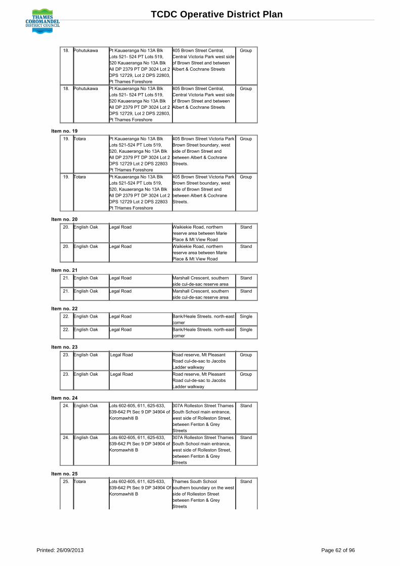
18. Pohutukawa Pt Kauaeranga No 13A BlkLots 521 524 PT Lots 519,520 Kauaeranga No 13A BlkAll DP 2379 PT DP 3024 Lot 2DPS 12729, Lot 2 DPS 22803,Pt Thames Foreshore
405 Brown Street Central,Central Victoria Park west sideof Brown Street and betweenAlbert & Cochrane Streets
Group
18. Pohutukawa Pt Kauaeranga No 13A BlkLots 521 524 PT Lots 519,520 Kauaeranga No 13A BlkAll DP 2379 PT DP 3024 Lot 2DPS 12729, Lot 2 DPS 22803,Pt Thames Foreshore
405 Brown Street Central,Central Victoria Park west sideof Brown Street and betweenAlbert & Cochrane Streets
Group
Item no. 19
19. Totara Pt Kauaeranga No 13A BlkLots 521524 PT Lots 519,520, Kauaeranga No 13A BlkAll DP 2379 PT DP 3024 Lot 2DPS 12729 Lot 2 DPS 22803Pt THames Foreshore
405 Brown Street Victoria ParkBrown Street boundary, westside of Brown Street andbetween Albert & CochraneStreets.
Group
19. Totara Pt Kauaeranga No 13A BlkLots 521524 PT Lots 519,520, Kauaeranga No 13A BlkAll DP 2379 PT DP 3024 Lot 2DPS 12729 Lot 2 DPS 22803Pt THames Foreshore
405 Brown Street Victoria ParkBrown Street boundary, westside of Brown Street andbetween Albert & CochraneStreets.
Group
Item no. 20
20. English Oak Legal Road Waikiekie Road, northernreserve area between MariePlace & Mt View Road
Stand
20. English Oak Legal Road Waikiekie Road, northernreserve area between MariePlace & Mt View Road
Stand
Item no. 21
21. English Oak Legal Road Marshall Crescent, southernside culdesac reserve area
Stand
21. English Oak Legal Road Marshall Crescent, southernside culdesac reserve area
Stand
Item no. 22
22. English Oak Legal Road Bank/Heale Streets. northeastcorner
Single
22. English Oak Legal Road Bank/Heale Streets. northeastcorner
Single
Item no. 23
23. English Oak Legal Road Road reserve, Mt PleasantRoad culdesac to JacobsLadder walkway
Group
23. English Oak Legal Road Road reserve, Mt PleasantRoad culdesac to JacobsLadder walkway
Group
Item no. 24
24. English Oak Lots 602605, 611, 625633,639642 Pt Sec 9 DP 34904 ofKoromawhiti B
307A Rolleston Street ThamesSouth School main entrance,west side of Rolleston Street,between Fenton & GreyStreets
Stand
24. English Oak Lots 602605, 611, 625633,639642 Pt Sec 9 DP 34904 ofKoromawhiti B
307A Rolleston Street ThamesSouth School main entrance,west side of Rolleston Street,between Fenton & GreyStreets
Stand
Item no. 25
25. Totara Lots 602605, 611, 625633,639642 Pt Sec 9 DP 34904 OfKoromawhiti B
Thames South Schoolsouthern boundary on the westside of Rolleston Streetbetween Fenton & GreyStreets
Stand
TCDC Operative District Plan
Printed: 26/09/2013 Page 62 of 96

25. Totara Lots 602605, 611, 625633,639642 Pt Sec 9 DP 34904 OfKoromawhiti B
Thames South Schoolsouthern boundary on the westside of Rolleston Streetbetween Fenton & GreyStreets
Stand
Item no. 26
26. Pin Oak Lots 308311 PT 303 RangiririB PT Lots 346, 349, 350, 378,379 Rangiriri C Lot 367Whakaharatau E Lots 312343,362366 Nokenoke A Lots 351361, 366377 Nokenoke B Sec5 Blk IV
300 Sealey Street ThamesHigh School west side ofplaying field on east side ofMackay Street betweenRIchmond & Sealey Streets
Single
Item no. 27
27. Puriri Lots 308311 PT 303 RangiririB PT Lots 346, 349, 350, 378,379 Rangiriri C Lot 367Whakaharatau E Lots 312343,362366 Nokenoke A Lots 351361, 366377 Nokenoke B Sec 5 Blk IV
300 Sealey Street ThamesHigh School east boundary ofplayingfield on the west side ofRolleston Street betweenRichmond & Sealey Streets
Single
Item no. 28
28. Pohutukawa Lots 308311 PT 303 RangiririB PT Lots 346, 349, 350, 378,379 Rangiriri C Lot 367Whakaharatau E Lots 312343,362366 Nokenoke A Lots 351361, 366377 Nokenoke B Sec5 Blk IV
300 Sealey Street ThamesHigh School east boundary ofplaying field on thewest side ofRolleston Street betweenRichmond & Sealey Streets
Group
Item no. 29
29. Sago Palm PT Lot 1 DPS 14512 606 Mackay Street ThamesHospital ResidenceNB: Tree has been removedfrom this site.
Single
29. Sago Palm PT Lot 1 DPS 14512 606 Mackay Street ThamesHospital ResidenceNB: Tree has been removedfrom this site.
Single
Item no. 30
30. Copper Beech PT Lot 1 DPS 14512 606 Mackay Street ThamesHospital grounds whereRolleston Street meets MaryStreet
Group
30. Copper Beech PT Lot 1 DPS 14512 606 Mackay Street ThamesHospital grounds whereRolleston Street meets MaryStreet
Group
Item no. 31
TCDC Operative District Plan
Printed: 26/09/2013 Page 63 of 96

31. Jacaranda PT Lot 1 DPS 14512 606 Mackay Street ThamesHospital grounds whereRolleston Street meets MaryStreet. NB Tree has beenremoved from this site.
31. Jacaranda PT Lot 1 DPS 14512 606 Mackay Street ThamesHospital grounds whereRolleston Street meets MaryStreet. NB Tree has beenremoved from this site.
Item no. 32
32. Moreton BayChestnut orBlack Bean
Pt Lot 1 DPS 14512 606 Mackay Street ThamesHospital Cnr Karaka Road &Rolleston Street
Single
32. Moreton BayChestnut orBlack Bean
Pt Lot 1 DPS 14512 606 Mackay Street ThamesHospital Cnr Karaka Road &Rolleston Street
Single
Item no. 33
33. Horse Chestnut Lots 407, 408 PT 406Kauaeranga No 1
304 Pahau Street Single
33. Horse Chestnut Lots 407, 408 PT 406Kauaeranga No 1
304 Pahau Street Single
Item no. 34
34. Northern RedOak
PT Lot 1 DPS 14512 606 Mackay Street Reservearea front entrance ThamesHospital on east side ofMackay Street between MaryStreet & the Karaka Stream
Single
34. Northern RedOak
PT Lot 1 DPS 14512 606 Mackay Street Reservearea front entrance ThamesHospital on east side ofMackay Street between MaryStreet & the Karaka Stream
Single
Item no. 35
35. Maidenhair Tree PT Lot 1 DPS 14512 606 Mackay Street ThamesHospital Reserve area frontentrance on east side ofMackay Street between MaryStreet & the Karaka Stream
35. Maidenhair Tree PT Lot 1 DPS 14512 606 Mackay Street ThamesHospital Reserve area frontentrance on east side ofMackay Street between MaryStreet & the Karaka Stream
Item no. 36
36. Canary IslandPine
PT Lot 1 DPS 14512 606 Mackay Street ThamesHospital Reserve area frontentrance east side of MackayStreet between Mary Street &the Karaka Stream
36. Canary IslandPine
PT Lot 1 DPS 14512 606 Mackay Street ThamesHospital Reserve area frontentrance east side of MackayStreet between Mary Street &the Karaka Stream
item no. 37
37. Pohutukawa Lots 135/151, 157/204, 219/23,274/81, 286/355 & Pts 224/6 &282 Tararu Township & PtKauaeranga Nos 8/11 & 14
921 Tararu Road East ofVictoria Street, Tararu & TararuRoad intersection
Single
37. Pohutukawa Lots 135/151, 157/204, 219/23,274/81, 286/355 & Pts 224/6 &282 Tararu Township & PtKauaeranga Nos 8/11 & 14
921 Tararu Road East ofVictoria Street, Tararu & TararuRoad intersection
Single
Item no. 38
38. Moreton Bay Fig Lots 7 & 8 DPS 775 818 Tararu Road Left at top ofdriveway entrance
Single
38. Moreton Bay Fig Lots 7 & 8 DPS 775 818 Tararu Road Left at top ofdriveway entrance
Single
TCDC Operative District Plan
Printed: 26/09/2013 Page 64 of 96

Item no. 39
39. Peruvian PepperTree
Lot 2 DPS 10931 201 Heale Street Single
39. Peruvian PepperTree
Lot 2 DPS 10931 201 Heale Street Single
Item no. 40
40. American SweetGum
Lot 2 DPS 10931 201 Heale Street Single
40. American SweetGum
Lot 2 DPS 10931 201 Heale Street Single
Item no. 41
41. Norfolk IslandPine
Lot 1 DPS 11864 210 Parawai Road Single
41. Norfolk IslandPine
Lot 1 DPS 11864 210 Parawai Road Single
Item no. 42
42. Norfolk IslandPine
Lot 1 DPS 11864 210 Parawai Road Single
42. Norfolk IslandPine
Lot 1 DPS 11864 210 Parawai Road Single
Item no. 43
43. Monkey Apple orLilly Pilly Tree
Lot 1 DPS 5338 200 Fenton Street Close tosoutheast corner of Rollestonand Fenton Streets
Single
43. Monkey Apple orLilly Pilly Tree
Lot 1 DPS 5338 200 Fenton Street Close tosoutheast corner of Rollestonand Fenton Streets
Single
Item no. 44
44. Bunya BunyaPine
Pt Kauaeranga E Nos 811, 14Blks
921 Tararu Road (SH25) Tararu Single
44. Bunya BunyaPine
Pt Kauaeranga E Nos 811, 14Blks
921 Tararu Road (SH25) Tararu Single
Item no. 45
45. Bunya BunyaPine
Lot 1 DPS 48100 200 Mount Sea RoadNB: The BunyaBunya PineTree has been removedfrom the site.
Group
45. Bunya BunyaPine
Lot 1 DPS 48100 200 Mount Sea RoadNB: The BunyaBunya PineTree has been removedfrom the site.
Group
Item no. 46
46. English Oak Lot 1 DPS 48100 200 Mount Sea Road Group
46. English Oak Lot 1 DPS 48100 200 Mount Sea Road Group
Item no. 47
47. English Oak Lot 4 DPS 5569 122 Brunton Crescent Rear ofsection
Single
47. English Oak Lot 4 DPS 5569 122 Brunton Crescent Rear ofsection
Single
Item no. 48
48. American SweetGum
Lot 2 DPS 21995 745 Tararu Road Single
48. American SweetGum
Lot 2 DPS 21995 745 Tararu Road Single
Item no. 49
49. Holm Oak PT Lots 387392 PT Lots D &E DP 821 Pt Karaka No 1 BlkPt Kauaeranga No 1Grahamstown
202 Pahau Street Union ParishChurch South side of PollenStreet entrance betweenKaraka Stream & Pahau Street
Stand
49. Holm Oak PT Lots 387392 PT Lots D &E DP 821 Pt Karaka No 1 BlkPt Kauaeranga No 1Grahamstown
202 Pahau Street Union ParishChurch South side of PollenStreet entrance betweenKaraka Stream & Pahau Street
Stand
Item no. 50
TCDC Operative District Plan
Printed: 26/09/2013 Page 65 of 96

50. Pohutukawa Lots 13 DPS 735 Kauaeranga24 Lots 17 DPS 77596 Lot 1DPS 36203 Lot 1 DP 37116
210 Beach Road, PricesFoundry Beach road boundarybetween storage yard andThames Croquet club
Stand
50. Pohutukawa Lots 13 DPS 735 Kauaeranga24 Lots 17 DPS 77596 Lot 1DPS 36203 Lot 1 DP 37116
210 Beach Road, PricesFoundry Beach road boundarybetween storage yard andThames Croquet club
Stand
Item no. 51
51. Norfolk IslandPine
Lot 2 DPS 8174 R/W over LOT1
200 The Terrace, The northtree is on the east side of TheTerrace between RichmondStreet & Hape Road
Stand
51. Norfolk IslandPine
Lot 2 DPS 8174 R/W over LOT1
200 The Terrace, The northtree is on the east side of TheTerrace between RichmondStreet & Hape Road
Stand
Item no. 52
52. Norfolk IslandPine
LOT 2 DPS 8174 R/W overLOT 1
200 The Terrace, The southtree is on the east side of TheTerrrace between RichmondStreeet & Hape Road
Stand
52. Norfolk IslandPine
LOT 2 DPS 8174 R/W overLOT 1
200 The Terrace, The southtree is on the east side of TheTerrrace between RichmondStreeet & Hape Road
Stand
Item no. 53
53. English Oak PT LOTS 121, 122 WaitangiruaBLK
604 Richmond StreetAugustus Street South (owner)rear entrance 606 RichmondStreet between RichmondStreet & Hape Road
Single
53. English Oak PT LOTS 121, 122 WaitangiruaBLK
604 Richmond StreetAugustus Street South (owner)rear entrance 606 RichmondStreet between RichmondStreet & Hape Road
Single
Item no. 54
54. Moreton Bay Fig Lot 1 Pt Lot 3 DPS 48100 200 Mount Sea Road Group
54. Moreton Bay Fig Lot 1 Pt Lot 3 DPS 48100 200 Mount Sea Road Group
Item no. 55
55. Holm Oak PT Kauaeranga E Nos 811, 14Blks
921 Tararu Road (SH25) TararuOld Persons Home
Single
55. Holm Oak PT Kauaeranga E Nos 811, 14Blks
921 Tararu Road (SH25) TararuOld Persons Home
Single
Item no. 56
56. Totara Pt Lots 2 & 3 DP 20317 202 Mackay Street, St FrancisPrimary School Mackay Streetentrance between Willoughby& Grey Streets
Single
56. Totara Pt Lots 2 & 3 DP 20317 202 Mackay Street, St FrancisPrimary School Mackay Streetentrance between Willoughby& Grey Streets
Single
Item no. 57
57. English Oak PT Lots 1 & 2 DPS 817 507 Mackay Street, ApostolicChurch, Southern boundarybetween Mary & Sealey Street
Stand
57. English Oak PT Lots 1 & 2 DPS 817 507 Mackay Street, ApostolicChurch, Southern boundarybetween Mary & Sealey Street
Stand
Item no. 58
58. Maidenhair Tree Lot 2 DPS 8811 & Lots 555,558 PTS 556, 557, 573Whakaupapa Blk
602 Mackay Street, ByAnglican Church
Single
58. Maidenhair Tree Lot 2 DPS 8811 & Lots 555,558 PTS 556, 557, 573Whakaupapa Blk
602 Mackay Street, ByAnglican Church
Single
TCDC Operative District Plan
Printed: 26/09/2013 Page 66 of 96

Item no. 59
59. Totara Lot 1 DPS 15045 116 Parawai Road Group
59. Totara Lot 1 DPS 15045 116 Parawai Road Group
Item no. 60
60. Pepper Tree Lot 1 DPS 15045 116 Parawai Road Single
60. Pepper Tree Lot 1 DPS 15045 116 Parawai Road Single
Item no. 61
61. Pohutukawa PT Kauaeranga E 13 Blk 750 Tararu Road Single
61. Pohutukawa PT Kauaeranga E 13 Blk 750 Tararu Road Single
Item no. 62
62. A number ofmixed species
Lots 61, 76 PTS 62, 73, 74,75, 77, 78, 80, 81, 82, 83, 84PT Kauaeranga E 13 BlkTararu Township
743 Tararu RoadNB: The Box Elder andSilver Birch Trees havebeen removed from the site.
Group
62. A number ofmixed species
Lots 61, 76 PTS 62, 73, 74,75, 77, 78, 80, 81, 82, 83, 84PT Kauaeranga E 13 BlkTararu Township
743 Tararu RoadNB: The Box Elder andSilver Birch Trees havebeen removed from the site.
Group
Item no. 63
63. Gum, Titoki,Totara
PT Kauaeranga E 13 Blk 746 Tararu roadNB: The Totara Tree hasbeen removed from the site.
Group
63. Gum, Titoki,Totara
PT Kauaeranga E 13 Blk 746 Tararu roadNB: The Totara Tree hasbeen removed from the site.
Group
Item no. 64
64. Holm Oak PT Kauaeranga E NOS 811,14 Blks
921 Tararu RoadNB: Tree no longer existsonthis site.
Single
64. Holm Oak PT Kauaeranga E NOS 811,14 Blks
921 Tararu RoadNB: Tree no longer existsonthis site.
Single
Item no. 65
65. Puriri, Oak PT Lot 1 DPS 20790 601 Mt Pleasant Road Group
65. Puriri, Oak PT Lot 1 DPS 20790 601 Mt Pleasant Road Group
Item no. 66
66. English Oak Pt Waitangirua Blk 205 Augustus Street South Single/Group
66. English Oak Pt Waitangirua Blk 205 Augustus Street South Single/Group
Item no. 67
67. A number ofmixed species
Lot 3 DPS 10877 Lots 10, 1113 DP 8499
300 Bank Street Group
67. A number ofmixed species
Lot 3 DPS 10877 Lots 10, 1113 DP 8499
300 Bank Street Group
TCDC Operative District Plan
Printed: 26/09/2013 Page 67 of 96

Coromandel Heritage Register Notable Trees
Item No Species Legal Description Location Single Tree/ Stand/Group
1. Norfolk Pine PT DP 1090 Blk V1 Coromandel SD 1165 Tiki Road, Coromandel Group
2. Kauri PT Pakirikiri No. 2 Blk VI Coromandel SD 72 Whangapoua Road Single
3. English Oak PT Pakirikiri No. 2 Blk VI Coromandel SD 72 Whangapoua Road Single
4. Blue Gum Lot 2 DPS 32332 Opposite 72 Whangapoua Road Single
5. Puriri Lot 1 DPS 44622 Blk VI Coromandel SD 85 Whangapoua RoadNB: Tree no longer on the site
Single
6. White Pine Road Reserve Beside Bridge Over Karaka Stream CoromandelNB: Tree is no longer at this site
Single
7. English Oak Rata/Kauri Lot 1 DPS 26043 Blk VI Coromandel SD 115 Whangapoua Road Group
8. Puriri Lot 1 DPS 2129 Blk V1 Coromandel SD 119 Whangapoua Road Single
9. English Oak Pt Te Umuhau Blk Blk V1 Coromandel SD 224 Tiki Road Anglican Church Group
10. Rimu Pt Kauri Blk Blk V Coromandel SD 840 Hauraki Road Single
11. Rimu/Kauri Pt Kauri Blk V Coromandel SD 845 Hauraki Road Two to three metres behindthe front boundary
Group
12. Rimu Pt Kauri Blk Blk V Coromandel SD 900 Hauraki Road Group
13. Norfolk Pine Pts Parang11 No.4 Blk V Coromandel SD 145 Wharf Road Single
14. Peppertree Lot 3 DPS 2335 Blk Vl Coromandel SD 31 Kapanga Road Single
15. Peruvian Peppertree Sec 15 Blk V1 Coromandel SD Reserve 24 Woollams Avenue Cnr Kapanga Road andWoollams AvenueNB: Tree has been removed from the site.
Single
16. Schinus Molle (2) & CupressusLawsoniana (1)
Legal Road Adjacent to Woollams Avenue entrance to theCoromandel Area School
Single Group
17. Puriri Lots 2744 PT26 Deed Plan H16 DP 11206being PT TE Umuhau Blk Blk Vl CoromandelSD
120 Woollams Avenue Coromandel AreaSchool grounds,
Group
18. Magnolia Sec 24 Blk Vl Coromandel SD RecreationReserve
230 Kapanga Road Hauraki House (OldSchool),
Group
19. Californian Redwood Sec 24 Blk Vl Coromandel SD RecreationReserve
230 Kapanga Road Hauraki House Reserve,(Situated 45 metres n/nw of school building)
Group
20. London Plane Legal Road Kapanga Stream Bridge carpark
21. Kauri Lots 2, 3 DPS 45087 Pt Ohiwa Blk Blk VlCoromandel SD
355 Kapanga Road Front Lawn entrance toTCDC Area Office and DOC
Group
22. Phoenix Palm All DP 33657 Lot 2 DP 29650 Blk VlCoromand3l SD Phoenix House Resthome
415 Kapanga Road Single
23. Garden Collection Lot 2 DPS 28350 Lot 2 DPS 37682 575 Kapanga Road 'Fir Lawn' House Group
24. Strawberry Tree Allot 64 Kapanga Parish Blk Vl Coromandel SD 745 Rings Road Elim/Pentecostal Church Single
25. Rewa Rewa Allot 72 Kapanga Parish Blk Vl Coromandel SD 915 Rings Road Group
26. Rimu Lot 3 DPS 14596 Blk VI Coromandel SD 175 Pagitt Street Single
27. Rimu Allot 103 Kapanga Parish Blk VI CoromandelSD Church
1426 Rings Road, St Andrews PresbyterianChurch
Single
28. English Oak Lot 37 13 14 39 Kapanga Parish Blk VlCoromandel SD
1628 Ring RoadNB: One of the two English Oaks has beenremoved from the site.
Stand
29. Garden Collection Lot 1 DP 9180 Blk Vl Coromandel SD 1699 Rings Road Group
30. Podacarpus Totara (7) Legal Road Rings Road adjacent to former CoromandelHospital buildings
Stand
31. Collection of Trees Lot 1 DPS 11731 Blk Vl Coromandel SD Coromandel Hospital
1740 Rings Road Coromandel Hospital, Group
32. Garden Collection Lot 1 DPS 20356 Blk Vl Coromandel SD 1813 Rings RoadNB: The Pear Tree has been removed fromthe site
Group
33. Matai Lot 1 DPS 23108 Blk Vl Coromandel SD 1925 Rings Road
34. Hall's Totara Lot 1 DPS 75730 Lot 1 DPS 73148 Blk I II V VICoromandel SD
2251 Rings Road Single
35. English Oak Sec 39 Buffalo Village kapanga Psh Blk VlCoromandel SD
2455 Rings Road Property corner Buffalo Roadand Rings Road
Single
36. English Oak Lots 1 & 3 DPS 51432 2365 Rings Road Group
37. White Pine Pt Allot 11 Kapanga Parish Blk Vl CoromandelSD
2628 Rings Road more or less opposite CuldianCelestial Age Trust's property
Stand
38. Magnolia Pt Allot 11 Kapanga Parish Blk Vl CoromandelSD
2711 Rings Road Adjacent to the Rings Roadand Driving Creek Road intersection
Stand
39. English Oak Lot 1 DPS 14612 Blk VI Coromandel SD 30 Driving Creek Road Stand
40. English Oak Lot 1 DPS 5536 Blk VI Coromandel SD 40 Driving Creek Road Stand
41. Norfolk Island Pine Pt Sec 11 Kapanga Parish Blks II VICoromandel SD
90 Driving Creek Road Single
42. Rimu Pt Sec 11 Kapanga Parish Blk VI CoromandelSD
180 Driving Creek Road Single
43. Kauri Pt Sec 11 Kapanga Parish Blk VI CoromandelSD
180 Driving Creek Road Coromandel Stand
TCDC Operative District Plan
Printed: 26/09/2013 Page 68 of 96

Item no. 1
1. Norfolk Pine PT DP 1090 Blk V1Coromandel SD
1165 Tiki Road, Coromandel Group
1. Norfolk Pine PT DP 1090 Blk V1Coromandel SD
1165 Tiki Road, Coromandel Group
Item no. 2
2. Kauri PT Pakirikiri No. 2 Blk VICoromandel SD
72 Whangapoua Road Single
2. Kauri PT Pakirikiri No. 2 Blk VICoromandel SD
72 Whangapoua Road Single
Item no. 3
3. English Oak PT Pakirikiri No. 2 Blk VICoromandel SD
72 Whangapoua Road Single
3. English Oak PT Pakirikiri No. 2 Blk VICoromandel SD
72 Whangapoua Road Single
Item no. 4
4. Blue Gum Lot 2 DPS 32332 Opposite 72 WhangapouaRoad
Single
4. Blue Gum Lot 2 DPS 32332 Opposite 72 WhangapouaRoad
Single
Item no. 5
5. Puriri Lot 1 DPS 44622 Blk VICoromandel SD
85 Whangapoua RoadNB: Tree no longer on thesite
Single
5. Puriri Lot 1 DPS 44622 Blk VICoromandel SD
85 Whangapoua RoadNB: Tree no longer on thesite
Single
Item no. 6
6. White Pine Road Reserve Beside Bridge Over KarakaStream CoromandelNB: Tree is no longer at this site
Single
6. White Pine Road Reserve Beside Bridge Over KarakaStream CoromandelNB: Tree is no longer at this site
Single
Item no. 7
7. English OakRata/Kauri
Lot 1 DPS 26043 Blk VICoromandel SD
115 Whangapoua Road Group
7. English OakRata/Kauri
Lot 1 DPS 26043 Blk VICoromandel SD
115 Whangapoua Road Group
Item no. 8
8. Puriri Lot 1 DPS 2129 Blk V1Coromandel SD
119 Whangapoua Road Single
8. Puriri Lot 1 DPS 2129 Blk V1Coromandel SD
119 Whangapoua Road Single
Item no. 9
9. English Oak Pt Te Umuhau Blk Blk V1Coromandel SD
224 Tiki Road Anglican Church Group
9. English Oak Pt Te Umuhau Blk Blk V1Coromandel SD
224 Tiki Road Anglican Church Group
Item no. 10
10. Rimu Pt Kauri Blk Blk V CoromandelSD
840 Hauraki Road Single
10. Rimu Pt Kauri Blk Blk V CoromandelSD
840 Hauraki Road Single
Item no. 11
11. Rimu/Kauri Pt Kauri Blk V Coromandel SD 845 Hauraki Road Two to threemetres behind the frontboundary
Group
11. Rimu/Kauri Pt Kauri Blk V Coromandel SD 845 Hauraki Road Two to threemetres behind the frontboundary
Group
Item no. 12
12. Rimu Pt Kauri Blk Blk V CoromandelSD
900 Hauraki Road Group
TCDC Operative District Plan
Printed: 26/09/2013 Page 69 of 96

12. Rimu Pt Kauri Blk Blk V CoromandelSD
900 Hauraki Road Group
Item no. 13
13. Norfolk Pine Pts Parang11 No.4 Blk VCoromandel SD
145 Wharf Road Single
13. Norfolk Pine Pts Parang11 No.4 Blk VCoromandel SD
145 Wharf Road Single
Item no. 14
14. Peppertree Lot 3 DPS 2335 Blk VlCoromandel SD
31 Kapanga Road Single
14. Peppertree Lot 3 DPS 2335 Blk VlCoromandel SD
31 Kapanga Road Single
Item no. 15
15. PeruvianPeppertree
Sec 15 Blk V1 Coromandel SDReserve
24 Woollams Avenue CnrKapanga Road and WoollamsAvenueNB: Tree has been removedfrom the site
Single
15. PeruvianPeppertree
Sec 15 Blk V1 Coromandel SDReserve
24 Woollams Avenue CnrKapanga Road and WoollamsAvenueNB: Tree has been removedfrom the site
Single
Item no. 16
16. Schinus Molle(2) & CupressusLawsoniana (1)
Legal Road Adjacent to Woollams Avenueentrance to the CoromandelArea School
SingleGroup
16. Schinus Molle(2) & CupressusLawsoniana (1)
Legal Road Adjacent to Woollams Avenueentrance to the CoromandelArea School
SingleGroup
Item no. 17
17. Puriri Lots 2744 PT26 Deed PlanH16 DP 11206 being PT TEUmuhau Blk Blk VlCoromandel SD
120 Woollams AvenueCoromandel Area Schoolgrounds,
Group
17. Puriri Lots 2744 PT26 Deed PlanH16 DP 11206 being PT TEUmuhau Blk Blk VlCoromandel SD
120 Woollams AvenueCoromandel Area Schoolgrounds,
Group
Item no. 18
18. Magnolia Sec 24 Blk Vl Coromandel SD Recreation Reserve
230 Kapanga Road HaurakiHouse (Old School),
Group
18. Magnolia Sec 24 Blk Vl Coromandel SD Recreation Reserve
230 Kapanga Road HaurakiHouse (Old School),
Group
Item no. 19
19. CalifornianRedwood
Sec 24 Blk Vl Coromandel SDRecreation Reserve
230 Kapanga Road HaurakiHouse Reserve, (Situated 45metres n/nw of school building)
Group
19. CalifornianRedwood
Sec 24 Blk Vl Coromandel SDRecreation Reserve
230 Kapanga Road HaurakiHouse Reserve, (Situated 45metres n/nw of school building)
Group
Item no. 20
20. London Plane Legal Road Kapanga Stream Bridgecarpark
20. London Plane Legal Road Kapanga Stream Bridgecarpark
Item no. 21
21. Kauri Lots 2, 3 DPS 45087 Pt OhiwaBlk Blk Vl Coromandel SD
355 Kapanga Road Front Lawn entrance to TCDC Area Officeand DOC
Group
21. Kauri Lots 2, 3 DPS 45087 Pt OhiwaBlk Blk Vl Coromandel SD
355 Kapanga Road Front Lawn entrance to TCDC Area Officeand DOC
Group
Item no. 22
TCDC Operative District Plan
Printed: 26/09/2013 Page 70 of 96

22. Phoenix Palm All DP 33657 Lot 2 DP 29650Blk Vl Coromand3l SD Phoenix House Resthome
415 Kapanga Road Single
22. Phoenix Palm All DP 33657 Lot 2 DP 29650Blk Vl Coromand3l SD Phoenix House Resthome
415 Kapanga Road Single
Item no. 23
23. GardenCollection
Lot 2 DPS 28350 Lot 2 DPS37682
575 Kapanga Road 'Fir Lawn'House
Group
23. GardenCollection
Lot 2 DPS 28350 Lot 2 DPS37682
575 Kapanga Road 'Fir Lawn'House
Group
Item no. 24
24. Strawberry Tree Allot 64 Kapanga Parish Blk VlCoromandel SD
745 Rings RoadElim/Pentecostal Church
Single
24. Strawberry Tree Allot 64 Kapanga Parish Blk VlCoromandel SD
745 Rings RoadElim/Pentecostal Church
Single
Item no. 25
25. Rewa Rewa Allot 72 Kapanga Parish Blk VlCoromandel SD
915 Rings Road Group
25. Rewa Rewa Allot 72 Kapanga Parish Blk VlCoromandel SD
915 Rings Road Group
Item no. 26
26. Rimu Lot 3 DPS 14596 Blk VICoromandel SD
175 Pagitt Street Single
26. Rimu Lot 3 DPS 14596 Blk VICoromandel SD
175 Pagitt Street Single
Item no. 27
27. Rimu Allot 103 Kapanga Parish BlkVI Coromandel SD Church
1426 Rings Road, St AndrewsPresbyterian Church
Single
27. Rimu Allot 103 Kapanga Parish BlkVI Coromandel SD Church
1426 Rings Road, St AndrewsPresbyterian Church
Single
Item no. 28
28. English Oak Lot 37 13 14 39 KapangaParish Blk Vl Coromandel SD
1628 Ring RoadNB: One of the two EnglishOaks has been removedfrom the site.
Stand
28. English Oak Lot 37 13 14 39 KapangaParish Blk Vl Coromandel SD
1628 Ring RoadNB: One of the two EnglishOaks has been removedfrom the site.
Stand
Item no. 29
29. GardenCollection
Lot 1 DP 9180 Blk VlCoromandel SD
1699 Rings Road Group
29. GardenCollection
Lot 1 DP 9180 Blk VlCoromandel SD
1699 Rings Road Group
Item no. 30
30. PodacarpusTotara (7)
Legal Road Rings Road adjacent to formerCoromandel Hospital buildings
Stand
30. PodacarpusTotara (7)
Legal Road Rings Road adjacent to formerCoromandel Hospital buildings
Stand
Item no. 31
31. Collection ofTrees
Lot 1 DPS 11731 Blk VlCoromandel SD CoromandelHospital
1740 Rings Road CoromandelHospital,
Group
31. Collection ofTrees
Lot 1 DPS 11731 Blk VlCoromandel SD CoromandelHospital
1740 Rings Road CoromandelHospital,
Group
Item no. 32
32. GardenCollection
Lot 1 DPS 20356 Blk VlCoromandel SD
1813 Rings RoadNB: The Pear Tree has beenremoved from the site.
Group
32. GardenCollection
Lot 1 DPS 20356 Blk VlCoromandel SD
1813 Rings RoadNB: The Pear Tree has beenremoved from the site.
Group
Item no. 33
TCDC Operative District Plan
Printed: 26/09/2013 Page 71 of 96
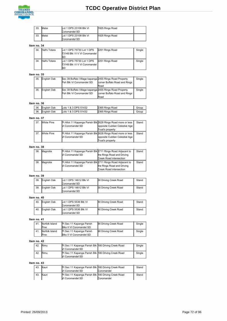
33. Matai Lot 1 DPS 23108 Blk VlCoromandel SD
1925 Rings Road
33. Matai Lot 1 DPS 23108 Blk VlCoromandel SD
1925 Rings Road
Item no. 34
34. Hall's Totara Lot 1 DPS 75730 Lot 1 DPS73148 Blk I II V VI CoromandelSD
2251 Rings Road Single
34. Hall's Totara Lot 1 DPS 75730 Lot 1 DPS73148 Blk I II V VI CoromandelSD
2251 Rings Road Single
Item no. 35
35. English Oak Sec 39 Buffalo Village kapangaPsh Blk Vl Coromandel SD
2455 Rings Road Propertycorner Buffalo Road and RingsRoad
Single
35. English Oak Sec 39 Buffalo Village kapangaPsh Blk Vl Coromandel SD
2455 Rings Road Propertycorner Buffalo Road and RingsRoad
Single
Item no. 36
36. English Oak Lots 1 & 3 DPS 51432 2365 Rings Road Group
36. English Oak Lots 1 & 3 DPS 51432 2365 Rings Road Group
Item no. 37
37. White Pine Pt Allot 11 Kapanga Parish BlkVl Coromandel SD
2628 Rings Road more or lessopposite Culdian Celestial AgeTrust's property
Stand
37. White Pine Pt Allot 11 Kapanga Parish BlkVl Coromandel SD
2628 Rings Road more or lessopposite Culdian Celestial AgeTrust's property
Stand
Item no. 38
38. Magnolia Pt Allot 11 Kapanga Parish BlkVl Coromandel SD
2711 Rings Road Adjacent tothe Rings Road and DrivingCreek Road intersection
Stand
38. Magnolia Pt Allot 11 Kapanga Parish BlkVl Coromandel SD
2711 Rings Road Adjacent tothe Rings Road and DrivingCreek Road intersection
Stand
Item no. 39
39. English Oak Lot 1 DPS 14612 Blk VICoromandel SD
30 Driving Creek Road Stand
39. English Oak Lot 1 DPS 14612 Blk VICoromandel SD
30 Driving Creek Road Stand
Item no. 40
40. English Oak Lot 1 DPS 5536 Blk VICoromandel SD
40 Driving Creek Road Stand
40. English Oak Lot 1 DPS 5536 Blk VICoromandel SD
40 Driving Creek Road Stand
Item no. 41
41. Norfolk IslandPine
Pt Sec 11 Kapanga ParishBlks II VI Coromandel SD
90 Driving Creek Road Single
41. Norfolk IslandPine
Pt Sec 11 Kapanga ParishBlks II VI Coromandel SD
90 Driving Creek Road Single
Item no. 42
42. Rimu Pt Sec 11 Kapanga Parish BlkVI Coromandel SD
180 Driving Creek Road Single
42. Rimu Pt Sec 11 Kapanga Parish BlkVI Coromandel SD
180 Driving Creek Road Single
Item no. 43
43. Kauri Pt Sec 11 Kapanga Parish BlkVI Coromandel SD
180 Driving Creek RoadCoromandel
Stand
43. Kauri Pt Sec 11 Kapanga Parish BlkVI Coromandel SD
180 Driving Creek RoadCoromandel
Stand
TCDC Operative District Plan
Printed: 26/09/2013 Page 72 of 96

450 Natural Hazards
451 DefinitionsThe following expressions and terms are defined in Section 9:
Flood EventFloodwaysFlood DefenceFlood Hazard AreaFlood Hazard Risk AssessmentResidual RiskDefendedFlood Hazard Classification
452 Activity StatusActivities affecting or affected by natural hazards are permitted, restricted discretionary, discretionary, noncomplying or prohibited according to all the rules inSection 450 to 458 (inclusive).Note For the avoidance of doubt, the more onerous provisions shall apply. Interpretation Notes
1. Where a flood hazard area applies on a site, then the rules for the area in which the development is occurring shall apply. This is illustrated by thefollowing examples:(i) If part of the property is affected by the defended notation and a new house is being constructed clear of this area, then there are no flood
hazard rules that apply. (ii) If part of the property is affected by the defended notation and a new house is being constructed within the defended notation, then the
flood hazard rules for the defended area apply.2. Where more than one flood hazard notation applies on a site, the more restrictive provisions shall apply if the area of development is affected by both
flood hazard areas. This is illustrated by the following examples:(i) If the area where a new house is being constructed is subject to both low and medium flood hazard area notations, then rules applicable to
the medium flood hazard area apply. (ii) If the area where a new house is being constructed is subject to the rules of the Thames Flood Management Plan and a Flood Hazard
Area notation, then the higher floor level standard shall apply.3. Both ThamesCoromandel District Council and Waikato Regional Council hold flood depth and speed information for sites in the low, medium, high
and defended flood hazard areas. This information is available on request.
452.1 Permitted Activities
1. Any permitted activity as identified in section 510 of this Plan and situated in the low flood hazard or defended area.2. Replacement houses, additions to houses, accessory buildings and walls and fences in the medium flood hazard area.3. Additions to houses in a defended area that are sited 20 metres or less from the base of a flood defence, and where either:
(i) the additions do not reduce the distance from the closest part of the house to the flood defence; or (ii) an easement, or other legal instrument, for the purposes of access to and maintenance of the flood defence has been registered on the
Computer Freehold Register or Certificate of Title and the proposed additions do not encroach over or impede that easement or legalinstrument.
4. The removal of earth or placement of fill in a high flood hazard area for the following activities:(i) driveways and accessways ≤ 1:8 gradient
(ii) planting of indigenous vegetation (iii) planting and removal of exotic vegetation and trees in the Rural Zone all parts except Village, Residential, Open Space, Recreation and
Conservation Policy Areas (iv) dune stabilisation planting (v) gardening for domestic purposes, horticulture and land cultivation (vi) work carried out to provide for effluent disposal systems, swimming pools, garden amenities and fences (vii) utility trenching carried out by Council or a network utilities operator (viii) emergency works to clear roads (ix) drilling for cores or waterbores, including the creation of drilling pads and associated stormwater management up to a maximum size of
200m2 per pad and rehabilitation of drilling pad sites, but excluding access to drilling pad sites. (x) irrigation or land drainage works below natural ground level (xi) the construction and maintenance of firebreaks.
Note Houses within coastal flooding and erosion area setback lines will be required to meet the provisions of the Building Act.
452.2 Controlled Activities
Note There are no activities affecting or affected by natural hazards under this activity status.
452.3 Restricted Discretionary Activities
1. Houses and/or habitable additions in flood hazard areas which do not comply with the floor level requirements of Rule 453.2.2. Within the medium flood hazard area:
(a) New houses (on a previously vacant title); (b) Comprehensive housing developments; (c) Replacement houses or additions to houses which do not comply with Rule 453.4; (d) New commercial and industrial buildings. 3. Within the defended area;
(a) Comprehensive housing developments; (b) New houses which do not comply with the setback standard of Rule 453.3.4. Within the high flood hazard area:
(a) Replacement houses, additions to houses, accessory buildings and walls and fences; (b) One new house on an existing certificate of title which has not contained a house as of 1 February 2009.
TCDC Operative District Plan
Printed: 26/09/2013 Page 73 of 96

5. The removal of earth or placement of fill in a high flood hazard area, other than for those activities listed as permitted in rule 452.1.4. All otherearthworks rules shall apply if more restrictive than this rule.
TCDC Operative District Plan
Printed: 26/09/2013 Page 74 of 96

452.4 Discretionary Activities
Note There are no activities affecting or affected by natural hazards under this activity status.
452.5 NonComplying Activities
.1 Coastal defence structures.
.2 Within the high flood hazard area:(a) New houses and new commercial and industrial buildings
Note This rule applies to both private and public property.
452.6 Prohibited Activities
Note There are no activities affecting or affected by natural hazards under this activity status.
453 StandardsFloor levels of all houses and all habitable rooms shall meet the following standards:
453.1
In areas covered by flood management plans:(a) Primary overland flow areas: Not less than one metre above natural ground level;(b) Secondary overland flow areas: Not less than 0.5 metres above natural ground level;(c) Ponding areas: Not less than 0.5m above the flood datum level stated on the planning map;(d) Overland flow and ponding areas: Not less than one metre above natural ground level.
453.2
Floor levels of all houses and all habitable rooms for sites located in a flood hazard area shall meet the following standard;Not less than 0.5 metres above predicted flood levels. Predicted flood levels are determined by reference to flood modelling, flooding history, a derived floodevent, and existing flood protection measures. In defended areas, floor levels must be 0.5 metres above the predicted flood level for a 1% flood event.
453.3
In defended areas, new houses must be set back a minimum of 20 metres from the base of any flood defence, unless an easement, or other legal instrument,for the purposes of access to and maintenance of the flood defence has been registered on the Computer Freehold Register or Certificate of Title.
453.4
In medium flood hazard areas, replacement houses or additions to houses must be designed with foundations that are open and allow the free passage offloodwaters to pass beneath them to ensure habitable areas are not subject to inundation and floodwaters are not diverted or displaced onto surroundingproperties.
To ensure compliance with this standard a report from a suitably qualified expert (e.g. hydrological engineer) is required to accompany any building consentfor the activities listed above, confirming that the proposal complies with this requirement.
Note
Note Ground levels and hazard setback lines should be confirmed by survey. Note Coastal flooding and erosion areas setback standards are applied and enforced under the Building Act.
Locations where the setbacks apply are shown on the same maps as those which define "Beachfront Yards" in Section 9 under "Yard".
The setbacks under the Building Act apply to buildings and structures including septic tanks and their disposal fields as follows:
No Buildings: Structures or septic tanks or their disposal fields shall be located within 30m inland from the toe of the natural shoreline orseaward vegetated toe of the foredune on the East Coast.
No Buildings: Structures or septic tanks or their disposal fields shall be located within 15m inland from the natural shoreline on the WestCoast between Tararu and Waikawau (inclusive).
Relocated Buildings: May be situated between the 30m and 60m hazard lines, East Coast (measured as above), provided that Council mayrequire a greater setback or building to be relocatable in other circumstances if required because of the severity of the erosion or flooding risk.
Note Ground levels and hazard setback lines should be confirmed by the most appropriate means for the solution as directed by Council's Building
Inspector.
454 Controlled Activity MattersNote There are no activities affecting or affected by natural hazards under this activity status.
455 Restricted Discretionary Activity Assessment Criteria and ProtocolsEach restricted discretionary activity shall be assessed according to:.1 The criteria listed in the earthworks rules Section 4 (416.3)..2 The information requirements (840) and notification protocols set out in Section 8..3 Within the medium or defended flood hazard area;
(a) If a flood hazard risk assessment determines that the level of risk to people or property associated with the proposal is acceptable. (b) Access to and maintenance of the flood defence is not compromised or impeded by any proposed development or subdivision. (c) All proposed building work has been designed to be able to accommodate/withstand the flood hazard (e.g. floor levels, structural design). (d) Offsite effects including displacement or diversion of flood waters associated with the proposal in terms of the flood hazard will be no more
than minor. (e) Whether the proposed use or development would have an adverse effect on the natural function of a river system. (f) If any proposed mitigation measures are considered appropriate to mitigate the risk to people and property arising from the flood hazard. (g) The extent and effect of any proposed earthworks in terms of diverting or displacing water or on the natural functioning of the river system.
TCDC Operative District Plan
Printed: 26/09/2013 Page 75 of 96

(h) Any changes to surface features or topography which have occurred over time and which may have a material effect on the flood modellingassumptions and identified areas of flood hazards.
.4 Within the high flood hazard area:(a) The potential of the structure to divert water and create offsite effects.
(b) Fences and walls should be of open construction to allow for the passage of flood waters. (c) All proposed buildings/structures have been designed to be able to accommodate/withstand the flood hazard and should be anchored to
prevent movement during flood events. (d) If the location of the proposal on the site is considered suitable in terms of the potential flood risk. (e) Whether the proposed building/structure would have an adverse effect on the natural function of the river system. (f) The extent and effect of any proposed earthworks in terms of diverting or displacing water or on the natural functioning of the river system.
456 Discretionary Activity Assessment Criteria and ProtocolsEach discretionary activity application shall be assessed according to:
Note There are no activities affecting or affected by natural hazards under this activity status.
457 NonComplying Activity Assessment Criteria and Protocols.1 Buildings in flood hazard areas protocols:
(a) Where a house is located on land in a flood hazard area, existing use rights under Section 10 of the Resource Management Act apply.Section 10 (1)(a) limits activities on the site. The only work which may be carried out on such sites under existing use rights shall be:(i) Maintenance of existing buildings;
(ii) Site works which do not involve raising natural ground level; (iii) Any activity which does not further impede flood flows or increase the susceptibility of the site or any other site to flooding.Note The assessment of a noncomplying activity is carried out under the provisions of the Resource Management Act (Section 104 and 105). The
assessment criteria in s850 may also assist.(b) In particular, the following are not permitted under existing use rights on any such site:
(i) Any increase in the ground coverage of any building; (ii) Any raising of the natural ground level; (iii) The erection of any fences or walls on or abutting any such site; (iv) Lowering the floor level of any existing habitable room in any existing building; (v) Converting any existing nonhabitable room in any existing building; (vi) Converting any existing nonhabitable room in a habitable room; (vii) Any new building; (viii) Any garden amenity which is above natural ground level; (ix) On any such site, any works or development or activity which would further impede flood flows or increase the susceptibility of
the site or any other site to flooding or flood damage.(c) Activities other than houses and their accessory buildings which are noncomplying activities in the zone are subject to the same existing
use right constraints as houses (as set out above)..2 Coastal defence structures protocols.
(a) Examples of coastal defence structures include:(i) Dumping of rocks, concrete, car bodies, tyres and other spoil;
(ii) Walls; (iii) Rip rap/gabion baskets; (iv) Groynes; (v) Other structural objects inconsistent with the beach environment.Note The Waikato Regional Council may also need a resource consent for those structures. Where two consents are required a joint hearing should
be held.
458 Relevant Issues, Objectives and PoliciesThe following significant resource management issues, objectives and policies are particularly relevant to these rules:212 Landscape and Natural Character213 Settlements and Amenity Values221 Land Disturbance and Earthworks222 Natural Hazards224 Cross Boundary Issues
TCDC Operative District Plan
Printed: 26/09/2013 Page 76 of 96

460 Hazardous Substances
461 DefinitionsThe following expressions and terms are defined in Section 9:
Hazardous facilityHazardous Facility Screening Procedure (HFSP) effects ratioHazardous substances
462 Activity StatusActivities involving the use or storage of hazardous substances are permitted, controlled, restricted discretionary, discretionary, noncomplying or prohibitedaccording to all the rules in Section 460 to 468 (inclusive). Note The Hazardous Substance Screening Procedure is not suitable for the following situations:
1 Trade waste sewer and waste treatment or disposal facilities due to the difficulty of identifying the quantity and nature of the substancesinvolved;
2 Storage or use of hazardous consumer products for private domestic purposes, because the degree of hazard is generally below the scale ofpotential effects considered by the HFSP;
3 Retail outlets for the domestic usage sale of hazardous substances (e.g. supermarkets, hardware shops, pharmacies), because storage ofhazardous substances is generally in small packages;
4 Facilities using genetically modified or new organisms;
5 Developments that are or may be hazardous but do not involve hazardous substances (e.g. mineral extraction, high voltage transmission lines,radio masts, electrical substances);
6 Dust explosions;
7 Gas and oil pipelines;
8 Fuel in motor vehicles, boats and small engines such as weedeaters, lawn mowers, chainsaws etc.
Note For the avoidance of doubt, the more onerous provisions shall apply.
462.1 Permitted Activities
462.1.1
Any new hazardous activity using or storing hazardous substances with effects ratios listed as permitted in the activity status Table 1.
462.1.2
Any existing activity which increases its average annual volumes stored or used by no more than 20%, from the average annual volume stored or usedimmediately preceding the date that this section of the Plan became operative, is a permitted activity. Any activity which increases its average annualvolume by more than 20% must comply with the rules.
462.1.3
The retail sale of petrol, up to a storage of 100,000 litres of petrol in underground storage tanks and up to 50,000 litres of diesel, provided that the "Code ofPractice for the Design, Installation and Operation of Underground Petroleum Systems" published by the Department of Labour OSH is adhered to; and
462.1.4
Retail LPG outlets, with the storage of up to 6 tonnes (single vessel storage) of LPG, provided that the "Australian Standard (AS 15961989) for LP GasStorage and Handling Siting of LP Gas Automotive Retail Outlets" is adhered to.
462.1.5
The installation or storage of LPG tanks up to 200 kg per site.
462.1.6
The use, transportation or storage of hazardous substances in association with temporary military training activities.
462.2 Controlled Activities
.1 Any new or existing hazardous activity which, increases its volume of hazardous substances in accordance with 462.1.2 above, with effects ratioslisted as Controlled in Table 1 Effects Ratio Standards for Hazardous Facilities.
.2 Installation or storage of LPG tanks over 200kg up to 600kg.
462.3 Restricted Discretionary Activities
Note No activities involving the storage or use of hazardous substances under this Activity Status.
TCDC Operative District Plan
Printed: 26/09/2013 Page 77 of 96

462.4 Discretionary Activities
.1 Any new or existing hazardous activity which, increases its volume of hazardous substances in accordance with 462.1.2 above, with effects ratioslisted as Discretionary in Table 1 Effects Ratio Standards for Hazardous Facilities.
.2 Installation or storage of LPG tanks over 600kg.
.3 Any hazardous activity that does not meet one or more of the standards listed in 463.
462.5 NonComplying Activities
Note No activities involving the storage or use of hazardous substances under this activity status.
462.6 Prohibited Activities
Note No activities involving the storage or use of hazardous substances under this activity status.
463 Standards
463.1
All hazardous substances shall be kept above the minimum floor level required for habitable rooms in houses in flood hazard areas.Note Hazardous substances should be stored above predicted flood levels on sites located within a flood hazard area.
463.2
Where there are multiple hazardous facilities on one site they may be screened through the HFSP individually, if there is sufficient open space between eachfacility. An onsite inspection will be required to determine sufficient open space in terms of the extent to which the substances have an explosive nature andwhether the substances will be carried or handled between facilities.
463.3
The hazardous facility site shall be serviced by a spill containment system that is:(a) Constructed from impervious materials resistant to the hazardous substances used, stored, manufactured, mixed, packaged, loaded, unloaded or
otherwise handled on the site;(b) Able to contain the maximum volume of the substance store plus sufficient allowance for servicing tankers; (c) Able to prevent any spill or other unintentional release of hazardous substances, and any stormwater and/or fire water that has become
contaminated, from entering the stormwater drainage system; (d) Able to prevent any spill or other unintentional release of hazardous substances, and any stormwater and/or fire water that has become
contaminated, from discharging into or onto land and/or water (including groundwater and potable water supplies) unless permitted by a resourceconsent;
(e) Regularly maintained and serviced.
463.4
All stormwater grates on the site shall be clearly labelled "Stormwater Only".
463.5
Underground storage tanks for the storage of petroleum products shall be designed, constructed and managed to prevent leakage and spills, and corrosion.
463.6
Adherence to the Code of Practice for "Design, Installation and Operation of Underground Petroleum Systems" (Department of Labour Occupational Safetyand Health) is deemed to be one method of complying with this condition.
463.7
Any hazardous facility shall be adequately signposted to indicate the nature of the substances stored, used or otherwise handled and emergency action andsafety precautions.
463.8
Adherence to the Code of Practice for "Warning Signs for Premises Storing Hazardous Substances" of the New Zealand Chemical Industry Council, or anyother Code of Practice approved by the New Zealand Fire Service is deemed to be one method of complying with this condition.
463.9
Hazardous waste shall be disposed of at facilities approved by Local Authorities, the Ministry for the Environment or under the Resource Management Actonly.
TCDC Operative District Plan
Printed: 26/09/2013 Page 78 of 96
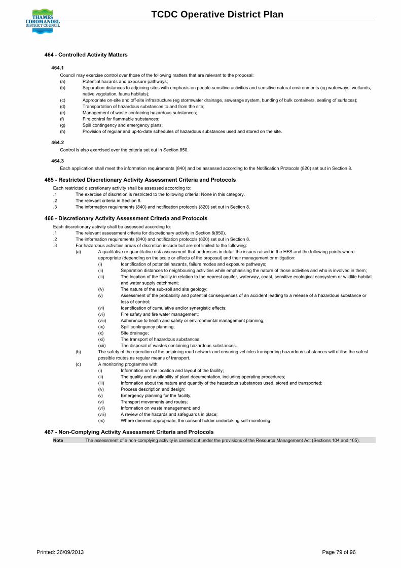
464 Controlled Activity Matters
464.1
Council may exercise control over those of the following matters that are relevant to the proposal:(a) Potential hazards and exposure pathways;(b) Separation distances to adjoining sites with emphasis on peoplesensitive activities and sensitive natural environments (eg waterways, wetlands,
native vegetation, fauna habitats);(c) Appropriate onsite and offsite infrastructure (eg stormwater drainage, sewerage system, bunding of bulk containers, sealing of surfaces); (d) Transportation of hazardous substances to and from the site;(e) Management of waste containing hazardous substances; (f) Fire control for flammable substances;(g) Spill contingency and emergency plans;(h) Provision of regular and uptodate schedules of hazardous substances used and stored on the site.
464.2
Control is also exercised over the criteria set out in Section 850.
464.3
Each application shall meet the information requirements (840) and be assessed according to the Notification Protocols (820) set out in Section 8.
465 Restricted Discretionary Activity Assessment Criteria and ProtocolsEach restricted discretionary activity shall be assessed according to:.1 The exercise of discretion is restricted to the following criteria: None in this category..2 The relevant criteria in Section 8. .3 The information requirements (840) and notification protocols (820) set out in Section 8.
466 Discretionary Activity Assessment Criteria and ProtocolsEach discretionary activity shall be assessed according to:.1 The relevant assessment criteria for discretionary activity in Section 8(850)..2 The information requirements (840) and notification protocols (820) set out in Section 8. .3 For hazardous activities areas of discretion include but are not limited to the following:
(a) A qualitative or quantitative risk assessment that addresses in detail the issues raised in the HFS and the following points whereappropriate (depending on the scale or effects of the proposal) and their management or mitigation:(i) Identification of potential hazards, failure modes and exposure pathways;
(ii) Separation distances to neighbouring activities while emphasising the nature of those activities and who is involved in them; (iii) The location of the facility in relation to the nearest aquifer, waterway, coast, sensitive ecological ecosystem or wildlife habitat
and water supply catchment; (iv) The nature of the subsoil and site geology; (v) Assessment of the probability and potential consequences of an accident leading to a release of a hazardous substance or
loss of control; (vi) Identification of cumulative and/or synergistic effects;
(vii) Fire safety and fire water management; (viii) Adherence to health and safety or environmental management planning; (ix) Spill contingency planning; (x) Site drainage; (xi) The transport of hazardous substances; (xii) The disposal of wastes containing hazardous substances.
(b) The safety of the operation of the adjoining road network and ensuring vehicles transporting hazardous substances will utilise the safestpossible routes as regular means of transport.
(c) A monitoring programme with: (i) Information on the location and layout of the facility;
(ii) The quality and availability of plant documentation, including operating procedures;(iii) Information about the nature and quantity of the hazardous substances used, stored and transported;
(iv) Process description and design; (v) Emergency planning for the facility; (vi) Transport movements and routes; (vii) Information on waste management; and (viii) A review of the hazards and safeguards in place; (ix) Where deemed appropriate, the consent holder undertaking selfmonitoring.
467 NonComplying Activity Assessment Criteria and ProtocolsNote The assessment of a noncomplying activity is carried out under the provisions of the Resource Management Act (Sections 104 and 105).
TCDC Operative District Plan
Printed: 26/09/2013 Page 79 of 96

468 Relevant Issues, Objectives and PoliciesThe following significant resource management issues, objectives and policies are particularly relevant to these rules:211 Biodiversity212 Landscape and Natural Character218 Community Water Supplies219 District Waterbodies222 Natural Hazards
TCDC Operative District Plan
Printed: 26/09/2013 Page 80 of 96

Table 1TABLE 1 EFFECTS RATIO STANDARDS FOR HAZARDOUS FACILITIES
Zone and Policy Area Effects Ratio forPermitted Activities
Effects Ratio forControlled Activities
Effects Ratio forDiscretionary Activities
HOUSING:
All Parts < 0.02 0.02 0.05 > 0.05
COASTAL:
All Parts < 0.02 0.02 0.05 > 0.05
CONSERVATION:
All Parts < 0.02 0.02 0.05 > 0.05
RECREATION (Passive), RECREATION (Active) & OPEN SPACE
All Parts < 0.02 0.02 0.05 > 0.05
RURAL:
All Parts except Village < 0.25 0.25 0.75 > 0.75
Village < 0.02 0.02 0.05 > 0.05
INDUSTRIAL & INDUSTRIAL A:
All Parts < 0.75 0.75 1.5 > 1.5
TOWN CENTRE:
All Parts < 0.25 0.25 0.75 > 0.75
Note See Appendix 3 to determine the effects ratio value. Appendix 3 contains the necessary information required to carry out hazardous facilityscreening procedures.
See Table 2 for example of activities "Effects Ratios".
Table 2
TABLE 2 APPROXIMATE EXAMPLES OF ACTIVITY EFFECTS RATIOS
Engineering Workshop Galvanising Business
Acetylene 32 m3 Hydrochloric Acid (33%) 30001
Oxygen 32m3 Ammonium Hydroxide (30%) 251
Hydraulic Oil 45kg Hydrogen Peroxide 1000kg
Enamel Paint 45kg Zinc Ammonium Chloride 1000kg
Molten Zinc 250t
Effects ratio 0.12 Effects ratio 14
Panel Beating & Spray Painting Shop Horticultural Activity
Degreaser 201 Diazinon (insecticide) 10 litres
Thinner 1201 Cypermethrin 5 litres
Waste thinner 601 Roundup 5 litres
Lacquer paints 1001 Diesel 580 litres
Enamel paints 601
Other paints 2001
Flux (Boric Acid) 1 litre
Fibreglass resin 10kg
Acetylene 8m3
Oxygen 8m3
Effects Ratio 0.13 Effects Ratio 0.03
Note The above approximations and numbers may alter depending on sitespecific circumstances. Activities may also be controlled through otherrules in the Plan also.
TCDC Operative District Plan
Printed: 26/09/2013 Page 81 of 96

470 Roading, Parking, Loading and Access
471 DefinitionsThe following expressions and terms are defined in Section 9:
Gross Floor AreaLoading BayParking Space
472 Activity StatusThe provision of roading, vehicle parking, loading and access is permitted, restricted discretionary, discretionary, noncomplying or prohibited according to all therules in Section 470 to 478 (inclusive)Note For the avoidance of doubt, the more onerous provisions shall apply.
472.1 Permitted Activities
472.1.1
Vehicle parking, loading and access in the Town Centre or Industrial Zones.
472.1.2
Vehicle parking, loading or access accessory to any Permitted Activity.
472.1.3
A proposed road or an alteration to an existing legal road, which is part of a development that is a permitted activity.
472.1.4
The formation of an existing legal road.
472.2 Controlled Activities
472.2.1
Vehicle parking, loading or access accessory to any Controlled Activity.
472.2.2
A proposed road or alteration to an existing legal road, which is part of a subdivision or development that is a controlled activity.
472.3 Restricted Discretionary Activities
472.3.1
In the Town Centre Zone, the shortfall in parking spaces where the parking standard of one space per 40m2 (or part thereof) is not met provided that: Ingranting consent, a condition may be attached requiring a payment of cash in lieu according to the following formula: one space or part thereof shall equalthe value of 20m2 of land plus the actual cost of forming, surfacing, draining, marking out and vehicle crossing.
472.3.2
Fewer than two visitor spaces but no fewer than one for home occupations, homestays.
472.3.3
Any permitted or controlled activity that does not meet the vehicle parking, loading, access, road design and construction standards, with discretionrestricted to the subject matter of the standard that can not be met.
472.3.4
Vehicle parking, loading or access accessory to any restricted discretionary activity.
472.4 Discretionary Activities
472.4.1
Vehicle parking, loading and access which does not meet the Section 473 standards and is not specified as restricted discretionary or noncomplying.
472.4.2
Vehicle parking, loading or access accessory to any discretionary activity.
472.4.3
A proposed road or an alteration to an existing legal road, which is not part of a permitted or controlled activity, unless the proposed road or alteration toan existing road is submitted as a requirement to designate or a plan change.
472.4.4
A proposed road or an alteration to an existing legal road, which is part of a subdivision or development that is a discretionary activity.
472.5 NonComplying Activities
472.5.1
Access from a service lane to land in the Housing Zone.
TCDC Operative District Plan
Printed: 26/09/2013 Page 82 of 96

472.5.2
The use of the service lane as a primary frontage for the purpose of conducting business activities.
472.5.3
Home occupations, homestays and farmstays with nil onsite carpark spaces.
472.5.4
Roading, parking, loading or access accessory to any noncomplying activity.
472.6 Prohibited Activities
Vehicle parking, loading or access accessory to any prohibited activity.
473 Standards Terms and Conditions
473.1 Parking Standards, Terms and Conditions for Town Centre Zone
473.1.1
The parking standard for all new buildings and additions to buildings for all activities (except service stations: refer 473.1.2) in the Town Centre Zone is onespace per 40m2 gross floor area or part thereof (refer to Figures 1 and 2 Carpark Standards). Spaces may be provided on or off site. Note The District Plan provides for development impact fees to offset localised effects, including any shortage of onsite parking. This is the
mechanism that enables a financial contribution or "cash in lieu of parking" to be made.
473.1.2
For service stations: 1 per 35m2 of the convenience store plus 4 spaces for a lube/servicing repair bay plus 2 per 3 staff members plus 1 per air hose orvacuum cleaner plus 3 per carwash.
473.1.3
Design of Parking Spaces All carparking spaces shall be laid out in accordance with the vehicle turning, and parking dimensions of Figures 1 and 2. On site turning areas shall be provided in accordance with the vehicle tracking curve minimum radius of Figure 1 to avoid the reversing of vehicles onto aroad or onto a private way required by Rule 703.6 to be formed to the road standards from:
473.1.4
Any carparking area containing more than two parking spaces;or
Any access onto a Regional Arterial or District Arterial road.
473.2 Parking Standards, Terms and Conditions for All Zones Other than Town Centre Zone
473.2.1
All activities shall provide adequate onsite vehicle parking. Town Centre Zone standards are not to be used to assess the quantum of onsite car parkingprovided for activities outside the Town Centre Zone.
473.2.2 Parking Standards for Comprehensive Housing Developments
At least three parking spaces shall be provided for every unit. One of these must be within a garage on the site accessible directly from the house itserves. The other two parking spaces may be located elsewhere on the site, but shall not be located within any living court or service area. The drivewaycentreline may be counted as parking spaces. The 90 percentile turning circles shall be met, and manoeuvring space to enable vehicles to exit in forwardgear. Where independent street access to each of the house sites does not exist, the shared access shall be paved and maintained to a standard thatmeets the width, location, grade and construction standards of the Plan, to give vehicular and pedestrian access to every house site. Refer Figure 1Carpark Standards. The owners shall provide and maintain, wherever reasonably necessary, artificial lighting sufficient to illuminate properly the drives andfootpaths to the same standard as the street to which the comprehensive development has its frontage and/or access.
473.2.3 Parking Standards for Housing Developments Other Than Comprehensive Developments
At least two parking spaces shall be provided for each house, and it shall be possible to erect a private garage with internal dimensions of not less than3m x 6m complying with all relevant development standards in this District Plan and with Council's bylaws. To each garage it shall be practicable to form auseable allweather driveway from the street or access lot or private way (as appropriate) to that garage, such driveway being never less than 2.5m wideand not shorter than 5m measured along its centreline. The driveway required under this rule shall be deemed to be useable if it complies with the 90percentile turning circle for cars. Refer Figure 1 Carpark Standards. This driveway centreline area may be counted as the second onsite parking space forthe house. Through the assessment of a discretionary activity application for more than one house on a lot, Council will ensure that there is adequate onsite parking.
473.2.4 Parking Standards for Home Occupations, Homestay, farmstay:
No fewer than two visitor parking spaces (in addition to the required two spaces for the house) shall be provided on the site.
473.2.5 Restaurants Outside the Town Centre Zone
One parking space shall be provided for every four patrons on the site that the activity is designed to accommodate plus one for every staff memberemployed on the premises. Where a restaurant has a drivethrough takeaway service, adequate driving facilities shall be provided to avoid parking andtraffic conflict on the site and adjacent street. Refer objectives and policies for parking.
TCDC Operative District Plan
Printed: 26/09/2013 Page 83 of 96

473.2.6 Parking standards for Industrial Activities
One onsite parking space per 100m2 gross floor area shall be provided as a minimum. More than this may be required depending on the scale and typeof the activity.
473.2.7 Parking Standards in Heritage Policy Areas or in respect of registered Heritage Items
Notwithstanding the parking standards that would normally apply in respect of a particular development proposal, Council will consider as a restricteddiscretionary activity a lesser standard where such reduced standard will enhance the protection of the heritage values concerned.
473.2.8 Design of Parking Spaces
All parking spaces shall be laid out in accordance with the vehicle turning, and parking dimensions of figures 1 and 2. On site turning areas shall be provided in accordance with the tracking curve minimum radius if Figure 1 to avoid the reversing of vehicles onto a road oronto a private way required by Rule 703.6 to be formed to road standards from..1 Any carparking area containing more than two parking spaces; or.2 Any access onto a Regional Arterial or District Arterial road.
473.3 Loading Standards, Terms and Conditions for All Zones Town Commercial and Industrial Activities
473.3.1
Permitted and controlled activities shall provide one loading bay per site.
473.3.2
An onsite turning area to avoid the reversing of vehicles from the loading bay onto a road shall be provided in accordance with the truck tracking curveminimum radius of Figure 1.
473.3.3
Where the site has frontage to an existing service lane, the loading bay shall be so designed and located in order that access to it will be obtained from anexisting service lane as shown on the Planning Maps.
473.4 Calculation of Cash in lieu of onsite parking in the Town Centre Zone
For the purpose of determining the quantum of a payment to Council in lieu of onsite parking, the value of one square metre of land in the Town Centre Zoneshall be calculated by taking the dollar value of the whole of the land area zoned Town Centre Zone (in that town) and dividing it by the (square metre) area ofthe same land. The value shall be the current value as contained in the Council's most recent valuation records, and the area taken similarly from thoserecords.
473.5 Vehicles Access Standards, Terms and Conditions for all Zones
473.5.1
Vehicle access to an activity, parking and loading facilities shall be provided from the formed carriageway of a road or service lane in accordance with thefollowing standards.
473.5.2 Sight and Separation Distances
The standards for the location of vehicle access crossings to all roads in all zones shall be in accordance with Tables 1A and 1B:
TCDC Operative District Plan
Printed: 26/09/2013 Page 84 of 96
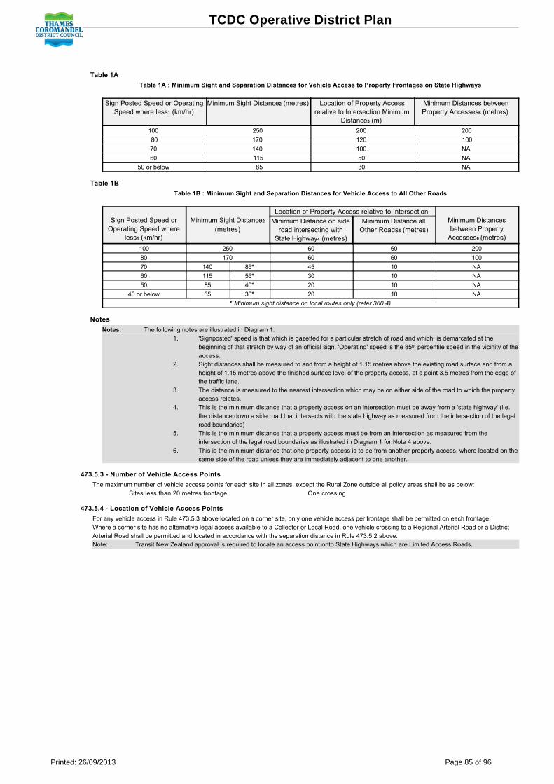
Table 1A
Table 1A : Minimum Sight and Separation Distances for Vehicle Access to Property Frontages on State Highways
Sign Posted Speed or OperatingSpeed where less1 (km/hr)
Minimum Sight Distance2 (metres) Location of Property Accessrelative to Intersection Minimum
Distance3 (m)
Minimum Distances betweenProperty Accesses6 (metres)
100 250 200 200
80 170 120 100
70 140 100 NA
60 115 50 NA
50 or below 85 30 NA
Table 1B
Table 1B : Minimum Sight and Separation Distances for Vehicle Access to All Other Roads
Sign Posted Speed orOperating Speed where
less1 (km/hr)
Minimum Sight Distance2
(metres)
Location of Property Access relative to Intersection Minimum Distancesbetween PropertyAccesses6 (metres)
Minimum Distance on sideroad intersecting withState Highway4 (metres)
Minimum Distance allOther Roads5 (metres)
100 250 60 60 200
80 170 60 60 100
70 140 85* 45 10 NA
60 115 55* 30 10 NA
50 85 40* 20 10 NA
40 or below 65 30* 20 10 NA
* Minimum sight distance on local routes only (refer 360.4)
Notes
Notes: The following notes are illustrated in Diagram 1: 1. 'Signposted' speed is that which is gazetted for a particular stretch of road and which, is demarcated at the
beginning of that stretch by way of an official sign. 'Operating' speed is the 85th percentile speed in the vicinity of theaccess.
2. Sight distances shall be measured to and from a height of 1.15 metres above the existing road surface and from aheight of 1.15 metres above the finished surface level of the property access, at a point 3.5 metres from the edge ofthe traffic lane.
3. The distance is measured to the nearest intersection which may be on either side of the road to which the propertyaccess relates.
4. This is the minimum distance that a property access on an intersection must be away from a 'state highway' (i.e.the distance down a side road that intersects with the state highway as measured from the intersection of the legalroad boundaries)
5. This is the minimum distance that a property access must be from an intersection as measured from theintersection of the legal road boundaries as illustrated in Diagram 1 for Note 4 above.
6. This is the minimum distance that one property access is to be from another property access, where located on thesame side of the road unless they are immediately adjacent to one another.
473.5.3 Number of Vehicle Access Points
The maximum number of vehicle access points for each site in all zones, except the Rural Zone outside all policy areas shall be as below: Sites less than 20 metres frontage One crossing
473.5.4 Location of Vehicle Access Points
For any vehicle access in Rule 473.5.3 above located on a corner site, only one vehicle access per frontage shall be permitted on each frontage. Where a corner site has no alternative legal access available to a Collector or Local Road, one vehicle crossing to a Regional Arterial Road or a DistrictArterial Road shall be permitted and located in accordance with the separation distance in Rule 473.5.2 above. Note: Transit New Zealand approval is required to locate an access point onto State Highways which are Limited Access Roads.
TCDC Operative District Plan
Printed: 26/09/2013 Page 85 of 96

473.5 Diagram 1: Using the Access Table Pictorial Description
473.5.5 Dimensions, Formation and Construction of Access Points
The minimum dimensions formation and construction of vehicle access crossings shall be in accordance with the council's Engineering Code: Notes: 1. State Highways Transit New Zealand is the controlling authority for State Highways. Section 51 of the Transit New Zealand Act 1989 list the matters which are an offenceto do, cause or permit on a State Highway, without the written permission of Transit New Zealand. This includes undertaking the construction of a vehicleaccess to a State Highway. Transit New Zealand has its own design and construction standards for crossings onto State Highways and reference to theHamilton Office of Transit New Zealand for the design and construction standards is required.
473.5.6 Gradient
In all zones, the grade change from the formed road edge, the vehicle access and the internal access within the property (where the entrance has to bepartly formed within the property as it cannot all be formed in the road reserve) shall not exceed the access drive grade change and break over anddeparture angles as shown in Figure 1.
473.6 Road Design Standards, Terms and Conditions
In all zones, the grade change from the formed road edge, the vehicle access and the internal access within the property (where the entrance has to be partlyformed within the property as it cannot all be formed in the road reserve) shall not exceed the access drive grade change and break over and departure anglesas shown in Figure 1.
Zone & Policy Area Table
Towns Rural Zone Rural Village & Future Development Policy Areas Coastal Zone Coastal Village & Coastal Residential Policy Areas Housing Zone & All Policy Areas Town Centre Zone & All Policy Areas Industrial Zone & All Policy Areas Within Towns Conservation Zone, Recreation (Passive) & (Active) & Open Space Zones
Table 1
Country side Rural Zone & All Policy Areas except Rural Village & Future Development Policy Areas Coastal Zone & All Policy Areasexcept Coastal Village & Coastal Residential Policy Areas Within Countryside Conservation Zone, Recreation (Passive) &(Active) & Open Space Zones
Table 2
Note: Where a road has a town zoning on one side and a countryside zoning on the other, the town zoning shall apply for the purposes of Rule 473.6.
TCDC Operative District Plan
Printed: 26/09/2013 Page 86 of 96

473.7 Road Construction Standards Terms and Conditions
.1 All road construction works (for new and for upgrading of existing roads) shall be in accordance with Council's standard specifications as set out inCouncil's Engineering Code.
Note In addition to the above rules, the following rules also apply to the formation of and alteration to roads:Earthworks and Land Disturbance Activities (Section 410)Clearance of Indigenous Vegetation, Wetland & Dune Vegetation (Section 420)Heritage Protection (Section 430)Tree Protection (Section 440).
Table 1 Urban Roading Standards
Road Classification Type of Road Traffic Volume(vpd)
Minimum RoadWidth (m)
Carriageway Width (m) Road Function
Local Roads Residential cul desac
<100 12 5.5 Local access
Residential road <150 >150
15 15
6 in Housing Zone Low DensityPolicy Area
8 in all other zones
Local access, connects with athrough road.
Industrial/Commercialroad
<1000 17 8 Access through industrial andcommercial areas
Collector Roads Residential roadIndustrial/Commercialroad
<1000 17 8
Local access to and through areas.Connects to primary network.Residential road
Industrial/Commercialroad
>1000 20 11
Regional & DistrictArterial Roads
Arterial n/a 22 13 Movement of heavy volumesof through traffic
Notes for Table 1: household unit = has the same meaning as 'house' in Section 9 (Definitions)cul de sac = a road having same exit and entry location off another roadm = metresvpd = vehicles per dayn/a = not applicable Traffic volume = as a guideline 5vpd/household unit for cul de sac and 8vpd/household unit for residential roads.The carriageway is that portion of the road devoted to the use of vehicles(i.e. traffic lanes and parking lanes), including shoulders. Where kerbThe carriageway is that portion of the road devoted to the use of vehicles(i.e. traffic lanes and parking lanes), including shoulders. Where kerband channel is required, the carriageway is from kerb face to kerb face.
TCDC Operative District Plan
Printed: 26/09/2013 Page 87 of 96

Table 2 Rural Roading Standards
Road Classification Traffic Vol (vpd) Min Road Width (m) Carriageway Width (m) Road FunctionLocal Roads <50 15 5.5 Local access
50 300 15 6
>300 15 7
Collector Roads <500 20 7 Local access to and through areas
>500 20 7.5
Regional & District Arterial Roads <1000 20 7.5 Movement of heavy volumes of traffic
>1000 20 8
Notes for Table 2: m = metresvpd = vehicles per dayTraffic volume = as a guideline 6vpd/household unit.The carriageway is that portion of the road devoted to the use of vehicles (i.e. traffic lanes parking lanes), including shoulders. Where kerb andchannel is required, the carriageway is from kerb to kerb face.
474 Controlled Activity Matters
474.1
Council may exercise control over those of the following matters that are relevant to the proposal: (a) Number of car parks on the site, in addition to the minimum required;(b) Arrangement of spaces on the site;(c) Location of entrance to and exit from the carpark;(d) Number of disabled persons spaces;(e) Location of car park areas on the site;(f) Vehicle circulation within the site;(g) Overall integration of activity on the site;(h) Design of the road.
474.2
Control is also exercised over the criteria set out in Section 851.6 and 851.7 roading, parking, loading and access.
474.3
Each application shall meet the information requirements (840) and be assessed according to the notification protocols (820) set out in Section 8.
475 Restricted Discretionary Activity Assessment Criteria And Protocols.1 Each restricted discretionary activity shall be assessed according to the following criteria:
(a) The extent to which adequate onsite parking, manoeuvring, loading and access for all vehicles generated by or associated with the activitywill be available. This may involve consideration of the programme of works for the Community Board public parking.
(b) The extent to which road and pedestrian safety may be affected. (c) The extent to which traffic generation may cause the need for road upgrading and whether that upgrading is in accordance with the function
of the road in the road hierarchy. (d) The extent to which the Disabled Persons Access Standards are met and whether the building meets NZS 4121, or to the like effect. (e) The extent to which onsite parking will be readily accessible to people visiting the site..2 The relevant criteria in Sections 850 and 851.6 and 851.7 roading, parking, loading and access..3 The information requirements (840) and notification protocols (820) set out in Section 8. .4 Where the approval of the relevant road control authority has been obtained, an application for resource consent to depart from standards, terms and
conditions in Section 473.5 (Vehicle Access Standards), 473.6 (Road Design Standards) and 473.7 (Road Construction Standards) may beconsidered without the need to obtain the written approval of other potentially affected persons and need not be notified in accordance with Section 93of the Act, unless the Council considers that special circumstances exist in relation to any such application.
476 Discretionary Activity Assessment Criteria And ProtocolsEach discretionary activity shall be assessed according to:.1 The relevant assessment criteria for discretionary activity in Section 8 (850)..2 The information requirements (840) and notification protocols (820) set out in Section 8..3 For roading, parking, loading or access restricted discretionary activities in 475 above.
477 NonComplying Activity Assessment Criteria And ProtocolsNote The assessment of a noncomplying activity is carried out under the provisions of the Resource Management Act (Sections 104 and 105).
TCDC Operative District Plan
Printed: 26/09/2013 Page 88 of 96

478 Relevant Issues, Objectives And PoliciesThe following Significant Resource Management Issues, Objectives and Policies are particularly relevant to these rules: 211 Landscape and Natural Character212 Settlement and Amenity Values213 Transportation225 Visitors and the Environment
Figure 1: Carpark Standards
TCDC Operative District Plan
Printed: 26/09/2013 Page 89 of 96

Figure 2: Carpark Standards
TCDC Operative District Plan
Printed: 26/09/2013 Page 90 of 96

480 Financial Contributions
481 DefinitionsDeleted
482 Activity StatusDevelopment impact fees (DIF's) are required by Council to be paid as a condition of a resource consent, in accordance with the Rules in 480 to 489 (inclusive)and section 108 Resource Management Act 1991. Council shall require DIF's for landuse activities in accordance with the rules set out in the following sections. Note For the avoidance of doubt, the more onerous provisions shall apply.
483 DIF's for Land Use.1 Deleted.2 Land Use
.1 In the case of application for land use consent, relevant DIF's will apply to:(a) Land use activities which come within the scope of Rule 485 hereunder.
484 DIF's for Existing or Proposed Facilities Works or Services: Types, Purpose and FormulaDeleted
485 DIF's for Provision of, or Contribution Towards Facilities, Works or Services Outside or in Advance of ApprovedDevelopment Programmes
.1 Where a resource consent will either individually or cumulatively create or add to the need for any new or additional works or accelerate the need forany approved works relating to carparking, Council may as a condition of the rsource consent, require such works to be undertaken or an equivalentmonetary contribution (up to the total value of the works) to be paid provided that:(a) Prior to imposing such a condition Council is satisfied that there is a direct (but not necessarily exclusive) casual relationship between the
need for the works and the proposed activity. (b) The scope and terms of any such condition shall not exceed the extent to which the required works will serve the proposed activity.
Where any additional or residual benefit to other uses (either existing or likely future) will result from the required works the proportionatefair share applicable to the proposed activity in question will be calculated in accordance with the relevant principles underlying the"rational nexus" test on which the application of DIF's is based.
Note Cash in lieu for carpaking involves the cost of land, formation, surfacing, draining, marking out and vehicle crossing points and is imposed under
the rules set out in Sections 480 to 488 (inclusive).
486 DIF's to Off Set Localised Environmental EffectsWhere a proposed discretionary or noncomplying activity will or is likely to create an adverse effect on the environment Council may as a condition of anyresource consent granted require works to be undertaken to avoid, mitigate or remedy such effect, or require an equivalent monetary contribution (up to the totalvalue of such works) to be paid.
487 DIF's for Water Supply Wastewater and Stormwater SystemsDeleted
488 Special DIF's Accounts.1 Financial contributions and DIF's collected by Council shall be held in special accounts used to provide the facility for which the contribution or fee
was collected..2 Where a development does not proceed and a financial contribution or development impact fee has been paid to Council that contribution or fee may
be refunded provided that: (a) Council is not already committed financially to the facility for which the contribution or fee was collected; and
(b) Council has been advised in writing by the consent holder that the development has not commenced and will not proceed; and (c) The resource consent has been withdrawn or cancelled or is unable to be legally acted upon.
489 Relevant Resource Management Issues and Objectives and PoliciesThe following significant resource management issues, objectives and policies are relevant to these rules:216 Transportation
490 Amenity and Safety RulesThis section sets out rules which apply to all activities throughout the district to manage the following environmental effects:.1 Noise (section (491).2 Signs (Section 492) .3 Airfield operational efficiency and safety (Section 493)
TCDC Operative District Plan
Printed: 26/09/2013 Page 91 of 96

491 Noise
491.1 Definitions
The following expressions and terms are defined in Section 9: NoiseSite
491.2 Method of Measurement
In this District Plan, measurement and assessment of noise levels shall be in accordance with: .1 NZS 6801:1991 Measurement of Sound, and in the event of any conflict between the definition in this Plan and the NZ Standard, the NZ Standard
shall prevail..2 NZS 6802:1991 Assessment of Environment Sound..3 In relation to noise from airports or airfields, measurement of noise and noise set out in NZS 6805:1991 Airport Noise Management and Land Use
Planning shall apply. .4 In relation to helicopter landing areas, measurement of noise and noise levels set out in NZS6807: 1994 Noise Management and Land Use
Planning for Helicopter Landing Areas shall apply..5 In relation to construction noise for activities being assessed for a resource consent as a controlled, restricted discretionary, discretionary or non
complying activity, construction noise shall meet the following provisions of the the New Zealand Standards: (a) The limits recommended in Table 1 of NZS 6803P: 1984 The Measurement and Assessment of Noise from Construction, Maintenance
and Demolition Work; (b) Be measured and assessed in accordance with NZS 6803P:1984; (c) Adjustments provided in Clause 6.1 of NZS 6803P : 1984 shall apply; (d) References in the Tables of NZS 6803P:1984 to NZS 6802 shall be read as references to Clause 4.2.2 of NZS 6802:1991. Note This provision may apply to activities where construction noise is a consideration when assessing an application for a resource consent. This
provision does not apply to Permitted Activities.
.6 Day hours shall mean the hours between 7am and 10pm on the same day, except in the Industrial A Zone where it means the hours between 7amand 11pm on the same day.
.7 Night hours shall mean the hours between 10pm on any one day and 7am on the day following, except in the Industrial A zone where it means thehours between 11pm on any one day and 7am on the day following.
491.3 Activity Status
Activities throughout the District are permitted, controlled, restricted discretionary, discretionary, noncomplying or prohibited by way of Rules in Section 4and Section 5.The rules in Section 5 require all activities to comply with the rules for noise set out in this Section (491).
491.4 Noise Standards
491.4.1
All activities shall meet the more onerous of the following standards:
491.4.1.1
Either The Standards in Table 2: Where an activity is located on one lot only, the noise level is measured at the boundary of the lot on which the activity creating the noise is locatedexcept in the case of activities in the Town Centre Zone all Parts where the following may substitute for the "Lot Boundary".
(a) The point of measurement in relation to lot boundaries that abut a service lane or road shall be the boundary of the service laneor road directly opposite the lot and on the other side of the road or service lane. That boundary shall substitute for the lotboundary.
For example, if the land on the other side of the lane or road is zoned Housing Zone, then the Town Centre Zone site shall be deemed to abut land inthe Housing Zone.
(b) Where the activity is located on more than 1 lot, the point of measurement of noise shall be the boundary of the site (seedefinition of "Site" Section 9) rather than the common boundary of the lots comprising the site.
Note The exception for "Lot Boundary" in the Town Centre Zone provided for above also applies to "Site Boundary". Note These standards establish the level of noise amenity appropriate to the zone or policy area and protect the effects of noise between
zones and/or policy areas.
491.4.1.2
Or The Standards in Table 1:
which shall apply to the notional boundary of a house.
For the purposes of this Plan, the notional boundary shall be a line 20 m from the facade of any house or the legal boundary of the lot on which thehouse is located where this is closer to the house.
Note These standards recognise that occupiers of houses, wherever they are located, are entitled to protection from excessive noise. Thestandards in Table 1 will therefore only apply where more stringent noise standards than those applying to an activity in the zone orpolicy area, are required, to ensure that occupants of a house are not subjected to excessive noise
Table 1: Standards For Noise Received at Houses
dBA L10 L max
Houses All zones and all parts Day Time 7am 10pm Night Time 10pm 7am
At notional boundary 55 45 Lower of 75 or background sound plus 30
491.4.2
Where the actual or anticipated noise level exceeds the noise standards set out in 491.4.1.1.a or 491.4.1.2 above, the noise generated may only be
TCDC Operative District Plan
Printed: 26/09/2013 Page 92 of 96

authorised following a consent to a restricted activity application, unless otherwise stated in 491.4.3 below.
491.4.3
Exceptions to standards
491.4.3.1
Helicopters: The standards for helicopter landing areas set out in 491.2.4 above shall apply in all zones at locations where helicopters have landingsites; except that noise standards shall not apply to helicopters using the Thames Hospital site or other Council approved emergency service sites forpatient transfer and other hospital purposes ( refer to definition and Section 339 for Use of Value);
491.4.3.2
Airports or airfields: The standards for airfields or airports set out in 491.2.3 above shall apply in all zones where airfields are permitted activities;
491.4.3.3
Town Centre Zone all parts for public holidays: The daytime noise levels shall apply instead of night time noise levels, to allow no more than 4 hours ofcontinuous noise, in the evening of Saturday night, until 1am of the Sunday following during the following statutory holidays only: Christmas, , Easter,Queen's Birthday, Labour Weekend, and for New Year's Eve on whichever day it falls.
491.4 Note
Note The noise standards in Tables 1 and 2 do not apply to construction noise for permitted activities. For construction noise generated byactivities requiring a resource consent see Section 8 (851.5.3)
Note Buildings on lots in the Housing Zone Low Density Policy Area (airfield) Racecourse Road Whitianga require special acoustic performance;see Section 514.1.g (iv)
491.5 Restricted Discretionary Activities
.1 Noise from any activity where the standards specified in 491.4 are not meet is a restricted discretionary activity.
.2 Each restricted discretionary activity shall be assessed according to:(a) The relevant NZ standard document, especially NZS 6802:1991 Assessment of Environmental Sound. (See 491.4 above for other
relevant standards); (b) The relevant criteria in Section 8 (850); (c) The information requirements (840) and the notification protocols (820) set out in Section 8.
491.6 Relevant Objectives and Policies
The following significant resource management issues, objectives and policies are particularly relevant to these rules:213 Settlement and Amenity Values
TCDC Operative District Plan
Printed: 26/09/2013 Page 93 of 96

Table 2: Noise
ZONE & POLICY AREA DAY L10 dBA NIGHT L10
dBANIGHT Lmax
dBA
RURAL:
All parts except Rural Village 50 40 60
Policy Areas:
Rural Village 40 30 60
HOUSING:
All parts except Identified Commercial Sites 40 30 60
Policy Areas:
Identified Commercial Sites 45 40 60
TOWN CENTRE:
All parts where site abuts land in the Housing Zone. 50 40 75
All parts where site abuts land in the Town Centre. 65 65 75
INDUSTRIAL:
Marine Activities Policy Area and outside all policy areas weher site abuts land in the Industrial Zone outsideall policy areas or Town Centre Zone.
70 70 75
Outside all policy areas where site abuts land in the Conservation, Coastal, or Rural Zone. 50 40 60
Service Industrial, Heritage Policy Areas where site abuts land in the Town Centre Zone. 65 65 75
Service Industrial, Heritage & Marine Activities policy areas where site abuts land in the Housing,Conservation, Coastal, or Rural Zone, or Service Industrial or Heritage Policy Areas.
50 40 75
INDUSTRIAL A:
All areas 60 45 75
COASTAL:
Outside all policy areas 50 40 60
Policy Areas:
Maori 50 40 60
Residential 40 30 60
Village 40 30 60
Future Development 40 30 60
CONSERVATION, RECREATION (PASSIVE), RECREATION (ACTIVE), OPEN SPACE:
All Parts 50 40 60
TCDC Operative District Plan
Printed: 26/09/2013 Page 94 of 96

492 Signs
492.1 Definitions
The following expressions and terms are defined in Section 9: Official SignSigns
492.2 Permitted Activities
492.2.1
Signs are controlled predominantly by a Signs Bylaw. Note The current Signs Bylaw was reviewed and amended in October 2007. Its title is Consolidated Bylaw 2004, Part 8 Control of Advertising
2007.
492.2.2
Offsite signs in rural and coastal Zones (all parts) subject to complying with all of the following(a) At intersections only and shall relate to lawfully established activities situated along a side road off that intersection and are outside the towns
and villages;(b) Intersections shall have only one structure to which signs may be attached; (c) Intersection structures shall be no more than 4m in height and 2.4m in width on any one face with a maximum of 2 faces on a single
structure; (d) Signs shall be a maximums of 600mm deep, to allow for a number of signs to be attached to the supporting structure; (e) Sign letter size must be a minimum of:
(i) 120mm in < 70km/hr speed areas; (ii) 160mm in > 70km/hr speed areas. (f) Signs shall be located with the following driver advance visibility distances:
(i) 150m < 70km/hr speed areas; (ii) 250m > 70km/hr speed areas.(g) Signs shall not imitate the content, colour or appearance of official signs; or be internally or externally illuminated;(h) Signs shall use nonreflective materials only;(i) Signs erected on private property require the written consent of the landowner, and the road controlling authority of both intersecting roads; (j) Signs within a road reserve require the written consent of the road controlling authority only; (k) Signs shall be located at least 15m away from an official sign.
492.2 Note
Note All freestanding signs which are situated within the boundaries of a State Highway with a speed limit greater than 50km/h are subject toTransit New Zealand Bylaw 1987/3.
Note For the avoidance of doubt, the more onerous provisions shall apply.
Note No sign shall:
Compromise traffic safety through visual obstruction, physical obstruction, distraction of drivers, confusion with traffic signals or illegibility.
Be established in, or allowed to deteriorate to, a state which constitutes a significance detraction from the amenity value of theneighbourhood. Thames Coromandel District may take action under Section 17 of the RMA (Duty to avoid, remedy or mitigate) requiringany such sign to be removed, modified or upgraded).
Official signs erected within the road reserve.
492.3 Signs for Activities, Buildings and Uses Requiring A Resource Consent
Note Signs for activities, buildings or uses which require a resource consent will be assessed as part of the application for a resource consentaccording to the criteria and guidelines set out in Sections 4, 5 and 8 for that activity, buildings or use and the zone and policy area.
The Signs and Hoardings Bylaw make provision for signs that have been specifically approved in a resource consent.
492.4 Relevant Resource Management Policies and Methods
Note See Policies 213.4.7 and 213.4.8 and Method 213.5.4 in Section 2 Settlements and Amenity Values.
TCDC Operative District Plan
Printed: 26/09/2013 Page 95 of 96

493 Airfield Operational Efficiency and Safety
493.1 Definitions
The following expressions and terms are defined in Section 9: AircraftAirfieldAirfield Height Rule
493.2 Rules Applicable to Land Within, Adjoining or in the Vicinity of Airfields
493.2.1
The safe and efficient operation of airfields relies on the adherence to strict height control lines around airfields so specific "Airfield Height Rules" governheight of buildings, structures and trees in and around airfields. The land to which this "Airfield Height Rules" applies is shown by specific notation onairfield height restriction maps shown with the appropriate Planning Map.
493.2.2 Airfield Height Rule
The height of buildings, structures and trees which are located within the flightpaths or recession and transition slopes associated with an airfield in theAirfield Policy Area shall not exceed:(a) Either the height of those flightpaths, recession and transition slopes(b) Or the maximum height standard of the zone; whichever is the lower height.
493 Note
Note The Thames Airfield Development refer to the ThamesCoromandel District Council designation on the Planning Maps; and
To the provisions and details of that designation and the effect of the designation on land within, adjoining and in the vicinity of that airfield.The details of the Thames Airfield Designation include height restrictions in the form of a rule called "Airfield Protection Height Limits". Thisrules is specific to land affected by the operation of the Thames Airfield.
See Appendix 1 Volume 2.
TCDC Operative District Plan
Printed: 26/09/2013 Page 96 of 96