tahoe area mountain biking association -...
TRANSCRIPT

Tahoe Area Mountain Biking Association
PO Box 13712, South Lake Tahoe, CA 96151 www.tamba .org
February 8, 2015
Irene DavidsonDistrict Ranger, Carson Ranger DistrictHumboldt-Toiyabe National Forest1536 South Carson StreetCarson City, NV 89701
Subject: Browns Creek Trail Proposal
Dear Irene,
Forest lands along the eastern corridor of the Mount Rose Highway have experienced increased demands from recre-ational trail user groups. The Thomas Creek and Whites Creek trails see heavy use from the mountain bike andhiking/running user groups and moderate equestrian use. These are the closest managed trails in a forest setting to theReno metropolitan area, which results in concentrated use. The most successful way of addressing increased and con-centrated trail use is to create additional trails, providing for loops and connections. Connectivity between existing trailnetworks was one of the top priorities noted during the Eastern Sierra Trails Summit in November 2013.
Due to the desire for connection between trails in the area, unauthorized trails were created many years ago. Knowninformally as Brown’s Creek Trail, it uses a mix of old jeep/wagon/bulldozer routes and primitive, user created trail. Us-ers access the trail from Sky Tavern, or by using the Old Mount Rose Hwy and crossing over State Route 431 at FS41041(Hibbett Trail). Many of the trail segments were removed during the 2008 Fuels Reduction Project in the area,causing the Carson Ranger District Office to receive a significant number of complaints related to the removal of thetrail connection from users unaware they had been using an unauthorized trail. The trail route re-appeared within ayear.
These user-created trails do not meet sustainable trail standards, have created tensions between trail users and privateproperty owners, and provide a mediocre trail experience that in turn entices more illegal trail building activity. From amanagement perspective, these trails present environmental and resource concerns, create potential Search and Res-cue difficulties due to the undocumented locations of these trails, and create strains on law-enforcement and forestmanagement due to the conflicts between public and private interests.
We are seeking to adopt the Brown’s Creek Trail as a National Forest System Trail and improve the trail to Forest ServiceStandards for public non-motorized access and resource protection. This would create an authorized and sustainabletrail connection between Sky Tavern and the existing Brown’s Creek Trail and trailhead authorized and established byWashoe County. Sky Tavern is in the process of creating a mountain-bike specific trail system which would connect tothe “Tamarack Lake Trail” currently under review by your office. This would create continuous connectivity by non-mo-torized single-track trails from the Tahoe Rim Trail and Relay Peak Road (NFD051) to the Galena residential area. Thenew route we are proposing for Brown’s Creek Trail would also bypass the private property along FS 41041(HibbettTrail) which would solve the current conflict between users and property owners.
The Tahoe Area Mountain Biking Association is dedicated to the stewardship of sustainable, multiple-use trailsand to preserving access for mountain bikers through advocacy, education and promotion of responsible trail use.

TAMBA Letter Page 2 February 8, 2015Browns Creek Trail Proposal
Since the current use of this trail route is primarily mountain bikers (96%), we feel this is an ideal location and situationto construct a trail designed for mountain bike use without excluding other non-motorized users. This is an opportu-nity to build a high quality trail for mountain bikers utilizing both the natural features already present, as well as someof the features specified in the engineered plans that the USFS Lake Tahoe Basin Management Unit purchased for im-plementation on the Corral Trail in South Lake Tahoe. These features are designed to be safe for any skill level whileproviding additional challenge for the more advanced riders.
Trail “best management practices” will be used to develop the trail with grade reversals for drainage and sustainabletrail grades. The additional maintenance demand of these proposed trails is expected to be minimal due to the newersustainable building standards that require less time and money to maintain. We are also committed to long termmaintenance of this trail system.
TAMBA is the ideal group to spearhead this project. We were the lead group for the Corral Trail Enhancement Project,which was intended to be a model trail for additional USFS/volunteer group partnerships. We have shown dedication tothe Humboldt-Toiyabe National Forest through trail construction and maintenance days as well as constructing threebridges on the Galena area trails. The contribution made by mountain bikers under our Volunteer Services Agreementwith the Humboldt-Toiyabe National Forest for the last two fiscal years has exceeded 1200 volunteer hours. We areprepared to utilize a similar model for the construction and rehabilitation required for this project as well as to ensurethe long term maintenance.
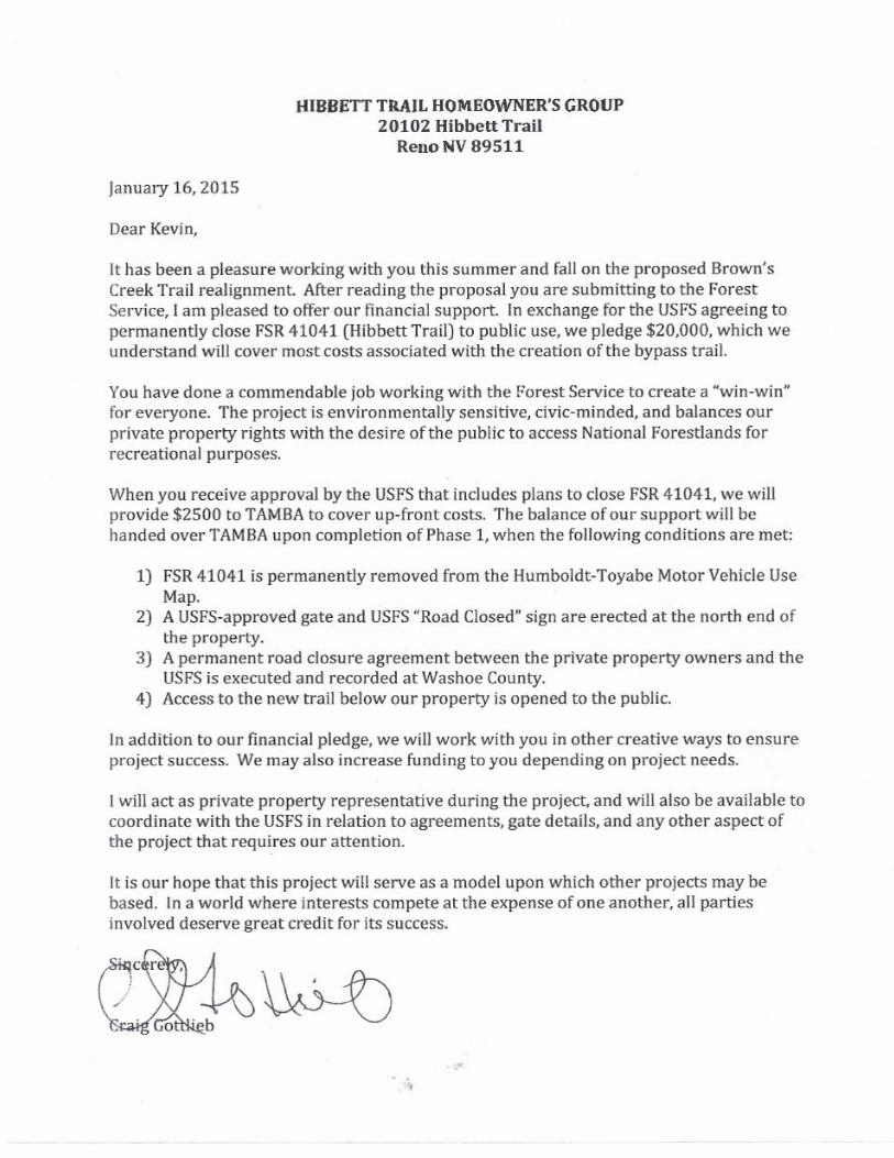
Enclosed with this letter is our detailed proposal to replace the unauthorized trails with a sustainable trail that will pro-vide for the recreation needs of the current users. This would be paid for using funds donated by the mountain bikecommunity, with the majority of costs paid for by Hibbett Trail property owners. This project provides an opportunityfor private individuals, community organizations, and government entities to become involved in a constructive partner-ship, which can serve as a model for future projects.
In summary, this project would:
1) Promote the use of authorized trails and discourage user-created trail construction.2) Increase the quality and quantity of outdoor recreational opportunities in the area.3) Appease the desire for advanced mountain bike trails.4) Eliminate conflicts with private property owners in the area.5) Protect the environment by restoring unauthorized created trails to natural habitat.6) Leverage private funds to create an asset owned by the public.
This project is supported by a broad coalition of public, private, educational, and user entities. We appreciate your con-sideration of this proposal and look forward to our continued partnership.
Sincerely,
Kevin JoellTrails Director
cc: Daniel Morris, Recreation Officer Bill Dunkelberger, Forest Supervisor Craig Gottlieb, Property Owner
att: Brown’s Creek Realignment & Restoration Project Proposal with supporting documents

BROWN’S CREEK TRAIL REALIGNMENT AND RESTORATION PROJECTProposed by TAMBA and Hibbett Trail Homeowners Group, February 2015
PROJECT SUMMARY
We are proposing a multi-phase project to realign and adopt into the system the existing trail known as “Brown’sCreek” located on Humboldt-Toiyabe National Forest lands primarily in Sections 16 and 17 of Township 17N Range 19E,Mount Diablo Meridian. Refer to Figure 1 for the general location of this project. With this approval, sections of exist-ing unauthorized and unsustainable trail will be decommissioned and restored back to nature. The following is a proj-ect breakdown as shown in Figure 2:
1) Construct 5808 lineal feet (1.1 miles) of new sustainable trail2) Improve to standard and adopt 4004 lineal feet (.91 miles) of existing trail3) Move the administrative gate location on FS 41041 north 4,224 feet to the private property boundary4) Remove and restore to nature 8025 lineal feet (1.52 miles) of existing unsustainable trail
The most significant portion of this project would be the construction of 1.1 mile of new trail below FS 41041 (the ac-cess road also known as Hibbett’s Trail for residential addressing purposes) to realign it closer to the Brown’s Creekdrainage. This would eliminate travel by users through the privately owned parcels along FS 41041 as well as place 90%of the new construction within the 2008 Fuels Reduction Project(as shown on Figure 6), an area that has been throughNEPA studies previously. Due to this, we are not expecting any negative impacts on sensitive plant or wildlife habitatwith this segment.
The section located above FS 41041, between that road and HWY 431 at Sky Tavern would require moderate re-routingand armoring for trail sustainability and safety, however the current alignment would generally be followed. Addition-ally, at the lower elevations of the project area, the .24 mile segment of existing trail from the tie-in of the new con-struction down to the existing Brown’s Creek Trail managed by Washoe County, would receive similar improvements.
We also propose to rehabilitate and restore to nature the current “Brown’s Creek Trail” alignment below FS 41041 thatwe are replacing with the new trail, as well as an older upper connection up to the Slide Mountain access road knownas “Hippyshack” that currently sees very little to zero use as some sections have no visible tread remaining. This routehas multiple sections that exceed 40% grade. Decommissioned areas would receive scarification, re-vegetation and ver-tical mulch to return them to natural habitat.
PROPOSED PROJECT GOALS
Improve non-motorized recreational opportunitiesProtect natural and cultural resources by mitigating erosion through improved trail design, standards, construc-tion and maintenancePromote connectivity to existing Trailheads and existing trailsProvide both local recreational and tourism opportunities.Provide high quality community-based trail stewardship opportunities and experiences.Curtail unauthorized trail construction and associated resource damage.Eliminate conflicts between trail users and private property owners.
RECOMMENDATIONS
Construct a new trail to meet USFS standards and specificationsFormally designate trails to be added to the USFS non-motorized trail system inventoryRestore to nature existing unauthorized user-created trails.Close FS 41041 at the private property boundary permanently to all non-official user traffic via the constructionof a USFS approved gate, and removal of this section of FS 41041 from the Motor Vehicle Use Map.Promote Trail Head connectivity in the urban interface of the Mount Rose Corridor.
ADDITIONAL PROJECT WORK
Update and or install Trailhead kiosk mapsProvide trail maps to local bike shops and GPS data to trail map publishers.Sign designated trail routes at intersections with Carsonites and/or trail markersProvide educational trail user signage at lower USFS boundary.Coordinate with WCSO to remove refuse left from illicit cultivation activities in the area of the new trail corridor.Continue with community outreach and education by web and social media.
PURPOSE AND NEED FOR ACTION:
Providing the public with trails opportunities accessible to a wide range of visitors. There are many trails for hik-ers, equestrians and intermediate mountain bikers but very few that are designed for advanced mountain bik-ers. This is an opportunity to address the desires of that user group while still maintaining trail safety for alllevels of riders. Since this area currently caters almost entirely to that demographic, it is the ideal location tocreate a legal advanced mountain bike trail.Defining and designing a trail network that will be easy for the public to use and will meet user expectations,thereby reducing the desire for users to create unauthorized trails and the associated resource damage.Eliminate the current need to cross private property on a debatable easement to connect recreation facilities.Restoring habitat and protecting sensitive species and cultural resources by closing and rehabilitating the user-created trails.Inaction will result in the continued and increasing number of user created trails not meeting USFS standards ormeeting trail user expectations with a negative impact to the natural resource.
EFFECTS
These actions would be of minimal impact, as these routes will result in substantial improvements to the usercreated routes.The trail system will be designed to meet USFS standards for non-motorized trail uses and trail improvementswill meet USFS trail standards for construction. Formal designation will make the trail system eligible for opera-tions and maintenance funding as well as enhance user safety, if for no other reason, making locating and evacu-ation of injured users easier for rescuers.Trail realignments and reclamation will mitigate erosion while at the same time providing a better trail experi-ence to the public. People will be more likely to use a designed trail system rather than attempt to create theirown.
FOREST PLAN
The Toiyabe National Forest Land and Resource Management Plan (1986) is still in effect for guiding management deci-sions on Forest Lands. It was created prior to the merging of the Humboldt and Toiyabe National Forests. Although dat-ed, much of the information and references in it are still accurate today. We feel that this project is in line with theguidance laid out in the forest plan.
In reference to the current Statewide Comprehensive Outdoor Recreation Plan (SCORP) at the time the Forest Plan wasapproved: “SCORP recognizes that in western Nevada there is a general lack of certain outdoor recreation facilities, in-cluding easy access to trails. This is especially true in the Carson Range. Close-in trail heads and feeder trails are in shortsupply in the Reno-Sparks-Carson City vicinity.” (II-5)
Referring to Management Area 2, which includes the area of this project: “The Carson front will be managed to provide adiversity of recreational opportunities. Intensive management emphasis on National Forest lands along the Mount Rose

Highway and US 50 corridors will be conducted. Management emphasis will provide roaded natural experiences alongmajor corridors and semi-primitive motorized and non-motorized experiences in other areas.” (IV-79)Due to the proximity of this project to the Mount Rose Highway Corridor, the Recreation Opportunity Spectrum(ROS) forthis area is deemed Roaded Natural. This is in concurrence with the ROS designation of similar type trail projects onother Forests. Note that no portion of this project is more than 1500’ from an existing public or administrative road.
“Emphasize loop opportunities and connector trails to other trails managed by other federal, state, or county agencies...”(IV-81). This project would connect Washoe County’s Browns Creek Trail with the trail network being developed on Cityof Reno land managed by the Sky Tavern Junior Ski Program. Once completed, it could be made into a loop utilizing theOld Mount Rose Hwy or in the future, possible connections planned for North of Galena Creek would allow this projectto be looped almost entirely on singletrack trail, which is the desire of most trail users.
CATEGORICAL EXCLUSION
The CEQ has identified specific actions that may be categorically excluded from documentation in an Environmental As-sessment (EA) or Environmental Impact Statement (EIS), if there are no adverse impacts leading to extraordinary circum-stances (36 CFR 220.6(a); FSH 1909.15, Chapter 30). This project is consistent with the National Environmental Policy Actbecause the activities as outlined in the proposed action fit within the following identified categorical exclusion:
Construction and reconstruction of trails (FSH 1909.15, Ch. 30, Sec. 31.2(1); 36 CFR 220.6(e)(1)). The followingproject activities are covered under this category: Bring existing user-created trails up to USFS standards neces-sary to designate the trails system and add it to the USFS transportation system and trail inventory. Activities in-clude rerouting user-created trails where necessary, closing and rehabilitating unnecessary user-created trails,widening trails to meet trail standards, clearing vegetation, cleaning and installing culverts, and grooming trailsurfaces.
EXISTING USFS ROADS, TRAILS, & USER CREATED ROUTES
BACKGROUND:
The current trail network along the Brown’s Creek Corridor consists of approximately 2.5 miles of unauthorized trails, 0miles of National Forest System Trails, and 3.3 miles of Washoe County Trails. There is also approximately 1.5 miles ofdesignated USFS roads currently open to the public and several miles of USFS administrative road that is closed to thepublic. This is shown on the location map in Figure 1. The user created trails have evolved because of the desire of rec-reational users to connect Sky Tavern to the Galena area using singletrack. In addition to being unauthorized, thesetrails have the following deficiencies: incised tread, braiding, improper turns, lack of grade reversals for drainage, nowayfinding signage, and excessive grades. In addition, portions of the route traverse private property along vehicleroadways, which creates conflicts within the community and deviates from the narrow singletrack trail experience thatmost users seek.
TAMBA has identified a trail alignment for the proposed “Brown’s Creek Trail” that is identified in Figure 2. It would con-nect Sky Tavern to Washoe County’s Brown’s Creek Trailhead on Joy Lake Road, providing users with the opportunity torecreate along the entire length of the Mount Rose corridor. This trail would be built per the Trail Management Hand-book and the Standard Specifications for Trail Construction and Maintenance as well as utilizing design specifications forbike features that have been constructed on other forests to provide a better quality experience as well as the connec-tivity desired.
CURRENT USE DATA
Usage data on the existing routes was collected over various periods during the Summer/Fall of 2014. Three locationswere selected to determine average use: FS 41041 on private property near Brown’s Creek, the unauthorized trailknown as “Browns Creek” identified as Section 3a on the project map, and the unauthorized trail known as “Hippyshack”identified as Section 3b on the project map. The time span varied for each counter but covered what would normally beconsidered the busy late summer season and all locations included Labor Day weekend.
LOCATION AVERAGE DAILY USE NOTESFS 41041 (Hibbett Trail) 2.33 Visitors Bike Traffic 2.1, Vehicles 0.2, Walkers .03Brown’s Creek Trail (Section 3a) 2.90 Visitors 96.4% of users were mountain bikersHippyshack (Section 3b) 0.00 Visitors Measured over 2 weeks, zero users recorded
The data acquired shows virtually no motor vehicle use (an average of 1 vehicle every 5 days), extremely limited pedes-trian use (less than 1 per month), and almost exclusive use by mountain bikers (96.4%). At the completion of this proj-ect, it is presumed that trail usage along the designated route would increase due to the improved quality of theexperience. Road usage through the private property, due to the road closure and the existence of the new route,would decrease to nearly zero.
NATURAL SURFACE TRAIL DESIGN & CONSTRUCTION STANDARDS
All approved Projects shall meet USFS Standard Specifications for Construction & Maintenance of Trails including:30”- 48” full bench constructionAverage trail grade should be 10% or less.Maximum trail grade (15%) for very short sections (100’ or less).Short pitch sections up to 30% with runouts and armoring.Trail Grade should not exceed ½ of Side Slope GradeBench Cut Outslope- Minimum 2%-6% out slope on bench cut / trail treadBack Slope from bench cut to be minimum 1:1 slope.Bench Cut Material on down slope to be thoroughly dispersed.Grade reversals or grade breaks every 100-200' maximum spacingSwitchbacks and Turns should be located on side slopes less than:
o Switchbacks – 40%o Super elevated or berm turns - 30%o Climbing turns – 20%
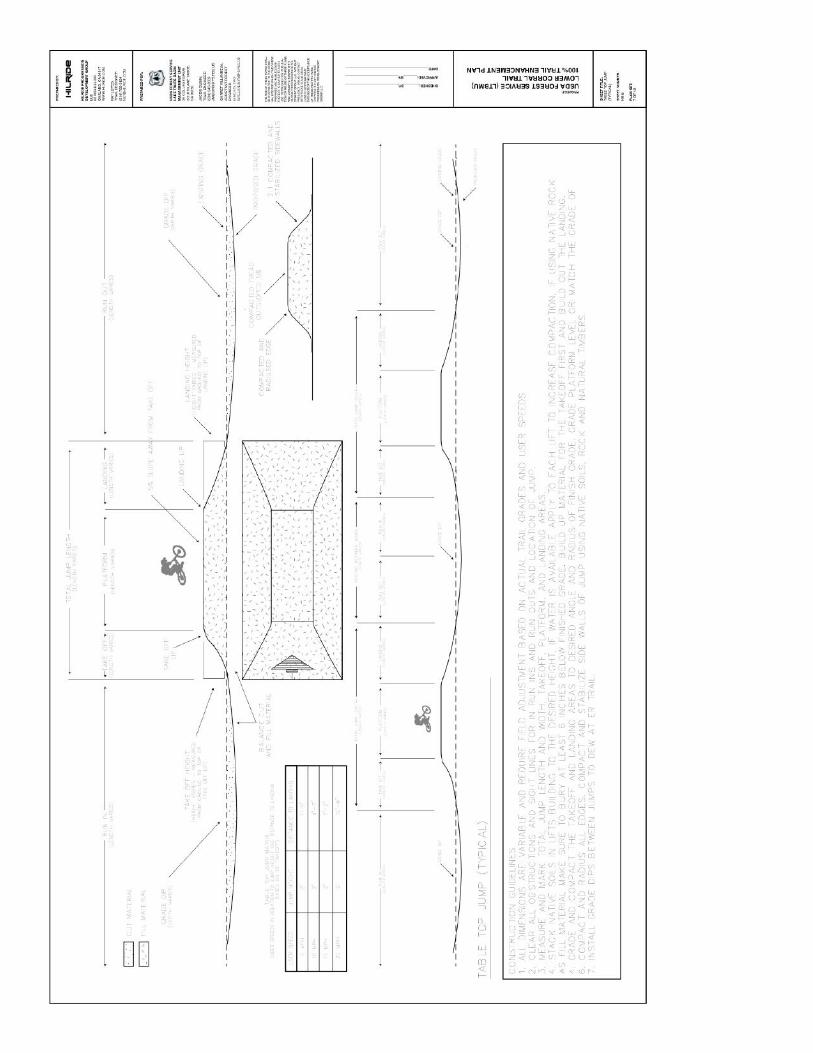
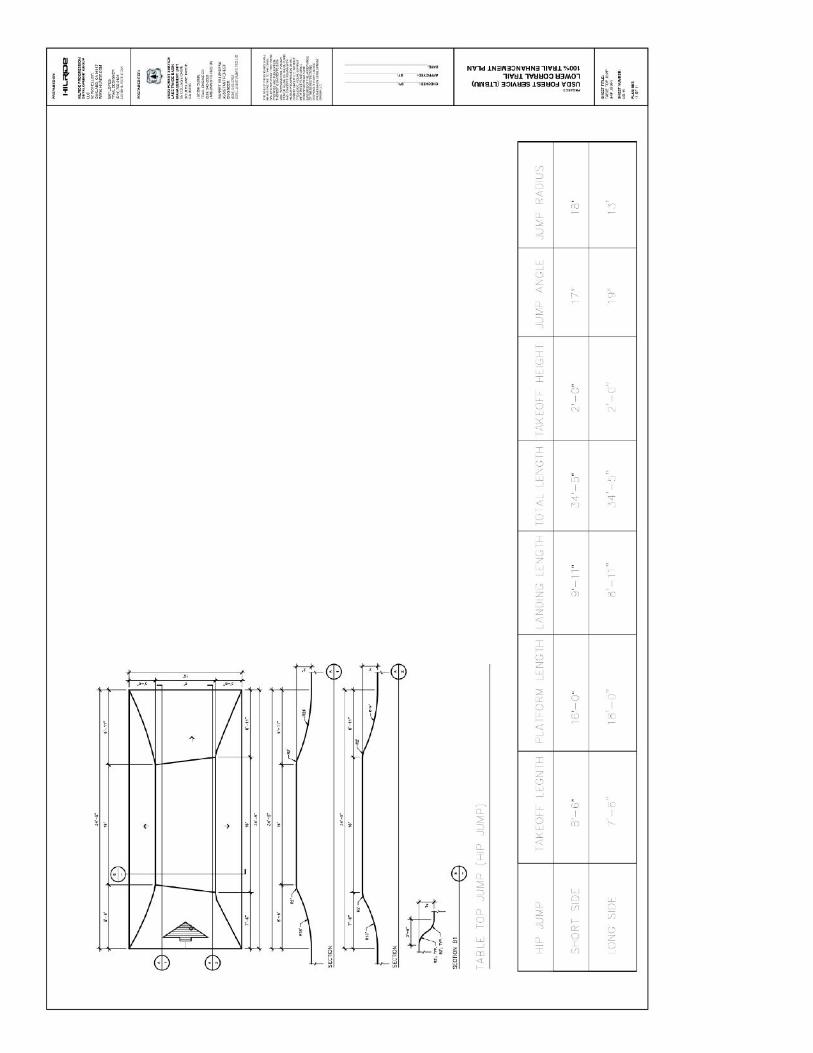
MOUNTAIN BIKE FEATURES:
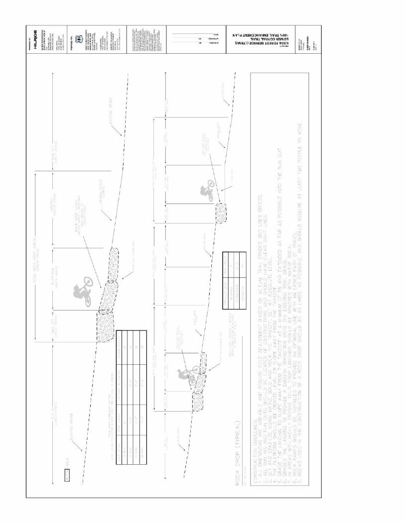
To appease the desires of many users for advanced mountain bike trails and maintain what is the current primary use ofthis area, we would like to incorporate safe, sustainable and fun features into the trail to enhance the experience formountain bike users. This would be similar to what has been installed on other mountain bike designed use trails lo-cated on other National Forests. Dimensions for features would be used from the plan set for the Corral Trail that waspurchased by the Lake Tahoe Basin Management Unit from Hilride Progression Group. These would be installed alongthe trail where topography and geology allow for their safe use. Like the Corral Trail, they would be designed to be funfor an advanced user, but still safe for a beginner rider or child to experience. This would be approximately 12 berms, 2sets of six tabletop jumps and 6 armored rock drop sections along the trail. Sections of the Corral Plans are attached tothis proposal. TAMBA was the Project Manager on the Corral Trail Enhancement Project and some of the same peoplethat built that will be working on this project.

EXECUTION
This project will be divided into 3 phases identified in Figures 3, 4 and 5 respectively:
Phase 1 will include the new trail construction below FS 41041 (Section 1a), installation of an USFS approved bridge overBrown’s Creek, and sustainability improvements along the lower section of Brown’s Creek (section 1b) between the re-route and the Washoe County section of Brown’s Creek Trail. Once complete, the administrative gate location on FS41041 would move north to the private property boundary.
Phase 2 will include improvements and re-routes to the upper section between FS 41041 and Sky Tavern.
Phase 3 will include the removal and restoration of the replaced sections of unauthorized trail (Sections 3a and 3b).
This project will be funded by donations from the mountain bike community as well as the adjacent property owners.Total construction costs including the bridge are estimated at $25,000, with $20,000 of that having been pledged by theproperty owners in exchange for the rerouting of the public around their property. In an effort to curtail additional ille-gal trail building, and to diffuse tensions along the private-property portion of the current travel route, TAMBA wouldlike the USFS to prioritize this proposal for approval. We respectfully request the following timeline:
February 2015 Proposal submittedSpring 2015 EA process beginsSummer 2015 Project approvalLate Summer 2015 Project work beginsLate Fall 2015 Phase 1 completeSummer 2016 Phase 2 completeFall 2016 Phase 3 complete
If this proposed project is of interest to the Forest Service, we’d like to schedule a meeting to discuss the EA process,what pre-existing scoping work in the project area would be acceptable to use and the level of work that would need tobe contracted out and who would be acceptable to the Forest Service to complete the scoping for the EA.
SUPPORTING DOCUMENTS
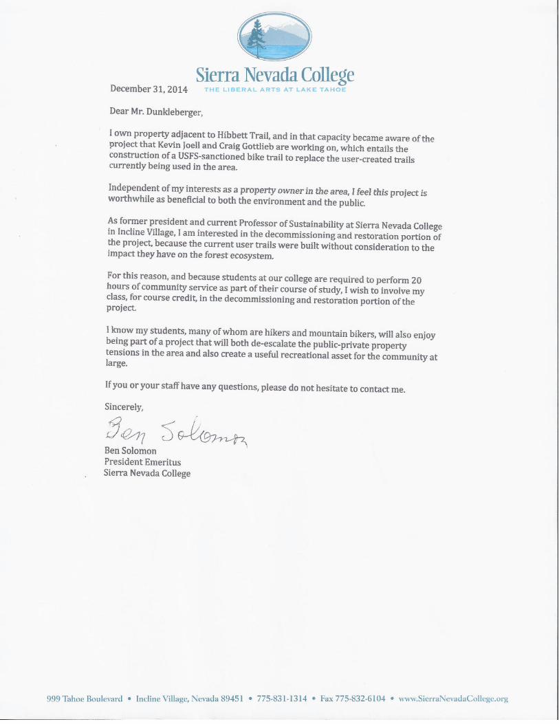
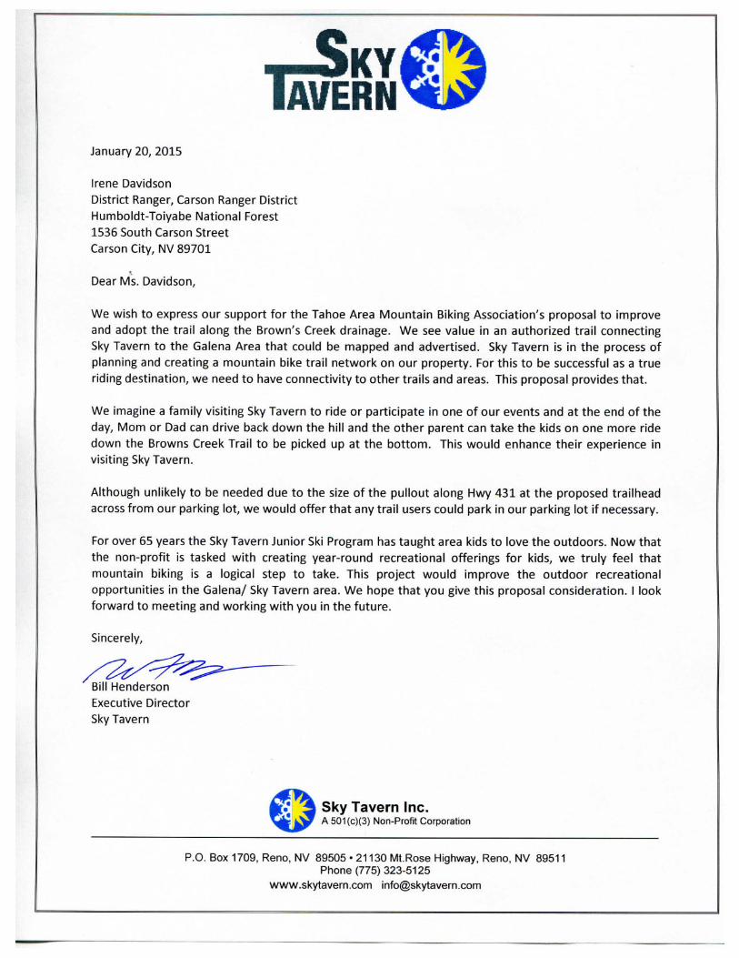
1. Maps showing proposed project location in figures 1 through 6.2. Letter of commitment and support from Hibbett Trail Homeowners Group.3. Sierra Nevada College letter of support4. Sky Tavern letter of support5. Washoe County letter of support6. Black Rock Bicycles/DHreno letter of support7. Richard Keillor letter of support8. Letter from Forest Supervisor Dunkelberger9. Excerpts from the Corral Trail plan set with spec trail features to be utilized.

Figu
re 1
- Pr
ojec
t Loc
atio
n M
ap

Figu
re 2
- Pr
ojec
t Map

Figu
re 3
- Ph
ase
1 D
etai
l Map

Figu
re 4
- Ph
ase
2 D
etai
l Map

Figu
re 5
- Ph
ase
3 D
etai
l Map

Figu
re 6
- Fu
el s
Redu
ctio
n A
rea
Refe
renc
e M
ap