summer recreational access management plan for the bulkley lrmp€¦ · for the bulkley lrmp...
TRANSCRIPT

Summer Recreational Access Management Plan
For the Bulkley LRMP
Prepared by
Summer RAMP Table
Submitted to
Bulkley Valley Community Resources Board
February 2013
Facilitator
Tom Chamberlin
Project supported by
Funding provided by

Summer RAMP Report February 2013 1
Table of Contents
Table of Contents ............................................................................................................... 1
List of Tables ..................................................................................................................... 2
Acknowledgements ............................................................................................................. 3
Executive Summary ............................................................................................................ 4
1.0 Introduction ................................................................................................................. 5
2.0 History ........................................................................................................................ 5
3.0 Objectives .................................................................................................................... 6
4.0 The Process and the Participants ..................................................................................... 6
4.1 Participants and their Goals ............................................................................................ 6
4.1.1 Bulkley Valley Quad Riders Club ................................................................................... 7
4.1.2 Bulkley Valley Backpackers Society .............................................................................. 7
4.1.3 Backcountry Horsemen of B.C., North West Chapter ....................................................... 7
4.1.4 Smithers Mountain Bike Association .............................................................................. 7
4.1.5 Public Representatives ................................................................................................ 7
4.2 Public Input .................................................................................................................. 7
4.3 Technical and Other Support .......................................................................................... 8
4.4 The Consensus Process .................................................................................................. 8
5.0 Principles of Recreational Access ..................................................................................... 9
6.0 Access and Human Effects on the Environment ............................................................... 10
6.1 Invasive Plants ........................................................................................................... 10
7.0 Categories of Recreational Access in the Site Recommendations ....................................... 11
7.1 Existing Accessible Roads and Gates.............................................................................. 11
7.2 Motorized, Non-Motorized and General Access Categories ................................................ 11
8.0 Management Objectives and Directions by Planning Unit .................................................. 13
9.0 Recommended uses for Summer Sites and Trails in the Bulkley TSA .................................. 13
10.0 Proposal: Intensive Motorized Area............................................................................. 17
11.0 Future Planning Process ............................................................................................. 18
12.0 Monitoring and Enforcement ....................................................................................... 20
13.0 Strategies for Unresolved Recreation Access Issues ....................................................... 20
14.0 Implementation ........................................................................................................ 22
References ...................................................................................................................... 23
Appendix 1. Alphabetical List of Summer Sites and Trails ...................................................... 24
Appendix 2. Mandate for the Summer RAMP project ............................................................. 26
Appendix 3. Terms of Reference for the Bulkley Recreation Access Management Plan Tables...... 27
Appendix 4. Summary of Public Input ................................................................................. 30
Appendix 5. Controlled Access Policy Proposal ...................................................................... 32
Appendix 6. Management Objectives and Directions by Planning Unit ...................................... 33
Appendix 7. Telkwa Mountain Access Understanding ............................................................. 40
Appendix 8. Principles of Recreational Access from 1997 RAMP .............................................. 42

Summer RAMP Report February 2013 2
List of Tables
Table 1. Categories of Recreational Access in the Bulkley TSA ................................................ 12
Table 2. Summary of Summer Site and Trail Usage Recommendations .................................... 14

Summer RAMP Report February 2013 3
Acknowledgements
The authors gratefully acknowledge the work of the Bulkley Valley Community Resources Board
Recreation Subcommittee, the Summer RAMP Table members, and the individuals and
organizations who contributed their ideas to this project. Funding and in-kind support from the
Real Estate Foundation of BC, the Wetzin'kwa Community Forest Corporation, Recreation Sites
and Trails BC, Smithers Exploration Group, Northwest Community College and the Bulkley Valley
Research Centre is greatly appreciated.

Summer RAMP Report February 2013 4
Executive Summary
This report of a Summer Recreational Access Management Plan (Summer RAMP) provides
recommendations to the Bulkley Valley Community Resources Board (BVCRB) for the appropriate
recreational use of 60 identified sites and trails in the Bulkley Land and Resource Management
Plan (Bulkley LRMP) (Bulkley 1998) area. The sites and trails are located on an associated Index
Map (scale 1:175,000) covering the entire area.
The report provides seven specific recommendations:
Recommendation 1: Management agencies responsible for gates on Crown land
implement the Controlled Access policy proposal (Appendix 5).
Recommendation 2: Government agencies designate the uses for sites and trails
identified in Table 2 and set objectives for them where applicable.
Recommendation 3: Recreation Sites and Trails BC supports exploration of the
Intensive Motorized Area (IMA) concept, by an identified champion organization.
Recommendation 4: The BVCRB includes in its Terms of Reference, and ensures
implementation of, the Future Planning Process described in Section 11.
Recommendation 5: Government agencies and clubs work to ensure people with limited
mobility have better access to high quality recreation areas. BVCRB (in cooperation with
the Bulkley Valley Research Centre) sponsors a focused research project in this area.
Recommendation 6: Government agencies, in association with the BVCRB, ensure that
digital data sets of recreation sites and trails are available to the public.
Recommendation 7: The BVCRB conducts a timely review of the Summer RAMP.
The planning process and the recommendations are consistent with the management directions of
the Bulkley LRMP, and build on and extend previous recreational access management plans and
agreements. The process involved a community based planning Table of 12 members,
representing four user clubs and the public, in a consensus based process assisted by an
independent facilitator.
Six main objectives from the Terms of Reference for the Bulkley Recreation Access Management
Plan Tables (Bulkley Valley Community Resources Board 2011) and eight recreation access
principles guided and informed the Table discussions. A central goal is to achieve a balance of use
so that high quality motorized and non-motorized experiences are available within a range of
travel distances and settings, while ensuring that environmental requirements are met.
The Bulkley Valley Research Centre, Northwest Community College, several resource agencies and
the BVCRB provided technical and administrative support. The Recreation Subcommittee of the
BVCRB provides coordination and communication with the public through their website
(www.bvcrb.ca) on which reference documents, periodic updates and public correspondence are
posted.

Summer RAMP Report February 2013 5
Summer RAMP (Recreational Access Management Plan)
For the Bulkley TSA
1.0 Introduction
This Summer Recreational Access Management Plan (Summer RAMP) provides community based
recommendations to the Bulkley Valley Community Resources Board (BVCRB) about various forms
of recreational access for identified sites, trails and lakes in the Bulkley Timber Supply Area (TSA).
It also provides a proposal for managing some of the more intensive forms of motorized
recreational use, and defines a process for dealing with future access initiatives, including
proposed modifications to this plan.
The planning process has been guided by management directions identified in the Bulkley Land
and Resource Management Plan (Bulkley LRMP) (Bulkley 1998), the Recreational Access
Management Plan (RAMP) for the Bulkley Portion of the Skeena Stikine Forest District (1997
RAMP) (B.C. Ministry of Forests and Range 1997) and the various existing access agreements
which have been developed since then, last summarized in 2006 in the report Current
Recreational Access Agreements: Bulkley TSA (B.C Integrated Land Management Bureau. 2006).
The responsible use of Crown land for recreation is both a right and a privilege of every citizen. In
this report we have applied well defined community values to help identify some of the limits and
criteria which define that responsible use.
2.0 History
The Bulkley LRMP, completed in 1996, reflects the Consensus Management Direction established
by the BVCRB and a team of Regional government representatives, in consultation with First
Nations and local governments. The Bulkley LRMP identifies general management directions in 11
management categories (biodiversity, access, timber, water quality, fish and wildlife habitat,
visual quality, range, outdoor recreation and tourism, subsurface resources, cultural heritage
resources, and future planning processes) that apply to all agencies, resources and activities in
the Bulkley TSA (Bulkley 1998).
The Bulkley LRMP did not, however, deal with recreational access, and directed that it be dealt
with in a future RAMP.
A RAMP process was initiated in 1996/7 to identify recreational areas and other areas that might
be negatively impacted by motorized use (e.g. sensitive site degradation), and to recommend
measures to resolve conflicts between differing uses. The resulting 1997 RAMP report provided
recommendations for summer use designation for 20 locations, and identified nine to be dealt with
in a future process. Detailed recommendations were also provided for the Harold Price Meadows
area. This Summer RAMP report builds on the foundation of the 1997 RAMP report, and completes
and extends it to include changes in recreation use to the present day.
Since 1997, a number of recreational access agreements have been reached after consultation
and negotiation between government and various user groups. Current Recreational Access
Agreements: Bulkley TSA (B.C Integrated Land Management Bureau 2006), identified 36 areas
for which designations were assigned, but left six as undesignated – to be dealt with in a future
process. That report also summarized more detailed access agreements in four specific areas:
Babine Mountains Provincial Park; Harold Price Meadows; Hudson Bay Mountain; and the Telkwa
Caribou Recovery Area. This document is available at this government website

Summer RAMP Report February 2013 6
http://archive.ilmb.gov.bc.ca/slrp/srmp/north/bulkley/cabinet/final_RAMP_agreements.pdf or
through the BVCRB website http://bvcrb.ca/ramp/background_documents.
The BVCRB recognized that there were many outstanding issues respecting recreational access
within the Bulkley TSA, and developed a proposal for completing the RAMP through a community
based project. The project was split into two stages: A Summer RAMP and a Winter RAMP. This
seasonal split was suggested in the report Proposed Process for Completing the Bulkley Recreation
Access Management Plan (Vold 2007). This report considers summer recreation access only.
In addition to the direction provided by the Bulkley LRMP and the 1997 RAMP, the project was
supported by the several government agencies dealing with land and resource use and a group of
recreational users. This mandate is summarized in Appendix 2.
The project received funding from Recreation Sites and Trails BC, the Real Estate Foundation of
British Columbia, Smithers Exploration Group and the Wetzin’kwa Community Forest Corporation,
and was initiated in 2011 with the selection of a community based Summer RAMP Table. The
Bulkley Valley Research Centre and Northwest Community College also provided support to the
project.
3.0 Objectives
The Terms of Reference for the Bulkley Recreation Access Management Plan Tables (Bulkley Valley
Community Resources Board 2011) (see Appendix 3) identify six main objectives:
Ensure that the Plan is based on the Bulkley LRMP and other existing higher level plans and
ensure that consideration is given to government policies.
Ensure a balance of recreational opportunities, minimizing conflicts.
Ensure that key areas are identified for public use.
Ensure that the process is community-based.
Ensure that the plan promotes stewardship and sustainable resource use, considering
economic, social and environmental factors.
Ensure that the plan can change over time.
The project was specifically not to deal with commercial recreation. It was required to consider all
areas within the Bulkley TSA and focus on results that can be displayed in a mapped format.
4.0 The Process and the Participants
4.1 Participants and their Goals
The Summer RAMP Table consisted of 12 members, two from each of four recreational user
groups (the Bulkley Valley Quad Riders Club; the Bulkley Valley Backpackers Society; Back
Country Horsemen of BC, North West Chapter; and the Smithers Mountain Bike Association) and
four members representing the general public. A neutral facilitator managed the process, and
assisted the Table members in reaching consensus about the issues. Between November 2011 and
January 2013 the Table met over 20 times, with many additional sub-group and constituency
(user clubs) meetings. Table members invested a substantial effort in reading and understanding
the background documents and technical reports which have gone into their discussions about
responsible access (See References).
Periodic “Updates” of progress and priorities were developed after most Table meetings and are
available on the BVCRB website, http://bvcrb.ca/ramp/updates.

Summer RAMP Report February 2013 7
4.1.1 Bulkley Valley Quad Riders Club
The BV Quad Riders promote responsible motorized access on established routes and trails. The
club organizes rides and works with partners to improve motorized access trails where
appropriate. The club has a continuing interest in working with other groups for trail improvement
and to negotiate increased access to some areas which are currently under BC Parks and BC
Environment jurisdiction. In general the Quad Riders support motorized access on all hard-packed
routes or trails that do not negatively impact environmental values.
4.1.2 Bulkley Valley Backpackers Society
The BV Backpackers Society seeks to provide a range of opportunities for self-powered
backcountry activities throughout the year for its membership. These activities mainly include
hiking, ski touring and snowshoe touring. The club wishes to improve the backcountry experience
through trail and infrastructure development, enhancement and maintenance, in cooperation with
other groups. The club works to conserve historic trails and features and provide social occasions
for members to get together. The BV Backpackers are committed to working with other
recreational groups to identify common concerns and opportunities for cooperation while still
preserving the natural experience that we value.
4.1.3 Backcountry Horsemen of B.C., North West Chapter
The Backcountry Horsemen of B.C. has as its mission to work together with recreational groups,
government agencies and the general public to promote awareness and understanding for a
cooperative wilderness experience; to build new trails, trailheads and other facilities for
horsemen; to maintain and preserve existing trails – wilderness or urban; to promote educational
programs in safety, courtesy, and environmental awareness and to preserve access for Canadians
to use horses and mules on public lands. The North West Chapter of the Back Country Horsemen
was created in 1999. Each year we have between 50 and 100 paid members. Many of our
members are active hikers and bikers as well as quad and snowmobile riders. We have a
commitment to work together with other recreational groups for both safety and enjoyment.
4.1.4 Smithers Mountain Bike Association
The Smithers Mountain Bike Association (SMBA) supports mountain biking in all regions of the
planning area, but has placed most of its effort in developing a dedicated trail system in the Bluff
Recreation Site, the Ptarmigan Recreation Site and the Piper Recreation Site, all in close proximity
to Smithers. The club does not anticipate any major new trail development in the near future. The
club is cooperating with the Backcountry Horsemen and the BV Backpackers to identify
maintenance and safety issues associated with the multi-use nature of some of the trails.
4.1.5 Public Representatives
Four members of the Summer RAMP Table represented the public at large, and did not have a
club mandate. They interacted with a number of other groups, some of which have management
agreements with government agencies. For example the Smithers Community Forest Society has
a partnership agreement with BC Sites and Trails to evaluate trail use in the Community Forest.
4.2 Public Input
Public comment was provided to the Table and to the BVCRB concerning the process itself and
then the first draft of the report which was released in June of 2012. Submissions were provided
to the Table through letters and e-mails and through meetings with the public and with recreation
user groups. Three public meetings were held (June, 2011; February, 2012; June, 2012), as well
as many additional meetings with community groups. All of the public input was reviewed by the

Summer RAMP Report February 2013 8
Table, and informed the Table in their discussions. Public input documents are, with the
permission of the authors, posted on the BVCRB website.
It is noted that there were significant numbers of individuals and groups who opposed the RAMP
process, feeling that no usage designation or regulation is required for the recreational use of
Crown land sites and trails. As well, the Village of Telkwa voted to officially oppose the project.
The Summer RAMP Table acknowledged these points of view, but felt that recreation values
warrant the completion of the RAMP project. A number of individuals and groups also expressed
their support for the RAMP process. A summary of public input is given in Appendix 4.
4.3 Technical and Other Support
Additional technical information (maps, data, etc.) was provided to the Table by government
agencies including BC Parks (Ministry of Environment), Ministry of Transportation and
Infrastructure, and Ministry of Forests, Lands and Natural Resource Operations (including
Recreation Sites and Trails BC, Ecosystems, and Fish and Wildlife). Agency staff attended
meetings as required to provide information, but were not involved in Table negotiations.
The Recreation Subcommittee of the BVCRB provided direction with respect to the process and
coordinated public information. The Recreation Subcommittee did not participate in the Table’s
negotiations. A Project Manager, representing the BVCRB, attended all meetings and provided
administrative support.
4.4 The Consensus Process
The Table developed its recommendations by consensus, which is defined as a solution to a
problem which, although not perfect, meets enough of the needs of the parties to be acceptable.
A consensus solution attempts to meet the needs of all the parties, sometimes in creative ways.
For the Summer RAMP, arriving at consensus required each participant to make an effort to
understand and respect the real needs and basic values of all members of the Table. The
consensus process is outlined in the Terms of Reference for the Bulkley Recreation Access
Management Plan Tables (Appendix 3).
When differences of opinion were not resolved and consensus not reached, or when issues were
identified that the Table could not deal with, the issue was documented. Further discussion or an
alternate decision making process was required. Section 12 summarizes some of these areas.

Summer RAMP Report February 2013 9
5.0 Principles of Recreational Access
The 1997 RAMP developed a set of “Principles for Recreation Access Management” They are
reproduced in Appendix 8. These principles have been extended or refined in some areas since
1997, for example to identify that lakes with a wilderness status should have no new road or trail
access within one kilometre (State of the Forest in the Bulkley Timber Supply Area ) (B.C. Ministry
of Forests and Range, Skeena Stikine Forest District 2004). Planning for recreational use has seen
an increased importance placed on discussions with local community groups and organizations,
especially with the assignment of new roles in some areas through partnership agreements
between Recreation Sites and Trails BC and groups such as the Smithers Community Forest
Society and the Smithers Mountain Bike Association. A simplified form of these principles has been
developed through discussion at the Summer RAMP Table. They are intended to support the
principles previously identified and may be viewed as a checklist for responsible recreation use.
Recreational Access Principles
1. Ensure responsible use of Crown land
All recreational users have an obligation for the responsible use of Crown land.
2. Prevent Harm
Responsible use does not cause undue harm to the environment, sensitive fish and wildlife, and
their respective habitat values, does not endanger public safety and is in accordance with specific
land use objectives that have been identified and will provide direction for recreational use. Extra
diligence is required for use in Sensitive or Rare Ecosystems (i.e., Core Ecosystems, Landscape
Corridors, sensitive Alpine, Alpine Forests or Woodland ecosystems).
3. Respect Other Users
Responsible use may entail limiting some types of use, scheduling conflicting uses for different
time periods or locations and respecting the values of other users in the same area.
4. Educate Users
Education about responsible recreation practices requires communication and cooperation
between communities, individuals, groups, organisations and government agencies. Education is
the primary tool to ensure responsible, safe and enjoyable recreation.
5. Share Responsibility
Monitoring of recreational use of Crown land is the responsibility of both government agencies and
users of the resource.
6. Provide a Range of High Quality Uses
High quality motorized and non-motorized experiences should be available within a range of travel
distances and settings, and should include opportunities for people with limited mobility.
7. Limit Access to Wilderness Lakes
No ‘new’ hard packed trails or roads should be built or existing trails upgraded that would increase
or improve access within one kilometre of lakes with a “Wilderness” designation.
8. Provide for Changes through Time in Recreation Use
Responsible recreational use means that agencies, community organizations, and individuals
employ a structured process to deal with complaints, new information, proposals for new
recreation site and trail developments, and other changes over time.

Summer RAMP Report February 2013 10
6.0 Access and Human Effects on the Environment
To provide one measure of the changes in human influence on the landscape and attendant
recreation which has developed over the years since the 1997 RAMP, a Northwest Community
College project mapped and analyzed the distribution and abundance of three classes of landscape
in the Bulkley TSA (Widen 2012). The classes are based on the Recreational Opportunity
Spectrum (ROS) measures of primitiveness derived from the distance of landscape areas from a
mapped road. “Primitive” landscape is defined as an area greater than 5,000 ha and more than
eight km from a road, “semi-primitive” is defined as an area greater than 1,000 ha and from one
to eight km from a road and “roaded” is less than one km from a road. The first ROS analysis was
done in 1997, and was updated in 2012, based on 2008 map data. The results of this analysis
indicate that areas classed as “primitive” have decreased by 12%, areas classed as “semi-
primitive” have decreased by 2% and areas classed as “roaded” have increased by 8%. These
results are not unexpected, and reflect the gradual expansion of road networks as resource
development takes place. They indicate that for all users, whether motorized or not, there is
progressively less “primitive” area available for recreation. These data should only be used to
indicate the direction of change. There were a number of technical challenges in the data and the
map bases which limit accuracy, but which also provide valuable information for future
comparisons. Northwest Community College (Geography department) should be contacted for
further information about the study.
The ongoing challenge for future recreational access management will be to ensure that high
quality opportunities are available for all recreational users.
6.1 Invasive Plants
Invasive plants can be spread by recreational activities. Invasive plants are non-native plants that
have been introduced to an area without the enemies that keep them in check in their native
environment. These plants can be highly destructive, difficult to control and can affect the health
of domestic animals and wildlife. All recreationists are responsible for limiting the spread of
invasive plants by following best management practices (see inset).
Selected best management practices for controlling invasive plants
Stay on managed trails, roads, and routes.
Clean vehicles, bikes, boots and other equipment; as well as
horses and dogs, by removing mud, dirt, seeds and plant
material prior to recreational activities.
Learn to identify invasive plants.
Ensure that staging areas are free of invasive plants.
Use weed-free forage for a minimum of 3 days prior to trips into
sensitive areas as identified by Northwest Invasive Plant Council
at www.invasiveplantcouncilbc.ca 1-866-44WEEDS.
Report invasive plants to the Northwest Invasive Plant Council.

Summer RAMP Report February 2013 11
7.0 Categories of Recreational Access in the Site Recommendations
From the highway system to the network of resource development (forestry, mining) roads with
their varying degrees of maintenance and/or deactivation through to trails and off-trail travel
there is a wide range of types of access to outdoor recreation in the Bulkley TSA.
7.1 Existing Accessible Roads and Gates
This plan does not specifically deal with existing accessible roads, although they are included on
the Summer RAMP Index Map. The Table assumed that all licensed vehicles, as well as Off Road
Vehicles (ORVs), horses, mountain bikes and hikers can utilize all existing accessible roads unless
such use conflicts with RAMP, Parks or LRMP rules or other government statutes, rules or
regulations. For this reason, recreation sites and campgrounds which are accessed by existing
roads are not included in the list of sites and trails identified in this Summer RAMP.
Some otherwise accessible roads have been placed off limits for motorized use by the use of gates
installed by management agencies or tenure holders. In some cases this is because of a fear that
irresponsible off-road ORV use will damage sensitive ecosystems or have impacts on wildlife.
However, the Table believed that most ORV riders, especially those affiliated with organized
groups or clubs, have a strong commitment to responsible riding, and make an effort to educate
their members and the community. The Table felt that the commitment and good examples of
responsible ORV riders should be encouraged and rewarded. The results of doing so increase the
protection of all sensitive landscape areas, encourage more riders to join organized groups and
help promote a culture of respect between all recreational users in our community.
The Summer RAMP Table prepared the following recommendation regarding motorized access
through gates on public roads, by permit, in certain defined circumstances. Existing gates are
located at North Mulwain (reference number 60), near Morin Lake Recreation Site, on the lower
Fletcher-Gardner Trail (15), in Planning Unit 1-2, and at several grizzly habitat areas in Planning
Unit 2-2. They are also mapped on the Index Map.
Recommendation 1: Management agencies responsible for gates on Crown
land implement the Controlled Access policy proposal (Appendix 5).
7.2 Motorized, Non-Motorized and General Access Categories
The Summer RAMP Table developed an array of categories to describe recommended access for
sites and trails in the Bulkley TSA (Table 1). The intent of the recommended access designations
is to apply the Principles of Recreational Access (Section 5) to the known information about the
identified sites and trails.
When roads become trails that are not suitable for vehicles licensed for highway use, they may
still be suitable for smaller ORVs (e.g. quads) or motorcycles. This use is designated M
(Motorized) or M-r (Motorized with restrictions). Trails that are not appropriate for motorized use,
or are within an area which has been designated non-motorized, are designated NM (Non-
motorized) or NM-r (Non-motorized with restrictions).
Many trails in this plan area do not have a recommended designation, and much (perhaps most)
of the landscape in the TSA is accessed for recreational purposes without using trails (e.g.
hunting, fishing, birding, viewing, cross-country hiking). The General Access provisions included in
Table 1 apply to these areas and they are subject to the overriding protection of the Forest and
Range Practices Act Section 46(1.1): Protection of the Environment (Forest and Range Practices
Act 2002).

Summer RAMP Report February 2013 12
Much discussion at the Summer RAMP Table, as well as from public input, focused on the
perception that designating categories of use may limit the opportunity for motorized access to
recreational experiences. On the contrary, the Table was committed to supporting the opportunity
for motorized access on roads and trails where it can be responsibly carried out. All members of
the Table are strong supporters of responsible and balanced use.
Table 1. Categories of Recreational Access in the Bulkley TSA
General Access: The basic principles of responsible recreational use apply to all activities on public land, whether an identified site or trail, or not. They are derived from the list of principles in Section 5. No use may cause damage to environmental or wildlife values or damage existing
trails. Use will ensure public safety and respect existing applicable legislation.
Users will respect the values of other users in the same area.
M (Motorized Use) Use is appropriate for off-road vehicles not intended for highway use (e.g. quads,
dirt bikes). Users have security in knowing they will have recreation access to the area. Non-motorized use is allowed.
The principles of General Access will always apply. M-r (Motorized with restrictions) The conditions for Motorized Use apply. Specific location or timing restrictions may be in place for the site. Permits for use may be required.
NM (Non-motorized use) Users have security in knowing they will have recreation access to the area.
All forms of non-motorized use are allowed. Motorized use is not allowed. The principles of General Access will always apply.
NM-r (Non-motorized with restrictions) The conditions of Non-Motorized use apply. Specific use location or timing restrictions may be in place for the site. Specific non-motorized uses may be restricted or designated (e.g. for specialized or
sensitive trails). Permits for use may be required.
Controlled Access Motorized access beyond an existing gate is by permit from management agency. The principles of General Access will always apply.

Summer RAMP Report February 2013 13
8.0 Management Objectives and Directions by Planning Unit
Each of the recommendations for recreational use in this plan is consistent with the management
objectives and directions provided in the Bulkley LRMP. The Bulkley LRMP established six types of
resource management zones (RMZs), where land is designated for distinct uses or values:
Protected (P)
Special Management 1 (SM1)
Special Management 2 (SM2)
Integrated Resource Management (IRM)
Settlement Zone (S)
Agriculture/Wildlife Zone (A/W)
More detailed planning in the LRMP is guided by dividing the resource management zones into 12
planning units; some with further division into sub-units. Each planning unit specifies
management requirements according to the 11 defined management categories. Most pertinent to
this report are the Access and Outdoor Recreation and Tourism directions for planning units or
sub-units. For some sub-units, specific Recreation directions were not provided.
To assist agency staff and others who may be applying the recommendations of this report,
objectives and management directions for the planning units are listed in Appendix 6.
9.0 Recommended uses for Summer Sites and Trails in the Bulkley TSA
Results of the Summer RAMP Table discussions are presented in Table 2: Summary of Summer
Site and Trail Usage Recommendations, compiled by planning unit. An alphabetical list of the sites
and trails is found in Appendix 1.
The sites and trails are located on an Index Map (scale 1:175,000) covering the entire TSA.
Recommendation 2: Government agencies designate the uses for summer
sites and trails identified in Table 2 and set objectives for them where
applicable.

Summer RAMP Report February 2013 14
Table 2: Summary of Summer Site and Trail Usage Recommendations (Continued) Resource roads: Generally hard-surfaced roads with running surfaces >5 m wide
Trails: Trails of various conditions <5 m wide P.U.: LRMP Planning Unit REF: Reference number for sites and trails Use: See Table 1
P.U. REF #
Name Use Comment
1-1 1 PU 1-1 NM Maintain primitive qualities
1-2 2 PU 1-2 M-r * Table recommends summer evaluation for Controlled M access to end of resource roads; maintain wilderness lakes
2-1 3 Babine River Corridor Park Park See BC Parks Management Plan1
2-3 4 Nilkitkwa Lake Provincial Park
Park See BC Parks Management Plan - boat access only1
2-3 5 Rainbow Alley Provincial Park
Park See BC Parks Management Plan - boat access only1
2-3 6 French Peak M-r M to end of resource road
2-3 7 Mt. Horetsky M-r * Upper limit of motorized access requires summer field assessment
2-3 8 PU 2-3 M-r
4-1 9 Netalzul Meadows Provincial Park
Park
5-1 10 Babine Mountains Park Park See Babine Mountains Park Access Agreements
5-2 11 Little Onion Trail NM See Babine Mountains Park Access Agreements
5-2 12 Orange Trail NM Table recommends discussions with BC Parks to move motorized boundary to another location
5-3 13 Cronin Ck. Trail M/NM Table recommends discussions with BC Parks to move motorized boundary to another location
5-8 14 Frohlick-Gilbert Trail NM See Harold Price Meadows Access Agreements and Driftwood Extension to Babine Mtn. Park Access Agreements
5-1 15 Fletcher-Gardiner Trail (Two Bridge; Reiseter Lk)
M-r Limited ATV access for 6 km to Harry Orm's cabin (June 15-Nov 15); contact BC Parks for Sunny Point gate key
5-8 16 Blunt Basin M-r On resource roads only
5-8 17 Blunt Mountain Trail NM
5-8 18 Seaton Basin M-r On resource roads only
5-8 19 Mt. Seaton Trail NM
5-8 20 Harold Price Meadows NM-r See Harold Price Meadows Access Agreements
1 Park Management Plans, available online: http://www.env.gov.bc.ca/bcparks/planning/mgmtplns/man_plan.html

Summer RAMP Report February 2013 15
Table 2: Summary of Summer Site and Trail Usage Recommendations (Continued)
Resource roads: Generally hard-surfaced roads with running surfaces >5 m wide Trails: Trails of various conditions <5 m wide P.U.: LRMP Planning Unit REF: Reference number for sites and trails
Use: See Table 1
P.U. REF #
Name Use Comment
5-8 21 Harold Price Recreation Cabin
NM Summer/winter hiking/ski use cabin
5-8 22 Harold Price Snowmobile Cabin
NM Winter snowmobile use cabin
5-8 23 Moricetown-Cronin Recreation Trail
NM Note: Travels through P.U.s 5-8, 5-9, 5-10; aka Moricetown-Cronin Trail
6-1 24 Dome Mountain Recreation Trails
M M access on established trails only
5-2 25 Canyon Creek Recreation Site
NM
6-1 26 Tyee Mountain Recreation Site
M/NM Mixed tenures, roads and trails; note partnership agreement with Tyee Mountain Trail Society.
27 Deep Ck. Trails NM Hiking trails to upper and lower waterfalls
6-1 28 Moose Mountain Trail NM New trail
6-1 29 Coulson's Cleft Trail NM New trail
7-1 30 Call Lake Provincial Park Park See BC Parks Management Plan1
7-1 31 Coffin Lake Road M
7-1 32 Ptarmigan Recreation Trails NM-r Note: Purpose built mountain bike trails not suitable for horse use.
7-1 33 Bulkley River Recreation Site NM
7-1 34 Tyee Lake Provincial Park Park See BC Parks Management Plan1
7-1 35 Bluff Recreation Site (Northeast Slopes)
NM-r * Requires summer assessment to identify trails suitable for horse use in consultation with user groups; includes a mixture of hiking trails and purpose built mountain bike trails
7-1 36 Horlings Road connector M Links Horlings Rd. to Toboggan Ck. Road.
8-2 37 East Boulder Ck. Trail M
8-2 38 Corya Basin NM NM trail past Moricetown water supply station
9-1 39 Hankin Lookout Trail NM A change from 1997 RAMP due to steepness and soils
9-1 40 Passby Lk. Trail (Passby Creek Trail)
NM
9-1 41 Hankin-Evelyn Backcountry Recreation Trails
NM/M Recreation Sites and Trails BC consultation with community underway; NM on purpose built ski trails; M on resource roads
10-1 42 Twin Falls Trails NM Trails from campground to falls and to glacier
10-1 43 Toboggan Ck. Road M *Note: Alpine spur trail needs field assessment

Summer RAMP Report February 2013 16
Table 2: Summary of Summer Site and Trail Usage Recommendations (Continued)
Resource roads: Generally hard-surfaced roads with running surfaces >5 m wide Trails: Trails of various conditions <5 m wide P.U.: LRMP Planning Unit REF: Reference number for sites and trails
Use: See Table 1
P.U. REF #
Name Use Comment
10-1 44 Elliot Ck Trail NM Hiking trail is NM; agency consultation with community underway; NM on purpose built ski trails; gravel pit bypass under discussion with BC Transportation and Infrastructure
10-2 45 Prairie to Crater Lake Trail NM-r New name; hiking only - no horse or mountain bike use
10-3 46 Hudson Bay Mtn. Adventures NM Commercial ski area
10-4 47 Smithers Community Forest Recreation Trails
NM-r Includes Nordic Ski Area; note partnership agreement with Smithers Community Forest Society; uses other than hiking require consultation with SCFS
10-4 48 Piper Down Recreation Site NM-r Note purpose built mountain bike trails not suitable for horse use and potential danger for hikers
11-2 49 Telkwa Mountains Caribou Recovery Area
NM See Telkwa Mountain Access Understanding; NM access July 15 – Sept. 30
11-4 50 Howson Ck. Road M M access on resource road and trail from Telkwa R. Bridge to Mooseskin Johnny Lk., subject to provisions of pending WHA. Recommend Controlled Access to other areas using existing roads.
11-6 51 Telkwa Pass M
11-6 52 Winfield Ck Road and Microwave Plateau Trail
M M access on resource roads and hard packed trails.
11-6 53 Sinclair Range and Trail NM Summer NM access only.
12-3 54 Serb Creek NM Maintain primitive summer access; re-evaluate if timber development begins
12-4 55 Bud Lake (w) and Cerber Lake (w)
NM No new road access, snow roads or trails to wilderness lakes within 1 km.
12-4 56 Louise Lake and Sandstone Lake
M-r M on resource roads; established trails currently being used will be evaluated by Recreation Sites and Trails BC to determine whether their current location/condition is suitable for quad access and to determine required upgrades.
12-4 57 Ashman Ridge Trail NM Maintain Cable Main FSR as access to trailhead if sponsor can be found
12-4 58 Silvern Lake Recreation Trail (Silvern Lakes Trail)
NM
12-4 59 McDonell Lake Trail NM
12-5 60 North Mulwain NM Table recommends summer evaluation for Controlled M access to end of 5 km road.
Disclaimer: The Summer RAMP Table and the BVCRB are not responsible for the condition of any
sites and trails. Site and trail locations and conditions can change as a result of development or
natural forces. Users must be prepared for unexpected circumstances. Access to trailheads may
not be maintained.

Summer RAMP Report February 2013 17
10.0 Proposal: Intensive Motorized Area
Introduction
Off Road Vehicles (ORVs) such as quads and dirt bikes are designed and marketed to access
difficult terrain. Many ORV owners enjoy the challenge of navigating wet, steep or otherwise
difficult terrain. Unfortunately, locations where this recreational activity can responsibly occur are
limited, and too often it takes place in environmentally sensitive areas, causing damage and
violating provisions of the Forest and Range Practices Act and regulations. The damaging activity
is believed to be extensive but is not systematically documented.
The concept of an intensive motorized area (IMA) for the recreational use of ORVs has been
developed in response to an awareness of this problem. The goal is to provide a location where
fun use of ORVs (an ORV Park?) can be supported and managed, without the damaging random
use being spread throughout the region. Other sports have identified specific areas to support
similar challenging activities. Examples include the snowboard park on the ski hill, the skateboard
park in the Town of Smithers and the annual demolition derby in Telkwa.
Design Characteristics of an Intensive Motorized Area
A viable IMA would require serious design work in order to meet two basic criteria: Environmental
responsibility and user satisfaction.
Environmental Responsibility: First, an IMA would have to be located so that
environmental impacts are minimized and so that there is no impact on the water quality
of adjacent watercourses. Sediment filtering and trapping systems may be required. The
area would need to be a sufficient distance from sensitive sites, core ecosystems and
landscape corridors, wildlife and wildlife habitats to ensure their protection. The issue of
noise would have to be addressed, and requirements for public safety met.
User Satisfaction: Second, the IMA would have to be fun for users. It would require the
design of purpose built trails, incorporating banked turns, steep sections, hill climbing and
enduro trails. The network of designed trails would need to be sufficiently large to
challenge most riders. Within this core area, specific locations would be dedicated to wet
terrain riding (mudbogging).
Meeting these criteria in a location accessible from Hwy 16, but sufficiently removed from
residential areas, will require technical input from soils and ecosystem specialists, construction
engineers, agency representatives, user groups and the community. The planning will be a
significant project, and would best be accomplished by a group of potential IMA users organized
for this purpose.
A variety of potential tenure types (private land, IR land, forest land) have been discussed by the
IMA working group of RAMP. The core area and mudbogging sites would require an exemption
from the Forest and Range Practices Act, but the surrounding purpose built trails would remain in
the forest land base and be designed and managed to provide adequate drainage and other
environmental safeguards.
It is clear that a considerable commitment by a championing organization and the involvement of
potential users will be required before an IMA proposal could be put before appropriate
government agencies.

Summer RAMP Report February 2013 18
Benefits
The result of a successful IMA would be to provide a location for fun-loving ORV riders to play
without having to seek opportunities throughout the backcountry. It would be a unique attraction
for riders from other communities to visit the Bulkley Valley, perhaps in conjunction with rides on
some of the other motorized trails in the area. The potential tourism spin-offs could be large.
There are currently very few agency resources available for enforcement of environmental
protection legislation in remote areas. This can result in a culture of disregard for existing rules.
An Intensive Motorized Area would encourage riders who enjoy motorized challenges to focus
their play in a well designed area, and offer legitimacy and public support to their recreational
activity.
Recommendation
The current (2012) Summer RAMP process does not have the time, resources or expertise to
evaluate potential sites and prepare design recommendations for an IMA. The information
requirements and procedural steps identified in the Future Planning Process section of the 2012
RAMP (below) may provide a framework for the work.
Recommendation 3: Recreation Sites and Trails BC supports exploration of
the Intensive Motorized Area (IMA) concept, by an identified champion
organization.
11.0 Future Planning Process Background
Persons or groups who want to develop or improve recreation sites or trails must apply to
Recreation Sites and Trails BC or other agencies for plan approval, and to various agencies for
required permits (e.g. to cut trees). The agency then refers such applications to other agencies,
community groups, First Nations, the public and to the BVCRB. Other development proposals,
such as for mines, forestry, construction, etc. follow a similar referral process. Similarly, concerns
about violations of land use regulations (such as use causing environmental damage or violating
other legislation e.g. FRPA (46(1.1)) (Forest and Range Practices Act 2002) are brought to the
enforcement arms of a relevant government agency, or the RCMP.
Scope
A Future Planning Process could apply to a variety of issues, including the following:
Recreation applications.
Applications to change or improve existing trails.
Applications for activities or developments which may have an impact on recreation in the
Bulkley TSA.
Significant concerns.
Impacts and opportunities for motorized air and water access. Aircraft and personal
watercraft are examples of uses that may be examined.

Summer RAMP Report February 2013 19
Process
The Table recommends two options for a recreation related proposal or for a potential conflict.
1. The BVCRB continues with its agreement to receive referral notices from government about
proposals that are related to or may affect recreation, and government also notifies the BVCRB of
recreation related conflicts and violations, or;
2. The proponent of a proposal or person/group making a complaint can contact the BVCRB
directly to ask for a review of their issue. The BVCRB will evaluate the proposal or issue and
respond with a recommendation to the proponent and to government decision making agencies.
In either case a working group (sub-committee of the BVCRB), perhaps known as the RAMP
Review Committee (RRC), would evaluate the issue and provide a recommendation to the BVCRB.
The RRC would have a composition/membership similar to the diversity of the current Summer
RAMP Table, and also include representatives from other clubs or interested parties. The RRC
would seek to arrive at a consensus recommendation from the information and views considered
and forward it as a recommendation to Recreation Sites and Trails BC and other appropriate
decision making government agencies.
Criteria and Steps
The RRC, when evaluating a proposal, will consider:
The objectives and management directions from the 1998 Bulkley LRMP.
The Summer RAMP use recommendations and principles, and assess the proposal/problem
for adherence to them.
Potential impacts and conflicts, including previous uses within the area and potential future
uses.
“Best management practices” if they exist (i.e. accepted trail standards).
Time sharing or use sharing options where applicable.
Ecological effects (i.e. on wildlife or sensitive habitats).
Cultural issues if applicable and known.
In addition, the RRC user club representatives would consult with their respective memberships
on issues which may affect their interests.
After the evaluation has been completed, the RRC would develop a final recommendation which is
forwarded to the BVCRB for discussion with appropriate agencies.
Public Input to Future Planning
Recreation is a highly valued activity in our community, and the Summer RAMP experience has
reinforced the need to understand viewpoints of all community groups. However, the
responsibility for public consultation lies with proponents (of major projects) and with government
agencies.

Summer RAMP Report February 2013 20
This proposed Future Planning Process builds in a degree of public involvement, both through the
membership diversity of the BVCRB and the RRC, and through the role of clubs. However, internal
intergovernmental agency referrals and public consultation is up to the agencies. We make a
strong recommendation to government to:
Adequately advertise new proposals.
Notify neighbours or community groups within/close to the trail or area.
Contact user groups that may be directly impacted but may not be aware of the
proposal.
Recommendation 4: The BVCRB includes in its Terms of Reference, and ensures
implementation of, the Future Planning Process described in Section 11.
12.0 Monitoring and Enforcement The Principles guiding this RAMP emphasize that shared responsibility and mutual respect are the
foundations for a community based process. Monitoring recreational use is the responsibility of all
users. In the event that individuals cause damage or choose to ignore designated uses,
information provided to the enforcement staff of the Ministry of Forests, Lands and Natural
Resource Operations or the Ministry of Environment can result in charges under Section 46(1.1) of
the Forest and Range Practices Act (Forest and Range Practices Act 2002).
The RAMP Table is hopeful, however, that the increased communication and education by clubs
and between user groups, together with the options for a Future Planning Process in this
document, will minimize conflicts between recreational users, and promote cooperative efforts to
give all users high quality access to recreational opportunities.
13.0 Strategies for Unresolved Recreation Access Issues
Some issues were identified during this planning process that the Summer RAMP Table could not
resolve, either because of a lack of mandate or because time and resources were not available. It
is worth noting, however, that the Table members arrived at a consensus recommendation for all
60 of the identified sites and trails.
Loss of Motorized Access: Prior to the establishment of Provincial Parks in the region,
existing trails or roads provided motorized access to areas such as the Babine River
corridor and the Babine Mountains. Much of that access has been replaced with the non-
motorized status of most park areas. In addition, motorized access leading to the Telkwa
Mountains has been curtailed under the provisions of the Telkwa Mountain Access
Understanding, presented in Appendix 7, which pertains to motorized access into the
voluntary non-motorized designated zones in the Telkwa Caribou Recovery Area.
While understanding the reasons for these restrictions, motorized representatives strongly
feel that these losses significantly limit their opportunity to access high quality areas.
The Table respected this point of view, but making recommendations dealing with land
under BC Parks jurisdiction or in the Telkwa Caribou Recovery Area is outside the scope of
the Table’s mandate.

Summer RAMP Report February 2013 21
The Table was informed by the BC Ministry of Environment that steps are underway to
designate a Wildlife Habitat Area in the Telkwa Caribou Recovery Area (for steps required
to complete the process see Establishment of Wildlife Habitat Areas at
http://www.env.gov.bc.ca/wld/frpa/iwms/establish.html). If Wildlife Habitat Area status is
approved then a Future Planning process might take place in the area. Likewise, a
procedure exists to amend Park Master Plans which, if undertaken, could to lead to an
agreement for access on the Orange Trail. While these are not quick processes, and do not
guarantee an outcome, the Table supports cooperative efforts between clubs and
partnerships with government agencies to extend motorized access routes to high quality
destinations.
Leadership and a willingness to work with responsible organizations will be required from
government agencies to address this issue.
Inadequate Enforcement and Understanding: The recommendations in this plan
require support from both government and the community for their implementation.
Because of the lack of resources for enforcement, and because restrictions have at times
been placed on roads and trails without sufficient explanation, a culture of disrespect has
developed among some recreational users. This in turn has frustrated the more responsible
recreational users, and has made it difficult to achieve consensus in areas where the reality
of poor compliance and few government resources makes it difficult to manage access
more intensively. A government policy for enforcement action in the case of documented
environmental damage violations of RAMP or government statutes, rules or regulations is
also needed.
The B.C. government publication Protect our Forests and Range Lands (B.C. Ministry of
Forests and Range 2008) states “Damaging the environment is prohibited by law in British
Columbia. Recent changes to forestry legislation make individuals who damage an
ecosystem on Crown land (such as wetlands, grasslands, and alpine areas) subject to
penalties. If cases are prosecuted in the courts, they carry a maximum fine of $100,000,
up to one year in jail, or both. The goal is to prevent damage to the environment, not stop
all recreational activities. Most people who use Crown land act responsibly. It is illegal to
build a trail or roadway on Crown land without authority.”
Better communication between government agencies and recreational user groups,
together with support for peer monitoring and mutual education among user groups, will
assist in the development of a culture of respect for recreational values.
Time Sharing Opportunities: There may be some degree of conflict between the values
of different user groups in some shared access areas. To resolve this type of conflict, the
Table would like to explore the opportunity for different user groups to use a desired area
at different times of the year, or even on alternate years. Most trips planned by the BV
Quad Riders, for example, are scheduled well in advance, and might fit this strategy.
This option will require consultation between the user clubs and application of the Future
Planning Process in consultation with Recreation Sites and Trails BC.
Persons with Limited Mobility: The Table felt that people with limited mobility should
enjoy as much access to scenic and backcountry recreation as possible. For most, this
means using motorized access. This is an additional rationale for the Table’s support for
the development and improvement of appropriate motorized trails. Although this report
identifies the importance of providing such recreational access but neither time nor
resources were available to examine specific trails, or trail policies, from the point of view
of these users. Expertise in this area is locally available, and the Table recommends that

Summer RAMP Report February 2013 22
Recreation Sites and Trails BC consider an analysis of the options, similar to that which is
being done for some of the national parks.
In addition, clubs are encouraged to develop events that allow people with limited mobility
to experience high elevation or primitive areas. (Note, for example, the summer use of the
chair lift on the ski hill.)
Recommendation 5: Government agencies and clubs work to ensure people
with limited mobility have better access to high quality recreation areas. BVCRB
(in cooperation with the Bulkley Valley Research Centre) sponsors a focused
research project in this area.
14.0 Implementation
The final step of this planning process will be the consideration and implementation of its
recommendations by appropriate government agencies. Equally important will be the educational
commitment of the many user clubs and organizations in the Bulkley Valley. These clubs and
organizations, as well as individual recreation users, will be the beneficiaries of the certainty which
this plan can provide, and will be the most important advocates for the application of its
principles.
In addition to this document and the associated Index Map, the data files for the location and
attributes of each site are available digitally. The Summer RAMP Table supports public access to
these data, and encourages clubs or other organizations to consider their use in separate
publications, and possibly as files able to be loaded into standard GPS devises.
Finally, all the maps and data will be available as .kml files on the BVCRB website. These files
enable users to display the maps and data in Google Earth.
Recommendation 6: Government agencies, in association with the BVCRB,
ensure that digital data sets of recreation sites and trails are available to the
public.
Each Summer RAMP Table member has invested hundreds of hours in complex and difficult
negotiations, carried out in good faith, to produce this plan. We sincerely hope that both our
community and the agencies which will consider these recommendations will reciprocate this
commitment.
Recommendation 7: The BVCRB conduct a timely review of the Summer RAMP.

Summer RAMP Report February 2013 23
References B.C. Integrated Land Management Bureau. 2006. Current Recreational Access Agreements: Bulkley TSA. http://archive.ilmb.gov.bc.ca/slrp/srmp/north/bulkley/cabinet/final_RAMP_agreements.pdf
B.C. Ministry of Forests and Range, Skeena Stikine Forest District. 1997. Recreational Access Management Plan (RAMP) for the Bulkley portion of the Skeena Stikine Forest District. Available at www.for.gov.bc.ca/dss/RAMP/RAMPtoc.htm
B.C. Ministry of Forests and Range, Skeena Stikine Forest District. 2004. State of the Forest in the Bulkley
Timber Supply Area. Available at http://www.for.gov.bc.ca/dss/StateofForest/foreststate1.htm
B.C. Ministry of Forests and Range. 2008. Protect Our Forests and Range Lands. Available at http://www.for.gov.bc.ca/ftp/hen/external/!publish/web/otherPublication/ProtectOurForestsAndRa
ngeLand.pdf
Bulkley Valley Community Resources Board. 2011. Terms of Reference for the Bulkley Recreation Access
Management Plan Tables (BRAMPT).
www.bvcrb.ca/files/issues/recreation/RAMP_Table_ToR_June30_2011.pdf
Bulkley Valley Community Resources Board & Interagency Planning Team. 1998. Bulkley Land and Resource Management Plan. Available at www.bvcrb.ca/files/admin/other/bulkley_LRMP.pdf Forest and Range Practices Act SBC 2002. Available at http://www.bclaws.ca/EPLibraries/bclaws_new/document/ID/freeside/00_02069_01
Park Management Plans, available online: http://www.env.gov.bc.ca/bcparks/planning/mgmtplns/man_plan.html Vold, T. 2007. Proposed process for completing the Bulkley Recreation Access Management Plan. www.bvcrb.ca/files/issues/recreation/Proposed_Process_to_Complete_Bulkley_RAMP_-_Nov_final_report.pdf
Widen, K. 2012. Recreational Opportunity Spectrum Analysis: 1997-2011 for the Bulkley TSA. Unpub. reports
to NWCC.
Summer RAMP Report February 2013 24
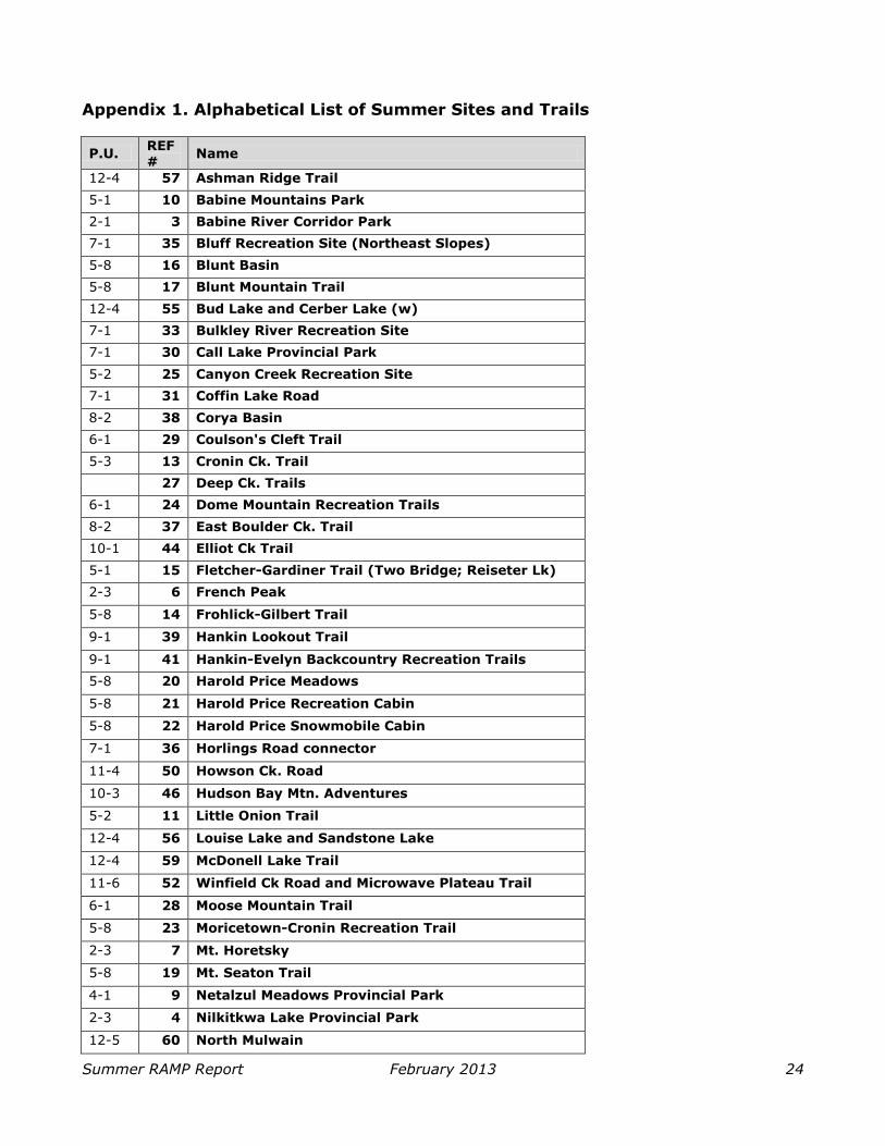
Appendix 1. Alphabetical List of Summer Sites and Trails
P.U. REF #
Name
12-4 57 Ashman Ridge Trail
5-1 10 Babine Mountains Park
2-1 3 Babine River Corridor Park
7-1 35 Bluff Recreation Site (Northeast Slopes)
5-8 16 Blunt Basin
5-8 17 Blunt Mountain Trail
12-4 55 Bud Lake and Cerber Lake (w)
7-1 33 Bulkley River Recreation Site
7-1 30 Call Lake Provincial Park
5-2 25 Canyon Creek Recreation Site
7-1 31 Coffin Lake Road
8-2 38 Corya Basin
6-1 29 Coulson's Cleft Trail
5-3 13 Cronin Ck. Trail
27 Deep Ck. Trails
6-1 24 Dome Mountain Recreation Trails
8-2 37 East Boulder Ck. Trail
10-1 44 Elliot Ck Trail
5-1 15 Fletcher-Gardiner Trail (Two Bridge; Reiseter Lk)
2-3 6 French Peak
5-8 14 Frohlick-Gilbert Trail
9-1 39 Hankin Lookout Trail
9-1 41 Hankin-Evelyn Backcountry Recreation Trails
5-8 20 Harold Price Meadows
5-8 21 Harold Price Recreation Cabin
5-8 22 Harold Price Snowmobile Cabin
7-1 36 Horlings Road connector
11-4 50 Howson Ck. Road
10-3 46 Hudson Bay Mtn. Adventures
5-2 11 Little Onion Trail
12-4 56 Louise Lake and Sandstone Lake
12-4 59 McDonell Lake Trail
11-6 52 Winfield Ck Road and Microwave Plateau Trail
6-1 28 Moose Mountain Trail
5-8 23 Moricetown-Cronin Recreation Trail
2-3 7 Mt. Horetsky
5-8 19 Mt. Seaton Trail
4-1 9 Netalzul Meadows Provincial Park
2-3 4 Nilkitkwa Lake Provincial Park
12-5 60 North Mulwain

Summer RAMP Report February 2013 25
P.U. REF #
Name
5-2 12 Orange Trail
9-1 40 Passby Lk. Trail (Passby Creek Trail)
10-4 48 Piper Down Rec Site
10-2 45 Prairie to Crater Lake Trail
7-1 32 Ptarmigan Recreation Trails
1-1 1 PU 1-1
1-2 2 PU 1-2
2-3 8 PU 2-3
2-3 5 Rainbow Alley Provincial Park
5-8 18 Seaton Basin
12-3 54 Serb Creek
12-4 58 Silvern Lake Recreation Trail (Silvern Lakes Trail)
11-6 53 Sinclair Range and Trail
10-4 47 Smithers Community Forest Recreation Trails
11-2 49 Telkwa Mountains Caribou Recovery Area
11-6 51 Telkwa Pass
10-1 43 Toboggan Ck. Road
10-1 42 Twin Falls Trails
6-1 26 Tyee Mountain Recreation Site
7-1 34 Tyee Lake Provincial Park

Summer RAMP Report February 2013 26
Appendix 2. Mandate for the Summer RAMP project
In the early 1990s, the B.C. government began its land-use planning program. The public was
requesting more comprehensive, open and consensus-based land use planning processes. The
goal was to create certainty for the public, private sector and First Nations with a framework that
would guide decisions about land and resource management. A high level of public involvement
was required.
By the late 1990s, the BVCRB had completed the Bulkley Land and Resource Management Plan
(Bulkley LRMP). The board worked independently, assisted by local government and the wider
community. With broad community buy-in, the Bulkley LRMP continues to act as a guide for
development decisions.
When the Bulkley LRMP was approved by the ministries of Forests, Energy and Mines, and
Environment, Lands and Parks, the ministers commented that “The Board has demonstrated that
diverse interests can work together to develop consensus on future management of land and
resources. Their cooperative approach and commitment to negotiation at the community level are
exemplary for other land use planning processes. We encourage the Board to continue to
participate in plan monitoring.”
The BVCRB continues to monitor Crown land management and provide recommendations to
government, with members coming from a broad cross-section of the community—forestry,
mining, agriculture, hunting and conservation.
The Bulkley LRMP also notes the importance of managing recreational access to provide a variety
of experiences and minimize impacts on fish, wildlife and other environmental resources. It says,
“A strategic Recreational Access Management Plan (RAMP) is required for the Bulkley Plan Area to
assist in meeting this objective. Input by various interest groups and lead agencies will assist in
developing the RAMP.”
The provincial government’s 2006 Bulkley LRMP Implementation Plan and Progress Report
identifies RAMP completion as “very high” priority. It also identifies the BVCRB as the public body
for implementation. In 2007, a report commissioned by the province showed that most of the 33
community members interviewed from a variety of backgrounds were strongly in favour of
completing the RAMP.
In 2009, the Minister of Agriculture and Lands encouraged a community-led process at arm’s-
length from government. Written support for RAMP completion has come from Recreation Sites
and Trails BC, Real Estate Foundation of BC, BV Quad Riders Club, Smithers Mountain Bike
Association, the BV Backpackers Society and the Back Country Horsemen of BC – North West
Chapter. Funding and in-kind support has come from the Real Estate Foundation of BC, the
Wetzin’kwa Community Forest Corporation, Recreation Sites and Trails BC, the B.C. Ministry of
Forest, Lands and Natural Resource Operations, Northwest Community College and the Bulkley
Valley Research Centre.
The BVCRB is mandated by government, organizations and community members to negotiate a
summer RAMP that creates certainty for residents and visitors who access the backcountry. It is
the continuation of a 20-year land management discussion for the region. As this area
experiences increasing demands for resource development, a completed summer RAMP puts
access in the community’s hands, instead of opening the community up to restrictions imposed by
government.

Summer RAMP Report February 2013 27
Appendix 3. Terms of Reference for the Bulkley Recreation Access Management Plan Tables Preface These Terms of Reference borrow heavily from the Golden Backcountry Recreation Access Plan because it was viewed as a very successful recreation planning process here in B.C. The “Proposed Process for Completing the Bulkley Recreation Access Management Plan” (Vold, 2007) was also drawn on. The dispute resolution section is an abbreviated version of the dispute resolution process outlined in the terms of
reference of the Bulkley Valley Community Resources Board (BVCRB). Participants Anne Harfenist, BVCRB Jim Easterday and Wayne Buholzer, Bulkley Valley Backpackers Society Kevin Eskelin, Recreation Sites and Trails BC Taylor Bachrach, BVCRB Ben Heemskerk, BVCRB, Alpine Club of Canada John Emmerson and Lenard Vriend, Smithers Snowmobile Association Lloyd Hooper, Guide Outfitter,
Ed Hinchliffe, BV Quad Riders
References Summary of Golden Backcountry Recreation Access Plan http://ilmbwww.gov.bc.ca/slrp/srmp/south/gbrap/background.html Golden Backcountry Recreation Access Plan http://ilmbwww.gov.bc.ca/slrp/srmp/south/gbrap/index.html BVCRB’s Terms of Reference http://www.bvcrb.ca/files/admin/other/BVCRB_termsofreference.pdf
Proposed Process for Completing the Bulkley Recreation Access Management Plan http://bvcrb.ca/files/issues/recreation/Proposed_Process_to_Complete_Bulkley_RAMP_-_Nov_final_report.pdf Definitions BVCRB = Bulkley Valley Community Resources Board RAMP = Recreation Access Management Plan
BRAMPT = Bulkley Valley Recreation Access Management Table Mission To develop a Recreation Access Management Plan for the Bulkley TSA which:
Maintains diversified, balanced, high quality recreational opportunities.
Is derived through consensus-based negotiation between participants reflecting a range of
recreational values and through public consultation, with input from government agencies.
Gives certainty to users.
Is sustainable over time. Objectives It is the role of the BRAMPT to develop a plan with recommended objectives and management direction; the ultimate decisions with respect to accepting the plan reside with the government.
Ensure that the Plan is based on the Bulkley Land and Resources Management Plan (LRMP) and other existing higher level plans and ensure that consideration is given to government policies
Consider previous recreation planning processes. Ensure a balance of recreational opportunities, minimizing conflicts
Ensure that opportunities for a range of motorized and non-motorized recreation exist both in remote
areas and in areas close to towns. Provide certainty for user groups. Consider sharing of areas and permitted access (e.g. seasonal allowances for stocking cabins with
firewood). Careful consideration will be given to existing use patterns by a full range of users.
Ensure that key areas are identified for public use Consider all areas within the Bulkley TSA. Focus on public recreation. Commercial recreation will not be directly addressed; future commercial considerations will be dealt
with through the review and amending processes.

Summer RAMP Report February 2013 28
Ensure that the project focuses on spatial (mapped) results.
Ensure that the Process is community-based Ensure that the plan is based as much as possible on recreational user negotiation and consensus
and general community consultation. Ensure that implementation be primarily undertaken via voluntary means. Consider regulatory restrictions in areas where there is evidence of non-compliance; non-compliance
with consequential negative impacts on recreation, wildlife or other values will be dealt with through the review and amending processes.
Ensure that the plan promotes stewardship and sustainable resource use, considering economic, social and environmental factors Ensure that the plan can change over time
Identify a mechanism for plan adaptation over time. Amendments may be required to deal with commercial recreation proposals, non-compliance,
imposed restrictive measures brought in by government agencies (e.g. general wildlife measures or a new park), etc.
Membership and Input
There will be an open call for participation at the beginning and as the process progresses that will be
overseen by the BVCRB. A minimum of one representative and one alternate from each recreation sector will sit at the table. Separate winter and summer tables will be formed. The preferred size of the table will be 10-12 people. Table members agree to represent the full range of relevant values expressed by members of their
sector.
Table members must abide by and sign this Terms of Reference in order to sit at the table. If members cease to abide by the Terms of Reference, the sector will be requested by the BVCRB to choose a new member.
A facilitator will be hired for the process; all other participation will be voluntary with no remuneration or expense reimbursement.
Sub-tables may be established, as needed, to address specific issues or projects and may include
non-table membership.
Representatives will be chosen by other members of their sector. Because area-specific agreements (e.g. cabin use agreements) in the plan will need the support of specific clubs/organisations, representatives of the relevant clubs will sit at the sub-table that deals with those issues.
Members of the Morice Implementation Committee will be invited to participate in the sub-tables dealing with the Starr Creek area.
Roles and Responsibilities of Table Members
Table members are expected to: Respect the rights and opinions of other table members. Be willing to work cooperatively to address the concerns and values of other sectors at the table in
addition to those of the sector that they represent. Ensure familiarization with the areas under consideration at each meeting. Attend scheduled meetings and work on or with sub-tables as needed.
Fully represent their constituency at all times, conveying sectoral, not personal, opinions to the table. Consult with their sector membership to ensure that the entire community has opportunities to
participate. The facilitator will have experience with consensus-based negotiations and is expected to:
Call and coordinate meeting dates and set agendas. Preside over meetings. Present a final recommended plan to the BVCRB to be passed on to the government for discussion
and action. Encourage an atmosphere conducive to productive discussion. This may involve working with
individual sub-tables. Meetings and Communications
The Table will meet frequently over a period of time expected to be less than one year. Government representatives will be invited to provide input as needed.

Summer RAMP Report February 2013 29
Meeting notes will be distributed for comment to ensure accuracy. These will be made available to
the public once they have been reviewed.
A designated administrative support person will take notes at table meetings. Process for Making Recommendations Consensus is defined as general agreement by all table members of lack of expressed objection by any table members. The aim is to reach consensus on recommendations relating to all issues addressed by the table.
The minutes of a meeting will be presented at the following meeting giving table members an opportunity to reaffirm the consensus previously reached. If the table is unable to achieve consensus on specific issues or planning options:
Dissenting table members will pinpoint the area of disagreement so that the exact nature of the disagreement can be determined (i.e. is it a difference over wording or a matter of principle).
If it is wording, the facilitator will entertain different wording proposals to determine if consensus can
be reached. If it is a matter of principle the dissenting table members will prepare a written report outlining their
differences with other members and the reasons for the disagreement; if possible, the report will contain an alternative to the position held by most table members and background documentation to
support that alternative; the facilitator will again place the issue before the table to see whether consensus can now be achieved; it not, the fallback procedure is to ask a Disputes Mediator, jointly agreed to by the table, to help resolve the differences.
The above is a summary of “Section 14.0 Decision Making and Principles of Consensus Building” as outlined in the BVCRB’s Terms of Reference. The full description can be found at http://www.bvcrb.ca/about on page 9. Presentation and Implementation of the Plan
The RAMP report will be presented by the BVCRB to the provincial government for consideration by relevant ministries.

Summer RAMP Report February 2013 30
Appendix 4. Summary of Public Input
Public commentary was received by various means:
Numerous meetings of BVCRB members with the general public, business owners, the
Town of Smithers, the Village of Telkwa, and user groups. At most of these meetings
comments were recorded and passed on to the Summer RAMP Table members.
Table members consulted their constituents throughout the process.
About 40 people completed a questionnaire which had been distributed at the February 22,
2012 public meeting. Results were compiled and given to Table members.
Form letters in support of the RAMP process were sent to the B.C. Premier. Number sent is
unknown, but a few were copied to the BVCRB.
A form letter and petition opposing the process were sent to the Premier. Number is
unknown but Table members were informed that the petition held over 500 signatures.
Many letters and emails were sent to the BVCRB and presented to the Table.
Public Comments Table Remarks
Process should be stopped Process is divisive Long time residents are shut out from accessing their backyards There are no conflicts in the backcountry Carving up the backcountry will not change misuse of it
Public does not trust the BVCRB; BVCRB does not have a mandate Committee does not represent all the stakeholders
Valley is large enough to share
Table members affirmed their commitment to complete the RAMP. Director of Recreation and Sites and Trails BC confirmed mandate of BVCRB to go ahead.
Support for the process
Tradition of participation in local community
planning and hearing local voices Value of balance Environmental issues need to be discussed We stand to lose what we most cherish and what draws people here
RAMP is part of responsible recreation expansion
Community, government, Forest Practices
Board, and many recreation user groups
have encouraged RAMP completion for many years. Table decided to proceed with making recommendations to update and improve recreation opportunities.
Table should review Village of Telkwa Official Community Plan – it reflects values of the community
Toboggan Creek Road – where does M access
end? Table recommends field work.
Potential impacts to Babine grizzly bear population must be considered; direction from land use plans must be considered
Table considered the Babine Coordinated Access Management Plan.
RAMP should develop opportunities for persons
with disabling conditions and seniors Table recommendation #5.
Wet’suwet’en chose to be observers of the process
Concern that government will not implement
recommendations Gov’t role is to review BVCRB
recommendations and implement where possible.
Hankin-Evelyn trail development concerns: neighbours were not consulted
Rec Sites and Trails BC is addressing.
Sinclair Range and Trail should be NM Corrected in report. FRPA 46 (1.1) should be included in report as foundation for enforcement
Included in report.

Summer RAMP Report February 2013 31
Public Comments Table Remarks
Seaton Basin should be removed from sites and trails list
Table recommends M on resource roads only.
IMA could be on Hudson Bay Mountain Left for Future Process. Number of NM trails is more than number of M trails.
A quantitative count is not applicable. Many M opportunities are not listed.
Ashman Ridge Trail: Cable Main should be maintained for access
Table added a comment to this trail.
Unresolved issues require further resolution Table has recommended a Future Planning Process.
New proposed M access within the Babine Mountains Prov Park is not supported
Table does not support M access within the Park, however, M access on roads and trails
that approach the Park could be reconsidered.
New access to the Telkwa Mountains and within the Telkwa Caribou Recovery Area is not supported
This is outside of Table mandate; Wildlife Habitat Area designation is under study by MOE.
Hislop Rd access to Tyee Mountain Trails is via private road; landowners concerned about M use.
McDowell Lake Road and Trails not included on sites and trails list.
Controlled Access Policy proposal not supported Report needs more info on the user groups that the plan represents and their values
More info added to report.
Recreational values for each of the subunits must be highlighted. If none exist, then there should be an explanation. Format should be clear e.g. bulleted lists (Subunit 5-2). Consistency between
subunits is v. imp.
See Appendix 6.
Making digital map info avail to public is a good idea. BVCRB/Rec Sites and Trails BC should look into providing training on how to use it.
Recommendation # 6 deals with this in part.
Report should not use winter rec examples Excluded. Babine Corridor may benefit from additional
buffer around Grizzly Drop Not located within TSA.
Invasive weeds are a problem Info added to report. Serb Creek watershed is for low intensity low impact recreation
Table supports this.

Summer RAMP Report February 2013 32
Appendix 5. Controlled Access Policy Proposal
Objective:
Some roads currently have locked gates which limit access to motorized vehicles. The objective of
Controlled Access is to establish conditions under which motorized vehicle access can be granted
through the gate for permitted use.
Assumptions:
A gate exists for a reason, such as to protect the road surface during spring breakup, to limit
damage to wildlife habitat from irresponsible motorized use, to limit harassment of wildlife, to
protect property, etc.
The proposed use will be enabled by a permit from a regulatory agency for a specific date.
The permit will be issued to a person, who will be responsible for ensuring that the gate is locked
after entrance and egress, and for the responsible behaviour of any other person on the trip.
The permit for use will identify the location available for use beyond the gate, any specific
conditions applicable to the time of use, and a procedure to endure that the gate key is returned.
The violation of the terms of the permit may result in loss of future access privileges.
Implementation:
Controlled access will be evaluated by the appropriate management agency on a case by case
basis, bearing in mind the reasons for the gate, the time of year and the likely impact of the
proposed access.
A recreation use club may, through education and sponsorship, assist members in meeting the
requirements for a Controlled Access use permit.
A recreation use club may, through discussion with appropriate agencies, develop use protocols to
ensure that the management objectives of the agency are met and may receive delegated
authority to manage Controlled Access permits for their club members.

Summer RAMP Report February 2013 33
Appendix 6. Management Objectives and Directions by Planning Unit The 1998 Bulkley LRMP contains a description of each of the planning units with management objectives and
management directions applicable to Access (Access Direction) and Outdoor Recreation and Tourism (Recreation Direction) for each sub-unit. For some sub-units, specific Recreation Directions were not provided. Planning Unit 1: Upper Nilkitkwa
The Upper Nilkitkwa is the most northerly and remote planning unit in the Bulkley Forest TSA. Recreational features of the area include the Nilkitkwa River and its tributaries: The West Nilkitkwa River, Mero Creek, Barbeau Creek and the many feeder streams. Lakes include Onerka, Hilary and several other unnamed lakes. The Bait Range and the Shelagyote Range make up the east and west boundaries. Sub-unit 1-1: Barbeau Ck (SM1)
Objective: Manage watershed in a primitive state; permit sensitive mineral exploration and
development; maintain water quality, goat and grizzly bear habitat and wilderness recreation opportunities. Access Direction: Minimize and control access near goat habitat; deactivate approved access to ensure primitive qualities are maintained and wetlands and riparian zones are protected. Ensure remote lakes will remain without public road access. Recreation Direction: Maintain the primitive setting and experience while permitting sensitive mineral exploration and development.
Sub-unit 1-2: Nilkitkwa River (IRM)
Access Direction: A Coordinated Access Management Plan (CAMP) that addresses timber development, mineral potential, and biodiversity issues will be completed.
Planning Unit 2: Babine River
The Babine River unit has a variety of high quality recreational features. The Babine River itself is designated a class 1 angling stream, only one of five in the province, which recognizes the high quality fishing and
wilderness-like experience. The river is also popular destination for rafters, kayakers and canoeists. The large salmon runs on the river attract grizzly bears, recreational anglers and allow for the easy viewing of the fish and wildlife. Other major streams within this unit include the Nilkitkwa River, Nichyeskwa Creek, Boucher Creek and Tsezakwa Creek. There are also a variety of smaller upland lakes. The Bait Range, Mt. Horetzky
and French Peak provide the backdrop for this unit. Sub-unit 2-1: Babine River Corridor (P)
Objective: Maintain the wilderness quality of the high-value grizzly bear habitat located in close proximity to the river through designation and management as a protected area. Access Direction: Access planning within the corridor must be part of the formal management plan for the Protected Area and co-ordinated with access to the entire planning unit with input from the
Board and the public as necessary.
Sub-unit 2-2: Babine River (SM2) Objective: To protect and buffer the river-based resource values within the protected corridor (Sub-unit 2-1).
Access Direction: There will be no permanent unrestricted road access north of the Babine River
bridge. Maintain all temporary access at least 300 metres from the Babine River Corridor boundary. Recreation Direction: Maintain the provincially significant angling values of the Babine River.
Sub-unit 2-3: Babine (IRM)
Objective: Manage for a variety of values and activities in an integrated and compatible manner. Access Direction: Discourage circle routes to adjacent districts. Maintain public boat access at Mercury Landing or an alternate suitable location on Babine Lake.
Planning Unit 3: Torkelson Lake

Summer RAMP Report February 2013 34
The most important recreational features in this unit are waterbodies. Babine Lake forms the eastern
boundary of the unit and the forest district. There are several smaller upland lakes including Torkelson which
has the only recreation site in this unit. The north part of the unit is accessed by the Nilkitkwa Forest Service Road while the southeast corner around Smithers Landing is reached via Babine Lake road. There are a number of recreational cabins at Smithers Landing as well as two commercial lodges and a BC Parks campsite and marine park. Angling and boating on Babine Lake is very popular during the summer.
Sub-unit 3-1: Torkelsen (IRM) Objective: Manage for a variety of values and activities in an integrated and compatible manner. Access Direction: Maintain boat access at Mercury Landing on Babine Lake. Set road access back from Babine Lake. In order to protect goats and habitat, do not allow permanent access to Netalzul Mountain.
Planning Unit 4: Harold Price
The main recreational features of the Harold Price planning unit include Harold Price Creek, portions of Blunt Creek, various smaller creeks, Camp Lake, Touhy Lake, Netalzul Falls and Netalzul Mountain.
Sub-unit 4-1: Lower Harold Price (IRM) Objective: To manage for a variety of values and activities in an integrated and compatible manner.
Planning Unit 5: Babine Mountains Planning unit 5 has a great diversity of recreational opportunities within it. Good road access and its proximity to Smithers give this unit a high profile. Sub-units 5.1 and 5.5 are now the Babine Mountains Provincial Park.
The main recreational feature of the northern portion of the area is the alpine areas of the Blunt Range. The area south of Blunt Creek and north of the Babine Mountains encompasses open grassy areas and swamp systems generally above the 1200 meter elevation. Recreational features in this area include portions of the Moricetown/Cronin Trail and the Harold Price cabins. The Moricetown/Cronin trail is of historical and cultural significance as it was the original access into the
Cronin Mine. The trail beyond the Harold Price meadows has been abandoned for many years and is in places
difficult or impossible to find. However it is a part of the history of the Bulkley Valley and for that reason and its potential recreational value it is important. The east slopes of the Babine Mountains are relatively well roaded and are a popular hunting area. The Babine Mountains Provincial Park is one of the most popular and heavily used areas in the Bulkley District. Sub-unit 5-1: Babine Mountains Recreation Area (P)
Objective: Protect the old growth, representative ecosystems, and other resources in this area as
part of the Protected Areas system. Protect the alpine flora and fauna from unrestricted motor vehicle use, while allowing for backcountry recreation opportunities to continue. Ensure that natural processes will predominate, and the essential qualities of wilderness experience are protected. Access Direction: See Babine Mountains Park Management Plan.
Sub-unit 5-2: Big Onion Mtn. (SM1)
Objective: Maintain snowmobile recreation opportunities and water quality, while accommodating mineral exploration and development. Minimize visual impacts from the Bulkley Valley.
Access Direction: Mineral exploration or mining approval processes will ensure access to the snowmobiling area (winter) and the alpine recreation area (summer). Hiking trails into the Babine Mountains will be recognized. Recreation Direction: If mining development requires relocation of the snowmobile club cabin, this will be done at the expense of the developer and to the satisfaction of the club. Details will be
discussed as part of the Environmental Assessment Process.
Sub-unit 5-3: Old Cronin Mine Area (SM1) Objective: Maintain the recreational quality of this alpine area while accommodating mineral exploration and mine development. Access Direction: Hiking trail access to Babine Mountains will be maintained. No vehicular access will be permitted, with the exception of controlled access for mining vehicles.

Summer RAMP Report February 2013 35
Recreation Direction: Maintain recreational quality of alpine area.
Sub-unit 5-4: Cronin Alpine Area (SM1) Objective: Accommodate recreation as well as mineral exploration and mine development. Access Direction: Hiking trail access to Babine Mountains will be maintained. Allow surface access for mineral exploration/development. Reclaim new roads immediately when no longer needed. Recreation Direction: Maintain recreational quality of the alpine area.
Sub-unit 5-5: Driftwood Recreation Extension (P)
Objective: Protect the resources of this area for a wilderness recreation park. Access Direction: Maintain ATV access on the existing road up to Harry Orm’s cabin.
Sub-unit 5-6: Reiseter Creek (SM2)
Objective: Preserve water quality of tributaries and maintain scenic quality of this area.
Access Direction: • Complete a Coordinated Access Management Plan (CAMP). • Hiking trail access to Babine Mountains will be maintained by protecting trails or partially re-routing them if necessary.
• Agencies will prepare a plan for presentation to the public exploring access from the south side of Reiseter Creek, considering the following:
• Access through private land;
• Hauling to Smithers via Driftwood or Moricetown; • Operating only in certain times of the year; • Hauling at certain times of the day, taking into account the number of trucks per day; and • Engineering of the haul road.
• If road access from the south side of Reiseter Creek proves environmentally or technically non-
feasible, government agencies and the Board will facilitate public discussions to arrive at recommendations on alternative access to the timber. The selected access option will be presented to the public for comments.
Sub-unit 5-7: Ganokwa Creek (IRM)
Objective: Manage for a variety of values and activities in an integrated and compatible manner.
Access Direction: Hiking trail access to Babine Mountains will be maintained.
Sub-unit 5-8: Blunt Mountain (IRM)
Objective: Manage for a variety of values and activities in an integrated and compatible manner. Access Direction: Maintain the wilderness quality of the northern portion of Sub-unit 5-1. No circle routes are allowed. Hiking trail access to Babine Mountains will be maintained. Recreation Direction: Manage to maintain the high recreation opportunities in the Blunt/Seaton area. Prepare a plan to address existing and potential activities among recreational users.
Sub-unit 5-9: Gramophone Creek (IRM)
Objective: Manage for a variety of values and activities in an integrated and compatible manner. Access Direction: None specified.
Sub-unit 5-10: Chapman Lake (IRM)
Objective: Manage for a variety of values and activities in an integrated and compatible manner. Access Direction: Maintain wilderness qualities of northern portion of Sub-unit 5-1. Maintain
accessibility of Cronin Road. Hiking trail access to Babine Mountains will be maintained. Planning Unit 6: Deep Creek The recreational features of this unit include the Dome Mountain snowmobile trail and cabin, a portion of the
Canyon Creek XC ski trails, a variety of creeks and lakes including McQuarrie, Farewell and McDowell and visibility from the Highway 16 corridor. Other activities include hunting, both guided and recreational, cross-country skiing and angling. Sub-unit 6-1: Deep Creek (IRM):
Objective: Manage for a variety of values and activities in an integrated and compatible manner.

Summer RAMP Report February 2013 36
Access Direction: Maintain access into Deception Lake. Manage according to options recommended
in the Deep Creek access management plan.
Recreation Direction: Relevant agencies will coordinate a planned approach to present and future recreation activities and will review options for backcountry recreation.
Planning Unit 7: Bulkley Valley
This unit is located along the Bulkley River corridor. Much of the land in this unit is privately owned. Highway 16, the main transportation route, bisects the valley bottom. The main recreational feature of this unit is the views of the surrounding landscape. Other important features include various lakes including Round, Tyhee, Seymour and Kathlyn, the Bulkley River, Moricetown Falls and Tyhee Lake Provincial Park. There are several private campsites including Fort Telkwa, Riverside Golf and RV, Smithers Municipal, Trout Creek and Moricetown Canyon.
Sub-unit 7-1: Bulkley Valley (IRM) Objective: Manage for a variety of values and activities in an integrated and compatible manner and to ensure the management of biodiversity is a priority on remaining Crown land. Access Direction: Ensure Malkow Lookout access is non-motorized only.
Recreation Direction: Agencies will provide management to address recreational user conflicts, including the Bulkley River. Encourage use of this planning unit as the front country service hub for tourism and recreation in the planning area.
Sub-unit 7-2: Valley Settlement Zone (S)
Objective: Minimize the impacts on wildlife habitat and water supply while allowing future residential, commercial and industrial development on Crown land. Access Direction: Retain existing recreation trails. Establish public rights-of-way prior to land alienation.
Recreation Direction: Maintain existing recreation trails. Where possible, provide opportunity to establish new trails that link the Settlement Zone and the Agriculture/Wildlife Zone to the IRM Zone.
Sub-unit 7-3: Valley Agriculture/Wildlife Zone (A/W) Objective: Activities and development must enhance the agricultural or wildlife capacity of the land. Access Direction: Maintain existing access to Crown land. Establish public rights-of-way prior to
land alienation.
Recreation Direction: Maintain existing recreation trails. Provide opportunity to establish new trails that link the Settlement zone, and the Agriculture/Wildlife zone to the IRM zone.
Planning Unit 8: Corya This unit is located west of Moricetown. Recreational features include portions of the Rocher Deboule range including Brian Boru Peak and Rocky Ridge, Boulder, John Brown and Corya Creeks, Corya Creek Trail and
East Boulder Creek Road. The Brian Boru Mountain area is used recreationally by mountain bikers, hikers, mountaineers, and all-terrain vehicles and is also used commercially for ski mountaineering and rock climbing. Sub-unit 8-1: Upper Corya Creek (SM2)
Objective: Maintain visual quality and promote the recreation opportunities that exist in this area.
Access Direction: Snowmobile use and its impact on wildlife will be assessed. Restrictions will be applied if assessments indicate a negative impact.
Recreation Direction: Promote recreational opportunities. Maintain and enhance linking trail systems. Manage with emphasis on recreation. Encourage commercial backcountry recreation development subject to normal review and approval processes.
Sub-unit 8-2: Corya Creek (IRM)
Objective: To manage for a variety of values and activities in an integrated and compatible manner. Access Direction: Maintain an access corridor through Boulder Creek Protected Area. Visually screen main haul roads to protect habitat interests. Recreation Direction: Maintain and enhance linking trail systems. Provide access to Sub-unit 8-1.

Summer RAMP Report February 2013 37
Planning Unit 9: Kitseguecla The Kitseguecla planning unit is a relatively narrow valley located northwest of Smithers. It is bordered by the Rocky Ridge portion of the Rocher de Boule Range to the north, Mt. Evelyn to the southeast, the Bulkley Valley to the east and the Kispiox District on the west.
The main recreational features include Kitseguecla, Taltzen and Jack Mould Lake, numerous streams including Trout Creek and Kitseguecla River. There are two recreation sites: Kitseguecla Lake and Taltzen Lake. There are several existing trails: Jack Mould Lake Trail, a short access trail into Jack Mould Lake, and the Owen Creek and Elliot Creek Trails. A backcountry ski area has been developed in the area (Hankin-Evelyn Backcountry Recreation Trails).
Sub-unit 9-1: Kitseguecla (IRM) Objective: To manage for a variety of values and activities in an integrated and compatible manner. Access Direction: Future building of permanent access structures will stay at least one km from the Kitseguecla River. Any branch roads within one km will be deactivated. No deactivation to the
existing road will take place. Recreation Direction: Manage to protect the quality of experience and environment in view of the current intensive use, and the resort tenures.
Sub-unit 9-2: Jack Mould Lake (SM2)
Objective: Maintain visual quality and promote the recreation opportunities that exist between and around Jack Mould and Kitseguecla Lakes. Recreation Direction: Maintain walk-in only status to Jack Mould Lake.
Planning Unit 10: Hudson Bay Mountain Planning Unit 10 is located on the slopes of Hudson Bay Mountain. There is a variety of high quality recreational features ranging from scenic values, recreation sites, trails (hiking and cross-country skiing), wildlife viewing, waterfalls, glaciers, interpretive trails and a commercial downhill ski development. There are also historical features including old mine sites, trails that were originally built to access mining claims, and
examples of old mill sites. The proximity to Smithers, the visibility from Highway 16 and from the ski area
and the high quality recreational opportunities combine to make the Hudson Bay Mountain Unit a highly sensitive area. Sub-unit 10-1: Glacier Gulch (SM2)
Objective: Maintain the visual and water qualities of this area. Access Direction: Retain existing roads. Encourage a network of hiking trails. New development (roads) must take into account the extreme visual sensitivity of the area.
Recreation Direction: Encourage a network of hiking trails. Toboggan Glacier Road will remain in its present state, subject to subsurface exploration and development. Review and approval processes will ensure reclamation will occur following any industrial activities.
Sub-unit 10-2: Hudson Bay Mountain (SM2) Objective: Recreation has a high priority in this area. Maintain existing hiking trails and encourage
commercial backcountry recreation. Visual quality must be maintained in keeping with the recreation objective.
Access Direction: Access will be restricted to non motorized trails, with exceptions for mining development. Mining roads will be reclaimed immediately when no longer needed. Recreation Direction: Encourage a network of hiking trails as in Sub-unit 10-1. Permit commercial backcountry tourism, subject to normal review and approval processes.
Sub-unit 10-3: Ski Smithers (SM2) Objective: To encourage commercial and public recreation in this area subject to visual quality constraints. Biodiversity and Access Direction: No facilities or motor vehicles will be operated on the grassy tundra portion of the prairie, west of the existing ski boundary. The road to the ski facility may be maintained and improved as necessary, subject to visual quality constraints.

Summer RAMP Report February 2013 38
Recreation Direction: Encourage commercial tourism and public recreation development subject to
visual quality constraints.
Sub-unit 10-4: Community Forest (SM2)
Objective: To provide community recreation and education in a demonstration forest. Any plan for this area must follow the Smithers Community Forest Steering Committee Plan. Access Direction: Develop a road and trail network compatible with other uses.
Recreation Direction: Create and improve opportunities, recognizing a diversity of compatible interests.
Planning Unit 11: Telkwa This unit has a variety of recreational features including the Telkwa River and several major creeks including Goathorn, Howson, Jonas, Winfield, Sinclair and Milk. There are several mountain ranges including the
Telkwa Range, the Howson Range and Mt. Leach/Microwave area to the north. There is a variety of well used trails into the Telkwa Range, which also supports a herd of caribou. Access to southern sub-units of this area (except 11-6 and 11-5) is under the jurisdiction of the Voluntary Access Agreement for the Telkwa Caribou Recovery Area, administered by BC Forest, Lands and Natural Resource Operations (Fish and Wildlife)
Sub-unit 11-1: Howson Range (SM1)
Objective: Maintenance of caribou and goat habitat is the primary consideration in this area, and
visual quality is a major consideration. Access Direction: Minimize impacts on critical winter habitat and populations of caribou and goat. Restrict motorized access as required. Agencies will identify specific areas for restrictions. Discourage circle route to Morice District. Recreation Direction: Permit wilderness recreation and backcountry tourism, subject to goat baseline study and caribou habitat.
Sub-unit 11-2: Hankin Plateau (SM1)
Objective: Sustain and enhance a viable caribou population. Manage the visual quality. Access Direction: Restrict motorized access (as it relates to caribou habitat). Agencies will identify specific areas for restrictions. Agencies will consult with existing guide regarding a Telkwa River and Scallion Creek access control point. Agencies will identify specific areas for restrictions. Discourage
circle route to Morice District.
Recreation Direction: Permit wilderness recreation and backcountry tourism opportunities, subject to caribou habitat requirements.
Sub-unit 11-3: Mooseskin Johnny Lake (SM2)
Objective: Protect the caribou habitat and the shallow lake and wetlands in this area, and maintain the existing commercial backcountry tourism operation, while allowing industrial activity to occur. Access Direction: Restrict motorized access (as it relates to caribou and goat habitat). Government
agencies will identify specific areas for restrictions. Allow current motorized access to commercial operation at Mooseskin Johnny Lake to continue. Discourage circle route to Morice District. Agencies will consult with the existing guide regarding a Telkwa River and Scallion Creek access control point.
Sub-unit 11-4: Goathorn Creek (IRM) Objective: Manage for a variety of values and activities in an integrated and compatible manner.
Access Direction: Discourage circle route to Morice District. Agencies will consult with existing guide regarding a Telkwa River and Scallion Creek access control point.
Sub-unit 11-5: Telkwa River (SM2)
Objective: Maintain and enhance the river corridor in this area; to maintain the water quality for fisheries, wetlands, and for deer and grizzly bear habitat. Access Directions: Agencies will address concerns about the impact of the main road on the river
corridor, specifically regarding the effects on recreational, fish, water quality and ecological values. Assess options of altering main road access to maintain ecological values. Recreation Direction: Maintain values associated with the river environment that make it desirable for outdoor recreation and tourism activities.

Summer RAMP Report February 2013 39
Sub-unit 11-6: Sinclair Creek (IRM) Objective: Manage for a variety of values and activities in an integrated and compatible manner. Access Direction: Evaluate need for new access to Pine Creek from McDonell Road. Recreation Direction: Maintain opportunities for high recreation use by bikers, hikers, skiers and snowmobilers, especially with access from the Microwave Road.
Planning Unit 12: Copper The Copper River unit is a diverse unit and offers a myriad of commercial and non-commercial recreational opportunities. The area is well used due to its accessibility and location. Some of the more important features include: The Copper River, various lakes including McDonell, Dennis, Hankin, Aldrich, Sandstone, Louise and others, several hiking trails and recreation sites and the visual resource. The Copper River is one of five
rivers in the province that has been classified as a Class I Angling River. It is renowned for its high quality steelhead fishing in a wilderness-like setting. Sub-unit 12-1: Silvern Lakes (SM1)
Objective: To encourage and promote the valuable backcountry recreation potential in this area by means of a comprehensive management plan. Access Direction: Encourage linked hiking trails to P.U. 10. Promote backcountry use and
recognize the future potential. The Silvern Lakes Trail has been "adopted" by the BV Backpackers and a management agreement is in place with the club to maintain and improve it.
Sub-unit 12-2 Copper River (SM2)
Objective: Maintain the high fisheries values and important riparian ecosystem of this area as part of the Ecosystem Network, and protect sensitive soils.
Access Direction: Where there is no existing development: 1. Ensure permanent access is at least one km from the Copper River, 2. Deactivate roads within one km of the Copper River. Do not deactivate the existing main road. Recreation Direction: Maintain priority of angling opportunities associated with this river. Maintain existing trails.
Sub-unit 12-3: Serb Creek Watershed (SM2)
Objective: To maintain the integrity of this sensitive ecosystem through fish, grizzly habitat, and water quality conditions attached to approval of activities and future plans for this area. Access Direction: Access options will be assessed and chosen based on least impact to the environment. Management plans will consider the sensitivity of the watershed and the integrity of the core ecosystem. No access will cross the Serb from any direction.
Sub-unit 12-4: Hankin Lake (IRM)
Objective: To manage for a variety of values and activities in an integrated and compatible manner. Access Direction: Respect limitations listed for Sub-Unit 12-2. Recreation Direction: Respect existing commercial recreation and guide and outfitters leases.
Sub-unit 12-5: Mulwain Creek (SM2) Objective: To maintain the water quality of this tributary and its viewscapes. The upper reaches of
Mulwain Creek are adjacent to the Seven Sisters protected areas study area. A special management zone would provide a buffer into the area.
Access Direction: Discourage a circle route linking to Kalum Forest District. Recreation Direction: Manage for low intensity, low impact recreational use.

Summer RAMP Report February 2013 40
Appendix 7. Telkwa Mountain Access Understanding Telkwa Mountain Access Understanding Agreement between the Houston Snowmobile Club, Smithers Snowmobile Association and Ministry of Natural
Resource Operations (MNRO) regarding winter motorized access into the voluntary non-motorized designated zones in the Telkwa Caribou Recovery Area
Recognizing that caribou recovery is the overriding priority in the area, through the Snowmobile Organizations (here after referred to as Clubs) additional special (limited) access may be available, provided that the needs of the caribou are met through conformance to the below provisions. These
provisions are in addition to those outlined in the related document “Telkwa Mountains Caribou Recovery Project Voluntary Recreation Access Restrictions” [March, 2003 – attached as a supplement to this Agreement];
Clubs will co-manage (i.e. limiting use, promote awareness and compliance) the “special” winter motorized access into the non-motorized area (Zone B: including the „Meat Cache‟ corridor and the Starr Creek Area);
Clubs will develop, implement, and maintain an effective notification program, including options such
as signage, phone calls, emails or other means of communication, so users will be clearly aware of when the special winter motorized access privileges are in effect or when the non-motorized designation applies;
The CORE Recovery Area (Zone D) remains off limits; East of Thautil R, snowmobile activity would be in the southern portion of the „Meat Cache‟ area to
access the steep topography found there [warning: avalanche hazard]. The flatter terrain (ridge tops) is to be avoided;
If caribou are present in the area, determined either through telemetry or the observation of animals or sign, special winter motorized access privileges are suspended and the Clubs will initiate notification program to ensure user compliance. Special snowmobile privileges will not resume until it is determined co-operatively between government (MNRO) and the Clubs that the caribou have left the area;
Winter motorized activity is to cease as of April 30;
Clubs are committed to addressing the access/caribou concerns and are willing to make reasonable and responsible efforts to ensure that the caribou receive the protection they require. Clubs further
acknowledge that legislated closure will be necessary as a final option if the voluntary restrictions can not be made to work;
March 2003 Telkwa Mountains Caribou Recovery Project
Voluntary Recreation Access Restrictions As agreed to by the Voluntary Recreational Access Management Group (VRAMG) Zone A - Integrated Use Areas - No restrictions. - Access will be controlled through the deactivation (gates, barricades, ditching and bridge removal) of industrial roads.
Zone B - Non- Motorized Areas - Generally no motorized recreational access is allowed (winter or summer). - Some winter motorized recreation opportunities are potentially available through the Smithers and Houston snowmobile clubs.
- No dogs allowed
Zone C – Grizzly Plateau Area - No summer recreational motorized access is allowed past the “Gas Stop” (May 1 – September 15) - There are no non-motorized restrictions - There are no winter motorized restrictions (Sept 16-April 30). - No dogs allowed. Zone D – Core Recovery Area (includes Hankin Plateau, Webster Lake and Hunters Basin)
- Generally, no recreational access is allowed in this zone except for non-motorized access between July 15 and September 30. - Additional limited access opportunities may be available through clubs after discussion with the VRAMG.

Summer RAMP Report February 2013 41
- No dogs allowed
Mooseskin Johnny Trail - Motorized access is allowed along the old access trail from the Telkwa River bridge to Mooseskin Johnny lake. Industrial access upgrades and development (roads and Bridges) are not intended to improve or increase the recreational access to the area.
Note: The 18 Km bridge across the Telkwa R. Is not intended to facilitate recreational activities except for, due to the Morice LRMP, the one weekend a year agreement to allow motorized access through the Protected Area Behaviour Protocol 1. Dogs are not permitted in the alpine 2. If caribou tracks are observed do not follow the tracks.
3. If you see caribou do not approach. Do not attempt to get closer for photographs. Stay downwind if possible. 4. If caribou are encountered while you are operating a motorized vehicle, turn off your machine and allow the animals to calmly move away. After the caribou have departed, leave the area. Make every effort to
minimize disturbance. 5. If caribou are encountered while you are engaged in non-motorized activities such as skiing, hiking, cycling or riding keep voices quiet and movement limited until the caribou have left the area. If the animals
do not appear to see you, leave the area immediately. 6. Remember you are in their home.

Summer RAMP Report February 2013 42
Appendix 8. Principles of Recreational Access from 1997 RAMP The following set of recreational access management principles are from the 1997 RAMP (B.C. Ministry of Forests and Range, Skeena Stikine Forest District. 1997). These principles were intended to help guide
decision-making with respect to the creation, management and deactivation of access used for recreational purposes; and assist in resolving access-related issues that may arise between recreational user groups, including the identification of areas where access restrictions may be necessary. 1 General
1. Recreational users of all sports and disciplines have intrinsic rights to the responsible use of Crown lands to fulfill their recreational needs.
2. Responsible recreation is a legitimate use of Crown lands and the public has a right to access recreational resources on Crown lands in the Bulkley/Cassiar Forest District, where it does not detrimentally affect the environment, endanger wildlife, or conflict with other specified land use objectives.
3. Education about responsible recreation practices should occur through and between communities, individuals, groups, organizations and government interaction, using such mechanisms as licensing,
public meetings, advertising, brochures, signs and formal training courses.
4. Monitoring for responsible recreation use of Crown land is the responsibility of both government agencies and the public.
2 Access Management
1. Except where land use objectives have established otherwise, roads will be permanently or semi-permanently deactivated. Deactivation will be well-advertised to the public and individual user groups
will be notified directly. Landscape Unit plans will address strategic road access management and include an assessment and consideration of recreational objectives. Access management plans will follow the direction provided by the Landscape Unit plan. (This follows the intent of the original workshop principle, and specifies how agencies and industry will utilize the management direction from the RAMP.)
3 Commercial Recreation
1. Commercial recreational ventures will not take precedence over, nor displace, the public
recreationist.
4 Environmental Protection 1. Where fish and wildlife habitat values are determined to be sensitive to access development and use,
these sensitivities will be recognized in recreation development and management decisions. 2. In areas identified for motorized recreational use, objectives for fish, wildlife and habitat values must
still be met. 3. Sensitive fish, wildlife and habitat values will provide direction when identifying motorized and non-
motorized recreational areas. 4. Sensitive ecosystems, such as, but not limited to, alpine, riparian~ wetlands and native grasslands,
will be recognized as important resource values and access will be managed to avoid negative impacts on these areas. Travel through these sensitive ecosystems will be restricted to hard surface
roads and trails. Where existing trails are negatively impacting a sensitive area or ecosystem, trails should be re-routed or upgraded.
5. Lakes offering potential for wilderness recreation will remain without roads until completion of a district-wide lake classification that includes the setting of management objectives for these lakes.
5 Non-Motorized/Motorized Principles
1. Motorized vehicles do not belong in some areas.
2. Restrictions on motorized recreational use in some areas should be qualitatively balanced with assured motorized vehicle access in other areas.
3. Planning must reflect that motorized use can have an impact on the ability non- motorized users to fulfill their recreational experiences in areas where both types of use occur concurrently; non-motorized use does not have the same potential effect on motorized users.
4. Both motorized and non-motorized experiences should exist within a range of travel distances and settings, including urban, semi-primitive and primitive.
5. Snowmobiles and other motorized vehicles must be registered and identifiable.

Summer RAMP Report February 2013 43