summary of stock area analysis and investigation of ... · meristic analysis (e.g. counting the...
TRANSCRIPT

Page 1 of 21
Summary of Stock Area
Analysis and
Investigation of Misreporting
in the Northeast Multispecies
Fishery
USCG First District Enforcement Staff

Page 2 of 21
The purpose of this document is to provide a summary of an analysis the Coast Guard
conducted from late 2014 through 2016 into potential misreporting in the Northeast Multispecies
(NMS) fishery. The analysis identified over 350 trips from 2011-2015 where there appears to be
evidence of misreporting. Each of these trips has a suspected amount of misreported fish
associated with it based on the specific actions of the vessel during that trip coupled with various
data sources available. Any weight estimates in this summary are based on those suspected
amounts of misreported fish. This report does not draw any conclusions on whether any
violations of law occurred and does not suggest that any potential violations could be prosecuted.
We recommend additional research into stock area misreporting.
Introduction
The species of fish off the New England coast commonly referred to as “groundfish” are
managed under the Northeast Multispecies (NMS) Fishery Management Plan (FMP) and
regulated under 50 CFR 648. These thirteen species, which are listed below, include cod,
haddock, and several species of flatfish.
*US/CA Transboundary Stocks on Georges Bank
From 1994 until 2009, these species were managed by restricting the number of Days-At-
Sea (DAS) a vessel could spend in the fishery and, at times, limiting the amount of each species
that a vessel could land per DAS or per trip. In 2010, NOAA made a significant change to this
regime. Amendment 16 to the FMP gave vessel owners with NMS permits the choice to either
remain under the DAS system or to form a sector of vessels that receives an allocation of fish to
catch each year based upon each member’s catch history. Instead of managing how much time a
vessel spent fishing, or how much fish it landed per trip, the federal government began to
manage how much fish the sector caught per year. This yearly allocation, called an annual catch
entitlement (ACE), is a specific number of pounds of each species that the sector may catch in a
Northeast Multispecies
Multiple Stocks
Atlantic Cod*
Haddock*
Yellowtail Flounder*
Winter Flounder
Single Stock
Pollock
White Hake
Atlantic Plaice
Witch Flounder
Atlantic Halibut
Redfish
Redfish
Prohibited Species
Windowpane Flounder
Atlantic Wolffish
Ocean Pout

Page 3 of 21
fishing year (May 1 – April 30). After the vessel returns from a trip and offloads its catch, the
sector deducts its landings of each species from its appropriate ACE.
Some species are managed as a single stock. From the fisherman’s perspective, it does
not matter geographically where he catches these fish in the ocean. They are all deducted from
the same ACE. Other species are managed as multiple stocks. The ACE for these four species
(cod, haddock, winter flounder and yellowtail flounder) are sub-divided into geographic regions
called stock areas. For example, winter flounder is divided into three stock areas: Gulf of Maine
(GOM), Southern New England/Mid-Atlantic (SNE/MA), and Georges Bank (GB). Each sector
is allocated a distinct ACE for each of these stock areas.
From a fisheries management perspective, the three stocks are viewed as if they were
three separate species. The stocks may have different populations, reproduction potentials, and
growth rates, so managers may have to establish different harvest limits for each stock in order to
achieve maximum sustainable yield from each stock.1
In addition to the stock areas, cod, haddock, and yellowtail flounder are subject to the
U.S.-Canada Transboundary Resource Sharing Understanding, an international agreement that
manages these three stocks because they straddle the Hague Line. As a result of this agreement,
the Georges Bank stock of cod and haddock are further divided into two parts with a separate
ACE: Georges Bank East and Georges Bank West. Overharvesting of the ACE in these areas
may have international implications.
The stock areas for each species, as well as the U.S./Canada Sharing Areas, are defined in
50 CFR 648.85.
Vessels are allowed to fish in multiple stock areas on the same trip. However, the vessel
operator must report how many pounds of each species he harvested from each stock area so that
the totals can be deducted from the appropriate ACE.
For law enforcement, these regulations governing stock areas are extremely difficult to
enforce. When a vessel returns to port, it is functionally impossible for law enforcement officers
to look at a pen of winter flounder and determine whether they came from the Gulf of Maine,
Southern New England, or Georges Bank. To law enforcement officers, the fish look the same.
Although there may be some scientific methods to distinguish the fish, such as genetic testing or
meristic analysis (e.g. counting the average number of spines on the dorsal fin of a winter
flounder), it is not feasible to attempt these time-consuming methods on thousands of pounds of
fish while conducting an inspection at sea or at the pier. As such, the entire sector management
system relies significantly on the master, owner, fish dealer, and sector managers to accurately
and honestly report the amount of each species landed and the location where they were
harvested.
There is an economic incentive to falsify catch reports. A sector that overharvests its
ACE must acquire additional ACE from another sector or modify its fishing methods to continue
1 Ricker, W. E. 1958. Maximum sustainable yields for fluctuating environments and mixed stocks. J. Fish. Res. Bd.
Can. 15: 991–1006.

Page 4 of 21
NMS operations in that stock area.2 This investigation suggests that vessels in multiple sectors
were misreporting their catch of NMS and avoiding this outcome.
Although each case is unique, it may be useful to understand that many incidents of
misreporting occurred in one of two situations: seasonal fisheries or choke species.
Seasonal fisheries occur when a species congregates together in large numbers for a few
months of the year making it easy to catch in high volume. Some examples of this are as follows:
For GOM cod, this can occur in the winter in Massachusetts Bay. For GB East cod this can occur
in late spring near the border of Closed Area II and the Northern Edge. For SNE/MA winter
flounder, this can occur in the fall near Great South Channel. And for Georges Bank yellowtail
flounder, this can occur in the winter and spring on the Southeast Part of Georges Bank (see
chart below).
When these seasonal fisheries occur, vessels can catch tens of thousands of pounds of
these species in a single trip, quickly exhausting their ACE for that stock area. If the sector has
excess ACE for the same species in a neighboring stock area, they might falsely report that they
caught part, or all, of that species in the other stock area. This analysis revealed that this type of
misreporting in a seasonal fishery can result in the illegal transfer of several hundred thousand
pounds of fish across stock areas in a few months.
Misreporting of seasonal fisheries may occur during those months when a species of fish congregates together and
becomes easy to catch in large volume in a short period of time.
2 50 CFR §648.14(k)(14)
Claim to have caught
them in the Georges
Bank West stock area.
Target GOM
Cod in
Winter
Target
Winter Fl.
in SNE/MA
in fall
Claim to have caught them
in the Georges Bank stock
area.
Target Yellowtail
Flounder on
Georges Bank in
winter/spring
Claim to have caught them in the
Southern New England stock area
or the CC/GOM stock area.
Target GB
East Cod in
late Spring
Page 5 of 21
A choke species is the fish or stock that a particular sector is in the most danger of
overharvesting (i.e. exceeding their ACE) through their normal fishing operations. Generally,
choke species are not the target species. They are a smaller portion of the catch, but they are the
limiting factor for the operation. If the sector exceeds its ACE for that species or stock, it is
“choked” off from fishing in that stock area for all other NMS. Choke species are unique to each
sector, but common ones are American plaice, witch flounder, and (during fishing years 2014 &
2015) GOM cod and GOM haddock. Sectors may have procedures in their operational plans
designed to address choke species. Sector members may be required by their operation plans to
take certain actions to avoid ACE overages including orders to stop fishing. Evidence from this
investigation, however, has shown that in lieu of legal options, some sector members
underreported these species or misreport their stock area.
This report outlines the landings data, observer reports, and vessel position information to
identify vessels that were misreporting their catch. The remainder of this report is divided into
three parts: background, investigation, and results.

Page 6 of 21
Part I: Background
Required Reports
At the time of this investigation, individuals in the fishing industry were required to provide the
following information to the federal government (Some of these rules may have changed since
2016. In addition, this is meant to be a summary of the regulation and should not be relied on in
lieu of the actual regulation.):
Owners
The owners of vessels permitted to participate in the NMS fishery must equip their vessel
with a Vessel Monitoring System (VMS) that reports the position of the vessel at least once
every hour.3 By combining a series of positions, NOAA can determine the vessel’s average
speed, average course, and time since last position report. The VMS system also provides the
operator and owner with a means to electronically submit some of the following reports while at
sea.
Operator
Electronic Daily Catch Hail: If an operator declares, through its VMS declaration code,
an intent to fish within multiple stock areas on the same trip, the operator must submit a catch
hail report via VMS providing a good-faith estimate of the amount of each NMS species retained
(in pounds, landed weight) from each statistical area (statistical areas are explained in more
detail in the next section). If one of the multiple stock areas that the operator intends to fish in is
the Gulf of Maine (GOM) or the Eastern US/CA Management Area, the operator must submit
these catch hail reports on a daily basis.4 If not, then only a single hail at the end of the trip is
required.
Fishing Vessel Trip Report: At the end of every trip, fishing vessel operators (or owners)
must complete a fishing vessel trip report (FVTR) for each statistical area (stat area) fished
during the trip.5
Although FVTRs can be submitted electronically, the vast majority of operators fill out
paper FVTRs on a standard form and mail them to NOAA. The FVTR includes the operator’s
estimation of the amount (in pounds of landed weight) of each NMS species harvested from each
stat area. For species that are gutted or processed at sea, the landed weight is less than the live
weight.
The operator also reports the number of tows, the average duration of each tow, the
general position of the fishing activity by lat/long, depth, the type of gear used, the dealer name,
and the date sold. The operator signs each FVTR under a line that reads: “I certify that the
3 50 CFR §648.10(b)(4) and 50 CFR §648.10(c)(1)(i) 4 50 CFR §648.10(k)(2) for broad stock areas and 50 CFR §648.85(a)(3)(v) for U.S./Canada Management Areas 5 50 CFR §648.7(b)
Page 7 of 21
information provided on this form is true, complete and correct to the best of my knowledge, and
made in good faith. Making a false statement on this form is punishable by law (18 U.S.C.
1001).”
Dealer
The dealer is required to submit weekly reports of all NMS purchased.6 The reports
include the weight of the fish as measured by the fish dealer using a scale. As such, this report
should be more accurate than the estimate submitted by the operator in the FVTR.
Sectors
Sector managers are required to submit regular “Sector Detail Reports” (SDR)
delineating the amount of fish harvested by stock area as well as a year-end report that includes
the final totals for the sector including harvest, bycatch, and ACE transfers as well as a narrative
explaining the fishing year.
NOAA Observer Program
Vessels engaged in the NMS fishery are required to carry NOAA observers on a periodic
basis. These observers submit reports at the end of each fishing trip with information about each
individual fishing tow conducted on the trip. The observer records the times and locations of the
start of the tow and the end of the tow. The observer also records the amount of each species
retained from each tow.
6 50 CFR §648.7(a) and (f)

Page 8 of 21
Statistical Areas
Stat areas are defined geographic regions in the ocean that NOAA uses for reporting
requirements. They are smaller than stock areas. They are combined, in different manners
(depending on the species), to create each stock area. On the following chart, the stat areas are
delineated in blue lines. As an example, stat areas 522, 525, 561, and 562 are combined to form
the Georges Bank stock area for winter flounder. The stat areas that make up each stock area are
explained in more detail below in the specific sections for each species.
A chart of some of the statisitcal areas, closed areas, and international borders in the NMS fishery. This chart was
created in the VMS program VTrack.

Page 9 of 21
Laws and Regulations
The following are some of the federal laws and regulations (at the time of this investigation) that
may be applicable:
18 U.S.C. §1001:
(a) Except as otherwise provided in this section, whoever, in any matter within the
jurisdiction of the executive, legislative, or judicial branch of the Government of the
United States, knowingly and willfully –
(1) falsifies, conceals, or covers up by any trick, scheme, or device a material fact;
(2) makes any materially false, fictitious, or fraudulent statement or representation; or
(3) makes or uses any false writing or document knowing the same to contain any
materially false, fictitious, or fraudulent statement or entry; shall be fined under
this title, imprisoned not more than 5 years…or both.
Magnuson-Stevens Act Provisions
50 C.F.R. §600.725 General Prohibitions
It is unlawful for any person to do any of the following:
(i) Make any false statement, oral or written, to an authorized officer concerning
the taking, catching, harvesting, landing, purchase, sale, offer of sale,
possession, transport, import, export, or transfer of any fish, or attempts to do
any of the above.
(k) Fish in violation of the terms or conditions of any permit or authorization
issued under the Magnuson-Stevens Act or any other statute administered by
NOAA.
Fisheries of the Northeastern United States
50 C.F.R. §648.14
(a) General prohibitions. It is unlawful for any person to do any of the following:
(5) Make any false statement or provide any false information on, or in
connection with, an application, declaration, record or report under this part.
(6) Fail to comply in an accurate and timely fashion with the log report, reporting,
record retention, inspection, or other requirements of §648.7, or submit or
maintain false information in records and reports required to be kept or filed
under §648.7.
50 C.F.R. §648.14
(k) NE multispecies:
(14) Sector requirements. It is unlawful for any person, including any owner or
operator of a vessel issued a valid Federal NE multispecies permit and
fishing on a sector trip to do any of the following:
(i) Fail to abide by the restrictions specified in §648.87(b)(1).

Page 10 of 21
(ii) Catch regulated species or ocean pout in excess of ACE allocated or
transferred to that sector pursuant to §648.87(b)(1)(i) and (viii),
respectively.
(iii) Fish in a particular stock area, the Eastern U.S./Canada Area, or a
[Special Access Program] if the sector has not been allocated, does
not acquire, or otherwise has insufficient ACE remaining/available
for all stocks caught in that area, or fail to operate in a manner that
would not catch stocks for which the sector has not been allocated
ACE, as described in an approved sector operations plan pursuant to
§648.87(b)(2)(xiv), as prohibited in §648.87(b)(1)(ii).
(iv) Violate the provisions of an approved sector operations plan or letter
of authorization issued by the Regional Administrator, as required by
§648.87(b)(1)(iv) and (b)(2).
(ix) Fail to comply with the reporting requirements specified in
§648.87(b)(1)(v) or (vi).
50 C.F.R. §648.87 Sector Allocation
(b) General requirements applicable to all approved Sectors.
(1) All sectors approved under the provisions of paragraph (a) of this section must
submit the documents specified in paragraphs (a)(1), (b)(2), and (b)(3) of this
section, and comply with the conditions and restrictions of this paragraph
(b)(1).
(iii) Sector AM. At the end of the fishing year, NMFS shall evaluate sector
catch using [Vessel Trip Reports], [Vessel Monitoring System],
[Interactive Voice Response reporting system], and any other
available information to determine whether a sector has exceeded any
of its ACE allocations based upon the cumulative catch by
participating permits/vessels, as identified in the final operations plan
approved by the Regional Administrator pursuant to paragraph (c) of
this section, and each sector's share of any overage of the overall
[Annual Catch Limit] for any stock caused by excessive catch by
other sub-components of the fishery pursuant to §648.90(a)(5), if
necessary. Should an ACE allocated to a sector be exceeded in a
given fishing year, the sector's ACE shall be reduced by the overage
on a pound-for-pound basis during the following fishing year, and the
sector, each vessel, vessel operator and/or vessel owner participating
in the sector may be charged, as a result of said overages, jointly and
severally for civil penalties and permit sanctions pursuant to 15 CFR
part 904.

Page 11 of 21
Part II: Investigation
In the first phase of this investigation, the Coast Guard performed a large-scale analysis of
fisheries data to identify NMS trips where misreporting by stock area may have occurred. The
Coast Guard developed a computer program to automate this process by analyzing the data
available to law enforcement in the NMS fishery across all stocks, seasons, sectors, and years,.
Through data analysis, computer algorithms were able to review information from every NMS
trip taken by a sector vessel during the calendar years 2011-2015 and flag those trips that met
certain criteria.
NOAA provided the Coast Guard with three separate databases for this project. The Greater
Atlantic VMS Program provided the VMS positions of every vessel underway in the northeast
from 2011-2015. The Analysis and Program Support Division at the Greater Atlantic Region
Fisheries Office (GARFO) provided the landings of NMS by stat area for every vessel from
2011-2015 as reported by the owner/operator in their FVTRs. The NOAA Office of Law
Enforcement provided the observed catch rates by tow from observer records for every NMS trip
that had an observer from 2011-2015.
In general terms, the analysis flagged vessels that reported the majority of their catch in a
stock area where they spent a small amount of time.
This analysis was performed on 60,713 NMS trips that occurred from calendar year
2011-2015. These analytical queries flagged 2,154 trips or 3.5%.
In phase 2 of this investigation, Coast Guard fisheries enforcement officers reviewed
each of the flagged trips for evidence that misreporting of did or did not occur. The following is
a representative, but not exhaustive, list of all of the ways the Coast Guard reviewed these trips:
The officers considered each criteria and weighed the sufficiency and totality of the evidence
before recommending whether enforcement actions should be pursued against the
operator/owner of a particular vessel.
1. Was the vessel’s reported fishing activity and catch location on the fishing grounds for
that species?
a. The Coast Guard used observer records from 2011-2015 to create heat maps of
bottom trawler catch rates. These maps could be made for any period of time,
geographic area, or species. Depending on the amount of fishing activity, these
maps can be representative of where fishing grounds are or are not for a particular
species during a particular time of year. A broad example of yellowtail flounder
catch rates from calendar year 2012 is below.

Page 12 of 21
b. From this heat map, the following generalized fishing grounds are apparent in
each stock area. (Note: This map is an example and does not reflect the seasonal
changes in catch rates and fishing grounds.):
i. GB Stock: Observed fishermen caught the most GB yellowtail near the
Southeast Part of Georges Bank. This fishing ground is in statistical areas
525 and 562. Yellowtail flounder were also caught seasonally on the
northern side of Georges Bank in statistical areas 522 and 561, but to a
lesser degree than the southern side of Georges Bank.
ii. CCGM Stock: Observed fishermen caught the most CCGM yellowtail
flounder on a fishing ground in Massachusetts Bay near Stellwagen Bank
in statistical area 514. Fishermen were observed fishing for NMS, but not
catching yellowtail flounder in the deeper water of statistical area 521.
iii. SNE Stock: Observed fishermen targeting the SNE stock caught the most
yellowtail flounder on a fishing ground between 10 and 50 miles southeast
of Block Island in statistical areas 539 and 537. Fishermen were observed
not catching yellowtail flounder in the deeper water in the southern half of
area 537.

Page 13 of 21
c. Under this review criteria, the Coast Guard looked if observed catch rates
corroborated or contradicted the operator’s reported catch rate (according to
FVTR and VMS). For example, did a vessel spend multiple days fishing on the
GB yellowtail flounder grounds on Southeast Part of Georges Bank, but report
that it caught all or the bulk of its yellowtail flounder in a relatively short period
of fishing in the northern portion of statistical area 521, which is part of the
CCGM stock area and is not a yellowtail flounder fishing ground.
2. Did the vessel spend any fishing time in the area where it reported its catch?
a. Under this review criteria, the Coast Guard examined VMS information to
corroborate or contradict the operator’s reported fishing time in a statistical area
In particular, did VMS indicate that the vessel was never in the statistical area or
never slowed to a fishing speed.
3. If a NOAA observer was onboard, did the FVTR match the observer’s report?
a. Under this review criteria, the Coast Guard examined the observer’s tow by tow
report from the trip to corroborate or contradict the operator’s reported catch.
4. How did the vessel’s reported catch rate in each stat area compare to other vessels fishing
in its proximity?
a. Under this review criteria, the Coast Guard examined the VMS and FVTR
information from all of the vessels that fished in the flagged vessel’s proximity to
corroborate or contradict the operator’s reported catch. In some cases, the Coast
Guard was able to make comparisons to vessels that were only fishing in one
stock area or were carrying an observer.
5. How did the vessel’s reported catch rate in a stock area compare with previous and
subsequent trips in the same area?
a. Under this review criteria, the Coast Guard examined multiple trips by the same
vessel to see if they corroborated or contradicted the flagged trip. In most cases,
the Coast Guard was able to compare the vessel to a trip it recently made to the
same fishing grounds, but while carrying an observer or while fishing in only one
stock area.
6. Was the vessel’s flagged fishing activity due to tows that crossed the border of two stock
areas?
a. Under this review criteria, the Coast Guard examined VMS to determine if the
vessel was fishing back and forth across a stock area border.
7. Was the vessel targeting a species other than the stock area species?
a. Under this review criteria, the Coast Guard examined whether the vessel’s fishing
activity was incorrectly flagged because it was targeting a species other than the
stock area species. For example, a vessel that spent several days targeting redfish
in certain parts of the GOM would not be expected to have caught cod at the same
rate as a vessel that spent several days on the cod fishing grounds in
Massachusetts Bay.
8. Were there any obvious errors in the FVTRs, VMS, or data entry?

Page 14 of 21
a. The Coast Guard examined FVTRs for inadvertent clerical errors by the operator.
In addition, several false flags were created when a vessel made a port call to
avoid foul weather, but did not unload its catch. In those cases, the FVTR system
may have considered it one single trip while the VMS system considered it two
separate trips.
9. How did the vessel’s reported catch rate in a particular location, habitat, and depth
compare with scientific studies of where that species is shown to live?
a. Under this review criteria, the Coast Guard examined scientific studies and
cooperative research to see if it corroborated or contradicted the flagged trip. For
example, did the vessel report catching significant amounts of a shallow water
species while fishing in deep water.
10. What was the Sector’s ACE for each stock area?
a. Under this review criteria, the Coast Guard examined the sector and the vessel’s
ACE across the entire fishing year, including transfers, for indications that
misreporting occurred.
Upon examination, many of the 2,154 flagged trips were easily explained by legitimate
fishing practices, border tows, or glitches in the data system and were therefore disregarded.
However, on over 350 trips, there was evidence of potential misreporting. In total, these 350 trips
amounted to less than one percent of the 60,000 NMS trips that were taken during this five-year
period, but represents a significant amount of fish that were potentially caught in one stock area
and reported in another.
In phase 3 of this investigation, the Coast Guard boarded some of these suspect vessels to
document three things:
1. The operator’s declaration of what he had caught and retained up until that point of
the fishing trip.
2. The crewman responsible for the fishhold’s declaration of what the vessel had in the
fish hold. This included an inspection of the fishhold by the Coast Guard.
3. The operator’s declaration or the Coast Guard’s observation of the species caught
during a tow.
After some of these boardings, the operator and the sector submitted official reports to
NOAA that directly contradicted the information gathered by the boarding team. Some of those
cases were included as counts in NOAA General Counsel’s NOVA to Carlos Rafael.

Page 15 of 21
Part III: Results
Winter Flounder
Winter flounder are managed in three distinct stock areas: Gulf of Maine (GOM),
Georges Bank (GB), and Southern New England/Mid-Atlantic (SNE/MA). These stock areas are
defined by latitude and longitude coordinates under 50 CFR 648.85(b)(6)(v). They also
correspond with the borders of statistical areas. The GOM stock area matches stat areas 464, 465,
and 511-515. The winter flounder GB stock area matches stat areas 522, 525, 542, 543, 561, and
562. Finally, the winter flounder SNE/MA stock area is a combination of stat areas 521, 526,
533-534, 537-539, 541, and all stat areas in the 600s.
Chart of Winter Flounder Stock Areas
Scientific studies have concluded that these three stocks are relatively discrete and
reproduce independently of each other: “Evidence from tagging studies, life history studies, and
meristic analysis indicates that the winter flounder in the Gulf of Maine area distinct from those

Page 16 of 21
in the Southern New England/Mid-Atlantic area….Georges Bank winter flounder exhibit the
highest growth rates and fin ray counts, and exhibit little interchange with inshore stocks.”7
The Coast Guard’s investigation revealed that the majority of potential misreporting of
winter flounder occurred when it was a seasonal fishery. This occurred in the SNE/MA stock
area, from August through October in the Great South Channel region of stat area 521. Scientific
studies, NOAA trawl surveys, and fishing activity have all shown that winter flounder
congregate in large numbers in this area in the late summer and fall. Observer reports show that
fishermen working in this area can catch several thousand pounds of winter flounder a day.
The approximate location of the autumn winter flounder fishery in stat area 521 is circled in red.
Vessels were prohibited from retaining winter flounder caught in the SNE/MA stock area
during the first three years of sector management. That prohibition included statistical area 521.
Beginning in fishing year 2013, NOAA began to distribute an ACE for the SNE/MA stock area.
In the fall of 2013, multiple vessels began to target winter flounder in the Great South Channel
region of stat area 521. It is likely that some of them caught winter flounder in stat area 521, but
reported that they caught it in stat areas 522 or 525, which are in the GB stock area.
Based on the review of these trips it is suspected that during fishing years 2013-2015, up
to 780,000 pounds of winter flounder were potentially harvested from the SNE/MA stock area
and misreported as coming from the GB stock area.
7 See DeCelles, G.R., and S.X. Cadrin, 2011.” An interdisciplinary assessment of winter flounder
(Pseudopleuronectes americanus) stock structure.” J. Northw. Atl. Fishery Sci. (Vol. 43).

Page 17 of 21
Yellowtail Flounder
Yellowtail flounder are managed as three distinct stocks, similar to winter flounder, but
with an important exception off Cape Cod. Yellowtail flounder in stat area 521 are part of the
Gulf of Maine stock to the north, as opposed to the Southern New England/Mid-Atlantic stock.
Additionally, yellowtail flounder are part of U.S.-Canada Transboundary Resource
Sharing Understanding, an international agreement that manages select fish stocks that straddle
the Hague Line. As a result of this agreement, the overharvesting of yellowtail flounder in the
Georges Bank stock area can have international implications.
Chart of Yellowtail Flounder Stock Areas
Scientific information supporting the three stock areas is available from the 36th
Northeast Regional Stock Assessment Workshop (36th SAW): Stock Assessment Review
Committee (SARC) Consensus Summary of Assessments, which met in 2003.8
“Yellowtail flounder resources off the U.S. may be a single genetic stock, but significant
variation in life history attributes and different patterns of abundance over time suggest that
8 http://nefsc.noaa.gov/publications/crd/crd0306/
Page 18 of 21
yellowtail flounder off the northeastern U.S. should be managed as three stocks: Cape Cod-Gulf
of Maine, Georges Bank, and southern New England-Mid Atlantic.”9
Of note in the scientific literature was that most scientific evidence, including tagging
studies, growth and maturity rates, and larval transport, suggested that yellowtail flounder on
Georges Bank are distinct from those in adjacent areas: “[D]ifferences in growth and maturity
are maintained because there is a significant degree of geographic isolation, particularly between
the Georges Bank stock and those to the west.”10
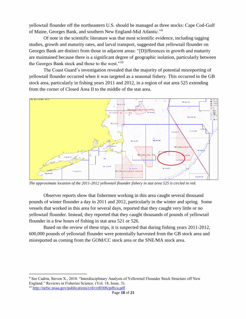
The Coast Guard’s investigation revealed that the majority of potential misreporting of
yellowtail flounder occurred when it was targeted as a seasonal fishery. This occurred in the GB
stock area, particularly in fishing years 2011 and 2012, in a region of stat area 525 extending
from the corner of Closed Area II to the middle of the stat area.
The approximate location of the 2011-2012 yellowtail flounder fishery in stat area 525 is circled in red.
Observer reports show that fishermen working in this area caught several thousand
pounds of winter flounder a day in 2011 and 2012, particularly in the winter and spring. Some
vessels that worked in this area for several days, reported that they caught very little or no
yellowtail flounder. Instead, they reported that they caught thousands of pounds of yellowtail
flounder in a few hours of fishing in stat area 521 or 526.
Based on the review of these trips, it is suspected that during fishing years 2011-2012,
600,000 pounds of yellowtail flounder were potentially harvested from the GB stock area and
misreported as coming from the GOM/CC stock area or the SNE/MA stock area.
9 See Cadrin, Steven X., 2010. “Interdisciplinary Analysis of Yellowtail Flounder Stock Structure off New
England.” Reviews in Fisheries Science. (Vol. 18, Issue. 3). 10 http://nefsc.noaa.gov/publications/crd/crd0306/pdfs/a.pdf
Page 19 of 21
Cod & Haddock
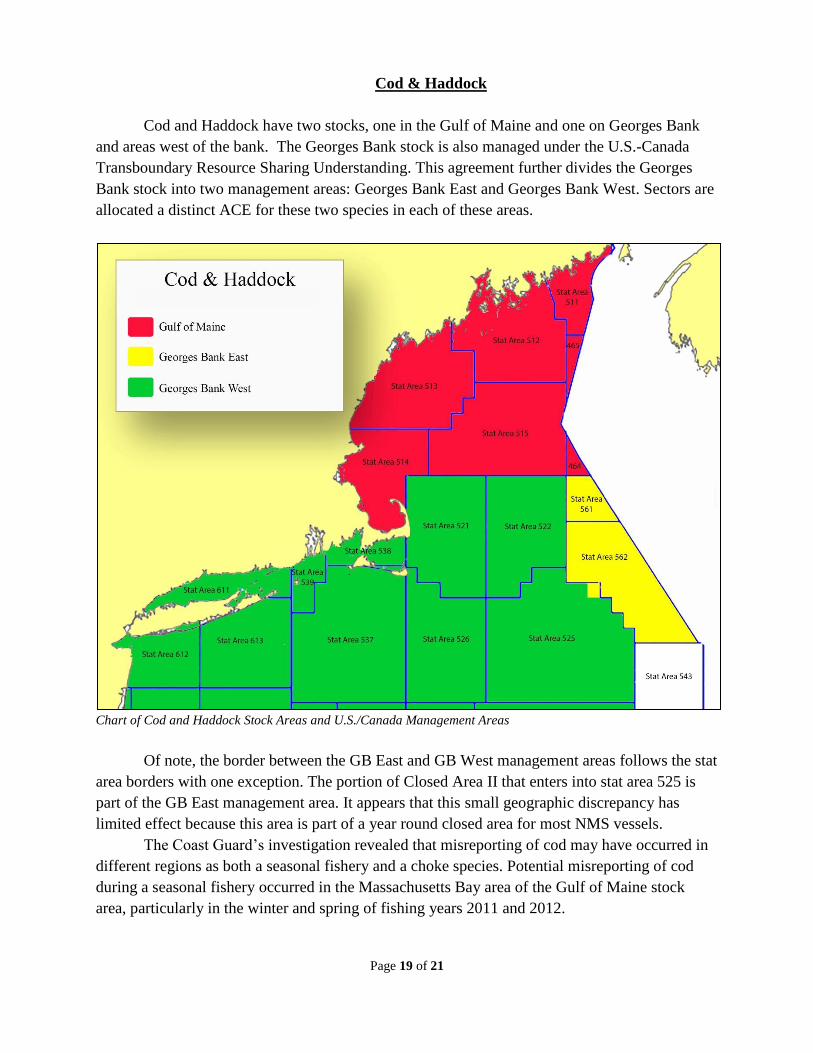
Cod and Haddock have two stocks, one in the Gulf of Maine and one on Georges Bank
and areas west of the bank. The Georges Bank stock is also managed under the U.S.-Canada
Transboundary Resource Sharing Understanding. This agreement further divides the Georges
Bank stock into two management areas: Georges Bank East and Georges Bank West. Sectors are
allocated a distinct ACE for these two species in each of these areas.
Chart of Cod and Haddock Stock Areas and U.S./Canada Management Areas
Of note, the border between the GB East and GB West management areas follows the stat
area borders with one exception. The portion of Closed Area II that enters into stat area 525 is
part of the GB East management area. It appears that this small geographic discrepancy has
limited effect because this area is part of a year round closed area for most NMS vessels.
The Coast Guard’s investigation revealed that misreporting of cod may have occurred in
different regions as both a seasonal fishery and a choke species. Potential misreporting of cod
during a seasonal fishery occurred in the Massachusetts Bay area of the Gulf of Maine stock
area, particularly in the winter and spring of fishing years 2011 and 2012.

Page 20 of 21
Observer reports show that fishermen working in this area caught several thousand
pounds of cod a day in 2011 and 2012. Evidence shows that some vessels who worked in this
area for several days, reported that they caught little or no cod. Instead, they reported that they
caught thousands of pounds of cod in a few hours of fishing in stat area 521.
Misreporting of cod as a seasonal species also occurred in GB East. Observer reports
show that fishermen working in stat area 561 during certain seasons and years could catch
several thousand pounds of cod a day, particularly in late spring, and occasionally in late fall.
Evidence shows that some vessels who worked in this area for several days, reported that they
caught little or no cod. Instead, they reported that they caught thousands of pounds of cod in a
few hours of fishing in stat areas 522 or 521, which is in GB West.
NOAA significantly reduced the ACE for GOM cod in fishing years 2014 and 2015. As a
result, cod became a choke species for vessels targeting other NMS. Evidence from this analysis
shows that in these years, some fishermen may have misreported several hundred to several
thousand pounds of GOM cod as if they were caught on Georges Bank.
The approximate location of targeted cod fisheries in Massachusetts Bay region of the GOM and in GB East are
circled in red. GOM cod became a choke species in 2014 & 2015, particularly in the area circled in green, when the
ACE was cut significantly.
Based on the review of these trips, it is suspected that up to 400,000 pounds of cod were
potentially harvested in the GOM stock area and misreported as coming from GB West,
primarily in FY11 and FY12. In addition, it is suspected that up to 800,000 pounds of cod were
potentially harvested from GB East were misreported as coming from GB West.
The misreporting of haddock was similar to cod as a targeted species in GB East, and, in
2015, as a choke species in the GOM stock area.

Page 21 of 21
Summary
This analysis revealed several misreporting schemes were utilized from 2011 to 2015 and
that potentially up to 2.5 million pounds of regulated species were misreported by vessels from
multiple sectors in the NMS fishery. The analysis also revealed that the current regulation regime
is vulnerable to stock area misreporting and limits the ability of enforcement to detect and
document misreporting of stock areas.