structure plan 0598 toodyay foggarthorpe residential estate
TRANSCRIPT


IT IS CERTIFIED THAT AMENDMENT NO. 1 TO FOGGARTHORPERESIDENTIAL ESTATE STRUCTURE PLAN WAS APPROVED BYRESOLUTION OF THE WESTERN AUSTRALIAN PLANNINGCOMMISSION ON: 23 NOVEMBER 2016
Signed for and on behalf of the Western Australian Planning Commission
an officer of the Com , Drised by the Commission pursuantto Section 16 of the Planning and Development Act 2005 for that purpose.

RECORD OF AMENDMENTS MADE TO THE
FOGGARTHORPE RESIDENTIAL ESTATE STRUCTURE PLAN
Amendment
No.
Summary of the Amendment Date approved
by WAPC
1 Amendment to the Structure Plan map (Figure 5) to identify
land for the Toodyay Recreation Precinct and to correct a
zoning anomaly relating to portions of Lot 9011.
23 November 2016
Contents List of Figures .......................................................................................................................................... 2
FOREWORD ............................................................................................................................................. 3
1. INTRODUCTION ............................................................................................................................... 4
2. SITE DESCRIPTION ........................................................................................................................... 5
2.1 LOCATION & SITE AREA ........................................................................................................... 5
2.2 SURROUNDING CONTEXT ....................................................................................................... 5
2.3 PHYSICAL DESCRIPTION .......................................................................................................... 8
2.3.1 Topography ..................................................................................................................... 8
2.3.2 Soils ................................................................................................................................. 9
2.3.3 Climate ............................................................................................................................ 9
2.3.4 Vegetation ....................................................................................................................... 9
2.3.5 Groundwater and Hydrology .......................................................................................... 9
2.3.6 Fauna ............................................................................................................................... 9
3. PLANNING CONSIDERATIONS ....................................................................................................... 10
3.1 TOWN PLANNING SCHEME NO. 1 (TPS1) .............................................................................. 10
3.2 AMENDMENT NO. 56 TO TPS 1 ............................................................................................. 12
3.3 DRAFT TOWN PLANNING SCHEME NO. 4 (TPS4) .................................................................. 12
3.4 DRAFT LOCAL PLANNING STRATEGY (LPS) ............................................................................ 12
3.5 AVON ARC SUB-REGIONAL STRATEGY (2001) ....................................................................... 13
3.6 FOGGARTHORPE RESIDENTIAL STRUCTURE PLAN (2001)..................................................... 13
3.7 PT AVON LOCATION U3 SUBDIVISION (WAPC 113772) ........................................................ 13
(i) District Sporting Complex Site .............................................................................................. 14
(ii) Community Purpose Site................................................................................................... 14
(iii) High School Extension ....................................................................................................... 14
(iv) Rural Lots / Mount Anderson ............................................................................................ 14
(v) Residential Super Lots – the subject land (Lots 3 and 6) .................................................. 14
4. STRUCTURE PLAN .......................................................................................................................... 15
4.1 DESIGN PHILOSOPHY ............................................................................................................ 15
(i) Relationship to Toodyay Township ....................................................................................... 15
(ii) Social Infrastructure .......................................................................................................... 15
(iii) Development Form ........................................................................................................... 15
4.2 PROPOSED STRUCTURE PLAN ............................................................................................... 19
4.2.1 Land Use ........................................................................................................................ 19
4.2.2 Movement System ........................................................................................................ 21
4.3 ENVIRONMENTAL IMPACTS AND MANAGEMENT ................................................................ 23
4.4 NOISE IMPACT ASSESSMENT ................................................................................................ 23
4.5 EARTHWORKS ....................................................................................................................... 24
4.6 SERVICES ............................................................................................................................... 25
4.6.1 Roads ............................................................................................................................. 25
4.6.2 Drainage ........................................................................................................................ 25
4.6.3 Reticulated Sewerage ................................................................................................... 27
4.6.4 Water Reticulation ........................................................................................................ 27
4.6.5 Underground Power ..................................................................................................... 28
4.6.6 Gas Reticulation ............................................................................................................ 28
4.6.7 Telecommunications ..................................................................................................... 28
4.7 STAGING ................................................................................................................................ 28
5. IMPLEMENTATION ........................................................................................................................ 30
List of Figures Figure 1 - Location Plan ........................................................................................................................... 6
Figure 2 - Existing Aerial Photograph ...................................................................................................... 7
Figure 3 - TPS No. 1 Zoning Map ........................................................................................................... 11
Figure 4 - Opportunities and Constraints .............................................................................................. 16
Figure 5 - Foggarthorpe Original Structure Plan ................................................................................... 17
Figure 6 - Amendment No. 1 Structure Plan Map ................................................................................ 18
Figure 7 - Movement Network .............................................................................................................. 22
Figure 8 - Subdivision Plan .................................................................................................................... 26
Figure 9 - Proposed Staging Plan .......................................................................................................... 29

FOREWORD
The ‘Foggarthorpe Estate’ land has been the subject of a number of plans and associated subdivision
approvals. Similarly several Structure Plan documents have been prepared both in the past (2001)
and as part of current proposals to develop the land for urban residential purposes (2006). The
present extent of the Foggarthorpe Structure Plan comprises two lots, namely Lots 3 and 6
Drummond Street, Nunile.
Two applications for subdivision for the land covered by the Structure Plan were also lodged in 2006.
These comprised:
An 18 lot ‘Stage 1’ application, being Western Australian Planning Commission (WAPC)
reference 132135, and comprising portion of Lot 2 being land fronting Drummond Street
(West). This application is the subject of State Administrative Tribunal DR396 of 2006; and
A balance of project application for 357 lots, being WAPC reference 132536, and comprising
the balance of Lot 3 and all of Lot 6 Drummond Street. This application is the subject of State
Administrative Tribunal DR397 of 2006.
Given the finalisation of additional technical work, and in accordance with an agreed course of
processing between the client, Shire of Toodyay and the WAPC under the related subdivision
application Reviews, this document has been issued. It comprises the most up to date technical work
undertaken for the land and is submitted for Structure Plan approval by the Shire of Toodyay and
the WAPC.
For the purposes of clarity, the extent of work comprises:
PART A – Foggarthorpe Structure Plan
PART B – Foggarthorpe Structure Plan – Sub-Consultant Technical Reports
Environmental Assessment Report (EAR), RPS Environmental Consultants (Dated: March
2007)
Traffic Assessment Report, Transcore Traffic & Transportation Consultants (Dated: March
2007)
Noise Impact Assessment, Lloyd Acoustics (Dated: February 2007)
Report on Geotechnical Investigation, Douglas Partners (Dated: February 2007)
Progress Report 1 (Drainage), JDA (Dated: 1 March 2007)
1. INTRODUCTION
The subject land comprising Lots 3 and 6 Drummond Street, Nunile was originally part of the
Foggarthorpe Estate previously known as Part Avon Location U3, Toodyay.
In 1991, Amendment No. 56 to the Shire of Toodyay Town Planning Scheme No. 1 (TPS1) was
gazetted to rezone portions of the Foggarthorpe Estate which adjoined the Avon River (including the
subject land) to “Urban 6”. Following this the WAPC approved application 113772 to subdivide Part
Avon Location U3 into 5 lots. The subdivision application was designed to facilitate the proposed
Toodyay Bypass and to accommodate a district-sporting complex proposed to be situated next to
the High School site, while also providing for the High School’s expansion. This application resulted in
the creation of the subject lots, 3 and 6, that form the basis of this Structure Plan document.
In order to fully re-canvas the development of the land, this report has been prepared on behalf of
the client, Ironbridge Holdings, by:
Koltasz Smith (Town Planners and Urban Designers)
Wood & Grieve (Consulting Engineers)
RPS Bowman Bishaw Gorham (Environmental Consultants)
Transcore (Traffic and Transport)
Lloyd Acoustic (Noise Modelling and Mitigation)
Jim Davies & Associates (Consultant Hydrologists)
Douglas Partners (Geotechnical Consultants)

2. SITE DESCRIPTION
2.1 LOCATION & SITE AREA
Part Avon Location U3 was the original landholding, comprising a farming property traditionally
known as Foggarthorpe Estate. The total area was 1,001.72ha.
Following the subdivision of Part Avon Location U3 as described in Part 1 of this report, the subject
Lots 3 and 6 were created and may be legally described as:
Lot 3 on Deposited Plan 25741, being Volume 2516, Folio 977 and comprising 23.9347
hectares; and
Lot 6 on Deposited Plan 34990, being Volume 2536, Folio 31 and comprising 35.5121
hectares.
Lot 3 comprises two land parcels at the western side of the project area divided by access legs to
adjoining Lots 4 and 5 to the north-west. Lots 4 and 5, originally part of the parent land holding have
no subdivision potential and were retained as separate rural lots. Lot 3 adjoins a small existing
residential area to its west and fronts Drummond Road on its southern boundary. Lot 3 is
particularly steep at its western end with the gradient of the slope becoming less significant moving
east. Lot 3 abuts Lot 6 at its eastern edge, which coincides with the general location of Boyagerring
Brook, a creek line into the Avon River on this northern side.
Lot 6 comprises the eastern extent of the project area from its boundary with Lot 3 at Boyagerring
Brook, to the Goomalling-Toodyay Road on its eastern edge. Lot 6 adjoins the Toodyay District High
School site as well as Drummond Road on its southern boundary opposite the Avon River.
Both lots are presently cleared rural land within the Toodyay townsite, on the northern side of the
Avon River with views south across the river to the ‘main street’ of Toodyay (Stirling Terrace). The
site slopes from its northern edges southwards towards the Avon River. Drummond Street separates
the land from the river. Limited vegetation remains on site, save for several small areas of vegetation
within outcrops of rock which were not cleared for grazing.
2.2 SURROUNDING CONTEXT
Figures 1 and 2 show the subject land in context, relative to the wider Perth and Avon region, and
also more locally, relative to the Toodyay townsite.
The site is situated directly adjacent to the existing Toodyay townsite, although it is physically
separated from the town centre by the Avon River, and has Mount Anderson and the proposed
Toodyay By-pass Road to its immediate north.

Figure 1 - Location Plan

Figure 2 - Existing Aerial Photograph

The main features in the immediate vicinity of the site as detailed in the 2001 Structure Plan and
updated here are as follows:
Toodyay Town Centre – the subject land is situated immediately north of the town centre.
Although physically separated by the Avon River, the site enjoys relatively direct access to
the town centre as it is situated between the two main river crossings (from the east and
north) into Toodyay.
A direct pedestrian link to the Town Centre exists joining the land via the existing footbridge
river crossing to the Toodyay Town Centre.
Toodyay District High School – the school adjoins the south west corner of the site in
proximity to the Avon River. This site and adjoining land provided for expansion were
excised from the original Foggarthorpe farm property and acquired by DET.
Residential Development – the western end of the site abuts an old established part of
Toodyay. The Shire of Toodyay has recently upgraded Drummond Street in proximity to this
residential area, and at its frontage to the western portion of Lot 3.
Avon River – the Avon River generally defines the southern boundary of Lots 3 and 6, with
Lot 3 physically divided by Boyagering Brook, a creek line feeding into the Avon from the
north.
Goomalling Toodyay Road – this road, which marks the south eastern boundary of the site, is
the main entrance into town from the eastern agricultural regions, connecting Toodyay with
numerous smaller rural settlements including Goomalling, Dowerin and Wongan Hills. The
road provides one of two road crossings over the Avon River within the Toodyay townsite.
Toodyay By-pass Road – the proposed Toodyay By-pass Road alignment forms the north
western boundary of Lots 3 and 6. Whilst the Toodyay By-pass Road offers excellent
connections to the surrounding region and ultimately through to Perth, both the Shire and
Main Roads WA have indicated that they would not support any direct road access from
individual lots onto the Bypass and, appropriately, the Structure Plan reflects this. Detailed
consideration of the By-pass Road is provided in separate accompanying reports by
Transcore Traffic Consultants and Lloyd Acoustics.
2.3 PHYSICAL DESCRIPTION
The following summary comments are drawn from the Environmental Assessment Report (EAR) of
the land comprising part of the Part B technical reports. Site conditions are analysed in detail in the
accompanying Geotechnical report by Douglas Partners also within Part B.
2.3.1 Topography The land and immediate surrounds drops from the granite dome of Mount Anderson in the west, at
an elevation 235 m AHD, down to 110 m in Boyagerring Brook before rising up a low ridge at 160 m
in the east.
Detailed consideration of the geology and geomorphology is included in the assessment undertaken
comprising Appendix 1. Specific site assessment of Lots 3 and 6 in this regard has included:
Survey pick-up of rock outcrops; and
Assessment of gradient / slope analysis for site access and drainage.

In addition to the more visible rock outcrops, alluvial terraces and flood deposits are associated with
the central creek, through this creek area the areas generally forming part of the floodplain are not
proposed to be developed.
2.3.2 Soils Both the EAR by RPS environmental consultants and the Geotechnical report by Douglas Partners
examine in detail the soil types across Lots 3 and 6, as well as the original Foggarthorpe land holding.
The soils on the site, in summary, are red brown loams with moderate to high inherent fertility and
nutrient retention capability, though this is reduced by the steepness of the slopes and common
occurrence of basement rock outcrop.
In this context, engineering works for the land will be minimised to retain natural slopes and avoid
cut/fill retaining. Similarly rock outcrops will remain in the rear of lots. Reticulated sewer will be
provided to service all lots and drainage considerations undertaken by Wood & Grieve engineers and
JDA Consulting Hydrologists take into account soil conditions.
2.3.3 Climate Summer maximum temperatures average about 31°C in the hottest months of January/February
down to an average of 15°C in the winter. Maximum temperatures range down to 4°C in the coldest
moths. Evaporation exceeds rainfall for eight months of the year.
Wind directions are predominantly from the east to south east on summer mornings, an afternoon
sea breeze occurs on most summer days. Winds are more variable in winter.
2.3.4 Vegetation Given the historic rural use of the land, the land has been cleared and the remainder grazed. The
grazing has removed all the under storey species. Only small areas of vegetation remain along
drainage lines and around rocky outcrops, where farming was too difficult.
2.3.5 Groundwater and Hydrology The RPS Environmental Assessment Report indicates the depth to groundwater across the site varies
from approximately 5m at the lowest point near Boyagerring Brook, to 30m in the north west and
south.
At the time of earlier assessment in May 2000, water quality in the brook was 510mSm which is
brackish and of stock quality only (i.e. not suitable for drinking – non-potable). There is no proposal
to utilise this water for drinking, as all lots will be serviced by normal reticulated water.
Flood mapping of the Avon River by the then Water Authority is reflected on the proposed Structure
Plan and plan of subdivision and shows portions of the land affected by the 1-100 year floodway.
This is in proximity to Boyagerring brook where the river can ‘back-up’ during heavy flow events. No
development is proposed in this floodway area. This mapping is also incorporated into the JDA
Consulting Hydrologist’s drainage considerations contained within the Part B technical reports.
2.3.6 Fauna Given the absence of vegetation, there is little significant habitat value. Some opportunities exist in
remnant trees and along two creek and adjoining river. No changes are proposed here.
3. PLANNING CONSIDERATIONS
3.1 TOWN PLANNING SCHEME NO. 1 (TPS1)
The project site is subject to the provisions of the Shire of Toodyay Town Planning Scheme No. 1
(TPS1) (Figure 3). Under TPS1 the land is zoned “Urban 6”. To the north / northwest the project site
adjoins “Rural 1” and “Rural 3” zoned land. To the south the site adjoins land reserved for
“Recreation & Landscape Protection” (the Avon River and Boyagerring Brook) and “Public Purpose –
Government Requirements” (Toodyay District High School).
The “Urban” zones under TPS1 relate to the various categories of urban townsite development and
include:
Urban 1 Zone: Central Business Area
Urban 2 Zone: Living Area (basic residential / institutional character)
Urban 3 Zone: Living Area (basic residential / historic buildings & landscape)
Urban 4 Zone: Living Area (basic residential)
Urban 5 Zone: Living Area (landscape character)
Urban 6 Zone: Future Development
Section 3.16 of TPS1 deals with the Urban 6 Zone, and specifically, Clause 3.16.2 of TPS1 states:
“3.16.2 Development for urban uses will be in accordance with a structure plan for the area
adopted by Council.”
In addition clause 3.16.5 of TPS1 reads:
“3.16.5 The land zoned Urban 6 – Future Development located between the Avon River and
the proposed Toodyay Bypass, being portion of Avon Location U3, shall be subject to the
preparation of a Structure Plan, approved by the Western Australian Planning Commission
and Council, prior to the subdivision and development of the land.
The Structure Plan shall provide an assessment of traffic noise levels from the Toodyay
Bypass and suitable noise mitigation measures, if required, to be implemented at subdivision
and/or development stage.”
Table 13 of TPS1 details the land uses permissible within the “Urban 6” Zone and indicates, in
respect to residential use:
“All residential uses subject to the provisions of the R10 Residential Planning Code.”

Figure 3 - TPS No. 1 Zoning Map

3.2 AMENDMENT NO. 56 TO TPS 1
The parent land holding (Avon Location U3), including Lots 3 and 6, was the subject of Amendment
No. 56 to TPS1 (endorsed by the Minister for Planning in June 2003). Amendment No. 56 rezoned
Lots 3 and 6 to “Urban 6” and rationalised zoning boundaries in accordance with the accompanying
“Foggarthorpe Residential Structure Plan”.
The Amendment No. 56 report indicates, at its conclusion:
“The intended rezoning represents the culmination of an extensive assessment of the most
current environmental and planning issues and constraints of the area and in accordance
with the provisions for the Urban 6 zone under Clause 3.16.2 of TPS1, presents a modified
Structure Plan to guide future development of the land.”
In the context of this previous material, and the zoning of the land which provides for Residential
R10 development, this submission provides the required comprehensive Structure Plan for the land.
3.3 DRAFT TOWN PLANNING SCHEME NO. 4 (TPS4)
In February 2001, the Shire of Toodyay resolved to prepare a draft TPS4, which was intended to
replace TPS1 and the Shire of Toodyay Town Planning Scheme No. 3 (TPS3). The draft TPS4 was
advertised in 2003, and adopted by the Shire subject to modifications. In 2005, the draft TPS4 was
forwarded to the WAPC for consideration and final approval. The draft TPS4 is presently being held
in-abeyance, however, pending finalisation and WAPC endorsement of the Shire’s associated Local
Planning Strategy by the WAPC.
It is understood that, TPS4 intends to retain the same residential development potential for the
subject land, in the form of “Residential Development” zone.
3.4 DRAFT LOCAL PLANNING STRATEGY (LPS)
In February 2001, the Shire resolved to prepare an LPS in conjunction with its town planning scheme
review (draft TPS4) to guide the Shire in the planning of its urban and rural areas for the next 10 to
15 years. The Shire advertised the LPS in 2003, and following further work, adopted it on 23
February 2006. Thereafter the LPS was advertised for public comment, ending on 2 June 2006. Final
modifications to the LPS were made in August 2006 and endorsed by Council thereafter. The draft
LPS is presently with the WAPC for its assessment and ultimately endorsement.
Aside from acknowledging the development potential of the subject land, the LPS also:
Identifies the requirement for “Road Vistas”, whereby the existing rural vista on entry roads
to the townsite are maintained through the use of setbacks;
Recognises Goomalling-Toodyay Road as the main transport link between Goomalling and
Toodyay and is a state road controlled by Main Roads WA. Additional residential
development will therefore need to consider traffic volumes and intersection locations;

The draft LPS also identifies a potential new Industrial Area to the north of the Toodyay
Bypass from the subject land. This area does not exist at present with no zoning in place to
provide for any such development, notwithstanding its identification to address long term
need. Ultimately the rezoning and development of this area will require its own structure
plan, including consideration of appropriate land uses, impacts and buffers, including
recognition of what will be an existing residential area on the subject land.
Recognises the Toodyay By-pass and the need to consider appropriate buffering to
residential development.
3.5 AVON ARC SUB-REGIONAL STRATEGY (2001)
This study, completed by the WA Planning Commission provides a broad framework for the use and
development of land at the western edge of the wheat belt, and at the gateway to the Perth
Metropolitan Region. The Strategy recognises the subject land as “Areas Zoned for
Urban/Residential Development” (p49).
3.6 FOGGARTHORPE RESIDENTIAL STRUCTURE PLAN (2001)
The Foggarthorpe Structure Plan was prepared in 2001, to accompany Amendment No. 56 and form
the basis for further subdivision. The plan dealt with the entirety of Pt Avon Location U3, and
allocated land for expansion of the high school, public open space, and a district sporting site.
Other elements of the 2001 Structure Plan included:
Generally 1000m2 minimum residential lots (although above the R10 minimum);
Landscape remediation at Boyagerring Brook (stormwater/flow containment);
Possible local shop sites;
10m wide vegetated buffer along Bypass Road to provide screening / rural vista
Road connection across Boyagerring Brook.
Based on more recent discussion with the Shire, it is apparent that the inclusion of local commercial
shops would not be viable and only serve to detract from the main Town Centre uses.
3.7 PT AVON LOCATION U3 SUBDIVISION (WAPC 113772)
This subdivision approval was granted to facilitate a variety of land requirements for community
purposes reflected in the 2001 Foggarthorpe Structure Plan. The main elements of the subdivision
are described as follows (and remain relevant as context to surrounding land use and assessment of
public open space and structure plan requirements):

(i) District Sporting Complex Site In 2003, the requirement for this site had been identified by the Shire of Toodyay and was the
primary factor behind the subdivision application. The site had been the subject of discussion and
negotiation between the Shire and the landowners for some time, during which time Council had
also been seeking state government funding to assist the development. At the time, the Council had
concluded that the site is well positioned for the use, and features the following locational
attributes:
It is situated at the periphery of the Shire’s main population centre (i.e., Toodyay townsite);
It is located adjacent to other complementary community amenities – principally the District
High School and the Toodyay River Foreshore;
It features direct accessibility to the main arterial road system, via Drummond Street, with
minimal disruption to existing residential areas;
It is close to the existing pedestrian footbridge crossing over the Avon River, Adjacent to the
District High School, which provides a direct pedestrian link to the Town Centre
It is situated within one of the main areas of intended future growth, which will improve its
centrality to the main population base.
Notwithstanding that the above points all remain accurate and valid, the sporting complex has never
been developed and discussion with Council staff suggests there is no certainty regarding its
development or timing. Issues of site works and construction cost appear to have prevented
progression of the project.
(ii) Community Purpose Site In 2003, or thereabouts, the then land owners also agreed to set aside additional land for other
community purposes, adjacent to the eastern boundary of the high school. The Shire recognised the
opportunity to plan for the facilitation of other community uses which may have direct relevance to
the adjacent high school and would certainly serve to reinforce the recognition of this area as a
community precinct.
(iii) High School Extension As with the above land uses, the Department of Education and Training (DET) previously identified
that the District High School would, in the short to medium term, need to expand beyond its existing
site boundaries. The then landowners agreed to set land aside for acquisition by the Education
Department. At the time of writing the DET could not provide any plans for expansion and were not
able to confirm the timing of any expansion works or forecasted school numbers. Notwithstanding
this, it is acknowledged that growth of High School attendance is expected, though this has already
been provided for in land acquisition.
(iv) Rural Lots / Mount Anderson Two rural lots to the north of Lots 3 and 6, encompassing the visually prominent southern and south
western slopes of Mount Anderson, were created as a result of the super lot subdivision. This land
will remain within the Rural zoning, within which no further subdivision will be permitted, to protect
the visual integrity of Mount Anderson as a prominent part of the Rural landscape.
(v) Residential Super Lots – the subject land (Lots 3 and 6) The balance of the original farming property was divided into two super lots being the subject Lots 3
and 6. These super lots were identified to form the primary parameters for future residential
development.

4. STRUCTURE PLAN
4.1 DESIGN PHILOSOPHY
The 2001 Foggarthorpe Structure Plan sought to respond to a number of opportunities and
constraints identified on the site. This document and the Structure Plan contained herein seeks to
evolve the same Structure Plan given the additional technical reporting material now at hand. The
following comments outline current opportunities and constraints (Figure 4) and detail the original
and amended Foggarthorpe Structure Plans (Figures 5 and 6).
The originally identified broad development philosophies for this land may be summarised as follows
and are reflected in detail in Figure 4:
(i) Relationship to Toodyay Township With the established alignment of the proposed Toodyay By-pass Road, and the proximity and
connectivity of the land with the Toodyay town centre, this zoned land now shows a stronger
physical relationship to the urban and social structure of the townsite than it does with its broad
acre farming origins, and demonstrates attractive attributes for the future urban expansion of the
Toodyay townsite.
(ii) Social Infrastructure An important part of the original structure plan was the identification of opportunities for the
development of social infrastructure, including a District Sporting Complex, other community
amenities, and an expansion of the existing District High School site. These uses were subsequently
facilitated, and this Structure Plan continues to provide connectivity and recognition of them.
(iii) Development Form Whilst it is recognised that the site will perform an important function in accommodating future
urban growth within the Toodyay townsite, it is important to ensure the land use and subdivision
pattern also respects the surrounding context, the physical and environmental constraints of the
site, and provides a residential land product consistent with site context and local market
requirements.
The 2001 Foggarthorpe Structure Plan sought to produce a land use and subdivisional framework
which makes efficient use of the residential land resource, but in a manner which respects the
physical and environmental characteristics of the land and its environs, ensuring that the
subdivisional pattern is sufficiently robust to meet the varying and changing demands of the local
residential market. The Structure Plan proposed for approval herein continues to remain consistent
with the earlier plan, retaining a base of Residential R10 lot size, albeit with a particularly robust
street layout that is sufficiently flexible in respect to review of lot size or staging of development if
ever required.

Figure 4 - Opportunities and Constraints

Figure 5 - Foggarthorpe Original Structure Plan

Figure 6 - Amendment No. 1 Structure Plan Map
4.2 PROPOSED STRUCTURE PLAN
The original Structure Plan (Figure 5) reflected the design review undertaken and the input of
engineering, environmental, traffic and acoustic consulting expertise. The overall layout is entirely
consistent with the earlier versions, albeit reflective of more detailed assessment now undertaken to
accompany subdivision of the land. The Structure Plan, as amended, (Figure 6) reflects the Shire’s
proposed recreation precinct.
4.2.1 Land Use
4.2.1.1 Residential
Residential subdivision remains the predominant land use element of the Structure Plan. The
subdivision pattern shows a variety of housing/ density choices, with the maximum density based on
the standards applied under the Urban 6 Zone (average lot size 1000m²; minimum lots size 875m2),
but with larger lots of between 1,250 and 2,859m2 on the external periphery adjoining the lower
slopes of Mt Anderson.
The detailed plan of subdivision for the land comprises Figure 8 and shows the density distribution is
designed to take maximum advantage of the natural landform, to capitalise on the visual and
physical accessibility on the site and the proximity to Boyagerring Brook and the Avon River.
In terms of total dwelling yield, the Structure Plan and proposed subdivision will ultimately produce
378 residential lots (not including four sites to be set aside for drainage), with one additional lot to
be set aside as Goomalling – Toodyay Road widening.
The subdivisional pattern features a robust semi-gridded design which will continue to enable
flexibility in lot density and configuration, acknowledging that trends and community expectations
may vary over the life of the Structure Plan.
4.2.1.2 Community Infrastructure
(i) District Sporting Complex
The 2001 Foggarthorpe Structure Plan included provision for a District Sporting Complex site of
approximately 7 ha adjacent to the Toodyay District High School and the Avon River foreshore. While
this site has been ceded and does not form part of the update report’s landholding, it remains
relevant given both the land was the subject of conditions for its ceding in the related WAPC
subdivision approval and in legal agreements reached between the landowner and the Shire.
In short, the Sporting Complex land was ceded to the Crown free of cost, pursuant to Section 28A of
the Town Planning and Development Act, for recreational purposes, on the understanding that it
will, in turn, be vested in Council for District Recreational Purposes. This agreement was secured on
the understanding that the contribution would fulfil the 10% public open space requirement for the
residential subdivision component of the Structure Plan area. Notwithstanding this agreement, this
Structure Plan Report acknowledges the need to allocate separate land areas for the protection of
Boyagerring Brook as well as for drainage purposes.
(ii) Community Purpose Site
The 2001 Structure Plan also made provision for additional Community Purpose land to be set aside
immediately east of the High School Site. This was also part of the privately owned farm and the
then landowners agreed to cede this land to the Crown to be vested in the Shire. Notably, when
considering the allocation of District Sporting site, and Community Purpose land, the Foggarthorpe
land has contributed significantly to the betterment of the Toodyay townsite.
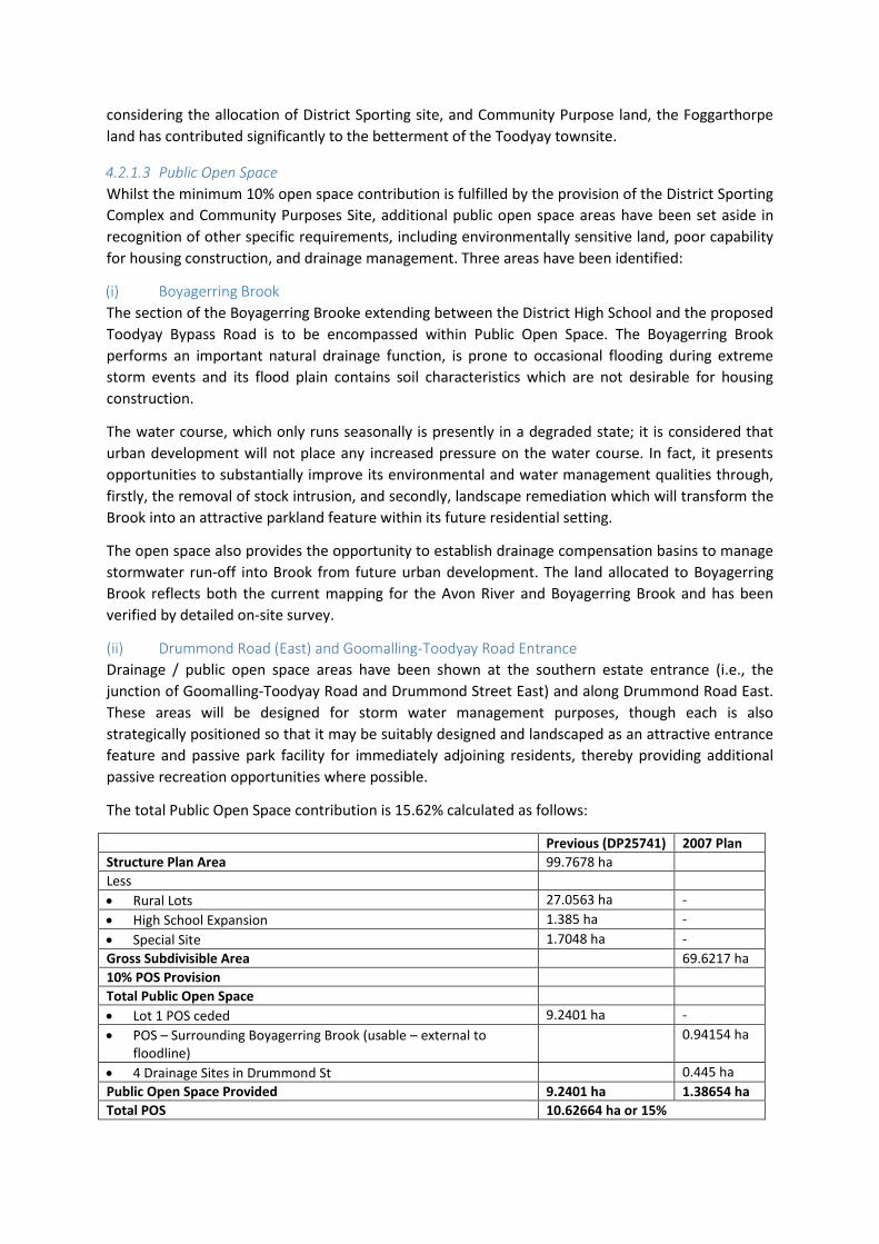
4.2.1.3 Public Open Space
Whilst the minimum 10% open space contribution is fulfilled by the provision of the District Sporting
Complex and Community Purposes Site, additional public open space areas have been set aside in
recognition of other specific requirements, including environmentally sensitive land, poor capability
for housing construction, and drainage management. Three areas have been identified:
(i) Boyagerring Brook
The section of the Boyagerring Brooke extending between the District High School and the proposed
Toodyay Bypass Road is to be encompassed within Public Open Space. The Boyagerring Brook
performs an important natural drainage function, is prone to occasional flooding during extreme
storm events and its flood plain contains soil characteristics which are not desirable for housing
construction.
The water course, which only runs seasonally is presently in a degraded state; it is considered that
urban development will not place any increased pressure on the water course. In fact, it presents
opportunities to substantially improve its environmental and water management qualities through,
firstly, the removal of stock intrusion, and secondly, landscape remediation which will transform the
Brook into an attractive parkland feature within its future residential setting.
The open space also provides the opportunity to establish drainage compensation basins to manage
stormwater run-off into Brook from future urban development. The land allocated to Boyagerring
Brook reflects both the current mapping for the Avon River and Boyagerring Brook and has been
verified by detailed on-site survey.
(ii) Drummond Road (East) and Goomalling-Toodyay Road Entrance
Drainage / public open space areas have been shown at the southern estate entrance (i.e., the
junction of Goomalling-Toodyay Road and Drummond Street East) and along Drummond Road East.
These areas will be designed for storm water management purposes, though each is also
strategically positioned so that it may be suitably designed and landscaped as an attractive entrance
feature and passive park facility for immediately adjoining residents, thereby providing additional
passive recreation opportunities where possible.
The total Public Open Space contribution is 15.62% calculated as follows:
Previous (DP25741) 2007 Plan
Structure Plan Area 99.7678 ha
Less
Rural Lots 27.0563 ha -
High School Expansion 1.385 ha -
Special Site 1.7048 ha -
Gross Subdivisible Area 69.6217 ha
10% POS Provision
Total Public Open Space
Lot 1 POS ceded 9.2401 ha -
POS – Surrounding Boyagerring Brook (usable – external to floodline)
0.94154 ha
4 Drainage Sites in Drummond St 0.445 ha
Public Open Space Provided 9.2401 ha 1.38654 ha
Total POS 10.62664 ha or 15%

4.2.1.4 Commercial Land Uses
One of the few changes to the 2001 Structure Plan proposed herein, is the removal of proposed local
retail.
The original structure plan identified a location for a possible local shop situated central to the
Structure Plan area, and adjacent to the Community Purposes Site, in close proximity to the High
School and District Sporting Complex.
Clearly, however, the local resident population of the Structure Plan area will not, in its own right, be
sufficient to sustain a local shop in this location and upon further review and discussion with Council
it is seen as more appropriate to avoid land uses which may detract from the main Town Centre
retail activities.
4.2.2 Movement System Figure 7 shows a conceptual illustration of the key pedestrian and vehicle movement structure. The
following comments provide a summary of traffic movement considerations, though this is
examined in detail within the Transcore traffic report accompanying this submission separately in
Part B.
The vehicle movement system is defined by a main connecting road linking Drummond Street East
and Drummond Street West across Boyagerring Brook. This connection provides internal
connectivity while linking back to Drummond Street and, on the east edge, to Goomalling-Toodyay
Road. The Local Distributor Road alignments are also positioned to provide direct access/frontage
for the existing and proposed district recreation, community and educational uses.
The semi-gridded road pattern combined with the generally linear nature of the Structure Plan area
provides for a highly permeable movement system, providing direct accessibility from all parts of the
sub-division. The road network provides for logical movement in either an easterly or westerly
direction.
Pedestrian movement generally adheres to the permeable road system, providing legibility and
connectivity for pedestrians throughout the estate. The subdivisional pattern emphasises strong
connections to the public spaces and facilities within the Structure Plan area, as well as links to the
external facilities, in particular the Avon River foreshore and Toodyay Town Centre.

Figure 7 - Movement Network

4.3 ENVIRONMENTAL IMPACTS AND MANAGEMENT
The Structure Plan design has been based on a thorough analysis of the environmental
characteristics of the land and its surrounds. A separate report, prepared by RPS Bowman Bishaw
Gorham and forming part of the Part B technical material details the extent of any management
requirements. These are summarised as context, and as the key features of the Structure Plan design
which respond to environmental conditions:
The development area includes a portion of Boyagerring Brook which is a tributary of the
Avon River that feeds the Swan River and therefore development is required to be
consistent with the Environmental Protection (Swan and Canning Rivers) Policy 1997 (EPP).
Notwithstanding this, Boyagerring Brook is highly degraded from historical ‘river training’
and agricultural land use. Revegetation will take place in Boyagerring Brook within the
project area to improve bank stability, water quality and habitat value. This will take the
form of a Revegetation Management Plan.
The site contains a number of steeply sloping areas that will need to be considered during
development to prevent erosion and drainage issues and a Construction Management Plan
will address this.
Acid Sulphate Soils are not considered a significant risk for to the project.
With increased salinity of the Avon River an issue, revegetation of the Brook will assist in
reducing further risk of salinisation of the area, though this is a regional problem.
Development will be setback external to the identified 1-100 year flood level.
A Drainage and Nutrient Management Plan will be prepared to deal with issues of drainage
treatment, infiltration basins, stormwater flow paths and the like.
A Foreshore Management Plan will be prepared to deal with issues of foreshore protection
and enhancement, access and interface.
Viewscapes from the Toodyay Town Centre will not be significantly affected, with key areas
of visual prominence such the slopes of Mount Anderson already separately protected. The
RPS Bowman Bishaw Gorham Environmental Assessment Report (EAR) concludes that no
environmental issues exist that preclude subdivision from occurring as proposed in
accordance with normal Council, Government agency and environmentally accepted
standards. The report foreshadows in greater detail the above mentioned Foreshore
Management Plan, which has been commenced by RPS Bowman Bishaw Gorham, although
would ultimately be expected to be a condition of approval.
4.4 NOISE IMPACT ASSESSMENT
Lloyd Acoustics have completed a noise impact assessment contained within Part B to this report. A
summation of the report is provided below:
Assessment was undertaken to test against ‘Statement of Planning Policy: Road and Rail
Transportation Noise’;
Toodyay Bypass and Goomalling-Toodyay Roads are assumed, for the purposes of this
modelling, to be 14mm chop seal;

As the Toodyay Bypass does not exist, logging was taken at 68 Telegraph Road to establish
current levels;
Traffic volumes show night-time noise volumes to vary. Data logging shows this as in the
order of 10dB less than day time levels;
Given neither residences nor the road exist, a joint approach can be taken to minimise noise
levels. This implies that either noise control to the road (smoother road surface) or to the
intervening path (noise bunds/walls) could be constructed to achieve ‘Exposure Level 1’
noise levels (i.e. the target level under the policy);
As the report shows, the majority of the proposed residences would fall within Exposure
Level 1 with some lots closest to the Bypass or Goomalling-Toodyay Road within Exposure
Level 2. This shows that walling or a bund will significantly reduce noise impact, though for
those lots at Exposure Level 2 Design Guidelines would be used to address ‘quiet house’
design measures;
Most importantly, the modelled noise levels may be considered a ‘worst case’ in respect to
the road surface. The use of 14mm chip seal results in the highest levels of tyre noise
compared to other road surfaces. The advantage of this is safety and minimal maintenance.
Alternatively, surfaces such as open graded asphalt would also be safe while quieter though
maintenance would be required every 7 years. Further discussion with MRWA is being
undertaken regarding the use of open graded asphalt.
Lloyd Acoustics’ recommended wall/bund design suggests an alignment whereby use of open graded
asphalt by MRWA is supported in addition to the installation of the wall/bund. The combined effect
of both these treatments indicates all lots would fall within required noise exposure levels and there
would be no obligations on the residents and no required memorials on title.
The range of options presented by Lloyd Acoustics, reflected in Table 6.1 of their report, highlights
that use of both a wall/bund and open graded asphalt is preferred. It is acknowledged that the Shire
of Toodyay seek use of bunding rather than walls in order to retain the rural vistas reflective of
Toodyay. With this in mind further discussion with MRWA to obtain support for the combined
bunding/open graded asphalt is being undertaken. Confirmation on the outcome of these
discussions will then provide both the Shire and WAPC with confirmation as to the collectively
agreed approach. Notwithstanding this, Structure Plan approval is sought subject to the issue being
finalised as a condition given the extent of modelling undertaken.
4.5 EARTHWORKS
Wood and Grieve engineers advise that bulk earthworks will be minimal due to the existing
topography and ground conditions which include subsurface rock. Consistent with typical
development within the Shire of Toodyay, the developed lots will typically be left at their natural
gradient and no retaining walls will be constructed at subdivision stage.
It is intended that the buildings within the proposed subdivision have a minimum finished floor level
that is 0.5m above the 100 year flood level of Boyagering Brook and the Avon River. The topography
of the site accommodates this requirement for the majority of lots without the need for any filling.
The slope of the existing surface enables the residential areas to be served by gravity sewers and
stormwater drainage to flood route out to the Avon River in a major storm event.

4.6 SERVICES
4.6.1 Roads The proposed subdivision will incorporate a road network as detailed on the subdivision plan (Figure
8). All roads will be designed to a kerbed and drained urban standard in accordance with the Shire of
Toodyay’s requirements and the geotechnical characteristics of the site.
Drummond Road West is currently being upgraded by the Shire of Toodyay and will provide access
to the western portion of the site. The Toodyay Goomalling Road and Drummond Road East will
provide access to the eastern portion of the site. Subdivision of the land in the manner proposed will
result in these two external connections being linked across Boyagerring Brook.
The road connection between the east and west sides of the subdivision will provide a road,
pedestrian and services crossing of Boyagerring Brook. The final configuration of this crossing would
be determined in detailed design and would be anticipated to be a box culvert or bridge structure. It
is anticipated that this would be constructed with the required servicing connection to the lots to
the west of the Brook.
MRWA advice indicates a 10m wide road-widening strip is required for the purposes of widening the
Goomalling-Toodyay Road adjoining the subject land. This 10m strip is to be set aside as a separate
lot, pending acquisition.
Suitable intersection treatment of the Drummond Road East and Toodyay-Goomalling Road
intersection will be provided in accordance with traffic engineering advice. At the time of writing
Transcore traffic consultants have advised that MRWA’s position is to oppose a round-a-bout at this
location in preference for an upgraded intersection with turning lanes. MRWA consider this will
better cater to heavier freight trucks using Goomalling-Toodyay Road. Ultimately, this issue can be a
condition of Structure Plan and subsequent subdivision approval. It is understood further discussion
to finalise intersection detail will take place between Transcore, MRWA and the DPI traffic branch as
organised by DPI.
4.6.2 Drainage JDA Consultant Hydrologist have been engaged by the client to undertake a hydrological study of the
site. A key component of their study is to determine the final stormwater drainage strategy including
final basin sizes, Boyagerring Brook flow characteristics and the like. Wood and Grieve engineers
provide the following additional advice.
It is proposed that drainage stormwater runoff be collected by an urban standard kerbed road and
piped drainage system. Side entry pits and gullies along the drainage network will be trapped to
minimize the transportation of pollutants and sediments.
Due to the low permeability of the ground, lot connections will be provided for each lot connecting
to the piped drainage network.
Subject to the outcomes of the Drainage and Nutrient Management Plan which is currently being
prepared for the development by JDA Consultant Hydrologist, it is anticipated that the piped
drainage network will discharge into a number of detention basins located along the Boyagerring
Brook, the Avon River and Drummond Street. The intent of these basins is to provide a nutrient
stripping facility and water quality treatment. Major stormwater events will be flood routed to the
Avon River and Boyagerring Brook.
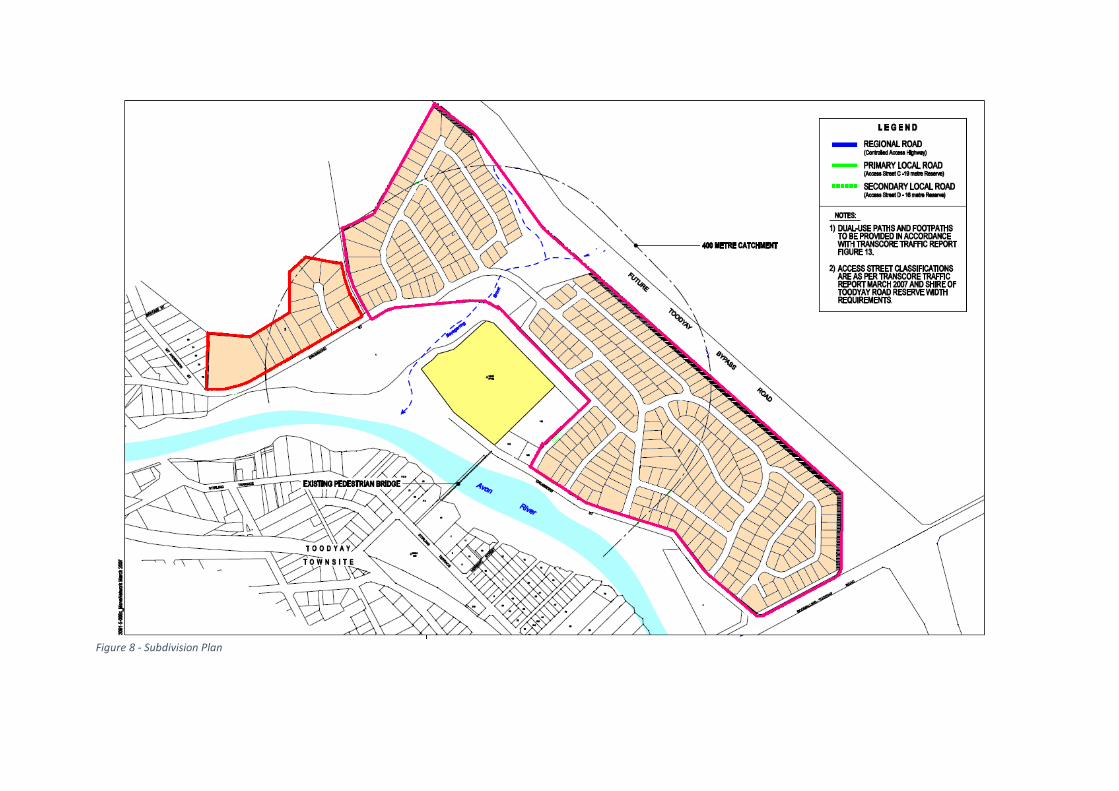
Figure 8 - Subdivision Plan
Preliminary advice from JDA Consultant Hydrologists, which has been included within Part B of the
Structure Plan, indicates the location and size of the proposed drainage areas included on the
Structure Plan are sufficient to accommodate the drainage runoff from the development.
Appropriate Best Management Practices in accordance with Department of Environment and
Conservation’s Stormwater Management Manual for Western Australia will be implemented. The
JDA progress report 1 is contained within the Part B technical material.
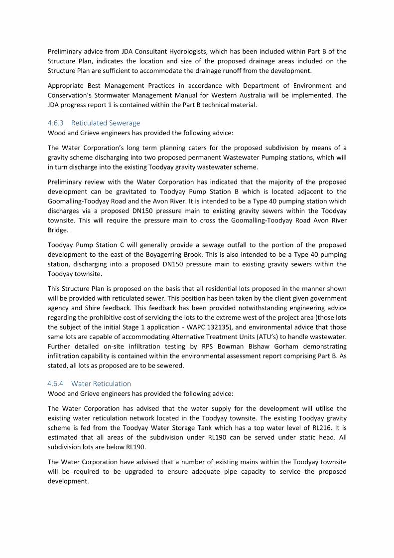
4.6.3 Reticulated Sewerage Wood and Grieve engineers has provided the following advice:
The Water Corporation’s long term planning caters for the proposed subdivision by means of a
gravity scheme discharging into two proposed permanent Wastewater Pumping stations, which will
in turn discharge into the existing Toodyay gravity wastewater scheme.
Preliminary review with the Water Corporation has indicated that the majority of the proposed
development can be gravitated to Toodyay Pump Station B which is located adjacent to the
Goomalling-Toodyay Road and the Avon River. It is intended to be a Type 40 pumping station which
discharges via a proposed DN150 pressure main to existing gravity sewers within the Toodyay
townsite. This will require the pressure main to cross the Goomalling-Toodyay Road Avon River
Bridge.
Toodyay Pump Station C will generally provide a sewage outfall to the portion of the proposed
development to the east of the Boyagerring Brook. This is also intended to be a Type 40 pumping
station, discharging into a proposed DN150 pressure main to existing gravity sewers within the
Toodyay townsite.
This Structure Plan is proposed on the basis that all residential lots proposed in the manner shown
will be provided with reticulated sewer. This position has been taken by the client given government
agency and Shire feedback. This feedback has been provided notwithstanding engineering advice
regarding the prohibitive cost of servicing the lots to the extreme west of the project area (those lots
the subject of the initial Stage 1 application - WAPC 132135), and environmental advice that those
same lots are capable of accommodating Alternative Treatment Units (ATU’s) to handle wastewater.
Further detailed on-site infiltration testing by RPS Bowman Bishaw Gorham demonstrating
infiltration capability is contained within the environmental assessment report comprising Part B. As
stated, all lots as proposed are to be sewered.
4.6.4 Water Reticulation Wood and Grieve engineers has provided the following advice:
The Water Corporation has advised that the water supply for the development will utilise the
existing water reticulation network located in the Toodyay townsite. The existing Toodyay gravity
scheme is fed from the Toodyay Water Storage Tank which has a top water level of RL216. It is
estimated that all areas of the subdivision under RL190 can be served under static head. All
subdivision lots are below RL190.
The Water Corporation have advised that a number of existing mains within the Toodyay townsite
will be required to be upgraded to ensure adequate pipe capacity to service the proposed
development.

The connection to the existing water reticulation mains requires a crossing of the Goomalling-
Toodyay Road Avon River Bridge.
4.6.5 Underground Power Underground power distribution is subject to the final requirements of Western Power though it will
be reticulated about the site through a network of high and low voltage power infrastructure.
Underground power connections would be provided to all proposed lots, with overhead lines
expected to be underground within Drummond Street where it abuts the development. Overhead
high voltage power lines are currently situated within the site, adjoining Goomalling Toodyay Road,
in Telegraph Road and across the Avon River adjacent to the wooden footbridge used to access the
school, and would provide a high voltage connection to the site.
4.6.6 Gas Reticulation Reticulated gas will not be provided within the subdivision as there are currently no reticulated gas
mains that extend to Toodyay.
4.6.7 Telecommunications Telstra mains and distribution networks exist within the vicinity of the subdivision. It is anticipated
that minor offsite trenching will be required to bring Telstra infrastructure to the site.
4.7 STAGING
The planning and development of Lots 3 and 6 are proposed to be undertaken in generally two
stages, namely 18 lots adjoining Drummond Road (West) and the balance project area of 357 lots in
subsequent stages to the east. The applications for subdivision accompanying this report have been
submitted to the WAPC to coincide with this proposed staging. Figure 9 shows the stage boundaries
for land release.
Notwithstanding this, the crossing of Boyagerring Brook will be constructed as part of initial
subdivision works, and as part of the first release of lots.
Given the significant demand for affordable residential land in the current housing market the
landowner seeks the support of Council to achieve implementation of the project as soon as
practicable. Notably the WAPC has actively sought the support of the development industry in this
regard to achieve the release of additional residential land to market.

Figure 9 - Proposed Staging Plan

5. IMPLEMENTATION
This report reflects the previous 2001 Structure Plan and subsequent 2006 reports, while recognising
the need to address various matters highlighted during discussion on the current applications for
subdivision of the land.
The approach is intended to achieve Structure Plan approval to this document and plan as per
agreed processing by the Shire of Toodyay and WAPC in relation to DR396 and DR397. The
document and accompanying technical reports are intended to provide those assessing with all
necessary information to approve or conditionally approve.
Under the provisions of the Urban 6 zone in TPS 1, Clause 3.16.2 requires that development for
urban uses be in accordance with a Structure Plan adopted by Council. Similarly, Clause 3.16.5
requires the specific Structure Plan for this land consider traffic noise levels and potential mitigation
requirements from the Toodyay Bypass.
The notion of future urban expansion over the subject land has been acknowledged for over 15
years as is evidenced by the existence of Urban 6 zone since 1991. Similarly, subdivision approvals
have been granted in 1992 (190 lots) and more recently in 2001 (super lot subdivision).
Given recent discussion regarding Structure Plan material prepared during 2006 and the resolution
of previously outstanding matters regarding that document, it is requested that Council endorse this
Structure Plan and recommend its similar endorsement by the WAPC at the earliest opportunity.