strategic outcomes of and future outlook for data-based
TRANSCRIPT
ISSN 2773-6857 Volume I Issue I (2021) pp.27-48
27
Strategic Outcomes of and Future Outlook for Data-based
Disaster Management: A Case Study in Sri Lanka
Rathnayake Mudiyanselage Wasantha Rathnayake
Department of Tourism Management, Faculty of Management Studies, Sabaragamuwa
University of Sri Lanka, Belihuloya, Sri Lanka
ABSTRACT
The preparation and implementation of Disaster
Management Plans and the National Emergency Plans
are enabled by data collection, data storing and data
sharing. The required data can be specified as
environment- and disaster-related data relevant to the
Sendai Framework and Rio Conventions. A case study
was carried out in the district of Badulla, which has
recorded the highest number of disaster events in Sri
Lanka, in order to explore the gaps in data and
information management, with the ultimate objective of
ensuring a disaster-minimised district. The study
revealed that there are shortcomings in data collection,
data storage and data sharing, which are important for
fulfilling the requirements of four pillars of disaster
management, i.e., mitigation–minimising the effects of
disaster, preparedness–planning on how to respond,
response–efforts to minimise hazards created by a
disaster; and recovery–returning the community to
normal.
Keywords: Data Management, Disaster Management
Plans, Environment-related Data, Inter-agency
Coordination, Rio Conventions, Sendai Framework
© Faculty of
Management Studies
Sabaragamuwa
University of Sri Lanka
ARTICLE INFO
Article history:
Received: 05 November 2020
Accepted: 02 January 2021
Published: 09 February 2021
E-mail Address:
ASIAN JOURNAL OF MANAGEMENT STUDIES
Journal homepage: https://www.sab.ac.lk/ajms/
Faculty of Management Studies
Sabaragamuwa University of Sri Lanka

Asian Journal of Management Studies Volume I Issue I
28
Faculty of Management Studies, Sabaragamuwa University of Sri Lanka
INTRODUCTION
Sri Lanka has experienced a variety of both natural and human-induced
disasters that have had a disastrous impact on human wellbeing as well as the
economic welfare of the country. The 2004 Tsunami is an extreme example of
a devastating disaster from which Sri Lanka is yet to recover. Apart from the
2004 Tsunami, which could be taken as a rare and unique event, Sri Lanka is
also impacted by other hazards that occur more or less on a yearly, if not, on
a more frequent basis.
Disaster management efforts aim to reduce or avoid the potential losses
from hazards, assure prompt and appropriate assistance to the victims of a
disaster, and achieve a rapid and effective recovery. With modern challenges
such as population increase, resource constraints, conflicts, and development-
related modifications to land use and landscape conditions, the potential for
disaster has increased even more due to such human-induced disaster triggers.
The devastating Indian Ocean Tsunami of December 2004 was a
watershed with regard to disaster management in Sri Lanka. The Sri Lanka
Disaster Management Act No. 13 was enacted in 2005 and, under provisions
of this Act, the National Council for Disaster Management and district-level
Disaster Management Centers were established for the purpose of disaster
management. The Act defines disaster as an actual or imminent occurrence of
a natural or manmade event, which endangers, or threatens to endanger, the
safety or health of any person or group of persons in Sri Lanka, or which
destroys or damages, or threatens to destroy or damage, any property. In
addition, riverbank erosion, toppling of trees, and human-animal conflicts are
also experienced by Sri Lankans among what constitutes ‘disaster’ in Sri
Lanka. Under the provisions of this Act, a National Disaster Management Plan
and a National Emergency Operation Plan have to be prepared in order to
ensure (i) preparedness for disasters and any other emergencies; (ii) risk
prevention; and (iii) the prevention and mitigation of disasters. All these ‘plan
preparations’ and ‘implementations’ are enabled by data collection, data
storing, and data sharing. The required data can be specified as environment-
and disaster-related data.
In order to achieve the Sustainable Development Goals (SDGs), it is
important that any development project proposed by sector agencies includes
measures to conserve environmental resources and reduce potential disaster
Asian Journal of Management Studies Volume I Issue I
29
Faculty of Management Studies, Sabaragamuwa University of Sri Lanka
risks. Development agencies must consider environmental data, particularly
related to biodiversity, climate change, and land degradation, from the design
phase of a project to its implementation. Enhancing development agency
capacity to utilise environmental and disaster data in developing and
evaluating project proposals is thus an essential component of this process.
During disasters, the need for data and information changes
continuously. Scholars all over the world have emphasised the importance of
the collection of various types of data, including those on topography, soil,
vegetation, land usage, precipitation and water levels, and their analysis in
disaster situations. Additionally, they have tried to identify the challenges and
future research directions (Kohler & Wachter, 2006; Hristidis et al., 2010;
Goswami et al., 2018) in disaster management. A study by Wu and Cui (2018)
have looked at how social media data and geo-location information can be
applied in disaster early warning and damage assessment analysis.
Meanwhile, scholars like Akter and Wamba (2019) have proposed a
big-data-driven approach to disaster response through sentiment analysis.
Utilising advances in software, other researchers have developed models for
disaster management systems, including floods, using data on disaster
management (Qiu et al., 2017; Ragini et al., 2018; Akter & Wamba, 2019).
On the other hand, Goswami et al. (2018) have reviewed the application
of data mining and analytical techniques designed so far for prediction and
detection of disasters and development of appropriate disaster management
strategies based on the collected data from disasters. They have also
highlighted the importance of maintaining a database for disaster
management.
A typical disaster management cycle includes mitigation, preparedness,
response, and recovery (Board on Natural Disasters National Research
Council, 1999). They are all phases in disaster management that demand
specific data and information.
According to Foster and Grossman (2003) and Saleem et al. (2008), the
concept of a Disaster Management Dataspace should be established based on
methodologies for disaster-related data acquisition, ingestion, organisation,
and representation (Saleem et al., 2008). However, Foster and Grossman
(2003) have pointed out that the mere availability of such data does not

Asian Journal of Management Studies Volume I Issue I
30
Faculty of Management Studies, Sabaragamuwa University of Sri Lanka
eliminate the challenge of designing and developing effective strategies for
data acquisition, ingestion, and organisation. On the other hand, as scholars
have shown, although a large quantity of disaster-related data is available,
including response plans, records of previous incidents, simulation data, and
data on social media web sites, current data management solutions offer few
or no integration capabilities (Grolinger et al., 2013).
It is obvious that according to the official and unofficial records
maintained by the government agencies in Sri Lanka, some development
projects have failed and/or have resulted in disasters due to lack of data and
data collection, data storing, and data sharing at different stages of the project
cycle. However, these processes are important in the planning and monitoring
phases of different development projects in Sri Lanka, the absence of which
could result in disasters. The objectives of the present study are to explore the
gaps in data and information management related to environment and disasters
and to identify the root causes of the shortcomings in disaster management in
the Badulla district in Sri Lanka.
STUDY AREA
Badulla District was selected as the study area, which is situated in
6059’05”N and 81003’23”E, encompasses approximately about 2861km2
area (Jayasinghe et al., 2017). The physical landscape of the district is complex
with mountain ranges, divided plateaus and narrow valleys. Geologically, the
district belongs to the rock formation of the highland series. The soil types in
the district include Red Earth and Brown Loams, Red-Yellow Podsols and
Reddish Brown Soils. Topographically, the Monaragala district is in a
transitional zone ranging from areas falling within the central highlands to
those located in the flat lowland. Three terrain types have been identified in
the district, namely, highly mountainous, hilly-steep and rolling, and
undulating and flat terrain. The average annual rainfall in the Badulla district
varies from 900 mm to over 2,500 mm. The district receives rainfall during
four seasons, namely, the first inter-monsoon (March-April), the southwest
monsoon (July-September), the second inter-monsoon (October-November)
and the northeast monsoon (December-January). Partial drought occurs very
often during the periods of February to July.

Asian Journal of Management Studies Volume I Issue I
31
Faculty of Management Studies, Sabaragamuwa University of Sri Lanka
The district of Badulla is located in the Uva Province. A prominent
natural hazard in the district is landslides that occur during heavy rains. Their
occurrence is the result of both natural and manmade causes. Among the
natural causes are earth movements, rock falls, cracks, creek movement,
localised earth slips and partial slides. Among manmade causes are activities
such as large-scale sand-mining, gem-mining, quarrying of dolomite, etc.,
which have aggravated the frequency of disasters in a district already at high
risk of natural disasters. Of the natural disasters, landslides have caused loss
of lives, damages to infrastructure, disruption of social stability, adverse
effects on education and health, economic failure, loss to farming, and
environmental degradation and pollution. In addition to landslides, the other
commonly reported disasters in the Badulla district are floods, manmade forest
fires, drought, lightning, and the human-elephant conflict.
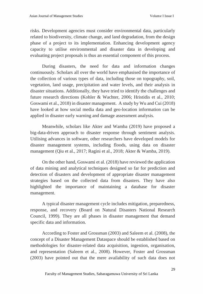
There are 15 Divisional Secretary Divisions in Badulla district, namely,
Badulla, Bandarawela, Ella, Hali-Ela, Haputale, Kandaketiya, Lunugala,
Mahiyanganaya, Meegahakivula, Passara, Rideemaliyadda, Soranathota, Uva-
Paranagama and Welimada. Each division is administered by a Divisional
Secretary, and is known as a D.S. Division (DSD) (Figure 1).
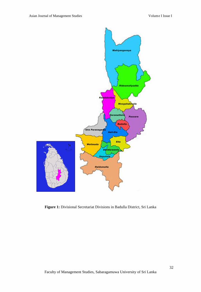
According to the available information on disasters, the main reasons
for the disasters recorded in the Badulla district are topography and geology,
climate, improper land use (constructions, agricultural practices, etc.), and
deforestation. Accordingly, about 66.91% of the land area of the Badulla
district is in danger, which is roughly 1914.29 km2 of the total land area of
2861 km2. Furthermore, about 2.77% of the land area has been identified as
high risk (Figure 2).
Asian Journal of Management Studies Volume I Issue I
32
Faculty of Management Studies, Sabaragamuwa University of Sri Lanka
Figure 1: Divisional Secretariat Divisions in Badulla District, Sri Lanka
Asian Journal of Management Studies Volume I Issue I
33
Faculty of Management Studies, Sabaragamuwa University of Sri Lanka
Figure 2: Land Slide Risk Zones in Badulla District

Asian Journal of Management Studies Volume I Issue I
34
Faculty of Management Studies, Sabaragamuwa University of Sri Lanka
METHODOLOGY
The study was undertaken in all Divisional Secretariats (DS) in the
Badulla district. Data relevant to environment and disaster were mainly
collected by referring to the existing literature on divisional-level resources,
resource profiles, hazardous profiles and other environment- and disaster-
related data contained in documents. During the study period, at least two
visits were made to each Divisional Secretariat and discussions were held with
the relevant officers of the DS offices to collect data. The following key points
were discussed at each DS office using a pretested data collection format: the
role of the DS when there is a disaster; support from other government
agencies when there is a disaster; issues when handling a disaster; availability
of a resource profile; availability of a hazardous area profile; gaps/issues in
the above systems; DS-level awareness sessions for officers involved in the
collection and reporting of environmental and disaster data; and availability of
a disaster management plan.
In addition, some of the techniques of Participatory Rural Appraisal
(PRA)–i.e., group discussions, brainstorming sessions, and structural
interviews–were used with the responsible officers or officers in charge of the
following key stakeholder institutions in order to collect the relevant
information on institutional level mandates, institutional level mechanisms,
and practices applicable to the collection, storing and sharing of data related
to environment and disaster. The key stakeholder agencies that participated in
the PRA exercises are given in Table1.
The existing resource profiles and hazardous profiles were also studied
to get an idea of how the agencies collect, store and share the existing data.
RESULTS AND DISCUSSION
The Status of Data Collection, Data Storage and Data Sharing at
Divisional Secretariat Level
The type and magnitude of the disaster faced could vary from one DS
to the next. While landslides are the main type of disaster faced by many DSs,
flooding is the main issue in the Mahiyanganaya DS division and drought and
human-elephant conflict, the main disasters in the Rideemaliyadda DS
division. In contrast, the Soranathota DSD has not, to date, experienced any
major disasters. All the DS divisions, except Bandarawela DS division, have
Asian Journal of Management Studies Volume I Issue I
35
Faculty of Management Studies, Sabaragamuwa University of Sri Lanka
resource profiles with specific information under broad categories such as
geographic information, details of Grama Niladhari divisions (or GN division,
which is a village cluster), and data on population and housing, agriculture,
health, transport, communication, land use, details of government and civil
societies, climate, forest and wildlife areas, water resources, and development
projects in the area.
All the DS divisions, except Welimada DS division, have Hazardous
Area Profiles but the scale of information available at different DS divisions
varies with regard to the aspects and type of hazard, hazard-prone areas, level
of risk, estimate of damage (cost), affected households, affected lands, maps
of hazardous areas, management plans, contact details, resources, reasons for
disasters, and identified solutions.
Some DS divisions already have disaster management and response
plans in place. While the DS division of Haldummulla has a Disaster Recovery
Preparedness and Response Plan, the DS divisions of Badulla and
Mahiyanganaya have 5-year disaster management plans. Hali-Ela and Passara
DS divisions have prepared Situational and Management Plans, quite similar
to disaster management plans, for their DS divisions. Updated versions of
these hazardous profiles are available for the years 2016/2017.
All DS divisions have collected and stored the data with regard to
disasters as either manual systems or as soft copies (either PDF or Word
document) and published them in the Sinhala language (one of the official
languages of Sri Lanka). Some DSDs like the Badulla DSD maintain data in
excel formats. But it was evident that they do not have proper systems to
manage or share either data or databases.
Generally, most of the DSDs share data with other state institutions
when a request is made barring a few like the Soranathota DS division. Some
DS divisions assign a separate person to maintain the data when there is a
disaster (for e.g., Lunugala, Kandeketiya, Rideemaliyadda, Passara,
Soranathota and Uva-Paranagama DS divisions). But some DSDs do not have
a dedicated member of staff to maintain the data relevant to disaster
management. Instead, it is done by different categories of officers, among
them, Development Officers, National Disaster Relief Centre Officers,
Assistant Directors, Administrative GN officers, and Public Management
Assistants.
Asian Journal of Management Studies Volume I Issue I
36
Faculty of Management Studies, Sabaragamuwa University of Sri Lanka
In some DS divisions, GND-wise disaster information reports are
available (e.g., Haldumulla, Bandarawela and Uva-Paranagama DS divisions).
In the Lunugala and Karandeniya DS divisions, where there was a database,
the non-availability of computers and of internet facilities posed a problem
with regard to its maintenance. Some DS divisions have highlighted the need
for a mobile app to better respond to disaster as such an app would enable
them to easily update data, for e.g., GPS locations, pictures, etc. of the disaster
sites.
Some DS divisions highlighted the lack of updated data as an issue when
handling a disaster, especially up-to-date maps and population data. They also
highlighted the lack of data in other fields such as that of material resources,
for e.g., the availability of vehicles, JCB machines, electricity, chain saws, and
generators. They also felt that the lack of funds and fixed communication
systems such as radio or satellite would constitute a major impediment in case
of a disaster.
Delays in sharing data with DS divisions by several institutions is also
a problem when handling disasters. For e.g., the Meegahakivula DS division
reported the absence of relevant maps, reports of National Building Research
Organisation (which is responsible for determining the landslide-prone sites
in a particular area), and data issued by the National Disaster Relief Services
Centre. Moreover, DS divisions did not find some of the data provided by
other institutions reliable for the purpose of making decisions. An example
would be the risk areas marked by NBRO when compared with areas actually
experiencing disasters.
The Status of Data Collection, Data Storage and Data Sharing at District
Level
The responsible officers from all the state institutions in Badulla district
were interviewed for the purpose of identifying the status of data collection,
data storage and data sharing, and formats used for data collection, storing and
sharing. The collected data and information were then studied in detail and
analysed, taking into consideration the data fields mentioned in the Rio
Conventions and Sendai Framework in addition to each institution’s mandate.
The summary findings are given in Table 1.

Asian Journal of Management Studies Volume I Issue I
37
Faculty of Management Studies, Sabaragamuwa University of Sri Lanka
Table 1: Findings of Availability of Data Relevant to Climate Change, Convention on
Biological Diversity and Land Degradation, Desertification and Drought at State Institutions in
Badulla District Availability of Data Relevant to Climate
Change, Convention on Biological Diversity
and Land Degradation, Desertification and
Drought
Remarks
Department of Census and Statistics
Department of Census and Statistics collects,
stores and shares the relevant data and
information on Climate Change and the
Convention on Biological Diversity. The data
is maintained as excel files, web-based
documents/reports and maps at Divisional
Secretariat level and GN levels.
Available data are not sufficient to fulfill
all the required data fields mentioned
under Climate Change and Convention on
Biological Diversity. Data are not
available for the data fields mentioned
under Land Degradation, Desertification
and Drought (LDD&D).
National Building and Research Organisation
(NBRO)
NBRO has been collecting, storing and sharing
data relevant to Climate Change (geographical
data, rainfall data and landslide data) from
2011 to date. Under Land Degradation,
Desertification and Drought (LDD&D), maps
and relevant documents on landslides are
available from 2011 to date. The data and
information is collected, stored and shared.
Relevant data are collected as per their
mandate. Depending on the type of
request, the collected data are shared either
free of charge or on a fee-levying basis.
There is no proper data-sharing
mechanism with other state institutions.
Forest Department
Data and information on land use change and
forestry emissions under climate change are
currently not available. There is an ongoing
national project to collect and store data in
these fields. By 2021, this project will be
completed. Under the Convention on
Biological Diversity, the data/information
required for the data fields are collected, stored
and shared. Data on forest fires, encroachments
and reforestation under the aspect of Land
Degradation, Desertification and Drought
(LDD&D) are available. The data collected are
up to date, and maps have been prepared for
information sharing.
There is no proper data sharing
mechanism, and data has to be obtained
from the Head Office. Data are not
available for all fields mentioned under
Climate Change, Convention on
Biological Diversity, Land Degradation,
Desertification and Drought.
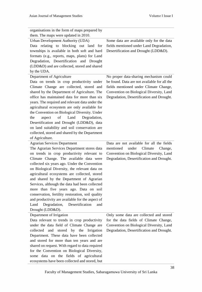
Survey Department
The Survey Department collects and stores
data for the relevant extent of forest cover and
land use under the Convention on Biological
Diversity. The data are shared with other
Some data are available relevant to the
Convention on Biological Diversity. The
maps, last updated in 2010, are in need of
updating.
Asian Journal of Management Studies Volume I Issue I
38
Faculty of Management Studies, Sabaragamuwa University of Sri Lanka
organisations in the form of maps prepared by
them. The maps were updated in 2010.
Urban Development Authority (UDA)
Data relating to blocking out land for
townships is available in both soft and hard
formats (e.g., reports, maps, plans) for Land
Degradation, Desertification and Drought
(LDD&D) and are collected, stored and shared
by the UDA.
Some data are available only for the data
fields mentioned under Land Degradation,
Desertification and Drought (LDD&D).
Department of Agriculture
Data on trends in crop productivity under
Climate Change are collected, stored and
shared by the Department of Agriculture. The
office has maintained data for more than six
years. The required and relevant data under the
agricultural ecosystem are only available for
the Convention on Biological Diversity. Under
the aspect of Land Degradation,
Desertification and Drought (LDD&D), data
on land suitability and soil conservation are
collected, stored and shared by the Department
of Agriculture.
No proper data-sharing mechanism could
be found. Data are not available for all the
fields mentioned under Climate Change,
Convention on Biological Diversity, Land
Degradation, Desertification and Drought.
Agrarian Services Department
The Agrarian Services Department stores data
on trends in crop productivity relevant to
Climate Change. The available data were
collected six years ago. Under the Convention
on Biological Diversity, the relevant data on
agricultural ecosystems are collected, stored
and shared by the Department of Agrarian
Services, although the data had been collected
more than five years ago. Data on soil
conservation, fertility restoration, soil quality
and productivity are available for the aspect of
Land Degradation, Desertification and
Drought (LDD&D).
Data are not available for all the fields
mentioned under Climate Change,
Convention on Biological Diversity, Land
Degradation, Desertification and Drought.
Department of Irrigation
Data relevant to trends in crop productivity
under the data field of Climate Change are
collected and stored by the Irrigation
Department. These data have been collected
and stored for more than ten years and are
shared on request. With regard to data required
for the Convention on Biological Diversity,
some data on the fields of agricultural
ecosystems have been collected and stored, but
Only some data are collected and stored
for the data fields of Climate Change,
Convention on Biological Diversity, Land
Degradation, Desertification and Drought.

Asian Journal of Management Studies Volume I Issue I
39
Faculty of Management Studies, Sabaragamuwa University of Sri Lanka
these data had been collected many years ago.
Data are shared on request with other agencies.
Under the aspect of Land Degradation,
Desertification and Drought (LDD&D), data
are collected and stored on soil quality, soil
conservation, drainage management, spatial
distribution of paddy lands, status of soil
quality, productivity, salinity and other abiotic
problems, soil erosion, nutrient build-up,
landslides, pollution of water bodies, streams,
stream reservations, watersheds/catchments,
reservoir distribution and water levels. The
collection of data commenced about three
years ago, and the data are shared with other
agencies on request.
National Disaster Relief Services Centre
(NDRSC)
NDRSC does not collect, store and share
relevant data on Weather and Climate, the
Convention on Biological Diversity, and Land
Degradation, Desertification and Drought
(LDD&D).
Sufficient data are not collected, stored
and shared in the fields mentioned under
Climate Change, Convention of Biological
Diversity, Land Degradation,
Desertification and Drought (LDD&D).
Road Development Authority (RDA)
Data on locations of construction with regard
to land degradation have been collected, stored
and shared by the RDA.
Data have been collected, stored and
shared under land degradation relevant to
road development.
Provincial Road Development Authority
(PRDA)
Data on locations of construction with regard
to land degradation have been collected, stored
and shared by PRDA. The data have been
collected for more than five years.
Data have been collected, stored and
shared under land degradation relevant to
road development.
Department of Land Use Policy Planning
(LUPPD)
This department has not been collecting,
storing and sharing data and information
relevant to Climate Change, Convention on
Biological Diversity, and Land Degradation,
Desertification and Drought (LDD&D).
They collect, store and share data relevant
to their mandate if and when necessary.
However, a proper data collecting and
sharing mechanism is not available.
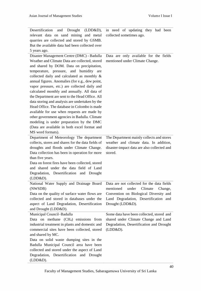
Geological Surveys and Mines Bureau
(GSMB)
GSMB does not collect and store relevant
data/information under Climate Change and
the Convention on Biological Diversity. Under
the aspect of Land Degradation,
Some data have been collected by GSMB
relevant to the data fields of Climate
Change and Biological Diversity under the
aspect of Land Degradation,
Desertification and Drought. The data are
Asian Journal of Management Studies Volume I Issue I
40
Faculty of Management Studies, Sabaragamuwa University of Sri Lanka
Desertification and Drought (LDD&D),
relevant data on sand mining and metal
quarries are collected and stored by GSMB.
But the available data had been collected over
5 years ago.
in need of updating they had been
collected sometimes ago.
Disaster Management Centre (DMC) - Badulla
Weather and Climate Data are collected, stored
and shared by DOM. Data on precipitation,
temperature, pressure, and humidity are
collected daily and calculated as monthly &
annual figures. Anomalies (for e.g., dew point,
vapor pressure, etc.) are collected daily and
calculated monthly and annually. All data of
the Department are sent to the Head Office. All
data storing and analysis are undertaken by the
Head Office. The database in Colombo is made
available for use when requests are made by
other government agencies in Badulla. Climate
modeling is under preparation by the DMC
(Data are available in both excel format and
MS word formats).
Data are only available for the fields
mentioned under Climate Change.
Department of Meteorology The department
collects, stores and shares for the data fields of
droughts and floods under Climate Change.
Data collection has been in operation for more
than five years.
Data on forest fires have been collected, stored
and shared under the data field of Land
Degradation, Desertification and Drought
(LDD&D).
The Department mainly collects and stores
weather and climate data. In addition,
disaster-impact data are also collected and
stored.
National Water Supply and Drainage Board
(NWSDB)
Data on the quality of surface water flows are
collected and stored in databases under the
aspect of Land Degradation, Desertification
and Drought (LDD&D).
Data are not collected for the data fields
mentioned under Climate Change,
Convention on Biological Diversity and
Land Degradation, Desertification and
Drought (LDD&D).
Municipal Council–Badulla
Data on methane (CH4) emissions from
industrial treatment in plants and domestic and
commercial sites have been collected, stored
and shared by MC.
Data on solid waste dumping sites in the
Badulla Municipal Council area have been
collected and stored under the aspect of Land
Degradation, Desertification and Drought
(LDD&D).
Some data have been collected, stored and
shared under Climate Change and Land
Degradation, Desertification and Drought
(LDD&D).

Asian Journal of Management Studies Volume I Issue I
41
Faculty of Management Studies, Sabaragamuwa University of Sri Lanka
Key Findings of the Study related to Disaster Preparedness
The case study finds that there are a lot of gaps with regard to disaster
preparedness in the Badulla district of the Uva Province. Among the gaps
identified are the following: (i) Each institution collects, stores and shares
data/information relevant to their mandate and functions; (ii) Data are
collected by each institution and stored in excel sheets, data bases or reports;
(iii) There was no proper data sharing mechanism in many institutions; (iv)
Most of the data is not collected by institutions according to the data fields
mentioned under Climate Change, Convention on Biological Diversity and
Land Degradation, Desertification and Drought (LDD&D); (v) Most of the
data is shared by institutions only on request by other institutions, with some
institutions only providing data with approval from their respective Head
Office; (vi) Data availability is not at a satisfactory level for required data
fields mentioned under Climate Change, Convention on Biological Diversity
and Land Degradation, Desertification and Drought (LDD&D); (vii) There is
no district-level central mechanism for data storage located at the District
Secretariat or any of the Divisional Secretariats; (viii) The relevant institutions
are not familiar with the Sendai Framework for Disaster Risk Reduction 2015-
2030 outlines and the Rio Conventions that the Government of Sri Lanka is
signatory to such as the Convention on Biological Diversity (CBD), the United
Nations Framework Convention on Climate Change (UNFCCC), and the
United Nations Convention to Combat Desertification; and (ix) Each
individual institution collects, stores and shares data in different formats, for
example, excel sheets, reports, questionnaires, maps, etc.
Key Problems, Issues and Challenges for Disaster Management
As shown by Smith and Hayne (1997), the process of information
sharing and coordination is further impeded by the pressure of time and event
uncertainty (Argote, 1982), which lead to unpredictability in information
needs and flows (Longstaff, 2005).
In disaster management, the organisation and management of resources
and responsibilities for dealing with all humanitarian aspects of emergencies,
in particular, preparedness, response and recovery, to lessen the impact of
disasters are required. In our study, the key problems, issues and challenges of
the climate and disaster management sector were clearly identified by
conducting discussions, interviews, focus group discussions and

Asian Journal of Management Studies Volume I Issue I
42
Faculty of Management Studies, Sabaragamuwa University of Sri Lanka
brainstorming sessions with key stakeholders by applying the techniques of
participatory rural appraisal (PRA). Since it is obvious that disasters cannot be
permanently eliminated, what is needed is the effective management of data
to minimise impacts.
The study identifies and classifies the shortcomings with regard to
disaster management in the District under four main aspects, namely, (i)
Disaster risk reduction, (ii) Preparedness, (iii) Emergency operations, and (iv)
Response and relief, recovery, resettlement, and rehabilitation. This shows
that shortcomings in disaster risk reduction, preparedness for disasters,
response to disasters, and recovery are identified as key problems in disaster
management. The root causes of the problems relating to disaster management
identified by the study in the Badulla district are lack of funds, constitutional
and legal issues, lack of inter-agency coordination, and lack of sensitivity and
awareness relating to disasters.
The effect of these root causes is evident in data collection, data storing,
data sharing, limited decisions-making powers and procedural delays. Hence,
while disaster is managed ultimately up to a certain level, it is far from
satisfactory. Since the ultimate goal of the proposed disaster management plan
is to strengthen the disaster management mechanism of the Badulla District,
its objectives should be the following: minimising the disaster risk in the
district; strengthening the preparedness for disaster management;
strengthening the mechanism of emergency operations and response vis-à-vis
disaster management; and strengthening the mechanism of relief, recovery,
resettlement and rehabilitation.
Data collection, data storing and data sharing are the main outcomes
envisaged by achieving the objectives mentioned above. Establishing inter-
agency coordination, providing infrastructure facilities and training for staff,
minimising carelessness of staff, minimising procedural delays, and providing
duty lists and responsibilities are the other areas to be improved in disaster
management. The ultimate goals of disaster management are reduction or
avoidance of losses from hazards; assurance of prompt assistance to victims;
and achievement of rapid and effective recovery.
It is a fact that in disaster management, despite the recent emergence of
a large number of technological innovations, these technologies have often
been developed in isolation of other developments and have not been
Asian Journal of Management Studies Volume I Issue I
43
Faculty of Management Studies, Sabaragamuwa University of Sri Lanka
integrated into the daily routine operations, which might thus prevent their
effective use during an emergency. Many cultural, organisational,
jurisdictional and legal barriers also impede or prevent necessary and proper
coordination among relevant public and private organisations during
unforeseen eventualities. However, traditional modes of coordination alone
are inadequate for volatile and dynamic situations (Faraj & Xiao, 2006).
Information needs and appropriate coordination mechanisms relating to the
needs of the people affected may also vary with changes in the disaster
situation. There is a need, therefore, to develop flexible coordination
mechanisms that could easily be customised for the specific situation and,
thereby, provide better support for improvised responses where it is deemed
necessary (Mendonca, 2007; Chen et al., 2008).
CONCLUSION
The findings of the study underscore the importance of a directive by
the government to all relevant state institutions in Badulla to identify the
existing district-level environmental and disaster-related data and to facilitate
the planning divisions in the District Secretariats to design the conceptual
framework for a district-level database on environmental and disaster data.
Although inter-agency coordination has attracted a great deal of attention in
the recent past, there are still several issues that require more research. For
example, coordination of commitments based on relationships has received
little attention within the field (Winograd & Flores, 1987). In their study,
Winograd and Flores (1987) found that most human coordination occurs in a
basic cycle consisting of requesting, making and fulfilling commitments
between people than at a more advanced and systematic level.
According to Faraj and Xiao (2006), the Coordination Theory is often
claimed by scholars to be at the centre of organisation theory. The limited
capacity and resources, the problems caused by the division of tasks and
labour, and the corresponding mechanisms needed to overcome the problems
form the core of organisational design (Galbraith, 1977). Although
coordination has attracted a great deal of attention, there are several issues that
require more research, among them, as pointed out by Winograd and Flores
(1987), the coordination of commitments based on relationships.

Asian Journal of Management Studies Volume I Issue I
44
Faculty of Management Studies, Sabaragamuwa University of Sri Lanka
The identified thrust areas and result areas are given in Table 2. The
future outlook is mostly related to the Sustainable Development Goals
mentioned in the Rio Declaration and other drafted Rio Conventions and the
Sendai Framework. The sustainable development goals cover social and
economic development issues including poverty, hunger, health, education,
global warming, gender equality, water, sanitation, energy, urbanisation,
environment and social justice. The resulting outcomes are also related to
sustainable development goals.
Table 2: The Thrust Areas and Key Result Areas
Sector Domain Purpose Thrust Areas Key Result Areas
Disaster
management
Quality
of life
Safe lives
and
properties
1. Disaster risk
reduction
mechanism
1.1 Mechanism for data
collection, storing and
sharing
1.2 Application of
evaluated risk potential
in development planning
1.3 Community
understanding on land
use
2. Preparedness for
disasters
2.1 Improved
preparedness mechanism
for minimising disaster
impacts
3. Improved
response for
disasters
3.1 Improved
mechanism for disaster
relief and response
4. Improved disaster
recovery,
resettlement and
rehabilitation
4.1 Improved
mechanism for speedy
recovery, resettlement
and rehabilitation
Source: Stakeholder Workshop 2018
Based on the results of the PRA exercise as well as discussions with
relevant officials, the following policy directions are proposed as
recommendations to achieve the vision and mission of disaster management in
the Badulla district.
(i). A policy decision should be taken to collect, store and share data by
relevant agencies pertaining to the Sendai Framework for Disaster Risk
Reduction 2015-2030 outlines, Convention on Biological Diversity (CBD), the
United Nations Framework Convention on Climate Change (UNFCCC) and
Asian Journal of Management Studies Volume I Issue I
45
Faculty of Management Studies, Sabaragamuwa University of Sri Lanka
the United Nations Convention to Combat Desertification. This can be done
through MOUs and Circulars which are part of the project;
(ii). Disaster management should be done according to the Sendai Framework
for Disaster Risk Reduction 2015-2030. Data collection, data storage and data
sharing are important for fulfilling the requirements of the four pillars of
disaster management, i.e. mitigation–minimising the effects of disaster;
preparedness–planning on how to respond; response–efforts to minimise
hazards created by a disaster; and recovery– rehabilitating the community to
pre-disaster levels. For this, a central database has to be established at the
District Secretariat level to store and share the data/information among the
relevant agencies;
(iii). Monthly/quarterly planning committee meetings should be held at the
District Secretariat in order to discuss development projects and to make
decisions based on the environment and disaster data collected;
(iv). Future development activities should be planned and information about
them disseminated among all stakeholders within a specific time period (i.e.,
a year) in order to obtain their inputs as well as relevant data into the database
for the purpose of decision-making on the development projects being
implemented;
(v). A risk planning and management framework should be introduced to
prepare for the possible failure of future projects;
(vi). Opportunities should be provided to the community to participate in
decision-making in order to prevent disasters during future development
projects. It is important to make local residents full and equal partners in
development planning and decision making, particularly members of
disadvantaged groups who tend to bear the brunt of the adverse outcomes of
such projects;
(vii). A hazard assessment and vulnerability analysis, especially hazard
proneness, should be included, at the appraisal stage, in all social and
environmental risk assessments of development projects;
(viii). Frequent monitoring of and updating information on disaster-prone
areas should be undertaken within the district based on small-scale/medium-
scale/large-scale disasters with the participation of the GN and DS;
Asian Journal of Management Studies Volume I Issue I
46
Faculty of Management Studies, Sabaragamuwa University of Sri Lanka
(ix). Both infrastructure and budgets should be provided to support
environmental management and risk reduction for the purpose of minimising
the frequency, if not occurrence, of disasters.
Although these are the recommendations proposed, as Thompson
(1967) has shown, disaster management is underpinned ultimately by
reciprocity, mutual trust, and willingness to share information among
organisations. As emphasised by him, these types of interactions should occur
not only at the top tiers of the organisations but at the lower levels as well.
REFERENCES
Argote, L. (1982). Input uncertainty and organisational coordination in
hospital emergency units. Administrative Science Quarterly, 27(3), 420-
434. doi:10.2307/2392320.
Akter, S., & Wamba, S. F. (2019). Big data and disaster management: a
systematic review and agenda for future research. Annals of Operations
Research, 283, 939-959.
Board on Natural Disasters National Research Council. (1999). Mitigation
emerges as a major strategy for reducing losses caused by natural
disasters. Science, 284(5422), 1943-1947.
doi:10.1126/science.284.5422.1943
Chen, R., Sharman, R., Rao, R., & Upadhyaya, S. (2008). Coordination in
emergency response management. Communications of the ACM, 51(5),
66-73. doi:10.1145/1342327.1342340
Faraj, S., & Xiao, Y. (2006). Coordination in fast-response organisations.
Management Science, 52(8), 1155-1169. doi:10.1287/ mnsc.1060.0526
Foster, I., & Grossman, R. L. (2003). Data integration in a bandwidth-rich
world. Communications of the ACM, 46(11), 50-57.
Galbraith, J. R. (1977). Organisation Design. Reading, MA: Addison Wesley.
Goswami, S., Chakraborty, S., Ghosh, S., Chakrabarti, A. & Chakraborty, B.
(2018). A review on application of data mining techniques to combat
natural disaster. Ain Shams Engineering Journal, 9(3), 365-378. doi:
https://doi.org/10.1016/j.asej.2016.01.012

Asian Journal of Management Studies Volume I Issue I
47
Faculty of Management Studies, Sabaragamuwa University of Sri Lanka
Grolinger, K., Capretz, M. A.M., Mezghani, E., & Exposito, E. (2013).
Knowledge as a Service Framework for Disaster Management. Workshop
on Enabling Technologies: Infrastructure for Collaborative Enterprises,
Hammemet, pp. 313-318., doi: 10.1109/WETICE.2013.48
Hristidis, V., Chen, S. C., Li, T., Luis, S., & Deng, Y. (2010). Survey of data
management and analysis in disaster situations. Journal of Systems and
Software, 83(10), 1701-1714. https://doi.org/10.1016/j.jss.2010.04.065
Jayasinghe, G. J. M. S. R., Wijekoon, P., & Gunatilake, J. (2017). Landslide
susceptibility assessment using statistical models: A case study in Badulla
disdrict, Sri Lanka. Ceylon Journal of Science, 46(4), 27-41. DOI:
http://doi.org/10.4038/cjs.v46i4.7466
Kohler, P., & Wachter, J. (2006). Towards an Open Information Infrastructure
for Disaster Research and Management: Data Management and
Information Systems Inside DFNK. Natural Hazards, 38, 141-157.
Longstaff, P. H. (2005). Security, resilience, and communication in
unpredictable environments such as terrorism, natural disasters, and
complex technology. http://pirp. harvard.edu/pubs_pdf/longsta/longsta-
p05-3.pdf
Mendonca, D. (2007). Decision support for improvisation in response to
extreme events: learning from the response to the 2001 World Trade
Center attack. Decision Support Systems, 43(3), 952-967.
doi:10.1016/j.dss.2005.05.025
Qiu, L., Du, Z., Zhu, Q., & Fan, Y. (2017). An integrated flood management
system based on linking environmental models and disaster-related data.
Environmental Modelling & Software, 91, 111-126.
https://doi.org/10.1016/j.envsoft.2017.01.025
Ragini, J. R., Anand, P. M. R., & Bhaskar, V. (2018). Big data analytics for
disaster response and recovery through sentiment analysis. International
Journal of Information Management, 42(October), 13-24.
https://doi.org/10.1016/j.ijinfomgt.2018.05.004

Asian Journal of Management Studies Volume I Issue I
48
Faculty of Management Studies, Sabaragamuwa University of Sri Lanka
Saleem, K., Luis, S., Deng, Y., Chen, S.-C., Hristidis, V., & Li, T. (2008).
Towards a business continuity information network for rapid disaster
recovery. In S. A. Chun, M. Janssen, & J. R. Gil-Garcıa (Eds.),
Proceedings of the 2008 International Conference on Digital Government
Research ACM International Conference Proceeding Series (pp. 107-
116).
Smith, C., & Hayne, S. (1997). Decision making under time pressure.
Management Communication Quarterly, 11(1), 97-126.
doi:10.1177/0893318997111005
Thompson, J. D. (1967). Organisations in action. New York: McGraw-Hill.
Winograd, T., & Flores, F. (1987). Understanding computers and cognition. A
new foundation for design. Massachusetts: Addison Wesley.
Wu, D., & Cui, Y. (2018). Disaster early warning and damage assessment
analysis using social media data and geo-location information. Decision
Support Systems, 111(July), 48-59.
https://doi.org/10.1016/j.dss.2018.04.005