st.andrews scots school geography department presents : igcse geography core theme 2. the natural...
TRANSCRIPT

•St.Andrews Scots School
Geography Department
Presents :
IGCSE Geography
Core Theme 2. The Natural Environment
Glacial Processes

Demonstrate an understanding of the glacial processes in eroding, transporting and deposition.Refernce should be made to the erosional processes of plucking and abrasion, assisted by freeze-thaw weathering. Transport of rock materials (moraine) as sub-glacial moraine (ground moraine), englacial morraine, lateral moraine and medial moraine should be understood.Describe and explain the landforms associated with the processes.A study should be made of the following glacial landforms:
Glacial troughs (U-shaped valleys with truncated spurs)
Corries (cirques)
Aretes
Pyramidal peaks
Hanging valleys
Rock basins
Roche moutonnees
Landforms resulting from depostion of moraine
terminal moraine, boulder clay and drumlins
The syllabus states that the student should be able to:

So what is a glacier?
In cold climates and at high altitude most precipitation is in the form of snow. Snow can collect in hollows on the side of mountains. With more prcipitation the weight increases and compresses the snow turning it into FIRN. This is snow which has survived one winter’s freezing and survived a summer’s melting. Once ice has formed, it may begin to flow downhill (due to gravity) as a glacier. They are like rivers of ice, flowing through valleys once occupied by running water.

The Glacial systemGlaciers behave like a system, with inputs, stores, transfers and outputs.Snow from avalanches and precipitation provides the inputs into the system. This occurs at the start (head) of the glacier in the zone of accumulation. As the snow accumulates and turns to ice it can be stored within the glacier. Under the influence of gravity the glacier can begin to move downhill, therefore the ice is transfered.At the end of the glacier, ice can melt creating meltwater streams. Some will also be evaporated. The melting of ice at the end (snout) of the glacier is known as ablation and occurs in the ablation zone
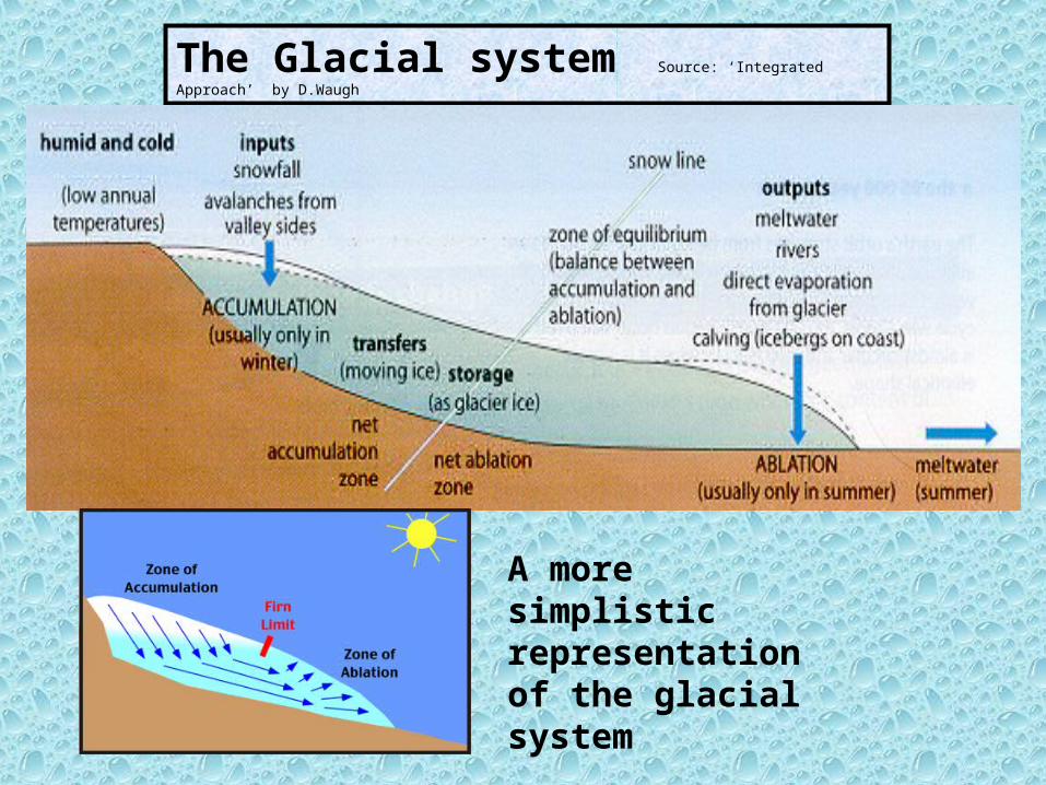
The Glacial system Source: ‘Integrated Approach’ by
D.Waugh
A more simplistic representation of the glacial system

Different types of glacierThere are several different types of glacier which are classified according to their shape, size and location.
A niche glacier
These are very small areas of ice which occupy shallow hollows and gulleys.

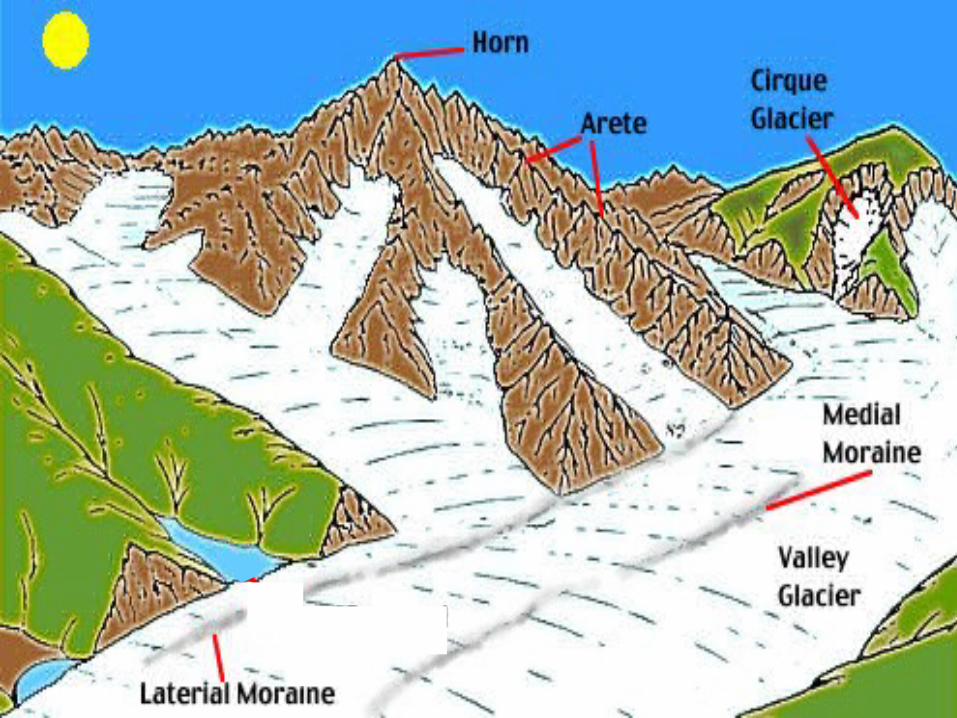
Corrie or Cirque glaciersAlthough larger than niche glaciers, these are relatively small ice masses which occupy armchair-shaped hollows on mountain sides. They often spillover from their hollows to feed valley glaciers.
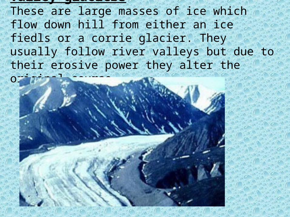
Valley glaciersThese are large masses of ice which flow down hill from either an ice fiedls or a corrie glacier. They usually follow river valleys but due to their erosive power they alter the original course.

Piedmont glaciersThese are formed when several valley glaciers spill onto lowland areas and then spreadout, often merging together.

Ice caps
These are huge areas of ice that spread out from central domes. Apart from the exposed tops of high mountains (Nunataks) the whole area is buried deep in ice. The largest ice sheet is found in Antarctica, followed by Greenland and then in South America.

How does a glacier erode the landscape?The speed at which a glacier erodes depends on its size and the amount of material it can carry. The source of the rock material is from frost shattering (freeze-thaw weathering). The glacier uses this material to erode the valley bottom and sides.A glacier can erode the landscape by the following processes:
ABRASION PLUCKING
Abrasion:
Material supplied by frost shattering and then picked up by the glacier is used to scrape against the side and floor of the valley. The more material it has the greater the rate and strength of abrasion. The glacier it like a giant piece of sandpaper rubbing along the valley.
Plucking:
Glaciers will freeze to rock surfaces when under extreme pressure. When the glacier starts to move it rips large pieces of rock away from the underlying surface. These rock fragments, now frozen into the ice, can be used by the glacier to abrade the valley.

Erosional landforms
1. Corries (or Cirques)These are deep, steep-sided hollows formed on
the side of a mountain. They form when snow starts to collect in small depressions and hollows on the mountain. With more snowfall the ice is compressed and it deepens. It eventually starts to move downhill when the corrie glacier starts to flow out of the hollow. As the corrie glacier starts to move it erodes the hollow even further. A steep back wall is created by plucking and the hollow is deepened by abrasion. The result is a corrie, an armchair shaped hollow. Many corries are filled with a corrie lake (or tarn) the result of trapped glacial water.

Steep back wall with jagged rock, the result of plucking and frost shattering
Large armchair shaped hollow
Corrie lake (or tarn)
Loose scree from frost shattering

2. AretesWhen two corries form back-to-back and begin to erode towards each other, the land inbetween them gets narrower. This knife-edge ridge is known as an arete. The following photos show some very clear examples.

3. Pyramidal peaks
When three or more corries erode back into the same mountain, a pyramidal peak results. Aretes will radiate out from the peak .A very famous pyramidal peak is the Matterhorn in Switzerland.
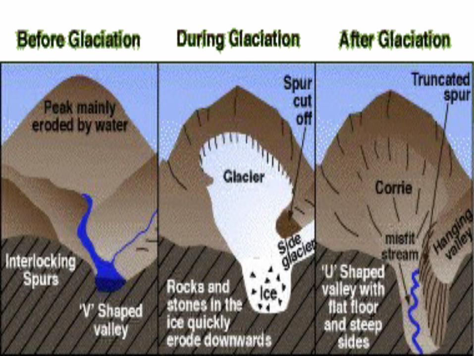
4. Glacial troughs (or U-shaped valleys)
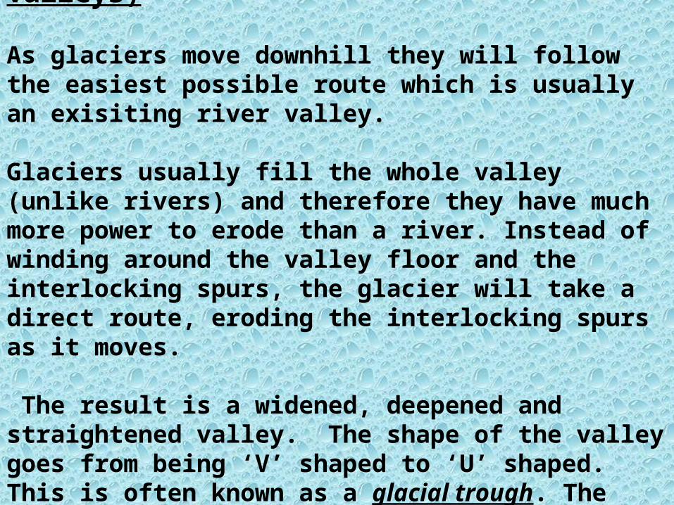
As glaciers move downhill they will follow the easiest possible route which is usually an exisiting river valley.
Glaciers usually fill the whole valley (unlike rivers) and therefore they have much more power to erode than a river. Instead of winding around the valley floor and the interlocking spurs, the glacier will take a direct route, eroding the interlocking spurs as it moves.
The result is a widened, deepened and straightened valley. The shape of the valley goes from being ‘V’ shaped to ‘U’ shaped. This is often known as a glacial trough. The interlocking spurs have been erode to leave truncated spurs.

The glacier would have occupied this river valley and through the processes of abrasion and plucking, it has eroded it to form a U-shaped glacial trough.

Photos to show glacial troughs

5. Hanging valleys
Before the appearance of glaciers, tributary rivers would have joined the main valley river at the same height. During the ice age, the glacier in the tributary valley would have been much smaller than the one occupying the main valley, and so it would not have as much energy to erode downwards. When the ice melted and the glaciers disappeared, the tributary valley would be left ‘hanging’ above the main valley. The only way for the water in the tributary river to know join the main valley river is by dropping down a very steep drop, often as a waterfall.

This picture shows not only a perfect hanging valley, complete with waterfall but a great example of a glaciated trough (or U-shaped valley).
Yosemite National Park, USA
U-shaped valley
Hanging valley
Waterfall connecting the hanging valley to the main valley below

6. Roche Moutonnees This feature occurs when the advancing glacier meets a more resistant rock than that of the surrounding valley. As the glacier passes over the more resistant rock it’s base actually starts to melt. The material it is carrying polishes the rock surfaces through the action of abrasion, leaving a gently sloping and smooth slope. The downward facing part of the rock is much steeper and more jagged. This is because the glacier refreezes on this surface (due to a decrease in pressure) and plucking takes place.
7. Ribbon lakes
When a glacier moves along its valley, changes in the rate of erosion may lead to increased deepening of sections of the valley floor. Areas of softer rock may also experience increased deepening. When the glacier retreats, the deepened sections fill with melt water and become lakes. These lakes remain long after glaciation has ended, supplied by rainfall and subsequent streams and rivers. The English Lake district owes its character to these narrow ribbon lakes along its valley floors.
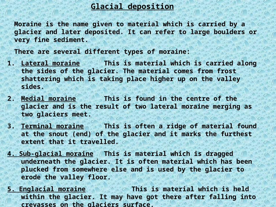
Glacial deposition
Moraine is the name given to material which is carried by a glacier and later deposited. It can refer to large boulders or very fine sediment.
There are several different types of moraine:
1. Lateral moraine This is material which is carried along the sides of the glacier. The material comes from frost shattering which is taking place higher up on the valley sides.
2. Medial moraine This is found in the centre of the glacier and is the result of two lateral moraine merging as two glaciers meet.
3. Terminal moraine This is often a ridge of material found at the snout (end) of the glacier and it marks the furthest extent that it travelled.
4. Sub-glacial moraine This is material which is dragged underneath the glacier. It is often material which has been plucked from somewhere else and is used by the glacier to erode the valley floor.
5. Englacial moraine This is material which is held within the glacier. It may have got there after falling into crevasses on the glaciers surface.
Features of glacial deposition
As already explained, glaciers have the potential to carry very large amounts of material (moraine). Under certain conditions this material can be deposited to produce some distinctive landforms.
The syllabus requires students to be familiar with the following three features of glacial deposition.
1. Boulder clay
2. Drumlins
3. Terminal moraine
1.Boulder clay
This is material which has been carried by the glacier (either as sub glacial or englacial moraine) and then has been deposited as glacial till by the glacier.
Till is the term often given to all material deposited by a glacier.As the name suggests, boulder clay can be a mixture of different size material, ranging from very fine to extremely large.
It is often deposited as the glacier retreats and it looses its ability to transport it’s load.
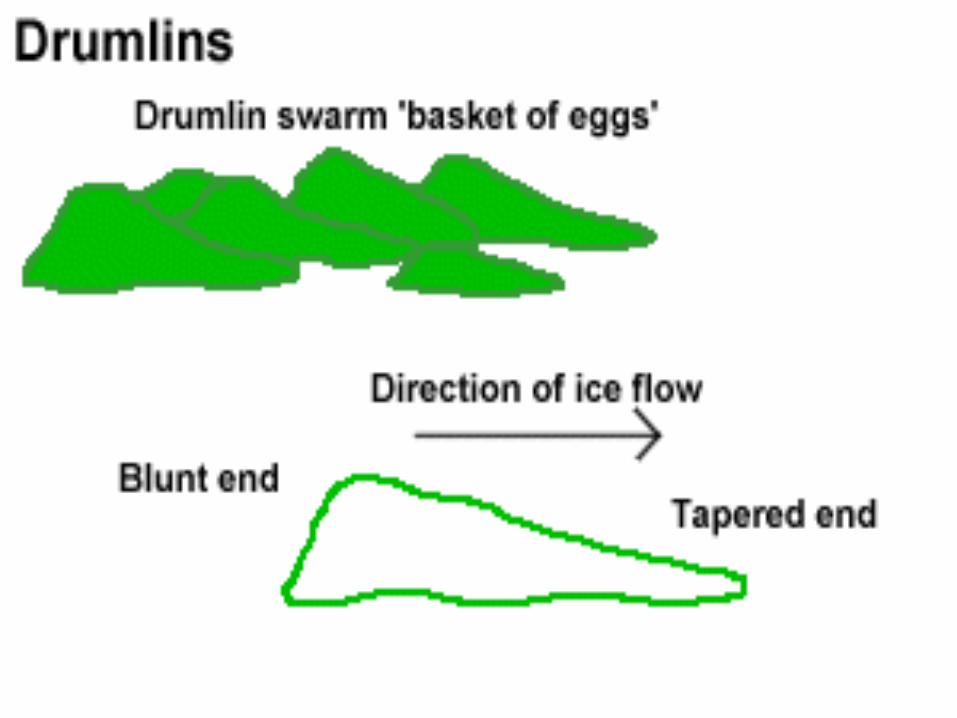
2. DrumlinsThese are smooth, elongated mounds of till (clay & stones) which have their long axis parallel to the directions of the ice movement. There is disagreement as to how drumlins form, but it is widely believed that they are the result of the glacier becoming overloaded with material. As a result it looses it’s ability to carry the load and so it is deposited. Subsequent ice movements will mould this material into mounds known as drumlins.Often drumlins are found in great numbers and this is called a swarm of drumlins.