spaces and flows: an international journal of urban and
TRANSCRIPT
Spaces and Flows: An International Journal of Urban and ExtraUrban Studies
SPACESANDFLOWS.COM
70-6.&� �
BBBBBBBBBBBBBBBBBBBBBBBBBBBBBBBBBBBBBBBBBBBBBBBBBBBBBBBBBBBBBBBBBBBBBBBBBB

SPACES AND FLOWS: AN INTERNATIONAL JOURNAL OF URBAN AND EXTRAURBAN STUDIES
wwwǤspacesandflows.com
First published in 2013 in Champaign, Illinois, USA
by Common Ground Publishing LLC
www.commongroundpublishing.com
ISSN: 2154-8676
© 201Ͷ (individual papers), the author(s)
© 201Ͷ (selection and editorial matter) Common Ground
All rights reserved. Apart from fair dealing for the purposes
of study, research, criticism or review as permitted under the
applicable copyright legislation, no part of this work may be
reproduced by any process without written permission from the
publisher. For permissions and other inquiries, please contact
Spaces and Flows: An International Journal of Urban and ExtraUrban Studies is
peer-reviewed, supported by rigorous processes of criterion-
referenced article ranking and qualitative commentary,
ensuring that only intellectual work of the greatest substance
and highest significance is published.

Planning for Flow in Ocean Space: A Barents Sea Case Study
Nancy Couling, Ecole Polytechnique Fédérale de Lausanne, Switzerland
Abstract: Ocean space is currently being urbanized on an unprecedented scale, a phenomenon under investigation by the architectural laboratoire bâle, EPFL Switzerland. Lefebvre writes of the all-encompassing process of urbanization, that agriculture, industry and urbanization follow each other (Lefebvre 2003). This model can be tested for ocean space, which already plays a major role within mobility and organisational networks and is at the same time a fluid, partially industrialised landscape of dimensions often far exceeding comparable zones on land. The research aims to investigate these relationships, position ocean spatial typologies within the urban debate and identify planning tools informed by the physical, as opposed to the virtual, condition of flow, which implement the ocean itself as an “active” agent. In the case of the Barents Sea in northern Norway, the interest in ocean space is fuelled by the opening of the Northern Sea Route to Asia and the prospect of releasing vast off-shore reserves of oil & gas on the one hand, and the alarming rate of global warming as reflected in the receding ice-front on the other. The strategic development of infrastructure, the provision of access and the complex grid of international networks active in the region are indicators of a particular type of urbanism acting at the territorial scale. This specific character, however, demands an urbanism of flows. Despite its remoteness, its vastness, its extreme climatic and light conditions, its relatively sparse human population and its abundance of natural habitats, this territory is under extreme pressure. The Barents Sea exemplifies the need for a new kind of spatial strategy, a strategy which works with the dynamics of the ocean and its potential for the current urbanization processes. How can urban design methods and principles be applied to ocean territory and how can natural “clients” such as inhabitants, or phenomena such as ice, be catered for in planning terms? The laboratory’s project developed “territorial constitutions” for the Barents Sea which were then further articulated in singular architectural projects as a proof of concept. The context revealed itself to be both an extremely harsh and aesthetic natural environment and a correspondingly extreme artificial and utilitarian built environment.
Keywords: Ocean Territory, Marine Spatial Planning, Urbanization of the Sea, Planning with Flow, Infrastructure
Introduction
ceanographer Robert Ballard articulates the human reluctance to investigate the world’s oceans, and claims that there is more known about the moon than the deepest oceans (Ballard 2000, 3). But urban history is intrinsically linked to waterways and currently
approximately 40% of the world’s population live near the coast (Pierce and Johnson 2009). Human interaction has been constant.
Our studies reveal a quantum shift in the intensity and scale of this interaction and concentrate on areas where this shift is evident within a predominantly ocean condition. This excludes both ocean reclamation, which essentially eliminates the water condition and urban systems integrating both liquid and solid ground, such as Venice.
the waterways were.. integral components of a unified land and aquatic-based spatial network. (Savoy 2012, 2)
The spatial condition of the ocean, including how this condition has changed with intensified activity, is the primary focus of our investigation. This paper aims to provide evidence of this shift, discuss theoretical positions relevant to ocean space and demonstrate ways of planning with flows within this physical context. Experience drawn from a year-long case study on the Barents Sea with master students at laba (laboratoire bâle, Ecole Polytechnique Fédérale de Lausanne) provides the groundwork.
O
Spaces and Flows: An International Journal of Urban and ExtraUrban Studies Volume 4, 201�, spacesandflows.com, ISSN: 2154-8676 © Common Ground, Nancy Couling, All Rights Reserved Permissions: [email protected]
SPACES AND FLOWS: AN INTERNATIONAL JOURNAL OF URBAN AND EXTRAURBAN STUDIES
Ocean Urbanization
The city…had been superseded by a process of urbanization or, more generally, of the production of space, that was binding together the global and the local, the city and the country, the centre and the periphery in new and quite unfamiliar ways (Lefebvre 1991, 431).
In David Harvey’s afterword to the English translation of “The Production of Space”, Lefebvre’s position on the process and nature of global urbanization is summarized as above. Flows of energy, raw materials, labour and information dominate the capitalist economy of production. This process produces not only contradictions between such flows and “fixities”, but also new types of space itself- which, in turn, become a marketable commodity.
Our investigations show that urban systems have extended beyond terrestrial boundaries out into the sea and that new types of space are being “produced”. Lefebvre’s perspective therefore provides a useful theoretical framework within which to examine this phenomenon. Infrastructure is a physical expression of operating networks and can be seen as a pioneer coloniser of space, potentially in preparation for further layers of occupation. The space generated around this infrastructure, however, is not characteristically urban, but forms territorial networks utilised and accessible for specific purposes and specific groups only. The recent shift in scale and intensity of ocean infrastructure in the shipping and energy sectors will be summarized here, in order to provide a context for further discussion.
Quantum Shift
While ocean trade has a long tradition, and forms a fundamental argument for the critical role of the sea in linking, harbouring and producing culture, this sector has undergone radical changes due to the double revolutions of containerisation and mechanised bulk transport in the 1960s. Since then shipping volume has been steadily increasing, encouraged initially by low fuel prices and the move away from state control to market economy approaches (Stopford 2009).
With over 80 per cent of world merchandise trade by volume being carried by sea, maritime transport remains the backbone supporting international trade and globalization (Asariotis et al. 2008, xiii).
A jump in physical size of ships and port facilities accompanied these developments, having reached a current maximum of 12,500 TEU (twenty feet-equivalent container units) in the “Emma” class introduced by Maersk Lines in the early 2000s. This size (ca. 396m in length) is called the “suezmax” and will also be the maximum size for the capacity of the new enlarged Panama Canal to be completed in 2014 (Rodrigue 2010).
Current plans for year-round shipping through the Northern Sea Route (Barents Sea-Bering Strait), a route from Europe to Asia which is independent of both the Suez and Panama Canals, includes constructing new ships with a capacity of 15-20,000 TEU (Gunnarsson 2012).
Parallel to merchant shipping, the cruise ship industry has continued to expand steadily since the turn of the century.
Similar tendencies occurred in the offshore gas and oil industries, which have grown exponentially since the first offshore oil-well structures were built in water depths of up to 100m in the Gulf of Mexico in the 1940`s, followed by the discovery of commercial quantities of oil in the Gulf states, England (1960s) and the Norwegian North Sea (1969). In the Barents Sea, for example, both improved rig-building and drilling technologies and the receding ice-front have recently made vast oil and gas reserves more readily accessible.
COULING: PLANNING FOR FLOW IN OCEAN SPACE
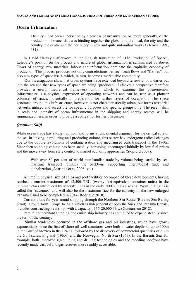
These activities illustrate the global scale of operations and flows, which both serve and create specific spatial typologies. In some cases, as in the Gulf of Mexico, (fig 1.) an almost seamless transition of systems from sea to land can be observed.
Figure 1: Infrastructure of the Petroleum Industry Source: Fontenot, Rosenzweig, and Schmidt 2006. Published with permission of the authors.
Emerging territories defined by particular relationships such as the flows described above may not necessarily be directly linked to urban centres- the relationship between city and territory has become highly diverse and diffuse and may have little to do with geographic proximity. Debarbieux defines territory as ”the arrangement of material and symbolic resources capable of structuring the practical conditions needed to support the existence of an individual or a social community” (Lévy and Lussault 2003). Scale and density, two parameters of the “urban”, are not determining factors and thus provide a clear distinction between urbanity and territory.
Our studies on the Barents Sea confirm that this sea is in fact a specific territory, defined by a network of interest groups and articulated through both physical and transient infrastructure. Potentially an urban tool, infrastructure alone does not necessarily produce an urban condition.
However, in the case of the Barents Sea, infrastructure has both enabled and determined settlement. Initially serving the exploitation of resources, such as mining, fishing or fossil fuels, towns often developed from a core of worker’s accommodation and facilities (Gugger, Couling, and Blanchard 2012).
Space at Sea
Given that the ocean is equipped with infrastructure corresponding to international networks, how can the spatial experience of the ocean itself be approached?
The ocean’s seeming lack of visible structure, direction and enclosure, suggests rhizomic space - open, smooth and undefined. Deleuze and Guattari discuss the rhizome attributes - non-

SPACES AND FLOWS: AN INTERNATIONAL JOURNAL OF URBAN AND EXTRAURBAN STUDIES
heirarchical and non-directional quality and behaviour- of what they have defined as “smooth space”. The sea is “the smooth space par excellence” (Deleuze and Guattari 2005, 479). The smoothness of this space refers to its isotropic nature and its surface texture, which while appearing homogeneous, is at the same time capable of accommodating multiple irregularities. It also refers to the space’s power of deterritorialisation and its directional property, which, like a vector, is always changing. Smooth space resists closing off and allocation. In smooth space one “distributes oneself in open space, according to frequencies and in the course of one’s crossings” (ibid 481). Examining these ideas, properties of ocean space can be seen as “deterritorialising” on the one hand, yet we have seen that through networks, territories are also established. Further to this, the scaleless and boundless ocean surface is accompanied by a complex three dimensional body of water, which is directly affected by surface activities. This implies that the territory of relationships operates on ephemeral layers, almost imperceptible from the surface.
This aspect of ocean space has been presented in a paper on regional ocean planning within the German exclusive economic zone. Among the essential differences to planning on land, the author cites the ocean’s diverse three-dimensionality, comprising of airspace, sea surface, sea body, seabed, and under-seabed (Nolte 2010). Each strata demands particular treatment in terms of potential use and protection and therefore for planning. While the ocean surface may be described as “smooth space”, the sea body is a diverse and complex environment.
Our studies on the Barents Sea, north of Norway, revealed specific environmental conditions. Ocean currents from both the Atlantic and the Barents Sea, temperatures and levels of salinity are interconnected and create a unique zone - the polar front - where these conditions meet (fig. 2). Here the unique biological and chemical exchanges result in rich phytoplankton bloom which provides the first step in the food-chain and nourishes extensive bird and fish populations. Such a territorial condition demonstrates a further differentiation between terrestrial and ocean planning. The ocean is an ecosystem, within which, effects of interactions may be far-reaching and, in fact, unpredictable. It presents dynamic and complex planning conditions which demand appropriate tools and methods.
To illustrate current planning and compare this to our laboratory’s work, two examples have been chosen; the Spatial Plan for the German Exclusive Economic Zone, and the Barents Sea Territorial Constitution “A Pool of Resources”, from the 2011/12 laba teaching programme.
Figure 2. Currents and the Polar Front in the Barents Sea Source: laba 2011

COULING: PLANNING FOR FLOW IN OCEAN SPACE
Marine Spatial Planning (MSP)
Intensified ocean use, conflicts and danger of pollution led to the preparation of the United Nations Convention on the Law of the Sea (UNCLOS) over a period of 14 years beginning in 1968. Based on the principle that the resources of the deep sea-bed constitute the “common heritage of mankind” (Koh 1982), this is the effective legal framework governing ocean space. The third convention defined a nation’s rights to an exclusive economic zone of 200 nautical miles offshore, and covered all issues involved with ocean space, including the exploitation of resources and marine research (UN 1982 Part V, Art. 55-7). The third convention first came into force in 1994, after being opened for signature in Montego Bay, Jamaica in 1982.
Marine Spatial Planning is an initiative to coordinate ocean use within a country’s exclusive economic zone as defined by UNCLOS, and is supported by UNESCO’s Intergovernmental Oceanographic Commission (IOC). Objectives of several of UNESCO’s ocean programmes, such as Man and Biosphere (MAB) and the Coastal Areas and Small Islands Programme overlap with, and stand to gain from, the overall objectives of MSP.
In the case of the German EEZ, established in 1995, planning preparation began in 2004 with an analysis of existing uses and the commissioning of an environmental report. The Federal Maritime and Hydrographic Agency (BSH) were commissioned by the Federal Ministry of Transport, Building and Urban Development (BMVBS) with this task. The example below, (fig. 3) shows the density of platforms, cables, pipelines, sites of sediment extraction and mariculture in the German EEZ (blue area) of the North Sea, as part of the ongoing coordination of networks. In-between this infrastructural network, extensive priority areas for energy production have been established, in particular for wind energy.
Figure 3. Platforms, Cables, Pipelines, Sediment extraction and Mariculture in the German EEZ, North Sea.
Source: BSH (The Federal Maritime and Hydrographic Agency
SPACES AND FLOWS: AN INTERNATIONAL JOURNAL OF URBAN AND EXTRAURBAN STUDIES
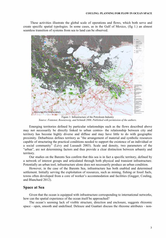
Transformer and converter platforms in the above plan, linked to electric cables, mark the
energy collector stations for groups of windparks (fig. 4). Neighbouring North Sea countries such as Belgium, the Netherlands, Denmark, Norway and England also have extensive off-shore energy networks, both planned and existing, criss-crossing the North Sea. This proximity of energy infrastructure has led to the conception of the “Supergrid” project, which could potentially centrally collect and distribute energy to the entire european network.
Figure 4: Planned and operating windparks, German EEZ, North Sea
Source: Global Offshore Windfarms Database accessed 14.06.2013 http://www.4coffshore.com
This example demonstrates the extent to which the hardware installed in the ocean, such as windparks and oilrigs, are producing new types of space and establishing a new scale of territorial organisation. These elements, plus the largely invisible networks they are connected to, have reached a threshold of density which has transformed the open character of this ocean space into a highly specialized and industrialised energy-park.
Conflicts of Flow
How can concrete planning tasks such as fuel production and the subsequent flows of energy respond to the specific spatial attributes of the ocean?
The marine spatial plan utilizes zoning as a tool to establish priority areas for uses of national economic importance, such as shipping and infrastructural corridors. The second priority for the German EEZ is energy production, and a total of 880km2 in the North Sea and 130 km2 in the Baltic Sea are currently designated as wind priority areas, which will make an important contribution to the German target of 30% electricity production from renewable sources by 2030 (BMU: Federal Ministry for the Environment, Nature Conservation and Nuclear Safety 2013). Achieving and maintaining the ocean’s ecological stability is a further objective of the plan. Here a range of methods are implemented; concentrating uses to economize on space, making

COULING: PLANNING FOR FLOW IN OCEAN SPACE
structures in the sea reversible (to be removed after use), defining natural protected areas according to the EU Natura 2000 directives, and maintaining large areas of undesignated “open space” as a characteristic ocean resource.
“The seascape should be safeguarded in its natural character and its typical vast open spaces should be preserved.” (BSH:Federal Maritime and Hydrographic Agency 2009b)
The plan is conceived as a framework and does not claim to have fully met the demands of planning ocean space. Seasonal, cyclic natural patterns of movement and distribution, such as fish populations, have as yet not been spatially articulated due partly to lack of reliable data, even though such parameters would seem to be essential to planning for a constant condition of flow. In the example of bird migration, however, data is available, and the results of a collision of use directly tangible. As an example of planning with flow, this situation will be examined in more detail.
In the case of the Baltic Sea, several migration paths cross the ocean both in a north/south and an east/west direction. An estimated 50.000-60.000 cranes, for example, make the autumn journey from Sweden southwards towards Rügen and Mecklenburg-Vorpommern in northern Germany on their way to France, Spain and North Africa, and vice-versa (fig. 5).
Figure 5. Crane migration in the western Baltic Sea. red= homeward path, green = outward path. Study commissioned by
the Federal Agency of Nature Conservation, Germany and carried out by The Institute of Applied Ecology. Source: IfAÖ 2005. Original in German:Vorkommen von See- und Zugvögeln in der westlichen Ostsee (Schwerpunkt
deutsche AWZ). Gutachten im Auftrag des Bundesamtes für Naturschutz (BfN). Institut für Angewandte Ökologie GmbH (IfAÖ), Neu Broderstorf, Germany
This path intersects with a priority zone for wind energy in the Baltic Sea and the approved
application for “EnBW Baltic 2” (fig 6.) - an 80-turbine park over an area of 27km2 which is scheduled to begin construction before October 2013.

SPACES AND FLOWS: AN INTERNATIONAL JOURNAL OF URBAN AND EXTRAURBAN STUDIES
Figure 6: Planned, approved and operating Windparksin the German EEZ, Baltic Sea
Source: BSH 2012
Space in the Baltic is limited- windpark priority zones are squeezed into residual areas after shipping zones and protected natural areas have been designated. Bird migration routes were also taken into consideration in the planning, but the precise route chosen by migrating birds will not necessarily adhere to zoning recommendations, being chosen rather according to atmospheric conditions among other factors.
Although cranes typically fly higher than the projected turbine height of 150m at EnBW Baltic 2, their flight path varies according to cloud height (fig 7.) and wind direction. In the case of unsuitable weather conditions, the cranes gather and wait. However, they may be forced to depart with a lower altitude if they tend to become behind schedule and the weather has not improved. The building permit requires that the responsible windpark operator provides further data on flight patterns and develops a plan to avoid collision, for example with “aversive conditioning installations” about which very little is yet known, or by switching off the turbines in the case of a large migration and low cloud.

COULING: PLANNING FOR FLOW IN OCEAN SPACE
Figure 7: Flight altitude of cranes over southern Sweden. Horizontal lines= cloud height Wind turbine type SWT-3.6-120
as planned for EnBW Baltic 2, height above sea level: 150m Source: original graph (Alterstam and Karlsson 1974) Turbine added by author.
Spatial planning in the German EEZ has clear priorities and obligations. The ocean has long
been described as first and foremost a private economic resource and secondly as the location for demonstrations of military power (Gröh 1988). As with other resources, the objective is to achieve effective management through planning. Comparing the pre-plan situation with the projected results, the environmental report concludes that the ocean environment stands to gain from the spatial plan, since disturbances to the ecosystem will at least be controlled and spatially restricted (BSH:Federal Maritime and Hydrographic Agency 2009a).
Territorial Constitutions for the Barents Sea
Laba students initiated their Barents research with an extensive regional analysis and were then free to develop planning concepts which addressed development pressure in the Barents Sea, which is estimated to contain around 25% of the world’s oil, and 30% of the world’s gas reserves. Such an investigation, focused on a body of water five times the size of Norway, also presented the opportunity to research the dynamics of other forces driven by important fish, mammal, bird and plankton populations. A differentiated underwater topography is one of the physical characteristics of the site as well as the seasonal transformation from a liquid to solid state, allowing the polar bear population, for example, to move from one archipelago to another. Throughout the average depth of 230m, the site is constantly changing according to currents, temperature, salinity and migration. The complexity, vulnerability and critical importance of this territory on a global scale soon became apparent.
These rich and diverse local conditions formed the basis for the proposals, which were nevertheless required to take the global significance of the territory into consideration. The Territorial Constitutions provide an answer to the investigative questions- how can urban design methods and principles be applied to ocean territory and how can natural “clients” such as inhabitants, or phenomena such as ice, be catered for in planning terms?

SPACES AND FLOWS: AN INTERNATIONAL JOURNAL OF URBAN AND EXTRAURBAN STUDIES
A Pool of Resources
This territorial constitution chose to treat the natural resources - the “Earth Constituents”- as their Barents Sea planning clients, a position which represents a reversal in planning philosophy and questions the evolution of human behaviour towards the environment. Based on environmental conditions, the development plan foresees priority zones for natural resources; plankton priority areas, seafloor priority areas (marine forests, bethnic organisms and cold-water coral reefs), priority fish spawning areas, priority seabird breeding areas and migration routes and priority areas for marine mammals including the polar bear (fig 8.). Activities harmful to the natural resources are banned within these priority zones, and shipping routes must be tightly controlled and/or deviated accordingly. In this plan infrastructure gives way to the Earth Constituents.
Threats to the environment are interrelated; pollution, overfishing, increasing installation of infrastructure and global warming. Detoxification programmes for existing nuclear waste in the Barents Sea are a priority- these include sunken nuclear submarines and radioactive remains of the nuclear tests carried out by the Soviet Union in the Novaya Zemlya archipelago in 1961. In one of the tests, the largest and most powerful nuclear weapon ever detonated, the three-stage hydrogen bomb Tsar Bomba, was used.
Figure 8: Priority areas, Barents Sea territorial constitution “A Pool of Resources”
Source: laba 2011

COULING: PLANNING FOR FLOW IN OCEAN SPACE
Figure 9: Areas of renewable energy production, Barents Sea territorial constitution “A Pool of Resources”
Source: Laba 2011
To relieve the pressure on the Barents Sea for oil and gas production, this constitution proposes equivalent energy yields through renewable sources, a commodity the Barents Sea also holds in abundance (fig.9). The following measures are recommended;
x oil platforms are transformed into bio-fuel production platforms, utilising the Sea’s excess production of algae
x harnessing of tidal energy in water depths of less than 100m and where tidal differences are significant, such as the Mezen Bay (White Sea/ Barents Sea) with a 6m difference
x conversion of stream energy is possible in currents greater than 0,25m/s x offshore wind energy in areas where wind-speeds are over 8m/s, in maximum
depths of 200m and outside bird migration paths. Windparks can also provide the infrastructure required for offshore algae production.
The proposed measures make the Barents Sea an exemplary case, conceptually endowing the natural resources with legislative power. Rather than declaring the area a marine park, the project aims to articulate the differentiated topography and topology of the sea, and find the appropriate tools for a biologically-driven long-term plan. These two examples demonstrate diverse strategies to plan for flows in ocean space.
The Territorial Constitution “A Pool of Resources” integrates seasonal flows of bird, fish and animal life into its strategy, which are a reflection of dynamic environmental conditions such as sea and wind currents, ice formation, bathymetry and food supply. Planning geometries and boundaries are determined by topographical features and natural events.
The Marine Spatial Plan, on the other hand, although also defining extensive protected areas, is concerned with maintaining “inorganic” flows - those of materials, energy and information, and uses Cartesian geometric devices to create these boundaries. Cyclic processes are currently represented by the limited “leasing” of ocean space for wind parks over a maximum period of 25 years, whereas the removal of cables, pipelines and other infrastructure may in fact prove to

SPACES AND FLOWS: AN INTERNATIONAL JOURNAL OF URBAN AND EXTRAURBAN STUDIES
damage the newly adapted ecosystem on the ocean bed, and become a permanent fixture.Some aspects of marine spatial planning, as exemplified by the plan for the German EEZ, are familiar and directly comparable to regional planning on land. Laba’s territorial constitution, on the other hand, articulates the dynamics of an exclusively fluid environment.
Comprehensive ocean planning would require a synthesis of both systems, a combination of strategies responding to both fixed and fluid elements and where infrastructure can react to seasonal conditions; an urbanism of flows.
Conclusion—Inherent Ocean Space
The territorialisation of the ocean has been seen to be structured around systems of flow and exchange - new and historic trade routes as well as the permanent materialisation of trade into trans-ocean energy arteries. As a liquid medium, the ocean would seem to provide an ideal environment of minimal friction, ease of transfer and reduced boundary situations for such systems. Undersea pipelines, for example, are chosen precisely for these reasons-
“Offshore lines minimize issues of land ownership and concerns of political instability” (Timmermans 2002).
Between such infrastructural trading corridors, what is the inherent nature of ocean space? Are spaces and flows complementary within this spatial system? The open sea is a neutral, scale-less, undetermined space from the point of view of ordinary human perception - this excludes experts equipped to read the ocean through either scientific or cultural knowledge such as the early Polynesian navigators (Howe 2007). It is undetermined in that it appears to have no direction and no orientation. Yet it is a space in continual flux, visually bounded only by the ultimate boundary - the horizon. The word horizon originates from the greek verb to divide (horizö) and boundary, landmark (oros). Although the real horizon quickly disappears from view - at a distance of ca. 5 kms from the natural human viewpoint- an object’s height and distance from the viewer determines the moment of its disappearance over the horizon. The open sea provides the possibility to experience space in its purest most abstract form. This is the closest we come to a space devoid of spatial information, or “visual depth cues” which can mediate between the body and its environment, transmitting information on scale and distance (Howard and Rogers 2012,122).
These spatial attributes would seem to support the condition of flow - flows of different types and dimensions, in different directions, at differing speeds. Flow is seemingly unconcerned with distance and scale. While accommodating vast networks which form new territorial bonds, the scale-less dimension of the above-surface ocean means it is also capable of accommodating the “non-territorial” condition. A condition conducive to undefined, undetermined interaction, or lack of social action, and therefore “natural space” as described by Lefebvre (Lefebvre 1991, 83). It follows that this attribute makes the sea a confluent space- capable of taking on different, integrative roles, as long as an undetermined space still exists.
“Cultural action, the making & remaking of identities, takes place in the contact zones, along the policed and transgressive intercultural frontiers of nations, peoples, locales” (Clifford 1997).
The inherent space of the ocean can be seen as a space of flows - a space determined by the unhindered condition of flow, which however, is also determined by natural and cultural cycles and its own spatial logic. Operations of ocean urbanization must take this into consideration and respect and nurture this condition.

COULING: PLANNING FOR FLOW IN OCEAN SPACE
Acknowledgements
Thanks to laba students and authors of the Territorial Constitution “A Pool of Resources”; Giulia Altarelli, Elsa Beniada and Martin Lepoutre, 2011/12. Anthony Fontenot, Jakob Rosenzweig and Anne Schmidt for permission to publish “Infrastructure of Petroleum Industry”, Exposing New Orleans (2006).

SPACES AND FLOWS: AN INTERNATIONAL JOURNAL OF URBAN AND EXTRAURBAN STUDIES
REFERENCES
Alterstam, Thomas, and Johnny Karlsson. 1974. ‘Radar Measurements of Flight Altitudes of Migrating Cranes, Grus Grus, over Southernmost Skåne, Sweden’. Vår Fågelv. 33: 265–269.
Asariotis, Regina, Hassiba Benamara, Jan Hoffmann, and Gordon Wilmsmeier. 2008. ‘Review of Maritime Transport 2008: Report by UNCTAD Secretariat’. New York and Geneva: UN. http://unctad.org/en/docs/rmt2008_en.pdf.
Ballard, Robert. 2000. 7KH� (WHUQDO� 'DUNQHVVࣟ�� D� 3HUVRQDO� +LVWRU\� RI� 'HHS-sea Exploration. Princeton, New Jersey: Princeton University Press.
BMU: Federal Ministry for the Environment, Nature Conservation and Nuclear Safety. 2013. ‘Long-term Development Path’. Energy Concept 2050 - Milestones and Assessments. Accessed July 5. http://www.bmu.de/en/topics/climate-energy/transformation-of-the-energy-system/resolutions-and-measures/energy-concept-2050-milestones-long-term-development-path-for-ambitious-climate-protection-targets-energy-efficiency-and-renewables/.
BSH: Federal Maritime and Hydrographic Agency. 2009a. ‘Umweltbericht Zum Raumordnungsplan Für Die Deutsche Ausschließliche Wirtschaftszone (AWZ) in Der Ostsee’.
BSH: Federal Maritime and Hydrographic Agency. 2009. ‘Marine Spatial Plan for the Exclusive Economic Zone of the Baltic Sea.’ http://www.bsh.de/en/Marine_uses/Spatial_ Planning_in_the_German_EEZ/documents2/Spatial_Plan_Baltic_Sea.pdf.
Clifford, James. 1997. 5RXWHVࣟ�� 7UDYHO� DQG� 7UDQVODWLRQ� LQ� WKH� /DWH� 7ZHQWLHWK� &HQWXU\. Cambridge, Massetc: Harvard University Press.
Deleuze, Gilles, and Félix Guattari. 2005. A Thousand Plateaus: Capitalism and Schizophrenia. Minneapolis: University of Minnesota Press.
Fontenot, Anthony, Jakob Rosenzweig, and Anne Schmidt. 2006. ‘Infrastructure of the Petroleum Industry’. www.exposingneworleans.org.
Gröh, Walter. 1988. )UHLKHLW� GHU� 0HHUHࣟ�� GLH� $XVEHXWXQJ� GHV� µJHPHLQVDPHQ� (UEes der Menschheit’. Bremen: Edition CON.
Gugger, Harry, Couling, Nancy, and Blanchard, Aurélie, (eds). 2012. Barents Lessons. Teaching and Research in Architecture. Zürich: Park Books.
Gunnarsson, Bjorn. 2012. ‘Infrastructure, Shipping & Logistics in the Arctic’ presented at the Seminar Kirkenes, AHO/EPFL, February 21, Kirkenes, Norway.
Howard, Ian P., and Brian J. Rogers. 2012. Perceiving in Depth. Oxford: Oxford University Press.
Howe, K. R., ed. 2007. Vaka Moana Voyages of the Ancestors the Discovery and Settlement of the Pacific. Honolulu: University of Hawaii Press.
Koh, Tommy T. B. 1982. ‘A Constitution for the Oceans’. http://www.un.org/Depts/ los/convention_agreements/convention_overview_convention.htm.
Lefebvre, Henri. 1991. The Production of Space. Translated by Donald Nicholson-Smith. Oxford: Blackwell.
Lefebvre, Henri. 2003. The Urban Revolution. Minneapolis: University of Minnesota Press. Lévy, Jacques and Lussault, Michel. 2003. Dictionnaire de la géographie. Paris: Belin. Nolte, Nico. 2010. ‘Nutzungsansprüche und Raumordnung auf dem Meer’. Hansa International
Maritime Journal 147 (9): 79–83. Pierce, Neil. R., and Curtis W. Johnson. 2009. Century of the City: No Time to Lose. New York:
Rockefeller Foundation.
COULING: PLANNING FOR FLOW IN OCEAN SPACE
Rodrigue, Jean-Paul. 2010. ‘Maritime Transportation: Drivers for the Shipping and Port Industries’. In International Transport Forum.
Savoy, Daniel. 2012. 9HQLFH�IURP�WKH�:DWHUࣟ��$UFKLWHFWXUH�DQG�0\WK�LQ�DQ�(DUO\�0RGHUQ�&LW\. New Haven, Conn: Yale University Press.
Stopford, Martin. 2009. Maritime Economics. 3rd ed. London: Routledge. Timmermans, Willem, J. 2002. ‘The Future of Offshore Pipelining’. Offshore Magazine 62 (6)
(June 1). UN. 1982. ‘UNCLOS 1982’. http://www.un.org/Depts/los/convention_agreements/convention_
overview_convention.htm.
ABOUT THE AUTHOR
Nancy Couling: Nancy Couling is an architect and doctoral assistant at laba (EPFL Laboratoire Bâle). Currently specialising in the urbanization of the sea, she coordinated the “Barents Sea” project at laba 2011/12 and co-edited the prize-wining book Barents Lessons—Teaching & research in Architecture, in 2012. This research is continuing as a doctoral thesis, to be completed in 2015. She is EPFL coordinator of the urban laboratory network Urban Lab +, which includes 7 further international urban design laboratories in Europe and the global south. Nancy previously co-led the architectural/urban design partnerships cet-0 and cet-01 in Berlin (1995-2010), earning recognition for long-term development strategies within unstable contexts undergoing transformation, particularly in former East Germany. Cet-01 also realised architectural prototypes within several federally funded interdisciplinary research projects. Parallel to practice, she taught architecture and urban design at the Technische Universität Berlin in 2000–2005 and 2008–2009, addressing core issues of urban design in diverse cultural contexts including China, Italy, New Zealand, Switzerland and Germany.

Spaces and Flows: An International Journal of Urban and ExtraUrban Studies addresses some of the most pressing social, cultural, economic and environmental questions of our time, focusing on spaces and flows as crucibles and vectors of ongoing transformation.
The journal discusses several central questions: What are the new and emerging spaces of production, consumption, and human living as communities, regions, and societies organize and re-organize in contemporary times? And what are the new flows of people, goods, services, information, and ideas? How are they being constructed and how are they functioning?
The issues addressed in the journal oscillate between the local and the global, the empirical and the theoretical, the utopian and the pragmatic, the disciplinary and the transdisciplinary, research and its
application, and the practices of knowledge making and those of knowledge dissemination.
In addition to traditional scholarly papers, this journal invites case studies that take the form of presentations of practice—including documentation of spatial practices and exegeses analyzing the effects of those practices.
Spaces and Flows: An International Journal of Urban and ExtraUrban Studies is a peer-reviewed scholarly journal.
ISSN 2154-8676