space-time adjustments to transportation, … adjusting_technologies.pdf · space-time adjustments...
TRANSCRIPT

Space-Time Adjustments to Transportation, Communication, and Information
Technologies – Social Consequences and Policy Issues
Donald G. JanelleCenter for Spatially Integrated Social Science
University of California, Santa Barbara
University of Southern California6 March 2002
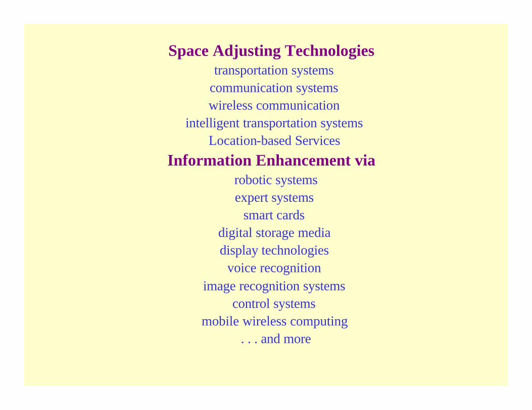
Space Adjusting Technologiestransportation systems
communication systemswireless communication
intelligent transportation systemsLocation-based Services
Information Enhancement viarobotic systemsexpert systems
smart cards digital storage media display technologies
voice recognition image recognition systems
control systemsmobile wireless computing
. . . and more


Adapted by M. van Geenhuizen (2002) from Mitchell (1999)

Space-Time Transformations
Time-space Convergence Time-space Compression
Human Space-time Extensibility Trackability and LBS
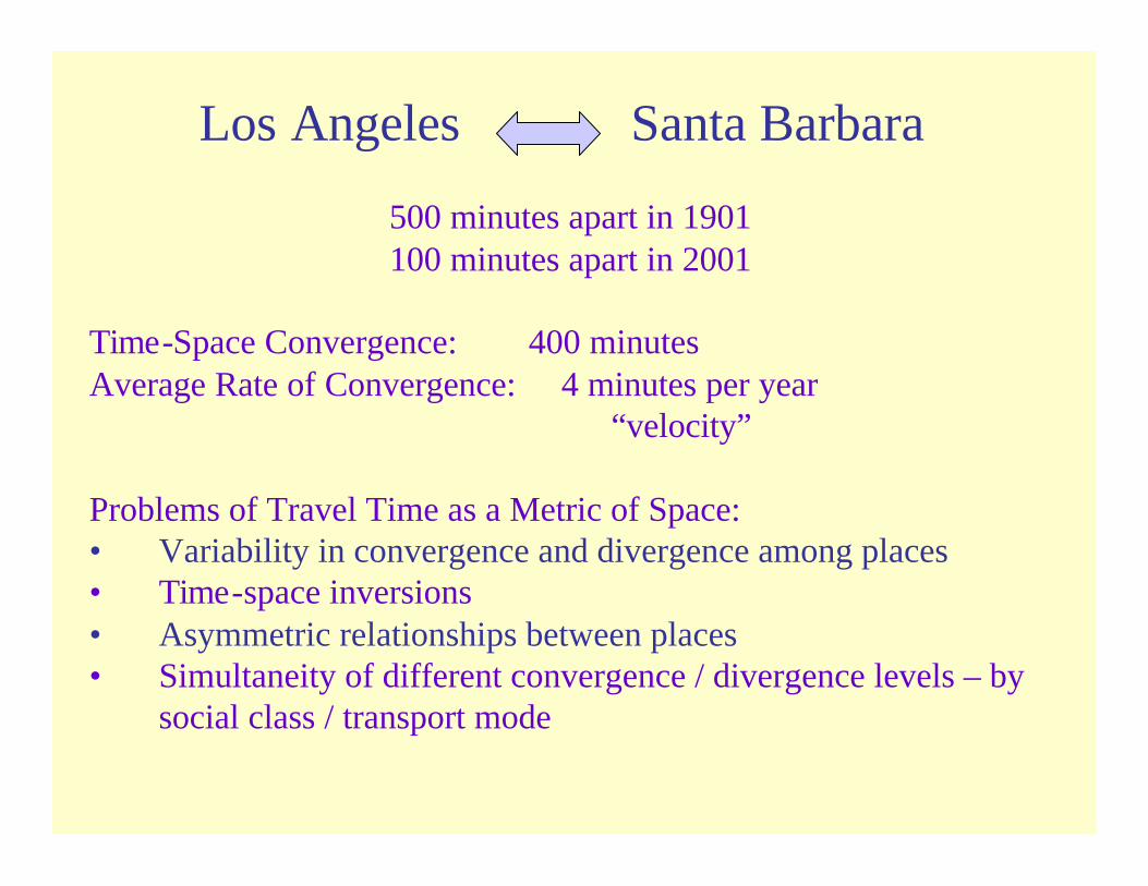
Los Angeles Santa Barbara
500 minutes apart in 1901100 minutes apart in 2001
Time-Space Convergence: 400 minutesAverage Rate of Convergence: 4 minutes per year
“velocity”
Problems of Travel Time as a Metric of Space:• Variability in convergence and divergence among places• Time-space inversions• Asymmetric relationships between places• Simultaneity of different convergence / divergence levels – by
social class / transport mode
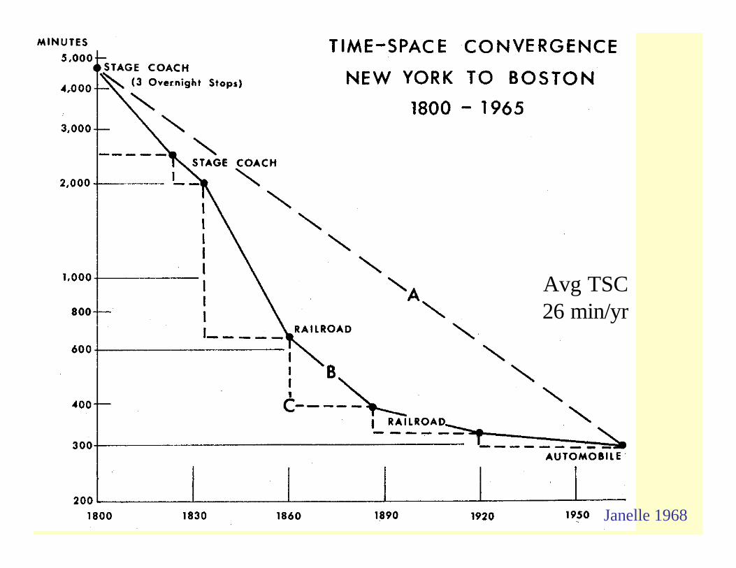
Avg TSC26 min/yr
Janelle 1968

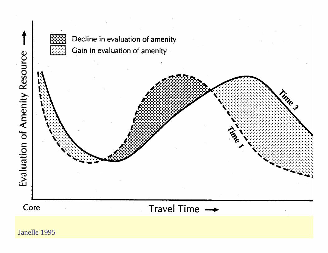
Time-Space Convergence Metropolitan Expansion
• Morphologies of Cities • Topologically Equivalent Locations• TSC and Susceptible Land Supply• Behavioral Responses to TSC – the Quest for
Amenity

Janelle 1995
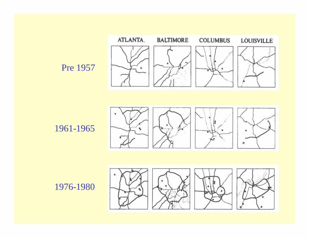
Pre 1957
1961-1965
1976-1980
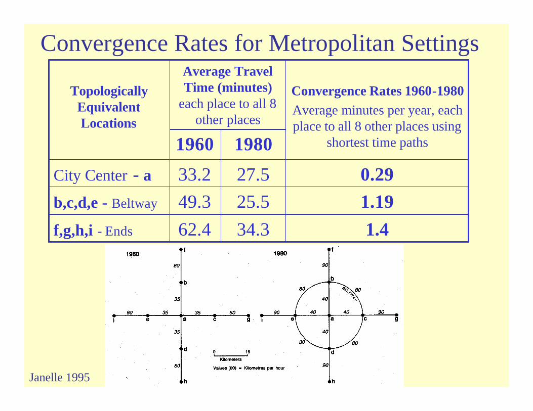
Convergence Rates for Metropolitan Settings
1.434.362.4f,g,h,i - Ends
1.1925.549.3b,c,d,e - Beltway
0.2927.533.2City Center - a
19801960
Convergence Rates 1960-1980Average minutes per year, each place to all 8 other places using
shortest time paths
Average Travel Time (minutes)
each place to all 8 other places
Topologically Equivalent Locations
Janelle 1995

Travel Speeds and Accessible Land Resources from Urban Center
14103675080
5027403080
3848353070
2827303060
Land Resource(Sq Km)
Potential Distance from City Center
(km)
Average Daily Commuter Trip (1-
way minutes)Average Travel Speed (Km/hr)
Janelle 1999
Janelle 1995

Adapted from Guert Hupkes
1982
Janelle 1995

Time-space Compression
• David Harvey – 1989 The Condition of Post Modernity– 2001 Spaces of Capital
• Experiential – pace of life / escalation of events• ‘Annihilation of space by time’ (Marx)
– Links to capital accumulation process – speeding up production, exchange, circulation, consumption
Human Space-time Extensibility• ‘Measuring human extensibility in a shrinking
world’ (Janelle 1973)
– The reciprocal of time-space convergence– Interaction beyond one’s immediate physical
presence– Projection of authority and of one’s presence
over space and time• Parallels with Anthony Giddens’ ‘time-space
distanciation’ (1981, 1984) – Stretching social systems across space and time
Recent Research Human Space-time Extensibility
• Paul Adams ‘A reconsideration of personal boundaries in space-time’ (1995); ‘CAD-based accessibility model’ (2000)
– People as branching structures – The extensibility diagram– Linking micro and macro scales – the role of IT– Using CAD with data collected though personal
interviews and detailed records of communication activities
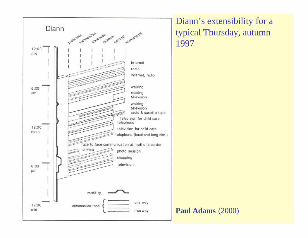
Diann’s extensibility for a typical Thursday, autumn 1997
Paul Adams (2000)
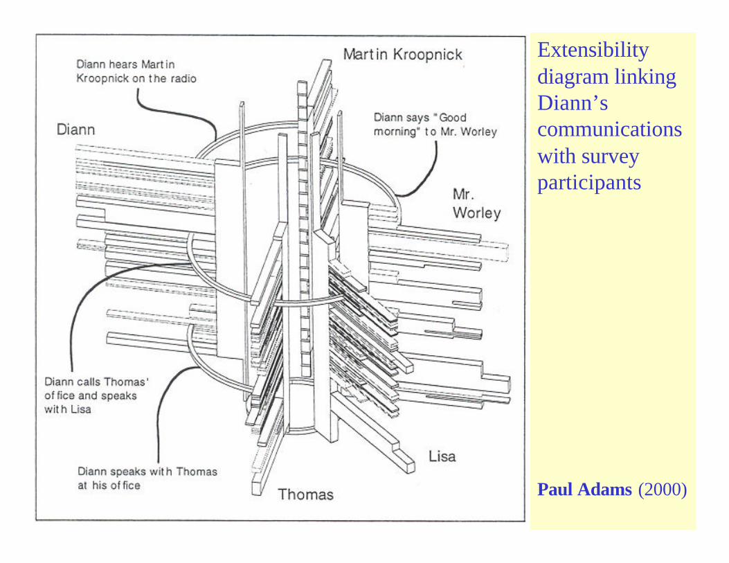
Extensibility diagram linking Diann’scommunications with survey participants
Paul Adams (2000)

Paul Adams 1999, Bringing globalization home: A homeworker in the Information Age
Recent Research Human Space-time Extensibility
• Mei-Po Kwan ‘Human extensibility and individual hybrid-accessibility’ (2000)– Cartographic visualization of interaction in
cyberspace and physical space– Extensibility diagram as analytic tool within 3D GIS
using data from Web browser logs and personal interviews

Mei-Po Kwan 2000 ‘Human extensibility and individual hyprid-accessibility in space-time: A multiscale representation using GIS

Multi-scale Extensibility diagram 3D GIS using data from Web browser logs and personal interviews
Mei-Po Kwan 2000
Trackability
• Consensual– Space-time activity diaries– Travel surveys
• Indirect surveillance– Zip code matching of Credit card expenditure
patterns (M.J. Weiss, The Clustering of America; O.H. Gandy Jr. The Panoptic Sort)
• Direct real-time surveillance– Cameras, mobile phone, GPS, telemetry
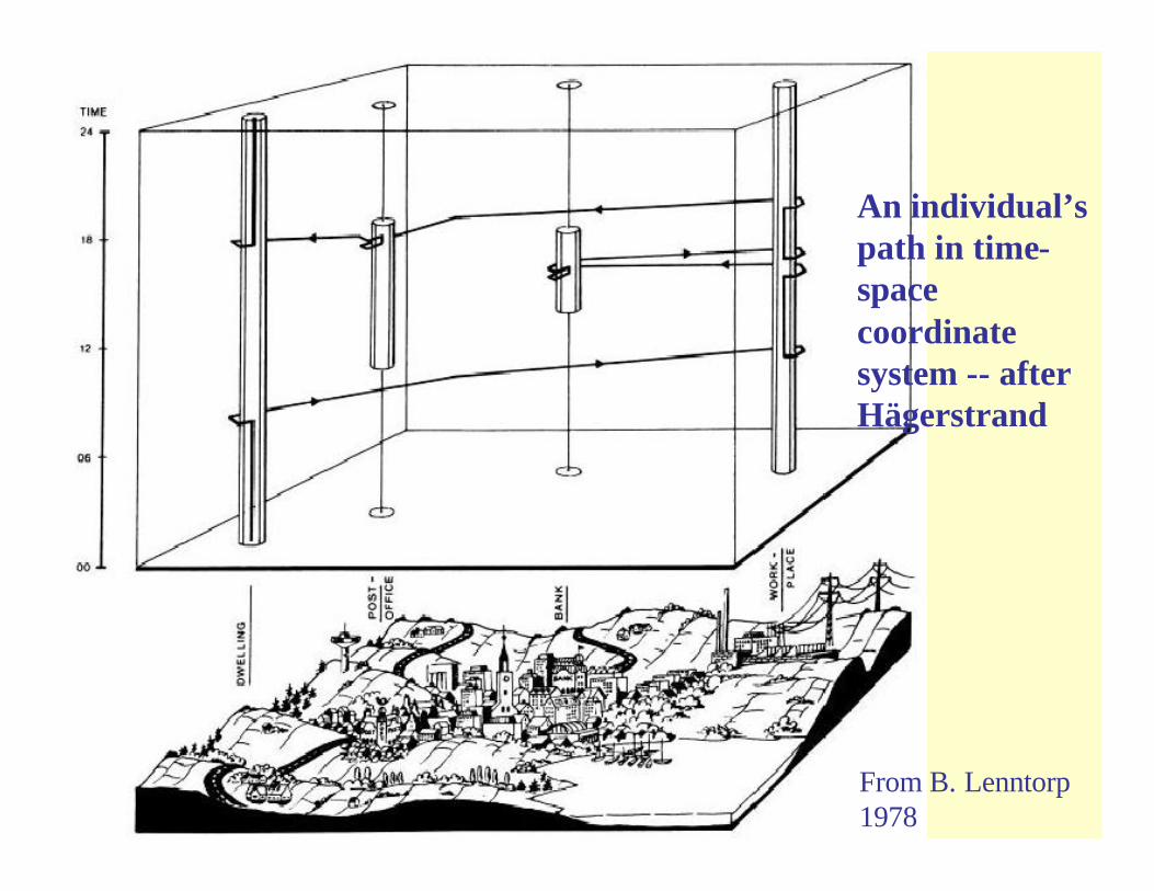
From B. Lenntorp1978
An individual’s path in time-space coordinate system -- after Hägerstrand
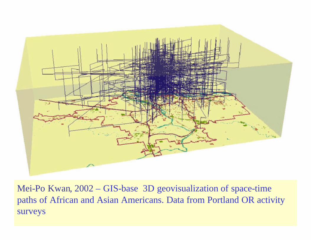
Mei-Po Kwan, 2002 – GIS-base 3D geovisualization of space-time paths of African and Asian Americans. Data from Portland OR activity surveys

The Time Geography of a Canadian City Project• DOMA (Dimensions of Metropolitan Activity) study of Halifax
CanadaSpace-time budget surveys and analyses (Andrew Harvey 1971-72).– Approx 2100 one-day diaries spread over the week / – 99 activity types (Multinational Time Budget Study, Szalai 1972)– space-time coded to a resolution 1-minute in time and 100 meters in space
• Time Geography of a Canadian City Project (Janelle & Goodchild)– Reconstructing “census-like” data for any time of day– Factorial ecology based on activity data instead of census data (who is where
when? What are they doing and with whom?)• PARAFAC 3-mode solution (activities, space, and time)
– What is the link between individual behavior and urban ecological structure?
•Janelle & Goodchild, Economic Geog (1983), Urban Geog (1983)
•Goodchild & Janelle, Environment & Planning A (1984)
•Goodchild, Klinkenberg, & Janelle, Geographical Analysis (1993)
•Janelle, Klinkenberg, & Goodchild, Geographical Systems (1997)
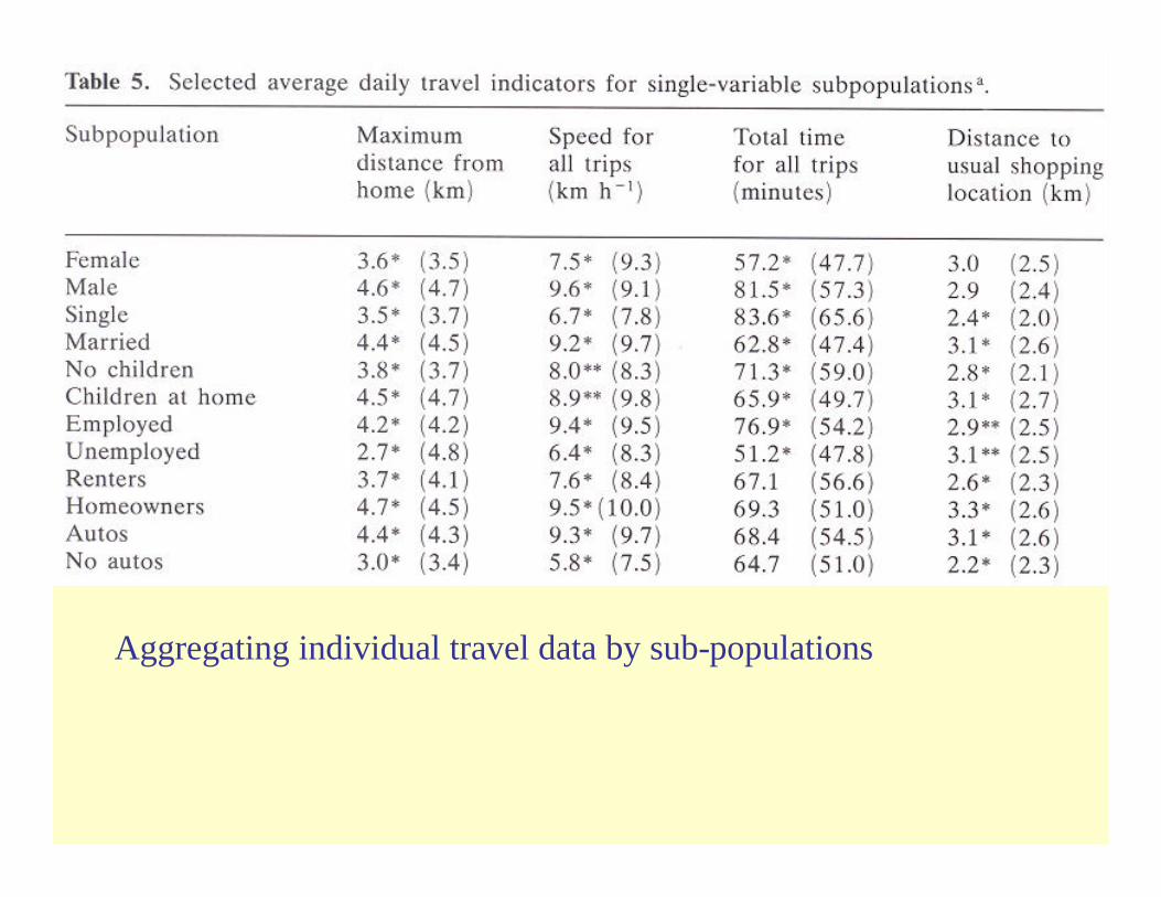
Aggregating individual travel data by sub-populations

Role-group correlations in space by time of day (for selected hours)
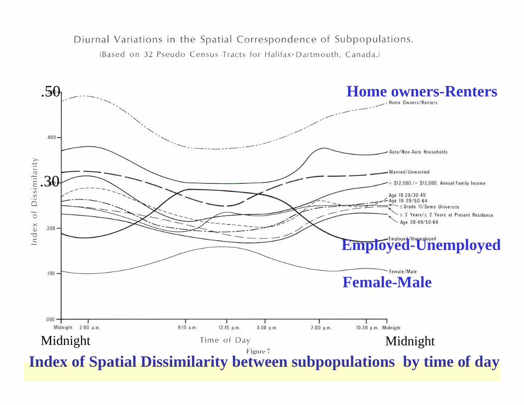
Index of Spatial Dissimilarity between subpopulations by time of day
Employed-Unemployed
Home owners-Renters
Female-Male
MidnightMidnight
.50
.30

Location Quotients –Concentration of Unmarried Respondents by time of day
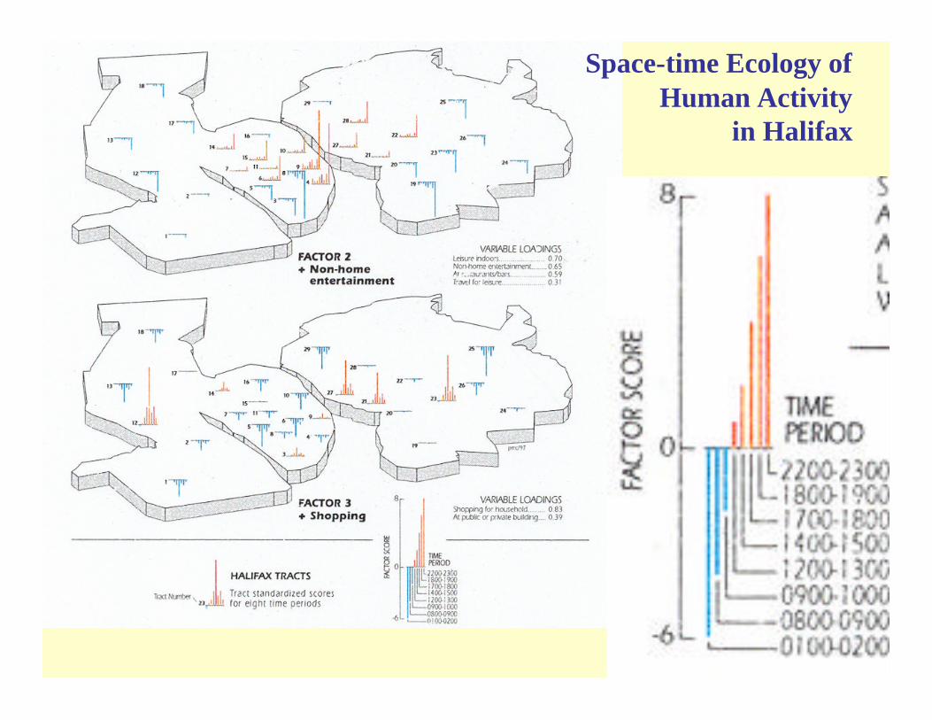
Space-time Ecology ofHuman Activity
in Halifax
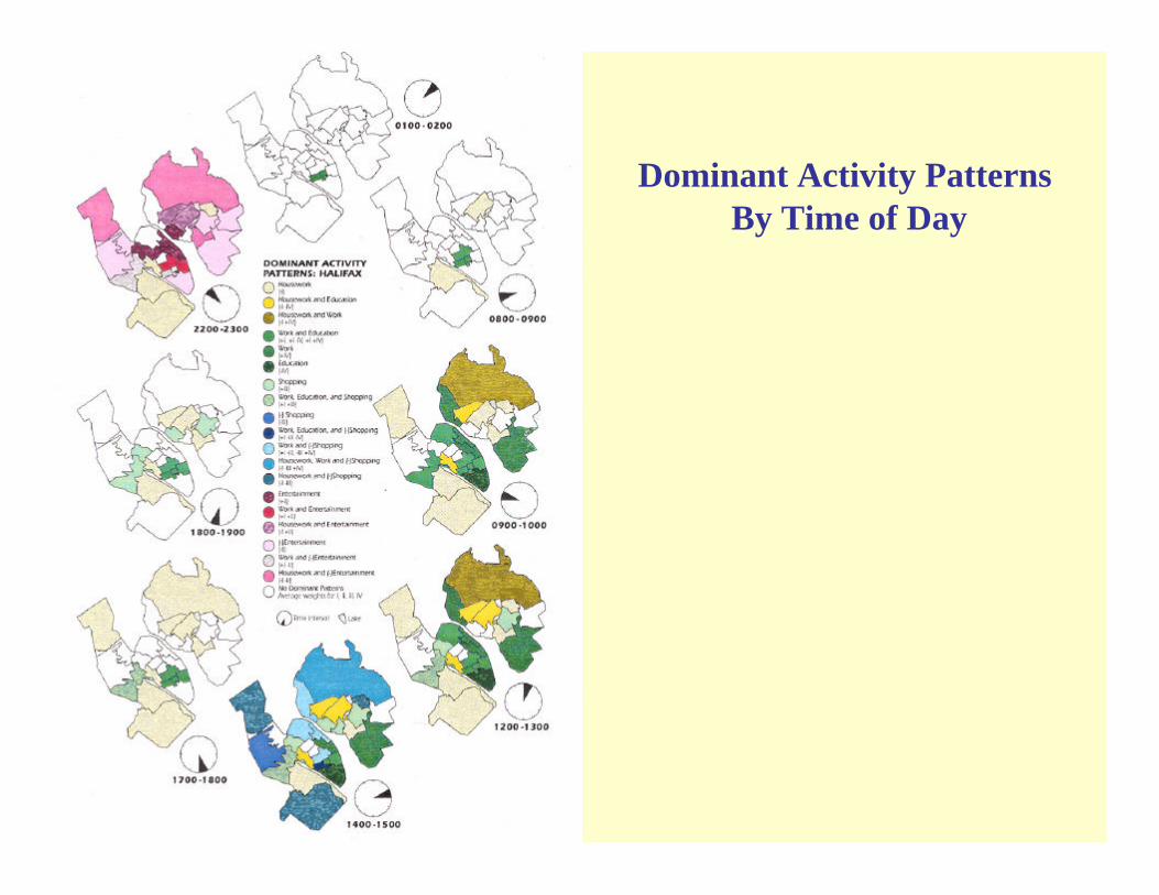
Dominant Activity Patterns By Time of Day
Location Based Services
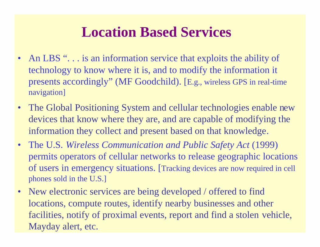
• An LBS “. . . is an information service that exploits the ability of technology to know where it is, and to modify the information itpresents accordingly” (MF Goodchild). [E.g., wireless GPS in real-time navigation]
• The Global Positioning System and cellular technologies enable new devices that know where they are, and are capable of modifying the information they collect and present based on that knowledge.
• The U.S. Wireless Communication and Public Safety Act (1999) permits operators of cellular networks to release geographic locations of users in emergency situations. [Tracking devices are now required in cell phones sold in the U.S.]
• New electronic services are being developed / offered to find locations, compute routes, identify nearby businesses and other facilities, notify of proximal events, report and find a stolen vehicle, Mayday alert, etc.

Nokia prognosis for 3G mobile communication
Monthly income pr. user in euro (1 euro = 1 USD ca.)
2000 2001 2002 2003 2004 2005 2006 2007 2008 2009 2010 2011
0
10
20
30
40
50
60
70
80
90
100
Location based services
Commercials
EntertainmentInformation servicesPayment transactionsMusic and videoInternet surfingDownload from internetChat on internetMultimedia messages
Text messages
Vide conferencing
Normal speech
Fixed subscription fees
Div. telecomm.
Photo messages
From T John Kim 2002
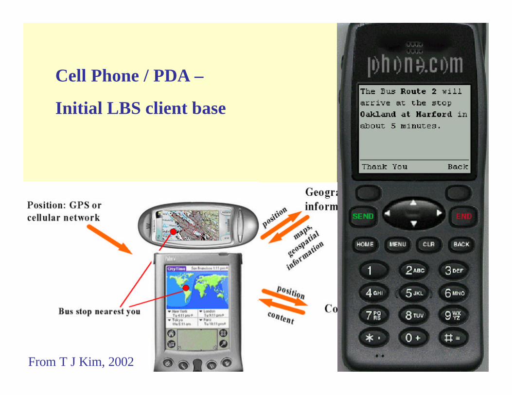
Cell Phone / PDA –
Initial LBS client base
From T J Kim, 2002
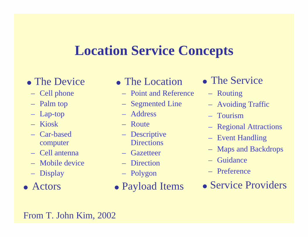
Location Service Concepts
= The Device– Cell phone – Palm top – Lap-top – Kiosk – Car-based
computer– Cell antenna – Mobile device– Display
= Actors
= The Location– Point and Reference– Segmented Line– Address– Route– Descriptive
Directions– Gazetteer– Direction– Polygon
= Payload Items
= The Service– Routing– Avoiding Traffic– Tourism– Regional Attractions– Event Handling– Maps and Backdrops– Guidance– Preference
= Service Providers
From T. John Kim, 2002
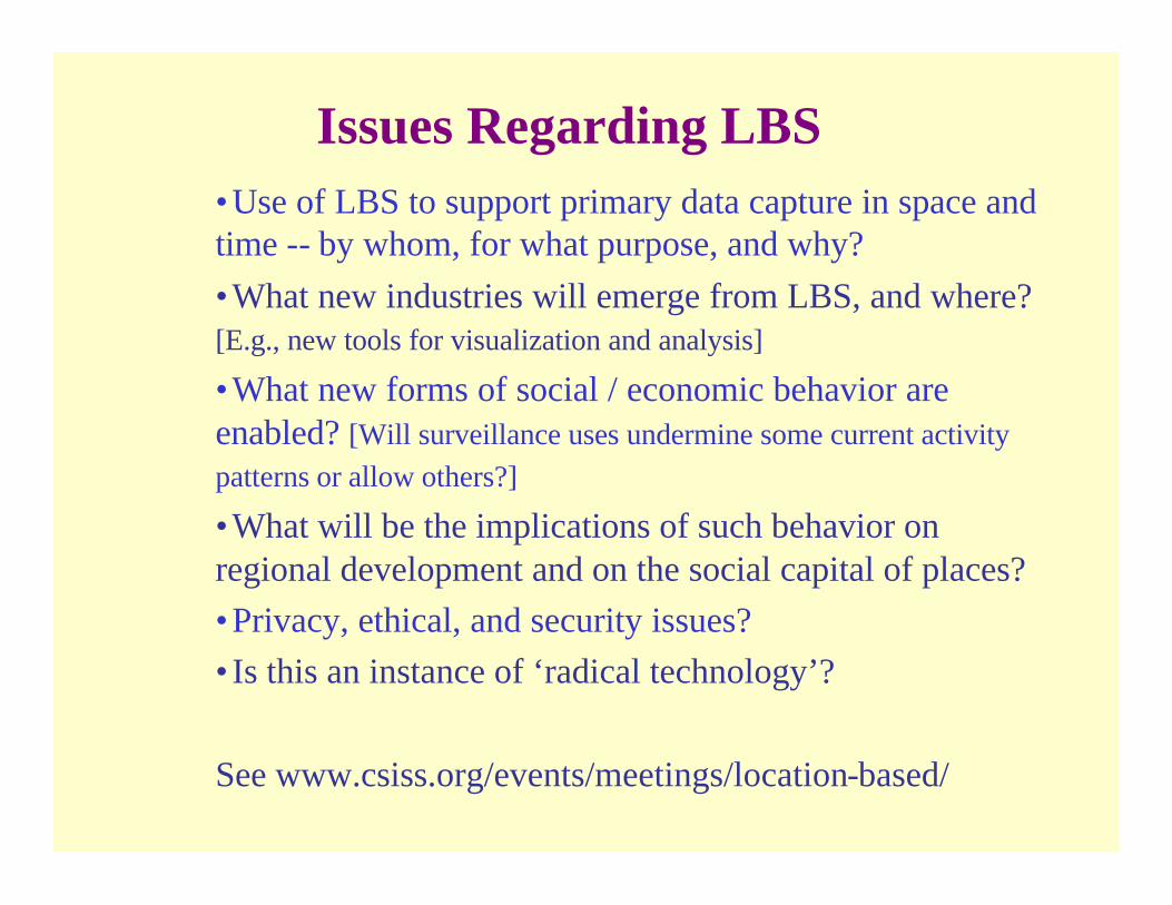
Issues Regarding LBS•Use of LBS to support primary data capture in space and time -- by whom, for what purpose, and why?•What new industries will emerge from LBS, and where? [E.g., new tools for visualization and analysis]
•What new forms of social / economic behavior are enabled? [Will surveillance uses undermine some current activity patterns or allow others?]
•What will be the implications of such behavior on regional development and on the social capital of places?•Privacy, ethical, and security issues?•Is this an instance of ‘radical technology’?
See www.csiss.org/events/meetings/location-based/
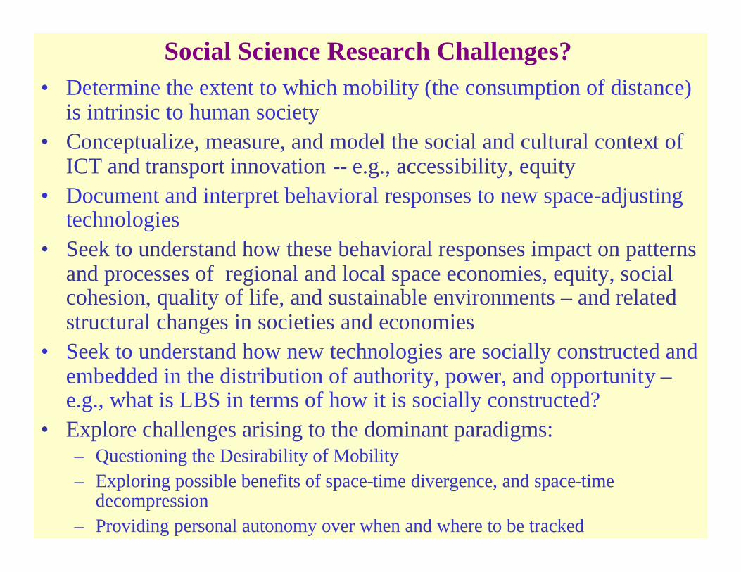
Social Science Research Challenges? • Determine the extent to which mobility (the consumption of distance)
is intrinsic to human society• Conceptualize, measure, and model the social and cultural context of
ICT and transport innovation -- e.g., accessibility, equity• Document and interpret behavioral responses to new space-adjusting
technologies• Seek to understand how these behavioral responses impact on patterns
and processes of regional and local space economies, equity, social cohesion, quality of life, and sustainable environments – and related structural changes in societies and economies
• Seek to understand how new technologies are socially constructed and embedded in the distribution of authority, power, and opportunity –e.g., what is LBS in terms of how it is socially constructed?
• Explore challenges arising to the dominant paradigms:– Questioning the Desirability of Mobility– Exploring possible benefits of space-time divergence, and space-time
decompression– Providing personal autonomy over when and where to be tracked

Policy Issues and Measures
• Facilitating constructive uses of new information and communication technologies to enhance accessibility
• Protecting/respecting individual autonomy over personal information and behavior
• Protecting/respecting a minimum basic economic and cultural autonomy for places, regions, and nations
• Protecting vulnerable environments and populations from destructive uses of new technologies

References• Paul Adams 1999, ‘Bringing globalization home: A homeworker in the Information Age” Urban
Geography 20:356-76• Paul Adams 1995 ‘A reconsideration of personal boundaries in space-time’ Annals of the Association of
American Geographers 85: 267-85.• Paul Adams “Application of a CAD-based accessibility model’ In Janelle and Hodge (2000)• MF Goodchild and DG Janelle, The City Around the Clock: Space-Time Patterns of Urban Ecological
Structure Environment and Planning, A 16 (1984) 807-20.• MF Goodchild and B Klinkenberg, and DG Janelle, A Factorial Model of Aggregate Spatio-Temporal
Behavior: Application to the Diurnal Cycle, Geographical Analysis 5, (Oct 1993) 277-94.• O.H. Gandy Jr. The Panoptic Sort• David Harvey 1989 The Condition of Post Modernity• David Harvey 2001 Spaces of Capital• DG Janelle, Metropolitan Expansion, Telecommuting, and Transportation, in S Hanson, ed, The
Geography of Urban Transportation, second edition (New York: Guilford Press, 1995) 407-34.• DG Janelle, Urban Social Behavior in Time and Space, in LS. Bourne and D Ley, eds, Social Geography
of Canadian Cities (McGill-Queens Press and the Canadian Association of Geographers, 1993) 103-18• DG Janelle, Time Space Convergence and Urban Transportation Issues, in Systems Thinking and the
Quality of Life. CK Blong, ed (Washington, DC: The Society for General Systems Research, 1975) 594-600.
• DG Janelle, Transportation Innovation and the Reinforcement of Urban Hierarchies, High Speed Ground Transportation Journal 8 (Fall 1974) 261-69.
• DG Janelle, Measuring Human Extensibility in a Shrinking World, Journal of Geography 72 (May 1973) 8-15.
References (cont.)
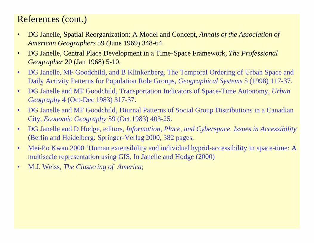
• DG Janelle, Spatial Reorganization: A Model and Concept, Annals of the Association of American Geographers 59 (June 1969) 348-64.
• DG Janelle, Central Place Development in a Time-Space Framework, The Professional Geographer 20 (Jan 1968) 5-10.
• DG Janelle, MF Goodchild, and B Klinkenberg, The Temporal Ordering of Urban Space and Daily Activity Patterns for Population Role Groups, Geographical Systems 5 (1998) 117-37.
• DG Janelle and MF Goodchild, Transportation Indicators of Space-Time Autonomy, Urban Geography 4 (Oct-Dec 1983) 317-37.
• DG Janelle and MF Goodchild, Diurnal Patterns of Social Group Distributions in a Canadian City, Economic Geography 59 (Oct 1983) 403-25.
• DG Janelle and D Hodge, editors, Information, Place, and Cyberspace. Issues in Accessibility(Berlin and Heidelberg: Springer-Verlag 2000, 382 pages.
• Mei-Po Kwan 2000 ‘Human extensibility and individual hyprid-accessibility in space-time: Amultiscale representation using GIS, In Janelle and Hodge (2000)
• M.J. Weiss, The Clustering of America;