commercial space transportation
TRANSCRIPT
AdministrationFederal Aviation
FY-2009Research and DevelopmentAccomplishmentsOctober 2009
Commercial Space Transportation
Federal Aviation AdministrationAssociate Administrator for Commercial Space Transportation
800 Independence Avenue, S.W., Rm. 331Washington, D.C. 20591
www.ast.faa.gov HQ
-109
86.IN
DD
Commercial Space Transportation

Available fromFederal Aviation Administration
Associate Administrator for Commercial Space Transportation800 Independence Avenue, S.W., Rm. 331
Washington, D.C. 20591
NOTICE
Use of trade names, services, or images associated with corporate entities in this document does not constitute official endorsement of such products, services, or corporate entities, either expressed or implied, by the Federal
Aviation Administration.
Photo credits for front cover: Upper right corner image, UP Aerospace Center right image, Stock ImageLower right image, Stock ImageCenter image, courtesy of Space Exploration Technologies (SpaceX)Upper left image, courtesy of FutronCenter left image, courtesy of NASA Lower left image: Aerospace Corporation
AST FY 2009 R&D Accomplishments
Commercial Space Transportation
1
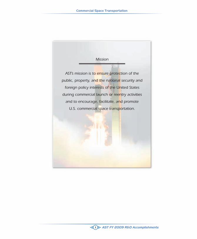
Mission
AST’s mission is to ensure protection of the
public, property, and the national security and
foreign policy interests of the United States
during commercial launch or reentry activities
and to encourage, facilitate, and promote
U.S. commercial space transportation.
Commercial Space Transportation
AST FY 2009 R&D Accomplishments2
InTRoDucTIon
This booklet describes several Research and Development (R&D) projects undertaken by the Associate Administrator for Commercial Space Transportation (AST) in the Federal Aviation Administration (FAA). Two of the research projects presented here were initiated and funded in Fiscal Year (FY) 2008 and completed in FY 2009. These are presented in the “Completed” section of the booklet. There were five research projects initiated and funded in FY 2009 and expect to be completed in FY 2010. Of the five, three are presented in the “In Progress” section of the booklet. These five new research projects were selected and assigned to an AST division to lead the research effort on them, but were able to commence only in March 2009, In addition to a description of each project, a summary of accomplishments to date is provided.
The AST safety research supports the development of the policy, standards, and guidance material needed to meet FAA goals and objectives. Such research is also essential in developing the knowledge necessary to maintain and improve FAA/AST materials used to verify that the products and procedures of launch and reentry vehicle and site operator licensees, permitees, and applicants adequately comply with applicable safety standards.
To that end, AST formulated and instituted an R&D activity to support its mission and the FAA’s strategic goal of safety. The AST Research and Development Plan provides a process for effectively applying resources for research based on clearly identified safety priorities each fiscal year. This Plan was used to solicit candidate research projects from internal sources, such as AST aerospace engineers and projects. External sources, such as the Commercial Space Transportation Advisory Committee’s (COMSTAC), were also solicited.
First, the AST R&D Advisory Board evaluated candidate research projects for relevance to AST’s mission, relative importance, and cost. Second, the AST R&D Advisory Board ranked the candidate research projects to arrive at a prioritized list to present to the AST R&D Senior Steering Committee for review. Third, the AST R&D Senior Steering Committee selected the R&D projects to undertake in FY 2009 that had the greatest potential to fulfill AST’s mission and to meet its budgeted requirements. Lastly, the R&D Advisory Board and Senior Steering Committee held periodic R&D project status reviews throughout the year.
AST FY 2009 R&D Accomplishments
Commercial Space Transportation
3
Completed Studies

Commercial Space Transportation
AST FY 2009 R&D Accomplishments4
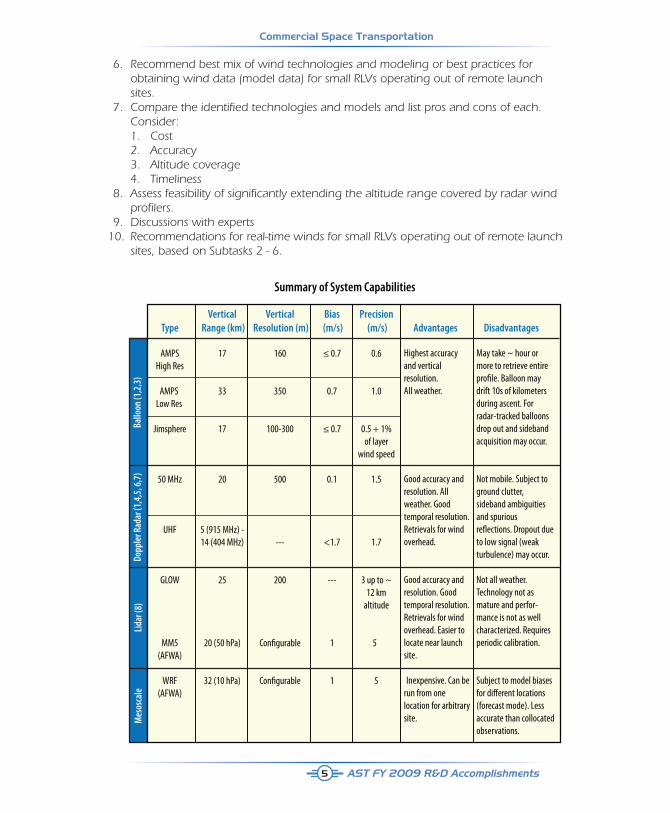
HIGH ALTITuDE WInD PREDIcTIon AnD MEASuRMEnTTEcHnoLoGY ASSESSMEnT
This document presents an overview of the technologies for gathering wind data and atmospheric models for predicting winds. It also presents an assessment of possible upgrades to extend the vertical coverage for Doppler Radar Wind Profilers (DRWPs).
Within the Commercial Space Launch Amendments Act of 2004, Congress authorized the Federal Aviation Administration (FAA) to promulgate regulations in the areas of experimental permits and human spaceflight (crew and passenger) requirements. Legislation was written to allow humans to travel into space for the first time on commercial launch vehicles and to ensure that the passengers and crew involved in commercial space are informed of all risks inherent to space travel, including those associated with the launch vehicle. Commercial launch sites have limited equipment and real-time data to support real-time launch decision making. In particular, there is a relative paucity of wind data from 50,000 ft (the altitude reliably attained by high resolution balloon measurements) and 100,000 ft (the altitude attained by low resolution systems and high performance radars). Significantly higher altitudes would require some development. The altitude limitations are mitigated by the fact that by 100,000 ft (~ 30 km) air density is reduced from sea values by a factor of ~ 100. The aerodynamic drag on vehicles and debris is similarly reduced.
This study evaluates technology to detect winds at these altitudes. Accurate wind data at these altitudes is very important for suborbital reusable launch vehicles (RLVs) because of the lack of time to adjust the trajectory once the main engine cut-off has occurred. In addition, it is important to characterize the tendency of winds to move debris laterally as it falls. The dispersion of debris by the winds increases the risk on the ground and in the air, when risk to aircraft is considered. This study presents the results of a literature survey of possible remote sensing technologies and the sensitivity of proposed systems to high altitude wind conditions.
Study approach 1. Conduct literature study of available technologies [i.e., balloon-borne instruments, atmospheric models, radar wind profilers, sounding rockets, Light Detection and Ranging (lidar) instruments] capable of discerning winds in the 50 - 150 kft altitude range. 2. Conduct survey of sensitivities of proposed systems (models) to high-altitude wind conditions. 3. Conduct survey of accuracies of proposed systems (models) for winds in 50 - 150 kft altitude range. 4. Compare the identified technologies and list pros and cons of each. 5. Assess feasibility of significantly extending the altitude range covered by radar wind profilers.
AST FY 2009 R&D Accomplishments
Commercial Space Transportation
Vertical Vertical Bias Precision Type Range (km) Resolution (m) (m/s) (m/s) Advantages Disadvantages AMPS 17 160 ≤ 0.7 0.6 High Res AMPS 33 350 0.7 1.0 Low Res Jimsphere 17 100-300 ≤ 0.7 0.5 + 1% of layer wind speed
50 MHz 20 500 0.1 1.5
UHF 5 (915 MHz) - 14 (404 MHz) --- <1.7 1.7
GLOW 25 200 --- 3 up to ~ 12 km altitude
MM5 20 (50 hPa) Con�gurable 1 5 (AFWA) WRF 32 (10 hPa) Con�gurable 1 5 (AFWA)
Summary of System Capabilities
Ballo
on (1
,2,3
)Do
pple
r Rad
ar (1
,4,5
, 6,7
)Li
dar (
8)M
esos
cale
Highest accuracy and vertical resolution. All weather.
Good accuracy and resolution. All weather. Good temporal resolution. Retrievals for wind overhead.
Good accuracy and resolution. Good temporal resolution. Retrievals for wind overhead. Easier to locate near launch site.
Inexpensive. Can be run from one location for arbitrary site.
May take ~ hour or more to retrieve entire pro�le. Balloon may drift 10s of kilometers during ascent. For radar-tracked balloons drop out and sideband acquisition may occur.
Not mobile. Subject to ground clutter, sideband ambiguities and spurious re�ections. Dropout due to low signal (weak turbulence) may occur.
Not all weather. Technology not as mature and perfor-mance is not as well characterized. Requires periodic calibration.
Subject to model biases for di�erent locations (forecast mode). Less accurate than collocated observations.
5
6. Recommend best mix of wind technologies and modeling or best practices for obtaining wind data (model data) for small RLVs operating out of remote launch sites. 7. Compare the identified technologies and models and list pros and cons of each. Consider: 1. Cost 2. Accuracy 3. Altitude coverage 4. Timeliness 8. Assess feasibility of significantly extending the altitude range covered by radar wind profilers. 9. Discussions with experts 10. Recommendations for real-time winds for small RLVs operating out of remote launch sites, based on Subtasks 2 - 6.
Commercial Space Transportation
AST FY 2009 R&D Accomplishments
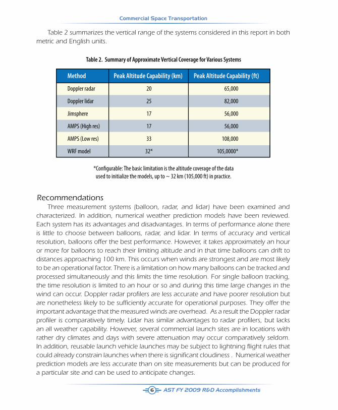
Table 2. Summary of Approximate Vertical Coverage for Various Systems
*Con�gurable: The basic limitation is the altitude coverage of the data used to initialize the models, up to ~ 32 km (105,000 ft) in practice.
Method Peak Altitude Capability (km) Peak Altitude Capability (ft)
Doppler radar 20 65,000
Doppler lidar 25 82,000
Jimsphere 17 56,000
AMPS (High res) 17 56,000
AMPS (Low res) 33 108,000
WRF model 32* 105,0000*
6
Table 2 summarizes the vertical range of the systems considered in this report in both metric and English units.
RecommendationsThree measurement systems (balloon, radar, and lidar) have been examined and
characterized. In addition, numerical weather prediction models have been reviewed. Each system has its advantages and disadvantages. In terms of performance alone there is little to choose between balloons, radar, and lidar. In terms of accuracy and vertical resolution, balloons offer the best performance. However, it takes approximately an hour or more for balloons to reach their limiting altitude and in that time balloons can drift to distances approaching 100 km. This occurs when winds are strongest and are most likely to be an operational factor. There is a limitation on how many balloons can be tracked and processed simultaneously and this limits the time resolution. For single balloon tracking, the time resolution is limited to an hour or so and during this time large changes in the wind can occur. Doppler radar profi lers are less accurate and have poorer resolution but are nonetheless likely to be suffi ciently accurate for operational purposes. They offer the important advantage that the measured winds are overhead. As a result the Doppler radar profi ler is comparatively timely. Lidar has similar advantages to radar profi lers, but lacks an all weather capability. However, several commercial launch sites are in locations with rather dry climates and days with severe attenuation may occur comparatively seldom. In addition, reusable launch vehicle launches may be subject to lightning fl ight rules that could already constrain launches when there is signifi cant cloudiness . Numerical weather prediction models are less accurate than on site measurements but can be produced for a particular site and can be used to anticipate changes.
AST FY 2009 R&D Accomplishments
Commercial Space Transportation
7
The precise system performance (accuracy, precision, reliability) required to support RLV flights is not known. Clearly, since balloon systems support launches of large expendable launch vehicles and the Space Shuttle, they would be accurate and dependable enough to support RLV launches. Since the performance of the large powerful radars such as the ER and WR 50 MHz, these most likely would also be adequate. Less certain is the adequacy of less capable radars, lidars and numerical weather prediction.
Balloon systems and the most capable of radar systems should be adequate stand alone systems. Both are accurate, reliable, and essentially all-weather. The best balloon solution would be one based on GPS. This alleviates the need for expensive high precision tracking by radar. At present, there are no operational Doppler lidars. However, lidars offer the advantage of mobility. Future lidars should provide a good solution for locations that are not limited by layered cloud when lightning constraints allow flight.
The safest system would be a remote measurement system (radar or lidar) in combination with a balloon system. This system would be robust and would offer the accuracy, precision, and reliability of the balloon system with the timeliness and localized sampling of a radar or lidar.
Numerical weather prediction (NWP) is less accurate than measurements, but in the absence of accuracy criteria for RLVs its utility as a means for assessing wind effects cannot be ruled out. Whether NWP as a standalone system is adequate depends on the sensitivities of the vehicle and the control requirements. At a minimum, the accuracy of the model predictions is a great improvement over climatology. Models can be employed to provide situational awareness. They would provide a good indication that present conditions will not persist. They will also provide an understanding of the causes of changes in the weather that are being experienced and how long unsettled conditions might persist.
SummaryThe principles and the operational characteristics of balloon and radar-based techniques
for measuring upper air winds in support of launches and recoveries have been presented. Each technique has advantages and disadvantages. The most effective approach to meeting upper air wind requirements may involve a mixed set of instruments, each with different strengths.
Balloon-based systems tend to have finer spatial (vertical) resolution than radar-based ones, whereas the radar-based systems have finer temporal resolution. The two kinds of systems appear to have approximately equal accuracy and reliability. As implemented at the Eastern Range, the Quality Control latencies for balloon- and radar-based systems are each about 5 minutes. The radar profilers scan a fixed vertical volume whereas balloons
Commercial Space Transportation
AST FY 2009 R&D Accomplishments8
drift with the wind. The volume of the latter sample is neither constant from profile to profile, nor is the volume overhead.
The best mix for generating high-quality wind profiles may consist of a DRWP in combination with balloons. The former gives more timely observations in a fixed volume, while the latter provide higher resolution.
TEMPoRAL WInDS DATAbASE conSIDERATIonS FoR SAFETY EvALuATIon oF unGuIDED SuboRbITAL LAuncH vEHIcLES
The rise of new inland launch sites in the continental United States has raised awareness of the need to ensure suitable environment databases exist to assess the impact of winds on planned launch operations of unguided suborbital rockets from these launch sites. Quite often launch operators will measure the wind environment at the launch site of their planned launches and determine a planned impact point for their single or multistage vehicle given this measured wind and the implementation of a wind weighting system. In most instances the launch operator needs to account for the temporal effect of winds on their planned impact points. These temporal effects in combinations with dispersions influence the clear out zone for the launch of these rockets.
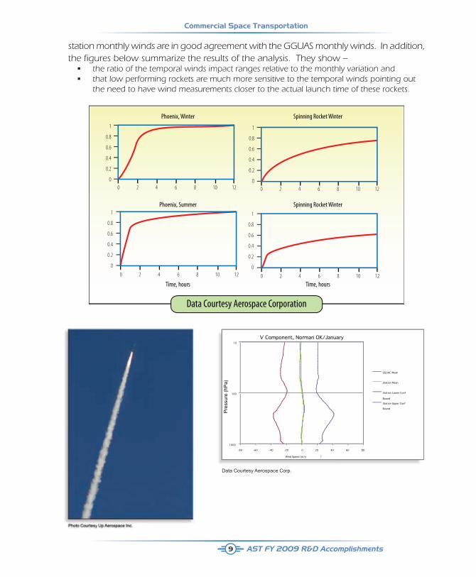
In cooperation with the FAA, the Aerospace Corporation performed a study to evaluate the impact of temporal winds on unguided suborbital rockets. This study had two objectives:
First, to determine if suitable temporal wind database exists at three inland launch sites of interest and
Second, to determine how much temporal winds can change the planned impact point of an unguided suborbital rocket, whether it is a suborbital to 30,000 feet or 360,000 feet.
The change in planned trajectories was related to the monthly wind variation.
Aerospace Corporation was tasked to develop this research and development effort and began a survey to determine if the Global Gridded Upper Air Station (GGUAS) database, a database the FAA regulation calls out, provides suitable environments at the launch sites of interest by comparing the GGUAS monthly winds with stations winds collected at these three launch sites (or stations). Aerospace Corporation collected existing temporal wind data from these stations and stations located at the ETR range and assessed a low altitude and high altitude unguided suborbital launch vehicle to determine the relationship between the temporal winds and the monthly winds. The figures below represent the launch of the Up Aerospace unguided suborbital launch vehicle and preliminary data showing that
AST FY 2009 R&D Accomplishments
Commercial Space Transportation
0 2 4 6 8 10 12
1
0.8
0.6
0.4
0.2
0
0 2 4 6 8 10 12
1
0.8
0.6
0.4
0.2
0
0 2 4 6 8 10 12
1
0.8
0.6
0.4
0.2
0
0 2 4 6 8 10 12
1
0.8
0.6
0.4
0.2
0
Phoenix, Winter
Phoenix, Summer
Time, hours
Spinning Rocket Winter
Spinning Rocket Winter
Time, hours
Data Courtesy Aerospace Corporation
V Component, Norman OK/January10
100
1000
-80 -60 -40 -20 0 20 40 60 80
Wind Speed (m/s )
GGUAC Mean
Station Mean
Station Lower Conf
Bound
Station Upper Conf
Bound
Pre
ssur
e (h
Pa)
Data Courtesy Aerospace Corp.
9
station monthly winds are in good agreement with the GGUAS monthly winds. In addition, the fi gures below summarize the results of the analysis. They show –
• the ratio of the temporal winds impact ranges relative to the monthly variation and • that low performing rockets are much more sensitive to the temporal winds pointing out the need to have wind measurements closer to the actual launch time of these rockets.
Commercial Space Transportation
AST FY 2009 R&D Accomplishments10
A cASE STuDY on RouTInE SPAcE vEHIcLE oPERATIonS InTHE nAS FoR nEXTGEn
Futron Corporation was directed by the FAA to develop a short study to identify National Airspace System (NAS) integration requirements associated with proposed twice weekly commercial space transportation operations. The operations studied and included in this report are limited to those based on the Scaled Composites WhiteKnightOne /SpaceShipOne operations out of Mojave, California. This combination is the only one that has actually flown at this time and was used as a model for the newer, Virgin Galactic, commercial, WhiteKnightTwo (WK II) / SpaceShipTwo (SS II) vehicles. There are several other mission concepts under development including vertical launch/parachute recovery, horizontal air breathing launch with rocket powered Kármán Line penetration (328,000 feet) and air breathing powered return and landing. In addition, for the purpose of this study all operations are assumed to be from the former Cecil Field Naval Air Station south west of Jacksonville, Florida.
The case study was developed to depict typical operations in the 2025 timeframe and an assumed flight rate of 2 flights a week. The goal of the study is to uncover any unique requirements that must be considered in the development of the Next Generation Air Transportation System (NextGen) to allow for this type of commercial space tourism with minimal impact on the NAS as it develops.
Several issues that were believed to be critical prior to this study were found to present minimal impact to the NAS. The first of these was the impact of high altitude flight through commercial airways. After careful study of the flight paths of this type of operation it was found the actual footprint of the flight was fairly small and very little airspace was needed. Once the space craft is released, it climbs from above 40,000 feet to over 350,000 feet returning to the same small area over the ground. On return to between 40,000 and 70,000 feet altitude, the spacecraft converts to a glider that proceeds on an almost straight line to approximately 8,500 feet directly over Cecil Field for landing. Because of the inability of the space craft to hold or perform a missed approach, the most important critical issue for airspace controllers is the requirement to have a window for the spacecraft to land after release from the carrier aircraft. The window for this clearance appears to open about 20 minutes after release from the carrier aircraft. Actual release of the spacecraft can also be significantly delayed to provide spacing for other aircraft approaching Cecil Field giving JAX TRACON controllers’ significant operational flexibility. The window for landing would normally be a period less than 5 minutes in duration. After landing, the spacecraft is normally clear of the runway within 30 minutes and the parallel runway is able to support normal operations throughout the removal of the spacecraft.
AST FY 2009 R&D Accomplishments
Commercial Space Transportation
11
Carrier aircraft (WK II) operation will have almost no impact on controllers as it is able to fly under a normal Flight Plan and its operation is relatively predictable and does not normally present any issues to NAS controllers. The carrier aircraft with SS II departs from and returns to Cecil Field like any other aircraft.
All other support aircraft operations are conducted in VFR conditions under normal local flight plans and operations are virtually transparent when compared to other normal aircraft operations in the area.
It was the top level conclusion of this study that the flights described in this report will not have a significant impact on NAS operations. Furthermore, export of this type of operation to other geographic areas could be easily integrated into the NAS in other areas, especially those with lower traffic density than the northern Florida area west of Jacksonville used in the study. Because of the unique nature of these kinds of flights, individual evaluation of other proposed sites would be necessary, but there were no systematic issues that would prevent export of this type of operation to other locations.

Commercial Space Transportation
AST FY 2009 R&D Accomplishments12
In-ProgressStudies
AST FY 2009 R&D Accomplishments
Commercial Space Transportation
13
non-TRADITIonAL Mono-PRoPELLAnTS AnD oXIDIzERS GuIDELInE DATA
Background information
Efforts to develop and use alternative monopropellants and oxidizers for rocket propulsion date back to the 1940s, though NASA and DOD have largely abandoned them. However in emerging commercial space programs, there have been increased efforts in recent years to use nitrous oxide (N2O) and hydrogen peroxide (H2O2) both as monopropellants and as oxidizers, predominantly for hybrid systems. Both propellants have stability issues. In 2007, two serious incidents occurred with N2O and H2O2, one of which resulted in loss of life. Other industries handle these chemicals in extremely large quantities without explosions or loss of life.
Project focus
The objective of this research effort is to develop guidelines for safe transport, loading, usage, and disposal of N2O and H2O2 in the commercial space industry based upon lessons learned in handling and using non-traditional mono-propellants and oxidizers.
Project plan and deliverables
The research effort is to:- Determine the current state of knowledge. Examine existing FAA documents
and other agency standards. Survey the Aerospace industry and other industries using these chemicals and review literature for any recent updates.
- Conduct small-scale laboratory tests if necessary. Measurements may be made of decomposition and conditions that lead to thermal runaway.
- Identify regimes where these monopropellants and oxidizers may be safely
handled.
- Document results and present at Annual FAA Commercial Space Transportation Conference or other FAA or industry forum.
Commercial Space Transportation
AST FY 2009 R&D Accomplishments14
APPLIcATIon oF GPS To SPAcE TRAnSPoRTATIon TEcHnoLoGIES
Background information
Global Positioning System (GPS) equipment is employed in all the navigation and flight safety systems of vehicles regulated by the FAA Office of Commercial Space Transportation (AST). Much of this GPS equipment is not space-qualified and consists of modified GPS equipment developed for other purposes. The technology associated with GPS (equipment, satellites, forecasting of outages, and performance) is evolving rapidly.
Project focus
The baseline of the study will be an update of the 2006 study performed for AST by Aerospace Corporation in specific areas. It will also focus on additional areas of concern related to GPS that have emerged since that time.
Project plan and deliverables
The goal of this study is to address GPS technology as employed in the navigation and flight safety systems of current and future expendable launch vehicles (ELVs), reusable launch vehicles (RLVs), and re-entry vehicles (RVs). The data obtained will be used in the safety analyses of existing vehicles and those under development to protect the public during flight operations.
The research effort is to:
- Analyze specific use of GPS equipment on vehicles of FAA commercial space applicants.
- Survey GPS technology relevant to use on ELVs, RLVs, and RVs and update areas of the February 2006 report to AST on GPS technology re: technology realized or forecast advancements.
- Provide AST with recommendations for existing or planned space-qualified GPS equipment use on commercial Reentry Vehicles under on-orbit, de-orbit, and re-entry conditions.
- Recommend future areas of study (potentially including ground and flight testing) of GPS technology relevant to safe commercial space activities in prioritized order.
AST FY 2009 R&D Accomplishments
Commercial Space Transportation
15
ISSuES AnD APPRoAcHES FoR InTEGRATInG PTP SYSTEMS InTo THE nAS AnD bEYonD
Introduction
The advent of suborbital transport brings the promise of point-to-point (PTP) transportation as a revolutionary mode of air transportation. Studies have shown that transatlantic flight times for suborbital vehicles from Paris to New York would take approximately one hour, less than one-third the travel time required by the supersonic aircraft Concorde, and a fraction of the travel time required by conventional air transportation. The potential for rapid global passenger transport and fast distribution of goods make PTP transportation an attractive space technology concept worth exploiting.
In 2008, the International Space University (ISU) of Strasbourg, France, published a report documenting their appraisal of point-to-point transportation technology. This report describes the conditions that should be put in place to foster and sustain the growth of this industry from technical, market, financial, infrastructure, safety, and legal perspectives. Based on the ISU findings, the FAA Office of Commercial Space Transportation has identified the need to explore issues and approaches for integrating PTP systems into the U. S. National Airspace System (NAS) and beyond (International Airspace and high altitude regimes). The analyses would serve to help the FAA formulate effective policies and regulations related to air traffic management of suborbital missions.
Description of work
The Volpe National Transportation System Center was selected to perform this study,
The specific tasks under this study are the following:
Task 1: Identify operational and technical issues that must be addressed for launching and operating either supersonic or hypersonic point-to-point (PTP) systems in or through the NAS and between transcontinental city pairs (e.g., New York to London, Los Angeles to Tokyo, Dubai to Sydney, etc.). The contractor shall identify areas that may require legal, regulatory, or policy changes.
Task 2: Prioritize operational and technical issues, ranking them from “most challenging” to “least challenging” and explain the rationale for each ranking.
Task 3: Prioritize recommendations for a path forward to resolve each identified issue.