soc mapping with rk: data preparation and method selection
TRANSCRIPT

SOC Mapping with RK: data preparation andmethod selection
Soil Organic Carbon Seminar
Guillermo Federico Olmedo
Pillar 4 ChairSouth America Soil Partnership
23 November 2016, FAO HQ, Malaysia Room, Rome, Italy

SOC
Outline
1 Conceptual basis
2 Software
3 Data preparationSoil profile data setsCovariate mapping
4 Method selection
5 Uncertainties
6 More information . . .

SOC
Outline
1 Conceptual basis
2 Software
3 Data preparationSoil profile data setsCovariate mapping
4 Method selection
5 Uncertainties
6 More information . . .

SOC
Outline
1 Conceptual basis
2 Software
3 Data preparationSoil profile data setsCovariate mapping
4 Method selection
5 Uncertainties
6 More information . . .

SOC
Outline
1 Conceptual basis
2 Software
3 Data preparationSoil profile data setsCovariate mapping
4 Method selection
5 Uncertainties
6 More information . . .

SOC
Outline
1 Conceptual basis
2 Software
3 Data preparationSoil profile data setsCovariate mapping
4 Method selection
5 Uncertainties
6 More information . . .

SOC
Outline
1 Conceptual basis
2 Software
3 Data preparationSoil profile data setsCovariate mapping
4 Method selection
5 Uncertainties
6 More information . . .

SOC
Proposed upscaling methods

SOC
Spatial Interpolation

SOC
Spatial Interpolation

SOC
Conceptual basis
Conceptual basis

SOC
Conceptual basis
Digital Soil Mapping: Origin
"Soils being a result of a verycomplicated interaction betweenlocal climate, plant and animal
organisms, content and structure ofparent rocks, topography, and,
finally, age of theterrain"(Dokuchaev, 1883)

SOC
Conceptual basis
Methods 1
1[McBratney et al., 2000]

SOC
Conceptual basis
The quantitative-digital model 2
Sc,p = f (s, c,o, r ,p,a,n) + ε (1)
2[McBratney et al., 2003]

SOC
Conceptual basis
The quantitative-digital model

SOC
Software
Software

SOC
Software
Why R?
Easy to develop new methodsNot just a statistics package, it’s a (high level) language.Designed to operate the way that problems are thoughtabout.State-of-the-art statistical techniquesState-of-the-art graphic capabilitiesUnderstands spatial (raster, vectorial) dataFree and open source softwareHigly extensible

SOC
Software

SOC
Software
RStudio

SOC
Software
AQP3
3[Beaudette et al., 2013]
SOC
Software

SOC
Software

SOC
Data preparation
Data preparation

SOC
Data preparation
Soil profile data sets
Data preparationSoil profile data sets

SOC
Data preparation
Soil profile data sets
Soil data organization

SOC
Data preparation
Soil profile data sets

SOC
Data preparation
Soil profile data sets

SOC
Data preparation
Soil profile data sets
Depth modelling 4
To convert soil profile datainto standard depths.Point data: standarddepths used for spatialinterpolation
4[Bishop et al., 1999]

SOC
Data preparation
Soil profile data sets
Depth modelling 4
To convert soil profile datainto standard depths.Point data: standarddepths used for spatialinterpolation
4[Bishop et al., 1999]

SOC
Data preparation
Soil profile data sets
Equal-area spline function5
Consists of a series oflocal quadratic polynomialsthat join at ’knots’ locatedat the horizon boundariesArea to the left of the fittedspline curve is equal to thearea to the right of thecurveMean value of eachhorizon is maintained bythe spline fit
5[Bishop et al., 1999]

SOC
Data preparation
Soil profile data sets

SOC
Data preparation
Soil profile data sets
[Odgers et al., 2012]

SOC
Data preparation
Soil profile data sets

SOC
Data preparation
Soil profile data sets
ea splines using GSIF6
6[Hengl, 2016]

SOC
Data preparation
Soil profile data sets

SOC
Data preparation
Covariate mapping
Data preparationCovariate mapping

SOC
Data preparation
Covariate mapping
The quantitative-digital model

SOC
Data preparation
Covariate mapping
Study area

SOC
Data preparation
Covariate mapping
Digital elevation model

SOC
Data preparation
Covariate mapping
Study area

SOC
Data preparation
Covariate mapping
Relief covariates

SOC
Data preparation
Covariate mapping
Relief covariates

SOC
Data preparation
Covariate mapping
Relief covariates
SOC
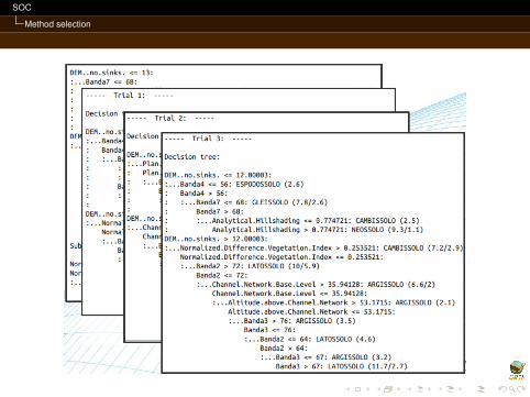
Method selection
Method selection

SOC
Method selection
Methods 7
7[McBratney et al., 2000]

SOC
Method selection
RK model

SOC
Method selection
El modelo de RK 8
8[Hengl, 2009]

SOC
Method selection
The Best Linear Unbiased Predictor of spatial data9
9[Hengl, 2009]

SOC
Method selection
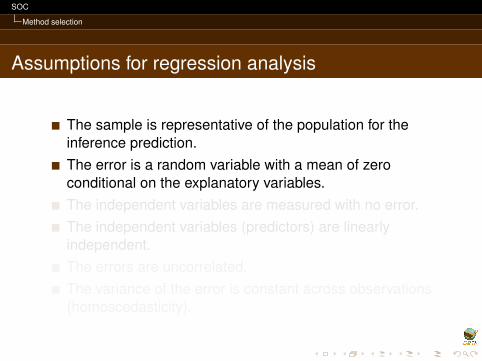
Assumptions for regression analysis
The sample is representative of the population for theinference prediction.The error is a random variable with a mean of zeroconditional on the explanatory variables.The independent variables are measured with no error.The independent variables (predictors) are linearlyindependent.The errors are uncorrelated.The variance of the error is constant across observations(homoscedasticity).
SOC
Method selection
Assumptions for regression analysis
The sample is representative of the population for theinference prediction.The error is a random variable with a mean of zeroconditional on the explanatory variables.The independent variables are measured with no error.The independent variables (predictors) are linearlyindependent.The errors are uncorrelated.The variance of the error is constant across observations(homoscedasticity).

SOC
Method selection
Explanation vs. Prediction

SOC
Method selection
Black Box models

SOC
Method selection
Machine Learning

SOC
Method selection
Single hidden layer neural network

SOC
Method selection

SOC
Method selection

SOC
Method selection

SOC
Method selection
SOC
Method selection

SOC
Uncertainties
Uncertainties

SOC
Uncertainties
Model uncertainty
Kriging variance of prediction only speaks about modeluncertaintyMap uncertainty can only be measured using anindependent data set: Independent ValidationIf we can measure te uncertainty, we can compare differentmethods

SOC
Uncertainties
Model uncertainty
Kriging variance of prediction only speaks about modeluncertaintyMap uncertainty can only be measured using anindependent data set: Independent ValidationIf we can measure te uncertainty, we can compare differentmethods

SOC
Uncertainties
Model uncertainty
Kriging variance of prediction only speaks about modeluncertaintyMap uncertainty can only be measured using anindependent data set: Independent ValidationIf we can measure te uncertainty, we can compare differentmethods

SOC
Uncertainties
Map quality

SOC
Uncertainties
k-fold Cross Validation

SOC
Uncertainties
LOO Cross Validation

SOC
Uncertainties
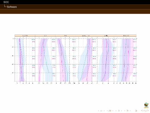
Spatial Uncertainty
Predicted value

SOC
Uncertainties
Spatial Uncertainty
Std Dev Predicted value

SOC
Uncertainties
Spatial Uncertainty
Confidence Interval
SOC
More information . . .
More information . . .

SOC
More information . . .
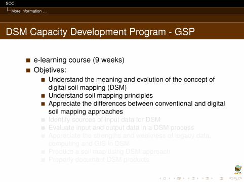
DSM Capacity Development Program - GSP
e-learning course (9 weeks)Objetives:
Understand the meaning and evolution of the concept ofdigital soil mapping (DSM)Understand soil mapping principlesAppreciate the differences between conventional and digitalsoil mapping approachesIdentify sources of input data for DSMEvaluate input and output data in a DSM processAppreciate the strengths and weakness of legacy data,computing and GIS in DSMProduce a soil map using DSM approachProperly document DSM products

SOC
More information . . .
DSM Capacity Development Program - GSP
e-learning course (9 weeks)Objetives:
Understand the meaning and evolution of the concept ofdigital soil mapping (DSM)Understand soil mapping principlesAppreciate the differences between conventional and digitalsoil mapping approachesIdentify sources of input data for DSMEvaluate input and output data in a DSM processAppreciate the strengths and weakness of legacy data,computing and GIS in DSMProduce a soil map using DSM approachProperly document DSM products
SOC
More information . . .
Hands-on Global Soil Information Facilities (GSIF)
From 15 to 19 May 2017, ISRIC - World Soil Information -Five-day course (+1)Mapping, classification and assessment of soils for soil andenvironmental scientists, students, experts andprofessionals in natural resources management.Wageningen Campus in the Netherlands.The aim of this course is to introduce GSIF and methodsand software for the management, analysis and mappingof global and regional soil dataMore information: ask Bas Kempen!


SOC
More information . . .
References I
Beaudette, D., Roudier, P., and O’Geen, A. (2013).Algorithms for quantitative pedology: A toolkit for soilscientists.Computers & Geosciences, 52:258–268.
Bishop, T., McBratney, A., and Laslett, G. (1999).Modelling soil attribute depth functions with equal-areaquadratic smoothing splines.Geoderma, 91(1–2):27 – 45.
Hengl, T. (2009).A Practical Guide to Geostatistical Mapping, volume 13.

SOC
More information . . .
References II
Hengl, T. (2016).GSIF: Global Soil Information Facilities.R package version 0.5-3.
McBratney, A., Santos, M. M., and Minasny, B. (2003).On digital soil mapping.Geoderma, 117(1–2):3 – 52.
McBratney, A. B., Odeh, I. O., Bishop, T. F., Dunbar, M. S.,and Shatar, T. M. (2000).An overview of pedometric techniques for use in soilsurvey.Geoderma, 97(3–4):293 – 327.

SOC
More information . . .
References III
Odgers, N. P., Libohova, Z., and Thompson, J. A. (2012).Equal-area spline functions applied to a legacy soildatabase to create weighted-means maps of soil organiccarbon at a continental scale.Geoderma, 189–190:153 – 163.