smart from a to b
TRANSCRIPT

Smart from A to B
Intelligent Transport Systems for the Vienna Region
More than 75% of all EU inhabitants now live in cities or
their suburbs, tendency increasing. For transport policy, this
throws up very special challenges and objectives:
Optimal access to the various locations, centres and
regions must be warranted
The limited public space available must be put to use as
efficiently as possible
Urban mobility must be networked, dynamic and flexible
Traffic information must be reliable, easy to use and
equally available to all transport users
The traffic environment need to be not only as ecological
as possible, it also needs to be economically efficient and
socially just.
Intelligent Transport Systems (ITS) make use of information
technology and telecommunications to record, process and
use digital data in transport. Especially in urban settings, ITS
services, which include route planners, navigation systems,
real-time information directly at the stops and congested
areas or information on traffic and parking situations,
may actually translate into that decisive edge in locational
competition.
ITS Vienna Region
The three federal provinces of Vienna, Lower Austria and
Burgenland recognised the potential of ITS early on and
went on to establish the cooperative telematics projects „ITS
Vienna Region“ in 2006 embedded in the public transport
association Verkehrsverbund Ost-Region VOR. ITS Vienna
Region is financed by contributions it receives from the three
federal provinces, contracts and research project funding
and has approx. 18 employees on its payroll. ITS Vienna
Region collects up-to-date traffic data from a number of
different partners, uses this date to draw up real-time traffic
situation reports, supports the federal provinces in their
traffic management as well as administration and is involved
in numerous research projects. ITS Vienna Region has been
operating the AnachB traffic information service since 2009.
The overall aim of ITS Vienna Region is to make traffic
more environmentally friendly, more flexible and safer using
Intelligent Transport Systems. Optimal use of the transport
network in its current form is to be ensured and all transport
users are to be given the possibility of using quality traffic
information to determine the best route to travel. A further
purpose of objective comparability of different routes, traffic
modes and intermodal combinations is to highlight new
options, which perhaps had previously gone unnoticed.
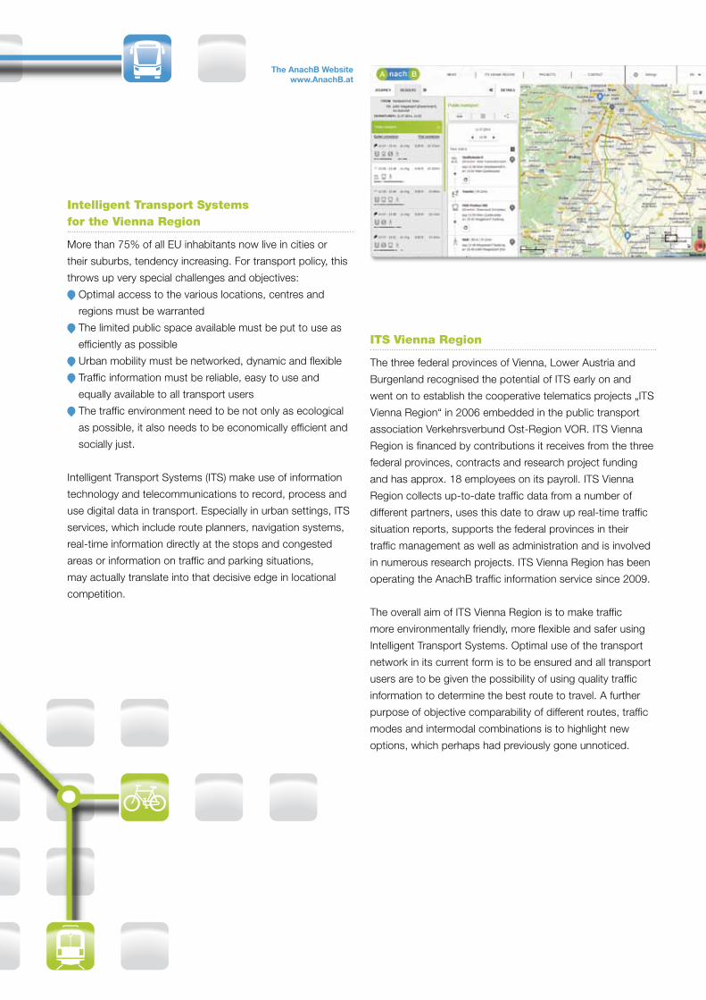
The AnachB Website www.AnachB.at

Roadworks, detours and traffic alerts are shown
immediately on AnachB.
AnachB web cams provide live images of individual road
sections across the entire Vienna region.
Furthermore, the AnachB map designates numerous
interesting sites called „points of interest“ (POIs), including
bike stands, car sharing sites or Nextbike and Citybike
Vienna stations.
smart from A to B with AnachB:
online at www.AnachB.at
on lots of partner websites, such as www.fahrradwien.at
or www.wienzufuss.at
as „AnachB | VOR App” on your iPhone and Android
smart phone which was jointly developed by ITS Vienna
Region and VOR, the public transport association of the
Vienna region
AnachB – smart from A to B
The Graph Integration Platform GIP as digital traffic network
The AnachB | VOR App for iPhone and Android Smartphones
Because many routes lead to B! And depending on the
purpose of the trip, your personal preferences, the weather
conditions or traffic situation, various routes, means of
transport or combinations can turn out to be the best option.
AnachB, which is brought to you by ITS Vienna Region,
provides the ideal traffic service for all of Austria and
particularly the federal provinces of Vienna, Lower Austria
and Burgenland, allowing you to determine the best route
to a destination and find all the information you require:
The AnachB route planer works equally well for public
transport and for routes to be travelled by bike, on foot
or by car. You also have the option of combining indi-
vidual means of transport, relying on features such as
Park&Ride, Kiss&Ride, Bike&Ride or motorail.
AnachB always shows several - frequently ignored -
options for your route. In addition to all the details, it also
objectively compares the travel times as well as CO2
emissions.
With the help of numerous sensors and GPS-based
vehicle data, AnachB draws up an up-to-date account of
the traffic situation. The traffic situation is automatically
taken into account in the route calculation and can be
shown directly on the map (traffic network in red –
yellow – green).
Contact:
ITS Vienna Region | Verkehrsverbund Ost-Region (VOR) GmbH
Europaplatz 3/3, 1150 Vienna | Austria
Tel.: +43 1 581 30 60 - 0 | Mail: [email protected]
www.its-viennaregion.at | www.AnachB.at | www.anachbvor.at
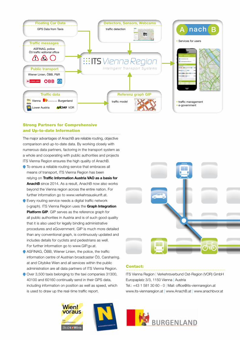
Traffic data
Floating Car Data
Public transport
Traffic messages
GPS Data from Taxis
• Services for users
• traffic management• e-government
ASFINAG, police Ö3 traffic editorial office
Wiener Linien, ÖBB, P&R
Strong Partners for Comprehensive and Up-to-date Information
The major advantages of AnachB are reliable routing, objective
comparison and up-to-date data. By working closely with
numerous data partners, factoring in the transport system as
a whole and cooperating with public authorities and projects
ITS Vienna Region ensures the high quality of AnachB.
To ensure a reliable routing service that embraces all
means of transport, ITS Vienna Region has been
relying on Traffic Information Austria VAO as a basis for
AnachB since 2014. As a result, AnachB now also works
beyond the Vienna region across the entire nation. For
further information go to www.verkehrsauskunft.at.
Every routing service needs a digital traffic network
(=graph). ITS Vienna Region uses the Graph Integration
Platform GIP. GIP serves as the reference graph for
all public authorities in Austria and is of such good quality
that it is also used for legally binding administrative
procedures and eGovernment. GIP is much more detailed
than any conventional graph, is continuously updated and
includes details for cyclists and pedestrians as well.
For further information go to www.GIP.gv.at.
ASFINAG, ÖBB, Wiener Linien, the police, the traffic
information centre of Austrian broadcaster Ö3, Carsharing.
at and Citybike Wien and all services within the public
administration are all data partners of ITS Vienna Region.
Over 3,500 taxis belonging to the taxi companies 31300,
40100 and 60160 continually send in their GPS data,
including information on position as well as speed, which
is used to draw up the real-time traffic report.
Vienna
Lower Austria
Burgenland
VOR
Detectors, Sensors, Webcams
traffic detection
Referenz graph GIP
traffic model