shute harbour marina development pty ltd shute...
TRANSCRIPT

Shute Harbour Marina Development Pty Ltd Shute Harbour Marine Traffic Study JULY 2008
Thompson Clarke Shipping Pty Ltd Suite 105, Level 1, 97 Pacific Highway
North Sydney NSW 2060 Australia
Tel: +61 2 9929 9469 Fax: +61 2 9955 7812
E-mail: [email protected]

Shute Harbour Marina Development Marine Traffic Study
Table of Contents 1 Executive Summary ............................................................................................ 3 2 Project Overview ................................................................................................. 5
2.1 Background to Marine Traffic Study............................................................. 5 2.2 Initial Meeting............................................................................................... 5 2.3 Scope of Work ............................................................................................. 5 2.4 Thompson Clarke Shipping.......................................................................... 7
3 Information Collection and Review ...................................................................... 8 3.1 Site Visit....................................................................................................... 8 3.2 Background Information............................................................................... 8 3.3 Information Review ...................................................................................... 9 3.4 Report .......................................................................................................... 9
4 Shute Harbour ................................................................................................... 10 4.1 Description................................................................................................. 10 4.2 Access ....................................................................................................... 10 4.3 Climate and Weather ................................................................................. 11 4.4 Hydrography .............................................................................................. 12 4.5 Marine Infrastructure.................................................................................. 12
4.5.1 Barge Jetty .......................................................................................... 13 4.5.2 Main Jetty............................................................................................ 13 4.5.3 Council Jetty........................................................................................ 14 4.5.4 Whitsunday Rent a Yacht Jetty ........................................................... 14 4.5.5 Boat Ramp .......................................................................................... 14 4.5.6 Swing Moorings................................................................................... 15 4.5.7 Anchorages......................................................................................... 15
4.6 Users ......................................................................................................... 15 4.6.1 Fantasea Cruises ................................................................................ 15 4.6.2 Hamilton Island Barge Services .......................................................... 15 4.6.3 Hayman Island .................................................................................... 15 4.6.4 Whitsunday Rent a Yacht.................................................................... 15 4.6.5 Long Island.......................................................................................... 16 4.6.6 Other Commercial Operators .............................................................. 16 4.6.7 Recreational and Fishing Vessels ....................................................... 16
5 Overview ........................................................................................................... 17 5.1 Statutory Requirements ............................................................................. 17 5.2 Navigation.................................................................................................. 17 5.3 Communication and Safety........................................................................ 18 5.4 Current Marine Traffic Issues..................................................................... 18
6 Marina Development – Project Description ....................................................... 19 6.1 Construction............................................................................................... 19 6.2 Facilities..................................................................................................... 20 6.3 Public Boat Ramp Facilities ....................................................................... 20 6.4 Access ....................................................................................................... 20
7 Potential Issues and Marine Stakeholder Views................................................ 22 7.1 Marina Footprint......................................................................................... 22 7.2 Dredging and Barging Operations ............................................................. 22 7.3 Shute Harbour Motel.................................................................................. 23 7.4 Engwirda Marine........................................................................................ 23 7.5 Traffic Management ................................................................................... 24
Thompson Clarke Shipping Page 1 July 2008

Shute Harbour Marina Development Marine Traffic Study
7.5.1 In and Out of Marina ........................................................................... 24 7.5.2 User Demographic .............................................................................. 25 7.5.3 Traffic Movement ................................................................................ 25
7.6 Other Potential Issues......................................................................... 26 8 Conclusions ....................................................................................................... 27 Annexes.................................................................................................................... 28
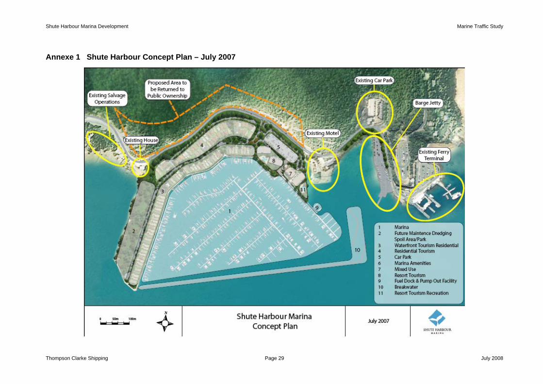
Annexe 1 Shute Harbour Concept Plan – July 2007........................................... 29 Annexe 2 Speed Limits – Shute Harbour ............................................................ 30 Annexe 3 Wind Climate....................................................................................... 31 Annexe 4 Shute Harbour Wave Height Comparison – Pre & Post Development 32 Annexe 5 Significant Wave Height – Cyclone April 1958.................................... 33 Annexe 6 Shute Bay – Average Currents – Pages 1 to 4 ................................... 34 Annexe 7 Shute Harbour Mooring Grids – 2 pages ............................................ 38 Annexe 8 Proposed Permit to Occupy……………………………………………….37 Annexe 9 EzyRider Mooring system……………………………………………… .39
Thompson Clarke Shipping Page 2 July 2008

Shute Harbour Marina Development Marine Traffic Study
Executive Summary This report, commissioned by Shute Harbour Marina Development Pty Ltd (SHMD), forms part of an Environmental Impact Statement required under Part 4 of the Queensland ‘State Development and Public Works Organisation Act 1971’ as determined by the Coordinator General for the proposed development of a marina complex in Shute Bay on the central Queensland coast.
1.1 Overview
Shute Harbour is known as the ‘Gateway to the Whitsundays’ and provides the infrastructure for commercial marine traffic to service the outlying islands as well as provide a safe haven for recreational boat users. Daily passenger ferry services, tourist vessels and vehicular barges operate from a number of privately and publicly owned wharves, resulting in an average of about 80 vessel movements a day. Recreational traffic consists of trailer launched boats mainly for fishing and a large number of yachts and power boats that lie to swing moorings in Shute Bay and off the inner harbour islands.
1.2 Marina
The proposed marina will be situated on the northern shore of Shute Bay to the west of the existing commercial vessel operations. The entrance to the marina will be positioned in the SE corner of the complex approximately 120 metres from the end of the barge jetty giving adequate room for the barges to manoeuvre. The marina is designed to provide 669 berths predominantly in the 11m – 35m LOA range with a maximum acceptable LOA of 50m. In addition to the marina there will be a resort hotel, managed resort accommodation, a commercial precinct and other marina administration and support facilities.
1.3 Potential Issues
Although there is no particular opposition to the project by other marine stakeholders subject to their own businesses not being affected, there are some issues relating to the size of the marina and its potential affect on commercial vessel operations. It is recommended that recreational boaters using the marina be directed to stay clear of the commercial operations by laying an approach channel at the marina entrance that segregates the marina users from the commercial vessels. The marina ‘footprint’ will require the relocation of about 26 swing moorings. According to the Regional Harbour Master, a further 31 swing moorings will need to be relocated to provide a suitable “setback“ from the proposed marina and improvement to access channels. There is capacity in the bay to handle the relocation of the moorings which will be undertaken at the proponent’s expense. The moorings will be replaced with an environmentally sensitive mooring that will prevent the anchor chain damage to the seabed and seagrass that currently occurs. The occupants of the Shute Harbour Motel and Engwirda Marine have specific concerns about access to their respective properties and these will have to be addressed in the final design. Increased traffic movement through the NE Channel will be made more safe by the implementation of a traffic separation scheme. The S Channel requires better marking.
1.4 Summary
Several modifications to the design and positioning of the marina entrance have resulted in an acceptable situation in relation to the potential impact on the commercial vessel traffic by users of the marina. The safety of traffic movement will be further enhanced by directing recreational boaters away from commercial vessel operations using signage and a marked approach channel to the marina as well as introducing a traffic separation scheme through the NE Channel. Monitoring of the potential increased traffic movement and regulatory
Thompson Clarke Shipping Page 3 July 2008

Shute Harbour Marina Development Marine Traffic Study
compliance by the relevant authority will minimise risk and provide for safe navigation of all users in the Shute Harbour area.
Thompson Clarke Shipping Page 4 July 2008

Shute Harbour Marina Development Marine Traffic Study
2 Project Overview In June 2007 Shute Harbour Marina Development (SHMD) commissioned Thompson Clarke Shipping Pty Ltd to undertake a study of the marine traffic impacts of the proposed marina development in Shute Harbour, Queensland. The prime purpose of this study is to ‘Provide details of the impact of the development of a marina in Shute Harbour on existing infrastructure and traffic management during construction and after completion of the project’. This study will form part of the Environmental Impact Statement (EIS) required under Part 4 of the Queensland ‘State Development and Public Works Organisation Act 1971 (SDPWO Act)’ as determined by the Coordinator General (CG).
2.1 Background to Marine Traffic Study
In July 2006 the CG declared the Shute Harbour Marina proposal ‘a significant project’ under Section 26(1)(a) of the SDPWO Act. This followed an initial submission from SHMD to develop a Marina and associated infrastructure to include onshore facilities of a commercial, tourism, residential and recreational nature. The Marina would provide the following facilities:
• 733 berths including 193 multi-hull berths ranging in size from 11m to 50m LOA • Floating pontoons supported by driven piles • Fuelling and pump-out facilities • All weather protection within fixed breakwaters • Charter boat facilities • All required navigational and safety infrastructure to include navaids, signage and
traffic management in compliance with Maritime Safety Queensland (MSQ) requirements
• Appropriate administrative and service accommodation to serve the marina
The location of the Marina is proposed on the north side of the Shute Bay adjacent to and to the west of the Shute Harbour Motel – see Annexe 1
2.2 Initial Meeting
Steve Hunt from TCS attended a project inception meeting with David Quinlan and Steve Fisher at the offices of Port Binnli Pty Ltd in Brisbane on July 9th 2007 to discuss the scope of the project and to receive an update on some changes to the ‘Terms of Reference for an Environmental Impact Statement’ as issued in March 2007.
2.3 Scope of Work
The specific Scope of Work for the Marine Traffic Study is detailed in the TOR in Section 3.5.2 Shipping/Waterborne Transport and Section 4.1.2.8 Transport – Water/Air Based. The requirements under each section are listed below: Section 3.5.2 Shipping/Waterborne Transport 1 Provide details of the impacts and management of infrastructure requirements for the proposed
transport of fill and other materials to the site by coastal barge including
• the location of any proposed infrastructure; • details of the type of infrastructure; • whether the infrastructure will be temporary or will remain as part of the site
development; • the type, length and draft of vessels (barges); • proposed anchoring points; • details of whether the vessels can access the site given the existing water depths or
whether there is need for dredging of an access channel.
Thompson Clarke Shipping Page 5 July 2008

Shute Harbour Marina Development Marine Traffic Study
2 Provide a marine traffic study of Shute Bay and adjoining waters, complete with marine traffic safety and management requirements, risk analysis and mitigation plans. The following are to be considered:
• known future developments such as a third barge ramp and proposed four lane boat
ramp; • the development's quay lines; • impacts on current marine activity between the marina opening to Low Rocks and the
southern channel; • whole of waterway risk including barge operations, marina traffic and recreational
boating; • risk mitigation for integration of regular and ad hoc vessel operations at the existing
harbour and bay infrastructure; • numbers of sand supplement barges operated by the proponent, their size and barge
scheduling; • risk mitigation and management for all vessel operations in the northern half of the Bay
and including the southern channel; • impact of the development on adjacent land holders water access requirements; • requirements to enhance the Bay as a "safe haven/cyclone access" for the general
boating public and to "increase public safety"; • required channel depths to provide for under keel clearance of 10% of a vessel’s draft
for manoeuvring and 0.6M for berthed vessels; • requirements to ensure that training of bare boat charter hirers does not occur in the
waters of Shute Bay; • provision for review of oil spill kits supplied by proponents and training for vessel
operators in the marina; • the displacement of buoy mooring authority holders to other locations and how this can
be mitigated (where necessary); • all waterborne activities within the Bay and proposed channels; and • protection of existing marine infrastructure including aids to navigation.
3 Provide details on how and where vessels will be serviced and maintained without a marine service
facility being included in the development i.e. boatyard hardstand. Section 4.1.2.8 Transport – Water/Air Based The following water transport issues are to be addressed:
• the potential of the Proposal to impact on water and land based recreational and commercial activities within and adjoining Shute Bay including: - the need for additional public boat ramps, facilities and parking (for vehicle and
trailers); - all-tide ramp status; - wave climate; - impact on adjacent ferry terminal and fuelling stations; - commercial boat operators; - commercial boat cleaning / slipway facilities - current mooring owners; - management and control of boat ramps (include ownership proposals);
• a review of the need for this project to provide additional recreational boat launching facilities to ensure reasonable availability of boat launching facilities in the region;
• proposals for the coordination of vessel navigation within and external to the marina (i.e. including access channels) including the capacity of the marina to accommodate the proposed berths in relation to vessel access and circulation during all weather and tidal conditions during construction and operation;
• detailed information on the additional pressure that will be placed on existing passenger transport infrastructure particularly if the proposal is predicated on achieving increased visitation to the region;
• impact of increased regional recreational and commercial boat traffic within the Whitsundays as a result of the proposal;
Thompson Clarke Shipping Page 6 July 2008

Shute Harbour Marina Development Marine Traffic Study
• specifically address the likely impacts of an increase in tourist visits on the existing transport system; and
• indicate any potential for interchanging between transport modes (e.g. private car, coaches, charter boats, air).
2.4 Thompson Clarke Shipping
Thompson Clarke Shipping Pty Ltd is Australia’s leading shipping consultancy. It was founded in 1981 to meet the needs of Australian and international maritime related businesses for independent, pragmatic advice on marine related matters. It has been engaged by major public and private sector interests to undertake a wide range of assignments on a confidential basis and enjoys an established reputation for quality, integrity and the highest professional standards. TCS has offices in Melbourne and Sydney from which a team of six consultants are engaged in a variety of projects on behalf of a diverse client base. Some of the largest Australian and overseas shipping companies, port authorities, shippers and both Federal and State Government agencies are clients. Overseas, the company has undertaken work for organisations in Asia, New Zealand, the Pacific Islands, Papua New Guinea, the Middle East, South Africa and Sri Lanka. On behalf of such clients TCS undertakes a broad range of assignments, involving:
• Shipping Methods & Economics • Strategic Business Reviews • Market Surveys & Analysis • siness Feasibility Studies for New Bu• Operational Procedures • Maritime Safety and Security • Cruise Ship & Ferry Operations • Tender Preparation & Evaluation
and Studies • Executive Search
t specialises in the operational and commercial areas of maritime transport and the firm possesses:
•
arative analysis of ports and other
ers
; and • in the event of incapacity of the
nominated project personnel.
• Port Representation • Organisational Reviews
TCS is a consultancy tha
• substantial expertise in all areas of shipping operations; wide ranging ex perience of working with Federal and State Government Departments and Agencies;
• substantial experience in conducting effective compoperating businesses in the maritime sector;
• particular experience of State maritime authorities; • an extensive network of contacts with port authorities, ship-owners, time charter
and cargo interests in Australia and overseas; • the capability of producing a high standard of output in clear, concise English
the capability of providing backup personnel
Thompson Clarke Shipping Page 7 July 2008

Shute Harbour Marina Development Marine Traffic Study
3 Information Collection and Review The information required for the preparation of this report was collected from a combination of stakeholder consultations, desktop document review and use of other media sources such as the Internet.
3.1 Site Visit
The TCS consultant conducted a site visit to Shute Harbour and environs in July 2007 to gain first hand knowledge of the current infrastructure and traffic management. During this visit a number of stakeholders were consulted with particular care being taken to ensure that all matters discussed related strictly to the Marine Traffic Study and what effects, if any, there might be on their interests by the construction of a large marina in Shute Bay. Stakeholders consulted include the following:
Organisation Contact Position Shute Harbour Motel David McInerny Owner/Operator Engwirda Marine James Engwirda Managing Director Hamilton Island Barge Services Jock Edgar Executive General Manager Fantasea Cruises Kate Thornton Operations Coordinator Simon Dunne Check Captain John Maiden Fleet Engineer Whitsunday Yacht Charters David McMahon General Manager Whitsunday Shire Council Stephanie Hunt Business Manager Shute Harbour Foreshore Michael Phillips Manager Queensland State Government – Department of State Development
Howard Hayes/Chris Nagle
Senior SD Officers
Maritime Safety Queensland Steven Whalley Manager Maritime Safety Maritime Safety Queensland Capt John Ellyett Regional Harbourmaster Office of the Cordinator General Steve Alcock
The comments and opinions of each of these stakeholders will be expressed within the scope of this report.
3.2 Background Information
TCS was provided with a copy of the Terms of Reference for an Environmental Impact Statement relating to the Shute Harbour Marina Project. This document outlined the requirements for various studies to be done, one of which was the marine Traffic Study. A copy of the Initial Advice Statement and Appendices dated July 2006 was obtained from the website of the Office of the Coordinator General. SHMD have also provided up-to-date copies of various diagrams relating to the Proposal as design modifications are made. In order to verify the current situation and to make comment on the future proposals a number of sources of data and information were used, including:
• Vessel Traffic Management Procedures: Official guide for the safe movement of shipping in Queensland Ports, Maritime Safety Queensland
• Transport Operations (Marine Safety) Act 1994 • Transport Operations (Marine Safety) Regulation 2004 • Transport Operations (Marine Pollution) Act 1995 • Transport Operations (Marine Pollution) Regulation 1995 • MSQ Vessel Traffic System documented operating procedures & practices
Thompson Clarke Shipping Page 8 July 2008
Shute Harbour Marina Development Marine Traffic Study
• Maritime Safety Queensland Act 2002 • Marine Parks Act 2004 • Marine Charts and publications • Local knowledge publications ie 100 Magic Miles
Where appropriate the relevant references to these documents will be made within the body of this report.
3.3 Information Review
It is evident from the Initial Advice Statement that the Proposal to place a large Marina complex in Shute Bay represents a major expansion for this relatively undeveloped but busy area. The projected increase in the number of recreational boats that will be attracted to the Marina along with some predicted increase in marine traffic due to other potential developments will have a significant impact on the movement of traffic into, out of and within the confined waters of Shute Harbour. Of particular concern is the potential conflict between commercial vessels that serve the Whitsunday Group of islands, charter vessels crewed by people with limited experience and recreational vessels operated by people that are required to have minimum qualifications and experience regardless of vessel size and manoeuvring characteristics.
3.4 Report
This Report is prepared to be a ‘Stand Alone’ document as part of the EIS. It will seek to identify and address the issues associated with traffic movement within the Shute Harbour area and provide pragmatic advice and some suggestions to ensure that all users of the marine environment can co-exist with a minimum of conflict in a safe and controlled manner.
Thompson Clarke Shipping Page 9 July 2008

Shute Harbour Marina Development Marine Traffic Study
4 Shute Harbour Shute Harbour is located on the Central Queensland coast adjacent to the Whitsunday Group of islands between the coastal cities of Mackay to the south and Townsville to the north. It is situated in a rapidly developing tourist and residential area that is gaining popularity due to an agreeable climate and proximity to the Great Barrier Reef islands. It has been described as the ‘Gateway to the Whitsundays’. See Fig 1
Fig 1 - Shute Harbour
4.1 Description
Shute Harbour lies between the southern edge of Rooper Inlet at Stripe Point (20o 19.3’S 148o 48.9’E) and The Beak (20o 16.8’S 148o 48’S). The port limits extend from Stripe Point to White Rock 1.25M NNW thence to The Beak. Except as described in the following section ‘Access’, Rooper inlet and Shute Bay are generally shallow with sand and mangrove lined mud banks that dry extensively at the head whilst being fronted by drying coral reefs that represent significant danger to mariners who should seek local knowledge when making Shute Harbour.
4.2 Access
From landward Shute Harbour is accessed by road extending from the Bruce Highway at Proserpine, the nearest Regional Centre about 25 kilometres away. The road passes through Cannonvale, a developing residential community, and Airlie Beach, a well established tourist/boating town, terminating at Shute Harbour. This road is effectively the supply line for all goods and services to and from the Whitsunday Group and makes Shute Harbour an important gateway to this popular and continuously developing tourist and residential area. From seaward Shute Harbour can be accessed through the channel that leads NE from the commercial wharves out past Low Rock (20o 17.3’S 148o 48’E), marked by cardinal marks, out into the Molle Channel. A pair of leading lights aligned 261o/081oT lead vessels into the commercial wharf area through the NE passage, clearing Coral Point. An alternative channel exists within Rooper Inlet that leads N/S and is marked by port and starboard hand markers. This channel passes south of Shute, Repair and Tancred Islands and the mainland, all of which are fringed with coral reefs. See Fig 2.
Thompson Clarke Shipping Page 10 July 2008

Shute Harbour Marina Development Marine Traffic Study
Reproduced courtesy of David Colfret
Fig 2 – Shute Harbour Marine Chartlet
There is a 6 knot speed limit within the designated area bounded by a line drawn from Coral Point to the NE extremity of Tancred Island and then from the SW extremity of Tancred Island to a position 20o 18.43’S 148o 46.97’E on the shore of Rooper Inlet – See Annexe 2.
4.3 Climate and Weather
The regional climate is tropical with summers generally being hot and wet although coastal areas benefit from regular sea breezes that tend to moderate the temperature particularly in the afternoons. Winter days are normally warm and sunny although the nights can be cool. The average annual rainfall is 1445mm the majority falling in the wet season from December through to March. The driest months are August and September. Typical maximum daytime temperatures are 20-30 degrees in the summer/wet months and 21-25 degrees in the winter/dry months. Night time temperatures for summer and winter are typically 23 degrees and 13-14 degrees respectively. The average sea temperature is 27 degrees in the summer and 23 degrees in the winter. For most of the year the area lies within the trade wind belt with the prevailing winds being predominantly from a south to south-easterly direction. Afternoon north-easterly sea breezes can be experienced during the warmer months. Statistically the prevailing winds are south-easterly for more than 50% of the time over a year with a strength of between 10 and 20 knots for about 43% of the time. Winds only exceed 20 knots in strength for about 16% of the time in total from all directions. See Annexe 3. Given the protection afforded by the location of Shute Harbour and offshore islands excessive wave heights are rare. In a 25 knot wind the maximum expected wave height in the area of the proposed marina would not exceed 0.5m currently but would increase to between 0.6m and 0.65m against the Marina breakwater, post construction. See Annexe 4. The cyclone season is generally between December and late March although it can be experienced as early as November and as late as May. Between 1910 and 1992 there were 43 cyclones passing
Thompson Clarke Shipping Page 11 July 2008

Shute Harbour Marina Development Marine Traffic Study
within 150kms of Mackay. The Shute Harbour region was severely affected by Cyclone Ada in January 1970 that caused significant damage to local infrastructure and 15 fatalities. During the 1958 cyclone (the worst recorded for adverse wind direction), Shute Harbour experienced significant wave heights up to 3m in the NE channel in as far as Coral Point and to the south and east of Tancred Island in Rooper Inlet. Within Shute Bay the maximum wave height experienced was no greater than 1.8m. See Annexe 5. The following diagram shows the worst case predicted wave height scenario at selected points post construction of the Marina complex:
Reproduced courtesy of Cardno Lawson & Treloar
Wave Period typically in the range 3 – 4 seconds Data positions It can be seen from the above diagram that the worst significant wave height predicted would be 2.3m during a 1 in 500 year event at position 4. The region experiences about 17 thunder days on average each year and fog occurs on average for 9 days a year. Shute Harbour is generally considered to be an excellent refuge in the event of heavy weather. The bay is protected on all sides and boats are considered to be safe in 25+ knot winds from all directions.
4.4 Hydrography
The bottom profile of Shute Harbour generally consists of mud, sand and gravel with depths ranging from 10m to 40m. Depths in excess of 10m extend down the NE channel almost to the berths. Rooper Inlet has depths less than 10m with the buoyed channel having average depths of about 6m with a least charted depth of 2.9m on the W side of starboard hand beacon No 5. Shute Bay is shallow with depths generally under 2m decreasing to less than a metre further up the bay. The bottom of Shute Bay and Rooper Inlet is soft mud. The tidal range can be as high as 4.2m which creates quite strong tidal flows particularly where the channels between the islands narrow. Generally, the tidal streams flow from south to north through Shute Harbour, except for the first hour of the flood when the tidal streams run north to south. The rate of tidal flow can be up to 4 knots. The tidal flow within Shute Bay is generally clockwise. The construction of the marina will interrupt the flow along the northern side of Shute Bay and create stronger east going currents in the vicinity of the SW corner of the reclaim and along the breakwater strongest about 2 hours after HW. Tidal flows into and out of the marina will be strongest between the freestanding breakwater and the coastline to the north, strongest about 2 hours after LW into the marina. See Annexe 6. The potential for scouring and siltation is examined thoroughly in another section of the EIS. The issue is mentioned here for completeness in that is was raised as a potential concern. See Section 7.4.
4.5 Marine Infrastructure
Being the closest harbour to the offshore islands Shute Harbour is the base of operations for a number of commercial vessel activities ranging from commercial barge services to the hire of single kayaks. All these activities are concentrated around the four jetties located to the west side of Shutehaven, the residential development.
Thompson Clarke Shipping Page 12 July 2008

Shute Harbour Marina Development Marine Traffic Study
4.5.1 Barge Jetty
The most westerly jetty serves the barge operations that ply between Shute Harbour and a number of the resort developments on the nearby islands. It is a finger jetty capable of accommodating two barges simultaneously, one either side head in, although barges sometimes double berth when laying over. This facility is adjacent to a truck park/delivery area and a car park. See Fig 3.
Fig 3 - Barge Jetty 4.5.2 Main Jetty
The ferry operator Fantasea has almost exclusive use of the main jetty for their services to the islands and their tourist boat operations. The jetty has enough wharf face to accommodate up to 8 vessels depending on size and allows vehicle access to the two outside jetties. There is a Fantasea retail/ticketing shop, a café, some administrative offices and toilet facilities at the head of the jetty complex. The lease for the jetty building is owned by SHIFT Whitsunday Pty Ltd which has some common shareholders with SHMD. The jetty buildings will be redeveloped under an existing Deed of Agreement with the Whitsunday Shire Council. See Fig 4. Hayman Island Resort also runs their transfer services to and from the main jetty.
Fig 4 - Commercial Wharf Complex
Thompson Clarke Shipping Page 13 July 2008

Shute Harbour Marina Development Marine Traffic Study
4.5.3 Council Jetty
This is a common user jetty providing a range of berths for up to six vessels. Just to the east of this berth is a boat launching ramp that is used for trailer boat launching as well as small barge access and provides water access for the Salty Dog Kayak Hire business that has its premises nearby. See Figs 5 & 6.
Fig 5 - Council Jetty Fig 6 - Boat Ramp 4.5.4 Whitsunday Rent a Yacht Jetty
This jetty is the base of the bareboat charter operator Whitsunday Rent a Yacht. The jetty accommodates up to about 10 charter yachts. The administrative offices and service premises of this business are located at the head of the jetty. See Fig 7.
Fig 7 - Bareboat Charter Jetty 4.5.5 Boat Ramp
Located between the barge jetty and the main jetty there is a public boat launching ramp that is useable for the full range of tides. The parking facilities for cars and boat trailers that use this ramp is somewhat limited and it is usual for parking of these vehicles to extend right around the northern side of Shute Bay on the side of the road during busy periods.
Fig 8 – Boat Ramp
Thompson Clarke Shipping Page 14 July 2008

Shute Harbour Marina Development Marine Traffic Study
4.5.6 Swing Moorings
There are some 300+ swing moorings positioned in the harbour area extending from Shute Bay, down Rooper Inlet and east towards Coral Point. Deeper draft vessels such as keel boats cannot moor in Shute Bay due to insufficient water so this area is given over largely to the shallower drafted multihulls. Some of these moorings are used by commercial vessels, particularly the smaller flat bottomed barges and the bareboat charter yachts. See Annexe 7. 4.5.7 Anchorages
Admiralty Chart Aus 253 shows two designated anchorages, one either side of the S channel. These anchorages roughly coincide with the MSQ mooring grids that are generally fully occupied except towards the head of Shute Bay where it is very shallow. The only useable anchorage therefore is at the southern end of Rooper Inlet beyond the southern extremity of the S channel The Fantasea cruise vessel Ammari anchors beyond the outer end of the southern channel when laying over between cruises.
4.6 Users
Shute Harbour facilities support a large number of users both commercial and recreational, and at certain times can be a busy harbour with the potential for conflict between the various stakeholders. Fortunately most of the users co-exist harmoniously with most aware of their responsibility to ensure smooth operations for the benefit of all. The main users are as follows: 4.6.1 Fantasea Cruises
Fantasea Cruises is a subsidiary of Riverside Marine and has been established at Shute Harbour for many years. They operate a fleet of 9 vessels up to 35m in length providing services to the islands and tourist trips to the Outer Reefs. On a daily basis they have about 44 arrivals and departures from the main wharf. In addition Fantasea Cruises operate the cruise vessel Ammari that is too large to get into the main wharf but is serviced by tenders operating from the main wharf to the Ammari that lies at anchor. 4.6.2 Hamilton Island Barge Services
The island resorts and the residential development on Hamilton Island require daily transfer of consumables, fuel, construction materials and all the requirements of a major hotel. These commodities are loaded onto a number of flat bottomed ‘landing craft’ type barges that have a bow door/ramp that is lowered onto a purpose built ramp allowing vehicular access. The service operates with two vessels each doing two round trips a day, a total of 8 movements. 4.6.3 Hayman Island
The Hayman Island transfer vessel ‘Sun Experience’ does regular calls to Shute Harbour. In addition the barge ‘Hercules’ that supports Hayman Island, does an average of three round trips a day, which is 6 movements a day at Shute Harbour. 4.6.4 Whitsunday Rent a Yacht
This bareboat charter company manages and operates a fleet of 39 charter yachts, both monohulls and multihulls. They average about 2400 movements a year or 6-7 a day using the NE channel for access due to the restrictions put on charterers using the south channel. The bareboat charter business hires out yachts to persons, some of whom have minimal or no experience, provide them with a comprehensive briefing session and allow them to take the boats out into the Whitsunday region.
Thompson Clarke Shipping Page 15 July 2008

Shute Harbour Marina Development Marine Traffic Study
4.6.5 Long Island
Peppers Resort on Long Island runs a transfer service 5 times a day, 10 movements, from Shute Harbour using their own vessel ‘Jetstream’. 4.6.6 Other Commercial Operators
A number of other small operators providing a range of experiences from kayaking to maxi yacht trips add to the general commercial traffic that moves in and out of Shute Harbour. These operator include:
• Salty Dog Kayaking (kayaks) – daily hire from Shute Harbour across to Repair Island • Ragamuffin (maxi yacht) – 4 movements a week • Kookaburra (charter day boat) - infrequent • 2001 (catamaran) – infrequent and apparently up for sale • Scamper (small barge) – at least 2 movements a week
ssel) – 4 movements a week • Reef Oddyssey (catamaran cruise ve• Coral Tripper (Day boat) - infrequent
nts a week • Windjammer (Schooner) – 2 moveme• Spank Me (Maxi Yacht) - Infrequent • Matador (Maxi Yacht) – 4 movements a week • Whitsunday Barges – about 4 – 5 movements per day • Engwirda Marine (Salvage barge) – sporadic
ute Harbour account for about 80 movements a day in total, the bulk of hich use the NE channel.
ekends, it can be een that there is already significant traffic movement in and out of Shute Harbour.
e traffic management within the confines of the harbour and this will be viewed in the next section.
The commercial users of Shw 4.6.7 Recreational and Fishing Vessels
With 300+ moorings and a large influx of trailered fishing vessels, particularly at wes The addition of a marina for another 700+ recreational vessels up to 50m in length will further increase the need for safe and effectivre
Thompson Clarke Shipping Page 16 July 2008
Shute Harbour Marina Development Marine Traffic Study
5 Overview The level and mix of traffic currently using Shute Harbour requires cooperation and understanding from all users to ensure safe and expedient operations within the port area and through the access channels. Statistically the number of incidents that have occurred in Shute Harbour over the last 5 years numbers 23. Of these 14 involved commercial vessels and 9 involved recreational vessels. In 16 cases the vessels sustained damage either through collision or grounding. Of the total there were 13 collisions and 6 groundings some of which did not result in damage.
5.1 Statutory Requirements
The conduct of vessels within Shute Harbour and adjacent waters comes under the jurisdiction of the State regulators through legislation imposed and monitored by Maritime Safety Queensland. Specifically the General Safety Obligations and Standards for commercial vessels are contained in Part 4 of the Transport Operations (Marine Safety) Act 1994 with details of safety equipment and operating standards contained within the Transport Operations (Marine Safety) Regulations 2004. For the purposes of this legislation a commercial vessel is considered to be any vessel used for the purposes of financial reward and includes vessels that do not receive direct fees for services such as resort vessels. Although recreational vessels do not specifically come within the Transport Operations safety legislation all boat owners and operators have a ‘general safety obligation’ to achieve the highest level of safety thus ensuring that their vessel is properly equipped, crewed and operated in a safe manner. The legislative requirements for the prevention of pollution are embraced in the Transport Operations (Marine Pollution) Act 1995 and the Transport Operations (Marine Pollution) Regulations 1995. Under the Maritime Safety Queensland Act 2002, Part 2, subsection 8(a)viii it states that MSQ has the following function: ‘to monitor and manage the movement of ships in Queensland waters’ The confines of Shute Harbour fall within the ‘Habitat Protected’ zoning parameters laid down by the Great Barrier Reef Marine Park Authority (GBRMPA) that requires commercial operators and tourist operators to obtain permits when working out of Shute Harbour. There is a local Maritime Safety Queensland office in Airlie Beach with a team of Boating Service Officers headed by a Marine Safety Manager and they are tasked with local management of vessels operating in the region.
5.2 Navigation
In general the vast majority of the commercial and recreational traffic enters and leaves Shute Harbour using the north east channel. This channel has a charted depth of 10m – 25m and is about 230m wide at its narrowest point. The channel is marked by a number of lit buoys and beacons assisting night navigation. At the eastern extremity of the channel there is a navigation hazard, Low Rock, which is marked by 4 lit cardinal beacons. The approach/exit from the channel along the leading marks/lights 261o/081oT clears Low Rock, the northern tip of Shute Island and Coral Point. Care must be taken when passing close to Low Rock as there may be strong tidal eddies that can be a hazard to navigation. The south channel has an average charted depth of 6 - 7 metres and an average width of about 100 metres. It is marked by a series of lit port and starboard hand markers and passes very close to the mud flats on the western side of Rooper Inlet. Bare boat charter vessels are prohibited from using this channel to access/egress Shute Harbour. Navigation through the swing moorings can be tricky especially to the south and west of the commercial berths due to their density – see Annexe 7. The mooring grid is quite tight and it isn’t uncommon for moored vessels to make contact with each other when the wind and tide are in
Thompson Clarke Shipping Page 17 July 2008

Shute Harbour Marina Development Marine Traffic Study
opposition which causes some vessels to swing in opposite directions. Occasionally the smaller transport barges use the south channel to save distance and time providing the tides are favourable.
5.3 Communication and Safety
The local police are responsible for providing Search and Rescue for vessels operating within port limits and can request further assistance from Australian Search and Rescue (AusSAR) if required. There is a Volunteer Marine Rescue Group based at Cannonvale who man an Operations Base on weekends and on public holidays from 0700 to 1700. There are 3 radio sites each with a monitoring radio setup listening on VHF Ch 16 and repeater channels 22, 81 and 82.. VMR monitors a telephone 24/7 at the Operations base and this telephone is diverted to a mobile phone passed between trained and competent volunteers. VMR also has a rescue craft. Four Search and Rescue Coordinators (SARCOs) are responsible for deploying resources in the most effective and appropriate manner.
5.4 Current Marine Traffic Issues
As can be seen from the foregoing information Shute Harbour is a busy working harbour servicing a range of marine users from large ferries to small recreational craft. Generally the traffic management is good on a day to day basis largely due to the professionalism of the operators and good communication between the various stakeholders. The main risk to traffic management in Shute Harbour is the mix of commercial traffic and recreational boaters many of whom have limited experience. This situation is compounded at weekends and during holiday periods when the movement of vessels within the Shute Harbour area is at its highest. The influx of another 700+ vessels to a new marina development has the potential to impact on this situation so some robust traffic management measures will need to be implemented.
Thompson Clarke Shipping Page 18 July 2008

Shute Harbour Marina Development Marine Traffic Study
6 Marina Development – Project Description SHMD are developing a proposal to build a marina complex on the northern shore of Shute Bay to the west of the existing commercial vessel operations between the Shute Harbour Motel and the existing house further westward. See Fig 9.
Boat Trailer Park
Motel
Existing House
Area of Marina
Barge Jetty
Boat Ramp
Fishing Pontoon Commercial
Wharf
Fig 9 - Proposed Development Site in yellow
A previous proposal for the site comprised a lesser number of marina berths. The new proposal takes the marina footprint further south and east. See Annexe 7.
Fig 10 Proposed Marina Development
Thompson Clarke Shipping Page 19 July 2008

Shute Harbour Marina Development Marine Traffic Study
6.1 Construction
The marina will extend south into Shute Bay by the creation of a reclaimed ‘spit’ of land to the west from which a solid breakwater will be constructed enclosing an area of approximately 24 hectares of water that will accommodate floating pontoon berths with the appropriate marine support services excluding a repair and maintenance facility. In addition the development will provide residential and tourist facilities adjacent to the marina backing onto Shute Harbour Road, the main road link inland to Airlie Beach and beyond. The marina will be dredged to depths of 3.3 m below LAT. This will be suitable to allow the great majority of vessels up to 35m in length to access the facility with sufficient under keel clearance to ensure safe navigation and manoeuvring. Not all vessels up to 50m in length will be able to be accommodated. In the earlier stages of the EIS investigations, it was proposed that some imported sand and fill material may be shipped by barge during the construction phase. Changes in the construction methodology have resulted in fill materials able to be imported over a different time frame and the resulting truck numbers determined to be acceptable by road traffic investigations. As such it is not now expected that barges would be used for importing fill materials however, for completeness the issue is examined as the barging operation would add another element to the marine traffic management required. See Section – 7.2.
6.2 Facilities
The marina is designed to provide 669 berths, 193 of which will be for multihulls, one of the fastest growing genres of boating in recreational boating today. The berths will cater for vessels predominantly in the 11m to 35m range although some facility is being considered to attract vessels up to 50m in length associated with the Superyacht market, another fast growing sector of the marine industry. As an adjunct to the proposed tourist development a charter boat base is planned with the associated berth tenancies, administration and amenities. There will be fuelling and waste disposal facilities complying with the appropriate Australian Standards but a Repair and Maintenance facility under a previous proposal has been withdrawn after listening to community concerns and the proximity of alternative R&M facilities nearby at Abel Point Marina and those proposed at Port of Airlie Marina.
6.3 Public Boat Ramp Facilities
Part of the proposal includes a financial contribution by SHMD to the construction of a public boat ramp facility to provide parking for cars and boat trailers that currently have to use roadside parking due to lack of suitable parking facilities. The Whitsunday Shire Council have a plan to reclaim the area encompassed by the small un-named bay between the Shute Harbour Motel and the barge ramp to the east. Although there are several variations on what might be provided, at it’s most basic parking will be allocated for up to 100 cars and trailers along with a four lane boat ramp accessible at all states of the tide. This will replace the existing boat ramp. It has also been mooted that an additional barge ramp could be built as part of this development. Given the overall strategy of trying to segregate commercial and recreational users this would not appear to be a logical proposal. However, if a new boat ramp facility were created it would allow for an additional barge jetty to be constructed at the location of the current boat ramp. It has not been determined yet who will own and manage this facility but the Whitsunday Shire Council’s Stephanie Hunt did express the opinion that it would probably be the council who would take on this responsibility.
6.4 Access
Shore access to the new marina and the boat ramp area will be via the Shute Harbour Road.
Thompson Clarke Shipping Page 20 July 2008

Shute Harbour Marina Development Marine Traffic Study
Access to the marina from seaward will be via an entrance in the SE corner of the marina bounded by the southern breakwater and the unattached N/S breakwater slightly to the north. Access will also be possible through a gap between the N/S breakwater and the land where the Shute Harbour Motel sits. It is proposed that vessel traffic from the aforementioned public boating ramps and the Motel pass through this part of the marina to use the main access when entering/exiting as a safer alternative to using the access between the barge operations and the marina wall - See Fig 13 .
Thompson Clarke Shipping Page 21 July 2008

Shute Harbour Marina Development Marine Traffic Study
7 Potential Issues and Marine Stakeholder Views Generally there is no particular opposition to the project by other marine stakeholders in and around Shute Harbour as long as their respective businesses are not affected either during construction or when the development is complete. Potential issues will be discussed in the following paragraphs with relevant stakeholder opinions stated where relevant.
7.1 Marina Footprint
Opinion has been expressed about the positioning of the marina in relation to the barge ramp and the problems this would cause with barge manoeuvring and recreational traffic passing close to the barge operations. However, the marina entrance has been positioned no closer than about 120 metres from the barge ramp and this is considered to leave more than enough room for barge operations to be carried out without hindrance. It is understood that the Regional Harbour Master has approved the marina entrance design and position. The marina ‘footprint’ will require the relocation of about 26 swing moorings. According to the Regional Harbour Master, a further 31 swing moorings will need to be relocated to provide a suitable “setback“ from the proposed marina and improvement to access channels. The Regional Harbour Master has indicated there is capacity in the bay to handle the relocation of the moorings which will be undertaken at the proponent’s expense. The moorings will be replaced with an environmentally sensitive mooring that will prevent the anchor chain damage to the seabed and seagrass that currently occurs.
7.2 Dredging and Barging Operations
Changes in the construction methodology have resulted in fill materials able to be imported over a different time frame and the resulting truck numbers determined to be acceptable by road traffic investigations. As such it is not now expected that barges would be used for importing fill materials however, for completeness the issue is examined as the barging operation would add another element to the marine traffic management required. An alternative that was examined was to barge some of this sand and fill material from collection points as far away as Bowen to the north with some coming by road from Proserpine. During the reclamation phase of the project barge traffic would add another potential risk to traffic movement through the NE channel particularly if a dumb barge and tug were used instead of a self propelled barge. The type of vessel that should be considered for the carriage of sand would be a self propelled split hopper barge of around 2000 tonnes deadweight. Such a vessel would have the following approximate characteristics;
• Length 70m • Breadth 12m • Depth 4.5m • Loaded Draft 3.3m • 3Hopper capacity 1,500m • Deadweight (DWT) 2,000 tonnes Split Hopper Barge
here are several advantages to using this type of barge; T
• The barge is far more manoeuvrable when working in confined waters like Shute
Harbour • The speed of the turn around is much faster as the vessel can dump the load quickly
by splitting the hull which obviates the use of cranes to unload. The vessel speed both loaded and empty would be probably dotowed barge thus reducing the transit time for each load.
• uble that of a tug and
Thompson Clarke Shipping Page 22 July 2008

Shute Harbour Marina Development Marine Traffic Study
The cost of such a vessel would be in the region of $A4 – 5M to purchase or about $A5,000 per day to harter including crew but excluding bunkers and fresh water.
y of sand should be possible every 12 hours depending on the loading method and loading rate.
7.3 Shute Harbour Motel
cility and the ability of any future proposal to add some berths on the southern edge of the property.
c Unless a dedicated dredged channel was cut through into Shute Harbour to the construction site the use of a 2000 DWT barge would be subject to tide. The round trip distance to Bowen is about 86 NM that, for a vessel capable of 10 knots, would give a round trip time of approximately 8.5 hours plus loading and discharging time which could fit in quite well with the tidal cycle. Theoretically, a 2000 tonne deliver
The proprietor of the Shute Harbour Motel, Mr David McInerney is concerned about the impact the , Marina development might have on his current negotiations with developers who want to purchase the motel, in respect of the closeness of the marina lease to his own boundary; he stated “about 25m”. His main concern is access to the western perimeter of his property (see Fig 11) which has a berthing fa.
Fig 11 - Shute Harbour Motel berth
7.4 Engwirda Marine
so that arrangements are made to keep a suitable channel pen for access to this site. See Fig 12.
On the western side of Shute Bay adjacent to the existing house there is a lease owned by Engwirda Marine a small salvage company that operate two barges from the foreshore of their lease. Their lease is relatively new and the company has plans to build a finger jetty to allow them to access their barges with a vehicle for the handling of goods and equipment. According to Mr James Engwirda, the Managing Director of the company, their plans are currently on hold pending the outcome of the proposal for the marina development. Furthermore, Mr Engwirda has some concerns relating to the silting of the western arm and southern breakwater due to the redirection of the tidal streams preventing him from being able to access his lease from seaward. This matter will need to be addressed as part of the final proposal o
Thompson Clarke Shipping Page 23 July 2008

Shute Harbour Marina Development Marine Traffic Study
Fig 12 - Engwirda Marine in the Foreground
7.5 Traffic Management
Notwithstanding the additional traffic created by the barging operation during the construction phase, the eventual marina traffic of 669 vessels will have some impact on traffic movement within and around Shute Harbour at certain times that will require appropriate traffic management provisions to be implemented and monitored. The segregation of commercial and recreational marine traffic in areas of potential conflict should be a fundamental principle in the traffic management of Shute Harbour for the future. 7.5.1 In and Out of Marina
The current proposal directs marina traffic through an entrance in the SE corner of the marina although vessels also have the option of passing to the north of the freestanding breakwater. See Fig 13. The main concern of the barge operators is that recreational vessels will pass close to the barge jetty where the barges have a fairly tight area in which to manoeuvre and the fact that they back out of the jetty. The landing craft type of barges currently in use have limited ability to manoeuvre given they are flat bottomed, square and have low powered propulsion systems, although they are twin screw. Recreational traffic from the proposed boat ramps and motel should therefore be prevented from passing close to the barge jetty and should be directed through the marina to use the main marina exit. This can be achieved by placement of the appropriate navaids.
Fig 13 - Marina Traffic Movement
Thompson Clarke Shipping Page 24 July 2008

Shute Harbour Marina Development Marine Traffic Study
It has been suggested that the barge operations should be relocated, possibly to a site near Cannonvale. The barge operators are, naturally, strongly opposed to this suggestion as it would require a longer transit time to most of the islands. Providing arrangements can be made to prevent recreational traffic from passing close to the barge operations, as suggested above, there does not seem to be any other marine traffic reason to relocate these operations. Should barge requirements increase with the development of the offshore islands then thought should be given to building of a new barge jetty at the site of the existing boat ramp. 7.5.2 User Demographic
As the marina development proposal includes residential and tourist facilities the profile of the potential users of the marina needs to be considered. Generally the type of person who obtains a berth in a marina development of this type has the financial ability and desire to own a relatively large boat in the 15m to 25m size range but sometimes has very limited experience in handling such a vessel. Furthermore it is likely that such vessels would only be used infrequently, probably during holiday periods such as Christmas, New Year and perhaps Easter. This potential influx of inexperienced boat owners at these times has the potential to heighten the risk of incident as these are also the busiest times of the year for the movement of tourists to and from the islands. Careful monitoring of marine traffic will be necessary at peak times to ensure that all boat users are observing the regulations and minimising the safety risk. See Section 7.5.3. 7.5.3 Traffic Movement
In order to avoid potential conflict between commercial vessel operations and recreational boating it is suggested that the marina traffic be encouraged to stay as far from the commercial berths as possible when entering and leaving the marina. This could be achieved by the strategic positioning of signage at the marina entrance and perhaps reinforced in any information packs provided to boaters by the marina. In addition a marked access channel leading to the marina entrance should be established. See Fig 12. 7.5.3.1 North East Channel
Although this channel is well marked and has a set of leading marks/lights to assist vessels approaching and leaving in safety, one further measure that warrants consideration is to introduce traffic separation within the channel itself to further enhance safety by minimising the risk of collision by vessels on reciprocal courses entering and leaving Shute Harbour simultaneously. This will become increasingly more important as the traffic increases in Shute Harbour with the development of the islands and the general increase in tourism in the region. The proposal would be to keep out going vessels on the southern side of the channel and incoming vessels on the northern side. The setting up of a separation scheme would require some additional navaids and specific communication with users. It is possible that some of the swing moorings close to Repair Island may need relocating. See Fig 10. .
Fig 10 - Possible Traffic Separation Concept .
Thompson Clarke Shipping Page 25 July 2008

Shute Harbour Marina Development Marine Traffic Study
7.5.3.2 South Channel
At present the S channel is narrow and runs very close to the coral and mud abutting the shoreline on the south side of Rooper Inlet. Recreational boat users would be more encouraged to use this channel if it were better marked and did not pass so close to the mud flats; this route naturally takes them away from the commercial vessel operations.
7.6 Other Potential Issues
• The number of boats that would likely use the proposed marina facility also increases the potential for oil pollution from spillage when bunkering so robust oil spill measures will have to be considered as part of the marina design.
• The development of the offshore islands as residential centres may lead in the future to the need for a larger number of road vehicles. Transport of these vehicles may require the introduction of vehicle/passenger ferries which will change the infrastructure requirements at the commercial port.
Thompson Clarke Shipping Page 26 July 2008

Shute Harbour Marina Development Marine Traffic Study
8 Conclusions The following points summarise the findings of this Marine Traffic Study:
1. There is no specific opposition to the Marina development from the marine associated stakeholders providing that there is no direct impact on their respective businesses.
2. The proximity of the proposed marina to the commercial boating activities should pose no marine traffic problem as long as arrangements are put in place to segregate the recreational and commercial marine traffic in areas where there is the potential for conflict.
3. Although there will be a significant increase in marine traffic by the development of the marina this increase will occur over time and should be managed by the proper monitoring of regulation compliance by the appropriate authorities.
4. Navigational safety could be improved in the NE channel by the introduction of a traffic separation scheme.
5. Shute Bay is confirmed as an excellent shelter for vessels during bad weather even during a 1 in 500 year cyclone event where the proposed Marina will provide good shelter.
6. Any displaced moorings may be able to be relocated by use of an alternative mooring method that reduces the area of vessel swing.
7. There may be a requirement for a maintenance dredging program which will examined more fully in another section of the EIS..
Thompson Clarke Shipping Page 27 July 2008

Shute Harbour Marina Development Marine Traffic Study
Thompson Clarke Shipping Page 28 July 2008
Annexes
Shute Harbour Marina Development Marine Traffic Study
Annexe 1 Shute Harbour Concept Plan – July 2007
Thompson Clarke Shipping Page 29 July 2008

Shute Harbour Marina Development Marine Traffic Study
Thompson Clarke Shipping Page 30 July 2008
Annexe 2 Speed Limits – Shute Harbour

Shute Harbour Marina Development Marine Traffic Study
Annexe 3 Wind Climate
Thompson Clarke Shipping Page 31 July 2008

Shute Harbour Marina Development Marine Traffic Study
Annexe 4 Shute Harbour Wave Height Comparison – Pre & Post Development
Thompson Clarke Shipping Page 32 July 2008

Shute Harbour Marina Development Marine Traffic Study
Annexe 5 Significant Wave Height – Cyclone April 1958
Thompson Clarke Shipping Page 33 July 2008

Shute Harbour Marina Development Marine Traffic Study
Annexe 6 Shute Bay – Average Currents – Pages 1 to 4
Thompson Clarke Shipping Page 34 July 2008

Shute Harbour Marina Development Marine Traffic Study
Thompson Clarke Shipping Page 35 July 2008

Shute Harbour Marina Development Marine Traffic Study
Thompson Clarke Shipping Page 36 July 2008

Shute Harbour Marina Development Marine Traffic Study
Thompson Clarke Shipping Page 37 July 2008

Shute Harbour Marina Development Marine Traffic Study
Annexe 7 Shute Harbour Mooring Grids – 2 pages
Mooring Grids Showing Existing Moorings
Thompson Clarke Shipping Page 38 July 2008

our Marina Development Marine Traffic Study
e Shipping Page 39 July 2008
Mooring Grids Showing Proposed Moorings
Shute Harb
Thompson Clark

Shute Harbour Marina Development Marine Traffic Study
Annexe 8 Proposed Permit to Occupy
Thompson Clarke Shipping Page 40 July 2008