shibuya station: a creative project submitted to the
TRANSCRIPT

SHIBUYA STATION:
A CORE COMPONENT IN AN URBAN REDEVELOPMENT PLAN
A CREATIVE PROJECT
SUBMITTED TO THE GRADUATE SCHOOL
IN PARTIAL FULFILLMENT OF THE REQUIREMENTS
FOR THE DEGREE
MASTER OF URBAN AND REGIONAL PLANNING
BY
SIHUI XU
NIHAL PERERA, PhD - ADVISOR
LISA DUNAWAY - ADVISOR
BALL STATE UNIVERSITY
MUNCIE, INDIANA
MAY 2018

i
ACKNOWLEDGEMENTS
The inspiration for beginning this creative project is from Professor Lisa Dunaway’s course,
the Japan Immersion study abroad in Summer 2017. The experience showed me some intelligent
models of city development in a modern Asian country. Compared with knowledge acquired from
the urban and regional planning program at Ball State University, concentrating more on western
city development concepts, the field trip provided a wider view around the world. As an
international student from China, I am so glad to know more various practices of planning in Asia.
Therefore, I would first like to thank my advisor, Lisa Dunaway, for giving me the chance
to see how great the world is and guide me to understand an Asian country with a western
planning view. Also, during my research period, she gave me a lot of great advice and
encouragement that help me to complete my final work.
I would also like to thank the Professors, John West and Nihal Perera, and students who
participated in Japan Immersion Study course, and in Urban Planning Capstone course. All of
them give me useful advice and fresh viewpoints during my research. Also, Amy Trendler, the
librarian in the Architecture Library, helped me to find some key and reliable resources of my
topic. Thank you to her for her help.
Finally, I would like to thank my parents for their love and all support for my academic
adventure; I cannot get these wonderful experiences without them.

TABLE OF CONTENTS
ACKNOWLEDGEMENT ...................................................................................................................... i
Introduction .................................................................................................................................... 1
Literature Review ............................................................................................................................ 2
Historic Development of Shibuya .............................................................................................................. 2
Current situation and problems in the central area of Shibuya ................................................................ 4
TOD Model with Japanese Characteristics ................................................................................................ 5
Redevelopment Plan for Central Area of Shibuya ......................................................................... 11
The Concept under Integrated City-Station Development Model ................................................ 23
A Compact City .............................................................................................................................. 37
Conclusion ..................................................................................................................................... 41
Reference ...................................................................................................................................... 43
List of Figures ................................................................................................................................ 44

1
Introduction
Losing direction in the central area of Shibuya Ward, a sub-center city located in the west
part of Tokyo, is a common experience for a lot of visitors when they first arrive the place by public
transportation. It is not because people lack a sense of direction, but the construction of Shibuya
Station and context of the area around it are extremely complex, like a huge labyrinth. After
observing and interviewing visitors in Shibuya’s central area, Shin’ichi Konomi, an associate
professor at University of Tokyo, wrote in his report that even locals admit that “they can still get
lost even though they have been to the area hundreds of times” (Konomi, 2014).
For this experience, some people think it is an interesting walking experience for
exploring new things, but the other people think it is a big problem in the urban development
process – limited accessibility. These two attitudes depend on the different types of visitors: the
emergence of this problem creates interesting aspects to explore. However, just as a literary
quotation says, “Rome was not built in a day,” the current issue is the outcome of the
accumulation of development. So, in order to understand the context of Shibuya Station and the
area around it, reviewing the historical development of Shibuya is a key component.

2
Literature Review
Historic Development of Shibuya
Shibuya was a suburban area during the Edo Period with large farmlands, fields, and
woodlands. The main resident at that time were samurai, because of Edo Castle, which was closer
to the area (Ito, 2015). It is hard to find any correlation between current Shibuya and the old
samurai decades later. So, what factors triggered the city growing in Shibuya? Throughout the
history, there are many elements influenced the development of Shibuya, but the unique location
and the development of the railway system in Japan are two basic and vital factors which led to
the prosperous of Shibuya today and these two factors supplemented each other.
From 1868, Japan was experiencing an epochal period of social revolution: the Meiji
Restoration. Japanese started to learn western advanced knowledge, like steam trains, western
administrative systems and industrialization, and used them for the city development. One of the
important achievements of this movement was railway construction, which is the beginning of
the development of Shibuya. In 1885, Akahane-Shinagawa line, the predecessor of Yamanote Line,
was put into use and a stop was set up in the current central area of Shibuya. The line not only
connected Shibuya with big cities, but the convenient transportation also attracted a few people
to settle down in Shibuya area along the pathway. The increase of residents was a sign of the
growth of a city, so in 1889, Shibuya as a city was founded.
In 1920, Tokyo started to urbanize, like many big cities in the world, a visual phenomenon
of urbanization was burgeoning population and the resulting urban expansion (Takashi & H, 2014).
Shibuya is located on the western outskirt of Tokyo; the prominent geographic location was likely

3
to attract many people to the central area of Tokyo. Besides, in 1923, after the Great Kanto
Earthquake in Japan, large numbers of people moved into Shibuya because of the higher and
more secure elevation. With the increase in population, Shibuya ward officially became a ward, a
part of Tokyo, in 1932 (Ito, 2015).
In some respects, the development of railway system in Shibuya promoted the population
movement during this time. In 1926 and1927, Tokyu Toyoko Line and Ginza Line set up their stop
near the original Shibuya Station. Moreover, in order to face huge pedestrian flow and join
different lines, Shibuya Station was extended and reconstructed many times. The construction of
the plaza in front of the station was one of the important points since it is a boundary between a
transportation hub and streets of the city. Some businesses detected the advantage of being
adjacent to the special area. In 1934, Tokyu Department Store opened next to the Shibuya Station,
which greatly promoted the commercial development of the area around Shibuya Station, but it
was hard to define this new function in zoning at that time.
Over the next few years, Japan went through the Second World War. Rebuilding after the
war became an urgent task for Tokyo’s residents. Compared to many places that suffered huge
losses, Shibuya had not been damaged heavily. With the postwar recovery work, many people
swarmed into the central area of Tokyo, which led to a second urbanization and the congestion
became more serious (Takashi & H, 2014).
In 1964, Tokyo hosted the summer Olympic Games, so many new facilities were
constructed to welcome participants and huge numbers of tourists around the world. The
planners of Tokyo encouraged the building of retail stores, commercial centers and office
structures in Shibuya to reduce the pressure of central business area (Cybriwsky, 1988). From that

4
point on, the City positioned Shibuya to transform from single residential area to a multifunctional
distract. Over the next few decades, Shibuya continued to develop over time, but the city context
and orientation of development have been basically set.
Current situation and problems in the central area of Shibuya
The historic accumulation formed Shibuya into what it is today, and it has continued to
influence the city over time. Up to now, Shibuya is one of the busiest and most bustling areas in
Tokyo and as one of special wards tied with Shinjuku and Ikebukuro, Shibuya plays an increasingly
significant role in current Tokyo metropolitan area. The large crossing in front of Shibuya Station
and various recreation facilities attract a many locals, and tourists spend time and money there:
especially the younger generation, which boosts the economic boom and Shibuya’s reputation in
the world.
In addition, there are eight lines (JR Yamanote Line, Saikyo Line, Tokyu Toyoko Line, Den-
en-Toshi Line, Keio Inokashira Line, Tokyo Metro Ginza Line, Hanzomon line and Fukutoshin Line)
go through the central area of Shibuya. Every week, 2.4 million people will arrive or pass through
Shibuya Station to their destinations. The square in front of the station gets great development
because of the huge volume of passenger flow. Many retail stores opened in or near Shibuya
Station to increase their earnings, but in the same time, they become a highlighted space in
Shibuya urban construction.
However, with the development of suburban areas in Tokyo in recent years, many smaller
districts, like Ebisu and Roppongi, take a part of the population away from big areas. According to

5
data from JR East, the passenger numbers of Shibuya Station declined after 2012, and the demand
is increasing in Ebisu and Roppongi areas (“東京”, 2016). The shedding of the population is a
warning for the government of Shibuya Ward. Therefore, facing current urban problems to
renovate the city space become a big task for Shibuya today.
There are three obvious problems can be easily found in Shibuya central area. First, the
spatial structure of Shibuya’s central area is too complicated to directly arrive at destinations,
because the city pattern is irregular. Second, the insufficient space in the central area limited the
development. It is an inevitable outcome from history. New and old interests and facilities were
gradually assembled in one area without management, which led to the low-efficiency land use.
Third, disordered transportation system. Even though the public transportation is extremely
convenient in Shibuya, the spatial construction of station building is complex and confusing.
Finally, near to railway station is a large bus terminal. The connection between two types of public
transportation is poor and the roads in Shibuya are narrow, which results in traffic jams and illegal
parking.
TOD Model with Japanese Characteristics
Japan went through an asset price bubble from the end of 1986 to 1991, which was
preceded by a period of economic downturn, especially in the urban areas. Stagnant economic
conditions, accompanied with a lot of social problems, alerted the Japanese government to
explore a new way for city regeneration. In the background of this time, Koizumi Junichiro, the
Japanese Prime Minister decided to revitalize Japanese economy by implementing the New
6
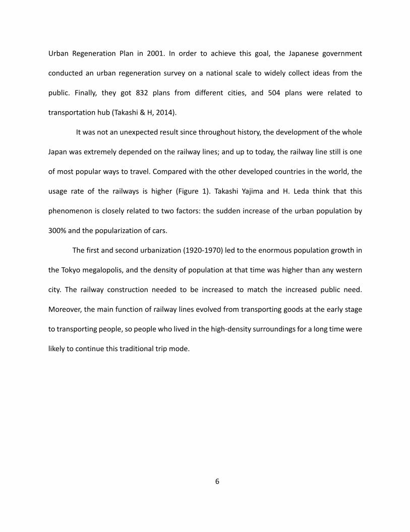
Urban Regeneration Plan in 2001. In order to achieve this goal, the Japanese government
conducted an urban regeneration survey on a national scale to widely collect ideas from the
public. Finally, they got 832 plans from different cities, and 504 plans were related to
transportation hub (Takashi & H, 2014).
It was not an unexpected result since throughout history, the development of the whole
Japan was extremely depended on the railway lines; and up to today, the railway line still is one
of most popular ways to travel. Compared with the other developed countries in the world, the
usage rate of the railways is higher (Figure 1). Takashi Yajima and H. Leda think that this
phenomenon is closely related to two factors: the sudden increase of the urban population by
300% and the popularization of cars.
The first and second urbanization (1920-1970) led to the enormous population growth in
the Tokyo megalopolis, and the density of population at that time was higher than any western
city. The railway construction needed to be increased to match the increased public need.
Moreover, the main function of railway lines evolved from transporting goods at the early stage
to transporting people, so people who lived in the high-density surroundings for a long time were
likely to continue this traditional trip mode.

7
Figure 1: Distribution of Trip Modes in Big Cities (Takashi & H, 2014).
Many western cities had a long period when the city development depended on their rail
systems; however, the popularization of automobiles changed this situation. The Japanese copied
the western system, and the appearance of the vehicle changed the traditional railway system
and city development model. Many people moved out of the urban area because of cheaper
housing and went to work by private cars. With the increasing number of automobiles, especially
private cars, high traffic became a big problem, and the flexibility of car travel exacerbated the
disordered urban expansion in some ways. But this development trend did not last long after the
asset price bubble. The economic bubble reduced the land value in the urban area and people
could afford a house near the place they work. In addition, compared with western cities, the
road development in Japan was sluggish because of many factors like the national policies,
geographical conditions, and unique culture. The busy traffic resulted in many people no longer
wanting to live far away from their workplaces.

8
The fundamental realities of Japan dictated their unique transit development model,
similar to “transit-oriented development” (TOD), which was created in the United States. TOD
had been widely used in many western counties, but the original intention and implement
methods were different. Nikken Sekkei, a reputable Japanese architecture firm and a core
organization involved in the Shibuya redevelopment project, published a book in 2014 called
Integrated Station-City development: The next advances of TOD. The book elaborated on the
practice of TOD under the unique Japanese context. The firm indicated that creating a “Compact
City” should be the main goal for current Japanese cities, in order to achieve economic
renaissance and sustainable development in the urban area. And as some popular transportation
hubs have the potential to gather a large number of people, the Shibyua Station redevelopment
center combined with the construction of infrastructure, is one of core strategies used in many
cities renovated projects. The TOD model has the potential to significantly enhance city
enchantment.
Development forms of the TOD transportation hub in big Japanese cities can be divided
into three types. Type A is based on a layered system, as shown in Figure 2, with the underground
train stops, squares, traffic facilities, workplaces, commercial stores, and recreational facilities all
set in a mutual vertical space. The main advantages of this type are saving horizontal spaces and
shorten the walking distance between different functions’ sites. However, this development form
required higher construction technology and more complicated integrated planning. Shin-
Yokohama Station and the Public Plaza is one of the representative cases of Type A.
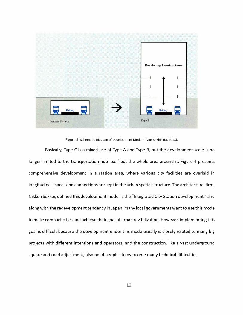
The design of type B emphasized the connection between the underground railway
station and city facilities. As Figure 3 shows that there is a vent that can directly connect railway

9
station space with the other spaces in the developing building, and in the reality, architects or
designers usually use elevators, stairs, and underpasses to replace this vent. It not only improves
convenience but also creates public spaces in the restricted urban area.
Figure 2: Schematic Diagram of Development Mode - Type A (Shikata, 2013).
10
Figure 3: Schematic Diagram of Development Mode – Type B (Shikata, 2013).
Basically, Type C is a mixed use of Type A and Type B, but the development scale is no
longer limited to the transportation hub itself but the whole area around it. Figure 4 presents
comprehensive development in a station area, where various city facilities are overlaid in
longitudinal spaces and connections are kept in the urban spatial structure. The architectural firm,
Nikken Sekkei, defined this development model is the “Integrated City-Station development,” and
along with the redevelopment tendency in Japan, many local governments want to use this mode
to make compact cities and achieve their goal of urban revitalization. However, implementing this
goal is difficult because the development under this mode usually is closely related to many big
projects with different intentions and operators; and the construction, like a vast underground
square and road adjustment, also need peoples to overcome many technical difficulties.

11
Figure 4: Schematic Diagram of Development Mode - Type C (Shikata, 2013).
From 1990 to now, these three development types of popular TOD transportation hubs
have been implemented many times in Japanese cities; and combined with the New Urban
Regeneration Plan in 2001, many urban areas have been reshaped by these three types. However,
how the Japanese TOD model works in reality, what are the benefits of a “Compact City” and it’s
meaning, and how TOD can achieve city renaissance are all questions that should be explored.
This project will focus on the Shibuya Station Area Redevelopment Plan, and the ongoing practice
of Type C, to understand the new utilization of TOD mode in Japan.
Redevelopment Plan for Central Area of Shibuya
Shibuya Station and the area around it were defined as the Urban Renaissance Emergency
Development Area in December 2005 (Shikata, 2013). The Shibuya Station District Infrastructure
Development Committee was composed of experts, government officials, and railway companies,
12
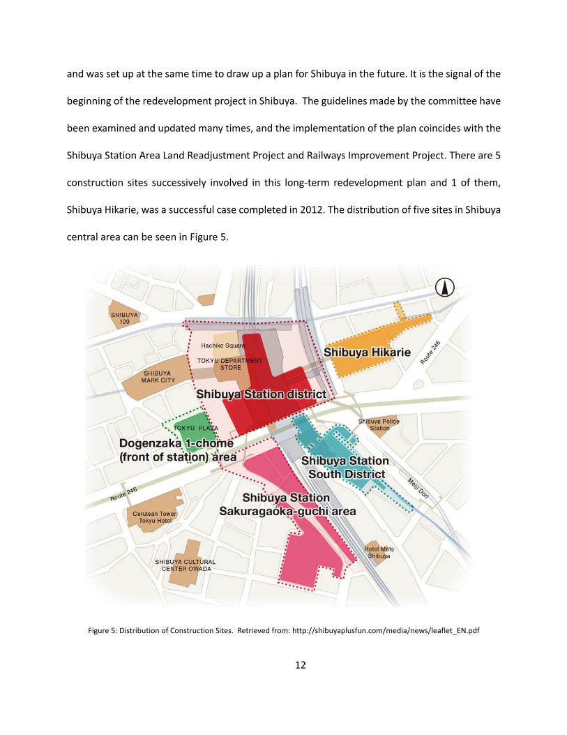
and was set up at the same time to draw up a plan for Shibuya in the future. It is the signal of the
beginning of the redevelopment project in Shibuya. The guidelines made by the committee have
been examined and updated many times, and the implementation of the plan coincides with the
Shibuya Station Area Land Readjustment Project and Railways Improvement Project. There are 5
construction sites successively involved in this long-term redevelopment plan and 1 of them,
Shibuya Hikarie, was a successful case completed in 2012. The distribution of five sites in Shibuya
central area can be seen in Figure 5.
Figure 5: Distribution of Construction Sites. Retrieved from: http://shibuyaplusfun.com/media/news/leaflet_EN.pdf

13
In general, the Shibuya Ward is in charge of the overall redevelopment plan, but every
individual planning site has been delegated to private corporations (Ito, 2015). Since the Japanese
National Railway company was facing a large economic problem from the 1960s to 1980s, the
government privatized the railways to save the problem. Later, a few private companies
successively entered in to Japanese railways market. However, the profit from railways is more
than enough to sustain a company, so many private companies started to invest in real estate.
Commercial businesses along their railway lines (did what?) and the phenomenon accelerated
after the Second World War (Takashi & H, 2014).
Up to now, railway companies held much territory in Tokyo and used it to increase their
benefits by bringing in various commercial activities and residents; but a prerequisite of this
economic growth is population. The investment of infrastructure not only enhances city
development but also is able to keep a stable population. Therefore, it is not hard to understand
why Japanese railway companies are principal participants in a city plan. For example, in Shibuya
central area’s redevelopment plan, Shibuya Station district was conducted by three private
railway companies, Tokyu Corporation, East Japan Railway Company and Tokyo Metro Co. The
Shibuya Station South district and Shibuya Hikarie are operated by Tokyu Corporation. These
private companies cooperate with the government, landholders, experts, and various community
leaders to negotiate the integrated development of the Shibuya Station area.
The content of the redevelopment can be divided into two parts: one is Shibuya Station’s
internal reconstruction and the other part is the four construction sites around it. As for Shibuya
Station itself, first, the internal structure is too complex and crowded. As mentioned above, new

14
visitors usually lose their direction at the beginning when they get off trains in Shibuya Station.
Even though the guiding signs are carefully designed, new visitors, especially foreigners, find to it
difficult to get to the exit or transfer trains.
Figure 6 is the map of the internal structure of Shibuya Station: there are 3 layers on the
ground and 5 layers under, and each layer is occupied by different railway or subway lines. The
platform of each line is independent, so if customers want to transfer to a different line, they
must walk more and pay more times. The outcome is an accumulation, because each railway or
subway line was built at a different time and the operators are also different.
Figure 6: Internal structure of Shibuya Station. Retrieved from: https://www.shibuyastation.com/shibuya-station-map-finding-
your-way/

15
There are several strategies mentioned in the plan to save this problem. First, Tokyu
Toyoko Line moves from the surface layer to underground to interconnect with the Tokyo Metro
Fukutoshin Line (B5F). The move not only achieved cooperation between different railway
companies but made a large space on the ground for facing the problem of insufficient space.
Second, the Saikyo Line will move its platform parallel with Yamanote Line platform, as shown in
Figure 7. The change will expand the platforms and reduce the distance to transfer. Third, which
transforms the Tokyo Metro Ginza Line platform from a solitary “island” platform (Figure 8) and
moves the whole platform into Shibuya Hikarie. The purpose of this change is to expand the space
of the transfer area and improve the connection between the train station and the city. In all, as
shown in Figure 9, after optimizing the railway lines and platforms’ shape, the Shibuya Station
District will become simpler and more integrated.
Figure 7: Change of Platforms – Yamanote Line and Saikyo Line (Shikata, 2013).

16
Figure 8: Change of Platforms – Ginza Line (Shikata, 2013).
Figure 9: Contrast Map of Railway Reconstruction (Shikata, 2013).
The second problem is the disordered transportation system. The transportation there
mainly refers to buses and trucks, which either stop at or pass stations. As mentioned above,
Shibuya Station cannot be simply defined as a trail station: the east and west sides of the station
have many bus lines and terminals, which increases the degree of crowdedness on the ground.
In addition, as one of most popular commercial centers, many trucks park there for unloading
goods to the stores in or near stations. Insufficient space in the station square usually results in
traffic jams and illegal parking. These two factors lead to an increase in poor traffic conditions and

17
potential security issues. The current situation can be seen in Figure 10.
Figure 10: Status Que of Shibuya Station Squares. Retrieved from:
http://www.city.shibuya.tokyo.jp/kurashi/machi/pdf/gaiku_a.pdf
In order to solve this problem, the station squares will be reshaped and used for relieving
the traffic congestion. Also, the road around Shibuya Station will be adjusted to fit the change to
the squares. Figure 11 presents an entire plan for the squares in front of a station. Besides, two
vertical areas will be built under the ground to alleviate the illegal parking problem. In this way,
trucks will have enough space to park and unload goods, which not only reduces the degree of
congestion on the ground, also ensures the safety of the pedestrian on the ground. In addition,
there are basement floors of two vertical areas that are separately connected with Shibuya
Underground Street and two subway lines: Hanzomon Line and Fukutoshine Line, which allow for
transfer between different trip modes.

18
Figure 11: Plan of Shibuya Station Squares. Retrieved from: http://www.city.shibuya.tokyo.jp/kurashi/machi/pdf/gaiku_a.pdf
For the whole city redevelopment mission, the committee considered that setting up
“urban cores” and improving the “pedestrian network” are two methods to renovate the city in

19
different dimensions. The concept of urban cores refers to the combination of city spaces in a
vertical stack. Since the situation in the central Shibuya area is a high-density population and
unique terrain, the city’s vertical development is a corollary. In contrast, perfecting the pedestrian
network around Shibuya Station provides a safer and easy-to-understand surrounding for visitors
and improves the pedestrian circulation across the area.
It is not hard to find skyscrapers in Shibuya; and in the redevelopment plan, 4 new high-
rising constructions will be completed in 10 years as a strategy to renew the city (Shibuya Hikarie
has completed). The urban core will be set up in the lower levels of these skyscrapers and Shibuya
Station. For example, an urban core has been found in Shibuya Hikarie, from basement third floor
to the fourth floor on the ground, visitors can easily and safely transfer between layers and the
barrier-free facility is set up to improve accessibility (see Figure 12). In addition, the urban core is
designed to promote the city’s ecology by creating gaps between buildings to increase the air
circulation and reduce the consumption of resources.

20
Figure 12: Urban Core in Shibuya Hikarie. Upper Photos Retrieved from:
https://design.rhizomatiks.com/en/works/shibuya_hikarie.html; Under Map is edited from Shibuya Hikarie Floor Map. Retrieved
from: https://www.tokyu-dept.co.jp.e.fa.hc.transer.com/shinqs/floor/2f.html
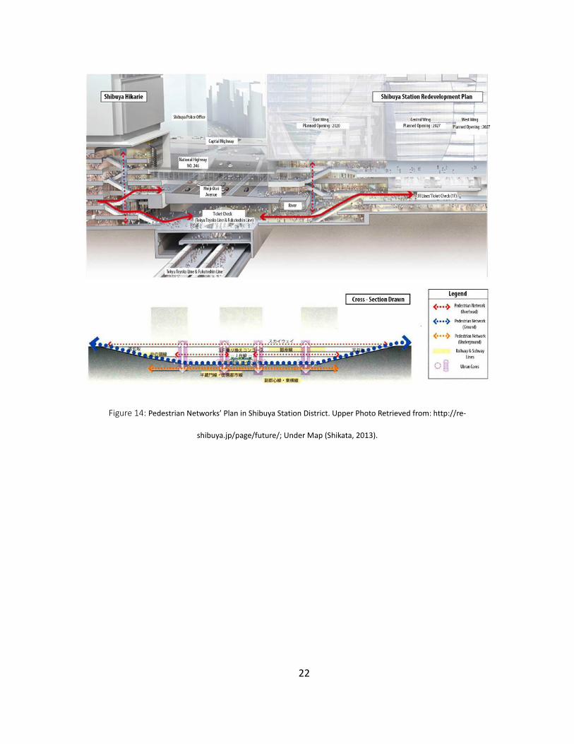
If the idea of urban core is a strategy for the vertical connection of city spaces, the
“pedestrian network” in central Shibuya is the method of horizontal spaces’ connection. The
distribution of urban cores is highlighted in purple circles of Figure 13. Figure 14 presents the new
plan of walkable routes that are built to connect skyscrapers and Shibuya Station by urban cores
in three levels: overhead - the aerial corridors have been established; ground - the extension of
squares around station and road reconstruction will enhance sidewalk system on the ground; and
underground – the current underpass will be extended to a vast underground square that will

21
connect the subway lines on the third layer of station and the basements of skyscrapers. In this
way, Shibuya Station will be a base spread out over the core spots in Shibuya Ward. Visitors can
arrive and explore the central area of Shibuya without too many puzzles.
Figure 13: Distribution of Urban Cores in Shibuya. Retrieved from:
http://www.city.shibuya.tokyo.jp/kurashi/machi/pdf/shibuya_shishin7_5.pdf
22
Figure 14: Pedestrian Networks’ Plan in Shibuya Station District. Upper Photo Retrieved from: http://re-
shibuya.jp/page/future/; Under Map (Shikata, 2013).

23
The Concept under Integrated City-Station Development Model
The strategies used in Shibuya Station Area Redevelopment Plan have a common effect –
reinforcing physical connections – which is the main idea from the Integrated City-Station
Development model to make a “Compact City.” On the other hand, the decisions or strategies are
made or designed by people from different groups, so how they work together and reach the
consensus is an underlying connection to strengthen “Compact City” in the planning process.
Therefore, connection, as the concept under the development model, can be displayed in two
aspects to help people understand the operational process of the model: physical connection and
cooperation. Physical connection refers to some visible construction projects which are links
between various spaces functions in urban the spatial structure, and cooperation can be
considered as a mental negotiation among the various groups that participated in the program.
In the internal development of Shibuya Station, as described above, there were three
main changes to the railway lines. First, the platforms of Saikyo Line and Yamanote Line in Shibuya
Station was merged, which was a physical strategy to simplify the railway system by shortening
the distance (see Figure 15). Even though these two lines are operated by one Railway Company,
JR East, the decision was made after discussing with the other members in the Shibuya Station
Distract Infrastructure Development Committee, since any move in the area should fit the main
aim. The main cooperation there was the individual railway company working with the related
government department.

24
Figure 15: The Diagram of the Railway Lines Reconstruction (Left: before, Right: After). Retrieved from:
https://www.bcj.or.jp/en/what/src/srilanka01_04.pdf
Second, as Figure 15 shows that Tokyu Toyoko Line disappeared on the ground after
reconstruction because the line moves down and interconnects with Tokyo Metro Fukutoshin Line
(underground). The strategy of connection not only enhanced the convenience of transfer
between two lines and the integrality of the station but saved land for development on the
ground. The advantage of the physical connections can be clearly pointed out, but the realization
process was complex. The project was completed in 2013 and there were two private railway
companies, Tokyu Corporation and Tokyo Metro, in charge of this interconnected process. As the
first case of railway lines interconnection by two companies, the project went through many
versions and demonstrated cooperation in different aspects.
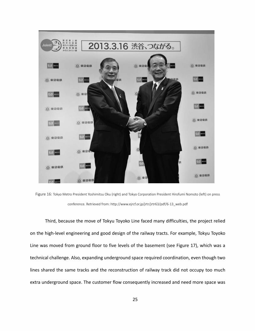
Above all, many analyses should be done to assess the success of this project. And since
the project is a component under the redevelopment plan, besides the internal analyses of the
two railway companies involved, the government officers and experts in the Development
Committee also should analyze the benefits in more comprehensive view to ensure whether the
project met city goals and the public interest.
25
Figure 16: Tokyo Metro President Yoshimitsu Oku (right) and Tokyo Corporation President Hirofumi Nomoto (left) on press
conference. Retrieved from: http://www.ejrcf.or.jp/jrtr/jrtr63/pdf/6-13_web.pdf
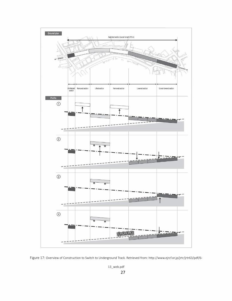
Third, because the move of Tokyu Toyoko Line faced many difficulties, the project relied
on the high-level engineering and good design of the railway tracts. For example, Tokyu Toyoko
Line was moved from ground floor to five levels of the basement (see Figure 17), which was a
technical challenge. Also, expanding underground space required coordination, even though two
lines shared the same tracks and the reconstruction of railway track did not occupy too much
extra underground space. The customer flow consequently increased and need more space was

26
needed after the merging. Therefore, collaboration emerged between railway companies, railway
technical research institutes, and design studios to save these problems.
For instance, in this project Tokyu Corporation handled the design and actual construction
with Tadao Ando, a famous architect, and Figure 2 is the Schematic Map of the interconnected
design. In addition, Pacific Consultants, an infrastructure consulting company, has been hired to
figure out the engineered challenges of expanding existing underground space and transforming
it to be a vast opening underground square. The company respectively assigned two engineers
for two railway companies, and they are the “job masters” to negotiate the content of the project
in order to get the best outcome from the cooperation.
27
Figure 17: Overview of Construction to Switch to Underground Track. Retrieved from: http://www.ejrcf.or.jp/jrtr/jrtr63/pdf/6-
13_web.pdf

28
Third, the platform of Ginza Line will move eastward and connect with Shibuya Hikarie
(see Figure 15). It is a strategy made by the committee under the redevelopment policy to narrow
the gap between a transport station and the urban infrastructure. The benefit for the public is
that the visitor can arrive at Shibuya Hikarie directly without confusion, and the transfer distance
will be reduced by “Urban Core” because the new location is right above Tokyu Toyoko Line,
Metro Fukutoshin Line, and the new east traffic square (see Figure 18). The Ginza line is operated
by Tokyo Metro, and the main developer of Shibuya Hikarie is Tokyu Corporation. As mentioned
above, the private railway company owned and invested in land along with the railway tracks to
increase earnings. Therefore, the main participant groups in this project are Tokyu Corporation
and Tokyo Metro.
Figure 18: New Location of the Ginza Line’s Platform (Cross-Section). Retrieved from: http://www.hikarie.jp/en/

29
It is worth mentioning that the frequent cooperation from different railway companies
improved the railway system and city development. In Japan, there are three types of railway
owners: first is the JR Company, which was privatized from the national railway company, so their
railway lines mainly make the connection between big cities over the whole country. The second
private railway company, Tokyu Corporation, is the best representative of the wholly private
companies. The private railway lines mainly connect the core area of a city with its suburban
districts. The third is the private metro companies like Tokyo Metro Co., Ltd. Their track
constructions usually are set up in the urban area. In the past, three types’ railway companies
lacked cooperation, which limited the availability of the railway system. One of the most obvious
problems was the difficult transfers because of different tickets. Different railway companies
provided different tickets, so if the passenger wanted to transfer lines between different
companies, they had to buy tickets at least twice.
Fortunately, integrated development (IT) as a new concept is increasingly accepted by
Japanese people and company in the modern time. Along with the rapid development of IT, in
November 2000, JR East introduced an IC card (Integrated Circuit Card), “Suica”, instead of
traditional paper tickets and this card could be commonly used in any railway lines in Tokyo. Since
then, many similar IC cards emerged and in April 2013, these IC cards were popularized in the
whole country. It was a giant leap for the Japanese railway system since it removed the
inconvenience transfer problem for the public and improved the relationships between different
railway companies. In addition, the IC Card also can be used in many other ways, such as riding
buses, paying in many stores, or in recreational facilities. In this way, many facilities that are

30
supporting people’s basic life can be connected by a small card, which refers to a wider
cooperation in many communities.
Figure 19: Various IC Cards in Japan. Retrieved from: http://bbs.qyer.com/thread-877945-1.html
The setup of “Urban Core” (see Figure 13) in some big buildings and the reconstruction
plan of the “Pedestrian Network” both show the significance of the walking trip in the urban area
by enhancing and amplifying the public infrastructure. In the future, visitors can easily complete
their transfers in vertical or horizontal axis by these Urban Cores and Pedestrian Networks. The
idea of Urban Core was created by the committee, but the implementers are different groups. In
the redevelopment plan, there are five construction projects (including Shibuya Hikarie and
Shibuya Station) were planned to be built or rebuilt with Urban Cores. Even though the Urban
Core belongs to the public infrastructure construction, the implementation is included in the
building construction.
In short, the developers and some public organizations are also responsible for the urban
public infrastructure construction. For example, the Shibuya Hikarie project on the demolished
site of Tokyu Bunka Kaikan was a coordinated effort by Tokyu Corporation, owners of the
neighboring district, and the owners of Shibuya Station (Tokyu Corporation, East Japan Railway
Company, and Tokyo Metro Co., Ltd.).

31
The reconstruction project of the “Pedestrian Network” should be analyzed with the other
related projects: the reforming of station plazas, because both rely on the adjustment of land use.
Especially on the ground floor, the proportion of road surface, sidewalks, and station plazas area
will be greatly adjusted in the redevelopment plan (two station’s plazas will be expanded and
contain some bus stops inside, and the west road will be narrowed) to create a pedestrian urban
space in Shibuya, thus encouraging people to take public transportations instead of private cars.
In the process, the project will be decided after many conferences between the
redevelopment committee and related groups in charge of the related projects. The new traffic
plaza construction and road construction will affect the benefits of the railway companies and
bus companies, so they are the project owners to involve. The government role there is not only
evaluate the feasibility of the project but also adjust land use and provide policy support.
For instance, Taku Tetsu-hō (宅鉄法), a housing-railway act, was published in 2005 to
ensure the railway land use in the urban area. The act gives railway companies rights to acquire
necessary lands for railway constructions (includes the construction of station squares) by
exchanging land with individual landowners.
Besides, establishing four huge buildings themselves is a strategy to further compact the
urban area because the vertical expansion of urban space will lead to various functions existing
in one integrated space. For example, as Figure 20 shows that there are many facilities assembled
in Shibuya Hikarie, like retail shops, workspaces, entertainment, disaster prevention, and culture.
Therefore, as a mix-used skyscraper, Shibuya Hikarie is endowed with a lot of meaning. The
functional aggregation is attributed to a huge number of cooperative relationships between
related groups or individual operators. In general, the project owners will get the return on

32
investment by renting space to retailers and companies. On the other hand, the retailers and
companies will get better financial results because of the superior location and environment.
Theaters and galleries are set up for culture transmission, so the relevant government
department and cultural organizations must involve in this project. Moreover, some public space,
like disaster prevention areas and green space, will be reserved in this building to fit public
interest and environmental aims. For these non-profit projects, government and building owners
will share responsibility.
Figure 20: Shibuya Hikarie Building Functional Introduction. Retrieved from: http://www.hikarie.jp/en/
In all, the planning process for Shibuya Station Redevelopment Plan under Integrated City-
Station Development model emphasizes a “Public-Private Cooperation” concept. As one of the

33
Japanese basic state policies mentioned that “if the city problems could be saved by the public,
let them do what they want.” Indeed, analysis of the planning process of the Shibuya Station
Redevelopment Plan shows that the participation rate of private companies is higher than many
other countries, and the construction of urban infrastructure in Japan usually relies on the
investment from private communities.
The main duty of the Japanese government in the planning process is to set the
overarching goal and clarify the orientation of development for the Japanese future, such as
urban renovation with the TOD model. Then, the government will select sites for the
implementation, like listing a few special urban renaissance districts and classifying these sites by
evaluating their current conditions and urban functions. Shibuya was one of renovation sites, and
as a sub-center city in Tokyo, it has corresponding urban function. The relevant policies will be
respectively formulated to match different districts’ conditions, and the local government has the
duty to detail the policy.
After that, a committee with government officers, experts and other stakeholders (like
Shibuya Station Distract Infrastructure Development Committee) will be established to be in
charge of the redevelopment plan instead of a simple urban planning department or company
hired by the government. The stakeholders have rights to propose projects in the committee to
fit the main goal and their own benefits, and experts and government will integrate feasible
proposals in the planning and update it every year.
Different stakeholders hold various city redevelopment projects, some of them work
together, and some of them hire related organizations to help them make the projects come true.
There are many ways of cooperation between different communities because the processes are

34
flexible. In addition, the stakeholders also pay attention to urban development and share
responsibility with government and non-profit organizations, such as public infrastructure
construction and environmental protection causes because they know that they will get benefits
from those investments. For example, when Tokyu Corporation, East Japan Railway Company, and
Tokyo Metro Co., Ltd perfect the basic facilities of their railway lines in Shibuya, many people are
likely to travel by railway and stop by Shibuya Station and the area around it for many purposes.
In these way, three railway companies are able to gain more benefits along with the increasing
population.
Figure 21: Japanese Planning Process in Shibuya Station Redevelopment Plan. (Shikata, 2013)
Besides, the government really cares about the degree of participation of common people
in Shibuya Station Redevelopment Program. Kazuhiro Okuno, an official in charge of urban
development in Shibuya, said in an interview that “locals have also been involved in the
development process to ensure that Shibuya is not just torn down and turned into something

35
that loses its vibrancy.” (Ito, 2015).
The related departments hold many activities to arouse the common people’s attention
and enthusiasm for the construction. For instance, they held a photo exhibition to show the
historical development of Shibuya Station and the area around it. Moreover, they created a few
websites with the vivid and colorful pictures (see Figure 22) to invite people to pay more attention
to the ongoing program, and the construction progress will be posted on websites every day.
Locals may find community attachment from these activities and websites, thereby compacting
a social connection in Shibuya.

36
Figure 22: Websites Created for Publishing Future Shibya Plan. Retrieved from: http://www.youmakeshibuya.jp/
37
A Compact City
Urbanization refers to the population shift from rural to urban areas, which is a universal
phenomenon happened in many big cities around the world and it closely links to modernization,
industrialization, wars, and some changes in social structure. For instance, America and many
European countries completed their urbanization after two industrial revolutions. However, the
dramatic growth of the economy and population in urban areas usually lead to many problems
such as public health, affordable housing/land, and traffic congestion. However, the basic
problem of urbanization is the how to balance the relationship between population size and
available urban spaces.
Two different attempts by developed western countries to stop the urbanization problem.
One is urban sprawl, where the outskirts of cities are developed, and America is one of the
representative countries. Many people move out of the urban area and live in low-density towns
in the outskirts or “suburbs.” They travel a long distance to a downtown area for work and
recreational activities in their private vehicles, and come back home for at the end of the day. The
attempt may alleviate the problem of a poor living environment, but it leads to many new
problems at the same time. For instance, unlimited sprawl increases the pressure of traffic system
and public expenditure for maintaining roads: especially in some big auto nations where driving
vehicles is the main trip mode for the public. Also, the model does not match some desired
development themes, like sustainable and environment-friendly development, in the present
time.
On the contrary, the second attempt to stop urbanization problems in many European
38
countries limited the urban sprawl phenomenon by efficiently utilizing existing urban land
resources and perfecting public infrastructure. For example, enhancing land allocation efficiency
by implementing mixed-use land use, using railway lines as the main trip mode to instead of
private vehicles, and promoting other public transport and walking in the urban area are basic
measures to build a “compact city.” The compact city concept was adopted by Japanese to
renovate their cities, but in practice the implementation is different because of the various
national conditions. The practice of “compact city” in Japan is based on TOD model, but Japanese
shifted the focus of urban revitalization to the construction of railway station and infrastructure,
which presented a new direction for urban development and planning.
After analyzing the Shibuya Station Redevelopment Plan, there are three main advantages
of a compact city can be summarized from this practical case. Above all, a compact city maximized
the urban land value. Comparing with a single type of land use, the mixed-use land creates extra
value when various functions work together. In Shibuya Station project, the central area of
Shibuya cannot be simply defined as commercial land even though there are a large number of
stores and restaurants. Many art or educational exhibitions are held in the area to promote the
Japanese culture. Many public spaces like small gardens are also created to beautify the urban
space. Shibuya Station, as one of the biggest and most popular transportation hubs in Tokyo, is
also located in the central area, which helps reduce the traffic pressure. These various functions
are flexibly distributed in one urban space, and influence each other in a positive way.
For instance, the construction of city environment and public transportation attract more
people to the area, thereby increasing the benefits for the store operators and land developers.
In order to keep this upward tendency, they may be willing to invest money in government

39
projects. The responsibility of city development can be diminished because of the support from
private companies, and they can put more attention on the other city works. For the public,
almost all their daily needs can be met within the walking distance (750m-800m), since the basic
necessities are assembled in one integrated area. People are then more likely to come back, thus
keeping the city active. This positive circle not only adds extra value to the urban land but also
creates a good social condition for the city renovation.
Second, a compact city will improve work efficiency in two ways. First, as mentioned
above, almost all functions are set up around the transportation hub, which means the distance
between people’s houses and work is reduced in the compact city. In addition, the integrated city-
station development enhances accessibility among various urban spaces, so people can easily
and quickly arrive at their work without confusion. Commuting time is saved to do something
more worthwhile.
On the other side, when people in different fields are working in a compact space, they
are likely to communicate and cooperate more. Sometimes, it is a good way to simplify work
processes and create more new ideas. For example, in Shibuya Station Redevelopment Plan, the
government, private railway companies, developers, and other local organizations broke the
traditional planning process (where the government makes plans and then collects money from
developers through various policies) and worked together from the beginning. In this way, this
planning committee possesses more comprehensive ideas and is closer to real people’s needs
and benefits, thus, the implementation process becomes easier.
The third main advantage is that making a compact city is beneficial to environmental
protection and energy savings, since the main trip mode in a compact city is using public

40
transportation. It is a way to reduce utilization rate of private vehicles, thereby cutting down the
exhaust emission and energy use. According to the data from NTT Data Institute of Management
Consulting, the energy used to move one person one kilometer by private car is six times more
than by railway lines (Shikata, 2013). Considering population numbers and density in urban Japan,
using the railway instead of automobiles is more significant for the environmental goal. In
addition, perfecting the construction of pedestrian system encourages people to walk and ride
the bike in urban areas, and those are more environmentally-friendly trip modes than the railways.
In short, the most environmentally-friend modes rely on districts where basic functions are highly
centralized.

41
Conclusion
As one of the developed countries in Asia, the Japan completed their urbanization earlier
than many other Asian countries. However, as time goes by, the benefits of urbanization have
weakened and a few urban problems were exposed, and even restricted the city development.
Because of those problems, like many developed countries in the world, the Japanese began
looking for a new development orientation for their future, and the Shibuya Station
Redevelopment Plan is one of the practices for the urban revitalization. The integrated city-station
development model, which was used in the Shibuya project, creates a compact city centered
around a railway hub. Combining with the advantages of using the railways, the Japanese
regrouped various basic functions in limited urban spatial structure and connected them with the
railway station to solve current urban problems and make the city more convenient, sustainable,
profitable, and ecological.
The practice of city redevelopment in Japan is a good reference for many developing
countries in Asia since these countries have similar backgrounds and face similar urban problems.
Due to geographical and historical reasons, the problem of balancing the huge population and
limited urban land sources in Asia is more severe than in many western countries. For example,
the population in Tokyo metropolitan circle was triple the population Paris in 2010, but acreages
of two capitals are similar (Takashi & H, 2014). The fundamental conditions of Asian countries
necessitate more accurate and complex plans for the redevelopment of their urban areas. In
recent years, even though some Asian countries are seemingly developing rapidly, problems have
emerged such as environmental pollution and traffic congestion.

42
As a forerunner in urban development, the Japanese have experienced many successes
and failures, both of which can provide lessons for avoid mistakes in other Asian countries.
However, any one city cannot directly copy the development methods from the other city
completely, since a good plan must match with a city’s unique conditions. For example, even
though a few concepts of integrated city-station development modes such as “TOD” and a
“compact city” were created by other countries, the mode used in Shibuya project is unique
because all the measures are based on Shibuya’s current problems and their planning
organization.
In the end, a city plan, whether successful or not, depends on the acceptance and
recognition of the public because any district is made up of people. Planning the whole city using
professional knowledge, previous experience, existing planning laws, and using capabilities of
people to stimulate their enthusiasm for urban development are all new topics for government
and planners to explore.

43
References
Cybriwsky, R. (1988). Shibuya center, tokyo. Geographical Review, 78(1), 48-61. doi:10.2307/214305
Ito, M. (2015). Shibuya's redevelopment to create a futuristic railway station fit for the 21st century. Japan Times (Tokyo, Japan).
Konomi, S. (2014). Lost again in Shibuya: Exploration and awareness in a labyrinth. Shikata, Y. (2013). Integrated station-City development: The next advances of TOD (A u. special
issue, 2013, October). Tokyo: A U Publishing. Takashi, Y&H, L. (2014). 鉄道が創りあげた世界都市・東京. Tōkyō: Keiryōkeikakukenkyūjo. Takatoshi, T., Yoshio, H. (1990). A Historical Review on the Station Square in Shibuya. Historical
Studies in Civil Engineering, 10(10). 東京大改造マップ 2016-2020 気になるあの街の近未来が分かる!(Nikkei bipi mukku). (2016).
Nikkeibipisha.

44
List of Figures
Figure 1: Distribution of Trip Modes in Big Cities (Takashi & H, 2014). .......................................... 7 Figure 2: Schematic Diagram of Development Mode - Type A (Shikata, 2013). ............................. 9 Figure 3: Schematic Diagram of Development Mode – Type B (Shikata, 2013). .......................... 10 Figure 4: Schematic Diagram of Development Mode - Type C (Shikata, 2013). .......................... 11 Figure 5: Distribution of Construction Sites. ................................................................................. 12 Figure 6: Internal structure of Shibuya Station. ............................................................................ 14 Figure 7: Change of Platforms – Yamanote Line and Saikyo Line (Shikata, 2013). ....................... 15 Figure 8: Change of Platforms – Ginza Line (Shikata, 2013). ........................................................ 16 Figure 9: Contrast Map of Railway Reconstruction (Shikata, 2013). ............................................ 16 Figure 10: Status Que of Shibuya Station Squares. ....................................................................... 17 Figure 11: Plan of Shibuya Station Squares................................................................................... 18 Figure 12: Urban Core in Shibuya Hikarie. .................................................................................... 20 Figure 13: Distribution of Urban Cores in Shibuya. ...................................................................... 21 Figure 14: Pedestrian Networks’ Plan in Shibuya Station District. ............................................... 22 Figure 15: The Diagram of the Railway Lines Reconstruction (Left: before, Right: After). ........... 24 Figure 16: Tokyo Metro President Yoshimitsu Oku (right) and Tokyo Corporation President Hirofumi Nomoto (left) on press conference. ............................................................................... 25 Figure 17: Overview of Construction to Switch to Underground Track. ....................................... 27 Figure 18: New Location of the Ginza Line’s Platform (Cross-Section). ..................................... 28 Figure 19: Various IC Cards in Japan. ............................................................................................ 30 Figure 20: Shibuya Hikarie Building Functional Introduction. ...................................................... 32 Figure 21: Japanese Planning Process in Shibuya Station Redevelopment Plan. (Shikata, 2013) 34 Figure 22: Websites Created for Publishing Future Shibya Plan. .................................................. 36